The Fury of the Past: Natural Disasters in Historical and Prehistoric Britain

Introduction

Over recent years, there’s been a growing tendency… to present images of climate in crisis.

Storms tearing through communities…
floods overwhelming towns…
weather described not just as severe… but as something almost theatrical in its intensity.

And alongside these images… comes a familiar language.

We hear about record-breaking rainfall…
unprecedented wind speeds…
and that now well-worn phrase… “since records began.”

It sounds authoritative.
It sounds definitive.
The Fury of the Past: Natural Disasters in Historical and Prehistoric Britain

But it’s worth pausing… just for a moment… to ask a simple question:

What records… exactly… are we talking about?

Because in many cases… those “records” begin surprisingly recently.
Daily observational data, in its most widely used form, only really starts in the early twentieth century — around 1914.

So when we describe a modern year… like 2023… as extreme or unprecedented… we are often comparing it to just over a century of detailed measurement.

And that… is a very narrow window… in the context of climate.

Because the story doesn’t begin there.

We have the England and Wales Precipitation series… stretching back to 1766.
We have the Central England Temperature record… reaching all the way back to 1659.

These are not trivial datasets.
They are the result of generations of careful observation… often by dedicated amateur meteorologists… people who simply watched the skies… and wrote it down.

Together, they offer something far more valuable than a snapshot.

They offer perspective.

A long, continuous conversation between humanity… and the weather.

And yet… paradoxically… these longer records are often pushed aside.
Quietly ignored… or treated as secondary… in favour of modern datasets that fit more neatly into contemporary narratives.

Which raises an important point.

If we are serious about understanding climate…
about understanding flooding…
about understanding extremes…

Then we cannot afford to work from fragments of the record.

We need the full canvas.

The Fury of the Past: Natural Disasters in Historical and Prehistoric Britain

Because without that depth… without that historical context…
we risk mistaking variability for anomaly…
and short-term patterns for long-term change.

Perhaps this is where a figure like Jacob Bronowski would urge caution.

Not to dismiss modern science… but to place it within the wider human story.

To recognise that knowledge is cumulative…
that understanding comes from continuity… not selectivity…

And that if we truly want to understand the forces shaping our world…
we must listen not just to the present…

…but to the long memory of the past.

Sky News Online:

“England and Wales have seen the wettest summer for 100 years, according to MeteoGroup. Rainfall for June, July and August was 362mm (14.25in), making it the wettest summer since 1912. The average summer rainfall across the UK is 226.9mm (8.9in).  MeteoGroup forecaster Nick Prebble said this summer is set to be the fourth wettest since records began in 1727. The record for the UK’s wettest summer is 1912, when 384.4mm (15.1in) of rain fell.” (The Fury of the Past: Natural Disasters in Historical and Prehistoric Britain)
(The Fury of the Past: Natural Disasters in Historical and Prehistoric Britain)
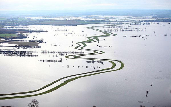
Somerset Flooding – (The Fury of the Past: Natural Disasters in Historical and Prehistoric Britain)

Let us delve into the fabric of the British summer, as narrated by the Met Office, revealing a tapestry less illuminated by the sun’s grace than in years past. A summer, they tell us, that may be recorded in the annals as one of the dullest, with a mere 399 hours of sunshine until the twilight of August, shadowed only by the year 1980’s modest 396 hours. This narrative unfolds in the aftermath of a Bank Holiday painted in the hues of unsettled weather, where rain and flood alerts draped many parts of the UK.

Joanna Robinson, a sage of weather from Sky News, recounts a tale of a season that began with the wettest June recorded, followed by a July that, too, was cradled in wetness. Yet, as the days of summer waned, the weather found a semblance of calm, only to be disturbed once again as August drew to a close. She speaks of the jet stream, that ethereal conveyor of weather, which, in its wanderings, steered storms across the British Isles that might have otherwise passed us by.

The summer of 2007 looms large in recent memory, its rainfall second only to records dating back to 1912, yet August of this summer hints at being the driest and sunniest. Such observations provoke exclamations of dismay and declarations of the grip of climate change on our world. Yet, a closer scrutiny, a peering into the depths of our climatic past, reveals a narrative less singular in its direction. The year 2007, while remarkable for its summer deluge, does not rank among the highest in annual rainfall, settling instead into the seventeenth position over the last century.

Our engagement with the elements, marked by the ebb and flow of rainfall, stretches back over centuries, with periods of intense precipitation, such as the decade spanning 1870 to 1880, punctuating our history. And between the notable years of 2007 and 2012, 2010 emerged as the eleventh-driest, a reminder of the natural oscillations that characterise our climate.

Grote Mandrenke

Turning our gaze to the winds and gales that sculpt our coastlines, history offers us a lens through which to view these forces in a broader context. The ‘Grote Mandrenke’, a tempest from the annals of the fourteenth century, wrought unparalleled devastation, claiming thousands of lives and altering landscapes and architecture. This event, among others, serves as a testament to the dynamic and often turbulent relationship between humanity and the environment.

In this reflection, inspired by the thoughtful considerations, we are invited to contemplate the narratives of weather and climate not as isolated phenomena but as part of a complex interplay of natural forces, historical events, and human experiences. Through this lens, we gain a deeper appreciation for the intricacies of our world and the myriad ways in which the past informs our understanding of the present and the future.
(Extreme weather and Ancient Subterranean shelters)
Grote Mandrenke 1362 – Extreme weather


In the reflective prose, let us explore the further reaches of our historical and environmental saga, where the dance between humanity and nature continues its timeless rhythm. As the great storm of 1362 stretched its wrath into the North Sea, it conspired with the tides to birth a tempestuous offspring—the storm surge. This phenomenon, a marauder of the coasts, reshaped the contours of the European shore, leaving ports from England to Denmark in ruins, and forever altering the dialogue between land and sea.

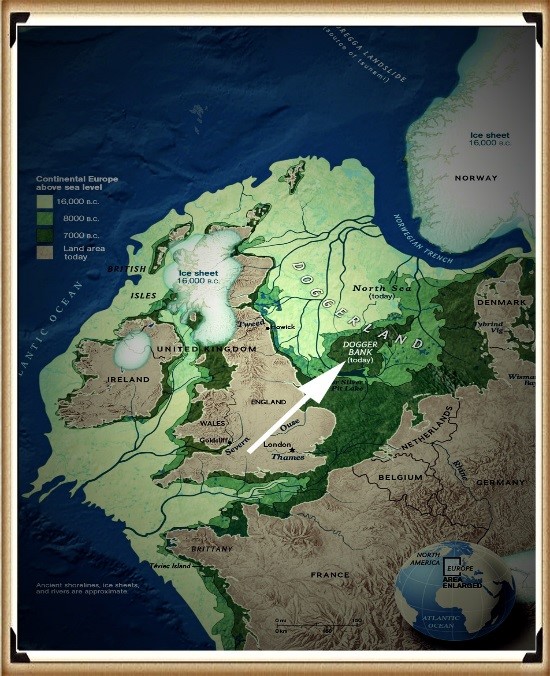
Yet, this cataclysm, while monumental, is not an isolated whisper in the annals of our planet’s climatic history. It echoes a more ancient, more profound narrative that commenced with the first settlers in the Mesolithic period. These early denizens of the land faced the capricious moods of a world freshly emerged from the clutches of the last Ice Age—a time when the land itself was a protagonist in a story of transformation and survival.

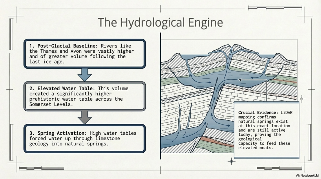
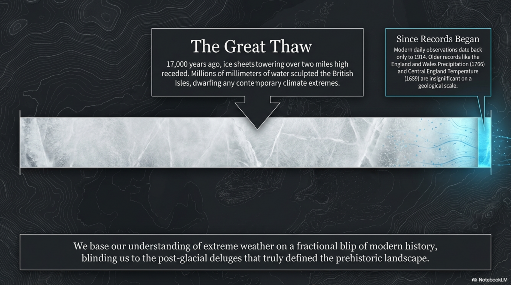
The landscape, a silent historian, bears the scars and tales of these epochal changes. The retreat of the ice sheets some ten thousand years ago unleashed waters that dwarf our contemporary rainfall measurements, inundating the land with a deluge that would reshape its very skeleton. The annual rainfall pales in comparison to the volumes discharged during this great thaw, when millions of millimetres of water sculpted the British Isles into a new form, carving out riverbeds and creating the floodplains we know today.
The Fury of the Past: Natural Disasters in Historical and Prehistoric Britain

British Geological Society

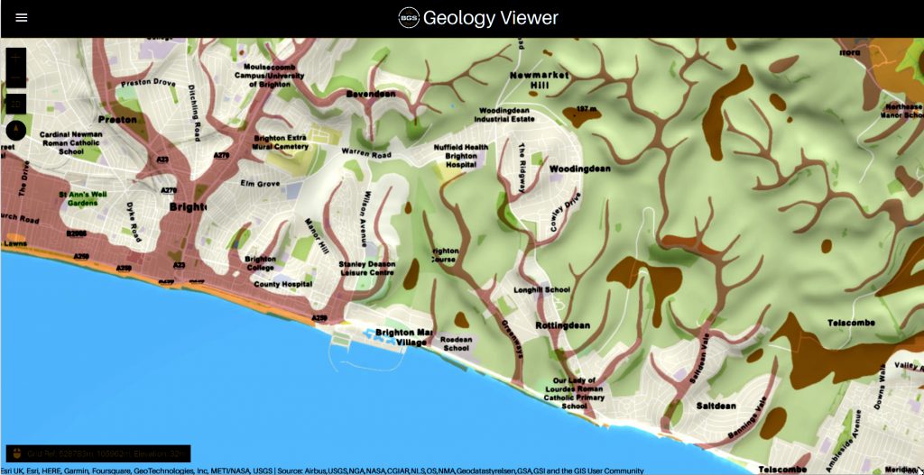
These ancient watercourses, now hidden beneath layers of sediment and time, are revealed to us through the meticulous cartography of the British Geological Society (BGS). Their maps unfurl a tapestry of geological memory, revealing the remnants of vast paleo-river systems that once cradled the waters of the past. The floodplains, marked by their unique sedimentary compositions, are not merely areas prone to contemporary flooding but are the fingerprints of ancient rivers that once dominated the landscape.

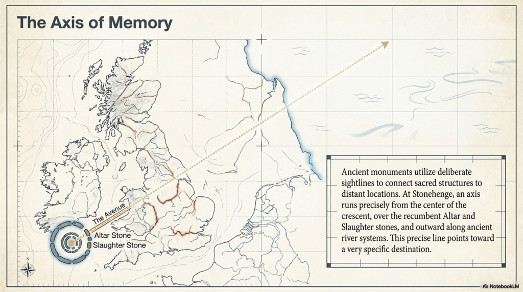
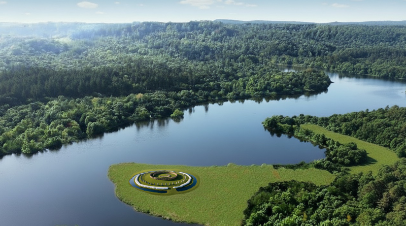
Our Mesolithic ancestors, attuned to the rhythm of this waterlogged world, chose the margins of these floodplains for their sacred sites and communal gatherings. Stonehenge, that enigmatic structure, stands as a testament to its profound connection with the land and its waterways. They navigated the flooded realms, moving from isle to isle, their lives intertwined with the ebb and flow of the waters.
The Fury of the Past: Natural Disasters in Historical and Prehistoric Britain

The evidence of these ancient flood plains and their impact on human settlement and activity is etched into the very bedrock of our island. A study of the BGS maps reveals a subterranean network of what were once mighty rivers and channels, especially in areas of chalk bedrock like Stonehenge. These geological whispers invite us to consider how our landscape has been shaped by water’s forceful hand, guiding our ancestors and shaping the course of our collective history.

In this contemplation, inspired by Bronowski’s reverence for the intertwining of science, history, and human endeavour, we are reminded of the enduring legacy of our planet’s natural forces. They beckon us to view our present and future through the lens of the deep past, understanding that the stories of storm surges, flooding, and climate are chapters in a much longer narrative of Earth and humanity.
(Extreme weather and Ancient Subterranean shelters)
Paleochannels – (The Fury of the Past: Natural Disasters in Historical and Prehistoric Britain)

Embarking on a journey of inquiry and reflection, we delve into the enigma of Britain’s dry river valleys. These landscapes, now silent and devoid of flowing waters, serve as a testament to the dynamic and ever-changing canvas of our planet’s geological and climatic history. Known to archaeologists, geologists, and the curious layperson alike as ‘Dry River Valleys,’ these formations beckon us to ponder the forces that sculpted them and the epochs they have witnessed.

Conventional wisdom held that the distinctive contours of these valleys, nestled within the chalk hills, were the handiwork of the Periglacial Phase of the Quaternary Period—a vast expanse of time that began around 2.6 million years ago. Yet the precise moment of their birth remains shrouded in the mists of prehistory, with no concrete evidence to mark their genesis.

Geology, a discipline ever ripe with evolving theories and reinterpretations, suggests these dry valleys were carved by the relentless flow of water, eroding topsoil and smoothing the underlying chalk during the thaw that followed an ice age. Yet the Quaternary Period is marked by a succession of ice ages, each leaving an indelible mark on the land. This presents a quandary for those who seek to understand not just the creation of these valleys, but the epochs in which they thrummed with the lifeblood of flowing rivers.

Post-Glacial Flooding

For archaeologists and geologists, the puzzle lies in discerning which ice age’s thaw sculpted these valleys into the landscape. The challenge is not merely academic; it bears significant implications for understanding the human story intertwined with these natural features. The timing of water coursing through these valleys could illuminate periods of human activity, migration, and settlement, shedding light on the ancient peoples who once lived alongside these now-vanished rivers.

Geological maps and studies suggest the existence of great rivers that once traversed the British Isles, sculpted by the monumental release of water at the end of the ice ages. The last great thaw, occurring some 17,000 years ago as the ice sheets, towering over two miles high in places, receded, would have unleashed floods of epic proportions. This deluge, the most significant in recent geological history, would have transformed the landscape, including the Valleys of the South Downs, far from the ice sheet’s edge.

The intrigue of these dry river valleys lies not solely in their geological formation but in the stories they hold of a world dramatically different from our own. To understand when these valleys last echoed with the sound of flowing water is to peel back layers of time, revealing insights into the climatic shifts that have shaped the earth and influenced the course of human civilisation.
(Extreme weather and Ancient Subterranean shelters)
Dry River Valley – Extreme Weather

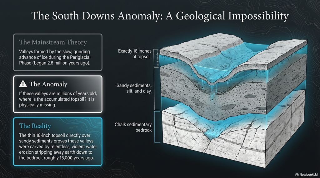
We are witnessing a paradigm shift in our understanding of Britain’s dry river valleys. Modern geological consensus now acknowledges that these features were carved not by the slow, grinding advance of ice but by the dynamic, erosive power of water. This revelation comes from observing the profound examples of soil erosion and the creation of valleys, where millions of gallons of water, moving with relentless force, stripped away layers of earth down to the bedrock.

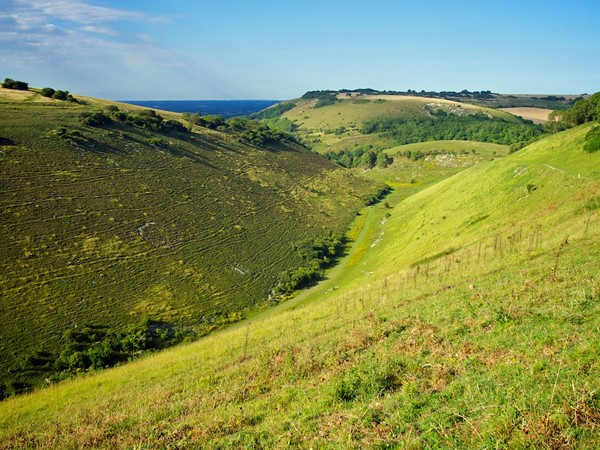
This narrative finds vivid illustration in the South Downs, where the cliffs and valleys bear silent testimony to ancient, post-glacial rivers. The region, much like the area surrounding Stonehenge, rests upon chalk sedimentary bedrock, shaped by the flows of yesteryear. The presence of these ancient watercourses is betrayed by the layers of sand, silt, and clay that comprise the subsoil, visible in the dales (valleys) of the South Downs and, most strikingly, on the faces of the chalky white cliffs. These cliffs, sculpted by the sea, offer a cross-sectional view into the past, revealing the sedimentary layers left by prehistoric rivers.

Contrary to earlier interpretations that attributed the formation of these geological features to windblown loess or wash from valley walls, the evidence suggests a different story. The discovery of sandy sediments, embedded within the chalk and lying in close proximity to the current topsoil, points to a more dramatic origin. These remnants of ancient rivers, dating back approximately 15,000 years to the aftermath of the last great melt, challenge the prevailing theories.

The puzzle for geologists and archaeologists alike lies in the thin veil of topsoil that covers these ancient sediments. If these valleys were as ancient as previously believed, the question arises: where has the expected accumulation of topsoil gone? Furthermore, if topsoil erosion occurs at the rate some experts claim, how do we account for the presence of 18 inches of topsoil atop the chalk in the present day?

These questions invite a reevaluation of our understanding of the landscape’s history, suggesting that erosion and sedimentation may not conform to the simplistic models previously proposed. The narrative of the South Downs and similar landscapes across Britain is not merely a tale of geological change but a reflection of the complex interplay between the earth’s natural forces and the passage of time.
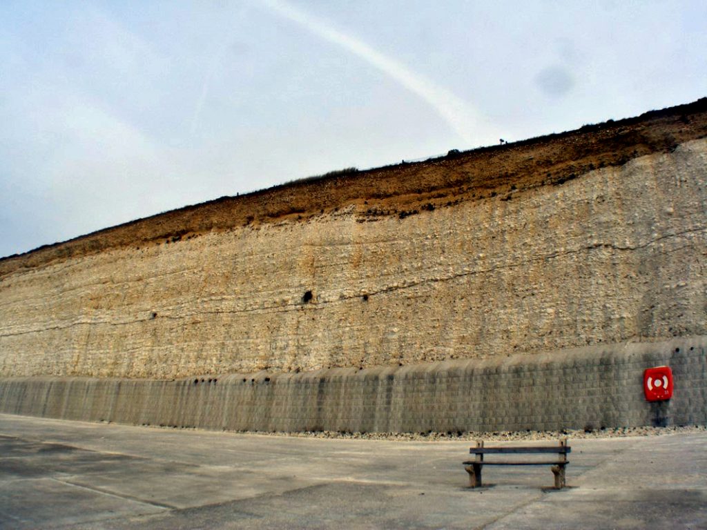
(Extreme weather and Ancient Subterranean shelters)
Paleochannel on South Downs cliff – (The Fury of the Past: Natural Disasters in Historical and Prehistoric Britain)

We find ourselves at a crossroads of questions concerning the sedimentary timelines and the environmental narratives of our ancient landscapes. The enigma of the seemingly scant topsoil overlaying the remnants of prehistoric river beds in places like the South Downs raises profound questions about our understanding of climatic events and geological processes. Are we on the brink of uncovering evidence of a massive climatic upheaval yet to come, one that could dramatically alter the topsoil? Or, perhaps more intriguingly, have we misdated the dry river valleys and the prehistoric river beds that cradle the foundations of our ancient history?

The puzzle deepens as we consider the architectural legacies of our ancestors, such as Woodhenge and the enigmatic site known as Durrington Walls. These ancient monuments, constructed with a profound understanding of their environmental context, may hold clues to the climatic and geological conditions of their time. The location and design of these structures, aligned with natural features and possibly informed by an awareness of floodplains and waterways, suggest a sophisticated interaction with the landscape that transcends mere habitation and ventures into the realm of reverence and ritual.

The construction of Woodhenge, positioned near the curious formation of Durrington Walls, invites speculation about the relationship between human society and the natural world in prehistoric times. Were these monuments erected in response to the environmental challenges faced by their builders, such as flooding or the need to navigate and control water resources? Or did they serve as markers of significant geological features, such as dry river valleys, embedding coded knowledge of the landscape’s history and cyclical transformations in their construction?

These questions compel us to reexamine our interpretations of the archaeological record, challenging us to integrate geological evidence with the cultural and spiritual dimensions of ancient constructions. The apparent discrepancy in the sedimentary record, marked by the proximity of ancient river sediments to the present-day topsoil, may not only point to gaps in our geological dating but also to a more complex understanding of how our ancestors interacted with and adapted to their environment.

Durrington Walls

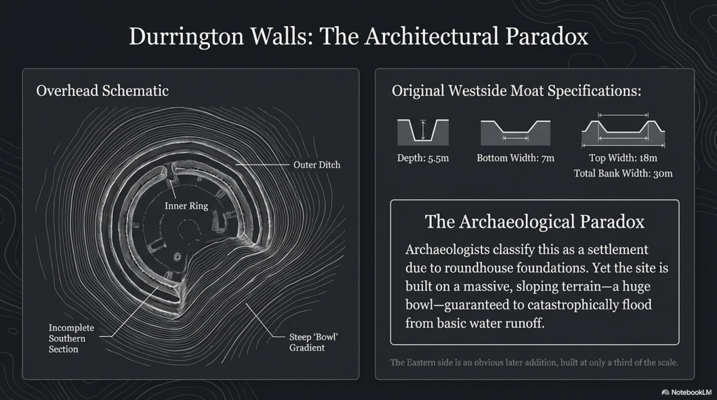
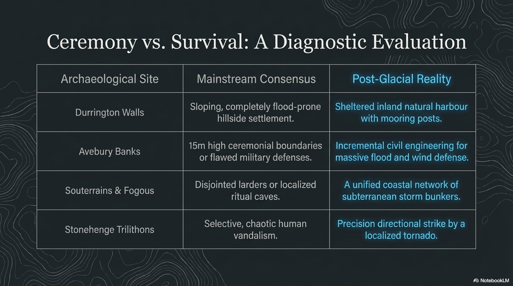
When you look at Durrington Walls, the first thing that strikes you is that it seems incomplete; it appears as a half-circle in aerial photographs, and from the ground, you get a sense that it is only half-finished. However, most illustrations include the easterly section because magnetometer surveys show more ditches beneath the surface, although you might question their purpose, as they are not apparent.  The easterly side of the site was clearly built much later than the original Westside. The East bank is smaller and does not match the initial ditch-and-moat specifications, which were roughly 5.5 m deep, 7 m wide at the bottom, and 18 m wide at the top. (The Fury of the Past: Natural Disasters in Historical and Prehistoric Britain)
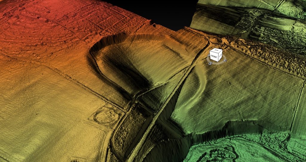
(Extreme weather and Ancient Subterranean shelters)
Durrington Walls showing harbour in the dip – (The Fury of the Past: Natural Disasters in Historical and Prehistoric Britain)

The bank was 30 m wide in some areas. The bank and ditch indicated by the magnetometer surveys are less than half that depth; the bank is only about a third the size of the one on the Northern side.  The current theory and plan for Durrington Walls do not stand up to investigation, for clearly the Eastern side of the camp was added later, when the prehistoric groundwater had begun to recede.

So what was its original use?

 To answer that question, you must look at the site’s terrain, position and layout. The first thing that hits you is that the site is not flat! In fact, it’s a huge bowl.
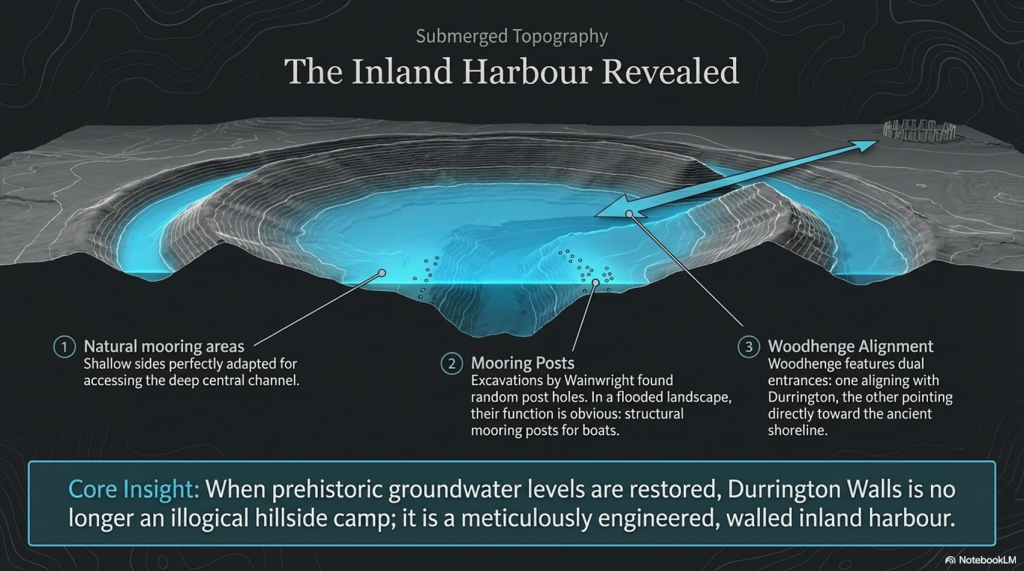
The Fury of the Past: Natural Disasters in Historical and Prehistoric Britain
Woodhenge & Durrington Walls Harbour- (The Fury of the Past: Natural Disasters in Historical and Prehistoric Britain)

The suggestion that our forebears might have chosen to establish settlements in locations that, to the modern eye, appear prone to flooding, invites a deeper investigation into the logic and environmental understanding of these ancient communities.

The case of Durrington Walls, traditionally interpreted as a settlement due to the discovery of roundhouse foundations, challenges contemporary notions of ideal habitation sites. The prevailing wisdom that discourages camping on a slope due to the risk of water runoff highlights a modern bias towards flat, stable ground. Yet the archaeological insistence on Durrington Walls as a settlement, despite its topographical peculiarities, might overlook the site’s strategic significance in relation to the environmental conditions of the time.
Harbour

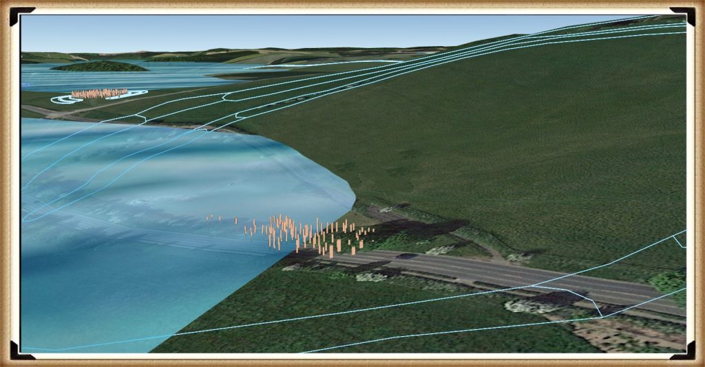
If we entertain the notion of significantly higher prehistoric groundwater levels, Durrington Walls transforms from a seemingly ill-chosen settlement into a potential natural harbour. The site’s configuration, with shallow sides ideal for mooring boats and a central ravine providing depth for watercraft, coupled with the remains of substantial external walls, suggests a sophisticated understanding of landscape and water management by its builders. Such a harbour, protected by formidable chalk walls, would have been a marvel of prehistoric engineering, offering shelter from the elements and facilitating trade or travel.

Woodhenge’s dual entrances further support the hypothesis of a water-centric landscape. One entrance aligns with Durrington Walls, suggesting a terrestrial connection, while the other, leading towards what would have been the ancient shoreline, implies a relationship with waterways. The presence of groundwater at Woodhenge, inferred from magnetometer surveys and the peculiarities of the site’s layout, underscores the adaptability and ingenuity of prehistoric peoples in harnessing their environment.

The evolution of the landscape, mirrored in the receding shoreline over millennia and the adaptation of human structures to these changes, reveals a dynamic interaction between our ancestors and their surroundings. The modern road, tracing the ancient shoreline’s path, serves as a tangible reminder of the deep history embedded in the land.

This reconsideration of Durrington Walls and Woodhenge as components of a prehistoric landscape intimately connected with water challenges us to think beyond conventional archaeological interpretations. It suggests that our ancestors were far from foolish in their choice of settlement locations. Instead, they possessed a profound understanding of their environment, selecting sites based on a complex array of factors, including access to water, natural protection, and the strategic advantages these locations offered.
(Extreme weather and Ancient Subterranean shelters)
Woodhenge and Durrington Walls Harbour – (The Fury of the Past: Natural Disasters in Historical and Prehistoric Britain)

We should not be too surprised by this, as lakeshores and coastlines still have paths along with them today so that we can fully enjoy them. There is no reason to believe that prehistoric people did anything different 8,000 years ago, and such a path would also have a practical purpose, as the shorelines were used as a mooring site.  If we are correct about the road and the mooring points, is it possible to find post holes here underground?

Unbelievably, the answer is yes!

Wainwright, in his excavations of Durrington Walls, discovered lots of them. Without a shoreline, the post holes would look random and not make much sense. However, as soon as the groundwater flooding is added, their function becomes apparent: they held mooring posts, as that is the natural landing area for boats coming to and from Stonehenge, Avebury or Old Sarum.  But are there other sites that have walls to protect them from the weather?

Avebury

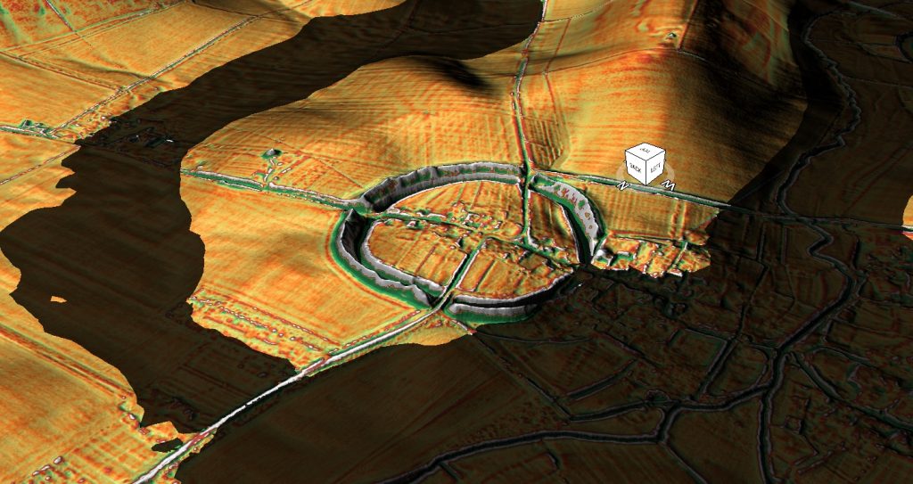
Navigating through the mysteries of Avebury and its ancient landscapes, we find ourselves in the midst of a dialogue that blends the profound insights of archaeology with the nuanced understanding of geology, much in the spirit of Jacob Bronowski’s interdisciplinary exploration. Avebury, nestled within the chalkland of the Upper Kennet Valley, presents a fascinating case study of human interaction with a dynamically changing environment.

The positioning of Avebury on a low chalk ridge, elevated above the surrounding landscape, and its proximity to the Marlborough Downs, speak to the strategic selection of this site by our ancestors. The discovery of flint artefacts dating to the late Mesolithic period suggests a long history of human presence, perhaps drawn by the natural resources and the strategic vantage point this location offers.
The Fury of the Past: Natural Disasters in Historical and Prehistoric Britain

The post-glacial flooding that reshaped the landscape around Avebury, transforming it into an almost island-like monument surrounded by waterways, highlights the profound impact of natural forces on human settlements. The effort to maintain Avebury’s island status through the construction of ditches and large banks reflects a determined human response to a changing environment, aimed at preserving the site’s symbolic or functional significance.

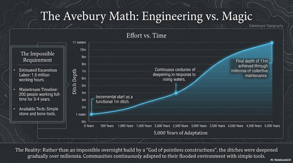
The estimated 1.5 million working hours required to construct the Avebury monument, involving 200 people working full-time for three to four years, underscores the monumental effort invested in this endeavour. This contrasts sharply with the even more staggering effort estimated for the construction of Silbury Hill, suggesting a remarkable dedication of resources and labour to these ancient projects. The discrepancy in the estimated working hours needed to move the respective volumes of chalk at Avebury and Silbury Hill raises intriguing questions about the methods, technologies, and organisational structures of prehistoric societies.

These ancient monuments, Avebury and Silbury Hill, stand as testaments to the ingenuity and resilience of our ancestors, who, faced with a world marked by extreme weather events and changing landscapes, sought to leave their mark through these colossal earthworks. The monumental scale of these projects, achieved without the modern machinery or technological aids available today, invites us to reconsider the capabilities of ancient societies and their profound connection to the landscapes they inhabited.
(Extreme weather and Ancient Subterranean shelters)
Avebury Harbour- (The Fury of the Past: Natural Disasters in Historical and Prehistoric Britain)

This is just another fact that does not make sense! –

There is just no consistency in archaeological findings; it’s all subjective, and quite frankly, wrong!

The suggestion that monuments like Avebury evolved gradually over centuries, with their ditches deepening from a modest one meter to the monumental eleven meters over 5,000 years, presents a compelling narrative of continuous human engagement with these sites. This slow but persistent expansion and deepening of the ditches could indeed offer a plausible explanation for the archaeological conundrum of the tools used in their construction.

The incremental growth of these monuments suggests a process deeply intertwined with the rhythms of prehistoric life, in which the maintenance and expansion of the ditches became part of the community’s ongoing relationship with their environment and heritage. The gradual excavation of the ditches, possibly for ritual cleansing, defence, or to expand the monument’s scope, would have allowed the use of simple tools available at the time. This contrasts with the daunting task of constructing such massive earthworks within a single generation, which would have required resources and coordination levels that seem less plausible without sophisticated tools and technologies.
The Fury of the Past: Natural Disasters in Historical and Prehistoric Britain

Giant Ditches

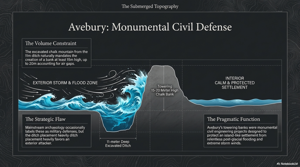
The analysis of the ‘chalk mountain’ formed from excavated material offers fascinating insights into the monument’s purpose and symbolism. The calculation that the bank could originally have stood at least 15 meters high, with the potential to reach 20 meters when accounting for chalk compression and air gaps, underscores the monumental effort invested in these structures. This towering presence would have dominated the landscape, serving as a potent symbol of the community’s identity, beliefs, and capabilities.

The bank’s considerable height, derived from the volume of chalk moved from the ditches, also speaks to the technical understanding and engineering skills of the people who built these monuments. The manipulation of the landscape on such a scale, with the tools and knowledge available at the time, demonstrates a sophisticated grasp of materials and a deep connection to the land itself.

This perspective, which sees the monuments growing organically over time, enriches our understanding of the relationship between prehistoric societies and their monumental creations. It suggests that these structures were not static symbols imposed on the landscape but dynamic, evolving entities that reflected the changing needs, beliefs, and aspirations of their builders.
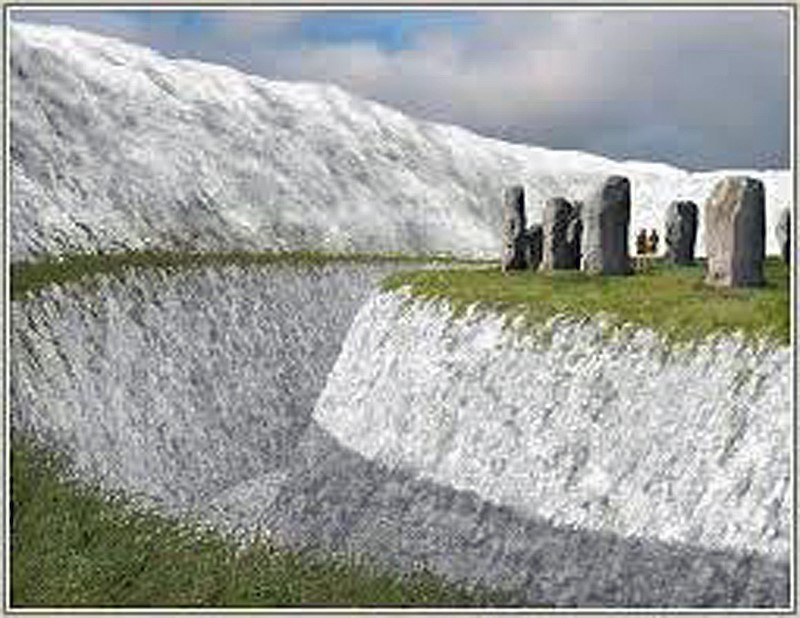
(Extreme weather and Ancient Subterranean shelters)
Avebury Harbour Walls- (The Fury of the Past: Natural Disasters in Historical and Prehistoric Britain)


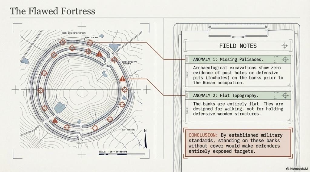
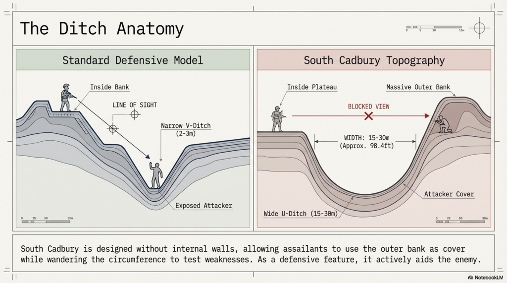
The endeavour to construct a 15-meter-high wall, especially within the context of ancient monumental architecture, invites a nuanced exploration that bridges the gap between archaeological theory and the lived realities of prehistoric communities. The suggestion that such walls were defensive structures, yet paradoxically positioned to ostensibly favour attackers, propels us into a deeper inquiry into the motivations and environmental challenges faced by these ancient builders.

The comparison with Durrington, where a high wall ostensibly serves a protective function for boats against wind and storms, suggests a pragmatic approach to construction that transcends mere defensive purposes. This insight challenges the notion of monumental walls as solely ceremonial or defensive and invites consideration of their role in mitigating the era’s environmental conditions.

The archaeological pivot to ‘ceremonial’ explanations in the face of such paradoxes, while often serving as a placeholder for the unknown, may indeed overlook the practical interactions between these ancient communities and their volatile climates. The humorously termed “God of pointless constructions and practices” belies a critical gap in our understanding of the symbiotic relationship between human societies and their environments.

Underground Bunkers

The suggestion that past weather was more severe and that the construction of shelters and walls was a response to these conditions is compelling. This perspective is supported by the presence of souterrains, or underground structures, which served as refuges from harsh weather. These structures, varying in design and function across regions, exemplify the adaptability and ingenuity of ancient communities in the face of climatic adversity.

The regional variation in the design of souterrains, from fogous in Cornwall that served as larders to other forms of underground shelter, underscores the diversity of responses to environmental challenges. This diversity not only highlights the practical considerations that drove the construction of monumental and subterranean structures but also reflects the rich tapestry of cultural practices that evolved in tandem with changing landscapes and climates.
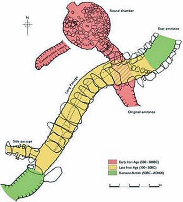
(Extreme weather and Ancient Subterranean shelters)
Souterrains- (The Fury of the Past: Natural Disasters in Historical and Prehistoric Britain)


The souterrains of Ireland, often colloquially termed ‘caves’, constitute a fascinating part of the archaeological and cultural landscape, rich in historical significance and imbued with the mysteries of the past. The scholarly works of individuals such as A.T. Lucas and the comprehensive study by Clinton in 2001 have provided invaluable insights into these subterranean structures, offering a window into their distribution, associated settlements, functions, and the chronology of their use.

Originating from the French term for “underground passageway,” souterrains were integral to the communities that constructed them, serving purposes that extended beyond the mere architectural or ceremonial. These underground galleries, often associated with settlements and ringforts, reflect a blend of ingenuity and necessity, designed to withstand the trials of their times.

Constructed by excavating earth and lining the resulting spaces with stone slabs or wood, souterrains were reburied to integrate seamlessly with the landscape. In instances where they were carved directly into rock, such elaborate preparations were unnecessary. Their functions, far removed from burial or ritualistic uses, leaned towards the practical, serving primarily as food stores or refuges during periods of conflict. The presence of souterrains within or adjacent to ringforts, and their dating to periods contemporary with these structures, suggests a synchronisation of defensive strategies and domestic planning.
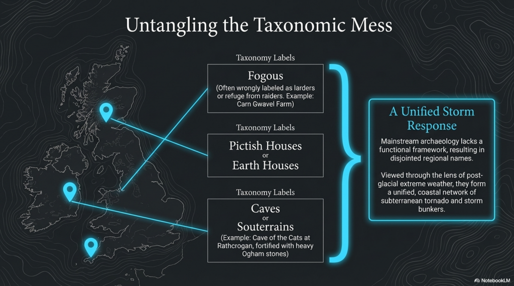
The Fury of the Past: Natural Disasters in Historical and Prehistoric Britain

The utilisation of ogham stones as structural elements within souterrains, and the repurposing of ancient script-bearing stones as roofing lintels or doorposts, underscores a fascinating intersection of cultural heritage and architectural necessity. Such practices highlight the adaptive reuse of materials and the deep-rooted connection between the physical and the symbolic in Irish heritage. The ‘cave of the cats’ at Rathcrogan stands as a prominent example, where the widened natural limestone fissure incorporates ogham stones, weaving together the threads of history, architecture, and mythology.

The distribution of souterrains in Ireland, particularly concentrated in certain counties, speaks to the geographical and environmental factors that influenced their construction. These underground structures, with their often obvious entrances, challenge our modern perceptions of secrecy and security, suggesting that their protective function was balanced with the practical needs of accessibility and use.

The first thing that strikes you as strange is the fact that these landscape features are categorised with different names in different locations:

Earth Houses – Modern use

Fogous – Cornwall

Pictish Houses – Found in Scotland (confusion arises here as some are only partially subterranean), unlike the Earth Houses in the same region.

Caves – Ireland

It’s quite literally an archaeological mess.  And the reason for this mess is that archaeologists don’t understand why they were built, so they gave them local names, unlike barrows, Stone circles and henges, which appear in the same areas but with a unified name to save confusion.  So, what can we find out about these structures that will help us understand why they were built?

Location, Location, Location

If we look at the minimal archaeological evidence, we do see a defined pattern of construction. For example, in Cornwall, we have found to date a collection of fifteen ‘fogous’.  According to archaeologists, this is a proposed use for fogous, a refuge during raiding trips, as they are close to the sea.  Sadly, if you look more closely, you see them in non-coastal areas and even in the middle of Dartmoor (Lade Hill Brook), where it’s called a Beehive Hut. 

The problem with looking for such objects in Devon is that hundreds of ‘caves’ are dotted around from the days of tin mining, and therefore it is almost impossible to distinguish a prehistoric mine opening from a fogou.
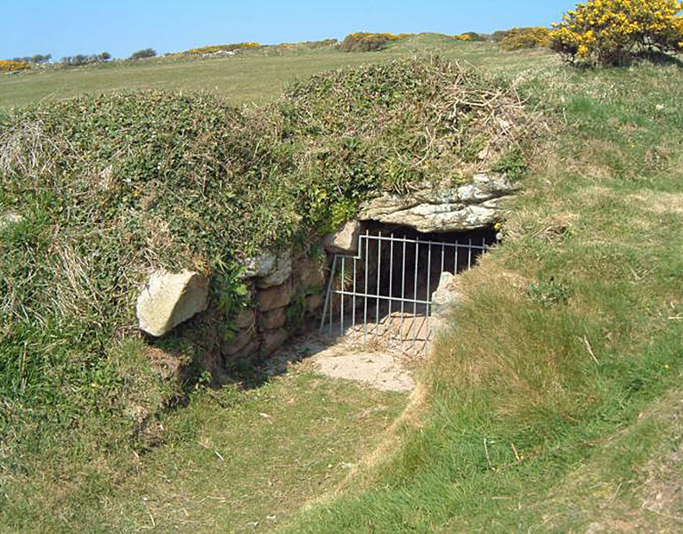
(Extreme weather and Ancient Subterranean shelters)
Fogou- (The Fury of the Past: Natural Disasters in Historical and Prehistoric Britain)


The exploration of subterranean structures across the British Isles and their potential functions opens a fascinating chapter in the study of prehistoric human adaptation to environmental challenges. The presence of fogous in Cornwall, notably the example at Carn Gwavel Farm on the Isle of Scilly, exemplifies the ingenuity of ancient communities in creating shelters that blend seamlessly with the landscape. These underground chambers, with their distinctive S-shaped curves and corbelled construction, suggest a level of architectural sophistication designed to address specific needs, whether for storage, habitation, or protection.

The orientation of fogous towards the SW-NE axis raises intriguing questions about their purpose. While some might speculate a religious or ceremonial significance, the practical considerations of climate and environmental exposure cannot be overlooked. The architectural similarities between fogous, chamber cairns, and passage chambers across different regions—each adapted to local conditions and available materials—underscore a widespread practice of constructing subterranean spaces for varied uses.

In regions like Ireland and Scotland, where these structures are more commonly found and referred to as ‘caves’ or ‘earth houses,’ their abundance points to a shared cultural practice of utilising underground spaces. The absence of similar structures in areas like Devon, Dorset, Somerset, and Wiltshire, juxtaposed with the concentration of other prehistoric monuments, suggests regional variations in responses to environmental and social pressures.

The situation in Wales, with its chambered cairns and passage chambers, adds another layer to this complex tapestry. The discovery of bodies within these structures has led to their classification as burial sites, yet the possibility that their original purpose evolved over time warrants consideration. The comparison to modern bunkers, which have found new uses beyond their original intent, illustrates the fluidity of human interactions with built environments.

Tornadoes

The hypothesis that these subterranean shelters were constructed in response to severe storm conditions, akin to practices in contemporary hurricane-prone areas of the USA, highlights a timeless human priority: the need for protection against the elements. This perspective offers a compelling narrative of prehistoric resilience and adaptability, suggesting that the construction of such shelters was a rational response to the challenges posed by a dynamic and sometimes hostile environment.

Understanding the motivations behind the construction of fogous and similar structures requires an interdisciplinary approach that considers archaeological evidence, environmental science, and historical climatology. The severity of prehistoric storms, as inferred from geological indicators of post-glacial flooding and climate change, provides a backdrop against which the necessity and ingenuity of these ancient shelters can be fully appreciated.

In contemplating these ancient structures, we are reminded of the enduring human capacity to innovate and adapt to the world’s ever-changing face. The legacy of fogous and their counterparts across the British Isles and beyond speaks to a deep-seated human instinct to seek shelter and safety in the face of nature’s fury, a testament to the ingenuity and resilience of our ancestors that continues to inspire and inform our understanding of human history.

But is there any other evidence that tornadoes hit Britain?

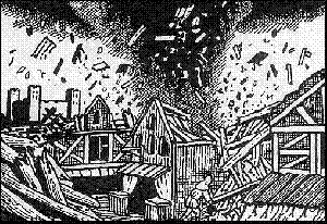
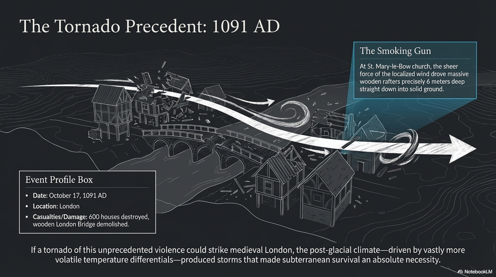
On 17th October 1091, London was hit by a vicious tornado.
The Fury of the Past: Natural Disasters in Historical and Prehistoric Britain
(The Fury of the Past: Natural Disasters in Historical and Prehistoric Britain)

The historical records describing the destruction wrought upon London, including the demolition of the wooden London Bridge, the devastation of 600 houses, and the severe damage to St. Mary-le-Bow church, underscore the formidable power of natural forces. The detail of rafters being driven six meters into the ground at St. Mary-le-Bow vividly illustrates the intensity of the event, likely a tornado, which also resulted in loss of life and widespread homelessness. This account provides a stark reminder of the vulnerability of even the most seemingly permanent human constructions to the whims of nature.

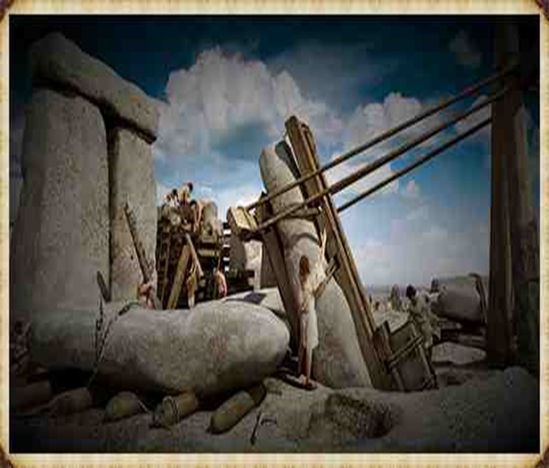
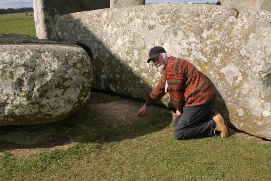
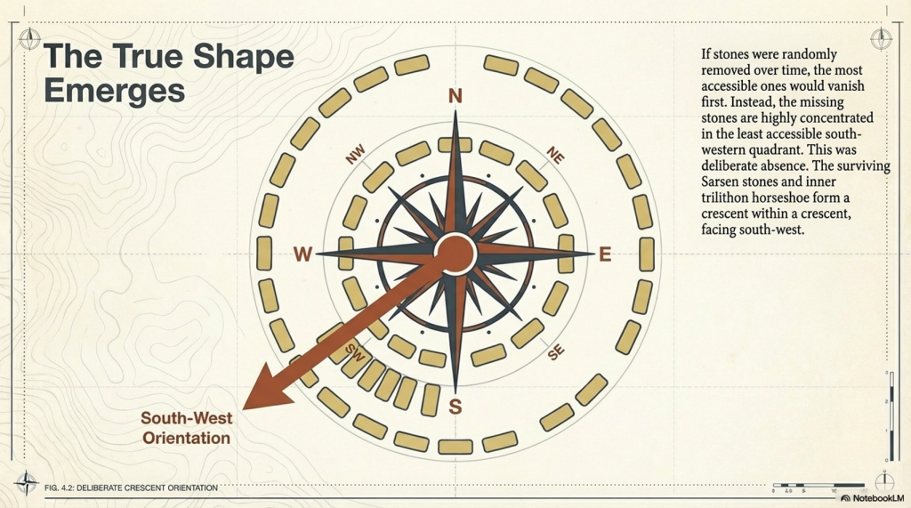
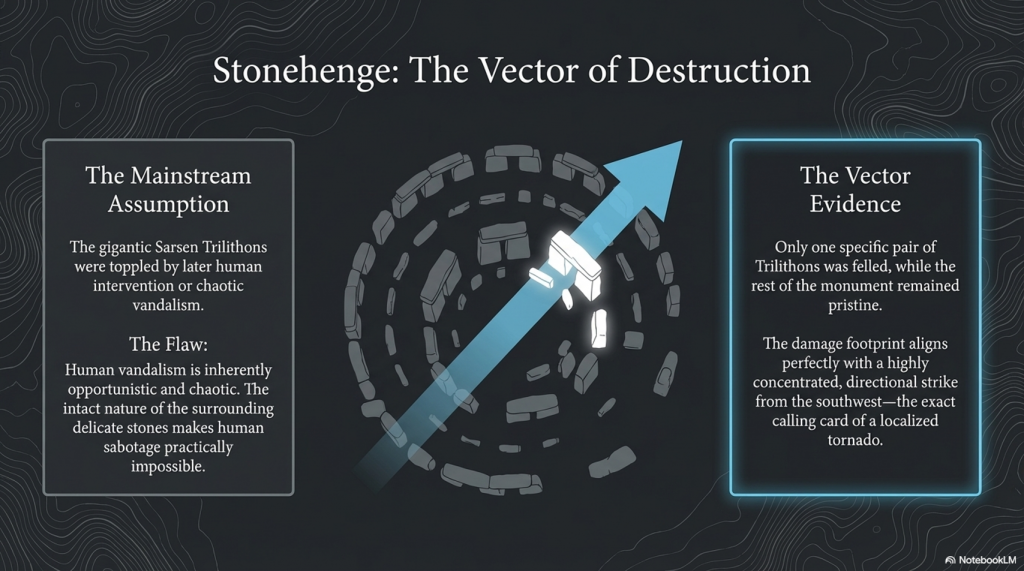
The enduring mystery surrounding Stonehenge, particularly the toppling of the gigantic Sarsen Trilithon Stones, invites a reconsideration of the forces capable of such feats. The traditional assumption that human intervention aimed at dismantling the monument falls short in light of the damage’s selective nature. The hypothesis of a tornado strike from the southwest offers a compelling alternative explanation, aligning with the directional pattern of damage observed at the site. The fact that only one pair of the trilithons was felled, while the rest of the monument remained relatively intact, suggests an event that combined immense power with precise directionality, characteristics emblematic of tornadoes.
The Fury of the Past: Natural Disasters in Historical and Prehistoric Britain

Tornadoes, though not commonly associated with Britain’s climate in the popular imagination, are indeed part of the British weather landscape, albeit on a smaller scale than in regions like the United States. The potential for a tornado to have caused the specific pattern of destruction observed at Stonehenge challenges preconceived notions about the stability of such ancient structures and the range of natural disasters that have affected them throughout history.

The observation made by Stukeley in the 16th century and the subsequent ‘repairs’ at the turn of the last century underscore the ongoing interaction between human efforts to preserve or restore ancient monuments and the natural processes that continue to shape them. This dynamic interplay highlights the fragility of our cultural heritage and the importance of understanding the human and natural factors that have influenced these iconic structures over millennia.

In exploring the possibility that tornadoes could impact Stonehenge, we are reminded of the broader implications of climate and environmental forces for archaeological sites. Such considerations not only enrich our understanding of the past but also inform preservation strategies for safeguarding our cultural heritage against future natural events. The case of Stonehenge serves as a poignant example of the complex relationship between human history, natural phenomena, and the ongoing efforts to interpret and preserve the legacies of ancient civilisations in the face of nature’s capricious power.
The Fury of the Past: Natural Disasters in Historical and Prehistoric Britain

PodCast

Author’s Biography

Robert John Langdon, a polymathic luminary, emerges as a writer, historian, and eminent specialist in LiDAR Landscape Archaeology.

His intellectual voyage has been interwoven with stints as an astute scrutineer in government and grand corporate bastions, a tapestry spanning British Telecommunications, Cable and Wireless, British Gas, and the esteemed University of London.

A decade hence, Robert’s transition into retirement unfurled a chapter of insatiable curiosity. This phase saw him immerse himself in Politics, Archaeology, Philosophy, and the enigmatic realm of Quantum Mechanics. His academic odyssey traversed the venerable corridors of knowledge hubs such as the Museum of London, University College London, Birkbeck College, The City Literature Institute, and Chichester University.

In the symphony of his life, Robert is a custodian of three progeny and a pair of cherished grandchildren. His sanctuary lies ensconced in the embrace of West Wales, where he inhabits an isolated cottage, its windows framing a vista of the boundless sea – a retreat from the scrutinising gaze of Her Majesty’s Revenue and Customs, an amiable clandestinity in the lap of nature.

Exploring Prehistoric Britain: A Journey Through Time

My blog delves into the fascinating mysteries of prehistoric Britain, challenging conventional narratives and offering fresh perspectives grounded in cutting-edge research, particularly LiDAR technology. I invite you to explore some key areas of my research. For example, the Wansdyke, often cited as a defensive structure, is re-examined in light of new evidence. I’ve presented my findings in my blog post Wansdyke: A British Frontier Wall – ‘Debunked’, and a Wansdyke LiDAR Flyover video further visualises my conclusions.

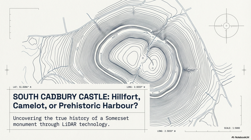
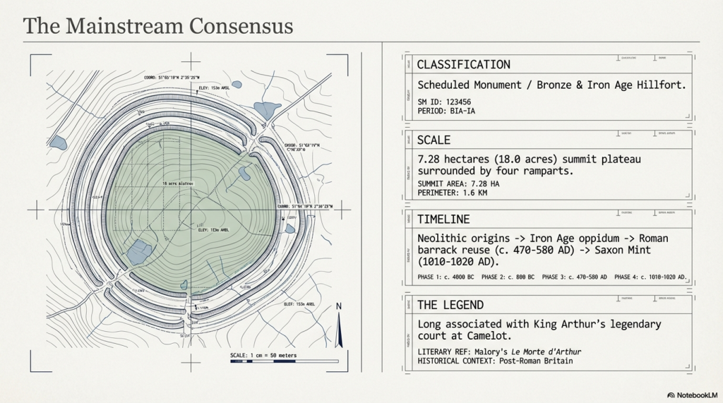
My work also often challenges established archaeological dogma. I argue that many sites, such as Hambledon Hill, commonly identified as Iron Age hillforts, are not what they seem. My posts Lidar Investigation Hambledon Hill – NOT an ‘Iron Age Fort’ and Unmasking the “Iron Age Hillfort” Myth explore these ideas in detail and offer an alternative view. Similarly, sites like Cissbury Ring and White Sheet Camp receive re-evaluations based on LiDAR analysis in my posts “Lidar Investigation Cissbury Ring through time” and “Lidar Investigation White Sheet Camp,“ revealing fascinating insights into their true purpose. I have also examined South Cadbury Castle, often linked to the mythical Camelot56.

My research also extends to ancient water management, including the role of canals and other linear earthworks. I have discussed the true origins of Car Dyke in multiple posts, including Car Dyke – ABC News Podcast and Lidar Investigation Car Dyke – North Section, which suggest a Mesolithic origin 2357. I also explore the misidentification of Roman aqueducts, as seen in my posts on the Great Chesters (Roman) Aqueduct. My research has also been greatly informed by my post-glacial flooding hypothesis, which has helped explain landscape transformations over time. I have discussed this hypothesis in several posts, including AI now supports my Post-Glacial Flooding Hypothesis and Exploring Britain’s Flooded Past: A Personal Journey

Finally, my blog also investigates prehistoric burial practices, as seen in Prehistoric Burial Practices of Britain and explores the mystery of Pillow Mounds, often mistaken for medieval rabbit warrens, but with a potential link to Bronze Age cremation in my posts: Pillow Mounds: A Bronze Age Legacy of Cremation? and The Mystery of Pillow Mounds: Are They Really Medieval Rabbit Warrens?. My research also includes astronomical insights into ancient sites, for example, in Rediscovering the Winter Solstice: The Original Winter Festival. I also review new information about the construction of Stonehenge in The Stonehenge Enigma.

Further Reading

For those interested in British Prehistory, visit www.prehistoric-britain.co.uk, a comprehensive resource featuring an extensive collection of archaeology articles, modern LiDAR investigations, and groundbreaking research. The site also includes insights and excerpts from the acclaimed Robert John Langdon Trilogy, a series of books that explore Britain during the Prehistoric period. Titles in the trilogy include The Stonehenge Enigma, Dawn of the Lost Civilisation, and The Post-Glacial Flooding Hypothesis, which offer compelling evidence of ancient landscapes shaped by post-glacial flooding.

To further explore these topics, Robert John Langdon has developed a dedicated YouTube channel featuring over 100 video documentaries and investigations that complement the trilogy. Notable discoveries and studies showcased on the channel include 13 Things that Don’t Make Sense in History and the revelation of Silbury Avenue – The Lost Stone Avenue, a rediscovered prehistoric feature at Avebury, Wiltshire.

In addition to his main works, Langdon has released a series of shorter, accessible publications, ideal for readers delving into specific topics. These include:

For active discussions and updates on the trilogy’s findings and recent LiDAR investigations, join our vibrant community on Facebook. Engage with like-minded enthusiasts by leaving a message or contributing to debates in our Facebook Group.

Whether through the books, the website, or interactive videos, we aim to provide a deeper understanding of Britain’s fascinating prehistoric past. We encourage you to explore these resources and uncover the mysteries of ancient landscapes through the lens of modern archaeology.

For more information, including chapter extracts and related publications, visit the Robert John Langdon Author Page. Dive into works such as The Stonehenge Enigma or Dawn of the Lost Civilisation, and explore cutting-edge theories that challenge traditional historical narratives.

Other Blogs

[sitemap_posts]

Archaeology in the Post-Truth Era

Introduction

Over the past ten years, I’ve faced a constant uphill battle to establish what I consider a straightforward conclusion—that Linear Earthworks are not defensive structures or boundary markers but prehistoric canals. It’s a claim that’s been dismissed repeatedly, often without proper engagement, but that resistance never stopped the work.(Archaeology in the Post-Truth Era)

Instead, it pushed me further. I carried out a full survey of over 1,500 of Historic England’s Scheduled Linear Earthworks, systematically analysing their form, placement, and context. That work eventually led to the first book in what has now become a larger series, focusing specifically on the East Wansdyke area. For me, that publication wasn’t just another book—it was a milestone. It represents a level of detailed, landscape-wide analysis that, to date, no university or research team has attempted at this scale.

(Britain's Giant Prehistoric Waterways)
Archaeology in the Post-Truth Era

The book itself takes a forensic approach. Every aspect of East Wansdyke is examined and placed into a wider framework—what I define as an ancient prehistoric canal system. The aim is simple: to challenge the existing archaeological narrative, not with speculation, but with measurable, testable evidence. The traditional explanations—defensive lines, territorial markers—don’t hold up under scrutiny. They lack physical evidence, contradict their own logic, and fail to explain the most basic characteristics of these structures.

What emerges instead is something far more significant. If these earthworks are canals, then we are looking at a completely different level of engineering capability in prehistory. These were not crude societies marking out land or preparing for war—they were shaping landscapes, managing water, and building infrastructure on a national scale. This not only challenges the archaeological community but also opens the door to a broader re-evaluation of how prehistoric landscapes were understood and used.

Archaeology in the Post-Truth Era

Embarking on this journey was not without its challenges, especially in an era where scepticism often overshadows scientific evidence. The response to my publication, which I had hoped would ignite a meaningful academic debate, was instead largely silent. Despite the use of modern LiDAR technology and a dataset far beyond what had previously been attempted, the work was either ignored or dismissed as speculative.

This resistance was mirrored on social media, where entrenched views dominated discussion. Any attempt to challenge established narratives was met with denial rather than engagement. Peer review, rather than being treated as part of an evolving process, was often presented as a final and unquestionable authority.

The Dyke Myth Collapse
Archaeology in the Post-Truth Era

This kind of blind adherence to established ideas is not unique to archaeology. It is a pattern repeated across disciplines, where existing frameworks are protected rather than tested. New evidence is not examined on its merits but rejected because it disrupts the accepted model.

That was the position in 2014.

Now, two years on, we can assess that position against new evidence—and, more importantly, against the predictions made at the time.

What has emerged since then is not a contradiction of the original work, but a direct reinforcement of it.

The borehole data, when analysed correctly using elevation rather than arbitrary depth, has revealed consistent clustering of water-related deposits at specific heights across multiple independent locations. Statistically, this pattern is highly unlikely to occur by chance and instead points to a structured, elevation-controlled hydrological system operating across the landscape.

Archaeology in the Post-Truth Era

At the same time, the mathematical framework behind the Post-Glacial Flooding Hypothesis has continued to develop. The mass-balance calculations, combined with ice-volume scaling and groundwater discharge modelling, demonstrate that Britain remained in a prolonged state of elevated water tables and enlarged river systems for thousands of years after the end of the last Ice Age.

This confirms a critical point:

The rivers of the past were higher than those we see today.

And once that is understood, the entire interpretation of Linear Earthworks shifts.

Rethinking The Past
Archaeology in the Post-Truth Era

Because these structures are not randomly placed. They align with contours, connect basins, and sit within hydrological positions that make sense only under sustained high water levels. Their form, scale, and distribution are consistent with water management—not defence, not boundaries, but controlled flow.

In other words, the environmental conditions required for canals are now demonstrably present.

This is the key difference between 2014 and 2026.

In 2014, the argument was based on landscape logic, structural analysis, and comparative reasoning.

In 2026, that same argument is now supported by independent physical data and mathematical proof of the environmental conditions required for it to function.

The conclusion, however, has not changed.

Linear Earthworks were constructed in a landscape defined by elevated water tables and expanded river systems. Within that context, their most coherent and evidence-based interpretation remains exactly what was originally proposed.

They were canals.

Archaeology in the Post-Truth Era

And perhaps most importantly, this progression follows the correct scientific sequence.

The prediction came first.

The evidence followed.

And that is not speculation—that is validation.

Archaeology in the Post-Truth Era
Fundamentalist

Wansdyke

In my book, I meticulously addressed every single meter of East Wansdyke, providing compelling evidence that challenges the traditional interpretation of Wansdyke as either a defensive structure or a boundary marker. My research and analysis have convincingly demonstrated that East Wansdyke was, in fact, part of a prehistoric canal system, a finding that significantly alters our understanding of the landscape and the capabilities of the people who engineered it. This conclusion was reached through a combination of detailed survey work, the application of modern technologies such as LiDAR, and a critical review of the archaeological and historical records.

However, one critic, emblematic of the resistance I’ve encountered, sought to undermine my hypothesis by citing a site associated with West Wansdyke. This individual argued that because West Wansdyke was built on a ‘late Iron Age’ fortification, it must, therefore, be of Saxon origin, aiming to cast doubt on my entire thesis by focusing on this one aspect. It’s a classic example of attempting to discredit a comprehensive theory by finding fault with a single, arguably tangential, element.

Archaeology in the Post-Truth Era

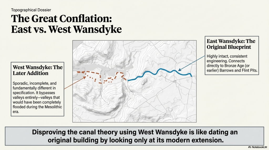
In my response, I emphasised that this site, situated in West Wansdyke, falls outside the primary focus of my research on the East Wansdyke segment. More importantly, I had already anticipated such objections and addressed them directly in my book. I concluded that West Wansdyke, while geographically related, was connected to the original canal system at a later date, likely by the Romans. This connection was based on evidence suggesting that West Wansdyke is incomplete, sporadic, and differs in specification from East Wansdyke, indicating a distinct phase of construction and purpose.

The dismissal of West Wansdyke from my primary analysis was not arbitrary but a considered decision grounded in the evidence and the scope of my research. It reflects a methodological approach that prioritises coherence, specificity, and relevance in building a historical narrative. The critique of my work that focuses on West Wansdyke, therefore, misses the mark. It overlooks the rigour of my research process and the clear rationale provided for the conclusions drawn about East Wansdyke and its role within a broader prehistoric canal system.

Archaeology in the Post-Truth Era

This encounter serves as a reminder of the challenges inherent in advancing new theories in archaeology, especially those that significantly depart from established interpretations. It also underscores the importance of clarity, precision, and thoroughness in both research and communication, qualities I strived to embody in my work on East Wansdyke.


West Wansdyke

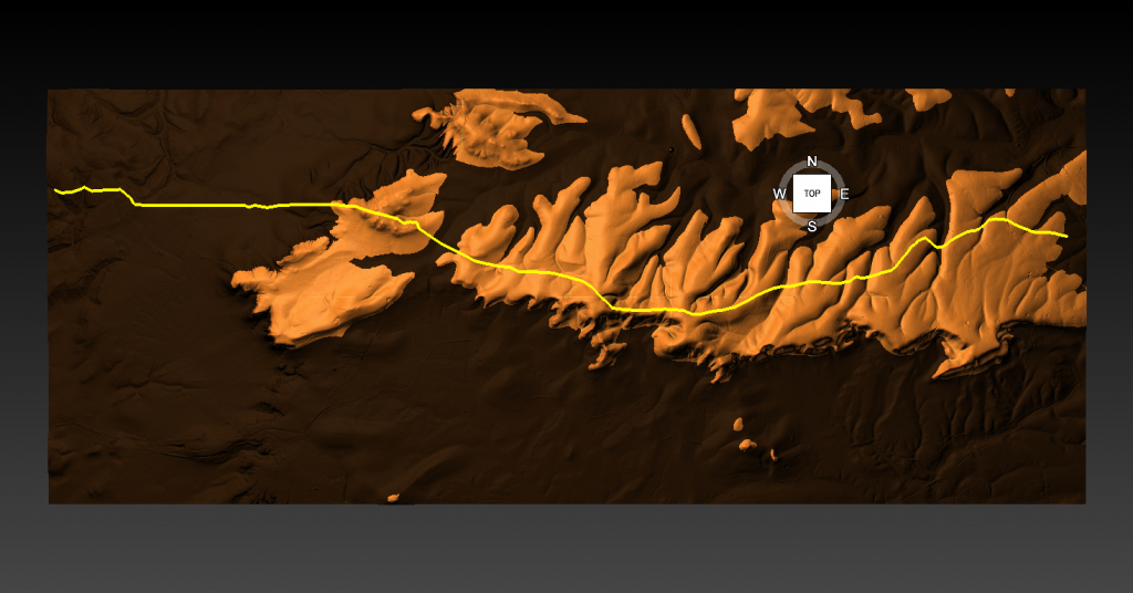
We have a problem with West Wansdyke – it’s not part of East Wansdyke. This has always been a historical debate over the last 100 years. If we look at the limited archaeological evidence, we find that although it may have been a much later Canal/Dyke it is not contemporary with the East Wansdyke canal and was not built at the same time.

Excavations conclusively show that the Ditches on the East side of Wansdyke are much more profound and twice as broad. In contrast, the Banks on the East Side are much wider. We see that East Dyke was built first, as our River height model shows that most of West Wansdyke would have been flooded or marshland at the time of use.

LocationWansdyke
BankDitchExcavator notes
MaterialsWidthHeightBermWidthDepthCounterscarp 
EAST        
Red ShoreClay/Flints9.52N103.9YGreen 1966
Sheppard’s shore 102.3N103.9YPitt Rivers 1888
Brown’s Barn 92.3N103.9YPitt Rivers 1891
WEST        
Binces Lane WestStoney12.5????3.51.7YErskine 1990s
Binces Lane EastStoney?5?N62.4?Erskine 1990s
Compton GreenClay marl130.8Y5.82.8YErskine 1990s
Blackrock LaneSilty Clay12.51.7Y4.82.7?Erskine 1990s
Park farmStones100.4Y5.52.4YErskine 1990s
Fairy Hill 13?Y6.5? Erskine 1990s
West Wansdyke Excavation

When the waters receded (possibly Early Iron Age period), it is possible that the Dyke was extended, or the more probable event of East Wansdyke after it dried up was turned into a roadway and what we see in West Wansdyke is the extension of the road, and hence it is wider than in the East.

Archaeology in the Post-Truth Era

We also see more shallow ditches as they were not used for water but to obtain soil for the walkway and become drainage ditches.

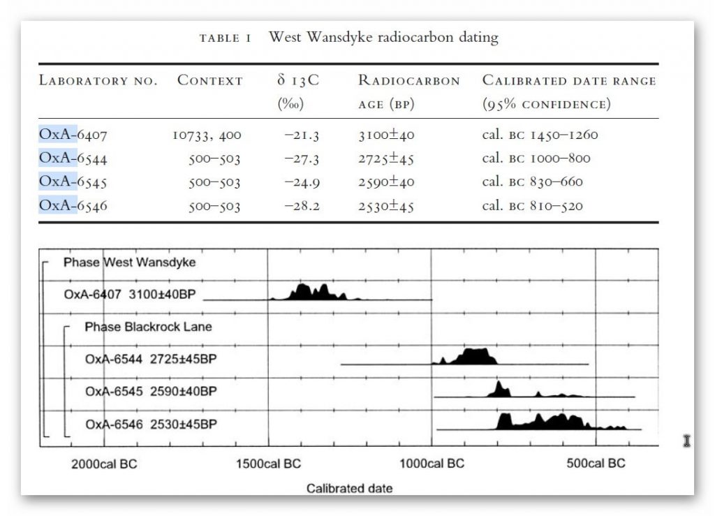
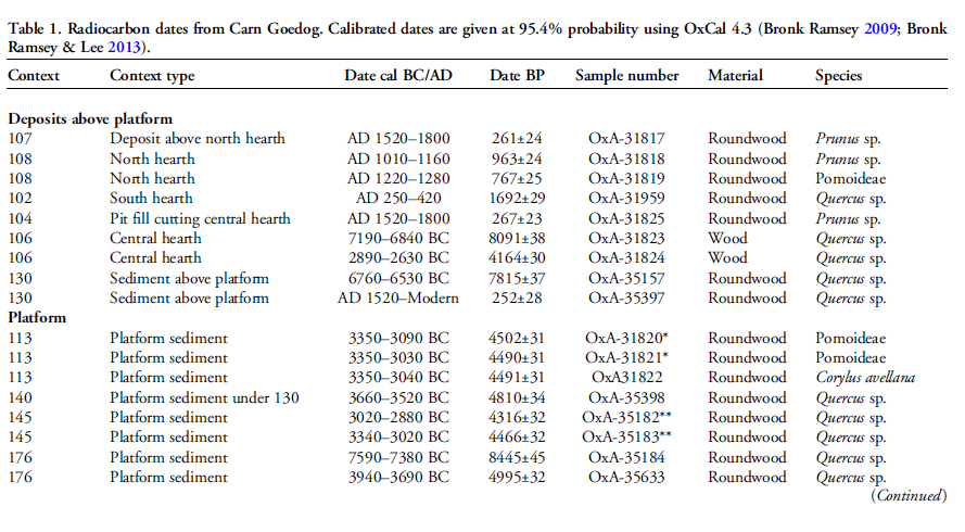
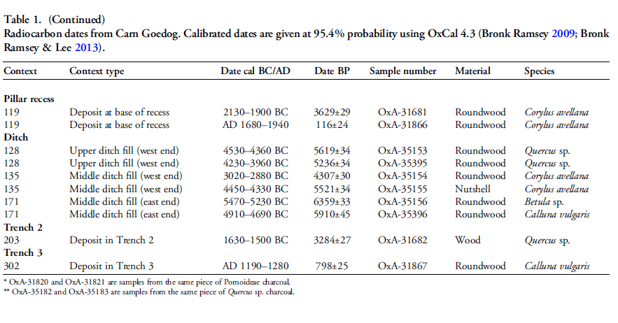
Indeed, we know the Romans used this as a road and always had drainage ditches, usually on both sides. This is supported by carbon dating at Erskine’s excavation at Blackrock Lane, where the section appeared to have been sealed by the primary bank material. One of these layers contained significant concentrations of woody oak charcoal.

Samples of this material were submitted to the Ancient Monuments Laboratory for radiocarbon dating to provide a possible construction of the bank. Unfortunately, as shown in the table below – sadly, as standard when scientific evidence disproves the current archaeological narrative – it is ignored and classified as an error.

Archaeology in the Post-Truth Era

Table 1. Erskine, Jonathan. (2007). The West Wansdyke: an appraisal of the dating, dimensions and construction techniques in the light of excavated evidence. Archaeological Journal. 164. 80-108.


The other missing aspect, shown in East Wansdyke but not in West Wansdyke, was the massive connection to Barrows and Flint Pits. Again, this connection is not seen on West Wansdyke, which may help date this monument, as the barrows were of the Bronze Age or earlier, and, as we have seen from the carbon dating evidence at Blackrock Lane, much earlier than its 1500 BCE date.

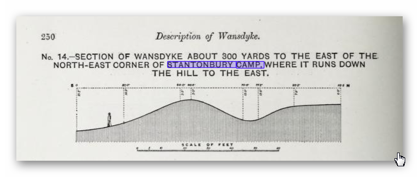
Statonbury Camp near Bath – an example of West Wansdyke

If we look at the Scheduled parts of the Wansdyke – we see that the East is very much intact, but the West is sporadic at best, and it’s hard to find a logical link to all the Dykes that seem to only appear over hills and not in the valley’s – which in my view would have been flooded in the Mesolithic and hence the west sections addition after East Wansdyke’s construction – probably by the roman’s who may have utilised the Dyke system for their own transportation reasons. But for the sake of scientific curiosity, let’s take a detailed look at Stantonbury Hill site, which is classified as an Iron Age Camp, with Wansdyke making up one of the defensive banks – but before we delve deeper into the field archaeology of the site – I feel I must clarify the use of the classification of ‘Iron Age Fort’ by archaeologists.

All sites that sit on top of hills and have ditches are called Iron Age Forts – sadly, I have yet to find a single location that is either ‘Iron Age’ or a ‘Fortification’, as not a single dead body from slaying has ever been found, and all the so-called defensive ditches EVER!! Yet the archaeological world continues to use this misleading classification, which confuses the public, as if it has been qualified and proven. So, back to Statonbury camp. The only investigation of this site was made by Fox and Fox in 1956 as part of their survey of Wansdyke in the publication ‘Wansdyke reconsidered.’ It should be noted that Historic England does not have an account with their scheduling as no excavation work has ever been undertaken, and so only field walking has been undertaken, and so the results are subject to the field walker.

Archaeology in the Post-Truth Era


In Fox’s publication, they also question the linkage of East and West Wansdyke through other, even older publications and field surveys, which call into question the logic of dating this linear earthwork. That great antiquary, Sir Richard Colt Hoare, had his doubts about the identification, which he endeavoured to suppress in his account of the earthwork in Ancient Wiltshire,


‘ Hitherto we have been enabled to trace the course of Wansdyke with certainty and success through Somersetshire, but on approaching the neighbouring county of Wiltshire we enter upon a new and doubtful field of inquiry respecting the direction as well as the formation of this celebrated rampart.’


His own observations in the field had shown him that in this central sector ‘ it bears the decided appearance of a Roman causeway, not of a Belgic or Saxon boundary and yet he felt obliged to support the current view that road and dyke were identical because he was convinced that the Wansdyke was continuous and he could find no alternative course for it in the area. Sir R. C. Hoare also observes that the camps appear to have been added to the Dyke, not the Dyke formed to connect the camps, which may be noticed especially at Stantonbury Camp, the second on the line of the course of Wansdyke through Somersetshire.


They continue
……


General Pitt-Rivers, also had misgivings, ‘ the Dyke he comments, in the Heddington region,’ is of very low relief everywhere on this line and it has often been questioned whether it is a dyke or a road’, and his suspicions were again aroused at a point west of Morgan’s Hill and on Bowden Hill near Lacock’.

Stanton Camp - Not Defensive
Stanton Camp – Not Defensive


On Statonbury Camp, there are not very helpful and report that:

Stantonbury is a univallate Iron Age hill-fort enclosing some 30 acres on the crest of the hill : until very recently it was waste ground going back to thorn scrub and islanded in dense woodland, as can be seen on the air-photo (Pl. VIIIB). The hill top (580 ft.) commands a wide view : from here the whole of the countryside traversed by West Wansdyke can be seen, Maes Knoll to the west. Odd Down to the east, as well as an uninterrupted stretch northwards to the Avon valley and the Cotswolds beyond. From here, the major alignment was probably planned (fig. 19 and p. 37).


In 1956-7 the hill top has been ploughed again, and the much reduced Iron Age defences are visible on the edge of the cultivation. It appears to us that Wansdyke was not constructed along the north-facing hill slope, and that as at Old Oswestry hill-fort, on Wat’s Dyke in Montgomery, the Iron Age defences were deemed sufficient. There is, however, as General Pitt-River’s level section shows, a steep scarp below the traces of the ploughed-in Iron Age ditch, which may be artificial and post-date the hill-fort, but this is uncertain.
East of the fort, in field 20, which is now occupied by a plantation and a pheasantry, the Dyke continues as a scarp for as far as we were able to trace it through the nettles and undergrowth. Below the 500 ft. contour, the large bank and ditch reappear in the dense woodland, and emerge beside the lane leading to the road to Stanton Prior, where the earthwork measures 75 ft. overall.


So, according to Fox and Fox, Wansdyke stops short and accepts the North Face is the Iron Age Site – therefore, if the Wansdyke had been cut to the north of the site, the Iron Age fort replaced it, which is not as the Jihad had claimed?

So where did he get this ‘ground-breaking’ revelation? For this, we must go not to a peer-reviewed book but a website ‘wansdyke21.org.uk’ by Robert Vermaat

He suggests that: It has been suggested by Fox & Fox that Wansdyke did not actually use Stantonbury Camp, the ditch stopping short of the Iron Age defences by several metres. However, Burrow showed in 1982 that this was incorrect. Although the western slope is much disturbed by quarrying and the lower slopes by cultivation, Wansdyke can still be traced quite well at several points on the hill. As with Maes Knoll, the northern defences are more prominent than those on the south side. As Wansdyke joins the defences here, it can be argued that, as was the case at Maes Knoll, the northern defences were refurbished when Wansdyke was constructed, neglecting the south side which was without use for the builders of Wansdyke.

Archaeology in the Post-Truth Era


If only we had £64 to see this so-called evidence from Field walking by burrows (as we know it was not excavated and LiDAR was not in use)!!


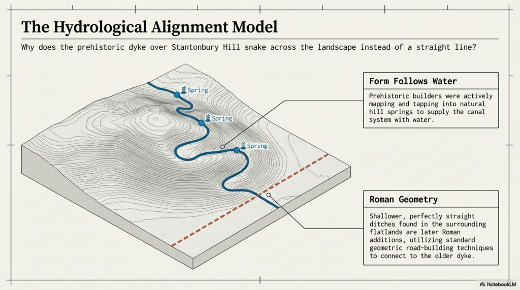
Fortunately, we have now obtained high-resolution LiDAR images of Statonbury Camp, and we can see that Wansdyke goes over the hill in a strange ‘wibbly wobbly’ way rather than a straight line – which we see on either side of the hill from much shallower ditches. This suggests that the area was not built entirely at the same time, and that the Hill Dyke is older than the flat ground levels surrounding the hill.

My estimate from the evidence in the smaller ditches is that they are Roman (and hence straight) in origin, which connects to the earlier prehistoric Dyke over Statonbury Hill, which the archaeologists call West Wansdyke (part of). The path over the hill indicates that the builders were attempting to locate natural springs as they built the Dyke to supply it with water, and hence the strange pathway.

Closer inspection of the Dyke as it approaches the ‘Iron Age Site’ suggests that it splits and shifts the bank from north-facing to south-facing, which Fox had seen as a terminus of the Dyke, for it reached the Fort. LiDAR clearly shows that the ditch moves to the south side of the bank and continues to create the East side of the fort, finally terminating in the South.

Also, the shape of the fort is not consistent, as it has rounded edges in the SE and SW regions but flat T-Junctions in the NE and NW, where it meets Wansdyke – indicating it was added to the existing Wansdyke canal either at the time of construction or a later date.

PodCast

Author’s Biography

Robert John Langdon, a polymathic luminary, emerges as a writer, historian, and eminent specialist in LiDAR Landscape Archaeology.

His intellectual voyage has been interwoven with stints as an astute scrutineer in government and grand corporate bastions, a tapestry spanning British Telecommunications, Cable and Wireless, British Gas, and the esteemed University of London.

A decade hence, Robert’s transition into retirement unfurled a chapter of insatiable curiosity. This phase saw him immerse himself in Politics, Archaeology, Philosophy, and the enigmatic realm of Quantum Mechanics. His academic odyssey traversed the venerable corridors of knowledge hubs such as the Museum of London, University College London, Birkbeck College, The City Literature Institute, and Chichester University.

In the symphony of his life, Robert is a custodian of three progeny and a pair of cherished grandchildren. His sanctuary lies ensconced in the embrace of West Wales, where he inhabits an isolated cottage, its windows framing a vista of the boundless sea – a retreat from the scrutinising gaze of Her Majesty’s Revenue and Customs, an amiable clandestinity in the lap of nature.

Exploring Prehistoric Britain: A Journey Through Time

My blog delves into the fascinating mysteries of prehistoric Britain, challenging conventional narratives and offering fresh perspectives grounded in cutting-edge research, particularly LiDAR technology. I invite you to explore some key areas of my research. For example, the Wansdyke, often cited as a defensive structure, is re-examined in light of new evidence. I’ve presented my findings in my blog post Wansdyke: A British Frontier Wall – ‘Debunked’, and a Wansdyke LiDAR Flyover video further visualises my conclusions.

My work also often challenges established archaeological dogma. I argue that many sites, such as Hambledon Hill, commonly identified as Iron Age hillforts, are not what they seem. My posts Lidar Investigation Hambledon Hill – NOT an ‘Iron Age Fort’ and Unmasking the “Iron Age Hillfort” Myth explore these ideas in detail and offer an alternative view. Similarly, sites like Cissbury Ring and White Sheet Camp receive re-evaluations based on LiDAR analysis in my posts “Lidar Investigation Cissbury Ring through time” and “Lidar Investigation White Sheet Camp,“ revealing fascinating insights into their true purpose. I have also examined South Cadbury Castle, often linked to the mythical Camelot56.

My research also extends to ancient water management, including the role of canals and other linear earthworks. I have discussed the true origins of Car Dyke in multiple posts, including Car Dyke – ABC News Podcast and Lidar Investigation Car Dyke – North Section, which suggest a Mesolithic origin 2357. I also explore the misidentification of Roman aqueducts, as seen in my posts on the Great Chesters (Roman) Aqueduct. My research has also been greatly informed by my post-glacial flooding hypothesis, which has helped explain landscape transformations over time. I have discussed this hypothesis in several posts, including AI now supports my Post-Glacial Flooding Hypothesis and Exploring Britain’s Flooded Past: A Personal Journey

Finally, my blog also investigates prehistoric burial practices, as seen in Prehistoric Burial Practices of Britain and explores the mystery of Pillow Mounds, often mistaken for medieval rabbit warrens, but with a potential link to Bronze Age cremation in my posts: Pillow Mounds: A Bronze Age Legacy of Cremation? and The Mystery of Pillow Mounds: Are They Really Medieval Rabbit Warrens?. My research also includes astronomical insights into ancient sites, for example, in Rediscovering the Winter Solstice: The Original Winter Festival. I also review new information about the construction of Stonehenge in The Stonehenge Enigma.

Further Reading

For those interested in British Prehistory, visit www.prehistoric-britain.co.uk, a comprehensive resource featuring an extensive collection of archaeology articles, modern LiDAR investigations, and groundbreaking research. The site also includes insights and excerpts from the acclaimed Robert John Langdon Trilogy, a series of books that explore Britain during the Prehistoric period. Titles in the trilogy include The Stonehenge Enigma, Dawn of the Lost Civilisation, and The Post-Glacial Flooding Hypothesis, which offer compelling evidence of ancient landscapes shaped by post-glacial flooding.

To further explore these topics, Robert John Langdon has developed a dedicated YouTube channel featuring over 100 video documentaries and investigations that complement the trilogy. Notable discoveries and studies showcased on the channel include 13 Things that Don’t Make Sense in History and the revelation of Silbury Avenue – The Lost Stone Avenue, a rediscovered prehistoric feature at Avebury, Wiltshire.

In addition to his main works, Langdon has released a series of shorter, accessible publications, ideal for readers delving into specific topics. These include:

For active discussions and updates on the trilogy’s findings and recent LiDAR investigations, join our vibrant community on Facebook. Engage with like-minded enthusiasts by leaving a message or contributing to debates in our Facebook Group.

Whether through the books, the website, or interactive videos, we aim to provide a deeper understanding of Britain’s fascinating prehistoric past. We encourage you to explore these resources and uncover the mysteries of ancient landscapes through the lens of modern archaeology.

For more information, including chapter extracts and related publications, visit the Robert John Langdon Author Page. Dive into works such as The Stonehenge Enigma or Dawn of the Lost Civilisation, and explore cutting-edge theories that challenge traditional historical narratives.

Other Blogs

[sitemap_posts]

The Stonehenge Transportation Mystery

Introduction

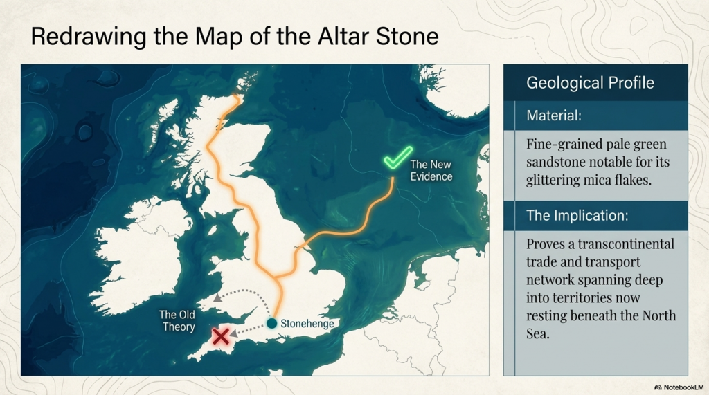
Exploring the origins and transport of the stones used to construct Stonehenge remains a fascinating subject, rife with theories and controversies. The viral interest generated by my blog post this week, which highlighted a map showing three known sites of the stones’ origins, barely scratches the surface of this complex logistical puzzle. Indeed, there are stones from even greater distances, raising myriad questions about how these megaliths were transported to their final resting place at Stonehenge. This essay aims to delve into these logistics, providing a comprehensive overview grounded in the latest research and theories. (The Stonehenge Transportation Mystery)

The Stonehenge Transportation Mystery

The Bluestones

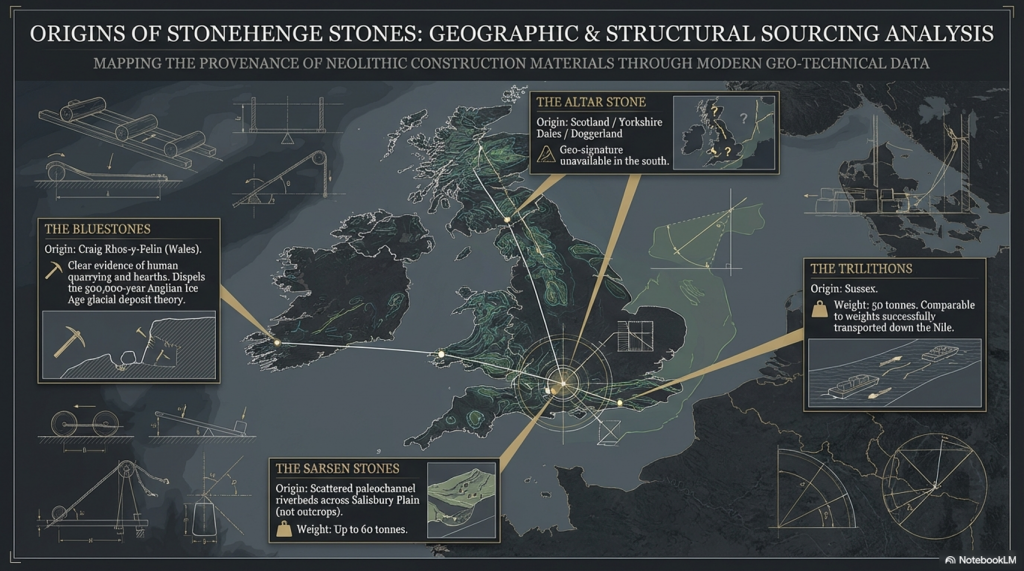
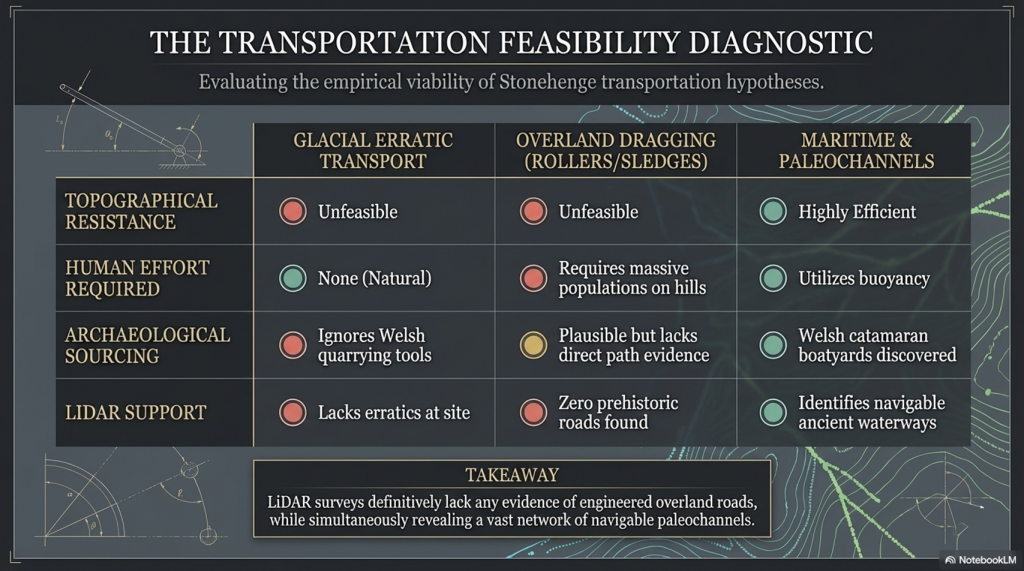
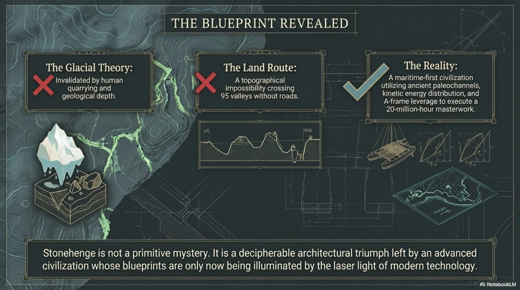
Recent advancements in micro-spectrum analysis have significantly contributed to our understanding of the origins of bluestones. However, this is not an exact science, as the movement of rocks due to glacial activity and post-ice age water flows complicates their traceability. Some academics have proposed that the bluestones found at Stonehenge were not quarried and transported from Wales but deposited nearby by glacial action. This theory, however, conflicts with geological evidence indicating that the last ice age glaciers did not reach as far as Stonehenge, stopping instead at the Bristol Channel. This discrepancy casts doubt on the glacier transport theory, suggesting the need to consider earlier ice ages, such as the Anglian, which occurred over 500,000 years ago. Yet the immense timescale involved means that any stones moved by such glaciers would be deeply buried beneath millennia of soil, making their discovery improbable.

The Stonehenge Transportation Mystery

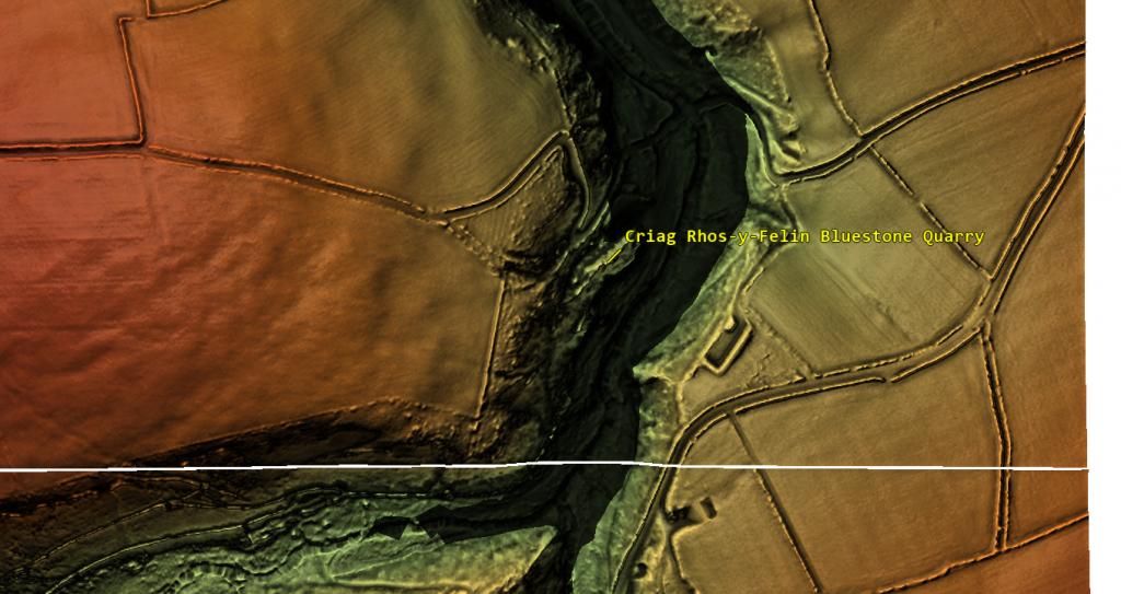
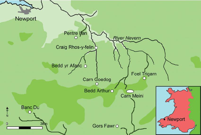
Furthermore, the lack of bluestone erratics in the vicinity of Stonehenge further challenges the idea of glacial transport. The site at Craig Rhos-Y-Felin, identified as a source of the bluestones, shows clear evidence of human quarrying activity, contradicting the theory that these stones were randomly picked up from glacial deposits. The discovery of human hearths and quarrying tools at Craig Rhos-Y-Felin, along with a partially quarried bluestone, strongly suggests that these stones were intentionally selected and transported for use at Stonehenge.

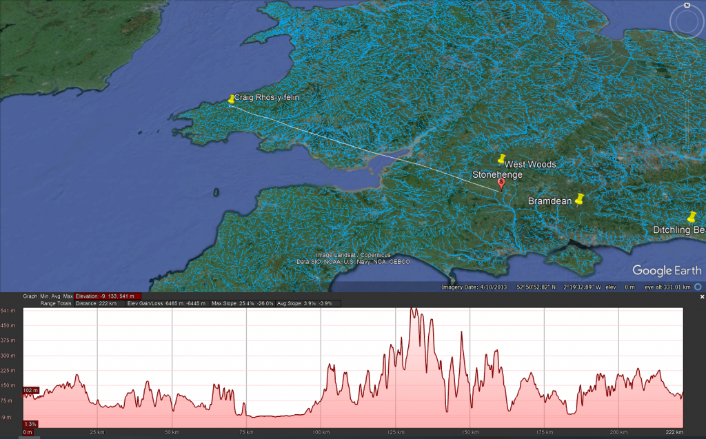
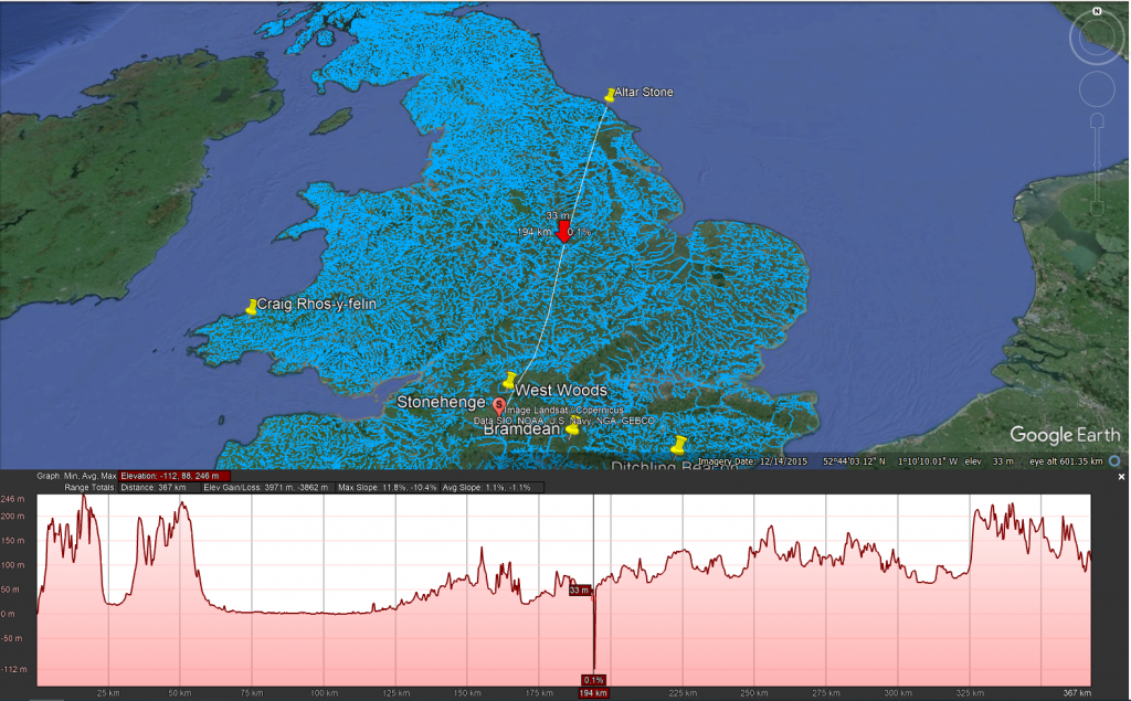
Craig Rhos-y-felin to Stonehenge
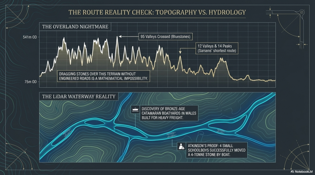
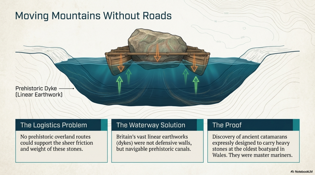
The overland path from Craig Rhos-y-felin to Stonehenge is insane. It goes from 75m OD to 541 OD and crosses 95 valleys – the idea that you can either roll, drag or ox-cart such a route without a road is bonkers!!

The Sarsen Stones

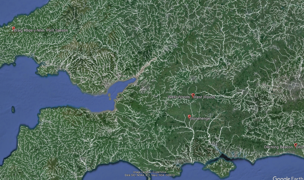
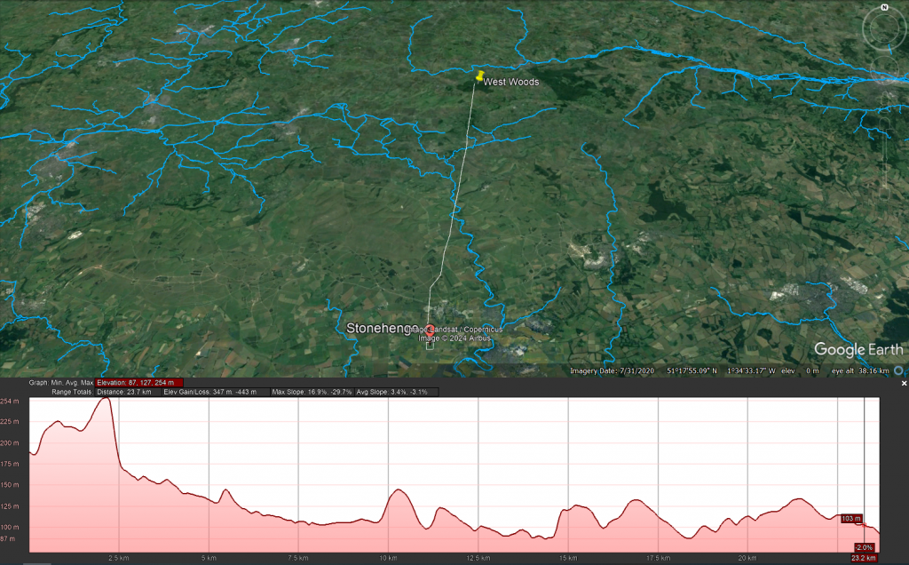
The origin and transportation of the sarsen stones present a different set of challenges. These stones are found scattered across the Salisbury Plain and further afield, in areas never reached by the ice sheets that covered Britain during the last ice age. The popular theory that the sarsen stones came from West Woods near Avebury suggests that they could have been dragged to their current location. However, recent observations indicate that many of these stones are in paleochannel riverbeds rather than rock outcrops. This suggests that they were transported by ice-age floodwaters rather than being quarried from nearby outcrops.

West Woods to Stonehenge
Even the shortest route known to transport these stones is difficult to follow, as the 12 valleys and 14 peaks shown on this map testify.

Theories of Transportation

The theory that the stones could have been moved over frozen rivers during the ice age is intriguing but fraught with logistical issues. The absence of a significant human population capable of organising such an endeavour, coupled with the challenges of moving heavy stones over potentially thin ice, makes this theory less plausible. Additionally, the radiocarbon dating of Stonehenge would be significantly off if the stones had been transported at the end of the ice age.

The Stonehenge Transportation Mystery

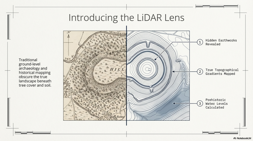
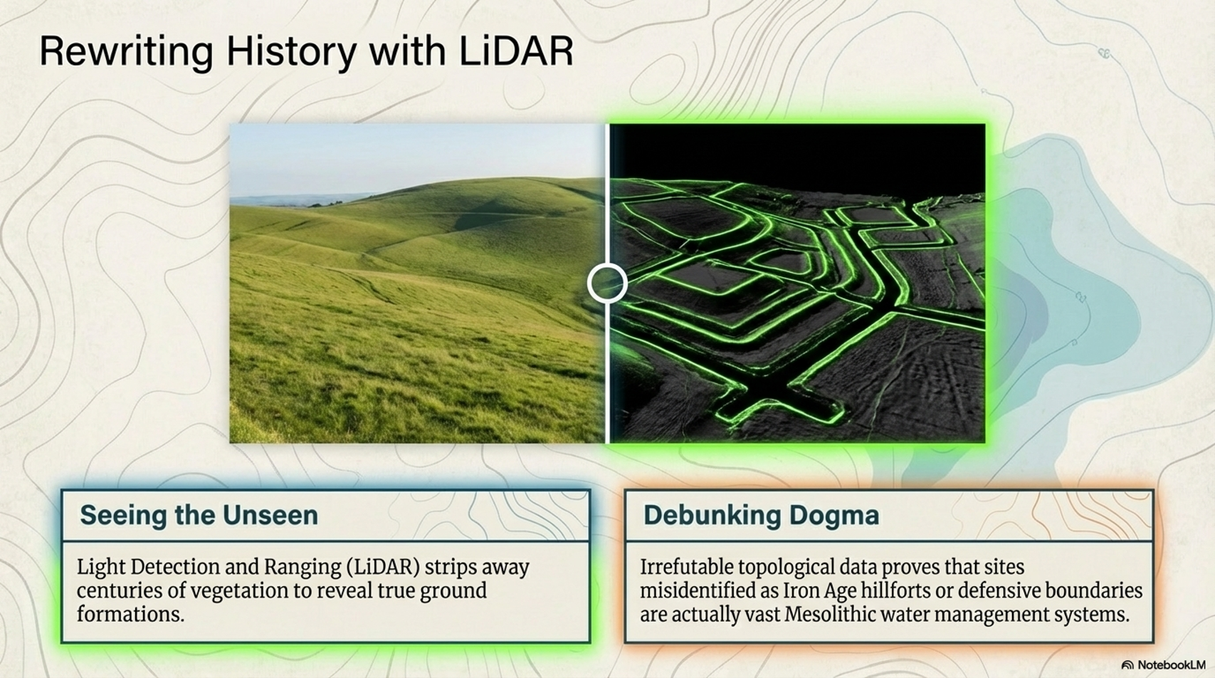
LiDAR, or Light Detection and Ranging, is a remote sensing technology that uses laser light to densely sample the earth’s surface, creating highly accurate topographic maps. It has revolutionised archaeological surveys by uncovering features difficult or impossible to see from the ground or through traditional surveying methods. Regarding Stonehenge and the transportation of the stones used in its construction, LiDAR technology offers invaluable insights into the landscape and potential transport routes used by ancient peoples.

Ditching to Stonehenge
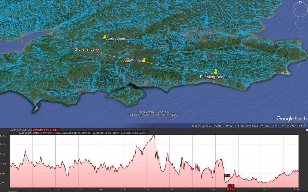
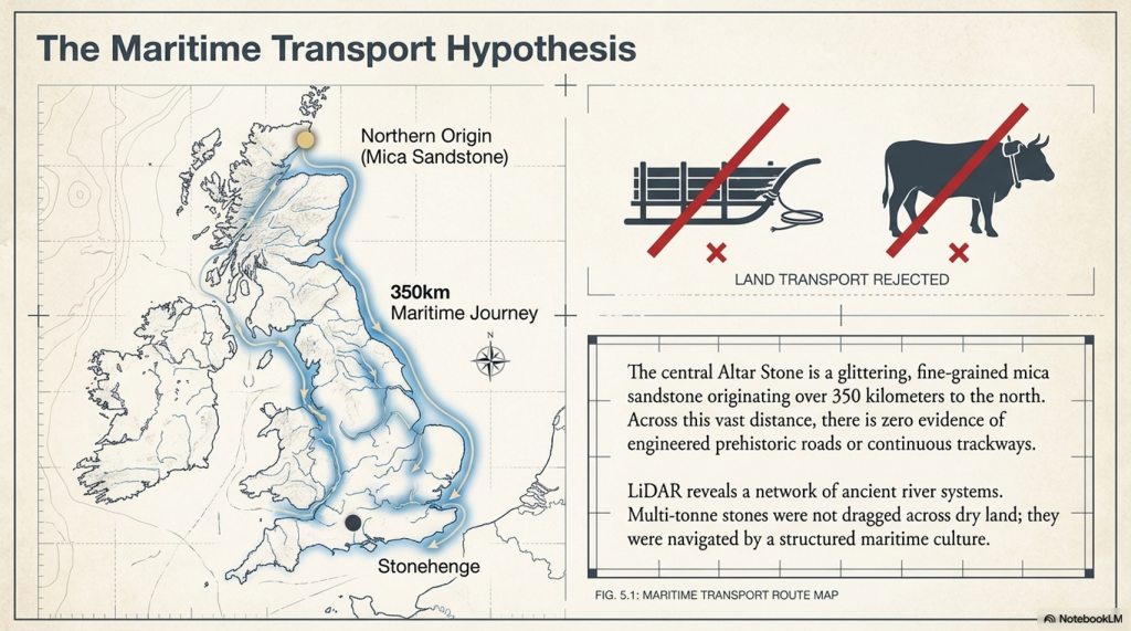
The trilithon stones, weighing around 50 tonnes, reportedly come from Sussex. Such weights were successfully transported down the Nile on boats.

LiDAR Evidence and Stonehenge

LiDAR has been instrumental in mapping the landscape around Stonehenge, revealing details that have remained hidden for millennia under vegetation or soil. This technology has the potential to identify old riverbeds, trackways, and other features that could suggest routes for transporting the massive sarsen stones and bluestones used in the monument’s construction. However, despite its capabilities, LiDAR has not yet provided definitive evidence of prehistoric roads or paths leading directly from the quarries to Stonehenge.

The Stonehenge Transportation Mystery

Key Findings from LiDAR Surveys

No Prehistoric Roads from Quarries: LiDAR surveys have not found any evidence of engineered roads or paths originating from the bluestone quarries in Wales or from locations where sarsen stones are found. This absence challenges theories that rely on overland transport of the stones using rollers, sledges, or ox-carts over vast distances and rugged terrain.

Ancient Waterways and Paleochannels: One significant contribution of LiDAR is the identification of ancient waterways and paleochannels. These features are crucial for understanding the prehistoric landscape, suggesting that rivers and watercourses may have played a significant role in transporting the stones. The larger rivers identified by LiDAR, which were navigable in the past, support the theory that water transport was a feasible and preferred method for moving the stones.

Atkinson's Method
Atkinson proved with just four small schoolboys that a 4-tonne stone can easily be moved by boat down to the River Avon

Landscape Features: LiDAR has revealed the complexity of the landscape through which any transportation route would have had to navigate, including valleys, dense forests, and waterlogged areas. This detailed mapping underscores the logistical challenges faced by ancient builders, further calling into question the practicality of relying solely on land-based transport methods.

The Stonehenge Transportation Mystery
We have now found empirical evidence of boat yards in which catamaran design is made to carry large weights in Wales, dating back to the Bronze Age and beyond

Implications of LiDAR Evidence

The evidence from LiDAR surveys, particularly the absence of prehistoric roads and the emphasis on natural watercourses, suggests a reevaluation of how the stones were transported to Stonehenge. The lack of direct routes from quarries to the site and the identification of navigable ancient rivers and paleochannels lend weight to theories prioritising water transport. This perspective aligns with the understanding that ancient peoples were highly adept at utilising their natural environment to achieve monumental feats of construction.

Alter Stone to Stonehenge
The Altar Stone is now suspected of coming from as far as Scotland, as its Geo signature is not available down south (I would guess Doggerland for obvious reasons), but even if it just came from the Yorkshire Dales, the idea of l, and transportation is pure nonsense

Short Transportation systems from the boat harbours to the Monument

Mechanical Advantage of Poles (from the book – Dawn of the Lost Civilisation)

The principle of leverage, applied through poles, provides a mechanical advantage when handling heavy weights. Professor John Cunningham, an art professor at Skidmore College, has introduced a novel concept, creating a new class of simple machines based on flexible rods. Unlike traditional machines, Cunningham’s design not only multiplies force but also distributes it and stores mechanical energy.

The Stonehenge Transportation Mystery

Consider a scenario with a 20,000-pound stone. If you attempt to support it on two rigid beams, each will bear half the weight (10,000 pounds), posing a risk of fracture. Now, imagine spreading the load across 20 solid, parallel beams, each supporting only a fraction of the total weight, making the burden manageable. Cunningham’s innovation takes this idea further by replacing solid beams with flexible poles.

Stone Transportation and Dumb Censorship
The Bluestones were carried, not dragged, to Stonehenge

In the flexible pole structure, each pole can be raised independently without affecting the others. By lifting one end of a pole, a small amount of extra energy is imparted to that pole, and the energy is distributed across the structure. The weight rises by a fraction of the raised end, divided by the number of pole ends. If one end is lifted by a foot, the weight on each of the other pole ends diminishes by a corresponding fraction. Using this method, heavy loads can be lifted with significantly fewer people, as each person is only moving a fraction of the weight at a time.

This innovative approach enables efficient handling of substantial weights, offering a unique perspective on the use of mechanical advantage in lifting and distributing loads. (Stone transportation and censorship)

The Stonehenge Transportation Mystery

Cunningham has distilled the concept to a formula:
D = S x 1/N

Where D is the distance, the load is raised, s is the distance any one pole is blocked up, and N is the total number of pole ends in the system. Given n is the number of pole ends lifted simultaneously, the mechanical advantage for any symmetrical pole configuration will be N/n.

The Stonehenge Transportation Mystery


So, the fact that a pole bends like a bow, storing energy, makes it easier to carry. So easy in fact, that it acts as a lever and gives you a mechanical advantage. This principle would be well known as it is the same principle as how a bow works as it is a store of potential energy, you can’t throw an arrow 100 metres, but the bowing of the wood channelled through a small area (the string) give you the potential energy.

Walk like an Egyptian

The experiment showed that 48 students ( four x 12 poles) could lift 2.3 tonnes, which was the weight of one of the pyramid’s building stones. The larger the stone, the more poles and men you need, but it was quite easy even for wimpish students. In prehistoric Days with Cro-Magnon works you would need only 24 people to move a Pyramid stone or a Bluestone at Stonehenge without the rest blocks the video has included in their H & S safety assessment….LOL!!

A-Frames and Cranes

The advancement of technology and the movement of massive stones, such as the Sarsen stones at Stonehenge, Avebury, and Carnac, demand a closer examination of the engineering and logistical challenges faced by the ancient civilisation of Homo Superior, also known as Cro-Magnons. The Sarsen stones, weighing up to 60 tonnes, were not merely transported but meticulously erected, presenting a feat that even modern attempts struggle to replicate.


In our exploration of ancient technology, we encounter the question of how to transport and handle colossal loads. The Sarsen stones serve as an illustrative example due to their significant size, and it is perplexing that historians and archaeologists often overlook the intricacies of moving and placing these stones. This oversight persists even though, even with today’s technology, replicating the achievements of Homo Superior at Stonehenge remains a daunting challenge.

The Stonehenge Transportation Mystery


The crane, a machine designed to lift and move heavy materials, is pivotal in the transport and construction industries. Equipped with a hoist, wire ropes or chains, and sheaves, a crane utilises mechanical advantages to lift and lower materials beyond the capacity of human effort. Historically, the invention of the crane is attributed to the Ancient Greeks in the late 6th century BC, as evidenced by cuttings for lifting tongs and Lewis irons on stone blocks of Greek temples dating to around 515 BC.

However, when scrutinising Stonehenge, we encounter a fascinating divergence. In contrast, archaeological evidence points to the use of lifting devices, particularly with cuttings indicating the application of cranes, the peculiarities of Stonehenge’s construction challenge conventional narratives. Notably, the placement of lintels on Sarsen uprights and the presence of holes like Y & Z, potentially serving as foundations for A-frame crane legs, hint at a more sophisticated lifting apparatus.

The Stonehenge Transportation Mystery

The reluctance of some scholars to acknowledge advanced lifting devices in the historical context of Homo Superior may stem from the challenge they pose to established historical frameworks. Nevertheless, the investigation into the engineering marvels of Stonehenge encourages us to reassess the capabilities of this ancient civilisation, prompting a deeper understanding of their technological prowess and organisational acumen.

The Stonehenge Transportation Mystery

The transition from ramps to the more sophisticated winch-and-pulley hoist marked a significant shift in ancient construction technology. The emergence of the compound pulley system, attributed to Aristotle in the Mechanical Problems, coincided with a notable decrease in the weights of stones handled on Greek building sites. This transformative period saw the prevalence of smaller stones, weighing less than 15–20 metric tonnes, in contrast to the archaic era’s trend of using larger blocks.

The adoption of the crane, facilitated by the compound pulley system, introduced a more efficient and practical method of vertical motion. Grecian temples of the classical age, exemplified by the Parthenon, favoured using several smaller stones rather than fewer larger ones. Monolithic columns, a prominent feature in earlier constructions, were gradually replaced by multiple-column drums.

The Stonehenge Transportation Mystery

The reasons behind this technological evolution are not entirely clear. It raises intriguing questions about whether the shift from larger to smaller stones was due to the loss of past techniques, improved quarrying methods that enabled faster cutting of shorter blocks, or other factors influencing construction practices. The shift in societal dynamics, with smaller, professional construction teams being favoured over larger bodies of unskilled labour, is proposed as a potential contributing factor. The crane, with its efficiency in handling smaller stones, became preferable in the more volatile social and political conditions of ancient Greece.

While the exact circumstances of this transition remain uncertain, the historical record indicates that the compound pulley system and the crane became integral to Greek construction sites. The literary evidence from Aristotle’s Mechanical Problems and the resurgence of larger block sizes at Greek temples suggests a correlation between the adoption of the compound pulley and advancements in construction techniques. The earliest construction cranes, likely powered by humans or beasts of burden like donkeys, marked a transformative period in ancient construction methods.

(Stone transportation and censorship)
The Stonehenge Transportation Mystery

The evolution of cranes played a crucial role in the construction of tall buildings, enabling the lifting of heavier loads. In the High Middle Ages, harbour cranes emerged to facilitate ship loading and unloading, often integrated into stone towers for enhanced strength and stability. The earliest cranes were crafted from wood, but with the advent of the Industrial Revolution, materials like cast iron and steel became predominant.

At Stonehenge, the construction methods are a subject of speculation, with suggestions that timber A-frames were employed to raise the stones. Teams of individuals may have hauled the stones upright using ropes, and the topmost stones (lintels) could have been incrementally raised on timber platforms and slid or pushed into place. Carpentry-type joints on the stones indicate a high level of woodworking skill among the builders.

The Stonehenge Transportation Mystery

The idea of A-frames finds support in demonstrations by individuals such as Wally Wallington, a retired construction worker, who showcased techniques based on lever principles for rotating, lifting, and positioning heavy monoliths. An A-frame, essentially a basic crane without a pulley or winch, operates on similar principles to facilitate vertical movement. Adding a swivel base could transform it into a fully functional crane, a concept compatible with the mortise-and-tenon joints observed at Stonehenge.

(Stone transportation and censorship)
The Stonehenge Transportation Mystery

Estimates of the manpower required for Stonehenge’s construction suggest a substantial effort, with millions of hours of work. The various phases of Stonehenge’s construction, from the initial to the third phase, may have required extensive human labour, amounting to up to 20 million hours spent working the stones. The primitive tools available at the time necessitated considerable effort, highlighting the strong will and advanced social organisation required to build and maintain such a monumental site. Stonehenge stands as a testament to the ingenuity and determination of its ancient builders. (Stone transportation and censorship)

The Stonehenge Transportation Mystery

PodCast

Author’s Biography

Robert John Langdon, a polymathic luminary, emerges as a writer, historian, and eminent specialist in LiDAR Landscape Archaeology.

His intellectual voyage has been interwoven with stints as an astute scrutineer in government and grand corporate bastions, a tapestry spanning British Telecommunications, Cable and Wireless, British Gas, and the esteemed University of London.

A decade hence, Robert’s transition into retirement unfurled a chapter of insatiable curiosity. This phase saw him immerse himself in Politics, Archaeology, Philosophy, and the enigmatic realm of Quantum Mechanics. His academic odyssey traversed the venerable corridors of knowledge hubs such as the Museum of London, University College London, Birkbeck College, The City Literature Institute, and Chichester University.

In the symphony of his life, Robert is a custodian of three progeny and a pair of cherished grandchildren. His sanctuary lies ensconced in the embrace of West Wales, where he inhabits an isolated cottage, its windows framing a vista of the boundless sea – a retreat from the scrutinising gaze of Her Majesty’s Revenue and Customs, an amiable clandestinity in the lap of nature.

Exploring Prehistoric Britain: A Journey Through Time

My blog delves into the fascinating mysteries of prehistoric Britain, challenging conventional narratives and offering fresh perspectives grounded in cutting-edge research, particularly LiDAR technology. I invite you to explore some key areas of my research. For example, the Wansdyke, often cited as a defensive structure, is re-examined in light of new evidence. I’ve presented my findings in my blog post Wansdyke: A British Frontier Wall – ‘Debunked’, and a Wansdyke LiDAR Flyover video further visualises my conclusions.

My work also often challenges established archaeological dogma. I argue that many sites, such as Hambledon Hill, commonly identified as Iron Age hillforts, are not what they seem. My posts Lidar Investigation Hambledon Hill – NOT an ‘Iron Age Fort’ and Unmasking the “Iron Age Hillfort” Myth explore these ideas in detail and offer an alternative view. Similarly, sites like Cissbury Ring and White Sheet Camp receive re-evaluations based on LiDAR analysis in my posts “Lidar Investigation Cissbury Ring through time” and “Lidar Investigation White Sheet Camp,“ revealing fascinating insights into their true purpose. I have also examined South Cadbury Castle, often linked to the mythical Camelot56.

My research also extends to ancient water management, including the role of canals and other linear earthworks. I have discussed the true origins of Car Dyke in multiple posts, including Car Dyke – ABC News Podcast and Lidar Investigation Car Dyke – North Section, which suggest a Mesolithic origin 2357. I also explore the misidentification of Roman aqueducts, as seen in my posts on the Great Chesters (Roman) Aqueduct. My research has also been greatly informed by my post-glacial flooding hypothesis, which has helped explain landscape transformations over time. I have discussed this hypothesis in several posts, including AI now supports my Post-Glacial Flooding Hypothesis and Exploring Britain’s Flooded Past: A Personal Journey

Finally, my blog also investigates prehistoric burial practices, as seen in Prehistoric Burial Practices of Britain and explores the mystery of Pillow Mounds, often mistaken for medieval rabbit warrens, but with a potential link to Bronze Age cremation in my posts: Pillow Mounds: A Bronze Age Legacy of Cremation? and The Mystery of Pillow Mounds: Are They Really Medieval Rabbit Warrens?. My research also includes astronomical insights into ancient sites, for example, in Rediscovering the Winter Solstice: The Original Winter Festival. I also review new information about the construction of Stonehenge in The Stonehenge Enigma.

Further Reading

For those interested in British Prehistory, visit www.prehistoric-britain.co.uk, a comprehensive resource featuring an extensive collection of archaeology articles, modern LiDAR investigations, and groundbreaking research. The site also includes insights and excerpts from the acclaimed Robert John Langdon Trilogy, a series of books that explore Britain during the Prehistoric period. Titles in the trilogy include The Stonehenge Enigma, Dawn of the Lost Civilisation, and The Post-Glacial Flooding Hypothesis, which offer compelling evidence of ancient landscapes shaped by post-glacial flooding.

To further explore these topics, Robert John Langdon has developed a dedicated YouTube channel featuring over 100 video documentaries and investigations that complement the trilogy. Notable discoveries and studies showcased on the channel include 13 Things that Don’t Make Sense in History and the revelation of Silbury Avenue – The Lost Stone Avenue, a rediscovered prehistoric feature at Avebury, Wiltshire.

In addition to his main works, Langdon has released a series of shorter, accessible publications, ideal for readers delving into specific topics. These include:

For active discussions and updates on the trilogy’s findings and recent LiDAR investigations, join our vibrant community on Facebook. Engage with like-minded enthusiasts by leaving a message or contributing to debates in our Facebook Group.

Whether through the books, the website, or interactive videos, we aim to provide a deeper understanding of Britain’s fascinating prehistoric past. We encourage you to explore these resources and uncover the mysteries of ancient landscapes through the lens of modern archaeology.

For more information, including chapter extracts and related publications, visit the Robert John Langdon Author Page. Dive into works such as The Stonehenge Enigma or Dawn of the Lost Civilisation, and explore cutting-edge theories that challenge traditional historical narratives.

Other Blogs

[sitemap_posts]
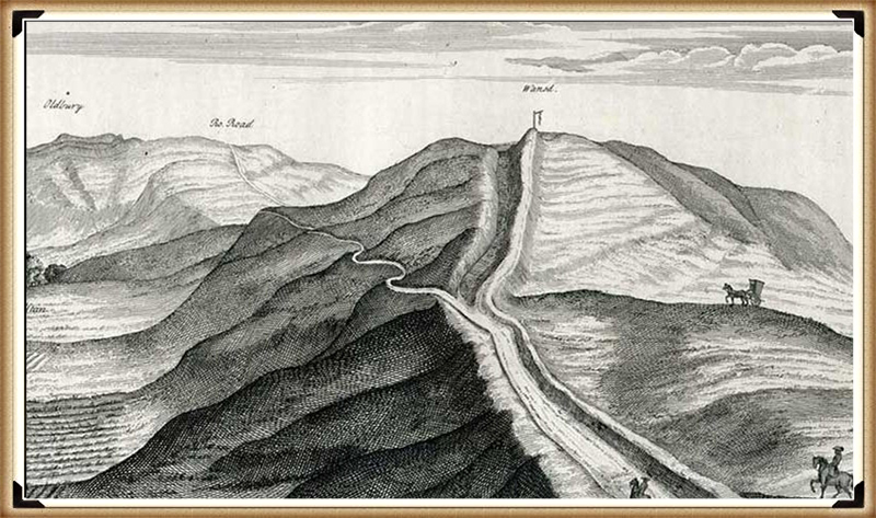
South Cadbury Castle – Camelot

Introduction

In the traditional archaeological interpretation, Cadbury Castle represents a long-lived settlement that developed gradually over several millennia. The earliest evidence of activity dates to the Neolithic period, where pits and postholes associated with pottery and flint finds suggest a small, unenclosed agricultural community. Radiocarbon dating places this early occupation around 3500–3300 BC, indicating that the hill was already being utilised long before the construction of its later defences.(South Cadbury Castle – Camelot)

The site continued to be occupied into the Bronze Age, where evidence of ovens and metalworking activity points to an increasingly organised settlement. By the Iron Age, Cadbury Castle had developed into a substantial fortified enclosure. Around 300 BC, a stone-built enclosure with timber reinforcements was constructed, later expanded into a complex hillfort with multiple ramparts and elaborate defensive systems. Excavations have revealed both roundhouses and rectangular structures, alongside evidence of industrial activity and possible ritual features, suggesting a permanent and socially complex community—often described as “oppidum-like” in character.

South Cadbury Castle - Camelot
South Cadbury Castle – Camelot

During the 1st century BC and into the early Roman period, the defences were further strengthened. Archaeological evidence indicates that the site may have been violently attacked during the Roman conquest of Britain, around AD 43, with signs of burning and destruction uncovered at key प्रवेश points. Following this, the Romans appear to have reused the hilltop, possibly establishing a military presence and later constructing a temple during the 3rd or 4th century AD.

After the end of Roman administration, Cadbury Castle was reoccupied in the post-Roman period, between approximately AD 470 and 580. Excavations led by Leslie Alcock revealed a large timber “Great Hall,” interpreted within the traditional framework as the residence of a high-status Brittonic ruler. The discovery of imported Mediterranean pottery from this phase suggests long-distance trade connections and reinforces the idea of the site as a regional power centre. It is this phase of occupation that has led to long-standing associations with the legendary Camelot of King Arthur.

South Cadbury Castle - Camelot
South Cadbury Castle – Camelot

The site saw later reuse in the early medieval period, including the establishment of a temporary Saxon mint in the 11th century. Across its long history, Cadbury Castle is therefore understood, in conventional terms, as a multi-period fortified settlement—evolving from a Neolithic farming site into a major Iron Age stronghold, later adapted by Roman and post-Roman communities, and ultimately woven into both historical and legendary narratives.

The Problem with the Traditional Interpretation

The conventional explanation of Cadbury Castle presents a familiar story: a hilltop settlement that gradually evolves from a Neolithic farm into a Bronze Age community, then into an Iron Age hillfort, later reused by Romans and post-Roman elites.

It sounds neat. It reads well. But when examined critically, it raises more problems than it solves.

South Cadbury Castle - Camelot
South Cadbury Castle – Camelot

The core issue is methodological.

The site is treated as a continuous “occupation sequence,” yet the evidence presented is not continuous—it is fragmentary, intermittent, and separated by significant spans of time. A pit here, a posthole there, a later rampart above it—all are grouped together and interpreted as a single evolving settlement. In reality, what is being described is not continuity, but repeated reuse of a prominent landscape feature over thousands of years.

This is a fundamental distinction.

Finding Neolithic pits does not prove a Neolithic settlement in the sense implied. It proves activity. The same applies to Bronze Age ovens, Iron Age ramparts, or post-Roman halls. Each represents a moment in time, not necessarily a continuous tradition of occupation.

Archaeology, however, routinely compresses these separate events into a single narrative—effectively averaging the past into a story that feels coherent but is not supported as a continuous process.

South Cadbury Castle - Camelot
South Cadbury Castle – Camelot

Elevation and Function — The Missing Variable

What is consistently overlooked in the traditional model is the most obvious physical characteristic of Cadbury Castle:

Its elevation.

At approximately 153 metres above sea level, the site sits well above the surrounding lowlands, particularly the Somerset Levels to the north. In the conventional interpretation, this is explained purely in terms of defence—height equals visibility, therefore height equals protection.

But this assumption is never tested.

It is simply inherited.

If we step back and apply a physical framework rather than a cultural one, a different question emerges:

Why are the earliest activities consistently located on elevated ground?

This is not unique to Cadbury. Across Britain, early prehistoric activity frequently appears at higher elevations, with later activity progressively occupying lower ground. This pattern is measurable, repeatable, and not dependent on interpretation.

South Cadbury Castle - Camelot
South Cadbury Castle – Camelot

The simplest explanation is not a defence.

It is an environment.

As demonstrated in the broader hydrological model of post-glacial Britain, early Holocene landscapes were characterised by significantly higher groundwater levels and expanded river systems. In such a system, low-lying areas—such as the Somerset Levels—would not have been stable, dry land in the way they are today. They would have been wetlands, floodplains, or standing water environments for extended periods.

Under these conditions, elevated sites like Cadbury Hill are not “defensive choices.”

They are the only viable ground.

South Cadbury Castle - Camelot
South Cadbury Castle – Camelot

Reframing the “Hillfort”

Once elevation is understood as an environmental constraint rather than a defensive preference, the entire interpretation of the site shifts.

The term “hillfort” becomes problematic.

It assumes:

  • conflict
  • territorial defence
  • permanent settlement

Yet none of these are directly proven by the physical evidence alone.

The ramparts, for example, are interpreted as defensive structures—but this is an assumption based on form, not function. Earthworks can serve multiple purposes: hydraulic control, stock management, boundary demarcation, or even phased landscape modification.

At Cadbury, the presence of multiple ramparts is often cited as evidence of increasing conflict. But an alternative explanation is equally plausible: staged construction responding to changing environmental conditions, particularly shifting water levels and drainage patterns.

South Cadbury Castle - Camelot
South Cadbury Castle – Camelot

The traditional model selects one interpretation—warfare—without excluding others.

The Illusion of Continuity

Perhaps the most significant issue is the illusion of continuity created by archaeological phasing.

Cadbury Castle is presented as:

Neolithic → Bronze Age → Iron Age → Roman → Post-Roman → Saxon

But this is not a continuous timeline of occupation.

It is a list of disconnected events.

South Cadbury Castle - Camelot

Between these phases lie gaps—sometimes centuries, sometimes longer—where no evidence of sustained activity exists. These gaps are rarely emphasised, because they disrupt the narrative of an “important settlement.”

Instead, the site is framed as persistently occupied, when the evidence more accurately supports periodic reuse of a prominent, strategically located landscape feature.

In other words, the hill is important.

Not necessarily the settlement.

South Cadbury Castle - Camelot
South Cadbury Castle – Camelot

A Simpler Model

If we remove the assumption and focus only on physical constraints, a more economical explanation emerges:

  • Early activity occurs on high ground because low ground is unstable or flooded
  • Sites are reused over time because elevated locations remain reliable as conditions change
  • Earthworks reflect adaptation to landscape conditions, not necessarily warfare
  • Later cultures reinterpret and reuse earlier features without preserving the original function
South Cadbury Castle - Camelot

This model requires fewer assumptions and aligns with measurable environmental behaviour.

It also explains why sites like Cadbury Castle appear repeatedly in the archaeological record across different periods without requiring continuous occupation.

South Cadbury Castle - Camelot
South Cadbury Castle – Camelot

Maps

1800s OS Map

South Cadbury Castle – 1800s OS Map

GE Satellite Map

South Cadbury GE Map

LiDAR Map

South Cadbury Castle – LiDAR Map

Investigation

Site Flyaround

South Cadbury Castle Flyaround

Site Flyover

South Cadbury Castle Fly Over

Lidar Map showing Bronze Age

South Cadbury Castle – with Bronze Age Water Levels

LiDAR Map showing Mesolithic Period

South Cadbury Castle with Mesloithic Water levels

Defence Strategy 101

Roman Defence System

Roman defences (of the same period as the ‘Iron Age’ ), we notice the ditches were relatively small and narrow. These ditches were called ‘Ankle Breaker’ as the purpose was for the assailant to fall into the ditch (usually containing pointed wooden stakes to either injure or kill the assailant) or to at least break their ankle from the fall, making them immobile. These ditches would be 3 to 4 m wide and about 2m deep and could be dug quickly.

Roman Ankle Breaker

The soil excavated from the ditch would be placed on the defensive side to elevate the defenders, allowing them to look down and fight their attackers from a higher position. Simply standing on elevated ground without a barrier would make defenders easy targets. Therefore, they built fortifications using wooden stakes or stone for more permanent and substantial defences. These fortifications provided cover from spears, arrows, or stones while looking down into the conflict zone. This basic defensive strategy has remained unchanged for thousands of years, as seen with the Normans, who used castles and moats. The moats slowed down assailants, allowing defenders to use crossbows effectively against anyone attempting to cross the deep waters.

Classic Roman Fort With Ditch and Palisade

Lidar Maps of Sth Cadbury Castle Show No Defences

Banks

The banks at South Cadbury Castle show no signs of palisades on top of the bank at any stage before the Roman occupation, which brought stone to the very top of the site. The other four banks appear to be quite flat, as if they have been used for walking upon rather than holding any defensive wooden structures or ‘foxholes.’

Importance and Use of Foxholes in Defense

Concealment and Protection: Foxholes are small, dug-out trenches or pits used by soldiers to provide cover and concealment. They protect defenders from enemy fire and other dangers. By being below ground level, soldiers can remain hidden and minimize their exposure to enemy attacks.

Historical Use: Throughout history, foxholes have been a crucial part of defensive strategies in various military contexts: While the term “foxhole” is modern, the concept of digging protective pits or trenches has been used in various forms throughout history. In ancient battles, soldiers would dig pits to defend against archers and other ranged weapons.

Advantages of Foxholes

  • Reduced Visibility: Soldiers in foxholes are less visible to the enemy, making it harder for attackers to target them.
  • Protection from Spears, Rocks and Arrows: Being below ground level the size of the target is greatly reduced.
  • Stability for Firing: Foxholes provide a stable firing position, allowing soldiers to fire and use their weapons more accurately.

South Cadbury Castle Context

The absence of evidence for palisades or foxholes at South Cadbury Castle before the Roman occupation suggests a different use or purpose for the banks. Instead of being purely defensive, the flat banks must have served other functions.

Ditches

Looking at the construction of the ditches at South Cadbury Castle, we notice that it has no defensive features as expected from a so-called ‘Iron Age Fort’. The ditches are far too broad to be defensive (15m to 30m wide) compared to Roman ‘Ankle Breaker’ of 2m to 3m. The maps show no sign of a wooden or stone barrier, and archaeological excavations have found no evidence of post holes or defensive pits on the banks. Moreover, the Ditch is banked on the wrong side to be defensive, as if it has been built to encase a watery moat. This outside bank would protect any assailants attacking, giving them ample bank coverage. The internal aspect of the Ditch shows no sign of any wooden defensive poles or post holes as seen in Roman Ditches and is designed without internal walls allowing assailants from using the Ditch as cover and the facility to wander around the circumference undercover, testing the weaknesses in the defence. Therefore, as a defensive feature, these types of ditches on so-called ‘Iron Age Forts’ are fundamentally flawed and commonplace.

Ditch is banked on the wrong side

The LiDAR Maps also show that the ditch of the ditches indicate that they were built for water, as shown by the blue on these images – this then allows us to look at the design of the earthwork in detail, which shows that the banks have been cut by not roads but other ditches. These ditches that cut across the circumference moats cut into them that, suggest that if water had been contained in these ditches, then the vertical dykes could have been used to gaol boats up from the bottom of the dyke ditch to one of these upper moat levels. These same LiDAR maps also show how the soil was distributed to the outside of the moats to enhance and make the feature deeper.

South Cadbury Castle – Banks on the outside to keep in the Water

Water Table

This hypothesis of using these ditches as moats can only be proven if we find the natural springs that could have fed these earthworks in the past. We know from our studies into rivers, such as The Thames and Avon, that they were both much higher and of greater volume in the past, and this height was retained for thousands of years after the last ice age. This enhanced height and volume is reflected and caused by a higher water table. Within these water tables, natural springs are formed, and water leaks into the land, creating rivers and streams. Although we do not have geological information that allows us to trace past springs, we find existing springs in this location (still active today), which suggests our hypothesis is correct.

South Cadbury Castle showing Springs still in existence

Dykes

As we have already suggested, the lack of defensive features shows that this is far from being a fortification; instead, it was used as a trading site with moats to facilitate the mooring of boats. The transportation to these moats was achieved by other earthworks called Linear Earthworks (also known as Dykes). Dykes were introduced when the river shorelines of the Prehistoric fell with the water table, and they wanted to continue to use these established trading sites rather than having to build new sites at a lower level. So, Dykes were built (like roads) to transport goods to market and also minerals extracted from the many quarries which uncommonly surround these Dykes. Here in South Cadbury Castle, we see not only Dykes feeding the local quarry sites but also placed on the side of this Trading site to allow access to the moats for the boats coming off the rivers, ready for unloading/loading.

Slipway built to feed the moats in the upper levels with trading boats
Two Possible Slipways – one connecting directly to a Dyke

To reinforce the use of this site as a trading The site as a trading place has a second vertical earthwork identified through LiDAR technology. This secondary slipway is distinguishable from the initial structure by its lack of connection to a dyke or river. The slipway appears to traverse from the lowest moat up to the top of the site. While photographs may provide a visual reference, the full extent and significance of this feature are best understood through LiDAR models, which enhance the landscape to reveal these historical elements with greater clarity.place, a second verticle earthwork has been identified via LiDAR technology is a secondary slipway, distinguishable from the initial structure by its lack of connection to a dyke or river. This slipway appears to traverse from the lowest moat up to the top of the site. While photographs may provide a visual reference, the full extent and significance of this feature are best understood through LiDAR models, which enhance the landscape to reveal these historical elements with greater clarity.

The Dykes seen on the LiDAR map are concentrated on the quarry in the East of the Site

Dating the Site

Archaeologists are puzzled by the unexpected dates of this site at South Cadbury Castle, the site that was originally thought to be Iron Age from its classification. Therefore, the discovery of Neolithic pits at the site challenges their previously held beliefs about its functions. However, instead of reconsidering their perceptions, they instead provided speculative explanations for these out-of-time artifacts and features. For example, they have described a bank beneath the Iron Age defenses as a “lynchet or terrace derived from early ploughing,” even though there is no carbon dating evidence to support this claim. In reality, this site is likely to be Neolithic, and the ‘lynchets’ could be Mesolithic banks, indicating its true age.

The discovery of the Bronze Age shield is also an indication of the status of the site and its trading routes – as only one has been found, this would indicate that it was part of the trading or personal ownership of someone in the 10th Century BC at this site. This suggests that this was trading could have been at a much earlier date than current archaeologists suggest, which could too have been with the Mediterranean and a possible source of this unusual artefact, as indicated by the other finds from the late saxon period.

Function of the site

The fact that in the East of this site is one of the largest quarries in Somerset and that the Saxons used the fort as a mint just over a thousand years ago proves that the site’s function was a mineral extraction and trading point. This extraction goes back to the Mesolithic period shown on LiDAR maps with a natural harbour by the Quarries and then Dykes to the Trading site as the prehistoric waters fell. No doubt (as the banks are found not to be defensive), the fort was fortified later during the Roman period with Stone as it was to keep the valuable minerals safe but not as a defensive barrier of warfare as suggested. This would explain the minor disturbances and deaths at a single gate as raiders would have attempted to steal the valuable minerals it contained in its workshops, as described by archaeologists.

PodCast

Author’s Biography

Robert John Langdon, a polymathic luminary, emerges as a writer, historian, and eminent specialist in LiDAR Landscape Archaeology.

His intellectual voyage has been interwoven with stints as an astute scrutineer in government and grand corporate bastions, a tapestry spanning British Telecommunications, Cable and Wireless, British Gas, and the esteemed University of London.

A decade hence, Robert’s transition into retirement unfurled a chapter of insatiable curiosity. This phase saw him immerse himself in Politics, Archaeology, Philosophy, and the enigmatic realm of Quantum Mechanics. His academic odyssey traversed the venerable corridors of knowledge hubs such as the Museum of London, University College London, Birkbeck College, The City Literature Institute, and Chichester University.

In the symphony of his life, Robert is a custodian of three progeny and a pair of cherished grandchildren. His sanctuary lies ensconced in the embrace of West Wales, where he inhabits an isolated cottage, its windows framing a vista of the boundless sea – a retreat from the scrutinising gaze of Her Majesty’s Revenue and Customs, an amiable clandestinity in the lap of nature.

Exploring Prehistoric Britain: A Journey Through Time

My blog delves into the fascinating mysteries of prehistoric Britain, challenging conventional narratives and offering fresh perspectives grounded in cutting-edge research, particularly LiDAR technology. I invite you to explore some key areas of my research. For example, the Wansdyke, often cited as a defensive structure, is re-examined in light of new evidence. I’ve presented my findings in my blog post Wansdyke: A British Frontier Wall – ‘Debunked’, and a Wansdyke LiDAR Flyover video further visualises my conclusions.

My work also often challenges established archaeological dogma. I argue that many sites, such as Hambledon Hill, commonly identified as Iron Age hillforts, are not what they seem. My posts Lidar Investigation Hambledon Hill – NOT an ‘Iron Age Fort’ and Unmasking the “Iron Age Hillfort” Myth explore these ideas in detail and offer an alternative view. Similarly, sites like Cissbury Ring and White Sheet Camp receive re-evaluations based on LiDAR analysis in my posts “Lidar Investigation Cissbury Ring through time” and “Lidar Investigation White Sheet Camp,“ revealing fascinating insights into their true purpose. I have also examined South Cadbury Castle, often linked to the mythical Camelot56.

My research also extends to ancient water management, including the role of canals and other linear earthworks. I have discussed the true origins of Car Dyke in multiple posts, including Car Dyke – ABC News Podcast and Lidar Investigation Car Dyke – North Section, which suggest a Mesolithic origin 2357. I also explore the misidentification of Roman aqueducts, as seen in my posts on the Great Chesters (Roman) Aqueduct. My research has also been greatly informed by my post-glacial flooding hypothesis, which has helped explain landscape transformations over time. I have discussed this hypothesis in several posts, including AI now supports my Post-Glacial Flooding Hypothesis and Exploring Britain’s Flooded Past: A Personal Journey

Finally, my blog also investigates prehistoric burial practices, as seen in Prehistoric Burial Practices of Britain and explores the mystery of Pillow Mounds, often mistaken for medieval rabbit warrens, but with a potential link to Bronze Age cremation in my posts: Pillow Mounds: A Bronze Age Legacy of Cremation? and The Mystery of Pillow Mounds: Are They Really Medieval Rabbit Warrens?. My research also includes astronomical insights into ancient sites, for example, in Rediscovering the Winter Solstice: The Original Winter Festival. I also review new information about the construction of Stonehenge in The Stonehenge Enigma.

Further Reading

For those interested in British Prehistory, visit www.prehistoric-britain.co.uk, a comprehensive resource featuring an extensive collection of archaeology articles, modern LiDAR investigations, and groundbreaking research. The site also includes insights and excerpts from the acclaimed Robert John Langdon Trilogy, a series of books that explore Britain during the Prehistoric period. Titles in the trilogy include The Stonehenge Enigma, Dawn of the Lost Civilisation, and The Post-Glacial Flooding Hypothesis, which offer compelling evidence of ancient landscapes shaped by post-glacial flooding.

To further explore these topics, Robert John Langdon has developed a dedicated YouTube channel featuring over 100 video documentaries and investigations that complement the trilogy. Notable discoveries and studies showcased on the channel include 13 Things that Don’t Make Sense in History and the revelation of Silbury Avenue – The Lost Stone Avenue, a rediscovered prehistoric feature at Avebury, Wiltshire.

In addition to his main works, Langdon has released a series of shorter, accessible publications, ideal for readers delving into specific topics. These include:

For active discussions and updates on the trilogy’s findings and recent LiDAR investigations, join our vibrant community on Facebook. Engage with like-minded enthusiasts by leaving a message or contributing to debates in our Facebook Group.

Whether through the books, the website, or interactive videos, we aim to provide a deeper understanding of Britain’s fascinating prehistoric past. We encourage you to explore these resources and uncover the mysteries of ancient landscapes through the lens of modern archaeology.

For more information, including chapter extracts and related publications, visit the Robert John Langdon Author Page. Dive into works such as The Stonehenge Enigma or Dawn of the Lost Civilisation, and explore cutting-edge theories that challenge traditional historical narratives.

Other Blogs

[sitemap_posts]
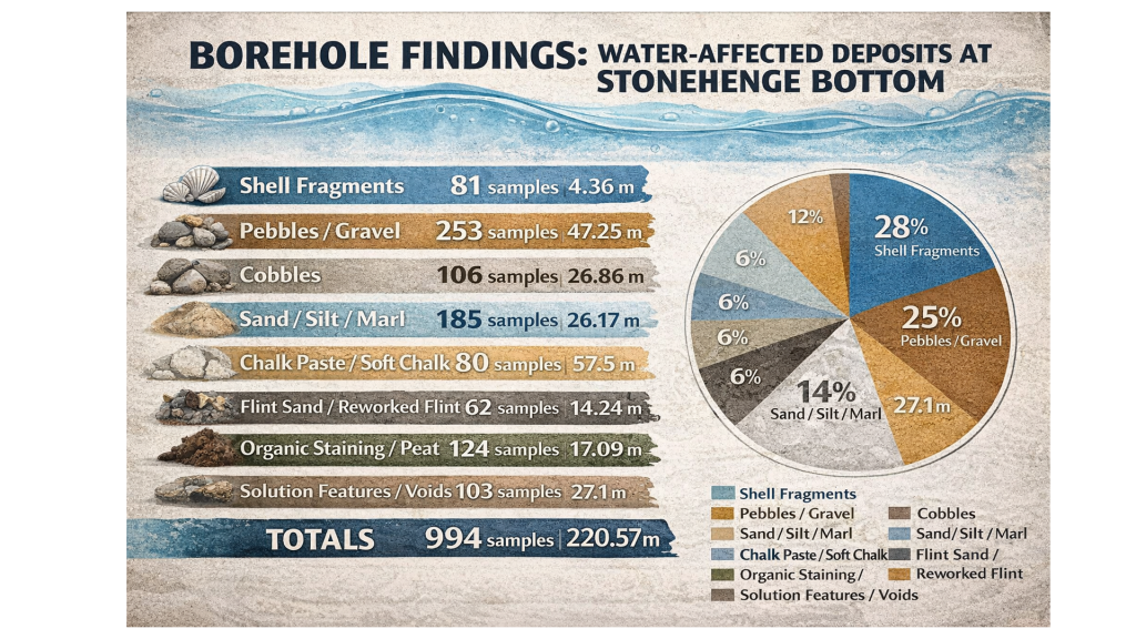
Stonehenge, Doggerland and Atlantis connection

Introduction

The third book in my trilogy aims to weave together the discoveries made across Britain, with a particular focus on Stonehenge, to shed light on a civilisation that archaeologists have termed the ‘megalithic builders.’ This civilisation is markedly distinct from those that came after, showcasing an extraordinary level of capability and engineering skill in moving vast stones and constructing earthworks that have endured for nearly ten thousand years. These achievements are even more striking when compared to the structures left by the Romans, who occupied these lands for hundreds of years yet left behind fewer enduring monuments. (Stonehenge, Doggerland and Atlantis connection)

Video

The megalithic builders’ legacy, characterised by iconic structures such as Stonehenge, reveals a sophisticated understanding of both engineering and astronomy. Their ability to align massive stones with celestial events suggests a deep connection to their environment and a complex societal organisation capable of undertaking such monumental projects. This civilisation’s accomplishments in stone construction and earthwork highlight their technical prowess and cultural and spiritual values, as many of these sites are believed to have served practical purposes.

(Stonehenge, Doggerland and Atlantis connection)
Long Barrows of Europe – centred over The North Sea (Doggerland) – (Stonehenge, Doggerland and Atlantis connection)

In writing this third book, I aimed to connect the dots between various megalithic sites across Britain and explore the knowledge, skills, and motivations of the people who built them. By examining the evidence left by the megalithic builders, from the stones they transported and erected to the earthworks they shaped, we can gain insights into a civilisation that continues to fascinate and inspire despite its distance in time.

(Stonehenge, Doggerland and Atlantis connection)

This exploration is an academic exercise and a journey into the heart of a civilisation whose creations still stand as a testament to human ingenuity and perseverance. The megalithic builders may have vanished into the mists of time, but their legacy endures, inviting us to marvel at their achievements and to contemplate our own place in the continuum of human history.

(Stonehenge, Doggerland and Atlantis connection)

The Megalthic Builders

The megalithic builders, a fascinating civilisation from our prehistoric past, operated on a scale and with a level of cooperation that transcends modern conceptions of boundaries and nation-states. Their domain spanned northern Europe, a testament to their widespread influence and shared cultural or technological practices. Unlike the segmented and often isolated cultures that followed, these ancient builders engaged in monumental constructions that served both the living and the dead, creating long barrows and dolmens as eternal resting places and linear earthwork canals and stone trading circles for the living.

(Stonehenge, Doggerland and Atlantis connection)

One of the most intriguing aspects of their civilisation is the central role played by an area now submerged beneath the North Sea, known as Doggerland. This now-lost land, which started to succumb to rising sea levels approximately 9,000 years ago, was once a vital part of a massive Mesolithic landscape. Doggerland connected the British Isles to mainland Europe, serving as a crossroads for people, ideas, and goods. The remnants of this landscape, including the Dogger Bank, provide a tantalising glimpse into a world where megalithic builders thrived, interacting with their environment and with one another in sophisticated ways.

Temple to the dead and mid-winter solstice
Stonehenge is a moon temple made for the dead – (Stonehenge, Doggerland and Atlantis connection)

The disappearance of Doggerland due to post-glacial sea level rise did not merely result in the loss of land; it marked the end of a significant chapter in human history. This transformation from a vast, interconnected landscape to a series of islands fundamentally altered the trajectory of European civilisation. The megalithic builders’ legacy, however, remains etched in the stone and earthworks that dot the landscape of northern Europe, enduring monuments to their engineering prowess and cosmopolitan outlook.

(Stonehenge, Doggerland and Atlantis connection)

Their achievements compel us to reconsider our understanding of prehistoric societies, challenging us to appreciate the complexity and depth of human ingenuity long before the advent of written history. The megalithic builders remind us that the desire to connect, communicate, and commemorate is a fundamental aspect of the human condition, transcending time, space, and the ever-changing contours of the earth.

The Stonehenge Connection

We can see from their greatest achievement, Stonehenge, a ‘message in a bottle’ that the megalithic builders left us some 5,000 years ago.  Although subsequent civilisations reused and altered aspects of the Stonehenge Monument, some of the most influential stones and structures still survive in situ, owing to the megalithic ability to manoeuvre vast weights, which effectively hindered lesser cultures in their attempts to radically alter the site’s significance.

(Stonehenge, Doggerland and Atlantis connection)

The origins of the Altar Stone at Stonehenge, described by Professor Hawkins as a “fine-grained pale green sandstone” notable for its mica flakes and glitter”, have long been a subject of speculation among experts. The prevailing theories had pointed towards Wales or Devon as the stone’s source. However, recent findings challenge this perspective, suggesting the stone could have originated much farther afield, potentially as far north as Scotland. This revelation aligns with my hypothesis, presented in my book over a decade ago, proposing an even more dramatic provenance for the Altar Stone—not just from the north, but from the northeast, specifically from the submerged landscapes of Doggerland.

Alter Stone recumbent stone - one of just two
The Altar is one of only two recumbents

Doggerland, the now-submerged landmass that once connected the British Isles to mainland Europe, represents a significant part of Mesolithic Europe’s landscape. The suggestion that the Altar Stone might have originated in this ancient, lost territory adds a fascinating layer to our understanding of Stonehenge’s construction. It implies that the builders of Stonehenge not only could transport massive stones over vast distances but also that their network of trade or cultural exchange spanned a far greater area than previously thought, encompassing regions that are now beneath the sea.

(Stonehenge, Doggerland and Atlantis connection)

The connection between Doggerland and Stonehenge, particularly through the Altar Stone, hints at a deeply intertwined prehistoric landscape that extends beyond current geographical boundaries. The intriguing alignment from the Altar Stone towards the last vestiges of Doggerland, known as the Isle of Dogger, intersects with another enigmatic feature of Stonehenge: the Slaughter Stone. This stone, distinctively recumbent and partially buried by the surrounding ditch, has long puzzled archaeologists. Its unique position within the Stonehenge complex and the name attributed to it by the Druids suggest a significant ceremonial or symbolic role.

Altar Stone and slaughter stone points to doggerland
Altar Stone and Slaughter Stone align with Doggerland

The deliberate placement of the Slaughter Stone, when considered in relation to the direction towards the remnants of Doggerland, could indicate a symbolic gesture by the builders of Stonehenge, perhaps to commemorate or maintain a connection with their ancestral lands now submerged beneath the North Sea. This alignment and the specific use of stones from distant locations underscore the profound sense of purpose and meaning the Stonehenge builders invested in the site’s construction.

Slaughter stone - burried in shallow ditch of water
The chalk under the Slaugher stone was cut away for a purpose

These potential connections to Doggerland not only expand our understanding of Stonehenge’s geographical and cultural significance but also invite us to consider the broader networks of communication, travel, and exchange that existed in prehistoric Europe. The use of stones from such distant sources and the possible alignments with lost lands hint at an intricate web of relationships and a deep historical consciousness among the people who constructed Stonehenge.

(Stonehenge, Doggerland and Atlantis connection)

As we continue to unravel the mysteries of Stonehenge and its stones, the importance of considering wider landscapes and connections becomes clear. The potential links to Doggerland offer a tantalising glimpse into the minds of the megalithic builders, revealing a world where memory, landscape, and the movement of materials were intimately connected. These insights challenge us to look beyond the immediate vicinity of prehistoric monuments and to consider the vast, now-hidden landscapes that were once integral to the lives and beliefs of ancient peoples.

Slaughter Stone - a relief map of doggerland
The Slaughrer stone is in fact a relief map (found after a HE scan) and not natural – the ground has been removed so to create an island surrounded by water

This hypothesis challenges the conventional archaeological narrative and suggests a level of sophistication and reach in prehistoric societies that is only now being understood. It underscores the importance of reconsidering and expanding our investigation into the origins and connections of the materials and people involved in creating monumental structures like Stonehenge. As we continue to uncover more about these ancient builders, their methods, and their world, it becomes increasingly clear that their achievements were far more complex and interconnected than once imagined, bridging lands now separated by waters but once part of a vast, interconnected landscape.

The Atlantis Connection

The completion of the quest to pinpoint the homeland of the megalithic builders marks a significant milestone in our understanding of this remarkable civilisation. The evidence of their extraordinary engineering achievements, from constructing monumental stone structures like Stonehenge to creating extensive earthworks such as Silbury Hill, underscores the sophistication and capabilities of these ancient architects and engineers. Without the modern machinery and technology we rely on today, their achievements in construction speak to a profound understanding of their environment and a remarkable ability to manipulate natural materials to their will.

(Stonehenge, Doggerland and Atlantis connection)

Given the scale of their constructions and the distances over which materials, such as the stones used in megaliths, were transported, it becomes clear that these builders possessed sophisticated transportation methods. The absence of roads for moving such massive stones over vast distances suggests that ships and boats were essential to their way of life. Waterways would have served as the arteries of trade, travel, and communication, connecting distant communities and facilitating the exchange of goods, ideas, and cultural practices across Europe.

Wales oldest Boat Yard
We have found prehistoric Catamarans made to carry stones – Wales oldest Boat Yard

This reliance on maritime technology indicates that the megalithic builders were skilled engineers, architects, and adept sailors and navigators. Using boats would have allowed them to traverse prehistoric Europe’s coastal and riverine landscapes, enabling the widespread distribution of their megalithic culture. Such capabilities would have been crucial for orchestrating the large-scale cooperative efforts to construct the monumental stone structures that define their legacy.

(Stonehenge, Doggerland and Atlantis connection)

The comparison with the maritime achievements of the Greeks and Romans, celebrated for their advancements in shipbuilding and navigation, underscores the significance of the megalithic builders’ accomplishments. Their ability to harness the power of water for transportation and communication is a testament to their ingenuity and a critical factor in their success as a civilisation.

(Stonehenge, Doggerland and Atlantis connection)

The megalithic builders’ reliance on maritime technology for movement and communication across Europe highlights a sophisticated understanding of their environment and an unparalleled ability to manipulate it to their advantage. This aspect of their civilisation offers valuable insights into the complexity of prehistoric societies and challenges us to expand our appreciation of their technological and cultural achievements.

Plato

The tale of Atlantis, as recounted by Plato, stands as one of the most captivating stories from antiquity, blurring the line between historical account and mythological narrative. Over time, the story of this advanced civilisation that supposedly sank into the sea around 9,000 years ago has been transformed by modern interpretations and entertainment into something more akin to science fiction. This transformation has, unfortunately, obscured the significance of Plato’s account, relegating it to the realm of mere fantasy in the eyes of many.

Plato

Plato, a philosopher of unparalleled influence in Western thought, presented the story of Atlantis not as a myth but as a recounting of historical fact told to him by Solon, who had learned it from Egyptian priests. According to the narrative, Atlantis was a civilisation of great power and technological prowess, with ships that traversed the globe and a highly advanced society.

(Stonehenge, Doggerland and Atlantis connection)

The comparison between the story of Atlantis and the archaeological evidence of Doggerland and the megalithic builders is striking. Like the Atlanteans, the people of Doggerland, who lived around 10,000 years ago, exhibited advanced capabilities, particularly in maritime technology. They built monumental structures and possessed the knowledge to navigate and sail to distant lands. This evidence challenges the prevailing academic view of prehistoric societies as simplistic hunter-gatherer tribes and aligns with Plato’s description of Atlantis as a great and advanced civilisation.

Stonehenge Debunked

Moreover, the presence of notable figures such as Solon, a key figure in the development of democracy in ancient Greece, and Socrates, celebrated for his wisdom, in the dialogues discussing Atlantis, lends credibility to the account. Their involvement suggests that the story was taken seriously by some of the most respected thinkers of the time, who did not dismiss it as mere fiction.

Some academics’ reluctance to accept the possibility of advanced prehistoric civilisations is perhaps understandable, given the scarcity of direct archaeological evidence and the challenge of separating historical fact from myth. However, the megalithic stones and the submerged landscapes of Doggerland offer tangible links to a past that may have been far more complex and interconnected than previously acknowledged.

The possible connection between Doggerland, the story of Atlantis told by Plato, and the initial stages of Stonehenge’s construction around 8300 BCE suggests that these ancient events might be related or share a common origin. Dating the beginning of Stonehenge to such an early era aligns with the timeline of Plato’s Atlantean civilisation, suggesting a potential connection or shared features between the Stonehenge builders and the advanced society described in the Atlantis legend.

(Stonehenge, Doggerland and Atlantis connection)

This theory challenges commonly accepted beliefs about the achievements and timelines of prehistoric humans. It suggests that Stonehenge, a monument that has fascinated scholars and visitors for centuries, might have originated during the same period as the legendary civilisation of Atlantis. This discovery prompts a reassessment of human activities during the Mesolithic period.

It is possible to imagine a prehistoric world where societies were not only technologically advanced but also well-connected across vast distances, given the architectural complexity and navigational skills demonstrated in the stories of these civilisations. The hypothesis that the megalithic builders, who were capable of maritime travel and of constructing monumental structures like Stonehenge, might have shared a cultural or historical link with the Atlanteans adds depth to the narrative of human history during the Mesolithic era.

This viewpoint emphasises a more inclusive and transparent approach to archaeology, emphasising the significance of sustained inquiry and the readiness to question conventional historical accounts. With the emergence of new findings challenging long-standing assumptions, the links among Doggerland, Atlantis, and Stonehenge exemplify the intricate and multifaceted nature of early human civilisation’s accomplishments.

Plato’s description of an Atlantis city fits the design of Causewayed Enclosures

PodCast

Author’s Biography

Robert John Langdon, a polymathic luminary, emerges as a writer, historian, and eminent specialist in LiDAR Landscape Archaeology.

His intellectual voyage has been interwoven with stints as an astute scrutineer in government and grand corporate bastions, a tapestry spanning British Telecommunications, Cable and Wireless, British Gas, and the esteemed University of London.

A decade hence, Robert’s transition into retirement unfurled a chapter of insatiable curiosity. This phase saw him immerse himself in Politics, Archaeology, Philosophy, and the enigmatic realm of Quantum Mechanics. His academic odyssey traversed the venerable corridors of knowledge hubs such as the Museum of London, University College London, Birkbeck College, The City Literature Institute, and Chichester University.

In the symphony of his life, Robert is a custodian of three progeny and a pair of cherished grandchildren. His sanctuary lies ensconced in the embrace of West Wales, where he inhabits an isolated cottage, its windows framing a vista of the boundless sea – a retreat from the scrutinising gaze of Her Majesty’s Revenue and Customs, an amiable clandestinity in the lap of nature.

Exploring Prehistoric Britain: A Journey Through Time

My blog delves into the fascinating mysteries of prehistoric Britain, challenging conventional narratives and offering fresh perspectives grounded in cutting-edge research, particularly LiDAR technology. I invite you to explore some key areas of my research. For example, the Wansdyke, often cited as a defensive structure, is re-examined in light of new evidence. I’ve presented my findings in my blog post Wansdyke: A British Frontier Wall – ‘Debunked’, and a Wansdyke LiDAR Flyover video further visualises my conclusions.

My work also often challenges established archaeological dogma. I argue that many sites, such as Hambledon Hill, commonly identified as Iron Age hillforts, are not what they seem. My posts Lidar Investigation Hambledon Hill – NOT an ‘Iron Age Fort’ and Unmasking the “Iron Age Hillfort” Myth explore these ideas in detail and offer an alternative view. Similarly, sites like Cissbury Ring and White Sheet Camp receive re-evaluations based on LiDAR analysis in my posts “Lidar Investigation Cissbury Ring through time” and “Lidar Investigation White Sheet Camp,“ revealing fascinating insights into their true purpose. I have also examined South Cadbury Castle, often linked to the mythical Camelot56.

My research also extends to ancient water management, including the role of canals and other linear earthworks. I have discussed the true origins of Car Dyke in multiple posts, including Car Dyke – ABC News Podcast and Lidar Investigation Car Dyke – North Section, which suggest a Mesolithic origin 2357. I also explore the misidentification of Roman aqueducts, as seen in my posts on the Great Chesters (Roman) Aqueduct. My research has also been greatly informed by my post-glacial flooding hypothesis, which has helped explain landscape transformations over time. I have discussed this hypothesis in several posts, including AI now supports my Post-Glacial Flooding Hypothesis and Exploring Britain’s Flooded Past: A Personal Journey

Finally, my blog also investigates prehistoric burial practices, as seen in Prehistoric Burial Practices of Britain and explores the mystery of Pillow Mounds, often mistaken for medieval rabbit warrens, but with a potential link to Bronze Age cremation in my posts: Pillow Mounds: A Bronze Age Legacy of Cremation? and The Mystery of Pillow Mounds: Are They Really Medieval Rabbit Warrens?. My research also includes astronomical insights into ancient sites, for example, in Rediscovering the Winter Solstice: The Original Winter Festival. I also review new information about the construction of Stonehenge in The Stonehenge Enigma.

Further Reading

For those interested in British Prehistory, visit www.prehistoric-britain.co.uk, a comprehensive resource featuring an extensive collection of archaeology articles, modern LiDAR investigations, and groundbreaking research. The site also includes insights and excerpts from the acclaimed Robert John Langdon Trilogy, a series of books that explore Britain during the Prehistoric period. Titles in the trilogy include The Stonehenge Enigma, Dawn of the Lost Civilisation, and The Post-Glacial Flooding Hypothesis, which offer compelling evidence of ancient landscapes shaped by post-glacial flooding.

To further explore these topics, Robert John Langdon has developed a dedicated YouTube channel featuring over 100 video documentaries and investigations that complement the trilogy. Notable discoveries and studies showcased on the channel include 13 Things that Don’t Make Sense in History and the revelation of Silbury Avenue – The Lost Stone Avenue, a rediscovered prehistoric feature at Avebury, Wiltshire.

In addition to his main works, Langdon has released a series of shorter, accessible publications, ideal for readers delving into specific topics. These include:

For active discussions and updates on the trilogy’s findings and recent LiDAR investigations, join our vibrant community on Facebook. Engage with like-minded enthusiasts by leaving a message or contributing to debates in our Facebook Group.

Whether through the books, the website, or interactive videos, we aim to provide a deeper understanding of Britain’s fascinating prehistoric past. We encourage you to explore these resources and uncover the mysteries of ancient landscapes through the lens of modern archaeology.

For more information, including chapter extracts and related publications, visit the Robert John Langdon Author Page. Dive into works such as The Stonehenge Enigma or Dawn of the Lost Civilisation, and explore cutting-edge theories that challenge traditional historical narratives.

Other Blogs

[sitemap_posts]

The Stonehenge Crescent: A Monument to a Lost World

A Monument to the Dead — Not the Sun

One of the most recognisable images in archaeology is that of a perfect circular Stonehenge — a continuous ring of upright stones capped with lintels. (The Stonehenge Crescent: A Monument to a Lost World)

You’ve seen it everywhere:

  • Textbooks
  • Reconstructions
  • Documentaries

It has become the accepted version of the monument.

There is just one problem.

Stonehenge was never built that way.

(The Stonehenge Crescent: A Monument to a Lost World)

The Myth of the Perfect Circle

The circular Stonehenge exists more in illustration than in reality.

When we examine the monument itself, the physical evidence tells a very different story:

  • Several stones required to complete the circle are missing
  • Others are too small to support lintels
  • Some are incorrectly positioned for a continuous ring
  • Stone holes reveal uprights that do not conform to a circular design

This creates a fundamental contradiction.

If Stonehenge was intended to be a perfect solar temple, then:

  1. It was never completed
  2. Or it was deliberately dismantled

Both explanations are unsatisfactory.

There is a far simpler solution.

It was never meant to be a complete circle.

(The Stonehenge Crescent: A Monument to a Lost World)

Structural Proof: Stone 11 Breaks the Model

This conclusion is not just interpretive — it is structural.

One stone alone exposes the flaw in the circular theory.

Stone 11.

This stone is:

  • Smaller than its neighbours
  • Structurally inadequate
  • Incapable of supporting a lintel

This is critical.

A continuous lintel ring requires every upright to meet a basic engineering condition:

It must support load.

Stone 11 cannot.

This is not a minor anomaly. It is a mechanical failure within the supposed design.

There are only two possible explanations:

  • The builders made a fundamental structural mistake
  • The circle was never intended to be continuous

Given the precision elsewhere in the monument, the first option is highly unlikely.

Which leaves only one conclusion:

Stone 11 is not an error — it is evidence.

It proves that the monument was never designed as a complete ring.

(The Stonehenge Crescent: A Monument to a Lost World)

A Different Shape Emerges

When we examine all surviving stones and stone holes together, a new pattern appears.

Not a circle.

A crescent.

The Sarsen arrangement — particularly the inner trilithon horseshoe — reinforces this, forming a crescent within a crescent.

This is deliberate.

And its orientation matters.

(The Stonehenge Crescent: A Monument to a Lost World)

Death, Not the Sun

Across ancient cultures:

  • The sun represents life and continuity
  • The circle reflects that — endless and complete

But death is different.

Death is transition.

And that transition is often symbolised by the crescent moon — a passage between darkness and renewal.

Stonehenge aligns with this symbolism precisely.

The structure faces the Winter Solstice sunset:

  • The lowest point of the sun
  • The moment of greatest darkness
  • The turning point before light returns

This is not a monument to life.

It is a monument to transition.

(The Stonehenge Crescent: A Monument to a Lost World)

The Missing Stones Tell the Story

The pattern of missing stones strengthens this interpretation.

If stones had been removed later, we would expect:

  • Random distribution
  • Removal from accessible locations

But instead:

  • The majority of missing stones occur in the south-western quadrant
  • This is the least accessible area

This is not random.

It is intentional.

The monument was designed to be open in this direction — forming a crescent aligned with the Winter Solstice sunset.

(The Stonehenge Crescent: A Monument to a Lost World)

The Altar Stone and the Slaughter Stone

At the centre of the monument lies the Altar Stone:

  • Fine-grained sandstone
  • Rich in mica
  • Distinct from all other stones

It is also placed flat.

This is unusual — but not unique.

Near the entrance lies the Slaughter Stone, also recumbent.

Excavations in the 1920s showed:

  • The chalk beneath it was deliberately levelled
  • It was always intended to lie flat

Even more importantly:

  • It sits in a shallow depression
  • Connected to the ditch system
  • Likely water-filled under higher groundwater conditions

This would have made the stone appear as a small island in water.

(The Stonehenge Crescent: A Monument to a Lost World)

A Monument Built in Water

This aligns directly with the hydrological model of early Holocene Britain.

Evidence shows that:

  • Water tables were significantly higher
  • River systems were larger
  • Floodplains dominated the landscape

Stonehenge was not a dry site.

It existed within a water-controlled environment

(The Stonehenge Crescent: A Monument to a Lost World)

The Altar Stone: A Geological Clue

The Altar Stone introduces another layer of evidence.

It is widely accepted that:

  • It originates from outside the local region
  • It travelled over long distances

Traditional explanations suggest land transport.

But there is a problem.

Across hundreds of kilometres:

  • No prehistoric roads
  • No engineered trackways
  • No infrastructure for overland movement

What we do find is:

  • Extensive river systems
  • Floodplains
  • Palaeochannels

The conclusion is straightforward:

The stones were transported by water.

(The Stonehenge Crescent: A Monument to a Lost World)

The Doggerland Origin Hypothesis

There is an additional, often overlooked possibility.

The geological composition of the Altar Stone matches:

  • Bedrock found in northern Britain
  • And bedrock mapped beneath the North Sea

This is critical.

Because during the early Holocene:

  • The North Sea was not fully submerged
  • It was a vast landmass

Doggerland.

If the Altar Stone originated from this region, then:

  • It was not just transported across distance
  • It was brought from a landscape that no longer exists
(The Stonehenge Crescent: A Monument to a Lost World)

A Lost Source Beneath the Sea

Geological evidence shows that Doggerland:

  • Contained exposed bedrock
  • Shared lithological characteristics with the Altar Stone
  • Was progressively flooded between ~9000 and 8000 years ago

This reframes the stone completely.

It is no longer just imported material.

It becomes:

a fragment of a lost homeland.

(The Stonehenge Crescent: A Monument to a Lost World)

A Deliberate Sightline

The Altar Stone and Slaughter Stone form a direct alignment:

  • From the centre
  • Through the entrance
  • Along the Avenue
  • Toward the ancient river system

When extended beyond the monument, this line points toward:

Doggerland.

This is not coincidence.

Ancient monuments frequently connect:

  • Structure
  • Landscape
  • Memory

Stonehenge does all three.

(The Stonehenge Crescent: A Monument to a Lost World)

A Monument Built from Memory

When combined:

  • Crescent design
  • Solstice alignment
  • Directional sightline
  • Geological connection

The interpretation becomes clear.

Stonehenge is not simply pointing toward a lost world.

It may contain material from it.

(The Stonehenge Crescent: A Monument to a Lost World)

The Hidden Interior: Stonehenge as a Painted Space

There is another overlooked feature.

The inner faces of the Sarsen stones are flattened.

This required:

  • Significant labour
  • Controlled shaping
  • Time investment across multiple stones

This was not done casually.

It was done for a reason.

(The Stonehenge Crescent: A Monument to a Lost World)

The Effort Behind the Surfaces

Flattening stone with prehistoric tools would have taken:

  • Weeks per stone
  • Possibly months across the structure

Prehistoric societies do not waste effort.

Every action has purpose.

These surfaces were prepared for something important.

(The Stonehenge Crescent: A Monument to a Lost World)

A Cultural Memory Lost

Before the Ice Age, the ancestors of these builders created:

  • Complex cave art
  • Symbolic imagery
  • Advanced visual culture

After this period, the art seems to disappear.

But it didn’t.

The medium changed

(The Stonehenge Crescent: A Monument to a Lost World)

The Missing Medium

We know:

  • Pigments were used
  • Bodies were painted
  • Symbolism was central

But open-air artwork does not survive:

  • Rain erodes it
  • Sunlight fades it
  • Time destroys it

Over 10,000 years, it vanishes.

(The Stonehenge Crescent: A Monument to a Lost World)

Stonehenge as an Art Space

Now reconsider the monument:

  • Flattened inner stone surfaces
  • Enclosed space
  • Controlled environment

These are perfect conditions for:

painting

(The Stonehenge Crescent: A Monument to a Lost World)

A Prehistoric Gallery

Instead of bare stone, imagine:

  • Painted surfaces
  • Symbolic imagery
  • Cultural storytelling
  • Ancestral representation

Stonehenge becomes:

a sacred visual environment


From Cold Stone to Living Culture

What we see today:

  • Weathered stone
  • Empty surfaces
  • Structural remains

What once existed:

  • Colour
  • Meaning
  • Cultural expression

Not a ruin.

But a gallery of memory and identity.

(The Stonehenge Crescent: A Monument to a Lost World)

A Memorial to a Lost World

When all evidence is combined:

  • The crescent form reflects death
  • The solstice alignment marks transition
  • The sightline points toward Doggerland
  • The Altar Stone may originate from that drowned land
  • The interior may have been painted with cultural memory

The meaning becomes clear.

Stonehenge is not a solar temple.

It is a memorial.

(The Stonehenge Crescent: A Monument to a Lost World)

Final Conclusion

Stonehenge was not built to mark the movement of the sun.

It was built to remember.

To record a moment in human history when:

  • A landscape was lost
  • A homeland disappeared
  • A civilisation adapted

The stones do not just stand.

They point.

They align.

They remember.

And once you remove the myth of the circle, the monument finally makes sense.

Stonehenge was never a circle.
It was a message.

(The Stonehenge Crescent: A Monument to a Lost World)

PodCast

Author’s Biography

Robert John Langdon, a polymathic luminary, emerges as a writer, historian, and eminent specialist in LiDAR Landscape Archaeology.

His intellectual voyage has been interwoven with stints as an astute scrutineer in government and grand corporate bastions, a tapestry spanning British Telecommunications, Cable and Wireless, British Gas, and the esteemed University of London.

A decade hence, Robert’s transition into retirement unfurled a chapter of insatiable curiosity. This phase saw him immerse himself in Politics, Archaeology, Philosophy, and the enigmatic realm of Quantum Mechanics. His academic odyssey traversed the venerable corridors of knowledge hubs such as the Museum of London, University College London, Birkbeck College, The City Literature Institute, and Chichester University.

In the symphony of his life, Robert is a custodian of three progeny and a pair of cherished grandchildren. His sanctuary lies ensconced in the embrace of West Wales, where he inhabits an isolated cottage, its windows framing a vista of the boundless sea – a retreat from the scrutinising gaze of Her Majesty’s Revenue and Customs, an amiable clandestinity in the lap of nature.

Exploring Prehistoric Britain: A Journey Through Time

My blog delves into the fascinating mysteries of prehistoric Britain, challenging conventional narratives and offering fresh perspectives grounded in cutting-edge research, particularly LiDAR technology. I invite you to explore some key areas of my research. For example, the Wansdyke, often cited as a defensive structure, is re-examined in light of new evidence. I’ve presented my findings in my blog post Wansdyke: A British Frontier Wall – ‘Debunked’, and a Wansdyke LiDAR Flyover video further visualises my conclusions.

My work also often challenges established archaeological dogma. I argue that many sites, such as Hambledon Hill, commonly identified as Iron Age hillforts, are not what they seem. My posts Lidar Investigation Hambledon Hill – NOT an ‘Iron Age Fort’ and Unmasking the “Iron Age Hillfort” Myth explore these ideas in detail and offer an alternative view. Similarly, sites like Cissbury Ring and White Sheet Camp receive re-evaluations based on LiDAR analysis in my posts “Lidar Investigation Cissbury Ring through time” and “Lidar Investigation White Sheet Camp,“ revealing fascinating insights into their true purpose. I have also examined South Cadbury Castle, often linked to the mythical Camelot56.

My research also extends to ancient water management, including the role of canals and other linear earthworks. I have discussed the true origins of Car Dyke in multiple posts, including Car Dyke – ABC News Podcast and Lidar Investigation Car Dyke – North Section, which suggest a Mesolithic origin 2357. I also explore the misidentification of Roman aqueducts, as seen in my posts on the Great Chesters (Roman) Aqueduct. My research has also been greatly informed by my post-glacial flooding hypothesis, which has helped explain landscape transformations over time. I have discussed this hypothesis in several posts, including AI now supports my Post-Glacial Flooding Hypothesis and Exploring Britain’s Flooded Past: A Personal Journey

Finally, my blog also investigates prehistoric burial practices, as seen in Prehistoric Burial Practices of Britain and explores the mystery of Pillow Mounds, often mistaken for medieval rabbit warrens, but with a potential link to Bronze Age cremation in my posts: Pillow Mounds: A Bronze Age Legacy of Cremation? and The Mystery of Pillow Mounds: Are They Really Medieval Rabbit Warrens?. My research also includes astronomical insights into ancient sites, for example, in Rediscovering the Winter Solstice: The Original Winter Festival. I also review new information about the construction of Stonehenge in The Stonehenge Enigma.

Further Reading

For those interested in British Prehistory, visit www.prehistoric-britain.co.uk, a comprehensive resource featuring an extensive collection of archaeology articles, modern LiDAR investigations, and groundbreaking research. The site also includes insights and excerpts from the acclaimed Robert John Langdon Trilogy, a series of books that explore Britain during the Prehistoric period. Titles in the trilogy include The Stonehenge Enigma, Dawn of the Lost Civilisation, and The Post-Glacial Flooding Hypothesis, which offer compelling evidence of ancient landscapes shaped by post-glacial flooding.

To further explore these topics, Robert John Langdon has developed a dedicated YouTube channel featuring over 100 video documentaries and investigations that complement the trilogy. Notable discoveries and studies showcased on the channel include 13 Things that Don’t Make Sense in History and the revelation of Silbury Avenue – The Lost Stone Avenue, a rediscovered prehistoric feature at Avebury, Wiltshire.

In addition to his main works, Langdon has released a series of shorter, accessible publications, ideal for readers delving into specific topics. These include:

For active discussions and updates on the trilogy’s findings and recent LiDAR investigations, join our vibrant community on Facebook. Engage with like-minded enthusiasts by leaving a message or contributing to debates in our Facebook Group.

Whether through the books, the website, or interactive videos, we aim to provide a deeper understanding of Britain’s fascinating prehistoric past. We encourage you to explore these resources and uncover the mysteries of ancient landscapes through the lens of modern archaeology.

For more information, including chapter extracts and related publications, visit the Robert John Langdon Author Page. Dive into works such as The Stonehenge Enigma or Dawn of the Lost Civilisation, and explore cutting-edge theories that challenge traditional historical narratives.

Other Blogs

[sitemap_posts]
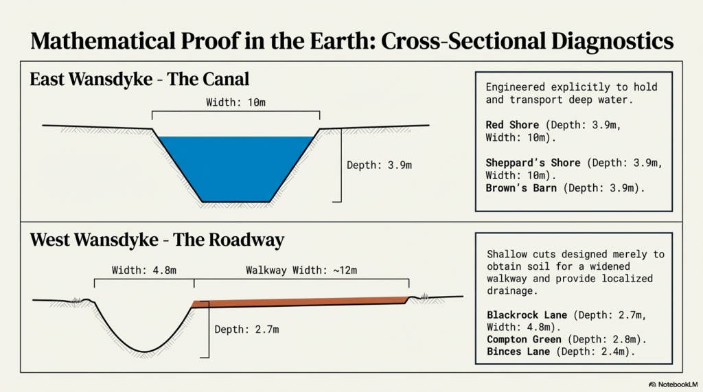
The Bluestone Enigma

Introduction

The Bluestone quarry sites give us compelling evidence of the Mesolithic construction dates of Stonehenge (The Bluestone Enigma)

The papers published by researchers from the University of London, Southampton, and Manchester, including Mike Parker-Pearson and his team, regarding the discovery of the quarries at Craig Rhos-y-Felin and the bluestone megaliths at Carn Goedog have been a significant contribution to our understanding of Stonehenge’s origins. This research brought to light the fascinating theory that Stonehenge was originally built in Wales and later transported to Salisbury Plain around 500 years later.

This groundbreaking discovery not only captured the attention of archaeologists worldwide but also challenged previous assumptions about the methods and motivations behind Stonehenge’s construction. The idea that these bluestones were quarried and shaped in Wales before making their journey to Salisbury Plain adds a new dimension to our understanding of prehistoric peoples’ capabilities and social organisation.

This revelation suggests a remarkable level of dedication and coordination among ancient communities. The logistical feat of transporting these massive stones over such a distance, and the decision to do so centuries after their initial quarrying, hints at the profound significance these stones—and the monument they came to form—held for the people of the time.

As someone deeply interested in the mysteries of ancient civilisations, I find the implications of this research thrilling. It deepens our appreciation for the ingenuity and spiritual dedication of our ancestors and opens up new avenues for exploring the cultural and religious ties that connected different regions of prehistoric Britain.

The Bluestone Enigma
Prescilli Mountains in Wales – The Bluestone Enigma

Craig Rhos-Y-Felin

The publication of the report “Craig Rhos-y-Felin: a Welsh bluestone megalith quarry for Stonehenge” in the December 2016 edition of Antiquity Magazine unveiled intriguing findings about the origins of the bluestones used in Stonehenge. This study, which identified a 4m long monolith at Craig Rhos-y-Felin as microscopically identical to the bluestones at Stonehenge, has sparked significant debate and speculation within the archaeological community and beyond.

Despite the excitement generated by these findings, the report’s focus on two radiocarbon dates that align with the authors’ hypothesis on Stonehenge’s construction date has raised questions about the completeness of the narrative presented to the public. The discrepancy between these dates and the hoped-for evidence led to the speculative suggestion that Stonehenge was originally constructed in Wales and later relocated to Salisbury Plain. This narrative, while intriguing, illustrates the complexities and challenges of interpreting archaeological data, as well as the temptation to fit new evidence into pre-existing hypotheses.

However, a more detailed analysis of the report reveals a wealth of Mesolithic carbon dates obtained from human-made hearths, suggesting a much earlier period of human activity at the site than the two Neolithic dates highlighted. These Mesolithic dates, which significantly predate the construction of Stonehenge as currently understood, were largely overlooked in the public dissemination of the research findings.

The Bluestone Enigma
Quarry Site at Craig Rhos-Y-Felin – The Bluestone Enigma

This oversight raises essential questions about the narrative surrounding Stonehenge’s origins and the methodologies used in archaeological dating. The presence of Mesolithic hearths at Craig Rhos-y-Felin suggests that the site was of importance to human communities thousands of years before the Neolithic period. This evidence challenges the conventional timeline of Stonehenge’s construction and suggests a longer, more complex history of human interaction with the landscape and the bluestones.

Furthermore, the report inadvertently highlights the ongoing debate within archaeology about how best to interpret and present findings to the public. The focus on headline-grabbing narratives, such as the relocation of Stonehenge from Wales, can sometimes overshadow equally significant but less sensational discoveries, such as the evidence of Mesolithic activity at the quarry site.

An Inconvenient TRUTH (Craig Rhos Y Felin)
Mesolithic Post Holes at the Old Car Park at Stonehenge – The Bluestone Enigma

The excavation in 1966 and subsequent discoveries surrounding Stonehenge offer a fascinating and somewhat contentious glimpse into the complex task of accurately dating ancient sites. The initial observations by Lance and Faith Vatcher highlighted the Neolithic character of three holes excavated near Stonehenge, with no datable pottery found. Yet, the characteristics of the holes suggested a Neolithic origin. This assumption was later questioned when a PhD student discovered that the charcoal deposits from these holes, surprisingly composed mostly of pine, could not be Neolithic as initially thought. Pine was believed to be ‘extinct’ in the area by the time of Stonehenge’s supposed construction, according to pollen analysis.

This revelation was startling, especially to the officials of the Historic Buildings and Monuments Commission, later known as English Heritage. The carbon dating of these pine samples placed them squarely in the Mesolithic era, specifically between 8860 to 6590 BCE, challenging the previously accepted timeline for Stonehenge’s construction. Furthermore, the report mentions pine samples from Woodhenge, which, if also Mesolithic, would radically alter our understanding of that site’s age.

Stonehenge Car Park

Mesolithic Post Holes in Old Car Park – The Bluehenge Enigma

Instead of seizing this opportunity to delve deeper into these findings, a narrative was constructed that dismissed these posts as totem poles from wandering hunter-gatherers, unrelated to Stonehenge. This decision to sideline potentially groundbreaking evidence highlights a reluctance within some parts of the archaeological community to reconsider established narratives, even in the face of new evidence.

The discovery in 1988-89 by Wessex Archaeology of another Mesolithic post hole, along with a piece of rhyolite dated to 7737 – 7454 BCE, further complicates the timeline for Stonehenge and the surrounding area. This finding should have prompted a reevaluation of the site’s dating. However, attempts to fit this new evidence into the existing narrative of Stonehenge’s construction timeline illustrate the challenges and controversies inherent in archaeological interpretation.

These instances underscore the necessity for openness, curiosity, and a willingness to revise our understanding of history in light of new evidence. They remind us that the story of human history is complex and continually evolving, and our interpretations must adapt as we uncover more about our past.

The Bluestone Enigma
Stone Hole WA9580 shows a piece of Bluestone 5,000 years before they arrived. – The Bluestone Enigma

Discoveries at Stonehenge, including charcoal (OxA-18655) found in the Hole socket of Stone 10, dating to 7330 – 7060 BCE, match the dates of the Mesolithic post holes, with significant implications for our understanding of the site’s history. This evidence, dating to the Mesolithic post holes, suggests that the activities at Stonehenge and its surroundings span much earlier than previously believed. However, the apparent suppression of this news from widespread media coverage raises questions about the narrative presented to the public and in educational materials.

The excavation at Blick Mead, less than a mile from Stonehenge, by the Open University, which uncovered evidence of Mesolithic-period habitation and feasting, further challenges the entrenched views held by some about prehistoric life around Stonehenge. These findings suggest a continuous and significant presence of people in this area during the Mesolithic period, contradicting the simplistic ‘totem pole’ myth still perpetuated in some narratives by English Heritage (EH) through their exhibitions and guidebooks.

Moreover, the recent transformation of the Stonehenge site, including the closure of the B-road past the stones and the relocation of the visitors’ car park to a new, multi-million-pound visitor centre, represents a significant shift in how the site is accessed and experienced by the public. The removal of the old tarmac and the reversion of the land to grass aim to restore a more authentic prehistoric ambience to Stonehenge. This effort to make the site appear more as it did at the time of its construction is commendable, but also highlights the ongoing tension between modern interpretations of the site and the emerging evidence of its ancient past.

These developments at Stonehenge and Blick Mead exemplify the dynamic nature of archaeological research and the complexities involved in interpreting and presenting the past. As new evidence continues to emerge, the narrative of prehistoric Britain needs to evolve accordingly, ensuring a more accurate and nuanced understanding of these ancient landscapes and their significance to human history.

The Bluestone Enigma
In 2008, Stone 10 – Tim Darvill and Geoffrey Wainwright found charcoal dating back to 7330 to 7060 – The Bluestone Enigma

You would indeed think that removing the tarmac from the old visitor car park at Stonehenge, especially given the significant previous findings beneath it, would prompt a comprehensive excavation to unearth more evidence of the site’s Mesolithic history. Such an excavation could potentially transform our understanding of Stonehenge and its origins, providing invaluable insights into its early history and the people who frequented the site during the Mesolithic period.

Tim Daw’s role as a warden at Stonehenge, combined with his proactive approach to documenting changes and features of the site through photography, exemplifies the kind of engaged observation that can lead to important discoveries. His finding of patch marks by the central upright stones, indicating the possible positions of missing stones from the Inner Circle, is a testament to the contributions individuals can make to the ongoing investigation of Stonehenge. Daw’s work underscores the value of continuous and attentive observation of archaeological sites, even by those not formally conducting research.

The Bluestone Enigma
Tim Daw’s evidence of yet another Pit in the Old Car Park not investigated! – The Bluehenge Enigma

The discovery of such features and the potential for further findings beneath the former car park area highlights the need for a thorough and systematic archaeological examination whenever opportunities arise. These efforts not only enrich our knowledge of Stonehenge’s past but also contribute to the broader understanding of prehistoric human activity in the region. As we continue to peel back the layers of Stonehenge’s history, each finding adds a piece to the puzzle of this enigmatic monument’s story, emphasising the importance of preserving and exploring our archaeological heritage.

The Bluestone Enigma
The Post Holes would have been on the shoreline of the River Avon in Mesolithic period – The Bluestone Enigma

Tim Daw’s experiences and observations as a warden at Stonehenge, particularly his discovery of additional post holes beneath the old visitor’s car park, highlight the ongoing potential for new findings that can challenge and enrich our understanding of Stonehenge’s history. Despite being warned against publishing his conclusions due to unauthorised blog activity, Daw chose to resign and continue his work, revealing, through ‘unofficial’ pictures, the existence of even more post holes under the car park, aligned with those discovered in 1966.

Bluestone Quarries

These findings, including the newly discovered post hole that aligns with the four others from 1966, support the hypothesis that these structures are situated on what was once the shoreline of the River Avon around 8000 BCE. This suggests that during the Mesolithic period, the stones quarried in Wales could have been transported by boat directly to Stonehenge, navigating along enlarged rivers rather than taking the longer sea route proposed by some archaeologists.

Further complicating the narrative are my analyses of the bluestone structures from other Preseli sites like Carn Goedog and Craig Talfynyydd, which are connected by streams and rivers to the River Nevern. Unfortunately, archaeologists have interpreted this network of waterways primarily through a religious lens rather than considering its practical functionality as a transportation network.

The persistence of the ‘ox-cart’ route theory, which posits a land route along the modern A40, overlooks the logistical challenges posed by the period’s dense woods, swamps, and forests. Such conditions would have made the construction and use of a road system highly impractical, if not impossible.

My critique extends to the inconsistencies and logical inaccuracies in the archaeological narrative, particularly regarding the site layout and geological evidence at Craig Rhos-y-Felin. The assumption that floodwaters in the area were solely the result of ice melt, quickly draining into the sea post-Ice Age, ignores the broader implications of such flooding for the landscape and its inhabitants.

The Bluestone Enigma
Craig Rhos-Y-Felin is on the edge of a gigantic river of the past – The Bluestone Enigma.

We confirm in the report that an old river ran around this quarry as long ago as 5620 – 5460 BCE and possibly as late as 1030 – 910 BCE.

“Most of the site was then covered by a layer of yellow colluvium (035), dated by oak charcoal to 1030–910 cal BC (combine SUERC-46199; 2799±30 BP and SUERC-46203; 2841±28 BP). This deposit is contemporary with the uppermost fill of a palaeochannel of the Brynberian stream that flowed past the northern tip of the outcrop. Charcoal of Corylus and Tilia from the basal fill of this palaeochannel dates to 5800–5640 cal BC (OxA- 32021; 6833±40 BP) and 5620–5460 cal BC (OxA-32022; 6543±37 BP), both at 95.4% probability.”

An Inconvenient TRUTH (Craig Rhos Y Felin)
The only RED hearths in the site are Mesolithic so they must be quarrying at that time – The Bluestone Enigma


The report’s insights suggest that during the Mesolithic Period, an enlarged stream that fed into the River Nevern reached the quarry outcrop rocks. Notably, it was positioned just a few meters away, even as late as 1000 BCE. This geographical configuration suggests that boats were likely the primary means of transporting the large, newly quarried stones to their final destination at Stonehenge, mirroring stone transport methods in other ancient civilisations, such as Egypt.

The site layout at the quarry provides crucial clues about the timing of the stone quarrying. Notably, a single monolith is positioned near the river on the site’s east side, ready for transportation. Nearby, to the south of this monolith, are human-made hearths, precisely where one would expect them to be. However, the challenge arises in dating these hearths as Mesolithic, with three distinct periods identified: 8550 – 8330 BCE; 8220 – 7790 BCE; and 7490 – 7190 BCE. Despite this, the report asserts that there is no evidence of Mesolithic quarrying or working of rhyolite at this site.

This claim overlooks the practical use of tools across different periods. If Mesolithic and Neolithic communities utilised similar tools, distinguishing tool marks from these different periods might be more challenging than the report suggests. Moreover, the presence of these communities at the quarry for over a millennium raises questions about their activities if not quarrying the stones.

The connection between the quarry site and Stonehenge is strengthened by over twenty Carbon-14 dates that align with my hypothesis, in contrast to the mere two samples currently highlighted by experts, which are dated 300 – 500 years older than existing estimates. By analysing these overlapping dates against the latest carbon-dating curve (IntCal20), we can refine the construction date of Stonehenge’s Phase I (the placement of bluestones in the Aubrey holes). By calculating the mean of these probable dates, we aim to obtain a more accurate estimate of when this monumental task was undertaken, potentially rewriting the timeline of one of the world’s most enigmatic prehistoric monuments.

Carbon Dating

StonehengeOld Car Park (Ref. and Date)Craig Rhos-Y-Felin RefCraig Rhos-Y-Felin DatesCarn Goedog Ref & Dates
Post Hole AHAR-455 (8825 – 7742)SUERC-50761
OxA-30507
OxA- 305481
SUERC-51164
SUERC-50760
OxA-30549
SUERC-51165
OxA-30506
OxA-305482
OxA-305062
OxA-30547
OxA-30504
8550 –  8330
8471 – 8285
8286 – 8163
8289 –  8169
8211 – 7955
8238 – 7941
8216 – 7785
8021 – 7792
8122 – 7962
8207 –  8030
8012 – 7711
8281 –  8166
Post Hole BHAR–456 (7377 – 6651)OxA-3050327232 – 7188OxA31823 – 7190 to 6840
WA 9580GU-5109 (8259 – 7742)OxA- 30548
SUERC-51164
SUERC-50760
OxA-30549
SUERC-51165
OxA-30506
OxA-305482
OxA-305062
OxA-30547
OxA-30504
8286 – 8163
8289 – 8169
8211 – 7955
8238 – 7941
8216 – 7785
8021 – 7792
8122 – 7962
8207 –  8030
8012 – 7711
8281 –  8166
WA 9580QxA-4219 (7737 – 7454)Beta-392850
OxA-30547
7944 – 7648
8012 – 7711
OxA-35184 – 7590 to 7380
WA 9580QxA-4220 (7595 – 7178)SUERC-51163
OxA-30523
OxA-3050311
7539 – 7308
7472 – 7182
7485 – 7248
Carbon Dates comparison – note that the sites are linked to different mooring posts, indicating activity dates

Table 1– Matching Carbon Dates

The calculations indicate that work at the quarry began around 8300 BCE, with its main phase of activity around 8000 BCE, and continued for at least a millennium, challenging the conventional narrative about Stonehenge and its Bluestones. This timeline suggests a far more ancient and enduring connection between the quarry site and Stonehenge than previously acknowledged.

Carn Goedog

Initially, Carn Menyn in the Preseli Hills was believed to be the source of Stonehenge’s spotted dolerite, but later analysis pinpointed Carn Goedog as a closer chemical match. Recent geochemical studies have divided the Stonehenge spotted dolerite into two main groups, with one group closely matching the Carn Goedog outcrop. The origin of the second group remains uncertain, potentially deriving from Carn Goedog or nearby outcrops.

Further geological investigations at Stonehenge have identified additional sources for its bluestones. Unspotted dolerite matches with outcrops at Cerrigmarchogion and Craig Talfynydd on the Preseli ridge. Another bluestone variety, “rhyolite with fabric,” traces back to Craig Rhos-y-Felin, while a source of Lower Palaeozoic sandstone has been identified north of the Preseli hills. The origin of volcanic tuffs found at Stonehenge also likely lies in the Preseli area.

Preseli Mountains and Quarry Sites are ALL by rivers – The Bluestone Enigma

Surface indications of post-medieval Quarrying, particularly on its south side, have evidenced Carn Goedog’s accessibility. This historical quarrying, distinguishable by cylindrical drill holes on some quarried blocks at the outcrop’s base, was performed using the ‘plug-and-feather’ technique with metal wedges. The discovery of a worn trade token beneath one of these blocks helps date this activity to around 1800.

In 2014, test trenching along the southern edge of Carn Goedog revealed layers of human activity spanning various periods, from the recent centuries in trench 3 to deeper prehistorical layers in trench 2. Trench 1, strategically positioned at the outcrop’s base and just beyond the eastern limit of the early modern quarry debris, was particularly significant. It was seen as offering a unique opportunity to uncover evidence of prehistoric quarrying that hadn’t been disturbed by later activities.

This layered historical context at Carn Goedog is crucial for understanding the complex human interactions with the site over millennia. The evidence for prehistoric quarrying, undisturbed by later post-medieval activity, provides invaluable insights into the methods and technologies used by ancient peoples to extract and transport the stones that contributed to the construction of monumental structures like Stonehenge.

The Bluestone Enigma
Plan of Excavation 106 is the hearth – The Bluestone Enigma.

Trench 1 was enlarged in 2015 and 2016 to reveal features that may relate to prehistoric quarrying activity. At the southern foot of the outcrop, excavation revealed an artificial platform of flat slabs—many of them split—laid (with the split faces upwards) in a tongue-shaped formation 10m north–south by at least 8m east–west (Figure 6).

Those slabs lying against the face of the outcrop had been pressed into the underlying sediments, presumably by the weight of pillars lowered onto the platform. The platform terminates from the outcrop with a vertical drop of 0.9m to the ground surface beyond. This platform is stratigraphically earlier than a series of deposits that included early modern quarrying debris and hearths of the Roman and medieval periods. One hearth (Figure 6: 105) set within a gap in the platform where a slab had been removed produced charcoal dating to 7190–6840 cal BC (8091±38 BP) and 2890–2630 cal BC (4164±30 BP) (Table 1).

Bluestone Enigma
Bluestone Enigma


The findings across the quarry sites, including Carn Goedog and Craig Rhos-y-Felin, point to a nuanced understanding of how the bluestones were utilised and replenished at Stonehenge. The hearths discovered at these sites, particularly those dating to the Mesolithic and Neolithic periods, suggest ongoing human activity and potentially organised efforts to quarry and transport bluestones over extended periods. This insight challenges the conventional explanation that the transportation of Bluestones to Stonehenge was a singular event.

The Stonehenge Layer

The evidence of modern quarrying at both the northern and southern ends of these sites and the dates from central hearths align with observations made at Craig Rhos-y-felin. Our research, as outlined in published books, supports the theory that ancestors chipped bluestones at Stonehenge for healing, utilising the water in the ditch to bathe their sickness away, as evidenced by the ‘Stonehenge Layer’ discovered by Dervill and Wainwright in 2008. This practice would naturally lead to the depletion of bluestones over time, necessitating periodic replenishment from the quarries.

The conventional narrative, which posits that the bluestones were transported to Stonehenge in a one-off event, needs to account for the scientific data emerging from these quarry sites and the Stonehenge site. The evidence suggests a more complex interaction with these stones, involving repeated quarrying and transportation activities that likely spanned centuries. This ongoing relationship with the bluestones reflects a deeper functional connection to them, underscoring the importance of revisiting and revising our understanding of Stonehenge’s construction and the role of the bluestones within this prehistoric monument.

English Heritage’s significant investment in the Stonehenge Visitors Centre, including the creation of exhibitions that present established theories about the monument’s origins and functions, raises questions about the implications of discoveries that contradict these narratives. If foundational assumptions about Stonehenge are proven incorrect, it could have financial repercussions, particularly if the narrative presented to the public through expensive exhibitions becomes outdated or inaccurate. This situation underscores the complex relationship between archaeological research, public interpretation, and financial investments in heritage sites.

PodCast

Author’s Biography

Robert John Langdon, a polymathic luminary, emerges as a writer, historian, and eminent specialist in LiDAR Landscape Archaeology.

His intellectual voyage has been interwoven with stints as an astute scrutineer in government and grand corporate bastions, a tapestry spanning British Telecommunications, Cable and Wireless, British Gas, and the esteemed University of London.

A decade hence, Robert’s transition into retirement unfurled a chapter of insatiable curiosity. This phase saw him immerse himself in Politics, Archaeology, Philosophy, and the enigmatic realm of Quantum Mechanics. His academic odyssey traversed the venerable corridors of knowledge hubs such as the Museum of London, University College London, Birkbeck College, The City Literature Institute, and Chichester University.

In the symphony of his life, Robert is a custodian of three progeny and a pair of cherished grandchildren. His sanctuary lies ensconced in the embrace of West Wales, where he inhabits an isolated cottage, its windows framing a vista of the boundless sea – a retreat from the scrutinising gaze of Her Majesty’s Revenue and Customs, an amiable clandestinity in the lap of nature.

Exploring Prehistoric Britain: A Journey Through Time

My blog delves into the fascinating mysteries of prehistoric Britain, challenging conventional narratives and offering fresh perspectives grounded in cutting-edge research, particularly LiDAR technology. I invite you to explore some key areas of my research. For example, the Wansdyke, often cited as a defensive structure, is re-examined in light of new evidence. I’ve presented my findings in my blog post Wansdyke: A British Frontier Wall – ‘Debunked’, and a Wansdyke LiDAR Flyover video further visualises my conclusions.

My work also often challenges established archaeological dogma. I argue that many sites, such as Hambledon Hill, commonly identified as Iron Age hillforts, are not what they seem. My posts Lidar Investigation Hambledon Hill – NOT an ‘Iron Age Fort’ and Unmasking the “Iron Age Hillfort” Myth explore these ideas in detail and offer an alternative view. Similarly, sites like Cissbury Ring and White Sheet Camp receive re-evaluations based on LiDAR analysis in my posts “Lidar Investigation Cissbury Ring through time” and “Lidar Investigation White Sheet Camp,“ revealing fascinating insights into their true purpose. I have also examined South Cadbury Castle, often linked to the mythical Camelot56.

My research also extends to ancient water management, including the role of canals and other linear earthworks. I have discussed the true origins of Car Dyke in multiple posts, including Car Dyke – ABC News Podcast and Lidar Investigation Car Dyke – North Section, which suggest a Mesolithic origin 2357. I also explore the misidentification of Roman aqueducts, as seen in my posts on the Great Chesters (Roman) Aqueduct. My research has also been greatly informed by my post-glacial flooding hypothesis, which has helped explain landscape transformations over time. I have discussed this hypothesis in several posts, including AI now supports my Post-Glacial Flooding Hypothesis and Exploring Britain’s Flooded Past: A Personal Journey

Finally, my blog also investigates prehistoric burial practices, as seen in Prehistoric Burial Practices of Britain and explores the mystery of Pillow Mounds, often mistaken for medieval rabbit warrens, but with a potential link to Bronze Age cremation in my posts: Pillow Mounds: A Bronze Age Legacy of Cremation? and The Mystery of Pillow Mounds: Are They Really Medieval Rabbit Warrens?. My research also includes astronomical insights into ancient sites, for example, in Rediscovering the Winter Solstice: The Original Winter Festival. I also review new information about the construction of Stonehenge in The Stonehenge Enigma.

Further Reading

For those interested in British Prehistory, visit www.prehistoric-britain.co.uk, a comprehensive resource featuring an extensive collection of archaeology articles, modern LiDAR investigations, and groundbreaking research. The site also includes insights and excerpts from the acclaimed Robert John Langdon Trilogy, a series of books that explore Britain during the Prehistoric period. Titles in the trilogy include The Stonehenge Enigma, Dawn of the Lost Civilisation, and The Post-Glacial Flooding Hypothesis, which offer compelling evidence of ancient landscapes shaped by post-glacial flooding.

To further explore these topics, Robert John Langdon has developed a dedicated YouTube channel featuring over 100 video documentaries and investigations that complement the trilogy. Notable discoveries and studies showcased on the channel include 13 Things that Don’t Make Sense in History and the revelation of Silbury Avenue – The Lost Stone Avenue, a rediscovered prehistoric feature at Avebury, Wiltshire.

In addition to his main works, Langdon has released a series of shorter, accessible publications, ideal for readers delving into specific topics. These include:

For active discussions and updates on the trilogy’s findings and recent LiDAR investigations, join our vibrant community on Facebook. Engage with like-minded enthusiasts by leaving a message or contributing to debates in our Facebook Group.

Whether through the books, the website, or interactive videos, we aim to provide a deeper understanding of Britain’s fascinating prehistoric past. We encourage you to explore these resources and uncover the mysteries of ancient landscapes through the lens of modern archaeology.

For more information, including chapter extracts and related publications, visit the Robert John Langdon Author Page. Dive into works such as The Stonehenge Enigma or Dawn of the Lost Civilisation, and explore cutting-edge theories that challenge traditional historical narratives.

Other Blogs

[sitemap_posts]

Stonehenge: Discovery with Dan Snow Debunked

Stonehenge: Discovery with Dan Snow Debunked (Transcript)

Stonehenge: Discovery with Dan Snow Debunked

Hello, this is my co-presenter Alice, and this is my co-presenter Robert John Langton this is Bob and Alex debunks another Stonehenge video

Deep in the English Countryside lies one of the most famous ancient monuments Stonehenge. Stonehenge is totally unique; there’s nothing like this ring of colossal Stone arches anywhere else in the world; it’s as old as the pyramids; it’s one of the world’s greatest archaeological sites, but who built it and why how did ancient Builders construct this extraordinary Stone Circle for centuries there’ve been so many unanswered questions about these Stones

Well that all looks very professional do you think that they will give us some answers at last well who knows Alice all we can do is watch the program and we’ll come back if there’s a clear error and point out to our viewers the correct information

In this program, I’m joining the investigations that are still unlocking the mysteries of Stonehenge I’ll be following the most recent hunt for where the biggest Stones came from there’s some big ones up ahead; oh yeah fantastic, and exploring how they were moved well done, everyone some a round of applause I’ll come face to face with the ancient people of Stonehenge and their beautiful Treasures – look at that’s fabulous and reveal the unbelievable sophistication of Stonehenge’s Builders – they knew their map they knew their astronomy that’s why stone is unique and will never find anything like this is the story of Stonehenge.

One of the things I love about Stonehenge is that one minute you’re just driving through typical English Countryside with its Hills and its valleys and its Fields, and the next minute, without warning, boom first Stonehenge right there, one of the world’s greatest prehistoric sites.

Built 2 and 1/ half thousand years before Britain’s first ever town towns or cities even existed. Stonehenge sits in the heart of the Wiltshire landscape on Salsbury Plane – 3 miles from the town of Amesbury, and once you’re Offroad, it still feels as wild as ever; when I was a kid visiting Stonehenge, he used to drive your car right up and park next to it and then clamber all over the stones and thankfully that’s changed now it’s much more special much better for the local environment you park some distance away, and then you walk across these beautiful downlands past these ancient mysterious humps and bumps in the landscape evidence of a rich prehistoric past building your anticipation that you’re about to reach somewhere very special and then you arrive and see this.

Wow you just don’t get a sense of the scale of this place until you walk inside these Stones you don’t get a feel for its power its intensity until you’re standing in here right up next them and they dwarf you look at them seven metres high each one of those weighs 20 tons it just feels so ancient and there’s just nowhere else in the world like this literally there is nowhere else where we have stone circles with these big Stones placed on top these lentils forming arches it’s Unique
These giant stones are just part of this or inspiring Monument within this incredible ring of huge stones called Sarsons there are smaller stones and these are known as the blue stones and every one of the stones big and small have been carefully placed in position and the entire stone circle is then surrounded by a huge bank and outer ditch but unlike other great ancient discoveries Stonehenge is different because it was never lost for thousands of years it stood here but people forgot what it was built for and it became a magnificent mystery.

The whole place is phenomenal and you find yourself thinking, who built it why did they build it when did they build it but above all, you think, how did they build it with the technology had available how did they transport these enormous Stones Some distance to this place how did they turn them on their ends sink them in the ground anchor them it’s just mind-blowing and all this happened thousands of years ago before the wheel had even been introduced to Britain so 900 years ago when people first began to speculate about how Stonehenge was created they simply could not believe that the giant Stones could have been put here by Ordinary People.


Wow that was a spectacular start to the program by Dan so why have we paused here I just want to stop you there to look at this picture at 11:00 you got a couple of parallel lines now they’ve been cut into the grass to represent a ditch now they’re not ditches these are cut marks in the grass why they couldn’t cut the grass to show you the ditch is another matter but there’s a degree of dishonesty here especially when you put the Hillstone in the middle of the Avenue because the Hillstone is not in the middle of the Avenue and it makes me very suspicious of what he’s going to tell you is not 100% accurate.

With a pretty wacky Theory, this is an illustration of one particular popular account of just how Stonehenge came to be, and this account is literally magical you can see the stones being laid here into the Stone Circle by a giant and it’s not being built right here it’s being built in Ireland before being magicked here by the wizard Merlin this Fantastical tale may sound ludicrous today, but it shows how people have been grappling for Centuries with the puzzle of how the stones got here, and it’s still a hot topic of research today.

I’m heading to the ancient Technology Centre in Dorset where they’re testing out a possible Theory the weather is grim today but that wouldn’t have stopped our Stone Age ancestors that’s a pretty big chunk of rock isn’t it is yeah it’s about a ton and a half ton and a half okay Anthony Whitlock is an experimental archaeologist at the centre it’s sort of equivalent to some of the smaller blue stones that we find at Stonehenge scary to think this would be one of the smaller Stones today at Stone Henge that’s amazing what is it a sort of sledge is is this the latest thinking on how they were moved yeah absolutely yes so it’s based on Stone carving some Assyria and ancient Egypt which are showing big statues being moved on sort of skis on Runners like we’ve got on the on the ground the old Theory which goes back to the 1500s was Stone Age people prehistoric people moved stones on rollers and that it works on flat level ground but experiments since the 1950s have proven that big lumps of rock if they’re being attempted to move sort of uphill or downhill on rollers you lose control very easily yeah
Does that mean they have now proven that using rollers to move the stones is no longer feasible? Mr Langdon, yes, it’s a bit obvious that you could not roll large Stones across Open Fields, Woods, Hills and forests. The question is, can you Sledge these Stones across the exact same environment?

Once on the move a sledge proved easier to control than rollers although a little bit more difficult to get moving in the first place so you need a lot of force you need a lot of force more than just be snow can provide unfortunately yes we’re going to need a little help Mighty as you are luckily we got an army of 50 volunteers on hand to flex their muscles grab a bit of rope let’s divide in half hope you’re feeling strong you can imagine the whole Stone AG Community coming together a bit like this to help move the rocks to an important place like Stonehenge with someone taking charge of the stone shifting today that’s me every I’m feeling good here we go ready 3 2 1 go

Let’s do it again; ready, okay? We’re going to try for another one here, ready? Okay, everyone, 3 2 1 go, oh, look at that. It’s moving; the wet, muddy ground certainly helps the sledges slip along fairly easily, and Stone Age people might well have used the weather to their advantage in just the same way. Okay, stop. Brilliance let her strong well-done everyone give yourself a round of applause look at that well that was a really interesting experiment; it shows that it is possible to move a big Stone over some distance using this setup, provided you have a lot of people to help with 50 people we moved our Stone a few meters quite easily and archaeologists are now pretty certain that this is how Stonehenge’s ancient Builders moved the stones 4 and half thousand years ago.

That’s brilliant. We now know for sure how they got the stones to Stonehenge at last, don’t we, Bob?

Sadly not Alice, you just looked at 50 people dragging a 1.5-ton Stone just 20 yards. The stones of Stonehenge can weigh up to 25 tons when it comes to the larger trilithons in the centre, so in this experiment, you would actually need 830 people dragging the stone, and that is over a flat wet ground you would need double that number for a small hill and as you can see from this profile map of the journey from Wales to Stonehenge you have about 90 Hills to cross and therefore it’s not impossible it’s totally futile to even try or imagine a little bit like rolling the stones eventually archaeologists will come to the conclusion that it went via boat.

400 years ago when the first person to really scrutinise the stones arrived on the scene, he was certainly impressed by Inigo Jones the most famous architect of the time and a man who knew all about putting up Stones Jones was enthralled he was convinced this site had been put together by very skilled Master Craftsman he noticed that some of the stones had large chunks gouged out of them this is realised fit neatly snugly on top of those knobs on the uprights someone had skilfully put these arches together like a huge ancient Lego model there’s only one people in his mind who it could be the Romans

Jones came up with a theory about what on Earth Stonehenge was that it was a Roman Temple built around 2,000 years ago; he began to measure and survey every single Stone to produce a plan to prove his theory; he knew that Romans built with a Keen Eye for Symmetry and proportion and this is the plan of the monument that he came up with just look at it here it’s very intricate and it’s perfect a little bit too perfect look he’s turned Stonehenge into an absolute Circle all the stones smooth exactly the same size almost interchangeable and as you can see the reality is a little bit more messy in fact if you overlay his plan over the Stone Circle it’s clear that Jones ignored the actual position of any standing stone that didn’t fit the Symmetry essentially Jones’s Roman Theory only worked he well made it up.

So Bob Stonehenge has a history of people making up stories of who and why the monument was built and its original design yes Alice they made it up in the past and they have continued to make it up even today and that is why this program has made it up again but about it being round as you can see from this aerial shot of stone h the monument is not complete and now our Stones missing from one quadrant of the circle

Well is that because people stole the stones to make buildings nearby

No it’s not Alice but that’s what they would like you to believe

So how do you know that is not true

Look at the picture again and note the position of the road if you wanted to steal the stones would you not move the ones closest to the road rather than the ones furthest away and harder to get to moreover you would need to break them up in the first place before putting them onto your cart now we’ seen this at Avery where the stones were stolen by carts but what they did beforehand was to burn the stones to break them up make them brittle we see no signs of that at all at Stonehenge we see no debris we see no fires what we do have is some of the stones being relics of the original size because in the Victorian days they gave them hammers to take pieces off and what they would have done is look for something on the floor which has fallen down nice and simple take a piece off and over a period of time what would happen that larger Stone will be smaller stones and this is what we see we see a scattering a smaller rounder stones from both wearing and chipping away from souvenir Hunters

So was Stonehenge not finished did they just run out of suitable Stone

Not at all Alice even this program has realised that this is a moon Temple to the dead hence the bodies Cremations therefore the temple would be Moon shaped and not a solar Temple this is shown in the illustration here showing that it was actually made for the mid winter Sunset to commemorate the dead.

Anybody who is anybody now came to look at these stones that included the world famous architect so Christopher Ren and look he left his Mark here that is graffiti of his name a cross for Christopher and then Ren here in this Mighty Stone as more and more people came to Stonehenge more theories were put forward about its Origins it was a Royal Viking camp or perhaps a temple built by an ancient British priesthood The Druids no one could agree and no one could find any proof to unlock the truth but that was about to change 300 years ago the discovery of a buried clue would finally reveal the true purpose of these ancient stones.

In the summer of 1721, one man began to explore the floor beyond the stones in the land around the monument; his name was William Stukeley he started to roam the surrounding landscape, eyes to the ground, searching for something, anything to help him understand Stonehenge’s ancient past as he was exploring this field Stukeley stumbled across something that felt familiar there was a depression almost like a dick in the landscape very difficult to see but with his practised eye it was clear and there was some Higher Ground here on the other side it reminded him of the ditch and bank that circled Stonehenge itself but the difference was this wasn’t circular this was straight it didn’t make much sense but then he noticed something even more intriguing.

He walked across this field for another 30 m until he found another ditch another bank you can see the line of it here and this one seemed to be parallel to the one he just discovered could it be that they were marking out some kind of route through this landscape and excitingly that route seemed to be leading up to Stonehenge intrigued Stukeley followed the course of the path he was determined to find out how it was connected to Stonehenge Stukeley quickly realised that the the path was leading him up to this big prominent Stone here and as he reached this Stone continued on the same line he realised that it was drawing him through that Arch there right into the centre of Stonehenge Stukeley was ecstatic that couldn’t have been an accident whoever laid out this route wanted people to move right up into the heart of the Monument Stukeley was fascinated and he had a convincing Theory

So why did you stop the program here Bob.

I’ve stopped here Alice’ because this bit is actually the most interesting part of the entire program you see obviously Stonehenge in its Glory at the top of the Avenue but what you also see and is not even mentioned in the program is the recumbent Stone in front of Dan snow which is known as the Slaughter Stone now the slaughter stone is probably the second most important Stone in the entire site because that stone and the stone in the middle known as the Altar Stone lines up in a direct path to a place called Doggerland – Doggerland is interesting because that is the birthplace of the Stonehenge Builders we call them the Megalithic Builders but that is their birthplace and one will imagine that as this is a temple to the dead and Doggerland sunk under the sea at basically the same time phase two of Stonehenge was built – I.E the large s of stones is it possible is it just remotely possible that they built this Temple for the dead to commemorate their island of Doggerland that was sunk into the sea just an idea.

He believed that he had found a sacred Avenue leading right into Stone Henge but what were those ancient people doing when they reached their destination inside the stone He was now obsessed and spent days and nights in and around the stones was then as he watched the sun rise and fall through its arches, he unlocked one of Stonehenge’s most incredible Secrets.

Stukeley noticed something spectacular on the summer solstice the longest day of the air and the Sun is highest in the sky the sun rose right above that stone there along the line of the Avenue and right through the middle of Stonehenge this couldn’t be an accident it had to be deliberate and that meant Stonehenge was designed around the movements of the sun today Skyscape archaeologist Fabio Sila is mapping the skies that our ancestors would have seen at Stonehenge to find out the precise astronomical alignments okay so Fabio what is a Skyscape archaeologist it sounds like the coolest job in the world it is a little bit we can use equipment like this to come here and take the measurements ourself put them on the computer open up a planetarium software that shows us what the sky looked like 5,000 years ago and put the sounds against that Sky the alignment of the Stars relative to the Earth has shifted slightly over the Millennia since Stone henge was first built Fabio’s finding out what the stone age Sky looked like right here back then so you can actually see the stars as they would have seen them that’s right yeah we can we can as close to what as they would have seen it as we as we can today yeah so stookie first chest’s place is solar aligned he he was right was he yeah absolutely was right so he mentioned the midsummer Sunrise alignment which is where the Avenue joins up with the Hench right where the Hillstone is cut Stonehenge in half two exactly equal parts and this line exactly matches the midsummer sunrise on one end and the midwinter sunset on the other these were Master Builders they knew their Ms they knew their astronomy they encoded everything they knew into this one place that’s why Stone age is unique and will never find anything like this all of this was over 4,000 years ago that’s just incredible to think about well it’s a bit cloudy but it is winter solers today so to prove just how skilled those ancient Stonehenge Builders were as we approach a gloomy Sunset Fabio has asked me to help him take some measurements

Hey Fabio what have we got hey let ass me their results let’s look at this O So what you’re seeing is is winter solstice around 2,500 BC that’s fantastic just as people would have seen it that is cool so this is 4 and a half thousand years ago this line here is the sun is it yes that’s the that’s the line the sun does on the day of the solers so we can see where it rises and then it’s going to set right in the middle of that window in the middle of stonehenge so cool you can well

Well Bob it looks like modern efficient technology has given us a precise date of the construction of Stonehenge which archaeologists call Phase 2 with the larger sarson Stones

Well it looks that way doesn’t it Alice but if you actually look very closely the sun’s actually not setting on the floor of this alignment in fact if you look closely it actually will set just behind the stone to the right and there’s a bit of a gap at the bot and you say well it’s not much of a gap but the Gap tells us a lot about the date of Stonehenge’s construction now the first thing to realize is that the sun moves about one degree every 5,000 years now half a degree is the diameter of the Sun so we can see there Gap is quite a substantial date change so the fact it actually doesn’t actually line correctly is interesting which would suggest that the date they’re going to promote is wrong

The second thing you should notice is where the alignment lines up with now at the moment we are just to the right of the slaughter stones though the slaughter stone you see in front of you on the left now the centre of the Avenue isn’t the slaughter Stone as we pointed out as you saw it’s actually a couple of feet to the right – now we’re not a couple of feet to the right we’re just by the side of the slaughter Stone otherwise if it was a couple of feet to the right of the sold Stone wouldn’t be in view so they’re cheating on the date.

Which is no surprise because we actually got the correct date which is 4,180 BCE and we know that because one of the stones has got an antler pick wedged against the side of the hole now archaeologists have tried to make excuses and this the antler is dated 4,300 BC they’re saying ah what happened they found a bit of old antler a thousand years old which was in really good condition – it’s like that when you leave a piece of antler around for a thousand years and they wedged it in by accident this can be easily confirmed by actually drawing a straight line down the middle of the Avenue and lining up to see where the sun sets and in what year. TV programs rather have professional looking with funny names running around with alignment scopes looking at sunsets from peculiar angles because it’s good television but very bad science.

Thousand years ago, people coming out this this processional room here and it would have just been in perfect alignment yeah that’s right it’s just the most extraordinary Monument is it the sophistication of that visitor experience marching up here on the shortest day of the year and seeing that alignment absolutely it’s Unique there’s nothing like this in the world 300 years ago Stonehenge’s solar alignment captivated people’s imagination.
As more and more visitors came and inspected the site there was a real hope that more of Stonehenge’s ancient Secrets would be unlocked but there was a problem with its popularity tourists were now beginning to put the stones themselves in danger they were coming here and clambering on them they were digging little holes around the place they were even shipping little pieces of the stones off and taking them home as souvenirs.
Then on the 3rd of January 1797, disaster struck; a group of Travelers was camping among the stones for some reason they dug a big hole at the base of one of them was already looking a bit precarious as the sun came up it and the ground soil became moist and with a great crash one of the stones fell over Bringing Down the Ring of stones like dominoes luckily, many of the stones remained standing but people worried the collapse of some of the Stone Circle might be the beginning of the end many feared that just as the secrets of Stonehenge were finally being rediscovered the ancient Monument was in danger of total collapse, the future looked Bleak

When you visit Stonehenge you realise that the Stone Circle itself is actually just a small part of a much larger ancient, more mysterious landscape dotted all around the hills that surround Stonehenge are mounds like these ones you can see three and there’s many more on the hills around me these are all a little bit different in shape and size but they all the same purpose they’re all burial mounds.

They’re called barrows these had been found right across the British Isles and treasure Hunters had been looting them for centuries so it was well known that they were used for barriers but nowhere had as many barrows as Stonehenge, and so Colt thought that if some of these barriers were undisturbed, he could excavate them and learn from the skeletons and the goods within them more about Stonehenge and unlock its

Secrets wasting no time the team began their archaeological assault on Stonehenge’s barrows their investigation was carried out with the speed and efficiency of a military operation; sometimes they would power through a whole Barrow in a single day after 5 years of slightly disappointing results they turned their attention to this spot just half a mile away overlooking the Magnificent Stone Circle.

Today it’s private land but I’ve been given special access still feel so magic so full of possibilities and it was in this mound here right on top of the hill that they would make the most extraordinary discoveries they called it Bush Baron thanks to a small tree on its side but there was nothing else particularly remarkable about this mound I imagine they approached it with trepidation with excitement as they always did when they started Excavating a new burial mound but they couldn’t have had High Hopes given their previous experience how wrong they would be with hundreds of excavated barrows under their belts the team tore through the soil after days of solid digging they reached the bottom and then at that moment they made the discovery of their lives at the base of this burial mound, they found an undisturbed human grave a tall Stout man laid out north to south, and the team gasped because around him was the most remarkable array of artefacts they had ever discovered Finally they had struck gold .

Today the Bush Barrow skeleton and his magnificent Treasures are held at the Wilshire Museum in devises so this gives you an impression of what they found yeah this is a reconstruction of his burial David Dawson has spent years unlocking the secrets of this incredible burial you can see he’s laid out in a Crouch position he’s got everything he needs everything that shows how important he is so clearly someone of great wealth and probably of prestige and power absolutely and what do we know about him I mean was he was he a tall man do we know how he died all we know is what the excavator said that he’s a stout and tall man and he also gives the length of his FEMA so he knows he’s a six-footer he’s a big chap.

Wow so the skeleton was 6t tall isn’t that unusually high for people of that period in Britain

Indeed Alice 6 feet is exceptionally high for the Bronze Age but not for the previous periods of the Neolithic and Mesolithic – because these people were exceptionally tall they were more 6′ six to 7 foot tall consequently looking at his height this may be a distant relative of the ancient ones and therefore his status was as a Chieftain of the tribe.

Now if we go back to the start of the video you saw the story of Stonehenge being built by Giants the question is when myth and reality mix you need to take a part of the myth because it’s real what we know is that the megalithic builders were very tall and very strong and we call them Cro-Magnons now these Cro-Magnons were seen as a separate species by the Victorians because like later immigrants to Britain they were somewhat smaller than the Cho-magnon and the average Victorian and bronze age person was about 5’6 we know that we got shorter as time went past because the average Roman was only 5’4 so when they looked at Cro-Magnons who was 6’9 they would ultimately call them Giants which is quite interesting because as you say Stonehenge myth is that they were built by Giants and Stonehenge was originally called the Giants Dance interestingly enough recent discoveries show that the blue stones don’t come from Ireland but come from Wows which is an amazing coincidence in a sense that is far to the west of Stonehenge almost on the other side of the water from Ireland.


He a six-footer he’s a big chap he’s tall the body is laid out with replicas of his personal items exactly as it was found 200 years ago and those treasured Goods reveal a person of incredible wealth and power and the Crown Jewel in this collection is this extraordinary piece of gold this decorative diamond shape that would probably have been worn on a cloak it’s not just beautifully crafted archaeologists have discovered something remarkable about it
They’ve worked out that the angles of the diamond inscribed on the surface precisely match the angle of the movements of the Sun at the summer and winter solers they discovered that if you place the diamond in the centre of Stonehenge at the winter solers you can use it like a compass if you align one side with the Setting Sun you can work out where the sun would set during the summer solers it’s 81° wow so and shows an understanding of astronomy and then you see the zigzag lines around the outside those are laid out to an accuracy of less than half a millimetre what that means is they understood geometry and Mathematics accurate measurement to be able to construct that they had to understand those 4,000 years ago that is astonishing isn’t it for the first time they were uncovering things which showed the sophistication of people at the time


With the discovery of the Bush Barrow burial we now had a glimpse of someone who’d actually known Stonehenge his golden Jewel suggests he was a sun worshipper maybe even the person who oversaw Stonehenge’s Solstice celebrations this man lived 4,000 years ago at the same time as the pharaohs ruled Egypt and he was more magnificent more wealthy and more sophisticated than anyone had ever imagined ancient Britain’s could be.


With such remarkable finds Stonehenge became more and more famous throughout the 19th century and so too did the visitors from Queen Victoria to Charles Dickens Arthur Conan Doyle to Charles Darwin but then disaster struck once again in in 1900 another of the giant Stones fell during a violent storm enough was enough Stonehenge might be privately owned but it was a National Treasure it needed to be protected and that meant putting up the stones that had fallen down and protecting those that remained standing they poured concrete around the bases they kept the lentils those horizontal arches fixed on top of the uprights using lead taken from the roof of Hampton Court Palace.


But the repairs gave archaeologists the chance to move in too they were determined to extract every piece of evidence they could by digging in and around the holes that have been left at the base of the stones that had fallen over they were going to sift through the soil layer by layer methodically and they didn’t find treasure at least not gold or other precious metals but they did find antlers charred wood and stone tools


The archaeologists concluded these were the ancient tools used to dig the ditch and shape the stones but there was a much bigger Revelation although metal had been found in the burials around Stonehenge there was no evidence of any metal tools buried in the monument Stonehenge had to have been built in the Stone Age it was an incredible breakthrough and the first step in solving the great mystery of when Stonehenge was built now 100 years later we can chart every phase of its construction from beginning to end.


So this is the I guess the first stone if you like what this this is 5,000 years ago yes absolutely what it’s showing us is the first things that happened in the space Heather sair is the head curator at Stonehenge they dug out a ditch and throw up a bank with the contents of the ditch slightly higher on the inside and lower on the outside so associated with the bank and ditch around the same period are 56 pits and we know they hold cremation burials but as well as that the the tops of the cremation burials were quite compressed so we’re fairly sure they held posts of some sort a lot of the academics who’ve done Recent research really do think they were probably blue stones so these could be the famous blue stones that are still on the site today absolutely.


So, the blue stones came from Wales and were used like gravestones for cremations is that right Bob


Well yes or no Alice, yes the blue stones definitely come from Wales and we’ve found their quarries, two quarries’ and we’ve carbon dated the quarries and they Mesolithic in date not Neolithic and it’s probably why they don’t talk about it on this program, one would imagine the quarry site is synonymous with Stonehenge and we should talk about that and it states but clearly this program doesn’t discuss the matter.

As for using them as gravestones absolutely and completely wrong what they found is cremations in the old holes which used to hold the blue stones and they’ come to this bizarre conclusion even though the evidence shows that not every hole has a cremation in fact there’s less than a dozen holes that have cremations within them and most those holes have had recesses cut into them for the cremations so the idea that they were made for Creations is a nonsense otherwise you won’t be carving holes in the side of the pits for the ashes it clearly something that’s happened after the stones have been removed which then asks the very interesting question well how long were the stones in the holes before they were removed now we know that these cremations in the blue stone holes have been carbon dated to 3,300 BCE the oldest dates on the site according to archaeologists now question is how long were these blue stones in the holes before they were chipped away or removed it could have been thousands of years gives credibility to the idea that basically this site is actually 5,000 years older than they’re telling you on this program.

So more STS come in but they’re much bigger this time that quite the chain so yes absolutely and what they did was they erected five in a horseshoe shape then they form a circle a Circle enclosing that horseshoe shape so it really is a feet of engineering so all of these stones or posts around the edge have gone haven’t they yes they have do you think they’ve taken the circle of blue stones and put them inside there is that I’m sure they would have used the same Stones so it now feels it’s all very much orientated towards the sunrise yes very much

So it’s been a bit remodelled I can see that these blue stones have been moved around a bit so the blue stones get put into a circle and really an oval there’s not major reconstruction at this time nothing has changed that will actually interfere with the source’s access so we’re fairly sure that that’s still very important so it’s 4, 200 years ago and how the Avenues here is this has this just been put in now yes indeed so really this Avenue you know if you imagine a processional away like the mile you know going up to Buckingham Palace it’s connected Stonehenge with the river so all the different elements seem to come together you’ve got the big Stones being built you’ve got the solar alignment you got the Avenue joining it to other things this feels like it’s Peak yes it is.

Bob the ditch that Dan just put his thumb around doesn’t look right as it is very bumpy why is it not perfect.

Well spotted Alice you’re quite right it’s very imperfect in fact the ditch isn’t a ditch most archaeologists don’t talk about the ditch and TV programs ignore it completely at least on the model they show there’s something underneath but it won’t tell you what because it then throws a light of confusion on what Stonehenge really was when it was first constructed the ditch is not a ditch it’s a series of pit holes here’s an illustration of what it looked like when it was excavated it’s still the greatest mystery of Stonehenge and it’s very rarely talked about.

It’s actually a series of holes with seats and there Stone holes at the bottom of the ditch why in Earth would that happen there’s only one single possibility which most archaeologists would like to avoid and TV programs again do not talk about it’s because once upon a time it was full of water because in the mesolithic the water table was much much higher and if you dug down a meter or two at Stonehenge it would immediately fill up with water, now this again allows us to date the site which shows it was 5,000 years older than that’s saying on this program and which most archaeologists believe.

And people used to bathe in the water and in the water is where they put the blue stone chips a little bit like bath Salts some of the holes have got large holes at the bomb so obviously large pieces of blue stone were placed at the bottom of the hole like a giant Barth salt now why they don’t want to talk about this is another matter we can go down this line of they put the temple together to worship the Sun but yet at the same time they were bathing and they were bathing their illnesses away because that’s what prehistoric people did and that’s what they carried on doing in throughout the Roman period and we know that because anybody goes down to Bath the reason the baths were there was for the same reason to bathe illness away and we even do it today in our own private little bath where we lay in the bath and throw some bath salts to make us feel good.

This precise dating of each phase from a simple bank and ditch to the big Stones arriving and then the construction of the Avenue has only been possible to work out recently because science back at the beginning of the 20th-century investigators were still beginning to feel more positive than ever about solving Stonehenge’s Mysteries until sudden 100 years ago Stonehenge’s future was suddenly thrown into doubt once again as it came into the firing line of the most devastating War the world had ever seen Stonehenge had a turbulent time, but after the war investigations picked up like never before now, archaeologists and Military Pilots began to work together, taking and sharing aerial photographs of this landscape in the hunt to understand Stonehenge and in 1926 that would result in an incredible

Discovery near to the monument look here just in this field here you can see this circular shape with lots of black dots there was something hidden buried in the ground analysing the photo in the 1920s the archaeologists were astonished the circle was almost exactly the same size as Stonehenge and the dots seemed to be symmetrically placed just like the stones at the monument just imagine how excited the archaeologist must have been when they entered this field were they about to discover the foundations of another Stonehenge just beneath their feet they started digging outside the main Circle soon became clear the dark circular impression was the remains of a ditch like the one at Stonehenge and next to it was a circular Bank I’m standing on it now this was almost exactly the same size as the one at Stonehenge 360 ft in diameter but it was when they started to dig inside the circle that they found something even more

intriguing fairly soon they found a pit which was exciting because they knew from Stonehenge the stones didn’t just sit on top of the ground they were sunk into them in p to make them far more solid so a pit here suggested a similar structure but this pit was smaller and there were residues of wood in it so archaeologists assumed that unlike Stonehenge this was made out of wood huge wooden posts stretching up out of the ground perhaps 20 metres High twice as high as the biggest stones in Stonehenge today this marks the sight of a pit but I should say pits because after finding that first one they went on to find pit after pit after pit until they realized that this was a whole landscape covered in 168 tall wooden columns soaring up to the sky visible for miles around and when the archaeologists looked at the layout of the monument they noticed something very familiar The Columns were aligned with the movements of the Sun so how was this Woodhenge connected to Stonehenge was it an early wooden prototype.

For 80 years no one had the answer until in 2004 a new investigation Finally Revealed the truth and it would revolutionise our understanding of Stonehenge a team from Sheffield University set up base here by Woodhenge and began to dig as they dug they revealed that there was a physical link between here and Stonehenge The Avenue at Stonehenge was connected to the river as it passed near Woodhenge the Avenue then picked up again this was clearly a route between the two monuments Stonehenge and Woodhenge was linked in the Stone Age but this amazing Discovery was just the start of their breakthroughs what they found next in the area by Woodhenge called Durrington walls was totally unexpected, and it was the real game changer as they dug their trenches right across this site they found layers of clay and on them burn marks it looked like people have been gathering around fires to the trained eye of archaeologist it seemed likely that these were hearths and that they had found Stone Age houses.

But as they realized the extent of the finds it became clear that this was a whole Stone Age Village to see how our ancient ancestors lived a replica of one corner of this rare Discovery has been recreated near Stonehenge look I love how picturesque and cosy the little Hamlet feels very different to the Stark Stone of stone Heng well these are your classic Watt and dorb houses this is the way that most people in Britain lived up until about 500 years ago Mike Parker Pearson led the team who discovered the houses.

What you what we’ve got it’s very simple construction that you have a screen of wood and then plaster against it WT and orb and then you have reads to build the roof that’s amazing they’re all different aren’t they they’re not all built to one particular why that what was really interesting is that they actually form a module a group although each of them was a habitation with beds they had slightly different purposes that’s the main house the storehouse around the corner we’re standing just behind the Cook House okay and that’s the workshop so uh they’re all working together as a single unit Mike believes that each cluster of buildings was probably home to 15 to 20 people all working together possibly extended families he believes that the whole Stone Age site would have been densely packed with groups like this we have maybe a thousand houses yes so this would have been perhaps the biggest settlement in the whole of Britain.

Wow and that do you think that’s because of Stonehenge undoubtedly the date for the occupation of this great settlement is the same as the second stage of Stonehenge when the really big sass went up so my guess is that this would have been where the building crew were actually living that’s almost a stone age city as a result of the excavations Mike has come up with an exciting new Theory the houses were found next to Woodhenge could that mean that together they were a place for the living and Stonehenge was a ceremonial sight for the dead it all seems to fit together quite nicely Stonehenge was the place where the people living down at Woodhenge could come and commemorate their ancestors at the summer and winter solers people would begin to gather at the Durrington walls town next the wood henge before making their way up the sacred Avenue to Stone hedge where they would celebrate their ancestors at special times in the year isn’t that incredible


Bob, we have found a whole new prehistoric City with thousands of houses just down the road from Stonehenge, which must be where the builders lived when constructing the site incredible

Yes but I would probably pull it down to be more delusional the 1,000 houses that the experts are quoting in come from just five houses found in an excavation outside Durrington walls at the entrance which should ask you a question if the houses are in a city surely the houses should be inside the city rather than on the walkway leaving the city but this sort of exaggeration is Common Place sadly nowadays in archaeology headlines of the fashion if they find five houses which to be honest is no big deal – it suddenly becomes a thousand house City because it gets better publicity than we just found five houses this is in fact very poor science what we found is five houses only two we know that are inhabited by someone the others have just halves on the floor so it could be anything the interesting aspect of it is that the shape of the house has changed they’ve told us in the past that everybody lived in round houses these are not round these are square with round corners so it’s very new and it just illustrates that archaeologists are just guessing when it comes to discoveries they haven’t really got a grip with our true history and at the moment they’re taking pot shots of ideas hoping that some of them will stick and that some of them will find other evidence in the future.

What we see in front of us at Durrington Walls is actually not a 1000 house site it’s actually a harbour in fact Durrington Walls isn’t a henge as it’s categorised because it doesn’t have a ditch and bank which is the normal criteria for a henge it’s actually a natural harbour made by the water as we can see very clearly on this liar map sadly archaeologists don’t use liar it’s the most advanced tool in archaeology why archaeologists don’t use this most sophisticated of tools on a day-to-day basis I just don’t understand this tool allows us to look at the landscape in great detail which is much much better than field walking because you have a different perspective from the sky and even Satellite photographs which to be honest is no good because it’s covered in foliage so you cannot see the detail as you see from this illustration the site is carved into the side of the landscape and that was due to the Waters of the mesic when the river Avon which is Tiny in comparison there was large and extensive and would have cut the chalk away from the side of the Durrington wall site carving out a natural harbour which people would have used with their boats.

But then the surprise discovery of an ancient skeleton would reveal an even bigger story, putting Stonehenge at the centre of the ancient world and when the homes of Stonehenge’s ancient inhabitants were discovered in 2004 archaeologists found evidence of scraps of food perfect for scientific analysis and it revealed something incredible there were traces of hazelnuts fruit honey even a sort of ancient cheese is a bit like mozzarella but there was one thing that dominated the menu there are tens of thousands of pig bones from the site about 90% of all the bones that were found there are from pigs so they really like their pork archaeologist Richard matwick analysed the food and was fascinated by the amount of pig being consumed in his experience this didn’t look like an everyday menu these were huge feasting events in my opinion not only because of the volume of material but also because of the volume of pigs because pigs are good feasting animals you can kill large numbers without harming what we call a secondary product economy.

So if you rely on milk if you rely on wool you don’t want to kill large quantities of cattle and and sheep in one go because you’ll have nothing to live on afterwards but pigs don’t don’t have those products and therefore they’re very well suited to feasting well so we can imagine that people at dint WS they’re there for a party and there’s just a huge pig base like the end of an asterisk book yeah I think you can think of it a bit like that Richard now began analysing chemicals in the pig bones called Isotopes these would help him work out where the pigs had come from so if we’re prepared to sacrifice a tiny fragment of a pig tooth 20 Mig of an can you see that cut there to that in half yeah exactly uh that is an archive of lots of important information about where the animal came from what its diet was like and how it lived.

So every time we consume food and drink and animals consume food and drink chemical signals from those products enter the body and ultimately and thankfully for archaeologists end up in our bones and teeth so what so you can kind of identify where these animals are from to some degree we can so if I can show you a graph so we can see this Square down here is the chalkland and the green s of of Wessex around the area of Durrington walls and these blue diamond’s here are the Durrington walls pigs so lots of them are coming from Fairly nearby lots of them are coming from Fairly nearby these that are below the 709 line and just above the 709 line they’re consistent with being local but the science also shows that pigs were being brought here from further away but you can see we have got large numbers that are higher much higher up in the map 710 711 all the way up to 717 now these are really high values and it it clearly points to the animals having come from a wide range of different locations different geological zones certainly Wales certainly Southwest England and certainly the Eastern Seaboard as well so people are coming from a long long way and they’re bringing their pigs with them wow the pig bones revealed that Stonehenge was not only celebrated with a massive communal feast but was the heart of a vast prehistoric Network drawing crowds from right across the land but what about the origins of the actual people who were coming here at that time 3 and a half thousand years ago.

In 2002 a chance Discovery was about to reveal an extraordinary clue just three miles from Stonehenge lies the town of Amesbury 20 years ago a brand new school was being built here but just as construction started work was suddenly halted anytime that anyone tries to build something new around here they have to be very careful indeed because we’re so close to Stonehenge that there is very likely to be precious archaeology just beneath the surface off so when they were building this school 20 years ago archaeologists were on hand for every single moment and it’s lucky they were because just over there where that playing field now is they discovered one of the most important one of the richest burials ever found in Britain the Amesbury Archer.

I’ve come to Salsbury where the skeleton and his extraordinary great Brave goods are on display this is one of the most significant prehistoric finds ever made in Europe it’s an adult male around 35 to 45 he was 5′ 8 tall missing a KNEe cap so he’d have walked with a limp he’s buried with his beakers there he might have drunk beer out of and an extraordinary Rich array of other objects laid out around him he’s got arrow heads and he’s got a wrist protector just here so that the string from the bow doesn’t graze him as he releases it and he’s been named as the Amesbury Archer as a result but the Archer had something else buried alongside him and it’s what makes this individual truly exciting alongside the archery equipment very unusually is this might not look like much but it is a portable Anvil a stone which he would have used to shape metal you can see examples of the sort of work he might have done just here these golden ornaments possibly used in hair to tie up braids and also you’ve got copper knives these gold and bronze objects are the oldest ever found in Britain which means the Asbury Archer could be one of our first metal workers other finds in the grave are equally intriguing lying around him were five Pottery cups called Bell beakers because of their bell-like shape this style wasn’t local it came from the continent archaeologists were very keen to find out where this trailblazing individual might have come from and luckily they now had the scientific tools to do just that.

I’m heading to the Natural History Museum in London where scientists have been analysing the Asbury archer in extraordinary detail so Selena you’ve got this mysterious character he’s absolutely dripping with all the new technology and Cool Stuff who is he what have you boffin’s been able to unlock about him so yeah we actually know quite a lot about this individual he’s a really interesting chat Selena brace is an expert in discovering the secrets of our ancient ancestors from minute information stored in their bones and teeth the Amesbury Archer is full of a wealth of data about where he came from well there’s lots of different lines of evidence U that we can use to uh explain more about who the Asbury Archer was one of the lines of evidence that we look at is isotope analyses so they looked at the Isotopes in his teeth it’s the same science that showed us earlier that the slaughtered pigs came from all over Britain by looking at chemicals in human teeth you can also find out where someone grew up so what’s all that telling us so what this actually tells us is that his the signature that we see in his teeth is not what you would expect from Britain oh so where’s he from well it looks like sort of Central Europe Germany Hungary Austria but he probably grew up in the Alps so he’s migrated from the Alps to be buried in Amesbury

Wow much nicer climate I don’t blame him well we think that he must have just migrated here probably with the community uh a whole group of people because this is a Time point when we see a lot of migration happening in Europe and a lot of people migrating into Britain at this time wow so even we think the modern world were all travelling around lots of migration going on but actually this was people moving across Europe even thousands of years ago yeah I mean this was what so he died 3,200 BC so and yeah there’s a huge sways of people moving around Europe bringing different cultures exchanging ideas yeah it’s a pretty active time point with the discovery of the Archer’s Continental Origins his extraordinary burial goods made much more sense metal working developed in Europe before arriving in Britain those jars called Bell beakers were also a continental Style the idea of traveling many hundreds of miles to come here it’s just remarkable and if people were making that big trick it implies that news of Stone Hedge must have spread far and wide


So we have stones from Wales pigs from East Anglia and now archers from the Alps so how did they get to Stonehenge and how did they know Stonehenge actually existed in the first place?

That indeed is a great question Alice how on Earth did people in the Alps knew there was a place called Stonehenge and why would you even attempt to undertake that Journey unless there’s some very very good reason now one thing the prob never mentioned is the fact that the AMC Archer had a kneecap missing and had a waivered leg this person doesn’t travel easy this person travels very badly this person would have to can’t walk obviously to St inch even if he knew where it was he would have to go by cart there’s no carts in those days there’s no roads in those days there’s no signposts in those days there’s no friendly villagers to say oh do you know where Stonehenge is particularly when you get halfway through France it’s a nonsense of history that people would know where Stonehenge was and where it was located the only way you can actually achieve a knowledge of where something was if there’s somebody on a regular basis traveling to your village or traveling to your town who tells you stories of where they’ve been in the past now that won’t be through walking and this won’t be through migration as the archaeologists and history books would tell you we’ve seen this in the past and this sort of communication on a constant basis happens when people trade when people in the past have traded via ships we’ve gone off to far distant Islands picked up and traded with far distant people come back tell stories of potatoes and tobacco and gone back again to trade with them and people have gone with those Traders because of the stories to say oh that sounds great i’ like to go and see those wonderful sites you tell stories for I’ll come with you

This is our natural way of communication this is how cultures intermingle this is how trading happens and it’s people going on trade routes so if people have come to Stonehenge it’s because it’s on a trading route and this very crucial piece of information has always been missed in our history and Stonehenge is classic case of someone coming to Stonehenge probably to B if we saw before because he’s ill and he hasn’t got a kneecap and he’s got a waivered leg he’s come to try and cure himself from a far distant country because he’s heard of this from the trading route and what we also know is that we traded in the Alps for other things such as Jade – Jade axes found a thousand years before the Amesbury Archer has been coming from the Alps so we’ve had regular contact on these trading routes sadly this information which is crucial for the understanding of Stonehenge and its history is missing from this program.

Modern science has transformed our understanding of Britain’s most iconic Monument but until very recently, there was still one very big question that had never been answered where did the biggest Stones themselves come from in 2017 that mystery was finally about to be solved but one of the greatest Mysteries still remain where did the biggest Stones the sarsens that that form these iconic arches actually come from investigators had never got close to revealing the truth until now when a lost piece of evidence emerged archaeologist Sue greeney was part of the team given this incredible opportunity to identify the exact spot where stonehenge’s largest sarson Stones came from.

So how how on Earth do you work out where a stone is from well actually sarson are really really tricky to tell where they’re from suris because if you look at sarson inside it’s just like sand it just looks like solidified sand okay that’s because it’s more than 99% silica so um actually you have to use geochemistry you have to take a sample and you have to look at the trace elements everything that’s not silica in order to be able to match it it’s sort like a fingerprint or a signature so you’re just looking at the chemical composition of the stone using very wizzy technology by matching the chemical signature of these Mammoth stones with the identical Fingerprints of ones found naturally in the landscape scientists hoped they could work out where these Stones originally came from before they were set up at Stonehenge but they had a big problem they really needed a stone sample and that would mean hacking out a piece and destroying a bit of this precious Monument the destroyed bit I can imagine is tricky with Stonehenge yes we don’t want to be drilling into the stones here at Stonehenge.

But back in the 1950s Engineers had done exactly that to stop this Stone from cracking they drilled a hole and pinned it together the core they removed was taken away to the United States by one of the team and forgotten until 2017 when it was returned out of the blue

oh wow look at this and here wow in this perspect tube is the core so it’s about a meter long section complete cross-section through the stone and if you look at it you can see it’s kind of like layers of sand it’s a bit like one of those things you buy as a souvenir on the beach on the beach yeah that’s perfect isn’t it uh and this bit here is where a little piece of it was sent away for destructive analysis so that we could look at the chemistry of this particular Stone in detail and you don’t feel like you’re desecrating ancient site do you ex it’s already been taken out finally Sue and the team had something they’d only ever dreamed of a sample it could send to the lab and analyse its chemical signature but now came the difficult part they were going to have to scour the countryside to find a match they started searching within a 10m radius of stone henge Susan is taking me on a trip through Wilshire to retrace their steps it’s soon clear why this was such a mammoth task the area is littered with natural Sasson Stones so these are Stones they the S Stones R to Sea they’re not this is a natural sarson spread sometimes called an assassin River and this is exactly what how it occurs here they’re quite small um but this would have been a common sight across lots of bits of of this part of Wilshire but when these Stones were sampled their chemical signatures didn’t quite match Stone henges precisely enough the hunt was still on for a better match wow right let’s keep going this up here up to the right here the investigation now took the archaeologist deep into West Woods 8 mil from Stonehenge this is where they’d make their breakthrough so I’m starting to see Stones poking up through the surface yeah we’ve got just a few of them here there’s a few aren’t there there’s some big ones up ahead

oh yeah fantastic that’s good some good size I mean that one you could almost make a lentil out of couldn’t you these stones were around the right size to be candidates for the ones chosen for Stonehenge the archaeologists began to analyse them could this be the exact spot where Stone’s Mighty Stones originally came from around 4 and a half thousand years ago the archaeologist carried out preliminary field tests this is a machine that scans beneath the surface to identify the chemical composition of any material metal wood or stone it basically is an x-ray machine we just turn it on and we place it near to the surface that we want to analyse and fire it away and then we just place it against The Rock and we just take the reading and it’s done and we can look at that back in the lab and download the data and yeah you can just see here a little graph of the reading we’ve just taken and so we’ve got that graph for the stones at Stonehenge yes and if it’s the same graph then the stones are from the same place yes when the archaeologists first analysed everything in the lab the results were remarkable so the sample that was taken from West woods which is where we are was the closest match to that signature that wiggle matching of all the chemical composition of the SARS and stones at Stonehenge and so the scientist were happy that the sassin from Stonehenge came from here it’s an amazing Discovery proving that 4 and a/ half thousand years ago the Builders of Stonehenge came right here to this exact spot in Westwood to choose the biggest and best stones for their great creation Sue’s team could now work out the route they travelled to Stonehenge these 20 ton stones were dragged from Westwood over 8 mil of rough terrain out of this wood downhills alongside the river then uphill to their final destination on Salsbury plane the scale of the operation was incredible.


I have this strangest feeling you’re going to tell me this is also not true

Well Alice once again yes and no yes the big S Stones did come from West woods or around West woods but no not all of the stones come from West woods and the fact that some of the very largest Stones the trilithon stones which are 25 tons came from much further field from both Hampshire and Sussex that tells us a little bit more about Stonehenge and this idea of dragging Stones across land which there still trying to push upon the viewer we even look at the 8 Mile very simple Crossing between West woods and Stonehenge as shown on this profile map you see it’s not as clear as Dan would suspect up a hill and down a hill dragging the stone no indeed you’ve got to go past what’s known as two very large rivers best will in the world you cannot drag a stone through a river and one of the rivers is the Avon and that will be at least 18 to 20 metres wide the chances are that you would probably drown if you try to do so all the stone will be swept away Downstream you’ll have to build a boat to take it across these rivers and if you’ve got a boat for the stone why would you want to drag it you could floated it down from where they found it because there’s Rivers by westwards there’s also a manmade structure a linear earthwork known as Wansdyke now people don’t understand what was Wansdyke and the age of on stake but strangely enough it connects to Two Rivers from one end to the other and it goes through West woods what’s the chances that someone built it to take the stone from Westwood all the way down to Stonehenge but that’s another story which sadly this documentary will not cover they just want you to believe people drag Stones across land.

Looking at the profiles of the Hampshire and Sussex maps showing the path of these gigantic Stones it is clear that you need a boat to take it and what you have seen over the last hour is the theme of boats people coming from Abroad in boats Stones being taken to sites by boats animals coming for Slaughter and feasting by boats are Central to the understanding of Stonehenge but it’s not Central to the understanding of archaeology today currently


It’s just extraordinary to think that over 4 and a half thousand years ago our Stone Age ancestors were foraging in some Woodland when they came across these Mighty Stones they decided to shape them and dig them up and transport them here and then erect them into this huge monument and then for centuries afterwards people from across Britain that as far fielders in Europe perhaps came here to visit and even now then yet later it’s drawing bigger crowds than ever Stonehenge’s discoveries are remarkable they’ve revealed when it was built 4 and a half thousand years ago they’ve revealed the extraordinary story of how it was built dragging those Mighty Stones here carefully shaping and erecting them to align precisely with the movements of the sun then creating that Avenue linking it to Woodhenge and that vast Stone Age village and discovering what it was used for thousands came here to celebrate the summer and winter solstice for over a thousand years journeying across the seas and the country burying their dead around it’s taken three centuries armies of archaeologists investigations from the high and looking under the ground it’s taken the latest scientific techniques and yet now finally it feels like we’ve unlocked some of Stonehenge’s most important Secrets it’s still one of the greatest one of the most magical archaeological sites on Earth there is no longer quite as much of a mystery well that’s all we got time for you today.


I hope you enjoyed the video and a little chat about archaeology come to our website where you can find essays and liar investigations or come and visit us on YouTube where we have a video channel where we have more videos for you to browse so it’s goodbye from me and it’s goodbye from Alice

Author’s Biography

Robert John Langdon, a polymathic luminary, emerges as a writer, historian, and eminent specialist in LiDAR Landscape Archaeology.

His intellectual voyage has been interwoven with stints as an astute scrutineer for governmental realms and grand corporate bastions, a tapestry spanning British Telecommunications, Cable and Wireless, British Gas, and the esteemed University of London.

A decade hence, Robert’s transition into retirement unfurled a chapter of insatiable curiosity. This phase saw him immerse himself in Politics, Archaeology, Philosophy, and the enigmatic realm of Quantum Mechanics. His academic odyssey traversed the venerable corridors of knowledge hubs such as the Museum of London, University College London, Birkbeck College, The City Literature Institute, and Chichester University.

In the symphony of his life, Robert is a custodian of three progeny and a pair of cherished grandchildren. His sanctuary lies ensconced in the embrace of West Wales, where he inhabits an isolated cottage, its windows framing a vista of the boundless sea – a retreat from the scrutinous gaze of Her Majesty’s Revenue and Customs, an amiable clandestinity in the lap of nature’s embrace.

Exploring Prehistoric Britain: A Journey Through Time

My blog delves into the fascinating mysteries of prehistoric Britain, challenging conventional narratives and offering fresh perspectives grounded in cutting-edge research, particularly LiDAR technology. I invite you to explore some key areas of my research. For example, the Wansdyke, often cited as a defensive structure, is re-examined in light of new evidence. I’ve presented my findings in my blog post Wansdyke: A British Frontier Wall – ‘Debunked’, and aWansdyke LiDAR Flyover video further visualises my conclusions.

My work also often challenges established archaeological dogma. I argue that many sites, such as Hambledon Hill, commonly identified as Iron Age hillforts, are not what they seem. My posts Lidar Investigation Hambledon Hill – NOT an ‘Iron Age Fort’ and Unmasking the “Iron Age Hillfort” Myth explore these ideas in detail and offer an alternative view. Similarly, sites like Cissbury Ring and White Sheet Camp also receive a re-evaluation based on LiDAR analysis in my posts “Lidar Investigation Cissbury Ring through time” and “Lidar Investigation White Sheet Camp,“ revealing fascinating insights into their true purpose. I have also examined South Cadbury Castle, often linked to the mythical Camelot56.

My research also extends to ancient water management, including the role of canals and other linear earthworks. I have discussed the true origins of Car Dyke in multiple posts, including Car Dyke – ABC News Podcast and Lidar Investigation Car Dyke – North Section, which suggest a Mesolithic origin 2357. I also explore the misidentification of Roman aqueducts, as seen in my posts on the Great Chesters (Roman) Aqueduct. My research has also been greatly informed by my post-glacial flooding hypothesis, which has helped explain landscape transformations over time. I have discussed this hypothesis in several posts, including AI now supports my Post-Glacial Flooding Hypothesis and Exploring Britain’s Flooded Past: A Personal Journey

Finally, my blog also investigates prehistoric burial practices, as seen in Prehistoric Burial Practices of Britain and explores the mystery of Pillow Mounds, often mistaken for medieval rabbit warrens, but with a potential link to Bronze Age cremation in my posts: Pillow Mounds: A Bronze Age Legacy of Cremation? and The Mystery of Pillow Mounds: Are They Really Medieval Rabbit Warrens?. My research also includes astronomical insights into ancient sites, for example, in Rediscovering the Winter Solstice: The Original Winter Festival. I also review new information about the construction of Stonehenge in The Stonehenge Enigma.

Further Reading

For those interested in British Prehistory, visit www.prehistoric-britain.co.uk, a comprehensive resource featuring an extensive collection of archaeology articles, modern LiDAR investigations, and groundbreaking research. The site also includes insights and excerpts from the acclaimed Robert John Langdon Trilogy, a series of books that explore Britain during the Prehistoric period. Titles in the trilogy include The Stonehenge Enigma, Dawn of the Lost Civilisation, and The Post-Glacial Flooding Hypothesis, which offer compelling evidence of ancient landscapes shaped by post-glacial flooding.

To further explore these topics, Robert John Langdon has developed a dedicated YouTube channel featuring over 100 video documentaries and investigations that complement the trilogy. Notable discoveries and studies showcased on the channel include 13 Things that Don’t Make Sense in History and the revelation of Silbury Avenue – The Lost Stone Avenue, a rediscovered prehistoric feature at Avebury, Wiltshire.

In addition to his main works, Langdon has released a series of shorter, accessible publications, ideal for readers delving into specific topics. These include:

For active discussions and updates on the trilogy’s findings and recent LiDAR investigations, join our vibrant community on Facebook. Engage with like-minded enthusiasts by leaving a message or contributing to debates in our Facebook Group.

Whether through the books, the website, or interactive videos, we aim to provide a deeper understanding of Britain’s fascinating prehistoric past. We encourage you to explore these resources and uncover the mysteries of ancient landscapes through the lens of modern archaeology.

For more information, including chapter extracts and related publications, visit the Robert John Langdon Author Page. Dive into works such as The Stonehenge Enigma or Dawn of the Lost Civilisation, and explore cutting-edge theories that challenge traditional historical narratives.

Other Blogs

[sitemap_posts]
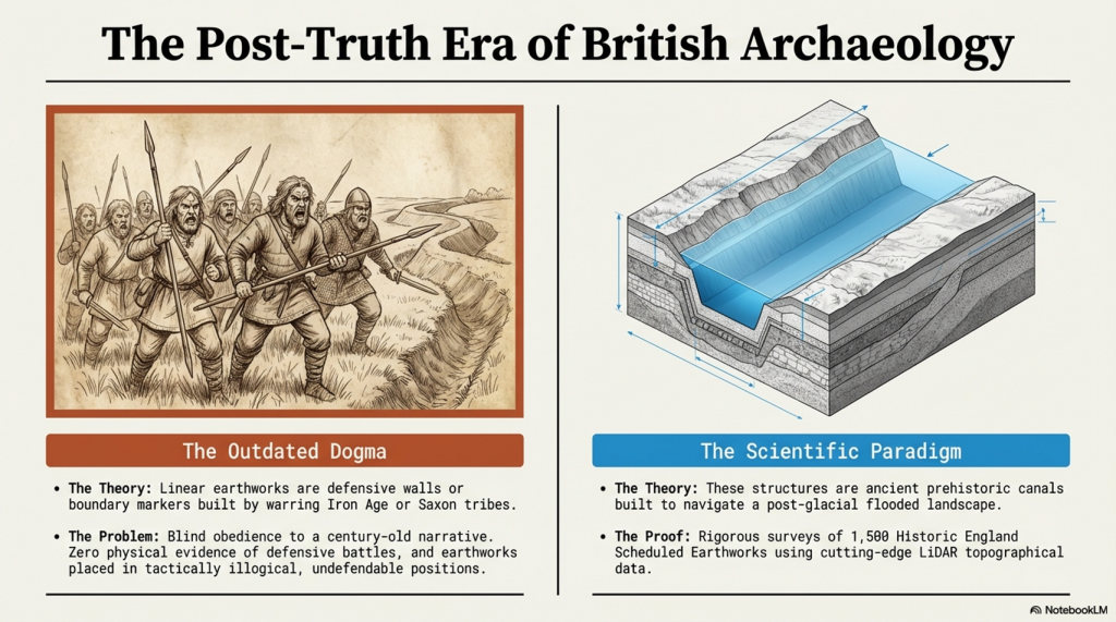
The Troy, Hyperborea and Atlantis Connection

Introduction

The connections between the legends of Atlantis and Hyperborea and the works of Homer represent a fascinating intersection of myth, philosophy, and epic narrative in ancient Greek literature. These stories not only provide insights into the Greeks’ geographical and cultural understanding but also reflect deeper philosophical and ethical concerns that permeate Greek thought. Below, we explore these themes in greater detail, delving into how these mythical and literary works intertwine and what they signify about ancient Greek civilisation. (The Troy, Hyperborea and Atlantis Connection)

 (The Troy, Hyperborea and Atlantis Connection)
(The Troy, Hyperborea and Atlantis Connection)

Homer’s Influence and the Greek Mythical Landscape

Homer’s literary works, namely the “Iliad” and the “Odyssey,” are of great importance in ancient Greek literature. These works provide a multifaceted depiction of heroism, divine intervention, and the human condition. It’s important to note that these epic stories are not standalone, but are part of a larger collection of Greek mythology that includes legends about Atlantis and Hyperborea. Although Homer doesn’t directly mention these myths, his themes of heroism, the impact of divine will, and the imperfection of humanity provide a foundation for later philosophical explorations by scholars such as Plato.

Geographical and Mythological Explorations

Homer’s epics describe real and mythical locations, which expand the boundaries of the Greek world and beyond. These places often blend factual geography with fantastical elements, creating a world full of possibilities and dangers that reflect the Greeks’ curious and exploratory nature.

 (The Troy, Hyperborea and Atlantis Connection)
(The Troy, Hyperborea and Atlantis Connection)

Similarly, Atlantis and Hyperborea are described as lands at the margins of the known world. Plato’s Atlantis, as mentioned in his dialogues “Timaeus” and “Critias,” is a powerful island nation beyond the Pillars of Hercules, rich in resources but doomed by its moral failings. Hyperborea, mentioned in sources such as Herodotus and later Greek lore, is portrayed as a northern paradise, untouched by war or disease, where people live exceptionally long lives in peace—a stark contrast to the often brutal world depicted by Homer.

 (The Troy, Hyperborea and Atlantis Connection)
(The Troy, Hyperborea and Atlantis Connection)

Themes of Heroism and Hubris

In Homer’s works, heroism plays a central role. Characters are often defined by their bravery, strength, and, sometimes, overconfidence. The gods frequently intervene in these epics, either supporting or hindering heroes based on divine justice or whims. The theme of excessive pride, known as hubris, leading to downfall, is particularly prominent, serving as a moral lesson on the limitations of human ambition.

The story of Atlantis presents a similar theme to this idea. Plato describes a society that starts off living in an idyllic state and enjoying divine favour. However, as Atlantis grows in power and pride, it falls prey to greed and corruption. This ultimately attracts divine wrath, leading to its destruction. This narrative echoes Homeric themes where divine justice ultimately restores the balance disrupted by human arrogance.

 (The Troy, Hyperborea and Atlantis Connection)
(The Troy, Hyperborea and Atlantis Connection)

Divine Favour and Moral Order

The gods play a significant role in human affairs in both Homer’s epics and the tales of Hyperborea and Atlantis. In Homer’s works, the gods are unpredictable and often act on personal motives, reflecting the Greeks’ belief that divine favour is fleeting and must be continually earned through piety and sacrifice.

Compared with other myths, the myths of Hyperborea and Atlantis portray divine favour as initially more stable, yet still requiring adherence to a moral order. Hyperborea is considered a favoured land as long as it remains isolated from the greed and corruption of the outside world. This suggests that societal perfection depends on both geographical isolation and moral purity. In contrast, Atlantis loses its divine favour not because of isolation but because of moral failure. This highlights a philosophical perspective where ethical decay leads to ruin.

 (The Troy, Hyperborea and Atlantis Connection)
(The Troy, Hyperborea and Atlantis Connection)

Literary and Cultural Influence

The ancient Greek myths and narratives not only conveyed historical experiences but also shaped their perceptions of the world and the cosmos. They blended mythological interpretation with reality to teach important lessons of morality, ethics, and human limitations.

Plato’s works “Timaeus” and “Critias” utilise the mythical city of Atlantis as a philosophical allegory to explore the ideal state and the consequences of moral decay. This is an extension of Homeric exploration of heroism and divine justice, but Plato takes it a step further. While Homer focuses on individual fate and divine intervention, Plato broadens the scope to societal destiny, where the collective actions of a society determine its ultimate fate.

 (The Troy, Hyperborea and Atlantis Connection)
(The Troy, Hyperborea and Atlantis Connection)

Conclusion

Let’s stop pretending these are just stories.

The legends of Atlantis and Hyperborea are not abstract myths or philosophical inventions. They are cultural memories—distorted over time, but rooted in real events, real places, and real people.

Plato gives us the key. He states clearly that this lost civilisation existed around 9500 years ago. That date is not negotiable, and it is not symbolic. It lands exactly at the end of the last Ice Age—precisely when the physical evidence shows catastrophic environmental change across north-west Europe.

At that moment in time, Doggerland existed.

And then it didn’t.

We know—measurably—that this landscape was flooded, fragmented, and ultimately destroyed by rising sea levels and sustained hydrological pressure. This is not speculation. It is supported by geological, sea-level, and sedimentary evidence. The land was there, and then it was gone.

Now combine that with archaeology.

 (The Troy, Hyperborea and Atlantis Connection)
(The Troy, Hyperborea and Atlantis Connection)

Stonehenge is no longer explainable as ritual nonsense or symbolic guesswork. When examined properly, it behaves as a functional system—engineered, repeatable, and practical. The so-called “Stonehenge computer” demonstrates predictive capability, environmental integration, and structured design. That is not primitive behaviour. That is applied knowledge.

So we have a date.
We have an event.
And we have a level of capability that matches the description.

This is where the academic narrative collapses.

Because once you accept the timing and the evidence, the conclusion becomes unavoidable:

Atlantis is Doggerland.

 (The Troy, Hyperborea and Atlantis Connection)
(The Troy, Hyperborea and Atlantis Connection)

Hyperborea is the same memory, seen from another direction.

And the “gods” described by the Greeks were not gods at all—they were the survivors of a lost civilisation whose knowledge far exceeded that of the cultures that came after them.

When Doggerland drowned, its people did not disappear. They moved. They carried knowledge of engineering, navigation, landscape, and time—knowledge that later cultures preserved as myth because they no longer understood its origin.

This is why the stories persist.
This is why they are consistent.
And this is why they refuse to go away.

Because they are not fiction.

They are memories.

And once you place them back into their correct context—time, landscape, and physical evidence—the mystery disappears.

What remains is not mythology.

It is history.

PodCast

Author’s Biography

Robert John Langdon, a polymathic luminary, emerges as a writer, historian, and eminent specialist in LiDAR Landscape Archaeology.

His intellectual voyage has been interwoven with stints as an astute scrutineer for governmental realms and grand corporate bastions, a tapestry spanning British Telecommunications, Cable and Wireless, British Gas, and the esteemed University of London.

A decade hence, Robert’s transition into retirement unfurled a chapter of insatiable curiosity. This phase saw him immerse himself in Politics, Archaeology, Philosophy, and the enigmatic realm of Quantum Mechanics. His academic odyssey traversed the venerable corridors of knowledge hubs such as the Museum of London, University College London, Birkbeck College, The City Literature Institute, and Chichester University.

In the symphony of his life, Robert is a custodian of three progeny and a pair of cherished grandchildren. His sanctuary lies ensconced in the embrace of West Wales, where he inhabits an isolated cottage, its windows framing a vista of the boundless sea – a retreat from the scrutinous gaze of Her Majesty’s Revenue and Customs, an amiable clandestinity in the lap of nature’s embrace.

Exploring Prehistoric Britain: A Journey Through Time

My blog delves into the fascinating mysteries of prehistoric Britain, challenging conventional narratives and offering fresh perspectives grounded in cutting-edge research, particularly LiDAR technology. I invite you to explore some key areas of my research. For example, the Wansdyke, often cited as a defensive structure, is re-examined in light of new evidence. I’ve presented my findings in my blog post Wansdyke: A British Frontier Wall – ‘Debunked’, and aWansdyke LiDAR Flyover video further visualises my conclusions.

My work also often challenges established archaeological dogma. I argue that many sites, such as Hambledon Hill, commonly identified as Iron Age hillforts, are not what they seem. My posts Lidar Investigation Hambledon Hill – NOT an ‘Iron Age Fort’ and Unmasking the “Iron Age Hillfort” Myth explore these ideas in detail and offer an alternative view. Similarly, sites like Cissbury Ring and White Sheet Camp also receive a re-evaluation based on LiDAR analysis in my posts “Lidar Investigation Cissbury Ring through time” and “Lidar Investigation White Sheet Camp,“ revealing fascinating insights into their true purpose. I have also examined South Cadbury Castle, often linked to the mythical Camelot56.

My research also extends to ancient water management, including the role of canals and other linear earthworks. I have discussed the true origins of Car Dyke in multiple posts, including Car Dyke – ABC News Podcast and Lidar Investigation Car Dyke – North Section, which suggest a Mesolithic origin 2357. I also explore the misidentification of Roman aqueducts, as seen in my posts on the Great Chesters (Roman) Aqueduct. My research has also been greatly informed by my post-glacial flooding hypothesis, which has helped explain landscape transformations over time. I have discussed this hypothesis in several posts, including AI now supports my Post-Glacial Flooding Hypothesis and Exploring Britain’s Flooded Past: A Personal Journey

Finally, my blog also investigates prehistoric burial practices, as seen in Prehistoric Burial Practices of Britain and explores the mystery of Pillow Mounds, often mistaken for medieval rabbit warrens, but with a potential link to Bronze Age cremation in my posts: Pillow Mounds: A Bronze Age Legacy of Cremation? and The Mystery of Pillow Mounds: Are They Really Medieval Rabbit Warrens?. My research also includes astronomical insights into ancient sites, for example, in Rediscovering the Winter Solstice: The Original Winter Festival. I also review new information about the construction of Stonehenge in The Stonehenge Enigma.

Further Reading

For those interested in British Prehistory, visit www.prehistoric-britain.co.uk, a comprehensive resource featuring an extensive collection of archaeology articles, modern LiDAR investigations, and groundbreaking research. The site also includes insights and excerpts from the acclaimed Robert John Langdon Trilogy, a series of books that explore Britain during the Prehistoric period. Titles in the trilogy include The Stonehenge Enigma, Dawn of the Lost Civilisation, and The Post-Glacial Flooding Hypothesis, which offer compelling evidence of ancient landscapes shaped by post-glacial flooding.

To further explore these topics, Robert John Langdon has developed a dedicated YouTube channel featuring over 100 video documentaries and investigations that complement the trilogy. Notable discoveries and studies showcased on the channel include 13 Things that Don’t Make Sense in History and the revelation of Silbury Avenue – The Lost Stone Avenue, a rediscovered prehistoric feature at Avebury, Wiltshire.

In addition to his main works, Langdon has released a series of shorter, accessible publications, ideal for readers delving into specific topics. These include:

For active discussions and updates on the trilogy’s findings and recent LiDAR investigations, join our vibrant community on Facebook. Engage with like-minded enthusiasts by leaving a message or contributing to debates in our Facebook Group.

Whether through the books, the website, or interactive videos, we aim to provide a deeper understanding of Britain’s fascinating prehistoric past. We encourage you to explore these resources and uncover the mysteries of ancient landscapes through the lens of modern archaeology.

For more information, including chapter extracts and related publications, visit the Robert John Langdon Author Page. Dive into works such as The Stonehenge Enigma or Dawn of the Lost Civilisation, and explore cutting-edge theories that challenge traditional historical narratives.

Other Blogs

[sitemap_posts]
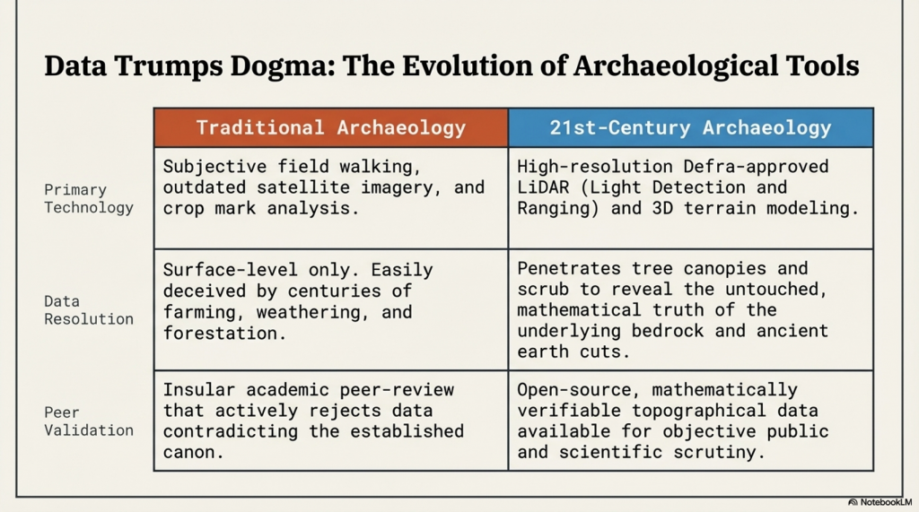
Hollingsbury Camp Brighton – A Hillfort… or a Forgotten Harbour?

Introduction

There is a single bank and ditch at Hollingbury, roughly square with rounded corners, enclosing around 9 acres (3.6 ha). The original entrances lie to the east and west, with the western entrance distinctly inturned—classic “defensive” design, we’re told. Pottery recovered during excavation places it neatly in the Iron Age, around 450–250 BC.

And that’s where the story usually stops.

But let’s actually look at the landscape.

Lidar Map of Brighton - Hollingsbury Camp
Lidar Map of Brighton – Hollingsbury Camp

Inside the enclosure sit three Bronze Age bowl barrows, aligned north–south near the centre. That alone tells us the site had significance long before the so-called Iron Age “fort” was constructed. This isn’t a one-phase monument—it’s a reused landscape.

Now here’s where it gets interesting.

The Harbour That Nobody Talks About

Lidar Map of Mesolithic  Brighton - Hollingsbury Camp
LiDAR Map of Hollingbury Camp in the Mesolithic Period – Hollingbury Camp Brighton

When you strip away the modern assumptions and look at the terrain model, Hollingbury reveals something far more compelling—a natural basin, a sheltered hollow with clear defensive sides.

In other words:

➡️ A harbour.

Not a symbolic one. A functional one.

A place where vessels could shelter, protected from prevailing conditions, connected to wider water systems leading toward the Channel.

If you accept—based on measurable hydrology—that early Holocene Britain operated under significantly higher water tables and river levels, then sites like Hollingbury stop being “hillforts” and start being coastal or inland port infrastructure.

This is not speculation—it follows directly from the physics of post-glacial drainage and landscape response.


Trade, Not Tribes

Look around the perimeter and you’ll find pits and quarries.

Archaeology calls them “extraction features.”

But ask the obvious question:

➡️ Extraction for what purpose?

The answer is trade.

Minerals, flint, chalk products—materials that had value and were moved. You don’t build infrastructure like this for isolation. You build it for exchange.


The Dating Problem Nobody Wants to Address

The conventional timeline—Iron Age construction—relies heavily on pottery and standard dating frameworks.

But those frameworks have known limitations:

➡️ Reworked material
➡️ Contamination
➡️ Reservoir effects
➡️ Post-depositional movement

All of which can shift dates significantly, especially in water-influenced environments .

So if the landscape itself was water-dominated for thousands of years after the Ice Age…

➡️ Then the context in which those artefacts were deposited is already compromised.

Which raises the uncomfortable possibility:

👉 The site could be far older than the assigned Iron Age label
👉 Potentially Late Mesolithic / Early Neolithic (~6000 years ago)


Midsummer, Memory, and Meaning

We’re told Hollingbury is a place of ritual—midsummer fires, folklore, Druids, dragons in burial mounds.

And yes, those traditions matter.

But they’re secondary.

They are memory, not origin.

People return to meaningful places. They reuse them. They mythologise them.

But they rarely build them without purpose in the first place.


So What Is Hollingbury?

Not just a hillfort.
Not just a burial ground.
Not just a ritual landscape.

➡️ It is infrastructure.
➡️ It is positioned for water.
➡️ It is aligned with trade.
➡️ It is reused across millennia.

And once you factor in post-glacial hydrology, it makes perfect sense.


The Bigger Picture

Hollingbury isn’t unique.

It’s part of a pattern:

➡️ Elevated sites
➡️ Basin-like interiors
➡️ Resource extraction nearby
➡️ Later “defensive” reinterpretation

What archaeology calls “hillforts” may in many cases be the fossilised remains of a water-based transport and trading network—one that existed in a very different Britain.

A Britain that was still draining from the Ice Age.


The question isn’t whether these sites were reused in the Iron Age.

They clearly were.

The question is:

👉 What were they before that?


The Prehistoric AI Team 🤖
(Still following the water… because the archaeology won’t 😎)

Use mouse and Left hand click (Ctrl) to PAN – Mouse and RIGHT hand Click to move UP and Down – and Wheel to zoom in the 3D Image