Archaeology in the Post-Truth Era

Introduction

Over the past ten years, I’ve faced a constant uphill battle to establish what I consider a straightforward conclusion—that Linear Earthworks are not defensive structures or boundary markers but prehistoric canals. It’s a claim that’s been dismissed repeatedly, often without proper engagement, but that resistance never stopped the work.(Archaeology in the Post-Truth Era)

Instead, it pushed me further. I carried out a full survey of over 1,500 of Historic England’s Scheduled Linear Earthworks, systematically analysing their form, placement, and context. That work eventually led to the first book in what has now become a larger series, focusing specifically on the East Wansdyke area. For me, that publication wasn’t just another book—it was a milestone. It represents a level of detailed, landscape-wide analysis that, to date, no university or research team has attempted at this scale.

(Britain's Giant Prehistoric Waterways)
Archaeology in the Post-Truth Era

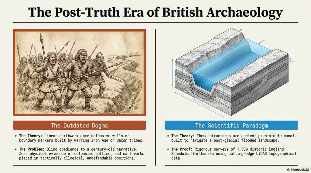
The book itself takes a forensic approach. Every aspect of East Wansdyke is examined and placed into a wider framework—what I define as an ancient prehistoric canal system. The aim is simple: to challenge the existing archaeological narrative, not with speculation, but with measurable, testable evidence. The traditional explanations—defensive lines, territorial markers—don’t hold up under scrutiny. They lack physical evidence, contradict their own logic, and fail to explain the most basic characteristics of these structures.

What emerges instead is something far more significant. If these earthworks are canals, then we are looking at a completely different level of engineering capability in prehistory. These were not crude societies marking out land or preparing for war—they were shaping landscapes, managing water, and building infrastructure on a national scale. This not only challenges the archaeological community but also opens the door to a broader re-evaluation of how prehistoric landscapes were understood and used.

Archaeology in the Post-Truth Era

Embarking on this journey was not without its challenges, especially in an era where scepticism often overshadows scientific evidence. The response to my publication, which I had hoped would ignite a meaningful academic debate, was instead largely silent. Despite the use of modern LiDAR technology and a dataset far beyond what had previously been attempted, the work was either ignored or dismissed as speculative.

This resistance was mirrored on social media, where entrenched views dominated discussion. Any attempt to challenge established narratives was met with denial rather than engagement. Peer review, rather than being treated as part of an evolving process, was often presented as a final and unquestionable authority.
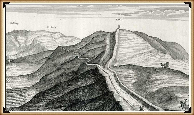
The Dyke Myth Collapse
Archaeology in the Post-Truth Era

This kind of blind adherence to established ideas is not unique to archaeology. It is a pattern repeated across disciplines, where existing frameworks are protected rather than tested. New evidence is not examined on its merits but rejected because it disrupts the accepted model.

That was the position in 2014.

Now, two years on, we can assess that position against new evidence—and, more importantly, against the predictions made at the time.

What has emerged since then is not a contradiction of the original work, but a direct reinforcement of it.

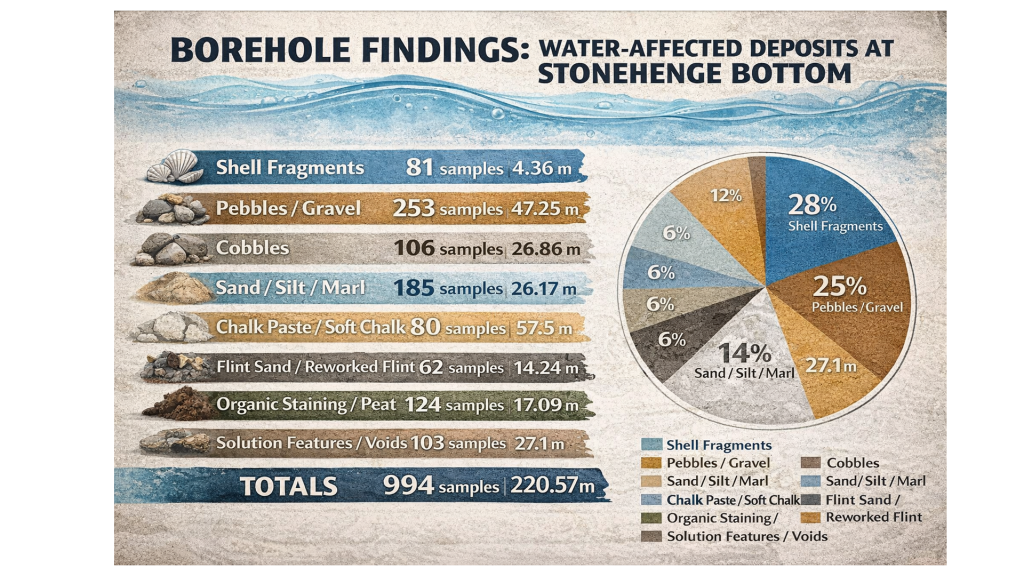
The borehole data, when analysed correctly using elevation rather than arbitrary depth, has revealed consistent clustering of water-related deposits at specific heights across multiple independent locations. Statistically, this pattern is highly unlikely to occur by chance and instead points to a structured, elevation-controlled hydrological system operating across the landscape.
Archaeology in the Post-Truth Era

At the same time, the mathematical framework behind the Post-Glacial Flooding Hypothesis has continued to develop. The mass-balance calculations, combined with ice-volume scaling and groundwater discharge modelling, demonstrate that Britain remained in a prolonged state of elevated water tables and enlarged river systems for thousands of years after the end of the last Ice Age.

This confirms a critical point:

The rivers of the past were higher than those we see today.

And once that is understood, the entire interpretation of Linear Earthworks shifts.

Rethinking The Past
Archaeology in the Post-Truth Era

Because these structures are not randomly placed. They align with contours, connect basins, and sit within hydrological positions that make sense only under sustained high water levels. Their form, scale, and distribution are consistent with water management—not defence, not boundaries, but controlled flow.

In other words, the environmental conditions required for canals are now demonstrably present.

This is the key difference between 2014 and 2026.

In 2014, the argument was based on landscape logic, structural analysis, and comparative reasoning.

In 2026, that same argument is now supported by independent physical data and mathematical proof of the environmental conditions required for it to function.

The conclusion, however, has not changed.

Linear Earthworks were constructed in a landscape defined by elevated water tables and expanded river systems. Within that context, their most coherent and evidence-based interpretation remains exactly what was originally proposed.

They were canals.
Archaeology in the Post-Truth Era

And perhaps most importantly, this progression follows the correct scientific sequence.

The prediction came first.

The evidence followed.

And that is not speculation—that is validation.

Archaeology in the Post-Truth Era
Fundamentalist

Wansdyke

In my book, I meticulously addressed every single meter of East Wansdyke, providing compelling evidence that challenges the traditional interpretation of Wansdyke as either a defensive structure or a boundary marker. My research and analysis have convincingly demonstrated that East Wansdyke was, in fact, part of a prehistoric canal system, a finding that significantly alters our understanding of the landscape and the capabilities of the people who engineered it. This conclusion was reached through a combination of detailed survey work, the application of modern technologies such as LiDAR, and a critical review of the archaeological and historical records.

However, one critic, emblematic of the resistance I’ve encountered, sought to undermine my hypothesis by citing a site associated with West Wansdyke. This individual argued that because West Wansdyke was built on a ‘late Iron Age’ fortification, it must, therefore, be of Saxon origin, aiming to cast doubt on my entire thesis by focusing on this one aspect. It’s a classic example of attempting to discredit a comprehensive theory by finding fault with a single, arguably tangential, element.
Archaeology in the Post-Truth Era

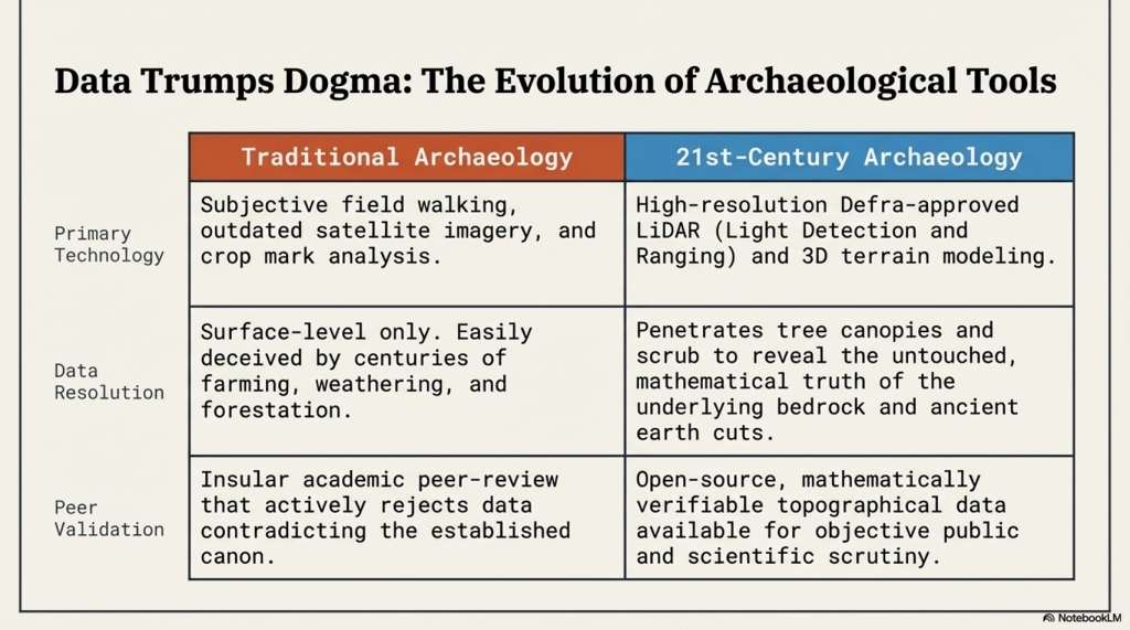
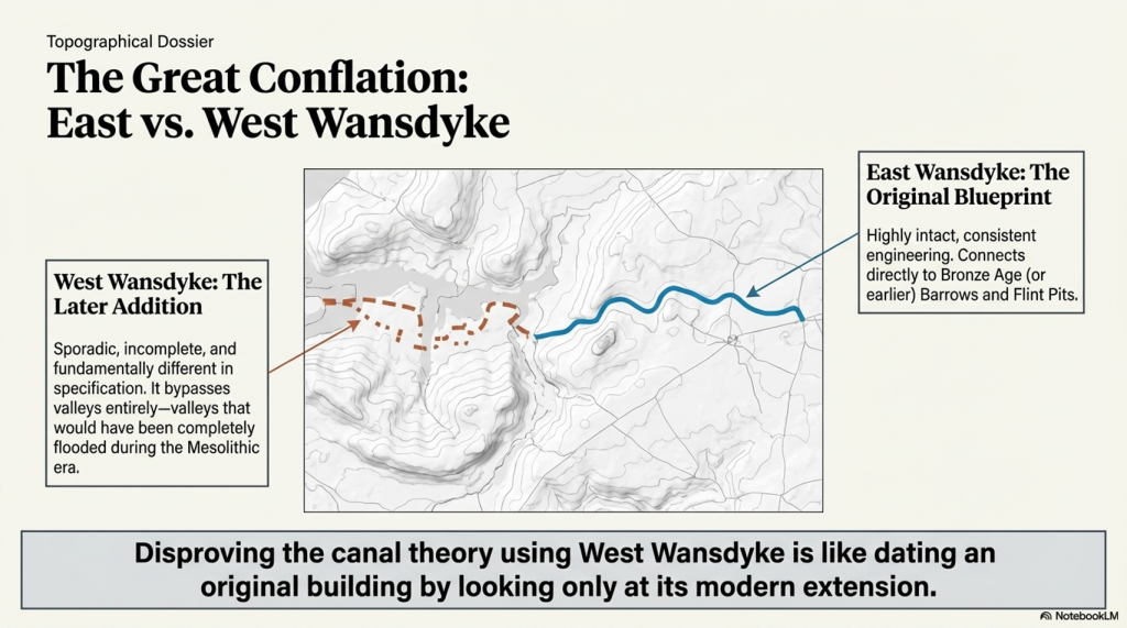
In my response, I emphasised that this site, situated in West Wansdyke, falls outside the primary focus of my research on the East Wansdyke segment. More importantly, I had already anticipated such objections and addressed them directly in my book. I concluded that West Wansdyke, while geographically related, was connected to the original canal system at a later date, likely by the Romans. This connection was based on evidence suggesting that West Wansdyke is incomplete, sporadic, and differs in specification from East Wansdyke, indicating a distinct phase of construction and purpose.

The dismissal of West Wansdyke from my primary analysis was not arbitrary but a considered decision grounded in the evidence and the scope of my research. It reflects a methodological approach that prioritises coherence, specificity, and relevance in building a historical narrative. The critique of my work that focuses on West Wansdyke, therefore, misses the mark. It overlooks the rigour of my research process and the clear rationale provided for the conclusions drawn about East Wansdyke and its role within a broader prehistoric canal system.
Archaeology in the Post-Truth Era

This encounter serves as a reminder of the challenges inherent in advancing new theories in archaeology, especially those that significantly depart from established interpretations. It also underscores the importance of clarity, precision, and thoroughness in both research and communication, qualities I strived to embody in my work on East Wansdyke.


West Wansdyke

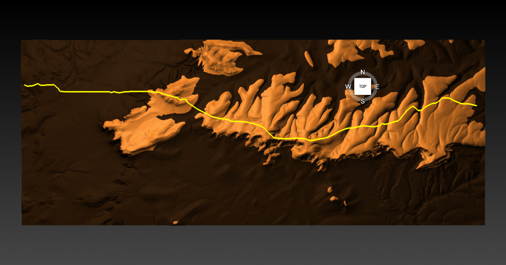
We have a problem with West Wansdyke – it’s not part of East Wansdyke. This has always been a historical debate over the last 100 years. If we look at the limited archaeological evidence, we find that although it may have been a much later Canal/Dyke it is not contemporary with the East Wansdyke canal and was not built at the same time.

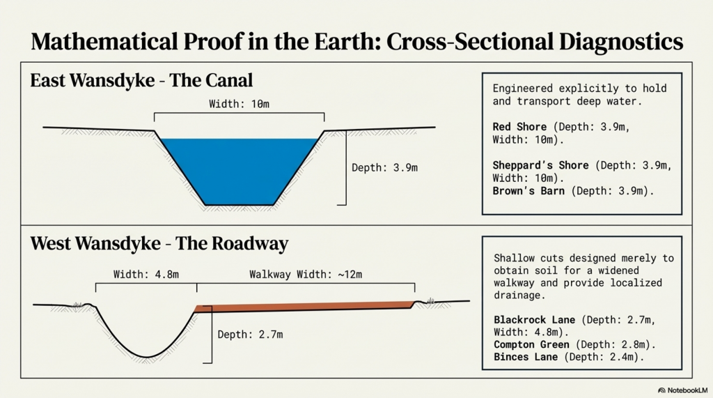
Excavations conclusively show that the Ditches on the East side of Wansdyke are much more profound and twice as broad. In contrast, the Banks on the East Side are much wider. We see that East Dyke was built first, as our River height model shows that most of West Wansdyke would have been flooded or marshland at the time of use.

LocationWansdyke
BankDitchExcavator notes
MaterialsWidthHeightBermWidthDepthCounterscarp 
EAST        
Red ShoreClay/Flints9.52N103.9YGreen 1966
Sheppard’s shore 102.3N103.9YPitt Rivers 1888
Brown’s Barn 92.3N103.9YPitt Rivers 1891
WEST        
Binces Lane WestStoney12.5????3.51.7YErskine 1990s
Binces Lane EastStoney?5?N62.4?Erskine 1990s
Compton GreenClay marl130.8Y5.82.8YErskine 1990s
Blackrock LaneSilty Clay12.51.7Y4.82.7?Erskine 1990s
Park farmStones100.4Y5.52.4YErskine 1990s
Fairy Hill 13?Y6.5? Erskine 1990s
West Wansdyke Excavation

When the waters receded (possibly Early Iron Age period), it is possible that the Dyke was extended, or the more probable event of East Wansdyke after it dried up was turned into a roadway and what we see in West Wansdyke is the extension of the road, and hence it is wider than in the East.
Archaeology in the Post-Truth Era

We also see more shallow ditches as they were not used for water but to obtain soil for the walkway and become drainage ditches.

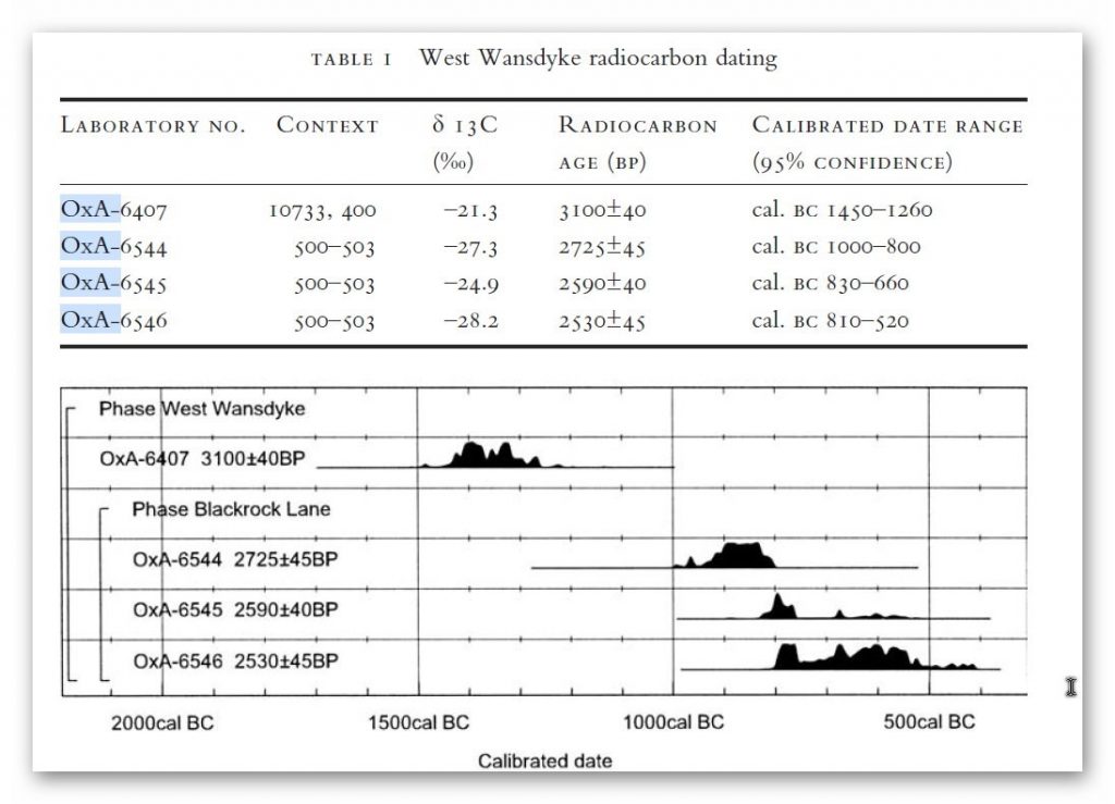
Indeed, we know the Romans used this as a road and always had drainage ditches, usually on both sides. This is supported by carbon dating at Erskine’s excavation at Blackrock Lane, where the section appeared to have been sealed by the primary bank material. One of these layers contained significant concentrations of woody oak charcoal.

Samples of this material were submitted to the Ancient Monuments Laboratory for radiocarbon dating to provide a possible construction of the bank. Unfortunately, as shown in the table below – sadly, as standard when scientific evidence disproves the current archaeological narrative – it is ignored and classified as an error.
Archaeology in the Post-Truth Era

Table 1. Erskine, Jonathan. (2007). The West Wansdyke: an appraisal of the dating, dimensions and construction techniques in the light of excavated evidence. Archaeological Journal. 164. 80-108.


The other missing aspect, shown in East Wansdyke but not in West Wansdyke, was the massive connection to Barrows and Flint Pits. Again, this connection is not seen on West Wansdyke, which may help date this monument, as the barrows were of the Bronze Age or earlier, and, as we have seen from the carbon dating evidence at Blackrock Lane, much earlier than its 1500 BCE date.

Statonbury Camp near Bath – an example of West Wansdyke

If we look at the Scheduled parts of the Wansdyke – we see that the East is very much intact, but the West is sporadic at best, and it’s hard to find a logical link to all the Dykes that seem to only appear over hills and not in the valley’s – which in my view would have been flooded in the Mesolithic and hence the west sections addition after East Wansdyke’s construction – probably by the roman’s who may have utilised the Dyke system for their own transportation reasons. But for the sake of scientific curiosity, let’s take a detailed look at Stantonbury Hill site, which is classified as an Iron Age Camp, with Wansdyke making up one of the defensive banks – but before we delve deeper into the field archaeology of the site – I feel I must clarify the use of the classification of ‘Iron Age Fort’ by archaeologists.

All sites that sit on top of hills and have ditches are called Iron Age Forts – sadly, I have yet to find a single location that is either ‘Iron Age’ or a ‘Fortification’, as not a single dead body from slaying has ever been found, and all the so-called defensive ditches EVER!! Yet the archaeological world continues to use this misleading classification, which confuses the public, as if it has been qualified and proven. So, back to Statonbury camp. The only investigation of this site was made by Fox and Fox in 1956 as part of their survey of Wansdyke in the publication ‘Wansdyke reconsidered.’ It should be noted that Historic England does not have an account with their scheduling as no excavation work has ever been undertaken, and so only field walking has been undertaken, and so the results are subject to the field walker.
Archaeology in the Post-Truth Era


In Fox’s publication, they also question the linkage of East and West Wansdyke through other, even older publications and field surveys, which call into question the logic of dating this linear earthwork. That great antiquary, Sir Richard Colt Hoare, had his doubts about the identification, which he endeavoured to suppress in his account of the earthwork in Ancient Wiltshire,


‘ Hitherto we have been enabled to trace the course of Wansdyke with certainty and success through Somersetshire, but on approaching the neighbouring county of Wiltshire we enter upon a new and doubtful field of inquiry respecting the direction as well as the formation of this celebrated rampart.’


His own observations in the field had shown him that in this central sector ‘ it bears the decided appearance of a Roman causeway, not of a Belgic or Saxon boundary and yet he felt obliged to support the current view that road and dyke were identical because he was convinced that the Wansdyke was continuous and he could find no alternative course for it in the area. Sir R. C. Hoare also observes that the camps appear to have been added to the Dyke, not the Dyke formed to connect the camps, which may be noticed especially at Stantonbury Camp, the second on the line of the course of Wansdyke through Somersetshire.


They continue
……


General Pitt-Rivers, also had misgivings, ‘ the Dyke he comments, in the Heddington region,’ is of very low relief everywhere on this line and it has often been questioned whether it is a dyke or a road’, and his suspicions were again aroused at a point west of Morgan’s Hill and on Bowden Hill near Lacock’.
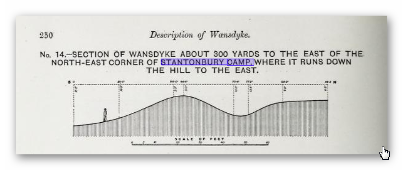
Stanton Camp - Not Defensive
Stanton Camp – Not Defensive


On Statonbury Camp, there are not very helpful and report that:

Stantonbury is a univallate Iron Age hill-fort enclosing some 30 acres on the crest of the hill : until very recently it was waste ground going back to thorn scrub and islanded in dense woodland, as can be seen on the air-photo (Pl. VIIIB). The hill top (580 ft.) commands a wide view : from here the whole of the countryside traversed by West Wansdyke can be seen, Maes Knoll to the west. Odd Down to the east, as well as an uninterrupted stretch northwards to the Avon valley and the Cotswolds beyond. From here, the major alignment was probably planned (fig. 19 and p. 37).


In 1956-7 the hill top has been ploughed again, and the much reduced Iron Age defences are visible on the edge of the cultivation. It appears to us that Wansdyke was not constructed along the north-facing hill slope, and that as at Old Oswestry hill-fort, on Wat’s Dyke in Montgomery, the Iron Age defences were deemed sufficient. There is, however, as General Pitt-River’s level section shows, a steep scarp below the traces of the ploughed-in Iron Age ditch, which may be artificial and post-date the hill-fort, but this is uncertain.
East of the fort, in field 20, which is now occupied by a plantation and a pheasantry, the Dyke continues as a scarp for as far as we were able to trace it through the nettles and undergrowth. Below the 500 ft. contour, the large bank and ditch reappear in the dense woodland, and emerge beside the lane leading to the road to Stanton Prior, where the earthwork measures 75 ft. overall.


So, according to Fox and Fox, Wansdyke stops short and accepts the North Face is the Iron Age Site – therefore, if the Wansdyke had been cut to the north of the site, the Iron Age fort replaced it, which is not as the Jihad had claimed?

So where did he get this ‘ground-breaking’ revelation? For this, we must go not to a peer-reviewed book but a website ‘wansdyke21.org.uk’ by Robert Vermaat

He suggests that: It has been suggested by Fox & Fox that Wansdyke did not actually use Stantonbury Camp, the ditch stopping short of the Iron Age defences by several metres. However, Burrow showed in 1982 that this was incorrect. Although the western slope is much disturbed by quarrying and the lower slopes by cultivation, Wansdyke can still be traced quite well at several points on the hill. As with Maes Knoll, the northern defences are more prominent than those on the south side. As Wansdyke joins the defences here, it can be argued that, as was the case at Maes Knoll, the northern defences were refurbished when Wansdyke was constructed, neglecting the south side which was without use for the builders of Wansdyke.
Archaeology in the Post-Truth Era


If only we had £64 to see this so-called evidence from Field walking by burrows (as we know it was not excavated and LiDAR was not in use)!!


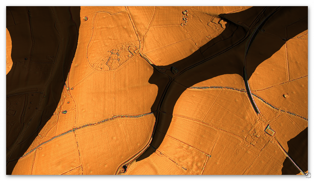
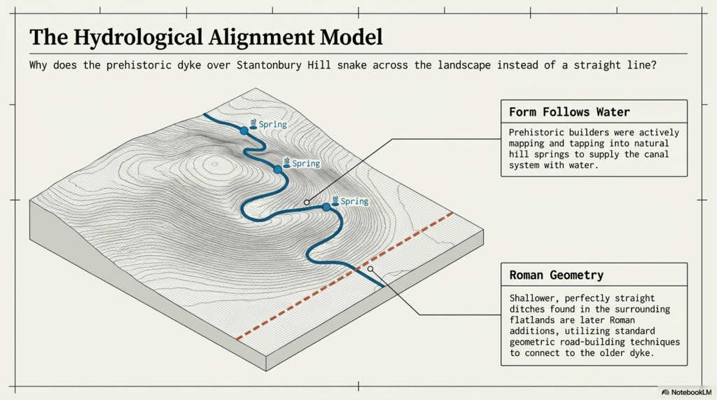
Fortunately, we have now obtained high-resolution LiDAR images of Statonbury Camp, and we can see that Wansdyke goes over the hill in a strange ‘wibbly wobbly’ way rather than a straight line – which we see on either side of the hill from much shallower ditches. This suggests that the area was not built entirely at the same time, and that the Hill Dyke is older than the flat ground levels surrounding the hill.

My estimate from the evidence in the smaller ditches is that they are Roman (and hence straight) in origin, which connects to the earlier prehistoric Dyke over Statonbury Hill, which the archaeologists call West Wansdyke (part of). The path over the hill indicates that the builders were attempting to locate natural springs as they built the Dyke to supply it with water, and hence the strange pathway.

Closer inspection of the Dyke as it approaches the ‘Iron Age Site’ suggests that it splits and shifts the bank from north-facing to south-facing, which Fox had seen as a terminus of the Dyke, for it reached the Fort. LiDAR clearly shows that the ditch moves to the south side of the bank and continues to create the East side of the fort, finally terminating in the South.

Also, the shape of the fort is not consistent, as it has rounded edges in the SE and SW regions but flat T-Junctions in the NE and NW, where it meets Wansdyke – indicating it was added to the existing Wansdyke canal either at the time of construction or a later date.

PodCast

Author’s Biography

Robert John Langdon, a polymathic luminary, emerges as a writer, historian, and eminent specialist in LiDAR Landscape Archaeology.

His intellectual voyage has been interwoven with stints as an astute scrutineer in government and grand corporate bastions, a tapestry spanning British Telecommunications, Cable and Wireless, British Gas, and the esteemed University of London.

A decade hence, Robert’s transition into retirement unfurled a chapter of insatiable curiosity. This phase saw him immerse himself in Politics, Archaeology, Philosophy, and the enigmatic realm of Quantum Mechanics. His academic odyssey traversed the venerable corridors of knowledge hubs such as the Museum of London, University College London, Birkbeck College, The City Literature Institute, and Chichester University.

In the symphony of his life, Robert is a custodian of three progeny and a pair of cherished grandchildren. His sanctuary lies ensconced in the embrace of West Wales, where he inhabits an isolated cottage, its windows framing a vista of the boundless sea – a retreat from the scrutinising gaze of Her Majesty’s Revenue and Customs, an amiable clandestinity in the lap of nature.

Exploring Prehistoric Britain: A Journey Through Time

My blog delves into the fascinating mysteries of prehistoric Britain, challenging conventional narratives and offering fresh perspectives grounded in cutting-edge research, particularly LiDAR technology. I invite you to explore some key areas of my research. For example, the Wansdyke, often cited as a defensive structure, is re-examined in light of new evidence. I’ve presented my findings in my blog post Wansdyke: A British Frontier Wall – ‘Debunked’, and a Wansdyke LiDAR Flyover video further visualises my conclusions.

My work also often challenges established archaeological dogma. I argue that many sites, such as Hambledon Hill, commonly identified as Iron Age hillforts, are not what they seem. My posts Lidar Investigation Hambledon Hill – NOT an ‘Iron Age Fort’ and Unmasking the “Iron Age Hillfort” Myth explore these ideas in detail and offer an alternative view. Similarly, sites like Cissbury Ring and White Sheet Camp receive re-evaluations based on LiDAR analysis in my posts “Lidar Investigation Cissbury Ring through time” and “Lidar Investigation White Sheet Camp,“ revealing fascinating insights into their true purpose. I have also examined South Cadbury Castle, often linked to the mythical Camelot56.

My research also extends to ancient water management, including the role of canals and other linear earthworks. I have discussed the true origins of Car Dyke in multiple posts, including Car Dyke – ABC News Podcast and Lidar Investigation Car Dyke – North Section, which suggest a Mesolithic origin 2357. I also explore the misidentification of Roman aqueducts, as seen in my posts on the Great Chesters (Roman) Aqueduct. My research has also been greatly informed by my post-glacial flooding hypothesis, which has helped explain landscape transformations over time. I have discussed this hypothesis in several posts, including AI now supports my Post-Glacial Flooding Hypothesis and Exploring Britain’s Flooded Past: A Personal Journey

Finally, my blog also investigates prehistoric burial practices, as seen in Prehistoric Burial Practices of Britain and explores the mystery of Pillow Mounds, often mistaken for medieval rabbit warrens, but with a potential link to Bronze Age cremation in my posts: Pillow Mounds: A Bronze Age Legacy of Cremation? and The Mystery of Pillow Mounds: Are They Really Medieval Rabbit Warrens?. My research also includes astronomical insights into ancient sites, for example, in Rediscovering the Winter Solstice: The Original Winter Festival. I also review new information about the construction of Stonehenge in The Stonehenge Enigma.

Further Reading

For those interested in British Prehistory, visit www.prehistoric-britain.co.uk, a comprehensive resource featuring an extensive collection of archaeology articles, modern LiDAR investigations, and groundbreaking research. The site also includes insights and excerpts from the acclaimed Robert John Langdon Trilogy, a series of books that explore Britain during the Prehistoric period. Titles in the trilogy include The Stonehenge Enigma, Dawn of the Lost Civilisation, and The Post-Glacial Flooding Hypothesis, which offer compelling evidence of ancient landscapes shaped by post-glacial flooding.

To further explore these topics, Robert John Langdon has developed a dedicated YouTube channel featuring over 100 video documentaries and investigations that complement the trilogy. Notable discoveries and studies showcased on the channel include 13 Things that Don’t Make Sense in History and the revelation of Silbury Avenue – The Lost Stone Avenue, a rediscovered prehistoric feature at Avebury, Wiltshire.

In addition to his main works, Langdon has released a series of shorter, accessible publications, ideal for readers delving into specific topics. These include:

For active discussions and updates on the trilogy’s findings and recent LiDAR investigations, join our vibrant community on Facebook. Engage with like-minded enthusiasts by leaving a message or contributing to debates in our Facebook Group.

Whether through the books, the website, or interactive videos, we aim to provide a deeper understanding of Britain’s fascinating prehistoric past. We encourage you to explore these resources and uncover the mysteries of ancient landscapes through the lens of modern archaeology.

For more information, including chapter extracts and related publications, visit the Robert John Langdon Author Page. Dive into works such as The Stonehenge Enigma or Dawn of the Lost Civilisation, and explore cutting-edge theories that challenge traditional historical narratives.

Other Blogs

s

t

Prehistoric Canals – Wansdyke

Promotional Video – Ancient Prehistoric Canals (Dykes) – Wansdyke

Chapter 1 – Dykes, Ditches and Earthworks

Start of Wansdyke East  -Prehistoric Canals - Wansdyke 2
Start of Wansdyke East – Prehistoric Canals – Wansdyke

The modern word dike or Dyke most likely derives from the Dutch word “dijk”, with the construction of dikes in the Netherlands well attested as early as the 12th century. The 126 kilometres (78 mi) long Westfriese Omringdijk was completed by 1250 and was formed by connecting existing older dikes. The Roman chronicler Tacitus even mentions that the rebellious Batavi pierced dikes to flood their land and protect their retreat (AD 70).  The word dijk initially indicated both the trench and the bank.– Wikipedia

If you study archaeology at university or even on an ordinance survey map at length, you will notice strange earthworks on the sides of hills of Britain, with no rational explanation as to why they are there and for what reason.  These features are mostly ignored at university, or an excuse is made for their construction.  The reality is that these features do not make any sense unless there are other factors in operation which have been ignored.

The first thing to notice is that the word ‘Dyke’ is associated with water.  It does seem strange you would call an earthwork on top of a hill a Dyke, unless there was some history passed down through the years to its actual use.  If we look at the most famous Dyke in Britain, ‘Offa’, we notice that it is attributed to a Saxon King and, therefore, could not be prehistoric.   Or is this a clear indication of how archaeologists find excuses for these features rather than factual, empirical evidence?

“Offa’s Dyke (Welsh: Clawdd Offa) is a massive linear earthwork, roughly followed by some of the current borders between England and Wales. In places, it is up to 65 feet (19.8 m) wide (including its flanking ditch) and 8 feet (2.4 m) in height.  In the 8th century, it formed some kind of delineation between the Anglian kingdom of Mercia and the Welsh kingdom of Powys.” – Wikipedia

At face value, this explanation seems to answer all the questions about Dykes (except the water connection).  But suppose you delve further down to look at the evidence, such as findings from the Dyke and any written history. In that case, you get a different version for the Roman historian Eutropius in his book, Historiae Romanae Breviarium, written around 369 AD, mentions the Wall of Severus, a structure built by Septimius Severus who was Roman Emperor between 193 AD and 211 AD:

“He had his most recent war in Britain, and to fortify the conquered provinces with all security; he built a wall for 133 miles from sea to sea. He died at York, a reasonably old man, in the sixteenth year and third month of his reign.” – Eutropius (369 AD)

This ‘wall’ need not be made of stone as we know from their Scottish endeavours that the first structure as a defence was usually a bank and a ditch – just like a Dyke!!

The problem with this account is that none of the known Roman defences are 133 miles long – Harridan’s Wall is only 70 miles, so are they talking about Offa’s Dyke, which is much longer?

Chapter 2 – The Post-Glacial Flooding Hypothesis

Rise of Sea Levels - Prehistoric Canals - Wansdyke 2
Rise of Sea Levels – Prehistoric Canals – Wansdyke 2

Before we show you what these ‘Linear Earthworks‘ were used for in prehistoric times.  We need to give you an idea of how the environment was at the time of construction and why it is so different today.

In ‘The Post-Glacial Flooding Hypothesis,’ we looked at the new mathematical models that allowed us to calculate the amount of water released during and after the Last Glacial Maximum just over ten thousand years ago.

If the Dykes of Britain are canals (and not markers or defensive ditches), we must prove that the water table was higher in the past than today (otherwise, they would still be flooded).

The models contained in the PGFH showed us that a minimum of 8.42 quadrillion tonnes of water was released on the UK at the end of the last ice age.  This is equivalent to 98425.2 inches of rain falling on every square inch of Britain’s landmass or the same as – One Inch of rain steadily falling every day for the next 270 years

The worst known flooding in British history occurred in 1947 when just six inches of rain (149mm) fell on up to 12″ of snow (so a maximum of 15″ of rain if melted) over three months. The flooding, which inundated nearly all the main rivers in the South, Midlands, and the Northeast of England, was notable for its origins, geographical extent, and duration.

It impacted thirty out of the forty English counties over two weeks, when around 700,000 acres of land flooded. As a result, tens of thousands of people were temporarily displaced from their homes, and thousands of acres of crops were lost; and this was just 15 of the estimated equivalent of 98,425 inches of water that was shed on the British landscape after the last Ice Age. 

Raised Water Table

According to William Donn (Donn et al., 1962). The Fennoscandian and Great Britain ice sheet covered 4.7 106 km2, which is equivalent to: 

•          8.42 106 Gigatonnes of water / 4.7 106 km2, which gives     us 1.79 Gt per km2

•          1.79 Gt of water at a penetration rate of 43%, give us   0.77 Gt of water per km2

•          0.77 Gigatonnes of water by UK landmass 242,495 km² give us 186,804 Gt of groundwater

This water will be released at a rate of 1 – 12mm per annum and possibly at a depth of 75km. Therefore, to release groundwater at a depth of 75km at an average rate of 6mm per annum would take 12,500 years – not the 1,200 years previously believed, which is just the surface water from the last stages of the meltwater ice.

This is why rivers (like the Thames) still flow even after months of drought, as the groundwater is constantly leaking into the river, which was at its highest rate at the start of the Mesolithic, just after the great meltwater floods.

Sea-Level Changes

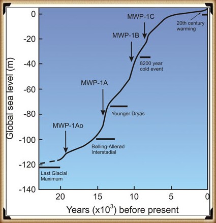
If this model is correct, we should be able to get verification via other empirical evidence, as shown in sea level water rises, to see if it has been constant over the last 12,500 years.

Most geologists and paleoclimatologists, when talking about the end of the last ice age, refer people to the phenomenon called the ‘Meltwater Pulse’ – which is the rapid rise in sea level (20m) between 13,500 and 14,700 years before present, over a 400 – 500 year period. Although it is a tremendous value, it should be recognised that this ‘pulse’ as only 16% of the total sea rise since the end of the last ice age.

Chapter 3 – Hydrology 101

Groundwater Sources - Prehistoric Canals - Wansdyke 2
Groundwater Sources – Prehistoric Canals – Wansdyke

When it comes to the use of ‘linear earthworks’ (we call ‘Dykes’), there is massive confusion amongst both professionals and amateur archaeologists about how such structures could function when they are dry today?

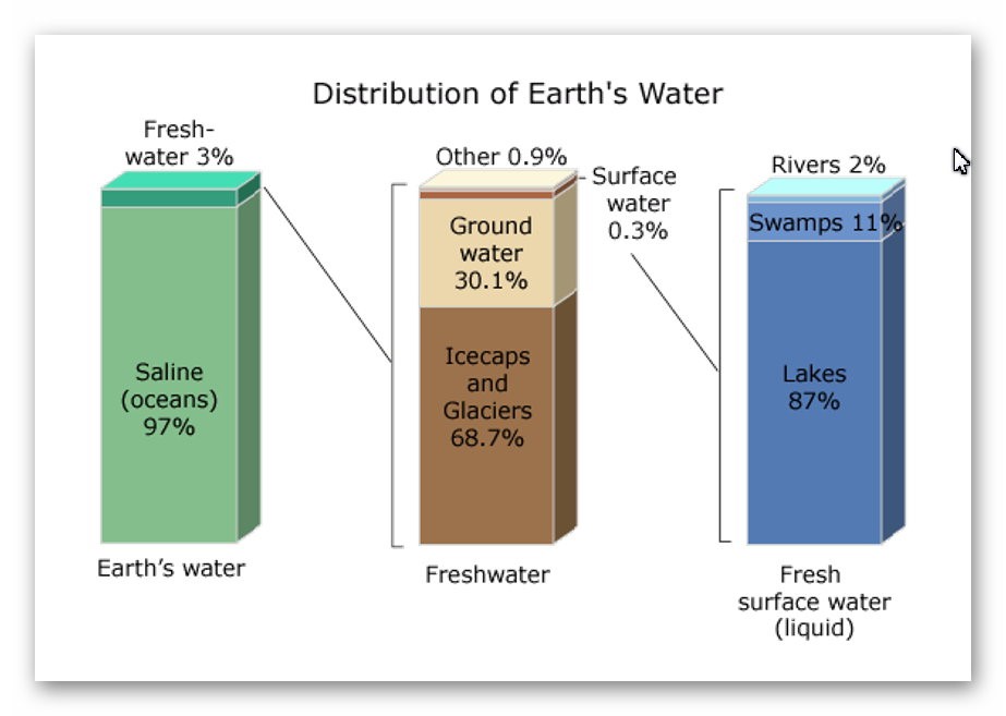
The incorrect perception of these ‘Dykes’ is either they are ‘rivers’ (like the Thames) that flow uphill or Victorian Canals with locks and wooden gates regulating the flow of the water – which are equally nonsensical as a prehistoric structures. Basic Hydrology that most people (should be but not necessarily ALL) learnt at school is that water is under the ground – not just a little water but 30% of all the fresh water on the planet.

This abundance of ‘groundwater’ is evident as it is the source of ALL rivers and supplies the Wells that have been dug since the beginning of time when rivers were absent. Even today, if you go into your garden and dig a hole, it will eventually fill with groundwater, whether in a valley or on top of a hill or mountain.

How and why water is on hills is very challenging for individuals as most people have a simplistic view of water being flat and sitting at ground level – but the earth is a far more complicated structure as this is the reason that it took centuries for people to recognise that we lived on a sphere and not a ‘flat-earth’ as such complex concepts such as gravity are hard to comprehend.

The reality is that ‘streams’ of water are encapsulated within the bedrock allowing ‘springs’ to start rivers at a great height as the groundwater is under pressure and erupts to the surface from BELOW and does not flow up or down the hill internally – but can flow downhill AFTER it escapes from the soil, because at the point of escape gravity then becomes the greater force overcoming the water pressure when within the bedrock – which stops it flowing down the landscape and can push it up to the top of hills and mountains.

Consequently, wells work even on hills as the groundwater is encapsulated in the bedrock and soil. The above illustration shows that if wells are dug halfway up a hill where there is a groundwater pocket, they will fill – if we join up these wells, the entire ditch will also fill with water – sourced from the ground.

The central aspect that must be remembered when considering the reasons behind the construction and maintenance of these earthworks (Dykes) is that the environment was so much different in the Mesolithic Period, which changed rapidly when entering the Neolithic and then even more changes in the Bronze and Iron Ages.

Once the ice sheets had melted and the climate began to warm, the landscape gradually changed from open tundra to dense woodland. By around 8000 BC, pine and birch dominated the woodland cover. These were slowly replaced by lime, elm and oak with some hazel. By 6500 BC, pine and birch woodland would only have been found on the thinner limestone soils of the uplands.

2025 Update – A Quantified Groundwater Decline Model for Stonehenge/Wansdyke/Avebury

Using Radiocarbon-Anchored Hydrological Markers from the Chalk Aquifer

Abstract

This paper presents a quantified model of post-glacial groundwater decline for the Stonehenge–Durrington–Wansdyke chalk block, expressed as groundwater height relative to the modern aquifer baseline.

The model integrates borehole stratigraphy, hydrologically constrained radiocarbon samples, and lateral aquifer continuity to produce a monotonic height–time curve from the early Mesolithic to the Bronze Age. Crucially, the radiocarbon samples used do not date human activity or construction phases, but instead function as groundwater elevation markers, constraining minimum or maximum water levels through time.

This approach resolves long-standing contradictions in the Stonehenge landscape chronology and supersedes interpretive models reliant on typology or isolated C14 dates.

1. Introduction: why groundwater, not monuments

Traditional Stonehenge chronologies rely on radiocarbon dates obtained from pits, artefacts, or infilled features and then interpreted as construction or usage phases. In hydrologically active chalk landscapes, this approach is fundamentally flawed: most dated material records post-formational infilling, not the conditions under which a feature was cut or a landscape functioned.

Instead, this study treats groundwater height as the primary controlling variable. In a laterally continuous chalk aquifer, groundwater level is a regional physical property that constrains what landscapes can exist, what features can function, and when construction is even possible.

The question addressed here is therefore not “when was Stonehenge built?” but:

When did groundwater fall below the elevations required for Stonehenge Bottom, Durrington palaeochannels, and Wansdyke to function as dry features?

2. Methodological principles

2.1 Aquifer continuity

The Upper Chalk beneath Stonehenge, Durrington Walls, and Wansdyke forms a single hydraulically continuous unit. Large-scale groundwater changes are therefore regional, not local. A groundwater level reconstructed at one site applies across the chalk block, adjusted only for topography.

2.2 What radiocarbon dates can and cannot do

Radiocarbon dates are not used here as construction dates. Instead, they are used only where they satisfy all three of the following criteria:

  1. In-situ organic material (preferably plant macrofossils)
  2. Hydrologically controlled context (palaeochannel base, waterlogged organic horizon, peat lens)
  3. Known or stated elevation (OD)

Such samples provide minimum groundwater heights at known times. Samples that fail these criteria (bulk humic sediments, disturbed fills, rootlet-contaminated samples) are explicitly excluded.

3. Data sources

3.1 Borehole stratigraphy (Stonehenge & surrounds)

Borehole logs beneath Stonehenge Bottom and adjacent areas record:

  • Water-derived sediments
  • Solution voids
  • Shell-bearing horizons
  • Prolonged saturation indicators

These demonstrate sustained groundwater levels significantly above modern values during the early Holocene, forming the physical basis of the model.

3.2 Radiocarbon samples used as groundwater markers

The following samples are extracted from the English Heritage Radiocarbon Database and associated ALSF projects. They are not Stonehenge construction dates, but hydrological constraints.

SUERC-10037

  • Date: 8445 ± 40 BP (≈ 7550–7500 cal BC)
  • Material: Waterlogged sediment (humic acid fraction)
  • Context: Gravel-bottomed palaeochannel with organic infill
  • Elevation: +49.55 m OD
  • Interpretation: Early Mesolithic wet ground with persistent saturation

    09d789aa-9fd6-4816-8220-5ac1e62…

SUERC-10038

  • Date: 8575 ± 35 BP (≈ 7600–7580 cal BC)
  • Material: Waterlogged sediment (humin fraction)
  • Context: Same sealed palaeochannel horizon as SUERC-10037
  • Elevation: +49.55 m OD
  • Notes: Minimal reservoir effect; consistent with pollen evidence

    09d789aa-9fd6-4816-8220-5ac1e62…

OxA-15972

  • Date: 7300 ± 40 BP (≈ 6240–6060 cal BC)
  • Material: Waterlogged sediment
  • Context: Palaeochannel infill
  • Interpretation: Channel already inactive; date reflects groundwater fall below channel base

    09d789aa-9fd6-4816-8220-5ac1e62…

OxA-15931

  • Date: 4334 ± 30 BP (≈ 2550–2290 cal BC)
  • Material: Waterlogged sediment (bulk sample)
  • Context: Early infilling after palaeochannel abandonment
  • Interpretation: Minimum age for sustained groundwater decline

    09d789aa-9fd6-4816-8220-5ac1e62…

OxA-15886 (preferred material)

  • Date: 3410 ± 60 BP (≈ 1890–1530 cal BC)
  • Material: Waterlogged plant macrofossil (monocot fragments)
  • Context: Sealed palaeochannel base
  • Significance: Highest-quality hydrological marker in the dataset

    09d789aa-9fd6-4816-8220-5ac1e62…

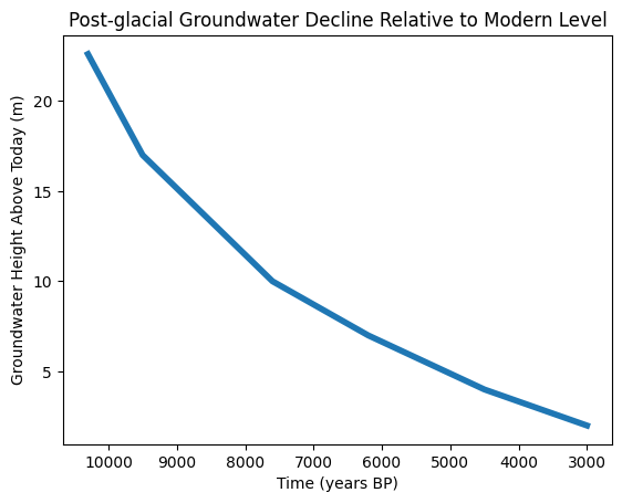
4. Construction of the H(t) groundwater curve

Groundwater height is expressed relative to today’s mean groundwater level, which already incorporates seasonal variability. This removes the need for uncertainty envelopes and isolates the long-term signal.

The curve is anchored by:

  • A calculated groundwater height of +22.6 m above modern at ~10,300 BP, derived from the linked Stonehenge–Wansdyke hydrological solution
  • Radiocarbon-anchored minimum groundwater levels at successive times

The resulting curve shows:

  • Rapid drawdown during the early Holocene
  • A long, shallow decline through the Mesolithic and Neolithic
  • Final stabilisation near modern levels in the Bronze Age

This curve is monotonic and physically constrained.

5. Results and implications

5.1 Stonehenge Bottom

At groundwater levels ≥ +10 m above modern, Stonehenge Bottom cannot function as a dry landscape. Borehole evidence, molluscs, pollen, and palaeochannels are all consistent with this state during the Mesolithic.

5.2 Durrington Walls

Palaeochannels dated using infill material record the decline of groundwater, not monument construction. When correctly interpreted, these dates support prolonged wet conditions rather than late dryland activity.

5.3 Wansdyke

The groundwater differential observed at Wansdyke is consistent with the same regional water table reconstructed at Stonehenge, reinforcing aquifer continuity and validating the linked model.

6. Why this supersedes traditional models

This approach differs fundamentally from conventional archaeology:

Traditional modelGroundwater model

Isolated C14 dates

Integrated hydrological curve

Interpretive phases

Physically constrained thresholds

Typology-driven

Mathematics-driven

Site-specific

Regionally continuous

Once groundwater height is constrained, many archaeological interpretations become physically impossible, regardless of cultural preference.

7. Conclusion

By treating radiocarbon samples as hydrological markers rather than construction dates, and by anchoring them to a laterally continuous chalk aquifer, it is possible to construct a robust, testable groundwater height–time curve for the Stonehenge landscape.

This model explains:

  • Borehole evidence
  • Molluscan and pollen preservation
  • Palaeochannel persistence
  • Chronological inconsistencies in monument interpretation

The burden of proof now lies not in reinterpretation, but in producing contradictory groundwater mathematics.

Until that is done, the dry-chalk Neolithic model for Stonehenge is not debated — it is superseded.

Case Study Wansdyke – Morgan’s Hill West

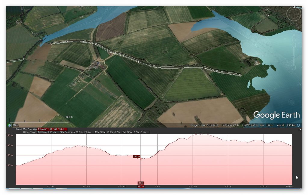
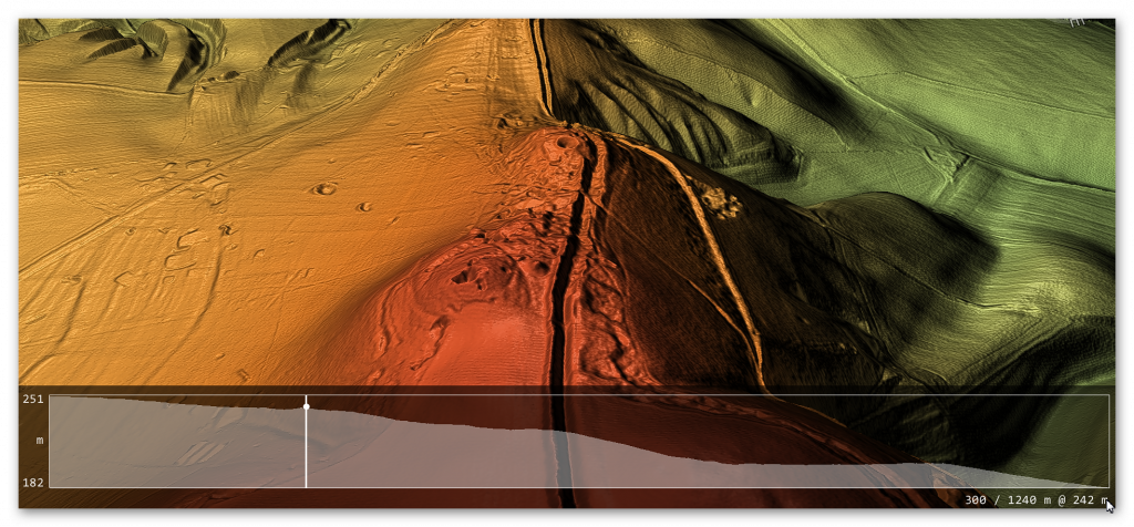
The steepest aspect of Wansdyke is the rise over Morgan’s Hill, which is an incline from 182m OD to 252m OD.

Figure 34 - Morgan Hill West (Wansdyke)  - Prehistoric Canals - Wansdyke 2
Figure 34 – Morgan Hill West (Wansdyke) – Prehistoric Canals – Wansdyke 2

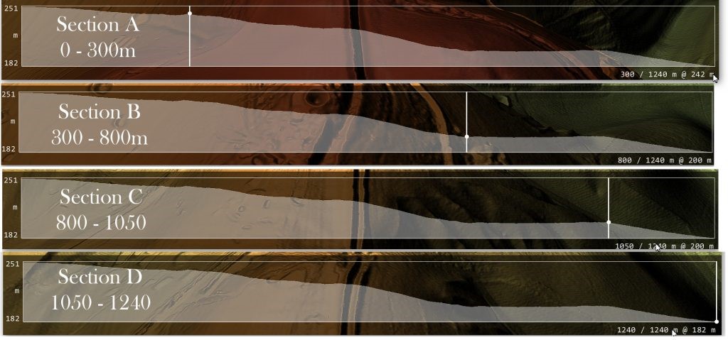
If we are correct with our assumption, we need to show that you can transverse this massive incline using natural springs and basic wooden weirs.  If we split the gradient into four parts, we can see better the profile and problems our ancestors faced.

Prehistoric Canals - Wansdyke 2
Figure 35 Morgan’s Hill West in Sections – Prehistoric Canals – Wansdyke

Section A – 0 to 300 downhill

Length is 300m, and the inclination lowers from 251m OD to 242m OD at a ratio of 3% or 1:33 – If we accept that within this section, we had four cat A ‘springs’ that would release 11.2 cu. metres of water PER SECOND (11,200 litres per second) would fill a 10m ditch that is 1.5 deep by one-metre width of the Dyke’s ditch every SECOND.

According to the mathematical formula (v = k * C * R0.63 * S0.54 ), water at the end of section A would be travelling at 5 MPH – the speed of the Thames at Henley (so quite navigable) and, therefore, no need for any Weirs to reduce the water flow.

Section B – 300 to 800m downhill

This section would receive water at one metre per second from Section A, travelling at 5 MPH – The length of this section is 500m in length, and the inclination lowers from 242m OD to 200m at a ratio of 8% or 1:12 this would accelerate the water to 15 mph which is too fast the navigate uphill. Therefore, a series of weirs would have been placed either under the water or, as the early Victorians achieved, by a paddle weir or both.

An underwater weir (blocking 50% of the water but allowing boats to move over the top without hindrance) would reduce the flow by 50% – so if placed at the End of Section A (at 5 MPH) would reduce the water flow to 2.5 MPH and down to 12.5 MPH at the End of Section B. Consequently, if we place one of these 50% reduction weirs at 100m intervals the water flow would not go over the 5-mph mark and would probably be in the region of 3 – 5 MPH which again is easily navigable.

Chapter 4 – Wansdyke

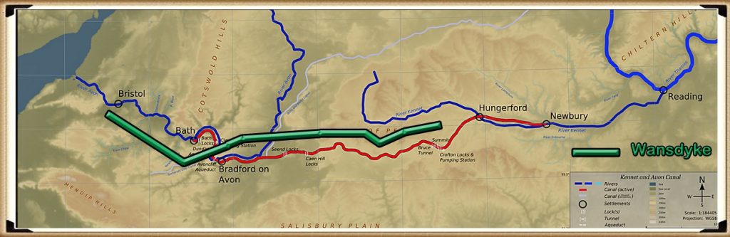
Wansdyke v Avon and Kennet Canal  - Prehistoric Canals - Wansdyke 2
Wansdyke v Avon and Kennet Canal – Prehistoric Canals – Wansdyke

According to Wikipedia, “Wansdyke consists of two sections of 14 and 19 kilometres (9 and 12 mi) long with some gaps in between. East Wansdyke is an impressive linear earthwork, consisting of a ditch and bank running approximately east-west, between Savernake Forest and Morgan’s Hill. West Wansdyke is also a linear earthwork, running from Monkton Combe south of Bath to Maes Knoll south of Bristol, but less impressive than its eastern counterpart. The middle section, 22 kilometres (14 mi) long, is sometimes referred to as ‘Mid Wansdyke’ but is formed by the remains of the London to Bath Roman road. It used to be thought that these sections were all part of one continuous undertaking, especially during the Middle Ages when the pagan name Wansdyke was applied to all three parts.

East Wansdyke in Wiltshire, on the south of the Marlborough Downs, has been less disturbed by later agriculture and building and remains more clearly traceable on the ground than the western part. Here the bank is up to 4 m (13 ft) high with a ditch up to 2.5 m (8.2 ft) deep. Wansdyke’s origins are unclear, but archaeological data shows that the eastern part was probably built during the 5th or 6th century. That is after the withdrawal of the Romans and before the takeover by Anglo-Saxons. The ditch is on the north side, so presumably it was used by the British as a defence against West Saxons encroaching from the upper Thames Valley westward into what is now the West Country.

West Wansdyke, although the antiquarians like John Collinson considered West Wansdyke to stretch from south East of Bath to the west of Maes Knoll, a review in 1960 considered that there was no evidence of its existence to the west of Maes Knoll.   Keith Gardner refuted this with newly discovered documentary evidence.  In 2007 a series of sections were dug across the earthwork which showed that it had existed where there are no longer visible surface remains.

It was shown that the earthwork had a consistent design, with stone or timber revetment. There was little dating evidence, but it was consistent with either a late Roman or post-Roman date. A paper in “The Last of the Britons” conference in 2007 suggests that the West Wansdyke continues from Maes Knoll to the hill forts above the Avon Gorge and controls the crossings of the river at Saltford and Bristol as well as at Bath.

As there is little archaeological evidence to date the western Wansdyke, it may have marked a division between British Celtic kingdoms or have been a boundary with the Saxons. The evidence for its western extension is earthworks along the north side of Dundry Hill, its mention in a charter and a road name.

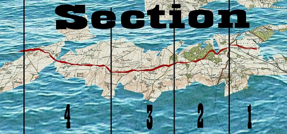
Sections covered in the Book - Prehistoric Canals - Wansdyke 2
Sections covered in the Book – Prehistoric Canals – Wansdyke

Section 1

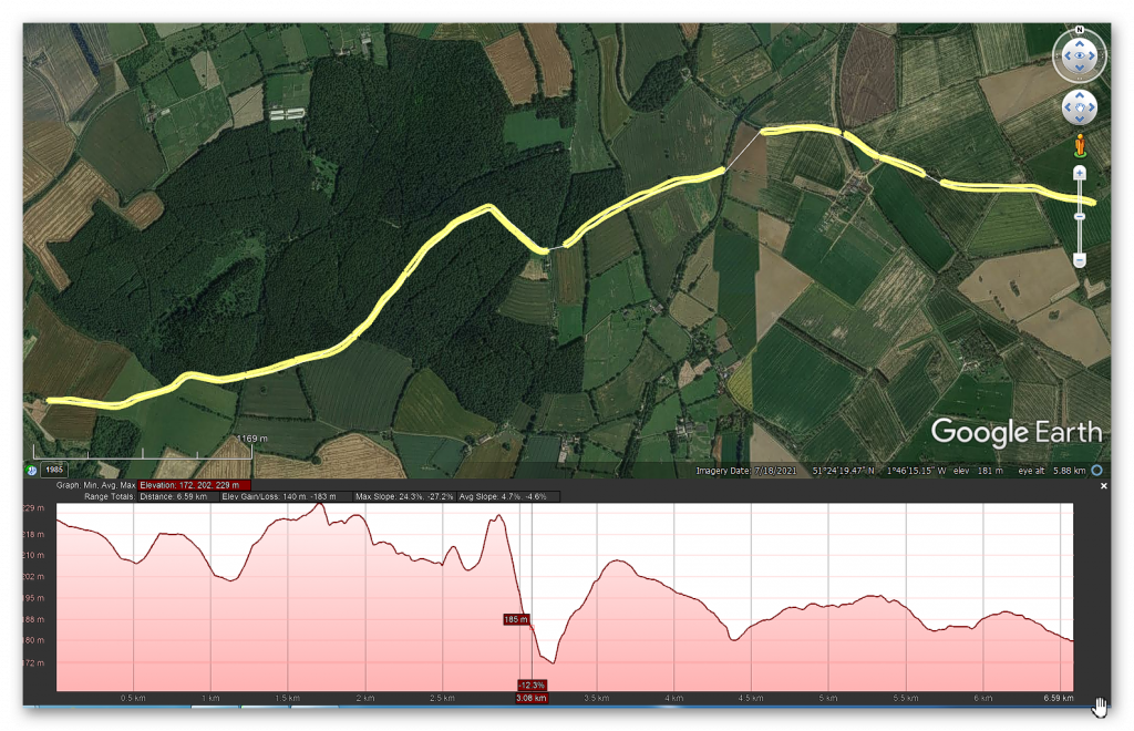
HE:1003784 Wansdyke: section 610yds (560m) NW of Wernham Farm to 250yds (230m) SW of New Buildings (560m = 1680 working days – 20 men taking 84 days to complete)

Figure 44 Wansdyke NW of Wernham (with added water levels)  - Prehistoric Canals - Wansdyke 2
Figure 44 Wansdyke NW of Wernham (with added water levels) – Prehistoric Canals – Wansdyke


No, HE Historic Details or Excavations Registered

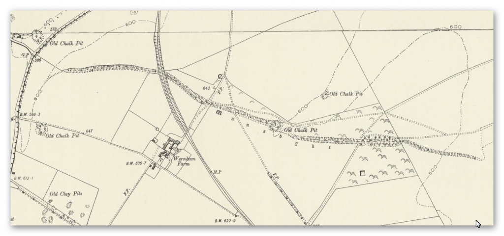
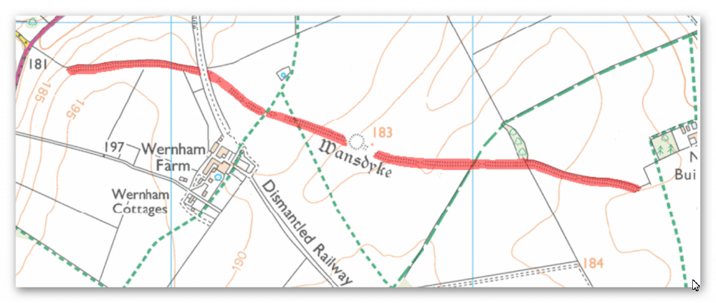
OS Map

1800 OS Map -Prehistoric Canals - Wansdyke 2
Prehistoric Canals – Wansdyke

1800 OS Map

OS Map -Prehistoric Canals - Wansdyke 2
Prehistoric Canals – Wansdyke

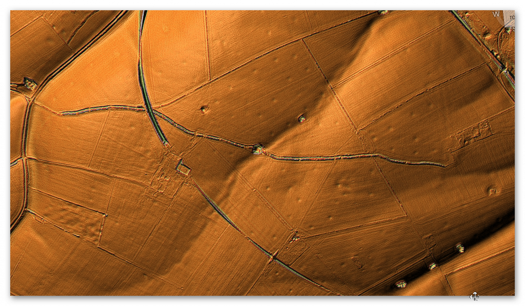
LiDAR Map

LiDAR Map -Prehistoric Canals - Wansdyke 2
Prehistoric Canals – Wansdyke

LiDAR (with Mesolithic water levels)

Prehistoric Canals - Wansdyke 2
Prehistoric Canals – Wansdyke

A feature called ‘firs’ is a gap on the OS Map – there is a strange quarry pit (no relevant substances under the surface to quarry?) – this pit is two metres deep and probably built later to the original ditch.


Are we looking for a hole to find the groundwater to keep the canal working with fresh water? As we will discover, this is not the first pit cut deep on the line of Wansdyke.


The Mesolithic water levels certainly explain the strange start of Wansdyke and the unexplained gaps (if it’s not a canal) in the Dyke.


Notice on the LiDAR maps the extensive ‘pits’ surrounding the Dyke, which are not below the Mesolithic river shoreline and are 14m in diameter.

Figure 45 - Quarry pits found in Paleochannels  - Prehistoric Canals - Wansdyke 2
Figure 45 – Quarry pits found in Paleochannels – Prehistoric Canals – Wansdyke

These features seem to be connected to even larger quarry holes (some under the Mesolithic shoreline), indicating that minerals have been extracted here for thousands of years and may be the reason for the Dykes construction to take minerals away – as have also found these pits in other mineral-rich areas of Britain such as Hadrian’s Wall.


Durrington Walls


The pits are about 20m in diameter and up to 5m deep, as revealed by further geophysical surveys using ground-penetrating radar and mechanical coring around Durrington Walls. Small quantities of struck flint, shell, and animal bone have been recovered from them, with the bone providing radiocarbon dates from about 2500 BC to 1200 BC.

Prehistoric Canals - Wansdyke 2
Prehistoric Canals – Wansdyke

What we see is that this type of quarrying was commonplace in the past and has confused archaeologists – but as this was a trading nation, the solution is evident and straightforward. 


Gap in the Dyke route

At the end of Section 1, we find the first gap (if you exclude the massive gap at the start of the Dyke) – this gap appears as the Dyke dips into a paleochannel. The obvious conclusion for the break in Wansdyke is that it must have been full of water at the construction time.

Prehistoric Canals - Wansdyke 2
Prehistoric Canals – Wansdyke
Figure 46 - Mesolithic Water levels show gap disappears - Prehistoric Canals - Wansdyke 2
Figure 46 – Mesolithic Water levels show gap disappears – Prehistoric Canals – Wansdyke
Ancient Prehistoric Canals - Wansdyke (The Book) -Prehistoric Canals - Wansdyke 2
Ancient Prehistoric Canals – Wansdyke (The Book) – Prehistoric Canals – Wansdyke 2

This was an extracts from the NEW Book Ancient Prehistoric Canals (Dykes) – Wansdyke available on Amazon as a FULL COLOUR HARD BACK (£19.95) or a ECONOMY (£4.99) SOFTBACK black and white VERSION – it is also available as a KINDLE (£1.99) book. For further information about our work on Prehistoric Britain visit our WEBSITE or VIDEO CHANNEL.

Book Details

  • ASIN ‏ : ‎ B0BF31GQKC
  • Publisher ‏ : ‎ Independently published (18 Sept. 2022)
  • Language ‏ : ‎ English
  • Hardcover ‏ : ‎ 134 pages
  • ISBN-13 ‏ : ‎ 979-8353488897
  • Dimensions ‏ : ‎ 15.24 x 1.3 x 22.86 cm
  • Illustrations: 85
  • Customer reviews: 5.0 out of 5 stars    1 rating

Podcast

Author’s Biography

Robert John Langdon, a polymathic luminary, emerges as a writer, historian, and eminent specialist in LiDAR Landscape Archaeology.

His intellectual voyage has interwoven with stints as an astute scrutineer for governmental realms and grand corporate bastions, a tapestry spanning British Telecommunications, Cable and Wireless, British Gas, and the esteemed University of London.

A decade hence, Robert’s transition into retirement unfurled a chapter of insatiable curiosity. This phase saw him immerse himself in Politics, Archaeology, Philosophy, and the enigmatic realm of Quantum Mechanics. His academic odyssey traversed the venerable corridors of knowledge hubs such as the Museum of London, University College London, Birkbeck College, The City Literature Institute, and Chichester University.

In the symphony of his life, Robert is a custodian of three progeny and a pair of cherished grandchildren. His sanctuary lies ensconced in the embrace of West Wales, where he inhabits an isolated cottage, its windows framing a vista of the boundless sea – a retreat from the scrutinous gaze of the Her Majesty’s Revenue and Customs, an amiable clandestinity in the lap of nature’s embrace.

Exploring Prehistoric Britain: A Journey Through Time

My blog delves into the fascinating mysteries of prehistoric Britain, challenging conventional narratives and offering fresh perspectives based on cutting-edge research, particularly using LiDAR technology. I invite you to explore some key areas of my research. For example, the Wansdyke, often cited as a defensive structure, is re-examined in light of new evidence. I’ve presented my findings in my blog post Wansdyke: A British Frontier Wall – ‘Debunked’, and a Wansdyke LiDAR Flyover video further visualizes my conclusions.

My work also often challenges established archaeological dogma. I argue that many sites, such as Hambledon Hill, commonly identified as Iron Age hillforts are not what they seem. My posts Lidar Investigation Hambledon Hill – NOT an ‘Iron Age Fort’ and Unmasking the “Iron Age Hillfort” Myth explore these ideas in detail and offer an alternative view. Similarly, sites like Cissbury Ring and White Sheet Camp, also receive a re-evaluation based on LiDAR analysis in my posts Lidar Investigation Cissbury Ring through time and Lidar Investigation White Sheet Camp, revealing fascinating insights into their true purpose. I have also examined South Cadbury Castle, often linked to the mythical Camelot56.

My research also extends to the topic of ancient water management, including the role of canals and other linear earthworks. I have discussed the true origins of Car Dyke in multiple posts including Car Dyke – ABC News PodCast and Lidar Investigation Car Dyke – North Section, suggesting a Mesolithic origin2357. I also explore the misidentification of Roman aqueducts, as seen in my posts on the Great Chesters (Roman) Aqueduct. My research has also been greatly informed by my post-glacial flooding hypothesis which has helped to inform the landscape transformations over time. I have discussed this hypothesis in several posts including AI now supports my Post-Glacial Flooding Hypothesis and Exploring Britain’s Flooded Past: A Personal Journey

Finally, my blog also investigates prehistoric burial practices, as seen in Prehistoric Burial Practices of Britain and explores the mystery of Pillow Mounds, often mistaken for medieval rabbit warrens, but with a potential link to Bronze Age cremation in my posts: Pillow Mounds: A Bronze Age Legacy of Cremation? and The Mystery of Pillow Mounds: Are They Really Medieval Rabbit Warrens?. My research also includes the astronomical insights of ancient sites, for example, in Rediscovering the Winter Solstice: The Original Winter Festival. I also review new information about the construction of Stonehenge in The Stonehenge Enigma.

Further Reading

For those interested in British Prehistory, visit www.prehistoric-britain.co.uk, a comprehensive resource featuring an extensive collection of archaeology articles, modern LiDAR investigations, and groundbreaking research. The site also includes insights and extracts from the acclaimed Robert John Langdon Trilogy, a series of books exploring Britain during the Prehistoric period. Titles in the trilogy include The Stonehenge Enigma, Dawn of the Lost Civilisation, and The Post Glacial Flooding Hypothesis, offering compelling evidence about ancient landscapes shaped by post-glacial flooding.

To further explore these topics, Robert John Langdon has developed a dedicated YouTube channel featuring over 100 video documentaries and investigations that complement the trilogy. Notable discoveries and studies showcased on the channel include 13 Things that Don’t Make Sense in History and the revelation of Silbury Avenue – The Lost Stone Avenue, a rediscovered prehistoric feature at Avebury, Wiltshire.

In addition to his main works, Langdon has released a series of shorter, accessible publications, ideal for readers delving into specific topics. These include:

For active discussions and updates on the trilogy’s findings and recent LiDAR investigations, join our vibrant community on Facebook. Engage with like-minded enthusiasts by leaving a message or contributing to debates in our Facebook Group.

Whether through the books, the website, or interactive videos, we aim to provide a deeper understanding of Britain’s fascinating prehistoric past. We encourage you to explore these resources and uncover the mysteries of ancient landscapes through the lens of modern archaeology.

For more information, including chapter extracts and related publications, visit the Robert John Langdon Author Page. Dive into works such as The Stonehenge Enigma or Dawn of the Lost Civilisation, and explore cutting-edge theories that challenge traditional historical narratives.

Other Blogs

s

t

Ivory Tower Collapse: How Academia Abandoned Society – and Took Education, Innovation, and Archaeology Down With It

Introduction:

Once seen as the guardians of progress and truth, our universities have now become detached fortresses — insulated from economic reality, unaccountable to public need, and increasingly irrelevant to the challenges they claim to address.

Instead of saving us from economic decline, social division, and failing education — academia has accelerated these crises through poor management, obsession with internal metrics, and a stubborn refusal to engage with innovation or the real world.

And nowhere is this failure more visible than in the slow suffocation of scientific disciplines like archaeology — now little more than a sandbox for ritual theories, self-referential papers, and tenure-chasing conformity. (How Academia Abandoned Society)


1. Academia’s Betrayal of Purpose

Referencing:
What Are We Good For? – Transforming Society

Academia was meant to be society’s think tank — a crucible for solving the great problems of our time. Instead, most modern academics:

  • Avoid the messy realities of policymaking or enterprise.
  • Prioritise journal metrics over practical outcomes.
  • Retreat into specialist silos, increasingly unreadable even to fellow academics.

Rather than challenge failing systems, they enable them through polite conformity and funding dependency.(How Academia Abandoned Society)

(How Academia Abandoned Society)

2. Universities as Debt Machines, Not Learning Institutions

Referencing:
University Crisis Demands a Complete Reboot – The Times

We were promised education as the golden ticket. What we got instead:

  • £50,000 debts for degrees that don’t deliver.
  • Admin-heavy institutions that divert funding from actual teaching.
  • Graduates pouring out with paper credentials but little practical skill — ending up underemployed, disillusioned, and still paying rent to the people who failed them.

Universities have become degree mills, selling “success” on credit, while absolving themselves of responsibility when reality knocks. (How Academia Abandoned Society)


3. Mismanagement Disguised as Meritocracy

Referencing:
How Management Academics Locked Themselves in an Iron Cage – Global Focus Magazine

The modern university is run less like an educational institution and more like a bloated consultancy firm, helmed by:

  • Academics turned administrators, with no real-world governance experience.
  • Part-educated managers obsessed with “strategy decks” and PowerPoints.
  • Cultures that reward safety and consensus over creativity or challenge.

Result? Conformity masquerading as scholarship, and regression disguised as tradition. (How Academia Abandoned Society)

(How Academia Abandoned Society)

4. The Economic Slump They Didn’t See Coming

Referencing:
Pull Britain Out of the Normie Doom Spiral – The Times

Let’s be blunt — the academics didn’t save us from economic stagnation. Many championed the very policies that contributed to it:

  • Over-credentialisation (degree inflation),
  • Downplaying vocational training,
  • Obsession with theory over innovation.

The truth? Most universities are no longer producing inventors, thinkers, or leaders — but clerks of a broken system. (How Academia Abandoned Society)


5. Archaeology: From Scientific Discipline to Storytelling Seminar

Referencing:

  • [Langdon, R.J. – The Post-Glacial Flooding Hypothesis]
  • OSL/LiDAR studies, EH oversight, unpublished hydrological data.

In no field is the rot more obvious than in archaeology, once a pioneering blend of earth sciences, hydrology, radiocarbon dating, geochemistry, and comparative anthropology. Today?

  • It has devolved into a storytelling discipline — more interested in interpretive dance around “ritual” than in hard evidence.
  • The scientific method has been displaced by literary analysis, with subjective speculation passed off as theory.
  • Worse still, new evidence is actively resisted — especially when it threatens comfortable narratives, tenured positions, or decades-old publications still on university reading lists.

Take LiDAR, for example. You’d think a tool that reveals thousands of previously undocumented prehistoric features across Britain would be welcomed. But no — because it wasn’t unearthed with a trowel by someone with the right initials, it’s often ignored or dismissed outright.

Even more absurd is the continued fetishisation of antler picks, “causewayed enclosures,” and Mesolithic postholes, used to prop up linear, outdated models of Neolithic development that crumble under scrutiny from:

  • OSL (Optically Stimulated Luminescence) dating,
  • Isotopic sourcing,
  • Floodplain regression models,
  • And maritime trade route simulations.

But don’t expect peer review to fix that. The academic gatekeeping system:

  • Relies on old-guard referees with vested interests,
  • Dismisses independent researchers (however well evidenced),
  • And blacklists journals or presses that break ranks.

This is not science. This is career maintenance disguised as scholarship. And it’s strangling progress.

(How Academia Abandoned Society)

🔍 Langdon’s Law:

“If a theory requires ignoring LiDAR, hydrology, carbon dating, and maritime logistics — it’s not archaeology. It’s fan fiction with soil samples.”


Conclusion: From Lighthouse to Lifeboat

The modern university should have been a lighthouse for society. Instead, it’s become a leaking lifeboat, captained by out-of-touch theorists and failed bureaucrats, waving credentials while steering into the iceberg.

We don’t need more qualifications. We need qualified people — trained to think clearly, build boldly, and challenge systems. That won’t come from within academia as it stands. It must come from outside, with real-world thinkers, innovators, and independent researchers willing to challenge the polite silence of decline.

(How Academia Abandoned Society)

Exploring Prehistoric Britain: A Journey Through Time

My blog delves into the fascinating mysteries of prehistoric Britain, challenging conventional narratives and offering fresh perspectives based on cutting-edge research, particularly using LiDAR technology. I invite you to explore some key areas of my research. For example, the Wansdyke, often cited as a defensive structure, is re-examined in light of new evidence. I’ve presented my findings in my blog post Wansdyke: A British Frontier Wall – ‘Debunked’, and a Wansdyke LiDAR Flyover video further visualizes my conclusions.

My work also often challenges established archaeological dogma. I argue that many sites, such as Hambledon Hill, commonly identified as Iron Age hillforts are not what they seem. My posts Lidar Investigation Hambledon Hill – NOT an ‘Iron Age Fort’ and Unmasking the “Iron Age Hillfort” Myth explore these ideas in detail and offer an alternative view. Similarly, sites like Cissbury Ring and White Sheet Camp, also receive a re-evaluation based on LiDAR analysis in my posts Lidar Investigation Cissbury Ring through time and Lidar Investigation White Sheet Camp, revealing fascinating insights into their true purpose. I have also examined South Cadbury Castle, often linked to the mythical Camelot56.

My research also extends to the topic of ancient water management, including the role of canals and other linear earthworks. I have discussed the true origins of Car Dyke in multiple posts including Car Dyke – ABC News PodCast and Lidar Investigation Car Dyke – North Section, suggesting a Mesolithic origin2357. I also explore the misidentification of Roman aqueducts, as seen in my posts on the Great Chesters (Roman) Aqueduct. My research has also been greatly informed by my post-glacial flooding hypothesis which has helped to inform the landscape transformations over time. I have discussed this hypothesis in several posts including AI now supports my Post-Glacial Flooding Hypothesis and Exploring Britain’s Flooded Past: A Personal Journey

Finally, my blog also investigates prehistoric burial practices, as seen in Prehistoric Burial Practices of Britain and explores the mystery of Pillow Mounds, often mistaken for medieval rabbit warrens, but with a potential link to Bronze Age cremation in my posts: Pillow Mounds: A Bronze Age Legacy of Cremation? and The Mystery of Pillow Mounds: Are They Really Medieval Rabbit Warrens?. My research also includes the astronomical insights of ancient sites, for example, in Rediscovering the Winter Solstice: The Original Winter Festival. I also review new information about the construction of Stonehenge in The Stonehenge Enigma. (Rhône to Wansdyke).

Further Reading

For those interested in British Prehistory, visit www.prehistoric-britain.co.uk, a comprehensive resource featuring an extensive collection of archaeology articles, modern LiDAR investigations, and groundbreaking research. The site also includes insights and extracts from the acclaimed Robert John Langdon Trilogy, a series of books exploring Britain during the Prehistoric period. Titles in the trilogy include The Stonehenge Enigma, Dawn of the Lost Civilisation, and The Post Glacial Flooding Hypothesis, offering compelling evidence about ancient landscapes shaped by post-glacial flooding.

To further explore these topics, Robert John Langdon has developed a dedicated YouTube channel featuring over 100 video documentaries and investigations that complement the trilogy. Notable discoveries and studies showcased on the channel include 13 Things that Don’t Make Sense in History and the revelation of Silbury Avenue – The Lost Stone Avenue, a rediscovered prehistoric feature at Avebury, Wiltshire. (Rhône to Wansdyke).

In addition to his main works, Langdon has released a series of shorter, accessible publications, ideal for readers delving into specific topics. These include:

For active discussions and updates on the trilogy’s findings and recent LiDAR investigations, join our vibrant community on Facebook. Engage with like-minded enthusiasts by leaving a message or contributing to debates in our Facebook Group.

Whether through the books, the website, or interactive videos, we aim to provide a deeper understanding of Britain’s fascinating prehistoric past. We encourage you to explore these resources and uncover the mysteries of ancient landscapes through the lens of modern archaeology.

For more information, including chapter extracts and related publications, visit the Robert John Langdon Author Page. Dive into works such as The Stonehenge Enigma or Dawn of the Lost Civilisation, and explore cutting-edge theories that challenge traditional historical narratives. (Rhône to Wansdyke).

Other Blogs

s

t

Hidden Sources of Ancient Dykes: Tracing Underground Groundwater Fractals

Introduction

This blog re-examines Britain’s ancient linear earthworks, such as Offa’s Dyke and Wansdyke, through the lens of hydrology and groundwater science, proposing that these structures were not ritual boundaries or defensive embankments, but part of a sophisticated, prehistoric mining and transport network. By tracing their unusual paths and comparing them with aquifer data, the post makes a compelling case: these dykes were built to move minerals via water—not soldiers.(Hidden Purpose of Ancient Dykes)

Contrary to the long-held belief that these features served military or symbolic functions, their actual design raises major questions. Many dykes are non-continuous, curve unpredictably, and pass through remote, uninhabited areas, far from any strategic stronghold or settlement. Instead of defending anything, they seem to follow the landscape’s natural water flow—especially the edges of aquifers and groundwater discharge zones.

 Hidden Purpose of Ancient Dykes
Wansdyke is on the edge of one of Britains largest Aquifers – Hidden Sources of Ancient Dykes – Source BGS

By overlaying dyke locations onto hydrogeological maps, a pattern emerges: nearly every major dyke in Britain correlates with aquifer systems or zones of high groundwater productivity. This includes saturated mineral-bearing soils, limestone and chalk formations, and ancient springs—features critical not for spiritual rituals, but for extracting and transporting resources. These dykes, the blog suggests, were likely built to channel groundwater seasonally or year-round, enabling flat-bottomed boats to move ore, stone, and other extracted materials from inland mining zones to major river systems for wider distribution.

The wibbly-wobbly routes of these earthworks make far more sense when viewed through this lens. Rather than being arbitrarily drawn or spiritually significant, they seem to trace fractally distributed groundwater flow patterns—the same paths water would naturally take through porous rock and sediment. By tapping into these natural routes, prehistoric engineers could move heavy materials across considerable distances without the need for roads or pack animals.

 Hidden Purpose of Ancient Dykes
The Vallum at Hadrian’s Wall is on a major Aquifer – Hidden Sources of Ancient Dykes – Source BGS

Sites along these dykes often yield clues of quarrying, digging pits, or early metallurgy, further suggesting an industrial—not ritualistic—function. Combined with LiDAR mapping and terrain modelling, many of these ancient dykes also show characteristics of canal-like trenching, including embankments, towpaths, and level gradients consistent with water management rather than warfare.

Importantly, the blog challenges modern archaeology’s tendency to label such constructions as “ritual” simply because their purpose is not immediately understood. By reframing these dykes as functional infrastructure, it positions prehistoric Britons not as superstitious monument builders, but as skilled engineers, capable of manipulating water to serve economic and industrial goals—centuries, perhaps millennia, before similar systems appeared in written history.

 Hidden Purpose of Ancient Dykes
Offa’s Dyke is on the edge of THREE major Aquifers – Hidden Sources of Ancient Dykes – Source BGS
Hidden Purpose of Ancient Dykes - Source BGS
Hidden Sources of Ancient Dykes – Source BGS
- Hidden Purpose of Ancient Dykes - Source BGS
Hidden Sources of Ancient Dykes – Source BGS

In conclusion, the blog argues that Britain’s ancient dykes were part of a hydrological logistics network designed for resource movement and mining operations, aligning deliberately with groundwater systems and aquifer boundaries. These were routes of commerce and industry, not symbols or borders. It’s time to stop viewing them as mysterious relics—and start seeing them as evidence of a forgotten era of practical innovation and environmental mastery.

Dykes Follow Water: The 68.6% Aquifer Overlap Nobody’s Talking About

In a GIS-based analysis of prehistoric dyke placements across Britain, using official aquifer mapping from the British Geological Survey, we found that over two-thirds (68.6%) of dyke segments intersect directly with known aquifer zones.

This finding severely undermines the long-standing assumption that dykes were purely ritual or defensive. Instead, it supports a far more practical theory: these features may have followed underground water fractures or aquifer boundaries — possibly to aid water transport, trade, or seasonal canal usage.

When linear earthworks like Offa’s Dyke and Wansdyke are mapped alongside hydrogeological data, patterns emerge that are too precise to be coincidental. Whether through environmental observation or water dowsing, the builders clearly knew something about the ground beneath their feet.

Forget chalk and ritual. This is water engineering.

AI’s Take

1. Introduction: Revisiting the Landscape Through Water

Across Britain, a network of ancient linear earthworks—often labelled dykes—traverse the landscape in puzzling patterns. Traditionally interpreted as defensive structures, many of these dykes do not conform to military logic. They often wind across hills, valleys, and open terrain in apparently arbitrary routes. However, by examining these features through the lens of hydrology, particularly groundwater distribution and fractal flow paths, an alternative explanation emerges: these ancient monuments may have been constructed in response to the hidden patterns of water beneath our feet.

Hidden Purpose of Ancient Dykes
Ancient dykes like Offa’s Dyke snake across the landscape with no obvious military logic.- Hidden Purpose of Ancient Dykes

2. The Science of Groundwater Flow

Groundwater moves beneath the Earth’s surface through porous materials like gravel, sand, and fractured rock. Governed by the laws of hydrogeology—most notably Darcy’s Law—its movement follows gradients in pressure and elevation. Contrary to the perception of random underground seepage, groundwater flow is directional, structured, and often forms recognizable spatial patterns when viewed over time.

Hidden Purpose of Ancient Dykes

3. Hydrological Predictability and Fractal Geometry

Groundwater doesn’t spread uniformly. Instead, it forms branching, tree-like pathways that closely resemble fractal geometry—irregular yet mathematically structured patterns found in nature. These fractal patterns can be seen in river systems, lightning strikes, and even blood vessels. When mapped in detail, groundwater follows similar structures: splitting, rejoining, and fanning out with a logic dictated by rock permeability and hydraulic gradients.

Hidden Purpose of Ancient Dykes
Groundwater often follows fractal patterns, mirroring trees, veins, and rivers. – Hidden Purpose of Ancient Dykes

4. The Role of Aquifers

An aquifer is a body of rock or sediment that holds usable groundwater. Britain’s principal aquifers—such as the Chalk Aquifer of southeast England or the Triassic sandstones in Wales and the Midlands—are well-documented by the British Geological Survey. These aquifers are not just water sources; they shape ecosystems, influence agriculture, and determine human settlement patterns over millennia.

Hidden Purpose of Ancient Dykes
Britain’s major aquifers form the nation’s underground reservoirs. – Hidden Purpose of Ancient Dykes

5. Linear Earthworks: Not So Linear in Purpose

Earthworks like Offa’s Dyke, Wansdyke, and Grim’s Ditch often deviate from straight lines, curving and looping across the countryside. Many historians and archaeologists have noted this “wibbly-wobbly” quality and chalked it up to terrain negotiation. But what if these bends follow not just topography, but subterranean water flows?

 Hidden Purpose of Ancient Dykes
Dykes appear “linear” in name only—many follow winding, unpredictable paths.- Hidden Purpose of Ancient Dykes

6. Evidence of Groundwater-Aware Design

Recent overlays of dyke paths on hydrogeological maps reveal compelling alignments. Dykes often trace the edges of aquifers, follow groundwater discharge zones (where springs emerge), or align with the boundaries between permeable and impermeable strata. These alignments are unlikely to be accidental, particularly when they persist across multiple sites.

Hidden Purpose of Ancient Dykes
Car Dyke aligns with underground water flow zones and aquifer edges which are still flowing..- Hidden Purpose of Ancient Dykes

7. Mapping the Invisible: Fractals in the Field

Using LiDAR data, some researchers have started mapping the subtle undulations in landscape that coincide with earthworks. When these are overlaid with known groundwater discharge points and aquifer margins, a fractal pattern begins to emerge. The ancient builders, whether consciously or through long experience, appear to have traced these subtle cues in the environment—potentially to access, mark, or manage water resources.

.- Hidden Purpose of Ancient Dykes
LiDAR data reveals invisible patterns matching ancient earthworks and water flows..- Hidden Purpose of Ancient Dykes

8. Offa’s Dyke and the Welsh Aquifers

One of the most prominent linear monuments in Britain, Offa’s Dyke, cuts through a landscape rich in aquifers. From the carboniferous limestone of the Brecon Beacons to the sandstones of the Cheshire Basin, the dyke’s route seems to skim or run adjacent to many known water-bearing formations. While once considered a boundary between Anglo-Saxon and Welsh territories, it now appears the dyke might also be a hydrological boundary marker.

 Hidden Purpose of Ancient Dykes
Hidden Purpose of Ancient Dykes

9. Wansdyke and Water Corridors

Wansdyke in southern England similarly defies defensive logic. Its route is discontinuous and loops across high ridges with no clear military advantage. However, much of it aligns with chalk geology—a major aquifer type in the UK. The chalk aquifer not only stores groundwater but releases it gradually into the landscape through springs, many of which lie near or along Wansdyke’s path.

Hidden Purpose of Ancient Dykes

10. Dyke Placement and the Absence of Settlements

Another clue lies in what’s not present. Many dykes pass through areas far from settlements, agriculture, or known defensive frontiers. These otherwise “inconvenient” locations begin to make sense when viewed hydrologically: they traverse zones of high groundwater potential, or cross landscape features connected to seasonal flooding and spring emergence.

Hidden Purpose of Ancient Dykes
Most Dykes are in the middle of nowhere and small – Hidden Purpose of Ancient Dykes

11. Ancient Hydroengineering?

Alternatively, these dykes may represent early attempts at hydrological management—channeling water, controlling flood plains, or marking safe grazing zones. If water was seasonally abundant or scarce, understanding its patterns would have been vital. Building linear earthworks along aquifer boundaries could have allowed communities to delineate water-rich areas from drier zones without modern instrumentation.

 Hidden Purpose of Ancient Dykes
Durrington Walls kept the water but adding a Dyke when the River water levels fell – Hidden Purpose of Ancient Dykes

12. Mathematical Validation of Dyke Placement

Using fractal analysis and mathematical modelling tools (like GIS or QGIS), modern researchers can now test the statistical probability of dyke placement aligning with hydrological features. Preliminary data suggests a non-random correlation—that is, dykes are significantly more likely to intersect aquifer boundaries or discharge zones than random lines across the same landscape would.

- Hidden Purpose of Ancient Dykes
Fractal flow modeling suggests non-random alignment of dykes and water.- Hidden Purpose of Ancient Dykes

13. A Landscape Language We’re Only Starting to Understand

Our ancestors may not have used scientific terminology, but they read the land through observation, oral tradition, and environmental memory. Dykes may have formed part of this unspoken language of the landscape—an early cartography of water, built in earth and stone. Rediscovering this language could reshape not only our understanding of earthworks, but of ancient Britain itself.

- Hidden Purpose of Ancient Dykes
Dykes may be part of an ancient “language” that mapped water underground.- Hidden Purpose of Ancient Dykes

14. Conclusion: From Defensive Lines to Water Lines

What appears as haphazard or defensive may, in fact, be ecological and intentional. Groundwater distribution patterns—fractal, functional, and factual—offer a powerful lens through which to reinterpret the placement and purpose of Britain’s linear earthworks. These dykes might not be walls at all—but lines drawn in reverence to the veins of the Earth, acknowledging the life-giving force of water hidden just beneath the surface.

Hidden Purpose of Ancient Dykes

Further Reading

For information about British Prehistory, visit www.prehistoric-britain.co.uk for the most extensive archaeology blogs and investigations collection, including modern LiDAR reports.  This site also includes extracts and articles from the Robert John Langdon Trilogy about Britain in the Prehistoric period, including titles such as The Stonehenge Enigma, Dawn of the Lost Civilisation and the ultimate proof of Post Glacial Flooding and the landscape we see today.

Robert John Langdon has also created a YouTube web channel with over 100 investigations and video documentaries to support his classic trilogy (Prehistoric Britain). He has also released a collection of strange coincidences that he calls ‘13 Things that Don’t Make Sense in History’ and his recent discovery of a lost Stone Avenue at Avebury in Wiltshire called ‘Silbury Avenue – the Lost Stone Avenue’.

(Maritime Diffusion Model for Megaliths in Europe)

Langdon has also produced a series of ‘shorts’, which are extracts from his main body of books:

The Ancient Mariners

Stonehenge Built 8300 BCE

Old Sarum

Prehistoric Rivers

Dykes ditches and Earthworks

Echoes of Atlantis

Homo Superior

(https://bloggers.feedspot.com/uk_archaeology_blogs/)

Other Blogs

s

t

Prehistoric Canals Wansdyke 2

Introduction

​The Wansdyke, a significant linear earthwork in southwestern England, has long intrigued historians and archaeologists. Traditionally interpreted as an early medieval defensive structure, recent analyses suggest it may have served a different purpose. The blog “Prehistoric Canals – Wansdyke” explores the theory that Wansdyke functioned as a prehistoric canal system, challenging conventional understandings of its role in ancient Britain.​

This perspective is rooted in the observation that Wansdyke’s design resembles that of ancient canals. The earthwork features a substantial ditch accompanied by an embankment, a configuration commonly associated with water management systems. Moreover, the alignment of Wansdyke with natural watercourses and its proximity to prehistoric sites suggest it may have facilitated transportation and trade, rather than solely serving as a military fortification.​

Further supporting this hypothesis is the presence of flint pits and barrows along Wansdyke’s route. These archaeological features indicate areas of significant prehistoric activity, implying that the earthwork played a role in the economic and social practices of the time. Additionally, the strategic placement of Wansdyke in relation to the ancient landscape suggests it was designed to harness natural waterways, enhancing connectivity between settlements and resource sites.​

Reevaluating Wansdyke as a prehistoric canal system offers a fresh perspective on the engineering capabilities of ancient societies in Britain. It underscores the complexity of their infrastructure and their adeptness at manipulating the environment to support transportation and trade. This interpretation invites a broader reconsideration of similar earthworks and their functions, highlighting the need for ongoing research and open-mindedness in archaeological discourse.

Promotional Video

– Ancient Prehistoric Canals (Dykes) – Wansdyke (Prehistoric Canals – Wansdyke 2)

Book Extracts

Chapter 1 – Dykes, Ditches and Earthworks

Start of Wansdyke East  -Prehistoric Canals - Wansdyke 2
Start of Wansdyke East -Prehistoric Canals – Wansdyke 2

The modern word dike or Dyke most likely derives from the Dutch word “dijk”, with the construction of dikes in the Netherlands well attested as early as the 12th century. The 126 kilometres (78 mi) long Westfriese Omringdijk was completed by 1250 and was formed by connecting existing older dikes. The Roman chronicler Tacitus even mentions that the rebellious Batavi pierced dikes to flood their land and protect their retreat (AD 70).  The word dijk initially indicated both the trench and the bank.– Wikipedia

If you study archaeology at university or even on an ordinance survey map at length, you will notice strange earthworks on the sides of hills of Britain, with no rational explanation as to why they are there and for what reason.  These features are mostly ignored at university, or an excuse is made for their construction.  The reality is that these features do not make any sense unless there are other factors in operation which have been ignored.

The first thing to notice is that the word ‘Dyke’ is associated with water.  It does seem strange you would call an earthwork on top of a hill a Dyke, unless there was some history passed down through the years to its actual use.  If we look at the most famous Dyke in Britain, ‘Offa’, we notice that it is attributed to a Saxon King and, therefore, could not be prehistoric.   Or is this a clear indication of how archaeologists find excuses for these features rather than factual, empirical evidence?

“Offa’s Dyke (Welsh: Clawdd Offa) is a massive linear earthwork, roughly followed by some of the current borders between England and Wales. In places, it is up to 65 feet (19.8 m) wide (including its flanking ditch) and 8 feet (2.4 m) in height.  In the 8th century, it formed some kind of delineation between the Anglian kingdom of Mercia and the Welsh kingdom of Powys.” – Wikipedia

At face value, this explanation seems to answer all the questions about Dykes (except the water connection).  But suppose you delve further down to look at the evidence, such as findings from the Dyke and any written history. In that case, you get a different version for the Roman historian Eutropius in his book, Historiae Romanae Breviarium, written around 369 AD, mentions the Wall of Severus, a structure built by Septimius Severus who was Roman Emperor between 193 AD and 211 AD:

“He had his most recent war in Britain, and to fortify the conquered provinces with all security; he built a wall for 133 miles from sea to sea. He died at York, a reasonably old man, in the sixteenth year and third month of his reign.” – Eutropius (369 AD)

This ‘wall’ need not be made of stone as we know from their Scottish endeavours that the first structure as a defence was usually a bank and a ditch – just like a Dyke!!

The problem with this account is that none of the known Roman defences are 133 miles long – Harridan’s Wall is only 70 miles, so are they talking about Offa’s Dyke, which is much longer?

Chapter 2 – The Post-Glacial Flooding Hypothesis

Rise of Sea Levels - Prehistoric Canals - Wansdyke 2
Rise of Sea Levels – Prehistoric Canals – Wansdyke 2

Before we show you what these ‘Linear Earthworks‘ were used for in prehistoric times.  We need to give you an idea of how the environment was at the time of construction and why it is so different today.

In ‘The Post-Glacial Flooding Hypothesis,’ we looked at the new mathematical models that allowed us to calculate the amount of water released during and after the Last Glacial Maximum just over ten thousand years ago.

If the Dykes of Britain are canals (and not markers or defensive ditches), we must prove that the water table was higher in the past than today (otherwise, they would still be flooded).

The models contained in the PGFH showed us that a minimum of 8.42 quadrillion tonnes of water was released on the UK at the end of the last ice age.  This is equivalent to 98425.2 inches of rain falling on every square inch of Britain’s landmass or the same as – One Inch of rain steadily falling every day for the next 270 years

The worst known flooding in British history occurred in 1947 when just six inches of rain (149mm) fell on up to 12″ of snow (so a maximum of 15″ of rain if melted) over three months. The flooding, which inundated nearly all the main rivers in the South, Midlands, and the Northeast of England, was notable for its origins, geographical extent, and duration.

It impacted thirty out of the forty English counties over two weeks, when around 700,000 acres of land flooded. As a result, tens of thousands of people were temporarily displaced from their homes, and thousands of acres of crops were lost; and this was just 15 of the estimated equivalent of 98,425 inches of water that was shed on the British landscape after the last Ice Age. 

Raised Water Table

According to William Donn (Donn et al., 1962). The Fennoscandian and Great Britain ice sheet covered 4.7 106 km2, which is equivalent to: 

•          8.42 106 Gigatonnes of water / 4.7 106 km2, which gives     us 1.79 Gt per km2

•          1.79 Gt of water at a penetration rate of 43%, give us   0.77 Gt of water per km2

•          0.77 Gigatonnes of water by UK landmass 242,495 km² give us 186,804 Gt of groundwater

This water will be released at a rate of 1 – 12mm per annum and possibly at a depth of 75km. Therefore, to release groundwater at a depth of 75km at an average rate of 6mm per annum would take 12,500 years – not the 1,200 years previously believed, which is just the surface water from the last stages of the meltwater ice.

This is why rivers (like the Thames) still flow even after months of drought, as the groundwater is constantly leaking into the river, which was at its highest rate at the start of the Mesolithic, just after the great meltwater floods.

Sea-Level Changes

If this model is correct, we should be able to get verification via other empirical evidence, as shown in sea level water rises, to see if it has been constant over the last 12,500 years.

Most geologists and paleoclimatologists, when talking about the end of the last ice age, refer people to the phenomenon called the ‘Meltwater Pulse’ – which is the rapid rise in sea level (20m) between 13,500 and 14,700 years before present, over a 400 – 500 year period. Although it is a tremendous value, it should be recognised that this ‘pulse’ as only 16% of the total sea rise since the end of the last ice age.

Chapter 3 – Hydrology 101

Groundwater Sources - Prehistoric Canals - Wansdyke 2
Groundwater Sources – Prehistoric Canals – Wansdyke 2

When it comes to the use of ‘linear earthworks’ (we call ‘Dykes’), there is massive confusion amongst both professionals and amateur archaeologists about how such structures could function when they are dry today?

The incorrect perception of these ‘Dykes’ is either they are ‘rivers’ (like the Thames) that flow uphill or Victorian Canals with locks and wooden gates regulating the flow of the water – which are equally nonsensical as a prehistoric structures. Basic Hydrology that most people (should be but not necessarily ALL) learnt at school is that water is under the ground – not just a little water but 30% of all the fresh water on the planet.

This abundance of ‘groundwater’ is evident as it is the source of ALL rivers and supplies the Wells that have been dug since the beginning of time when rivers were absent. Even today, if you go into your garden and dig a hole, it will eventually fill with groundwater, whether in a valley or on top of a hill or mountain.

How and why water is on hills is very challenging for individuals as most people have a simplistic view of water being flat and sitting at ground level – but the earth is a far more complicated structure as this is the reason that it took centuries for people to recognise that we lived on a sphere and not a ‘flat-earth’ as such complex concepts such as gravity are hard to comprehend.

The reality is that ‘streams’ of water are encapsulated within the bedrock allowing ‘springs’ to start rivers at a great height as the groundwater is under pressure and erupts to the surface from BELOW and does not flow up or down the hill internally – but can flow downhill AFTER it escapes from the soil, because at the point of escape gravity then becomes the greater force overcoming the water pressure when within the bedrock – which stops it flowing down the landscape and can push it up to the top of hills and mountains.

Consequently, wells work even on hills as the groundwater is encapsulated in the bedrock and soil. The above illustration shows that if wells are dug halfway up a hill where there is a groundwater pocket, they will fill – if we join up these wells, the entire ditch will also fill with water – sourced from the ground.

The central aspect that must be remembered when considering the reasons behind the construction and maintenance of these earthworks (Dykes) is that the environment was so much different in the Mesolithic Period, which changed rapidly when entering the Neolithic and then even more changes in the Bronze and Iron Ages.

Once the ice sheets had melted and the climate began to warm, the landscape gradually changed from open tundra to dense woodland. By around 8000 BC, pine and birch dominated the woodland cover. These were slowly replaced by lime, elm and oak with some hazel. By 6500 BC, pine and birch woodland would only have been found on the thinner limestone soils of the uplands.

Case Study Wansdyke – Morgan’s Hill West

The steepest aspect of Wansdyke is the rise over Morgan’s Hill, which is an incline from 182m OD to 252m OD.

Figure 34 - Morgan Hill West (Wansdyke)  - Prehistoric Canals - Wansdyke 2
Figure 34 – Morgan Hill West (Wansdyke) – Prehistoric Canals – Wansdyke 2

If we are correct with our assumption, we need to show that you can transverse this massive incline using natural springs and basic wooden weirs.  If we split the gradient into four parts, we can see better the profile and problems our ancestors faced.

Prehistoric Canals - Wansdyke 2
Figure 35 Morgan’s Hill West in Sections – Prehistoric Canals – Wansdyke 2

Section A – 0 to 300 downhill

Length is 300m, and the inclination lowers from 251m OD to 242m OD at a ratio of 3% or 1:33 – If we accept that within this section, we had four cat A ‘springs’ that would release 11.2 cu. metres of water PER SECOND (11,200 litres per second) would fill a 10m ditch that is 1.5 deep by one-metre width of the Dyke’s ditch every SECOND.

According to the mathematical formula (v = k * C * R0.63 * S0.54 ), water at the end of section A would be travelling at 5 MPH – the speed of the Thames at Henley (so quite navigable) and, therefore, no need for any Weirs to reduce the water flow.

Section B – 300 to 800m downhill

This section would receive water at one metre per second from Section A, travelling at 5 MPH – The length of this section is 500m in length, and the inclination lowers from 242m OD to 200m at a ratio of 8% or 1:12 this would accelerate the water to 15 mph which is too fast the navigate uphill. Therefore, a series of weirs would have been placed either under the water or, as the early Victorians achieved, by a paddle weir or both.

An underwater weir (blocking 50% of the water but allowing boats to move over the top without hindrance) would reduce the flow by 50% – so if placed at the End of Section A (at 5 MPH) would reduce the water flow to 2.5 MPH and down to 12.5 MPH at the End of Section B. Consequently, if we place one of these 50% reduction weirs at 100m intervals the water flow would not go over the 5-mph mark and would probably be in the region of 3 – 5 MPH which again is easily navigable.

Chapter 4 – Wansdyke

Wansdyke v Avon and Kennet Canal  - Prehistoric Canals - Wansdyke 2
Wansdyke v Avon and Kennet Canal – Prehistoric Canals – Wansdyke 2

According to Wikipedia, “Wansdyke consists of two sections of 14 and 19 kilometres (9 and 12 mi) long with some gaps in between. East Wansdyke is an impressive linear earthwork, consisting of a ditch and bank running approximately east-west, between Savernake Forest and Morgan’s Hill. West Wansdyke is also a linear earthwork, running from Monkton Combe south of Bath to Maes Knoll south of Bristol, but less impressive than its eastern counterpart. The middle section, 22 kilometres (14 mi) long, is sometimes referred to as ‘Mid Wansdyke’ but is formed by the remains of the London to Bath Roman road. It used to be thought that these sections were all part of one continuous undertaking, especially during the Middle Ages when the pagan name Wansdyke was applied to all three parts.

East Wansdyke in Wiltshire, on the south of the Marlborough Downs, has been less disturbed by later agriculture and building and remains more clearly traceable on the ground than the western part. Here the bank is up to 4 m (13 ft) high with a ditch up to 2.5 m (8.2 ft) deep. Wansdyke’s origins are unclear, but archaeological data shows that the eastern part was probably built during the 5th or 6th century. That is after the withdrawal of the Romans and before the takeover by Anglo-Saxons. The ditch is on the north side, so presumably it was used by the British as a defence against West Saxons encroaching from the upper Thames Valley westward into what is now the West Country.

West Wansdyke, although the antiquarians like John Collinson considered West Wansdyke to stretch from south East of Bath to the west of Maes Knoll, a review in 1960 considered that there was no evidence of its existence to the west of Maes Knoll.   Keith Gardner refuted this with newly discovered documentary evidence.  In 2007 a series of sections were dug across the earthwork which showed that it had existed where there are no longer visible surface remains.

It was shown that the earthwork had a consistent design, with stone or timber revetment. There was little dating evidence, but it was consistent with either a late Roman or post-Roman date. A paper in “The Last of the Britons” conference in 2007 suggests that the West Wansdyke continues from Maes Knoll to the hill forts above the Avon Gorge and controls the crossings of the river at Saltford and Bristol as well as at Bath.

As there is little archaeological evidence to date the western Wansdyke, it may have marked a division between British Celtic kingdoms or have been a boundary with the Saxons. The evidence for its western extension is earthworks along the north side of Dundry Hill, its mention in a charter and a road name.

Book Sections

Sections covered in the Book - Prehistoric Canals - Wansdyke 2
Sections covered in the Book – Prehistoric Canals – Wansdyke 2

Section 1

HE:1003784 Wansdyke: section 610yds (560m) NW of Wernham Farm to 250yds (230m) SW of New Buildings (560m = 1680 working days – 20 men taking 84 days to complete)

Figure 44 Wansdyke NW of Wernham (with added water levels)  - Prehistoric Canals - Wansdyke 2
Figure 44 Wansdyke NW of Wernham (with added water levels) – Prehistoric Canals – Wansdyke 2


No, HE Historic Details or Excavations Registered

OS Map

1800 OS Map -Prehistoric Canals - Wansdyke 2
Prehistoric Canals – Wansdyke 2

1800 OS Map

OS Map -Prehistoric Canals - Wansdyke 2
Prehistoric Canals – Wansdyke 2

LiDAR Map

LiDAR Map -Prehistoric Canals - Wansdyke 2
Prehistoric Canals – Wansdyke 2

LiDAR (with Mesolithic water levels)

Prehistoric Canals - Wansdyke 2
Prehistoric Canals – Wansdyke 2

A feature called ‘firs’ is a gap on the OS Map – there is a strange quarry pit (no relevant substances under the surface to quarry?) – this pit is two metres deep and probably built later to the original ditch.


Are we looking for a hole to find the groundwater to keep the canal working with fresh water? As we will discover, this is not the first pit cut deep on the line of Wansdyke.


The Mesolithic water levels certainly explain the strange start of Wansdyke and the unexplained gaps (if it’s not a canal) in the Dyke.


Notice on the LiDAR maps the extensive ‘pits’ surrounding the Dyke, which are not below the Mesolithic river shoreline and are 14m in diameter.

Figure 45 - Quarry pits found in Paleochannels  - Prehistoric Canals - Wansdyke 2
Figure 45 – Quarry pits found in Paleochannels – Prehistoric Canals – Wansdyke 2

These features seem to be connected to even larger quarry holes (some under the Mesolithic shoreline), indicating that minerals have been extracted here for thousands of years and may be the reason for the Dykes construction to take minerals away – as have also found these pits in other mineral-rich areas of Britain such as Hadrian’s Wall.


Durrington Walls


The pits are about 20m in diameter and up to 5m deep, as revealed by further geophysical surveys using ground-penetrating radar and mechanical coring around Durrington Walls. Small quantities of struck flint, shell, and animal bone have been recovered from them, with the bone providing radiocarbon dates from about 2500 BC to 1200 BC.

Prehistoric Canals - Wansdyke 2
Prehistoric Canals – Wansdyke 2

What we see is that this type of quarrying was commonplace in the past and has confused archaeologists – but as this was a trading nation, the solution is evident and straightforward. 


Gap in the Dyke route


At the end of Section 1, we find the first gap (if you exclude the massive gap at the start of the Dyke) – this gap appears as the Dyke dips into a paleochannel. The obvious conclusion for the break in Wansdyke is that it must have been full of water at the construction time.

Prehistoric Canals - Wansdyke 2
Prehistoric Canals – Wansdyke 2
Figure 46 - Mesolithic Water levels show gap disappears - Prehistoric Canals - Wansdyke 2
Figure 46 – Mesolithic Water levels show gap disappears – Prehistoric Canals – Wansdyke 2
Ancient Prehistoric Canals - Wansdyke (The Book) -Prehistoric Canals - Wansdyke 2
Ancient Prehistoric Canals – Wansdyke (The Book) – Prehistoric Canals – Wansdyke 2

This was an extracts from the NEW Book Ancient Prehistoric Canals (Dykes) – Wansdyke available on Amazon as a FULL COLOUR HARD BACK (£19.95) or a ECONOMY (£4.99) SOFTBACK black and white VERSION – it is also available as a KINDLE (£1.99) book. For further information about our work on Prehistoric Britain visit our WEBSITE or VIDEO CHANNEL.

Product details

  • ASIN ‏ : ‎ B0BF31GQKC
  • Publisher ‏ : ‎ Independently published (18 Sept. 2022)
  • Language ‏ : ‎ English
  • Hardcover ‏ : ‎ 134 pages
  • ISBN-13 ‏ : ‎ 979-8353488897
  • Dimensions ‏ : ‎ 15.24 x 1.3 x 22.86 cm
  • Illustrations: 85
  • Customer reviews: 5.0 out of 5 stars    1 rating

Further Reading

For information about British Prehistory, visit www.prehistoric-britain.co.uk for the most extensive archaeology blogs and investigations collection, including modern LiDAR reports.  This site also includes extracts and articles from the Robert John Langdon Trilogy about Britain in the Prehistoric period, including titles such as The Stonehenge Enigma, Dawn of the Lost Civilisation and the ultimate proof of Post Glacial Flooding and the landscape we see today.

Robert John Langdon has also created a YouTube web channel with over 100 investigations and video documentaries to support his classic trilogy (Prehistoric Britain). He has also released a collection of strange coincidences that he calls ‘13 Things that Don’t Make Sense in History’ and his recent discovery of a lost Stone Avenue at Avebury in Wiltshire called ‘Silbury Avenue – the Lost Stone Avenue’.

(Maritime Diffusion Model for Megaliths in Europe)

Langdon has also produced a series of ‘shorts’, which are extracts from his main body of books:

The Ancient Mariners

Stonehenge Built 8300 BCE

Old Sarum

Prehistoric Rivers

Dykes ditches and Earthworks

Echoes of Atlantis

Homo Superior

(Maritime Diffusion Model for Megaliths in Europe)

Other Blogs

s

t