Pinkery Canal

The Victorian Engineering Project That Challenges Everything We Thought We Knew About Britain’s Ancient Dykes


Introduction

For years, one of the most common objections to Britain’s great prehistoric dykes has been remarkably simple. (Pinkery Canal: The Victorian Engineering Project)

“They’re too high.”

“There wouldn’t have been enough water.”

“They couldn’t have been used for transport.”

Pinkery Canal on Exmoor changes that debate forever.

Built around 1820, this remarkable engineering project carried water across one of the highest stretches of land in southern Britain. Its purpose remains debated, but the engineering itself is undeniable. Victorian engineers considered it entirely practical to construct a canal more than 400 metres above sea level, collecting water from reservoirs, springs, bogs and hillside runoff as it crossed the moor.

That single fact removes one of archaeology’s favourite objections.

More interesting still is why it was built.

Several interpretations suggest the canal formed part of a wider system intended to move or support the movement of minerals and other resources across difficult terrain, linking extraction sites with the estate’s developing transport network. Whether for transport, water power, or land improvement, the principle is the same: using water engineering to connect remote upland resources with places where they can be processed, distributed, or exported.
 (Pinkery Canal: The Victorian Engineering Project)
(Pinkery Canal: The Victorian Engineering Project)

That concept should sound familiar.

Across Britain, more than 1,500 ancient linear dykes cross the landscape. They are usually described as defensive boundaries, yet many display engineering characteristics that are difficult to reconcile with purely military functions. Could at least some have formed part of much earlier transport and water-management systems, linking quarries, rivers and settlements in much the same way that Victorian engineers attempted on Exmoor?

This article isn’t about proving Pinkery Canal is prehistoric, yet it should be noted that there are aspects of this canal that predate the Victorian construction date and maybe where the engineers obtained the original idea?

It’s about recognising that a documented nineteenth-century engineering project demonstrates something archaeologists have often dismissed—that high-altitude canals are entirely feasible, that they can be supplied by catchment water rather than a single river, and that long-distance water engineering for moving resources across the landscape is not only possible, but historically documented.

Perhaps it’s time to stop asking whether such systems could have existed…

...and start asking where else we should be looking.

 (Pinkery Canal: The Victorian Engineering Project)
(Pinkery Canal: The Victorian Engineering Project)

1. The Myth

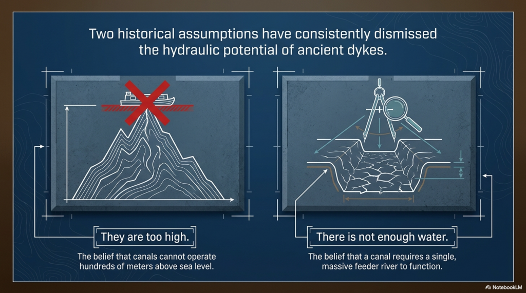
For years, critics of Britain’s prehistoric dykes have repeated the same two objections.

“Nobody would build a canal hundreds of metres above sea level.”

“There wouldn’t be enough water to keep it supplied.”

Pinkery Canal on Exmoor demolishes both arguments.

Not because it became a great commercial success.

Not because every detail of its purpose is understood.

But because Victorian engineers actually designed and constructed it.

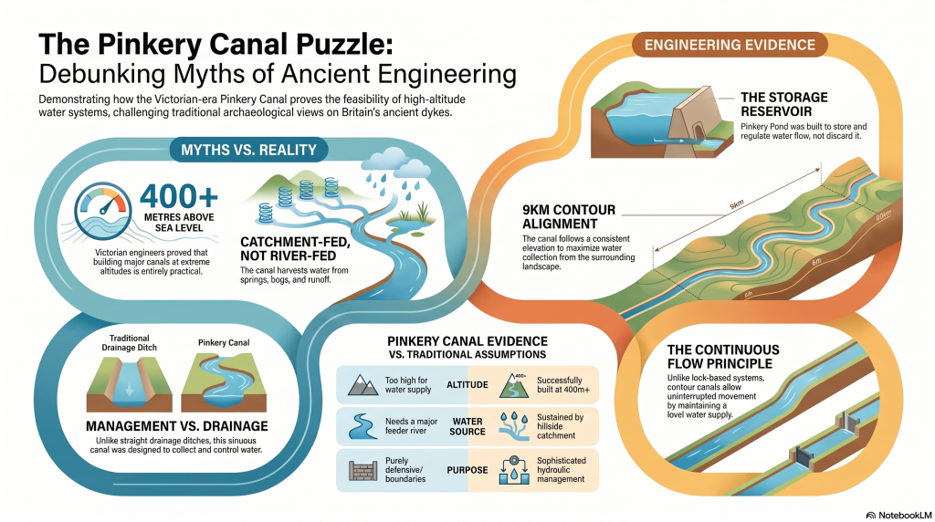
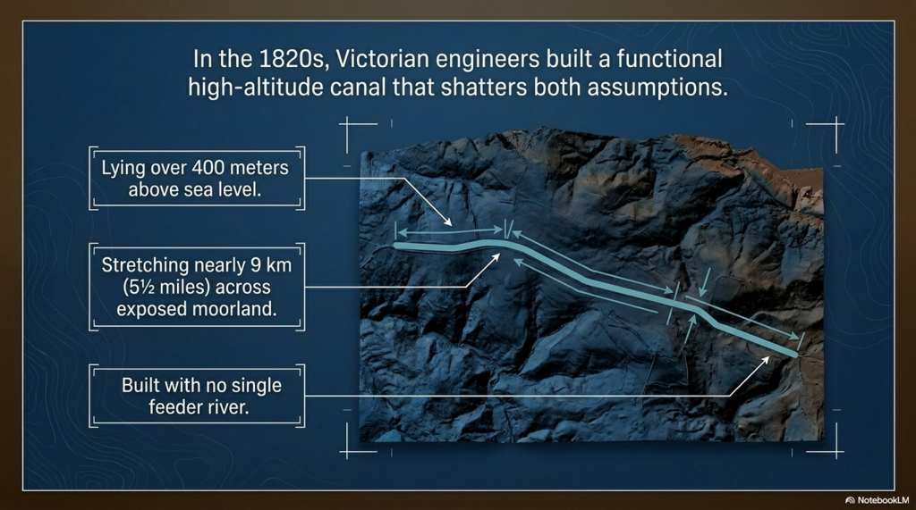
Nearly 9 km (5½ miles) long and lying over 400 metres above sea level, Pinkery Canal is undeniable proof that engineers considered high-altitude water engineering both practical and achievable.

That fact alone changes the debate.

Whether the canal ultimately fulfilled its intended purpose is almost irrelevant. Its existence proves that altitude was not considered an insurmountable obstacle, and that upland landscapes could provide sufficient water through reservoirs, bogs, springs, and intercepted surface runoff to justify the construction of a major canal.

In other words, two of the most frequently repeated objections to prehistoric canals are no longer objections at all.

The question is no longer:

“Could people build canals at high altitude?”

Pinkery Canal answers that with a resounding yes.

The real question is:

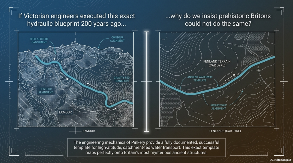
If the Victorians considered this perfectly feasible less than 200 years ago, why do archaeologists still insist prehistoric engineers could not have done the same?
 (Pinkery Canal: The Victorian Engineering Project)
(Pinkery Canal: The Victorian Engineering Project)

2. The Engineering

Forget the archive for a moment.

Forget the arguments over dates.

Imagine Pinkery Canal had just been discovered using modern LiDAR, with no nineteenth-century documents to guide us. How would an engineer interpret the monument purely from its design?

The first impression is its sheer ambition.

Stretching for almost 9 km (5½ miles) across the southern slopes of Exmoor at more than 400 metres above sea level, Pinkery Canal is one of the most remarkable examples of upland hydraulic engineering ever attempted in Britain. It crosses exposed moorland, deep peat, boggy ground and numerous valley heads. This was not a casual drainage ditch dug by local farmers. It required planning, surveying, labour, and a clear engineering objective.

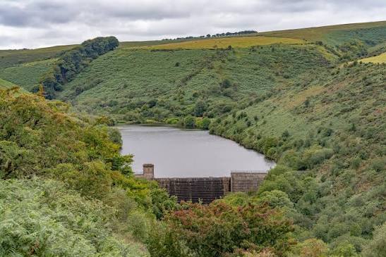
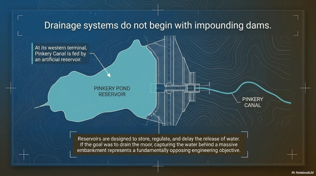
The canal begins at its western end with an artificial reservoir created behind a substantial embankment or dam. That single feature immediately challenges one of the proposed interpretations.
 (Pinkery Canal: The Victorian Engineering Project)
The reservoir – (Pinkery Canal: The Victorian Engineering Project)

Drainage systems are designed to remove water.

Reservoirs are designed to store it.

Those are fundamentally different engineering objectives.

If the intention had simply been to drain the moor, why begin by constructing a dam capable of impounding water? The reservoir suggests that water itself was regarded as a valuable resource requiring collection, regulation and controlled distribution rather than something to be discarded.

The route itself is equally revealing.

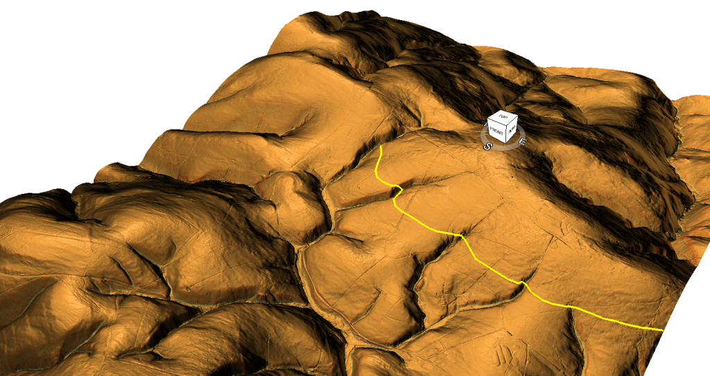
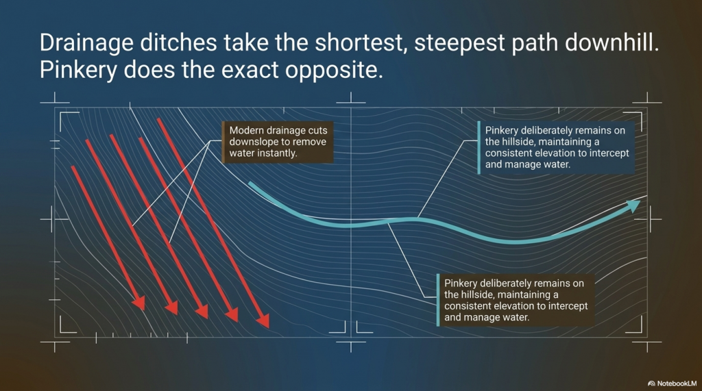
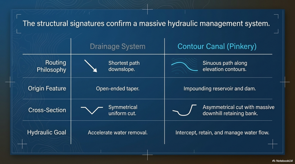
Rather than taking the shortest downhill path, as every modern drainage ditch on Exmoor does today, Pinkery Canal follows a long, sweeping contour across the hillside. Modern drainage channels cut almost directly downslope because their purpose is obvious: to remove water from the land as quickly and efficiently as possible.
 (Pinkery Canal: The Victorian Engineering Project)
(Pinkery Canal: The Victorian Engineering Project)

Pinkery does the exact opposite.

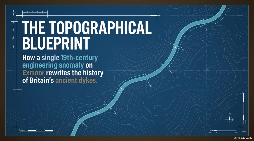
It deliberately remains on the hillside, maintaining a remarkably consistent elevation over many kilometres while gently curving around the contours. Every bend represents additional surveying, excavation and labour. Engineers do not introduce unnecessary curves into a project of this scale. Every deviation must therefore have served a purpose.

That purpose may lie in the hydrology itself.

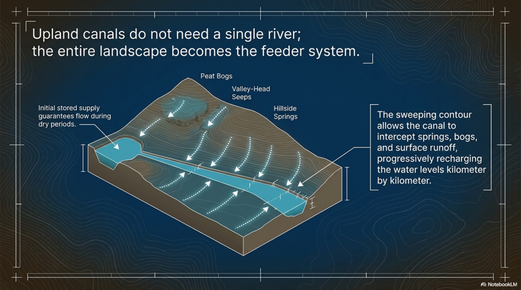
Unlike a river-fed canal supplied by a single large watercourse, a contour canal can collect water progressively along its entire length. Every spring, emerging from the hillside, every bog, every valley-head seep, every small stream, and every episode of surface runoff flowing down the slope contribute additional water. Rather than relying on a single source, the canal effectively harvests water from its entire catchment.

This is one of Pinkery’s most important engineering lessons.

For years, critics have argued that high-altitude canals would never have possessed sufficient water. Pinkery demonstrates another solution entirely. In a wet upland landscape, rainfall, springs, peat bogs, and intercepted runoff constitute the water supply. The canal itself becomes a collector, gradually increasing its flow as it crosses the hillside.

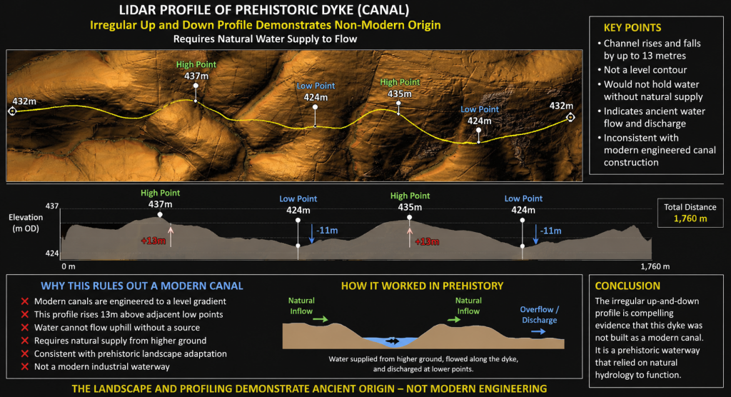
The LiDAR evidence also reveals that the canal is far more sophisticated than the phrase “contour leat” suggests.

Detailed examination shows changing widths, varying bank forms and an undulating longitudinal profile rather than a perfectly level line. The route repeatedly approaches the heads of valleys and drainage features. Modern maps also show later north-south drainage channels cutting across the canal, demonstrating that subsequent engineers adopted a completely different solution to reclaim the moor. Their drains are short, straight and steep. Pinkery is long, sinuous and almost level.

These are two entirely different engineering philosophies.

The terminal arrangements are equally intriguing.

At both ends, the canal appears closely associated with quarry workings or extraction areas. At least one location has a defined track linking the quarry directly to the canal. At another, the canal appears to terminate in a carefully engineered widening adjacent to a palaeochannel rather than simply continuing into the valley below. If drainage had been the objective, extending the ditch a short distance downhill would have been the simplest solution. Instead, the engineering appears far more elaborate than a straightforward drainage outlet.
 (Pinkery Canal: The Victorian Engineering Project)
(Pinkery Canal: The Victorian Engineering Project)

Whether these features relate to transport, water management, construction, or another purpose remains uncertain, but they deserve far greater attention than they have received.

Perhaps the most striking conclusion is that, despite detailed archaeological surveys, no single interpretation successfully explains every aspect of the monument.

Transport explains some features but not others.

Drainage explains some features but struggles with the reservoir and the geometry.

Water power requires hydraulic calculations that have yet to be convincingly demonstrated.

Irrigation raises unanswered questions about distribution.

Each hypothesis explains part of the engineering.

No one yet explains the complete system.

That is precisely why Pinkery Canal remains so fascinating.

It is not simply an archaeological site.

It is a large-scale engineering puzzle.

And whatever its ultimate purpose, one conclusion is beyond dispute. Victorian engineers considered it entirely practical to build and supply a major contour canal more than 400 metres above sea level. In doing so, they demolished two of archaeology’s favourite objections in a single project: that high-altitude canals could not be built, and that there would never have been sufficient water to sustain them.

The real challenge now is no longer asking whether such engineering was possible.

Pinkery has already answered that question.

The challenge is understanding why it was designed exactly as it was.

 (Pinkery Canal: The Victorian Engineering Project)
(Pinkery Canal: The Victorian Engineering Project)

3. Pinkery and Car Dyke – More Similar Than You Might Think

At first glance, Pinkery Canal and Car Dyke appear to have nothing in common.

One crosses the high moorland of Exmoor.

The other traverses the low-lying Fenlands of eastern England.

One is traditionally regarded as Victorian.

The other has long been attributed to Roman engineers.

Yet when viewed as engineering projects rather than archaeological labels, the similarities become surprisingly difficult to ignore.

Both were constructed to move water across the landscape rather than simply allowing it to flow naturally downhill.

(Car Dyke - North Section)
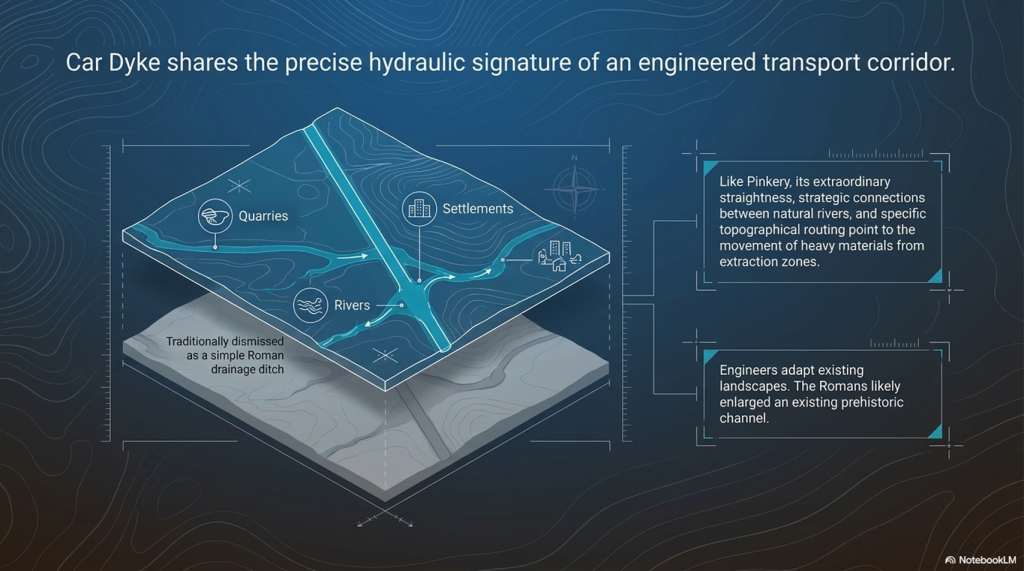
Car Dyke reused in a similar fashion as Pinkery Canal – (Pinkery Canal: The Victorian Engineering Project)

Both follow carefully selected routes designed to exploit the surrounding topography rather than take the shortest possible course.

Both have uncertain purposes despite decades of archaeological investigation.

And both have been linked to the movement of heavy materials from extraction areas towards wider transport networks.

That last point is particularly interesting.

Several interpretations of Pinkery Canal suggest it formed part of a system for moving lime, minerals, or other resources across Exmoor. Whether by boat, a water-powered incline, or another engineering solution, the underlying objective appears to have been the same: to overcome difficult terrain and connect remote resources to the estate’s developing transport network.

That is remarkably similar to the engineering questions surrounding Car Dyke.

For generations, archaeologists have regarded Car Dyke simply as a Roman drainage canal.

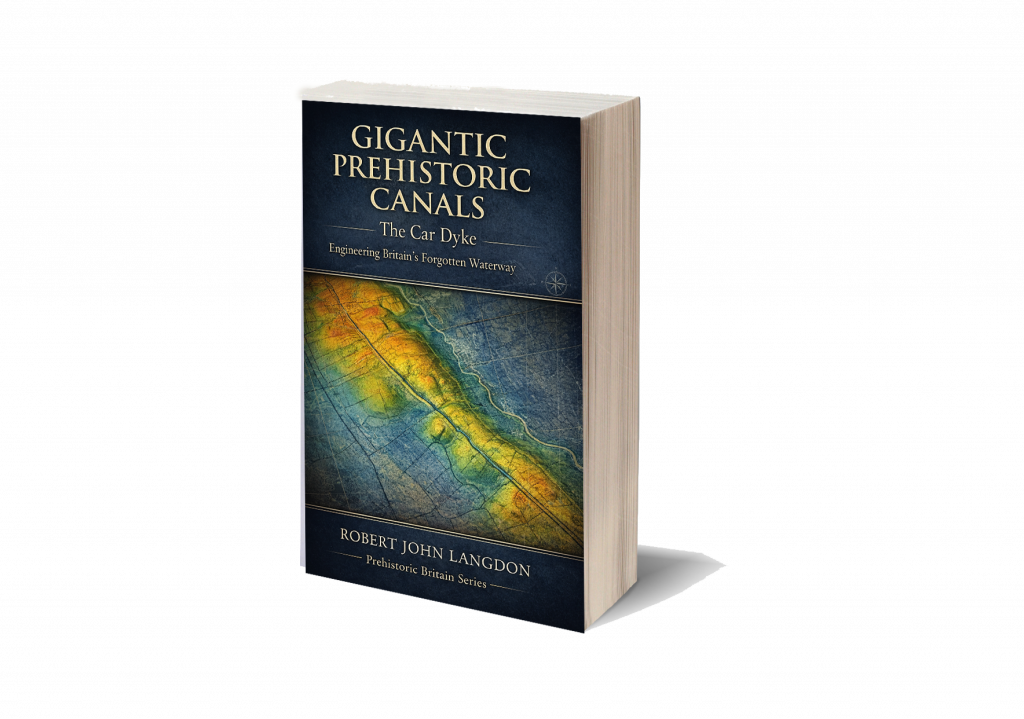
Yet its extraordinary scale, remarkable straightness and strategic connections between rivers have always hinted at a far more ambitious purpose. Our own investigation concluded that Car Dyke makes far more sense as a transport corridor linking quarries, settlements, rivers and distribution centres across the Fenlands. Rather than creating an entirely new waterway, the Romans may have enlarged and engineered an existing prehistoric channel, transforming it into Britain’s largest canal-like transport route.

(Britain's Giant Prehistoric Waterways)

Pinkery demonstrates that this approach is neither unusual nor implausible.

Throughout history, engineers have repeatedly adapted existing landscapes rather than starting with a blank slate. Rivers have been canalised. Ancient roads have become Roman roads. Medieval tracks became turnpikes. Victorian railways often followed much older routeways.

Why should canals be any different?

Pinkery therefore provides something that has been missing from the debate over Britain’s prehistoric dykes.

It offers a documented example of engineers modifying a landscape, harvesting water from multiple natural sources and constructing a substantial canal in terrain that many archaeologists would previously have dismissed as impossible.

Pinkery demonstrate that the engineering principles behind our Car Dyke hypothesis are entirely realistic.

Instead of asking whether prehistoric engineers could have built such systems, perhaps archaeology should begin asking whether later engineers simply inherited, enlarged, and improved landscapes whose origins stretch much further back than the surviving documents.
 (Pinkery Canal: The Victorian Engineering Project)
(Pinkery Canal: The Victorian Engineering Project)

4. The Second Myth Falls – Where Did the Water Come From?

Perhaps the most common criticism of prehistoric canals is not their height, but their supposed lack of water.

The argument is usually presented as though every canal requires a single obvious source—a large river, a lake, or a permanent reservoir.

Without one, the idea is dismissed.

Pinkery Canal demonstrates that this assumption is far too simplistic.

When viewed from the ground, Exmoor appears to be little more than open moorland.

Viewed using modern LiDAR and historical mapping, however, an entirely different landscape emerges.

Pinkery crosses one of the wettest upland environments in southern Britain.

Its route intersects extensive peat deposits, blanket bog, spring lines, valley-head seepages, small streams and countless natural drainage pathways. Historical maps also show large areas of marshy ground surrounding parts of the canal, while later land reclamation introduced numerous straight drainage ditches to drain the landscape.
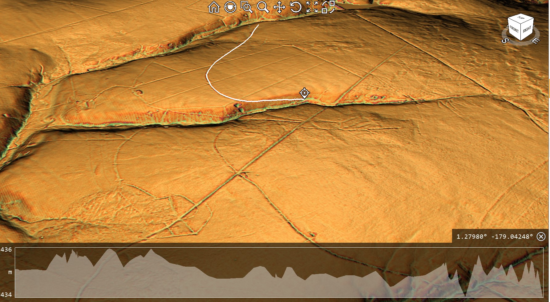
 (Pinkery Canal: The Victorian Engineering Project)
First Section By the Reservoir – (Pinkery Canal: The Victorian Engineering Project)

In other words, this was never a dry hillside.

It was a giant natural catchment.

That distinction is crucial.

Rather than relying on a single river to supply it, Pinkery appears to have been designed to collect water progressively as it crossed the landscape. Every period of rainfall generated surface runoff from the higher ground above. Every spring emerging from the peat contributed additional flow. Every valley head intercepted by the canal became another source of water.

The canal itself became the collector.

This is a completely different hydraulic principle from the one usually imagined by archaeologists.

Instead of asking:

“Where is the river feeding the canal?”

Perhaps the better question is:

“How much water does the entire catchment above the canal produce?”

Once viewed in that way, the engineering begins to make far more sense.

The long, curving alignment is no longer simply following a contour.

It is harvesting water from an entire hillside.

Every bend allows the canal to intercept another small drainage system. Every kilometre increases the contributing catchment. Rather than relying on a single large source, the available water gradually accumulates along the route.
 (Pinkery Canal: The Victorian Engineering Project)

This also explains why the western reservoir becomes so important.

The dam provided an initial stored supply, ensuring water was available even during drier periods, while the remainder of the canal progressively collected additional inflows from springs, bogs and hillside runoff.

Together they formed a single hydraulic system.

Ironically, the modern drainage network demonstrates the exact opposite of the engineering philosophy.

Today’s straight north-south drainage ditches were constructed to remove water from the moor as quickly as possible. They cut directly downslope, rapidly carrying water away from the peat and into the valleys below.

Pinkery does the reverse.

Instead of losing water, it captures it.

Instead of accelerating drainage, it intercepts it.

Instead of taking the shortest route downhill, it deliberately remains on the contour, collecting water from every natural drainage feature it encounters.

This distinction is fundamental.

The canal was not simply crossing a wet landscape.

It appears to have been designed around it.

For students of Britain’s prehistoric dykes, this observation is particularly significant.

One of the most common objections to their interpretation as waterways has always been the supposed absence of a large feeder river. Pinkery demonstrates another engineering solution entirely. A canal does not necessarily require a single major water source. Given the right landscape, it can harvest countless smaller sources distributed across an entire catchment.

Whether Victorian engineers consciously calculated this in modern hydrological terms is almost irrelevant.

Their design shows they understood the principle.

And if nineteenth-century engineers recognised that an upland landscape of springs, bogs and runoff could sustain a canal, perhaps archaeologists should think more carefully before dismissing similar possibilities elsewhere in Britain.

 (Pinkery Canal: The Victorian Engineering Project)
(Pinkery Canal: The Victorian Engineering Project)

5. If It Was Simply Drainage, Why Doesn’t It Behave Like a Drain?

One of the most revealing aspects of the Pinkery Canal is not where it begins or ends.

It is the shape of the engineering itself.

For nearly two centuries, the canal has frequently been described as a contour leat, with drainage often forming part of the explanation. Yet when the surrounding landscape is examined using modern LiDAR, an obvious question emerges.

If the objective was simply to drain the moor, why wasn’t it designed like every other drainage system on Exmoor?

The answer is surprisingly simple.

Because it wasn’t.
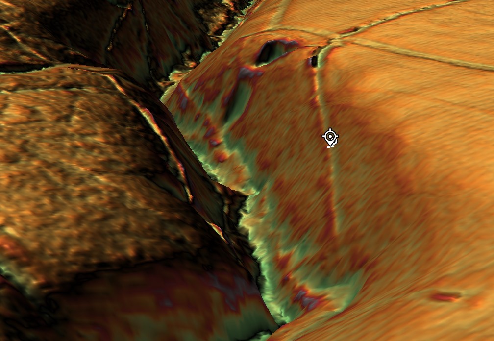
 (Pinkery Canal: The Victorian Engineering Project)
The end of Section One goes into a quarry past two other quarries – (Pinkery Canal: The Victorian Engineering Project)

Modern drainage ditches are easy to recognise. They follow the most efficient engineering solution possible. They are generally straight or only gently curved, taking the shortest practical route downhill. Their purpose is to quickly remove water from the land, reducing waterlogging and reclaiming boggy ground for agriculture.

The later drainage channels that cross the Pinkery Canal demonstrate exactly this principle.

Cutting almost directly north-to-south, they ignore the contours and descend rapidly into the valleys below. They waste no effort. They take the shortest available route because every unnecessary metre represents additional excavation and cost.

That is exactly what engineers designing a drainage system would be expected to do.

Pinkery Canal is completely different.

Instead of descending the hillside, it clings to it.

Instead of taking the shortest route, it extends for almost 9 kilometres in a broad sweeping curve.

Instead of accelerating water downhill, it appears to intercept it, retaining a remarkably consistent elevation across the landscape.

From an engineering perspective, those are not small differences.

They are fundamental.

Every bend required additional surveying.

Every curve required additional excavation.

Every extra metre increased both labour and construction costs.

Engineers simply do not introduce that level of complexity unless it serves a practical purpose.
 (Pinkery Canal: The Victorian Engineering Project)
(Pinkery Canal: The Victorian Engineering Project)

The obvious question, therefore, becomes:

What was the canal trying to achieve that a series of straight drainage ditches could not?

This is where the modern drainage network becomes unexpectedly useful.

Far from supporting the drainage interpretation, it provides a direct comparison between two completely different engineering philosophies.

The modern drains remove water.

Pinkery appears to manage it.

The modern drains cut across the landscape.

Pinkery works with it.

The modern drains dispose of water as quickly as possible.

Pinkery appears designed to collect water progressively from the surrounding catchment while preventing its immediate loss downslope.

These are not variations of the same design.

They are solutions to different engineering problems.

This distinction also helps explain why the canal repeatedly approaches the heads of valleys and natural drainage features. Rather than avoiding them, the alignment appears to exploit them. Every small stream, spring, or area of surface runoff that the canal intercepts becomes another potential source of water entering the system.

That behaviour makes perfect sense for a contour channel intended to harvest water.

It makes far less sense for a ditch whose sole purpose was drainage.

Perhaps the most telling observation is that Victorian engineers later constructed entirely different drainage works across the same landscape. If a simple drainage ditch had been the original objective, why wasn’t Pinkery built in the same way as the later drains?

The answer appears to be that it was never solving the same problem.

Pinkery Canal may ultimately have failed to achieve its intended purpose, but its geometry reveals something important.

It was not engineered as the quickest way to drain Exmoor.

It was engineered to control water.

Understanding that distinction is the key to understanding the monument itself—and perhaps to understanding many of Britain’s much older linear earthworks as well.

 (Pinkery Canal: The Victorian Engineering Project)
(Pinkery Canal: The Victorian Engineering Project)

6. The Reservoir – Storing Water or Removing It?

Perhaps the single most overlooked feature of the entire Pinkery Canal system lies at its western end.

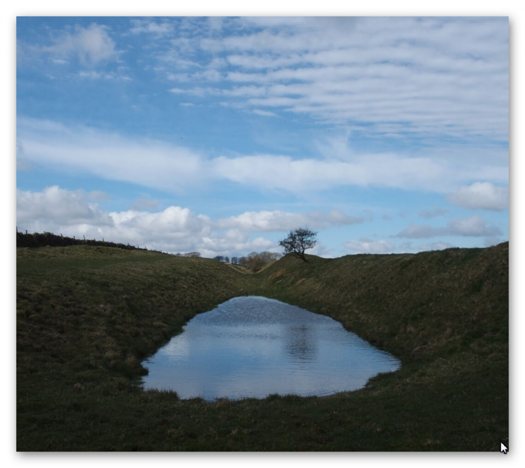
Before the canal even began, the Victorian engineers constructed a substantial embankment, creating what is now known as Pinkery Pond. This artificial reservoir formed the head of the entire system, storing water before it entered the canal.

At first glance, this may appear entirely unremarkable.

In reality, it may be one of the most important engineering clues on the site.

Think about the logic.

If your primary objective is to drain a wet upland landscape, why begin by constructing a dam?

Drainage and reservoirs represent two fundamentally different engineering philosophies.

A drainage system is designed to remove water from the landscape as efficiently as possible. Every engineering decision seeks to accelerate the movement of water downhill, reducing flooding, drying peat and reclaiming land for agriculture.
 (Pinkery Canal: The Victorian Engineering Project)
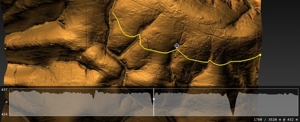
The Canal can not operate as a single entity without the paleochannel being full of water – (Pinkery Canal: The Victorian Engineering Project)

A reservoir does exactly the opposite.

It captures water.

It stores water.

It regulates water.

It delays its release.

Those are not minor differences.

They are completely different engineering objectives.

This immediately raises an obvious question.

Was Pinkery Canal ever intended to function as a simple drainage ditch?

The reservoir suggests otherwise.
 (Pinkery Canal: The Victorian Engineering Project)
(Pinkery Canal: The Victorian Engineering Project)

Instead of treating water as a nuisance, the engineer appears to regard it as a valuable resource that requires careful management. Water could be impounded during wetter periods, creating a reserve that could maintain flow through the canal even when natural runoff declined.

That interpretation fits remarkably well with the canal’s overall design.

As discussed previously, the canal follows a long contour across one of the wettest landscapes in southern Britain. Rather than rapidly discharging water into the nearest valley, it intercepts springs, bogs, valley-head seepages and surface runoff along its entire route. The reservoir therefore appears to provide the initial supply, while the surrounding catchment progressively replenishes the system as it continues eastwards.

Viewed together, the dam and canal form a single hydraulic network rather than two unrelated engineering works.

This also explains why the reservoir should not be dismissed as merely a convenient pond.

It was an integral part of the design.

Without stored water at the head of the system, the canal would have been entirely dependent upon seasonal rainfall. By constructing a reservoir first, Victorian engineers introduced a degree of hydraulic control, allowing water levels to be managed instead of simply reacting to whatever nature provided.

Once again, this differs fundamentally from the later drainage ditches that now cross the moor. Those channels require no reservoirs because their purpose is simply to remove water from the landscape. Gravity performs all the work.

Pinkery required something far more sophisticated.

It required water to be available when needed.
 (Pinkery Canal: The Victorian Engineering Project)
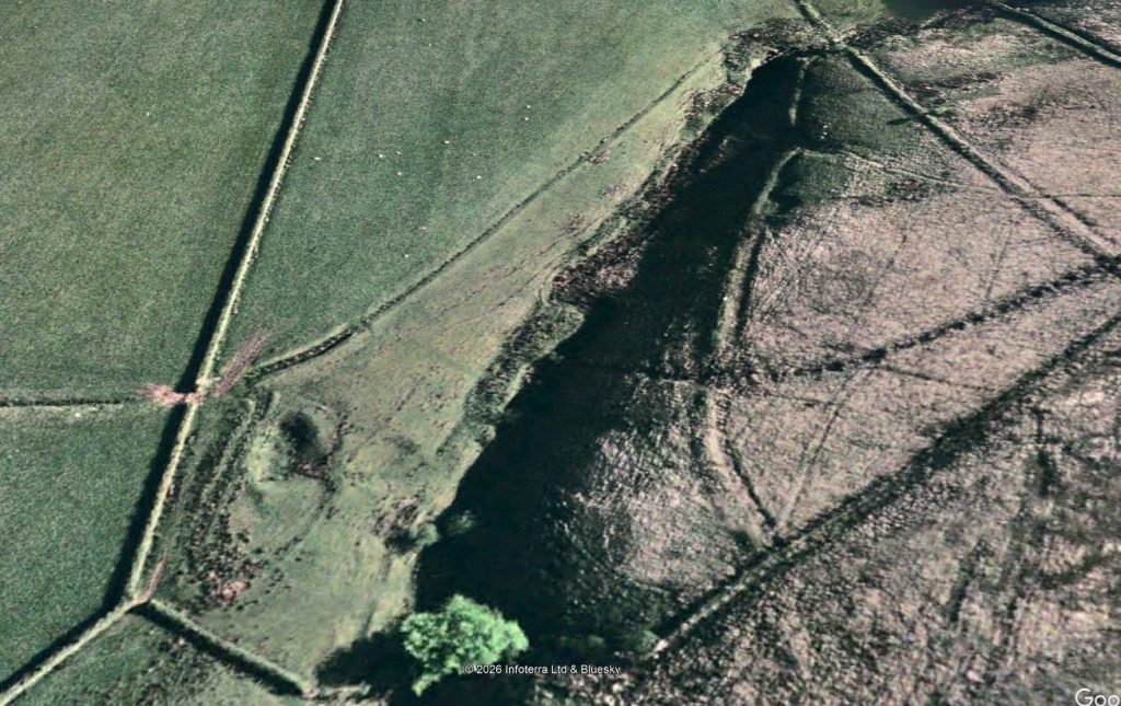
End of section one shows a quarry and a road to the Canal (Pinkery Canal: The Victorian Engineering Project)

That simple observation creates difficulties for several of the traditional interpretations. If the canal existed only to drain land, the reservoir appears unnecessary. If it existed to transport water, power machinery, or support navigation, however, regulating and storing water would be much easier to understand.

The reservoir, therefore, becomes much more than an isolated feature at the western end of the canal.

It becomes the first component in a carefully engineered hydraulic system.

Whether that system ultimately succeeded is almost secondary.

Its design demonstrates that the engineers were not simply trying to get rid of water.

They were trying to control it.

And that distinction may prove to be one of the most important lessons Pinkery Canal has to offer—not only for understanding this remarkable Victorian project, but also for reconsidering how similar large-scale water engineering systems elsewhere in Britain have been interpreted.

You’re right. I was too generic. If we’re referring to the report, we should discuss the profiles by number and what each demonstrates, rather than making broad statements.

Here’s a much stronger version.
 (Pinkery Canal: The Victorian Engineering Project)
(Pinkery Canal: The Victorian Engineering Project)

7. The Engineering Puzzle: What the Profiles Actually Reveal

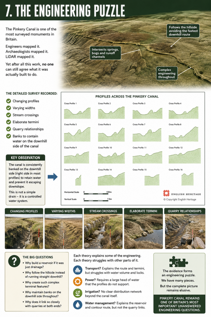
One of the strengths of the Historic England survey is that it did not simply record the canal’s position. It excavated and measured cross-sections along its entire length, producing sixteen profile drawings that reveal something far more interesting than the accompanying interpretation acknowledges.

Far from being a uniform ditch, the Pinkery Canal constantly changes its form.
 (Pinkery Canal: The Victorian Engineering Project)

Profiles 1–5 show a relatively consistent engineered channel cut into the hillside, but even here the uphill and downhill banks vary considerably in both height and width. This immediately suggests the builders were responding to local ground conditions rather than applying a single standard design.

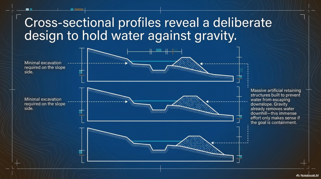
Profiles 6–11 become even more revealing. Here, the downslope bank becomes substantially larger in places, while the uphill side often appears much less pronounced. If the feature was merely intended as a drainage ditch, this extra effort seems unnecessary. Gravity already removes water downhill. There would be little reason to build and maintain substantial retaining banks on the downhill side.

Instead, these profiles make far more engineering sense if the objective is to retain water within the channel while preventing it from escaping downslope.

Profiles 12 and 15 are particularly interesting because the canal becomes much deeper on one side, reflecting the increasing side slope of the hillside. Rather than abandoning the contour, the builders modified the earthworks to maintain the channel despite increasingly difficult terrain. That is a considerable investment in engineering effort.

By contrast, Profile 16 shows a much more symmetrical section, suggesting that local topography again dictated the amount of excavation and banking required. The canal was clearly being adapted to changing ground conditions rather than simply being cut to a single standard template.

Perhaps the most important observation is what none of the profiles shows.

None resembles a simple modern drainage ditch.

Modern drainage systems generally seek the quickest route downhill using relatively uniform cuts. Pinkery repeatedly does the opposite. Its profiles demonstrate deliberate construction to maintain a contour route while containing water against the land’s natural fall.

The retaining banks become key evidence.

On a hillside, any water entering the canal naturally wants to escape over the lower edge. The substantial downhill embankments shown in many of the profiles would have acted as retaining structures, keeping water within the channel while intercepting runoff from bogs, springs, and small streams higher on the slope.

Ironically, the report illustrates all of this beautifully but never fully explores its engineering implications. The profiles are presented as descriptive archaeology rather than as evidence of hydraulic design.

Yet these drawings may contain one of the most important clues to understanding the Pinkery Canal.

They show that the builders were not simply digging a ditch.

They were designing a hydraulic system whose cross-section changed repeatedly in response to the landscape.

That is engineering.

The real mystery is not whether the builders understood hydraulics.

The profiles prove they did.

The mystery is what hydraulic problem they were actually trying to solve.

I think this is a good conclusion, but I’d make one important change. I would avoid saying “this is why canals failed in Britain.” Historically, Britain’s canal network was hugely successful for decades before railways largely displaced it. A stronger and more accurate point is that lock canals trade speed for flexibility. Every lock introduces a delay, whereas a contour canal with continuous water offers uninterrupted movement.

Here’s how I’d write the conclusion.
 (Pinkery Canal: The Victorian Engineering Project)
(Pinkery Canal: The Victorian Engineering Project)

8. What Pinkery Canal Really Teaches Us

Pinkery Canal remains one of Britain’s most fascinating engineering puzzles.

Almost two centuries after its construction, archaeologists still cannot agree upon its purpose. Was it built for transport? Water power? Irrigation? Land improvement? Water management? Every interpretation explains part of the evidence, yet none successfully accounts for the monument as a complete engineering system.

Perhaps the problem is not the evidence.

Perhaps it is the questions being asked.

Throughout this investigation, we have deliberately set the archive aside and examined the monument as engineers would.

In doing so, several important conclusions emerge.

First, Pinkery Canal proves beyond doubt that high-altitude canals are entirely feasible. Victorian engineers had no hesitation in constructing a major contour canal more than 400 metres above sea level. The argument that upland canals are somehow impossible can therefore be dismissed.

Second, Pinkery demonstrates that canals do not necessarily require a major river to function. By combining a reservoir with intercepted springs, bogs, valley-head seepages and surface runoff, the canal could potentially harvest water from its entire catchment. The landscape itself became the feeder system.

Third, the monument’s geometry differs fundamentally from a drainage ditch. Instead of removing water as quickly as possible, it appears to be designed to intercept, retain, and regulate it. The substantial banks recorded in the cross-sectional profiles reinforce this interpretation, showing engineering adapted to controlling water rather than simply disposing of it.

Finally, Pinkery reminds us that ancient and historic engineers were often far more inventive than we give them credit for.
 (Pinkery Canal: The Victorian Engineering Project)
(Pinkery Canal: The Victorian Engineering Project)

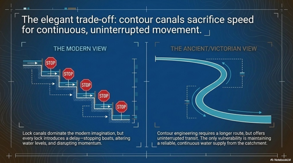
Today, when we think of canals, we instinctively picture straight channels linked together by locks.

That is understandable because lock canals dominated Britain’s Industrial Revolution.

But lock systems come at a cost.

Every lock interrupts the journey.

Boats must stop, water levels must be altered, gates opened and closed, and only then can the journey continue. Over a long route, those delays accumulate significantly.

A contour canal operates on a completely different principle.

Once water is established within the channel, a boat can continue along the contour without repeatedly stopping to negotiate locks. The route may be longer, but movement is continuous.

That is an elegant engineering solution.

Its weakness, however, is equally obvious.

Everything depends upon maintaining a reliable water supply.

If the reservoir feeding Pinkery Canal could not provide sufficient water during prolonged dry periods, the entire system would struggle to operate effectively. Whether this ultimately contributed to its limited success remains an intriguing possibility, although the surviving evidence cannot yet answer that question with certainty.

This comparison also helps explain why Britain’s prehistoric dykes deserve far more serious investigation.

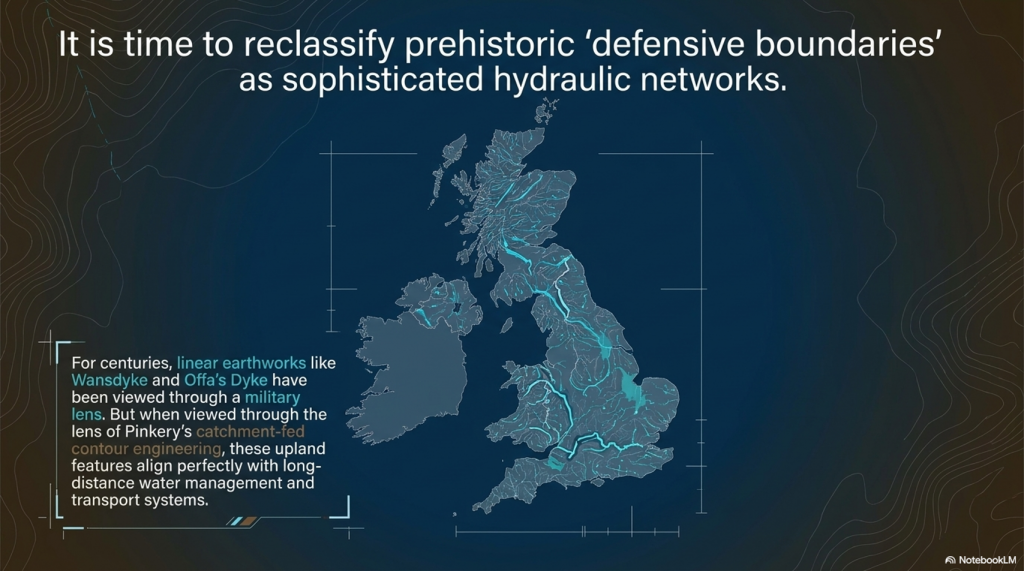
Features such as the Car Dyke, the Wansdyke, and Offa’s Dyke have often been viewed through the lens of defence or territorial boundaries. Yet if naturally fed springs, groundwater and higher prehistoric water levels provided a more dependable year-round supply than an artificial upland reservoir, then the hydraulic possibilities become considerably more interesting.

Pinkery does not prove that Britain’s prehistoric dykes were canals.

What it does prove is something equally important.

Many of the engineering objections used to dismiss that possibility are no longer sustainable.

High-altitude canals are possible.

Catchment-fed canals are possible.

Long-distance contour engineering is possible.

Victorian engineers demonstrated every one of those principles.

Perhaps the greatest lesson from Pinkery is not about Victorian engineering at all.

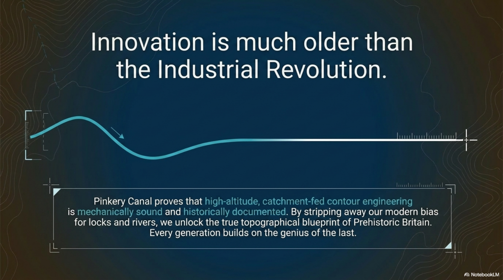
It is a reminder that we should never underestimate the ingenuity of earlier societies simply because their achievements do not fit our modern expectations. Every generation builds upon the knowledge of those who came before it. If nineteenth-century engineers recognised the advantages of contour water engineering, it is entirely reasonable to ask whether they were rediscovering principles that had been understood long before the Industrial Revolution.

That is why sites like Pinkery Canal deserve to be studied—not simply as isolated archaeological curiosities, but as windows into the long history of engineering innovation that shaped Britain’s landscape.
 (Pinkery Canal: The Victorian Engineering Project)
(Pinkery Canal: The Victorian Engineering Project)

PODCAST

Author’s Biography

Robert John Langdon, a polymathic luminary, emerges as a writer, historian, and eminent specialist in LiDAR Landscape Archaeology.

His intellectual voyage has been interwoven with stints as an astute scrutineer in government and grand corporate bastions, a tapestry spanning British Telecommunications, Cable and Wireless, British Gas, and the esteemed University of London.

A decade hence, Robert’s transition into retirement unfurled a chapter of insatiable curiosity. This phase saw him immerse himself in Politics, Archaeology, Philosophy, and the enigmatic realm of Quantum Mechanics. His academic odyssey traversed the venerable corridors of knowledge hubs such as the Museum of London, University College London, Birkbeck College, The City Literature Institute, and Chichester University.

In the symphony of his life, Robert is a custodian of three progeny and a pair of cherished grandchildren. His sanctuary lies ensconced in the embrace of West Wales, where he inhabits an isolated cottage, its windows framing a vista of the boundless sea – a retreat from the scrutinising gaze of Her Majesty’s Revenue and Customs, an amiable clandestinity in the lap of nature.

Exploring Prehistoric Britain: A Journey Through Time

My blog delves into the fascinating mysteries of prehistoric Britain, challenging conventional narratives and offering fresh perspectives grounded in cutting-edge research, particularly LiDAR technology. I invite you to explore some key areas of my research. For example, the Wansdyke, often cited as a defensive structure, is re-examined in light of new evidence. I’ve presented my findings in my blog post Wansdyke: A British Frontier Wall – ‘Debunked’, and a Wansdyke LiDAR Flyover video further visualises my conclusions.

My work also often challenges established archaeological dogma. I argue that many sites, such as Hambledon Hill, commonly identified as Iron Age hillforts, are not what they seem. My posts Lidar Investigation Hambledon Hill – NOT an ‘Iron Age Fort’ and Unmasking the “Iron Age Hillfort” Myth explore these ideas in detail and offer an alternative view. Similarly, sites like Cissbury Ring and White Sheet Camp receive re-evaluations based on LiDAR analysis in my posts “Lidar Investigation Cissbury Ring through time” and “Lidar Investigation White Sheet Camp,“ revealing fascinating insights into their true purpose. I have also examined South Cadbury Castle, often linked to the mythical Camelot56.

My research also extends to ancient water management, including the role of canals and other linear earthworks. I have discussed the true origins of Car Dyke in multiple posts, including Car Dyke – ABC News Podcast and Lidar Investigation Car Dyke – North Section, which suggest a Mesolithic origin 2357. I also explore the misidentification of Roman aqueducts, as seen in my posts on the Great Chesters (Roman) Aqueduct. My research has also been greatly informed by my post-glacial flooding hypothesis, which has helped explain landscape transformations over time. I have discussed this hypothesis in several posts, including AI now supports my Post-Glacial Flooding Hypothesis and Exploring Britain’s Flooded Past: A Personal Journey

Finally, my blog also investigates prehistoric burial practices, as seen in Prehistoric Burial Practices of Britain and explores the mystery of Pillow Mounds, often mistaken for medieval rabbit warrens, but with a potential link to Bronze Age cremation in my posts: Pillow Mounds: A Bronze Age Legacy of Cremation? and The Mystery of Pillow Mounds: Are They Really Medieval Rabbit Warrens?. My research also includes astronomical insights into ancient sites, for example, in Rediscovering the Winter Solstice: The Original Winter Festival. I also review new information about the construction of Stonehenge in The Stonehenge Enigma.

Further Reading

For those interested in British Prehistory, visit www.prehistoric-britain.co.uk, a comprehensive resource featuring an extensive collection of archaeology articles, modern LiDAR investigations, and groundbreaking research. The site also includes insights and excerpts from the acclaimed Robert John Langdon Trilogy, a series of books that explore Britain during the Prehistoric period. Titles in the trilogy include The Stonehenge Enigma, Dawn of the Lost Civilisation, and The Post-Glacial Flooding Hypothesis, which offer compelling evidence of ancient landscapes shaped by post-glacial flooding.

To further explore these topics, Robert John Langdon has developed a dedicated YouTube channel featuring over 100 video documentaries and investigations that complement the trilogy. Notable discoveries and studies showcased on the channel include 13 Things that Don’t Make Sense in History and the revelation of Silbury Avenue – The Lost Stone Avenue, a rediscovered prehistoric feature at Avebury, Wiltshire.

In addition to his main works, Langdon has released a series of shorter, accessible publications, ideal for readers delving into specific topics. These include:

For active discussions and updates on the trilogy’s findings and recent LiDAR investigations, join our vibrant community on Facebook. Engage with like-minded enthusiasts by leaving a message or contributing to debates in our Facebook Group.

Whether through the books, the website, or interactive videos, we aim to provide a deeper understanding of Britain’s fascinating prehistoric past. We encourage you to explore these resources and uncover the mysteries of ancient landscapes through the lens of modern archaeology.

For more information, including chapter extracts and related publications, visit the Robert John Langdon Author Page. Dive into works such as The Stonehenge Enigma or Dawn of the Lost Civilisation, and explore cutting-edge theories that challenge traditional historical narratives.

Other Blogs

s

t

How Lidar will change Archaeology

Introduction

In the vast tapestry of human history, there are moments when a single technological shift forces us to stop… reassess… and begin again. (How Lidar will change Archaeology)

Innovation in Archaeology has always pushed the boundaries of understanding.

LiDAR is one of those moments.

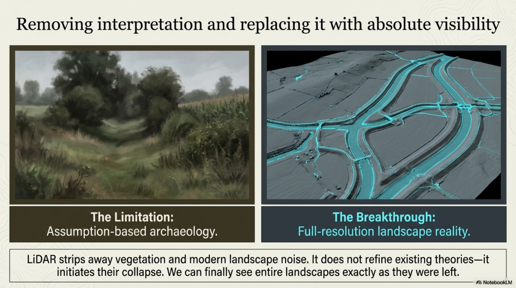
For centuries, archaeology has relied on what could be seen from the ground — fragments of banks, ditches, crop marks, and partial excavations. From these fragments, entire narratives have been constructed. Boundaries have been drawn. Timelines fixed. Functions assumed.

With tools like LiDAR, the field of Archaeology is evolving rapidly.

But what happens… when we can suddenly see everything?

Not just isolated sections…
but entire landscapes…
in full resolution…
stripped of vegetation…
revealed exactly as they were left.

How Lidar will change Archaeology
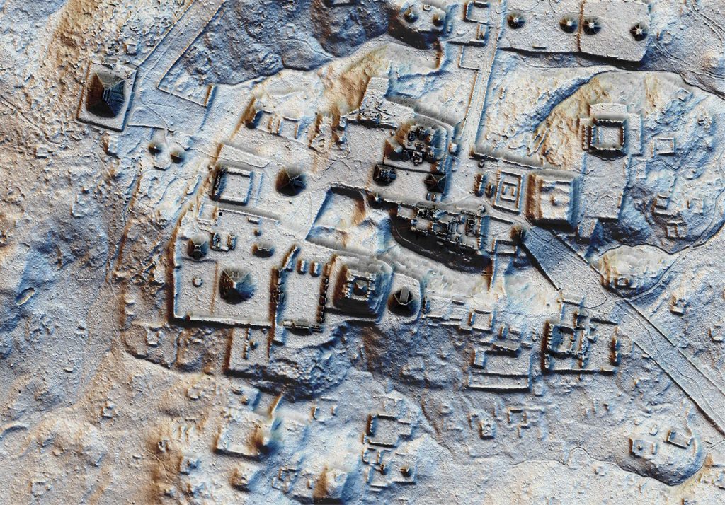
Lost Myan Structues found by LiDAR Archaeology

This paradigm shift in Archaeology is crucial for future research.

That is what LiDAR has done.

And what it is revealing… is not a refinement of existing theories.

It is their collapse.


New findings in Archaeology challenge our previous beliefs.

The Illusion of the “Defensive Dyke”

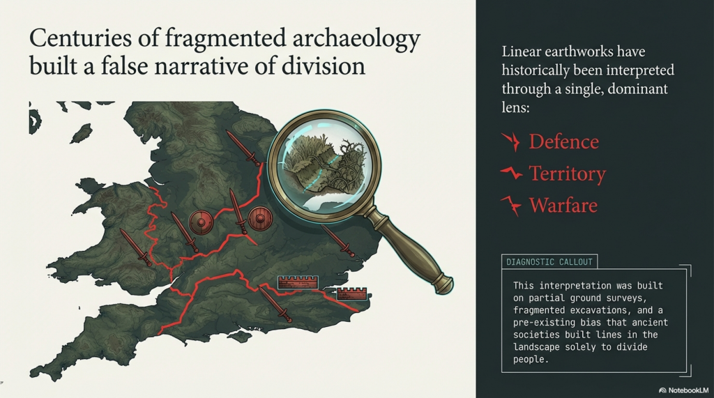
Linear Earthworks have long been interpreted through a single dominant lens:

👉 Defence
👉 Territory
👉 Warfare

From Offa’s Dyke to Wansdyke, from the Antonine Wall to the Vallum, the assumption has remained largely unchanged — these were barriers. Lines in the landscape built to divide people.

But this interpretation was never based on full evidence.

It was based on partial observation.

(How Lidar will change Archaeology)

Ground surveys… fragmented excavation… and most importantly…
a pre-existing belief that these features must be defensive.

LiDAR removes that limitation.

Understanding landscapes through Archaeology offers fresh insights.

These revelations in Archaeology reveal ancient practices.

And when you remove the trees… the crops… and the modern landscape noise…

A very different picture emerges.


Car Dyke — Britain’s Longest Engineered Water System

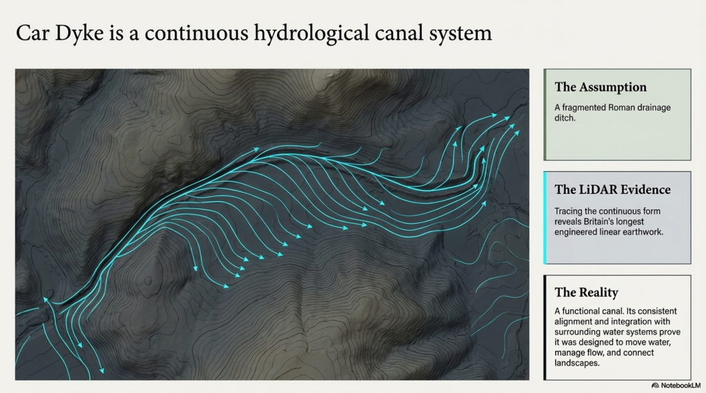
One of the most striking discoveries is the true scale of Car Dyke.

In Archaeology, understanding water management is critical.

Previously understood as a Roman drainage feature… its full extent was never properly mapped or understood.

LiDAR changes that completely.

For the first time, we can trace its continuous form across the landscape — revealing it not as a fragmented ditch… but as Britain’s longest engineered linear earthwork.

And critically…

Its form is not defensive.

It is hydrological.

(How Lidar will change Archaeology)

Its consistent alignment…
its relationship to natural gradients…
and its integration with surrounding water systems…

Through Archaeology, we can explore human ingenuity.

All point to a single conclusion:

👉 Car Dyke is a canal system.

Not symbolic.
Not territorial.
But functional.

Designed to move water… manage flow… and connect landscapes.

(How Lidar will change Archaeology)

Collaboration in Archaeology is vital for comprehensive studies.


Wansdyke — Not One Dyke, But Two

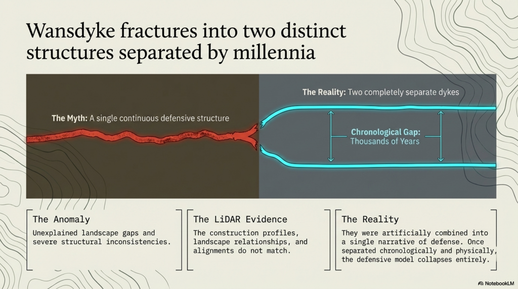
LiDAR has also resolved one of the long-standing inconsistencies surrounding Wansdyke.

The role of community in Archaeology cannot be overstated.

Traditionally treated as a single continuous defensive structure, its gaps and inconsistencies have always been difficult to explain.

Now we can see why.

Because it isn’t one structure.

👉 It is two completely separate dykes.

(How Lidar will change Archaeology)
The gaps in Wansdyke proves its not a defensive feature but once held water

Constructed in different periods, with thousands of years between them.

Their alignments… their construction profiles… and their landscape relationships do not match.

They have been artificially combined into a single narrative… because that narrative required them to be one.

LiDAR shows they are not.

And once separated…

The defensive model collapses entirely.

(How Lidar will change Archaeology)

Insights from Archaeology reveal the complexities of history.


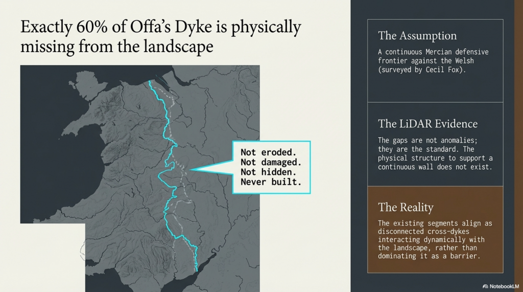
Offa’s Dyke — The Missing 60%

Perhaps the most telling example of interpretive bias is Offa’s Dyke.

For decades, it has been presented as a continuous Mercian frontier — a monumental defensive barrier dividing England and Wales.

(How Lidar will change Archaeology)
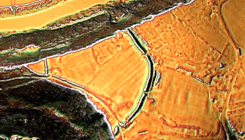
Offa’s Dyke nr Chepstow – shows not only is it not (as reported by Cecil Fox) a defensive structure against the Welsh but a Cross-Dyke

But LiDAR reveals a critical truth:

👉 Around 60% of Offa’s Dyke is missing.

Not eroded.
Not damaged.
Not hidden.

Simply… never there.

What has been presented as a continuous defensive structure is in reality a series of disconnected segments.

And those segments do not behave like a defensive line.

New methodologies in Archaeology enhance our understanding.

They align as cross-dykes — interacting with the landscape rather than dominating it.

The earlier surveys… most notably those influenced by Cecil Fox… were not neutral observations.

They were shaped by the assumption of defence.

And once that assumption is removed…

The structure no longer supports the theory.

(How Lidar will change Archaeology)

The Vallum — Not a Barrier, But a Transport System

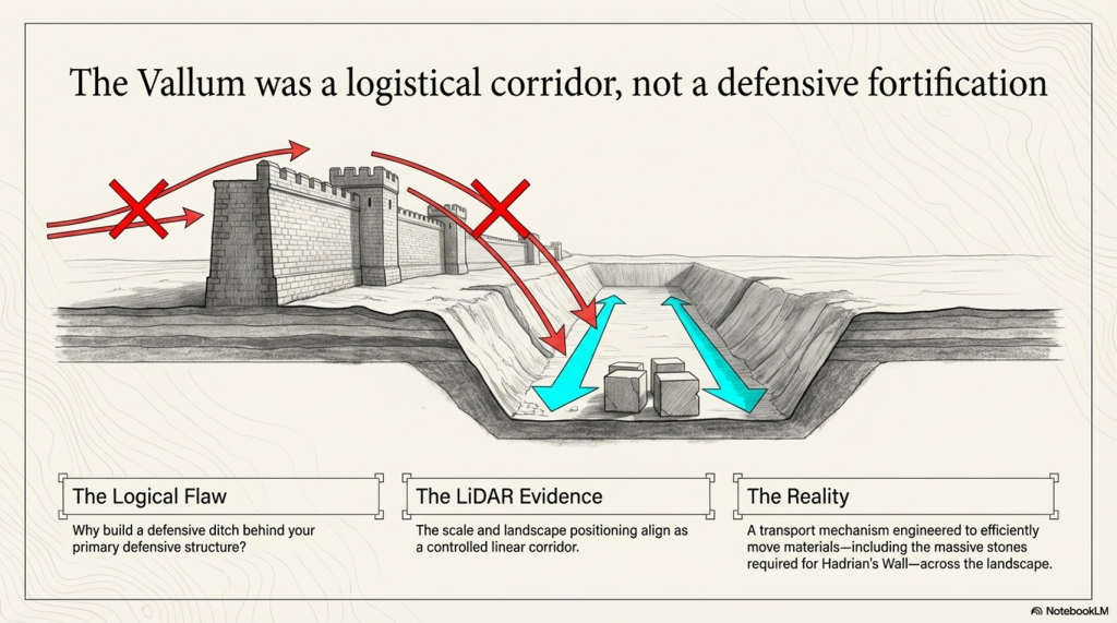
The Vallum, running alongside Hadrian’s Wall, has long been described as a defensive ditch — part of a complex military boundary.

But again… this interpretation struggles under scrutiny.

Its position… its scale… and its relationship to the Wall itself raise a fundamental question:

Why build a defensive ditch behind your primary defensive structure?

LiDAR provides the answer.

The Vallum aligns not as a barrier…
but as a controlled linear corridor.

A route.

A system.

(How Lidar will change Archaeology)

👉 A transport mechanism.

Used to move materials — including the massive stones required for Hadrian’s Wall — efficiently across the landscape.

Not defence…

But logistics.

(How Lidar will change Archaeology)

A New Interpretation — Water, Not War

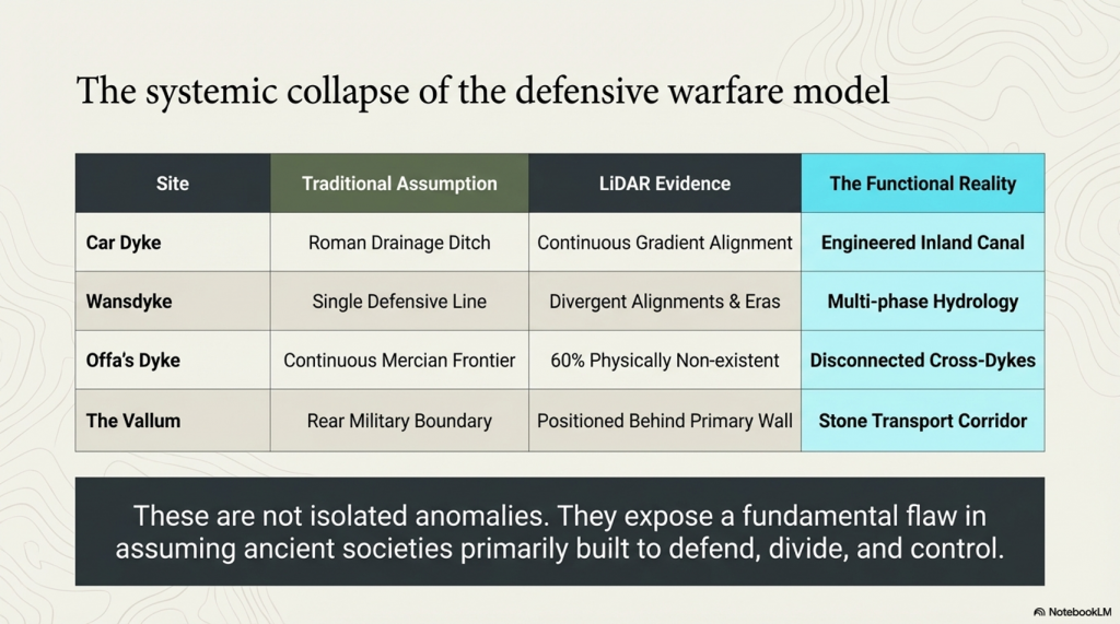
When these examples are brought together, a pattern becomes impossible to ignore:

  • Car Dyke — a canal
  • Wansdyke — multiple phases, not a single barrier
  • Offa’s Dyke — incomplete, non-defensive
  • Vallum — transport, not fortification
(How Lidar will change Archaeology)

These are not isolated anomalies.

They are part of a systemic misinterpretation.

A framework built on the assumption that ancient societies primarily built to defend… divide… and control territory.

LiDAR shows something very different.

👉 They built to manage water
👉 They built to connect landscapes
👉 They built to enable movement and trade

In short…

They engineered environments.

(How Lidar will change Archaeology)

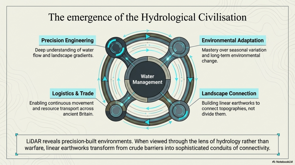
The Hydrological Civilisation

What LiDAR is revealing is not just new data…

But a new type of civilisation.

One that understood:

  • Water flow
  • Landscape gradients
  • Seasonal variation
  • Long-term environmental change

These Linear Earthworks are not crude barriers.

They are precision-built systems.

And when viewed through the lens of hydrology rather than warfare…

They begin to make sense.

(How Lidar will change Archaeology)

Conclusion — The End of Assumption-Based Archaeology

It removes interpretation… and replaces it with visibility.

No longer are we limited to fragments.

No longer can gaps be filled with assumption.

The landscape is now visible in its entirety.

(How Lidar will change Archaeology)
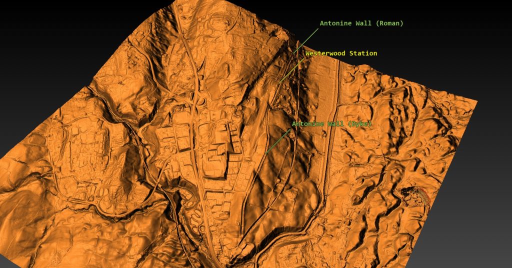
The Antonine Wall was originally a Dyke

And what it shows… is clear:

👉 The defensive model of Linear Earthworks in Archaeology is no longer sustainable
👉 The traditional surveys in Archaeology were incomplete — and in many cases, biased
👉 A hydrological and engineering interpretation fits the evidence more closely

LiDAR does something archaeology has long struggled with:

This is not a minor adjustment.

It is a fundamental shift.

(How Lidar will change Archaeology)

A moment where technology forces us to reconsider everything we thought we knew.

As Jacob Bronowski once championed — knowledge advances not by defending old ideas…

…but by having the courage to replace them.

LiDAR has given us that opportunity.

The question now is:

👉 Will archaeology take it?

(How Lidar will change Archaeology)

PodCast

Author’s Biography

Robert John Langdon, a polymathic luminary, emerges as a writer, historian, and eminent specialist in LiDAR Landscape Archaeology.

His intellectual voyage has been interwoven with stints as an astute scrutineer in government and grand corporate bastions, a tapestry spanning British Telecommunications, Cable and Wireless, British Gas, and the esteemed University of London.

A decade hence, Robert’s transition into retirement unfurled a chapter of insatiable curiosity. This phase saw him immerse himself in Politics, Archaeology, Philosophy, and the enigmatic realm of Quantum Mechanics. His academic odyssey traversed the venerable corridors of knowledge hubs such as the Museum of London, University College London, Birkbeck College, The City Literature Institute, and Chichester University.

In the symphony of his life, Robert is a custodian of three progeny and a pair of cherished grandchildren. His sanctuary lies ensconced in the embrace of West Wales, where he inhabits an isolated cottage, its windows framing a vista of the boundless sea – a retreat from the scrutinising gaze of Her Majesty’s Revenue and Customs, an amiable clandestinity in the lap of nature.

Exploring Prehistoric Britain: A Journey Through Time

My blog delves into the fascinating mysteries of prehistoric Britain, challenging conventional narratives and offering fresh perspectives grounded in cutting-edge research, particularly LiDAR technology. I invite you to explore some key areas of my research. For example, the Wansdyke, often cited as a defensive structure, is re-examined in light of new evidence. I’ve presented my findings in my blog post Wansdyke: A British Frontier Wall – ‘Debunked’, and a Wansdyke LiDAR Flyover video further visualises my conclusions.

My work also often challenges established archaeological dogma. I argue that many sites, such as Hambledon Hill, commonly identified as Iron Age hillforts, are not what they seem. My posts Lidar Investigation Hambledon Hill – NOT an ‘Iron Age Fort’ and Unmasking the “Iron Age Hillfort” Myth explore these ideas in detail and offer an alternative view. Similarly, sites like Cissbury Ring and White Sheet Camp receive re-evaluations based on LiDAR analysis in my posts “Lidar Investigation Cissbury Ring through time” and “Lidar Investigation White Sheet Camp,“ revealing fascinating insights into their true purpose. I have also examined South Cadbury Castle, often linked to the mythical Camelot56.

My research also extends to ancient water management, including the role of canals and other linear earthworks. I have discussed the true origins of Car Dyke in multiple posts, including Car Dyke – ABC News Podcast and Lidar Investigation Car Dyke – North Section, which suggest a Mesolithic origin 2357. I also explore the misidentification of Roman aqueducts, as seen in my posts on the Great Chesters (Roman) Aqueduct. My research has also been greatly informed by my post-glacial flooding hypothesis, which has helped explain landscape transformations over time. I have discussed this hypothesis in several posts, including AI now supports my Post-Glacial Flooding Hypothesis and Exploring Britain’s Flooded Past: A Personal Journey

Finally, my blog also investigates prehistoric burial practices, as seen in Prehistoric Burial Practices of Britain and explores the mystery of Pillow Mounds, often mistaken for medieval rabbit warrens, but with a potential link to Bronze Age cremation in my posts: Pillow Mounds: A Bronze Age Legacy of Cremation? and The Mystery of Pillow Mounds: Are They Really Medieval Rabbit Warrens?. My research also includes astronomical insights into ancient sites, for example, in Rediscovering the Winter Solstice: The Original Winter Festival. I also review new information about the construction of Stonehenge in The Stonehenge Enigma.

Further Reading

For those interested in British Prehistory, visit www.prehistoric-britain.co.uk, a comprehensive resource featuring an extensive collection of archaeology articles, modern LiDAR investigations, and groundbreaking research. The site also includes insights and excerpts from the acclaimed Robert John Langdon Trilogy, a series of books that explore Britain during the Prehistoric period. Titles in the trilogy include The Stonehenge Enigma, Dawn of the Lost Civilisation, and The Post-Glacial Flooding Hypothesis, which offer compelling evidence of ancient landscapes shaped by post-glacial flooding.

To further explore these topics, Robert John Langdon has developed a dedicated YouTube channel featuring over 100 video documentaries and investigations that complement the trilogy. Notable discoveries and studies showcased on the channel include 13 Things that Don’t Make Sense in History and the revelation of Silbury Avenue – The Lost Stone Avenue, a rediscovered prehistoric feature at Avebury, Wiltshire.

In addition to his main works, Langdon has released a series of shorter, accessible publications, ideal for readers delving into specific topics. These include:

For active discussions and updates on the trilogy’s findings and recent LiDAR investigations, join our vibrant community on Facebook. Engage with like-minded enthusiasts by leaving a message or contributing to debates in our Facebook Group.

Whether through the books, the website, or interactive videos, we aim to provide a deeper understanding of Britain’s fascinating prehistoric past. We encourage you to explore these resources and uncover the mysteries of ancient landscapes through the lens of modern archaeology.

For more information, including chapter extracts and related publications, visit the Robert John Langdon Author Page. Dive into works such as The Stonehenge Enigma or Dawn of the Lost Civilisation, and explore cutting-edge theories that challenge traditional historical narratives.

Other Blogs

s

t

Car Dyke Atlas – Prehistoric Canals – FREE Flipbook

Introduction

Step into a new era of historical exploration where cutting-edge technology meets centuries-old mysteries. Our latest publication not only redefines the story of one of Britain’s most enigmatic earthworks but also transforms the way you experience a book. Welcome to the launch of the groundbreaking Car Dyke Atlas and the innovative FusionBook 360 concept—a fusion of traditional scholarship and next-generation multimedia interactivity.


Unmasking the True Origins of Car Dyke

For centuries, Car Dyke was regarded as a relic of Roman engineering—a mere canal or drainage system that facilitated military logistics and agricultural management. However, our first-ever comprehensive LiDAR investigation has completely rewritten that narrative. By employing state-of-the-art laser scanning, we have penetrated the dense vegetation and hidden soil layers to reveal a much more complex story. The data, bolstered by advanced mathematical dating methods and AI-assisted analysis, demonstrate that Car Dyke is not Roman but prehistoric in origin, with roots dating to the Mesolithic and Neolithic periods.

Inside the Investigation

  • LiDAR Mapping: Our high-resolution scans provide unprecedented detail, capturing the full 103-mile span of Car Dyke. The imagery reveals intricate construction details and natural variations that traditional methods have overlooked.
  • Mathematical Dating: Utilising a novel approach that integrates archaeological finds with advanced algorithms, our team has applied mathematical theorems to establish a definitive timeline. This breakthrough challenges centuries of conventional wisdom and suggests a multi-phased construction history long before the Roman era.
  • Archaeological Integration: The Atlas includes comprehensive data from archaeological excavations—pottery shards, tools, and other artefacts—that further support the prehistoric origin of the Dyke.

LiDAR mapping reveals Car Dyke’s hidden prehistoric layers, challenging the Roman narrative.”
LiDAR mapping reveals Car Dyke’s hidden prehistoric layers, challenging the Roman narrative

The Car Dyke Atlas: A Deep Dive into History

Car Dyke Atlas is not merely a book—it is a complete digital and print repository of our groundbreaking research. With over 140 meticulously crafted illustrations, 58 audio files, 22 360° interactive maps, and 120 flyover video clips, the Atlas offers a multidimensional view of this ancient earthwork.

Key Sections of the Atlas

  • Preamble & Introduction: Sets the stage by summarising decades of archaeological debate and introducing our revolutionary LiDAR findings.
  • Methodology: Explains the innovative techniques, including advanced AI and mathematical models, that enabled us to accurately map and date Car Dyke.
  • Detailed Mapping & Analysis: Interactive maps and flyover videos allow readers to explore Car Dyke in minute detail—from its northern, central, and southern sections to the subtle variations in its elevation and course.
  • Comparative Archaeology: Chapters that juxtapose traditional interpretations with our new findings, offering a compelling case for re-evaluating Britain’s ancient landscape.
  • Multimedia Content: Beyond static images, the Atlas integrates audio narrations, expert discussions, and interactive elements that provide context and bring the research to life.
The Car Dyke Atlas offers a panoramic view of history—where detailed maps meet immersive multimedia.”
The Car Dyke Atlas offers a panoramic view of history—where detailed maps meet immersive multimedia.

FusionBook 360: A New Paradigm in Storytelling

In today’s fast-paced digital age, traditional books are evolving. FusionBook 360 represents the future of reading—a concept that reimagines the boundaries between print and digital media. This revolutionary format brings historical scholarship into the 21st century by seamlessly integrating interactive and multimedia elements into the reading experience.

What Makes FusionBook 360 Unique?

  • Dual Format Availability: Choose between a digital edition loaded with interactive features and a beautifully designed printed edition enhanced with QR codes that unlock a wealth of supplementary content.
  • Realistic Page-Turning Effects: Experience the nostalgic feel of flipping pages, complete with authentic sound effects, yet enjoy the benefits of digital enhancements.
  • Embedded Interactive Content: Access video introductions, expert panels, detailed audio narrations, and 360° maps—all within the book’s pages. Each chapter invites readers to engage more deeply with the content.
  • Cloud-Based Updates: Stay current with ongoing research. As new discoveries emerge, the book updates automatically, ensuring that your copy remains at the cutting edge of historical scholarship.
  • Smart Chatbot Integration: Have a question while reading? Our integrated chatbot provides instant answers and additional context, making your exploration seamless and interactive.
FusionBook 360 transforms your reading experience, merging the tactile pleasure of print with the limitless possibilities of digital interactivity.”

Bridging the Past and Future: The Impact of Our Research

The implications of our findings extend far beyond Car Dyke itself. By challenging the long-held view of Car Dyke as a Roman construct, we open up new avenues of research into prehistoric engineering and land management. Our work sets a new standard for historical inquiry, combining rigorous scientific analysis with the creative potential of modern multimedia technology.

Why This Matters

  • Rewriting History: Our research forces historians, archaeologists, and the public to reconsider the origins of Car Dyke and, by extension, the broader narrative of Britain’s ancient past.
  • Innovative Methodologies: The integration of LiDAR technology, AI, and mathematical analysis provides a blueprint for future studies in archaeology.
  • Enhanced Engagement: FusionBook 360 invites a wider audience—from academic experts to curious enthusiasts—to engage with history in a more dynamic, interactive way.
The Car Dyke Atlas
Where ancient mysteries meet modern innovation—redefining our understanding of the past.


Join Us on This Journey

Be part of a transformative moment in historical research and digital publishing. Whether you are a scholar, a technology enthusiast, or simply passionate about uncovering the secrets of our past, the Car Dyke Atlas and FusionBook 360 offer an unparalleled journey into history.


By merging rigorous scientific inquiry with immersive multimedia technology, we’re not just telling history—we’re experiencing it. Step into a world where every page turns into a window to the past, and where the future of historical research is unfolding right before your eyes.

For more exclusive content, behind-the-scenes insights, and regular updates, visit our website and follow us on social media.


Car Dyke – ABC News Podcast

Summary

The book ‘The Car Dyke LiDAR Atlas’ presents a thorough investigation of the Car Dyke, a large ancient waterway in Britain. Using LiDAR technology, the author argues that the Dyke is much older than previously thought, dating back to the Mesolithic/Neolithic periods, and was likely used for transportation and water management rather than simply as a Roman drainage channel or defensive barrier. The book features detailed maps and analysis of the Dyke’s construction and course, including insights into the surrounding landscape and archaeological finds, to support the author’s conclusions.


Car Dyke Audio Book

Britain’s first-ever LiDAR investigation and mapping project of Car Dyke.

Downloadable audio file: https://drive.google.com/file/d/1z17XHVqzTVc8mrtk7Wkx7d-5uI_8tQuD/view

Unveiling the Truth: The Real History of Britain’s Dykes

For over a century, conventional archaeology has promoted the idea that Britain’s great Dykes—such as Offa’s Dyke and Wansdyke—were built by the Saxons as defensive barriers. These theories, based on limited fieldwalking evidence and subjective interpretation, have gone largely unchallenged. But what if this widely accepted narrative is completely wrong?

Car Dyke: The Key to a Forgotten Past

Car Dyke has long stood apart, defying the traditional explanations of Saxon territorial defence. When a boat laden with goods was discovered at the bottom of Car Dyke—dating back hundreds of years before the Saxons arrived in Britain—it should have rewritten history. Yet, mainstream archaeology dismissed this evidence, continuing to support outdated theories.

Revolutionary New Findings with LiDAR Technology

Using cutting-edge LiDAR mapping, our research has uncovered undeniable proof that Car Dyke and similar Dykes are not Saxon or even Roman constructions. Instead, they are intricately linked to ancient paleochannels, suggesting an advanced transportation and water management system that predates recorded history. Our new maps have corrected the estimated length of Car Dyke from 85 miles to 103 miles, aligning with the theories proposed by William Stukeley nearly 300 years ago. His claim that the Dyke supported the Roman occupation of Lincolnshire by facilitating troop and resource movements has now been scientifically validated.

Redefining Britain’s Longest Dyke

This research now positions Car Dyke as Britain’s longest Dyke, surpassing Offa’s Dyke, previously believed to be 177 miles long. Our survey reveals that Offa’s Dyke is, in fact, a series of smaller Dykes, totalling just 59.2 miles. Like Car Dyke, these ancient waterways were repurposed by the Romans for transportation and resource extraction, fundamentally shifting our understanding of Britain’s infrastructure.

A Groundbreaking Discovery: The Mesolithic and Neolithic Origins of the Dykes

Our mathematical analysis reveals that Car Dyke, Offa’s Dyke, and Wansdyke predate both the Romans and Saxons, tracing their origins back to the Mesolithic and Neolithic periods. This breakthrough challenges the established archaeological timeline and presents a compelling case for an advanced prehistoric civilisation. Could these ancient canals have been used to transport the massive stones of Britain’s megalithic structures? Our findings suggest they very well could have.

Rewriting the History of Britain’s Past. This book uncovers the real purpose and origins of Britain’s enigmatic Dykes, using cutting-edge technology and rigorous analysis to challenge centuries of academic assumptions. If you’re ready to explore the truth behind Britain’s forgotten past, this book will change everything you thought you knew about history.

NB. The tile references relate to their site’s FREE DEFRA LiDAR surveys, which are available on their site: .https://environment.data.gov.uk/survey


Car Dyke LiDAR Flyover


Softback B/W Edition for Amazon – with QR codes to the interactive website links

The Car Dyke Atlas
The Car Dyke Atlas

Softback Colour Edition for Amazon – with QR codes to the interactive website links

The Car Dyke Atlas
The Car Dyke Atlas

Further Reading

For those interested in British Prehistory, visit www.prehistoric-britain.co.uk, a comprehensive resource featuring an extensive collection of archaeology articles, modern LiDAR investigations, and groundbreaking research. The site also includes insights and extracts from the acclaimed Robert John Langdon Trilogy, a series of books exploring Britain during the Prehistoric period. Titles in the trilogy include The Stonehenge Enigma, Dawn of the Lost Civilisation, and The Post Glacial Flooding Hypothesis, offering compelling evidence about ancient landscapes shaped by post-glacial flooding.

To further explore these topics, Robert John Langdon has developed a dedicated YouTube channel featuring over 100 video documentaries and investigations that complement the trilogy. Notable discoveries and studies showcased on the channel include 13 Things that Don’t Make Sense in History and the revelation of Silbury Avenue – The Lost Stone Avenue, a rediscovered prehistoric feature at Avebury, Wiltshire. (The Great Farming Hoax – Einkorn Wheat)

In addition to his main works, Langdon has released a series of shorter, accessible publications, ideal for readers delving into specific topics. These include:

For active discussions and updates on the trilogy’s findings and recent LiDAR investigations, join our vibrant community on Facebook. Engage with like-minded enthusiasts by leaving a message or contributing to debates in our Facebook Group.

Whether through the books, the website, or interactive videos, we aim to provide a deeper understanding of Britain’s fascinating prehistoric past. We encourage you to explore these resources and uncover the mysteries of ancient landscapes through the lens of modern archaeology.

For more information, including chapter extracts and related publications, visit the Robert John Langdon Author Page. Dive into works such as The Stonehenge Enigma or Dawn of the Lost Civilisation, and explore cutting-edge theories that challenge traditional historical narratives. (The Great Farming Hoax – Einkorn Wheat)


Other Blogs

s

t

Hidden Sources of Ancient Dykes: Tracing Underground Groundwater Fractals

Introduction

This blog re-examines Britain’s ancient linear earthworks, such as Offa’s Dyke and Wansdyke, through the lens of hydrology and groundwater science, proposing that these structures were not ritual boundaries or defensive embankments, but part of a sophisticated, prehistoric mining and transport network. By tracing their unusual paths and comparing them with aquifer data, the post makes a compelling case: these dykes were built to move minerals via water—not soldiers.(Hidden Purpose of Ancient Dykes)

Contrary to the long-held belief that these features served military or symbolic functions, their actual design raises major questions. Many dykes are non-continuous, curve unpredictably, and pass through remote, uninhabited areas, far from any strategic stronghold or settlement. Instead of defending anything, they seem to follow the landscape’s natural water flow—especially the edges of aquifers and groundwater discharge zones.

 Hidden Purpose of Ancient Dykes
Wansdyke is on the edge of one of Britains largest Aquifers – Hidden Sources of Ancient Dykes – Source BGS

By overlaying dyke locations onto hydrogeological maps, a pattern emerges: nearly every major dyke in Britain correlates with aquifer systems or zones of high groundwater productivity. This includes saturated mineral-bearing soils, limestone and chalk formations, and ancient springs—features critical not for spiritual rituals, but for extracting and transporting resources. These dykes, the blog suggests, were likely built to channel groundwater seasonally or year-round, enabling flat-bottomed boats to move ore, stone, and other extracted materials from inland mining zones to major river systems for wider distribution.

The wibbly-wobbly routes of these earthworks make far more sense when viewed through this lens. Rather than being arbitrarily drawn or spiritually significant, they seem to trace fractally distributed groundwater flow patterns—the same paths water would naturally take through porous rock and sediment. By tapping into these natural routes, prehistoric engineers could move heavy materials across considerable distances without the need for roads or pack animals.

 Hidden Purpose of Ancient Dykes
The Vallum at Hadrian’s Wall is on a major Aquifer – Hidden Sources of Ancient Dykes – Source BGS

Sites along these dykes often yield clues of quarrying, digging pits, or early metallurgy, further suggesting an industrial—not ritualistic—function. Combined with LiDAR mapping and terrain modelling, many of these ancient dykes also show characteristics of canal-like trenching, including embankments, towpaths, and level gradients consistent with water management rather than warfare.

Importantly, the blog challenges modern archaeology’s tendency to label such constructions as “ritual” simply because their purpose is not immediately understood. By reframing these dykes as functional infrastructure, it positions prehistoric Britons not as superstitious monument builders, but as skilled engineers, capable of manipulating water to serve economic and industrial goals—centuries, perhaps millennia, before similar systems appeared in written history.

 Hidden Purpose of Ancient Dykes
Offa’s Dyke is on the edge of THREE major Aquifers – Hidden Sources of Ancient Dykes – Source BGS
Hidden Purpose of Ancient Dykes - Source BGS
Hidden Sources of Ancient Dykes – Source BGS
- Hidden Purpose of Ancient Dykes - Source BGS
Hidden Sources of Ancient Dykes – Source BGS

In conclusion, the blog argues that Britain’s ancient dykes were part of a hydrological logistics network designed for resource movement and mining operations, aligning deliberately with groundwater systems and aquifer boundaries. These were routes of commerce and industry, not symbols or borders. It’s time to stop viewing them as mysterious relics—and start seeing them as evidence of a forgotten era of practical innovation and environmental mastery.

Dykes Follow Water: The 68.6% Aquifer Overlap Nobody’s Talking About

In a GIS-based analysis of prehistoric dyke placements across Britain, using official aquifer mapping from the British Geological Survey, we found that over two-thirds (68.6%) of dyke segments intersect directly with known aquifer zones.

This finding severely undermines the long-standing assumption that dykes were purely ritual or defensive. Instead, it supports a far more practical theory: these features may have followed underground water fractures or aquifer boundaries — possibly to aid water transport, trade, or seasonal canal usage.

When linear earthworks like Offa’s Dyke and Wansdyke are mapped alongside hydrogeological data, patterns emerge that are too precise to be coincidental. Whether through environmental observation or water dowsing, the builders clearly knew something about the ground beneath their feet.

Forget chalk and ritual. This is water engineering.

AI’s Take

1. Introduction: Revisiting the Landscape Through Water

Across Britain, a network of ancient linear earthworks—often labelled dykes—traverse the landscape in puzzling patterns. Traditionally interpreted as defensive structures, many of these dykes do not conform to military logic. They often wind across hills, valleys, and open terrain in apparently arbitrary routes. However, by examining these features through the lens of hydrology, particularly groundwater distribution and fractal flow paths, an alternative explanation emerges: these ancient monuments may have been constructed in response to the hidden patterns of water beneath our feet.

Hidden Purpose of Ancient Dykes
Ancient dykes like Offa’s Dyke snake across the landscape with no obvious military logic.- Hidden Purpose of Ancient Dykes

2. The Science of Groundwater Flow

Groundwater moves beneath the Earth’s surface through porous materials like gravel, sand, and fractured rock. Governed by the laws of hydrogeology—most notably Darcy’s Law—its movement follows gradients in pressure and elevation. Contrary to the perception of random underground seepage, groundwater flow is directional, structured, and often forms recognizable spatial patterns when viewed over time.

Hidden Purpose of Ancient Dykes

3. Hydrological Predictability and Fractal Geometry

Groundwater doesn’t spread uniformly. Instead, it forms branching, tree-like pathways that closely resemble fractal geometry—irregular yet mathematically structured patterns found in nature. These fractal patterns can be seen in river systems, lightning strikes, and even blood vessels. When mapped in detail, groundwater follows similar structures: splitting, rejoining, and fanning out with a logic dictated by rock permeability and hydraulic gradients.

Hidden Purpose of Ancient Dykes
Groundwater often follows fractal patterns, mirroring trees, veins, and rivers. – Hidden Purpose of Ancient Dykes

4. The Role of Aquifers

An aquifer is a body of rock or sediment that holds usable groundwater. Britain’s principal aquifers—such as the Chalk Aquifer of southeast England or the Triassic sandstones in Wales and the Midlands—are well-documented by the British Geological Survey. These aquifers are not just water sources; they shape ecosystems, influence agriculture, and determine human settlement patterns over millennia.

Hidden Purpose of Ancient Dykes
Britain’s major aquifers form the nation’s underground reservoirs. – Hidden Purpose of Ancient Dykes

5. Linear Earthworks: Not So Linear in Purpose

Earthworks like Offa’s Dyke, Wansdyke, and Grim’s Ditch often deviate from straight lines, curving and looping across the countryside. Many historians and archaeologists have noted this “wibbly-wobbly” quality and chalked it up to terrain negotiation. But what if these bends follow not just topography, but subterranean water flows?

 Hidden Purpose of Ancient Dykes
Dykes appear “linear” in name only—many follow winding, unpredictable paths.- Hidden Purpose of Ancient Dykes

6. Evidence of Groundwater-Aware Design

Recent overlays of dyke paths on hydrogeological maps reveal compelling alignments. Dykes often trace the edges of aquifers, follow groundwater discharge zones (where springs emerge), or align with the boundaries between permeable and impermeable strata. These alignments are unlikely to be accidental, particularly when they persist across multiple sites.

Hidden Purpose of Ancient Dykes
Car Dyke aligns with underground water flow zones and aquifer edges which are still flowing..- Hidden Purpose of Ancient Dykes

7. Mapping the Invisible: Fractals in the Field

Using LiDAR data, some researchers have started mapping the subtle undulations in landscape that coincide with earthworks. When these are overlaid with known groundwater discharge points and aquifer margins, a fractal pattern begins to emerge. The ancient builders, whether consciously or through long experience, appear to have traced these subtle cues in the environment—potentially to access, mark, or manage water resources.

.- Hidden Purpose of Ancient Dykes
LiDAR data reveals invisible patterns matching ancient earthworks and water flows..- Hidden Purpose of Ancient Dykes

8. Offa’s Dyke and the Welsh Aquifers

One of the most prominent linear monuments in Britain, Offa’s Dyke, cuts through a landscape rich in aquifers. From the carboniferous limestone of the Brecon Beacons to the sandstones of the Cheshire Basin, the dyke’s route seems to skim or run adjacent to many known water-bearing formations. While once considered a boundary between Anglo-Saxon and Welsh territories, it now appears the dyke might also be a hydrological boundary marker.

 Hidden Purpose of Ancient Dykes
Hidden Purpose of Ancient Dykes

9. Wansdyke and Water Corridors

Wansdyke in southern England similarly defies defensive logic. Its route is discontinuous and loops across high ridges with no clear military advantage. However, much of it aligns with chalk geology—a major aquifer type in the UK. The chalk aquifer not only stores groundwater but releases it gradually into the landscape through springs, many of which lie near or along Wansdyke’s path.

Hidden Purpose of Ancient Dykes

10. Dyke Placement and the Absence of Settlements

Another clue lies in what’s not present. Many dykes pass through areas far from settlements, agriculture, or known defensive frontiers. These otherwise “inconvenient” locations begin to make sense when viewed hydrologically: they traverse zones of high groundwater potential, or cross landscape features connected to seasonal flooding and spring emergence.

Hidden Purpose of Ancient Dykes
Most Dykes are in the middle of nowhere and small – Hidden Purpose of Ancient Dykes

11. Ancient Hydroengineering?

Alternatively, these dykes may represent early attempts at hydrological management—channeling water, controlling flood plains, or marking safe grazing zones. If water was seasonally abundant or scarce, understanding its patterns would have been vital. Building linear earthworks along aquifer boundaries could have allowed communities to delineate water-rich areas from drier zones without modern instrumentation.

 Hidden Purpose of Ancient Dykes
Durrington Walls kept the water but adding a Dyke when the River water levels fell – Hidden Purpose of Ancient Dykes

12. Mathematical Validation of Dyke Placement

Using fractal analysis and mathematical modelling tools (like GIS or QGIS), modern researchers can now test the statistical probability of dyke placement aligning with hydrological features. Preliminary data suggests a non-random correlation—that is, dykes are significantly more likely to intersect aquifer boundaries or discharge zones than random lines across the same landscape would.

- Hidden Purpose of Ancient Dykes
Fractal flow modeling suggests non-random alignment of dykes and water.- Hidden Purpose of Ancient Dykes

13. A Landscape Language We’re Only Starting to Understand

Our ancestors may not have used scientific terminology, but they read the land through observation, oral tradition, and environmental memory. Dykes may have formed part of this unspoken language of the landscape—an early cartography of water, built in earth and stone. Rediscovering this language could reshape not only our understanding of earthworks, but of ancient Britain itself.

- Hidden Purpose of Ancient Dykes
Dykes may be part of an ancient “language” that mapped water underground.- Hidden Purpose of Ancient Dykes

14. Conclusion: From Defensive Lines to Water Lines

What appears as haphazard or defensive may, in fact, be ecological and intentional. Groundwater distribution patterns—fractal, functional, and factual—offer a powerful lens through which to reinterpret the placement and purpose of Britain’s linear earthworks. These dykes might not be walls at all—but lines drawn in reverence to the veins of the Earth, acknowledging the life-giving force of water hidden just beneath the surface.

Hidden Purpose of Ancient Dykes

Further Reading

For information about British Prehistory, visit www.prehistoric-britain.co.uk for the most extensive archaeology blogs and investigations collection, including modern LiDAR reports.  This site also includes extracts and articles from the Robert John Langdon Trilogy about Britain in the Prehistoric period, including titles such as The Stonehenge Enigma, Dawn of the Lost Civilisation and the ultimate proof of Post Glacial Flooding and the landscape we see today.

Robert John Langdon has also created a YouTube web channel with over 100 investigations and video documentaries to support his classic trilogy (Prehistoric Britain). He has also released a collection of strange coincidences that he calls ‘13 Things that Don’t Make Sense in History’ and his recent discovery of a lost Stone Avenue at Avebury in Wiltshire called ‘Silbury Avenue – the Lost Stone Avenue’.

(Maritime Diffusion Model for Megaliths in Europe)

Langdon has also produced a series of ‘shorts’, which are extracts from his main body of books:

The Ancient Mariners

Stonehenge Built 8300 BCE

Old Sarum

Prehistoric Rivers

Dykes ditches and Earthworks

Echoes of Atlantis

Homo Superior

(https://bloggers.feedspot.com/uk_archaeology_blogs/)

Other Blogs

s

t

Britain’s Giant Prehistoric Waterways

Introduction

Unmasking the Shared Secrets of Offa’s Dyke, Wansdyke, Car Dyke, and the Vallum

For centuries, the great linear earthworks of Britain – Offa’s Dyke, Wansdyke, Car Dyke, and Hadrian’s Wall’s Vallum – have been shrouded in mystery, often interpreted as defensive barriers or territorial markers. However, groundbreaking research utilizing LiDAR technology and re-evaluating archaeological evidence reveals a fascinating shared secret. These monumental structures bear compelling evidence of a significant relationship with water at various stages of their development, challenging conventional understandings of prehistoric and Roman Britain. (Britain’s Giant Prehistoric Waterways)

Let’s delve into the individual investigations of these four colossal “dykes” to uncover their watery past and shared characteristics:

(Britain's Giant Prehistoric Waterways)
Car Dyke – (Britain’s Giant Prehistoric Waterways)

Car Dyke: The Undeniable Waterway

Car Dyke, stretching across the Fens of Eastern England, has long puzzled historians. Unlike the other three, Car Dyke’s historical narrative has often acknowledged its role as a waterway, albeit primarily attributed to Roman engineering. However, recent investigations, including LiDAR surveys, reveal a more complex and ancient story.

  • Direct Evidence of Water Retention and Navigation: AI analysis even admits that Car Dyke shows empirical evidence of intentional water retention, with ditches designed for drainage and navigation. Our research confirms this, highlighting its function as a transportation hub for boats carrying men and materials.
  • Connection to Rivers and Springs: Car Dyke’s course appears to hug the shoreline, seemingly looking for natural springs to fill the canal. It has direct links to existing or prehistoric rivers created from post-glacial flooding. LiDAR mapping has further revealed its connections to other Roman sites and infrastructure, emphasizing its strategic importance within a network of waterways.
  • Prehistoric Origins and Water Use: Mathematical analysis of artefacts suggests that Car Dyke predates the Roman period, potentially having Mesolithic/Neolithic origins. This aligns with the broader theory that prehistoric societies utilized waterways extensively for transport. The “wobbly” nature of much of the Dyke’s course further hints at an adaptation of earlier natural water features.

(Britain’s Giant Prehistoric Waterways)

(Britain's Giant Prehistoric Waterways)
Offa’s Dyke in the Neolithic (Britain’s Giant Prehistoric Waterways)

Offa’s Dyke: More Canal Than Combat Barrier

Offa’s Dyke, famously dividing England and Wales, has traditionally been seen as a massive defensive earthwork. However, detailed LiDAR studies are dismantling this long-held belief.

  • Discontinuity and “Wrong-Facing” Defences: Our LiDAR surveys reveal that a significant portion of what is thought to be Offa’s Dyke is either missing (66% with over 70 gaps) or linked to natural river formations. Additionally, sections of the ditch face the “wrong way” if its primary purpose was defence.
  • Connection to Quarries and Rivers: A consistent pattern emerges: Offa’s Dyke shows a strong association with numerous quarries (48 identified within 200m in one section) and connections to both existing rivers and prehistoric paleochannels. This strongly suggests its use as a canal system to transport mined minerals.
  • Springs and Water Replenishment: Investigations have identified numerous springs along the alignment of Offa’s Dyke (17 in one section), indicating an intentional placement near water sources. This supports the idea that the “dyke” could trap and replenish water, functioning as a canal. The presence of potential “ponds” and connecting channels further hints at a prehistoric lock system to navigate elevation changes.
  • Adaptation of Prehistoric Waterways: Like Car Dyke, mathematical analysis suggests that parts of Offa’s Dyke are likely of Mesolithic/Neolithic origin, reused and potentially modified by later periods, including the Romans.
(Britain's Giant Prehistoric Waterways)
Wansdyke design shows its not for defence or a land marker – (Britain’s Giant Prehistoric Waterways)

Wansdyke: An Island’s Watery Embrace

Wansdyke, with its two main sections across Wiltshire, has also been conventionally interpreted as a Saxon defensive structure—however, our LiDAR surveys and analysis point towards a more intricate relationship with water.

  • Proximity to Prehistoric Waterways: Wansdyke’s location is significant: East Wansdyke runs between Savernake Forest and Morgan’s Hill, while West Wansdyke extends towards Bristol. Importantly, Wansdyke was potentially an island during the Mesolithic period, surrounded by the waters of the River Kennet.
  • Connection to Springs and Pits: LiDAR surveys reveal a notable number of springs and pits/quarries close to Wansdyke, similar to Offa’s Dyke. The consistent mathematics assigning a mining site to every 7 meters of Dyke suggests an intentional link.
  • Potential for Boat Travel: The western end of Wansdyke, situated within a prehistoric island, intriguingly splits the landmass, raising the possibility of boats sailing from end to end during the Mesolithic era.
  • Roman Adaptation: Evidence suggests that the Romans likely reworked sections of Wansdyke, creating a more cohesive structure. However, its underlying origins appear to be linked to prehistoric water management and transport during higher river levels.

(Britain's Giant Prehistoric Waterways)
Parts of the Vallum still contain water today – (Britain’s Giant Prehistoric Waterways)

The Vallum: Hadrian’s Watery Companion

The Vallum, a significant earthwork associated with Hadrian’s Wall, is often seen as a linear barrier south of the wall. While its Roman origin is widely accepted, its function is debated. Our research suggests that, like the other dykes, the Vallum also has strong connections to water.

  • Water Retention in the Ditch: AI analysis indicates that sections of the Vallum ditch show empirical evidence of water retention.
  • Connection to Springs and Water Sources: LiDAR investigations reveal a significantly higher number of springs (460% more than the norm) and quarries (180% more than the norm) near the Vallum. This mirrors the pattern observed with Offa’s and Wansdyke. The Vallum also connects with the Eden River and Brunstock Beck.
  • Paleochannel Connections and Potential for Canal Use: Paleochannels seem to connect Roman temporary forts near the Vallum, suggesting a potential for waterborne movement. The presence of a bridge and castle named after “Drawsdyke” further points to a historical association with a water-filled ditch. It’s plausible that the Romans, known for their engineering prowess, utilized a pre-existing prehistoric dyke for water management and the transport of materials for Hadrian’s Wall, similar to their adaptation of other British Dykes.

(Britain's Giant Prehistoric Waterways)

Shared Features and a New Perspective

Examining these four major linear earthworks collectively reveals compelling shared features indicative of a significant relationship with water:

  • Proximity to Water Sources: All four “dykes” exhibit a notable association with springs, existing rivers, and prehistoric paleochannels.
  • Links to Quarries: A strong connection exists between these earthworks and numerous quarries, suggesting a function in transporting quarried materials.
  • Evidence Against Solely Defensive Purposes: Discontinuities, “wrong-facing” ditches, and locations that would be illogical for defence suggest alternative primary functions.
  • Potential for Water Retention and Navigation: Evidence of ditch design and historical accounts (especially for Car Dyke) indicate the capacity for water retention and boat transport.
  • Likely Prehistoric Origins: Mathematical analysis and the “wobbly” nature of some sections suggest that these “Roman” or “Saxon” structures often have much earlier, possibly Mesolithic/Neolithic, origins linked to a landscape with significantly higher river levels due to post-glacial flooding.Introduction

Arles Rhône 3,

In 2004, archaeologists working near Arles in southern France discovered a remarkable Roman barge buried in the silt of the Rhône River. Named the Arles Rhône 3, this 1st-century AD vessel is a masterpiece of Roman-era inland water transport. But beyond its craftsmanship lies a deeper story—one that could reshape how we view Britain’s ancient linear earthworks.

Was this boat design truly Roman? Or did it originate earlier, as part of a pan-European river and canal culture? And if so, could Britain’s dykes and waterways—like the Car Dyke, Wansdyke, and the Vallum—have used similar vessels? Let’s dive in. (Rhône to Wansdyke).

From the Rhône to Wansdyke
Arles Rhône 3– From the Rhône to Wansdyke

The Arles Rhône 3: A Flat-Bottomed Marvel

The Arles Rhône 3 is about 31 meters long and 3 meters wide, with a flat-bottomed hull, shallow draft, and a side rudder for steering. These traits make it ideal for shallow rivers and canals—not the open sea. It was built with robust oak planks using mortise-and-tenon joinery, a technique consistent with Roman construction standards, though not unique to them.

This barge wasn’t designed for speed or waves. It was built to carry cargo—up to 30 tonnes—downriver efficiently, and then be towed back upstream by oxen, slaves, or ropes along towpaths. This was standard practice across the empire.

But here’s the crucial detail: this design predates Roman occupation. Flat-bottomed boats were used by Gauls and other European cultures for centuries before the Romans arrived. The Romans didn’t invent the design—they simply adopted and refined it. (Rhône to Wansdyke).

From the Rhône to Wansdyke
Arles Rhône 3– From the Rhône to Wansdyke

Roman Shipbuilding: The Great Inheritor

The Romans were not seafaring pioneers. Their naval tradition was built by copying and improving on the technologies of others—Carthaginians, Greeks, Celts, and Phoenicians. Even the famed Roman quinqueremes were based on captured Carthaginian ships.

What the Romans excelled at was standardisation and replication. Once they saw something that worked—be it a road, aqueduct, or barge—they duplicated it across the empire. The Arles Rhône 3 represents not an isolated invention, but a functional watercraft refined for mass deployment across inland Europe. (Rhône to Wansdyke).

From the Rhône to Wansdyke
Arles Rhône 3– From the Rhône to Wansdyke

Britain’s Dykes and Waterways: Built for Boats?

One of the strongest pieces of evidence supporting the canal hypothesis lies in the geography of Britain itself. Much of the island’s landscape is hilly and fed by abundant natural springs, particularly at higher elevations. These springs would have provided a consistent water source at altitude, ideal for feeding manmade waterways through gravity alone.

Now consider this: many quarries and prehistoric stone sources are found at the tops of hills. Flat-bottomed barges like the Arles Rhône 3, when used in this context, make perfect engineering sense. They could be dragged uphill while empty—a task made easier by constructing a large earthen bank or causeway—and then floated downhill fully loaded, using gravity and spring-fed water flow to move cargo efficiently.

This system would eliminate the need for locks or complex water-lifting infrastructure. The consistent gradient and the known spring-fed terrain match perfectly with this form of gravity-assisted water transport. It fits so well with the physical structure of earthworks like Wansdyke and the Vallum that it goes a long way to support the idea that these were never just boundaries or defensive moats—they were engineered canals, tailored for one-way barge traffic designed for the landscape.

Now let’s look at Britain. The Car Dyke, Wansdyke, and Vallum are long, linear earthworks that resemble canals more than fortifications. They run through low-lying, sloping terrain, have consistent gradients, and in many cases, align with rivers and spring sources. (Rhône to Wansdyke).

These are precisely the conditions that suit flat-bottomed barges like the Arles Rhône 3:

  • Shallow water: ✔️
  • Gentle gradients: ✔️
  • Cargo transport potential: ✔️
  • Limited need for locks: ✔️

If the Romans were using this design in Gaul and the Rhine, why wouldn’t they use the same boats in Britain’s engineered water routes?

Even more compelling—what if these British earthworks predate Roman occupation, and the Romans simply inherited them, just as they did the boat design?

From the Rhône to Wansdyke
Arles Rhône 3– From the Rhône to Wansdyke

The Logic of a Pan-European Canal Culture

Flat-bottomed barges are functionally inevitable in any society using water transport through shallow inland terrain. If Gauls had them before the Romans, and Romans used them everywhere from the Rhône to the Po, there’s every reason to think that prehistoric Britons used them too.

Perhaps the real question isn’t whether Roman barges came to Britain—but whether Britain’s prehistoric canal system inspired the very model the Romans used elsewhere. (Rhône to Wansdyke).


Arles Rhône 3: Evidence of One-Way Flow Design

🔻 1. Hull Design: One-Way Flow Bias
The flat-bottomed hull is ideal for shallow, slow-moving water.

But crucially: this shape is not suited to sailing upstream—especially in rivers with even modest currents.

The boat’s structure lacks features (like a deep keel or robust rigging) needed to tack against the flow—meaning it could go downstream easily, but upstream only with assistance.

🐂 2. Towpaths and Towing Evidence
Roman documents (like those by Pliny the Elder) describe towpaths along rivers and canals.

In many parts of the empire (e.g. the Moselle, Po, Tiber, Rhône), goods were floated downstream, and barges were then dragged back by animals or slaves.

Archaeological traces of towpaths—flattened, eroded soil tracks along riverbanks—appear alongside known Roman transport routes.

🔄 3. Wear Patterns and Construction
The wear on the hull of Arles Rhône 3 is consistent with slow, controlled navigation, not being battered by surf or fast-moving water.

Its broad beam and robust timber joinery would have made it sturdy under lateral stress—ideal for being dragged when empty.

📦 4. Transport Economics: Gravity Efficiency
Roman freight economics favoured downhill bulk movement (grains, wine, amphorae) from inland settlements toward ports like Arles, where goods could be offloaded to sea vessels.

It was far more efficient to send heavy goods downstream and then haul the empty barge back uphill.

Example: A full barge might carry 15–30 tonnes of goods downstream, but return empty or lightly loaded—making overland or riverbank hauling feasible.

🧾 5. Roman Textual Support
The Codex Theodosianus and other Roman records refer to barge haulers (tractores or halatores) as part of commercial operations.

Writings from the late Empire reference teams of oxen or slaves towing barges upstream, including detailed provisions for how and when they were paid or taxed.

🏞️ 6. Rhône Geography
The Rhône is a strongly flowing river—even today.

Before modern locks and dams, upstream sailing was nearly impossible for heavy vessels.

Barges like Arles Rhône 3 were almost certainly floated downstream from Roman workshops or upriver loading points, then dragged back to repeat the cycle.

🧠 Conclusion:
They put the pieces together logically:

  • The design says “downstream floater.”
  • The Roman transport economy says “drag it back up.”
  • The archaeological context shows towpath-compatible riverbanks.
  • The written sources say “yes, we hauled stuff.”

So the idea that Arles Rhône 3 and its ilk were floated with gravity and hauled by muscle is not just theory—it’s a conclusion based on design pragmatism, textual evidence, and site context. (Rhône to Wansdyke).


Reclaiming the Narrative

The Arles Rhône 3 doesn’t just tell us about Roman logistics. It gives us a template for understanding the practicality of prehistoric British water transport.

Roman or not, the boat’s design proves one thing: if you have a canal, you need a barge like this. And if Britain has thousands of kilometres of mysterious linear earthworks designed for water—then we know exactly what kind of boat would have sailed through them.

It’s time to stop calling them ditches and start recognising them for what they may truly be: the ancient motorways of a forgotten seafaring civilisation. (Rhône to Wansdyke).

Conclusion: Britain’s Ancient Canal Network

The investigations into Offa’s Dyke, Wansdyke, Car Dyke, and the Vallum strongly suggest that these monumental earthworks were not simply defensive barriers or boundary markers. Instead, the evidence points towards a more sophisticated understanding of their purpose: they were integral components of a vast prehistoric (and later Roman-utilized) network of canals designed for water management and the efficient transportation of goods, particularly quarried materials, across a landscape significantly shaped by higher post-glacial river levels.

By embracing modern technologies like LiDAR and shedding outdated assumptions, we are beginning to unravel the true nature of these enigmatic structures, revealing a prehistoric Britain far more interconnected and technologically capable than previously imagined. The story of these giant waterways is still unfolding, promising further groundbreaking discoveries that will continue to reshape our understanding of Britain’s ancient past.

(Britain's Giant Prehistoric Waterways)
Car Dyke at the edge of the prehistoric flood plain – (Britain’s Giant Prehistoric Waterways)

Timeline of Main Events:

  • Prehistoric Era (before written records):
  • Palaeolithic and Mesolithic Periods: Evidence of human activity and settlements. (Hosfield et al., 2008; various mentions in “DAWN of the LOST CIVILISATION”, “Echoes of Atlantis”)
  • Last Eurasian Ice Sheets: Recession of ice sheets occurred within the last 20,000 years, a relatively recent period geologically. (Hughes et al., 2016)
  • Doggerland: Existence of a landmass connecting the British Isles to mainland Europe in the North Sea. (III, V, 99, various mentions in “DAWN of the LOST CIVILISATION”)
  • Neolithic Period: Construction of ditches and dykes. (Figure 57 in “Enigma”)
  • Construction of Ancient Monuments: Building of Long Barrows, Durrington Walls, Stonehenge, Silbury Hill, Windmill Hill, and other prehistoric sites. Dating evidence suggests activity in the millennia BCE. (Various mentions in “DAWN of the LOST CIVILISATION”, “Enigma”, “The Stonehenge Hoax”)
  • Early Use of Dykes/Canals: Evidence suggesting prehistoric dykes were utilized as waterways or for water management. (Various mentions in “Prehistoric Dykes (Canals) – Offa’s Dyke”, “Prehistoric Dykes (Canals) – Wansdyke”)
  • Bronze Age: Mention of a Bronze Age civilization that sailed the planet, possibly referencing Doggerland. (Jul 17, 2022 Facebook Text)
  • Development of the Word “Dyke”: Evolved from Proto-Indo-European roots to Proto-Germanic (c. 1500–500 BCE) with the dual meaning of “ditch” and “embankment.” (Facebook Texts)
  • Roman Period (c. 43 AD – 410 AD):
  • Roman Chronicler Tacitus (c. 56 AD – c. 120 AD): Mentions the Batavi piercing dikes to flood their land in AD 70. (“Dykes Ditches and Earthwortks”)
  • Roman Activity in Britain: Reworking of prehistoric structures like Wansdyke. (“Prehistoric Dykes (Canals) – Wansdyke”)
  • Construction of Roman Roads: Mention of a possibly “impossible” Roman road to Bath at Old Sarum. (Figure 66 in “Enigma”)
  • Great Chesters Roman Aqueduct: Construction and later questioning of its true nature and connection to local dykes. (“Great Chesters Roman Aqueduct”)
  • Hadrian’s Wall and Vallum: Construction and later re-evaluation of the Vallum’s purpose, suggesting it might have functioned as a water-filled ditch (moat) connected to existing dykes. (“The Hadrian’s Wall Hoax”)
  • Use of Jet: Evidence of Roman mining and manufacturing of Jet in Whitby. (“Prehistoric Dykes (Canals) – Wansdyke”)
  • Post-Roman Period:
  • Old English and Old Norse (c. 500 – 1100 CE): The word “dic” (Old English) and “dík” (Old Norse) were in use, meaning both trench and earthwork. (Facebook Texts)
  • Offa’s Dyke (generally attributed to the 8th century AD): Construction of a significant linear earthwork, potentially utilizing earlier prehistoric structures. (Various mentions in “Prehistoric Dykes (Canals) – Offa’s Dyke”, Robert John Langdon’s quote in “Great Chesters Roman Aqueduct”)
  • Medieval Period:
  • Dikes in the Netherlands (from 12th century onwards): Well-attested construction of dikes, with the Westfriese Omringdijk completed by 1250. (“Dykes Ditches and Earthwortks”)
  • Later Periods:
  • Antiquarian Studies: Individuals like Cunnington and Stukeley map and excavate ancient sites, including dykes. (Figure 59 and 98 in “Enigma”)
  • Modern Archaeological and Geological Research: Utilizing LiDAR and other technologies to re-examine the purpose and origins of ancient earthworks. (Various mentions across sources)

Cast of Characters:

  • Robert John Langdon: A modern-day individual living in West Wales and author of books in the trilogy “Prehistoric Britain,” including “The Post-Glacial Flooding Hypothesis.” He appears to be independently researching and writing about prehistoric Britain.
  • Tacitus: A Roman historian (c. 56 AD – c. 120 AD) who chronicled events in the Roman Empire, including mentioning the Batavi piercing dikes.
  • Offa: An 8th-century King of Mercia, generally credited with the construction of Offa’s Dyke, though the sources suggest possible prehistoric origins or influence.
  • Cunnington: Likely refers to William Cunnington (1754–1810) or his descendants (like Maud Cunnington), early antiquarians who conducted excavations at sites like Woodhenge and Avebury. His excavation plan is mentioned.
  • Stukeley: Likely refers to William Stukeley (1687–1765), an English antiquarian who made detailed surveys and drawings of Stonehenge and other ancient monuments, including Roman roads. His map is mentioned.
  • Pitt-Rivers: Likely refers to Augustus Pitt Rivers (1827–1900), an English archaeologist and ethnologist known for his meticulous excavations, including work on Wansdyke. His cross-section of Wansdyke is mentioned.
  • Harold St. George Grey: An archaeologist who conducted excavations at Avebury and other sites. His sketch of an excavation is mentioned.
  • Hawley: Likely refers to Robert Sibbald Hawley (1850–1932), an archaeologist who conducted significant early excavations at Stonehenge. His discovery of an antler pick is mentioned.
  • Fox: Likely refers to Cyril Fred Fox (1882–1967), a prominent archaeologist who extensively studied Offa’s Dyke. His interpretations of the dyke’s changes in direction are mentioned.
  • Erskine: An archaeologist involved in studying Wansdyke in the 1990s, mentioned in the context of excavation findings.
  • Green: An archaeologist involved in studying Wansdyke in 1966, mentioned in the context of excavation findings.
  • Sheppard: An individual associated with a location on Wansdyke where Pitt Rivers excavated.
  • Isaac Newton: A famous physicist mentioned in the context of individuals whose ideas changed the world, although not directly related to the prehistoric or Roman periods discussed in detail regarding dykes and earthworks.
  • Wilkinson, I. P., Brayson, J., Evans D.J.; Hosfield, Rob & Straker, V. & Gardiner, P. & Brown, Tony & Davies, P. & Fyfe, Ralph & Jones, J. & Tinsley, H.; Hughes, A. L. C., Gyllencreutz, R., Lohne, Ø. S., Mangerud, J., Svendsen, J. I.: Authors of the academic papers cited regarding geological and archaeological contexts.
  • Robert John Langdon: A modern author (2023) who has questioned the conventional understanding of Offa’s Dyke and other earthworks.

This timeline and cast provide a structured overview of the information presented in the provided sources. The sources heavily focus on the origins, purpose, and reinterpretation of ancient earthworks, particularly dykes, in the British Isles, spanning from prehistoric times through the Roman period and up to modern archaeological investigations.

Further Reading

For those interested in British Prehistory, visit www.prehistoric-britain.co.uk, a comprehensive resource featuring an extensive collection of archaeology articles, modern LiDAR investigations, and groundbreaking research. The site also includes insights and extracts from the acclaimed Robert John Langdon Trilogy, a series of books exploring Britain during the Prehistoric period. Titles in the trilogy include The Stonehenge Enigma, Dawn of the Lost Civilisation, and The Post Glacial Flooding Hypothesis, offering compelling evidence about ancient landscapes shaped by post-glacial flooding.

To further explore these topics, Robert John Langdon has developed a dedicated YouTube channel featuring over 100 video documentaries and investigations that complement the trilogy. Notable discoveries and studies showcased on the channel include 13 Things that Don’t Make Sense in History and the revelation of Silbury Avenue – The Lost Stone Avenue, a rediscovered prehistoric feature at Avebury, Wiltshire.

In addition to his main works, Langdon has released a series of shorter, accessible publications, ideal for readers delving into specific topics. These include:

For active discussions and updates on the trilogy’s findings and recent LiDAR investigations, join our vibrant community on Facebook. Engage with like-minded enthusiasts by leaving a message or contributing to debates in our Facebook Group.

Whether through the books, the website, or interactive videos, we aim to provide a deeper understanding of Britain’s fascinating prehistoric past. We encourage you to explore these resources and uncover the mysteries of ancient landscapes through the lens of modern archaeology.

For more information, including chapter extracts and related publications, visit the Robert John Langdon Author Page. Dive into works such as The Stonehenge Enigma or Dawn of the Lost Civilisation, and explore cutting-edge theories that challenge traditional historical narratives.(Blackhenge: Debunking the Media misinterpretation of the Stonehenge Builders)


Other Blogs

s

t

Car Dyke – ABC News PodCast

Summary

The book ‘The Car Dyke LiDAR Atlas’ presents a thorough investigation of the Car Dyke, a large ancient waterway in Britain. Using LiDAR technology, the author argues that the Dyke is much older than previously thought, dating back to the Mesolithic/Neolithic periods, and was likely used for transportation and water management rather than simply as a Roman drainage channel or defensive barrier. The book features detailed maps and analysis of the Dyke’s construction and course, including insights into the surrounding landscape and archaeological finds, to support the author’s conclusions.

Car Dyke Transcript

Welcome in deep divers ready to get our hands dirty.

Always up for a challenge, especially if it involves rewriting history.

Today we’re diving headfirst into the heart of eastern England.

Sounds intriguing. What’s on the agenda? Roman ruins, hidden treasure.

Even better, we’re tackling a seemingly unassuming ditch known as Car Dyke

A ditch. You’ve piqued my curiosity. There’s got to be more to it than meets the eye.

Oh, absolutely. This isn’t just any ditch car. Dyke has been hiding in plain sight for centuries, mislabeled as just another Roman canal.

I’m sensing a butt coming,

But thanks to some seriously cool tech. Lidar, our car dyke secrets are finally coming to light

Lidar for our listeners who aren’t familiar, it’s like giving archaeologist X-ray vision, right? Seeing beneath the surface without even lifting a shovel.

You got it. And that’s where Robert John Langdon’s work comes in his Car Dyke Atlas uses lidar to paint a whole new picture of this ancient waterway.

Okay. I’m hooked. We’ve got cutting edge technology and a fresh perspective on what we thought we knew. Let’s dive in.

Let’s start with the biggest bombshell car Dyke’s actual length. We used to think it was around 85 miles long. Not too shabby, right?

Impressive for sure.

Hold on to your hats, because LiDAR revealed it’s actually a whopping 103 miles long.

Well, that’s longer than any other known dyke in Britain. Talk about a game changer.

Yeah,

Suddenly we’re not talking about a local project. This suggests a level of planning and coordination that makes you rethink everything.

And that’s just the beginning. Remember those assumptions about car dyke being Roman? Well, LiDAR revealed something interesting. Instead of those ruler straight lines. The Romans loved some sections. Let’s just say they get a little. Wiggly. Not exactly the precision engineering we associate with Rome.

So not just longer, but potentially much older. This is where things get really interesting.

These wiggly sections, what makes them so special?

They often line up perfectly with ancient shorelines and natural springs. Features you wouldn’t know about without Lidar’s ability to see underground. It suggests construction happened when the Fens were a much wetter, wilder place.

So instead of battling the landscape like the Romans might have, these early builders worked with nature using their knowledge of water flow and natural springs to their advantage. Talk about ingenuity. It really highlights their adaptability and deep understanding of the environment.

It’s like comparing two completely different engineering philosophies, reflecting not just changing needs, but how technology evolved over thousands of years.

Absolutely. And that contrast is crystal clear when you look at Langdon’s maps, the early sections hugging the high ground, ensuring that natural flow from the springs,

And then the later Roman sections just slicing straight through.

It’s like they said, we’re the Romans, we build in straight lines.

But what’s amazing is how those early sections might have worked, just like modern canals, but without using locks, they relied on those natural gradients and carefully chosen routes to manage the flow of water.

Now that’s some clever engineering. Speaking of which, how did LiDAR help uncover these subtle differences in construction?

Imagine looking at an aerial photo of a dense forest. You see trees, right? But not what’s below. LiDAR strips away that canopy. It revealed subtle changes in elevation and vegetation that hinted at these different construction phases.

So it’s like they left us a hidden message written in the very landscape itself, and we finally have the tools to decipher it.

We’ve got this massive waterway, potentially pre-Roman, showing a deep understanding of water management. This can’t just be about irrigation, right? What was its purpose?

That’s the million dollar question. And it forces us to rethink our assumptions about life in prehistoric Britain. If these early sections of Car Dyke really do predate the Romans,

Which the lidar suggests they do.

Exactly. Then we’re talking about a society far more advanced and interconnected than we ever imagined.

This wasn’t just a weekend project. It was a mammoth undertaking requiring incredible coordination and collaboration, and that just wasn’t thought possible for people of that era.

It really flips the script on how we view them, doesn’t it? They weren’t just surviving, they were thriving. And Car Dyke, that just might be the key to understanding how.

############################ (Car Dyke – ABC News PodCast)

Car Dyke - ABC News PodCast
(Car Dyke – ABC News PodCast)

We’re back. Deep divers. Did you catch your breath yet? After that last revelation?

Honestly, I’m still wrapping my head around it. It really makes you wonder what else we’ve missed when it comes to our ancient ancestors.

Right? And get this, the plot thickens. It turns out Car Dyke might challenge one of our biggest assumptions about ancient dykes in general.

Okay. I’m listening. What assumption are we shattering today?

Well, we usually think of these huge ditches as, you know, defensive barriers. Like drawing a line in the sand. You stay over there. We’ll stay over here.

Yeah, like a giant keep out sign. But Car Dyke doesn’t quite fit that mould, does it?

Not one bit. This network, especially with those older sections connecting to lost shorelines. And get this paleo channels, they’re basically ancient dried up riverbeds. Points to something way more interesting.

So instead of walls, we’re talking about prehistoric highways. Like a way to actually connect with other settlements.

Bingo. Think about it. Moving goods, sharing ideas, all made possible by an intricate network of waterways. Long before the Romans ever marched in with their straight roads, the Britons were cruising along these waterways. And speaking of moving things,

You’re thinking about Stonehenge, aren’t you?

Busted. But seriously, those massive stones, Avebury, all of that moving them has always been a logistical head scratcher. Could Car Dyke hold the answer?

It’s a mind blowing thought, isn’t it? Imagine, instead of back breakingly dragging those stones over land, they were floating them along this intricate waterway system. So much more efficient and less disruptive. Picture a flotilla of prehistoric boats navigating these channels, those iconic stones on board not just cargo, but symbols of shared beliefs, maybe even religious ideas. It’s a completely different picture of prehistoric Britain, isn’t it?

Completely. It makes you realise how much we may have underestimated them. But okay, before we get too carried away, let’s bring it back to the data. Langdon doesn’t just stop it, at Lidar. He goes full on detective, analysing the objects found along car dyke. What he find.

This is where the statistical analysis comes in. Langdon looked at how likely it was to find such a large cluster of artefacts from specific eras. The Mesolithic, Neolithic and Bronze Age all along the Dyke.

Don’t keep us in suspense.

Let’s just say the results were, statistically speaking, through the roof. Way too many artifacts to be some happy coincidence.

So not just a few random things people dropped, but evidence of something much bigger going on.

Precisely. It strongly indicates that stretches of car dyke were hives of activity long before the Romans showed up.

Okay, so now we have this picture. A huge ancient network of waterways possibly used for trade transportation. Who knows what else. Then enter the Romans, Masters of engineering and straight lines. What did they make of this already existing infrastructure?
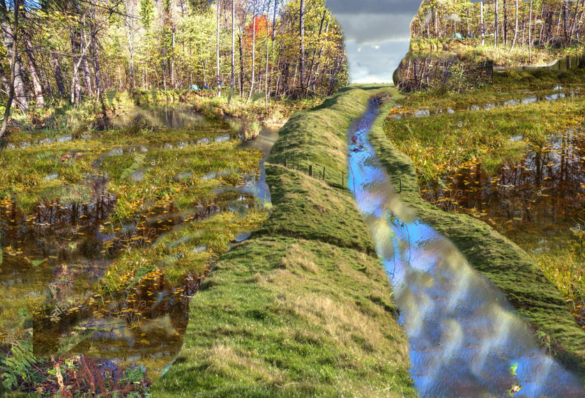
That’s the fascinating part. As ingenious as the Romans were, they were also incredibly practical. They saw the brilliance in those wiggly, meandering waterways, how they follow the natural lay of the land. And they rolled with it.

So a bit of where the Romans, we do things our way, but also a touch of, hmm, these prehistoric folks were on to something.

Exactly. They incorporated the preexisting knowledge into their own plans. You can actually see this in Car Dyke today. Some sections are those laser street Roman roads bear hair waterways, while others wiggle and wind following those ancient, more organic roots.

Talk about a fusion of styles. It speaks to Roman ingenuity, but also a respect for the people who came before. But this begs the question why were the Romans so drawn to Car Dyke  in the first place? Was it just strategic, or was there more to it? Langdon suggests this waterway may have been a key factor in the economy back then. Could we go as far as to call it a prehistoric economic engine?
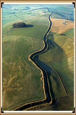
##############################(Car Dyke – ABC News PodCast)

(Car Dyke - ABC News PodCast)

So we’re back. Last we left off, we were trying to wrap our heads around car dyke being this, well, prehistoric economic powerhouse, a bit of a bold statement that you think maybe, but think about it. What are the key ingredients for a thriving economy? You need resources, sure, but also the means to move them around, to connect, to exchange. Not just goods, but ideas. And that’s where car dyke comes in.

So it wasn’t just about moving stuff from point A to point B, but actually creating a system for growth and innovation.

Exactly. Car Dyke wasn’t just a ditch. It was an artery, a network of waterways breathing life into these settlements that might have otherwise been isolated. Imagine the possibilities. Suddenly you have specialized skills. Trade routes, a breeding ground for new ideas. All thanks to this intricate water system.

Okay, I’m starting to see the bigger picture, but what evidence did Langdon find that really supports this prehistoric Silicon Valley theory?

Well, he points to the clusters of specific artifacts found along car dyke tools, pottery, remnants of early metalworking, all concentrated in ways that suggest something beyond just your average everyday life.

More like specialized workshops, right? Taking advantage of the waterway, both to get their raw materials and then ship out whatever they created.

Precisely. And it makes you look at those wiggly sections, those seemingly less efficient paths in a whole new light.

They weren’t just following the terrain, they were strategically connecting these hubs of activity.

Exactly. Plus, we can’t forget the sheer scale of this thing. Building and maintaining 103 mile waterway, even with prehistoric tools, would have taken massive coordination and organization.

We’re talking next level project management, leadership, planning, resource allocation. It boggles the mind, not to mention the exchange of knowledge that must have happened along the way.

Right? Think about all those different groups coming together, each with their own skills and knowledge. That kind of collaboration, that cross-pollination of ideas, it’s the perfect recipe for innovation.

So not just an economic engine, but a melting pot of ideas and innovation. It’s amazing to think that this simple ditch might hold the key to understanding how complex societies developed in prehistoric Britain.

It really makes you wonder what else is still out there, hidden just beneath the surface, waiting for us to uncover it,

And to think all it took was a fresh perspective, a healthy dose of curiosity, and of course, the magic of Lidar.

Who knows what other mysteries are waiting to be revealed

To all you deep divers tuning in. If this exploration of Car Dyke has taught us anything, it’s that history is full of surprises. So keep questioning, keep exploring. And who knows, maybe you’ll make the next big discovery. Until next time, happy digging.

Car Dyke the eBook with be available from www,prehistoric-britain.co.uk website from 1st November 2024 price £4.95.

(Car Dyke – ABC News PodCast)

Further Reading

For information about British Prehistory, visit www.prehistoric-britain.co.uk for the most extensive archaeology blogs and investigations collection, including modern LiDAR reports.  This site also includes extracts and articles from the Robert John Langdon Trilogy about Britain in the Prehistoric period, including titles such as The Stonehenge Enigma, Dawn of the Lost Civilisation and the ultimate proof of Post Glacial Flooding and the landscape we see today.

Robert John Langdon has also created a YouTube web channel with over 100 investigations and video documentaries to support his classic trilogy (Prehistoric Britain). He has also released a collection of strange coincidences that he calls ‘13 Things that Don’t Make Sense in History’ and his recent discovery of a lost Stone Avenue at Avebury in Wiltshire called ‘Silbury Avenue – the Lost Stone Avenue’.

Langdon has also produced a series of ‘shorts’, which are extracts from his main body of books:

The Ancient Mariners

Stonehenge Built 8300 BCE

Old Sarum

Prehistoric Rivers

Dykes ditches and Earthworks

Echoes of Atlantis

Homo Superior

Other Blogs

s

t

Car Dyke – North Section

This is a primary report of the first LiDAR mapping of Car Dyke in Lincolnshire

Introduction

Car Dyke is one of the most enigmatic and intriguing remnants of Roman engineering in Britain.  Stretching across the Fens of Eastern England, this ancient waterway has puzzled historians, archaeologists, and enthusiasts for centuries.  Theories about its purpose and origin are as varied as they are compelling, reflecting the complexities of interpreting ancient structures without definitive historical records.  This introduction aims to present a comprehensive overview of Car Dyke, encompassing both past and current theories regarding its use and origin.

Car Dyke: A Brief Description

Car Dyke runs for approximately 85 miles (137 kilometres) from Waterbeach in Cambridgeshire to the River Witham near Lincoln.  Its construction is attributed to the Roman period, specifically around the 1st or 2nd century AD.  The Dyke consists of a broad, shallow ditch with accompanying banks, a typical feature of Roman civil engineering, yet its exact function remains a matter of debate.

Early Theories: Navigational and Defensive Purposes

The earliest theories about Car Dyke’s purpose centred around its potential use as a navigational canal.  Some scholars suggested that the Romans constructed it to facilitate the movement of goods and troops across the Fenlands, which were notoriously difficult to traverse due to their marshy nature.  This theory aligns with the Romans’ known prowess in building canals and other hydraulic structures throughout their empire.

Another prevalent early theory posited that Car Dyke served a defensive purpose.  Given the strategic importance of controlling the Fenlands, it was speculated that the Dyke might have been part of a broader military defence network.  The presence of Roman forts and settlements along its route lends some credence to this idea, suggesting that the Dyke could have been a boundary or a means to control movement through the region.

(Car Dyke - North Section)

Our Research

We have now sucessfully mapped the northern section of Car Dyke and located all the findings from periods from Mesolithic Period to modern times. Our objective is to discover or confirm the construction date of the Dyke and its function.

(Car Dyke - North Section)
Fens

The first aspect of the maps show that Car Dyke ‘hugs’ the raised shorelines of the Fen Area. This is in contrast to the modern and some Roman drainage ditches.

(Car Dyke - North Section)
Car Dyke – Profile

Locks and Water Management

One of the most striking anomalies observed in the Car Dyke is the varying elevation profile along its course. Contrary to what might be expected from a Roman engineering project, the dyke does not maintain a flat or consistent gradient. In fact, in some sections, the elevation fluctuates by as much as 4 meters (14 feet) without the apparent use of locks to regulate water flow.

This irregularity raises intriguing questions about the design and function of the Car Dyke. Historically, Greek engineers were pioneers in using canal locks, employing them to manage water levels in the Ancient Suez Canal as early as the 3rd century BC. Similarly, under Emperor Trajan, the Romans utilised sluice gates to control water flow at the entrance to the Red Sea, extending the canal south to what is now Cairo to improve water inflow.

The possibility that the Romans might have used ancient pound locks to manage height differences in canals has been proposed by several scholars. These locks would have allowed for regulating water levels and bridging elevation gaps, much like modern lock systems. However, the absence of clear archaeological evidence for such structures in the Car Dyke—or elsewhere in Roman Britain—leaves this hypothesis unresolved.

Given the significant elevation changes along the Car Dyke, the lack of any visible lock mechanisms suggests alternative explanations must be considered. It’s possible that natural springs or other water sources were strategically utilised to maintain water levels or that the dyke served a different purpose altogether, one that did not require precise water level management.

The question of whether ancient pound locks were used in the Car Dyke remains one of the many mysteries surrounding this ancient structure. Without concrete archaeological evidence, the debate is likely to continue. However, the abnormal elevation profile is a critical factor that must be addressed in any comprehensive analysis of the Car Dyke’s construction and function. As we delve deeper into the investigation, understanding how these variations in height were managed will be crucial to unravelling the true nature of this enigmatic alleged Roman legacy.

(Car Dyke - North Section)
Wibbly-Wobbly pathway is not of Roman design

Dyke Design

In examining the northern section of the Car Dyke, we observe two markedly different design patterns, each suggesting a distinct approach to engineering. The first pattern, characterised by a “wibbly-wobbly” alignment, closely follows the contours of higher land formations and hugs the shoreline. In contrast, the second design, which traverses the low-lying marshlands (indicated in blue), features the straight, linear precision typically associated with Roman engineering.

This stark contrast in design raises the possibility of looking at two different techniques, potentially indicative of two separate historical periods and civilisations at work. The “wibbly-wobbly” design, with its organic, meandering course, suggests a construction that prioritised the natural landscape, possibly indicating a pre-Roman origin. This approach aligns with a more ancient engineering practice, where the path of the dyke would have been dictated by the topography and the need to follow natural water sources or higher ground to avoid flooding.

The more uniform and linear sections of the dyke, on the other hand, are characteristic of Roman engineering. The Romans emphasised straight lines and efficient, purposeful design, often cutting across landscapes with little regard for natural obstacles. This technique is evident in their roads, aqueducts, and canals, where functionality and directness were paramount.

Given these observations, it is logical to hypothesise that the Car Dyke in its “wibbly-wobbly” form may have been an earlier construction, later adapted or reused by the Romans. This scenario suggests a continuum of engineering efforts, where the Romans recognised the utility of an existing structure and modified or extended it according to their own methods and needs.

Roman Roads and car dyke
Car Dyke and Roman Roads that are Straight

This theory of two distinct periods of construction is supported by the duality in the dyke’s design: the original, meandering path possibly built by an earlier civilisation and the later, more systematic Roman modifications. The reuse of earlier infrastructure by the Romans was not uncommon; they often incorporated and improved upon existing works, blending local traditions with their engineering principles.

While this hypothesis offers a compelling narrative, it remains speculative without further archaeological evidence. The precise dating of the different sections and the identification of specific construction techniques and materials will be crucial in confirming whether the “wibbly-wobbly” sections indeed predate the Roman modifications.

If this interpretation holds, it would provide valuable insights into the history of the region, illustrating a timeline where the Car Dyke evolved from a local engineering solution to a component of the expansive Roman infrastructure network. This layered history would highlight the Romans’ pragmatic approach to utilising existing resources and underscore the continuity and adaptation of engineering practices across different civilisations in Britain.

In conclusion, the northern section of the Car Dyke, with its dual design characteristics, likely reflects two distinct historical phases. The “wibbly-wobbly” sections suggest an earlier, possibly pre-Roman origin, later integrated into the Roman landscape through their characteristic straight-line construction. This scenario offers a fascinating glimpse into the interaction between different cultures and the evolution of engineering practices over time. Further research and excavation will be essential to validate this theory and fully understand the complex history of the Car Dyke.

The Maths and Proof of Concept

End of The Northern Section

This is the end of the Northern section and the Lincolnshire database. It allows us to examine the number of artefacts found and the probability that they were in use during this period. This probability is calculated by understanding the frequency of finds on Average over the entire county.  Consequently, this is the collective number of artefacts found in Lincolnshire:

To calculate the prior probabilities for each period based on the total number of finds in Lincoln, we first calculate the total number of finds across all periods:

Step 1: Total Number of Finds

Total Finds=13,723(Roman)+8,994(Medieval)+5,619(Post Medieval)+1,680(Early Medieval)+2,451(Iron Age)+2,091(Neolithic)+634(Mesolithic)+980(Bronze Age)=36,172\text{Total Finds} = 13,723 (\text{Roman}) + 8,994 (\text{Medieval}) + 5,619 (\text{Post Medieval}) + 1,680 (\text{Early Medieval}) + 2,451 (\text{Iron Age}) + 2,091 (\text{Neolithic}) + 634 (\text{Mesolithic}) + 980 (\text{Bronze Age}) = 36,172Total Finds=13,723(Roman)+8,994(Medieval)+5,619(Post Medieval)+1,680(Early Medieval)+2,451(Iron Age)+2,091(Neolithic)+634(Mesolithic)+980(Bronze Age)=36,172

Step 2: Calculate Prior Probabilities

Divide the number of finds for each period by the total number of finds:

P(Roman)=13,72336,172≈0.3794P(\text{Roman}) = \frac{13,723}{36,172} \approx 0.3794P(Roman)=36,17213,723​≈0.3794 P(Medieval)=8,99436,172≈0.2487P(\text{Medieval}) = \frac{8,994}{36,172} \approx 0.2487P(Medieval)=36,1728,994​≈0.2487 P(Post Medieval)=5,61936,172≈0.1554P(\text{Post Medieval}) = \frac{5,619}{36,172} \approx 0.1554P(Post Medieval)=36,1725,619​≈0.1554 P(Early Medieval)=1,68036,172≈0.0465P(\text{Early Medieval}) = \frac{1,680}{36,172} \approx 0.0465P(Early Medieval)=36,1721,680​≈0.0465 P(Iron Age)=2,45136,172≈0.0678P(\text{Iron Age}) = \frac{2,451}{36,172} \approx 0.0678P(Iron Age)=36,1722,451​≈0.0678 P(Neolithic)=2,09136,172≈0.0578P(\text{Neolithic}) = \frac{2,091}{36,172} \approx 0.0578P(Neolithic)=36,1722,091​≈0.0578 P(Mesolithic)=63436,172≈0.0175P(\text{Mesolithic}) = \frac{634}{36,172} \approx 0.0175P(Mesolithic)=36,172634​≈0.0175 P(Bronze Age)=98036,172≈0.0271P(\text{Bronze Age}) = \frac{980}{36,172} \approx 0.0271P(Bronze Age)=36,172980​≈0.0271

Summary of Prior Probabilities:

  • Roman: 0.3794
  • Medieval: 0.2487
  • Post Medieval: 0.1554
  • Early Medieval: 0.0465
  • Iron Age: 0.0678
  • Neolithic: 0.0578
  • Mesolithic: 0.0175
  • Bronze Age: 0.0271

Step 1: Define Prior Probabilities

Using the prior probabilities:

  • Roman: P(HRoman)=0.3794P(H_{\text{Roman}}) = 0.3794P(HRoman​)=0.3794
  • Bronze Age: P(HBronze Age)=0.0271P(H_{\text{Bronze Age}}) = 0.0271P(HBronze Age​)=0.0271
  • Neolithic/Mesolithic: P(HNeolithic/Mesolithic)=0.0753P(H_{\text{Neolithic/Mesolithic}}) = 0.0753P(HNeolithic/Mesolithic​)=0.0753

Step 2: Evidence Likelihoods Based on Local Data

Given the distribution of finds:

  • Roman: P(ERoman∣HRoman)=24132≈0.1818P(E_{\text{Roman}}|H_{\text{Roman}}) = \frac{24}{132} \approx 0.1818P(ERoman​∣HRoman​)=13224​≈0.1818
  • Bronze Age: P(EBronze Age∣HBronze Age)=47132≈0.3561P(E_{\text{Bronze Age}}|H_{\text{Bronze Age}}) = \frac{47}{132} \approx 0.3561P(EBronze Age​∣HBronze Age​)=13247​≈0.3561
  • Neolithic/Mesolithic: P(ENeolithic/Mesolithic∣HNeolithic/Mesolithic)=61132≈0.4621P(E_{\text{Neolithic/Mesolithic}}|H_{\text{Neolithic/Mesolithic}}) = \frac{61}{132} \approx 0.4621P(ENeolithic/Mesolithic​∣HNeolithic/Mesolithic​)=13261​≈0.4621

Step 3: Apply Bayes’ Theorem

Posterior Probability for Roman:

P(HRoman∣E)=0.1818×0.3794P(E)=0.0689P(E)P(H_{\text{Roman}}|E) = \frac{0.1818 \times 0.3794}{P(E)} = \frac{0.0689}{P(E)}P(HRoman​∣E)=P(E)0.1818×0.3794​=P(E)0.0689​

Posterior Probability for Bronze Age:

P(HBronze Age∣E)=0.3561×0.0271P(E)=0.0097P(E)P(H_{\text{Bronze Age}}|E) = \frac{0.3561 \times 0.0271}{P(E)} = \frac{0.0097}{P(E)}P(HBronze Age​∣E)=P(E)0.3561×0.0271​=P(E)0.0097​

Posterior Probability for Neolithic/Mesolithic:

P(HNeolithic/Mesolithic∣E)=0.4621×0.0753P(E)=0.0348P(E)P(H_{\text{Neolithic/Mesolithic}}|E) = \frac{0.4621 \times 0.0753}{P(E)} = \frac{0.0348}{P(E)}P(HNeolithic/Mesolithic​∣E)=P(E)0.4621×0.0753​=P(E)0.0348​

Step 4: Normalize the Posterior Probabilities

Sum of the calculated values for normalisation:

P(E)=0.0689+0.0097+0.0348≈0.1134P(E) = 0.0689 + 0.0097 + 0.0348 \approx 0.1134P(E)=0.0689+0.0097+0.0348≈0.1134

Now, calculate the normalised posterior probabilities:

  • Roman:

P(HRoman∣E)=0.06890.1134≈0.6074P(H_{\text{Roman}}|E) = \frac{0.0689}{0.1134} \approx 0.6074P(HRoman​∣E)=0.11340.0689​≈0.6074

  • Bronze Age:

P(HBronze Age∣E)=0.00970.1134≈0.0855P(H_{\text{Bronze Age}}|E) = \frac{0.0097}{0.1134} \approx 0.0855P(HBronze Age​∣E)=0.11340.0097​≈0.0855

  • Neolithic/Mesolithic:

P(HNeolithic/Mesolithic∣E)=0.03480.1134≈0.3069P(H_{\text{Neolithic/Mesolithic}}|E) = \frac{0.0348}{0.1134} \approx 0.3069P(HNeolithic/Mesolithic​∣E)=0.11340.0348​≈0.3069

Analysis and Interpretation:

  • Neolithic/Mesolithic: The higher frequency of finds in this period significantly increases its posterior probability to approximately 30.69%, which is quite substantial.
  • Roman: Despite having fewer finds in this area, the Roman period still has a high posterior probability due to its higher prior, but it is now only about 60.74%.
  • Bronze Age: The probability for the Bronze Age period remains lower at approximately 8.55%.

Conclusion:

The calculated probabilities show a more balanced view, with the Roman period still favoured but with a much stronger case for the Mesolithic/Neolithic period. This suggests that while Roman use of the Dyke is still likely, the Mesolithic/Neolithic period also holds significant importance, potentially indicating earlier use or occupation before the Romans.

Langdon Mathematics

While Bayesian theory often yields definitive results, its accuracy can be compromised due to its dependence on subjective prior assumptions, which may only sometimes reflect reality. If these priors are not well-chosen or are based on incomplete or biased information, the resulting analysis might be misleading.

Therefore, relying solely on Bayesian methods without considering the variability and complexity of archaeological data could lead to conclusions that only partially capture the nuances of the actual distribution of artefacts. My method, which focuses on spatial analysis and empirical data, addresses these limitations.

My approach to calculating finds would differ significantly. First, I would define the area where artefacts could be discovered—using Lincolnshire as a reference due to its comprehensive archaeological data. By doing so, we can estimate the expected number of artefacts per square meter of Lincolnshire land, offering a more objective and spatially grounded method for understanding artefact distribution.

As IA reports:

To calculate the percentage likelihood of finding an artefact from each period in a single square meter of Lincolnshire, we can follow these steps:

Step 1: Determine the Area of Lincolnshire

  • Area of Lincolnshire: Approximately 6,959 square kilometres (6,959,000,000 square meters).

Step 2: Calculate the Find Density

For each period, calculate the density of finds per square meter by dividing the total number of finds by the area of Lincolnshire.

​

Step 3: Calculate the Likelihood for Each Period

  1. Roman:

Likelihood: 0.000156%

  • Neolithic:

Likelihood: 0.000011%

  • Mesolithic:

Likelihood: 0.000004%

  • Bronze Age:

Likelihood: 0.000003%

Summary of Likelihoods in order of expectation:

  • Roman: 0.000156%
  • Medieval: 0.000129%
  • Post Medieval: 0.000081%
  • Early Medieval: 0.000024%
  • Iron Age: 0.000021%
  • Neolithic: 0.000011%
  • Mesolithic: 0.000004%
  • Bronze Age: 0.000003%

These percentages represent the likelihood of finding an artefact from each period in a square meter of Lincolnshire. Given the extensive activity during that time, the highest is for the Roman period, just marginally ahead of the Medieval period.

We now need to look at the search area (63 miles of the Northern End of Car Dyke) as listing on the LiDAR maps in the previous section of the book.  We must first calculate the total search area in square metres, count the number of finding within this area, and then compare against the expected number.

Summary of Expected Finds:

  • Roman: 15.83 artefacts
  • Medieval: 13.07 artefacts
  • Post Medieval: 8.19 artefacts
  • Early Medieval: 2.44 artefacts
  • Iron Age: 2.17 artefacts
  • Neolithic: 1.07 artefacts
  • Unknown: 0.59 artefacts
  • Modern: 0.50 artefacts
  • Mesolithic: 0.36 artefacts
  • Bronze Age: 0.34 artefacts

Summary of Items Found:

  • Mesolithic/Neolithic: 61 finds
  • Bronze Age: 47 finds
  • Roman: 24 finds

Calculate the Odds of This Kind of Find

For each period, the odds ratio of finding this many artefacts compared to the expected finds:

Step 4: Interpret the Results

  • Mesolithic/Neolithic: A massive 5589.72% increase and an odds ratio of 57.01 suggest significant activity during this period, far beyond what was expected.
  • Bronze Age: An even higher increase of 13723.53% and an odds ratio of 138.24 indicate the area was very important during the Bronze Age.
  • Roman: A modest 51.60% increase with an odds ratio of 1.52 suggests Roman activity, but not as dominant as the earlier periods.

Conclusion

The very high percentage increases and odds ratios for the Mesolithic/Neolithic and Bronze Age periods strongly suggest that the Car Dyke area was occupied and actively used during these times, with significant archaeological activity that exceeds what would be expected based on general Lincolnshire data. While still represented, the Roman period is less prominent in this area compared to the earlier periods.

This confirms other Dyke surveys such as Offa’s and Wansdyke that also show design (wibbly-wobbly) in construction attributed to the builders seeking natural springs rather than a direct line of route to maintain water levels which were achieved at a later date in history by locks.

Further Reading

For information about British Prehistory, visit www.prehistoric-britain.co.uk for the most extensive archaeology blogs and investigations collection, including modern LiDAR reports.  This site also includes extracts and articles from the Robert John Langdon Trilogy about Britain in the Prehistoric period, including titles such as The Stonehenge Enigma, Dawn of the Lost Civilisation and the ultimate proof of Post Glacial Flooding and the landscape we see today.

Robert John Langdon has also created a YouTube web channel with over 100 investigations and video documentaries to support his classic trilogy (Prehistoric Britain). He has also released a collection of strange coincidences that he calls ‘13 Things that Don’t Make Sense in History’ and his recent discovery of a lost Stone Avenue at Avebury in Wiltshire called ‘Silbury Avenue – the Lost Stone Avenue’.

Langdon has also produced a series of ‘shorts’, which are extracts from his main body of books:

The Ancient Mariners

Stonehenge Built 8300 BCE

Old Sarum

Prehistoric Rivers

Dykes ditches and Earthworks

Echoes of Atlantis

Homo Superior

Other Blogs

s

t