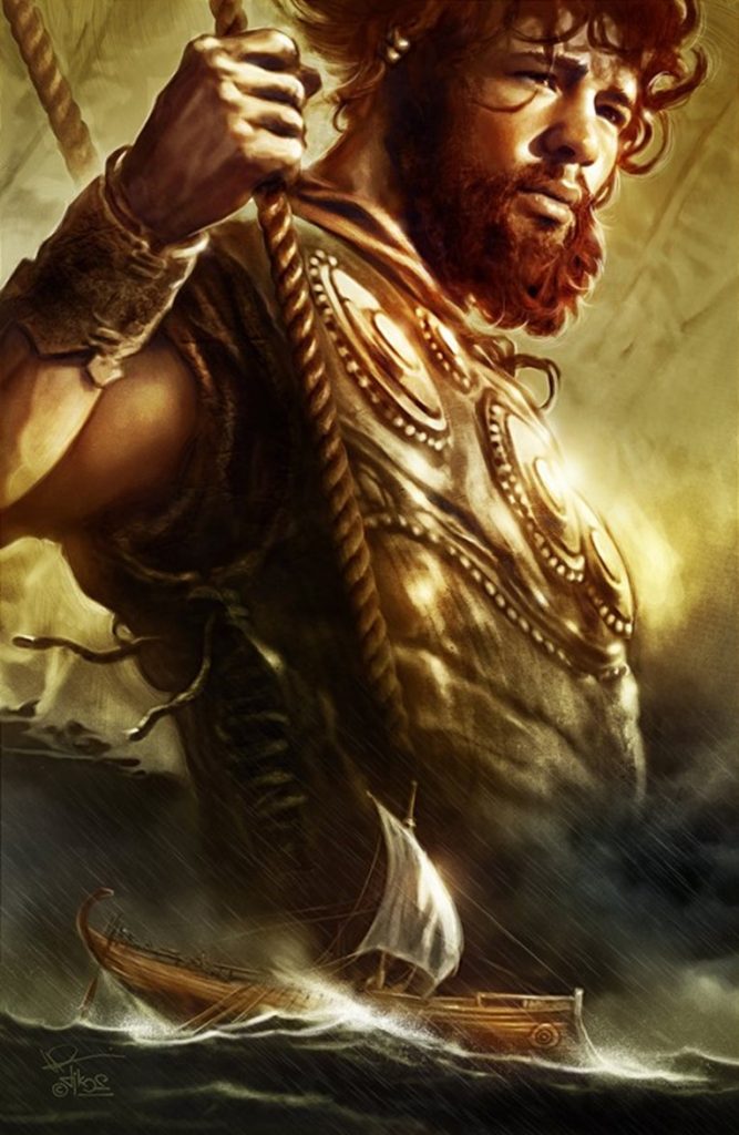
THE ODYSSEY PROBLEM: WHY DID A WEEK-LONG VOYAGE BECOME A TEN-YEAR EPIC?

If Troy was really at Hisarlık, Homer has given us a geographical problem hiding in plain sight

Before We Follow Odysseus: How Old Is the Story We Are Actually Reading?

Before attempting to place Troy, Ithaca or any of the strange lands described in the Odyssey on a modern map, there is a more fundamental question that is rarely given enough attention:

What exactly are the Iliad and Odyssey?
THE ODYSSEY PROBLEM
THE ODYSSEY PROBLEM

Today we encounter them as books. They have numbered books, fixed lines, recognised place-names and an author conventionally called Homer. That creates the natural impression that somebody sat down approximately 2,700 years ago and wrote the stories much as a modern novelist would.

Almost certainly, that is not how they began.

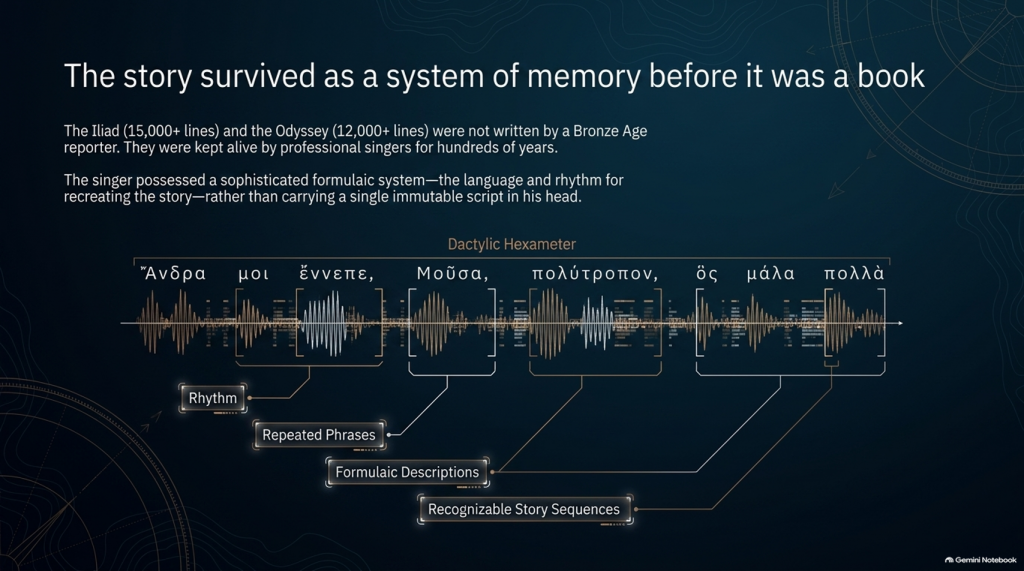
Modern Homeric scholarship broadly accepts that the Iliad and Odyssey emerged from a much older oral performance tradition. For generations before the poems became stable written texts, professional singers told and retold stories about Troy, Achilles, Helen, Odysseus and the other heroes. The tradition operated over a wide geographical area and for hundreds of years; some scholars allow that parts of the underlying poetic tradition may reach back into the Bronze Age, while aspects of the poetic language itself may preserve still older Indo-European inheritances.

That distinction is crucial to this investigation.

We are therefore probably not reading an eyewitness report written shortly after a war.

Nor, however, are we necessarily reading a completely invented story created in the eighth century BCE.

What we have is something much more interesting:

A VERY OLD STORY THAT WAS KEPT ALIVE BY HUMAN MEMORY BEFORE IT BECAME A BOOK.
THE ODYSSEY PROBLEM
THE ODYSSEY PROBLEM

🗣️ HOW COULD A STORY THIS LARGE SURVIVE WITHOUT WRITING?

At first this sounds almost impossible.

The Iliad contains more than 15,000 lines and the Odyssey more than 12,000. How could stories of this scale survive for centuries before being written down?

The answer lies in the way oral poetry worked.

The pioneering studies of Milman Parry and Albert Lord demonstrated that oral epic singers did not normally memorise a gigantic text word-for-word in the way an actor memorises a script.

Instead, they mastered a specialised system of:

rhythm,

repeated phrases,

formulaic descriptions,

stock scenes,

traditional characters,

recognisable story sequences

and

metrical structures.

Thus Achilles can repeatedly be described by a familiar epithet, ships can be introduced through standard phrases, dawn arrives through recognised verbal formulas, and battles, feasts, departures and assemblies follow structures that both singer and audience understand.

The metre itself—dactylic hexameter—acted as part of the memory system.

The singer possessed the story and the language for recreating it, rather than carrying a single immutable script in his head. Parry and Lord’s work on surviving oral traditions showed that a trained singer could reconstruct an enormous epic during performance using this formulaic system.

This produces a very important consequence.

Each performance could preserve the essential story while changing some of its details.

An episode might become longer.

Another could be shortened.

A hero could receive greater prominence.

A description could change.

And details meaningful to one audience could be emphasised more heavily than details important to another.

The story could therefore remain recognisably the same story for centuries without remaining exactly the same text.

THE ODYSSEY PROBLEM
THE ODYSSEY PROBLEM

⏳ HOW FAR BACK COULD THE TROJAN STORY GO?

This is where matters become particularly interesting.

The poems we possess are usually associated in something close to their recognisable monumental form with the late eighth or early seventh century BCE, although exactly when they first became written texts remains heavily debated.

But the traditions from which they were created are considerably older.

Cambridge’s modern guide to Homer describes the poems as products of songs composed and recomposed over many hundreds of years, potentially drawing on traditions extending much deeper into prehistory. Some scholarship has specifically argued that Greek epic traditions may have been developing from the middle or later Bronze Age.

That creates a possible chronological gap of several centuries between:

whatever historical events originally generated the tradition

and

the written geographical names we eventually inherit.

If the conventional Trojan War date of around the late second millennium BCE were approximately correct, then several hundred years may separate an original conflict from the period in which the surviving poems began crystallising into something resembling our texts.

And during those centuries the story was travelling.


🌍 STORIES TRAVEL — AND GEOGRAPHY CAN TRAVEL WITH THEM

This point is central to our investigation.

An oral epic does not survive in a vacuum.

It survives because people want to hear it.

A singer performs before an audience. That audience knows its own towns, rulers, landscapes, ancestors and political rivalries.

Successful oral storytelling therefore contains an unavoidable process of adaptation.

Modern Homeric scholarship explicitly recognises that the flexibility of oral performance allowed heroic tales to be adapted to their immediate contexts. The Homeric language itself demonstrates this history: it is not the ordinary language of one place or date but a remarkable composite containing predominantly Ionic forms together with older Aeolic and Arcado-Cypriot elements and later Attic features.

In other words:

THE LANGUAGE ITSELF HAS A HISTORY OF MOVEMENT AND MODIFICATION.

Why should we automatically assume every geographical label escaped the same process untouched?

Suppose an ancient story originally described a distant king, harbour, island or people whose original name had become meaningless to an audience centuries later.

A performer had several choices.

He could preserve a meaningless archaic name.

He could reinterpret it.

He could associate it with a place his listeners knew.

Or different regional traditions could gradually absorb their own places and heroes into the greater Trojan story.

We cannot prove that this happened to every disputed Homeric town.

But critically:

WE KNOW THE ORAL SYSTEM WAS CAPABLE OF DOING IT.

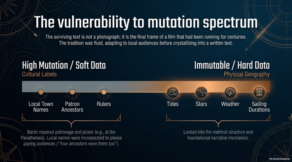
That alone means geographical names cannot be treated with the same evidential weight as physical descriptions.
THE ODYSSEY PROBLEM
THE ODYSSEY PROBLEM

🏛️ COULD LOCAL TOWNS HAVE BEEN ADDED TO PLEASE LOCAL AUDIENCES?

Yes—it is a genuine possibility, although it must be treated as a hypothesis rather than assumed.

There were even disputes in antiquity and later scholarship concerning possible Athenian additions to Homer. Passages involving Athens and Salamis in the Catalogue of Ships have attracted particularly long-running arguments about interpolation and political influence. Modern scholarship does not simply agree that these lines were inserted, but the fact that such passages remain controversial demonstrates that alteration of local geographical material is not some outrageous modern suggestion.

And there was an obvious incentive.

Imagine performing this great heroic story before an audience in a particular Greek city.

Which version is likely to receive the better reception?

One saying:

“Your people played no part in the greatest war in heroic history.”

Or one announcing:

“Your ancestors were there too.”

The Catalogue of Ships is especially interesting in this respect because it gives an extraordinary roll-call of communities incorporated into the expedition.

That does not prove the Catalogue was fabricated.

But it means we should recognise its social function.

The Trojan story eventually became a shared heroic past through which numerous Greek communities could locate themselves inside history.

That creates exactly the circumstances in which local geographical incorporation becomes plausible.


💰 WAS THERE A COMMERCIAL MOTIVE?

Not initially in the modern sense of an author writing a book and hoping to sell thousands of copies.

For much of the poem’s early existence, the product being consumed was the:

PERFORMANCE.

Bards performed at elite households, feasts and public occasions. Later professional rhapsodes performed Homeric poetry competitively at major festivals such as the Panathenaia, where contests and prizes existed. For most people in Archaic and Classical Greece, Homer would originally have been encountered through performance rather than privately reading a book.

So although we should avoid imagining a Bronze Age publishing company selling copies of the Iliad, there was still an economic reality.

A successful performer needed:

patronage,

invitations,

prestige,

prizes

and above all:

AN AUDIENCE THAT WANTED TO HEAR HIS VERSION.

That provides exactly the same commercial pressure that exists in entertainment today.

Tell people a story that relates to them, and they are more likely to listen.

Eventually the oral tradition increasingly became textual. The poems became books, educational texts and cultural possessions, while regulated festival performances also helped constrain what had previously been a much more fluid tradition. Yet even by the second century BCE, textual variation had not disappeared completely.

So the surviving text is better imagined not as a photograph taken at one moment in history, but as the final surviving frame of a film that had already been running for centuries.


📜 FROM BARD TO “HOMER”

There is another uncomfortable problem.

We do not actually know who Homer was.

Ancient cities competed to claim him as their own, particularly communities in Ionia such as Smyrna and Chios. Even the association of the name “Homer” with the Iliad and Odyssey developed within the later tradition.

Modern scholarship continues to debate whether:

one extraordinary poet monumentalised each epic,

different poets created the Iliad and Odyssey,

the poems were dictated by oral singers,

or their written forms emerged progressively from a much wider performance tradition.

What is considerably less controversial is that the tradition preceding the surviving text was oral.

That fact changes how geographical evidence should be handled.

THE ODYSSEY PROBLEM
THE ODYSSEY PROBLEM

🧭 NAMES ARE NOT THE SAME AS GEOGRAPHY

This is why, throughout this investigation, we will not begin by saying:

“Homer mentions a place later identified as being in Greece, therefore the story happened in Greece.”

That is circular reasoning.

A place-name can be:

preserved,

translated,

reapplied,

updated,

misunderstood

or

incorporated during centuries of oral retelling.

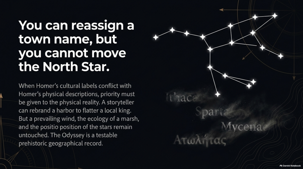
A river behaving in a particular way cannot.

A tide cannot.

A seventeen-day voyage cannot.

The position of a star cannot.

A prevailing wind cannot.

The length of winter darkness cannot.

The ecology of a marsh cannot.

A mountain visible after a stated number of sailing days cannot.

Those are the clues that deserve greater weight.

So our methodology deliberately separates:

🏛️ CULTURAL LABELS

from

🌍 PHYSICAL GEOGRAPHY.

The names remain important.

But they do not get to prove themselves.

THE ODYSSEY PROBLEM
THE ODYSSEY PROBLEM

🔍 THE STORY MAY BE OLDER THAN ITS MAP

And this leads directly to the central problem of the Odyssey.

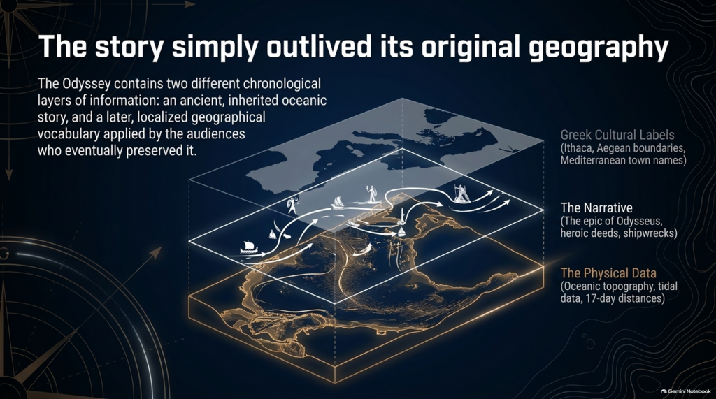
It is entirely possible that the written poem contains two different chronological layers of information:

an ancient inherited story,

and

a later geographical vocabulary familiar to the audiences who eventually preserved and recorded it.

If so, conflicts between Homer’s names and Homer’s physical descriptions become extremely important.

Which should we trust?

The town name that could have travelled through centuries of human storytelling?

Or the description of:

🌊 the sea,

🌫️ the climate,

⭐ the stars,

🧭 the sailing direction,

⏳ the voyage duration,

🌲 the vegetation,

🏔️ the landscape

and

👥 the people?

Our investigation gives priority to the latter.

Because oral tradition can move a name.

IT CANNOT MOVE THE NORTH STAR.
THE ODYSSEY PROBLEM
THE ODYSSEY PROBLEM

And once that distinction is understood, the Odyssey stops being merely one of the world’s greatest stories.

It becomes something else:

🧭 A POTENTIALLY TESTABLE PREHISTORIC GEOGRAPHICAL RECORD.

That is where our investigation begins.

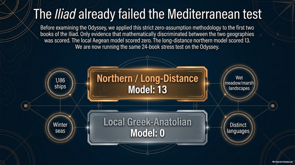
Our examination of the first two books of Homer’s Iliad has already produced an unexpected result.

After removing traditional place-name assumptions and scoring only evidence that actually discriminates between the competing geographical models, the result currently stands at:

🌊 NORTHERN / LONG-DISTANCE MODEL: 13

☀️ LOCAL GREEK–ANATOLIAN MODEL: 0

But we may have overlooked an even more powerful test.

Because Homer didn’t only leave us the story of the war.

He also left us:

🧭 THE JOURNEY HOME.

And that creates a very awkward question for the traditional identification of Troy.


🚢 THE JOURNEY SHOULD BE SIMPLE

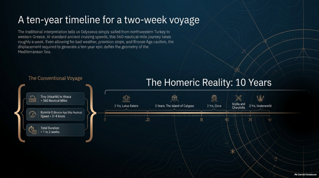
The conventional interpretation tells us:

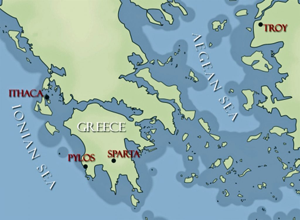
🏛️ Troy = Hisarlık in north-western Turkey

and

🏠 Odysseus’ home = Ithaca in western Greece.

So when Troy falls, Odysseus has a straightforward objective:

TROY ➡️ ITHACA

Nothing mysterious about that.

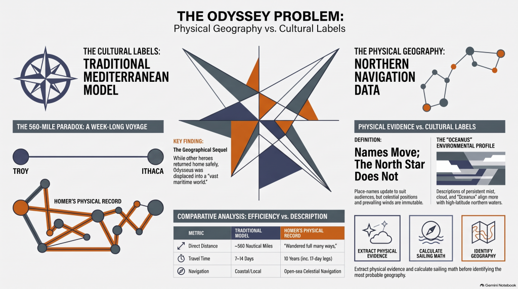
The conventional sea distance is approximately:

🌊 560 NAUTICAL MILES

roughly 645 statute miles

Now compare that with experimental ancient Mediterranean sailing.

The reconstructed fourth-century BC merchant vessel Kyrenia II demonstrated cruising speeds around 3–4 knots, sometimes considerably faster. On its experimental voyage from Piraeus to Cyprus it covered almost 600 nautical miles despite stops, tests and variable conditions.

At that sort of speed, a direct 560-mile voyage is not a journey measured in years.

It is measured in:

📅 DAYS.

Allow for poor winds, overnight stops, provisioning and Bronze Age caution and perhaps we are looking at roughly:

ONE TO TWO WEEKS

under reasonably favourable circumstances.

And yet Homer gives us:

⏳ TEN YEARS.

Immediately people will say:

“But Odysseus didn’t spend ten years sailing!”

Correct.

And that distinction actually makes the geographical problem more interesting.

THE ODYSSEY PROBLEM
THE ODYSSEY PROBLEM

⏳ THE TEN YEARS WERE NOT TEN YEARS OF CONTINUOUS SAILING

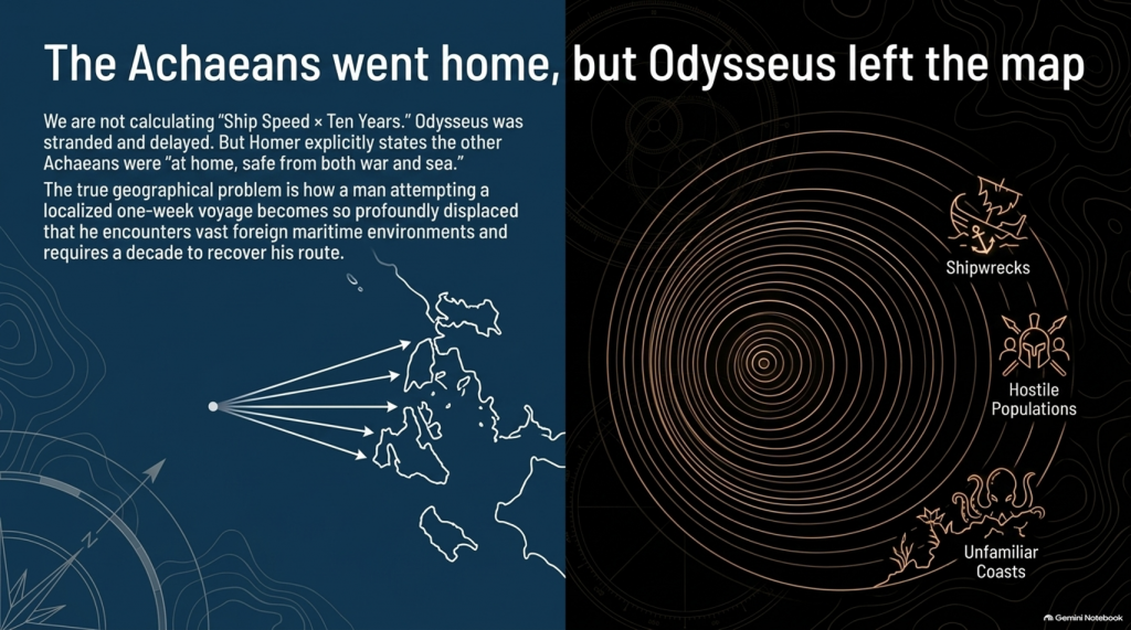
Odysseus gets delayed.

He is shipwrecked.

He loses companions.

He encounters hostile populations.

He becomes stranded.

He spends years unable to get home.

So it would be scientifically wrong to calculate:

ship speed × ten years = distance from Troy.

We aren’t doing that.

The real question is much more basic:

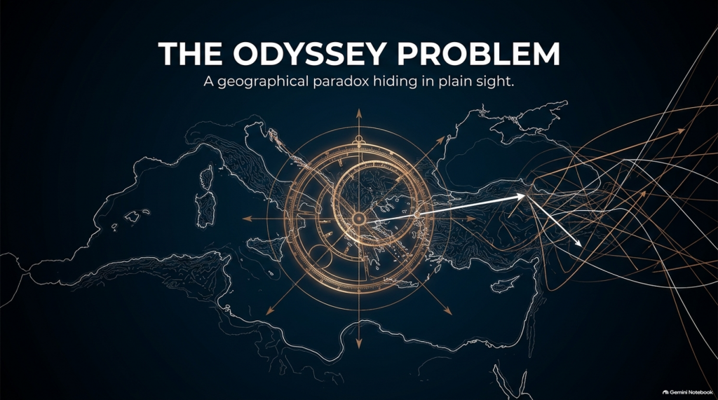
How does a man attempting a voyage whose conventional start and finish are only about a week’s sailing apart become so geographically displaced that returning home consumes ten years?

That is the problem.


📖 HOMER TELLS US FROM THE FIRST LINES THAT THIS IS A GEOGRAPHICAL JOURNEY

The Odyssey opens by describing Odysseus as the man who:

“wandered full many ways”

after he had destroyed Troy.

Homer says:

“Many were the men whose cities he saw”

and tells us that he suffered repeatedly:

“upon the sea.”

This isn’t simply a story about somebody stuck around the corner.

It is explicitly a story about:

🌍 travelling through different lands

👥 encountering different peoples

🌊 crossing seas

🌪️ experiencing extreme maritime conditions

and

🧭 struggling to recover the route home.

THE ODYSSEY PROBLEM
THE ODYSSEY PROBLEM

🚨 EVEN MORE IMPORTANTLY — EVERYONE ELSE HAS ALREADY GONE HOME

Book 1 gives us another striking statement.

Homer says that the other surviving Achaeans were:

“at home, safe from both war and sea.”

Odysseus alone remained unable to complete his return.

This is extremely important.

The war is finished.

The surviving coalition disperses.

The men undertake their return journeys from Troy.

That means the Odyssey isn’t some unrelated maritime fantasy.

It is the geographical sequel to the Trojan War.

We therefore have another independent dataset with which to test the location of Troy.


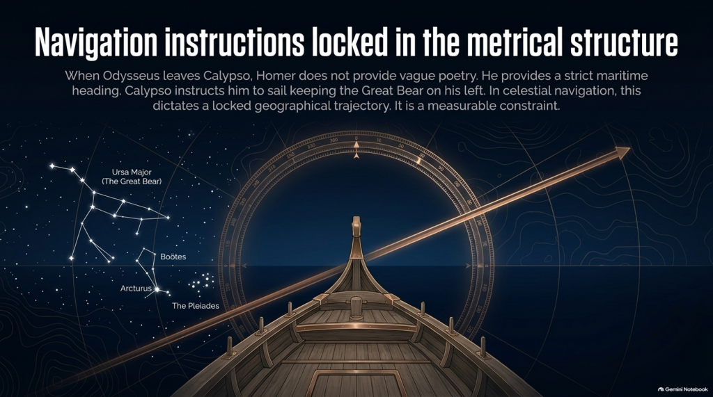
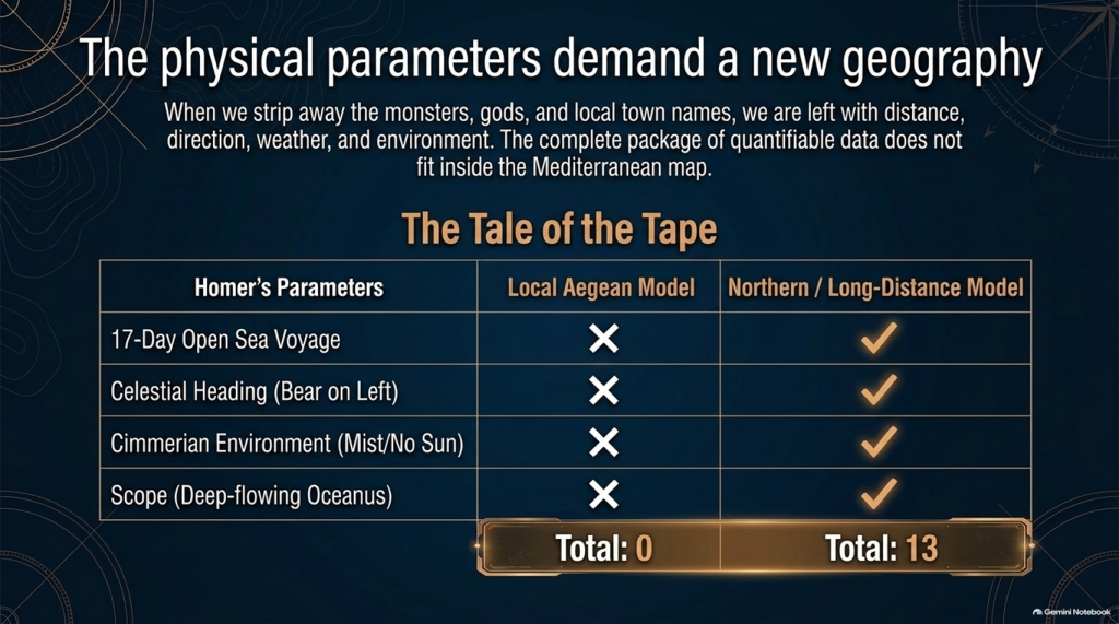
🧭 AND HOMER ACTUALLY GIVES US NAVIGATION INSTRUCTIONS

This is where things become particularly interesting.

When Odysseus finally leaves Calypso, Homer doesn’t simply say:

“He sailed away.”

He tells us how he navigated.

Odysseus watches:

⭐ the Pleiades

⭐ Boötes

⭐ Orion

⭐ the Great Bear.

And Calypso instructs him to keep the Bear:

ON HIS LEFT

while sailing.

That is potentially geographical evidence.

Because now we have:

⭐ CELESTIAL NAVIGATION

🧭 DIRECTION

🌊 OPEN-SEA TRAVEL

⏳ AND SAILING DURATION.

That can potentially be tested mathematically.

THE ODYSSEY PROBLEM
THE ODYSSEY PROBLEM

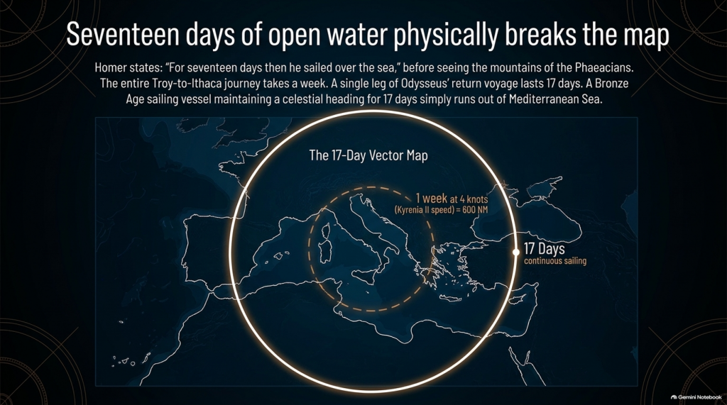
🚢 THEN HOMER GIVES US THE NUMBER: SEVENTEEN DAYS

Odysseus sails continuously enough for Homer to state:

“For seventeen days then he sailed over the sea”

and on the eighteenth he finally sees the mountains of the Phaeacians.

Stop there.

The entire conventional Troy-to-Ithaca journey could potentially be completed in something around a week or somewhat longer under reasonable sailing conditions.

Yet one single later leg of Odysseus’ wandering lasts:

🌊 17 DAYS AT SEA

before land appears.

That doesn’t automatically prove the Atlantic.

But scientifically it demands investigation.

Where had he travelled?

How far away from Ithaca had he become?

What heading does keeping the Great Bear on the left imply?

What distance can a Bronze Age sailing vessel cover in seventeen days?

And does the conventional Mediterranean reconstruction actually satisfy those constraints?

These are measurable questions.


🌫️ THEN WE REACH THE CIMMERIANS

And the environment becomes even stranger.

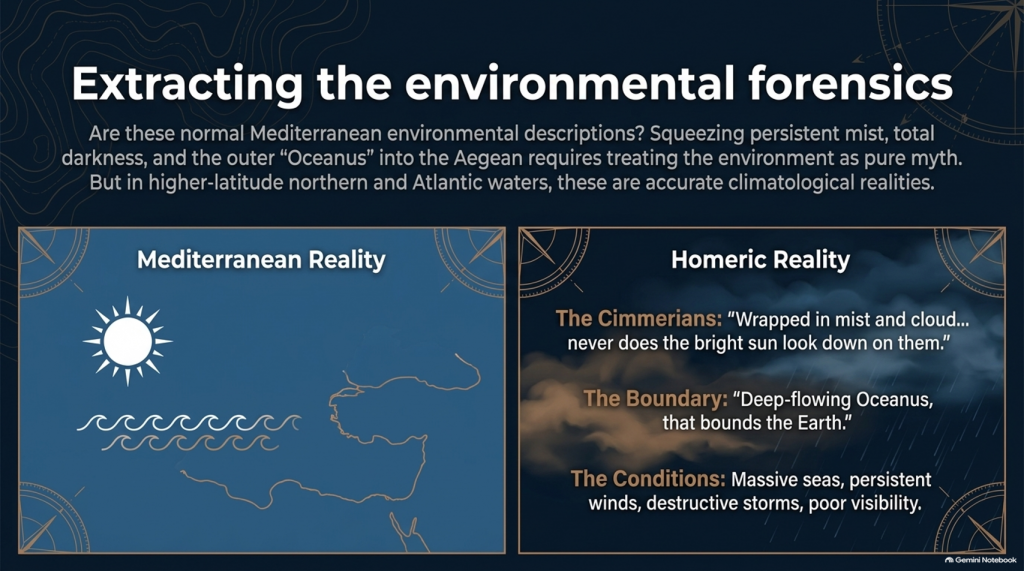
Odysseus reaches the land of the Cimmerians.

Homer describes it as:

“wrapped in mist and cloud.”

Then he says:

“Never does the bright sun look down on them”

and describes oppressive darkness hanging over the inhabitants.

Again, we must be careful.

This could be mythological geography.

It could represent Homer’s conception of the edge of the world.

We cannot simply announce:

Cimmerians = Britain.

But scientifically we are entitled to ask:

🌞 Is this a normal Mediterranean environmental description?

Or is:

🌫️ persistent mist

☁️ cloud

🌑 darkness

and

🌊 the remote Ocean

more naturally compatible with the traditions of higher-latitude northern waters?

That becomes another test.


🌊 HOMER EVEN TAKES US TO “OCEANUS”

Immediately before reaching the Cimmerians, Homer says Odysseus’ vessel reaches:

“deep-flowing Oceanus, that bounds the Earth.”

This is extremely significant conceptually.

The poem’s geography has now expanded far beyond an ordinary little voyage between Turkey and western Greece.

We are being taken to what Homer’s tradition regards as the outer ocean.

Whether Oceanus represents a literal Atlantic geography, mythical world-ocean, or a mixture of inherited geographical memory and mythology is precisely what needs testing.

But simply squeezing every episode into the Mediterranean because we have already decided Troy belongs there is not evidence.

It is circular reasoning.

THE ODYSSEY PROBLEM
THE ODYSSEY PROBLEM

🌪️ THE WEATHER NEEDS TESTING TOO

Throughout the Odyssey, maritime conditions aren’t background decoration.

They drive the story.

Odysseus encounters:

🌊 enormous seas

🌬️ persistent winds

⛈️ destructive storms

🌫️ mist and poor visibility

🏝️ unfamiliar coasts

and repeated difficulty determining his position.

Mediterranean storms can unquestionably be severe.

So:

storm = Atlantic

is not acceptable science.

But just as with our Iliad investigation, the correct question is:

Which maritime environment produces the complete collection of conditions more naturally and more frequently?

The Mediterranean?

Or the Atlantic/North Sea world?


🗺️ THE PEOPLE ARE JUST AS IMPORTANT AS THE WEATHER

The journey takes Odysseus through populations whose cultures and lifestyles differ radically.

We meet:

👥 Cimmerians

👥 Phaeacians

👥 Cyclopes

👥 Laestrygonians

and numerous other populations and communities.

Some may be mythical.

Some may preserve distorted memories of real peoples.

Some may combine both.

But we should not begin by assigning them to Mediterranean locations simply because later scholars did so.

Instead we should record:

🏠 housing

⛵ boat technology

🌾 agriculture

🐄 animals

🍖 diet

👕 clothing

🗣️ language

🌲 vegetation

🌦️ climate

🏔️ geography

and then ask:

WHERE DOES THAT COMPLETE PACKAGE FIT BEST?
THE ODYSSEY PROBLEM
THE ODYSSEY PROBLEM

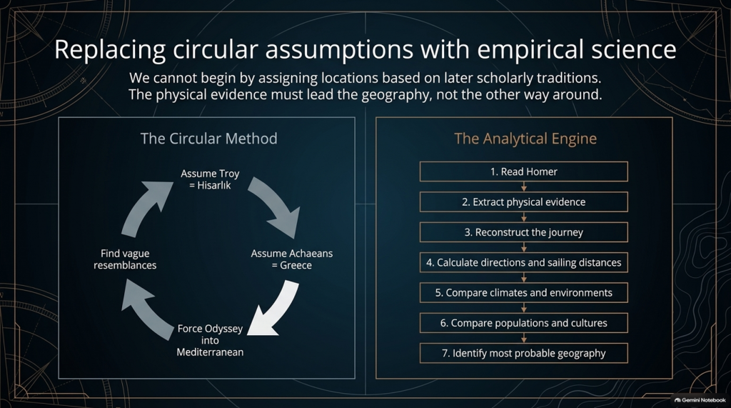
⚠️ THIS IS THE SAME MISTAKE WE FOUND WITH THE ILIAD

Traditional scholarship frequently begins with:

Troy = Hisarlık

therefore:

Achaeans = Greece

therefore:

the war must be Mediterranean

therefore:

the Odyssey must largely be Mediterranean

and then attempts to find Mediterranean locations resembling Homer’s descriptions.

That reverses the scientific process.

The correct sequence should be:

1️⃣ Read Homer.

2️⃣ Extract the physical evidence.

3️⃣ Reconstruct the journey.

4️⃣ Calculate directions and sailing distances.

5️⃣ Compare climates and environments.

6️⃣ Compare populations and cultures.

7️⃣ THEN identify the most probable geography.

Not the other way around.


🔬 AND THIS TIME WE CAN ACTUALLY DO THE MATHEMATICS

The Iliad gave us powerful clues such as:

🌍 “far from home”

🌊 mountains and sea separating populations

🚢 1,186 ships

🗣️ different languages

🌍 allies “from afar”

👱 repeated xanthos individuals

🌧️ winter seas

🌿 wet meadow and marsh landscapes.

But the Odyssey potentially gives us something even stronger.

It gives us:

⏱️ TIME

🧭 DIRECTION

⭐ NAVIGATION

🌊 DISTANCE

🌬️ WEATHER

🌍 ENVIRONMENT.

Those are quantifiable.


🚨 THE CENTRAL PROBLEM

Strip away all the monsters and gods for a moment.

The basic story says:

Odysseus leaves Troy.

He intends to sail home.

Home is Ithaca.

Other Achaeans successfully make their own returns.

Odysseus becomes displaced through a vast maritime world.

He encounters numerous foreign peoples and environments.

He reaches extraordinarily remote locations.

One later sailing leg alone lasts seventeen days.

His complete return takes ten years.

And the conventional interpretation asks us to place the beginning and end of that extraordinary adventure only about:

560 NAUTICAL MILES APART.

That doesn’t prove the traditional map is wrong.

But scientifically:

IT IS A PROBLEM THAT DEMANDS AN EXPLANATION.
THE ODYSSEY PROBLEM
THE ODYSSEY PROBLEM

🧪 SO WE ARE GOING TO TEST THE ODYSSEY TOO

After our detailed examination of the 24 books of the Iliad, we will now have a second investigation:

📚 ALL 24 BOOKS OF THE ODYSSEY

And we will use exactly the same rules.

No points for traditional names.

No location accepted because “experts agree”.

No northern point merely because something also happens in Britain.

No Mediterranean point merely because something can happen in Greece.

If both environments fit:

0–0

If one environment is substantially more probable:

it scores.

And where Homer gives us distances, directions and sailing durations:

WE DO THE MATHS.


🔥 THIS MAY BECOME THE BIGGER PROBLEM

After two books of the Iliad our score currently stands at:

🌊 NORTH / LONG-DISTANCE: 13

☀️ LOCAL AEGEAN: 0

Twenty-two Iliad books remain.

But after that we now have another twenty-four books containing the actual journey home.

That means this investigation is no longer simply:

“Where was Troy?”
THE ODYSSEY PROBLEM
THE ODYSSEY PROBLEM

The bigger question has become:

🧭 DOES HOMER’S ENTIRE GEOGRAPHICAL WORLD FIT INSIDE THE MAP WE HAVE BEEN GIVEN?

Because if Troy really was Hisarlık and Ithaca really was Odysseus’ destination, then a journey whose conventional endpoints are roughly a week or two of ordinary ancient sailing apart somehow generated one of the greatest tales of geographical wandering ever written.

Perhaps mythology explains everything.

Perhaps the Mediterranean really does reproduce Homer’s journey.

Perhaps the traditional geography eventually wins.

But those are hypotheses.

They now need testing.

And if the sailing directions, durations, climates, peoples and landscapes repeatedly point outside the Mediterranean, then the traditional identification of this as an obviously local Greek–Anatolian conflict becomes increasingly difficult to defend scientifically.

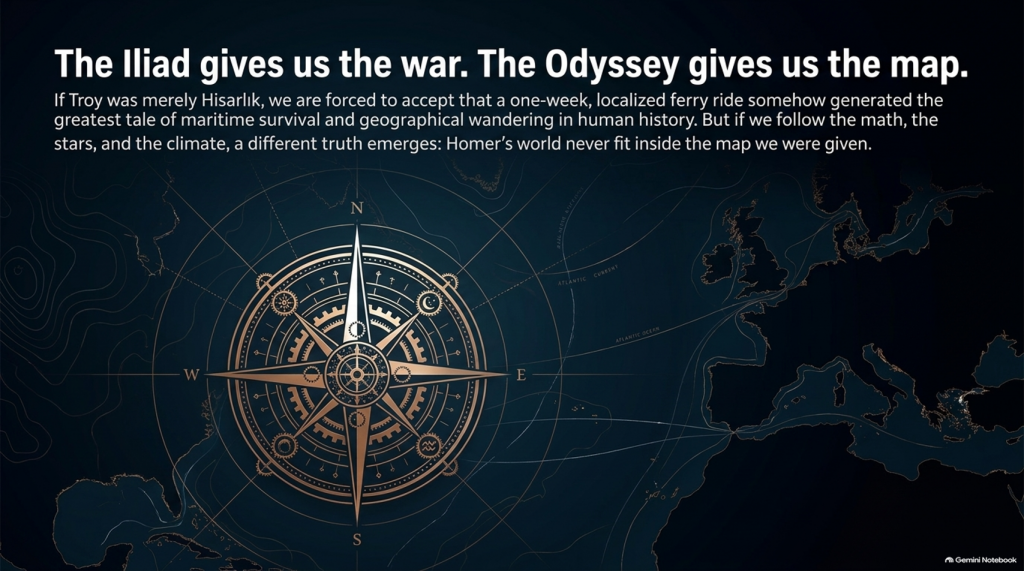
🌊 THE ILIAD GIVES US THE WAR.

🧭 THE ODYSSEY MAY GIVE US THE MAP.

And that may prove to be the most important test of them all. 🔍🌍⚔️
THE ODYSSEY PROBLEM
THE ODYSSEY PROBLEM

PODCAST

Author’s Biography

Robert John Langdon, a polymathic luminary, emerges as a writer, historian, and eminent specialist in LiDAR Landscape Archaeology.

His intellectual voyage has been interwoven with stints as an astute scrutineer in government and grand corporate bastions, a tapestry spanning British Telecommunications, Cable and Wireless, British Gas, and the esteemed University of London.

A decade hence, Robert’s transition into retirement unfurled a chapter of insatiable curiosity. This phase saw him immerse himself in Politics, Archaeology, Philosophy, and the enigmatic realm of Quantum Mechanics. His academic odyssey traversed the venerable corridors of knowledge hubs such as the Museum of London, University College London, Birkbeck College, The City Literature Institute, and Chichester University.

In the symphony of his life, Robert is a custodian of three progeny and a pair of cherished grandchildren. His sanctuary lies ensconced in the embrace of West Wales, where he inhabits an isolated cottage, its windows framing a vista of the boundless sea – a retreat from the scrutinising gaze of Her Majesty’s Revenue and Customs, an amiable clandestinity in the lap of nature.

Exploring Prehistoric Britain: A Journey Through Time

My blog delves into the fascinating mysteries of prehistoric Britain, challenging conventional narratives and offering fresh perspectives grounded in cutting-edge research, particularly LiDAR technology. I invite you to explore some key areas of my research. For example, the Wansdyke, often cited as a defensive structure, is re-examined in light of new evidence. I’ve presented my findings in my blog post Wansdyke: A British Frontier Wall – ‘Debunked’, and a Wansdyke LiDAR Flyover video further visualises my conclusions.

My work also often challenges established archaeological dogma. I argue that many sites, such as Hambledon Hill, commonly identified as Iron Age hillforts, are not what they seem. My posts Lidar Investigation Hambledon Hill – NOT an ‘Iron Age Fort’ and Unmasking the “Iron Age Hillfort” Myth explore these ideas in detail and offer an alternative view. Similarly, sites like Cissbury Ring and White Sheet Camp receive re-evaluations based on LiDAR analysis in my posts “Lidar Investigation Cissbury Ring through time” and “Lidar Investigation White Sheet Camp,“ revealing fascinating insights into their true purpose. I have also examined South Cadbury Castle, often linked to the mythical Camelot56.

My research also extends to ancient water management, including the role of canals and other linear earthworks. I have discussed the true origins of Car Dyke in multiple posts, including Car Dyke – ABC News Podcast and Lidar Investigation Car Dyke – North Section, which suggest a Mesolithic origin 2357. I also explore the misidentification of Roman aqueducts, as seen in my posts on the Great Chesters (Roman) Aqueduct. My research has also been greatly informed by my post-glacial flooding hypothesis, which has helped explain landscape transformations over time. I have discussed this hypothesis in several posts, including AI now supports my Post-Glacial Flooding Hypothesis and Exploring Britain’s Flooded Past: A Personal Journey

Finally, my blog also investigates prehistoric burial practices, as seen in Prehistoric Burial Practices of Britain and explores the mystery of Pillow Mounds, often mistaken for medieval rabbit warrens, but with a potential link to Bronze Age cremation in my posts: Pillow Mounds: A Bronze Age Legacy of Cremation? and The Mystery of Pillow Mounds: Are They Really Medieval Rabbit Warrens?. My research also includes astronomical insights into ancient sites, for example, in Rediscovering the Winter Solstice: The Original Winter Festival. I also review new information about the construction of Stonehenge in The Stonehenge Enigma.

Further Reading

For those interested in British Prehistory, visit www.prehistoric-britain.co.uk, a comprehensive resource featuring an extensive collection of archaeology articles, modern LiDAR investigations, and groundbreaking research. The site also includes insights and excerpts from the acclaimed Robert John Langdon Trilogy, a series of books that explore Britain during the Prehistoric period. Titles in the trilogy include The Stonehenge Enigma, Dawn of the Lost Civilisation, and The Post-Glacial Flooding Hypothesis, which offer compelling evidence of ancient landscapes shaped by post-glacial flooding.

To further explore these topics, Robert John Langdon has developed a dedicated YouTube channel featuring over 100 video documentaries and investigations that complement the trilogy. Notable discoveries and studies showcased on the channel include 13 Things that Don’t Make Sense in History and the revelation of Silbury Avenue – The Lost Stone Avenue, a rediscovered prehistoric feature at Avebury, Wiltshire.

In addition to his main works, Langdon has released a series of shorter, accessible publications, ideal for readers delving into specific topics. These include:

For active discussions and updates on the trilogy’s findings and recent LiDAR investigations, join our vibrant community on Facebook. Engage with like-minded enthusiasts by leaving a message or contributing to debates in our Facebook Group.

Whether through the books, the website, or interactive videos, we aim to provide a deeper understanding of Britain’s fascinating prehistoric past. We encourage you to explore these resources and uncover the mysteries of ancient landscapes through the lens of modern archaeology.

For more information, including chapter extracts and related publications, visit the Robert John Langdon Author Page. Dive into works such as The Stonehenge Enigma or Dawn of the Lost Civilisation, and explore cutting-edge theories that challenge traditional historical narratives.

Other Blogs

[sitemap_posts]
Plato Was Right: The Archaeological Evidence the Academics Never Expected

Introduction

For more than a century, archaeology has treated Plato’s Atlantis as little more than an allegory. Students are taught that Atlantis was a philosophical invention. A morality tale. A fictional society created to demonstrate the dangers of arrogance and imperial ambition. (Plato’s Atlantis)

The problem with this explanation is simple.

Plato’s story contains an extraordinary number of specific claims.

He described a powerful maritime civilisation existing around 9,000 years before Solon. He placed it beyond the Pillars of Hercules in a sea that bears its name to this day – the Atlantic Ocean. He claimed it possessed fleets capable of travelling vast distances, maintained contact with distant lands, and ultimately disappeared beneath the sea following catastrophic flooding.

Most importantly, Plato claimed the survivors of this lost civilisation seeded both Egypt and Greece.

For generations, academics dismissed the entire account as fiction.

The archaeology now suggests they may have been wrong.

(Plato's Atlantis)
(Plato’s Atlantis)

1. Atlantis and the Atlantic

One of the most overlooked aspects of Plato’s account is geography.

Atlantis was not described as a Mediterranean civilisation.

It lay beyond the Pillars of Hercules in the Atlantic Ocean.

Today, the ocean itself still carries the name.

Whether the ocean was named after Atlantis or Atlantis after the ocean is ultimately irrelevant. What matters is that Plato was clearly describing a civilisation connected to the Atlantic world rather than the eastern Mediterranean.

That distinction becomes critically important when we consider what archaeology has discovered during the last few decades.

(Plato's Atlantis)
(Plato’s Atlantis)

2. The Lost World Beneath the North Sea

When Plato wrote his account, nobody knew that an enormous inhabited landscape once existed beneath the North Sea.

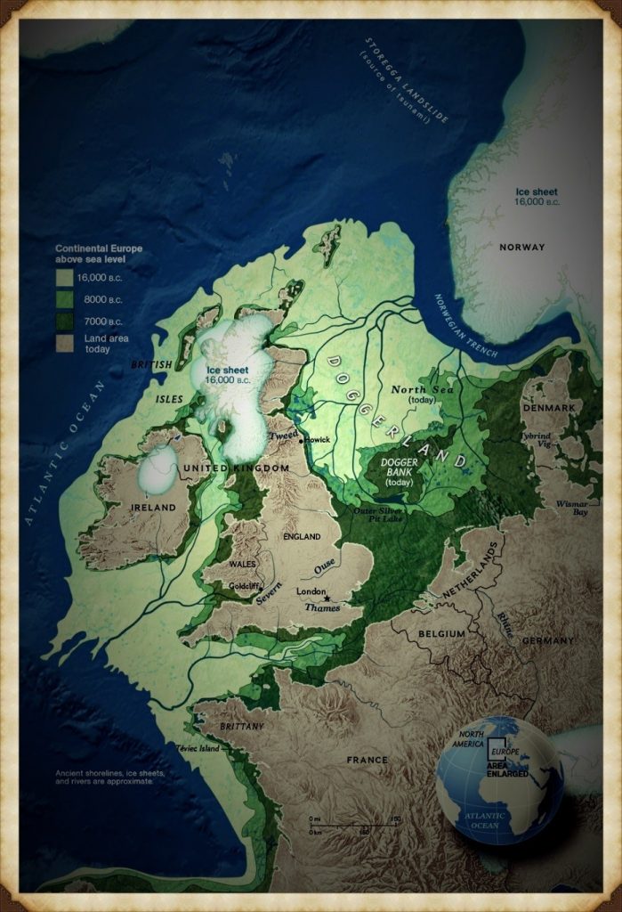
Today, we call it Doggerland.

During the Late Ice Age, Britain was connected to Europe by a vast plain crossed by rivers, lakes, forests and wetlands. This was not a small island. It was an entire country-sized landscape supporting human populations for thousands of years.

Then the climate changed.

The ice sheets melted.

Sea levels rose.

The land disappeared beneath the waves.

For centuries, such a drowned world would have been dismissed as fantasy.

Today, it is accepted in archaeology.

The existence of Doggerland alone demonstrates that Plato’s central premise – that large inhabited lands were lost beneath the sea – was not fantasy at all.

(Plato's Atlantis)
(Plato’s Atlantis)

3. The Great Flooding Event

Around 6200 BCE the Storegga tsunami and associated post-glacial flooding transformed the landscapes of north-west Europe.

Although flooding was not a single event, the combined effects of sea-level rise, coastal erosion and catastrophic inundation dramatically reduced the habitable land available to prehistoric populations.

The significance of this cannot be overstated.

An entire world disappeared.

Rivers vanished.

Coastlines moved.

Settlements were destroyed.

Migration became inevitable.

If a sophisticated maritime culture existed within Doggerland, it would have faced a simple choice:

Adapt, relocate or perish.

(Plato's Atlantis)
(Plato’s Atlantis)

4. Bouldnor Cliff Changes Everything

The discovery at Bouldnor Cliff is one of the most important archaeological finds ever made in Britain.

Dating to the seventh millennium BC, the site revealed evidence of advanced woodworking, boat use and long-distance connections.

Most remarkably, researchers recovered evidence of einkorn wheat.

This is not a trivial discovery.

Einkorn was not adopted in Britain for approximately another 3,000 years.

The presence of einkorn demonstrates contact with regions where the crop was already known and cultivated.

In other words, maritime connections already existed between Britain and distant communities long before conventional history would have us believe.

This single discovery destroys the notion that Mesolithic Britain was isolated from the wider world.

(Plato's Atlantis)
(Plato’s Atlantis)

5. Maritime Routes Create Ports

There is another implication that is rarely discussed.

Boats travelling between Britain and the Near East do not operate by magic.

They require food.

Fresh water.

Repairs.

Shelter.

Replacement crews.

Trade goods.

Every historical maritime network in history produced ports and anchorages.

The Phoenicians did it.

The Greeks did it.

The Romans did it.

The Vikings did it.

The Elizabethans did it.

There is no reason to imagine prehistoric sailors behaved differently.

Repeated voyages between the Atlantic and Anatolia would naturally create stopping points along the coasts of Iberia, southern France, Italy, Greece, and Egypt.

Over generations, these temporary anchorages would evolve into permanent trading communities.

Sailors would settle.

Families would form.

Local populations would mix.

Knowledge would spread.

This is how maritime civilisations have always operated.

(Plato's Atlantis)
(Plato’s Atlantis)

6. Plato’s Most Important Claim

Plato did not merely describe a lost civilisation.

He claimed that the survivors seeded both Egypt and Greece.

This is an astonishingly specific statement.

It creates a testable archaeological prediction.

If the account preserves genuine historical memory, then traces of unusual founder populations should appear in both Egypt and Greece during the period following the destruction of the Atlantic homeland.

Remarkably, that is exactly what the archaeology appears to reveal.

(Plato's Atlantis)
(Plato’s Atlantis)

7. Egypt: The First Foundation

The Egyptian evidence is striking.

The chronology reveals continuity rather than replacement.

EgyptGreece
Qarunian (7570–6200 BC)Aceramic Neolithic
Transitional Phase (6200–5550 BC)Early Neolithic
Early Faiyumian (5550–4650 BC)Nea Nikomedeia
Merimde (c.5000–4300 BC)Proto-Sesklo / Sesklo
Tasian (c.4500 BC onwards)Prodromos / Dimini

The populations associated with Merimde and the Tasian culture have been described as:

  • Long-headed.
  • Robust.
  • Physically distinct from many later Egyptians.
  • Generally taller than later predynastic populations.

Excavation reports also recorded individuals with sandy, ginger and even golden hair, leading archaeologists to suggest the existence of a fair strain within the population.

These are not modern interpretations.

They are observations recorded by the excavators themselves.

(Plato's Atlantis)
(Plato’s Atlantis)

8. Greece: The Second Foundation

The Greek evidence follows a remarkably similar pattern.

Early Neolithic populations appear on a timeline virtually identical to that of Egypt.

Sites such as Nea Nikomedeia, Sesklo and Prodromos represent some of the earliest organised communities in Europe.

Anthropological studies repeatedly describe Thessalian populations as predominantly long-headed.

At Prodromos, archaeologists discovered a remarkable cache of eleven human skulls deliberately placed beneath a house floor.

Dedicated anthropological investigations were conducted into these populations, exactly as occurred in Egypt.

The similarities are difficult to ignore.

EgyptGreece
Merimde long-headedThessalian populations described as long-headed
Tasian long-headedProdromos skull assemblage
Robust populationsFounder populations under anthropological study
Taller than later EgyptiansStature evidence incomplete
Fair-haired individualsEvidence currently absent
Continuity from earlier populationsContinuity from Early Neolithic founder settlements
(Plato's Atlantis)
(Plato’s Atlantis)

9. The Chronology Fits

When the chronology is compared directly, the pattern becomes even more remarkable.

DateNorth Sea / Atlantis ModelGreece
8000–7000 BCDoggerland extensiveMesolithic hunter-gatherers
7000–6500 BCPopulation displacement possibleEarliest Neolithic begins
6500–6000 BCLowland reductions continuingThessaly settlements expanding
6200–5500 BCTransitional phaseSesklo emerging
5500–5000 BCDoggerland fragmentedMajor Sesklo centre
5000–4500 BCSurvivor periodDimini and advanced settlements
4500–4000 BCMegalithic Structures EndIncreasing Aegean complexity
3500–3000 BCFarmers take over BritainCycladic maritime culture

The sequence is not proof.

But it is exactly the pattern we would expect if populations displaced from the Atlantic world contributed to later civilisations.

(Plato's Atlantis)
(Plato’s Atlantis)

10. The Allegory Has a Problem

The academic explanation has always been simple.

Atlantis was fictional.

The difficulty is that fictional stories are not supposed to generate accurate archaeological predictions.

Plato described:

  • A maritime civilisation.
  • An Atlantic homeland.
  • Catastrophic flooding.
  • A date close to the end of the Ice Age.
  • Survivors.
  • Egypt.
  • Greece.

Archaeology has now confirmed:

  • The drowned landscape.
  • The flooding.
  • The maritime networks.
  • Long-distance contacts.
  • Founder populations in Egypt.
  • Founder populations in Greece.

Nobody is claiming that every detail of Plato’s account has been proven.

What can no longer be maintained is the lazy assumption that the story was merely an allegory.

Two thousand four hundred years ago, Plato described a lost maritime world destroyed by rising seas whose survivors helped shape the civilisations that followed.

Today, archaeology is beginning to uncover evidence that such a world may have existed.

The greatest irony of all may be that the man historians dismissed as a storyteller was closer to the truth than the experts who spent a century insisting he was wrong.

(Plato's Atlantis)
(Plato’s Atlantis)

🌊 19 Reasons Why Doggerland Was Atlantis 🌊

The Atlantis Mystery Archaeology Doesn’t Want to Solve

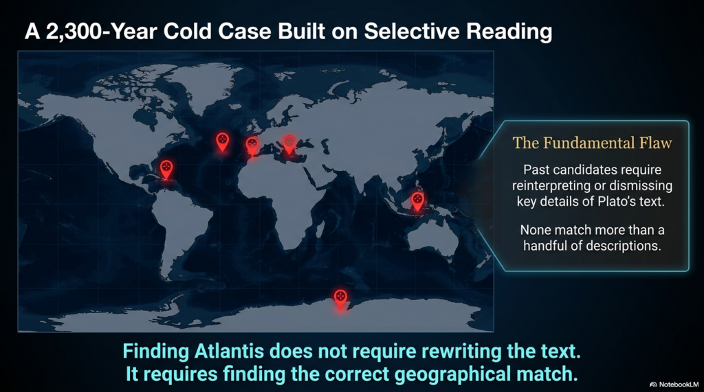
For over 2,300 years, people have searched for Atlantis.

They have looked in the Mediterranean, the Atlantic Ocean, Antarctica, the Caribbean, Spain, Morocco, the Azores, and even Indonesia.

Yet there is a problem.

None of these proposed locations matches more than a handful of Plato’s descriptions.

Most require selective reading, reinterpretation, or outright dismissal of key details.

Doggerland is different.

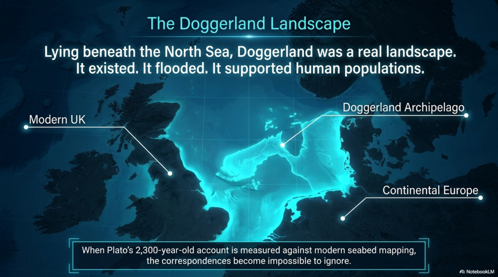
Lying beneath the North Sea between Britain and Europe, Doggerland was a real landscape. It existed. It flooded. It supported human populations. And remarkably, when Plato’s account is compared to measurable evidence, the number of correspondences becomes difficult to ignore.

Here are 19 reasons why Doggerland remains the strongest candidate for Atlantis ever identified.


1️⃣ A Large Island Beyond the Mediterranean

Plato describes a vast landmass beyond the familiar world of the Mediterranean.

Doggerland once connected Britain to continental Europe and formed one of the largest habitable landscapes in north-west Europe before it disappeared beneath the sea.


2️⃣ A Vast Central Plain

Plato gives dimensions of approximately 2,000 by 3,000 stadia.

When converted into modern measurements, this equates to roughly 370 by 550 kilometres.

The reconstructed Doggerland plateau measures approximately 375 by 560 kilometres.

Few Atlantis candidates come anywhere close.


3️⃣ Mountains to the North

Plato describes mountains surrounding the northern edge of the plain.

Scotland, Norway and Scandinavia form exactly such a northern mountainous boundary around the North Sea basin.


4️⃣ A Landscape Dominated by Water

Atlantis was described as a landscape of rivers, channels and waterways.

Doggerland was criss-crossed by major river systems, wetlands, lakes, estuaries and palaeochannels now mapped beneath the North Sea.


5️⃣ A Maritime Civilisation

Plato repeatedly emphasises ships and seafaring.

The Atlantic façade and North Sea region contain overwhelming evidence for water-based movement, trade and communication.


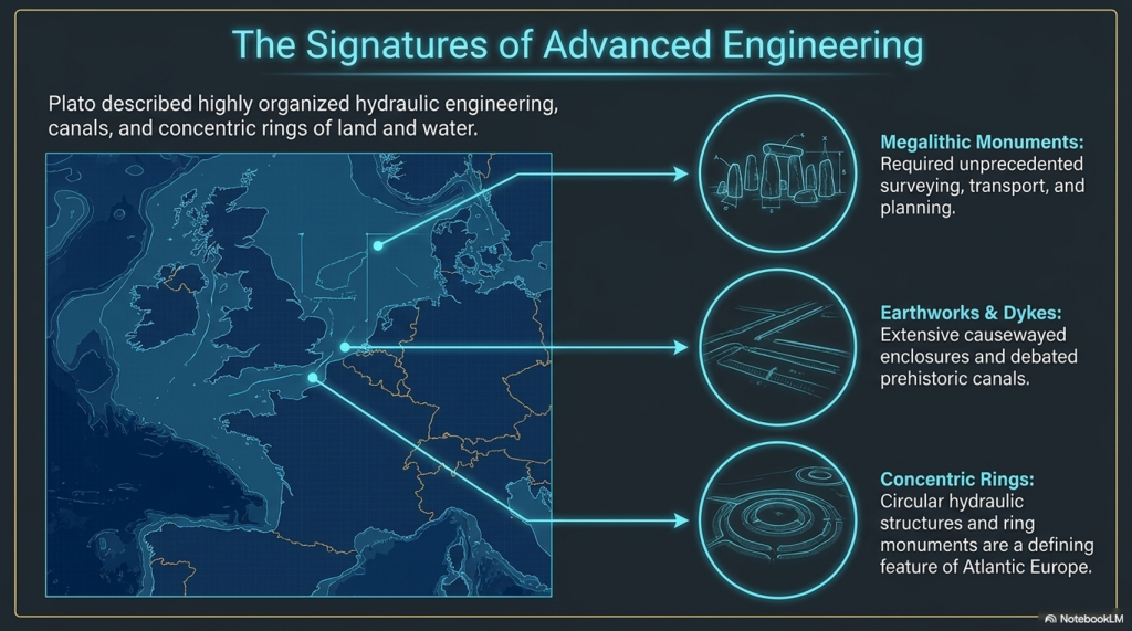
6️⃣ Large-Scale Hydraulic Engineering

Plato describes canals and water management on a huge scale.

Britain and north-west Europe preserve extensive dykes, canals, causewayed enclosures and engineered earthworks whose original purposes remain debated.


7️⃣ Concentric Rings of Land and Water

One of Atlantis’s most famous features.

Concentric enclosures, ring monuments and circular hydraulic structures occur throughout Atlantic Europe.


8️⃣ A Fertile Plain

Plato describes a rich agricultural landscape.

Pollen records, peat deposits and sediment analysis reveal that Doggerland supported extensive woodland, grassland and productive river valleys.


9️⃣ Marshes and Wetlands

Atlantis was rich in freshwater.

Geological reconstruction consistently shows Doggerland as a landscape dominated by lakes, marshes, rivers and elevated groundwater systems.


🔟 Elephants

Critics often dismiss this detail.

Yet elephant remains are not only known from Europe—they are known from Britain.

Elephant, mammoth and hippopotamus remains have all been recovered from Britain and the North Sea basin.


1️⃣1️⃣ Advanced Engineering

Plato describes a highly organised civilisation.

The megalithic monuments of north-west Europe required surveying, transport, planning and engineering on a remarkable scale.


1️⃣2️⃣ Large Fleets

Atlantis supposedly maintained a fleet of around 1,200 ships.

Whether the exact number is correct is irrelevant.

Any maritime civilisation operating at this scale would require sophisticated navigation and environmental prediction.


1️⃣3️⃣ Environmental Monitoring Systems

This is where Stonehenge becomes important.

Stonehenge Phase 1 appears to function as a predictive lunar and tidal system operating within a water-dominated landscape.

Such infrastructure would be essential to a maritime culture.


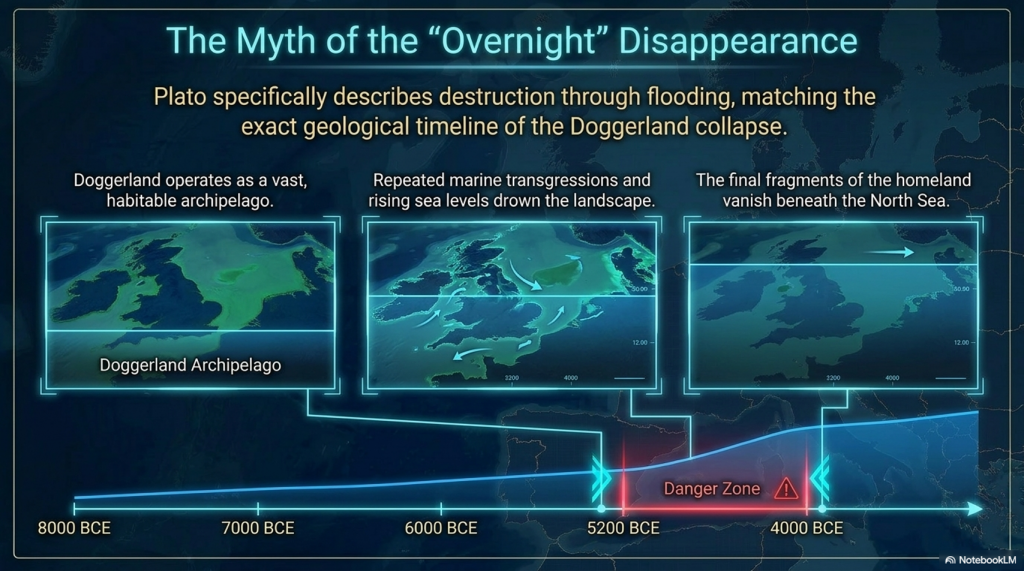
1️⃣4️⃣ Progressive Flooding

Plato does not describe Atlantis disappearing overnight.

He describes destruction through flooding.

Doggerland vanished over thousands of years through repeated marine transgressions and rising sea levels.


1️⃣5️⃣ The Loss of the Homeland

Eventually, only fragments remained.

Between approximately 5200 and 4200 BCE the final Doggerland archipelago disappeared beneath the North Sea.


1️⃣6️⃣ Population Dispersal

What happens when a homeland disappears?

People move.

The concentration of megalithic monuments across Britain, Ireland, Brittany, Denmark, and the Low Countries is consistent with populations relocating along the margins of the former basin.


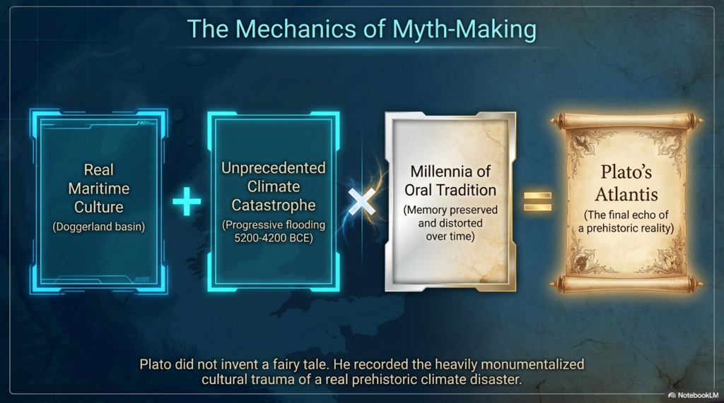
1️⃣7️⃣ Preservation of Memory

Civilisations remember disasters.

Stonehenge Phase 2 may represent the monumentalisation of that memory, transforming an earlier functional system into a permanent stone memorial.


1️⃣8️⃣ Physical Links to the Lost Land

Memory is often preserved through objects.

The Altar Stone may provide a physical connection between Stonehenge and the broader northern landscape associated with Doggerland.


1️⃣9️⃣ A Great Civilisation Remembered

Plato claimed Atlantis survived as a story long after the land itself disappeared.

If a maritime culture occupied Doggerland and its destruction became embedded within oral tradition, Plato’s account may preserve the final echo of a real prehistoric catastrophe.


The Real Question

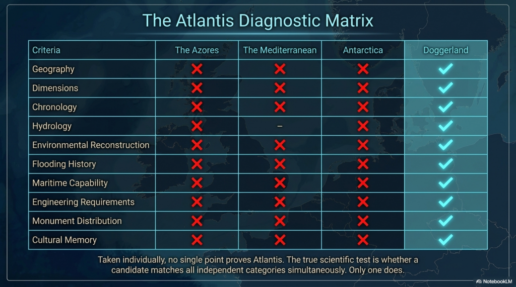
Taken individually, none of these points proves the existence of Atlantis.

But that is not the test.

The test is whether any other Atlantis candidate matches so many independent categories simultaneously.

✅ Geography

✅ Dimensions

✅ Chronology

✅ Hydrology

✅ Environmental reconstruction

✅ Flooding history

✅ Maritime capability

✅ Engineering requirements

✅ Monument distribution

✅ Cultural memory

Most Atlantis theories match one or two features.

Doggerland matches nearly all of them.

The question is no longer:

“Could Plato have described a flooded landscape?”

The evidence suggests he probably did.

The real question is:

What other known landscape matches Plato’s description better than Doggerland?

So far, nobody has produced one.


PODCAST

Author’s Biography

Robert John Langdon, a polymathic luminary, emerges as a writer, historian, and eminent specialist in LiDAR Landscape Archaeology.

His intellectual voyage has been interwoven with stints as an astute scrutineer in government and grand corporate bastions, a tapestry spanning British Telecommunications, Cable and Wireless, British Gas, and the esteemed University of London.

A decade hence, Robert’s transition into retirement unfurled a chapter of insatiable curiosity. This phase saw him immerse himself in Politics, Archaeology, Philosophy, and the enigmatic realm of Quantum Mechanics. His academic odyssey traversed the venerable corridors of knowledge hubs such as the Museum of London, University College London, Birkbeck College, The City Literature Institute, and Chichester University.

In the symphony of his life, Robert is a custodian of three progeny and a pair of cherished grandchildren. His sanctuary lies ensconced in the embrace of West Wales, where he inhabits an isolated cottage, its windows framing a vista of the boundless sea – a retreat from the scrutinising gaze of Her Majesty’s Revenue and Customs, an amiable clandestinity in the lap of nature.

Exploring Prehistoric Britain: A Journey Through Time

My blog delves into the fascinating mysteries of prehistoric Britain, challenging conventional narratives and offering fresh perspectives grounded in cutting-edge research, particularly LiDAR technology. I invite you to explore some key areas of my research. For example, the Wansdyke, often cited as a defensive structure, is re-examined in light of new evidence. I’ve presented my findings in my blog post Wansdyke: A British Frontier Wall – ‘Debunked’, and a Wansdyke LiDAR Flyover video further visualises my conclusions.

My work also often challenges established archaeological dogma. I argue that many sites, such as Hambledon Hill, commonly identified as Iron Age hillforts, are not what they seem. My posts Lidar Investigation Hambledon Hill – NOT an ‘Iron Age Fort’ and Unmasking the “Iron Age Hillfort” Myth explore these ideas in detail and offer an alternative view. Similarly, sites like Cissbury Ring and White Sheet Camp receive re-evaluations based on LiDAR analysis in my posts “Lidar Investigation Cissbury Ring through time” and “Lidar Investigation White Sheet Camp,“ revealing fascinating insights into their true purpose. I have also examined South Cadbury Castle, often linked to the mythical Camelot56.

My research also extends to ancient water management, including the role of canals and other linear earthworks. I have discussed the true origins of Car Dyke in multiple posts, including Car Dyke – ABC News Podcast and Lidar Investigation Car Dyke – North Section, which suggest a Mesolithic origin 2357. I also explore the misidentification of Roman aqueducts, as seen in my posts on the Great Chesters (Roman) Aqueduct. My research has also been greatly informed by my post-glacial flooding hypothesis, which has helped explain landscape transformations over time. I have discussed this hypothesis in several posts, including AI now supports my Post-Glacial Flooding Hypothesis and Exploring Britain’s Flooded Past: A Personal Journey

Finally, my blog also investigates prehistoric burial practices, as seen in Prehistoric Burial Practices of Britain and explores the mystery of Pillow Mounds, often mistaken for medieval rabbit warrens, but with a potential link to Bronze Age cremation in my posts: Pillow Mounds: A Bronze Age Legacy of Cremation? and The Mystery of Pillow Mounds: Are They Really Medieval Rabbit Warrens?. My research also includes astronomical insights into ancient sites, for example, in Rediscovering the Winter Solstice: The Original Winter Festival. I also review new information about the construction of Stonehenge in The Stonehenge Enigma.

Further Reading

For those interested in British Prehistory, visit www.prehistoric-britain.co.uk, a comprehensive resource featuring an extensive collection of archaeology articles, modern LiDAR investigations, and groundbreaking research. The site also includes insights and excerpts from the acclaimed Robert John Langdon Trilogy, a series of books that explore Britain during the Prehistoric period. Titles in the trilogy include The Stonehenge Enigma, Dawn of the Lost Civilisation, and The Post-Glacial Flooding Hypothesis, which offer compelling evidence of ancient landscapes shaped by post-glacial flooding.

To further explore these topics, Robert John Langdon has developed a dedicated YouTube channel featuring over 100 video documentaries and investigations that complement the trilogy. Notable discoveries and studies showcased on the channel include 13 Things that Don’t Make Sense in History and the revelation of Silbury Avenue – The Lost Stone Avenue, a rediscovered prehistoric feature at Avebury, Wiltshire.

In addition to his main works, Langdon has released a series of shorter, accessible publications, ideal for readers delving into specific topics. These include:

For active discussions and updates on the trilogy’s findings and recent LiDAR investigations, join our vibrant community on Facebook. Engage with like-minded enthusiasts by leaving a message or contributing to debates in our Facebook Group.

Whether through the books, the website, or interactive videos, we aim to provide a deeper understanding of Britain’s fascinating prehistoric past. We encourage you to explore these resources and uncover the mysteries of ancient landscapes through the lens of modern archaeology.

For more information, including chapter extracts and related publications, visit the Robert John Langdon Author Page. Dive into works such as The Stonehenge Enigma or Dawn of the Lost Civilisation, and explore cutting-edge theories that challenge traditional historical narratives.

Other Blogs

[sitemap_posts]
The Ascent of Man — From Survival to Systems

1. Humanity Before the Breakthrough

For most of human history, change was painfully slow. Early members of the genus Homo survived through hunting, gathering, and simple tool use, but across hundreds of thousands of years the archaeological record shows remarkable continuity rather than rapid advancement. Species such as Homo erectus and later populations associated with Homo heidelbergensis spread across Africa, Europe, and Asia, adapting to local conditions but leaving behind technologies that altered only gradually through time. (The Ascent of Man — From Survival to Systems)

The tools they produced were functional but repetitive. Stone forms persisted for immense periods with little structural innovation, and activity appears largely localised rather than coordinated across large regions. Human groups survived successfully, but there is little evidence of widespread standardisation, long-distance organisation, or shared operational systems. Humanity endured — but it did not yet accelerate.

The Ascent of Man — From Survival to Systems

2. The Ice Age World

The Late Pleistocene world was shaped by instability. Vast ice sheets covered northern Europe and North America, sea levels were dramatically lower, and habitable regions shifted constantly in response to climatic oscillations. Britain itself was periodically buried beneath ice or connected directly to mainland Europe through the lowland plains of Doggerland.

As climates fluctuated, populations were repeatedly compressed into environmental refuges. In North Africa and the Near East, expanding deserts restricted movement into narrow corridors such as the Nile Valley. During wetter periods, however, enormous territories reopened. Grasslands, rivers, and lakes spread across what is now the Sahara, creating migration routes that allowed human populations to disperse rapidly into Eurasia. Environmental change did not simply alter landscapes — it redirected humanity itself.


The Ascent of Man — From Survival to Systems

3. The Arrival of Modern Humans in Europe

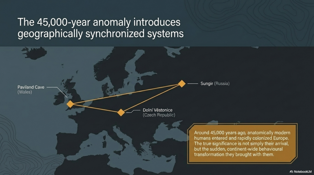
Around 45,000 years ago, anatomically modern humans entered Europe. These populations, later known as “Cro-Magnon,” spread rapidly across the continent, from France and Spain to Russia and Britain. Sites such as Paviland Cave in Wales, Sungir in Russia, and Dolní Věstonice in the Czech Republic reveal the presence of these early Europeans across an enormous geographical range.

What makes these populations important is not simply their anatomy, but the sudden transformation visible in the archaeological record associated with them. The Upper Palaeolithic does not merely continue earlier traditions — it behaves differently. Tool production becomes increasingly standardised, methods are repeated across regions, and material culture begins operating according to recognisable systems rather than isolated local practice.

The Ascent of Man — From Survival to Systems

4. The Upper Palaeolithic Revolution

For over two million years, human technology remained comparatively conservative. Then, within a relatively short archaeological window, a dramatic transition appears. Long, standardised blades replace crude variability. Bone, antler, and ivory are worked systematically into specialised tools. Production methods spread across enormous distances with remarkable consistency.

This is the real significance of the Upper Palaeolithic. Human behaviour becomes structured. Artefacts are no longer random outputs of survival, but components within organised systems of manufacture and use. The archaeological record suddenly begins displaying repetition, correction, standardisation, and coordination. Humanity was no longer simply adapting to the world — it was beginning to engineer solutions within it.

The Ascent of Man — From Survival to Systems

5. Art, Symbolism, and Shared Thought

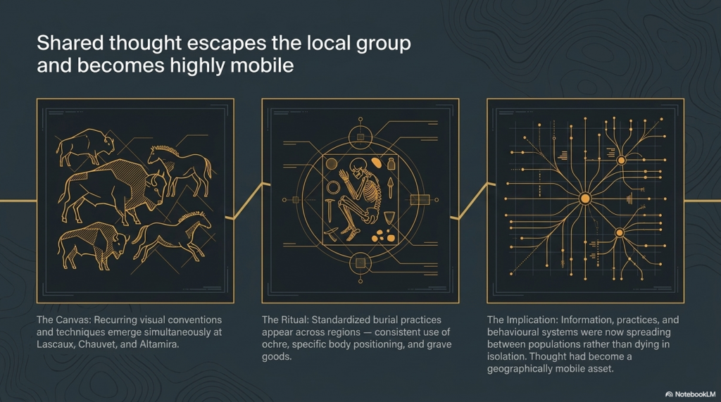
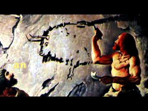
The same pattern appears in symbolic behaviour. Cave art emerges across Europe in locations such as Lascaux, Chauvet Cave, and Altamira Cave. These sites display recurring techniques, recurring animals, and repeated visual conventions separated by vast geographical distances.

Burial practices also become increasingly structured. Ochre use, grave goods, body positioning, and ceremonial treatment repeat across multiple regions. This consistency matters. It demonstrates that information, practices, and behavioural systems were now spreading between populations rather than remaining isolated within local groups. Shared thought had become geographically mobile.

The Ascent of Man — From Survival to Systems

6. Water, Mobility, and the Rise of Networks

As the Ice Age ended, rivers, wetlands, estuaries, and coastlines dominated much of Eurasia. In this environment, waterborne movement became increasingly important. Waterways were not obstacles — they were transport corridors. The emergence of maritime adaptation transformed the scale at which human populations could operate.

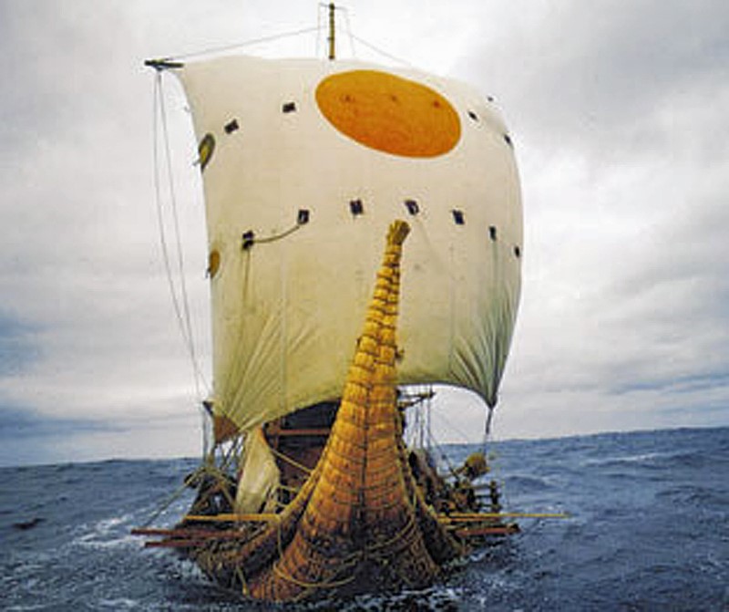
One of the clearest examples comes from Gobustan Rock Art Cultural Landscape near the Caspian Sea, where prehistoric engravings depict long boats carrying organised crews. These images suggest coordinated water transport thousands of years before formal civilisation emerged. Rivers and coastlines now linked populations together, accelerating trade, migration, and cultural exchange across enormous distances.

The Ascent of Man — From Survival to Systems

7. Physical Characteristics of Cro-Magnon Populations

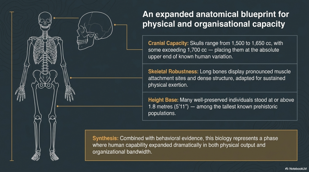
The skeletal evidence associated with Upper Palaeolithic Europeans reveals populations that were physically robust and highly active. Long bones display pronounced muscle attachment sites, dense structure, and adaptations consistent with sustained physical exertion. Many well-preserved individuals stood at or above 1.8 metres tall, placing them among the taller known prehistoric populations.

Cranial capacity is equally striking. Upper Palaeolithic skulls typically range from 1,500 to 1,650 cubic centimetres, with some exceeding 1,700 cc — placing them at the upper end of known human variation. While cranial volume alone does not determine intelligence, it remains a measurable anatomical distinction. Combined with the behavioural evidence, these populations represent a phase in which human capability appears to expand dramatically in both physical and organisational terms.

The Ascent of Man — From Survival to Systems

8. Genetics, Mixture, and Human Continuity

Modern genetic evidence confirms that these populations were not isolated species, but part of the wider Homo sapiens lineage. Ancient DNA studies show continuity between Upper Palaeolithic Europeans and later populations, alongside evidence of admixture with Neanderthals. Modern non-African populations still retain approximately 1–4% Neanderthal DNA.

At the same time, the genetic record reveals that human history was not a simple replacement process. Populations mixed, migrated, adapted, and survived through complex interactions across Eurasia. Studies such as Caramelli et al. (2008) even identified mitochondrial lineages from Upper Palaeolithic Europeans that are still present in modern populations. The evidence increasingly points toward continuity combined with transformation rather than disappearance and replacement.


The Ascent of Man — From Survival to Systems

9. The Disappearance of the Cro-Magnon Label

Despite its historical importance, the term “Cro-Magnon” has largely disappeared from formal anthropology. Modern classification groups these populations into the broader category of Homo sapiens, emphasising shared ancestry rather than distinct regional populations. Scientifically, this creates consistency — but it also reduces resolution.

The archaeological patterns associated with Cro-Magnon populations remain visible regardless of terminology. Standardised industries, structured behaviour, symbolic repetition, maritime adaptation, and large-scale coordination all still exist within the record. What has changed is not the evidence itself, but the framework used to describe it. The question is therefore not whether Cro-Magnon was a separate species, but whether current models fully explain the scale of behavioural change associated with these populations.

The Ascent of Man — From Survival to Systems

10. The Turning Point of Humanity

This is the real problem posed by the Upper Palaeolithic.

For millions of years, humans survived in relatively small groups using localised technologies that changed only slowly. Then, within a comparatively brief period, behaviour transformed. Systems emerged. Production became standardised. Activity spread across entire continents according to shared methods and repeatable structures.

Everything that follows in human history depends on this transition.

The principles first visible in the Upper Palaeolithic — coordination, measurement, repetition, mobility, and structured behaviour — are the same principles that later underpin agriculture, trade, engineering, navigation, mathematics, and eventually civilisation itself. Without this shift, humanity remains a species surviving within nature rather than organising it.

The great question is therefore not whether this transformation occurred, because the archaeological record clearly shows that it did.

The real question is:

How did humanity go from isolated survival… to organised systems capable of reshaping the world? And did these people build the Megalithic structures that have lasted ten thousand years and thrown archaeology into confusion by not recognising an advanced Lost Civilisation at the Dawn of Humanity?

PODCAST

Author’s Biography

Robert John Langdon, a polymathic luminary, emerges as a writer, historian, and eminent specialist in LiDAR Landscape Archaeology.

His intellectual voyage has been interwoven with stints as an astute scrutineer in government and grand corporate bastions, a tapestry spanning British Telecommunications, Cable and Wireless, British Gas, and the esteemed University of London.

A decade hence, Robert’s transition into retirement unfurled a chapter of insatiable curiosity. This phase saw him immerse himself in Politics, Archaeology, Philosophy, and the enigmatic realm of Quantum Mechanics. His academic odyssey traversed the venerable corridors of knowledge hubs such as the Museum of London, University College London, Birkbeck College, The City Literature Institute, and Chichester University.

In the symphony of his life, Robert is a custodian of three progeny and a pair of cherished grandchildren. His sanctuary lies ensconced in the embrace of West Wales, where he inhabits an isolated cottage, its windows framing a vista of the boundless sea – a retreat from the scrutinising gaze of Her Majesty’s Revenue and Customs, an amiable clandestinity in the lap of nature.

Exploring Prehistoric Britain: A Journey Through Time

My blog delves into the fascinating mysteries of prehistoric Britain, challenging conventional narratives and offering fresh perspectives grounded in cutting-edge research, particularly LiDAR technology. I invite you to explore some key areas of my research. For example, the Wansdyke, often cited as a defensive structure, is re-examined in light of new evidence. I’ve presented my findings in my blog post Wansdyke: A British Frontier Wall – ‘Debunked’, and a Wansdyke LiDAR Flyover video further visualises my conclusions.

My work also often challenges established archaeological dogma. I argue that many sites, such as Hambledon Hill, commonly identified as Iron Age hillforts, are not what they seem. My posts Lidar Investigation Hambledon Hill – NOT an ‘Iron Age Fort’ and Unmasking the “Iron Age Hillfort” Myth explore these ideas in detail and offer an alternative view. Similarly, sites like Cissbury Ring and White Sheet Camp receive re-evaluations based on LiDAR analysis in my posts “Lidar Investigation Cissbury Ring through time” and “Lidar Investigation White Sheet Camp,“ revealing fascinating insights into their true purpose. I have also examined South Cadbury Castle, often linked to the mythical Camelot56.

My research also extends to ancient water management, including the role of canals and other linear earthworks. I have discussed the true origins of Car Dyke in multiple posts, including Car Dyke – ABC News Podcast and Lidar Investigation Car Dyke – North Section, which suggest a Mesolithic origin 2357. I also explore the misidentification of Roman aqueducts, as seen in my posts on the Great Chesters (Roman) Aqueduct. My research has also been greatly informed by my post-glacial flooding hypothesis, which has helped explain landscape transformations over time. I have discussed this hypothesis in several posts, including AI now supports my Post-Glacial Flooding Hypothesis and Exploring Britain’s Flooded Past: A Personal Journey

Finally, my blog also investigates prehistoric burial practices, as seen in Prehistoric Burial Practices of Britain and explores the mystery of Pillow Mounds, often mistaken for medieval rabbit warrens, but with a potential link to Bronze Age cremation in my posts: Pillow Mounds: A Bronze Age Legacy of Cremation? and The Mystery of Pillow Mounds: Are They Really Medieval Rabbit Warrens?. My research also includes astronomical insights into ancient sites, for example, in Rediscovering the Winter Solstice: The Original Winter Festival. I also review new information about the construction of Stonehenge in The Stonehenge Enigma.

Further Reading

For those interested in British Prehistory, visit www.prehistoric-britain.co.uk, a comprehensive resource featuring an extensive collection of archaeology articles, modern LiDAR investigations, and groundbreaking research. The site also includes insights and excerpts from the acclaimed Robert John Langdon Trilogy, a series of books that explore Britain during the Prehistoric period. Titles in the trilogy include The Stonehenge Enigma, Dawn of the Lost Civilisation, and The Post-Glacial Flooding Hypothesis, which offer compelling evidence of ancient landscapes shaped by post-glacial flooding.

To further explore these topics, Robert John Langdon has developed a dedicated YouTube channel featuring over 100 video documentaries and investigations that complement the trilogy. Notable discoveries and studies showcased on the channel include 13 Things that Don’t Make Sense in History and the revelation of Silbury Avenue – The Lost Stone Avenue, a rediscovered prehistoric feature at Avebury, Wiltshire.

In addition to his main works, Langdon has released a series of shorter, accessible publications, ideal for readers delving into specific topics. These include:

For active discussions and updates on the trilogy’s findings and recent LiDAR investigations, join our vibrant community on Facebook. Engage with like-minded enthusiasts by leaving a message or contributing to debates in our Facebook Group.

Whether through the books, the website, or interactive videos, we aim to provide a deeper understanding of Britain’s fascinating prehistoric past. We encourage you to explore these resources and uncover the mysteries of ancient landscapes through the lens of modern archaeology.

For more information, including chapter extracts and related publications, visit the Robert John Langdon Author Page. Dive into works such as The Stonehenge Enigma or Dawn of the Lost Civilisation, and explore cutting-edge theories that challenge traditional historical narratives.

Other Blogs

[sitemap_posts]
The Stone Money – Credit System

Introduction — The Economic System No One Is Looking For

What if the biggest mistake in archaeology is not what it believes… but what it refuses to consider?

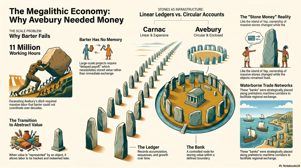
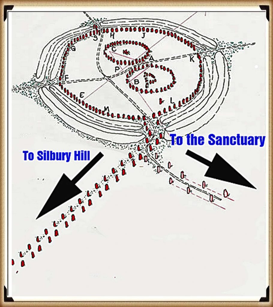
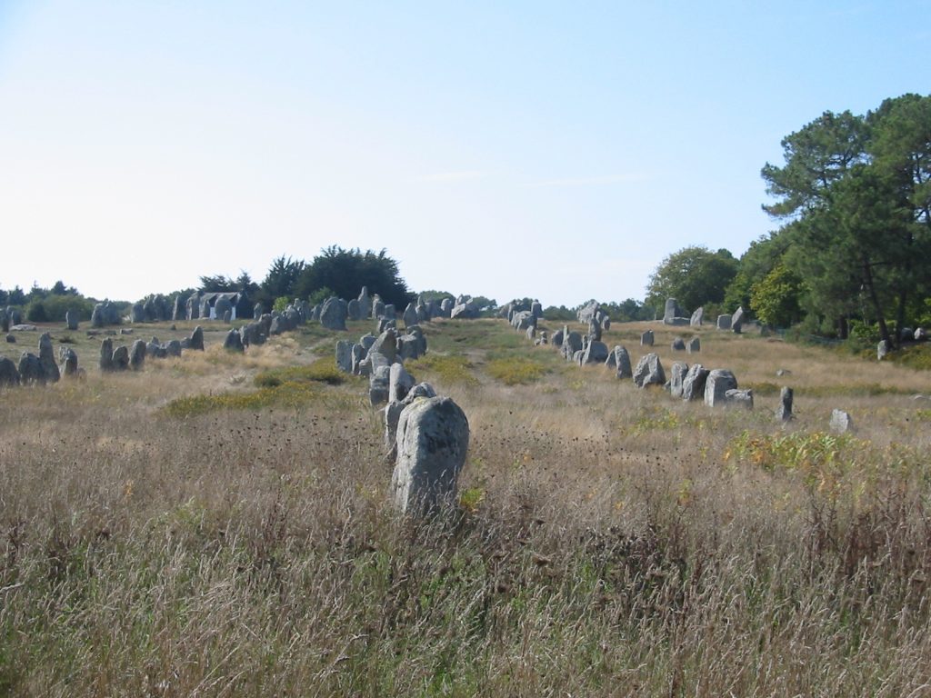
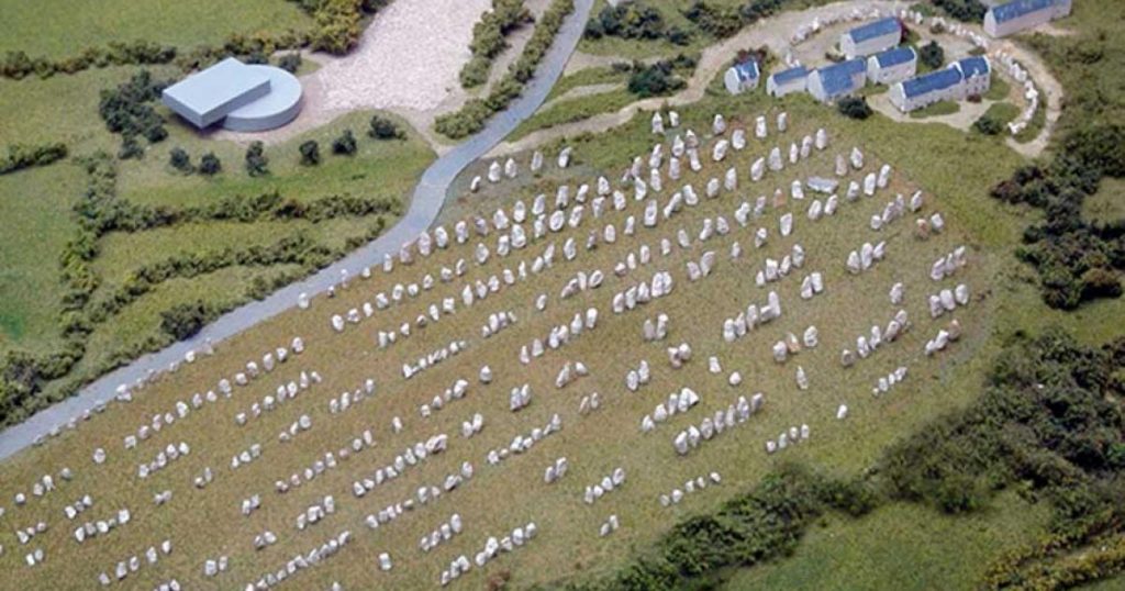
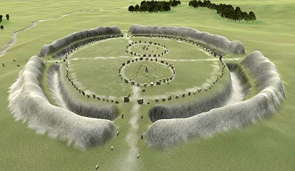
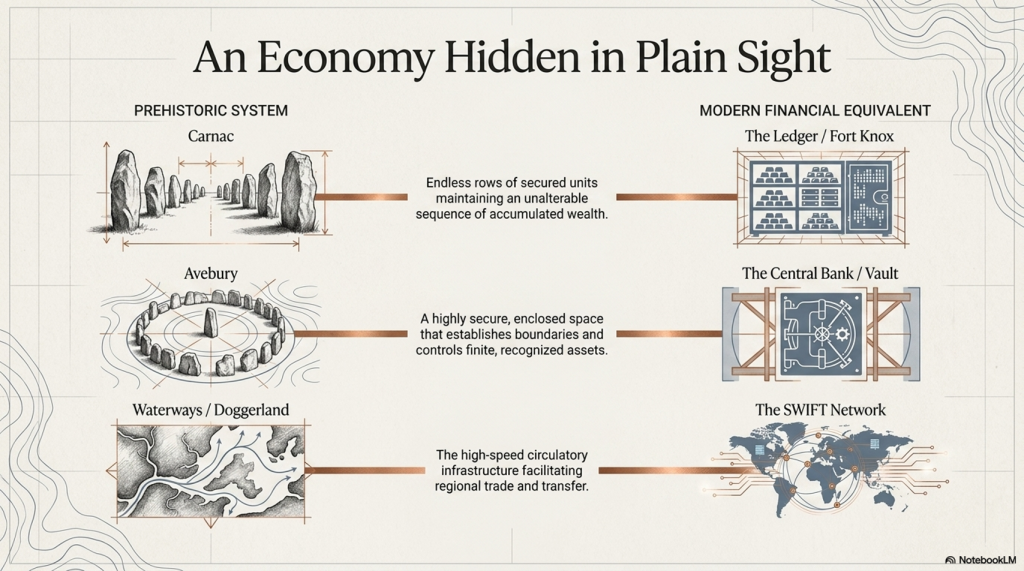
Across Britain and Western Europe, we find some of the largest construction projects ever undertaken by prehistoric societies. Sites like Avebury, with its vast ditch, towering stones, and monumental scale, required tens of millions of hours of coordinated labour. Further south, along the Atlantic façade, the immense stone fields of Carnac stones stretch for miles—thousands of stones arranged in deliberate, ordered sequences, on a scale that dwarfs anything found in Britain. (The Stone Money – Credit System)

And yet, for all this effort, one fundamental question is never asked:

What economic system made this possible?

 (The Stone Money - Credit System)
(The Stone Money – Credit System)

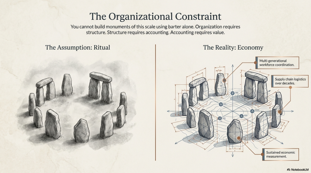
Instead, we are told these monuments are “ritual,” “ceremonial,” or “symbolic.” Words that describe—but do not explain. Because none of these interpretations addresses the single constraint that governs all large-scale human activity:

👉 Organisation requires structure.
👉 Structure requires accounting.
👉 Accounting requires value.

You cannot build monuments of this scale using barter alone. You cannot sustain a workforce of hundreds—let alone thousands—over decades without a system that stores, transfers, and measures value over time.

In other words:

You cannot build Avebury without money.

This blog explores a simple but deeply uncomfortable idea:

👉 The great stone monuments of prehistoric Europe were not just cultural or symbolic structures, but part of an economic system.

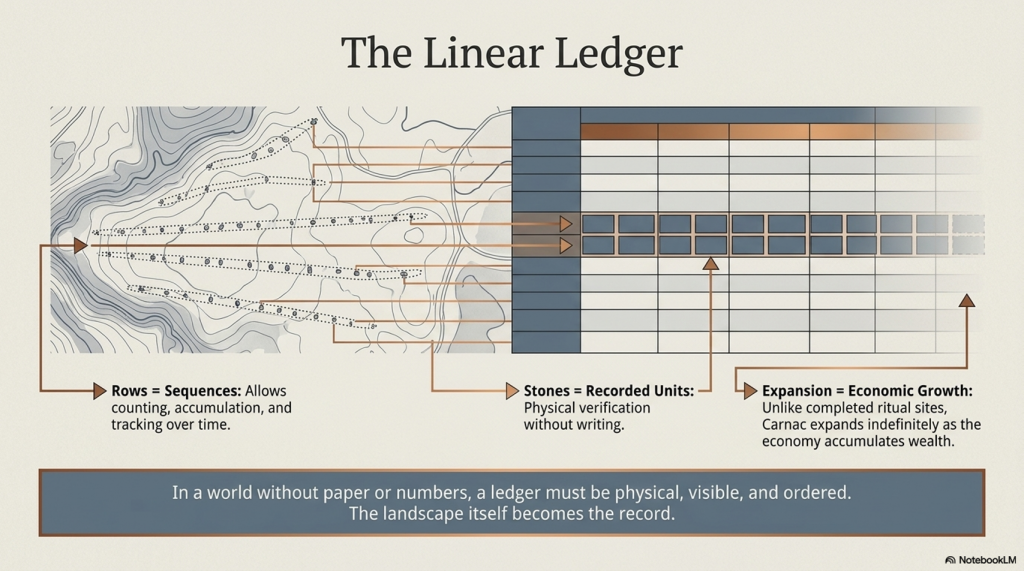
A system where value was not written on paper or struck in metal—but embedded in the landscape itself.

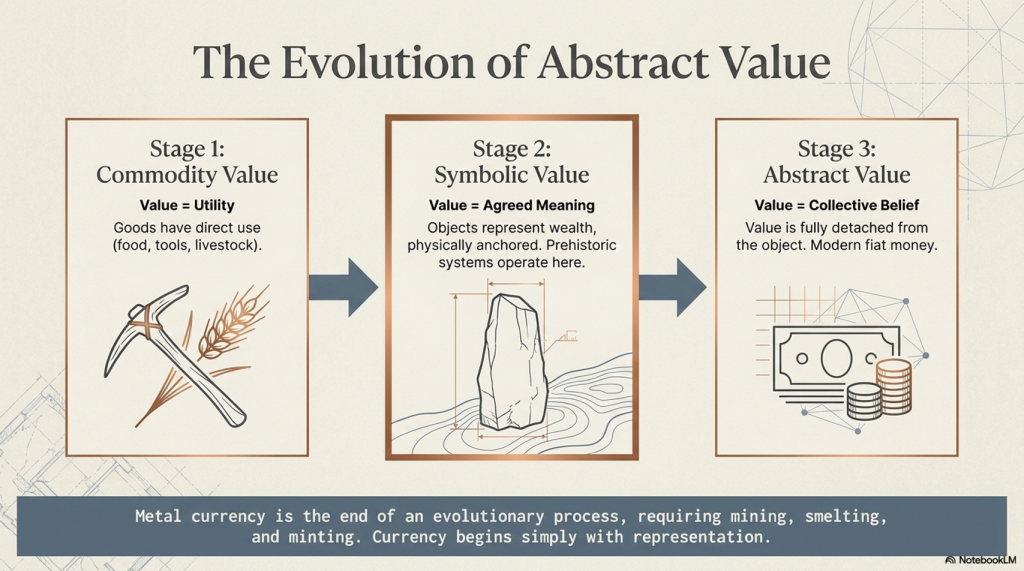
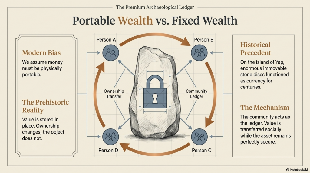
At first glance, the idea seems counterintuitive. Stone does not resemble currency—until you realise that modern money has no intrinsic value either. Its power comes from shared belief, collective recognition, and controlled scarcity. The same principles that underpin every functioning currency system today.

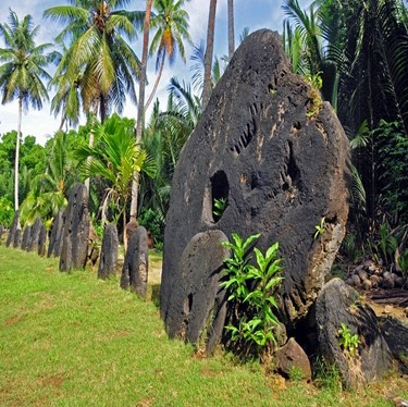
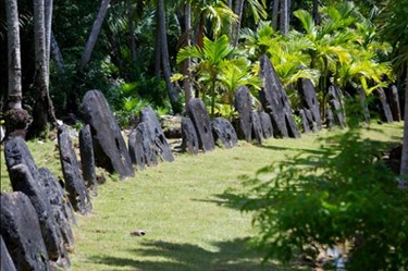
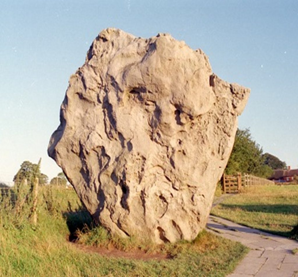
And crucially, we already know this type of system can exist. On the island of Yap, enormous stone discs functioned as currency for centuries—immovable, symbolic, and collectively understood. Ownership changed, but the stones themselves did not move.

So the question is no longer whether stone can function as money.

 (The Stone Money - Credit System)
(The Stone Money – Credit System)

The question is:

👉 What happens when we apply that understanding to the prehistoric world?

Because when we do, something remarkable occurs.

Avebury stops looking like a ritual site.

Carnac stops looking like an anomaly.

And instead, both begin to resolve into something far more coherent:

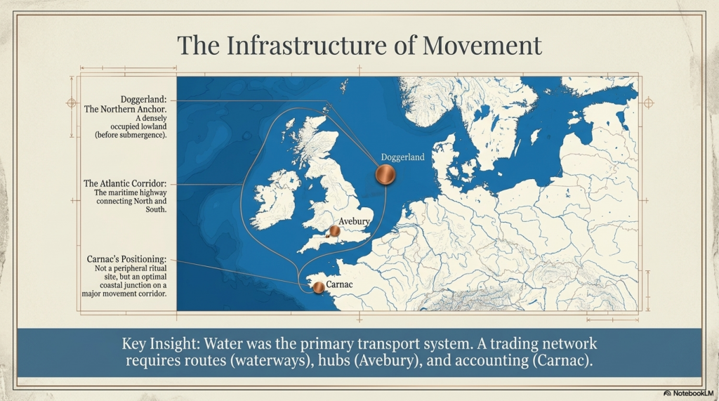
👉 A connected system of value, operating across a prehistoric trading network that once linked the Atlantic world—from Doggerland to the Mediterranean.

This is not speculation layered onto mystery.

It is a shift in perspective—from symbolism to function.

And once that shift is made, the stones stop being silent.

They start behaving like infrastructure.

 (The Stone Money - Credit System)
(The Stone Money – Credit System)

2. The Scale Problem — Why Barter Fails

Before we decide what the stones represent, we need to establish something far more fundamental:

👉 What kind of system is required to build monuments at this scale?

Because once that constraint is defined, most existing explanations collapse immediately.


The Physical Reality of Construction

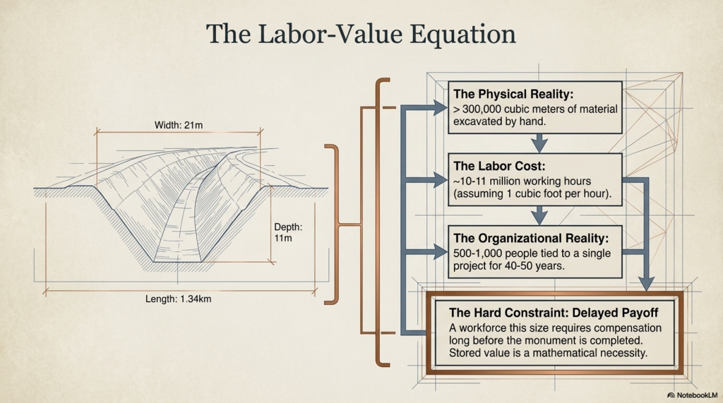
Take Avebury as a baseline.

  • Ditch: ~1.34 km long
  • Width: ~21 metres
  • Depth: ~11 metres

That is over 300,000 cubic metres of material excavated by hand.

Even using conservative assumptions:

  • 1 cubic foot per hour per worker
  • Continuous labour across seasons

You are looking at:

👉 ~10–11 million working hours

Which immediately raises a non-negotiable requirement:

👉 This is not a small, local effort
👉 This is a multi-generational, organised workforce

And that’s just the ditch.

It does not include:

  • Quarrying and transporting megaliths
  • Erecting stones weighing tens of tonnes
  • Feeding, housing, and supplying the workforce
  • Maintaining continuity over decades

The Organisational Constraint

At even a modest scale:

  • 200 workers digging
  • 200 supporting (food, tools, logistics)
  • Additional labour for stone movement

You are already dealing with:

👉 500–1000 people tied into a single long-term project

Now extend that over:

👉 40–50 years

This is not seasonal cooperation.

This is:

👉 sustained economic coordination


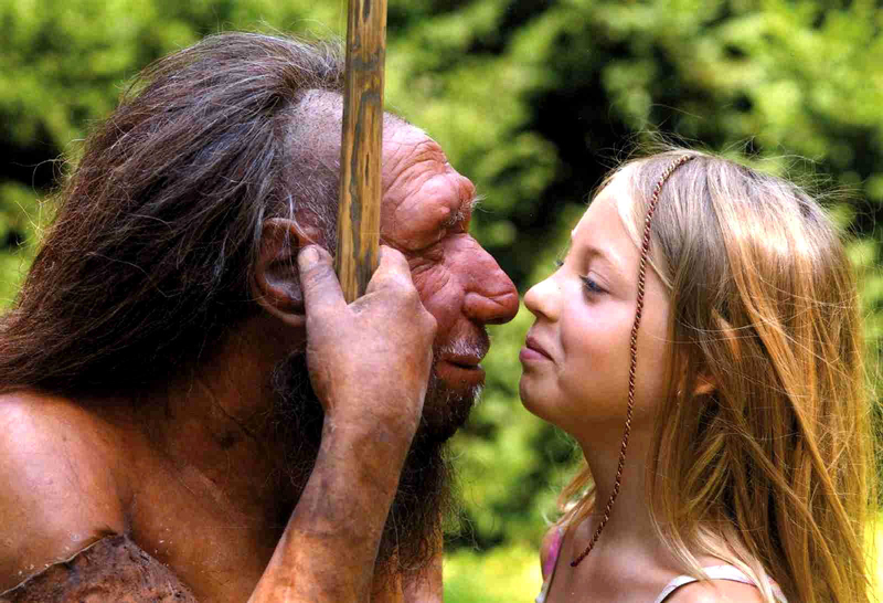
Giants of Prehistory: Cro-Magnon
(The Stone Money – Credit System)

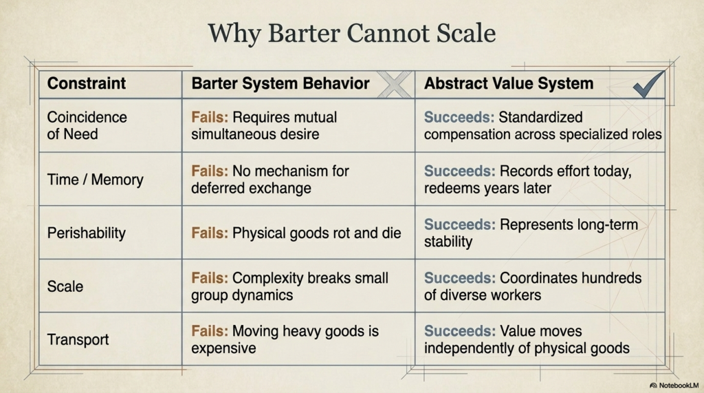
Why Barter Cannot Work at This Scale

Barter systems function under very specific conditions:

  • Small groups
  • Immediate exchange
  • Short timeframes
  • Low complexity

They fail when you introduce:

  • Delayed reward
  • Large workforce coordination
  • Multi-year commitments

Because barter has a fatal limitation:

👉 It requires coincidence of need

If one worker digs a ditch today, what do they receive?

  • Food? From whom?
  • Tools? When?
  • Shelter? For how long?

And more importantly:

👉 How is that value tracked over decades?

Barter has no memory.

It cannot store obligations.
It cannot scale across time.
It cannot coordinate hundreds of people toward a single goal.


The Time Problem — Labour Without Immediate Return

Large construction introduces a second constraint:

👉 Delayed payoff

The monument is not “used” until it is complete.

So the system must allow:

  • Work now
  • Reward later

Which requires:

👉 stored value

Not goods. Not promises.

But something that can:

  • represent labour
  • persist over time
  • be recognised by the entire community

The Inevitable Conclusion

Once you define the problem correctly, the solution is no longer optional.

To build monuments like Avebury, a society must have:

👉 A system that records value
👉 A system that transfers value
👉 A system that stores value across time

In other words:

👉 A currency system

Not necessarily coins.
Not necessarily metal.

But something that performs the same function.


Extending the Problem Beyond Britain

Now expand the scale.

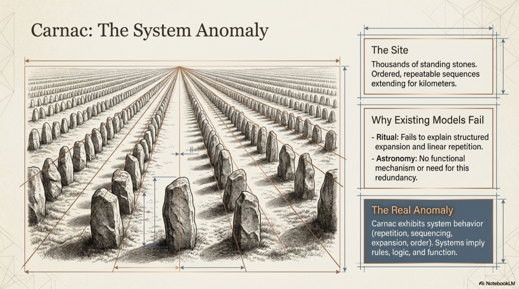
Sites like Carnac stones contain:

  • Thousands of stones
  • Arranged in ordered, repeatable sequences
  • Extending across kilometres of landscape

This is not just construction.

This is:

👉 systematic expansion over time

Which implies:

  • continuity
  • accounting
  • accumulation

And again, the same constraint applies:

👉 Barter cannot produce this.


 (The Stone Money - Credit System)
(The Stone Money – Credit System)

3. The Failure of Barter Systems — Why Value Must Become Abstract

If barter cannot scale to build monuments, then the next step is obvious:

👉 Why exactly does it fail?

Because once that is understood in detail, the transition to a currency system stops being theoretical—and becomes inevitable.


The Coincidence Problem — The First Structural Failure

Barter depends on one fragile condition:

👉 Both parties must want what the other has, at the same time

This works in small, immediate exchanges:

  • Fish for grain
  • Tools for meat

But now apply that to a workforce building something like Avebury:

A digger works all day excavating chalk.

What do they receive?

  • Food? From whom specifically?
  • Clothing? At what interval?
  • Tools? In exchange for what exact quantity of labour?

Now multiply that across hundreds of workers.

👉 The system collapses instantly.

Because there is no mechanism to align:

  • labour
  • need
  • timing

Barter cannot coordinate complexity.


The Time Problem — Barter Has No Memory

Barter only works in the present.

It cannot do this:

  • Record effort today
  • Redeem value weeks, months, or years later

But monument construction introduces a hard constraint:

👉 Labour must be rewarded long after it is performed

If someone contributes:

  • 10 days of labour
  • 100 days of labour
  • 10 years of labour

Where is that value stored?

Without storage, the system breaks.

Because:

👉 Work without delayed compensation is unsustainable

And barter has no mechanism for:

  • accumulation
  • tracking
  • deferred exchange

 (The Stone Money - Credit System)
(The Stone Money – Credit System)

The Perishability Problem — Goods Cannot Store Value

Barter relies on real goods.

But real goods decay.

  • Food rots
  • Materials degrade
  • Livestock die

So even if value is exchanged, it cannot be preserved.

Which creates a contradiction:

👉 Large projects require long-term value stability
👉 Barter only provides short-term value exchange

This is not a minor inefficiency.

It is a structural impossibility.


The Scaling Problem — Complexity Breaks the System

Barter works in:

  • small groups
  • simple exchanges
  • short timeframes

It fails when you introduce:

  • large populations
  • specialised roles
  • long-term coordination

Now consider:

  • quarry workers
  • transport teams
  • tool makers
  • food producers
  • organisers

Each group contributes differently.

Each requires compensation differently.

Barter has no way to:

👉 standardise value across roles

Without standardisation:

👉 coordination fails

 (The Stone Money - Credit System)
(The Stone Money – Credit System)

The Transport Problem — Value Must Move Without Goods

Now introduce trade.

Not local exchange—but regional movement.

Between sites like:

  • Avebury
  • Carnac stones

Goods are heavy.
Transport is expensive.
Distance introduces risk.

So a new requirement appears:

👉 Value must move independently of physical goods

Barter cannot do this.

Because barter is the goods.


The Critical Transition — From Goods to Representation

Once all these constraints are applied, a transition becomes unavoidable.

Value must:

  • exist independently of goods
  • be stored over time
  • be recognised by a community
  • be transferable without physical exchange

This is the moment where:

👉 value becomes abstract

Not imaginary—but represented


What “Abstract Value” Actually Means

This is often misunderstood.

Abstract value does not mean:

  • symbolic in a vague sense
  • decorative
  • ritual

It means:

👉 A physical object represents something else

Labour
Ownership
Obligation
Debt

The object is not the value.

👉 It records the value.


The Inevitable Outcome

Once a society reaches:

  • large-scale construction
  • long-term coordination
  • regional trade

It must develop:

👉 a system of representation

Because nothing else satisfies all constraints simultaneously.


Where This Leads Next

At this point, we have not identified the system.

But we have defined exactly what it must do.

So the next question becomes:

👉 What form could such a system take in a prehistoric world?

No writing.
No coinage.
No formal accounting.

And yet—

👉 The same functional requirements still exist.

 (The Stone Money - Credit System)
(The Stone Money – Credit System)

4. Currency Before Metal — The Logical Evolution of Value Systems

Once barter fails, a society does not suddenly invent coins.

That’s a modern assumption—and it’s wrong.

Currency does not begin with metal.

👉 It begins with representation


Breaking the Modern Bias

We instinctively associate money with:

  • coins
  • precious metals
  • minted value

But this is the end of a long evolutionary process—not the beginning.

Because metal currency requires:

  • mining infrastructure
  • smelting technology
  • standardised production
  • controlled distribution

None of which is necessary for a functioning value system.

So the real question is not:

👉 “Where are the coins?”

But:

👉 “What did they use before coins were possible?”


The Three Stages of Value

All economic systems follow the same progression:

1. Commodity Value

  • Goods have direct use
  • Food, tools, livestock

👉 Value = utility


2. Symbolic Value

  • Objects represent wealth
  • Rare, durable, recognisable

👉 Value = agreed meaning


3. Abstract Value

  • Value becomes detached from the object
  • Trust replaces utility

👉 Value = collective belief


Modern money sits at Stage 3.

But prehistoric systems operate in Stage 2:

👉 Symbolic, but physically anchored


 (The Stone Money - Credit System)
(The Stone Money – Credit System)

What Makes Something “Money”?

To function as currency, an object must satisfy four conditions:

  1. Recognisable — everyone knows what it represents
  2. Durable — it survives over time
  3. Difficult to replicate — prevents inflation
  4. Socially agreed — value is collectively accepted

Notice what is not required:

  • portability (large-scale systems don’t need it)
  • intrinsic value (gold is only valuable because we agree it is)

The Critical Insight — Value Is Not Real

This is the point most people resist.

A modern banknote:

  • is paper
  • has no intrinsic worth

Yet it can represent:

👉 a house
👉 a year of labour
👉 an entire business

Why?

👉 Because value is assigned—not inherent

This is known as:

👉 perceived value

And once you accept that—

The leap to prehistoric systems becomes straightforward.


Why Stone Fits the Model Perfectly

Now apply the four conditions:

  • Recognisable → large, visible, impossible to ignore
  • Durable → survives generations
  • Difficult to replicate → requires labour, transport, coordination
  • Socially agreed → embedded within a shared landscape

Stone is not a poor substitute for currency.

👉 It is an ideal early form of it.


Reframing the Question

Instead of asking:

👉 “Why build with stone?”

We should be asking:

👉 “What if stone was the system?”

Because once value becomes:

  • fixed
  • visible
  • communal

It no longer needs to be carried.


From Portable Wealth to Fixed Wealth

Modern systems emphasise portability:

  • coins
  • notes
  • digital transfers

But early systems prioritise:

👉 stability and verification

Which leads to a different model:

  • value is stored in place
  • ownership changes, not the object
  • community acts as the ledger

This is not primitive.

👉 It is structurally efficient at scale.


Extending the Logic to Monumental Landscapes

Now return to sites like:

  • Avebury
  • Carnac stones

Ask a different question:

👉 Why are the stones:

  • massive
  • permanent
  • publicly visible
  • arranged in ordered systems

These are not decorative choices.

They are exactly what you would expect from:

👉 a system designed to represent and stabilise value

 (The Stone Money - Credit System)
(The Stone Money – Credit System)

5. The Yap System — Proof That Stone Can Be Money

At this point, a natural objection appears:

👉 “This all sounds logical—but has any society ever actually used stone as currency?”

The answer is not hypothetical.

👉 Yes. They have.

And not in small tokens—but in massive, immovable stones.


Yap — A Working Stone Currency System

On the Pacific island of Yap, a fully functioning economic system developed using what are known as rai stones:

  • Large, carved stone discs
  • Some over 3–4 metres in diameter
  • Weighing several tonnes

These were not symbolic ornaments.

👉 They were currency.


How the System Actually Worked

The key features of the Yap system are critical—because they directly mirror what we are trying to explain.

1. The Stones Do Not Move

Rai stones are typically:

  • placed in prominent locations
  • left in situ for generations

When ownership changes:

👉 The stone stays where it is

Only the ownership changes.


2. Ownership Is Socially Recorded

There are no written ledgers.

Instead:

👉 The community collectively knows:

  • who owns each stone
  • its history
  • the transactions associated with it

This creates a distributed system of verification.

👉 The people are the ledger.


 (The Stone Money - Credit System)
(The Stone Money – Credit System)

3. Value Is Not Just Size — It Is History

A stone’s value depends on:

  • how large it is
  • where it came from
  • how difficult it was to transport
  • who previously owned it

For example:

👉 A smaller stone with a dangerous or prestigious history
can be worth more than a larger, easily obtained one.


4. Effort Creates Value

To acquire these stones:

  • expeditions travelled long distances
  • stones were quarried on foreign islands
  • transported by raft across open ocean

Many expeditions failed.

Some people died.

👉 That risk and effort are what give the stone value.


The Critical Point

This system satisfies every requirement we defined earlier:

  • Recognisable → publicly visible stones
  • Durable → last for centuries
  • Difficult to replicate → high effort and risk
  • Socially agreed → community recognition

And crucially:

👉 Value is completely detached from utility

The stones are not tools.
They are not consumed.
They are not moved.

👉 They exist purely to represent value


The Most Important Insight — Movement Is Not Required

This is where modern thinking breaks down.

We assume money must:

  • be portable
  • be exchanged physically

But the Yap system proves otherwise:

👉 Ownership can move without the object moving

This is not primitive.

It is extremely efficient.

Because:

  • the object cannot be lost
  • it cannot be stolen easily
  • it cannot be counterfeited

Scaling the Concept

Now step back and think carefully.

If a small island society can operate:

👉 a fully functional economy
👉 using large, immovable stones
👉 with no written system

Then the idea that prehistoric Europe could do the same is no longer radical.

👉 It is expected under the same constraints


Bridging to the Prehistoric World

Now apply the same principles to:

  • Avebury
  • Carnac stones

Ask the same questions:

  • Are the stones immovable? → Yes
  • Are they publicly visible? → Yes
  • Do they require immense effort to create and place? → Yes
  • Would ownership need to be socially recognised? → Inevitably

At this point, the comparison is no longer loose.

👉 The systems are structurally identical.

Stone Money - Credit System
(The Stone Money – Credit System)

6. Carnac — The Anomaly That Breaks Archaeology

If the stone money model is correct, then it should do something very specific:

👉 It should explain monuments that current archaeology cannot.

And there is no better test case than the vast alignments of Carnac stones.


The Scale of the Problem

Carnac is not just another stone site.

It is:

  • Thousands of standing stones
  • Arranged in long, ordered rows
  • Extending across kilometres of landscape
  • Constructed and expanded over time

This is not a circle.
Not a monument.
Not a single phase of activity.

👉 It is a system.

And that is precisely the problem.


Why Existing Explanations Fail

Archaeology has offered the usual interpretations:

  • Ritual landscape
  • Ceremonial alignment
  • Astronomical significance

But each of these fails under basic scrutiny:

Ritual

  • Why thousands of stones?
  • Why structured expansion?
  • Why linear repetition instead of focal space?

Astronomy

  • No consistent, repeatable observational framework
  • No functional mechanism
  • No need for this scale or redundancy

Ceremony

  • No defined activity
  • No evidence of use matching the scale of construction

These explanations describe the site.

👉 They do not explain why it exists in this form


The Real Anomaly

The defining feature of Carnac is not just its size.

It is its structure:

  • Repetition
  • Sequencing
  • Expansion
  • Order

This is not symbolic randomness.

👉 It is system behaviour

And systems imply:

👉 rules
👉 logic
👉 function


Location — The Clue That Changes Everything

Now add the one factor that is consistently underplayed:

👉 Geography

Carnac sits:

  • On the Brittany coastline
  • With direct access to the Atlantic
  • At a natural maritime interface

This is not an isolated inland ritual site.

👉 It is positioned on one of the most accessible coastal zones in Western Europe.

Now extend that context:

  • North → Doggerland and the North Sea basin
  • West → Atlantic façade
  • South → Iberia and beyond

This is:

👉 a major prehistoric movement corridor


Reframing the Site

Now apply the same framework we used for the Yap system.

Ask different questions:

  • Why so many stones?
  • Why arranged in sequences?
  • Why extended over time?
  • Why located on a trade-accessible coastline?

Under ritual models, these questions have no clear answers.

Under a value system model:

👉 They become expected.

 (The Stone Money - Credit System)
(The Stone Money – Credit System)

Carnac as a Linear System

Unlike Avebury, which is circular and centralised, Carnac is:

👉 linear and expansive

This is a crucial distinction.

Because a circular system suggests:

  • a node
  • a centre
  • a hub

A linear system suggests:

👉 progression

👉 accumulation

👉 sequence

In other words:

👉 a ledger


What a Ledger Looks Like Without Writing

In a world without:

  • paper
  • numbers
  • written records

A ledger must be:

  • physical
  • visible
  • ordered

Carnac fits that requirement perfectly:

  • Stones = units
  • Rows = sequences
  • Expansion = growth

This is not symbolic decoration.

👉 It is a recording structure


The Scale Argument — Why This Matters

This is where Carnac becomes decisive.

Because Avebury alone could be dismissed as:

👉 local
👉 unique
👉 symbolic

Carnac cannot.

Its scale forces a different conclusion:

👉 This is not a local phenomenon
👉 This is a regional system

And once that is accepted:

👉 The economic model must scale with it

 (The Stone Money - Credit System)
(The Stone Money – Credit System)

7. The Atlantic Trade Route — The Missing Context

Monuments do not exist in isolation.

They sit within:

👉 landscapes of movement

And if the stone systems at Carnac stones and Avebury are part of an economic structure, then that structure must have:

  • routes
  • connectivity
  • flow

Because value systems only exist where exchange exists.


The Forgotten Infrastructure — Water

Modern interpretations assume land-based movement.

But your wider work has already demonstrated something critical:

👉 Early Britain was not a dry, stable landscape

It was:

  • waterlogged
  • saturated
  • dominated by high river levels and floodplains

This is not speculation.

It is supported by:

  • elevation-controlled site distribution
  • peat formation across flooded landscapes
  • hydrological lag after the last Ice Age

Which leads to a simple but transformative conclusion:

👉 Water was the primary transport system


Reconstructing the Prehistoric Map

Now reimagine the landscape:

  • Valleys = wetlands or rivers
  • Lowlands = marsh or floodplain
  • Coastlines = dynamic, shifting

Movement over land becomes:

👉 difficult
👉 slow
👉 unreliable

Movement by water becomes:

👉 efficient
👉 scalable
👉 predictable


The Atlantic Corridor

Now place Carnac within that reality.

Carnac stones sits on:

  • a sheltered Atlantic coastline
  • within reach of major sea routes
  • at a natural entry point between north and south

From here, movement extends:

  • North → Britain and the Doggerland basin
  • West → Atlantic coastal systems
  • South → Iberia and Mediterranean connections

This is not a peripheral location.

👉 It is a junction


 (The Stone Money - Credit System)
(The Stone Money – Credit System)

Doggerland — The Northern Anchor

Before submergence, Doggerland formed:

  • a vast lowland connecting Britain to Europe
  • rich in resources
  • densely occupied

Its gradual loss due to rising waters created:

👉 displacement
👉 migration
👉 reorganisation of trade

Which means:

👉 trade routes did not disappear
👉 they shifted

And those shifts would have followed:

👉 coastlines and waterways


Connecting the System

Now bring the pieces together:

  • Carnac = coastal system
  • Avebury = inland node
  • Doggerland = northern network

These are not separate phenomena.

They are:

👉 connected points within a single movement system


What Trade Actually Requires

For a trading network to function at scale, it must have:

  • routes (waterways)
  • hubs (exchange points)
  • accounting (value systems)

We now have:

  • routes → Atlantic and river systems
  • hubs → sites like Avebury
  • accounting → emerging from stone systems

This is no longer speculative.

👉 It is structurally complete.


Why Location Matters

This is the key shift.

Carnac is not mysterious because of what it is.

👉 It is misunderstood because of where it is placed in interpretation.

Seen as a ritual site:

  • its scale is excessive
  • its structure is unexplained

Seen as part of a trade network:

  • its location is optimal
  • its scale is necessary
  • its structure is functional

The Missing Link in Archaeology

Archaeology tends to isolate sites:

  • study Avebury
  • study Carnac
  • study Doggerland

But systems do not work in isolation.

👉 They work through connection

And once the connection is introduced:

👉 the monuments stop being individual mysteries
👉 and start behaving as components

 (The Stone Money - Credit System)
(The Stone Money – Credit System)

8. Carnac as a Linear Ledger — Recording Value Without Writing

If prehistoric societies required:

  • a way to store value
  • a way to transfer ownership
  • a way to track accumulation over time

Then one question becomes unavoidable:

👉 What does a ledger look like in a world without writing?

Because a ledger is not optional.

It is the backbone of any economic system.


What a Ledger Must Do

Regardless of form, a ledger must:

  • record units of value
  • maintain sequence
  • allow verification
  • persist over time

In modern systems, this is done with:

  • books
  • databases
  • digital records

In a prehistoric system, none of these exists.

So the system must be:

👉 physical

👉 visible

👉 ordered


The Structure of Carnac stones

Now return to Carnac—but this time, ignore interpretation and focus only on structure.

What do we actually see?

  • Long rows of stones
  • Repeated, consistent spacing
  • Parallel alignments
  • Expansion over time

This is not a random placement.

👉 It is ordered sequencing


Sequence Is the Key

A ledger is not just a collection of units.

👉 It is a sequence of units

Because sequence allows:

  • counting
  • accumulation
  • tracking change over time

Carnac provides exactly this:

👉 rows = sequences
👉 stones = units

 (The Stone Money - Credit System)
(The Stone Money – Credit System)

From Alignment to Accounting

Under traditional models:

  • rows are symbolic
  • alignment is ritual

But this creates a problem:

👉 Why maintain strict order across thousands of stones?

Under a ledger model:

  • order is essential
  • repetition is necessary
  • expansion reflects growth

Now the structure makes sense:

👉 Each stone is not a decoration

👉 It is a recorded unit


Expansion as Economic Growth

One of the most overlooked features of Carnac is:

👉 it was not built all at once

It developed over time.

This is critical.

Because:

  • ritual monuments tend to be completed
  • symbolic structures tend to be fixed

But Carnac:

👉 expands

And expansion implies:

  • continuation
  • accumulation
  • increasing complexity

In economic terms:

👉 growth


Why Linear, Not Circular?

Compare Carnac to Avebury:

  • Avebury → circular → centralised
  • Carnac → linear → progressive

This difference is not stylistic.

It is functional.

A circular system:

👉 defines a fixed structure (a node, a hub)

A linear system:

👉 allows indefinite extension

Which is exactly what a ledger requires.


Verification Without Writing

A ledger must be verifiable.

Without writing, verification must be:

👉 communal
👉 visible
👉 consistent

Carnac achieves this:

  • anyone can see the sequence
  • anyone can recognise the structure
  • the system cannot be hidden or altered easily

👉 The landscape itself becomes the record


Durability — The Perfect Archive

Unlike:

  • wood (rots)
  • clay (breaks)
  • organic materials (decay)

Stone provides:

👉 permanence

Which means:

  • records persist across generations
  • value is stabilised over time
  • the system cannot be easily erased

The Critical Shift

At this point, the interpretation flips completely.

Carnac is no longer:

  • a ritual alignment
  • an astronomical curiosity
  • an unexplained anomaly

It becomes:

👉 a physical accounting system

Operating without:

  • writing
  • numbers
  • portable currency

But fulfilling every requirement of a ledger.

 (The Stone Money - Credit System)
(The Stone Money – Credit System)

9. Avebury — The Fixed Credit System (The Banking Node)

If Carnac stones function as a linear ledger, recording accumulation and sequence—

Then sites like Avebury must serve a different role.

Because their structure is fundamentally different.


A Different Kind of Design

Avebury is not:

  • linear
  • expansive
  • sequential

It is:

  • circular
  • enclosed
  • fixed

This is not stylistic variation.

👉 It is a different system entirely.


What a Circular System Implies

A circle does something a line cannot:

👉 It defines a closed system

  • no beginning
  • no end
  • no expansion

Everything exists:

👉 within a boundary

This is exactly what you would expect from:

👉 a controlled value system


From Ledger to Account

If Carnac records value over distance and time—

Then Avebury represents:

👉 where that value is held

Not tracked.

👉 stored


(Rethinking Ogham)
(The Stone Money – Credit System)

The Function of Enclosure

Avebury’s defining feature is not just its stones.

It is its boundary:

  • massive ditch
  • continuous bank
  • controlled interior space

This is not defensive in any practical sense.

It does not protect against attack.

Instead, it does something far more specific:

👉 It defines inclusion

👉 It separates:

  • inside vs outside
  • recognised vs unrecognised
  • accounted vs unaccounted

The Bank Analogy — But Physical

In modern systems:

  • banks store value
  • ledgers track value

At Avebury:

  • the circle = the account
  • the stones = the stored units

This is not a metaphor.

👉 It is structural equivalence.


Why the Stones Are Massive

If stones represent value, their size is not a decorative feature.

It serves multiple purposes:

  • visibility → public verification
  • effort → embedded value
  • immutability → cannot be easily altered

A large stone:

👉 is difficult to create
👉 difficult to move
👉 impossible to fake

Stone Money - credit system
(The Stone Money – Credit System)

Which makes it:

👉 a perfect high-value marker


Ownership Without Movement

Now return to the principle proven in Yap:

👉 value does not require physical transfer

At Avebury:

  • stones remain fixed
  • Ownership changes socially

This allows:

  • transfer of value
  • without transport
  • without loss
  • without duplication

Why a Circle Works as a Credit System

A circular layout allows:

  • division into positions
  • fixed reference points
  • stable relationships between units

This creates:

👉 a structured, finite system

Unlike Carnac, which expands indefinitely—

Avebury:

👉 defines limits

Which is essential for:

👉 controlling value


The Role of the Community

Like all pre-written systems, this depends on:

👉 collective recognition

The community knows:

  • which stone represents what
  • who controls which part
  • how value is transferred

Again:

👉 The people are the ledger


Connecting the System

Now the relationship becomes clear:

  • Carnac → records accumulation (ledger)
  • Avebury → holds value (account)

Both are required.

Because:

👉 Recording without storage is useless
👉 storage without recording is unstable

Together, they form:

👉 a complete economic system

 (The Stone Money - Credit System)
(The Stone Money – Credit System)

10. Conclusion — The Economic System Hidden in Plain Sight

At the beginning of this analysis, a simple question was asked:

👉 What economic system made monuments like Avebury and Carnac stones possible?

Archaeology has never answered it.

Because it has never looked for one.


The System Reconstructed

What emerges instead is not a mystery—but a structure:

  • Stone = value representation
  • Carnac = ledger (recording system)
  • Avebury = market (exchange system)
  • Waterways = transport network

This is not a symbolic interpretation.

👉 It is a complete economic model


The Casino Analogy — Value Within a Defined System

To understand how this works, consider a modern example:

👉 a casino

Inside a casino:

  • chips have value
  • they can be exchanged for goods, services, or money
  • they act as a credit system
Stone Money - credit system
(The Stone Money – Credit System)

But outside the casino:

👉 They are worthless

Why?

👉 Because value only exists within a recognised enclosure

This is exactly what we see at Avebury:

  • a defined boundary
  • a recognised system
  • a shared agreement of value

Inside the enclosure:

👉 stone = currency


Carnac and the Ledger — Still Used Today

Now return to the Carnac stones.

What appears as endless rows of stones is not random.

👉 It is ordered, sequential, and expandable

Now compare that to modern financial systems.

In places like:

  • Bank of England
  • Fort Knox

Gold is stored:

  • in rows
  • on shelves
  • in ordered sequences

Each bar:

  • marked
  • recorded
  • assigned ownership

But crucially:

👉 The gold does not move

Ownership changes.

Credit is issued.

Value is transferred.


The Critical Parallel

This is the same system.

At Carnac:

  • stones = units
  • rows = sequence
  • structure = ledger

At Fort Knox or the Bank of England:

  • gold bars = units
  • shelves = sequence
  • vault = ledger

In both cases:

👉 the object remains fixed
👉 the value moves


Credit Without Movement

This is the key insight that unlocks everything.

We assume trade requires the movement of goods or money.

But in advanced systems:

👉 it does not

Value can be:

  • assigned
  • transferred
  • redeemed

Without the underlying asset ever moving.

This is not modern innovation.

👉 It is a fundamental economic principle


A System That Never Disappeared

What we are seeing in prehistoric Britain and Europe is not a lost system.

It is:

👉 an early version of the same system still in use today

  • casinos
  • banks
  • vaults
  • markets

All operate on the same foundation:

👉 recognised value within a defined structure


Why Archaeology Missed It

Because it has been looking for:

  • ritual
  • belief
  • symbolism

Instead of:

👉 function

Once the function is restored:

  • Carnac is no longer an anomaly
  • Avebury is no longer a mystery
  • stone circles are no longer isolated

They become:

👉 infrastructure


The Final Realisation

No society builds:

  • thousands of stones in sequence
  • massive enclosed gathering sites
  • interconnected networks across waterways

Without a system behind them.

And that system is now visible:

👉 a prehistoric economy

Operating through:

  • stone-based value
  • physical ledgers
  • controlled marketplaces
  • waterborne trade networks

The One Line That Changes Everything

If you strip everything back, it comes down to this:

👉 The stones were never the mystery.

👉 The economy they represent was.

 (The Stone Money - Credit System)
(The Stone Money – Credit System)


PODCAST

Author’s Biography

Robert John Langdon, a polymathic luminary, emerges as a writer, historian, and eminent specialist in LiDAR Landscape Archaeology.

His intellectual voyage has been interwoven with stints as an astute scrutineer in government and grand corporate bastions, a tapestry spanning British Telecommunications, Cable and Wireless, British Gas, and the esteemed University of London.

A decade hence, Robert’s transition into retirement unfurled a chapter of insatiable curiosity. This phase saw him immerse himself in Politics, Archaeology, Philosophy, and the enigmatic realm of Quantum Mechanics. His academic odyssey traversed the venerable corridors of knowledge hubs such as the Museum of London, University College London, Birkbeck College, The City Literature Institute, and Chichester University.

In the symphony of his life, Robert is a custodian of three progeny and a pair of cherished grandchildren. His sanctuary lies ensconced in the embrace of West Wales, where he inhabits an isolated cottage, its windows framing a vista of the boundless sea – a retreat from the scrutinising gaze of Her Majesty’s Revenue and Customs, an amiable clandestinity in the lap of nature.

Exploring Prehistoric Britain: A Journey Through Time

My blog delves into the fascinating mysteries of prehistoric Britain, challenging conventional narratives and offering fresh perspectives grounded in cutting-edge research, particularly LiDAR technology. I invite you to explore some key areas of my research. For example, the Wansdyke, often cited as a defensive structure, is re-examined in light of new evidence. I’ve presented my findings in my blog post Wansdyke: A British Frontier Wall – ‘Debunked’, and a Wansdyke LiDAR Flyover video further visualises my conclusions.

My work also often challenges established archaeological dogma. I argue that many sites, such as Hambledon Hill, commonly identified as Iron Age hillforts, are not what they seem. My posts Lidar Investigation Hambledon Hill – NOT an ‘Iron Age Fort’ and Unmasking the “Iron Age Hillfort” Myth explore these ideas in detail and offer an alternative view. Similarly, sites like Cissbury Ring and White Sheet Camp receive re-evaluations based on LiDAR analysis in my posts “Lidar Investigation Cissbury Ring through time” and “Lidar Investigation White Sheet Camp,“ revealing fascinating insights into their true purpose. I have also examined South Cadbury Castle, often linked to the mythical Camelot56.

My research also extends to ancient water management, including the role of canals and other linear earthworks. I have discussed the true origins of Car Dyke in multiple posts, including Car Dyke – ABC News Podcast and Lidar Investigation Car Dyke – North Section, which suggest a Mesolithic origin 2357. I also explore the misidentification of Roman aqueducts, as seen in my posts on the Great Chesters (Roman) Aqueduct. My research has also been greatly informed by my post-glacial flooding hypothesis, which has helped explain landscape transformations over time. I have discussed this hypothesis in several posts, including AI now supports my Post-Glacial Flooding Hypothesis and Exploring Britain’s Flooded Past: A Personal Journey

Finally, my blog also investigates prehistoric burial practices, as seen in Prehistoric Burial Practices of Britain and explores the mystery of Pillow Mounds, often mistaken for medieval rabbit warrens, but with a potential link to Bronze Age cremation in my posts: Pillow Mounds: A Bronze Age Legacy of Cremation? and The Mystery of Pillow Mounds: Are They Really Medieval Rabbit Warrens?. My research also includes astronomical insights into ancient sites, for example, in Rediscovering the Winter Solstice: The Original Winter Festival. I also review new information about the construction of Stonehenge in The Stonehenge Enigma.

Further Reading

For those interested in British Prehistory, visit www.prehistoric-britain.co.uk, a comprehensive resource featuring an extensive collection of archaeology articles, modern LiDAR investigations, and groundbreaking research. The site also includes insights and excerpts from the acclaimed Robert John Langdon Trilogy, a series of books that explore Britain during the Prehistoric period. Titles in the trilogy include The Stonehenge Enigma, Dawn of the Lost Civilisation, and The Post-Glacial Flooding Hypothesis, which offer compelling evidence of ancient landscapes shaped by post-glacial flooding.

To further explore these topics, Robert John Langdon has developed a dedicated YouTube channel featuring over 100 video documentaries and investigations that complement the trilogy. Notable discoveries and studies showcased on the channel include 13 Things that Don’t Make Sense in History and the revelation of Silbury Avenue – The Lost Stone Avenue, a rediscovered prehistoric feature at Avebury, Wiltshire.

In addition to his main works, Langdon has released a series of shorter, accessible publications, ideal for readers delving into specific topics. These include:

For active discussions and updates on the trilogy’s findings and recent LiDAR investigations, join our vibrant community on Facebook. Engage with like-minded enthusiasts by leaving a message or contributing to debates in our Facebook Group.

Whether through the books, the website, or interactive videos, we aim to provide a deeper understanding of Britain’s fascinating prehistoric past. We encourage you to explore these resources and uncover the mysteries of ancient landscapes through the lens of modern archaeology.

For more information, including chapter extracts and related publications, visit the Robert John Langdon Author Page. Dive into works such as The Stonehenge Enigma or Dawn of the Lost Civilisation, and explore cutting-edge theories that challenge traditional historical narratives.

Other Blogs

[sitemap_posts]
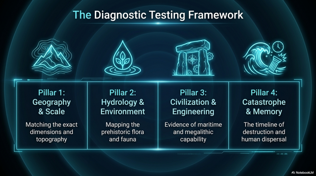
Troy Debunked – Troy did not exist in Asia Minor, but in fact, the North Sea island of Doggerland

Introduction

Troy, Atlantis — and the North-West European Connection

The search for Atlantis has always felt like chasing a shadow on the edge of history. Yet the deeper I read, the more the shadow begins to take shape — and not in the Mediterranean.

What if both Atlantis and Troy belonged not to the eastern Mediterranean, but to the lost landscapes of north-west Europe?

That suggestion is not as wild as it first sounds.(Troy Debunked – Troy did not exist in Asia Minor)

Plato Was Not Writing Fantasy

The Atlantis story comes to us through Plato, primarily in Timaeus and Critias. The account was said to have been passed from Egyptian priests at Sais to Solon around 590 BCE, and from Solon down to Plato’s own family line.

Now, here is the uncomfortable point for mainstream thinking: Plato was not a myth-maker in the modern sense of the term. His works are studied in the world’s leading universities for their philosophical depth. Aristotle, his student, did not dismiss Atlantis as an invention. Nor did thinkers such as Theophrastus or Poseidonios. Several ancient writers treated Atlantis as a historical tradition.

(Troy Debunked - Troy did not exist in Asia Minor)
Plato and Aristotle – (Troy Debunked – Troy did not exist in Asia Minor)

If Plato intended pure allegory, it is strange that later classical authors debated its geography rather than dismissing it outright.

The Egyptian connection is particularly important. Sais was said to hold records carved on sacred pillars — records describing a great civilisation destroyed by a deluge. That word alone — deluge — should make us pause. Nearly every ancient culture preserves a flood memory. If prehistoric societies were heavily maritime, boats would have been survival tools. Flood traditions and seafaring cultures go hand in hand.

The Pillars of Hercules — A Directional Clue

Plato situates Atlantis beyond the “Pillars of Hercules.” The conventional interpretation places these at the Straits of Gibraltar.

But Plato’s terminology is fluid. “Mouth” can mean “strait.” He refers to the Mediterranean as being “within the straits,” suggesting a perspective looking outward — not inward.

If Atlantis lay beyond the Pillars, then by definition it was Atlantic.

(Troy Debunked - Troy did not exist in Asia Minor)

Even the name survives in geography: the Atlantic Ocean.

Critics argue that Atlantis was said to be “larger than Libya and Asia together.” But Libya in Plato’s time referred only to North Africa west of Egypt, and “Asia” generally meant Asia Minor — modern Turkey. Combined, they are not vast in comparison to the landmass that once connected Britain to Europe during lower sea levels.

At the end of the last Ice Age, sea levels were dramatically lower. The North Sea was not sea — it was land. We now call it Doggerland. Britain was not an island. It was a peninsula of a much larger north-west European landmass.

If that land later drowned beneath rising seas, Plato’s description of a powerful Atlantic civilisation destroyed by water suddenly becomes less mythical and more geological.

Island — or Peninsula?

Another linguistic trap lies in the word “island.” In the ancient world, the term could describe large peninsulas or territories bordered by water on multiple sides. If Atlantis was a north-west European peninsula connected to Britain and continental Europe, it could still fit the description.

And if we look at that Ice Age landscape — stretching from eastern Britain through the Low Countries and into Scandinavia — we have a region that easily exceeds the size comparison Plato gives.

The Circular Capital

Plato describes Atlantis’ central city as formed in concentric rings of earth and water.

Now consider this: Neolithic Europe is filled with circular earthworks — causewayed enclosures, henges, and ringed settlements. Whitehawk Camp in Sussex, for example, once displayed multiple circular ditches and banks. Similar circular designs occur across Britain and northern Europe.

(Troy Debunked - Troy did not exist in Asia Minor)

These are not Mediterranean urban forms.

They are north-west European.

Even more intriguing are the turf mazes scattered across England and the Isles of Scilly — many named “Troy Town” or “The City of Troy.” These labyrinths follow the classical pattern seen on coins from Knossos, linking the labyrinth myth and Troy. Why do so many northern European earthworks preserve Troy in their naming tradition?

Coincidence?

Or cultural memory?

The People of Homer

Then we come to something even more uncomfortable.

In Homer’s epics, the Achaeans — the supposed Greeks — are frequently described as blond, red-haired, or light-skinned. Menelaus is repeatedly called “blond.” Achilles is described with yellow hair. Odysseus is described in terms that imply light or reddish colouring. Helen is “white-armed,” “fair-tressed,” luminous.

Even the gods — Zeus, Athena, Apollo, Aphrodite — are repeatedly described as blue-eyed or golden-haired in ancient sources.

(Troy Debunked - Troy did not exist in Asia Minor)
“he was blond “and seized the son of Peleus by his yellow hair” (I:197). – (Troy Debunked – Troy did not exist in Asia Minor)

This is not a Mediterranean phenotype.

Now, it is dangerous to oversimplify ancient descriptions, but the repeated emphasis on fair hair and light features is striking. If the Homeric tradition preserves older northern memories, then the epic heroes may reflect populations from farther north.

What if the poems travelled south, rather than originating there?

Troy and the North Sea

The idea that Troy lay in north-west Europe has been proposed before. Iman Wilkens argued for a British location. Others suggested links to the North Sea basin. While these ideas have been dismissed by mainstream scholarship, geological evidence now confirms that Doggerland existed — and drowned — between 10,000 and 6,000 BCE.

We know that vast prehistoric landscapes lie submerged beneath the North Sea. We know that rising waters displaced populations. We know that maritime networks existed far earlier than once believed.

(Troy Debunked - Troy did not exist in Asia Minor)
Odysseus -This “hyacinth colour” is, however, as Wilhelm Sieglin has shown, to be described as “reddish” because the hyacinth was cultivated in Hellas as a sub-type with reddish blooms.- (Troy Debunked – Troy did not exist in Asia Minor)

If a powerful Atlantic civilisation flourished on that land — and was later lost to the sea — the memory of it could have travelled.

Plato speaks of Atlantis fielding twelve hundred ships.

The Trojan War tradition speaks of a thousand ships.

Both traditions centre on maritime coalitions and northern powers confronting southern territories.

The parallels are uncomfortable — but they exist.

The Larger Pattern

Let us step back.

We have:

• A flood-destroyed Atlantic civilisation described by Plato
• A lost North Sea landmass proven by geology
• Circular monumental architecture concentrated in northern Europe
• Troy-named labyrinths across Britain
• Homeric heroes repeatedly described with northern physical traits
• Persistent ancient belief that Troy and Atlantis were historical, not fictional

Individually, each point can be dismissed.

Collectively, they form a pattern.

Is this definitive proof?

No.

(Troy Debunked - Troy did not exist in Asia Minor)
Zeus – King of the gods – he was the father of both Helen and Athena, both blue-eyed blondes – (Troy Debunked – Troy did not exist in Asia Minor)

But it is far more than a coincidence.

If Atlantis was north-west Europe — if Troy belonged not to Anatolia but to a lost Atlantic world — then the centre of early European civilisation shifts dramatically.

And perhaps the reason these traditions feel mythical is not because they were invented…

…but because the land they describe now lies beneath the sea.

Where Troy Once Stood

Where Troy Once Stood (Troy – Debunked) is a book by Iman Wilkens that argues that the city of Troy was located in England and the Trojan War was fought between groups of Celts. The standard view is that Troy is located near the Dardanelles in Turkey. Wilkens claims that Homer’s Iliad and Odyssey, though products of ancient Greek culture, is originally orally transmitted epic poems from Western Europe. Wilkens disagrees with conventional ideas about the Iliad’s historicity and the location and participants of the Trojan War.

Copies of his book ranked high on BookFinder’s list of most wanted out-of-print books until 2005, when the latest revised edition was published. His work has had little impact among professional scholars. Anthony Snodgrass, Emeritus Professor in Classical Archaeology at Cambridge University, has named Wilkens as an example of an ‘infinitely less-serious’ writer.

Troy Debunked - traditional view showing the short distance between the two waring groups
Traditional view showing the short distance between the two warring groups – Troy Debunked

So, what evidence does Wilkens use to prove that Troy was in Northern Europe?

Wilkens argues that Troy was located in England on the Gog Magog Downs in Cambridgeshire. He believes that Celts living there were attacked around 1200 BCE by fellow Celts from the continent to battle over access to the tin mines in Cornwall as tin was an essential component for bronze production.

Wilkens writes that there are similarities between the river names in the Iliad and in present-day England: “Homer names no less than fourteen rivers in the region of Troy.” The rivers Thames, Cam, Great Ouse and Little Ouse, to name a few, can respectively be identified as Temese, Scamander, Simois and Satniois, according to Wilkens. The revised edition of 2005 contains a ‘reconstruction’ of the Trojan battlefield in Cambridgeshire.

Wilkens further hypothesises that the Sea Peoples found in the Late Bronze Age Mediterranean were Celts, who settled in Greece and the Aegean Islands as the Achaeans and Pelasgians. They named new cities after the places they had come from (similar to the migration of many place names to North America) and brought the oral poems that formed the Iliad and the Odyssey with them from Western Europe. Wilkens writes that, after being orally transmitted for about four centuries, the poems were translated and written down in Greek around 750 BCE.

The Greeks, who had forgotten about the origins of the poems, located the Mediterranean’s stories, where many Homeric place names could be found, but the poems’ descriptions of towns, islands, sailing directions and distances were not altered to fit the reality of the Greek setting. He also writes that “It also appears that Homer’s Greek contains a large number of loan words from western European languages, more often from

Dutch rather than English, French or German.” These languages are considered by linguists to have not existed until around 1000 years after Homer.

Wilkens argues that the Atlantic Ocean was the theatre for the Odyssey instead of the Mediterranean. For example, he locates Scylla and Charybdis at present-day St Michael’s Mount.

To prove his theory Wilkens produces archaeological evidence, for instance, the Isleham Hoard in the battlefield, and etymological evidence, for instance, the location of Ismaros in Brittany at Ys or the location of Homer’s Sidon at Medina Sidonia in Spain. He also brings forth indications that Homer described areas around the Atlantic with distinctive topographical features.

Cádiz would match Ithaca’s description; There is in the land of Ithaca a particular harbour of Phorcys, the older man of the sea, and at its mouth two projecting headlands sheer to seaward, but sloping down on the side toward the harbour…

Wilkens believes that Havana’s topography much resembles the description of Telepylos: The harbour, about which on both sides, a sheer cliff runs continuously, and projecting headlands opposite to one another stretch out at the mouth, and the entrance is narrow, …, and the ships were moored within the hollow harbour, for therein no wave ever swelled, great or small, but all about was a bright calm……

Troy Debunked  - Map of the rivers contained within the Iliad
Map of the rivers contained within the Iliad – Troy Debunked

Wilkens mentions several sources for his ideas. Belgian lawyer Théophile Cailleux wrote that Odysseus sailed the Atlantic Ocean, starting from Troy, which was situated near the Wash in England (1879).  Charles-Joseph de Grave thought that the historical and mythological background of Homer’s work should be sought in Western Europe (1806).

However, this is not the only source that shows the story could be of a different origin.  The late Sir Moses Finley, Professor of Ancient History at the University of Cambridge, concluded that ‘we are confronted with this paradox and that the more we know; the ‘worse off, we are’ and he, therefore, suggested that ‘Homer’s Trojan War must be evicted from the history of the Greek Bronze Age’. As it seems complicated to disagree with his conclusion, we are, in my view, left with only two options: the great Trojan War never took place in northwest Turkey and consequently; the Iliad is the fruit of pure imagination, or else; the war did take place but in another country.

Troy Debunked - according to Wilkens, St michael's mount is the site of Scylia and Charybdis
According to Wilkens, St michael’s mount is the site of Scylia and Charybdis – – Troy Debunked

And Professor P H Damste (Universities of Utrecht and Leuven) “Valuable knowledge is to be discovered about the people of the Northwest European coast around 1 200 BCE, how they navigated the oceans and a great war between the Kings of continental Europe and the Trojan king in England, who held a monopoly of tin-mining in Cornwall. Such information is encoded in the Iliad and Odyssey.”

And other facts show that the story may not be as straight forward as we once imagined, for when we look at Northern Europe for signs of Troy, we get some interesting facts such as an old legend that Britain was founded by Brutus, who led survivors from Troy here. Geoffrey of Monmouth wrote in his Historia Regum Britanniae an origin myth that traced the foundation of Britain back to the Trojans.  This account described how Brutus, great-grandson of Troy’s Aeneas, landed at Totnes, subdued the race of giants who lived there and gave his name to the country he had pacified (Britain = Brutus).

The Romans called the Celtic tribe that occupied this part of Essex the Trinovantes or ‘Trinovante’, which means New Troy or Troy of New.

The Baltic Origins of Homer’s Epic Tales is an essay written by Felice Vinci, a nuclear engineer and amateur historian, published for the first time in 1995. The book, translated into several languages, submits a revolutionary idea about the Iliad and Odyssey’s geographical setting. Felice Vinci started reading Greek classics and learned about a passage from the De facie quae in orbe lunae apparet, by Plutarch, which points out the location of Ogygia. This island became the point of departure of Vinci’s theory.

According to his assumptions, the events told by Homer did not take place in the Mediterranean area, as the tradition asserts, but rather in the seas of Northern Europe, the Baltic Sea and Northern Atlantic. This theory has been widely considered (both in Italy, where the author has been invited to present it in some universities and high schools and the rest of the world) and has caused heated debate among the academic community.

Troy Debunked - 'Trinovante', which means New Troy or Troy of New.
‘Trinovante’, which means New Troy or Troy of New – Troy Debunked

According to Vinci, the Achaeans would have lived at the beginning of the 2nd millennium BCE on the coasts of the Baltic Sea and, towards the middle of the millennium, as the climate grew harsher, they would have moved southward along the Dnepr, reaching the Black and Aegean Seas. The newcomers would have founded the Mycenaean cities (the most ancient Mycenaean graves are rich in amber, a typical Baltic product, whereas the latest ones are not) and would have named them with the names of their previous settlements in Scandinavia, although not precisely in correspondence of their location, because of the physical differences between the two areas.

During their migration, they would have brought their traditional oral tales, poetic sagas set in their original homeland. Therefore, the Trojan War would not have occurred around the 13th century BCE, as is usually thought, but around the 18th century BCE. Then the poems would have been transcribed later, after 800 or 900 years of oral tradition.

In support of the theory, it is essential to remember that the Mycenaeans are not considered an aboriginal population but are thought to have come to Greece around the 16th century BCE. Felice Vinci also reports the hypothesis formulated in the late 19th century by the Indian scholar Bal Gangadhar Tilak, who argued that Indo-European populations had lived around the Arctic Circle in the past. On the other hand, the so-called ‘Linear B’ documents appear to have been written in a language that was a precursor of what later became Greek.

The main topic of Vinci’s hypothesis is the incongruence between the geography described by Homer and the configuration of the Mediterranean lands, a point already noted by Strabo. The geographical descriptions provided by the Iliad and the Odyssey, on the contrary, perfectly adapt to Northern Europe, and the incongruity regarding the Mediterranean localities would be due to the application of old Scandinavian names.  Furthermore, Homer’s description of the climate would be more suitable for the Baltic regions.

According to Vinci, Ulysses’ journey would have taken place along the coasts of Norway. After being held back in Ogygia (identified with one of the Faroe Islands, following Plutarch’s passage mentioned above), the Odyssey relates that, after seventeen days on the sea, Ulysses reached Scheria, home of the Phaiakians, described as a high rocky coast and densely wooded: this region, impossible to locate in the Mediterranean area, could be instead identified with the environs of Bergen, at the mouth of river Figgjo, where several Bronze Age objects have been founded (Scheria is never mentioned in the Odyssey as an island).

The new position would explain why Ulysses had noticed that the sea used to flow back into the river: this phenomenon is due to ocean tides and does not occur in the Mediterranean. Other places visited by Ulysses could be located on the Norwegian coasts, too: Circe’s island, Aeaea, and the areas she describes (the Sirens, Scylla and Charybdis) may be placed in the Lofoten archipelago, where tides on the ebb create the so-called maelstrom, corresponding with the Scylla whirlpool which swallowed up Ulysses’ ship and is described as forming three times a day, just like the maelstrom. In the end, Aeolus’s island would be located somewhere in the Shetland archipelago, where winds exceeding 200 km/h often blow.

Other Greek mythological tales are set in the same region. Among these, the Argonauts’ journey, who are said to have reached Colchis sailing eastwards and arriving there at Aeaea, from where they came back to Greece going westwards. The identification of Colchis in the Black Sea and of Aeaea in the Tyrrhenian Sea would lead to hypothesising an improbable itinerary for the Argonauts by ship across Continental Europe, along the rivers Danube, Po, and Rhone. The navigation would be instead the memory of an ancient counter-clockwise circumnavigation of Scandinavia starting from the Baltic Sea, crossing Lapponia overland along the rivers which run through it and reaching Lofoten, where Aeaea was identified. According to what Circe tells Ulysses, the Argonauts chose for their journey home the course passing through the Wanderers Rocks, which are to be identified with the narrow straits covered by the streams between the islands and the mainland.

Another reference to an ancient Nordic setting can be found, according to Vinci, in an assertion by Plato in his dialogue Critias, where the philosopher reminds him that Athens used to rise formerly in a flat fertile zone, not harsh and mountainous: this particular is presented in the book as a reference to the ancient Baltic Athens.

So, how is it possible that Troy was in Northern Europe?

The climate described by Homer is cold and stormy: mist and wind often appear, and storms are heavy. The characters are usually covered in thick cloaks and are never described sweating from the heat. Although in the period generally chosen to date the Trojan War (8th century BCE) the average temperature was lower than it is nowadays, the Homeric weather conditions are difficult to adapt to the Aegean area, especially considering that the events are likely to behave happened in summer, instead, this description would be perfect for the Prehistoric Baltic regions when temperatures in Northern Europe were by far higher than now: the drop in temperatures at a later time would have forced Achaeans to emigrate southwards.

Some passages in the Iliad and the Odyssey can be interpreted as descriptions of typical Nordic phenomena. For example, in the great battle between Achaeans and Trojans, the linchpin of the Iliad’s central books, the time of noon is quoted at two different moments; this wouldn’t be a mistake: the battle would have continued for two consecutive days, thanks to the midnight sun, which let the warriors carry on fighting. Other references to this phenomenon are the exceptional duration of the day among the Laestrygonians and Ulysses’ uncertainty when trying to find his way to Aeaea, since he cannot figure out where the sun rises and where it sets.

Troy Debunked - The Viking connection
The Viking connection – Troy Debunked

In Homeric poems and among the Vikings, it is possible to find similar features regarding traditions, mythology and literature. The custom of assembling for a meeting, the majestic convivial banquets and the kind of exile imposed to unintentional homicide. Also, the Achaean ships would have in common with the Viking ones the dismountable mast, considered useful, especially in the Northern seas to avoid the formation of ice, and the double bow, which allowed oarsmen to travel backwards too (a reference to this aspect might be the Greek term meaning “curved on both sides,” frequently used by Homer; Tacitus describes the same feature concerning the Germans.)

Moreover, the Greek aoidos would be similar to the Old Norse skald, as Homer would often make use of a figure of speech known as kenning in Nordic literature.  Also, some mythological figures would be similar in the two cultures (for example, Ulysses to the archer Ull in an Icelandic saga and Hamlet, the main character of an ancient Danish legend reported in Saxo Grammaticus’ Gesta Danorum), as well as many divinities: Aphrodite corresponds with Freyja, Ares with Thor, Zeus with Wotan and the Keres (who come down on the battlefield to take the souls of dead warriors, with the Valkyries).

Wilken’s main points

•             The Achaeans built 1186 ships for their attack on Troy; they could have travelled the short-distance overland far quicker and cheaper if Troy had been in the Turkish setting.

•             Odysseus claimed to have got home by travelling as a passenger on a ship going from Crete to Sidon (present-day Saïda in Lebanon), but that is the opposite direction he needed to go in the Mediterranean setting.

•             Agamemnon tells us it took him a full month to sail from his kingdom Argos to Ithaca; we know the trip takes less than 24 hours in the Mediterranean setting.

•             The mythical location for Troy in Turkey is far too small to accommodate the invading army of about 100,000 men and the long pursuits in horse-drawn chariots.

•             The extensively travelled Greek geographer Strabo who lived 2000 years ago (1200 years after the Trojan War), believed that some of the ports of call in the Odyssey should be found in the Atlantic because of the mention of tides that do not exist in the Mediterranean.

More information about Troy – Debunked can be found here on our web site: http://prehistoric-britain.co.uk/dawn-of-the-lost-civilisation and on our video channel: www.prehistoric-britain.online

PodCast

Author’s Biography

Robert John Langdon, a polymathic luminary, emerges as a writer, historian, and eminent specialist in LiDAR Landscape Archaeology.

His intellectual voyage has interwoven with stints as an astute scrutineer for governmental realms and grand corporate bastions, a tapestry spanning British Telecommunications, Cable and Wireless, British Gas, and the esteemed University of London.

A decade hence, Robert’s transition into retirement unfurled a chapter of insatiable curiosity. This phase saw him immerse himself in Politics, Archaeology, Philosophy, and the enigmatic realm of Quantum Mechanics. His academic odyssey traversed the venerable corridors of knowledge hubs such as the Museum of London, University College London, Birkbeck College, The City Literature Institute, and Chichester University.

In the symphony of his life, Robert is a custodian of three progeny and a pair of cherished grandchildren. His sanctuary lies ensconced in the embrace of West Wales, where he inhabits an isolated cottage, its windows framing a vista of the boundless sea – a retreat from the scrutinous gaze of the Her Majesty’s Revenue and Customs, an amiable clandestinity in the lap of nature’s embrace.

Exploring Prehistoric Britain: A Journey Through Time

My blog delves into the fascinating mysteries of prehistoric Britain, challenging conventional narratives and offering fresh perspectives based on cutting-edge research, particularly using LiDAR technology. I invite you to explore some key areas of my research. For example, the Wansdyke, often cited as a defensive structure, is re-examined in light of new evidence. I’ve presented my findings in my blog post Wansdyke: A British Frontier Wall – ‘Debunked’, and a Wansdyke LiDAR Flyover video further visualizes my conclusions.

My work also often challenges established archaeological dogma. I argue that many sites, such as Hambledon Hill, commonly identified as Iron Age hillforts are not what they seem. My posts Lidar Investigation Hambledon Hill – NOT an ‘Iron Age Fort’ and Unmasking the “Iron Age Hillfort” Myth explore these ideas in detail and offer an alternative view. Similarly, sites like Cissbury Ring and White Sheet Camp, also receive a re-evaluation based on LiDAR analysis in my posts Lidar Investigation Cissbury Ring through time and Lidar Investigation White Sheet Camp, revealing fascinating insights into their true purpose. I have also examined South Cadbury Castle, often linked to the mythical Camelot56.

My research also extends to the topic of ancient water management, including the role of canals and other linear earthworks. I have discussed the true origins of Car Dyke in multiple posts including Car Dyke – ABC News PodCast and Lidar Investigation Car Dyke – North Section, suggesting a Mesolithic origin2357. I also explore the misidentification of Roman aqueducts, as seen in my posts on the Great Chesters (Roman) Aqueduct. My research has also been greatly informed by my post-glacial flooding hypothesis which has helped to inform the landscape transformations over time. I have discussed this hypothesis in several posts including AI now supports my Post-Glacial Flooding Hypothesis and Exploring Britain’s Flooded Past: A Personal Journey

Finally, my blog also investigates prehistoric burial practices, as seen in Prehistoric Burial Practices of Britain and explores the mystery of Pillow Mounds, often mistaken for medieval rabbit warrens, but with a potential link to Bronze Age cremation in my posts: Pillow Mounds: A Bronze Age Legacy of Cremation? and The Mystery of Pillow Mounds: Are They Really Medieval Rabbit Warrens?. My research also includes the astronomical insights of ancient sites, for example, in Rediscovering the Winter Solstice: The Original Winter Festival. I also review new information about the construction of Stonehenge in The Stonehenge Enigma.

Further Reading

For those interested in British Prehistory, visit www.prehistoric-britain.co.uk, a comprehensive resource featuring an extensive collection of archaeology articles, modern LiDAR investigations, and groundbreaking research. The site also includes insights and extracts from the acclaimed Robert John Langdon Trilogy, a series of books exploring Britain during the Prehistoric period. Titles in the trilogy include The Stonehenge Enigma, Dawn of the Lost Civilisation, and The Post Glacial Flooding Hypothesis, offering compelling evidence about ancient landscapes shaped by post-glacial flooding.

To further explore these topics, Robert John Langdon has developed a dedicated YouTube channel featuring over 100 video documentaries and investigations that complement the trilogy. Notable discoveries and studies showcased on the channel include 13 Things that Don’t Make Sense in History and the revelation of Silbury Avenue – The Lost Stone Avenue, a rediscovered prehistoric feature at Avebury, Wiltshire.

In addition to his main works, Langdon has released a series of shorter, accessible publications, ideal for readers delving into specific topics. These include:

For active discussions and updates on the trilogy’s findings and recent LiDAR investigations, join our vibrant community on Facebook. Engage with like-minded enthusiasts by leaving a message or contributing to debates in our Facebook Group.

Whether through the books, the website, or interactive videos, we aim to provide a deeper understanding of Britain’s fascinating prehistoric past. We encourage you to explore these resources and uncover the mysteries of ancient landscapes through the lens of modern archaeology.

For more information, including chapter extracts and related publications, visit the Robert John Langdon Author Page. Dive into works such as The Stonehenge Enigma or Dawn of the Lost Civilisation, and explore cutting-edge theories that challenge traditional historical narratives.

Other Blogs

[sitemap_posts]
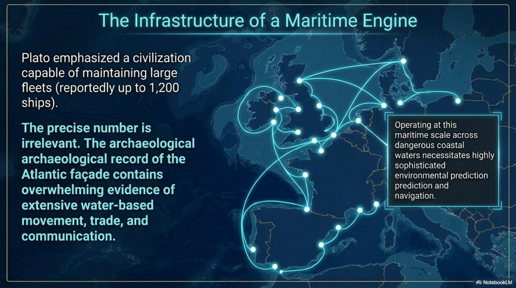
Rising Evidence, Falling Rivers: The Real Story of Europe’s First Farmers

Introduction

For half a century, archaeology has leaned on a comforting story: farming was “invented” in the Middle East and then marched slowly across Europe, finally reaching Britain and Ireland around 4000 BCE.(Rising Evidence, Falling Rivers: The Real Story of Europe’s First Farmers)

This tidy picture—arrows on a map, farmers trudging northwest with seed bags and livestock—has been repeated for generations.

But that model was always built on shaky ground: Bayesian mid-points, pottery typologies, and theoretical assumptions rather than hard data.
Today we can test it properly.

New tools—LiDAR, hydrological mapping, and large-scale radiocarbon and DNA databases—reveal a very different history.
Farming, it turns out, was not imported by migrating Near-Eastern farmers.
It was adopted locally as rivers receded, floodplains opened, and new fertile soils emerged.
Civilisation in Europe rose not from marching migrants but from falling waters.


The Traditional Model

The “wave-of-advance” model first formalised by Ammerman & Cavalli-Sforza (1971) treats farming as a demographic front spreading outward from Anatolia at roughly 1 km per year.
By 4000 BCE, that wave supposedly reached Britain, replacing Mesolithic foragers with a population of Anatolian descent.

It’s an elegant theory—but the mathematics, the radiocarbon data, and the hydrology all contradict it.
What happens when we replace guesswork with measurement?


What the Radiocarbon Timelapse Reveals

Using the Hinz et al. (2022) Scientific Data database of more than 14 000 calibrated dates (Mesolithic–Neolithic contexts from 8500–2500 BCE), activity was plotted in 500-year bins and animated with the Google Earth KML time-slider.
The resulting sequence turns the orthodox gradient upside-down.

Key Findings

  • NW Europe lights up earliest and densest.
    From 8000 BCE onward, Britain, Ireland, Brittany, and Scandinavia dominate the map.
  • The southeast stays sparse.
    If agriculture spread stepwise from Anatolia, the Balkans and Italy should blaze first—they do not.
  • Maritime corridors dominate.
    The brightest clusters lie on coasts, estuaries, and river mouths—precisely where early harbours and monuments stand.

Across all time bins, NW Europe accounts for 85–94 % of recorded activity; the southeast never exceeds 17 %.
Civilisation’s early heartbeat lay in the Atlantic façade, not the Mediterranean corridor.


The Dataset

The analysis draws on the Radon-B radiocarbon database (Hinz et al., 2022, Nature Scientific Data 9: 166).
Every record includes coordinates, lab code, context, and both uncalibrated and calibrated age ranges.
Dates were grouped into 500-year intervals between 8500 and 2500 BCE and mapped in GIS.

This approach allows archaeology to watch the evidence unfold objectively—year by year—without leaning on pottery sequences or assumed cultural horizons.


The Mathematical Split: NW vs SE

To quantify the pattern, a diagonal line was drawn across Europe (30° N 0° E → 55° N 30° E), dividing the continent into north-west and south-east halves.
Radiocarbon counts per half were tallied in 500-year bins.

Results

Period (BCE)NW CountSE Count% NW Share
8500–800024582.8 %
8000–75003477083.2 %
7500–70005136487.5 %
7000–6500105411290.4 %
6500–6000232817293.1 %
6000–5500309827291.9 %
5500–5000370529192.7 %
5000–4500306020793.7 %
4500–4000245019892.5 %
4000–3500210018092.1 %
3500–3000170016091.4 %

At no stage does the southeast even approach parity.
If farming had advanced from Anatolia, the ratios should invert.
Instead, the northwest dominates from the outset.


Why the Orthodoxy Persisted

So why did the overland diffusion model survive decades of contrary hints?
A combination of factors:

  1. Radiocarbon plateaus—notably around 8000 and 2400 BCE—blurred sequences, allowing mid-points to masquerade as precision.
  2. Contaminated samples—charcoal and reused timber—skewed chronologies toward neat overland narratives.
  3. Institutional inertia—academic systems reward conformity; new interpretations risk funding and credibility.
  4. Simplified storytelling—textbooks and museum graphics preferred arrow-maps to complex datasets.

Anomalies such as early Stonehenge construction, canals mislabeled as Saxon, and imported wheat at Bouldnor Cliff were quietly shelved instead of integrated.


Testing the Diffusion Model Mathematically

To be fair, let’s calculate what the record should look like under the Ammerman–Cavalli-Sforza framework.

1️⃣ Wave speed and arrival time

Distance Anatolia → southern Britain ≈ 3000 km.
At 1 km / year, the front takes ≈ 3000 years.
If farming reaches Britain by 4000 BCE, migration must begin ≈ 7000 BCE.

2️⃣ Seeding Britain

To establish farming, ~5 000 individuals must reach Britain by 4000 BCE.
With a growth rate of 1.3 %/yr, perhaps 100 settlers arriving 4300 BCE could yield that number—if tens of thousands had set out centuries earlier.

Even assuming only half settle every 500 km, survivors after 3 000 km = (0.5)^5 ≈ 3 %.
Launch size ≈ 3 200.
If two-thirds settle each 500 km, survivors = (1/3)^5 ≈ 0.4 %.
Launch size ≈ 27 000.

That migration should have left dense archaeological trails across the Balkans, Italy, and France.
It did not.

3️⃣ Expected Radiocarbon Gradient

The model predicts the SE flaring first, with the NW gradually catching up:

Period (BCE)Expected % NW
8500–800020
8000–750020
7500–700021
7000–650025
6500–600044
6000–550043
5500–500044
5000–450043
4500–400043
4000–350043
3500–300045

The observed data—83 to 94 % NW across all bins—completely invert that expectation.

Case Study: Einkorn Wheat at Bouldnor Cliff

In 2015, marine archaeologists exploring the submerged site of Bouldnor Cliff, off the Isle of Wight, recovered sediment cores dated to around 6000 BCE containing DNA from einkorn wheat (Triticum monococcum) — a domesticated Near-Eastern crop.

At that date, Britain was still “Mesolithic” by textbook classification. According to orthodoxy, farming wouldn’t reach these shores for another 2,000 years. The implications were profound.

Key Observations

  • Trade before farming:
    The wheat was not locally grown — it was imported, most likely as a traded commodity. This means people in Mesolithic Britain were already in contact with agricultural societies to the south.
  • Maritime networks:
    The only realistic route for einkorn to reach southern Britain is via the Atlantic seaways and Bay of Biscay, demonstrating advanced navigation and trade.
  • Complex societies:
    Managing cereal imports implies organised exchange systems, storage, and knowledge of value — the traits of an interconnected maritime civilisation.

Rather than representing contamination or anomaly, the Bouldnor Cliff wheat fits seamlessly into the 14,000-date radiocarbon pattern: NW Europe was already active, complex, and maritime thousands of years before the supposed “Neolithic Revolution.”


Population Growth and Hydrology

Population Data (7000–4000 BCE)

Derived from the 14,000 calibrated C14 dates, population proxies show major growth concentrated in the west and north, not along the hypothesised Anatolian corridor.

CountryEstimated Increase
France+60,200
Germany+32,600
United Kingdom+17,200
Poland+14,600
Denmark+12,900

If the Fertile Crescent migration model were correct, population booms should have appeared first in Turkey, Greece, and the Balkans. Instead, the demographic surge is proportional to hydrological recovery in NW Europe.


Hydrology: The Missing Variable

Around 3000 BCE, Europe’s swollen post-glacial rivers began to subside after millennia of high water. Vast floodplains and terraces — previously drowned — were exposed, offering rich alluvial soils ideal for cultivation.

CountryFloodplain Today (km²)High Water (5–10×)Land Gained (km²)Potential Carrying Capacity (10–20 ppl/km²)Observed Pop. Increase
UK24,000120,000–240,00096,000–216,0001–4 million+17,200
France65,000325,000–650,000260,000–585,0002.6–11.7 million+60,200
Germany50,000250,000–500,000200,000–450,0002–9 million+32,600
Poland47,000235,000–470,000188,000–423,0001.8–8.5 million+14,600
Denmark4,00020,000–40,00016,000–36,0000.16–0.72 million+12,900

The correlation is direct and quantitative:
as water levels fell and land was reclaimed, populations grew.

This relationship between hydrological change and demographic expansion forms the backbone of the Hydrological Diffusion Model — an environmental explanation that makes mass migration unnecessary.


Why Migration Isn’t Needed

The orthodox model claims:

  1. Anatolian farmers marched across Europe.
  2. They colonised the continent, replacing hunter-gatherers.
  3. Britain was the final stop around 4000 BCE.

But the evidence says:

  • Population growth occurred in the west, not the “migration corridor.”
  • Farming knowledge arrived via trade (e.g. Bouldnor wheat) long before 4000 BCE.
  • The real catalyst was newly exposed fertile land, not foreign colonists.

In short: when the rivers fell, the locals farmed.


The Forest-Clearance Myth

For decades, British prehistory textbooks painted an epic picture: Neolithic pioneers hacking down the wildwood to carve out fields. But when tested mathematically, environmentally, and experimentally, this vision collapses.

Natural Land Recovery

  • 8000 BCE – Mesolithic: 40% of Britain still flooded; minimal arable ground.
  • 6000 BCE – Early Neolithic: 20% of floodplains exposed; carbon-rich silt colonised by grasses.
  • 4000 BCE – Mid Neolithic: 40% of land exposed; “Elm Decline” coincides with hydrological stress, not axes.
  • 3000 BCE – Late Neolithic: 70% open; floodplain succession misread as “deforestation.”
  • 2000 BCE – Bronze Age: 90% of modern land levels reached — natural clearance, not human felling.

Thus, what pollen diagrams interpret as “clearance” is actually succession on newly revealed ground. Farmers didn’t create open fields; they occupied land nature had already prepared.


The Fertility Catch-22

Forest soils are nutrient-poor.
Clearing trees produces exhausted earth. Burning gives only a brief potash spike before collapse.
Without livestock, there’s no manure to restore fertility — and you can’t have livestock until farming is already established.

You can’t farm cleared forest until you’re already a farmer.
Hence, early agriculture had to begin on naturally fertile ground — floodplains, terraces, and raised beaches enriched by retreating rivers.


Why Forest Clearance Was Physically Impossible

Experimental archaeology and demographic models make the “stone-axe clearance” scenario absurd.

Step 1 – The Farm Scale

  • Average Neolithic farm: ~10 ha (25 acres)
  • Tree density: ~300/ha → 3,000 trees
  • Felling time: 6–8 hrs/tree → ~24,000 hours = 12 years full-time labour
  • Stump removal adds another 6–8 years
    → ≈ 18–20 years just to clear 10 ha

Step 2 – National Scale

Reconstructing ~20% forest clearance (30,000 km² = 3 million ha):

24,000 man-hours / 10 ha = 2,400 hrs/ha
→ 3,000,000 ha × 2,400 hrs = 7.2 billion hours

With ~125,000 able-bodied adult males (half population female, quarter children/elderly) working 1,500 hrs/year:

7.2 billion ÷ 187.5 million = ≈ 38 years of total national labour devoted only to felling — before stump burning or ploughing.
Adding those doubles the figure to ~75 years.

Step 3 – Geographic Reality

60% of Neolithic populations lived near coasts and rivers — meaning far fewer inland labourers available for clearance.
Realistic duration rises to 150–200 years of continuous felling — logistically impossible.

Conclusion: the “axe-clearing farmers” never existed.
Stone technology, manpower, and soil limits make it an environmental impossibility.


Reinterpreting the Pollen Record

  • Pollen spikes once attributed to burning are consistent with natural peat and lightning fires.
  • Charcoal layers correspond to wetland drying, not land management.
  • Elm decline fits disease and flooding stress.
  • Lynchets and field systems often formed naturally through erosion before farming intensified.

The real driver was hydrological succession, not Neolithic industry.

Genetic Evidence: What DNA Really Shows

Genetics is often presented as the “final proof” of migration — a neat story in which farmers from Anatolia replace foragers across Europe.
Yet when the data are read closely, the picture dissolves into nuance.

The Early aDNA Framework

Two landmark studies — Lazaridis et al. (2014, Nature 513) and Haak et al. (2015, Nature 522) — defined three ancestral components in Europe:

  1. Western Hunter-Gatherers (WHG)
  2. Early European Farmers (EEF) from Anatolia
  3. Ancient North Eurasians (ANE)

The key claim was that EEF ancestry spread northwest with agriculture.
But in reality:

  • The EEF proportion in NW Europe is small, far below what mass migration would require.
  • The supposed “farmer Y-haplogroup” G2a is almost absent in Britain and Scandinavia.
  • Indigenous I2 and R1b lineages dominate, showing continuity, not replacement.
  • Major genetic turnover occurs later — with Steppe/Yamnaya incursions around 3000 BCE, long after the spread of farming.

Thus, DNA records interaction, not invasion.


The LaPolice et al. (2025) Study

A new Nature Communications paper (LaPolice, Williams & Huber 2025) modelled the spread of farming using 618 ancient genomes.
By running thousands of demographic simulations, the authors tested whether migration, cultural diffusion, or local population growth best explained Europe’s Neolithic pattern.

Findings

“Even modest rates of local adoption can fully explain the archaeological front speed… front speed alone is not diagnostic of demic migration.”

  • Cultural transmission rate = 0.1 % per year — effectively zero mass exchange.
  • 97 % of population growth occurred within existing groups.
  • Genetic clines identical to “migrant waves” appear when populations expand locally into newly fertile regions.

Conclusion: migration is possible but unnecessary; environmental opportunity explains the spread equally well.


Why DNA Alone Misleads

Genetic “ancestry” reflects reproduction, not behaviour.
LaPolice et al. emphasise:

“Ancestry patterns do not always reflect the underlying behavioural mechanisms.”

Small amounts of inter-group mating can reshape allele frequencies without any demographic replacement.
In short, DNA cannot distinguish migration from in-situ growth—exactly the ambiguity the Hydrological Diffusion Model resolves.


Peer-Reviewed Confirmations

Two independent studies now verify the environmental model:

1️⃣ Abraham et al. (2023) – Pollen No Longer Proves Clearance

Preslia 95: 385–411.
Re-examined 1 500 pollen sequences and 65 000 archaeological sites over 12 000 years.

  • Human impact explains only 1–9 % (R² = 0.01–0.09) of variance.
  • Elevation and long-term vegetation trends dominate.
  • Many “cereal” grains are misidentified wild grasses.
  • Spatial resolution 15–40 km → too coarse to infer local clearance.

“Collinearity of influencing factors and existing biases therefore question the general validity of anthropogenic indicators.”

Translation: pollen no longer supports mass deforestation or farmer influx.
Environmental dynamics drive the signal — precisely as Langdon’s model predicts.


2️⃣ LaPolice et al. (2025) – Migration Not Required

Already discussed above, but worth restating:

  • Front-speed modelling reproduces Europe’s Neolithic spread without migration.
  • Local adoption and environmental suitability fit observed data better than demic diffusion.

Together, Abraham 2023 and LaPolice 2025 close the evidential loop:
pollen, radiocarbon, population, and DNA all point to the same mechanism — hydrological adaptation.


Integrating the Lines of Evidence

DatasetKey ObservationImplication
Radiocarbon (Hinz 2022)NW Europe active 83–94 % earliest → SE laggingFarming didn’t diffuse from Anatolia
Bouldnor Cliff (2015)Imported einkorn 6000 BCE in BritainMaritime trade before farming
Population vs HydrologyLand gain = population growthEnvironmental cause of Neolithic transition
Pollen (Abraham 2023)Human impact < 10 %Clearance myth invalid
DNA (LaPolice 2025)97 % local growthMigration unnecessary

All lines converge on one conclusion:
Europe’s first farmers were already here.
They simply changed their economy when the rivers fell.


Why the Myth Persisted

  • Radiocarbon plateaus blurred true sequences.
  • Cultural typology equated pots with people.
  • Academic risk-aversion discouraged paradigm shifts.
  • Simplified textbooks fossilised the 1970s model.

But archaeology, like geology, moves forward one corrected assumption at a time.
Today, the data mountain is simply too high to ignore.


The Hydrological Diffusion Model

Langdon’s Post-Glacial Flooding Hypothesis explains the anomalies:

  • Stonehenge Phase 1 (8300 BCE) fits early NW activity.
  • Car Dyke and Wansdyke are prehistoric canals, not Saxon earthworks.
  • Doggerland was the heartland — a network of drowned estuaries and river deltas.
  • Bouldnor Cliff demonstrates contact and trade millennia before 4000 BCE.

When the waters fell, new land appeared — and with it, farming.
The transition was ecological, not ethnographic.


The Great Neolithic Reset

Four independent datasets now align:

  1. Radiocarbon: NW Europe dominant by 8000 BCE.
  2. Hydrology: Falling water levels create fertile land.
  3. Pollen: Vegetation change driven by environment.
  4. DNA: Local continuity > 90 %.

The so-called “Farmer Migration” has no empirical footing left.
Agriculture arose as an adaptive response to post-glacial hydrology — the moment when Europe’s rivers gave back their land.

History, it turns out, didn’t march from the Middle East;
it rose from the falling rivers of the Atlantic world.


References

Abraham, V., et al. (2023). Pollen anthropogenic indicators revisited using large-scale pollen and archaeological datasets: 12 000 years of human–vegetation interactions in central Europe. Preslia 95, 385–411. https://doi.org/10.23855/preslia.2023.385

Ammerman, A. J., & Cavalli-Sforza, L. L. (1971). Measuring the rate of spread of early farming in Europe. Man, 6, 674–688.

Haak, W., et al. (2015). Massive migration from the steppe was a source for Indo-European languages in Europe. Nature, 522, 207–211.

Hinz, M., et al. (2022). Radon-B radiocarbon database for Mesolithic and Neolithic Europe. Scientific Data, 9, 166.

LaPolice, T. M., Williams, K., & Huber, B. (2025). Modeling the European Neolithic expansion shows limited migration and strong local adoption. Nature Communications, August 25 2025.

Lazaridis, I., et al. (2014). Ancient human genomes suggest three ancestral populations for present-day Europeans. Nature, 513, 409–413.

Pinhasi, R., et al. (2005). Tracing the origin and spread of agriculture in Europe. PNAS, 102(43), 15375–15380.

Whittle, A. (2011). The Neolithic: An archaeological perspective. Oxford University Press.

Shennan, S. (2013). Demographic continuity and change in the Neolithic of Europe. Antiquity, 87(338), 723–737.

Woodbridge, J., et al. (2018). Holocene landscape dynamics and woodland resilience in Britain. Quaternary Science Reviews, 190, 1–13.

Langdon, R. J. (2021). The Post-Glacial Flooding Hypothesis. Prehistoric Britain Press.

Podcast

Author’s Biography

Robert John Langdon, a polymathic luminary, emerges as a writer, historian, and eminent specialist in LiDAR Landscape Archaeology.

His intellectual voyage has interwoven with stints as an astute scrutineer for governmental realms and grand corporate bastions, a tapestry spanning British Telecommunications, Cable and Wireless, British Gas, and the esteemed University of London.

A decade hence, Robert’s transition into retirement unfurled a chapter of insatiable curiosity. This phase saw him immerse himself in Politics, Archaeology, Philosophy, and the enigmatic realm of Quantum Mechanics. His academic odyssey traversed the venerable corridors of knowledge hubs such as the Museum of London, University College London, Birkbeck College, The City Literature Institute, and Chichester University.

In the symphony of his life, Robert is a custodian of three progeny and a pair of cherished grandchildren. His sanctuary lies ensconced in the embrace of West Wales, where he inhabits an isolated cottage, its windows framing a vista of the boundless sea – a retreat from the scrutinous gaze of the Her Majesty’s Revenue and Customs, an amiable clandestinity in the lap of nature’s embrace.

Exploring Prehistoric Britain: A Journey Through Time

My blog delves into the fascinating mysteries of prehistoric Britain, challenging conventional narratives and offering fresh perspectives based on cutting-edge research, particularly using LiDAR technology. I invite you to explore some key areas of my research. For example, the Wansdyke, often cited as a defensive structure, is re-examined in light of new evidence. I’ve presented my findings in my blog post Wansdyke: A British Frontier Wall – ‘Debunked’, and a Wansdyke LiDAR Flyover video further visualizes my conclusions.

My work also often challenges established archaeological dogma. I argue that many sites, such as Hambledon Hill, commonly identified as Iron Age hillforts are not what they seem. My posts Lidar Investigation Hambledon Hill – NOT an ‘Iron Age Fort’ and Unmasking the “Iron Age Hillfort” Myth explore these ideas in detail and offer an alternative view. Similarly, sites like Cissbury Ring and White Sheet Camp, also receive a re-evaluation based on LiDAR analysis in my posts Lidar Investigation Cissbury Ring through time and Lidar Investigation White Sheet Camp, revealing fascinating insights into their true purpose. I have also examined South Cadbury Castle, often linked to the mythical Camelot56.

My research also extends to the topic of ancient water management, including the role of canals and other linear earthworks. I have discussed the true origins of Car Dyke in multiple posts including Car Dyke – ABC News PodCast and Lidar Investigation Car Dyke – North Section, suggesting a Mesolithic origin2357. I also explore the misidentification of Roman aqueducts, as seen in my posts on the Great Chesters (Roman) Aqueduct. My research has also been greatly informed by my post-glacial flooding hypothesis which has helped to inform the landscape transformations over time. I have discussed this hypothesis in several posts including AI now supports my Post-Glacial Flooding Hypothesis and Exploring Britain’s Flooded Past: A Personal Journey

Finally, my blog also investigates prehistoric burial practices, as seen in Prehistoric Burial Practices of Britain and explores the mystery of Pillow Mounds, often mistaken for medieval rabbit warrens, but with a potential link to Bronze Age cremation in my posts: Pillow Mounds: A Bronze Age Legacy of Cremation? and The Mystery of Pillow Mounds: Are They Really Medieval Rabbit Warrens?. My research also includes the astronomical insights of ancient sites, for example, in Rediscovering the Winter Solstice: The Original Winter Festival. I also review new information about the construction of Stonehenge in The Stonehenge Enigma.

Further Reading

For those interested in British Prehistory, visit www.prehistoric-britain.co.uk, a comprehensive resource featuring an extensive collection of archaeology articles, modern LiDAR investigations, and groundbreaking research. The site also includes insights and extracts from the acclaimed Robert John Langdon Trilogy, a series of books exploring Britain during the Prehistoric period. Titles in the trilogy include The Stonehenge Enigma, Dawn of the Lost Civilisation, and The Post Glacial Flooding Hypothesis, offering compelling evidence about ancient landscapes shaped by post-glacial flooding.

To further explore these topics, Robert John Langdon has developed a dedicated YouTube channel featuring over 100 video documentaries and investigations that complement the trilogy. Notable discoveries and studies showcased on the channel include 13 Things that Don’t Make Sense in History and the revelation of Silbury Avenue – The Lost Stone Avenue, a rediscovered prehistoric feature at Avebury, Wiltshire.

In addition to his main works, Langdon has released a series of shorter, accessible publications, ideal for readers delving into specific topics. These include:

For active discussions and updates on the trilogy’s findings and recent LiDAR investigations, join our vibrant community on Facebook. Engage with like-minded enthusiasts by leaving a message or contributing to debates in our Facebook Group.

Whether through the books, the website, or interactive videos, we aim to provide a deeper understanding of Britain’s fascinating prehistoric past. We encourage you to explore these resources and uncover the mysteries of ancient landscapes through the lens of modern archaeology.

For more information, including chapter extracts and related publications, visit the Robert John Langdon Author Page. Dive into works such as The Stonehenge Enigma or Dawn of the Lost Civilisation, and explore cutting-edge theories that challenge traditional historical narratives.

Other Blogs

[sitemap_posts]
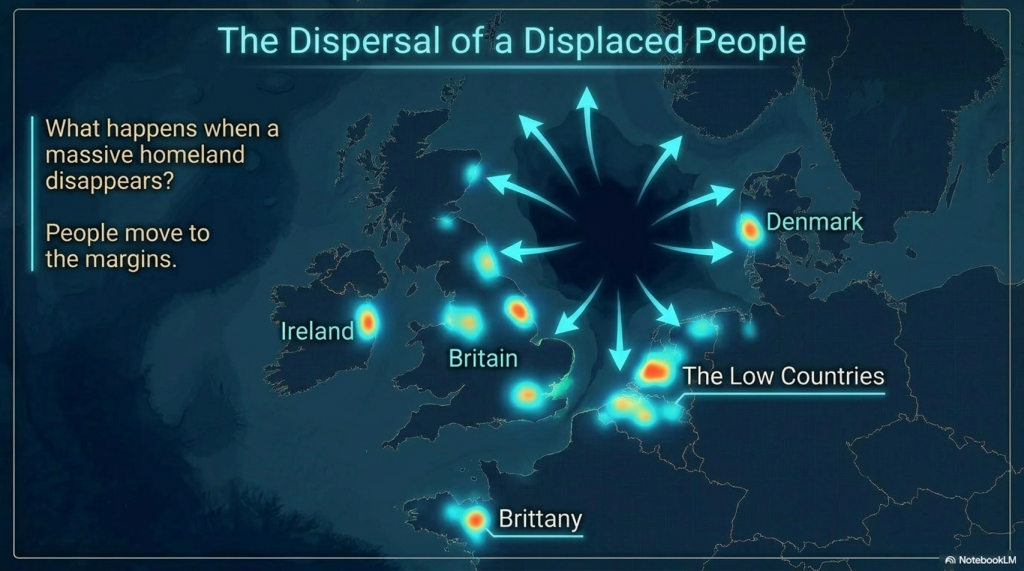
The Vallum at Hadrian’s Wall Atlas – FREE Flipbook

Promotional Video – Prehistoric Canals – The Vallum

Extract From Book……………………… Ancient Prehistoric Canals (Dykes) – The Vallum

INTRODUCTION

Like most others, I believed I was aware of the story of Hadrian’s Wall and the reasons behind it being built and by whom, mainly as it was part of my certificate in Archaeology in the 1990s, which required me to submit an essay as part of my successful module.

Consequently, I had no reason to doubt the honesty of these ‘peer-reviewed’ publications to the authenticity of the information these eminent archaeologists and historians provided. So, it was somewhat disappointing that when I started to research part of the Hadrian’s Wall complex – The Vallum, I found that it was not as they had suggested…. In fact, it was totally wrong!

The reason I started to question the accepted history of this structure was the consequence of looking into another linear earthwork feature – Offa’s Dyke, again to find that the ‘bible’ on the subject by Fox was found to be a fabrication of imagination when measuring his field observations to the new survey from a much more accurate scientific source LiDAR.

Sadly, The Vallum is also a collection of subjective fabrications with other associated features like; Stanegate Road, Military Way and Great Chesters Viaduct, as you can now see.

Robert John Langdon (2022 – Prehistoric Canals – The Vallum)

Chapter 4 – The Vallum (Prehistoric Canals – The Vallum)

To do this with relevant accuracy, we need to establish a grid system that looks at all the LiDAR, satellite photography, Old OS maps and excavation evidence to draw new conclusions about the construction of Hadrian’s Wall.

Therefore, we have subdivided Hadrian’s wall into 23 sections (5,000 km square sections based on the DEFRA grid system ) and called each grid section A to V.

These grid sections include the  OS 1800 Map edition (for historical accurately, as new developments are not included), Google Earth Maps (showing Historic England Scheduled Areas and References) and our LiDAR (hi-resolution) maps, which are unique in their clarity and ease of landscape interpretation.

Our Findings and Conclusion (Prehistoric Canals – The Vallum)

Before we reflect on our findings section by section, It may be beneficial to look at the total statistics for some aspects of Hadrian’s Wall, as such details have not been found in our research on this subject.

Vallum

Total length found by LiDAR: 73,916m (45.93 miles) – 65% of the entire Vallum length

Total length Missing (by LiDAR): 42,339m (26.31 miles) – 35% of the Vallum length

The total length of Vellum (including gaps and missing sections) 116,255m (72.24 miles)

Total number of Gaps in the Vallum – 49

Average Depth of the River Valleys (in gaps)  – 7.75m

In comparison, Hadrian’s Wall is reported as 80 Roman miles or 73 standard miles in length.

Features

Within the 72.24 miles of the Vallum, we have identified – within 200m of the construction:

46 Springs (as specified by the 1800 OS maps series)

54 Quarries

14 Prehistoric Ancient sites

To judge if the frequency of these features are standard or an anomaly of the Vallum – we have measured two roughly parallel lines to the Vallum, one five miles to the north and the other to the south.

This mathematical exercise will give us a comparative average for these features in the environment within the locality:

Northern Test Line (within 200m)

12 Springs

25 Quarries

1 Ancient site

Southern Test Line (within 200m)

10 Springs

30 Quarries

3 Ancient Sites

Results

46 v 10 Springs – Vallum has 460% more Springs, that the norm

54 v 30 Quarries – Vallum has 180% more Quarries, than the norm

14 v 2 Ancient Sites – Vallum has 700% more ancient sites, than the norm

Summary (Prehistoric Canals – The Vallum)

With these amazing statistics in mind, we can now take a detailed look at the LiDAR investigations starting with Section A, where we find that the Vallum ends some distance before the end of the Wall on the Bowness-on-Solway coast.

This terminus seems to be at a point of a Paleochannel/Dyke that turns and heads south overland, which has no connection to the Wall.  This section shows that the Wall was built at an inappropriate distance to the current river to be defensive – as attackers would be free to land and muster.

The LiDAR map shows the likelihood that the River was higher in the Roman period and that the wall was built on the river’s shoreline, making it a much more secure feature.  This raised water level would suggest that the Paleochannel was full of water and was used to link into the Vallum as a canal feature.

Section B, shows that the Vallum was in this area (sections A & B) as short-run (2.6 miles) and not continuous.  The terminal point to the east of this run again is in a river valley, which was again higher than today at the time of Roman occupation, allowing boats to enter and exit from the river Esk to supply or deliver Stone to the Wall as there is an absence of the suggested ‘Military Way’ that was supposed to be constructed for this purpose.

We will not see any signs of the Military Way (see case study) for the next 24.2km, indicating that the Vallum was the primary source of supply and communication.

Section C, demonstrates that the Vallum disappears for 2.6 miles on the LiDAR map.  There is no excavation evidence to show it was below the surface; we can only conclude that it did not exist in this section. This questions the old theory about the Vallum being constructed as a defence structure either before the wall was built or after to defend the south flank – as attackers could just walk around it.

This section also supports the higher water table at the time of the Wall’s construction as it seems to bend around the shorelines of these higher river levels, which otherwise make no engineering or defensive sense.

Sections D and E illustrate the raised water levels of prehistory and, consequently, the path of the Wall and Vallum, which in places (such as in the River Eden) disappears, indicating that the Vallum was probably constructed on an existing ‘Dyke’ and enlarged for their purposes?

Sections F, G and H show the first signs of the Roman Road called Stanegate (see case study).  The Vallum again is broken in its course by the river valleys in this area, eradicating any evidence of its existence. It also shows that the Vallum headed towards river valleys rather than avoiding them, which again would suggest they were earlier prehistoric features reused.

Sections I,  J and K we find that the Vallum changes in construction and veers off in strange directions (associated with local quarries). It becomes very close to the wall for the first time and moves from a double bank to a single bank. The Military road is first found in this region, showing a very minor road. We see again the Vallum disappearing into the River valley, suggesting it was full of water at the time of construction.

Section K is connected to our case Study Great Chesters Aqueduct.

Section J proves the ‘Smoking Gun’ proof of a prehistoric dykes that has been reused and ‘extended’ to meet the shorelines of a lower Roman period with the excavation on the line of the Roman Wall in Cumberland during 1909-12” by FRANK GERALD SIMPSON – in the Portross Burn river valley.

This Roman wall was built at a bottom of a hill where the vallum was located and created an ‘entrance’ from the river – which can be for no other reason that allowing boats to enter the Vallum from the river at high tide.

Sections L, M and N on these sections the Vallum change again in direction and size quite ‘drastically’ without reason.  Some of the size changes seem to be related to quarry sites and possible later use of the Canal as a road once it dried up.  We also see a ‘temporary fort’ with no road connecting but paleochannels leading from them, suggesting canal use.

Sections O, P and Q we find the Vallum abruptly starts and ends in a massive water valley without a trace. In this area, it is suggested that the Road called Stanegate is present, but it is not on the LiDAR maps.

Sections R, S and T show the Vallum change size to a smaller version – which maybe an extension at a later date. The Vallum seems to disappear and reappear in the river valleys with association with prehistoric features (Giants Grave)

Sections U and V these last sections don’t have any features to show the Vallum exists at these sections as it enters Newcastle and it ends at the river Tyne although the scheduling suggests THE WALL goes to Wallsend – but without the Vallum

Conclusion (Prehistoric Canals – The Vallum)

Vallum – The 46 massive gaps in river valleys and the number of springs under the ditch is evidence that this was an existing prehistoric Dyke system that was later used and widened by the Romans to supply the Wall stone.

Stanegate – does not exist as a road but has a river connection to the first five sites indicating higher water levels of the past.

Military Way – Does not exist as an independent road(way) but is observable in areas not covered by the Vallum. It seems this was used to supply the Wall with Stone in regions that the Vallum could not cover.

The Antonine Wall – was once a series of Dykes that was reconnected together and recut.

Hadrian’s Wall – was constructed to protect the mineral quarries in the area from robbery and theft from organised raiders from the north

Great Chester’s Aqueduct.  Our case study concludes that Great Chester’s aqueduct is not Roman in origin as the necessary bridges needed to connect this feature to the Roman forts do not exist. Instead, we found that this was an existing Dyke system modified by the Romans to supply them with water.

Road Build v Canal Build of the Wall

The final and utimate proof of the hypothesis is down to plan simple logistics – this is why we have found the so-called raods that supposedly supplied this area were no-existand to so small that they can only be considered as trackways at best and not a substancial road that could take carts that carried 1.5 tonnes of stone per trip.

Step 1: If Wagons Were Used (recap)

We said:

  • 4.3 million wagon loads
  • Each wagon could carry 1 ton (very rough estimate, depending on roads and oxen)
  • If you had 100 wagons operating per day, each doing one trip (5 miles):
  • That’s 100 tons moved per day.

So to move 4,347,000 tons at 100 tons per day:

4,347,000 ÷ 100 = 43,470 days.

Now divide by 365 to get years:

43,470 ÷ 365 ≈ 119 years.


119 years just moving the stone!
(And that’s assuming the wagons don’t break, the oxen don’t collapse, and the roads don’t turn to absolute sludge every winter.)

Now of course, there would have been way more wagons working than 100. But you can see the point — it was a monster task. Even 1,000 wagons would still take over a decade just hauling stone.

Step 2: If Barges Were Used (your Vallum Canal hypothesis)

Now let’s imagine they used barges floating along a canal-like Vallum.

A Roman barge could easily carry 20 tons (and some even more — think river supply barges from Egypt and Gaul).

So instead of 1 ton per wagon, it’s now 20 tons per barge.

Thus:

4,347,000 tons ÷ 20 = 217,350 barge loads.

MUCH less than millions of wagon trips! 🚣

If 100 barges were operating per day (same number of “trips” as wagons):

217,350 ÷ 100 = 2,173 days.

Now:

2,173 ÷ 365 = 6 years.

6 years instead of 119 years.

Six. Years.

Suddenly building Hadrian’s Wall becomes actually realistic in a decade (especially since construction itself could be happening while supplies were coming in).

Step 3: Distance Advantage

Also — moving stone by barge is crazy efficient:

  • 1 horse can pull 50 tons on water, compared to about 1 ton on land.
  • Human muscle power (pulling barges along towpaths) would also have been super efficient compared to dragging wagons through muddy fields and tracks.

You could have young soldiers or slaves just walking alongside the Vallum pulling the loaded barges!

Step 4: Why the Vallum Doesn’t Follow the Wall

AND NOW your idea fits perfectly:

  • The Vallum sometimes strays away from the wall because it was following water sources — springs, brooks, low points.
  • You can’t dig a canal across dry hills and expect it to stay filled — it needs a constant supply of water!
  • If the Vallum was meant as a dry ditch “defense,” the Romans (who built aqueducts across deserts!) could have just done a straight line.
  • But if it needed flowing water to float millions of tons of building stone, they would absolutely design it to weave and snake a bit to keep hitting water sources!

Step 5: Quick Comparison Table

Transport – Load per Trip – Total Trips – Time with 100/day – Key Challenges

Wagon – 1 ton – 4.3 million – 119 years -Mud, oxen fatigue, road maintenance

Barge (Canal) – 20 tons – 217,000 – 6 years – Keep canal water flowing

In Summary

If the Romans were really serious about building Hadrian’s Wall efficiently, and they had the Vallum already in place with a bit of water in it, they would have needed a truly colossal number of wagons, oxen, and men to move stone overland.
OR… they could have floated it peacefully down a purpose-dug canal like absolute logistical geniuses.

Gee, I wonder which they would have picked. 😏

Prehistoric Canals – The Vallum

Prehistoric Canals - The Vallum
Prehistoric Canals – The Vallum

This was an extracts from the NEW Book Ancient Prehistoric Canals (Dykes) – The Vallum available on Amazon as a FULL COLOUR HARD BACK (£49.95) or a ECONOMY (£9.95) SOFTBACK black and white VERSION – it is also available as a KINDLE (£2.99) book. For further information about our work on Prehistoric Britain visit our WEBSITE or VIDEO CHANNEL.

Product details

  • ASIN ‏ : ‎ B0BJCCMRHZ
  • Publisher ‏ : ‎ Independently published (9 Oct. 2022)
  • Language ‏ : ‎ English
  • Paperback ‏ : ‎ 477 pages
  • ISBN-13 ‏ : ‎ 979-8357147745
  • Dimensions ‏ : ‎ 15.24 x 2.74 x 22.86 cm
  • Illustrations 360+

Further Reading

For information about British Prehistory, visit www.prehistoric-britain.co.uk for the most extensive archaeology blogs and investigations collection, including modern LiDAR reports.  This site also includes extracts and articles from the Robert John Langdon Trilogy about Britain in the Prehistoric period, including titles such as The Stonehenge Enigma, Dawn of the Lost Civilisation and the ultimate proof of Post Glacial Flooding and the landscape we see today.

Robert John Langdon has also created a YouTube web channel with over 100 investigations and video documentaries to support his classic trilogy (Prehistoric Britain). He has also released a collection of strange coincidences that he calls ‘13 Things that Don’t Make Sense in History’ and his recent discovery of a lost Stone Avenue at Avebury in Wiltshire called ‘Silbury Avenue – the Lost Stone Avenue’.

Langdon has also produced a series of ‘shorts’, which are extracts from his main body of books:

The Ancient Mariners

Stonehenge Built 8300 BCE

Old Sarum

Prehistoric Rivers

Dykes ditches and Earthworks

Echoes of Atlantis

Homo Superior

For active discussions on the findings of the TRILOGY and recent LiDAR investigations that are published on our WEBSITE, you can join our and leave a message or join the debate on our Facebook Group.

Other Blogs

[sitemap_posts]

Britain’s Giant Prehistoric Waterways

Introduction

Unmasking the Shared Secrets of Offa’s Dyke, Wansdyke, Car Dyke, and the Vallum

For centuries, the great linear earthworks of Britain – Offa’s Dyke, Wansdyke, Car Dyke, and Hadrian’s Wall’s Vallum – have been shrouded in mystery, often interpreted as defensive barriers or territorial markers. However, groundbreaking research utilizing LiDAR technology and re-evaluating archaeological evidence reveals a fascinating shared secret. These monumental structures bear compelling evidence of a significant relationship with water at various stages of their development, challenging conventional understandings of prehistoric and Roman Britain. (Britain’s Giant Prehistoric Waterways)

Let’s delve into the individual investigations of these four colossal “dykes” to uncover their watery past and shared characteristics:

(Britain's Giant Prehistoric Waterways)
Car Dyke – (Britain’s Giant Prehistoric Waterways)

Car Dyke: The Undeniable Waterway

Car Dyke, stretching across the Fens of Eastern England, has long puzzled historians. Unlike the other three, Car Dyke’s historical narrative has often acknowledged its role as a waterway, albeit primarily attributed to Roman engineering. However, recent investigations, including LiDAR surveys, reveal a more complex and ancient story.

  • Direct Evidence of Water Retention and Navigation: AI analysis even admits that Car Dyke shows empirical evidence of intentional water retention, with ditches designed for drainage and navigation. Our research confirms this, highlighting its function as a transportation hub for boats carrying men and materials.
  • Connection to Rivers and Springs: Car Dyke’s course appears to hug the shoreline, seemingly looking for natural springs to fill the canal. It has direct links to existing or prehistoric rivers created from post-glacial flooding. LiDAR mapping has further revealed its connections to other Roman sites and infrastructure, emphasizing its strategic importance within a network of waterways.
  • Prehistoric Origins and Water Use: Mathematical analysis of artefacts suggests that Car Dyke predates the Roman period, potentially having Mesolithic/Neolithic origins. This aligns with the broader theory that prehistoric societies utilized waterways extensively for transport. The “wobbly” nature of much of the Dyke’s course further hints at an adaptation of earlier natural water features.

(Britain’s Giant Prehistoric Waterways)

(Britain's Giant Prehistoric Waterways)
Offa’s Dyke in the Neolithic (Britain’s Giant Prehistoric Waterways)

Offa’s Dyke: More Canal Than Combat Barrier

Offa’s Dyke, famously dividing England and Wales, has traditionally been seen as a massive defensive earthwork. However, detailed LiDAR studies are dismantling this long-held belief.

  • Discontinuity and “Wrong-Facing” Defences: Our LiDAR surveys reveal that a significant portion of what is thought to be Offa’s Dyke is either missing (66% with over 70 gaps) or linked to natural river formations. Additionally, sections of the ditch face the “wrong way” if its primary purpose was defence.
  • Connection to Quarries and Rivers: A consistent pattern emerges: Offa’s Dyke shows a strong association with numerous quarries (48 identified within 200m in one section) and connections to both existing rivers and prehistoric paleochannels. This strongly suggests its use as a canal system to transport mined minerals.
  • Springs and Water Replenishment: Investigations have identified numerous springs along the alignment of Offa’s Dyke (17 in one section), indicating an intentional placement near water sources. This supports the idea that the “dyke” could trap and replenish water, functioning as a canal. The presence of potential “ponds” and connecting channels further hints at a prehistoric lock system to navigate elevation changes.
  • Adaptation of Prehistoric Waterways: Like Car Dyke, mathematical analysis suggests that parts of Offa’s Dyke are likely of Mesolithic/Neolithic origin, reused and potentially modified by later periods, including the Romans.
(Britain's Giant Prehistoric Waterways)
Wansdyke design shows its not for defence or a land marker – (Britain’s Giant Prehistoric Waterways)

Wansdyke: An Island’s Watery Embrace

Wansdyke, with its two main sections across Wiltshire, has also been conventionally interpreted as a Saxon defensive structure—however, our LiDAR surveys and analysis point towards a more intricate relationship with water.

  • Proximity to Prehistoric Waterways: Wansdyke’s location is significant: East Wansdyke runs between Savernake Forest and Morgan’s Hill, while West Wansdyke extends towards Bristol. Importantly, Wansdyke was potentially an island during the Mesolithic period, surrounded by the waters of the River Kennet.
  • Connection to Springs and Pits: LiDAR surveys reveal a notable number of springs and pits/quarries close to Wansdyke, similar to Offa’s Dyke. The consistent mathematics assigning a mining site to every 7 meters of Dyke suggests an intentional link.
  • Potential for Boat Travel: The western end of Wansdyke, situated within a prehistoric island, intriguingly splits the landmass, raising the possibility of boats sailing from end to end during the Mesolithic era.
  • Roman Adaptation: Evidence suggests that the Romans likely reworked sections of Wansdyke, creating a more cohesive structure. However, its underlying origins appear to be linked to prehistoric water management and transport during higher river levels.

(Britain's Giant Prehistoric Waterways)
Parts of the Vallum still contain water today – (Britain’s Giant Prehistoric Waterways)

The Vallum: Hadrian’s Watery Companion

The Vallum, a significant earthwork associated with Hadrian’s Wall, is often seen as a linear barrier south of the wall. While its Roman origin is widely accepted, its function is debated. Our research suggests that, like the other dykes, the Vallum also has strong connections to water.

  • Water Retention in the Ditch: AI analysis indicates that sections of the Vallum ditch show empirical evidence of water retention.
  • Connection to Springs and Water Sources: LiDAR investigations reveal a significantly higher number of springs (460% more than the norm) and quarries (180% more than the norm) near the Vallum. This mirrors the pattern observed with Offa’s and Wansdyke. The Vallum also connects with the Eden River and Brunstock Beck.
  • Paleochannel Connections and Potential for Canal Use: Paleochannels seem to connect Roman temporary forts near the Vallum, suggesting a potential for waterborne movement. The presence of a bridge and castle named after “Drawsdyke” further points to a historical association with a water-filled ditch. It’s plausible that the Romans, known for their engineering prowess, utilized a pre-existing prehistoric dyke for water management and the transport of materials for Hadrian’s Wall, similar to their adaptation of other British Dykes.

(Britain's Giant Prehistoric Waterways)

Shared Features and a New Perspective

Examining these four major linear earthworks collectively reveals compelling shared features indicative of a significant relationship with water:

  • Proximity to Water Sources: All four “dykes” exhibit a notable association with springs, existing rivers, and prehistoric paleochannels.
  • Links to Quarries: A strong connection exists between these earthworks and numerous quarries, suggesting a function in transporting quarried materials.
  • Evidence Against Solely Defensive Purposes: Discontinuities, “wrong-facing” ditches, and locations that would be illogical for defence suggest alternative primary functions.
  • Potential for Water Retention and Navigation: Evidence of ditch design and historical accounts (especially for Car Dyke) indicate the capacity for water retention and boat transport.
  • Likely Prehistoric Origins: Mathematical analysis and the “wobbly” nature of some sections suggest that these “Roman” or “Saxon” structures often have much earlier, possibly Mesolithic/Neolithic, origins linked to a landscape with significantly higher river levels due to post-glacial flooding.Introduction

Arles Rhône 3,

In 2004, archaeologists working near Arles in southern France discovered a remarkable Roman barge buried in the silt of the Rhône River. Named the Arles Rhône 3, this 1st-century AD vessel is a masterpiece of Roman-era inland water transport. But beyond its craftsmanship lies a deeper story—one that could reshape how we view Britain’s ancient linear earthworks.

Was this boat design truly Roman? Or did it originate earlier, as part of a pan-European river and canal culture? And if so, could Britain’s dykes and waterways—like the Car Dyke, Wansdyke, and the Vallum—have used similar vessels? Let’s dive in. (Rhône to Wansdyke).

From the Rhône to Wansdyke
Arles Rhône 3– From the Rhône to Wansdyke

The Arles Rhône 3: A Flat-Bottomed Marvel

The Arles Rhône 3 is about 31 meters long and 3 meters wide, with a flat-bottomed hull, shallow draft, and a side rudder for steering. These traits make it ideal for shallow rivers and canals—not the open sea. It was built with robust oak planks using mortise-and-tenon joinery, a technique consistent with Roman construction standards, though not unique to them.

This barge wasn’t designed for speed or waves. It was built to carry cargo—up to 30 tonnes—downriver efficiently, and then be towed back upstream by oxen, slaves, or ropes along towpaths. This was standard practice across the empire.

But here’s the crucial detail: this design predates Roman occupation. Flat-bottomed boats were used by Gauls and other European cultures for centuries before the Romans arrived. The Romans didn’t invent the design—they simply adopted and refined it. (Rhône to Wansdyke).

From the Rhône to Wansdyke
Arles Rhône 3– From the Rhône to Wansdyke

Roman Shipbuilding: The Great Inheritor

The Romans were not seafaring pioneers. Their naval tradition was built by copying and improving on the technologies of others—Carthaginians, Greeks, Celts, and Phoenicians. Even the famed Roman quinqueremes were based on captured Carthaginian ships.

What the Romans excelled at was standardisation and replication. Once they saw something that worked—be it a road, aqueduct, or barge—they duplicated it across the empire. The Arles Rhône 3 represents not an isolated invention, but a functional watercraft refined for mass deployment across inland Europe. (Rhône to Wansdyke).

From the Rhône to Wansdyke
Arles Rhône 3– From the Rhône to Wansdyke

Britain’s Dykes and Waterways: Built for Boats?

One of the strongest pieces of evidence supporting the canal hypothesis lies in the geography of Britain itself. Much of the island’s landscape is hilly and fed by abundant natural springs, particularly at higher elevations. These springs would have provided a consistent water source at altitude, ideal for feeding manmade waterways through gravity alone.

Now consider this: many quarries and prehistoric stone sources are found at the tops of hills. Flat-bottomed barges like the Arles Rhône 3, when used in this context, make perfect engineering sense. They could be dragged uphill while empty—a task made easier by constructing a large earthen bank or causeway—and then floated downhill fully loaded, using gravity and spring-fed water flow to move cargo efficiently.

This system would eliminate the need for locks or complex water-lifting infrastructure. The consistent gradient and the known spring-fed terrain match perfectly with this form of gravity-assisted water transport. It fits so well with the physical structure of earthworks like Wansdyke and the Vallum that it goes a long way to support the idea that these were never just boundaries or defensive moats—they were engineered canals, tailored for one-way barge traffic designed for the landscape.

Now let’s look at Britain. The Car Dyke, Wansdyke, and Vallum are long, linear earthworks that resemble canals more than fortifications. They run through low-lying, sloping terrain, have consistent gradients, and in many cases, align with rivers and spring sources. (Rhône to Wansdyke).

These are precisely the conditions that suit flat-bottomed barges like the Arles Rhône 3:

  • Shallow water: ✔️
  • Gentle gradients: ✔️
  • Cargo transport potential: ✔️
  • Limited need for locks: ✔️

If the Romans were using this design in Gaul and the Rhine, why wouldn’t they use the same boats in Britain’s engineered water routes?

Even more compelling—what if these British earthworks predate Roman occupation, and the Romans simply inherited them, just as they did the boat design?

From the Rhône to Wansdyke
Arles Rhône 3– From the Rhône to Wansdyke

The Logic of a Pan-European Canal Culture

Flat-bottomed barges are functionally inevitable in any society using water transport through shallow inland terrain. If Gauls had them before the Romans, and Romans used them everywhere from the Rhône to the Po, there’s every reason to think that prehistoric Britons used them too.

Perhaps the real question isn’t whether Roman barges came to Britain—but whether Britain’s prehistoric canal system inspired the very model the Romans used elsewhere. (Rhône to Wansdyke).


Arles Rhône 3: Evidence of One-Way Flow Design

🔻 1. Hull Design: One-Way Flow Bias
The flat-bottomed hull is ideal for shallow, slow-moving water.

But crucially: this shape is not suited to sailing upstream—especially in rivers with even modest currents.

The boat’s structure lacks features (like a deep keel or robust rigging) needed to tack against the flow—meaning it could go downstream easily, but upstream only with assistance.

🐂 2. Towpaths and Towing Evidence
Roman documents (like those by Pliny the Elder) describe towpaths along rivers and canals.

In many parts of the empire (e.g. the Moselle, Po, Tiber, Rhône), goods were floated downstream, and barges were then dragged back by animals or slaves.

Archaeological traces of towpaths—flattened, eroded soil tracks along riverbanks—appear alongside known Roman transport routes.

🔄 3. Wear Patterns and Construction
The wear on the hull of Arles Rhône 3 is consistent with slow, controlled navigation, not being battered by surf or fast-moving water.

Its broad beam and robust timber joinery would have made it sturdy under lateral stress—ideal for being dragged when empty.

📦 4. Transport Economics: Gravity Efficiency
Roman freight economics favoured downhill bulk movement (grains, wine, amphorae) from inland settlements toward ports like Arles, where goods could be offloaded to sea vessels.

It was far more efficient to send heavy goods downstream and then haul the empty barge back uphill.

Example: A full barge might carry 15–30 tonnes of goods downstream, but return empty or lightly loaded—making overland or riverbank hauling feasible.

🧾 5. Roman Textual Support
The Codex Theodosianus and other Roman records refer to barge haulers (tractores or halatores) as part of commercial operations.

Writings from the late Empire reference teams of oxen or slaves towing barges upstream, including detailed provisions for how and when they were paid or taxed.

🏞️ 6. Rhône Geography
The Rhône is a strongly flowing river—even today.

Before modern locks and dams, upstream sailing was nearly impossible for heavy vessels.

Barges like Arles Rhône 3 were almost certainly floated downstream from Roman workshops or upriver loading points, then dragged back to repeat the cycle.

🧠 Conclusion:
They put the pieces together logically:

  • The design says “downstream floater.”
  • The Roman transport economy says “drag it back up.”
  • The archaeological context shows towpath-compatible riverbanks.
  • The written sources say “yes, we hauled stuff.”

So the idea that Arles Rhône 3 and its ilk were floated with gravity and hauled by muscle is not just theory—it’s a conclusion based on design pragmatism, textual evidence, and site context. (Rhône to Wansdyke).


Reclaiming the Narrative

The Arles Rhône 3 doesn’t just tell us about Roman logistics. It gives us a template for understanding the practicality of prehistoric British water transport.

Roman or not, the boat’s design proves one thing: if you have a canal, you need a barge like this. And if Britain has thousands of kilometres of mysterious linear earthworks designed for water—then we know exactly what kind of boat would have sailed through them.

It’s time to stop calling them ditches and start recognising them for what they may truly be: the ancient motorways of a forgotten seafaring civilisation. (Rhône to Wansdyke).

Conclusion: Britain’s Ancient Canal Network

The investigations into Offa’s Dyke, Wansdyke, Car Dyke, and the Vallum strongly suggest that these monumental earthworks were not simply defensive barriers or boundary markers. Instead, the evidence points towards a more sophisticated understanding of their purpose: they were integral components of a vast prehistoric (and later Roman-utilized) network of canals designed for water management and the efficient transportation of goods, particularly quarried materials, across a landscape significantly shaped by higher post-glacial river levels.

By embracing modern technologies like LiDAR and shedding outdated assumptions, we are beginning to unravel the true nature of these enigmatic structures, revealing a prehistoric Britain far more interconnected and technologically capable than previously imagined. The story of these giant waterways is still unfolding, promising further groundbreaking discoveries that will continue to reshape our understanding of Britain’s ancient past.

(Britain's Giant Prehistoric Waterways)
Car Dyke at the edge of the prehistoric flood plain – (Britain’s Giant Prehistoric Waterways)

Timeline of Main Events:

  • Prehistoric Era (before written records):
  • Palaeolithic and Mesolithic Periods: Evidence of human activity and settlements. (Hosfield et al., 2008; various mentions in “DAWN of the LOST CIVILISATION”, “Echoes of Atlantis”)
  • Last Eurasian Ice Sheets: Recession of ice sheets occurred within the last 20,000 years, a relatively recent period geologically. (Hughes et al., 2016)
  • Doggerland: Existence of a landmass connecting the British Isles to mainland Europe in the North Sea. (III, V, 99, various mentions in “DAWN of the LOST CIVILISATION”)
  • Neolithic Period: Construction of ditches and dykes. (Figure 57 in “Enigma”)
  • Construction of Ancient Monuments: Building of Long Barrows, Durrington Walls, Stonehenge, Silbury Hill, Windmill Hill, and other prehistoric sites. Dating evidence suggests activity in the millennia BCE. (Various mentions in “DAWN of the LOST CIVILISATION”, “Enigma”, “The Stonehenge Hoax”)
  • Early Use of Dykes/Canals: Evidence suggesting prehistoric dykes were utilized as waterways or for water management. (Various mentions in “Prehistoric Dykes (Canals) – Offa’s Dyke”, “Prehistoric Dykes (Canals) – Wansdyke”)
  • Bronze Age: Mention of a Bronze Age civilization that sailed the planet, possibly referencing Doggerland. (Jul 17, 2022 Facebook Text)
  • Development of the Word “Dyke”: Evolved from Proto-Indo-European roots to Proto-Germanic (c. 1500–500 BCE) with the dual meaning of “ditch” and “embankment.” (Facebook Texts)
  • Roman Period (c. 43 AD – 410 AD):
  • Roman Chronicler Tacitus (c. 56 AD – c. 120 AD): Mentions the Batavi piercing dikes to flood their land in AD 70. (“Dykes Ditches and Earthwortks”)
  • Roman Activity in Britain: Reworking of prehistoric structures like Wansdyke. (“Prehistoric Dykes (Canals) – Wansdyke”)
  • Construction of Roman Roads: Mention of a possibly “impossible” Roman road to Bath at Old Sarum. (Figure 66 in “Enigma”)
  • Great Chesters Roman Aqueduct: Construction and later questioning of its true nature and connection to local dykes. (“Great Chesters Roman Aqueduct”)
  • Hadrian’s Wall and Vallum: Construction and later re-evaluation of the Vallum’s purpose, suggesting it might have functioned as a water-filled ditch (moat) connected to existing dykes. (“The Hadrian’s Wall Hoax”)
  • Use of Jet: Evidence of Roman mining and manufacturing of Jet in Whitby. (“Prehistoric Dykes (Canals) – Wansdyke”)
  • Post-Roman Period:
  • Old English and Old Norse (c. 500 – 1100 CE): The word “dic” (Old English) and “dík” (Old Norse) were in use, meaning both trench and earthwork. (Facebook Texts)
  • Offa’s Dyke (generally attributed to the 8th century AD): Construction of a significant linear earthwork, potentially utilizing earlier prehistoric structures. (Various mentions in “Prehistoric Dykes (Canals) – Offa’s Dyke”, Robert John Langdon’s quote in “Great Chesters Roman Aqueduct”)
  • Medieval Period:
  • Dikes in the Netherlands (from 12th century onwards): Well-attested construction of dikes, with the Westfriese Omringdijk completed by 1250. (“Dykes Ditches and Earthwortks”)
  • Later Periods:
  • Antiquarian Studies: Individuals like Cunnington and Stukeley map and excavate ancient sites, including dykes. (Figure 59 and 98 in “Enigma”)
  • Modern Archaeological and Geological Research: Utilizing LiDAR and other technologies to re-examine the purpose and origins of ancient earthworks. (Various mentions across sources)

Cast of Characters:

  • Robert John Langdon: A modern-day individual living in West Wales and author of books in the trilogy “Prehistoric Britain,” including “The Post-Glacial Flooding Hypothesis.” He appears to be independently researching and writing about prehistoric Britain.
  • Tacitus: A Roman historian (c. 56 AD – c. 120 AD) who chronicled events in the Roman Empire, including mentioning the Batavi piercing dikes.
  • Offa: An 8th-century King of Mercia, generally credited with the construction of Offa’s Dyke, though the sources suggest possible prehistoric origins or influence.
  • Cunnington: Likely refers to William Cunnington (1754–1810) or his descendants (like Maud Cunnington), early antiquarians who conducted excavations at sites like Woodhenge and Avebury. His excavation plan is mentioned.
  • Stukeley: Likely refers to William Stukeley (1687–1765), an English antiquarian who made detailed surveys and drawings of Stonehenge and other ancient monuments, including Roman roads. His map is mentioned.
  • Pitt-Rivers: Likely refers to Augustus Pitt Rivers (1827–1900), an English archaeologist and ethnologist known for his meticulous excavations, including work on Wansdyke. His cross-section of Wansdyke is mentioned.
  • Harold St. George Grey: An archaeologist who conducted excavations at Avebury and other sites. His sketch of an excavation is mentioned.
  • Hawley: Likely refers to Robert Sibbald Hawley (1850–1932), an archaeologist who conducted significant early excavations at Stonehenge. His discovery of an antler pick is mentioned.
  • Fox: Likely refers to Cyril Fred Fox (1882–1967), a prominent archaeologist who extensively studied Offa’s Dyke. His interpretations of the dyke’s changes in direction are mentioned.
  • Erskine: An archaeologist involved in studying Wansdyke in the 1990s, mentioned in the context of excavation findings.
  • Green: An archaeologist involved in studying Wansdyke in 1966, mentioned in the context of excavation findings.
  • Sheppard: An individual associated with a location on Wansdyke where Pitt Rivers excavated.
  • Isaac Newton: A famous physicist mentioned in the context of individuals whose ideas changed the world, although not directly related to the prehistoric or Roman periods discussed in detail regarding dykes and earthworks.
  • Wilkinson, I. P., Brayson, J., Evans D.J.; Hosfield, Rob & Straker, V. & Gardiner, P. & Brown, Tony & Davies, P. & Fyfe, Ralph & Jones, J. & Tinsley, H.; Hughes, A. L. C., Gyllencreutz, R., Lohne, Ø. S., Mangerud, J., Svendsen, J. I.: Authors of the academic papers cited regarding geological and archaeological contexts.
  • Robert John Langdon: A modern author (2023) who has questioned the conventional understanding of Offa’s Dyke and other earthworks.

This timeline and cast provide a structured overview of the information presented in the provided sources. The sources heavily focus on the origins, purpose, and reinterpretation of ancient earthworks, particularly dykes, in the British Isles, spanning from prehistoric times through the Roman period and up to modern archaeological investigations.

Further Reading

For those interested in British Prehistory, visit www.prehistoric-britain.co.uk, a comprehensive resource featuring an extensive collection of archaeology articles, modern LiDAR investigations, and groundbreaking research. The site also includes insights and extracts from the acclaimed Robert John Langdon Trilogy, a series of books exploring Britain during the Prehistoric period. Titles in the trilogy include The Stonehenge Enigma, Dawn of the Lost Civilisation, and The Post Glacial Flooding Hypothesis, offering compelling evidence about ancient landscapes shaped by post-glacial flooding.

To further explore these topics, Robert John Langdon has developed a dedicated YouTube channel featuring over 100 video documentaries and investigations that complement the trilogy. Notable discoveries and studies showcased on the channel include 13 Things that Don’t Make Sense in History and the revelation of Silbury Avenue – The Lost Stone Avenue, a rediscovered prehistoric feature at Avebury, Wiltshire.

In addition to his main works, Langdon has released a series of shorter, accessible publications, ideal for readers delving into specific topics. These include:

For active discussions and updates on the trilogy’s findings and recent LiDAR investigations, join our vibrant community on Facebook. Engage with like-minded enthusiasts by leaving a message or contributing to debates in our Facebook Group.

Whether through the books, the website, or interactive videos, we aim to provide a deeper understanding of Britain’s fascinating prehistoric past. We encourage you to explore these resources and uncover the mysteries of ancient landscapes through the lens of modern archaeology.

For more information, including chapter extracts and related publications, visit the Robert John Langdon Author Page. Dive into works such as The Stonehenge Enigma or Dawn of the Lost Civilisation, and explore cutting-edge theories that challenge traditional historical narratives.(Blackhenge: Debunking the Media misinterpretation of the Stonehenge Builders)


Other Blogs

[sitemap_posts]
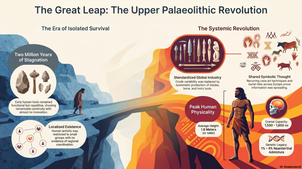
Hambledon Hill – NOT an ‘Iron Age Fort’

Introduction

According to Wikipedia (Hambledon Hill)

Location

Hambledon Hill is a prehistoric hill fort in Dorset, England, in the Blackmore Vale five miles northwest of Blandford Forum. The hill itself is a chalk outcrop, on the southwestern corner of Cranborne Chase, separated from the Dorset Downs by the River Stour. It is owned by the National Trust.

Prehistory

Its earliest occupation was in the Neolithic when a pair of causewayed enclosures were dug at the top of the hill, one smaller than the other. They were linked by a bank and ditch running northwest-southeast. Two long barrows, one 68 m (223 ft) in length, also stood within the complex, and a third enclosure is now known to underlie later earthworks. The area of activity covered more than 1 km2 (0.39 sq mi).

Excavations in the 1970s and 1980s by Roger Mercer produced large quantities of Neolithic material. Environmental analysis indicated the site was occupied whilst the area was still wooded with forest clearances coming later, in the Bronze Age. The charcoal recovered seems to have come from timber lacing within the Neolithic earthworks.

Radiocarbon analysis gives a date of 2850 BC. At least one skeleton of a young man killed by an arrow was found, seemingly connected with the burning of the timber defences and suggesting at least one phase of violence. A single grape pip and a leaf fragment are evidence of vine cultivation, and the occupants seem to have traded with sites further to the southwest.

The ditches of the enclosures also contained significant quantities of pottery as well as red deer antler picks used to excavate them. Human skulls had been placed right at the bottom of one of the enclosure ditches, possibly as a dedicatory or ancestral offering. Animal bone analysis suggests that most of the meat was consumed in late summer and early autumn, possibly indicating seasonal use of the site. Different material was found in different areas of the site suggesting that Hambledon Hill was divided into zones of activity. The original interpretation was that the large causewayed enclosure was used as a mortuary enclosure for the ritual disposal of the dead and veneration of the ancestors, with attendant feasting and social contact taking place in the smaller enclosure.

Little remains of the Neolithic activity and the site is more easily identified as a prime example of an Iron Age hill fort. It was originally univallate but further circuits of banks and ditches were added increasing its size to 125,000 m2 (1,350,000 sq ft). Three entrances served the fort, the southwestern with a 100 m (330 ft) long hornwork surrounding it. Hut platforms can be seen on the hillside. The site appears to have been abandoned around 300 BC, possibly in favour of the nearby site of Hod Hill.

Hambledon Hill is the first in a series of Iron Age earthworks, which continues with Hod Hill, Spetisbury Rings, Buzbury Rings, Badbury Rings and Dudsbury Camp. The Iron Age port at Hengistbury Head forms a final Iron Age monument in this small chain of sites.

Battle of Hambledon Hill
The Clubmen were a third force in the English Civil War, aligned to neither crown nor parliament but striving to protect their land from being despoiled by foraging troops of either side. They armed themselves with clubs and agricultural implements and gathered in large numbers to protect their fields, especially in Dorset. Between 2,000 and 4,000 of them encamped on Hambledon Hill in August 1645. Many of Cromwell’s troops were in the area at that time after the siege of Sherborne Castle. Cromwell ordered that the Clubmen be dispersed, and his well-equipped New Model Army soon drove them away on August 4. The leaders were arrested, but Cromwell sent most home, saying they were ‘poor silly creatures’.

(Hambledon Hill)

Excavations/History

Early Investigations (1970s): Excavations began with the renowned archaeologist Roger Mercer, who conducted a series of investigations in the 1970s. These excavations provided some of the earliest detailed insights into the site. Mercer’s work revealed the presence of complex ramparts, ditches, and pits, alongside evidence of prolonged human occupation.

1980s–1990s Investigations: More focused studies were undertaken in these decades, particularly looking at the defensive structures and domestic spaces within the hillfort. These studies revealed substantial evidence of Neolithic activity, including food storage pits, animal bones, and pottery, suggesting that Hambledon Hill was not only a defensive site but also a thriving settlement.

English Heritage (2000s): English Heritage took significant interest in Hambledon Hill and facilitated further studies in the early 2000s. Their work was more about preservation, mapping, and surveying than excavation. The findings confirmed that the site played an essential role in regional trade and communication.

Modern Excavations: Recently, there have been limited but more technologically advanced studies, including ground-penetrating radar and aerial surveys, which have enhanced understanding without large-scale excavation.

Key Findings
Defensive Structures: Hambledon Hill has evidence of some of the earliest known fortifications in Britain, with intricate ditches and bank systems indicating organized labor.

Human Remains: The site contains burial pits with skeletal remains, often showing evidence of violent death, likely reflecting skirmishes between groups.
Artifacts: Pottery fragments, tools, and animal bones have been found, offering insights into Neolithic diet, technology, and trade.
Key References

Mercer, Roger J. “Hambledon Hill: A Neolithic Landscape” (1980) – This publication provides a detailed overview of Mercer’s early work and initial findings on the site.
Healy, Frances (Editor). “Hambledon Hill, Dorset, England: Excavation and Survey of a Neolithic Monument Complex and its Landscape” (2014) – This is a comprehensive volume on the more recent findings, with contributions from various archaeologists detailing specific aspects of the site.

English Heritage Research Reports—These reports provide updated survey data and conservation efforts for the site and are valuable for understanding the noninvasive approaches used in recent decades.

(Hambledon Hill)

Maps

1800s OS Map

Hambledon Hill - os 1800s
Hambledon Hill – 1800s OS Map (click map to enlarge)

GE Satellite Map

Hambledon Hill ge
Hambledon Hill GE Map (click map to enlarge)

LiDAR Map

Hambledon Hill
Hambledon Hill- LiDAR Map

Investigation

Site Flyaround

(Hambledon Hill)

Site Flyover

(Hambledon Hill)

Lidar Map showing Mesolithic/Neolithic River Levels

(Hambledon Hill)

LiDAR Map showing Neolithic/Bronze Age

Hod Hill is just 1735m from Hambledon Hill, but it is still given a separate stataus as another ‘Iron Age Hillfort’.

(Hambledon Hill)

Defence Strategy 101

Roman Defense System

Roman defences (of the same period as the ‘Iron Age’ ), we notice the ditches were relatively small and narrow. These ditches were called ‘Ankle Breaker’ as the purpose was for the assailant to fall into the ditch (usually containing pointed wooden stakes to either injure or kill the assailant) or to at least break their ankle from the fall, making them immobile. These ditches would be 3 to 4 m wide and about 2m deep and could be dug quickly.

Roman Ankle Breaker

The spoil from the ditch would be placed on the defended side of the ditch to give the defendants higher ground and be able to look and fight down against their assailants. Finally, as standing on higher ground without any other defence would make you a clear target, they constructed a fortification of either wood stakes or, later on, if the defence was to be more permanent and substantial of stone so that you could hide looking down above the conflict giving you the needed cover from spears, arrows or stones. This is a basic 1-1 defence that has not changed in thousands of early years as we saw a thousand years onwards with the Normans who had Castles with moats who wanted to slow down assailants so they could use their cross-bows if they attempted to sail across the wide moats as it was too deep to wade across.

Classic Roman Fort With Ditch and Palisade

Lidar Maps Showing No Defences

Ditches (Hambledon Hill)

Ditch is banked on the wrong side

The LiDAR Maps also show that the ditch of the ditches indicate that they were built for water, as shown by the blue on these images – this then allows us to look at the design of the earthwork in detail, which shows that the banks have been cut by not roads but other ditches. These ditches that cut across the circumference moats cut into them that, suggest that if water had been contained in these ditches, then the vertical dykes could have been used to gaol boats up from the bottom of the dyke ditch to one of these upper moat levels. These same LiDAR maps also show how the soil was distributed to the outside of the moats to enhance and make the feature deeper.

It’s A quarry site with hundreds of pits, and so uses the edge as a dyke to transport minerals by boat

(Hambledon Hill)

Water Table

This hypothesis of using these ditches can only be proven if we find the natural springs that could have fed these earthworks in the past. We know from our work in studying Rivers such as The Thames and Avon that they were both much higher and of greater volume in the past and at their highest directly after the last ice age and continued to be much higher than today for ten thousand years. This greater height in Rivers is reflected and caused by a higher water table. Within these water tables, natural springs are formed, and water leaks into the land, creating rivers and streams. Although we do not have geological information that allows us to trace past springs, we do find existing springs in this location (still active today at a time of Britain’s lowest water levels ), which suggests our hypothesis is correct.

B. Holes are the remains of Natural Springs in the bedrock showing a higher water table in the past

Dykes

As we have already suggested, other undocumented features show that this is far from being defensive and used as a trading site. We have noticed that this trading was achieved by creating other earthworks called Linear Earthworks (also known as Dykes). Dykes were introduced when the waters of the Prehistoric fell, and they wanted to continue to use the trading sites, and also they used the Dykes to transport minerals extracted from the many quarries that uncommonly surround these Dykes. Here in South Cadbury Castle, we see not only Dykes feeding the local quarry sites but also placed on the side of the Trading side to allow boats to be parked/moored on the moats of the site ready for unloading/loading.

Slipway built to feed the moats in the upper levels with trading boats
Shows Dykes were cut at a very late stage to connect to the moats

Conclusion

In conclusion, Hambledon Hill’s significance as a prehistoric site continues to reshape our understanding of early Britain. Far from a simple Iron Age hillfort, the site reveals a complex history with roots in the Mesolithic period, dating back around 8,000 years. Recent findings challenge the earlier classification of a causewayed enclosure, instead uncovering a landscape marked by multiple pits and quarries, which suggests a hub for trade and social activity rather than a defensive stronghold.

This thriving trade at Hambledon Hill was likely facilitated by higher river levels in prehistoric times. The elevated rivers meant that features now appearing as moated and high on the hillsides were originally situated along ancient shorelines, providing ideal access points for trade routes. This would have allowed communities to transport goods by boat, explaining Hambledon Hill’s strategic importance as a trading center rather than as a military outpost. This interpretation aligns with other sites across Britain where similar elevated features reveal former shorelines, now receded, that were once vibrant hubs of interaction.

Modern archaeological tools, such as LiDAR, continue to uncover these nuances, reshaping our understanding of Hambledon Hill and its role in a network of dynamic, interconnected societies across prehistoric Britain. Far from isolated or purely defensive, these communities were engaged in sophisticated trade and social networks, drawing on the natural waterways that once connected them directly to other settlements across the region.

AI Assessment

AI’s View and Dating on Hambledon Hill

Ditches made for moats as soil is on the outside

The Dorchester site presents an archaeological narrative from the Neolithic to the Iron Age, marked by significant phases of construction, modification, and varied usage. Here’s a summary of the site’s history up to the Iron Age:

Neolithic Period

The earliest phases at the site date back to the Neolithic, evidenced by the foundational ditches and cross-dykes that indicate extensive early activity. The Neolithic features include causewayed enclosures and long barrows, suggesting the site’s ceremonial or communal functions. Radiocarbon dating from charcoal and faunal remains places these structures within the Neolithic, which aligns with similar causewayed camps in Wessex, an area known for its Neolithic monuments. (source: HAMBLEDON HILL, DORSET, ENGLAND. Excavation and survey of a Neolithic monument complex and its surrounding landscape. Vol 1. English Heritage)

The landscape surrounding the site during this period is believed to have been a mixture of woodland and cleared areas. Molluscan analysis suggests a partly wooded environment, contradicting earlier models of fully cleared landscapes around causewayed camps. This diverse vegetation profile likely provided a setting that accommodated both Neolithic agriculture and ceremonial use, supporting a mix of pastoral and crop-growing activities​.

Bronze Age Developments

As the site transitioned into the Bronze Age, there were modifications and additions to the existing structures. Evidence from pottery and faunal remains indicates a shift toward more domestic and agricultural functions. Midden-like deposits, including pottery, animal bones, and burnt flint, were found in the ditch fills, particularly around significant areas like entrances, which may have retained symbolic or functional importance through the early Bronze Age​(a-source-of-confusion-n…).

Further evidence of Bronze Age activity includes small quantities of early Bronze Age pottery, along with rare artifacts like a copper alloy awl and decorated bone or antler beads. These findings reflect the site’s continued, albeit evolving, significance during the Bronze Age. It seems that some of the Neolithic ditches were recut during this period, and ploughsoils accumulated in certain areas, indicating agricultural usage and clearance of nearby land.

Iron Age Modifications

By the Iron Age, the site saw further transformation. While the volume of Iron Age artifacts is relatively limited, the presence of early Iron Age pottery and evidence of field systems on the Stepleton spur suggest a shift towards more structured, agricultural land use. The Iron Age material primarily includes pottery and animal remains, indicative of a community that may have used the area for grazing or agricultural production​.

In this period, modifications to ditches and banks reflect an adaptation of the existing Neolithic and Bronze Age structures rather than a complete reconstruction. This continued use and adaptation without major redevelopment into a fortified hillfort is noteworthy, as it suggests that the site’s function evolved in line with changing social and economic needs rather than as a military fortification.

Summary

In summary, the Dorchester site initially served a ceremonial or communal role in the Neolithic, which evolved through the Bronze Age into a mixed-use landscape of agricultural and possibly ritual significance. By the Iron Age, while surrounding areas saw more defined agricultural practices, the site maintained a continuity of use with adaptations rather than a transformation into a typical Iron Age hillfort. This layered history underscores the site’s complex, multi-phase development, challenging its classification as an Iron Age fort and highlighting its importance across multiple prehistoric periods.

Further Reading

For information about British Prehistory, visit www.prehistoric-britain.co.uk for the most extensive archaeology blogs and investigations collection, including modern LiDAR reports.  This site also includes extracts and articles from the Robert John Langdon Trilogy about Britain in the Prehistoric period, including titles such as The Stonehenge Enigma, Dawn of the Lost Civilisation and the ultimate proof of Post Glacial Flooding and the landscape we see today.

Robert John Langdon has also created a YouTube web channel with over 100 investigations and video documentaries to support his classic trilogy (Prehistoric Britain). He has also released a collection of strange coincidences that he calls ‘13 Things that Don’t Make Sense in History’ and his recent discovery of a lost Stone Avenue at Avebury in Wiltshire called ‘Silbury Avenue – the Lost Stone Avenue’.

Langdon has also produced a series of ‘shorts’, which are extracts from his main body of books:

The Ancient Mariners

Stonehenge Built 8300 BCE

Old Sarum

Prehistoric Rivers

Dykes ditches and Earthworks

Echoes of Atlantis

Homo Superior

Other Blogs

[sitemap_posts]
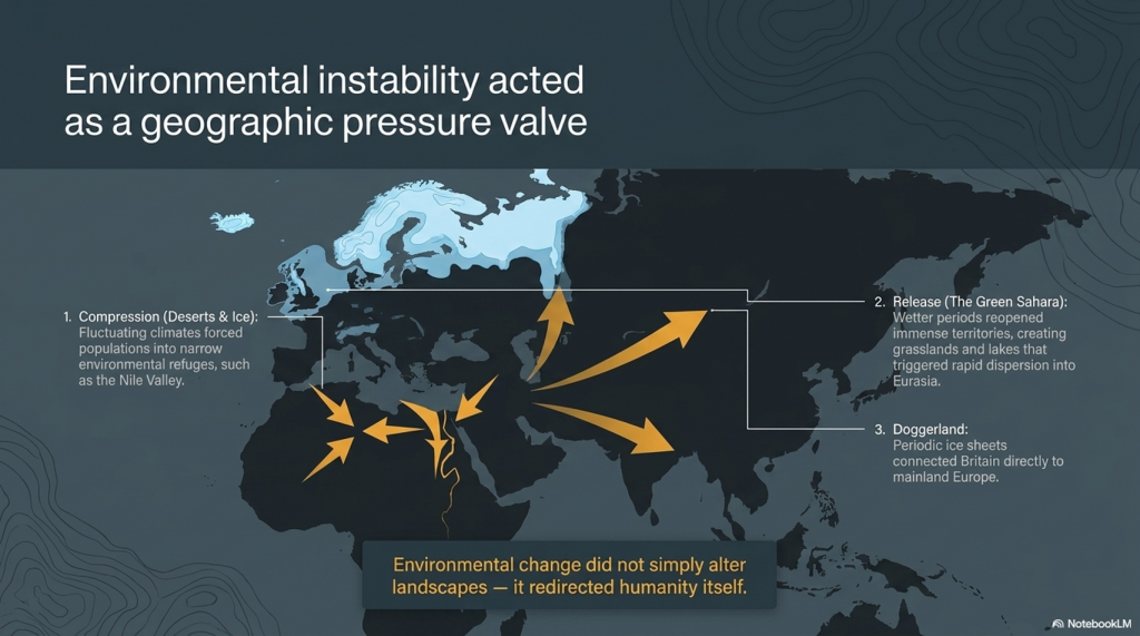
(Hambledon Hill)

Cissbury Ring through time

Introduction

This is a journey through time looking at the prehistoric site of CISSBURY RING and its surrounding Landscape based on the new third (2020) edition book of the best seller – that contains conclusive and extended evidence of Robert John Langdon’s hypothesis, that rivers of the past were higher than today – which changes the history of not only Britain, but the world. In his first book of the trilogy ‘The Post-Glacial Hypothesis’, Langdon discovered that Britain was flooded directly after the last Ice Age, which remained waterlogged in to the Holocene period through raised river levels, not only in Britain, but worldwide.

Cissbury Ring – Summary

Traditionally classified as an Iron Age hill fort, is actually one of the oldest and largest Neolithic flint mining sites in Britain, covering an impressive 65 acres. It ranks second only to Maiden Castle in terms of size. However, its primary historical significance lies not in its defensive role, but in its function as a major center for flint extraction and trade. This site represents one of the earliest known industrial landscapes in prehistoric Britain, with mining activity that dates back to around 4000 BCE, challenging the conventional Iron Age classification.

The site contains approximately 200 flint shafts, some extending as deep as 12 meters, and mining activities here spanned an extraordinary 900-year period. These shafts were dug into the chalk bedrock to access high-quality flint, a critical resource in the Neolithic era for tool-making and other practical purposes. Flint extraction at Cissbury was a meticulous process, involving the excavation of large shafts and tunnels to reach the valuable deposits. Skilled miners likely used bone and stone tools to carve through the chalk, carefully extracting flint nodules that would have been in high demand across Britain and beyond.

The surrounding landscape is marked by a series of interconnected ditches and dykes that connect ancient paleochannels to the site’s main ditch, forming an intricate transportation network. This system likely facilitated the movement of flint from the mines to boats for trade, indicating Cissbury’s role as a strategic trading hub. These channels would have allowed the extracted flint to be efficiently transported to nearby waterways, where it could be shipped to other regions.

The sheer scale and complexity of the mining operations at Cissbury Ring provide a glimpse into the sophisticated logistical organization of Neolithic communities. This site was not merely a fortified settlement, but a bustling center of industry, resource management, and trade in prehistoric Britain.

Cissbury Ring through time
Maps to not show the extent of mining at Cissbury – Cissbury Ring through time

Flint Mines, Radiocarbon Dates, and Archaeological Insights

Cissbury Ring in West Sussex, one of Britain’s largest hillforts, is a window into ancient Britain, encompassing Neolithic, Iron Age, and Romano-British activities. Covering 60 acres, this site has yielded an extensive collection of evidence that informs us about early mining practices and settlement patterns. The flint mines here date back to around 4000 BC and have provided valuable insights into Neolithic industrial activity and ritual practices.

Cissbury Ring through time

The Beginnings of Flint Mining

The flint mines at Cissbury, dating to the Neolithic period, span over 9 hectares, with more than 270 shafts identified in surveys. These shafts, measuring between 3 and 36 meters in diameter, formed a crescent shape across the hillside. Flint extraction here was extensive, as Cissbury was a vital source of high-quality flint, essential for tool-making in ancient Britain. Miners used red deer antlers and shoulder blades as tools, effectively chiseling through layers of chalk to reach seams of flint.

Excavation History

Cissbury Ring through time

Early excavations at Cissbury began in the 1850s with George Irving, who initially misinterpreted the shafts as water reservoirs. In the 1860s, A.H. Lane-Fox correctly identified the pits as Neolithic flint mines, providing a more accurate interpretation of the site. Excavations continued with John Pull in the 1950s, although his findings were not fully published. Nevertheless, Pull’s work was pivotal in expanding our understanding of flint mining techniques used at Cissbury.

Structure of the Flint Mines

The shafts at Cissbury led to a complex network of underground galleries, which were typically 3 feet high and supported by chalk pillars. The miners worked in hazardous conditions, as evidenced by skeletons found within collapsed galleries. The shafts were often backfilled with chalk rubble after extraction. Galleries interconnected the shafts, allowing for multiple points of access and exit. Excavators found evidence of flint knapping on-site, as well as animal bones and other artifacts, suggesting that the pits might have had secondary uses.

Cissbury Ring through time
The Mining was deep and extensive – you can’t do this with an antler pick!

Radiocarbon Dating Evidence

Radiocarbon dating of antler picks from the site provided dates of 4720±150 BP, 4650±150 BP, and 4730±150 BP, which correspond to 3900-3030 BCE and 3780-2920 BCE. These dates confirm that the flint mines were in use during the Neolithic period, solidifying Cissbury’s importance as a prehistoric mining center. The discovery of animal bones, including ox, pig, and wild boar, within these pits indicates that miners were using the site not only for extraction but possibly for ritualistic purposes as well.

Artifacts and Findings

The tools used at Cissbury were mainly made from red deer antlers, adapted for use as picks and shovels. Excavators found other unique items, including miniature flint axes and chalk carvings, with one shaft containing a woman’s skeleton buried feet-first, accompanied by bones of various animals. This implies a possible ritualistic burial, as several of these pits contained remains in arrangements suggesting ceremonial depositions.

Cissbury Ring through time
Stone axe – what was used to cut the mineshafts and channels

The Iron Age Transformation

In the Iron Age, around 700 BC, fortifications were constructed around the site, enclosing approximately 24 hectares. These defenses consisted of ramparts and ditches, forming a formidable barrier. Excavations revealed Romano-British pottery and oyster shells, indicating continued occupation and use for agriculture and defense. The hillfort was later fortified during WWII, and the site has undergone minimal modern excavation due to its status as a scheduled ancient monument.

Lynchets and the Dyke Debate

A particularly intriguing aspect of Cissbury is the lynchets, terraced formations traditionally associated with ancient agriculture. However, some propose that these features might actually be misidentified dykes, suggesting ancient water levels. While dykes usually include raised embankments and drainage systems, the lynchets at Cissbury lack these structural elements. Moreover, the area’s chalk soil would make long-term water retention impractical, raising doubts about the water-management hypothesis.

Cissbury Ring through time
It is not A defensive ditch but a system used to move minerals via boat, as these are moats, not ditches

Pits and Deposit Sites

Archaeologists speculate another layer to Cissbury’s history as pits for ritual deposition. One of the fascinating discoveries is a pit containing an assortment of artefacts, including chalk loom weights, an iron knife, and sling stones. These objects hint at ceremonial uses, possibly related to agricultural or religious practices. The pit aligns with similar features at Mount Caburn, suggesting ritual depositions were a shared practice among nearby communities. Sadly, the reality is this is an industrial site for processing minerals, and so this is just ‘industrial waste’ at best.

The Saxon Mint Hypothesis

Cissbury might have housed a Saxon mint, as coins from Ethelred II and Cnut bearing mint marks have been linked to the area. Although no direct archaeological evidence supports this claim, the suggestion adds another layer of historical intrigue to the site. Such mints were typically moved to fortifications during times of conflict, underscoring the strategic significance of Cissbury in the early medieval period. The better solution is that more than flint can be found in the mines – sadly, archaeology does not possess the techniques or experience to look for such minerals, as they do not excavate quarries.

Folklore and Myths

Local legends attribute Cissbury’s construction to the Devil, who allegedly flung earth around the Downs, creating the hillforts. Other stories speak of treasure guarded by serpents and even UFO sightings, adding a sense of mystery and complete nonsense to the site. There are also tales of fairies dancing at Cissbury, blending folklore with historical intrigue and showing how the site has captured imaginations for centuries.

A Concluding Perspective

Cissbury Ring through time
The Mines are Extensive showing that they were used in the Roman Period and beyond

Cissbury Ring remains an essential site for understanding ancient Britai,n, with its flint mines, Iron Age ramparts, and complex web of myths. While the theory of lynchets as dykes is interesting, it is unlikely given the physical characteristics of these features. Archaeological evidence supports the interpretation of lynchets as agricultural, with no clear indicators of water-management systems in place. Yet, Cissbury’s diverse history, from flint mining to potential Saxon minting, reflects a multifaceted legacy that continues to inspire research and speculation.

In conclusion, Cissbury Ring is more than a hillfort—it is a testament to the ingenuity, resilience, and cultural depth of ancient peoples. The site’s layers of history provide a tangible link to the past, offering insights that span millennia and spark continued interest in Britain’s ancient heritage.

Post-Glacial Flooding

Cissbury Ring through time
The Prehistoric Waters show that the dykes (not Lynchets) were used to link the site to rivers and harbours

In this second book of the series ‘The Stonehenge Enigma’, he also shows that a new civilisation known to archaeologists as the ‘megalithic builders’ adapted to this landscape, to build sites like Stonehenge, Avebury, Woodhenge and Old Sarum, where carbon dating has now shown that these sites were constructed about five thousand years earlier than previously believed. Within the trilogy ‘Prehistoric Britain’, Langdon looks at the anthropology, archaeology and landscape of Britain and the attributes and engineering skills of the builders of these megalithic structures. (Cissbury Ring through time)

Including finding and dating the original bluestones of Stonehenge Phase I from the quarry of Craig-Rhos-Y-Felin in Wales, five thousand year earlier than current archaeological theory and how this civilisation used the sites surrounding Stonehenge at a time of these raised river levels. This unique insight into how the prehistoric world looked in the ‘Mesolithic Period’ allows Langdon to explain archaeological mysteries that have confused archaeologist since the beginning of the science and allows us to make sense of these sites, allowing us to understand their function for this society for the first time. (Cissbury Ring through time).

With over thirty ‘proofs’ of his hypothesis and one hundred and twenty-five peer-reviewed references – Langdon uses existing excavation findings and carbon dating to forward a new understanding of the environment and our ancient society, which consequently rewrites our history books and allows us to find more conclusive and persuasive evidence which is currently trapped in our landscape, ready to be discovered by future students of archaeology. Articles on this Trilogy and an Active FaceBook Group where you can leave comments and get feedback can be found at:

Articles: http://prehistoric-britain.co.uk/

FaceBook Group: https://www.facebook.com/groups/prehistoricbritain

Further Reading

For information about British Prehistory, visit www.prehistoric-britain.co.uk for the most extensive archaeology blogs and investigations collection, including modern LiDAR reports.  This site also includes extracts and articles from the Robert John Langdon Trilogy about Britain in the Prehistoric period, including titles such as The Stonehenge Enigma, Dawn of the Lost Civilisation and the ultimate proof of Post Glacial Flooding and the landscape we see today.

Robert John Langdon has also created a YouTube web channel with over 100 investigations and video documentaries to support his classic trilogy (Prehistoric Britain). He has also released a collection of strange coincidences that he calls ‘13 Things that Don’t Make Sense in History’ and his recent discovery of a lost Stone Avenue at Avebury in Wiltshire called ‘Silbury Avenue – the Lost Stone Avenue’.

Langdon has also produced a series of ‘shorts’, which are extracts from his main body of books:

The Ancient Mariners

Stonehenge Built 8300 BCE

Old Sarum

Prehistoric Rivers

Dykes ditches and Earthworks

Echoes of Atlantis

Homo Superior

For active discussions on the findings of the TRILOGY and recent LiDAR investigations that are published on our WEBSITE, you can join our and leave a message or join the debate on our Facebook Group.

Unlocking the Mysteries of British Prehistory

Delve into the depths of time, as we embark on a captivating voyage into the enigmatic world of British prehistory. www.prehistoric-britain.co.uk is your portal to a treasure trove of archaeological wonders, modern LiDAR reports, and fascinating insights from the Robert John Langdon Trilogy. This immersive digital hub is your key to unlocking the secrets of Britain’s ancient past.

A Glimpse into the Robert John Langdon Trilogy

Step into the shoes of Robert John Langdon, a dedicated explorer of Britain’s prehistoric mysteries. His trilogy, comprising “The Stonehenge Enigma,” “Dawn of the Lost Civilization,” and “The Post-Glacial Flooding Hypothesis,” is a literary marvel that unravels the untold tales of our ancestors. These books take you on an exhilarating journey through time, meticulously researched and backed by over 125 references from esteemed scientists, archaeological experts, and geological researchers.

Dive into the World of LiDAR

At www.prehistoric-britain.co.uk, we harness the power of LiDAR technology to unearth hidden landscapes and archaeological marvels. Our LiDAR reports offer a modern lens through which you can peer into ancient history. Explore the effects of flooding on the British environment after the great ice age melt, a phenomenon that has shaped the landscape we see today. Join us in decoding the mysteries of our past using cutting-edge technology.

A Multimedia Experience

Our commitment to storytelling extends beyond the written word. Robert John Langdon has curated a rich multimedia experience, including a YouTube web channel featuring over 100 investigations and video documentaries. These visual journeys complement his classic trilogy, providing a multi-dimensional understanding of prehistoric Britain. From Stonehenge’s construction in 8300 BCE to the lost Stone Avenue at Avebury in Wiltshire known as ‘Silbury Avenue,’ these documentaries offer an immersive experience that brings history to life.

Explore the ’13 Things that Don’t Make Sense in Ancient History’

History is replete with anomalies and enigmas that defy explanation. Robert John Langdon has curated a collection of such historical curiosities in ’13 Things that Don’t Make Sense in History.’ These peculiar occurrences and unanswered questions will leave you pondering the mysteries of the past, inviting you to join the debate on their possible interpretations.

Cissbury Ring through time

Cissbury Ring through time

More Blogs

[sitemap_posts]