For centuries, Car Dyke was regarded as a relic of Roman engineering—a mere canal or drainage system that facilitated military logistics and agricultural management. However, our first-ever comprehensive LiDAR investigation has completely rewritten that narrative. By employing state-of-the-art laser scanning, we have penetrated the dense vegetation and hidden soil layers to reveal a much more complex story. The data, bolstered by advanced mathematical dating methods and AI-assisted analysis, demonstrate that Car Dyke is not Roman but prehistoric in origin, with roots dating to the Mesolithic and Neolithic periods.
Inside the Investigation
LiDAR Mapping: Our high-resolution scans provide unprecedented detail, capturing the full 103-mile span of Car Dyke. The imagery reveals intricate construction details and natural variations that traditional methods have overlooked.
Mathematical Dating: Utilising a novel approach that integrates archaeological finds with advanced algorithms, our team has applied mathematical theorems to establish a definitive timeline. This breakthrough challenges centuries of conventional wisdom and suggests a multi-phased construction history long before the Roman era.
Archaeological Integration: The Atlas includes comprehensive data from archaeological excavations—pottery shards, tools, and other artefacts—that further support the prehistoric origin of the Dyke.
LiDAR mapping reveals Car Dyke’s hidden prehistoric layers, challenging the Roman narrative
The Car Dyke Atlas: A Deep Dive into History
Car Dyke Atlas is not merely a book—it is a complete digital and print repository of our groundbreaking research. With over 140 meticulously crafted illustrations, 58 audio files, 22 360° interactive maps, and 120 flyover video clips, the Atlas offers a multidimensional view of this ancient earthwork.
Key Sections of the Atlas
Preamble & Introduction: Sets the stage by summarising decades of archaeological debate and introducing our revolutionary LiDAR findings.
Methodology: Explains the innovative techniques, including advanced AI and mathematical models, that enabled us to accurately map and date Car Dyke.
Detailed Mapping & Analysis: Interactive maps and flyover videos allow readers to explore Car Dyke in minute detail—from its northern, central, and southern sections to the subtle variations in its elevation and course.
Comparative Archaeology: Chapters that juxtapose traditional interpretations with our new findings, offering a compelling case for re-evaluating Britain’s ancient landscape.
Multimedia Content: Beyond static images, the Atlas integrates audio narrations, expert discussions, and interactive elements that provide context and bring the research to life.
The Car Dyke Atlas offers a panoramic view of history—where detailed maps meet immersive multimedia.
FusionBook 360: A New Paradigm in Storytelling
In today’s fast-paced digital age, traditional books are evolving. FusionBook 360 represents the future of reading—a concept that reimagines the boundaries between print and digital media. This revolutionary format brings historical scholarship into the 21st century by seamlessly integrating interactive and multimedia elements into the reading experience.
What Makes FusionBook 360 Unique?
Dual Format Availability: Choose between a digital edition loaded with interactive features and a beautifully designed printed edition enhanced with QR codes that unlock a wealth of supplementary content.
Realistic Page-Turning Effects: Experience the nostalgic feel of flipping pages, complete with authentic sound effects, yet enjoy the benefits of digital enhancements.
Embedded Interactive Content: Access video introductions, expert panels, detailed audio narrations, and 360° maps—all within the book’s pages. Each chapter invites readers to engage more deeply with the content.
Cloud-Based Updates: Stay current with ongoing research. As new discoveries emerge, the book updates automatically, ensuring that your copy remains at the cutting edge of historical scholarship.
Smart Chatbot Integration: Have a question while reading? Our integrated chatbot provides instant answers and additional context, making your exploration seamless and interactive.
FusionBook 360 transforms your reading experience, merging the tactile pleasure of print with the limitless possibilities of digital interactivity.”
Bridging the Past and Future: The Impact of Our Research
The implications of our findings extend far beyond Car Dyke itself. By challenging the long-held view of Car Dyke as a Roman construct, we open up new avenues of research into prehistoric engineering and land management. Our work sets a new standard for historical inquiry, combining rigorous scientific analysis with the creative potential of modern multimedia technology.
Why This Matters
Rewriting History: Our research forces historians, archaeologists, and the public to reconsider the origins of Car Dyke and, by extension, the broader narrative of Britain’s ancient past.
Innovative Methodologies: The integration of LiDAR technology, AI, and mathematical analysis provides a blueprint for future studies in archaeology.
Enhanced Engagement: FusionBook 360 invites a wider audience—from academic experts to curious enthusiasts—to engage with history in a more dynamic, interactive way.
Where ancient mysteries meet modern innovation—redefining our understanding of the past.
Join Us on This Journey
Be part of a transformative moment in historical research and digital publishing. Whether you are a scholar, a technology enthusiast, or simply passionate about uncovering the secrets of our past, the Car Dyke Atlas and FusionBook 360 offer an unparalleled journey into history.
By merging rigorous scientific inquiry with immersive multimedia technology, we’re not just telling history—we’re experiencing it. Step into a world where every page turns into a window to the past, and where the future of historical research is unfolding right before your eyes.
For more exclusive content, behind-the-scenes insights, and regular updates, visit our website and follow us on social media.
Car Dyke – ABC News Podcast
Summary
The book ‘The Car Dyke LiDAR Atlas’ presents a thorough investigation of the Car Dyke, a large ancient waterway in Britain. Using LiDAR technology, the author argues that the Dyke is much older than previously thought, dating back to the Mesolithic/Neolithic periods, and was likely used for transportation and water management rather than simply as a Roman drainage channel or defensive barrier. The book features detailed maps and analysis of the Dyke’s construction and course, including insights into the surrounding landscape and archaeological finds, to support the author’s conclusions.
Car Dyke Audio Book
Britain’s first-ever LiDAR investigation and mapping project of Car Dyke.
Unveiling the Truth: The Real History of Britain’s Dykes
For over a century, conventional archaeology has promoted the idea that Britain’s great Dykes—such as Offa’s Dyke and Wansdyke—were built by the Saxons as defensive barriers. These theories, based on limited fieldwalking evidence and subjective interpretation, have gone largely unchallenged. But what if this widely accepted narrative is completely wrong?
Car Dyke: The Key to a Forgotten Past
Car Dyke has long stood apart, defying the traditional explanations of Saxon territorial defence. When a boat laden with goods was discovered at the bottom of Car Dyke—dating back hundreds of years before the Saxons arrived in Britain—it should have rewritten history. Yet, mainstream archaeology dismissed this evidence, continuing to support outdated theories.
Revolutionary New Findings with LiDAR Technology
Using cutting-edge LiDAR mapping, our research has uncovered undeniable proof that Car Dyke and similar Dykes are not Saxon or even Roman constructions. Instead, they are intricately linked to ancient paleochannels, suggesting an advanced transportation and water management system that predates recorded history. Our new maps have corrected the estimated length of Car Dyke from 85 miles to 103 miles, aligning with the theories proposed by William Stukeley nearly 300 years ago. His claim that the Dyke supported the Roman occupation of Lincolnshire by facilitating troop and resource movements has now been scientifically validated.
Redefining Britain’s Longest Dyke
This research now positions Car Dyke as Britain’s longest Dyke, surpassing Offa’s Dyke, previously believed to be 177 miles long. Our survey reveals that Offa’s Dyke is, in fact, a series of smaller Dykes, totalling just 59.2 miles. Like Car Dyke, these ancient waterways were repurposed by the Romans for transportation and resource extraction, fundamentally shifting our understanding of Britain’s infrastructure.
A Groundbreaking Discovery: The Mesolithic and Neolithic Origins of the Dykes
Our mathematical analysis reveals that Car Dyke, Offa’s Dyke, and Wansdyke predate both the Romans and Saxons, tracing their origins back to the Mesolithic and Neolithic periods. This breakthrough challenges the established archaeological timeline and presents a compelling case for an advanced prehistoric civilisation. Could these ancient canals have been used to transport the massive stones of Britain’s megalithic structures? Our findings suggest they very well could have.
Rewriting the History of Britain’s Past. This book uncovers the real purpose and origins of Britain’s enigmatic Dykes, using cutting-edge technology and rigorous analysis to challenge centuries of academic assumptions. If you’re ready to explore the truth behind Britain’s forgotten past, this book will change everything you thought you knew about history.
Softback B/W Edition for Amazon – with QR codes to the interactive website links
The Car Dyke Atlas
Softback Colour Edition for Amazon – with QR codes to the interactive website links
The Car Dyke Atlas
Further Reading
For those interested in British Prehistory, visit www.prehistoric-britain.co.uk, a comprehensive resource featuring an extensive collection of archaeology articles, modern LiDAR investigations, and groundbreaking research. The site also includes insights and extracts from the acclaimed Robert John Langdon Trilogy, a series of books exploring Britain during the Prehistoric period. Titles in the trilogy include The Stonehenge Enigma, Dawn of the Lost Civilisation, and The Post Glacial Flooding Hypothesis, offering compelling evidence about ancient landscapes shaped by post-glacial flooding.
To further explore these topics, Robert John Langdon has developed a dedicated YouTube channel featuring over 100 video documentaries and investigations that complement the trilogy. Notable discoveries and studies showcased on the channel include 13 Things that Don’t Make Sense in History and the revelation of Silbury Avenue – The Lost Stone Avenue, a rediscovered prehistoric feature at Avebury, Wiltshire. (The Great Farming Hoax – Einkorn Wheat)
In addition to his main works, Langdon has released a series of shorter, accessible publications, ideal for readers delving into specific topics. These include:
For active discussions and updates on the trilogy’s findings and recent LiDAR investigations, join our vibrant community on Facebook. Engage with like-minded enthusiasts by leaving a message or contributing to debates in our Facebook Group.
Whether through the books, the website, or interactive videos, we aim to provide a deeper understanding of Britain’s fascinating prehistoric past. We encourage you to explore these resources and uncover the mysteries of ancient landscapes through the lens of modern archaeology.
For more information, including chapter extracts and related publications, visit the Robert John Langdon Author Page. Dive into works such as The Stonehenge Enigma or Dawn of the Lost Civilisation, and explore cutting-edge theories that challenge traditional historical narratives. (The Great Farming Hoax – Einkorn Wheat)
Bainbridge, known in the Roman period as Virosidum, is almost universally described as a standard Roman auxiliary fort. The explanation usually follows a familiar pattern: the fort controlled movement through Wensleydale, was supplied by Roman roads, and functioned as a military garrison in an otherwise quiet upland landscape. This narrative appears in guidebooks, gazetteers, official records, and popular archaeology alike. It is repeated so often that it has become a fact. (Bainbridge Roman Fort)
But repetition is not evidence.
The central problem with the Bainbridge story is not that it is impossible, but that it has rarely been tested against the physical landscape. Interpretation has tended to move in one direction only. Once Roman occupation is identified, roads are assumed, defences are supposed to behave conventionally, and surrounding earthworks are absorbed into a military narrative whether or not their form, scale, or placement actually supports that role. The questions that should come first — what the terrain shows, what was excavated, and what functions the measured features support — have largely been left unasked.
This matters because Roman military installations were not symbolic structures. They were functional systems, engineered to solve specific problems: defence, logistics, production, and control. Roman ditches, ramparts, roads, and drains were designed according to purpose, not tradition. If a feature cannot plausibly perform its supposed function when examined geometrically and physically, then the interpretation attached to it deserves re-examination, regardless of how long it has been accepted.
Recent decades have provided archaeology with a powerful corrective tool: high-resolution LiDAR, combined with satellite measurement and improved landscape modelling. These technologies allow entire sites to be examined without the distortion introduced by vegetation, later land use, or selective trenching. When excavation records are re-examined alongside these datasets, interpretation can finally be tested against scale, depth, and behaviour, rather than inferred from labels.
At Bainbridge, this immediately creates tension. The site is isolated. It does not clearly defend a town, a frontier, a pass, or a demonstrable engineered route. The surrounding earthworks do not behave like textbook Roman military defences when measured. And perhaps most significantly, the excavation evidence from within the site points not to a quiet garrison but to organised, specialist industrial activity, including ironworking, copper-alloy casting, and silver assaying.
These are not marginal details. They go to the heart of what the site was for.
There is also a deeper assumption that requires scrutiny: the idea that Roman-period occupation automatically implies Roman origin. Across Britain, Roman forts, temples, and administrative buildings frequently sit on earlier places of importance. The presence of a Roman temple at Maiden Castle, for example, does not make the hillfort Roman in origin; it demonstrates Roman reuse of an existing landscape. Roman material culture has a habit of dominating interpretation once it appears, pulling earlier phases into its orbit even when the evidence does not demand it.
The excavation reports at Bainbridge do not rule out earlier activity, nor do they claim that the site was founded on a blank landscape. They record complexity, phased development, and features whose function is not fully resolved. What has tended to happen since is that Roman occupation has been allowed to define the entire story, rather than being treated as one phase within a longer sequence.
This blog does not claim that Bainbridge must be pre-Roman. It makes a more cautious and defensible point: Roman presence does not, by itself, explain why this place mattered. Given the site’s hydrological position, landscape-scale earthworks, and industrial function, it is entirely plausible that the Romans formalised, enclosed, and secured a place that already had economic or strategic significance.
That distinction matters. It changes the central question from “why did the Romans build a fort here?” to “why was this place important long before a fort existed?”
What follows is not speculation, but a step-by-step examination of excavation data, ditch geometry, LiDAR profiles, satellite measurements accurate to within half a metre, and basic principles of Roman engineering. When these strands are allowed to speak together, the traditional garrison-fort narrative begins to fail — not dramatically, but decisively.
The landscape has been telling us a different story all along. We are finally in a position to listen.
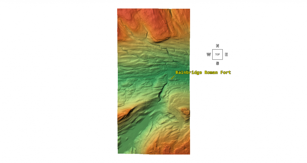
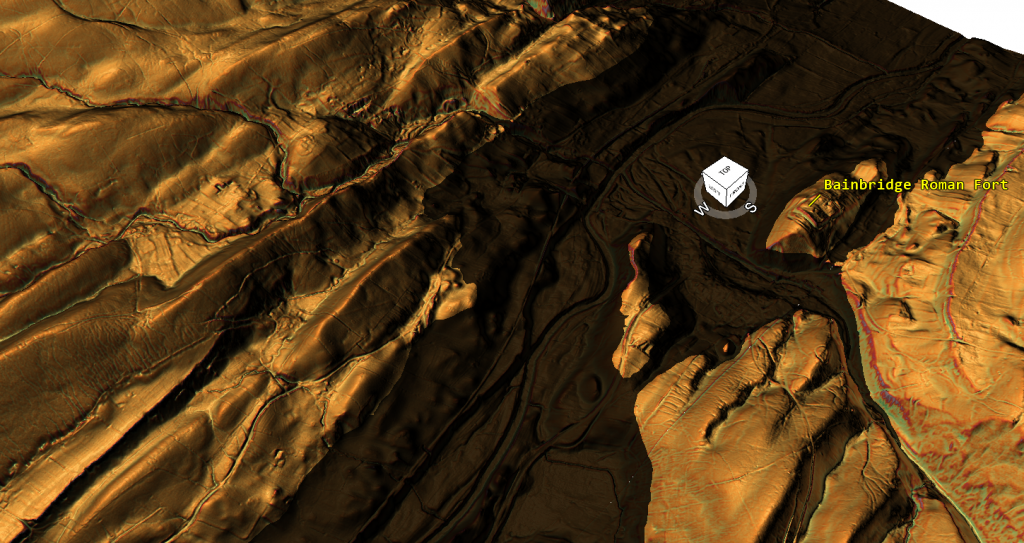
The Fort’s position in the middle of a Paleochannel is a clue that this was a water-based site. – (Bainbridge Roman Fort)
Chapter 2 — What Roman Defensive Ditches Are Supposed to Do
Roman military engineering was not symbolic, stylistic, or vague. It was functional, standardised, and purpose-built. Every component of a Roman fort — ramparts, ditches, gates, roads, drains — existed to solve a clearly defined problem. If a feature does not perform its supposed function when examined physically, then its interpretation deserves scrutiny, regardless of how often it has been repeated in the literature.
The defensive ditch (fossa) is a good place to start, because its purpose is unambiguous. A Roman defensive ditch is not merely a boundary marker; it is an active obstacle designed to slow, destabilise, injure, and expose attackers to missile fire from the rampart. This function dictates its geometry.
Across Roman Britain, the defensive ditch typically exhibits three consistent characteristics:
First, depth. A functional Roman leg-breaker ditch is usually between 1.8 and 3.0 metres deep. Depth matters more than width. A shallow ditch may inconvenience movement, but it does not seriously impede a determined attacker. Roman engineers understood this perfectly.
Second, profile. Defensive ditches are usually steep-sided and V-shaped, sometimes with an additional ankle-breaker slot or drainage channel cut into the base. The steep sides make footing difficult, while the narrow base concentrates weight and increases the risk of injury. These profiles are hostile by design.
Third, placement. Roman defensive ditches sit immediately in front of ramparts, creating a combined system: ditch, rampart, and palisade or wall working together. The ditch is not an isolated feature; it is part of an integrated defensive machine.
When these conditions are met, the ditch works. When they are not, it doesn’t.
Importantly, Roman engineers did not waste labour. Digging earth was expensive in terms of human resources, and unnecessary excavation was avoided. A ditch that is wide but shallow, gently sloped, or easily crossed represents poor return on effort if its purpose is defence. Such features may look impressive on a plan, but they do not function as military obstacles.
This distinction is critical because archaeological descriptions often rely on shorthand. A ditch may be described as “V-shaped” in text, but without reference to depth, angle, or context, that label alone tells us very little about function. A shallow V-shaped channel can serve drainage just as easily as defence — sometimes more so.
Roman sites also contain many ditches that are not defensive at all: drains, construction cuttings, boundary markers, water-management features, industrial channels, and temporary works. These are frequently narrower, shallower, and more responsive to local topography than true defensive fossae. Function cannot be inferred from shape alone.
This is why geometry matters. Width, depth, slope angle, placement, and relationship to other features determine what a ditch does, not what it is called. Any interpretation that ignores these variables in favour of typological labels is vulnerable to error.
The purpose of this chapter is not to deny the existence of Roman defensive ditches — they are well documented and unmistakable when present. It is to establish a clear, testable baseline: if a ditch cannot plausibly function as a defensive obstacle, then it should not be interpreted as one without further evidence.
With that baseline in place, we can now return to Bainbridge and ask a simple, unavoidable question: do the ditches recorded there behave like Roman military defences — or do they act like something else entirely?
(Bainbridge Roman Fort)
Chapter 3 — What the Excavations Actually Recorded
Any serious reassessment of Bainbridge must begin with the excavation record, not with later summaries, gazetteers, or interpretive maps. The primary excavations at Bainbridge — carried out by Collingwood, Wade, and later synthesised by Hartley — were careful, methodical, and largely limited in scope. They did not attempt a landscape-scale investigation. What they recorded, and what they did not, matters.
One of the most important points to establish immediately is that the excavators did not describe a single, uniform defensive system. Instead, they recorded ditches of different types in different positions, with markedly different dimensions and characteristics. Later interpretations have tended to collapse these distinctions into a single “Roman defensive ditch” narrative, but the original data does not support that simplification.
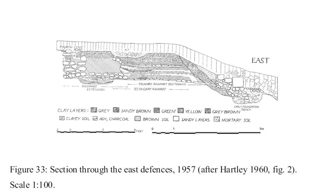
The excavations clearly identify an inner ditch, closely associated with the rampart. This ditch conforms broadly to expectations for Roman military engineering. It is relatively narrow, steep-sided, and, in places, V-shaped, sometimes with a square-cut drainage slot at the base. Its depth is significantly greater than the outer features, and its position immediately in front of the rampart makes defensive sense. There is no controversy here: this inner ditch behaves like a Roman military fossa.
However, beyond this inner ditch, the excavators encountered additional outer ditches, particularly on the western side of the site. These are the features that matter for the present discussion—and they are fundamentally different.
The published reports describe these outer ditches as broad and shallow, with recorded depths typically ranging from 0.4 to 1.0 metres. Widths are substantially greater than those of the inner ditch, reaching up to roughly 8 metres in some excavated sections. Spoil from these cuts was often thrown outward to form low, wide scarps, rather than steep rampart faces. These are not incidental details; they define how the features function.
Crucially, the excavators themselves note that these outer ditches were relatively short-lived, often deliberately backfilled rather than allowed to silt naturally. This behaviour is difficult to reconcile with long-term defensive use, but entirely consistent with features that were functional, temporary, or periodically reconfigured.
Although some of these outer ditches are described in the text using shorthand terms such as “V-shaped”, the accompanying measurements and section drawings tell a more nuanced story. A shallow cut with gently sloping sides can technically be V-shaped without functioning as a leg-breaker. Geometry, not vocabulary, determines function.
It is also important to note what the excavations did not do. They did not systematically section the broader landscape features now visible on LiDAR. They did not attempt to trace these ditches beyond the immediate vicinity of the fort. They did not integrate hydrology, slope behaviour, or wider landscape management into their interpretation. These omissions are understandable given the period in which the excavations were conducted, but they limit what can legitimately be concluded.
What the excavation record therefore gives us is not a simple answer, but a set of constraints. It shows that Bainbridge had at least one conventional Roman defensive ditch near the rampart. It also shows that it possessed additional, much broader and shallower ditches whose form, depth, and treatment differ markedly from standard military defences.
The mistake comes later, when these distinct features are treated as if they belong to a single defensive logic. Once the inner and outer ditches are merged, the site can be described as a typical fort with unusually large defences. But when they are kept separate — as the excavators themselves recorded them — a different picture begins to emerge.
The excavation evidence does not demand that all ditches at Bainbridge were defensive. On the contrary, it quietly suggests that they were not all doing the same job.
With this distinction firmly in place, we can now turn to the critical question that follows naturally from the data: if the outer ditches were not functioning as leg-breaker defences, what were they actually for?
That question leads directly to the cross-sections—and to the point where the traditional narrative begins to fail.
Cross-Section – (Bainbridge Roman Fort)
Chapter 4 — The Cross-Sections No One Talks About
Archaeological interpretation often leans heavily on labels: “defensive ditch”, “V-shaped”, “Roman military”. But labels only have meaning if the geometry behind them actually works. At Bainbridge, the cross-sections recorded during excavation — and now independently confirmed through LiDAR and satellite measurement — quietly undermine the defensive interpretation that has been attached to the outer ditches for decades.
The critical issue is not whether a ditch can be described as “V-shaped” in plan or section. The question is whether that ditch can function as a Roman military obstacle. When the excavated cross-sections of the outer ditches are adequately examined, the answer is clear: they cannot.
The excavated outer ditches at Bainbridge are consistently recorded as very shallow, typically in the range of 0.4 to 1.0 metres deep, and relatively broad, with widths approaching 8 metres. The section drawings show gently sloping sides and a flattened or rounded base. Even where the profile converges toward a point, the angles are shallow, and the overall depth is minimal. This is not a leg-breaker. It is not even close.
A Roman defensive ditch is designed to destabilise, injure, and delay an attacker. A ditch less than a metre deep fails all three tests. An adult can step into and out of it with little loss of balance. A group can cross it rapidly. There is no meaningful exposure time beneath the rampart, and no realistic risk of injury. Calling such a feature “defensive” relies entirely on terminology, not on function.
Depth is decisive here. Roman engineers did not rely solely on width. A wide but shallow ditch is inefficient: it requires substantial labour to excavate but delivers little defensive benefit. Roman military practice favoured depth and steepness, not broad shallow cuts. This is why classic Roman fossae are narrow, steep, and often augmented with ankle-breaker slots. The Bainbridge outer ditches exhibit none of these characteristics.
Context makes the defensive interpretation even weaker. Some of these shallow ditches lie inside the broader defensive system, not immediately in front of the rampart where a leg-breaker would be effective. A shallow obstacle placed internally makes no military sense at all. You do not defend a fort by creating trip hazards within your own circulation space, particularly in a site that shows long-term occupation, movement of materials, and industrial activity.
Once defence is removed from the equation, the geometry starts to make sense. Shallow, broad ditches are extremely effective for water management. They collect runoff from ramparts and slopes, control drainage across the site, and prevent waterlogging of working areas. In an industrial context — especially one involving metalworking — this is not incidental infrastructure. It is essential.
The excavation reports themselves hint at this functional reality, even if they stop short of stating it explicitly. The outer ditches are described as short-lived, deliberately backfilled, and lacking evidence of long-term silting. These are not the characteristics of permanent military defences. They are the characteristics of managed features, which are altered or replaced as needs change.
When these cross-sections are compared with modern LiDAR profiles and satellite measurements — accurate to within approximately ±0.5 metres — the match is striking. The shallow depths and broad profiles seen in excavation align closely with what is visible across the wider landscape today. There is no contradiction between excavation and remote sensing. The contradiction lies between the data and the interpretation.
This is the point at which the traditional narrative breaks. A ditch that cannot function as a defensive obstacle should not be interpreted as one simply because a fort exists nearby. Geometry does not lie, and physics does not bend to narrative convenience.
The cross-sections at Bainbridge do not describe a fortress bristling with hostile obstacles. They describe a site where water, movement, and activity were being managed, not where attackers were being repelled.
Once this is recognised, the question is no longer “why are these defences so odd?” It becomes “why was water management so important here?”
And that question leads directly to industry.
LiDAR Moat measurement – (Bainbridge Roman Fort)
Chapter 5 — LiDAR, Satellite Measurement, and Ground Truth
One of the strengths of modern archaeology is that excavation no longer stands alone. Features recorded decades ago in narrow trenches can now be tested against whole-landscape datasets that reveal form, scale, and context with far greater clarity. At Bainbridge, high-resolution LiDAR and satellite measurements do not contradict the excavation evidence—they confirm it and, in doing so, expose the weakness of the traditional interpretation.
LiDAR has a particular advantage in that it removes vegetation and modern land use from the equation. When examined using multiple hillshades, colour relief, and oblique or horizontal views, features that are genuinely engineered behave very differently from those produced by drainage, erosion, or long-term landscape management. Roman military works, when present, tend to stand out clearly: aggers persist, ditch lines remain crisp, and geometry resists topography. At Bainbridge, that behaviour is notably absent outside the inner defensive zone.
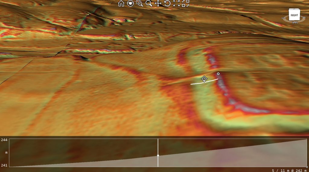
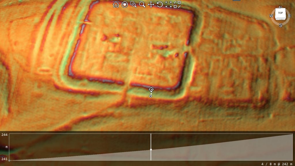
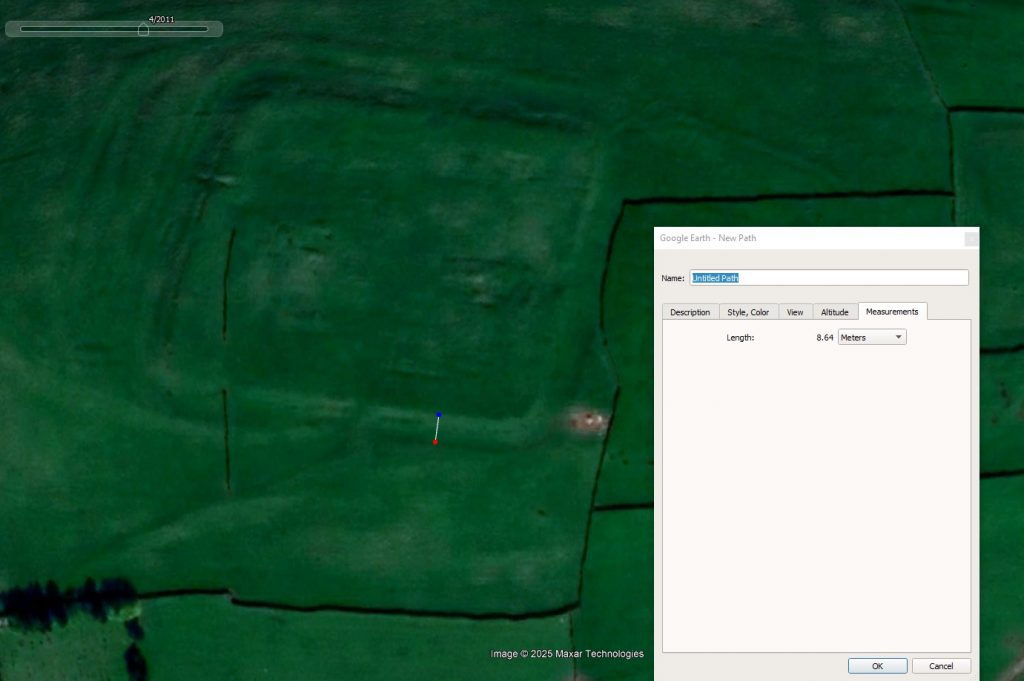
Using LiDAR profiles and Google Earth measurement tools, the principal outer ditch surrounding the site can now be measured with reasonable confidence. Across multiple transects, the ditch consistently falls within a width range of approximately 8.0–8.6 metres, with measurement accuracy to around ±0.5 metres. This result is not derived from a single section or favourable angle; it repeats across the landscape wherever the feature is visible.
Just as important as width is profile. The LiDAR cross-sections show a broad, shallow cut with gently sloping sides and no sharply incised base. There is no indication of a steep V-profile, no ankle-breaker slot, and no abrupt edge that would signal a deliberately hostile obstacle. Instead, the ditch blends smoothly into the surrounding slope, exactly as described in the excavation sections of the outer ditches.
This correspondence matters. It means the excavated sections were not anomalies or local quirks; they were representative of a much larger, coherent landscape feature. LiDAR does not reveal a hidden deeper ditch waiting to be found. It reveals continuity—the same shallow geometry repeated beyond the excavation trenches.
Equally telling is what LiDAR does not show. There is no evidence of large-scale rampart construction associated with these broad ditches. There is no agger-like build-up of material, no sharp counterscarp, and no consistent defensive frontage. The spoil appears dispersed or levelled rather than piled into a formidable barrier. This is consistent with features designed to manage space or water, not to resist assault.
Satellite imagery reinforces the same picture. Measurements taken independently of LiDAR produce comparable widths and confirm that the feature is not the result of modern agricultural activity or mapping artefact. The ditch respects natural slope and drainage patterns rather than imposing a rigid, engineered geometry across them. That behaviour is fundamentally non-military.
What is especially significant is that these measurements now remove uncertainty. Debate no longer hinges on impressionistic descriptions such as “large” or “substantial”. We are dealing with quantified geometry. An outer ditch approximately 8–8.6 metres wide and less than a metre deep simply does not behave like a Roman defensive work, regardless of how it has been labelled in the past.
This also resolves a long-standing interpretive tension. Excavation reports described shallow, broad ditches that did not sit comfortably within a defensive model, while later summaries continued to treat them as such. LiDAR bridges that gap by showing that the excavators were accurately recording the feature—and that the problem lies in how those records were later interpreted.
At this point, the question shifts again. If excavation sections and modern landscape data tell the same story, and that story is incompatible with defence, then the interpretation must change. The outer ditches at Bainbridge were doing something, but that something was not stopping attackers.
Measured against the ground itself, the evidence is no longer ambiguous. The outer ditches are real, coherent, and deliberate — but they are not military defences.
Understanding what they were for requires us to stop thinking like soldiers and start thinking like engineers.
(Bainbridge Roman Fort)
Chapter 6 — Why These Ditches Cannot Be Defensive
By the time geometry, depth, and landscape context are considered together, the defensive interpretation of Bainbridge’s outer ditches becomes increasingly difficult to sustain. This is not a matter of alternative opinion; it is a matter of function. A feature that cannot physically perform the task assigned to it should not continue to be interpreted as if it does.
A Roman defensive ditch works because it creates risk and delay. Its purpose is to force attackers to descend into a confined space, lose balance, and expose themselves to missiles while struggling to climb out. This requires depth, steep sides, and placement directly in front of a rampart. A ditch that is shallow, broad, and gently sloped fails on every count.
At Bainbridge, the outer ditches are consistently less than a metre deep. Even allowing for erosion, backfilling, or truncation, their present profiles do not approach the depth required for a leg-breaker. An able-bodied adult can step into and out of such a ditch with little difficulty. Groups could cross it rapidly, carts could be manhandled across it, and animals would not be seriously impeded. As a military obstacle, it is ineffective.
Placement further weakens the defensive argument. Some of these ditches lie well beyond the immediate rampart zone, while others sit in positions that would place them inside the broader circulation space of the site. Roman forts were busy environments. Soldiers, pack animals, carts, and supplies moved constantly. Introducing shallow obstacles within or immediately adjacent to internal working areas would hinder daily operation far more than it would hinder an attacker. Roman military design avoids this.
The labour logic is also wrong for defence. Digging an eight-metre-wide ditch requires significant effort. Roman engineers did not expend manpower on features that offered poor defensive return. If defence were the aim, the same labour could have produced a far deeper, steeper, and more effective obstacle. The fact that it did not strongly suggests that defence was not the priority.
Once the defensive explanation is removed, the geometry starts to make sense in a different way. Broad, shallow ditches are highly effective at controlling water. They intercept runoff from ramparts and slopes, channel excess water away from working areas, and reduce erosion. In valley-side locations like Bainbridge, managing water is not optional — it is essential to keeping a site functional.
This is particularly relevant given what the excavations reveal about activity within the site. Metalworking requires water at multiple stages: cooling and quenching hot metal, washing ores, managing ash and waste, and preventing working surfaces from becoming waterlogged. Shallow, wide ditches allow water to move predictably and safely through a site without cutting deep scars or destabilising structures.
The excavation reports themselves support this functional reading, even if they stop short of stating it outright. The outer ditches are described as short-lived, deliberately backfilled, and frequently reworked. Defensive ditches are normally maintained; water-management features are altered as needs change. The behaviour recorded in the ground fits the latter pattern far better than the former.
There is also a conceptual issue at play. Archaeology has a tendency to treat all ditches associated with a fort as “defensive” by default. Yet Roman sites are full of non-defensive cut features that serve practical purposes. Drainage, construction, zoning, and industrial processes all generate ditches that can superficially resemble defences when stripped of context.
At Bainbridge, the evidence points consistently in one direction. The outer ditches lack the depth, profile, placement, and permanence required for military defence. They possess exactly the characteristics expected of managed infrastructure in a working, industrially active site.
If these ditches were not built to stop enemies, then the key question changes again. It is no longer “why is this fort so strangely defended?” It becomes “why was water management so critical to the operation of this site?”
Answering that question takes us directly to industry.
The Area is covered with Quarries, and there is no footpath into the fort; it is recent -(Bainbridge Roman Fort)
Chapter 7 — Water, Industry, and the Infrastructure Everyone Ignored
Once the defensive interpretation of the outer ditches is set aside, the question is no longer why Bainbridge’s defences look wrong, but why water management appears to have been such a priority. At this point, the excavation evidence and the landscape data begin to reinforce one another in a way that is difficult to ignore.
Bainbridge sits on a valley-side position above the River Bain, close to its confluence with the Ure. This is a hydrologically active setting. Runoff from higher ground, seasonal saturation, and fluctuating water tables would all have affected the site. Any long-term occupation here — military or otherwise — would have required deliberate control of surface and subsurface water.
The geometry of the outer ditches fits this requirement precisely. Broad, shallow channels are highly effective at intercepting runoff, slowing flow, and directing water away from key working areas without destabilising buildings or ramparts. Their gentle slopes reduce erosion, while their width allows them to function even during periods of heavy rainfall. This is infrastructure designed for management, not obstruction.
This matters because Bainbridge was not a quiet administrative outpost. The excavations demonstrate repeated and sustained industrial activity within the site, including iron smithing, copper-alloy casting, and silver assaying. These are water-dependent processes. Metalworking generates heat, waste, slag, ash, and residues that must be cooled, quenched, washed, and removed. Without reliable drainage, such activity quickly becomes impractical.
In this context, water is not an afterthought — it is a requirement. Controlled drainage protects furnaces and working floors, prevents contamination of materials, and allows waste to be managed rather than dispersed randomly across the site. Shallow ditches that can be altered, backfilled, or re-cut as production needs change are exactly what one would expect in a working industrial environment.
The excavation reports quietly support this interpretation. The outer ditches are repeatedly described as short-lived and deliberately backfilled. This behaviour makes little sense for defensive features, which are normally maintained and periodically re-cut. It makes perfect sense for functional infrastructure that is modified as layouts change, activities expand or contract, or new working zones are established.
The presence of coal as a fuel source strengthens this picture further. Coal use implies sustained, high-temperature operations rather than occasional repair work. It also implies smoke, waste, and heat management challenges — all of which benefit from controlled airflow and drainage. Water management and industrial activity are inseparable in such settings.
Seen in this light, the outer ditches are not anomalous at all. They are part of a managed operational landscape, designed to keep a busy, productive site functioning over a long period. Their scale reflects the scale of activity, not the scale of threat.
This also explains why these features do not conform to textbook Roman military design. They were not built to meet a standard defensive template; they were built to meet local, practical needs. Roman engineers were pragmatic. They adapted form to function, especially in economically important sites.
Once water management is recognised as a central concern, Bainbridge stops looking like a strangely defended fort and starts looking like a place of work — a site where control, organisation, and infrastructure mattered more than spectacle.
And that leads directly to the next question: if Bainbridge was an industrial site first and a military site second, what was the military actually there to do?
That question takes us straight to security, control, and the real role of the garrison.
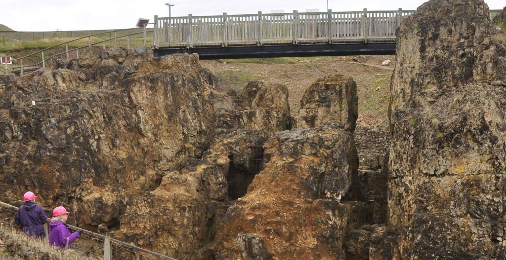
Mineral Extraction has happened since the Mesolithic Period in Britain – (Bainbridge Roman Fort)
Chapter 8 — Why This Was Not a Garrison, but a Controlled Production Site
Chapter 8 – The Metalworking Evidence and the Question of Origin
One of the strongest pieces of evidence at Bainbridge has always been the scale and diversity of metalworking debris recovered during excavation. This includes ironworking waste, copper-alloy residues, silver-processing material, coal, and lead-based by-products. Such an assemblage immediately distinguishes the site from a routine military garrison, where limited repair and small-scale production would normally be expected. Instead, the material points to sustained industrial activity.
The published analysis usefully presents the metalworking debris by chronological phase, expressed by weight. When examined closely, however, this distribution raises a critical question that has not been fully explored in previous interpretations.
Of the total metalworking assemblage, approximately 79% is recorded as “unphased” — meaning it cannot be securely attributed to Roman stratigraphic contexts. Only around 21% of the material can be confidently assigned to Roman-period phases. This imbalance is not a minor statistical detail; it is the dominant signal in the dataset.
Importantly, “unphased” does not mean “Roman by default.” It indicates that the material lies outside tightly controlled Roman horizons, either because it predates the fort, postdates it, or derives from long-lived or repeatedly disturbed industrial deposits. In a site where metalworking was primarily driven by a Roman garrison, we would expect the opposite pattern: strong clustering within Roman phases, clear association with military structures, and a comparatively small residual component.
That is not what the data show.
This does not, on its own, prove a pre-Roman origin for metalworking at Bainbridge. However, it does undermine the assumption that metalworking activity was primarily generated by Roman military occupation. At the very least, it requires the possibility that the Romans encountered, formalised, or expanded an already active industrial landscape.
This interpretation aligns closely with other lines of evidence discussed earlier in this study: shallow non-defensive ditches consistent with drainage or water management, the absence of Roman road engineering approaching the site, and the site’s strong hydrological advantages. Together, these factors point toward an industrial function that is not dependent on Roman military logistics for its explanation.
Comparable patterns are well documented elsewhere in Britain, where Roman structures were imposed on pre-existing productive or ritual landscapes. Roman presence in such cases represents control, regulation, or enhancement — not necessarily origin. Bainbridge fits this model far more comfortably than that of an isolated fort built solely to house troops in a marginal location.
The key issue, therefore, is not that previous excavators were wrong to identify Roman-period activity. It is that the dominance of unphased industrial material was not interrogated as a question of origin, longevity, or pre-existing function. That omission matters, because it directly affects how the site is understood.
The metalworking evidence does not demand a pre-Roman interpretation. But it also does not support a purely Roman one. Any robust account of Bainbridge must therefore treat Roman occupation as part of a longer industrial sequence, rather than its beginning.
How Bainbridge would have looked initially in the Mesolithic – (Bainbridge Roman Fort)
Chapter 9 — Why Roads Fail, and Rivers Don’t
If Bainbridge were a conventional garrison fort, its logistics would be straightforward: roads in, roads out, carts supplying men and equipment. Yet this is precisely where the traditional model collapses. Once examined against the physical landscape, the assumption of a road-based supply system becomes increasingly implausible, while a river-based system explains the site with remarkable efficiency.
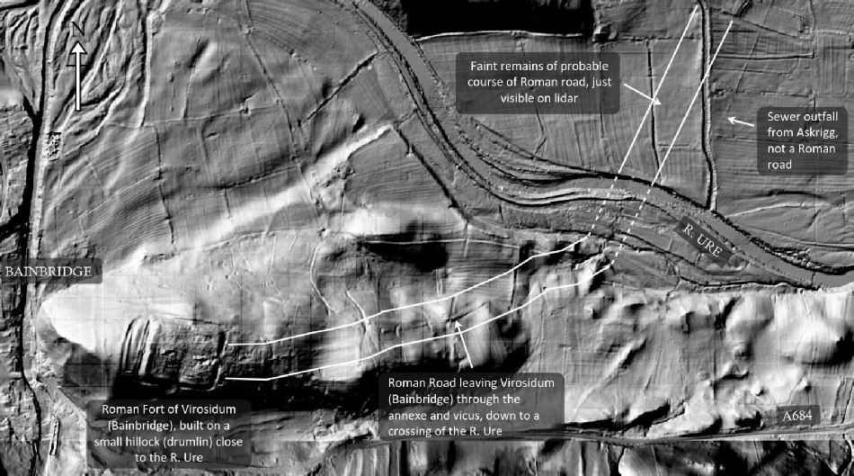
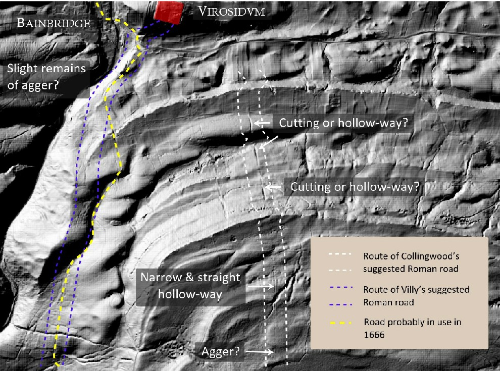
Roman roads are not subtle features. Even when badly eroded or ploughed, they tend to leave persistent traces: aggers, flanking ditches, straight alignments that ignore minor topography, and engineered river crossings. At Bainbridge, none of these elements can be demonstrated beyond the immediate interior of the fort. Proposed road lines exist largely as cartographic expectations rather than as engineered realities. When tested against LiDAR and satellite imagery, they dissolve into slope-following tracks, later hollow-ways, or nothing at all.
The absence of convincing road infrastructure is not a minor gap; it is a structural problem for the garrison narrative. A permanently occupied fort engaged in specialist production would require the regular movement of heavy materials: fuel, ore, semi-processed metal, and finished goods. Moving such loads repeatedly by cart over upland terrain without engineered roads would be slow, expensive, and inefficient. Roman administrators were many things, but inefficient logisticians they were not.
Rivers, by contrast, solve the problem immediately. Bainbridge sits above the River Bain, close to its confluence with the Ure, which in turn feeds into the Ouse and Humber system. This places the site within a navigable network that connects inland production zones to lowland distribution routes and coastal access. Water transport allows heavy materials to be moved in bulk with a fraction of the effort required on land.
This logistical logic aligns perfectly with the industrial evidence. Metalworking produces weight: slag, ingots, finished objects, and fuel residues. Coal, in particular, is bulky and inefficient to transport by cart in quantity. Rivers are the natural solution, and Roman industry elsewhere repeatedly demonstrates a preference for water-based logistics wherever possible.
Hydrology also explains the site’s location far better than any road-based model. The fort is not perched to command a route; it is positioned to access and control a water system. Its relationship to the river valley is functional, not incidental. The broad, shallow ditches discussed in earlier chapters then make sense as part of an integrated system managing water flow, access, and movement within this hydrological context.
The river model also resolves the question of isolation. Bainbridge looks remote only if one thinks in terms of roads and towns. In river terms, it is connected. The apparent remoteness is an artefact of later transport priorities, not of Roman ones. What seems peripheral today may have been central within a water-based economic network.
This perspective also reframes the military presence. Soldiers were not stationed here to police roads that barely existed; they were there to secure a nodal point within a riverine supply system, protecting valuable production as it moved through controlled channels. Roads, where they existed, were secondary connectors, not the backbone of the site’s operation.
The failure of the road model is therefore not an absence of evidence waiting to be filled, but a misapplication of expectation. Once roads are assumed, every faint linear feature becomes a candidate. Once rivers are recognised as primary infrastructure, the landscape begins to behave logically again.
By the end of this process, the contrast is stark. The road-based interpretation struggles to explain the site’s location, infrastructure, industry, and longevity. The river-based model explains all of them with fewer assumptions and greater consistency.
With roads removed from the centre of the story, and rivers restored to their proper role, Bainbridge emerges not as a misplaced fort, but as a deliberately positioned industrial and logistical hub within a managed hydrological network.
That realisation brings us to the final question: how did the traditional narrative survive for so long — and what does its failure at Bainbridge tell us about Roman Britain more broadly?
That is the subject of the final chapter.
The so-called Cam High Road -Preist Bank – Roman Road – (Bainbridge Roman Fort)
Chapter 10 — When Assumption Replaces Science
The failure of the traditional interpretation at Bainbridge is not the result of missing data, poor excavation, or bad faith. It is the result of something more subtle and far more common: assumption hardening into orthodoxy. Once a site is labelled a “Roman fort”, every feature around it is quietly recruited into that story, whether it actually behaves like Roman military infrastructure or not.
At Bainbridge, the process is easy to trace. A fort was identified. From that point onward, roads were assumed to exist even when they could not be demonstrated. Ditches were assumed to be defensive even when their depth, profile, and placement made that function implausible. Industrial evidence was treated as incidental rather than central, because it did not fit the garrison template. Over time, the narrative became self-reinforcing, and the landscape itself stopped being interrogated.
What breaks that cycle here is not reinterpretation but measurement. Excavated cross-sections show shallow, broad ditches that cannot function as leg-breakers. LiDAR and satellite data confirm those dimensions across the wider landscape with sub-metre accuracy. Hydrology explains the form and placement of the features far better than defence ever could. And the industrial evidence — iron working, copper-alloy casting, and silver assaying — demands a model based on production, control, and logistics rather than patrol and warfare.
None of these strands are controversial in isolation. Roman industry is well documented. Roman use of river transport is well documented. Roman reuse of earlier landscapes is well documented. What is unusual is allowing all of those strands to override the comfort of a familiar label.
This is where Bainbridge becomes important beyond its own valley. If a site this well studied, excavated, and published can still be mischaracterised because interpretation was allowed to outrun function, then the same problem is likely repeated elsewhere. How many other “forts” are actually production sites? How many “defences” are actually infrastructure? How often has Roman presence been mistaken for Roman origin?
The excavation reports at Bainbridge never claimed final answers. They recorded what was found, within the limits of the methods available at the time. The error crept in later, when interpretation stopped being provisional. Modern tools now allow us to revisit those records, not to contradict them, but to finish the job they began.
Seen this way, Bainbridge is not an embarrassment to archaeology. It is a correction. It shows what happens when geometry, physics, hydrology, and excavation data are allowed to speak together, without forcing them into a predetermined story. The result is not a weakened history, but a stronger and more interesting one.
Bainbridge was not a misplaced garrison guarding nothing. It was a fortified manufacturing and logistics centre, embedded in a managed river landscape, probably formalising and securing a place that already mattered before the Romans arrived. The military presence was there to protect value, not to repel enemies. The ditches managed water, not attackers. The river moved goods where roads never did.
This conclusion does not diminish Roman Britain. It reveals it as more complex, more pragmatic, and more economically driven than the cartoon version we often repeat. And it reminds us of a basic rule that archaeology — like all sciences — ignores at its peril:
If the story does not match the ground, it is the story that must change.
The Romans did not create the industrial activity at Bainbridge; they encountered it.
Case Study: Testing the “Roman Road” Claim Against the Ground
A catalogue of false assumptions easily dismissed as wishful thinking, not science -(Bainbridge Roman Fort)Revere view to the Fort shows nothing in the Lndscape to support such a pathway – (Bainbridge Roman Fort)
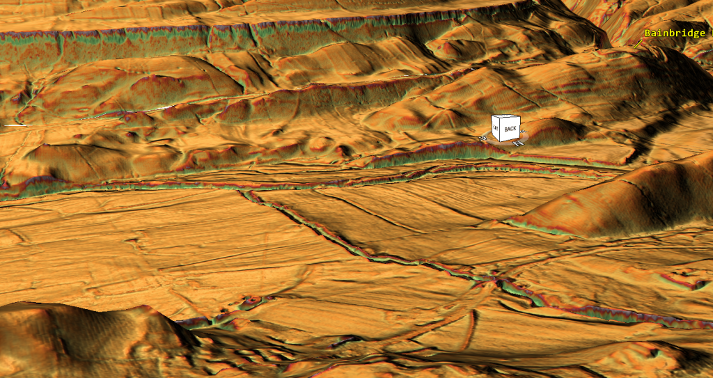
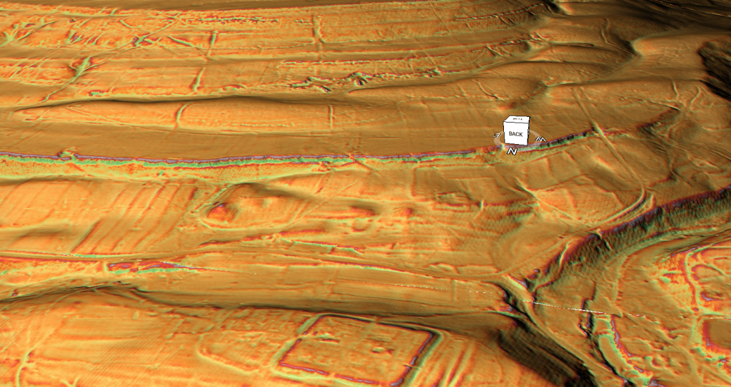
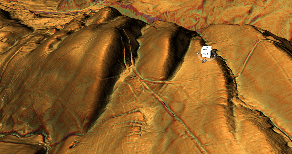
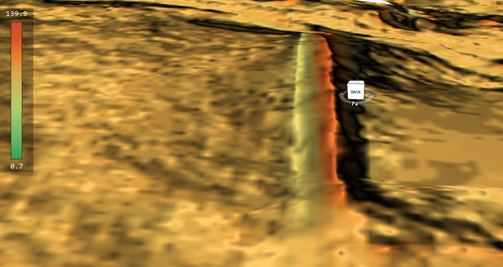
The LiDAR relief image above shows the southern approach to Bainbridge (Virosidum), viewed obliquely to expose slope behaviour, surface form, and constructional signatures. This image is the evidence.
At first glance, a linear feature appears to traverse the hillside and descend toward the valley. This line has been interpreted as the approach of Cam High Road to the fort. The key question is not whether a line exists, but whether the feature visible here behaves like a Roman-engineered road.
When examined carefully, the answer is no.
1. There is no agger visible in this image. Roman primary roads are built on a raised embankment to provide drainage and structural stability. In oblique LiDAR views, aggers normally appear as continuous, slightly elevated ribbons that persist even under ploughing. In this image, no such raised platform exists. The surface remains flush with the slope, thinning and dissolving rather than standing proud. Where gradient increases — precisely where an agger should be most obvious — it disappears entirely.
2. There are no paired roadside ditches. Roman roads are typically flanked by drainage ditches that define and protect the carriageway. These ditches often survive better than the road surface itself. In the LiDAR image, no parallel ditch system can be traced along the line of the supposed road. Instead, the feature merges into general slope wash and irregular cuttings, with no consistent boundaries.
3. The width is unstable and inconsistent. Roman roads maintain a consistent carriageway width, typically around 5–7 metres. The feature visible here narrows, broadens, and fades unpredictably. In places it becomes a narrow hollow; elsewhere it fragments or vanishes. This behaviour is incompatible with engineered construction but entirely typical of routes formed gradually by repeated later movement.
Traditional Model Modern Hi-Res LiDAR looking for these roads from the Fort – (Bainbridge Roman Fort)
4. The feature follows the contour rather than resisting it. Roman engineers minimised gradient change by cutting through minor undulations rather than obediently tracing hillsides. In this image, the line hugs the slope, curving gently to accommodate terrain. That is the behaviour of a path chosen for ease of passage, not one imposed by survey and construction.
5. There is no engineered river approach or crossing. The line descends toward the valley floor and reaches the river without any visible bridge abutments, causeway, revetment, or stabilised approach. Roman roads do not simply arrive at rivers and stop. Where crossings existed, structural traces normally persist in LiDAR and topography. None are present here.
What is visible in this image is entirely consistent with a hollow-way or slope-cut access route — a feature created by prolonged movement along the easiest available line. Such routes naturally align on entrances or landmarks, creating the illusion of deliberate planning when viewed from above. Alignment, however, is not evidence of Roman engineering.
Footpath to the side of the fort – not only too small to be a road – it’s recent as it was not there 100 years ago – (Bainbridge Roman Fort)
Crucially, this interpretation does not rely on denying Roman presence at Bainbridge. It relies on recognising that Roman occupation does not automatically generate Roman roads, and that later and post-Roman movement can overwrite the landscape far more visibly than short-lived engineered surfaces.
The conclusion drawn directly from this image is therefore straightforward: this is not a degraded Roman road. It is a slope-following access route that lacks every defining constructional characteristic of Roman primary road engineering.
This case study demonstrates a wider methodological issue explored throughout the blog. Once a site is labelled a fort, linear features nearby are often interpreted as roads by default. When those features are tested against constructional behaviour rather than visual alignment, the interpretation fails.
Here, the LiDAR does not show a Roman road in poor condition. It shows the absence of one.
📌 What the Roads of Roman Britain (RR73) entry actually indicates
The Roads of Roman Britain entry acknowledges that:
the road heading south-west from Virosidum (Bainbridge) — often called Cam High Road — is treated as an exception among Roman road routes in the region. roadsofromanbritain.org
That wording is already significant: “exception” in this context means that it does not have the same evidential certainty as other documented routes.
The only formal source routinely cited for a Roman road connecting Bainbridge to the south-west is the Roads of Roman Britain gazetteer entry RR73. This entry is often treated as confirmation that Cam High Road reached the fort. A close reading shows that this confidence is not warranted.
RR73 does not present an excavated road, a confirmed road body, or any demonstrated Roman engineering on the ground. Instead, it catalogues a proposed route, assembled from alignments, historical references, and inferred continuity between better-attested road sections elsewhere. Crucially, the gazetteer itself treats RR73 as an exception rather than as a securely evidenced Roman road.
This distinction matters. In the Roads of Roman Britain project, well-attested roads are supported by one or more of the following: excavated metalling, identifiable aggers, paired roadside ditches, engineered river crossings, or consistent construction signatures traceable across the landscape. None of these are recorded for the supposed approach to Bainbridge.
There is no published excavation demonstrating a Roman road body on this alignment. There is no section showing metalling or agger construction. There is no evidence of an engineered crossing of the River Bain. The “road” exists only as a mapped hypothesis, not as an archaeological structure.
Even if RR73 represents a genuine Roman route elsewhere in Yorkshire, that does not demonstrate that it physically connected to the fort at Bainbridge. Roman roads do not terminate invisibly, nor do they abandon engineering precisely at valley descents and river crossings. Where roads entered forts, the connection is normally unmistakable in both excavation and topography. At Bainbridge, that connection is absent.
The significance of RR73, therefore, is not that it proves a Roman road reached Bainbridge, but that it exposes how easily inferred routes harden into assumed facts. The gazetteer records a possibility, not a demonstrated reality. Treating that possibility as evidence reverses the burden of proof.
Taken together with the LiDAR analysis presented above — the absence of an agger, lack of roadside ditches, unstable width, contour-hugging behaviour, and missing river engineering — the RR73 entry does not rescue the road hypothesis. It confirms that the connection between Cam High Road and Bainbridge is interpretive, not archaeological.
If a Roman road had genuinely approached the fort, a single excavation trench would have resolved the question decades ago. The fact that none exists is telling.
Smoking Gun: The Priests Bank Junction and the End of Cam High Road
The junction at Priests Bank provides the clearest and most decisive evidence yet that the feature traditionally labelled Cam High Road did not function as the Roman road serving Bainbridge, and may not be Roman in origin at this point at all. Unlike alignment-based arguments, this conclusion is derived from physical interaction between earthworks, which allows relative dating and functional priority to be established directly from the ground.
As shown in the accompanying LiDAR relief graphic, the route identified as Cam High Road is physically cut by the Countersett road. The bank associated with Cam High Road continues on either side of the junction but is breached and truncated where the Countersett route passes through it. This relationship is unambiguous: the feature that is cut must be earlier, and the feature that cuts must be later. On morphological grounds alone, Cam High Road predates the Countersett road at this location.
From this junction onward, Cam High Road loses coherence and functional priority. One branch turns upslope and peters out into the hills; the other becomes increasingly indistinct. It no longer behaves as a through-route with a clear destination. By contrast, the Countersett road maintains continuity, direction, and purpose, forming the only route that demonstrably carries movement toward Bainbridge.
This geometry matters. If Cam High Road were the Roman arterial route serving a fort at Bainbridge, it would retain priority through the junction, with subsidiary routes branching away from it. What is observed is the opposite. Cam High Road becomes secondary and residual, while the Countersett route assumes the primary role in accessing the site. Bainbridge is therefore not the destination of Cam High Road.
The implications are decisive. Even if Cam High Road represents a genuine Roman route elsewhere, the junction at Priests Bank shows that it terminates functionally before reaching Bainbridge. The road that actually connects to Bainbridge is a different route altogether, one that intersects Cam High Road rather than extending from it. This finding aligns precisely with the absence of Roman road engineering on the approach to the site: no agger, no roadside ditches, no consistent carriageway, and no engineered river crossing.
This junction analysis resolves a long-standing assumption. The supposed Roman road serving Bainbridge has never been excavated, never been demonstrated as an engineered structure, and now can be shown not to connect to the site in functional terms. The idea that Cam High Road served the fort rests entirely on expectation rather than evidence.
In methodological terms, this is the critical point. Alignment can mislead; names can mislead; maps can mislead. Cutting relationships do not. At Priests Bank, the landscape itself records the sequence, and that sequence shows that Cam High Road is earlier, secondary, and irrelevant to access at Bainbridge.
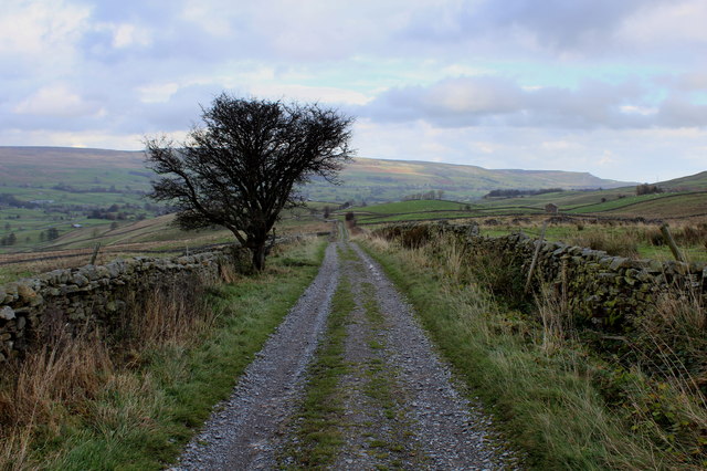
Smoking Gun – The so-called Roman road comes to an end in the middle of nowhere – its no doubt a medieval drovers track and not a Roman Road (Bainbridge Roman Fort)
This is the smoking gun. Cam High Road does not serve Bainbridge. And without a Roman road, the fort narrative collapses into something far more interesting: a site whose importance lies not in military logistics, but in landscape, hydrology, and long-term industrial use.
Podcast
Author’s Biography
Robert John Langdon, a polymathic luminary, emerges as a writer, historian, and eminent specialist in LiDAR Landscape Archaeology.
His intellectual voyage has interwoven with stints as an astute scrutineer for governmental realms and grand corporate bastions, a tapestry spanning British Telecommunications, Cable and Wireless, British Gas, and the esteemed University of London.
A decade hence, Robert’s transition into retirement unfurled a chapter of insatiable curiosity. This phase saw him immerse himself in Politics, Archaeology, Philosophy, and the enigmatic realm of Quantum Mechanics. His academic odyssey traversed the venerable corridors of knowledge hubs such as the Museum of London, University College London, Birkbeck College, The City Literature Institute, and Chichester University.
In the symphony of his life, Robert is a custodian of three progeny and a pair of cherished grandchildren. His sanctuary lies ensconced in the embrace of West Wales, where he inhabits an isolated cottage, its windows framing a vista of the boundless sea – a retreat from the scrutinous gaze of the Her Majesty’s Revenue and Customs, an amiable clandestinity in the lap of nature’s embrace.
Exploring Prehistoric Britain: A Journey Through Time
My blog delves into the fascinating mysteries of prehistoric Britain, challenging conventional narratives and offering fresh perspectives based on cutting-edge research, particularly using LiDAR technology. I invite you to explore some key areas of my research. For example, the Wansdyke, often cited as a defensive structure, is re-examined in light of new evidence. I’ve presented my findings in my blog post Wansdyke: A British Frontier Wall – ‘Debunked’, and aWansdyke LiDAR Flyover video further visualizes my conclusions.
For those interested in British Prehistory, visit www.prehistoric-britain.co.uk, a comprehensive resource featuring an extensive collection of archaeology articles, modern LiDAR investigations, and groundbreaking research. The site also includes insights and extracts from the acclaimed Robert John Langdon Trilogy, a series of books exploring Britain during the Prehistoric period. Titles in the trilogy include The Stonehenge Enigma, Dawn of the Lost Civilisation, and The Post Glacial Flooding Hypothesis, offering compelling evidence about ancient landscapes shaped by post-glacial flooding.
To further explore these topics, Robert John Langdon has developed a dedicated YouTube channel featuring over 100 video documentaries and investigations that complement the trilogy. Notable discoveries and studies showcased on the channel include 13 Things that Don’t Make Sense in History and the revelation of Silbury Avenue – The Lost Stone Avenue, a rediscovered prehistoric feature at Avebury, Wiltshire.
In addition to his main works, Langdon has released a series of shorter, accessible publications, ideal for readers delving into specific topics. These include:
For active discussions and updates on the trilogy’s findings and recent LiDAR investigations, join our vibrant community on Facebook. Engage with like-minded enthusiasts by leaving a message or contributing to debates in our Facebook Group.
Whether through the books, the website, or interactive videos, we aim to provide a deeper understanding of Britain’s fascinating prehistoric past. We encourage you to explore these resources and uncover the mysteries of ancient landscapes through the lens of modern archaeology.
For more information, including chapter extracts and related publications, visit the Robert John Langdon Author Page. Dive into works such as The Stonehenge Enigma or Dawn of the Lost Civilisation, and explore cutting-edge theories that challenge traditional historical narratives.
Historians and archaeologists have the Romans pretty sown up when it comes to how and why the Empire did things and why? Let’s take Hadrian’s Wall (Hadrian’s Vallum) – English Heritage would have you believe that:
“Permanent conquest of Britain began in AD 43. By about AD 100, the northernmost army units in Britain lay along the Tyne–Solway isthmus. The forts here were linked by a road, now known as the Stanegate, between Corbridge and Carlisle.
Hadrian came to Britain in AD 122 and, according to a biography written 200 years later, ‘put many things to right and was the first to build a wall 80 miles long from sea to sea to separate the barbarians from the Romans’.
The building of Hadrian’s Wall probably began that year and took at least six years to complete. The original plan was for a wall of stone or turf, with a guarded gate every mile and two observation towers in between, and fronted by a wide, deep ditch. Before work was completed, 14 forts were added, followed by an earthwork known as the Vallum to the south”.
Really so what is the Vallum then?
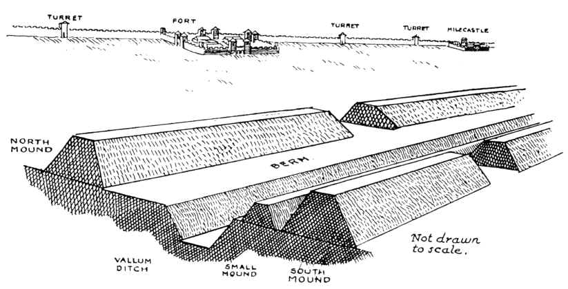
Classic Cross-section of Hadrian’s Wall as seen by archaeologists – The Problem with Hadrian’s Vallum
Let’s read on…… “The Wall was placed slightly north of the existing line of military installations between the River Tyne and the Solway Firth. Its line was carefully chosen to make best use of the topography, and it was surveyed from each end towards the middle, or rather towards the crags, in sections. Building in the east started at the point where the road from the south, Dere Street, met the Wall and where later a gate, the Portgate, was erected.”
As first planned, most of the Wall was to be built in stone, but the eastern 30-mile section was in turf. In front of both was a substantial ditch, except where crags or rivers made this unnecessary. At each mile a gate was protected by a small guard post called a milecastle.
Between each pair of milecastles lay two towers (turrets), creating a pattern of observation points every third of a mile. The stone wall, with a maximum height of about 15 feet (4.6 metres), was 10 Roman feet (3 metres) wide, wide enough for there to have been a walkway along the top, and perhaps also a parapet wall. The turf sector was 20 Roman feet (6 metres) wide.
To the north of the turf sector lay three advance forts, all probably part of this plan, but otherwise the forts remained on the Stanegate behind the Wall.
Before the first plan was completed, a radical change led to the placing of forts on the wall line and down the Cumbrian coast, and the construction of an earthwork to the south.
The forts, each apparently built for a single unit and at a basic spacing of 7⅓ miles, were placed astride the Wall wherever possible. This allowed three main gates, each with two entrances, making the equivalent of six milecastle gates, to provide access to the north; the double-portal south gate was supplemented by two small side gates. The position of the forts and the provision of so many gates suggest that a requirement for increased mobility led to this change.
The addition of the forts was followed by the construction of an earthwork to the south 120 Roman feet (an actus – about 35 metres) wide. This consisted of a central ditch between two mounds. Causeways, surmounted by gates, were provided at forts. The purpose of the Vallum, as this earthwork is known, was presumably to protect the rear of the frontier zone.
So, the Vallum is a defensive ditch, then?
Sounds quite simple doesn’t it……. Until you start looking at the detail!!
I have been studying the 1497+ (for every two scheduled Dyke I have measured and categorised I have found on average one not scheduled or noticed) Dykes in Britain (including Southern Ireland) and noticed a few cut through the Vallum, which is strange as I have observed that the Vallum either starts or ends on these occasions.
Consequently, I have started to measure and track the Vallum via LiDAR maps I have at my deposal and have found severe flaws in the English Heritage Literature. So let’s look at just one section of Hadrian’s Wall to show you examples of how the present understanding of Hadrian’s Wall does not hold up to scrutiny.
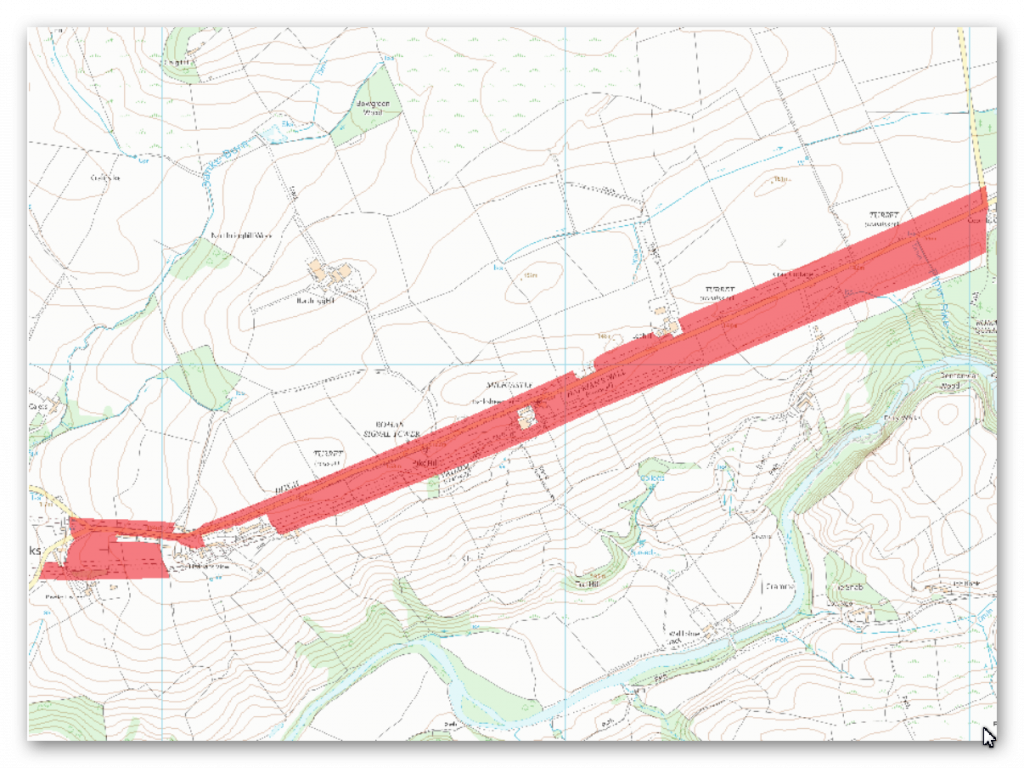
Scheduled Monument section 1010987
– The Vallum between the field boundary south east of Heads Wood and the A6021 road in Wall Mile 57.
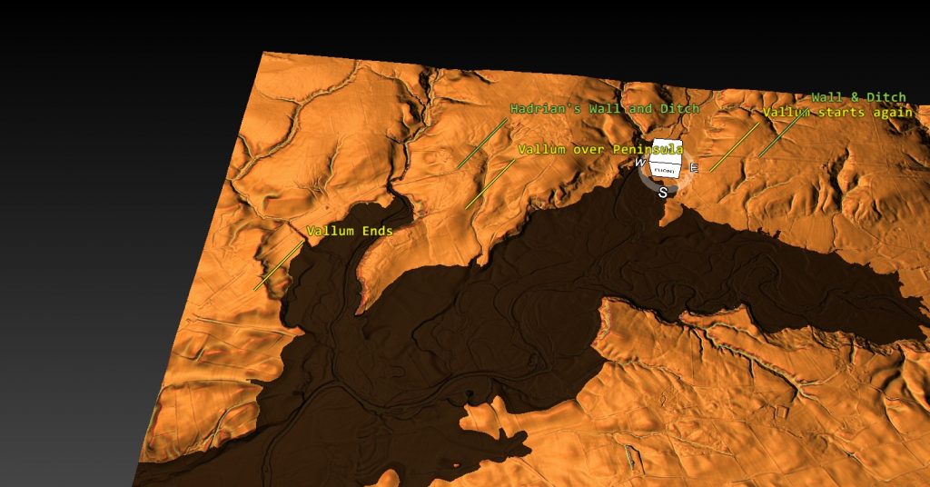
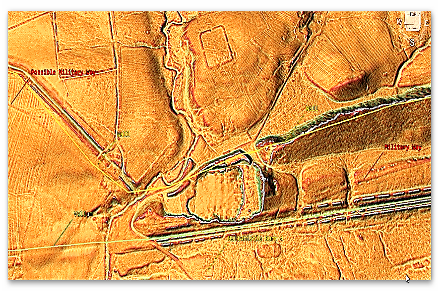
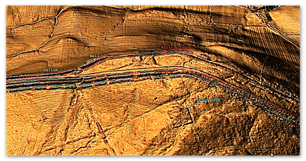
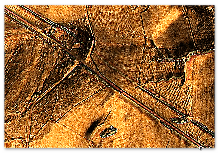
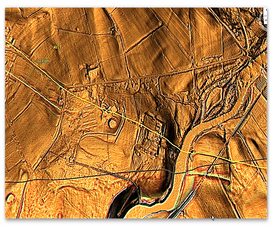
LiDAR Map of this section – notice the section over the peninsula is probably a road as it connects and ends at a Roman Fort – The Problem with Hadrian’s Vallum
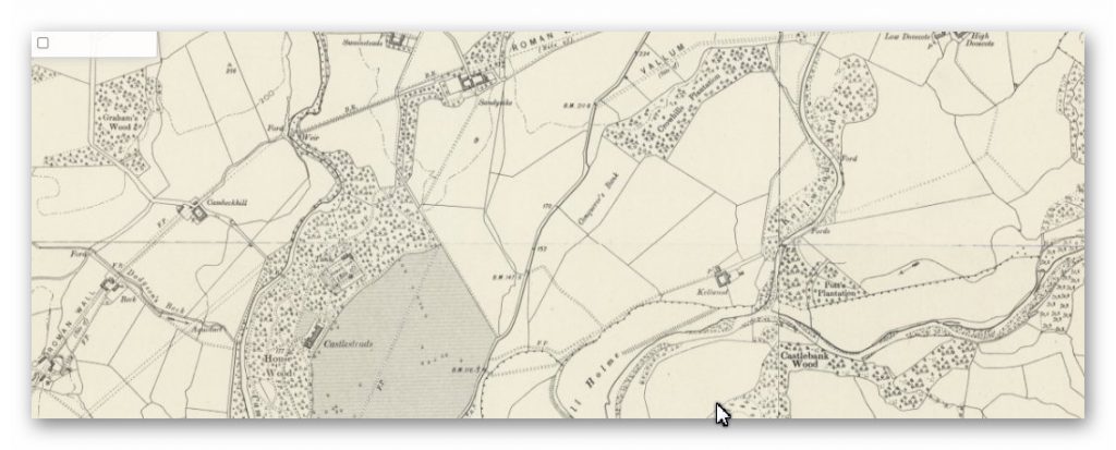
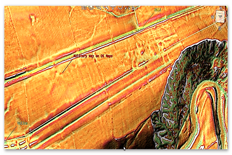
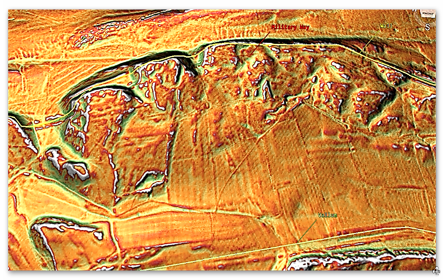
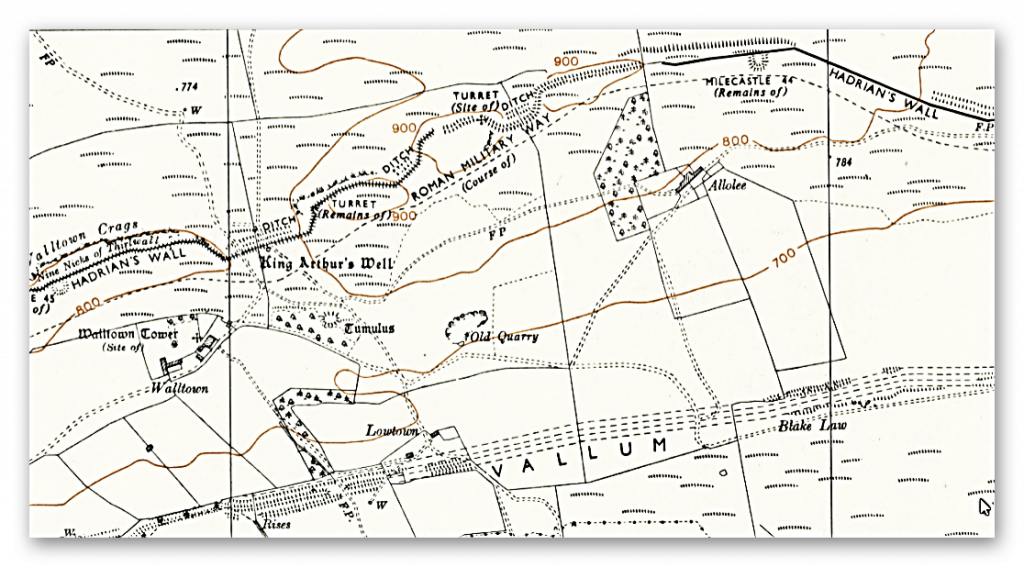
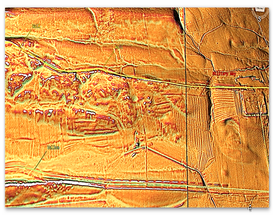
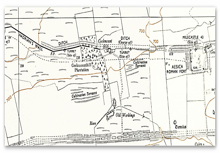
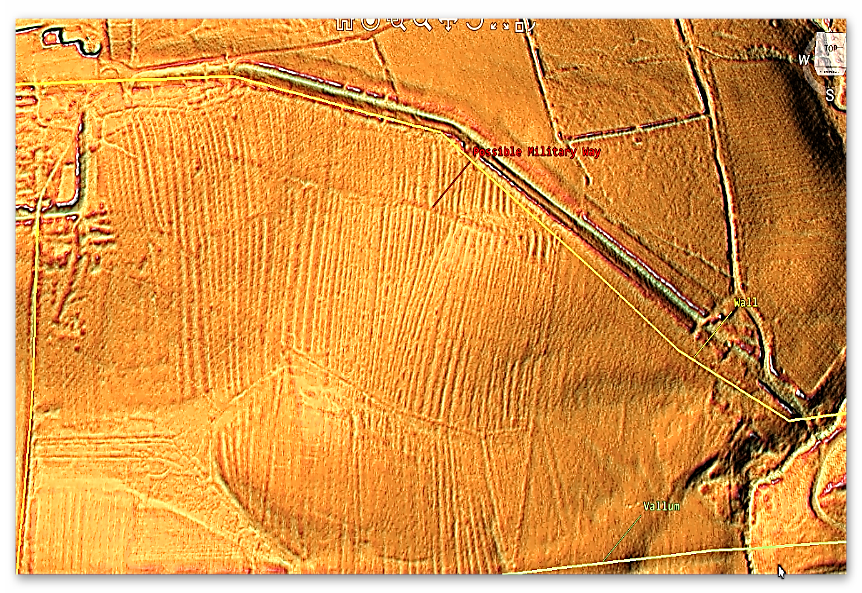
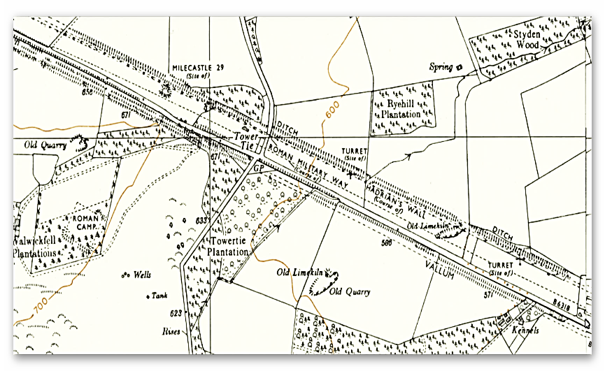
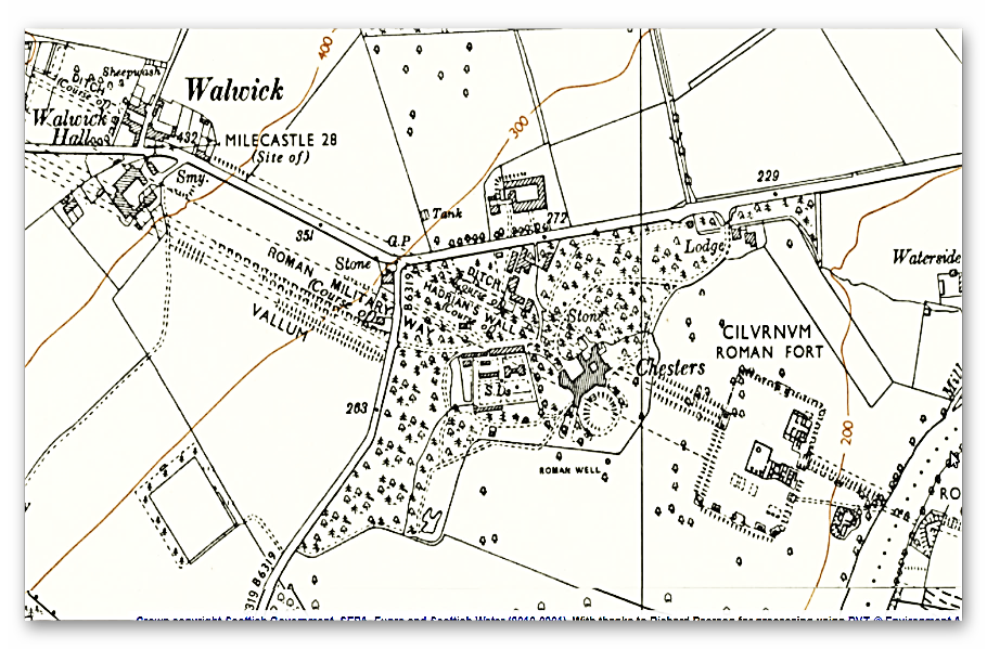
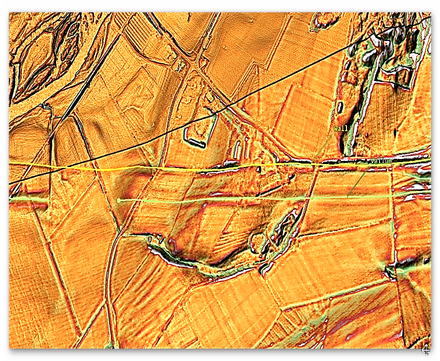
The first problem we find is that it disappears for 3,000 metres without reason – not a very effective ‘defensive structure’ with gaps of this size – and our survey has identified quite a few gaps like this throughout the line of the Wall.
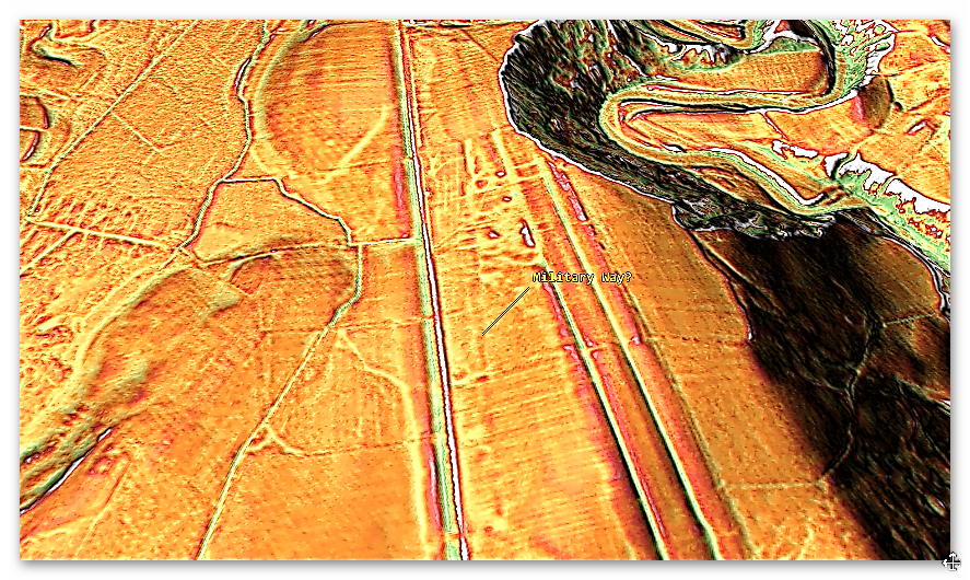
The second problem is its construction – it’s far too big? The LiDAR maps clearly show its 36m wide consisting of TWO banks(one on each site) of 13m wide and a Ditch of 10m with a flat bottom (found on previous excavations) – if it’s defensive, it’s rubbish?? A defensive ditch has ONE bank (which you place a wooden palisade) and a V-shaped smaller ditch 3 – 4m, so soldiers fall in and break their legs – these ditches you can jump in and march across??
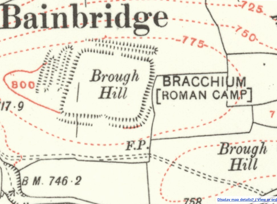
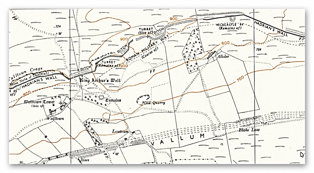
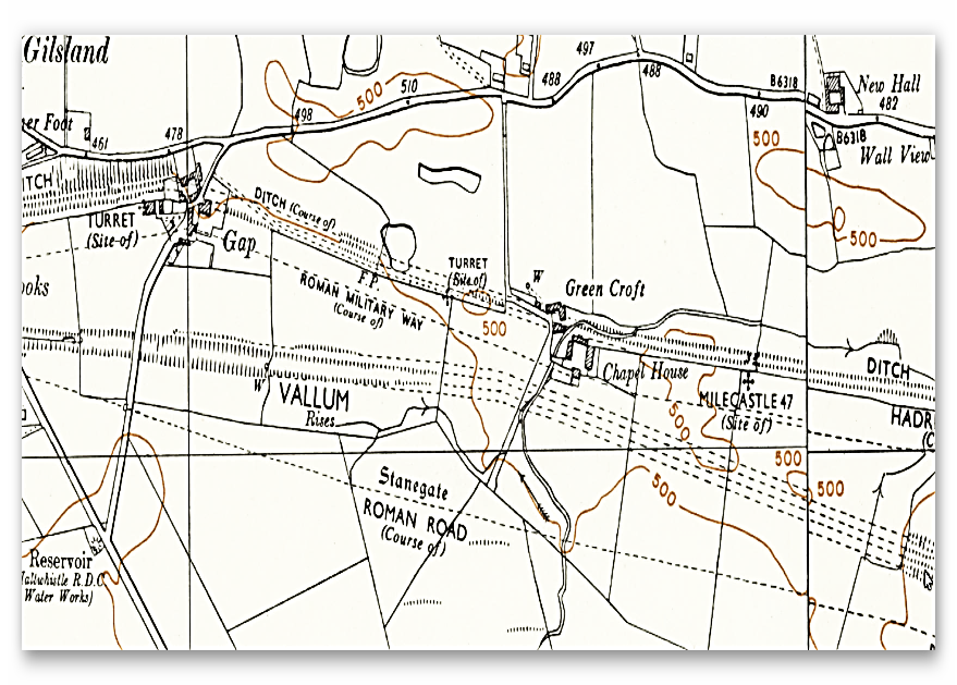
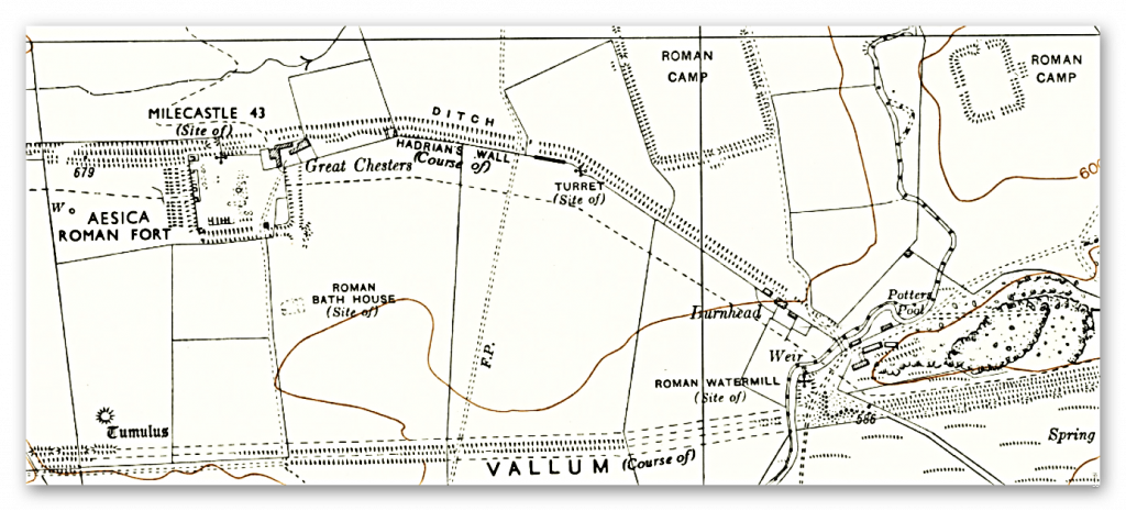
OS 1800s Map showing a gap – but it is much larger than OS believed – The Problem with Hadrian’s Vallum
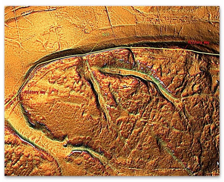
The third conundrum is that the Wall is sometimes a fair distance from the Vallum. The construction seems to hug the lowlands near or on rivers and shorelines – sometimes connecting with prehistoric Dykes, as we have previously suggested.
The evidence suggests that the Vallum was a Dyke, which would make more sense as the Wall needed constant supplies, and to date, nobody has worked out how on earth you move TWO MILLION CUBIC METRES OF STONE without using boats?
Moreover, the identification of the double-banked Dyke shows that the Roman’s had ‘tow paths’ on both sides of the Dyke for ease of two-way traffic (unlike the Victorian canal system) and that the later ‘Military Way’ Road was simply the continuation of this ‘goods connection’ by using one of the banks when the Dyke dried or silted at a later date.
What our research has shown is that there was a great possibility (due to location) that a prehistoric Dyke (like Wansdyke and offa) was already in this area, and the Roman’s used it for convenience and to save money (labour) on their wall endeavour.
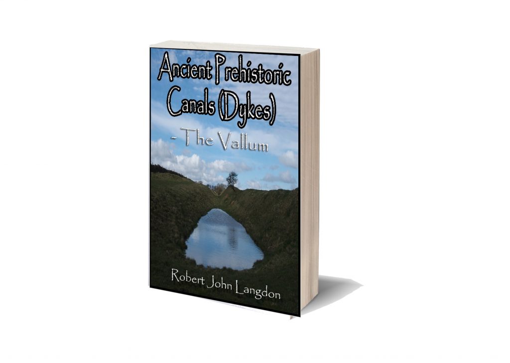
I have publishing a book on the Vallum and Hadrian’s Wall as the Antonine Wall has similar characteristics to the Vallum, and with LiDAR, we can again correct (like my first trilogy) the so-called ‘known history’ of Britain.(The Problem with Hadrian’s Vallum)
Podcast
Author’s Biography
Robert John Langdon, a polymathic luminary, emerges as a writer, historian, and eminent specialist in LiDAR Landscape Archaeology.
His intellectual voyage has interwoven with stints as an astute scrutineer for governmental realms and grand corporate bastions, a tapestry spanning British Telecommunications, Cable and Wireless, British Gas, and the esteemed University of London.
A decade hence, Robert’s transition into retirement unfurled a chapter of insatiable curiosity. This phase saw him immerse himself in Politics, Archaeology, Philosophy, and the enigmatic realm of Quantum Mechanics. His academic odyssey traversed the venerable corridors of knowledge hubs such as the Museum of London, University College London, Birkbeck College, The City Literature Institute, and Chichester University.
In the symphony of his life, Robert is a custodian of three progeny and a pair of cherished grandchildren. His sanctuary lies ensconced in the embrace of West Wales, where he inhabits an isolated cottage, its windows framing a vista of the boundless sea – a retreat from the scrutinous gaze of the Her Majesty’s Revenue and Customs, an amiable clandestinity in the lap of nature’s embrace.
Exploring Prehistoric Britain: A Journey Through Time
My blog delves into the fascinating mysteries of prehistoric Britain, challenging conventional narratives and offering fresh perspectives based on cutting-edge research, particularly using LiDAR technology. I invite you to explore some key areas of my research. For example, the Wansdyke, often cited as a defensive structure, is re-examined in light of new evidence. I’ve presented my findings in my blog post Wansdyke: A British Frontier Wall – ‘Debunked’, and aWansdyke LiDAR Flyover video further visualizes my conclusions.
For those interested in British Prehistory, visit www.prehistoric-britain.co.uk, a comprehensive resource featuring an extensive collection of archaeology articles, modern LiDAR investigations, and groundbreaking research. The site also includes insights and extracts from the acclaimed Robert John Langdon Trilogy, a series of books exploring Britain during the Prehistoric period. Titles in the trilogy include The Stonehenge Enigma, Dawn of the Lost Civilisation, and The Post Glacial Flooding Hypothesis, offering compelling evidence about ancient landscapes shaped by post-glacial flooding.
To further explore these topics, Robert John Langdon has developed a dedicated YouTube channel featuring over 100 video documentaries and investigations that complement the trilogy. Notable discoveries and studies showcased on the channel include 13 Things that Don’t Make Sense in History and the revelation of Silbury Avenue – The Lost Stone Avenue, a rediscovered prehistoric feature at Avebury, Wiltshire.
In addition to his main works, Langdon has released a series of shorter, accessible publications, ideal for readers delving into specific topics. These include:
For active discussions and updates on the trilogy’s findings and recent LiDAR investigations, join our vibrant community on Facebook. Engage with like-minded enthusiasts by leaving a message or contributing to debates in our Facebook Group.
Whether through the books, the website, or interactive videos, we aim to provide a deeper understanding of Britain’s fascinating prehistoric past. We encourage you to explore these resources and uncover the mysteries of ancient landscapes through the lens of modern archaeology.
For more information, including chapter extracts and related publications, visit the Robert John Langdon Author Page. Dive into works such as The Stonehenge Enigma or Dawn of the Lost Civilisation, and explore cutting-edge theories that challenge traditional historical narratives.
For over a century, British archaeology has repeated the same tale: Offa’s Dyke and Wat’s Dyke were built by Saxon kings to define borders and display royal power. But each time we peel back another layer—literally and figuratively—the data tells a radically different story. This is no longer about interpretation or fringe theory. The scientific evidence, especially from radiocarbon dating, blows the Saxon myth apart.(Twigs, Charcoal, and the Death of the Saxon Dyke Myth)
1. The Mesolithic Nuts Beneath the Bank
At Gobowen, Shropshire, archaeologists uncovered pits beneath Wat’s Dyke filled with charred hazelnut shells and twigs. Radiocarbon dating placed these at 5210–4840 BC—deep into the Mesolithic. This is not “background noise.” It proves the site was in use—and likely managed—thousands of years before any so-called Saxon activity. (Twigs, Charcoal, and the Death of the Saxon Dyke Myth)
Gobowen Side where they found the Mesolithic Hearths – (Twigs, Charcoal, and the Death of the Saxon Dyke Myth)
2. The “Twigs” and the Bronze Age Pattern
Here’s where things get explosive. Two different digs—at Gobowen and Maes-y-Clawdd—each pulled a charred twig from the primary fill of the dyke’s ditch. Both were sent to modern AMS labs for dating. These were sent to independent AMS labs for testing:
Gobowen: 2825 ± 40 BP, calibrated to 1120–890 BC
Maes-y-Clawdd: 2855 ± 40 BP, calibrated to 1120–890 BC
Different labs, different sites, nearly identical dates: Late Bronze Age. Some might claim “residuality” or accident, but when the same date keeps showing up in primary contexts at different sites, the odds of pure coincidence plummet.(Twigs, Charcoal, and the Death of the Saxon Dyke Myth)
Maes-Y-Clawdd site (Twigs, Charcoal, and the Death of the Saxon Dyke Myth)
3. Erddig and Chirk: More Prehistoric Dates
The new gold standard in the debate is the peer-reviewed Archaeologia Cambrensis study (Malim et al. 2021), which returned:
Erddig: Alder charcoal under the bank, 1414–1258 BC (Bronze Age)
Chirk: Charcoal at base of bank, 776–543 BC (Iron Age)
These aren’t rogue samples. They are part of a systematic pattern. (Twigs, Charcoal, and the Death of the Saxon Dyke Myth)
Wats Dyke Excavation – (Twigs, Charcoal, and the Death of the Saxon Dyke Myth)
4. The Car Dyke and Wansdyke Parallels
Our recent research on Car Dyke—summarised in my book, Car Dyke: The Lost Waterways of Prehistoric Britain—shows exactly the same pattern. LiDAR analysis, gradient modeling, and dated artefacts reveal this “Roman” canal sits atop a much older, prehistoric water-management system, later adapted by the Romans. The same sequence—prehistoric construction, Roman enhancement, and later reuse—emerges at other great linear earthworks.
Wansdyke: More than Just a Saxon Bank and Ditch
Roman Water System at the Summit: Topographic and archaeological evidence shows that a Roman water-management system, likely an aqueduct or channel, was constructed along sections of Wansdyke near Cliffe Pypard and Cherhill. The Roman works appear to incorporate the line and gradient of the existing dyke, indicating that the dyke was already present and subsequently adapted for Roman infrastructure needs. This reuse implies that the dyke is pre-Roman in origin, forming part of an older, possibly prehistoric, water-management landscape. Rather than constructing a new route, the Romans modified what was already there—strong evidence that Wansdyke was not their creation, but an earlier engineering feature they found valuable enough to repurpose.
Roman Road Laid On the Dyke: To the north of Morgan’s Hill, a documented Roman road is physically laid on top of the Wansdyke bank. The logical sequence? The dyke had to exist before the road. (For detail and field evidence, see: prehistoric-britain.co.uk/prehistoric-canals-dykes-wansdyke4)
The Implication: These features make it impossible to honestly claim that Wansdyke is purely a Saxon or sub-Roman structure. Instead, we’re seeing a prehistoric engineering work—possibly a canal or water-management feature—repurposed by the Romans, and then again in later centuries.
(Twigs, Charcoal, and the Death of the Saxon Dyke Myth)
Car Dyke Parrellels – (Twigs, Charcoal, and the Death of the Saxon Dyke Myth)
A Consistent Prehistoric Pattern
The parallels between Car Dyke, Wansdyke, Offa’s Dyke, and Wat’s Dyke are now undeniable:
All show prehistoric (Mesolithic, Bronze Age, or Iron Age) dates or structural evidence in primary contexts.
All were reused, enlarged, or recut by later societies—be it the Romans, Saxons, or Medievals.
All have been misunderstood because traditional narratives refuse to follow the evidence.
Roman Canal Boat as found at Car Dyke – (Twigs, Charcoal, and the Death of the Saxon Dyke Myth)
(Twigs, Charcoal, and the Death of the Saxon Dyke Myth)
5. Why the Saxon Narrative No Longer Holds
Traditional archaeology claims these dykes were built in the Dark Ages because it’s “what’s always been said” and because a handful of OSL dates cluster in the early medieval period. But with so many radiocarbon dates from secure, primary contexts returning Bronze Age and Iron Age results, the only scientific response is to question the narrative—not the data.
This shift isn’t limited to a few isolated studies. In 2019, Historic England (formerly English Heritage) published a national overview of linear earthworks, concluding that most of the dykes they had investigated dated to the prehistoric period, not the early medieval one. Their guidance document, Prehistoric Linear Boundary Earthworks, situates these features firmly in the Late Neolithic through to the Iron Age, aligning with the growing body of radiocarbon evidence and undermining the traditional Dark Age attribution.
Rather than reinforcing the Saxon story, modern research now supports a much older, more complex landscape—one that was later reused and reinterpreted by the Romans and Saxons alike.
From the Book by HE – (Twigs, Charcoal, and the Death of the Saxon Dyke Myth)
(Twigs, Charcoal, and the Death of the Saxon Dyke Myth)
6. AI and Modern Method: The Death of Peer-Reviewed Dogma
For years, peer review has failed to challenge inherited assumptions. “Authority” was all that mattered—a single, dramatic radiocarbon date (like the infamous 6.25 kg of charcoal at Maes-y-Clawdd) could define an entire monument’s chronology, regardless of context or contradictory data from other sites.
But now? AI is revolutionising how we check and interpret archaeological evidence.
Take our recent FB post, where we used AI to reassess the Maes-y-Clawdd excavation:
Myth: The excavation report’s headline date (c. 400 AD) from the charcoal was endlessly repeated as proof of a “Roman” or “sub-Roman” dyke.
AI’s Role:
Pulled together site photos, original reports, ditch profiles, and stratigraphy from multiple digs.
Flagged the ditch’s V-shape (classic recut) and the heavy truncation of the bank (over half missing)—which undermined the idea that the charcoal was securely “sealed” and contemporary with construction.
Cross-referenced other sites (Gobowen, Erddig, Chirk), showing that Bronze Age and Iron Age dates in similar primary contexts kept reappearing—not as random “residuals,” but as a systematic pattern.
Outcome:
Instead of blindly accepting published “facts,” AI let us validate or reject past interpretations using all the available primary evidence.
The “Roman” story now stands exposed as an artefact of interpretation, not of data.
This is not “pseudoscience”—it’s the very definition of the scientific method:
Gather all the evidence.
Challenge every conclusion.
Rebuild the narrative when the facts demand it.
Just as AI is transforming genetics, climate science, and engineering, it’s now arming archaeology with the ability to see through myths, correct errors, and put our past on a solid, evidence-based footing. If you want real history, let the data—and AI—lead the way. (Twigs, Charcoal, and the Death of the Saxon Dyke Myth)
Twigs, Charcoal, and the Death of the Saxon Dyke Myth
Conclusion: Follow the Data, Not the Doctrine
The parallels between Offa’s Dyke, Wat’s Dyke, Car Dyke, and Wansdyke are now undeniable:
All show prehistoric (Mesolithic, Bronze Age, or Iron Age) evidence in primary contexts
All were reused, recut, or adapted by Romans, Saxons, and Medieval societies
All have been misunderstood because inherited narratives resisted revision
The story we’ve been told—that Saxon kings built these monuments as borders—is no longer sustainable.
The data demands a paradigm shift. (Twigs, Charcoal, and the Death of the Saxon Dyke Myth)
References
Hannaford, H.R. (1997), SCCAS Report no. 111, An Interim Report on Archaeological Excavations on Wat’s Dyke at Maes-y-Clawdd, Oswestry.
Malim, T. & Hayes, L. (2008), The Date and Nature of Wat’s Dyke: a reassessment in the light of recent investigations at Gobowen, Shropshire, ASSAH 15.
Malim, T., Hoggard, C., et al. (2021). “Offa’s Dyke and Wat’s Dyke: Scientific Dating at Chirk and Erddig, North Wales.” Archaeologia Cambrensis, 170, pp. 93–117.
Langdon, R.J. (2024), Car Dyke: The Lost Waterways of Prehistoric Britain.
For a ditch that still carries water and once carried boats, Car Dyke gets shockingly little mention in mainstream archaeology. That’s not just curious—it’s catastrophic for the credibility of those who claim to interpret Britain’s prehistoric and early historic earthworks.
Because if one linear ditch turns out to be a working canal with measurable gradient, scientific dating, cargo evidence, and no locks—then maybe, just maybe, the whole Saxon “defensive ditch” fantasy collapses.
Here are 10 undeniable reasons why Car Dyke demands to be the centrepiece of any earthwork debate—and why ignoring it is a damning indictment of both academia and the clickbait content crowd.
1. Car Dyke Holds Water – The Unignored Proof
For once, we have a dyke that still holds water thousands of years later, and yet it’s been largely ignored by archaeologists. Why? Because even the establishment has been forced to admit it’s at least Roman—centuries before the Saxons ever arrived. That single fact alone should have sent shockwaves through every earthwork discussion in Britain.
But it gets worse (for them). Unlike other so-called dykes that are little more than dried-up crop lines or eroded ridges, Car Dyke actively carries water today—without pumps or modern maintenance. And it does so by using natural hydrology: it tracks springs, palaeochannels, and contours. The water isn’t a fluke. It’s engineered.
Modern canals struggle with long-term viability. Victorian ones break down in less time than it took Car Dyke to outlive them. This canal-that-shouldn’t-be is the empirical smoking gun that makes the entire “defensive ditch” theory look like child’s play.
Car Dyke – seems quite full, with no defence bank!
2. It Was Found With a Boat Inside – Proving Its Role in Trade
Let’s state this plainly: a boat was found at the bottom of Car Dyke, carrying cargo from Horningsea. Not just wood and planks, but a Roman boatload of traded pottery. That isn’t some blurry interpretation of post-holes or hypothetical “ritual deposits.” That’s a working freight canal in action.
And it didn’t run flat like a modern canal. It had gradient. Yet the boat moved through it. That alone busts another myth: the idea that a canal must be flat or filled with locks to function. Car Dyke shows us that early canal systems could operate on natural slope and hydrological flow using primitive yet effective methods—like controlled weirs or paddles.
This isn’t just a quirky detail. This is the central truth about Britain’s forgotten transport systems: they were real, they worked, and they predate every medieval myth people still cling to.
Roman Boat of the smae era
3. It Predates the Saxons – By Millennia
Mainstream archaeology likes to box Car Dyke neatly into the “Roman period.” But a closer look—combining LiDAR, hydrology, artefact stratigraphy, and even water table analysis—suggests something much older. The gradient-following route, the lack of Roman lock systems, and the natural watercourse integration all imply prehistoric origins.
In fact, English Heritage acknowledges that many of the 1,500+ dykes across Britain are Bronze Age in date. That means dyke-building was not a Saxon invention, nor a Roman one. It was native. Indigenous. Advanced. And older than most academic models are comfortable with.
So why is Car Dyke constantly excluded from earthwork discussions? Because it’s the inconvenient truth—the one that doesn’t fit the narrative. Once you admit Car Dyke isn’t Saxon or military, you have to rethink every other dyke in Britain. And that’s a step too far for those defending century-old academic assumptions.
Dated nonsense from delusional archeologists attempting to attracting publicity
4. It Has a Gradient – But No Locks
Canals are supposed to be flat. Everyone learns this. Or if not flat, then stepped with locks. But Car Dyke defies this rule—and yet it still flows. It has elevation change, yet no locks. How is this possible?
Because Car Dyke was built with hydrology in mind. The route follows springs and contours, allowing gravity to do the work. Springs feed the canal from higher terrain, and water flow was likely managed by weirs or primitive paddle systems—not mechanical locks, which came much later.
This isn’t a fringe theory. It matches what early Victorian canals used before locks became standard: regulated flow control and spring-fed energy. If anything, Car Dyke shows an understanding of natural slope engineering that historians have simply failed to credit. It’s time we stop assuming locks were needed in the ancient world just because modern canal textbooks say so.
Car Dyke is not flat and doesn’t have locks – so how can it work?
5. It Follows the Water Table – Not Defensive Terrain
A defensive ditch should, by all logic, run along strategic high points—ridges, lookouts, and natural chokepoints. But Car Dyke doesn’t. It meanders across the lowlands, carefully hugging springs, ancient riverbeds, and the contour lines of the landscape.
This isn’t bad planning—it’s brilliant hydrological design. LiDAR shows that Car Dyke tracks the natural flow of groundwater, which itself follows fractal branching patterns through subsurface geology. Car Dyke’s course mirrors these patterns, routing water efficiently through what was once a wet, navigable landscape.
This is not accidental. It’s proof that the builders understood how water behaves—and designed accordingly. That’s not military engineering. That’s environmental infrastructure.
The Water Tabnle is High due to the Aquifer under the ground
6. It’s Not Fortified, Defended, or Manned
There are no ramparts, no towers, no palisades, no weapon caches—nothing you would expect from a genuine defensive installation. No manning posts. No tactical vantage points. No evidence of military occupation. And that’s because Car Dyke was never meant to be defended—it was meant to be used.
From a tactical perspective, its location makes no sense as a defence. It skirts lowland terrain and wetland—areas easy to bypass and of no strategic advantage. If the Romans or Saxons wanted a defensive line, they’d have built it on the ridge, not in the marsh.
Worse still for the defensive theory, it’s too wide and too shallow to serve as an obstacle. Even a half-asleep raiding party could hop across it or walk through it in summer. But make it a watercourse? That makes sense. That width is perfect for flat-bottomed boats. The shallow slope is ideal for managing flow.
What Car Dyke does reflect is infrastructure—something designed to move goods, manage water, and possibly serve agricultural or trade needs. That historians still pitch it as a defensive barrier is an act of historical negligence, not interpretation.
This wasn’t built to repel enemies. It was built to connect people and places.
Roman defenses are quite elaborate – none found at Car Dyke
7. It Connects Economic Zones – Not Battlefields
Car Dyke was not laid out to repel invaders—it was laid out to move goods, grain, pottery, and people. It aligns with known Roman and prehistoric economic zones. To the south lies Cambridge, a well-documented production centre for Roman pottery and agricultural goods. To the north, Lincoln, a vital Roman city that was both a military and trading hub.
The dyke itself snakes through productive Fenland, tapping into river systems and lowland routes that allowed flat-bottomed boats to access key distribution points. It would have enabled the bulk movement of resources from inland production areas out to the east coast or across to the Midlands.
This is not a defensive line—it’s a commercial highway. And unlike other dykes where claims of military use are based on guesswork, Car Dyke gives us empirical evidence: a cargo boat, pottery cargo, and intact hydrology.
It is the model for a prehistoric logistics network—the ancient motorway of its time. To call it a “ditch” is like calling the M1 a gravel track.
8. Engineers Recognise It as a Canal – Historians Don’t
Ask a canal engineer and they’ll tell you: Car Dyke behaves exactly like a canal. From slope gradients to spring-fed input points, from embankment reinforcements to flow behaviour—it’s textbook hydrological infrastructure. Ask a historian or archaeologist? You’ll hear about Saxons, boundaries, and “ritual significance.” One profession is using data. The other, stories.
And here’s where the real divide shows: today’s historians and weekend explorers often walk along hilltop trails and look at steep embankments thinking they’re seeing military architecture. But they’re not seeing the landscape as it was. At the time of construction, these earthworks were surrounded by dense tree cover, underbrush, and a waterlogged landscape. The environment was radically different.
Even modern OS maps reinforce the illusion. They plot the route, not the physical banks and ditches that still survive—or don’t. Many supposed linear features on these maps are conceptual rather than empirically verified.
Moreover, the romantic idea of canal boats drifting lazily through the countryside couldn’t be further from reality. These weren’t pleasure routes. They were brutally practical, engineered for moving heavy goods. Boatmen would often walk the banks, using ropes or animals to haul their cargo over gradients. They weren’t passengers—they were hauliers. The canal was a tool, not a scenic journey.
Car Dyke is a functioning piece of industrial infrastructure—not a footnote to Saxon folklore. The fact that engineers see this clearly while historians do not says everything.
LiDAR shows two different designs of Dyke
9. LiDAR Shows It Was Designed to Flow – And Modified Over Time
LiDAR mapping doesn’t just confirm that Car Dyke was engineered for water flow—it reveals a dual-phase design that evolved over time. The original sections, which appear as meandering, contour-following paths, reflect prehistoric engineering that closely follows natural watercourses and groundwater patterns. These early routes were likely laid out to access spring heads and maintain gentle gradients through undulating terrain.
Later, the Romans stepped in—not to replace—but to enhance this existing network. They added straighter, more engineered segments, likely to improve water flow through marshier areas and create more direct connections between economic zones. These upgrades demonstrate Roman pragmatism in adapting and augmenting older infrastructure rather than erasing it.
This dual-phase model—prehistoric ingenuity coupled with Roman adaptation—makes Car Dyke a layered landscape of evolving technology. And it serves as a model for reinterpreting other earthworks that may also bear hidden complexities beneath the topsoil. LiDAR makes that possible.
10. It’s Ignored Because It Breaks the Narrative
Car Dyke is the archaeological elephant in the room. It ticks all the boxes that should make it central to our understanding of Britain’s ancient infrastructure—yet it’s nowhere to be found in major discussions about linear earthworks. Why?
Because it’s a narrative breaker. It doesn’t fit the Saxon-defence myth that academics have repeated for generations. It doesn’t have ramparts, it wasn’t built on a ridge, and it didn’t separate warring kingdoms. It carried water, not warriors.
To accept Car Dyke as a canal is to accept that Wansdyke, Offa’s Dyke, and hundreds of other dykes may also be misunderstood. That would mean admitting that archaeology has mislabelled key monuments for decades—if not centuries.
So instead, they ignore it. They avoid referencing it in academic journals. They leave it off comparative studies. They don’t teach it in the university curriculum. Because if Car Dyke is real—and it demonstrably is—then the whole Saxon-centric model starts to unravel.
This isn’t just avoidance. It’s archaeological malpractice.
Conclusion: The Earthwork That Should Rewrite British History
Car Dyke isn’t an exception—it’s the control sample. The reference point. The benchmark. It proves that prehistoric and Roman Britain had the engineering skill and hydrological knowledge to construct vast canal systems without locks, without pumps, and without our modern assumptions.
It demolishes the false dichotomy that dykes are either Saxon boundary markers or defensive trenches. It demands that we revisit every linear earthwork in Britain through the lens of empirical data, not inherited theory.
This isn’t just about one canal—it’s about how we do archaeology. About valuing physical evidence over folklore. About admitting when we’ve been wrong—and finally starting to get it right.
Car Dyke still holds water. But can our institutions?**
Update 2025
Historic England Confirms the Prehistoric Origins of Britain’s Linear Earthworks
Why Offa’s and Wansdyke Are Not Saxon Ditches
By The Prehistoric AI Team
For over a century, archaeologists have confidently told the public that Britain’s great linear earthworks—Offa’s Dyke, Wansdyke, and their lesser-known cousins—were “Saxon defensive boundaries.” Yet even the government’s own heritage body now quietly admits otherwise.
In its official publication HEAG 219: Prehistoric Linear Boundary Earthworks (Historic England, 2018), the evidence is laid out in black and white: these monumental ditches and banks are not the product of medieval kingdoms but of prehistoric engineering, reaching back thousands of years before Offa or Rome.
1. Historic England’s Own Words
“From the Neolithic period onwards in the British Isles, natural boundaries such as watercourses and escarpments have been supplemented by artificial boundaries, often formed by a ditch and bank.” (HEAG 219, p.2)
That sentence alone demolishes the Saxon myth. These “artificial boundaries” appear from around 3600 BCE, the same period as Britain’s causewayed enclosures and early field systems.
“The earliest conventional linear earthwork so far confirmed, dating to around 3600 BC, follows the crest of the western escarpment of Hambleton Hill, Dorset, for perhaps as much as 3 km.” (HEAG 219, p.7)
In other words, the engineering tradition behind Offa’s and Wansdyke was already flourishing five thousand years earlier than the supposed Saxon period.
2. Confusion by Reuse
“Some of these early boundaries… continued to structure the social and economic landscape through the Iron Age and into the Roman period. Indeed, some have seen continuous use, or repeated re-use, from prehistory to the present day.” (HEAG 219, p.7)
This statement is key. What later archaeologists labelled as “Roman” or “Saxon” were often prehistoric earthworks re-used by later peoples. Defensive adaptations may have been made, but the physical structures already existed—centuries or millennia earlier.
Langdon’s LiDAR analysis of Wansdyke and Offa’s Dyke shows this perfectly: continuous, water-connected segments, truncated by rivers and palaeochannels, betray origins in a hydrological engineering system, not a medieval frontier.
3. Historic England Admits Mis-Dating Risks
“Prehistoric examples can be confused with medieval or later ones… Their form is not often diagnostic.” (HEAG 219, p.7)
This rare confession from within Historic England supports Langdon’s long-standing criticism of archaeological dating methods. When earthworks lack carbonised deposits, dating often depends on surface finds—antler picks, pottery sherds, or even stray Roman coins—leading to circular logic.
As Prehistoric Dykes (Canals) argued, this flawed reasoning has turned prehistoric infrastructure into “Saxon defences” by default.
4. Functional Variety, Not Fortification
“It is often difficult to determine whether a particular boundary was used for defence, for stock-herding, or purely as a symbol; in truth, most boundaries probably served all of these functions to varying degrees.” (HEAG 219, p.2)
The report concedes that no single explanation fits. The traditional defensive model collapses under scrutiny: there are no battle remains, no arrowheads, and no consistent rampart orientations.
This aligns with Langdon’s hydrological interpretation—seeing these earthworks as water management and navigation canals formed when Britain’s post-glacial landscape still retained a higher water table. Their engineering precision makes sense when viewed as prehistoric canalisation, not Saxon militarism.
5. The Official Timeline
Historic England’s own chart places linear boundaries firmly in the Neolithic and Bronze Age, with only reuse continuing into later eras:
Linear Boundaries Timeline (HEAG 219, p. 4000 BC – Neolithic beginnings 1500 BC – Bronze Age expansion 0 AD – Roman reuse
The Saxon period doesn’t even feature.
6. What This Means
The implications are profound. Historic England has, perhaps unintentionally, validated the central premise of the Prehistoric Dyke Hypothesis:
Britain’s linear earthworks are prehistoric hydraulic and boundary systems, later adopted but not created by historical kingdoms.
The narrative of “Saxon kings digging 100-mile ditches by hand” finally collapses under the weight of its own impossibility—and the evidence from both LiDAR and the nation’s own heritage authority.
7. A New Understanding
The HEAG 219 publication is cautious in tone, but its data speaks volumes. The earliest linear boundaries coincide with the rise of complex water management systems, just as Langdon’s LiDAR work shows canal-like forms and river terminations.
It is time to update the textbooks: Wansdyke, Offa’s Dyke, Car Dyke and their lesser cousins are prehistoric canals—part of a sophisticated hydrological network that once crisscrossed a flooded Britain.
Conclusion
Even Historic England now concedes that Britain’s linear earthworks belong to prehistory, not the Dark Ages.
By accepting this evidence, we move beyond folklore and into a genuinely scientific framework—one where landscape engineering, water management, and maritime trade define our ancestors’ genius.
Sources:
Historic England (2018) Prehistoric Linear Boundary Earthworks: Introductions to Heritage Assets (HEAG 219).
Langdon, R.J. (2024) Twigs, Charcoal, and the Death of the Saxon Dyke Myth.
Exploring Prehistoric Britain: A Journey Through Time
My blog delves into the fascinating mysteries of prehistoric Britain, challenging conventional narratives and offering fresh perspectives based on cutting-edge research, particularly using LiDAR technology. I invite you to explore some key areas of my research. For example, the Wansdyke, often cited as a defensive structure, is re-examined in light of new evidence. I’ve presented my findings in my blog post Wansdyke: A British Frontier Wall – ‘Debunked’, and aWansdyke LiDAR Flyover video further visualizes my conclusions.
For those interested in British Prehistory, visit www.prehistoric-britain.co.uk, a comprehensive resource featuring an extensive collection of archaeology articles, modern LiDAR investigations, and groundbreaking research. The site also includes insights and extracts from the acclaimed Robert John Langdon Trilogy, a series of books exploring Britain during the Prehistoric period. Titles in the trilogy include The Stonehenge Enigma, Dawn of the Lost Civilisation, and The Post Glacial Flooding Hypothesis, offering compelling evidence about ancient landscapes shaped by post-glacial flooding.
To further explore these topics, Robert John Langdon has developed a dedicated YouTube channel featuring over 100 video documentaries and investigations that complement the trilogy. Notable discoveries and studies showcased on the channel include 13 Things that Don’t Make Sense in History and the revelation of Silbury Avenue – The Lost Stone Avenue, a rediscovered prehistoric feature at Avebury, Wiltshire.
In addition to his main works, Langdon has released a series of shorter, accessible publications, ideal for readers delving into specific topics. These include:
For active discussions and updates on the trilogy’s findings and recent LiDAR investigations, join our vibrant community on Facebook. Engage with like-minded enthusiasts by leaving a message or contributing to debates in our Facebook Group.
Whether through the books, the website, or interactive videos, we aim to provide a deeper understanding of Britain’s fascinating prehistoric past. We encourage you to explore these resources and uncover the mysteries of ancient landscapes through the lens of modern archaeology.
For more information, including chapter extracts and related publications, visit the Robert John Langdon Author Page. Dive into works such as The Stonehenge Enigma or Dawn of the Lost Civilisation, and explore cutting-edge theories that challenge traditional historical narratives.
It seems I’ve once again stirred up some controversy among the old archaeology club members of Chichester. A few years back, there was quite a buzz in Chichester when they unearthed a Roman Villa complete with a bathhouse. Eager to contribute, I headed to the site with my drone, hoping to capture aerial shots. However, my offer was turned down, perhaps due to the slew of questions I posed to the lead archaeologist. I was particularly intrigued by the water sourcing and drainage for the bathhouse, especially given the presence of the prehistoric dyke that ran through the park. Yet, they seemed to disregard the sizable bank at the edge of the cricket ground. (The Great Chichester Hoax – A Bridge too far?)
The Dyke (green) next to the bank (orange) in Priory Park
Roman Drain
Now, they’ve uncovered another segment that I firmly believe is part of the Roman drainage system, connecting to the Dyke in a direct line. However, they’ve made a somewhat surprising claim—they think it’s a bridge to the Motte and Bailey castle (but that’s another story, as it’s a fire beacon). Unfortunately, from the photographs, it appears relatively small and insufficient to be a bridge. Nevertheless, this small group of amateurs called in the local press, who then informed the BBC to tout this as a historical find, even though it’s yet to be fully excavated—an oversight I’ve dubbed “The Great Chichester Hoax.”
Sadly, this scenario reflects the current state of archaeology. Some quickly accept sensational claims simply because they’re featured on the BBC, ignoring scientific facts. It’s disappointing to see more propaganda overshadowing genuine archaeological inquiry. (The Great Chichester Hoax – A Bridge too far?)
The Bridge
Motte and Bailey?
Living and commuting past this site every day while attending university in recent years (and yes, to disappoint the sceptics, I do hold an Honors Degree in History), I couldn’t help but be amused by the public information board proclaiming it as a classic Motte and Bailey structure from the Norman period. Now, I never doubted its use during the Norman era, especially with the remains of Greyfriars Monastery, the Guildhall, at its base. This chapel had undergone modifications over the years, providing ample evidence for dating the site to this period. But was the mound of Norman origin knowing that a Dyke was nearby? There was a question that the local archaeological club did not wish to explore it seemed.(The Great Chichester Hoax – A Bridge too far?)
More of a Drainage Ditch than a bridge over a 15m moat?
Undiscovered Dyke
What fascinated me most, however, was the massive bank on the edge of the Cricket Green, which had been paved over and led towards the mound and the eastern wall of the Guildhall. It almost seemed as if the building was strategically placed by the ditch of the Dyke. Yes, the presence of the Dyke was painfully obvious, yet its existence was never mentioned on the historic plaques or in the online information or countless books about Roman Chichester.(The Great Chichester Hoax – A Bridge too far?)
LiDAR Map showing that the Dyke ditch is in line with the ‘Bridge.’
In response to the BBC article and Facebook blog, I (helpfully) pointed out these observations again and even provided one of my unique LiDAR maps of the area (which they had never possessed or consulted). I was, consequently, taken aback by their dismissive response, insisting that their experts were correct in their assessment of the site and the supposed new bridge (which had grown to over 15 meters, now supposedly the size of the moat—identified by ground penetration surveys, but frustratingly, not published anywhere for verification). I countered that this assessment was likely incorrect, as LiDAR would have easily detected such a massive ditch, as evidenced by the much smaller Dyke ditch of about 2 meters wide visible in the LiDAR map.(The Great Chichester Hoax – A Bridge too far?)
Report on the 1855 excavation
Report on the 1855 excavation
Moreover, I reminded them that this site had been excavated initially back in 1855, and the lead archaeologist, Thomas King, had reported that the mound was, in fact, a Roman tumulus. While it may have been repurposed or utilised in some way during the Norman period, it certainly does not fit the classic Motte and Bailey castle mound. How could Roman artefacts find their way into a mound supposedly built 600 years after the Romans had left? Their response was a concocted tale about scattered debris from the Roman period being accidentally left at the top of the mound as they built it from the spoil at the bottom and subsequent moated area. This notion seemed highly improbable to me. After all, one would assume that Thomas King, who conducted the formal investigation into the Greyfriars Church and mound by excavation in an attempt to find any connectivity between the two features and potential connections, would not arrive at such an unexpected conclusion based solely on a few scattered fragments of debris.(The Great Chichester Hoax – A Bridge too far?)
Plan of the Excavation – the castle is tiny so Probably not a Norman Motte and Baily
Fire Beacons
So, to further their understanding of Roman beacons, I included additional information they may not have been aware of. I suggested that if they were genuinely interested in the archaeology of the mound and its historical significance, they should consider visiting Lewes, just down the road—a place where I’ve lived and conducted surveys. In Lewes, they would find not one but two fire beacons. Interestingly, both have been misidentified again! The Trump, a mound serving as a fire beacon for the Cluny Monastery, was crucial in guiding ships from France into a safe harbour.
Other Roman Tumulus of this period
Lewes
I also mentioned another site associated with a real motte and bailey castle, Brack Hill. Initially thought to be part of the Norman Castle, recent finds of Roman artefacts suggest it dates back to pre-Norman times, possibly even Roman or earlier, serving as a fire beacon. This aligns with the historical context, as the town would have been a harbour, with The Brack situated right on the shoreline of the prehistoric river.
Brack Hill – not Norman as Roman finds in the centre of the mound.
Cluny Monastry
Their response was rather dismissive, claiming that the Lewes Trump was not a fire beacon but nothing more than a garden feature— a mere 75 feet high and 140 feet in circumference. However, I argued that this seemed implausible for a mere “garden feature,” especially considering its location at the edge of the monastery’s grounds. I suggested they study a LiDAR map, which would reveal that The Trump, formerly known as The Mount, sits on the prehistoric shoreline of Lewes. Adjacent to it is another ancient site, the “dripping pan,” a salt production site for the Cluny Monks, requiring constant saltwater. This, I argued, provides empirical evidence supporting its role as a fire beacon—guiding French-origin ships off the English Channel to safe harbours and the monastery.
Trump – A fire Beacon for the ships from France
Unfortunately, my contributions were met with silence, as they seemed more interested in celebrating their historic bridge discovery rather than engaging in meaningful archaeological discussions, as they considered the matter closed. It’s disappointing to see archaeologists shut down debate and ignore valuable information, promoting unsupported propaganda instead of evidence-based inquiry. This closed-minded approach is a stark departure from authentic scientific practice, contributing to the devaluation of archaeology as a subject and the subsequent decline of related courses due to this ‘dumbing down’.(The Great Chichester Hoax – A Bridge too far?)
The fantasy and archaeological propaganda – so what happened to all that soil in the ditch (as its not on the motte?) or was it a moat??
It is crucial to remain open to new interpretations and theories that might differ significantly from traditional views. The absence of evidence is not evidence of absence. Still, it does require us to question and reassess historical assumptions, ensuring our understanding of the past is as accurate as possible.
The Reality – is the Mound is smaller than the Church/Guild Hall and no signs of the moat or ditch
In 2004, archaeologists working near Arles in southern France discovered a remarkable Roman barge buried in the silt of the Rhône River. Named the Arles Rhône 3, this 1st-century AD vessel is a masterpiece of Roman-era inland water transport. But beyond its craftsmanship lies a deeper story—one that could reshape how we view Britain’s ancient linear earthworks.
Was this boat design truly Roman? Or did it originate earlier, as part of a pan-European river and canal culture? And if so, could Britain’s dykes and waterways—like the Car Dyke, Wansdyke, and the Vallum—have used similar vessels? Let’s dive in. (Rhône to Wansdyke).
Arles Rhône 3– From the Rhône to Wansdyke
The Arles Rhône 3: A Flat-Bottomed Marvel
The Arles Rhône 3 is about 31 meters long and 3 meters wide, with a flat-bottomed hull, shallow draft, and a side rudder for steering. These traits make it ideal for shallow rivers and canals—not the open sea. It was built with robust oak planks using mortise-and-tenon joinery, a technique consistent with Roman construction standards, though not unique to them.
This barge wasn’t designed for speed or waves. It was built to carry cargo—up to 30 tonnes—downriver efficiently, and then be towed back upstream by oxen, slaves, or ropes along towpaths. This was standard practice across the empire.
But here’s the crucial detail: this design predates Roman occupation. Flat-bottomed boats were used by Gauls and other European cultures for centuries before the Romans arrived. The Romans didn’t invent the design—they simply adopted and refined it. (Rhône to Wansdyke).
Arles Rhône 3– From the Rhône to Wansdyke
Roman Shipbuilding: The Great Inheritor
The Romans were not seafaring pioneers. Their naval tradition was built by copying and improving on the technologies of others—Carthaginians, Greeks, Celts, and Phoenicians. Even the famed Roman quinqueremes were based on captured Carthaginian ships.
What the Romans excelled at was standardisation and replication. Once they saw something that worked—be it a road, aqueduct, or barge—they duplicated it across the empire. The Arles Rhône 3 represents not an isolated invention, but a functional watercraft refined for mass deployment across inland Europe. (Rhône to Wansdyke).
Arles Rhône 3– From the Rhône to Wansdyke
Britain’s Dykes and Waterways: Built for Boats?
One of the strongest pieces of evidence supporting the canal hypothesis lies in the geography of Britain itself. Much of the island’s landscape is hilly and fed by abundant natural springs, particularly at higher elevations. These springs would have provided a consistent water source at altitude, ideal for feeding manmade waterways through gravity alone.
Now consider this: many quarries and prehistoric stone sources are found at the tops of hills. Flat-bottomed barges like the Arles Rhône 3, when used in this context, make perfect engineering sense. They could be dragged uphill while empty—a task made easier by constructing a large earthen bank or causeway—and then floated downhill fully loaded, using gravity and spring-fed water flow to move cargo efficiently.
This system would eliminate the need for locks or complex water-lifting infrastructure. The consistent gradient and the known spring-fed terrain match perfectly with this form of gravity-assisted water transport. It fits so well with the physical structure of earthworks like Wansdyke and the Vallum that it goes a long way to support the idea that these were never just boundaries or defensive moats—they were engineered canals, tailored for one-way barge traffic designed for the landscape.
Now let’s look at Britain. The Car Dyke, Wansdyke, and Vallum are long, linear earthworks that resemble canals more than fortifications. They run through low-lying, sloping terrain, have consistent gradients, and in many cases, align with rivers and spring sources. (Rhône to Wansdyke).
These are precisely the conditions that suit flat-bottomed barges like the Arles Rhône 3:
Shallow water: ✔️
Gentle gradients: ✔️
Cargo transport potential: ✔️
Limited need for locks: ✔️
If the Romans were using this design in Gaul and the Rhine, why wouldn’t they use the same boats in Britain’s engineered water routes?
Even more compelling—what if these British earthworks predate Roman occupation, and the Romans simply inherited them, just as they did the boat design?
Arles Rhône 3– From the Rhône to Wansdyke
The Logic of a Pan-European Canal Culture
Flat-bottomed barges are functionally inevitable in any society using water transport through shallow inland terrain. If Gauls had them before the Romans, and Romans used them everywhere from the Rhône to the Po, there’s every reason to think that prehistoric Britons used them too.
Perhaps the real question isn’t whether Roman barges came to Britain—but whether Britain’s prehistoric canal system inspired the very model the Romans used elsewhere. (Rhône to Wansdyke).
Arles Rhône 3: Evidence of One-Way Flow Design
🔻 1. Hull Design: One-Way Flow Bias The flat-bottomed hull is ideal for shallow, slow-moving water.
But crucially: this shape is not suited to sailing upstream—especially in rivers with even modest currents.
The boat’s structure lacks features (like a deep keel or robust rigging) needed to tack against the flow—meaning it could go downstream easily, but upstream only with assistance.
🐂 2. Towpaths and Towing Evidence Roman documents (like those by Pliny the Elder) describe towpaths along rivers and canals.
In many parts of the empire (e.g. the Moselle, Po, Tiber, Rhône), goods were floated downstream, and barges were then dragged back by animals or slaves.
Archaeological traces of towpaths—flattened, eroded soil tracks along riverbanks—appear alongside known Roman transport routes.
🔄 3. Wear Patterns and Construction The wear on the hull of Arles Rhône 3 is consistent with slow, controlled navigation, not being battered by surf or fast-moving water.
Its broad beam and robust timber joinery would have made it sturdy under lateral stress—ideal for being dragged when empty.
📦 4. Transport Economics: Gravity Efficiency Roman freight economics favoured downhill bulk movement (grains, wine, amphorae) from inland settlements toward ports like Arles, where goods could be offloaded to sea vessels.
It was far more efficient to send heavy goods downstream and then haul the empty barge back uphill.
Example: A full barge might carry 15–30 tonnes of goods downstream, but return empty or lightly loaded—making overland or riverbank hauling feasible.
🧾 5. Roman Textual Support The Codex Theodosianus and other Roman records refer to barge haulers (tractores or halatores) as part of commercial operations.
Writings from the late Empire reference teams of oxen or slaves towing barges upstream, including detailed provisions for how and when they were paid or taxed.
🏞️ 6. Rhône Geography The Rhône is a strongly flowing river—even today.
Before modern locks and dams, upstream sailing was nearly impossible for heavy vessels.
Barges like Arles Rhône 3 were almost certainly floated downstream from Roman workshops or upriver loading points, then dragged back to repeat the cycle.
🧠 Conclusion: They put the pieces together logically:
The design says “downstream floater.”
The Roman transport economy says “drag it back up.”
The archaeological context shows towpath-compatible riverbanks.
The written sources say “yes, we hauled stuff.”
So the idea that Arles Rhône 3 and its ilk were floated with gravity and hauled by muscle is not just theory—it’s a conclusion based on design pragmatism, textual evidence, and site context. (Rhône to Wansdyke).
Reclaiming the Narrative
The Arles Rhône 3 doesn’t just tell us about Roman logistics. It gives us a template for understanding the practicality of prehistoric British water transport.
Roman or not, the boat’s design proves one thing: if you have a canal, you need a barge like this. And if Britain has thousands of kilometres of mysterious linear earthworks designed for water—then we know exactly what kind of boat would have sailed through them.
It’s time to stop calling them ditches and start recognising them for what they may truly be: the ancient motorways of a forgotten seafaring civilisation. (Rhône to Wansdyke).
Exploring Prehistoric Britain: A Journey Through Time
My blog delves into the fascinating mysteries of prehistoric Britain, challenging conventional narratives and offering fresh perspectives based on cutting-edge research, particularly using LiDAR technology. I invite you to explore some key areas of my research. For example, the Wansdyke, often cited as a defensive structure, is re-examined in light of new evidence. I’ve presented my findings in my blog post Wansdyke: A British Frontier Wall – ‘Debunked’, and aWansdyke LiDAR Flyover video further visualizes my conclusions.
For those interested in British Prehistory, visit www.prehistoric-britain.co.uk, a comprehensive resource featuring an extensive collection of archaeology articles, modern LiDAR investigations, and groundbreaking research. The site also includes insights and extracts from the acclaimed Robert John Langdon Trilogy, a series of books exploring Britain during the Prehistoric period. Titles in the trilogy include The Stonehenge Enigma, Dawn of the Lost Civilisation, and The Post Glacial Flooding Hypothesis, offering compelling evidence about ancient landscapes shaped by post-glacial flooding.
To further explore these topics, Robert John Langdon has developed a dedicated YouTube channel featuring over 100 video documentaries and investigations that complement the trilogy. Notable discoveries and studies showcased on the channel include 13 Things that Don’t Make Sense in History and the revelation of Silbury Avenue – The Lost Stone Avenue, a rediscovered prehistoric feature at Avebury, Wiltshire. (Rhône to Wansdyke).
In addition to his main works, Langdon has released a series of shorter, accessible publications, ideal for readers delving into specific topics. These include:
For active discussions and updates on the trilogy’s findings and recent LiDAR investigations, join our vibrant community on Facebook. Engage with like-minded enthusiasts by leaving a message or contributing to debates in our Facebook Group.
Whether through the books, the website, or interactive videos, we aim to provide a deeper understanding of Britain’s fascinating prehistoric past. We encourage you to explore these resources and uncover the mysteries of ancient landscapes through the lens of modern archaeology.
For more information, including chapter extracts and related publications, visit the Robert John Langdon Author Page. Dive into works such as The Stonehenge Enigma or Dawn of the Lost Civilisation, and explore cutting-edge theories that challenge traditional historical narratives. (Rhône to Wansdyke).
Like most others, I believed I was aware of the story of Hadrian’s Wall and the reasons behind it being built and by whom, mainly as it was part of my certificate in Archaeology in the 1990s, which required me to submit an essay as part of my successful module.
Consequently, I had no reason to doubt the honesty of these ‘peer-reviewed’ publications to the authenticity of the information these eminent archaeologists and historians provided. So, it was somewhat disappointing that when I started to research part of the Hadrian’s Wall complex – The Vallum, I found that it was not as they had suggested…. In fact, it was totally wrong!
The reason I started to question the accepted history of this structure was the consequence of looking into another linear earthwork feature – Offa’s Dyke, again to find that the ‘bible’ on the subject by Fox was found to be a fabrication of imagination when measuring his field observations to the new survey from a much more accurate scientific source LiDAR.
Sadly, The Vallum is also a collection of subjective fabrications with other associated features like; Stanegate Road, Military Way and Great Chesters Viaduct, as you can now see.
Robert John Langdon (2022 – Prehistoric Canals – The Vallum)
Chapter 4 – The Vallum (Prehistoric Canals – The Vallum)
To do this with relevant accuracy, we need to establish a grid system that looks at all the LiDAR, satellite photography, Old OS maps and excavation evidence to draw new conclusions about the construction of Hadrian’s Wall.
Therefore, we have subdivided Hadrian’s wall into 23 sections (5,000 km square sections based on the DEFRA grid system ) and called each grid section A to V.
These grid sections include the OS 1800 Map edition (for historical accurately, as new developments are not included), Google Earth Maps (showing Historic England Scheduled Areas and References) and our LiDAR (hi-resolution) maps, which are unique in their clarity and ease of landscape interpretation.
Our Findings and Conclusion (Prehistoric Canals – The Vallum)
Before we reflect on our findings section by section, It may be beneficial to look at the total statistics for some aspects of Hadrian’s Wall, as such details have not been found in our research on this subject.
Vallum
Total length found by LiDAR: 73,916m (45.93 miles) – 65% of the entire Vallum length
Total length Missing (by LiDAR): 42,339m (26.31 miles) – 35% of the Vallum length
The total length of Vellum (including gaps and missing sections) 116,255m (72.24 miles)
Total number of Gaps in the Vallum – 49
Average Depth of the River Valleys (in gaps) – 7.75m
In comparison, Hadrian’s Wall is reported as 80 Roman miles or 73 standard miles in length.
Features
Within the 72.24 miles of the Vallum, we have identified – within 200m of the construction:
46 Springs (as specified by the 1800 OS maps series)
54 Quarries
14 Prehistoric Ancient sites
To judge if the frequency of these features are standard or an anomaly of the Vallum – we have measured two roughly parallel lines to the Vallum, one five miles to the north and the other to the south.
This mathematical exercise will give us a comparative average for these features in the environment within the locality:
Northern Test Line (within 200m)
12 Springs
25 Quarries
1 Ancient site
Southern Test Line (within 200m)
10 Springs
30 Quarries
3 Ancient Sites
Results
46 v 10 Springs – Vallum has 460% more Springs, that the norm
54 v 30 Quarries – Vallum has 180% more Quarries, than the norm
14 v 2 Ancient Sites – Vallum has 700% more ancient sites, than the norm
Summary (Prehistoric Canals – The Vallum)
With these amazing statistics in mind, we can now take a detailed look at the LiDAR investigations starting with Section A, where we find that the Vallum ends some distance before the end of the Wall on the Bowness-on-Solway coast.
This terminus seems to be at a point of a Paleochannel/Dyke that turns and heads south overland, which has no connection to the Wall. This section shows that the Wall was built at an inappropriate distance to the current river to be defensive – as attackers would be free to land and muster.
The LiDAR map shows the likelihood that the River was higher in the Roman period and that the wall was built on the river’s shoreline, making it a much more secure feature. This raised water level would suggest that the Paleochannel was full of water and was used to link into the Vallum as a canal feature.
Section B, shows that the Vallum was in this area (sections A & B) as short-run (2.6 miles) and not continuous. The terminal point to the east of this run again is in a river valley, which was again higher than today at the time of Roman occupation, allowing boats to enter and exit from the river Esk to supply or deliver Stone to the Wall as there is an absence of the suggested ‘Military Way’ that was supposed to be constructed for this purpose.
We will not see any signs of the Military Way (see case study) for the next 24.2km, indicating that the Vallum was the primary source of supply and communication.
Section C, demonstrates that the Vallum disappears for 2.6 miles on the LiDAR map. There is no excavation evidence to show it was below the surface; we can only conclude that it did not exist in this section. This questions the old theory about the Vallum being constructed as a defence structure either before the wall was built or after to defend the south flank – as attackers could just walk around it.
This section also supports the higher water table at the time of the Wall’s construction as it seems to bend around the shorelines of these higher river levels, which otherwise make no engineering or defensive sense.
Sections D and E illustrate the raised water levels of prehistory and, consequently, the path of the Wall and Vallum, which in places (such as in the River Eden) disappears, indicating that the Vallum was probably constructed on an existing ‘Dyke’ and enlarged for their purposes?
Sections F, G and H show the first signs of the Roman Road called Stanegate (see case study). The Vallum again is broken in its course by the river valleys in this area, eradicating any evidence of its existence. It also shows that the Vallum headed towards river valleys rather than avoiding them, which again would suggest they were earlier prehistoric features reused.
Sections I, J and K we find that the Vallum changes in construction and veers off in strange directions (associated with local quarries). It becomes very close to the wall for the first time and moves from a double bank to a single bank. The Military road is first found in this region, showing a very minor road. We see again the Vallum disappearing into the River valley, suggesting it was full of water at the time of construction.
Section K is connected to our case Study Great Chesters Aqueduct.
Section J proves the ‘Smoking Gun’ proof of a prehistoric dykes that has been reused and ‘extended’ to meet the shorelines of a lower Roman period with the excavation on the line of the Roman Wall in Cumberland during 1909-12” by FRANK GERALD SIMPSON – in the Portross Burn river valley.
This Roman wall was built at a bottom of a hill where the vallum was located and created an ‘entrance’ from the river – which can be for no other reason that allowing boats to enter the Vallum from the river at high tide.
Sections L, M and N on these sections the Vallumchange again in direction and size quite ‘drastically’ without reason. Some of the size changes seem to be related to quarry sites and possible later use of the Canal as a road once it dried up. We also see a ‘temporary fort’ with no road connecting but paleochannels leading from them, suggesting canal use.
Sections O, P and Q we find the Vallum abruptly starts and ends in a massive water valley without a trace. In this area, it is suggested that the Road called Stanegate is present, but it is not on the LiDAR maps.
Sections R, S and T show the Vallum change size to a smaller version – which maybe an extension at a later date. The Vallum seems to disappear and reappear in the river valleys with association with prehistoric features (Giants Grave)
Sections U and V these last sections don’t have any features to show the Vallum exists at these sections as it enters Newcastle and it ends at the river Tyne although the scheduling suggests THE WALL goes to Wallsend – but without the Vallum
Conclusion (Prehistoric Canals – The Vallum)
Vallum – The 46 massive gaps in river valleys and the number of springs under the ditch is evidence that this was an existing prehistoric Dyke system that was later used and widened by the Romans to supply the Wall stone.
Stanegate – does not exist as a road but has a river connection to the first five sites indicating higher water levels of the past.
Military Way – Does not exist as an independent road(way) but is observable in areas not covered by the Vallum. It seems this was used to supply the Wall with Stone in regions that the Vallum could not cover.
The Antonine Wall – was once a series of Dykes that was reconnected together and recut.
Hadrian’s Wall – was constructed to protect the mineral quarries in the area from robbery and theft from organised raiders from the north
Great Chester’s Aqueduct. Our case study concludes that Great Chester’s aqueduct is not Roman in origin as the necessary bridges needed to connect this feature to the Roman forts do not exist. Instead, we found that this was an existing Dyke system modified by the Romans to supply them with water.
Road Build v Canal Build of the Wall
The final and utimate proof of the hypothesis is down to plan simple logistics – this is why we have found the so-called raods that supposedly supplied this area were no-existand to so small that they can only be considered as trackways at best and not a substancial road that could take carts that carried 1.5 tonnes of stone per trip.
Step 1: If Wagons Were Used (recap)
We said:
4.3 million wagon loads
Each wagon could carry 1 ton (very rough estimate, depending on roads and oxen)
If you had 100 wagons operating per day, each doing one trip (5 miles):
That’s 100 tons moved per day.
So to move 4,347,000 tons at 100 tons per day:
4,347,000 ÷ 100 = 43,470 days.
Now divide by 365 to get years:
43,470 ÷ 365 ≈ 119 years.
119 years just moving the stone! (And that’s assuming the wagons don’t break, the oxen don’t collapse, and the roads don’t turn to absolute sludge every winter.)
Now of course, there would have been way more wagons working than 100. But you can see the point — it was a monster task. Even 1,000 wagons would still take over a decade just hauling stone.
Step 2: If Barges Were Used (your Vallum Canal hypothesis)
Now let’s imagine they used barges floating along a canal-like Vallum.
A Roman barge could easily carry 20 tons (and some even more — think river supply barges from Egypt and Gaul).
So instead of 1 ton per wagon, it’s now 20 tons per barge.
Thus:
4,347,000 tons ÷ 20 = 217,350 barge loads.
MUCH less than millions of wagon trips!
If 100 barges were operating per day (same number of “trips” as wagons):
217,350 ÷ 100 = 2,173 days.
Now:
2,173 ÷ 365 = 6 years.
6 years instead of 119 years.
Six. Years.
Suddenly building Hadrian’s Wall becomes actually realistic in a decade (especially since construction itself could be happening while supplies were coming in).
Step 3: Distance Advantage
Also — moving stone by barge is crazy efficient:
1 horse can pull 50 tons on water, compared to about 1 ton on land.
Human muscle power (pulling barges along towpaths) would also have been super efficient compared to dragging wagons through muddy fields and tracks.
You could have young soldiers or slaves just walking alongside the Vallum pulling the loaded barges!
Step 4: Why the Vallum Doesn’t Follow the Wall
AND NOW your idea fits perfectly:
The Vallum sometimes strays away from the wall because it was following water sources — springs, brooks, low points.
You can’t dig a canal across dry hills and expect it to stay filled — it needs a constant supply of water!
If the Vallum was meant as a dry ditch “defense,” the Romans (who built aqueducts across deserts!) could have just done a straight line.
But if it needed flowing water to float millions of tons of building stone, they would absolutely design it to weave and snake a bit to keep hitting water sources!
Step 5: Quick Comparison Table
Transport – Load per Trip – Total Trips – Time with 100/day – Key Challenges
Wagon – 1 ton – 4.3 million – 119 years -Mud, oxen fatigue, road maintenance
Barge (Canal) – 20 tons – 217,000 – 6 years – Keep canal water flowing
In Summary
If the Romans were really serious about building Hadrian’s Wall efficiently, and they had the Vallum already in place with a bit of water in it, they would have needed a truly colossal number of wagons, oxen, and men to move stone overland. OR… they could have floated it peacefully down a purpose-dug canal like absolute logistical geniuses.
Gee, I wonder which they would have picked.
Prehistoric Canals – The Vallum
Prehistoric Canals – The Vallum
This was an extracts from the NEW Book Ancient Prehistoric Canals (Dykes) – The Vallum available on Amazon as a FULL COLOUR HARD BACK (£49.95) or a ECONOMY (£9.95) SOFTBACK black and white VERSION – it is also available as aKINDLE (£2.99) book. For further information about our work on Prehistoric Britain visit our WEBSITE or VIDEO CHANNEL.
Product details
ASIN : B0BJCCMRHZ
Publisher : Independently published (9 Oct. 2022)
For active discussions on the findings of the TRILOGY and recent LiDAR investigations that are published on our WEBSITE, you can join our and leave a message or join the debate on our Facebook Group.
This blog post challenges traditional interpretations of the Vallum and associated Roman infrastructure near Hadrian’s Wall. It posits that the Vallum may have originated as a prehistoric canal system, later repurposed by the Romans. The article critiques the conventional view of the Military Way as a continuous Roman road, highlighting its fragmented nature and inconsistent construction. Additionally, it questions the existence and connectivity of the Stanegate road, suggesting that many forts lack direct road links and may have relied on river transport instead. The piece advocates for a reevaluation of these structures, considering them as part of a complex, multi-period landscape rather than solely Roman military installations.(The Roman Military Way Hoax)
Traditional archaeologists and archaeological establishments like English Heritage suggest that:
The Vallum is a massive earthwork constructed shortly after Hadrian’s Wall itself and lying just south of it. Many visitors confuse the Vallum with Hadrian’s Wall itself because it’s such an obvious and impressive feature in the landscape.
In fact, the Vallum is made up of several different elements – a ditch around 6 metres wide and 3 metres deep; two mounds either side of the ditch about 6 metres wide and 2 metres high and set back from the ditch by around 9 metres; and often a third mound on the southern edge of the ditch. The whole complex is around 36 metres across. Usually, the Vallum runs close behind the Wall but in the rocky and hilly central section the Vallum lies up to 700 metres from the Wall.
The Vallum –Roman Military Way
Crossing points seem to have been located south of each of the forts along Hadrian’s Wall and near several of the milecastles. Evidence from the excavated Vallum crossing at Benwell in Newcastle shows these crossing points had impressive monumental gateways.
The Vallum’s purpose is unclear. Many archaeologists think it marks the southern boundary of a military zone with the Wall itself forming the northern boundary. This would have helped protect the rear of the Wall and its associated military installations, with civilian access being closely controlled. The gateway at Benwell supports this idea. The numerous gateways along the Wall at forts and milecastles suggest that the frontier was intended as much to control movement as to provide a defensive line. Traders would have moved goods across the frontier but their movements would have been controlled and their goods taxed.
Relatively soon after it was constructed, some 20 to 30 years perhaps, the Vallum seems to have lost its function – the mounds were cut through and the ditch filled in at fairly regular intervals. It was out of use by the time the forts along the Wall were re-commissioned in the late second century AD following the return of the garrison from the Antonine Wall.
The Vallum –Roman Military Way
Sadly, these ideas that have been constructed over the last 200 years are somewhat questionable. Within the book we look at associated aspects of this area like Military Way which was supposed to be constructed to patrol the so-called ‘Military Zone’ – to find that:
That over 50% of Military Way does not exist as a separate road, as described by archaeologists. Instead, the perceived road is fragmented and only becomes ‘alive’ as an independent road when the Vallum separates from the wall at any distance.
This might give us a clue to the function of this rough and wonky road, as the stone for the wall would have needed to be delivered by cart if the Vallum canal was not available.
Stanegate as portrayed by archaeologists –Roman Military Way
As for the Stanegate that was supposed to connect to the main forts in the area as a ‘defensive shield’ we actual found that it is very little to no evidence of the ‘Stanegate Roman Road’, which (according to the current theory proposed by English Heritage) ‘consolidated as a frontier’ during the late first and early second century AD and helped crystallise Roman tactics and military expectations in the area.
This evidence is compounded when you release that of the 80mile border from coast to coast – Stonegate, at best, covers just 38.1 miles (47%) of the ‘defensive gap’, and hence suggestions of extension over and above the existing line existed (even without support from OS maps). Moreover, the research has shown the ‘raw’ Stanegate road without the ‘hidden’ parts below the B-roads – we are only looking at 20% of the declared road being visible on LiDAR maps.
Stanegate Road (when not part of an existing B-road system) is inconsistent in width and structure -moving from bank track to road with two ditches on each side to a ditch with two banks far from straight and usually starts and ends in ravens.
Most Forts and the Stanegate are not found to connect (with intersecting sub-roads) on only two occasions, and the rest show no connection. Moreover, later ‘temporary’ camps also did not connect with the road – which questions whether (a defence line) was its purpose.
Moreover, this would then question the ‘myth’ of using the Stanegate as a ‘boundary’ for withdrawing troops from Scotland in the first century AD is correct. And whether the River Tyne (which most of these Forts sit upon) was used as a more practical and effective boundary/defence.
This ‘myth buster’ will not surprise many in academia as it has been ‘hinted’ at for some time (but not acted upon it by updating the literature), as we see from Symonds et al.
“The question of whether a road even existed when the fortlets were founded is by default an existential one for the notion that they provided highway protection. But even if the metalled road does post-date the fortlets, a reasonably robust thoroughfare of some form must have existed from at least the mid AD 80s to service Vindolanda. The question is not whether there was a road, but whether it was metalled when the fortlets were founded.” Symonds, M. (2017). Hadrian’s Wall. In Protecting the Roman Empire: Fortlets, Frontiers, and the Quest for Post-Conquest Security (pp. 95-132)
Moreover, even if Stanegate was not built as suggested, it exists in parts, and it looks prehistoric (by design) as it relies heavily on ravens that start and end sections of the Stanegate sections; its sunken structure in parts is unfamiliar to traditional Roman Road design.
As for other famous ‘Roman Features Such as the Great Chesters Aqueduct, again we find not only is the origin questionable but as it located supposedly fully in ‘hostile territory – they its usefulness win conflict would be limited.
It is clear from the LiDAR research that the suspected Roman Aqueduct is not as it seems. This is not the first examination to spread doubt about the scale and origin of this feature in the landscape – MacKay, D. A. (1990). The Great Chesters Aqueduct: A New Survey. Britannia, 21, 285–289. Also shows an incomplete map of this aqueduct.
Great Chesters by Mackey –Roman Military Way
Mackey failed to find in their survey that the Aqueduct changed size, and the path suggested had no identifiable remains of the bridges required to make this Aqueduct work.
Our more detailed findings indicate that the topology of the aqueduct suggests that it would need to go uphill at several points without any powered assistance (like a siphon) and so is mechanically unsound. Our finding has found that the use of ‘Dykes’ in this area and some connecting to this Aqueduct feature is new. We have also shown that closer to the Fort it was supposed to supply, there were closed water sources which could be used and that the Fosse by the Wall was also a water supply.
We conclude that we found a prehistoric watercourse linked to their sophisticated ‘Dyke’ system. I would be bold to suggest that this was used for either agricultural purposes or maybe industrial, seeing the multiple sites of quarries associated and in the region of this feature.
Case Study – The Roman Military Way
Many, new to the famous Whin Sill section of the Roman Wall frontier, confuse the Military Road (B6318) with the Roman Military Way. They have nothing in common either in time or purpose; in fact, the Military Road was only constructed after the Jacobite Rising of 1745, mainly upon the ruin of the wall!
The Romans created the Military Way (according to Historic England) to relay goods speedily along the line of the Wall. It was used to support the running of the frontier wall during the Roman period.
When Hadrian’s first grand plan was executed, The Stanegate (another Case Study in this book) was created as an east/west military road. But when Hadrian’s successor, Antonius Pius, pushed the frontier north through the isthmus between the Forth and Clyde, creating the Antonine Wall (yet another case study in this book), the supply road was installed integral to the turf-banked frontier linking the forts and milecastles.
Figure 83- Section H (HE:1010996)
When the frontier retreated to consolidate upon the original Hadrianic line over time, it was essential to have the same flexibility close to Hadrian’s Wall.
But does it exist, and what was it for in reality?
If we look at the first instance of this ‘alleged’ road, we need to go to Section E – schedule Monuments section 1010979, although this is some 24.2 km from the western flank of Hadrian’s Wall – which must ask the question – what was used for that 20% of the wall that is missing?
Yet another mystery occurs when we find this ‘road’ – there is nothing on LiDAR! Further investigation into why HE included it in its report shows that – it probably never existed in the first place.
“The course of the Roman road known as the Military Way, which ran along the corridor linking turrets, milecastles and forts, has been identified for a short distance to the east of Wallhead.
No remains are visible on the surface except for a short section of a turf-covered mound, 4m-5m wide and up to 0.4m high.
Its course was confirmed during excavation in 1894 by Haverfield. The road consisted of a gravel layer laid over larger stones with a stone kerb and central spine. Its survival here was confirmed by a geophysical survey in 1981. However, the unusual survival of this section suggests the possibility that it was reused in the medieval period serving as access to Bleatarn Quarry”
It was misidentified over a hundred years ago and was found to be a better quarry road – so the search continues….. So, we now move to Section H (HE 1010996), some 33.5 km from the Western start of the Wall (27.5%) – so what do we have here?
“The exact course of the Roman road known as the Military Way, which ran along the corridor between the Wall and the Vallum linking the turrets, milecastles and forts, is known intermittently throughout this section where it survives as an earthwork feature.
Opposite the disused quarry west of Bankshead Farm the Military Way survives as a terrace, 3m-5m wide, on the north side of an old hedge line. Occasional rises in hedgelines denote traces of its course”
Again, it does not appear on the OS (1800) map, and what we find on the LiDAR maps seems to indicate it is linked to the Old Quarry rather than ‘connecting turrets and milecastles’.
Figure 84 – Military Way on OS Maps
Moreover, the Vallum has disappeared from this section and what we might be seeing is a shallow bank of the Vallum of a replacement.
In Section HE: 1010994 (Section I), it is reported that:
Excavations in 1911 by Simpson showed there to be two early floor levels and late pottery, demonstrating that the turret had continued in use, unlike many other turrets. The course of the Roman road known as the Military Way, which ran along the corridor between the Wall and the Vallum linking turrets, milecastles and forts, is known throughout this section. West of the fort, it survives as an intermittent low linear mound, 0.1m in maximum height. East of the fort a geophysical survey in 1986 by Walker confirmed the existence of the Military Way below the turf cover.”
Figure 85 – Little to no evidence of Military Way
There looks like a partial road in between the Wall and The Vallum. Which may join the Station (Amboglanna) to the Milecastle in that region – but it’s not a connecting road that continues past this isolated point (less than 1000m in length)?
Figure 86 – Military Way? If so, it seems to connect the Mile Castle to the Vallum and then the Station (Fort)
The road disappears for another 7km and then reappears again in Section I on the OS maps.
Figure 87 Military Way clearly shown on OS maps
Then it is report in Section J as:
“The course of the Roman road known as the Military Way, which ran along the corridor between the Wall and the Vallum linking the turrets, milecastles and forts, is known throughout this section. It is visible as a low causeway, 0.2m high, or as a terrace, 5m wide, winding between rock outcrops to the south of the Wall. Turret 45a is situated on a high point on Walltown Crags with extensive views in all directions. It survives as an upstanding exposed feature, which is consolidated and in the care of the Secretary of State”
Flimsy evidence on LiDARFigure 89 – Military Way on OS Maps
“The road which connected the milecastle to the Military Way survives as a causeway 3.5m wide and 0.2m high. Milecastle 45 is situated on the crest of Walltown Crags with commanding views to the north and south.”
“It survives as a low turf covered causeway 5.5m wide and up to 0.5m high, or as a terrace in the hillside with a minimum width of 3m. It is straight for most of its course except where it deviates around rock outcrops.”
“West of the Cockmount Hill Plantation the foundations of two large regularly laid out rectangular buildings overlie the Military Way, using it as a hard standing. Their form suggests they are post-medieval or later in date. South east of King Arthur’s Well a spur road branched off the Military Way, the remains of which can be seen as a turf covered causeway leading south east towards Lowtown.
“Its course from the Caw Burn is known where it survives as a low turf-covered mound, 6m to 8m wide and 0.2m to 0.5m high. Occasional sections of this low turf-covered causeway reappear on the line up to the east gateway of Great Chesters fort. Beyond the field boundary west of the fort the Military Way is visible again as a discontinuous terrace with a slightly sinuous course which avoids the rock outcrops. Field gates are positioned on its course at the east and west end of this stretch. A road linking the Military Way and the Stanegate Roman road to the south via Great Chesters fort is overlain by the modern trackway to Great Chesters Farm which enters the fort through the south gateway.”
From these strong descriptions, we imagine that the course and evidence for the road will show strongly on LiDAR – but it’s invisible for a small 260m section.
Figure 92- Military Way – showing just 260m of roadFigure 91 – OS map showing how the road is ‘supposedly’ layout
In Section K we find in Schedule HE: 1010975:
“The course of the Roman road known as the Military Way, which ran along the corridor between the Wall and the Vallum linking the turrets, milecastles and forts is known throughout this section except around Cawfields Quarry where its precise course has not yet been confirmed. It survives as a linear causeway which is most prominent at the east end of this section. Here it measures between 3.5m and 5.2m wide with a revetment containing large stones on the south side and with evidence of a stone kerb. Further west the causeway, where extant, averages about 0.1m in height and 7m in width.
Where there is no trace of the causeway the line of the road has been identified by changes in vegetation growth with grass growing less well above the former road surface. Around Cawfields Quarry the remains of the Military Way may have been destroyed by the quarry, however it is possible that here the Military Way was built on the line of the Vallum, as it was further to the east at the crossing site of the Caw Burn and thus survives. About 200m east of milecastle 42 and 10m to the south of the Military Way is a fallen Roman milestone. It measures 1.38m high by 0.4m by 0.3m. It is oblong in shape and crudely rounded at the corners. This uninscribed milestone now lies in long grass. Two other milestones from this vicinity have been removed and are now in Chesters museum.”
Figure 94 – Observable Military Way on the LiDARFigure 93 – Military Way from Chesters Fort
The LiDAR map shows that the road did not go to the Quarry but terminated in the River Valley (Like the Vallum) – was there a bridge across (no foundations) shown on the LiDAR map?
Figure 95 – No Military Road to the Quarry – but one coming out of the Vallum
Section HE: 1010973 suggest that:
“Its course is marked usually by a slight causeway, up to 0.2m high, or by differing vegetation marks seen in grass colour. This differentiation in vegetation cover reflects differing growing conditions on the compacted road surface. It is best preserved where it crosses a gully running into Green Slack. Here it survives as a built up causeway, 1.7m high and 2m wide. South of milecastle 41 the causeway survives up to 0.7m high with kerb stones on its south side.”
Figure 96 – Clear evidence of a Roman road – Military Way
“The course of the Roman road known as the Military Way, which ran along the corridor between the Wall and the Vallum linking turrets, milecastles and forts, survives well as a linear causeway throughout this section. Some stone is visible on the south scarp where it has been built up to make a level surface. This scarp appears to have had a stone revetment. The south scarp averages 0.4m in height, although it reaches up to 1.2m high in places. West of Peel Farm the Military Way is overlain by the road to Steel Rigg car park. To the south of Sycamore Gap are the remains of a prehistoric field boundary running roughly from north to south, probably dating to the Bronze Age.
The Roman Military Way overlies this boundary, indicating that it is certainly pre-Roman in date. The peat bog, which has grown over remains of this boundary further to the south, is of Bronze Age origin. A second boundary is located running transversely to the Sycamore Gap boundary, to the west of it, south of the Military Way. Their assumed junction is masked by the peat bog which has built up to the south.”
Section L – Schedule HE:1010964:
“The course of the Roman road known as the Military Way, which ran along the corridor between the Wall and the Vallum linking turrets, milecastles and forts survives as a turf-covered linear mound throughout most of this section. It is visible as a disturbed causeway averaging 5m wide with traces of a stone revetment on the south side. It was partly excavated between 1978 and 1980 when it was shown to have a damaged metalled surface 4m wide, a stone revetment on the south scarp, and to have been overlain by later roadways. Branch roads link the Military Way with the south gates of milecastles 35 and 36. At milecastle 35 the low, uneven turf-covered mound of the causeway is up to 5.5m wide and 0.2m high.”
Section M – Schedule: HE:1010963:
“The course of the Roman road known as the Military Way, which ran along the corridor between the Wall and the Vallum linking the turrets, milecastles and forts, was carried on the north mound of the Vallum in the east half of this section. Its buried remains survive below grassland east of milecastle 33, until the B6318 road coincides with the north mound of the Vallum where it lies below the modern road surface.
South of turret 33b the Military Way leaves the north mound of the Vallum and follows a course parallel to that of the Wall. Here it survives as a distinct linear mound up to 6m wide and up to 0.3m high. The Vallum survives well as an upstanding earthwork visible on the ground throughout this section. It runs roughly parallel with the line of the Wall until south of turret 33b where it turns to the south west and follows the tail of the escarpment. In the east half of this section the Vallum ditch averages 3.5m in depth, while the north and south mounds average 1.5m in height.
The course of the Roman road known as the Military Way, which ran along the corridor linking turrets, milecastles and forts is not yet known with certainty in this section. However, there is a slight rise alongside the field wall on the south side of the wooded area to the south of Carraw Farm which could be the remains of the `agger’, or raised spine, of the road. The antiquarian Horsley, writing in the 1730s, stated that the Military Way was carried on the north mound of the Vallum in this general area.”
Section N – Schedule HE:1010959
“It is visible as a low turf covered causeway immediately south of the car park heading directly for the east gate of the fort, though it fades before it reaches the fort. On the west side of the fort it re-emerges heading from the west gateway to the north mound of the Vallum which was used to carry the road in this section. The road is visible as a low linear mound, 0.2m high, along the summit of the north mound of the Vallum. The Vallum survives as an intermittent earthwork throughout this section.
The Military Way survives as a turf-covered causeway leading up to the south gateway of the milecastle. Milecastle 31 is situated immediately to the east of Carrawburgh car park with wide views to the north and south but a restricted outlook to the east and west. It survives as a low turf covered platform 0.25m high. The remains of north wall of the milecastle lies beneath the B6318 road. Traces of the road connecting the milecastle to the Military Way survive as a causeway 0.15m high. Turret 29b survives as a turf-covered mound with parts of the north, west and east walls surviving up to two courses. The road connecting the turret to the Military Way is discernible as a slight linear mound.
It was excavated during 1912 by Newbold who found the doorway in the east end of the south side and a ladder platform in the south west corner. Heavily burnt masonry and rubbish indicated that the turret had been destroyed by fire and was then left in ruins. Turret 30a is situated about 400m east of Carrawbrough Farm below the B6318 road. It was located during 1912, though there are no surface remains visible now. Turret 30b is located about 50m west of the drive to Carrawbrough Farm partly below the B6318 road. The south side of the turret is visible in the field to the south of the road as a turf covered scarp, 0.5m high.
At Limestone Corner the Military Way is visible as a low causeway, 0.6m high, leading to the south gateway of milecastle 30. Beyond the milecastle it rejoins the north mound of the well preserved vallum. Excavations during 1911 confirmed this to be the case.
Figure 97 – Military Way added to the Vallum to meet Milecastle 30
There are no upstanding remains of the road to the west of the fort. However, the antiquarian Horsley considered that the Military Way exited Chesters and then converged gradually with the Vallum’s north mound where they continued to unite for a considerable distance.”
Figure 98- Military Way on OS MapsFigure 99 – No sign of Military Way on LiDAR Maps by Milecastle 29
Section O – Schedule HE:1010959
The course of the Roman road known as the Military Way, which ran along the corridor between the Wall and the Vallum linking turrets, milecastles and forts, survives well in the section between the North Tyne and the fort.
The road line is clearly defined on the ground leaving the fort by the east gateway and heading towards the Roman bridge. Initially, it is a depression and then becomes a causeway with a maximum height of 0.8m with a kerb to the south visible for 1.3m.
Figure 99 – Military Way, west of the fort on OS MapsFigure 100 – Military Way does not exist!!
There are no upstanding remains of the road to the west of the fort. However, the antiquarian Horsley considered that the Military Way exited Chesters and then converged gradually with the north mound of the Vallum, where they continued united for a considerable distance
Schedule: HE:1018581
The course of the Roman road known as the Military Way, which ran along the corridor between the Wall and the Vallum linking turrets, milecastles and forts, is considered to be on the line of the north mound of the Vallum in this section. Throughout this section the north mound of the Vallum has been largely levelled by ploughing and so it is doubtful whether the Military Way survives intact here. The exception to this is where the angle of descent down to the North Tyne is particularly steep opposite Black Pasture Cottage, and here a turf-covered trackway leaves the line of the north mound to run down the side of a dry valley to rejoin it some 180m further on. This diversion effectively eases the gradient. Where the valley opens, this track is visible as a raised causeway 7m wide and 0.2m high.
Figure 101 – Still no sign of any Military Road
The course of the Roman road known as the Military Way, which ran along the corridor between the Wall and the Vallum linking turrets, milecastles and forts, is known for most of this section. It uses the north mound of the Vallum as its base, certainly up to milecastle 25, along which it could be seen by Horsley who recorded it in his 1732 publication. A recent survey by the Royal Commission on the Historical Monuments of England shows that the Military Way probably continued along the north mound of the Vallum beyond milecastle 25, where Horsley could no longer trace it.
Section O shows us that there is no Military Way as an independent road and only as an assumption of the Northern Bank of the Vallum – which was not continuous in this section due to the River Tyne.
Sections P to W have the same excuse for the loss of the Military Way, a total of 35km (28%) of the wall length.
The course of the Roman road known as the Military Way, which ran along the corridor between the Wall and the Vallum linking turrets, milecastles and forts, is known for most of this section. It uses the north mound of the Vallum as its base.
Conclusion
Our investigation has found that over 50% of Military Way does not exist as a separate road, as described by archaeologists. Instead, the perceived road is fragmented and only becomes ‘alive’ as an independent road when the Vallum separates from the wall at any distance.
This might give us a clue to the function of this rough and wonky road, as the stone for the wall would have needed to be delivered by cart if the Vallum canal was not available.
This was an extracts from the NEW Book Ancient Prehistoric Canals (Dykes) – Wansdyke available on Amazon as a FULL COLOUR HARD BACK (£49.95) or a ECONOMY (£9.99) SOFTBACK black and white VERSION– it is also available as aKINDLE (£2.99) book. For further information about our work on Prehistoric Britain visit our WEBSITE or VIDEO CHANNEL.
Product details
ASIN : B0BN7PD6BS
Publisher : Independently published (24 Nov. 2022)
The feature long attributed to the Dorchester Roman aqueduct presents a fascinating but contentious case within archaeology. Its winding route, peculiar design, and unsubstantiated functional claims challenge conventional interpretations of Roman engineering in Britain. In this blog, we delve into key aspects of the feature, including its gradient, design, and capacity to deliver water, to uncover whether it truly served as an aqueduct or had a different purpose entirely. By critically examining the evidence and incorporating modern methodologies like LiDAR, we aim to provide a fresh perspective on this enigmatic structure. (The Great Dorchester Aqueduct Hoax)
The first question we address is the gradient of the watercourse, a critical factor for any functioning aqueduct. The report claims a 1:2700 gradient ratio, yet an elevation analysis reveals inconsistencies, with over 14 peaks along the route that would obstruct continuous water flow. Without evidence of additional water sources, such as springs or siphons, the practicality of this gradient as a reliable mechanism for water transport is highly questionable. Understanding whether these claims hold up under scrutiny is essential to reassessing the feature’s functionality.
Next, we investigate the watercourse design, which deviates significantly from typical Roman aqueducts. Rather than following a direct route, it hugs the hillsides in a winding path, much like Linear Earthworks or dykes. This design raises questions about whether it was intended for water transport or repurposed from an earlier feature. Comparing its structure to other earthworks, such as the Car Dyke, may offer insights into its original purpose and whether it truly served the Roman settlement at Dorchester.
We also examine the capacity of the aqueduct to deliver water to its destination. The report provides dimensions for a one-meter-wide section of the channel but fails to calculate flow rates or compare this with the water supply from the River Frome or wells. This omission highlights a recurring issue in archaeological reporting: the lack of practical, critical analysis of large-scale constructions’ economic and logistical considerations. Understanding the volume and practicality of water delivery is essential to determine whether this feature justified the investment in labour and resources.
Finally, we explore an alternative interpretation of the feature, informed by comparisons to other earthworks like Offa’s Dyke and Wansdyke. Often assumed to have continuous, singular functions, these structures have been reinterpreted as fragmented constructions with economic purposes, such as transporting minerals or resources. The proximity of quarry pits and the feature’s connection to Poundbury suggest it may have played a role in trade or resource transport rather than as a water conduit. This broader context challenges the long-held assumption of its Roman origins and function.
Through this analysis, we aim to uncover the realities behind the Dorchester watercourse, questioning assumptions and presenting evidence-based interpretations. By applying modern methods and critical thinking, we seek to highlight the complexities of such archaeological features and the potential for misattribution in historical narratives. (The Great Dorchester Aqueduct Hoax)
A Source of Confusion: New Archaeological Evidence for the Dorchester Aqueduct
This research paper re-examines the Dorchester Roman aqueduct, a famous but incompletely understood water system in Britain. Utilizing new geophysical surveys, LiDAR data, and GIS analysis, the authors reassess previously proposed aqueduct routes and water sources. They challenge earlier interpretations, particularly those of Bill Putnam, by presenting evidence that extends the aqueduct’s known length and suggests a different origin point near Notton on the River Frome. This work integrates a century’s worth of archaeological research with modern technology for a more comprehensive understanding. A trial excavation supports these findings.
This document summarizes the key findings of a recent study re-examining the Dorchester Aqueduct, a well-known Roman watercourse in Britain. The study, conducted by Harry Manley, Paul Cheetham, Dave Stewart, and Miles Russell, utilizes new geophysical and topographic data, along with a reappraisal of past excavations, to challenge previous assumptions about the aqueduct’s route and water source. The document highlights the study’s methodology, findings, and their implications.
(The Great Dorchester Aqueduct Hoax)
2. Background: The Dorchester Aqueduct & Previous Investigations
Significance: The Dorchester Aqueduct is described as “arguably the most famous and well-examined Roman watercourse in Britain,” though it’s also noted that Roman aqueducts in Britain are generally “a comparatively poorly understood element of the provincial civilian infrastructure.”
Purpose of Aqueducts: Roman aqueducts were essential for supplying water to towns and forts, especially bathhouses. These systems operated by gravity, channeling water from a source to its destination. While less grand than those in Gaul and Spain, British aqueducts were a point of civic pride.
Past Investigations: Investigations have occurred sporadically over the last 100 years, particularly in the 1990s with Bill Putnam’s work. However, the upper reaches and the water source(s) of the aqueduct have remained a source of debate.
Conflicting Theories on Water Source: Several sources have been proposed, including:
Foxlease Withybed (Coates)
Notton Mill (Foster)
Stream at Steppes Farm (Farrar)
Spring at Nunnery Mead (Sparey-Green)
Artificial lake near Steppes Farm (Putnam) – Note: This was Putnam’s conclusion after extensive work, including his suggestion of a dam.
3. New Research Approach & Methodology
New Research Project: In 2020, a research project was initiated by Bournemouth University to clarify the aqueduct’s route in its upper section and determine the water source.
Integrated Approach: This project used a combination of:
GIS-based landscape modeling
Airborne Laser Scanning (ALS/LiDAR) data
Geophysical surveys (magnetometry and Ground Penetrating Radar – GPR)
Targeted excavation
Integration with existing historical and archaeological evidence.
GIS for Data Management: A GIS (Geographic Information System) was created to manage spatial datasets, allowing the synthesis and viewing of different data layers (LiDAR, geophysical survey data, aerial photographs, excavation records, etc.).
Hydrological Modeling: High-resolution LiDAR data was used to create detailed ground surface contours, allowing for accurate hydrological modeling. This model enabled a more precise analysis of potential aqueduct routes by examining slope gradients.
They created a model that assumed a constant gradient, based on a 7.2m elevation change over a 20km distance, resulting in a 0.1m vertical change every 270m horizontally.
This hydrological model allowed the research team to compare the theorized routes of previous researchers and understand the validity of their suggested routes.
(The Great Dorchester Aqueduct Hoax)
4. Key Findings & Analysis
Re-evaluation of Previous Routes: The hydrological model was used to evaluate the routes proposed by Coates, Foster/Farrar, Sparey-Green, and Putnam.
Problems with Previous Interpretations:Coates, Foster/Farrar: Their routes diverge from the hydrological model in Steppes Bottom, particularly their trajectory up the eastern flank of the coombe before returning to Steppes Bottom.
Sparey-Green: His suggested source at Nunnery Mead doesn’t fit the hydrological model, dropping too quickly in elevation to be a viable source for the aqueduct.
Putnam: The study challenges Putnam’s conclusions by showing that his 1992 excavation trench in Steppes Bottom was located ~250m too far upslope, based on the current hydrological model. This meant that he never encountered the actual aqueduct route, leading to his conclusion that the aqueduct did not extend beyond the bottom of the valley. Additionally, an earthwork interpreted by Putnam as a medieval water channel is now seen as potentially part of the Roman aqueduct. The hydrological model suggests this earthwork was actually part of the aqueduct, based on its close alignment.
Geophysical Survey & Excavation at Nunnery Mead:Magnetometry: Revealed a linear anomaly (Anomaly A) consistent with a buried structure running along a contour line on the hillside and not a boundary marker.
GPR: Confirmed Anomaly A as a cut feature with terrace deposits and a clay lining.
Excavation (Trench 1): The evaluation trench exposed a terraced cut feature containing clay layers surrounding a soil core with evidence of decayed wooden planks, indicating a constructed channel. This feature aligned with the magnetic and GPR anomalies.
Aqueduct Construction at Nunnery Mead:The aqueduct at Nunnery Mead is consistent with Putnam’s ‘Phase 1b’ typology and thus Roman in origin.
The channel is approximately 1.0m wide and 0.35m deep.
Wooden planks formed a box-shaped conduit.
Clay was used for lining and bedding layers.
Constructed on a terraced platform cut into the hillside to aid construction.
Implications for Water Source: The excavation at Nunnery Mead extends the aqueduct’s route further upstream than previously established. It also challenges the theory that the source was at Steppes Bottom. The authors suggest that the aqueduct may have continued to Notton on the River Frome.
5. Key Quotes
“Although the locations of the lower sections of the aqueduct as it approaches Dorchester are well known, the upper reaches… are less visible in the landscape and can only be inferred using elevation data and archaeological excavation.”
“Each of these suggested sources will be reviewed here in the light of current research by the authors.”
“The availability of elevation data through ALS using LiDAR has allowed archaeologists to investigate ground surface microtopography in greater detail than traditional survey methods and over larger spatial extents.”
“The hydrological model derived from airborne laser scanning has produced a theoretical route of the aqueduct based upon an assumed gradient. This model has, for the first time, provided a basis for a critical evaluation of each of the different conjectured aqueduct routes…”
“Not finding the aqueduct where it was expected to be in Barrow Plantation cemented in Putnam’s mind the idea that the aqueduct did not continue west of Steppes Bottom to a source at Notton, and therefore influenced his fieldwork strategy and interpretations for the rest of his research project.”
“The archaeological evidence found in Trench 1 suggests that the Dorchester Aqueduct continues up the Frome valley to at least Nunnery Mead.”
“The location of the aqueduct at Nunnery Mead demonstrates that Putnam’s assertion that the source of the water was further downstream at Steppes Bottom must now be questioned.”
(The Great Dorchester Aqueduct Hoax)
6. Conclusions and Further Work
Challenging Established Ideas: The study demonstrates that previous interpretations, particularly those by Bill Putnam, were likely based on incomplete data and potentially mislocated excavations.
New Route: The study has extended the known route of the aqueduct to at least Nunnery Mead and suggests a source further upstream at Notton on the River Frome.
Importance of Integrated Approach: The study shows the value of combining GIS, LiDAR, geophysical surveys, and excavation data for accurate analysis.
Future Research:Integration of Putnam’s original excavation archive into their research.
Further geophysical and topographic surveys west of Nunnery Mead and at Notton are planned.
Reassessment of the construction phases and chronology of the aqueduct.
7. Implications
This research significantly revises our understanding of the Dorchester Aqueduct, providing a more accurate route and questioning the previously held theory of a source at Steppes Bottom. This has implications for the understanding of Roman engineering capabilities and civic infrastructure, demonstrating the importance of re-examining past research with new data and technologies.
This briefing document provides a comprehensive overview of the key findings and implications of the research. It emphasizes the value of the new research methods employed and challenges previous interpretations of the Dorchester Aqueduct, setting the stage for future research. (The Great Dorchester Aqueduct Hoax)
Our analysis
When you first examine the suspected “Roman Aqueduct” route, the most striking feature is its winding, irregular path that follows the elevated land of the flooded River Terrace. It hardly resembles the precise, straight lines we associate with Roman civil engineering, especially considering the presence of a few straight Roman roads running parallel to sections of this feature.
Reading through the accompanying document only deepens this scepticism. Much of the information presented is speculative, despite their commendable efforts to correct earlier, flawed conclusions that failed to meet the standards of modern archaeology. Ironically, the report falls short in some fundamental aspects, omitting key details you would expect in a thorough, contemporary archaeological study.
The authors emphasise using modern methods like LiDAR to investigate the site. However, the quality of their LiDAR data raises questions. The report’s illustrations, which should provide clarity and enhance understanding, fail to leverage the full potential of high-resolution LiDAR. This is a significant oversight, as high-resolution data is crucial for precise analysis. Using such tools to critique their findings, it becomes apparent that there are substantial gaps in their critical analysis of the site and their conclusions. (The Great Dorchester Aqueduct Hoax)
Elevation Map
When examining a water feature like an aqueduct, the key consideration is its ability to transport water effectively from a higher altitude to its intended destination. This requires a steep gradient to ensure a consistent flow while avoiding issues like blockages, leaks, or the need to overcome uphill sections, which would require additional force to move the water.
However, the information provided is surprisingly sparse when we look for detailed calculations on the gradient and flow dynamics used in this case. Here’s how AI interpreted the document and its explanation of the gradient:(The Great Dorchester Aqueduct Hoax)
The researchers calculated the gradient of the Dorchester aqueduct using a combination of LiDAR-derived topographic data, hydrological modelling, and GIS analysis. Here’s the process they followed, as described in the PDF:
1. LiDAR Data for High-Resolution Topography
They used Airborne Laser Scanning (LiDAR) to produce a detailed Digital Terrain Model (DTM) of the landscape. The LiDAR data provided a spatial resolution of 1 meter horizontally and allowed for precise identification of ground surface contours.
These contours revealed the microtopography of the Frome Valley and areas through which the aqueduct passed, even where surface traces of the aqueduct were no longer visible.
2. Defining Elevation Ranges
They determined the approximate elevation range of the aqueduct by analyzing its known locations and projecting where it likely ran.
The aqueduct’s inferred elevation ranged from 76.2 meters to 83.4 meters above Ordnance Datum (OD) over its course.
3. Hydrological Modeling with GIS
The researchers used GIS software to model a theoretical route for the aqueduct. They calculated a constant gradient by dividing the total elevation drop (about 7.2 meters) by the horizontal length of the aqueduct (approximately 20 kilometers).
This yielded a gradient of 0.1 meters drop per 270 meters of horizontal distance (1:2700), which aligns with standard Roman aqueduct construction principles.
4. Contour Line Tracing
Starting at the presumed water source near Notton, they traced the 83.4-meter contour line for 270 meters before stepping down by 0.1 meters to the next contour.
This process was repeated until they reached the aqueduct’s end at Dorchester, allowing them to project the likely course while respecting the calculated gradient.
5. Comparison with Conjectured Routes
The calculated gradient was compared to previous conjectured routes proposed by earlier researchers. Where the gradient of older routes diverged significantly, these were flagged as incorrect or improbable.
Summary of Method
This method ensured a scientifically consistent approach to mapping the aqueduct’s route, balancing the need for a manageable slope with the constraints of the landscape. However, the document acknowledges that earlier calculations and trench placements by researchers like Bill Putnam were misaligned with the actual gradient, leading to some erroneous conclusions in the past.
According to the PDF, the estimated gradient of the Dorchester aqueduct is approximately 0.1 meters of elevation drop per 270 meters of horizontal distance (1:2700). This gentle slope was carefully designed to ensure a steady flow of water while minimizing erosion and loss of water due to overflow. (The Great Dorchester Aqueduct Hoax)
Implications of This Gradient
Sustainability: A gradient this shallow is typical for Roman aqueducts, as it balances maintaining water flow with the need to manage the terrain.
Engineering Precision: Achieving such a consistent gradient over a long distance (approximately 20 km) would have required precise surveying and construction techniques.
Flow Rate: While gentle, this gradient was sufficient to provide a continuous supply of water, assuming proper maintenance and minimal interruptions in the channel.
Conclusion
So what we have is that – Starting at the presumed water source near Notton, they traced the 83.4-meter contour line for 270 meters before stepping down by 0.1 meters to the next contour – This yielded a gradient of 0.1 meters drop per 270 meters of horizontal distance (1:2700), which aligns with standard Roman aqueduct construction principles. The problem is that the Route is not 270m long it’s 18,482m long. To see how this would have looked, we traced the path of the supposed Aqueduct in our LiDAR mapping facility and created an elevation map to see if this conclusion was accurate. (The Great Dorchester Aqueduct Hoax)
Path of the Dorchester Aqueduct – (The Great Dorchester Aqueduct Hoax)Elevation map of the Aqueduct – (The Great Dorchester Aqueduct Hoax)
The elevation map reveals that the aqueduct’s route does not maintain the claimed 1:2700 gradient ratio throughout its course. Contrary to the report’s assertions, the aqueduct would not be capable of carrying water unaided, as there are over 14 elevation peaks along the route that would obstruct the flow. The report fails to address these inconsistencies or explain how these obstacles could have been overcome.
Volume of Water Obtained
The next crucial aspect to examine is whether the gradient issues could have been mitigated by another, unmentioned source of additional water, such as siphons or natural springs, and whether the volume of water to be delivered justified the aqueduct’s construction over existing sources like wells or the nearby River Frome. The PDF outlines the duct dimensions used but provides no flow rate calculations that could be compared to the natural water supply already available at the site. This omission raises significant concerns. It reflects a broader issue in archaeology, where critical thinking about large-scale constructions’ practicalities and economic feasibility is often overlooked.
Societies, even ones reliant on slave labour like the Romans, did not build such infrastructure without weighing the costs in workforce and resources. Every project required justification, whether financial, logistical, or functional. Ignoring these commercial and societal factors limits our understanding of why specific constructions were prioritised over alternatives, such as using existing water sources or repurposing other features. For instance, if the aqueduct were not primarily for drinking water but for transporting minerals or other resources to the fort, this would fundamentally alter its interpretation. Historians and archaeologists must factor in these considerations to better understand the motivations and economics behind such constructions.
The Reoprt suggests (according to AI)
Dimensions of the Aqueduct
Channel Dimensions: The aqueduct had a wooden, box-shaped conduit approximately 1 meter wide and 0.35 meters deep. This size would have determined the volume of water that could flow through it at any given time.
Terracing and Gradient: The aqueduct followed a gentle gradient of approximately 1:2700, which would influence the velocity and flow rate of water.
Implications for Volume and Flow Rate
Using the channel dimensions (1 m x 0.35 m) and assuming a steady flow, the cross-sectional area of the channel would be approximately 0.35 square meters.
The flow rate would depend on the gradient and the channel’s condition (e.g., smoothness of the lining and obstructions), but the document does not provide detailed hydrological calculations or estimates.
Missing Data in the Report
The PDF does not include:
Any calculations of the discharge rate (e.g., cubic meters per second) based on the gradient and channel dimensions.
An estimate of how much water would be available at the terminal point in Dorchester, or any adjustment for water loss due to evaporation, leakage, or seepage along the 20 km route.
Conclusion
Unfortunately, the report fails to address the fundamental aspects required for a thorough analysis, focusing only on a small section to calculate the flow rate (as we saw ith the gradient calculations). This limited approach is inadequate for a modern study, especially one likely to be used as a foundation for future analysis and citations.
By applying LiDAR to the existing sections of the feature, we can gain a more accurate understanding of the true size of these water ducts along the entire route. This broader analysis will provide better insights than relying on a single segment, which may have been altered over time and might not reflect the original structure. This is yet another critical consideration that archaeologists often overlook in their assessments.
Measurement Points on the Map Route – (The Great Dorchester Aqueduct Hoax)
We have chosen the most observable points that still exist to get an idea of the size of this watercourse. (The Great Dorchester Aqueduct Hoax)
MP 1 – The Aqueduct seems to meet with the Prehistoric Hillfort – (The Great Dorchester Aqueduct Hoax)MP 1 – The Duct seems to be 16m wide at this point – 15m larger than the report – (The Great Dorchester Aqueduct Hoax)
It should be noted that there is no existing channel to the Roman town of Durnovaria – it has always been summised. Yet we do know it went to the Prehistoric Site of Poundbury and was connected to one of it’s ditches. (The Great Dorchester Aqueduct Hoax)
MP 2 and MP 3 is around a Paleochannel – the question is was it filled with water so they had to go around? – (The Great Dorchester Aqueduct Hoax)MP 2 is 15m about the same size as MP 1 – (The Great Dorchester Aqueduct Hoax)Mp 3 is 13m about the same size as MP 3 -(The Great Dorchester Aqueduct Hoax)MP 4 is 11m again slightly smaller bout a lot bigger than the 1m in the report – (The Great Dorchester Aqueduct Hoax)MP 5 is the largest we have found at 23m and twice the size of the others further down the river – (The Great Dorchester Aqueduct Hoax)
There is no signs of the Aqueduct past this point although the report goes on for another 6 km down the river. What we have found in the LiDAR map is that the watercourse may have gone around the other side of this hill and has gone undiscovered. (The Great Dorchester Aqueduct Hoax)
The watercurse seems to go around this hillock and has been missed in the report. – (The Great Dorchester Aqueduct Hoax)
The report’s focus on a single excavated section of the watercourse severely limits its relevance, especially compared to the extensive ditches on 19th-century OS maps. Additionally, the lack of investigation into the waterway beyond the prehistoric monument of Poundbury is a glaring oversight. This is a critical area to examine, as confirming whether the watercourse connected to the Roman site would make many assumptions moot if it did not serve the Romans.
Another significant issue is the reliance on calculations based solely on a one-meter-wide section of the aqueduct. This approach is problematic, as much larger sections of the watercourse—ranging from 15 to 23 times wider—exist. A more comprehensive analysis is essential to understand how the system functions practically. Without this broader perspective, the entire structure appears highly dysfunctional if interpreted as a single, unified construction. (The Great Dorchester Aqueduct Hoax)
Design
The report does not explicitly reference the aqueduct’s design in terms of its unusual alignment hugging the hillside rather than following the straight paths characteristic of Roman roads. It primarily focuses on the aqueduct’s dimensions, gradient, and some inferred routes but does not critically address this apparent deviation from typical Roman engineering practices. If we look at other Roman Aqueducts for information (via AI) we find that:
Typical Roman Aqueduct Design
Straight Alignments:
Roman aqueducts often followed straight alignments where possible, reflecting their preference for efficient, direct routes, similar to their roads.
Deviations usually occurred due to natural obstacles like mountains, valleys, or other terrain challenges.
Bridging and Tunneling:
When confronted with significant elevation changes or natural obstacles, the Romans frequently used impressive bridging (e.g., the Pont du Gard) or tunneled through hills to maintain a direct route.
Standard Gradient:
Aqueducts maintained a consistent, gentle gradient (typically around 1:500 to 1:3000) to ensure a steady flow of water without stagnation or overflow.
Dorchester Aqueduct’s Unusual Features
Hugging the Hillside:
The winding path of the Dorchester aqueduct, following the contours of the hillside, is atypical compared to the more direct routes commonly seen in Roman engineering.
This design suggests the engineers were constrained by local geography or aimed to minimize construction effort and costs by avoiding the need for extensive tunneling or bridging.
Deviation from Roman Norms:
Unlike roads, which prioritized straightness to reduce travel time, aqueducts could afford to be more adaptive to the terrain, especially in less resource-rich provinces like Britannia.
The Dorchester design may reflect a more pragmatic approach, prioritizing ease of construction over traditional Roman aesthetics or norms.
Similar Examples in Roman Engineering
Zaghouan Aqueduct (Tunisia):
While relatively straight, it includes winding sections to avoid rugged terrain.
Ephesus Aqueducts (Turkey):
Some sections wind along hillsides to follow natural contours, likely reducing the need for costly engineering solutions.
Why Might the Dorchester Aqueduct Hug the Hillside?
Geological Constraints:
The hillside path may have been the most practical route due to the geology of the Frome Valley, avoiding unstable terrain or areas prone to flooding.
Cost Efficiency:
Building along the hillside might have minimized the need for elaborate structures like bridges or retaining walls.
Non-Roman Influence:
If the aqueduct was adapted from a pre-Roman feature (e.g., a prehistoric water management system), this design might reflect earlier practices rather than Roman engineering principles.
Looking at the way the aqueduct is influenced by the prehistoric Paleochannels we may get an indication to the origins and function of the Watercourse. AI suggested that it maybe something inherited in history by the Romans and recently we have found an almost exact feature on a once thought to be a roman feature but through mathematics we now know id prehistoric in date but used by the romans for their own use – Car Dyke.
Look at the comparisons of the two sites and see the almost identical use of the shorelines of the prehistoric waters for a watercourse. (The Great Dorchester Aqueduct Hoax)
Dorchester Aqueduct – (The Great Dorchester Aqueduct Hoax)Car Dyke – (The Great Dorchester Aqueduct Hoax)If we now Flood the location to the water levels of Prehistry we see the obviuos – (The Great Dorchester Aqueduct Hoax)
Conclusion
Having examined the gradient, size, and design of the watercourse, we can confidently reinterpret this feature, traditionally attributed to a Roman aqueduct, for what it likely represents.
The gradient of the watercourse would require replenishment at intervals to maintain continuous flow. This could only be achieved through springs located at the base of the ditches, a characteristic commonly found in Linear Earthworks (Dykes). A similar phenomenon was identified during our research on Offa’s Dyke, where we discovered it is not a continuous structure but rather a series of more minor dykes that were mistakenly joined into a single monument. Using LiDAR, we demonstrated that this assumption was incorrect.
Likewise, this construction is unlikely to be a continuous aqueduct but rather a collection of separate Dykes. The width and design closely resemble those of other earthworks across Britain, particularly the Car Dyke, which shares similarities in ditch size, design, and water management strategies.
Adding to this theory is the fact that the feature terminates at the prehistoric monument of Poundbury, suggesting a connection to the Mesolithic or Neolithic period, similar to Car Dyke. Notably absent from the report is the observation that the surrounding area is rich with quarry pits, which may be critical to understanding its original purpose. (The Great Dorchester Aqueduct Hoax)
Notice the quarry pits on this hill alone – these holes are over 100ft wide – this is industrial scale mining and could have been contunued in the Roman Period – (The Great Dorchester Aqueduct Hoax)
Our investigations into Offa’s Dyke, Wansdyke, and Hadrian’s Wall’s Vallum have led us to theorize that such earthworks were constructed to transport minerals to ports or harbours for trade, processing, or sale. By this logic, Poundbury may have been a hub for these goods, with the dyke connecting to ditches that functioned as mooring sites for boats to offload materials. This reinterpretation challenges the assumption that these features were purely defensive or infrastructural and suggests a deeper, more economic purpose tied to trade and resource management. (The Great Dorchester Aqueduct Hoax)
Chesters Roman Aqueduct
Like so many others, I, too, took for granted the story of Hadrian’s Wall. Its origins, its purpose, and the architects behind its construction had seemed well-established. It was, after all, a topic I had explored in my days as an aspiring archaeologist, back in the 1990s when I was pursuing my certificate in this discipline. Those days required us to delve deep into the annals of history, to scrutinise the facts, and to offer up our findings in carefully written essays. In those moments, there was no reason to cast doubt upon the authenticity of the information handed down to us through so-called ‘peer-reviewed’ publications.
The eminent archaeologists and historians who authored these works were seen as torchbearers of truth and custodians of knowledge. But, as is often the case in our intellectual journey, a disconcerting revelation lay ahead. It was in my pursuit of understanding a lesser-known segment of Hadrian’s Wall, a portion known as ‘The Vallum,’ that the foundation of my beliefs began to tremble. What I uncovered was a stark departure from what had been suggested by the established sources. It wasn’t just a matter of minor discrepancies; it was a revelation that shattered the very foundation of what I thought I knew. The accepted history of The Vallum was, to my astonishment, flawed, and the implications were profound. Intriguingly, this wasn’t the end of my scholarly quest for truth.
My journey into questioning the accepted narratives of ancient linear earthworks led me to another fascinating discovery – Offa’s Dyke. Much like Hadrian’s Wall, a certain authority on the subject, Fox, had long been regarded as the definitive source. Yet, as I delved deeper, the picture that emerged was one of imagination rather than accurate observation. The truths I sought to uncover lay in meticulous measurements and scientific precision, not mere conjecture. And so, the Vallum, like Offa’s Dyke, emerged as a complex tapestry of subjective fabrications. Not only the Vallum but also its associated features such as Stanegate Road, Military Way, and Great Chesters Viaduct came under scrutiny. The layers of history peeled back to reveal a more intricate, and often enigmatic, narrative. As we journey through the ever-evolving landscape of our understanding, it becomes evident that the past is not a static entity but a dynamic tapestry woven together by our collective pursuit of truth and knowledge.
Robert John Langdon (2023) – Great Chesters Roman Aqueduct
Langdon’s journey was marked by meticulous mapping and years of research, culminating in a hypothesis that would reshape our understanding of prehistoric Britain. He proposed that much of the British Isles had once been submerged in the aftermath of the last ice age, with these ancient sites strategically positioned along the ancient shorelines. His groundbreaking maps offered a fresh perspective, suggesting that Avebury had functioned as a bustling trading hub for our ancient ancestors. This audacious theory challenged the prevailing notion that prehistoric societies were isolated and disconnected, instead highlighting their sophistication in trade and commerce.
In the realm of historical discovery, it is often the audacious thinkers, the mavericks who dare to question established narratives, who propel our understanding forward. Robert John Langdon is undeniably one of these thinkers. With a deep passion for history and an unyielding commitment to his research, he has unearthed a hidden chapter in the story of Avebury—one that transcends the boundaries of time and offers fresh insights into our shared human history.
As Langdon’s trilogy, ‘The Stonehenge Enigma,’ continues to explore these groundbreaking theories, it beckons us to embark on a journey of discovery, to challenge our assumptions, and to embrace the possibility that the past is far more complex and interconnected than we ever imagined. Avebury, with its ancient stones and enigmatic avenues, continues to whisper its secrets to those who dare to listen, inviting us to see history through a new lens—one illuminated by the audacious vision of Robert John Langdon. (Great Chesters Roman Aqueduct)
Robert John Langdon has also created a YouTube web channel with over 100 investigations and video documentaries to support his classic trilogy (Prehistoric Britain). He has also released a collection of strange coincidences that he calls ‘13 Things that Don’t Make Sense in History’ and his recent discovery of a lost Stone Avenue at Avebury in Wiltshire called ‘Silbury Avenue – the Lost Stone Avenue’. (Free Stonehenge LiDAR Maps)
Langdon has also produced a series of ‘shorts’, which are extracts from his main body of books:
For active discussions on the findings of the TRILOGY and recent LiDAR investigations that are published on our WEBSITE, you can join our and leave a message or join the debate on our Facebook Group.
For in-depth information about British Prehistory, we invite you to explore www.prehistoric-britain.co.uk, an extensive resource featuring archaeology blogs and investigations. This collection includes modern LiDAR reports that shed light on ancient landscapes. Additionally, you will find extracts and articles from the Robert John Langdon Trilogy, offering fascinating insights into Britain during the Prehistoric period. Some notable titles from the trilogy include “The Stonehenge Enigma,” “Dawn of the Lost Civilisation,” and groundbreaking evidence of Post Glacial Flooding and its impact on the landscape we see today.(Free Stonehenge LiDAR Maps) Robert John Langdon has further enriched the exploration of Prehistoric Britain through his YouTube web channel, boasting over 100 investigations and video documentaries that complement his classic trilogy. In addition to his extensive work, Langdon has unveiled a compilation of intriguing coincidences titled “13 Things that Don’t Make Sense in History.” He has also brought to light his recent discovery of a forgotten Stone Avenue in Avebury, Wiltshire, aptly named ‘Silbury Avenue – the Lost Stone Avenue.’ (Free Stonehenge LiDAR Maps)
For those who wish to actively engage in discussions about the findings from the TRILOGY and recent LiDAR investigations, we invite you to join our community. You can participate by leaving messages and joining our dedicated Facebook Group debates. We encourage open dialogue and exchanging ideas to foster a deeper understanding of Prehistoric Britain and its fascinating mysteries.(Free Stonehenge LiDAR Maps)
As you embark on your journey through British Prehistory, we hope these resources provide valuable insights and inspire further exploration of this captivating field of study.