London – The Thames through time

The Thames through time

Introduction

This is a journey through time, looking at the prehistoric London (The Thames) through time, Landscape based on the book ‘The Post-Glacial Flooding Hypothesis’ – that contains conclusive and extended evidence of Robert John Langdon’s hypothesis, that rivers of the past were higher than today, which changes the history of not only Britain, but the world. In this extract, we look at the Case Study within the book about the Thames. (The Thames through time ).

Case Study – The Thames

The Lower Thames sequence has been thoroughly studied not only because it is one of the largest river systems in the country but also because of its fortuitous exposure in many of the quarries and recent development programmes in and around London. The Thames was diverted into its current valley during the Anglian period, where it proceeded to lay down extensive gravel deposits before reaching the sea. Archaeological interest in the Thames alluvial deposits and the raised beaches of the south-east coast is also due to the presence of significant Lower and Middle Palaeolithic artefacts and hominin remains within these deposits.

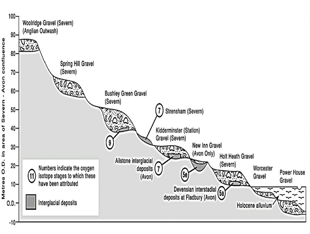
The depositional chronology of the Thames gravel terraces has not yet been universally accepted, and the two significant sequences have been proposed by Gibbard (1985) and Bridgland (1994).  This is because the terraces are dated by the artefacts found within them, which are archaeologically dated and not carbon-dated.  The problem with this method is that if the area flooded after the original deposits were laid down, the artefacts could have been washed down from upstream and embedded at random.
(The Thames through time)
Traditional View of the Thames River terraces
(The Thames through time)

The modern floodplain of the Lower Thames, downstream of central London, is bounded either by older Pleistocene sands or gravels at the higher levels or by bedrock. The depositional chronology of the Thames gravel terraces has not yet been universally accepted, and the two significant sequences were proposed by Gibbard (1985).

The SBAB model of floodplain evolution proposes that during the early Holocene, multi-channel braided systems stabilised as some channels narrowed and deepened, and others were progressively abandoned over the course of the Holocene (Brown et al. 1994).

The Lower Thames saw a rise of about 15m in relative sea level between c. 10,000 and c. 6000 BP (Rackham and Sidell, 2000; Sidell, 2003b). This would have had a significant effect on the settlement of the outer and mid estuary floodplain. It has been suggested, for example, that settlement areas along the river margin progressively moved to higher ground as the land below was overtaken by the rising water levels (Rackham and Sidell 2000).

During the early Holocene, the Lower Thames floodplain was a complex environment of peat-forming areas, migrating channels and raised eyots (Sidell 2003a). Often, these eyots were the focus of prehistoric occupation, for example, at Runnymede (Needham 1991; 1992), Westminster, Southwark (Bowsher 1991; Dillion et al. 1991; Merriman 1992), and Bermondsey (Sidell et al. 2002). These areas tended to lie at the junction between the higher ground on the edge of an island and the adjacent peat and alluvium, which preserved evidence of human activity that occurred when river levels were lower (Merriman 1992; Sidell et al. 2002).

The investigations carried out for the Jubilee Line extension have suggested that the sand eyots of Westminster and north Southwark did not complete their formation by the early Holocene as initially believed. Still, instead, they formed in the mid-Neolithic (c. 3500 cal B.C.). This could help explain why there is a lack of Early Neolithic occupation in the floodplain (Sidell 2003b).

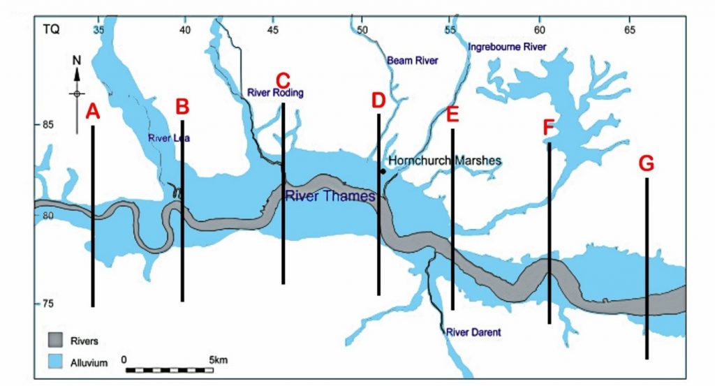
An extensive number of boreholes (> 1100) have enabled the British Geological Society to map the extent of flooding in the early Holocene, as it left extensive alluvium up to 10m deep in places, showing the long duration of the raised water levels.
(The Thames through time)
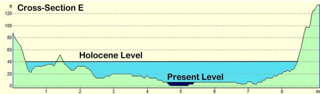
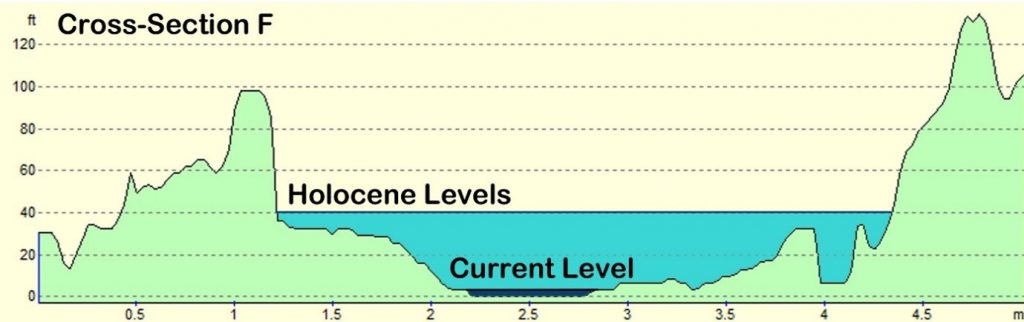
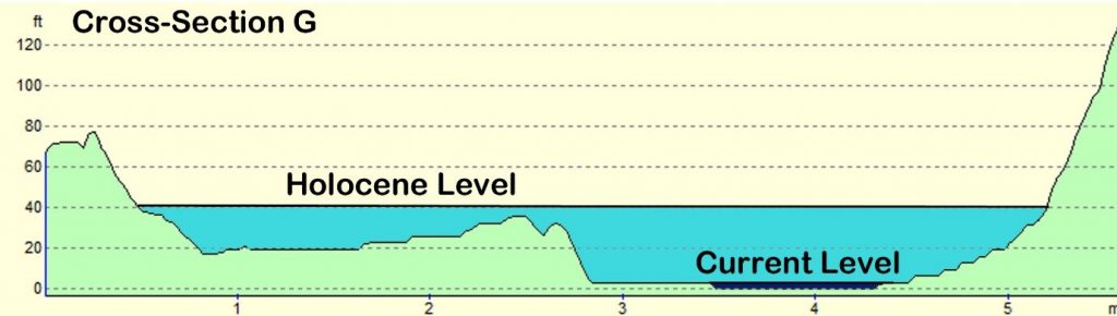
BGS Map of London showing in blue the Alluvium deposited at the end of the LGM.  We have sectioned off A- G areas to look at their cross-sections. 
(The Thames through time)

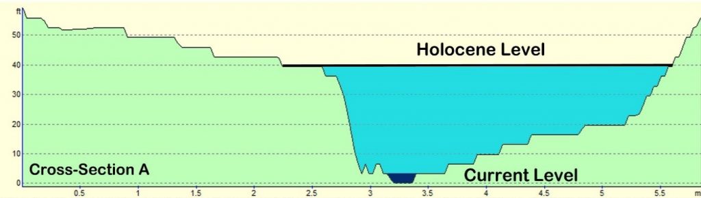
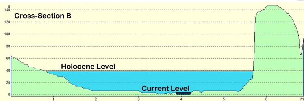
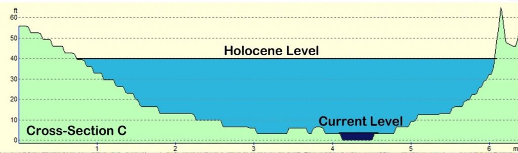
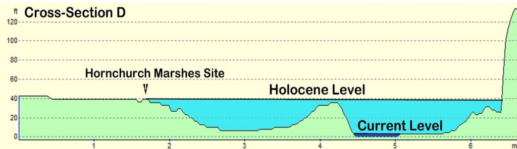
If we section off (A to G) the Thames and look at the volume and width of the Holocene Thames in comparison to today, we can get an estimation of the discharge of water at its peak during this period.

Increased discharge levels during the Holocene

Cross- SectionCurrent WidthHolocene WidthWidth Increase %Volume Increase – (Holo. – Present =) Cu.m3Increase in Volume
A400m4,425m1,10071,724 – 800 = 70,9248,866%
B650m7,725m1,18871,950 – 1950 = 70,0003,590%
C731m8,450m1,156128,430 – 2924 = 125,5064,292%
D965m7,644m79260,348 – 4825 = 55,5231,151%
E1,207m11,265m93390,122 – 7274 = 82,8807,367%
F1,125m5,230m46538,622 – 7875 = 30,747390%
G1,448m7,242m50058,902 – 11584 = 47318408%
Average932m7426m797% 3723%
(The Thames through time)
Thames River Cross-Sections A – G
(The Thames through time)

The current average discharge is 65.8 m³/s; therefore, with a 3723% increase in the watershed area, we can estimate that, at its peak, the Thames River discharged 2450 m³/s (0.0025 Gt/s or 1314 Gt per annum). 

About the same rate of one of the smaller rivers ‘Susquehanna/Chesapeake River’ (Table 5) in North America – which is minor, in comparison to the eight North American river discharge ratios, which begs the question as the Thames is the largest river in the country, would it not be affected mostly by the meltwater at the end of the last ice age – so, have the scientists got the extent of the alluvium flooding correct?

To investigate further, we need to examine a detailed excavation at the edge of the BGS superficial Alluvium flood map to obtain real evidence of dates and clues about which sediments are present, compared with the ages suggested in past publications.

‘Holocene environmental changes in the Lower Thames Valley’ (Branch et al.,2012) excavated parts of Hornchurch marsh at the edge of the BSG alluvium deposit (Cross-Section D). 

The paper suggests that “Palaeoenvironmental data (publicly or in the form of commercial archaeological reports) on these near-surface sediments indicate that following the end of the last glaciation, the lower reaches of the Thames Valley and its tributaries were inundated by the sea, and marine and estuarine sediments accumulated. Since that time, the evidence suggests that sea level continued to rise at a much slower rate as a response to either glacio-eustatic or sedimentary processes”.  But the idea of any recent “inundation by the sea” can now be easily rebuked.

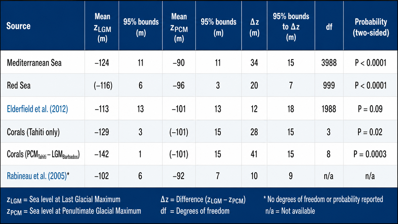
The reason for this incorrect interpretation of sediments was that past Geologists believed that the LGM was much smaller than previous ice ages – this has now been disproved by new research at sea level data from the Mediterranean (Rohling et al., 2017) as they could only measure by observation the extent of the ice sheets on the surface of the landmass and took for granted the greater the area, the larger the ice mass by estimation.

The conclusion of this study is to show that the last Ice Age was far more significant than previously thought (PCM) as illustrated below in Table 6 and Fig. 30)
(The Thames through time)

Table 6 – (Rohling et al., 20170 Comparison of LGM v PGM by sea-level difference
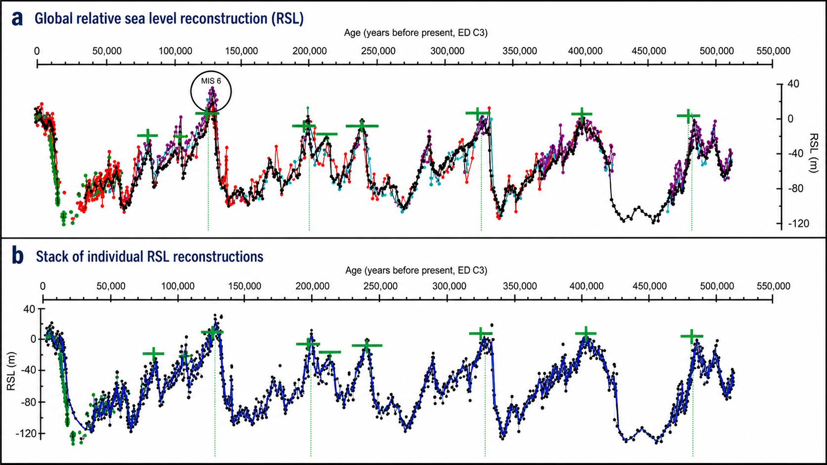
(Rohling et al.,2009) sea levels over the last 500k years – notice that they are either equivalent or smaller than the LGM
(The Thames through time)

🔍 Validating the 40 Metre Flood Model: A Conservative Benchmark with Room for Expansion

Recent analysis of Thames River terrace data, combined with marine isotope stages (MIS) and global sea-level reconstructions, has confirmed that the highest river terrace associated with the Anglian glaciation (MIS 12) reaches elevations of up to 45–50 metres above the present-day floodplain. These terraces are preserved in locations such as Wimbledon Common, Islington, Dartford Heath, and around the Goring Gap and represent the earliest and most substantial fluvial deposits in the Thames Valley. Their considerable height corresponds with what is now understood to be the largest ice volume of the last 500,000 years, when sea levels were more than 130 metres below modern levels.

In contrast, our working model for reconstructing prehistoric Thames hydrology assumes a maximum flood level of 40 metres above modern—a figure chosen deliberately to provide a conservative and defensible baseline. This height has been used to calculate post-glacial meltwater volume, floodplain extent, and terrace formation through time. Although lower than the peak terrace cuts, 40 metres accurately reflects the likely active flood height during the most extreme meltwater episodes, accounting for factors such as sediment infill, compaction, and subsequent erosion that would have reshaped the original floodplain surface.

River Thames
Sea level minimum equals Ice On land, and hence the River sizes after it melts – (Case Study – River Thames)

That said, the confirmation of higher terrace cuts opens the door for revising the volume model upwards. If we were to use the 45–50 metre elevation as our baseline for MIS 12, the resulting model would show a 12.5% to 25% increase in total flood volume compared to the current 40 metre assumption. This adjustment could significantly strengthen the case for post-glacial aquifer discharge and explain the massive sediment loads and geomorphic features observed downstream. However, such a shift would require recalibration of all terrace heights and their correlation with glacial episodes, which, while feasible, may introduce new assumptions and reduce the clarity of the proportional model.

In conclusion, the existing 40 metre model remains sound—anchored in observable data and consistent with LiDAR-documented terrace formations. Nevertheless, this model should be viewed as a minimum estimate of post-glacial river height and volume. Future work could explore enhanced modelling scenarios using 45–50-metre benchmarks to test the upper limits of Thames flooding during MIS 12. Such refinements would not undermine the current hypothesis but rather strengthen the argument that prehistoric Britain experienced hydrological conditions far more dynamic and extreme than currently acknowledged in traditional archaeological and geological narratives.

📊 Table: Sea-Level Minima and Estimated River Terrace Heights by Glacial Cycle

Glacial Period Marine Isotope Stage (MIS) Approx. Date (ka) Sea-Level Minimum (m below present) % of Maximum Ice Volume Estimated Thames Terrace Height (if MIS 12 = 45 m)
Fifth Glacial (Anglian) MIS 12 ~480 – 430 –130 m 100% 45 m
Penultimate Glacial MIS 6 ~190 – 135 –125 m 96.2% 43.3 m
Last Glacial Maximum MIS 2 ~26 – 19 –120 m 92.3% 41.5 m
Third Glacial MIS 8 ~300 – 245 –105 m 80.8% 36.4 m
Fourth Glacial MIS 10 ~360 – 335 –120 m 92.3% 41.5 m

📚 References

  • Grant, K.M. et al. (2014). Sea-level variability over five glacial cycles. Nature Communications, 5, 5076. DOI: 10.1038/ncomms6076
  • Rohling, E.J. et al. (2009). Relative sea-level and climate change over the past 500,000 years. Quaternary Science Reviews, 28(17–18), 1537–1552. DOI: 10.1016/j.quascirev.2009.02.026
  • British Geological Survey. (n.d.). Quaternary deposits and river terraces of the Thames Valley. Earthwise: The BGS Open Geoscience knowledge base. earthwise.bgs.ac.uk

Dated Geology

This new information has created a problem for Geologists, as their sequences were based on the assumption of more significant ice caps, and consequently, meltwater deposits prior to the last ice age formed the foundations of our geological river terracing.

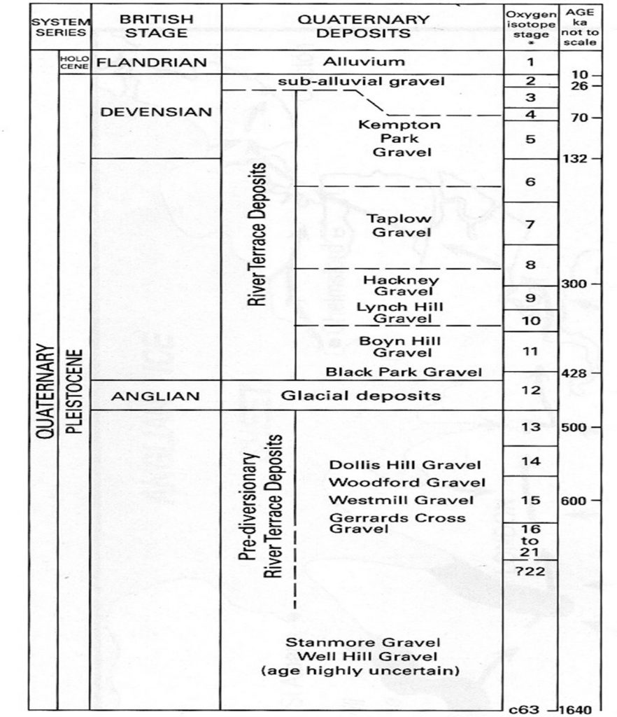
According to previous publications, only ‘Alluvium’ OIS 1 was laid down on the landscape (as at our Case Study site in the Thames Valley) directly after the last Ice Age, 10k years ago.  But there is no evidence that that is true or that the larger rivers would not have washed the previous deposits further down the stream, making these sequences incorrect; consequently, the ‘River Terrace’ Deposits of:

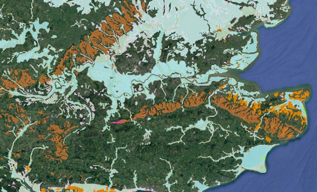
Kempton Park – Taplow – Hackney – Lynch Hill – Boyn Hill and Black Park are Holocene in origin (or a mixture) and not solely Late Pleistocene as suggested in Geology books.   In practical terms, when we examine boreholes, we should look for the ‘floodplain Terrance’ to indicate the extent of Holocene flooding and ignore the guestimations of gravel deposits.
(The Thames through time)
Figure 31. Traditionally expressed river terrace deposits by ‘guesstimated’ age
(The Thames through time)

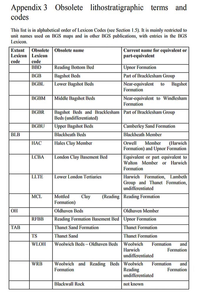
This ambiguity is, in fact, pointed out in BGS’s –‘The stratigraphical framework for the Palaeogene successions of the London Basin, the U.K. where it states that “In some areas, notably the north-eastern part of the London Basin, it has proved difficult to subdivide the strata between the Chalk and the London Clay with confidence” and this view is commonplace through the history of British Geology and hence the constant reclassification as shown in their obsolete terms table.
(The Thames through time)
Figure 32. Obsolete terms are a common occurrence in Geology as modern new methods are incorporated. BGS Superficial Deposits Handbook.
(The Thames through time)

This assumption is also highlighted by Lewin et al. (2005), who state –

“Furthermore, their assumption that floodplain gravels were Pleistocene in age was not supported by dating, and work both on the Thames (Robinson, 1992, Fig. 19.2) and more widely elsewhere (Brown et al., 1994) tends to suggest that late dates for overbank sedimentation may generally be constrained by the fact that the gravels beneath are themselves often of considerably later date than was earlier assumed.”

And concluded with “Overall, the skewed distributions suggest rapid autogenic recycling of older materials, with earlier deposits only being preserved beyond the reach of river activity (e.g. in terraces or floodplains which have not been impinged on by later river migration). The exceptions to this are floodplain environments where localised long-term aggradation has permitted the greater preservation of older Holocene units. To obtain evidence from parts of the Holocene that remain less well known, such sites still require discovery and study, whilst commonplace deposits (notably floodplain gravels) would benefit from the application of dating techniques that are less dependent on the fortuity’s preservation of datable organic materials”.

When we look at Palaeolithic sites on a regional scale, such as in the Thames basin, several general problems become apparent. The first is correlation and chronology. By their very nature, terrace fragments may not be unequivocally traceable down a river system. Ideally, a combination of surveying, stratigraphic description and lithological analysis is required to correlate fragments with key sites where more than one formation is present. None of these methods alone can be relied upon; for example, the same lithological content does not necessarily imply time equivalence, especially where rivers are reworking previous gravel terraces. (Brown et al., 1997)

Until the 1950s, archaeology dated the geology, but it is now increasingly the other way around. From the nineteenth century onwards, the traditional chronology of Northern European Pleistocene terraces was based on a combination of hand-axe typology, stratigraphy and counting climatic episodes back in time or from the top of the sequence down. This methodology was based on the belief that axe typology followed a clear progression from what we perceive as crude or simple to elegant or sophisticated, and that this progression occurred at roughly the same rate across different places. This was allied to the belief that a typology represented a ‘culture’.

Chronology

This chronology and methodology have been questioned for a variety of reasons (Green and McGregor, 1980). First, the traditional chronology was at odds with revised Pleistocene chronologies from ocean cores and from new terrestrial sites in North-West Europe, which showed an extremely complex picture of glacial, interglacial, stadial and interstadial stages. The ocean cores, for example, show at least 30 warm/cold cycles, and the terrestrial record has improved through the discovery of more sites and new chronometric dating techniques (Lowe and Walker, 1984; Jones and Keen, 1993).

However, the terrestrial record in Britain still shows major discontinuities in comparison with the ocean record and the much more detailed chronologies from the Netherlands and Germany. A chronology, and it must be noted that there is considerable debate and uncertainty about not only the position of major British stratigraphic units but also the number of pre-Pastonian and post-Hoxnian-pre-Ipswichian climatic cycles present in the British record (Jones and Keen, 1993).

Moreover, given that the river gravel sequences are ‘problematical’, we can now revisit the Holocene ‘Alluvium’ map to see whether the boundaries of the Holocene Thames were even more significant than those shown in the original BGS map.

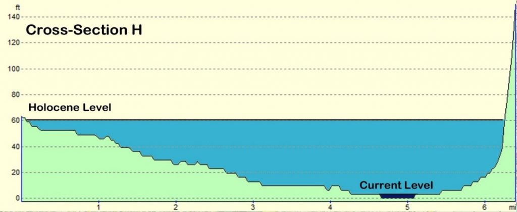
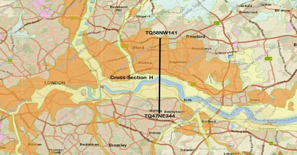
If we look at the Cross-Section H profile, we see that the area of the Holocene effect increases by at least one mile and is terminated by Boreholes TQ47NE344 and TQ58NW141.
(The Thames through time)
Figure 34. Cross-Section H
(The Thames through time)
BGS map of ‘superficial’ deposits left by the last LGM with cross-section H and the two boreholes (borehole details in Appendix A)
(The Thames through time)

Borehole TQ47NE344 – shows 5.95m of “Brown Silty Sand” before hitting Chalk and TQ58NW141 4.42m of “Loamy Sand and Stones” with a base of “sand and Gravel”.

This increases the Thames Flood Model from a discharge of 2,450 m3/s to 12,250 m3/s, which more accurately reflects the North American Discharge Model.

If we take this new model into account, the Thames valley will look very different to today, with all of the ‘superficial sediments’ being covered by water at the start of the Holocene period, 10 – 6 Ka.
(The Thames through time)
How London probably looked just after the LGM, about 10,000 BCE, with as much water as land and most of it swampy.
(The Thames through time)

We can review the Hornchurch Marshes Paper (Branch et al., 2012) and examine the results to identify outcomes and possible related dates for our new Thames Valley flooding model.
(The Thames through time)
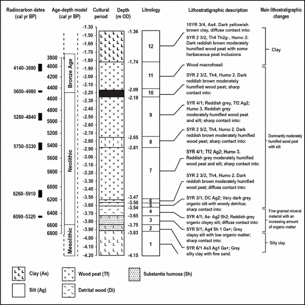
(Branch et al.,2012) Hornchurch marshes investigation
(The Thames through time)

The radiocarbon dates show that the site was inhabited during the early Holocene period “Between −4.15 and −3.83 m O.D., a clay-rich sedimentary unit was deposited probably on the margins of a river channel (floodplain)” This would give us an idea of how much sediment was deposited by the river during the early Holocene, directly after the last ice age.  If we look at boreholes around this site and within a few hundred metres of it, those bored lower, we can develop a working hypothesis.

Borehole TQ58SW:1 – the closest to the site (Appendix A) shows the sand and pebbles go down another 12.8m until it reaches “Coloured Sands and Stones”, whilst Borehole TQ58SW762 shows the names of many more segments, including ‘terrace gravel’ that goes down to 12.2m below the surface – which confirms our Holocene water level set at 40′ or 12.2m.

Between −3.54 m O.D. and −1.74 m O.D., the formation of wood peat represents the creation of more terrestrial conditions at the site. The results of the radiocarbon dating indicate that peat formation commenced at c. 6300 cal. Yr B.P. and ceased at c. 3900 cal. Yr B.P. with the onset of estuarine sedimentation.

Closer inspection of the Lithostratigraphic descriptions and Lithology reveals that the site suffered possible flooding about 6800 yr B.P. as silt deposits are found in unit number 2&3 (Figure 36.) after over 3000 years of flooding since the end of the last ice age and a build-up of ‘Grey Silty Clay and fine sand’ as would be expected.

There is then a sequence of peat (an accumulation of partially decayed vegetation or organic matter. It is unique to natural areas called peatlands, bogs, mires, moors, or muskegs) growth as this become a marsh area because of the Holocene flooding as is a majority of Britain (as we have seen in Fig. 25). This marshland lasted for 1200 – 1600 years (Unit number 4 -7, figure 36.).

Then there seems to be a flood period of about 200 years during which the area was inundated with a deposit of Sand and clay, replacing the marshland peat, dated 5750 – 5330 cal yr B.P. We then see another 1500 years as a marshland, with new peat samples, before another river flood at 3800 BP. The carbon dating of this site provides the evidence we require to finally prove that rivers were not only higher in the Holocene/Mesolithic period, but also remained high to such an extent that they periodically flooded into recent history, as we will now further illustrate.

NB. Extract from the Book ‘Post-Glacial Flooding Hypothesis’

  PODCAST

Author’s Biography

Robert John Langdon, a polymathic luminary, emerges as a writer, historian, and eminent specialist in LiDAR Landscape Archaeology.

His intellectual voyage has been interwoven with stints as an astute scrutineer in government and grand corporate bastions, a tapestry spanning British Telecommunications, Cable and Wireless, British Gas, and the esteemed University of London.

A decade hence, Robert’s transition into retirement unfurled a chapter of insatiable curiosity. This phase saw him immerse himself in Politics, Archaeology, Philosophy, and the enigmatic realm of Quantum Mechanics. His academic odyssey traversed the venerable corridors of knowledge hubs such as the Museum of London, University College London, Birkbeck College, The City Literature Institute, and Chichester University.

In the symphony of his life, Robert is a custodian of three progeny and a pair of cherished grandchildren. His sanctuary lies ensconced in the embrace of West Wales, where he inhabits an isolated cottage, its windows framing a vista of the boundless sea – a retreat from the scrutinising gaze of Her Majesty’s Revenue and Customs, an amiable clandestinity in the lap of nature.

Exploring Prehistoric Britain: A Journey Through Time

My blog delves into the fascinating mysteries of prehistoric Britain, challenging conventional narratives and offering fresh perspectives grounded in cutting-edge research, particularly LiDAR technology. I invite you to explore some key areas of my research. For example, the Wansdyke, often cited as a defensive structure, is re-examined in light of new evidence. I’ve presented my findings in my blog post Wansdyke: A British Frontier Wall – ‘Debunked’, and a Wansdyke LiDAR Flyover video further visualises my conclusions.

My work also often challenges established archaeological dogma. I argue that many sites, such as Hambledon Hill, commonly identified as Iron Age hillforts, are not what they seem. My posts Lidar Investigation Hambledon Hill – NOT an ‘Iron Age Fort’ and Unmasking the “Iron Age Hillfort” Myth explore these ideas in detail and offer an alternative view. Similarly, sites like Cissbury Ring and White Sheet Camp receive re-evaluations based on LiDAR analysis in my posts “Lidar Investigation Cissbury Ring through time” and “Lidar Investigation White Sheet Camp,“ revealing fascinating insights into their true purpose. I have also examined South Cadbury Castle, often linked to the mythical Camelot56.

My research also extends to ancient water management, including the role of canals and other linear earthworks. I have discussed the true origins of Car Dyke in multiple posts, including Car Dyke – ABC News Podcast and Lidar Investigation Car Dyke – North Section, which suggest a Mesolithic origin 2357. I also explore the misidentification of Roman aqueducts, as seen in my posts on the Great Chesters (Roman) Aqueduct. My research has also been greatly informed by my post-glacial flooding hypothesis, which has helped explain landscape transformations over time. I have discussed this hypothesis in several posts, including AI now supports my Post-Glacial Flooding Hypothesis and Exploring Britain’s Flooded Past: A Personal Journey

Finally, my blog also investigates prehistoric burial practices, as seen in Prehistoric Burial Practices of Britain and explores the mystery of Pillow Mounds, often mistaken for medieval rabbit warrens, but with a potential link to Bronze Age cremation in my posts: Pillow Mounds: A Bronze Age Legacy of Cremation? and The Mystery of Pillow Mounds: Are They Really Medieval Rabbit Warrens?. My research also includes astronomical insights into ancient sites, for example, in Rediscovering the Winter Solstice: The Original Winter Festival. I also review new information about the construction of Stonehenge in The Stonehenge Enigma.

Further Reading

For those interested in British Prehistory, visit www.prehistoric-britain.co.uk, a comprehensive resource featuring an extensive collection of archaeology articles, modern LiDAR investigations, and groundbreaking research. The site also includes insights and excerpts from the acclaimed Robert John Langdon Trilogy, a series of books that explore Britain during the Prehistoric period. Titles in the trilogy include The Stonehenge Enigma, Dawn of the Lost Civilisation, and The Post-Glacial Flooding Hypothesis, which offer compelling evidence of ancient landscapes shaped by post-glacial flooding.

To further explore these topics, Robert John Langdon has developed a dedicated YouTube channel featuring over 100 video documentaries and investigations that complement the trilogy. Notable discoveries and studies showcased on the channel include 13 Things that Don’t Make Sense in History and the revelation of Silbury Avenue – The Lost Stone Avenue, a rediscovered prehistoric feature at Avebury, Wiltshire.

In addition to his main works, Langdon has released a series of shorter, accessible publications, ideal for readers delving into specific topics. These include:

For active discussions and updates on the trilogy’s findings and recent LiDAR investigations, join our vibrant community on Facebook. Engage with like-minded enthusiasts by leaving a message or contributing to debates in our Facebook Group.

Whether through the books, the website, or interactive videos, we aim to provide a deeper understanding of Britain’s fascinating prehistoric past. We encourage you to explore these resources and uncover the mysteries of ancient landscapes through the lens of modern archaeology.

For more information, including chapter extracts and related publications, visit the Robert John Langdon Author Page. Dive into works such as The Stonehenge Enigma or Dawn of the Lost Civilisation, and explore cutting-edge theories that challenge traditional historical narratives.

Other Blogs

s

t

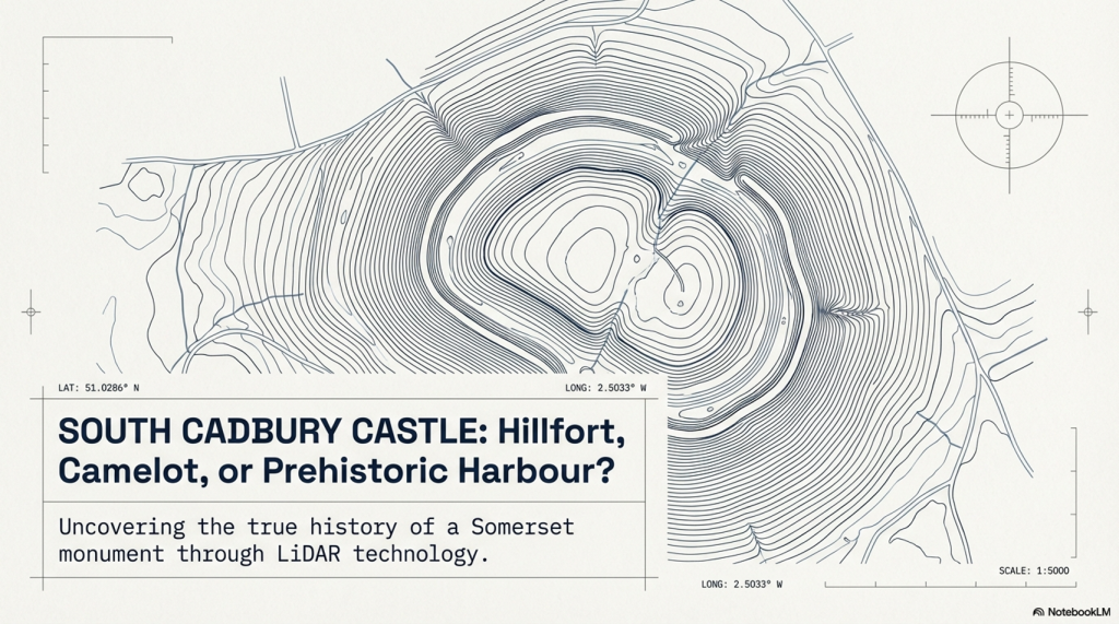
South Cadbury Castle – Camelot

Introduction

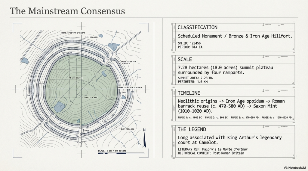
In the traditional archaeological interpretation, Cadbury Castle represents a long-lived settlement that developed gradually over several millennia. The earliest evidence of activity dates to the Neolithic period, where pits and postholes associated with pottery and flint finds suggest a small, unenclosed agricultural community. Radiocarbon dating places this early occupation around 3500–3300 BC, indicating that the hill was already being utilised long before the construction of its later defences.(South Cadbury Castle – Camelot)

The site continued to be occupied into the Bronze Age, where evidence of ovens and metalworking activity points to an increasingly organised settlement. By the Iron Age, Cadbury Castle had developed into a substantial fortified enclosure. Around 300 BC, a stone-built enclosure with timber reinforcements was constructed, later expanded into a complex hillfort with multiple ramparts and elaborate defensive systems. Excavations have revealed both roundhouses and rectangular structures, alongside evidence of industrial activity and possible ritual features, suggesting a permanent and socially complex community—often described as “oppidum-like” in character.

South Cadbury Castle - Camelot
South Cadbury Castle – Camelot

During the 1st century BC and into the early Roman period, the defences were further strengthened. Archaeological evidence indicates that the site may have been violently attacked during the Roman conquest of Britain, around AD 43, with signs of burning and destruction uncovered at key प्रवेश points. Following this, the Romans appear to have reused the hilltop, possibly establishing a military presence and later constructing a temple during the 3rd or 4th century AD.

After the end of Roman administration, Cadbury Castle was reoccupied in the post-Roman period, between approximately AD 470 and 580. Excavations led by Leslie Alcock revealed a large timber “Great Hall,” interpreted within the traditional framework as the residence of a high-status Brittonic ruler. The discovery of imported Mediterranean pottery from this phase suggests long-distance trade connections and reinforces the idea of the site as a regional power centre. It is this phase of occupation that has led to long-standing associations with the legendary Camelot of King Arthur.

South Cadbury Castle - Camelot
South Cadbury Castle – Camelot

The site saw later reuse in the early medieval period, including the establishment of a temporary Saxon mint in the 11th century. Across its long history, Cadbury Castle is therefore understood, in conventional terms, as a multi-period fortified settlement—evolving from a Neolithic farming site into a major Iron Age stronghold, later adapted by Roman and post-Roman communities, and ultimately woven into both historical and legendary narratives.

The Problem with the Traditional Interpretation

The conventional explanation of Cadbury Castle presents a familiar story: a hilltop settlement that gradually evolves from a Neolithic farm into a Bronze Age community, then into an Iron Age hillfort, later reused by Romans and post-Roman elites.

It sounds neat. It reads well. But when examined critically, it raises more problems than it solves.

South Cadbury Castle - Camelot
South Cadbury Castle – Camelot

The core issue is methodological.

The site is treated as a continuous “occupation sequence,” yet the evidence presented is not continuous—it is fragmentary, intermittent, and separated by significant spans of time. A pit here, a posthole there, a later rampart above it—all are grouped together and interpreted as a single evolving settlement. In reality, what is being described is not continuity, but repeated reuse of a prominent landscape feature over thousands of years.

This is a fundamental distinction.

Finding Neolithic pits does not prove a Neolithic settlement in the sense implied. It proves activity. The same applies to Bronze Age ovens, Iron Age ramparts, or post-Roman halls. Each represents a moment in time, not necessarily a continuous tradition of occupation.

Archaeology, however, routinely compresses these separate events into a single narrative—effectively averaging the past into a story that feels coherent but is not supported as a continuous process.

South Cadbury Castle - Camelot
South Cadbury Castle – Camelot

Elevation and Function — The Missing Variable

What is consistently overlooked in the traditional model is the most obvious physical characteristic of Cadbury Castle:

Its elevation.

At approximately 153 metres above sea level, the site sits well above the surrounding lowlands, particularly the Somerset Levels to the north. In the conventional interpretation, this is explained purely in terms of defence—height equals visibility, therefore height equals protection.

But this assumption is never tested.

It is simply inherited.

If we step back and apply a physical framework rather than a cultural one, a different question emerges:

Why are the earliest activities consistently located on elevated ground?

This is not unique to Cadbury. Across Britain, early prehistoric activity frequently appears at higher elevations, with later activity progressively occupying lower ground. This pattern is measurable, repeatable, and not dependent on interpretation.

South Cadbury Castle - Camelot
South Cadbury Castle – Camelot

The simplest explanation is not a defence.

It is an environment.

As demonstrated in the broader hydrological model of post-glacial Britain, early Holocene landscapes were characterised by significantly higher groundwater levels and expanded river systems. In such a system, low-lying areas—such as the Somerset Levels—would not have been stable, dry land in the way they are today. They would have been wetlands, floodplains, or standing water environments for extended periods.

Under these conditions, elevated sites like Cadbury Hill are not “defensive choices.”

They are the only viable ground.

South Cadbury Castle - Camelot
South Cadbury Castle – Camelot

Reframing the “Hillfort”

Once elevation is understood as an environmental constraint rather than a defensive preference, the entire interpretation of the site shifts.

The term “hillfort” becomes problematic.

It assumes:

  • conflict
  • territorial defence
  • permanent settlement

Yet none of these are directly proven by the physical evidence alone.

The ramparts, for example, are interpreted as defensive structures—but this is an assumption based on form, not function. Earthworks can serve multiple purposes: hydraulic control, stock management, boundary demarcation, or even phased landscape modification.

At Cadbury, the presence of multiple ramparts is often cited as evidence of increasing conflict. But an alternative explanation is equally plausible: staged construction responding to changing environmental conditions, particularly shifting water levels and drainage patterns.

South Cadbury Castle - Camelot
South Cadbury Castle – Camelot

The traditional model selects one interpretation—warfare—without excluding others.

The Illusion of Continuity

Perhaps the most significant issue is the illusion of continuity created by archaeological phasing.

Cadbury Castle is presented as:

Neolithic → Bronze Age → Iron Age → Roman → Post-Roman → Saxon

But this is not a continuous timeline of occupation.

It is a list of disconnected events.

South Cadbury Castle - Camelot

Between these phases lie gaps—sometimes centuries, sometimes longer—where no evidence of sustained activity exists. These gaps are rarely emphasised, because they disrupt the narrative of an “important settlement.”

Instead, the site is framed as persistently occupied, when the evidence more accurately supports periodic reuse of a prominent, strategically located landscape feature.

In other words, the hill is important.

Not necessarily the settlement.

South Cadbury Castle - Camelot
South Cadbury Castle – Camelot

A Simpler Model

If we remove the assumption and focus only on physical constraints, a more economical explanation emerges:

  • Early activity occurs on high ground because low ground is unstable or flooded
  • Sites are reused over time because elevated locations remain reliable as conditions change
  • Earthworks reflect adaptation to landscape conditions, not necessarily warfare
  • Later cultures reinterpret and reuse earlier features without preserving the original function
South Cadbury Castle - Camelot

This model requires fewer assumptions and aligns with measurable environmental behaviour.

It also explains why sites like Cadbury Castle appear repeatedly in the archaeological record across different periods without requiring continuous occupation.

South Cadbury Castle - Camelot
South Cadbury Castle – Camelot

Maps

1800s OS Map

South Cadbury Castle – 1800s OS Map

GE Satellite Map

South Cadbury GE Map

LiDAR Map

South Cadbury Castle – LiDAR Map

Investigation

Site Flyaround

South Cadbury Castle Flyaround

Site Flyover

South Cadbury Castle Fly Over

Lidar Map showing Bronze Age

South Cadbury Castle – with Bronze Age Water Levels

LiDAR Map showing Mesolithic Period

South Cadbury Castle with Mesloithic Water levels

Defence Strategy 101

Roman Defence System

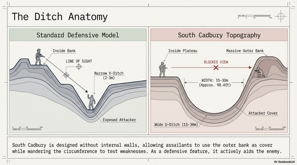
Roman defences (of the same period as the ‘Iron Age’ ), we notice the ditches were relatively small and narrow. These ditches were called ‘Ankle Breaker’ as the purpose was for the assailant to fall into the ditch (usually containing pointed wooden stakes to either injure or kill the assailant) or to at least break their ankle from the fall, making them immobile. These ditches would be 3 to 4 m wide and about 2m deep and could be dug quickly.

Roman Ankle Breaker

The soil excavated from the ditch would be placed on the defensive side to elevate the defenders, allowing them to look down and fight their attackers from a higher position. Simply standing on elevated ground without a barrier would make defenders easy targets. Therefore, they built fortifications using wooden stakes or stone for more permanent and substantial defences. These fortifications provided cover from spears, arrows, or stones while looking down into the conflict zone. This basic defensive strategy has remained unchanged for thousands of years, as seen with the Normans, who used castles and moats. The moats slowed down assailants, allowing defenders to use crossbows effectively against anyone attempting to cross the deep waters.

Classic Roman Fort With Ditch and Palisade

Lidar Maps of Sth Cadbury Castle Show No Defences

Banks

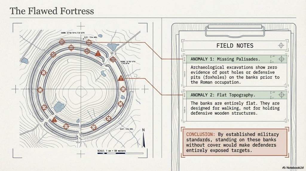
The banks at South Cadbury Castle show no signs of palisades on top of the bank at any stage before the Roman occupation, which brought stone to the very top of the site. The other four banks appear to be quite flat, as if they have been used for walking upon rather than holding any defensive wooden structures or ‘foxholes.’

Importance and Use of Foxholes in Defense

Concealment and Protection: Foxholes are small, dug-out trenches or pits used by soldiers to provide cover and concealment. They protect defenders from enemy fire and other dangers. By being below ground level, soldiers can remain hidden and minimize their exposure to enemy attacks.

Historical Use: Throughout history, foxholes have been a crucial part of defensive strategies in various military contexts: While the term “foxhole” is modern, the concept of digging protective pits or trenches has been used in various forms throughout history. In ancient battles, soldiers would dig pits to defend against archers and other ranged weapons.

Advantages of Foxholes

  • Reduced Visibility: Soldiers in foxholes are less visible to the enemy, making it harder for attackers to target them.
  • Protection from Spears, Rocks and Arrows: Being below ground level the size of the target is greatly reduced.
  • Stability for Firing: Foxholes provide a stable firing position, allowing soldiers to fire and use their weapons more accurately.

South Cadbury Castle Context

The absence of evidence for palisades or foxholes at South Cadbury Castle before the Roman occupation suggests a different use or purpose for the banks. Instead of being purely defensive, the flat banks must have served other functions.

Ditches

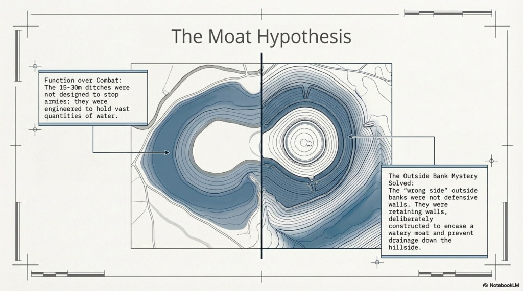
Looking at the construction of the ditches at South Cadbury Castle, we notice that it has no defensive features as expected from a so-called ‘Iron Age Fort’. The ditches are far too broad to be defensive (15m to 30m wide) compared to Roman ‘Ankle Breaker’ of 2m to 3m. The maps show no sign of a wooden or stone barrier, and archaeological excavations have found no evidence of post holes or defensive pits on the banks. Moreover, the Ditch is banked on the wrong side to be defensive, as if it has been built to encase a watery moat. This outside bank would protect any assailants attacking, giving them ample bank coverage. The internal aspect of the Ditch shows no sign of any wooden defensive poles or post holes as seen in Roman Ditches and is designed without internal walls allowing assailants from using the Ditch as cover and the facility to wander around the circumference undercover, testing the weaknesses in the defence. Therefore, as a defensive feature, these types of ditches on so-called ‘Iron Age Forts’ are fundamentally flawed and commonplace.

Ditch is banked on the wrong side

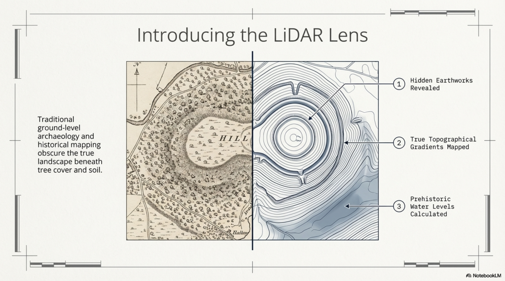
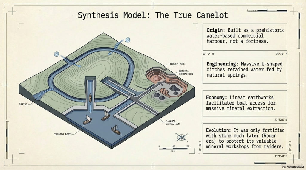
The LiDAR Maps also show that the ditch of the ditches indicate that they were built for water, as shown by the blue on these images – this then allows us to look at the design of the earthwork in detail, which shows that the banks have been cut by not roads but other ditches. These ditches that cut across the circumference moats cut into them that, suggest that if water had been contained in these ditches, then the vertical dykes could have been used to gaol boats up from the bottom of the dyke ditch to one of these upper moat levels. These same LiDAR maps also show how the soil was distributed to the outside of the moats to enhance and make the feature deeper.

South Cadbury Castle – Banks on the outside to keep in the Water

Water Table

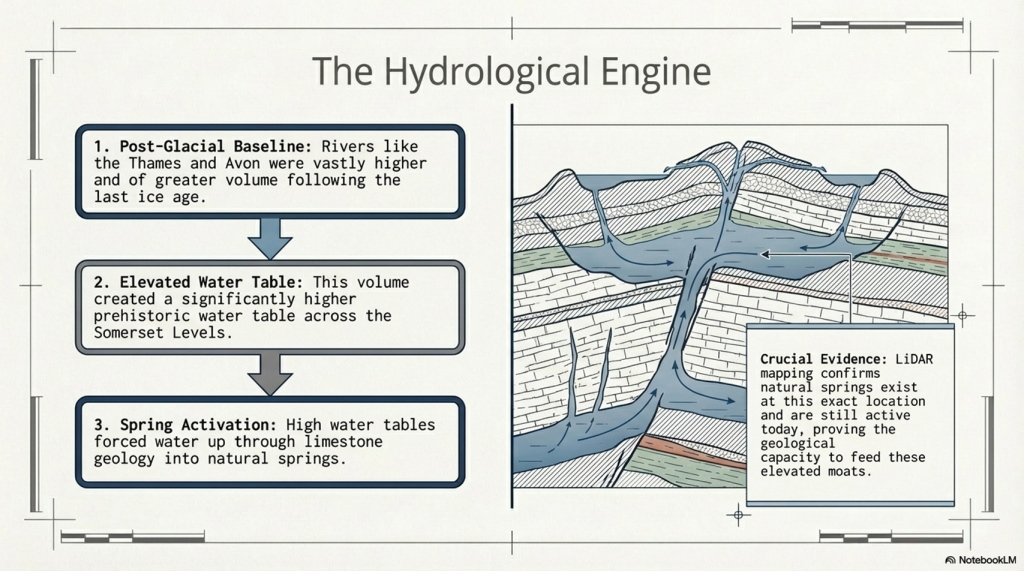
This hypothesis of using these ditches as moats can only be proven if we find the natural springs that could have fed these earthworks in the past. We know from our studies into rivers, such as The Thames and Avon, that they were both much higher and of greater volume in the past, and this height was retained for thousands of years after the last ice age. This enhanced height and volume is reflected and caused by a higher water table. Within these water tables, natural springs are formed, and water leaks into the land, creating rivers and streams. Although we do not have geological information that allows us to trace past springs, we find existing springs in this location (still active today), which suggests our hypothesis is correct.

South Cadbury Castle showing Springs still in existence

Dykes

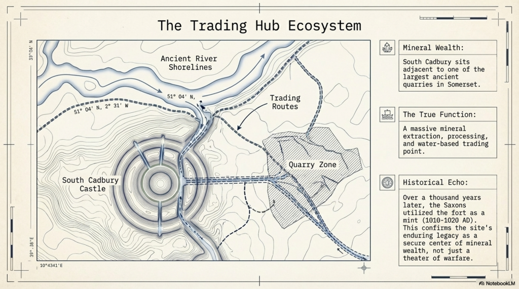
As we have already suggested, the lack of defensive features shows that this is far from being a fortification; instead, it was used as a trading site with moats to facilitate the mooring of boats. The transportation to these moats was achieved by other earthworks called Linear Earthworks (also known as Dykes). Dykes were introduced when the river shorelines of the Prehistoric fell with the water table, and they wanted to continue to use these established trading sites rather than having to build new sites at a lower level. So, Dykes were built (like roads) to transport goods to market and also minerals extracted from the many quarries which uncommonly surround these Dykes. Here in South Cadbury Castle, we see not only Dykes feeding the local quarry sites but also placed on the side of this Trading site to allow access to the moats for the boats coming off the rivers, ready for unloading/loading.

Slipway built to feed the moats in the upper levels with trading boats
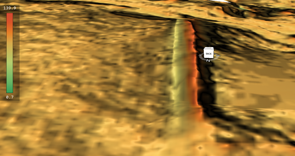
Two Possible Slipways – one connecting directly to a Dyke

To reinforce the use of this site as a trading The site as a trading place has a second vertical earthwork identified through LiDAR technology. This secondary slipway is distinguishable from the initial structure by its lack of connection to a dyke or river. The slipway appears to traverse from the lowest moat up to the top of the site. While photographs may provide a visual reference, the full extent and significance of this feature are best understood through LiDAR models, which enhance the landscape to reveal these historical elements with greater clarity.place, a second verticle earthwork has been identified via LiDAR technology is a secondary slipway, distinguishable from the initial structure by its lack of connection to a dyke or river. This slipway appears to traverse from the lowest moat up to the top of the site. While photographs may provide a visual reference, the full extent and significance of this feature are best understood through LiDAR models, which enhance the landscape to reveal these historical elements with greater clarity.

The Dykes seen on the LiDAR map are concentrated on the quarry in the East of the Site

Dating the Site

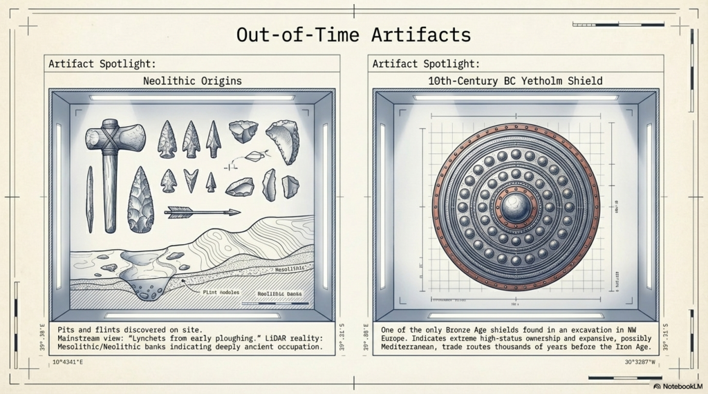
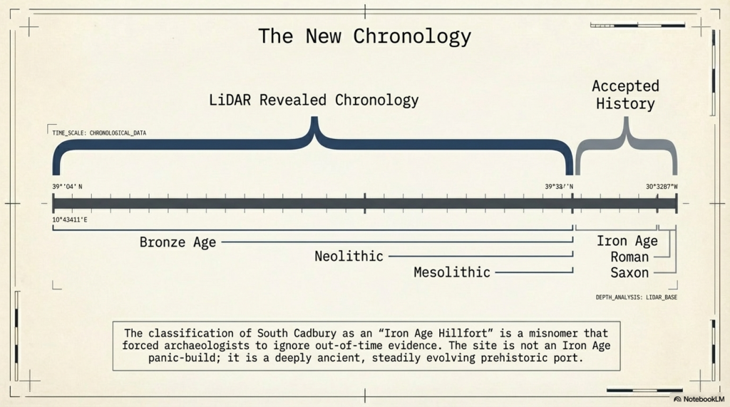
Archaeologists are puzzled by the unexpected dates of this site at South Cadbury Castle, the site that was originally thought to be Iron Age from its classification. Therefore, the discovery of Neolithic pits at the site challenges their previously held beliefs about its functions. However, instead of reconsidering their perceptions, they instead provided speculative explanations for these out-of-time artifacts and features. For example, they have described a bank beneath the Iron Age defenses as a “lynchet or terrace derived from early ploughing,” even though there is no carbon dating evidence to support this claim. In reality, this site is likely to be Neolithic, and the ‘lynchets’ could be Mesolithic banks, indicating its true age.

The discovery of the Bronze Age shield is also an indication of the status of the site and its trading routes – as only one has been found, this would indicate that it was part of the trading or personal ownership of someone in the 10th Century BC at this site. This suggests that this was trading could have been at a much earlier date than current archaeologists suggest, which could too have been with the Mediterranean and a possible source of this unusual artefact, as indicated by the other finds from the late saxon period.

Function of the site

The fact that in the East of this site is one of the largest quarries in Somerset and that the Saxons used the fort as a mint just over a thousand years ago proves that the site’s function was a mineral extraction and trading point. This extraction goes back to the Mesolithic period shown on LiDAR maps with a natural harbour by the Quarries and then Dykes to the Trading site as the prehistoric waters fell. No doubt (as the banks are found not to be defensive), the fort was fortified later during the Roman period with Stone as it was to keep the valuable minerals safe but not as a defensive barrier of warfare as suggested. This would explain the minor disturbances and deaths at a single gate as raiders would have attempted to steal the valuable minerals it contained in its workshops, as described by archaeologists.

PodCast

Author’s Biography

Robert John Langdon, a polymathic luminary, emerges as a writer, historian, and eminent specialist in LiDAR Landscape Archaeology.

His intellectual voyage has been interwoven with stints as an astute scrutineer in government and grand corporate bastions, a tapestry spanning British Telecommunications, Cable and Wireless, British Gas, and the esteemed University of London.

A decade hence, Robert’s transition into retirement unfurled a chapter of insatiable curiosity. This phase saw him immerse himself in Politics, Archaeology, Philosophy, and the enigmatic realm of Quantum Mechanics. His academic odyssey traversed the venerable corridors of knowledge hubs such as the Museum of London, University College London, Birkbeck College, The City Literature Institute, and Chichester University.

In the symphony of his life, Robert is a custodian of three progeny and a pair of cherished grandchildren. His sanctuary lies ensconced in the embrace of West Wales, where he inhabits an isolated cottage, its windows framing a vista of the boundless sea – a retreat from the scrutinising gaze of Her Majesty’s Revenue and Customs, an amiable clandestinity in the lap of nature.

Exploring Prehistoric Britain: A Journey Through Time

My blog delves into the fascinating mysteries of prehistoric Britain, challenging conventional narratives and offering fresh perspectives grounded in cutting-edge research, particularly LiDAR technology. I invite you to explore some key areas of my research. For example, the Wansdyke, often cited as a defensive structure, is re-examined in light of new evidence. I’ve presented my findings in my blog post Wansdyke: A British Frontier Wall – ‘Debunked’, and a Wansdyke LiDAR Flyover video further visualises my conclusions.

My work also often challenges established archaeological dogma. I argue that many sites, such as Hambledon Hill, commonly identified as Iron Age hillforts, are not what they seem. My posts Lidar Investigation Hambledon Hill – NOT an ‘Iron Age Fort’ and Unmasking the “Iron Age Hillfort” Myth explore these ideas in detail and offer an alternative view. Similarly, sites like Cissbury Ring and White Sheet Camp receive re-evaluations based on LiDAR analysis in my posts “Lidar Investigation Cissbury Ring through time” and “Lidar Investigation White Sheet Camp,“ revealing fascinating insights into their true purpose. I have also examined South Cadbury Castle, often linked to the mythical Camelot56.

My research also extends to ancient water management, including the role of canals and other linear earthworks. I have discussed the true origins of Car Dyke in multiple posts, including Car Dyke – ABC News Podcast and Lidar Investigation Car Dyke – North Section, which suggest a Mesolithic origin 2357. I also explore the misidentification of Roman aqueducts, as seen in my posts on the Great Chesters (Roman) Aqueduct. My research has also been greatly informed by my post-glacial flooding hypothesis, which has helped explain landscape transformations over time. I have discussed this hypothesis in several posts, including AI now supports my Post-Glacial Flooding Hypothesis and Exploring Britain’s Flooded Past: A Personal Journey

Finally, my blog also investigates prehistoric burial practices, as seen in Prehistoric Burial Practices of Britain and explores the mystery of Pillow Mounds, often mistaken for medieval rabbit warrens, but with a potential link to Bronze Age cremation in my posts: Pillow Mounds: A Bronze Age Legacy of Cremation? and The Mystery of Pillow Mounds: Are They Really Medieval Rabbit Warrens?. My research also includes astronomical insights into ancient sites, for example, in Rediscovering the Winter Solstice: The Original Winter Festival. I also review new information about the construction of Stonehenge in The Stonehenge Enigma.

Further Reading

For those interested in British Prehistory, visit www.prehistoric-britain.co.uk, a comprehensive resource featuring an extensive collection of archaeology articles, modern LiDAR investigations, and groundbreaking research. The site also includes insights and excerpts from the acclaimed Robert John Langdon Trilogy, a series of books that explore Britain during the Prehistoric period. Titles in the trilogy include The Stonehenge Enigma, Dawn of the Lost Civilisation, and The Post-Glacial Flooding Hypothesis, which offer compelling evidence of ancient landscapes shaped by post-glacial flooding.

To further explore these topics, Robert John Langdon has developed a dedicated YouTube channel featuring over 100 video documentaries and investigations that complement the trilogy. Notable discoveries and studies showcased on the channel include 13 Things that Don’t Make Sense in History and the revelation of Silbury Avenue – The Lost Stone Avenue, a rediscovered prehistoric feature at Avebury, Wiltshire.

In addition to his main works, Langdon has released a series of shorter, accessible publications, ideal for readers delving into specific topics. These include:

For active discussions and updates on the trilogy’s findings and recent LiDAR investigations, join our vibrant community on Facebook. Engage with like-minded enthusiasts by leaving a message or contributing to debates in our Facebook Group.

Whether through the books, the website, or interactive videos, we aim to provide a deeper understanding of Britain’s fascinating prehistoric past. We encourage you to explore these resources and uncover the mysteries of ancient landscapes through the lens of modern archaeology.

For more information, including chapter extracts and related publications, visit the Robert John Langdon Author Page. Dive into works such as The Stonehenge Enigma or Dawn of the Lost Civilisation, and explore cutting-edge theories that challenge traditional historical narratives.

Other Blogs

s

t

The Great Chichester Hoax – A Bridge too far?

Introduction

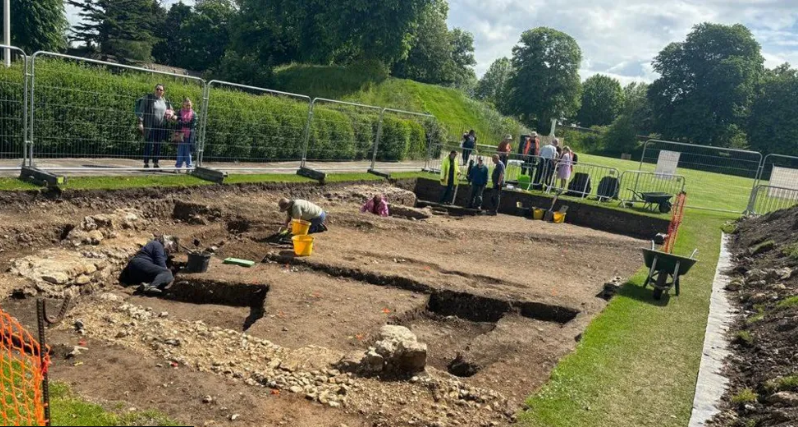
It seems I’ve once again stirred up some controversy among the old archaeology club members of Chichester. A few years back, there was quite a buzz in Chichester when they unearthed a Roman Villa complete with a bathhouse. Eager to contribute, I headed to the site with my drone, hoping to capture aerial shots. However, my offer was turned down, perhaps due to the slew of questions I posed to the lead archaeologist. I was particularly intrigued by the water sourcing and drainage for the bathhouse, especially given the presence of the prehistoric dyke that ran through the park. Yet, they seemed to disregard the sizable bank at the edge of the cricket ground. (The Great Chichester Hoax – A Bridge too far?)

The Great Chichester Hoax - A Bridge too far?
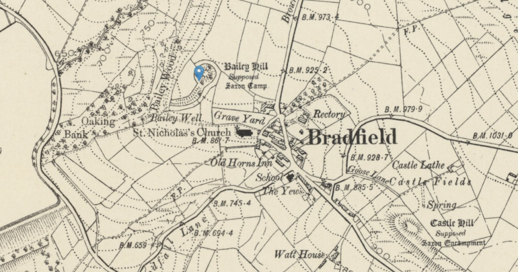
The Dyke (green) next to the bank (orange) in Priory Park

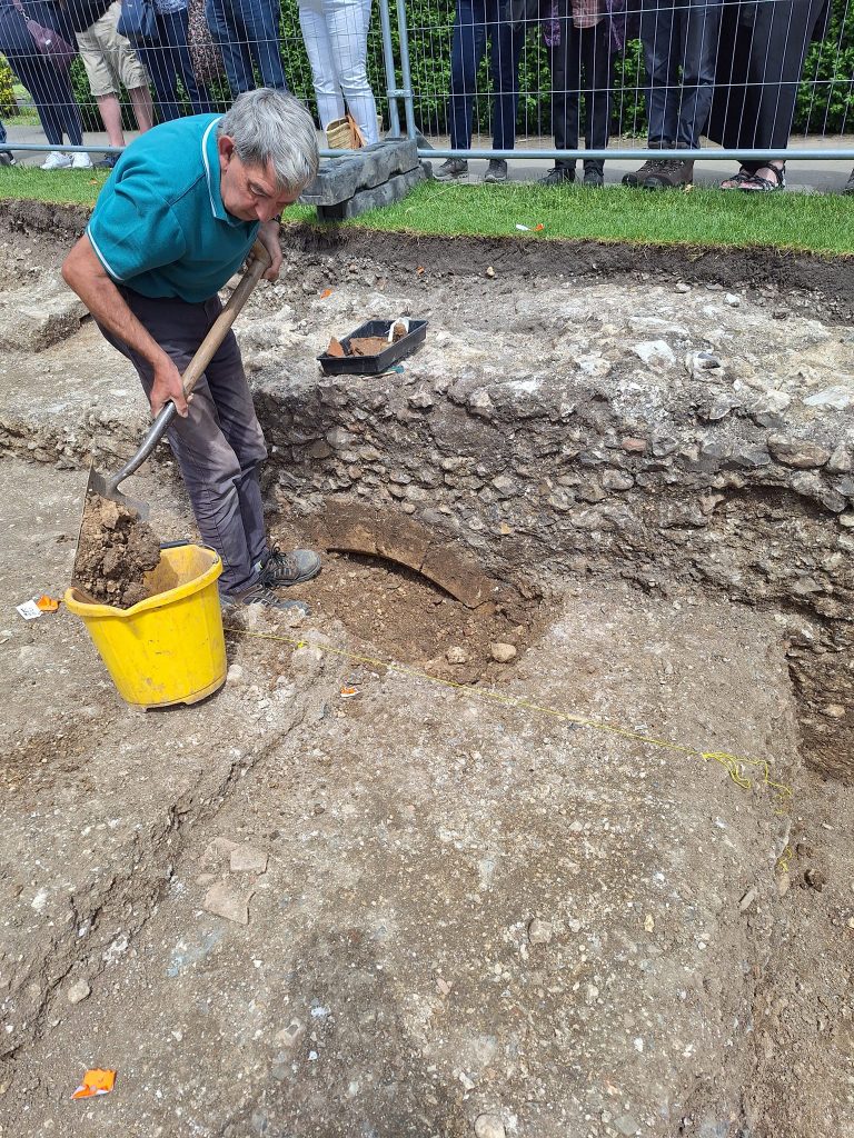
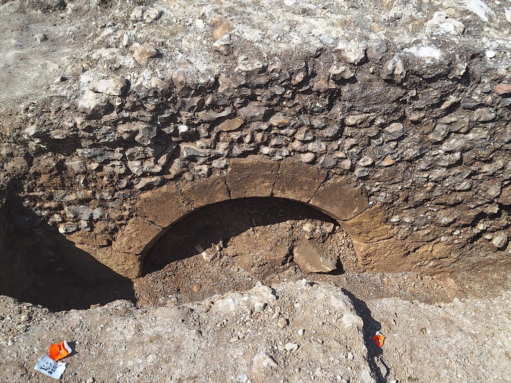
Roman Drain

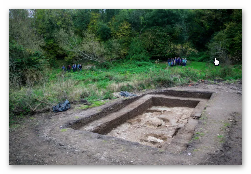
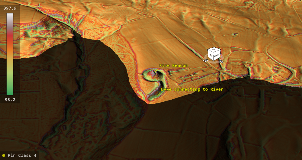
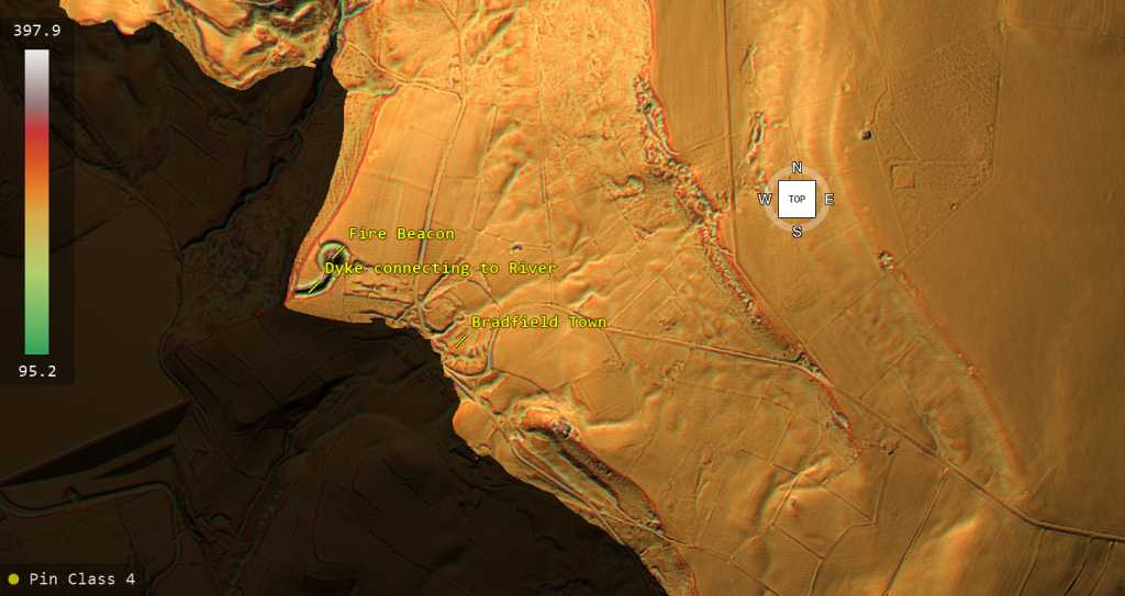
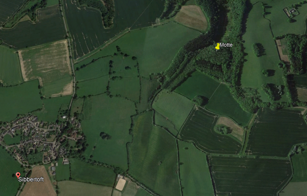
Now, they’ve uncovered another segment that I firmly believe is part of the Roman drainage system, connecting to the Dyke in a direct line. However, they’ve made a somewhat surprising claim—they think it’s a bridge to the Motte and Bailey castle (but that’s another story, as it’s a fire beacon). Unfortunately, from the photographs, it appears relatively small and insufficient to be a bridge. Nevertheless, this small group of amateurs called in the local press, who then informed the BBC to tout this as a historical find, even though it’s yet to be fully excavated—an oversight I’ve dubbed “The Great Chichester Hoax.”

The Great Chichester Hoax - A Bridge too far?
The BBC article

Sadly, this scenario reflects the current state of archaeology. Some quickly accept sensational claims simply because they’re featured on the BBC, ignoring scientific facts. It’s disappointing to see more propaganda overshadowing genuine archaeological inquiry. (The Great Chichester Hoax – A Bridge too far?)

The Great Chichester Hoax - A Bridge too far?
The Bridge

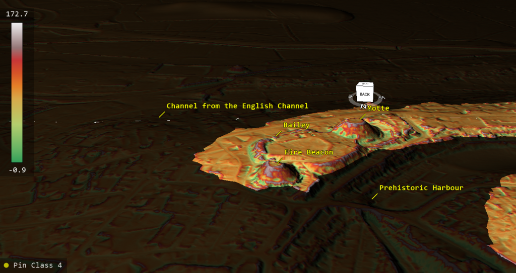
Motte and Bailey?

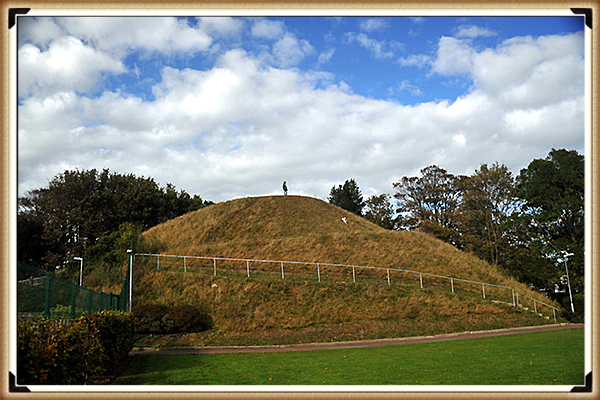
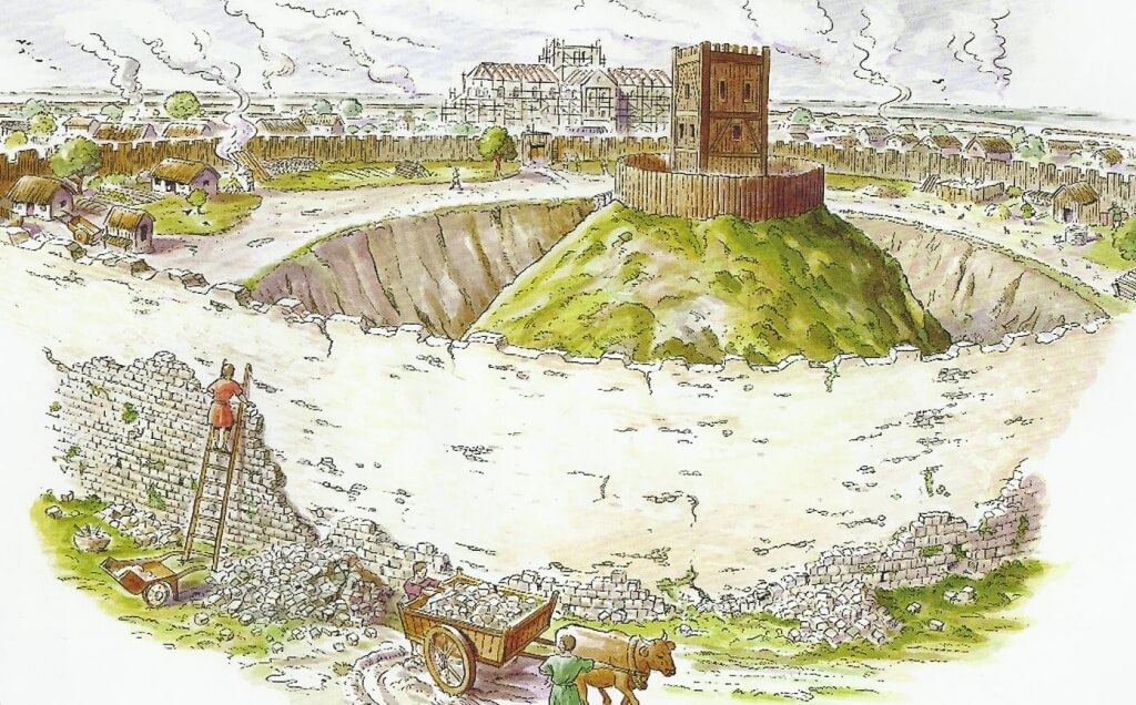
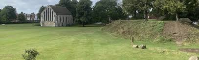
Living and commuting past this site every day while attending university in recent years (and yes, to disappoint the sceptics, I do hold an Honors Degree in History), I couldn’t help but be amused by the public information board proclaiming it as a classic Motte and Bailey structure from the Norman period. Now, I never doubted its use during the Norman era, especially with the remains of Greyfriars Monastery, the Guildhall, at its base. This chapel had undergone modifications over the years, providing ample evidence for dating the site to this period. But was the mound of Norman origin knowing that a Dyke was nearby? There was a question that the local archaeological club did not wish to explore it seemed.(The Great Chichester Hoax – A Bridge too far?)

The Great Chichester Hoax - A Bridge too far?
More of a Drainage Ditch than a bridge over a 15m moat?

Undiscovered Dyke

What fascinated me most, however, was the massive bank on the edge of the Cricket Green, which had been paved over and led towards the mound and the eastern wall of the Guildhall. It almost seemed as if the building was strategically placed by the ditch of the Dyke. Yes, the presence of the Dyke was painfully obvious, yet its existence was never mentioned on the historic plaques or in the online information or countless books about Roman Chichester.(The Great Chichester Hoax – A Bridge too far?)

The Great Chichester Hoax - A Bridge too far?
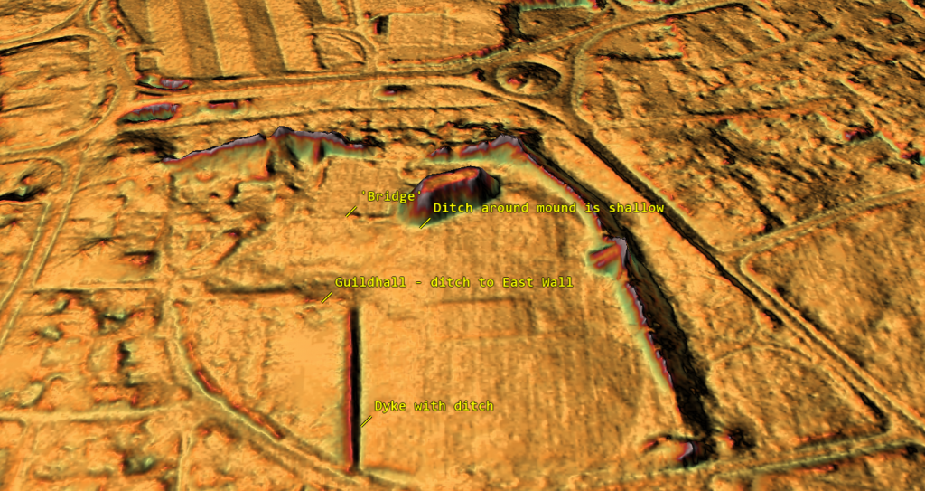
LiDAR Map showing that the Dyke ditch is in line with the ‘Bridge.’

In response to the BBC article and Facebook blog, I (helpfully) pointed out these observations again and even provided one of my unique LiDAR maps of the area (which they had never possessed or consulted). I was, consequently, taken aback by their dismissive response, insisting that their experts were correct in their assessment of the site and the supposed new bridge (which had grown to over 15 meters, now supposedly the size of the moat—identified by ground penetration surveys, but frustratingly, not published anywhere for verification). I countered that this assessment was likely incorrect, as LiDAR would have easily detected such a massive ditch, as evidenced by the much smaller Dyke ditch of about 2 meters wide visible in the LiDAR map.(The Great Chichester Hoax – A Bridge too far?)

The Great Chichester Hoax - A Bridge too far?
Report on the 1855 excavation

Report on the 1855 excavation

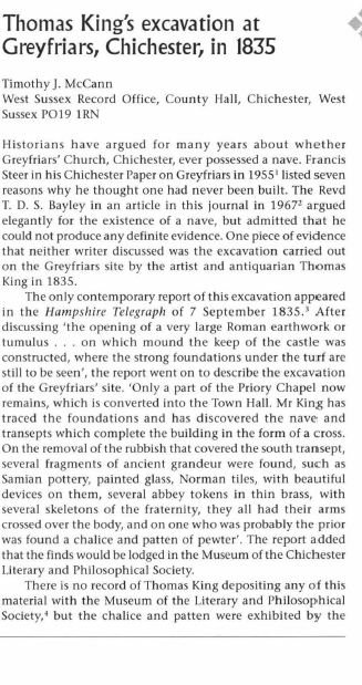
Moreover, I reminded them that this site had been excavated initially back in 1855, and the lead archaeologist, Thomas King, had reported that the mound was, in fact, a Roman tumulus. While it may have been repurposed or utilised in some way during the Norman period, it certainly does not fit the classic Motte and Bailey castle mound. How could Roman artefacts find their way into a mound supposedly built 600 years after the Romans had left? Their response was a concocted tale about scattered debris from the Roman period being accidentally left at the top of the mound as they built it from the spoil at the bottom and subsequent moated area. This notion seemed highly improbable to me. After all, one would assume that Thomas King, who conducted the formal investigation into the Greyfriars Church and mound by excavation in an attempt to find any connectivity between the two features and potential connections, would not arrive at such an unexpected conclusion based solely on a few scattered fragments of debris.(The Great Chichester Hoax – A Bridge too far?)

The Great Chichester Hoax - A Bridge too far?
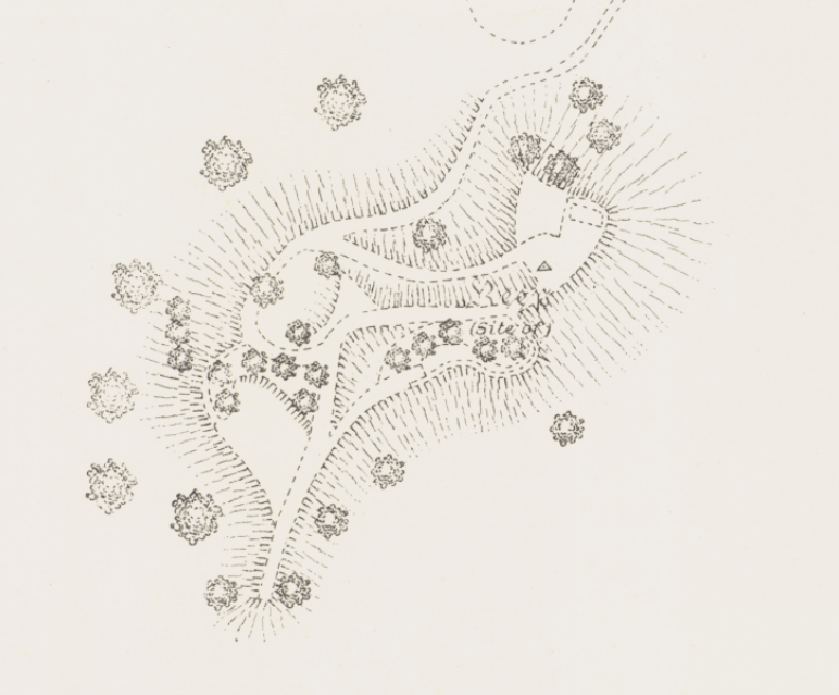
Plan of the Excavation – the castle is tiny so Probably not a Norman Motte and Baily

Fire Beacons

So, to further their understanding of Roman beacons, I included additional information they may not have been aware of. I suggested that if they were genuinely interested in the archaeology of the mound and its historical significance, they should consider visiting Lewes, just down the road—a place where I’ve lived and conducted surveys. In Lewes, they would find not one but two fire beacons. Interestingly, both have been misidentified again! The Trump, a mound serving as a fire beacon for the Cluny Monastery, was crucial in guiding ships from France into a safe harbour.

The Great Chichester Hoax - A Bridge too far?
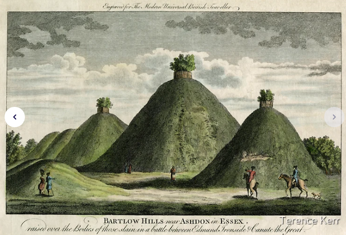
Other Roman Tumulus of this period

Lewes

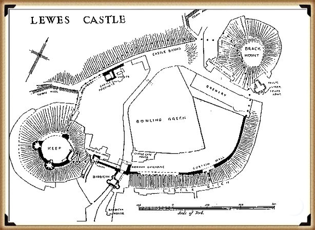
I also mentioned another site associated with a real motte and bailey castle, Brack Hill. Initially thought to be part of the Norman Castle, recent finds of Roman artefacts suggest it dates back to pre-Norman times, possibly even Roman or earlier, serving as a fire beacon. This aligns with the historical context, as the town would have been a harbour, with The Brack situated right on the shoreline of the prehistoric river.

Lewes Castle
Brack Hill – not Norman as Roman finds in the centre of the mound.

Cluny Monastry

Their response was rather dismissive, claiming that the Lewes Trump was not a fire beacon but nothing more than a garden feature— a mere 75 feet high and 140 feet in circumference. However, I argued that this seemed implausible for a mere “garden feature,” especially considering its location at the edge of the monastery’s grounds. I suggested they study a LiDAR map, which would reveal that The Trump, formerly known as The Mount, sits on the prehistoric shoreline of Lewes. Adjacent to it is another ancient site, the “dripping pan,” a salt production site for the Cluny Monks, requiring constant saltwater. This, I argued, provides empirical evidence supporting its role as a fire beacon—guiding French-origin ships off the English Channel to safe harbours and the monastery.

The Great Chichester Hoax - A Bridge too far?
Trump – A fire Beacon for the ships from France

Unfortunately, my contributions were met with silence, as they seemed more interested in celebrating their historic bridge discovery rather than engaging in meaningful archaeological discussions, as they considered the matter closed. It’s disappointing to see archaeologists shut down debate and ignore valuable information, promoting unsupported propaganda instead of evidence-based inquiry. This closed-minded approach is a stark departure from authentic scientific practice, contributing to the devaluation of archaeology as a subject and the subsequent decline of related courses due to this ‘dumbing down’.(The Great Chichester Hoax – A Bridge too far?)

The Great Chichester Hoax - A Bridge too far?
The fantasy and archaeological propaganda – so what happened to all that soil in the ditch (as its not on the motte?) or was it a moat??

It is crucial to remain open to new interpretations and theories that might differ significantly from traditional views. The absence of evidence is not evidence of absence. Still, it does require us to question and reassess historical assumptions, ensuring our understanding of the past is as accurate as possible.

The Great Chichester Hoax - A Bridge too far?
The Reality – is the Mound is smaller than the Church/Guild Hall and no signs of the moat or ditch

(The Great Chichester Hoax – A Bridge too far?)

Further Reading

For information about British Prehistory, visit www.prehistoric-britain.co.uk for the most extensive archaeology blogs and investigations collection, including modern LiDAR reports.  This site also includes extracts and articles from the Robert John Langdon Trilogy about Britain in the Prehistoric period, including titles such as The Stonehenge Enigma, Dawn of the Lost Civilisation and the ultimate proof of Post Glacial Flooding and the landscape we see today.

Robert John Langdon has also created a YouTube web channel with over 100 investigations and video documentaries to support his classic trilogy (Prehistoric Britain). He has also released a collection of strange coincidences that he calls ‘13 Things that Don’t Make Sense in History’ and his recent discovery of a lost Stone Avenue at Avebury in Wiltshire called ‘Silbury Avenue – the Lost Stone Avenue’.

Langdon has also produced a series of ‘shorts’, which are extracts from his main body of books:

The Ancient Mariners

Stonehenge Built 8300 BCE

Old Sarum

Prehistoric Rivers

Dykes ditches and Earthworks

Echoes of Atlantis

Homo Superior

Other Blogs

s

t

(The Great Chichester Hoax – A Bridge too far?)

Mesolithic Stonehenge

Introduction

Mesolithic Stonehenge

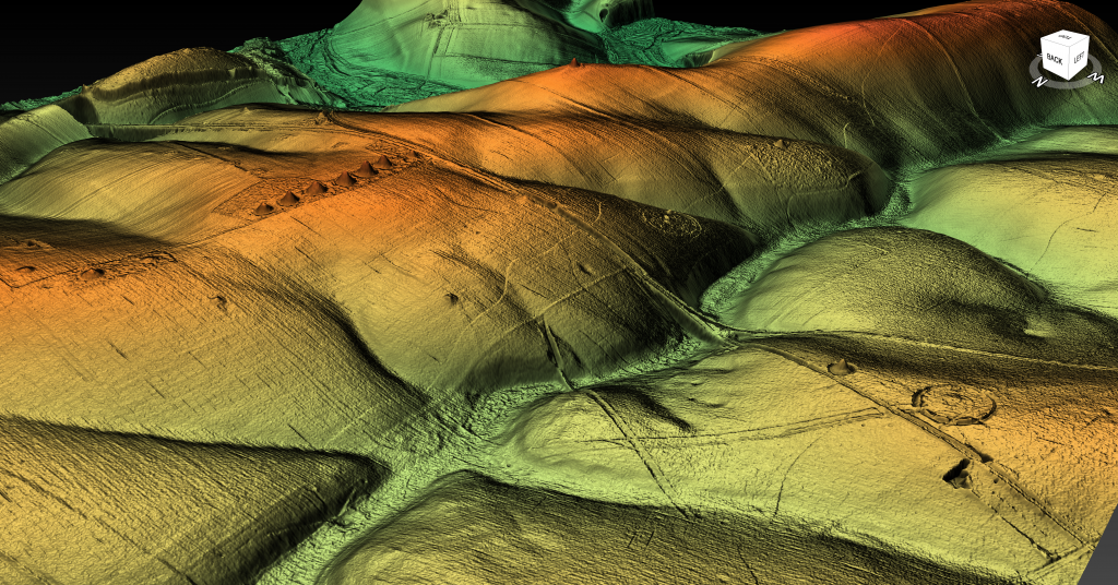
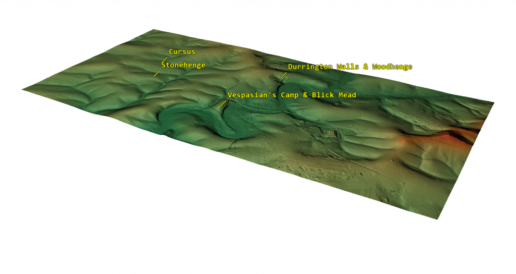
Using LiDAR to examine Stonehenge reveals a surprising detail: the monument isn’t situated at the highest point in the landscape. Instead, it lies midway down a slope, despite nearby elevated sites like Vespasian Camp, near Blick Mead, where the Open University uncovered Mesolithic fire pits with evidence of cooked meat. This raises an intriguing question: why was Stonehenge built in this seemingly less advantageous location?

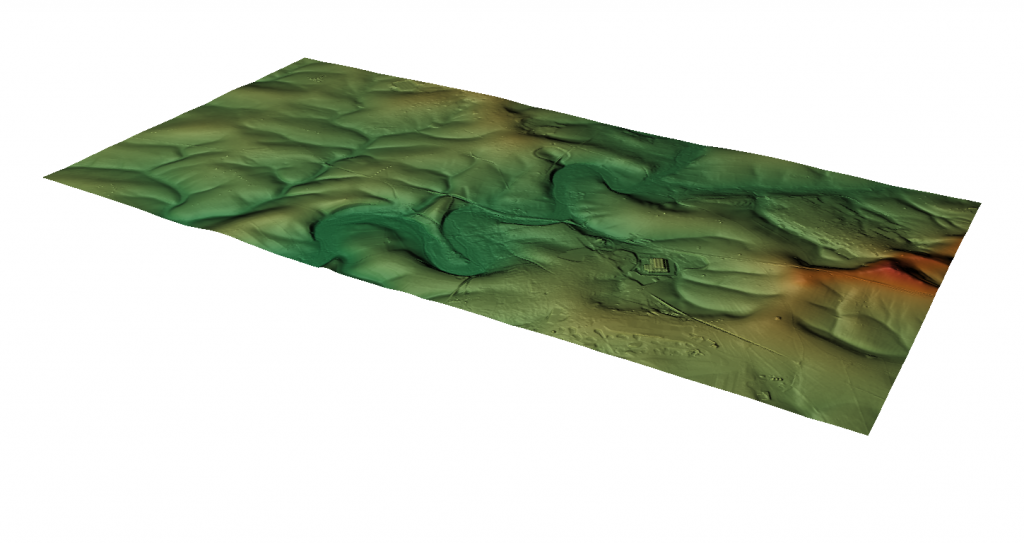
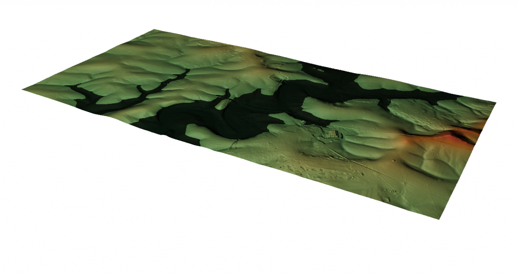
LiDAR technology offers a compelling way to answer this. By creating a detailed 3D landscape model, LiDAR highlights terrain features far more effectively than traditional OS maps or on-site surveys, where important details can easily be overlooked. From a virtual vantage point approximately 100 feet above the ground, facing south, it becomes clear that Stonehenge is perched on the edge of what is now a dry valley. However, during the Mesolithic period, this valley was far from dry; it was an active waterway fed by natural springs, which flowed southward into the River Avon. (Mesolithic Stonehenge)

Blick Mead - Mesolithic Stonehenge
Blick Mead – Mesolithic Stonehenge

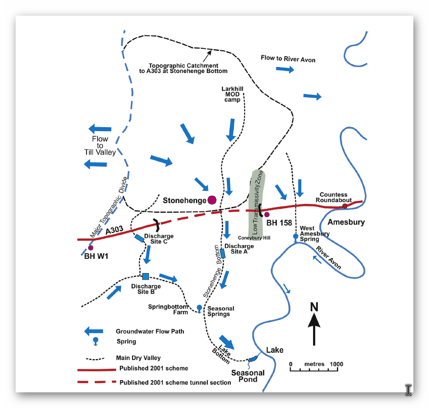
These springs were fueled by a high groundwater table, a feature characteristic of post-Ice Age conditions when meltwater replenished underground aquifers. Springs are categorized by their flow rate, with the most productive reaching up to 2,800 litres per second. Evidence suggests that during the Mesolithic, the “Stonehenge Bottom” valley was home to multiple springs, collectively discharging a significant volume of water into the River Avon. Modern core samples taken while surveying the proposed Stonehenge tunnel have confirmed this. The core data revealed that the water table in this area was significantly higher than previously estimated, forcing the tunnel design to be revised and deepened—at a cost of millions. This finding directly challenges the long-held views of archaeologists who have advised on Stonehenge’s historical groundwater levels, casting doubt on their previous peer-reviewed conclusions. (Mesolithic Stonehenge)

Stonehenge Bottom - Mesolithic Stonehenge
Stonehenge Bottom – Mesolithic Stonehenge

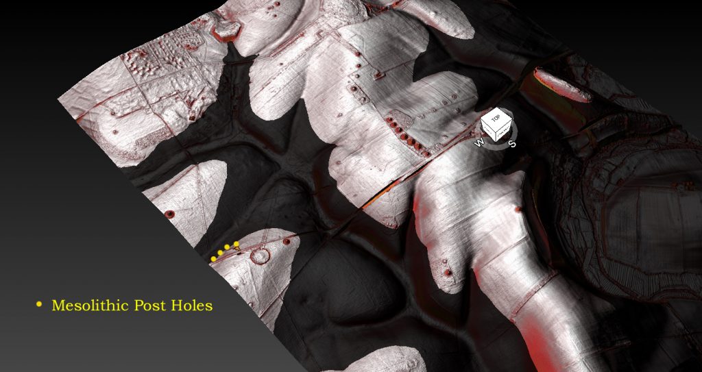
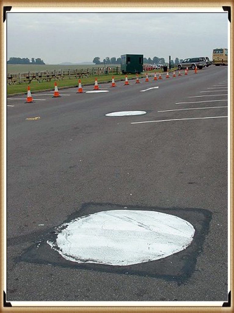
Using LiDAR simulations, we can reconstruct how this water would have shaped the landscape. Archaeological evidence indicates that the water table—and thus the river’s shoreline—was approximately 30 meters higher than today, flooding the valley up to the old Stonehenge car park at 97 meters above sea level. This hypothesis is supported by discoveries made during the construction of the old car park in 1966, where three large post holes were uncovered. These holes cut into the chalk bedrock around 9,000–10,000 years ago and contained silt and sand indicative of a shoreline environment. (Mesolithic Stonehenge)

Stonehenge Bottom in the Mesolithic - Mesolithic Stonehenge
Stonehenge Bottom in the Mesolithic – Mesolithic Stonehenge

Radiocarbon dating of pine charcoal from the base of these post holes dates their use to approximately 8,300 BCE. Additionally, more post holes have been discovered in the same area, forming a peculiar alignment. Five such holes have been identified, all dating to the same early Mesolithic period. Intriguingly, these dates align with hearths found at Craig Rhos-y-Felin, the quarry believed to be the source of Stonehenge’s Bluestones. Further supporting this connection is the discovery of hearths at another Bluestone quarry, Carn Goedog, also carbon-dated to approximately 8,400 BCE. These findings strengthen the case for a sophisticated network of activity linking Stonehenge to its quarry sites in Wales. (Mesolithic Stonehenge)

Stonehenge Old Car Park - Mesolithic Stonehenge
Stonehenge Old Car Park – Mesolithic Stonehenge

The old car park is located 10 meters lower than Stonehenge, and further dating evidence from charcoal within the Sarsen circle (confirmed by Darvill and Wainwright in 2008) suggests the site was in use as early as 7,200 BCE. This strongly connects the Mesolithic post holes, possibly used as mooring points for boats, to the later development of Stonehenge. The post holes may have supported cross-beams, functioning as primitive yet effective lifting mechanisms. Boats tied to these beams could utilize the natural rise and fall of the river’s tides to lift heavy stones effortlessly. This would mark an early use of hydraulic lifting principles, demonstrating the ingenuity of Mesolithic communities. (Mesolithic Stonehenge)

Post Hole A Matches Quarry Hearth Date - Mesolithic Stonehenge
Post Hole A Matches Quarry Hearth Date – Mesolithic Stonehenge

Despite this compelling evidence, mainstream archaeologists often dismiss the idea of a higher River Avon during the Mesolithic. Instead, they suggest these post holes housed “ceremonial totem poles” erected by random hunter-gatherers. However, this explanation is riddled with logical flaws. The post holes are over a meter wide, implying the use of enormous pine trees, which would have required significant effort to fell with stone tools—an unlikely endeavour for mere ceremonial markers. Furthermore, the poles were periodically replaced over more than a thousand years, suggesting a practical rather than symbolic, purpose. (Mesolithic Stonehenge)

Bluestone lifting device - Mesolithic Stonehenge
Bluestone lifting device – Mesolithic Stonehenge

The discovery of modern core samples in the Stonehenge Bottom Valley only adds to the scepticism regarding traditional archaeological interpretations. For decades, experts advising on Mesolithic groundwater levels have underestimated the height of the water table in the region. The recent core sample findings confirm my hypothesis of a higher water table and highlight the limitations of earlier studies. These experts, whose opinions were once considered definitive, now find their conclusions undermined by hard data—data that has already necessitated expensive revisions to modern engineering projects. (Mesolithic Stonehenge)

Modern Core Samples show Ground Water in the Area – Mesolithic Stonehenge

LiDAR and archaeological evidence together paint a picture of Stonehenge as part of a peninsula surrounded by water in its early days. This watery context may hold the key to understanding why this iconic monument was built where it stands today. The valley would have provided a natural harbour, making it an ideal location for landing heavy stones transported by boat. The site’s proximity to abundant water resources also suggests that it may have held significant practical and symbolic value for the people who built it.

It’s time to reconsider long-held assumptions about Stonehenge. The combination of LiDAR, modern core samples, and radiocarbon dating has provided a richer, more nuanced understanding of its landscape and early history. These findings challenge traditional narratives and open the door to exciting new interpretations about how and why this monumental site was created. (Mesolithic Stonehenge)

The Stonehenge Book

Video

(Mesolithic Stonehenge)

Synopsys

Stonehenge, a timeless enigma etched in stone and earth, has stood as a formidable puzzle challenging the intellects of archaeologists and historians alike. Despite the myriad attempts, including books, TV programs, and academic conferences, the secrets of these ancient stones and their encircling ditches have proven elusive. Against this backdrop, we scrutinise the existing thirteen hypotheses, each presenting its narrative but collectively lacking a coherent thread.

In adopting the deductive reasoning akin to Sherlock Holmes, we endeavour to weave these disparate threads into a unified tapestry that not only unravels the mystery of Stonehenge but also shakes the foundations of established academic narratives. This intellectual journey may induce some discomfort as we challenge conventional perceptions and invite a reevaluation of our understanding of the past. Apologies are extended in advance for any cognitive dissonance, but the pursuit of truth and reason mandates an unfiltered presentation of the facts.So, fasten your seatbelts for an expedition into the archaeological unknown.

As we navigate this intellectual rollercoaster, be prepared for a revelation that might reshape our understanding of Stonehenge and question the foundations of our historical narratives. The dawn of a new archaeological era awaits promising insights that could leave even the most curious minds astonished. As we delve into this intellectual rabbit hole, be ready for a revelation that could make Alice astonished.(Mesolithic Stonehenge)

Robert John Langdon (2023) – (The Stonehenge Hoax)

The Stonehenge Hoax
The Great Stonehenge Hoax

FREE LiDAR Maps

Here is the perfect resaerch resource for any bidding arcaheologist – 3D LiDAR Maps – there are free and can be downloaded by clicking the Right Site of the Mouse and saving it to your hard Drive for closer inspection, with you PC/Mobile reader software. (Mesolithic Stonehenge)

FREE Stonehenge LiDAR 8K Map

FREE Stonehenge LiDAR Maps

FREE Stonehenge LiDAR water Map

FREE Stonehenge LiDAR Maps

FREE Stonehenge LiDAR 3D Map

(FREE Stonehenge LiDAR Maps)

Exploring Prehistoric Britain: A Journey Through Time

My blog delves into the fascinating mysteries of prehistoric Britain, challenging conventional narratives and offering fresh perspectives based on cutting-edge research, particularly using LiDAR technology. I invite you to explore some key areas of my research. For example, the Wansdyke, often cited as a defensive structure, is re-examined in light of new evidence. I’ve presented my findings in my blog post Wansdyke: A British Frontier Wall – ‘Debunked’, and a Wansdyke LiDAR Flyover video further visualizes my conclusions.

My work also often challenges established archaeological dogma. I argue that many sites, such as Hambledon Hill, commonly identified as Iron Age hillforts are not what they seem. My posts Lidar Investigation Hambledon Hill – NOT an ‘Iron Age Fort’ and Unmasking the “Iron Age Hillfort” Myth explore these ideas in detail and offer an alternative view. Similarly, sites like Cissbury Ring and White Sheet Camp, also receive a re-evaluation based on LiDAR analysis in my posts Lidar Investigation Cissbury Ring through time and Lidar Investigation White Sheet Camp, revealing fascinating insights into their true purpose. I have also examined South Cadbury Castle, often linked to the mythical Camelot56.

My research also extends to the topic of ancient water management, including the role of canals and other linear earthworks. I have discussed the true origins of Car Dyke in multiple posts including Car Dyke – ABC News PodCast and Lidar Investigation Car Dyke – North Section, suggesting a Mesolithic origin2357. I also explore the misidentification of Roman aqueducts, as seen in my posts on the Great Chesters (Roman) Aqueduct. My research has also been greatly informed by my post-glacial flooding hypothesis which has helped to inform the landscape transformations over time. I have discussed this hypothesis in several posts including AI now supports my Post-Glacial Flooding Hypothesis and Exploring Britain’s Flooded Past: A Personal Journey

Finally, my blog also investigates prehistoric burial practices, as seen in Prehistoric Burial Practices of Britain and explores the mystery of Pillow Mounds, often mistaken for medieval rabbit warrens, but with a potential link to Bronze Age cremation in my posts: Pillow Mounds: A Bronze Age Legacy of Cremation? and The Mystery of Pillow Mounds: Are They Really Medieval Rabbit Warrens?. My research also includes the astronomical insights of ancient sites, for example, in Rediscovering the Winter Solstice: The Original Winter Festival. I also review new information about the construction of Stonehenge in The Stonehenge Enigma.

(Mesolithic Stonehenge)

Further Reading

For those interested in British Prehistory, visit www.prehistoric-britain.co.uk, a comprehensive resource featuring an extensive collection of archaeology articles, modern LiDAR investigations, and groundbreaking research. The site also includes insights and extracts from the acclaimed Robert John Langdon Trilogy, a series of books exploring Britain during the Prehistoric period. Titles in the trilogy include The Stonehenge Enigma, Dawn of the Lost Civilisation, and The Post Glacial Flooding Hypothesis, offering compelling evidence about ancient landscapes shaped by post-glacial flooding.

To further explore these topics, Robert John Langdon has developed a dedicated YouTube channel featuring over 100 video documentaries and investigations that complement the trilogy. Notable discoveries and studies showcased on the channel include 13 Things that Don’t Make Sense in History and the revelation of Silbury Avenue – The Lost Stone Avenue, a rediscovered prehistoric feature at Avebury, Wiltshire.

In addition to his main works, Langdon has released a series of shorter, accessible publications, ideal for readers delving into specific topics. These include:

For active discussions and updates on the trilogy’s findings and recent LiDAR investigations, join our vibrant community on Facebook. Engage with like-minded enthusiasts by leaving a message or contributing to debates in our Facebook Group.

Whether through the books, the website, or interactive videos, we aim to provide a deeper understanding of Britain’s fascinating prehistoric past. We encourage you to explore these resources and uncover the mysteries of ancient landscapes through the lens of modern archaeology.

For more information, including chapter extracts and related publications, visit the Robert John Langdon Author Page. Dive into works such as The Stonehenge Enigma or Dawn of the Lost Civilisation, and explore cutting-edge theories that challenge traditional historical narratives.

(Mesolithic Stonehenge)

Other Blogs

s

t

(Mesolithic Stonehenge)

Hambledon Hill – NOT an ‘Iron Age Fort’

Introduction

According to Wikipedia (Hambledon Hill)

Location

Hambledon Hill is a prehistoric hill fort in Dorset, England, in the Blackmore Vale five miles northwest of Blandford Forum. The hill itself is a chalk outcrop, on the southwestern corner of Cranborne Chase, separated from the Dorset Downs by the River Stour. It is owned by the National Trust.

Prehistory

Its earliest occupation was in the Neolithic when a pair of causewayed enclosures were dug at the top of the hill, one smaller than the other. They were linked by a bank and ditch running northwest-southeast. Two long barrows, one 68 m (223 ft) in length, also stood within the complex, and a third enclosure is now known to underlie later earthworks. The area of activity covered more than 1 km2 (0.39 sq mi).

Excavations in the 1970s and 1980s by Roger Mercer produced large quantities of Neolithic material. Environmental analysis indicated the site was occupied whilst the area was still wooded with forest clearances coming later, in the Bronze Age. The charcoal recovered seems to have come from timber lacing within the Neolithic earthworks.

Radiocarbon analysis gives a date of 2850 BC. At least one skeleton of a young man killed by an arrow was found, seemingly connected with the burning of the timber defences and suggesting at least one phase of violence. A single grape pip and a leaf fragment are evidence of vine cultivation, and the occupants seem to have traded with sites further to the southwest.

The ditches of the enclosures also contained significant quantities of pottery as well as red deer antler picks used to excavate them. Human skulls had been placed right at the bottom of one of the enclosure ditches, possibly as a dedicatory or ancestral offering. Animal bone analysis suggests that most of the meat was consumed in late summer and early autumn, possibly indicating seasonal use of the site. Different material was found in different areas of the site suggesting that Hambledon Hill was divided into zones of activity. The original interpretation was that the large causewayed enclosure was used as a mortuary enclosure for the ritual disposal of the dead and veneration of the ancestors, with attendant feasting and social contact taking place in the smaller enclosure.

Little remains of the Neolithic activity and the site is more easily identified as a prime example of an Iron Age hill fort. It was originally univallate but further circuits of banks and ditches were added increasing its size to 125,000 m2 (1,350,000 sq ft). Three entrances served the fort, the southwestern with a 100 m (330 ft) long hornwork surrounding it. Hut platforms can be seen on the hillside. The site appears to have been abandoned around 300 BC, possibly in favour of the nearby site of Hod Hill.

Hambledon Hill is the first in a series of Iron Age earthworks, which continues with Hod Hill, Spetisbury Rings, Buzbury Rings, Badbury Rings and Dudsbury Camp. The Iron Age port at Hengistbury Head forms a final Iron Age monument in this small chain of sites.

Battle of Hambledon Hill
The Clubmen were a third force in the English Civil War, aligned to neither crown nor parliament but striving to protect their land from being despoiled by foraging troops of either side. They armed themselves with clubs and agricultural implements and gathered in large numbers to protect their fields, especially in Dorset. Between 2,000 and 4,000 of them encamped on Hambledon Hill in August 1645. Many of Cromwell’s troops were in the area at that time after the siege of Sherborne Castle. Cromwell ordered that the Clubmen be dispersed, and his well-equipped New Model Army soon drove them away on August 4. The leaders were arrested, but Cromwell sent most home, saying they were ‘poor silly creatures’.

(Hambledon Hill)

Excavations/History

Early Investigations (1970s): Excavations began with the renowned archaeologist Roger Mercer, who conducted a series of investigations in the 1970s. These excavations provided some of the earliest detailed insights into the site. Mercer’s work revealed the presence of complex ramparts, ditches, and pits, alongside evidence of prolonged human occupation.

1980s–1990s Investigations: More focused studies were undertaken in these decades, particularly looking at the defensive structures and domestic spaces within the hillfort. These studies revealed substantial evidence of Neolithic activity, including food storage pits, animal bones, and pottery, suggesting that Hambledon Hill was not only a defensive site but also a thriving settlement.

English Heritage (2000s): English Heritage took significant interest in Hambledon Hill and facilitated further studies in the early 2000s. Their work was more about preservation, mapping, and surveying than excavation. The findings confirmed that the site played an essential role in regional trade and communication.

Modern Excavations: Recently, there have been limited but more technologically advanced studies, including ground-penetrating radar and aerial surveys, which have enhanced understanding without large-scale excavation.

Key Findings
Defensive Structures: Hambledon Hill has evidence of some of the earliest known fortifications in Britain, with intricate ditches and bank systems indicating organized labor.

Human Remains: The site contains burial pits with skeletal remains, often showing evidence of violent death, likely reflecting skirmishes between groups.
Artifacts: Pottery fragments, tools, and animal bones have been found, offering insights into Neolithic diet, technology, and trade.
Key References

Mercer, Roger J. “Hambledon Hill: A Neolithic Landscape” (1980) – This publication provides a detailed overview of Mercer’s early work and initial findings on the site.
Healy, Frances (Editor). “Hambledon Hill, Dorset, England: Excavation and Survey of a Neolithic Monument Complex and its Landscape” (2014) – This is a comprehensive volume on the more recent findings, with contributions from various archaeologists detailing specific aspects of the site.

English Heritage Research Reports—These reports provide updated survey data and conservation efforts for the site and are valuable for understanding the noninvasive approaches used in recent decades.

(Hambledon Hill)

Maps

1800s OS Map

Hambledon Hill - os 1800s
Hambledon Hill – 1800s OS Map (click map to enlarge)

GE Satellite Map

Hambledon Hill ge
Hambledon Hill GE Map (click map to enlarge)

LiDAR Map

Hambledon Hill
Hambledon Hill- LiDAR Map

Investigation

Site Flyaround

(Hambledon Hill)

Site Flyover

(Hambledon Hill)

Lidar Map showing Mesolithic/Neolithic River Levels

(Hambledon Hill)

LiDAR Map showing Neolithic/Bronze Age

Hod Hill is just 1735m from Hambledon Hill, but it is still given a separate stataus as another ‘Iron Age Hillfort’.

(Hambledon Hill)

Defence Strategy 101

Roman Defense System

Roman defences (of the same period as the ‘Iron Age’ ), we notice the ditches were relatively small and narrow. These ditches were called ‘Ankle Breaker’ as the purpose was for the assailant to fall into the ditch (usually containing pointed wooden stakes to either injure or kill the assailant) or to at least break their ankle from the fall, making them immobile. These ditches would be 3 to 4 m wide and about 2m deep and could be dug quickly.

Roman Ankle Breaker

The spoil from the ditch would be placed on the defended side of the ditch to give the defendants higher ground and be able to look and fight down against their assailants. Finally, as standing on higher ground without any other defence would make you a clear target, they constructed a fortification of either wood stakes or, later on, if the defence was to be more permanent and substantial of stone so that you could hide looking down above the conflict giving you the needed cover from spears, arrows or stones. This is a basic 1-1 defence that has not changed in thousands of early years as we saw a thousand years onwards with the Normans who had Castles with moats who wanted to slow down assailants so they could use their cross-bows if they attempted to sail across the wide moats as it was too deep to wade across.

Classic Roman Fort With Ditch and Palisade

Lidar Maps Showing No Defences

Ditches (Hambledon Hill)

Ditch is banked on the wrong side

The LiDAR Maps also show that the ditch of the ditches indicate that they were built for water, as shown by the blue on these images – this then allows us to look at the design of the earthwork in detail, which shows that the banks have been cut by not roads but other ditches. These ditches that cut across the circumference moats cut into them that, suggest that if water had been contained in these ditches, then the vertical dykes could have been used to gaol boats up from the bottom of the dyke ditch to one of these upper moat levels. These same LiDAR maps also show how the soil was distributed to the outside of the moats to enhance and make the feature deeper.

It’s A quarry site with hundreds of pits, and so uses the edge as a dyke to transport minerals by boat

(Hambledon Hill)

Water Table

This hypothesis of using these ditches can only be proven if we find the natural springs that could have fed these earthworks in the past. We know from our work in studying Rivers such as The Thames and Avon that they were both much higher and of greater volume in the past and at their highest directly after the last ice age and continued to be much higher than today for ten thousand years. This greater height in Rivers is reflected and caused by a higher water table. Within these water tables, natural springs are formed, and water leaks into the land, creating rivers and streams. Although we do not have geological information that allows us to trace past springs, we do find existing springs in this location (still active today at a time of Britain’s lowest water levels ), which suggests our hypothesis is correct.

B. Holes are the remains of Natural Springs in the bedrock showing a higher water table in the past

Dykes

As we have already suggested, other undocumented features show that this is far from being defensive and used as a trading site. We have noticed that this trading was achieved by creating other earthworks called Linear Earthworks (also known as Dykes). Dykes were introduced when the waters of the Prehistoric fell, and they wanted to continue to use the trading sites, and also they used the Dykes to transport minerals extracted from the many quarries that uncommonly surround these Dykes. Here in South Cadbury Castle, we see not only Dykes feeding the local quarry sites but also placed on the side of the Trading side to allow boats to be parked/moored on the moats of the site ready for unloading/loading.

Slipway built to feed the moats in the upper levels with trading boats
Shows Dykes were cut at a very late stage to connect to the moats

Conclusion

In conclusion, Hambledon Hill’s significance as a prehistoric site continues to reshape our understanding of early Britain. Far from a simple Iron Age hillfort, the site reveals a complex history with roots in the Mesolithic period, dating back around 8,000 years. Recent findings challenge the earlier classification of a causewayed enclosure, instead uncovering a landscape marked by multiple pits and quarries, which suggests a hub for trade and social activity rather than a defensive stronghold.

This thriving trade at Hambledon Hill was likely facilitated by higher river levels in prehistoric times. The elevated rivers meant that features now appearing as moated and high on the hillsides were originally situated along ancient shorelines, providing ideal access points for trade routes. This would have allowed communities to transport goods by boat, explaining Hambledon Hill’s strategic importance as a trading center rather than as a military outpost. This interpretation aligns with other sites across Britain where similar elevated features reveal former shorelines, now receded, that were once vibrant hubs of interaction.

Modern archaeological tools, such as LiDAR, continue to uncover these nuances, reshaping our understanding of Hambledon Hill and its role in a network of dynamic, interconnected societies across prehistoric Britain. Far from isolated or purely defensive, these communities were engaged in sophisticated trade and social networks, drawing on the natural waterways that once connected them directly to other settlements across the region.

AI Assessment

AI’s View and Dating on Hambledon Hill

Ditches made for moats as soil is on the outside

The Dorchester site presents an archaeological narrative from the Neolithic to the Iron Age, marked by significant phases of construction, modification, and varied usage. Here’s a summary of the site’s history up to the Iron Age:

Neolithic Period

The earliest phases at the site date back to the Neolithic, evidenced by the foundational ditches and cross-dykes that indicate extensive early activity. The Neolithic features include causewayed enclosures and long barrows, suggesting the site’s ceremonial or communal functions. Radiocarbon dating from charcoal and faunal remains places these structures within the Neolithic, which aligns with similar causewayed camps in Wessex, an area known for its Neolithic monuments. (source: HAMBLEDON HILL, DORSET, ENGLAND. Excavation and survey of a Neolithic monument complex and its surrounding landscape. Vol 1. English Heritage)

The landscape surrounding the site during this period is believed to have been a mixture of woodland and cleared areas. Molluscan analysis suggests a partly wooded environment, contradicting earlier models of fully cleared landscapes around causewayed camps. This diverse vegetation profile likely provided a setting that accommodated both Neolithic agriculture and ceremonial use, supporting a mix of pastoral and crop-growing activities​.

Bronze Age Developments

As the site transitioned into the Bronze Age, there were modifications and additions to the existing structures. Evidence from pottery and faunal remains indicates a shift toward more domestic and agricultural functions. Midden-like deposits, including pottery, animal bones, and burnt flint, were found in the ditch fills, particularly around significant areas like entrances, which may have retained symbolic or functional importance through the early Bronze Age​(a-source-of-confusion-n…).

Further evidence of Bronze Age activity includes small quantities of early Bronze Age pottery, along with rare artifacts like a copper alloy awl and decorated bone or antler beads. These findings reflect the site’s continued, albeit evolving, significance during the Bronze Age. It seems that some of the Neolithic ditches were recut during this period, and ploughsoils accumulated in certain areas, indicating agricultural usage and clearance of nearby land.

Iron Age Modifications

By the Iron Age, the site saw further transformation. While the volume of Iron Age artifacts is relatively limited, the presence of early Iron Age pottery and evidence of field systems on the Stepleton spur suggest a shift towards more structured, agricultural land use. The Iron Age material primarily includes pottery and animal remains, indicative of a community that may have used the area for grazing or agricultural production​.

In this period, modifications to ditches and banks reflect an adaptation of the existing Neolithic and Bronze Age structures rather than a complete reconstruction. This continued use and adaptation without major redevelopment into a fortified hillfort is noteworthy, as it suggests that the site’s function evolved in line with changing social and economic needs rather than as a military fortification.

Summary

In summary, the Dorchester site initially served a ceremonial or communal role in the Neolithic, which evolved through the Bronze Age into a mixed-use landscape of agricultural and possibly ritual significance. By the Iron Age, while surrounding areas saw more defined agricultural practices, the site maintained a continuity of use with adaptations rather than a transformation into a typical Iron Age hillfort. This layered history underscores the site’s complex, multi-phase development, challenging its classification as an Iron Age fort and highlighting its importance across multiple prehistoric periods.

Further Reading

For information about British Prehistory, visit www.prehistoric-britain.co.uk for the most extensive archaeology blogs and investigations collection, including modern LiDAR reports.  This site also includes extracts and articles from the Robert John Langdon Trilogy about Britain in the Prehistoric period, including titles such as The Stonehenge Enigma, Dawn of the Lost Civilisation and the ultimate proof of Post Glacial Flooding and the landscape we see today.

Robert John Langdon has also created a YouTube web channel with over 100 investigations and video documentaries to support his classic trilogy (Prehistoric Britain). He has also released a collection of strange coincidences that he calls ‘13 Things that Don’t Make Sense in History’ and his recent discovery of a lost Stone Avenue at Avebury in Wiltshire called ‘Silbury Avenue – the Lost Stone Avenue’.

Langdon has also produced a series of ‘shorts’, which are extracts from his main body of books:

The Ancient Mariners

Stonehenge Built 8300 BCE

Old Sarum

Prehistoric Rivers

Dykes ditches and Earthworks

Echoes of Atlantis

Homo Superior

Other Blogs

s

t

(Hambledon Hill)

Cissbury Ring through time

Introduction

This is a journey through time looking at the prehistoric site of CISSBURY RING and its surrounding Landscape based on the new third (2020) edition book of the best seller – that contains conclusive and extended evidence of Robert John Langdon’s hypothesis, that rivers of the past were higher than today – which changes the history of not only Britain, but the world. In his first book of the trilogy ‘The Post-Glacial Hypothesis’, Langdon discovered that Britain was flooded directly after the last Ice Age, which remained waterlogged in to the Holocene period through raised river levels, not only in Britain, but worldwide.

Cissbury Ring – Summary

Traditionally classified as an Iron Age hill fort, is actually one of the oldest and largest Neolithic flint mining sites in Britain, covering an impressive 65 acres. It ranks second only to Maiden Castle in terms of size. However, its primary historical significance lies not in its defensive role, but in its function as a major center for flint extraction and trade. This site represents one of the earliest known industrial landscapes in prehistoric Britain, with mining activity that dates back to around 4000 BCE, challenging the conventional Iron Age classification.

The site contains approximately 200 flint shafts, some extending as deep as 12 meters, and mining activities here spanned an extraordinary 900-year period. These shafts were dug into the chalk bedrock to access high-quality flint, a critical resource in the Neolithic era for tool-making and other practical purposes. Flint extraction at Cissbury was a meticulous process, involving the excavation of large shafts and tunnels to reach the valuable deposits. Skilled miners likely used bone and stone tools to carve through the chalk, carefully extracting flint nodules that would have been in high demand across Britain and beyond.

The surrounding landscape is marked by a series of interconnected ditches and dykes that connect ancient paleochannels to the site’s main ditch, forming an intricate transportation network. This system likely facilitated the movement of flint from the mines to boats for trade, indicating Cissbury’s role as a strategic trading hub. These channels would have allowed the extracted flint to be efficiently transported to nearby waterways, where it could be shipped to other regions.

The sheer scale and complexity of the mining operations at Cissbury Ring provide a glimpse into the sophisticated logistical organization of Neolithic communities. This site was not merely a fortified settlement, but a bustling center of industry, resource management, and trade in prehistoric Britain.

Cissbury Ring through time
Maps to not show the extent of mining at Cissbury – Cissbury Ring through time

Flint Mines, Radiocarbon Dates, and Archaeological Insights

Cissbury Ring in West Sussex, one of Britain’s largest hillforts, is a window into ancient Britain, encompassing Neolithic, Iron Age, and Romano-British activities. Covering 60 acres, this site has yielded an extensive collection of evidence that informs us about early mining practices and settlement patterns. The flint mines here date back to around 4000 BC and have provided valuable insights into Neolithic industrial activity and ritual practices.

Cissbury Ring through time

The Beginnings of Flint Mining

The flint mines at Cissbury, dating to the Neolithic period, span over 9 hectares, with more than 270 shafts identified in surveys. These shafts, measuring between 3 and 36 meters in diameter, formed a crescent shape across the hillside. Flint extraction here was extensive, as Cissbury was a vital source of high-quality flint, essential for tool-making in ancient Britain. Miners used red deer antlers and shoulder blades as tools, effectively chiseling through layers of chalk to reach seams of flint.

Excavation History

Cissbury Ring through time

Early excavations at Cissbury began in the 1850s with George Irving, who initially misinterpreted the shafts as water reservoirs. In the 1860s, A.H. Lane-Fox correctly identified the pits as Neolithic flint mines, providing a more accurate interpretation of the site. Excavations continued with John Pull in the 1950s, although his findings were not fully published. Nevertheless, Pull’s work was pivotal in expanding our understanding of flint mining techniques used at Cissbury.

Structure of the Flint Mines

The shafts at Cissbury led to a complex network of underground galleries, which were typically 3 feet high and supported by chalk pillars. The miners worked in hazardous conditions, as evidenced by skeletons found within collapsed galleries. The shafts were often backfilled with chalk rubble after extraction. Galleries interconnected the shafts, allowing for multiple points of access and exit. Excavators found evidence of flint knapping on-site, as well as animal bones and other artifacts, suggesting that the pits might have had secondary uses.

Cissbury Ring through time
The Mining was deep and extensive – you can’t do this with an antler pick!

Radiocarbon Dating Evidence

Radiocarbon dating of antler picks from the site provided dates of 4720±150 BP, 4650±150 BP, and 4730±150 BP, which correspond to 3900-3030 BCE and 3780-2920 BCE. These dates confirm that the flint mines were in use during the Neolithic period, solidifying Cissbury’s importance as a prehistoric mining center. The discovery of animal bones, including ox, pig, and wild boar, within these pits indicates that miners were using the site not only for extraction but possibly for ritualistic purposes as well.

Artifacts and Findings

The tools used at Cissbury were mainly made from red deer antlers, adapted for use as picks and shovels. Excavators found other unique items, including miniature flint axes and chalk carvings, with one shaft containing a woman’s skeleton buried feet-first, accompanied by bones of various animals. This implies a possible ritualistic burial, as several of these pits contained remains in arrangements suggesting ceremonial depositions.

Cissbury Ring through time
Stone axe – what was used to cut the mineshafts and channels

The Iron Age Transformation

In the Iron Age, around 700 BC, fortifications were constructed around the site, enclosing approximately 24 hectares. These defenses consisted of ramparts and ditches, forming a formidable barrier. Excavations revealed Romano-British pottery and oyster shells, indicating continued occupation and use for agriculture and defense. The hillfort was later fortified during WWII, and the site has undergone minimal modern excavation due to its status as a scheduled ancient monument.

Lynchets and the Dyke Debate

A particularly intriguing aspect of Cissbury is the lynchets, terraced formations traditionally associated with ancient agriculture. However, some propose that these features might actually be misidentified dykes, suggesting ancient water levels. While dykes usually include raised embankments and drainage systems, the lynchets at Cissbury lack these structural elements. Moreover, the area’s chalk soil would make long-term water retention impractical, raising doubts about the water-management hypothesis.

Cissbury Ring through time
It is not A defensive ditch but a system used to move minerals via boat, as these are moats, not ditches

Pits and Deposit Sites

Archaeologists speculate another layer to Cissbury’s history as pits for ritual deposition. One of the fascinating discoveries is a pit containing an assortment of artefacts, including chalk loom weights, an iron knife, and sling stones. These objects hint at ceremonial uses, possibly related to agricultural or religious practices. The pit aligns with similar features at Mount Caburn, suggesting ritual depositions were a shared practice among nearby communities. Sadly, the reality is this is an industrial site for processing minerals, and so this is just ‘industrial waste’ at best.

The Saxon Mint Hypothesis

Cissbury might have housed a Saxon mint, as coins from Ethelred II and Cnut bearing mint marks have been linked to the area. Although no direct archaeological evidence supports this claim, the suggestion adds another layer of historical intrigue to the site. Such mints were typically moved to fortifications during times of conflict, underscoring the strategic significance of Cissbury in the early medieval period. The better solution is that more than flint can be found in the mines – sadly, archaeology does not possess the techniques or experience to look for such minerals, as they do not excavate quarries.

Folklore and Myths

Local legends attribute Cissbury’s construction to the Devil, who allegedly flung earth around the Downs, creating the hillforts. Other stories speak of treasure guarded by serpents and even UFO sightings, adding a sense of mystery and complete nonsense to the site. There are also tales of fairies dancing at Cissbury, blending folklore with historical intrigue and showing how the site has captured imaginations for centuries.

A Concluding Perspective

Cissbury Ring through time
The Mines are Extensive showing that they were used in the Roman Period and beyond

Cissbury Ring remains an essential site for understanding ancient Britai,n, with its flint mines, Iron Age ramparts, and complex web of myths. While the theory of lynchets as dykes is interesting, it is unlikely given the physical characteristics of these features. Archaeological evidence supports the interpretation of lynchets as agricultural, with no clear indicators of water-management systems in place. Yet, Cissbury’s diverse history, from flint mining to potential Saxon minting, reflects a multifaceted legacy that continues to inspire research and speculation.

In conclusion, Cissbury Ring is more than a hillfort—it is a testament to the ingenuity, resilience, and cultural depth of ancient peoples. The site’s layers of history provide a tangible link to the past, offering insights that span millennia and spark continued interest in Britain’s ancient heritage.

Post-Glacial Flooding

Cissbury Ring through time
The Prehistoric Waters show that the dykes (not Lynchets) were used to link the site to rivers and harbours

In this second book of the series ‘The Stonehenge Enigma’, he also shows that a new civilisation known to archaeologists as the ‘megalithic builders’ adapted to this landscape, to build sites like Stonehenge, Avebury, Woodhenge and Old Sarum, where carbon dating has now shown that these sites were constructed about five thousand years earlier than previously believed. Within the trilogy ‘Prehistoric Britain’, Langdon looks at the anthropology, archaeology and landscape of Britain and the attributes and engineering skills of the builders of these megalithic structures. (Cissbury Ring through time)

Including finding and dating the original bluestones of Stonehenge Phase I from the quarry of Craig-Rhos-Y-Felin in Wales, five thousand year earlier than current archaeological theory and how this civilisation used the sites surrounding Stonehenge at a time of these raised river levels. This unique insight into how the prehistoric world looked in the ‘Mesolithic Period’ allows Langdon to explain archaeological mysteries that have confused archaeologist since the beginning of the science and allows us to make sense of these sites, allowing us to understand their function for this society for the first time. (Cissbury Ring through time).

With over thirty ‘proofs’ of his hypothesis and one hundred and twenty-five peer-reviewed references – Langdon uses existing excavation findings and carbon dating to forward a new understanding of the environment and our ancient society, which consequently rewrites our history books and allows us to find more conclusive and persuasive evidence which is currently trapped in our landscape, ready to be discovered by future students of archaeology. Articles on this Trilogy and an Active FaceBook Group where you can leave comments and get feedback can be found at:

Articles: http://prehistoric-britain.co.uk/

FaceBook Group: https://www.facebook.com/groups/prehistoricbritain

Further Reading

For information about British Prehistory, visit www.prehistoric-britain.co.uk for the most extensive archaeology blogs and investigations collection, including modern LiDAR reports.  This site also includes extracts and articles from the Robert John Langdon Trilogy about Britain in the Prehistoric period, including titles such as The Stonehenge Enigma, Dawn of the Lost Civilisation and the ultimate proof of Post Glacial Flooding and the landscape we see today.

Robert John Langdon has also created a YouTube web channel with over 100 investigations and video documentaries to support his classic trilogy (Prehistoric Britain). He has also released a collection of strange coincidences that he calls ‘13 Things that Don’t Make Sense in History’ and his recent discovery of a lost Stone Avenue at Avebury in Wiltshire called ‘Silbury Avenue – the Lost Stone Avenue’.

Langdon has also produced a series of ‘shorts’, which are extracts from his main body of books:

The Ancient Mariners

Stonehenge Built 8300 BCE

Old Sarum

Prehistoric Rivers

Dykes ditches and Earthworks

Echoes of Atlantis

Homo Superior

For active discussions on the findings of the TRILOGY and recent LiDAR investigations that are published on our WEBSITE, you can join our and leave a message or join the debate on our Facebook Group.

Unlocking the Mysteries of British Prehistory

Delve into the depths of time, as we embark on a captivating voyage into the enigmatic world of British prehistory. www.prehistoric-britain.co.uk is your portal to a treasure trove of archaeological wonders, modern LiDAR reports, and fascinating insights from the Robert John Langdon Trilogy. This immersive digital hub is your key to unlocking the secrets of Britain’s ancient past.

A Glimpse into the Robert John Langdon Trilogy

Step into the shoes of Robert John Langdon, a dedicated explorer of Britain’s prehistoric mysteries. His trilogy, comprising “The Stonehenge Enigma,” “Dawn of the Lost Civilization,” and “The Post-Glacial Flooding Hypothesis,” is a literary marvel that unravels the untold tales of our ancestors. These books take you on an exhilarating journey through time, meticulously researched and backed by over 125 references from esteemed scientists, archaeological experts, and geological researchers.

Dive into the World of LiDAR

At www.prehistoric-britain.co.uk, we harness the power of LiDAR technology to unearth hidden landscapes and archaeological marvels. Our LiDAR reports offer a modern lens through which you can peer into ancient history. Explore the effects of flooding on the British environment after the great ice age melt, a phenomenon that has shaped the landscape we see today. Join us in decoding the mysteries of our past using cutting-edge technology.

A Multimedia Experience

Our commitment to storytelling extends beyond the written word. Robert John Langdon has curated a rich multimedia experience, including a YouTube web channel featuring over 100 investigations and video documentaries. These visual journeys complement his classic trilogy, providing a multi-dimensional understanding of prehistoric Britain. From Stonehenge’s construction in 8300 BCE to the lost Stone Avenue at Avebury in Wiltshire known as ‘Silbury Avenue,’ these documentaries offer an immersive experience that brings history to life.

Explore the ’13 Things that Don’t Make Sense in Ancient History’

History is replete with anomalies and enigmas that defy explanation. Robert John Langdon has curated a collection of such historical curiosities in ’13 Things that Don’t Make Sense in History.’ These peculiar occurrences and unanswered questions will leave you pondering the mysteries of the past, inviting you to join the debate on their possible interpretations.

Cissbury Ring through time

Cissbury Ring through time

More Blogs

s

t

White Sheet Camp

Introduction

The video (not mine!!) provides a valuable visual of the landscape around White Sheet Camp, illustrating how much detail is obscured when viewed from ground level. This highlights why traditional methods of landscape surveying, which relied heavily on ground-based observation, often missed key features. Unsurprisingly, many peer-reviewed books contain inaccuracies, as walking the terrain without modern tools like LiDAR leads to an incomplete understanding of these ancient sites. The video helps to demonstrate the importance of using advanced technologies in revealing the full complexity of these historical landscapes, rather than subjective observations. Note that the Neolithic Causeway is the Cross-Dyke and the Barrow is probably a fire beacon for the boats to follow to the trading site.

According to Wikipedia

White Sheet Hill, also known as Whitesheet Hill, is a hill in the English county of Wiltshire. As one of the most westerly areas of downland in Britain the area is noted for its chalky farmland which contains a rich variety of rare and protected fauna and flora. The hill is also the site of a neolithic causeway camp and barrows; and an Iron Age hill fort. The Roman road which runs along the hill was at one time the main route through the Selwood Forest. The hill is part of the Stourhead estate and has been in the ownership of the National Trust since 1946.

The hill is the site of the 136.1 hectares (336 acres) Whitesheet Hill biological Site of Special Scientific Interest, notified in 1965.

There are some 12 ancient burial mounds (barrows) on the hill dating from 1800 BC,[2] and a large Iron Age hillfort called White Sheet Camp.[3]

The site was excavated by Sir Richard Hoare, 2nd Baronet in the early 19th century:[4]

Immediately on ascending the hill called Whitesheet, we find ourselves surrounded by British antiquities. The road intersects an ancient earthen work, of a circular form, and which, from the slightness of its vallum, appears to have been of high antiquity. Adjoining it is a large barrow, which we opened in October 1807, and found it had contained a skeleton, and had been investigated before.

On a point of land near this barrow are three others, all of which, by the defaced appearance of their summits, seemed to have attracted the notice of former antiquaries. No 1, the nearest to the edge of the hill, had certainly been opened, and appears to have contained a double interment. The primary one was an interment of burned bones deposited within a shallow cist, in an urn rudely formed, and badly baked. Above it was a skeleton with its head laid towards the south, and which from its position and perfect preservation appears not to have been disturbed. Its mouth was wide open, and it “grinn’d horribly a ghastly smile,” a singularity we have never before met with.

Location

White Sheet Hill is divided between the civil parishes of Kilmington, Mere , and Stourton, along with Gasper. It is situated within the Cranborne Chase and West Wiltshire Downs Area of Outstanding Natural Beauty and has extensive views over Somerset, Dorset and Wiltshire. It is home to White Sheet Radio Flying Club, which uses it as a slope-soaring site for fun and competition flying.

Excavations/History

This monument includes a large multivallate hillfort with two bowl barrows and a beacon situated on the summit of a prominent south facing spur of White Sheet Hill at the top of a very steep scarp slope overlooking a dry valley. The hillfort survives as roughly oval enclosure defined by three widely spaced ramparts with ditches to the north and east and by a single ditch and slight rampart to the west and south where the steep natural scarps are augmented. The inner enclosure is approximately 2ha, the medial enclosed area 0.6ha and the outer 0.9ha and all three areas contain large quantities of circular platforms measuring up to 12m in diameter which indicate a proliferation of dense settlement throughout the entire interior.

The hillfort is thought to be multi-phased, to have started as a single univallate enclosure and to have expanded and become more complex through time. There is a complex entrance which has double portals. The ramparts appear to have been constructed as a series of shorter lengths of bank and ditch which were eventually amalgamated. There is also strong evidence of internal quarry scoops surrounding the interior side of the defences. To the south west two bowl barrows were incorporated into the defences and these survive as circular mounds of 10m and 12.5m in diameter, standing from 0.8m up to 1m high, surrounded by visible quarry ditches from which the construction material was derived of up to 3.5m wide and 0.6m deep.

One barrow mound has a central hollow. Almost central to the inner enclosure is a circular feature that survives as a ring bank measuring 15m in diameter, 4m wide, and 0.5m high, surrounded by an outer ditch of 2m wide and 0.4m deep. These surround a slightly dished interior with a small central mound of 6m in diameter and 0.2m high with a central hollow. A beacon is shown at this position on Saxton’s map of 1576. Although this feature has been interpreted as a disc barrow, possible pond barrow, tree ring or a beacon’s exact date and function is unknown. Still, the beacon appears very likely, given the prominent location and early map depiction. Other features investigated by Colt Hoare as potential barrows were found not to be sepulchral but formed part of the hillfort defences. Iron Age pottery and animal bone have also been recovered within the hillfort as stray surface finds.

Maps

1800s OS Map

White Sheet Camp
White Sheet Camp – click on map for larger version

GE Satellite Map

White Sheet Camp
White Sheet Camp – GE Map

LiDAR Map

South Cadbury Castle – LiDAR Map

Investigation

Site Flyaround

White Sheet Camp Look around

Site Flyover

Flyover showing that it was once a landing site for boats as the surrounding area was flooded in Prehistory (Blue)

White Sheet Camp

The SE section of White Sheet Camp shows that a cut was made in the bank so that boats could be placed inside the camp in the moats for loading. Notice also the shape of the moat – is u-shaped and a shallow 3m deep and 18m wide, again no remotely the the classic V-shaped 2m deep 2m wide Roman ankle breaker defense.

White Sheet Camp

The Closed Dyke that goes NE to SW has no defensive bank (clearly with the spoil on both sides of the Ditch, which is 1m deep and 11m wide – allowing boats to be dragged across the hill from one paleochannel to the other.

White Sheet Camp

The NE side of this same Dyke shows (unlike on OS Maps) that the ditch goes all the way down to the bottom of the Paleochannel (natural harbour), suggesting that the boats were hauled up using the bank (with men or animals) as a ‘towpath’ as we see in later Victorian Canals.

White Sheet Camp
White Sheet Camp – So-Called Neolithic Causewayed Camp

Causewayed Enclosure

Historic England Summary

An Early Neolithic causewayed enclosure on Whitesheet Hill. It lies on the western edge of the Wessex downland overlooking the Vale of Wardour. The Neolithic enclosure has one probable entrance, and consists of a single ovoid circuit enclosing 2.3 hectares. It may form part of a larger complex of Neolithic earthworks, comparable to that on Hambledon Hill, although they may also relate to an Iron Age hillfort 350 metres to the south. These include traces of what may be an earlier ditch circuit beneath the hillfort itself and a univallate ovoid enclosure 300 metres to the north-east. Beyond this is an undated cross-ridge dyke which cuts off another spur. Leslie Grinsell identified the site as a causewayed enclosure and Stuart Piggott later carried out limited excavations in 1951. Earthwork survey further excavation took place in 1989-90. Artefacts included pottery, animal bone, and struck flint. Recent research into the dating of causewayed enclosures has indicated that the enclosure was probably built in 3595-3550 cal BC. The circuit seems to have been used for a relatively brief period, probably for up to 55 years. The main phase of activity may have only lasted for a few generations or less.

Comment from RJL

It is truly astonishing that archaeologists continue to label Dykes as Saxon boundary markers, giving them names like Offa’s Dyke and Wansdyke. This stance persists despite evidence that Cross-Dykes are prehistoric. If Dykes were constructed over 4,000 years before the Saxons, it raises the question: was this an engineering skill lost and then reinvented, or is the dating simply incorrect?

My research on Offa’s Dyke and Wansdyke (detailed in my books and blogs) suggests they were built during the Mesolithic/Neolithic periods and later reused by the Romans. This theory is now substantiated by my latest investigation into Car Dyke, which, through Bayesian and spatial (Monte Carlo) mathematics, has been confirmed as the longest dyke in Britain and dates back to the Mesolithic/Bronze Age. Despite this, some archaeologists still label Car Dyke as Roman due to the discovery of a boat laden with goods at its bottom, indicating later usage rather than original construction.

Car Dyke
Car Dyke looking similar with high river levels to the East – dated as Mesolithic

The approach to White Sheet Camp by some archaeologists shows a surprising lack of connected thinking. Classified as a “causewayed enclosure,” which usually involves more than one ring and features causeways between the rings, White Sheet Camp only has a single ring. LiDAR analysis and excavation reports reveal that this ring consists of pits joined together, a construction method similar to Stonehenge Phase I, which our mathematical dating places at 8300 BCE. This aligns with the high river levels of that period, suggesting that the ditches could have been viable for boat use.

More information : (ST 802352) Camp (GT).- From Historic England

Whitesheet Hill: Neolithic causeway camp. Identified by Grinsell in 1950. Trial trenches by Stuart Piggott in 1951 revealed Windmill Hill potsherds and an ox-skull in the ditch silting. A probably EBA barrow (ST 83 NW 49) overlies bank and ditch on the SE. See illustration card. Finds in Devizes Museum, Acc No 10/52/39-54. (2-3)

ST 80173519. A well defined ‘egg shaped’ causewayed camp measuring approximately 200 x 140 metres. The bank, ditch and causeways are clearly visible. Surveyed at 1:2500. (4)Visible on air photographs. (7-8). This Neolithic causewayed camp lies on the edge of a plateau on Whitesheet Hill, at 235m above OD above steep chalk scarps to the south and west and approached by level ridges from the north east and south east. The irregularly interrupted ditch measures 5.0m wide, and 0.4m deep, and has causeways approximately 4m wide. The inner bank is 6.0m wide; it stands up to 1.5m above the ditch bottom and is 0.4m above the interior. The level interior measures 185m north east to south west by 140m transversely, enclosing approximately 2.0 ha. A hollow-way, and a modern road have cut through the camp, but it is otherwise in good condition.

Whitesheet Hill causewayed enclosure has been surveyed by staff of RCHME Salisbury as part of a project focussing on the earthworks of South Wiltshire. The following is abstracted from the archive report:

White Sheet Camp
White Sheet Camp – Causewayed Enclosure is showing long trenches and not a circular ditch.

This oval enclosure is defined by an internal bank and external ditch. Both circuits are interrupted and there are in excess of 23 individual segments of ditch. The enclosure is best defined to the NE of the existing trackway which crosses the site. Here the ditch is identifiable as a series of elongated hollows up to 0.5m in depth, max 0.4m wide and 4-5m long. Within some ditch segments are smaller ’causeways’. The internal bank is correspondingly well-preserved in this area, surviving to a height of c0.7m above the ground surface. It is generally continuous, although there are occasional isolated segments. Although not all discontinuities in the line of the rampart are mirrored in the ditch, these dumps of material relate directly to the excavated ditch sections. Slightly off-set alignments between ditch and rampart causeways are also evident. The enclosure SW of the modern track is less substantial, damage reducing the bank to a series of mound-like dumps. These too tend to occur opposite ditch segments, which in this area are noticeably more irregular and slighter constructions.

Recent quarrying has damaged the NW quadrant of the enclosure. Here, a stone extraction pit c60m in length, 10m wide and 2-4m deep, running parallel to the enclosure has encroached upon c40m of the latter’s ditch.

Roman Road placed on top of the Dyke Ditch

One potential entrance was located 35m to the W of the round barrow (ST 83 NW 49) which impinges upon the enclosure. The approach to the entrance itself is defined by a double lynchet trackway c10m wide, traceable to the SE for c45m. The entrance itself consisted of a simple gap in the defences c10m wide. Two noticeable misalignments occur in the course of the enclosure boundary. The first of these consists of a misclosure 8m in length between two sections of bank and ditch. The second is a staggered gap of 2-5m. This apparent misplacement of c170m of enclosure circuit (one-third of the entire circuit) suggests non-contemporaneity with the remaining two-thirds.

Comment from RJL

First of all, the ‘hollow way’ is a Dyke that connects to the road and goes down to the bottom of the Paleochannel – the Dyke was replaced by the road when the water table fell, and the shoreline fell down the hill until it reached the present ground level – Probably in the Bronze Age. This means that the Romans also quarried here, as we can see when they cut a path to the Roman Road that replaced the Dyke going down from the site to the paleochannel shoreline.

White Sheet Camp
Is It a Fire Beacon or a Round Barrow

The so-called Causewayed Enclosure is of great interest as it is near to three other barrows (to the top Right) but is much bigger (the video has the chap climbing it to find a flat top and a crater) – is it a Fire Beacon to attract ships to the Cross-Dyke – there seems to be a part in that direction that stops. The beacon seems to have a moat surrounding it, built on the direct line of one of these 10m long ditches. The other three barrows (HE:1005674) have never been excavated, so dates are speculative, but it doesn’t seem logical to build three round barrows of a size and the one seven times larger unless it had a different purpose.

This would suggest that the ditches were part of the manufacturing process for the site and the likelihood it was to obtain groundwater as the ditches are very narrow and shallow (The irregularly interrupted ditch measures 5.0m wide and 0.4m deep, and has causeways approximately 4m wide) and this water level and alignment would have filled the ditch of the fire beacon also.

If it is similar to the Stonehenge ditch/individual pits, then it could be for the same function—bathing pools. Were the minerals from the quarries (like the bluestones) extracted for health reasons? Archaeologists and geologists alike have never looked at the minerals ancient quarries extracted, and so, sadly, we have a massive hole in our history due to dumb, subjective guesswork and bad science.

Neolithic Camp

No information is available on the Neolithic Camp at any of the official archaeology sites (Earthworks on White Sheet Downs 800yds S of Coombe Barn—1003006), as no excavations have been undertaken, and so the classification is just a guesstimate from the past.

White Sheet Camp
Neolithic camp? – White Sheet Camp
 White Sheet Camp
Even under extreme enhancement it shows very little – White Sheet Camp

It offer very little in detail in comparison to the other ‘Causedwayed Enclosure’ and so looks like an earlier site abandoned when the waters of the prehistory fell – as the enhancement shows the natural harbour and possibly some path lines to the camp – excavation is required to furrther our understanding of the site (but don’t hold your breath!).

Dykes

The entire site is surrounded by Dykes (as seen on the LiDAR Maps by depressions that are green in colour and red/white banks).

White Sheet Camp
Dykes – White Sheet Camp

The two main Dykes are NE and NW of the main site (White Sheet Camp). These are classified as ‘Cross-Dykes’ by archaeologists, who now accept that they are Bronze Age in origin (still not correct – but better than the Saxon boundaries of 50 years ago). As we have already shown above, the Dyke to the NW (in green at the start of the blog) dips down into the valley that is dry today but was a river in the Mesolithic period. This LiDAR map below shows how all of the Dykes would have connected to the shorelines of the Mesolithic and hence the reason for their construction.

White Sheet Camp
Dykes connecting to the Paleochannel of the Mesolithic – White Sheet Camp
White Sheet Camp
Dyke to the NE of the Camp – White Sheet Camp

LiDAR analysis of these Dykes quickly dispels the notion that they were either defensive or markers at any time, as they are only 1m deep. The ditch spill is evenly distributed with slightly more to the right-hand bank (the wrong one if it’s defensive!!) but perfect if you are dragging across a boat full of goods as you have a towpath for yourself or animals to pull the boats across from the natural harbour to the open river.

White Sheet Camp

Accodring to English Hertitage

This monument includes a large multivallate hillfort with two bowl barrows and a beacon situated on the summit of a prominent south facing spur of White Sheet Hill at the top of a very steep scarp slope overlooking a dry valley.

The hillfort survives as roughly oval enclosure defined by three widely spaced ramparts with ditches to the north and east and by a single ditch and slight rampart to the west and south where the steep natural scarps are augmented. The inner enclosure is approximately 2ha, the medial enclosed area 0.6ha and the outer 0.9ha and all three areas contain large quantities of circular platforms measuring up to 12m in diameter which indicate a proliferation of dense settlement throughout the entire interior.

The hillfort is thought to be multi-phased, to have started as a single univallate enclosure and to have expanded and become more complex through time. There is a complex entrance which has double portals. The ramparts appear to have been constructed as a series of shorter lengths of bank and ditch which were eventually amalgamated. There is also strong evidence of internal quarry scoops surrounding the interior side of the defences.

White Sheet Camp
White Sheet Camp showing the Ditch Layout

To the south west two bowl barrows were incorporated into the defences and these survive as circular mounds of 10m and 12.5m in diameter, standing from 0.8m up to 1m high, surrounded by visible quarry ditches from which the construction material was derived of up to 3.5m wide and 0.6m deep. One barrow mound has a central hollow.

Almost central to the inner enclosure is a circular feature which survives as a ring bank measuring 15m in diameter, 4m wide and 0.5m high surrounded by an outer ditch of 2m wide and 0.4m deep these surround a slightly dished interior with a small central mound of 6m in diameter and 0.2m high which has a central hollow.

A beacon is shown at this position on Saxton’s map of 1576. Although this feature has been interpreted as a disc barrow, possible pond barrow, tree ring or a beacon its exact date and function is not known but the beacon appears very likely given the prominent location and early map depiction. Other features investigated by Colt Hoare as potential barrows were found not to be sepulchral but formed part of the hillfort defences. Iron Age pottery and animal bone have also been recovered within the hillfort as stray surface finds.

Comment from RJL

The central ‘circular feature with moat is the exact same size as the one found to the NW of the Site at the edge of the so-called ‘Causewayed Enclosure’ except it is not as high – probably as it was reused as a beacon later in history and hence it’s been hollowed out. But the function did not cahnge in over 5,000 years as it was a fire beacon to attact boats to the new harbour to the SE of the site and hence the enhanced Dyke features.

There is no evidence that it was occupied, and the likelihood is that it was a trading centre and processing site for the raw minerals excavated by the causewayed enclosure. The LiDAR map confirms that this was made in stages, with the middle ditch first and complete, then the Inner Ditch NW side – with the rest added in patches at a later date again. The outer bank is of great interest (and missed by archaeologists, as it does not have an associated ditch and the spoil has come from both sides of the bank – this looks like a Roman Feature and no doubt will be revealed if an excavation is done as I suspect a palisade will be found on top of the bank.

Natural Harbour to the SE of the Camp with lots of Dykes – some scheduled, some unidentified until now
White Sheet Camp third Bank - Roman with palisade?
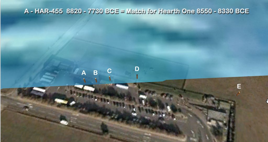
White Sheet Camp third bank – Roman with palisade?
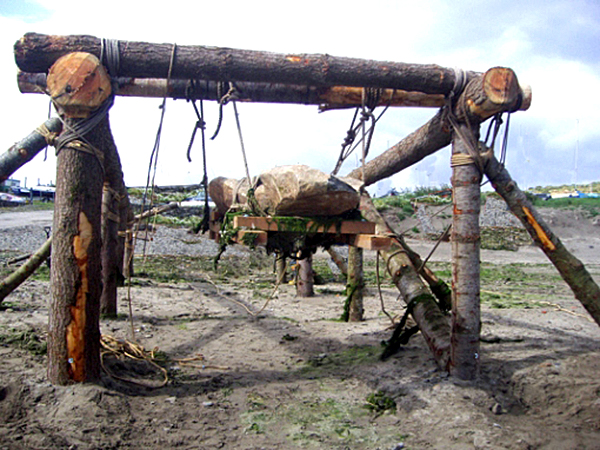
White Sheet Camp - prehistoric Bank and Ditch
White Sheet Camp – Prehistoric Bank and Ditch of 3m deep

Lastly, let’s look at this area in the Mesolithic before the natural harbours were formed in the Late Mesolithic/early Neolithic. We see that this was an isolated island in the landscape. Moreover, we find within this island a Dyke going through the centre and, on the Eastern side, hundreds of small 4m – 8m quarry pits as we have seen with all our investigations of Dykes in Prehistory – this Dyke cuts through both ‘Cross-Dykes’ and terminates at the ‘Causewayed Enclosure. It should be noted that all the Dykes have associated prehistoric Barrows by the side of the cuttings, which confirms the early Neolithic Dates of these features.

White Sheet Camp
Mesolithic Landscape showing an island with Dykes cutting accross the paleochannels (and later Dykes as waters dropped to maintain the sites use

Defence Strategy 101

Roman Defense System

Roman defences (of the same period as the ‘Iron Age’ ), we notice the ditches were relatively small and narrow. These ditches were called ‘Ankle Breaker’ as the purpose was for the assailant to fall into the ditch (usually containing pointed wooden stakes to either injure or kill the assailant) or to at least break their ankle from the fall, making them immobile. These ditches would be 3 to 4 m wide and about 2m deep and could be dug quickly.

Roman Ankle Breaker

The spoil from the ditch would be placed on the defended side of the ditch to give the defendants higher ground and be able to look and fight down against their assailants. Finally, as standing on higher ground without any other defence would make you a clear target, they constructed a fortification of either wood stakes or, later on, if the defence was to be more permanent and substantial of stone so that you could hide looking down above the conflict giving you the needed cover from spears, arrows or stones. This is a basic 1-1 defence that has not changed in thousands of early years as we saw a thousand years onwards with the Normans who had Castles with moats who wanted to slow down assailants so they could use their cross-bows if they attempted to sail across the wide moats as it was too deep to wade across.

Classic Roman Fort With Ditch and Palisade

Lidar Maps Showing No Defences – South Cadbury Castle Illustration

Ditches

Ditch is banked on the wrong side

The LiDAR Maps also show that the ditch of the ditches indicate that they were built for water, as shown by the blue on these images – this then allows us to look at the design of the earthwork in detail, which shows that the banks have been cut by not roads but other ditches. These ditches that cut across the circumference moats cut into them that, suggest that if water had been contained in these ditches, then the vertical dykes could have been used to gaol boats up from the bottom of the dyke ditch to one of these upper moat levels. These same LiDAR maps also show how the soil was distributed to the outside of the moats to enhance and make the feature deeper.

Water Table

This hypothesis of using these ditches can only be proven if we find the natural springs that could have fed these earthworks in the past. We know from our work in studying Rivers such as The Thames and Avon that they were both much higher and of greater volume in the past and at their highest directly after the last ice age and continued to be much higher than today for ten thousand years. This greater height in Rivers is reflected and caused by a higher water table. Within these water tables, natural springs are formed, and water leaks into the land, creating rivers and streams. Although we do not have geological information that allows us to trace past springs, we do find existing springs in this location (still active today at a time of Britain’s lowest water levels ), which suggests our hypothesis is correct.

South Cadbury Castle showing Springs still in existence

Dykes

As we have already suggested, other undocumented features show that this is far from being defensive and used as a trading site. We have noticed that this trading was achieved by creating other earthworks called Linear Earthworks (also known as Dykes). Dykes were introduced when the waters of the Prehistoric fell, and they wanted to continue to use the trading sites, and also they used the Dykes to transport minerals extracted from the many quarries that uncommonly surround these Dykes. Here in South Cadbury Castle, we see not only Dykes feeding the local quarry sites but also placed on the side of the Trading side to allow boats to be parked/moored on the moats of the site ready for unloading/loading.

Slipway built to feed the moats in the upper levels with trading boats
Two Possible Slipways – one connecting directly to a Dyke

The second old earthwork identified via LiDAR technology is a secondary slipway, distinguishable from the initial structure by its lack of connection to a dyke or river. This slipway appears to traverse from the lowest moat up to the top of the site. While photographs may provide a visual reference, the full extent and significance of this feature are best understood through LiDAR models, which enhance the landscape to reveal these historical elements with greater clarity.

The Dykes seen on the LiDAR map are concentrated on the quarry in the East of the Site

Further Reading

For information about British Prehistory, visit www.prehistoric-britain.co.uk for the most extensive archaeology blogs and investigations collection, including modern LiDAR reports.  This site also includes extracts and articles from the Robert John Langdon Trilogy about Britain in the Prehistoric period, including titles such as The Stonehenge Enigma, Dawn of the Lost Civilisation and the ultimate proof of Post Glacial Flooding and the landscape we see today.

Robert John Langdon has also created a YouTube web channel with over 100 investigations and video documentaries to support his classic trilogy (Prehistoric Britain). He has also released a collection of strange coincidences that he calls ‘13 Things that Don’t Make Sense in History’ and his recent discovery of a lost Stone Avenue at Avebury in Wiltshire called ‘Silbury Avenue – the Lost Stone Avenue’.

Langdon has also produced a series of ‘shorts’, which are extracts from his main body of books:

The Ancient Mariners

Stonehenge Built 8300 BCE

Old Sarum

Prehistoric Rivers

Dykes ditches and Earthworks

Echoes of Atlantis

Homo Superior

Other Blogs

s

t

Car Dyke – North Section

This is a primary report of the first LiDAR mapping of Car Dyke in Lincolnshire

Introduction

Car Dyke is one of the most enigmatic and intriguing remnants of Roman engineering in Britain.  Stretching across the Fens of Eastern England, this ancient waterway has puzzled historians, archaeologists, and enthusiasts for centuries.  Theories about its purpose and origin are as varied as they are compelling, reflecting the complexities of interpreting ancient structures without definitive historical records.  This introduction aims to present a comprehensive overview of Car Dyke, encompassing both past and current theories regarding its use and origin.

Car Dyke: A Brief Description

Car Dyke runs for approximately 85 miles (137 kilometres) from Waterbeach in Cambridgeshire to the River Witham near Lincoln.  Its construction is attributed to the Roman period, specifically around the 1st or 2nd century AD.  The Dyke consists of a broad, shallow ditch with accompanying banks, a typical feature of Roman civil engineering, yet its exact function remains a matter of debate.

Early Theories: Navigational and Defensive Purposes

The earliest theories about Car Dyke’s purpose centred around its potential use as a navigational canal.  Some scholars suggested that the Romans constructed it to facilitate the movement of goods and troops across the Fenlands, which were notoriously difficult to traverse due to their marshy nature.  This theory aligns with the Romans’ known prowess in building canals and other hydraulic structures throughout their empire.

Another prevalent early theory posited that Car Dyke served a defensive purpose.  Given the strategic importance of controlling the Fenlands, it was speculated that the Dyke might have been part of a broader military defence network.  The presence of Roman forts and settlements along its route lends some credence to this idea, suggesting that the Dyke could have been a boundary or a means to control movement through the region.

(Car Dyke - North Section)

Our Research

We have now sucessfully mapped the northern section of Car Dyke and located all the findings from periods from Mesolithic Period to modern times. Our objective is to discover or confirm the construction date of the Dyke and its function.

(Car Dyke - North Section)
Fens

The first aspect of the maps show that Car Dyke ‘hugs’ the raised shorelines of the Fen Area. This is in contrast to the modern and some Roman drainage ditches.

(Car Dyke - North Section)
Car Dyke – Profile

Locks and Water Management

One of the most striking anomalies observed in the Car Dyke is the varying elevation profile along its course. Contrary to what might be expected from a Roman engineering project, the dyke does not maintain a flat or consistent gradient. In fact, in some sections, the elevation fluctuates by as much as 4 meters (14 feet) without the apparent use of locks to regulate water flow.

This irregularity raises intriguing questions about the design and function of the Car Dyke. Historically, Greek engineers were pioneers in using canal locks, employing them to manage water levels in the Ancient Suez Canal as early as the 3rd century BC. Similarly, under Emperor Trajan, the Romans utilised sluice gates to control water flow at the entrance to the Red Sea, extending the canal south to what is now Cairo to improve water inflow.

The possibility that the Romans might have used ancient pound locks to manage height differences in canals has been proposed by several scholars. These locks would have allowed for regulating water levels and bridging elevation gaps, much like modern lock systems. However, the absence of clear archaeological evidence for such structures in the Car Dyke—or elsewhere in Roman Britain—leaves this hypothesis unresolved.

Given the significant elevation changes along the Car Dyke, the lack of any visible lock mechanisms suggests alternative explanations must be considered. It’s possible that natural springs or other water sources were strategically utilised to maintain water levels or that the dyke served a different purpose altogether, one that did not require precise water level management.

The question of whether ancient pound locks were used in the Car Dyke remains one of the many mysteries surrounding this ancient structure. Without concrete archaeological evidence, the debate is likely to continue. However, the abnormal elevation profile is a critical factor that must be addressed in any comprehensive analysis of the Car Dyke’s construction and function. As we delve deeper into the investigation, understanding how these variations in height were managed will be crucial to unravelling the true nature of this enigmatic alleged Roman legacy.

(Car Dyke - North Section)
Wibbly-Wobbly pathway is not of Roman design

Dyke Design

In examining the northern section of the Car Dyke, we observe two markedly different design patterns, each suggesting a distinct approach to engineering. The first pattern, characterised by a “wibbly-wobbly” alignment, closely follows the contours of higher land formations and hugs the shoreline. In contrast, the second design, which traverses the low-lying marshlands (indicated in blue), features the straight, linear precision typically associated with Roman engineering.

This stark contrast in design raises the possibility of looking at two different techniques, potentially indicative of two separate historical periods and civilisations at work. The “wibbly-wobbly” design, with its organic, meandering course, suggests a construction that prioritised the natural landscape, possibly indicating a pre-Roman origin. This approach aligns with a more ancient engineering practice, where the path of the dyke would have been dictated by the topography and the need to follow natural water sources or higher ground to avoid flooding.

The more uniform and linear sections of the dyke, on the other hand, are characteristic of Roman engineering. The Romans emphasised straight lines and efficient, purposeful design, often cutting across landscapes with little regard for natural obstacles. This technique is evident in their roads, aqueducts, and canals, where functionality and directness were paramount.

Given these observations, it is logical to hypothesise that the Car Dyke in its “wibbly-wobbly” form may have been an earlier construction, later adapted or reused by the Romans. This scenario suggests a continuum of engineering efforts, where the Romans recognised the utility of an existing structure and modified or extended it according to their own methods and needs.

Roman Roads and car dyke
Car Dyke and Roman Roads that are Straight

This theory of two distinct periods of construction is supported by the duality in the dyke’s design: the original, meandering path possibly built by an earlier civilisation and the later, more systematic Roman modifications. The reuse of earlier infrastructure by the Romans was not uncommon; they often incorporated and improved upon existing works, blending local traditions with their engineering principles.

While this hypothesis offers a compelling narrative, it remains speculative without further archaeological evidence. The precise dating of the different sections and the identification of specific construction techniques and materials will be crucial in confirming whether the “wibbly-wobbly” sections indeed predate the Roman modifications.

If this interpretation holds, it would provide valuable insights into the history of the region, illustrating a timeline where the Car Dyke evolved from a local engineering solution to a component of the expansive Roman infrastructure network. This layered history would highlight the Romans’ pragmatic approach to utilising existing resources and underscore the continuity and adaptation of engineering practices across different civilisations in Britain.

In conclusion, the northern section of the Car Dyke, with its dual design characteristics, likely reflects two distinct historical phases. The “wibbly-wobbly” sections suggest an earlier, possibly pre-Roman origin, later integrated into the Roman landscape through their characteristic straight-line construction. This scenario offers a fascinating glimpse into the interaction between different cultures and the evolution of engineering practices over time. Further research and excavation will be essential to validate this theory and fully understand the complex history of the Car Dyke.

The Maths and Proof of Concept

End of The Northern Section

This is the end of the Northern section and the Lincolnshire database. It allows us to examine the number of artefacts found and the probability that they were in use during this period. This probability is calculated by understanding the frequency of finds on Average over the entire county.  Consequently, this is the collective number of artefacts found in Lincolnshire:

To calculate the prior probabilities for each period based on the total number of finds in Lincoln, we first calculate the total number of finds across all periods:

Step 1: Total Number of Finds

Total Finds=13,723(Roman)+8,994(Medieval)+5,619(Post Medieval)+1,680(Early Medieval)+2,451(Iron Age)+2,091(Neolithic)+634(Mesolithic)+980(Bronze Age)=36,172\text{Total Finds} = 13,723 (\text{Roman}) + 8,994 (\text{Medieval}) + 5,619 (\text{Post Medieval}) + 1,680 (\text{Early Medieval}) + 2,451 (\text{Iron Age}) + 2,091 (\text{Neolithic}) + 634 (\text{Mesolithic}) + 980 (\text{Bronze Age}) = 36,172Total Finds=13,723(Roman)+8,994(Medieval)+5,619(Post Medieval)+1,680(Early Medieval)+2,451(Iron Age)+2,091(Neolithic)+634(Mesolithic)+980(Bronze Age)=36,172

Step 2: Calculate Prior Probabilities

Divide the number of finds for each period by the total number of finds:

P(Roman)=13,72336,172≈0.3794P(\text{Roman}) = \frac{13,723}{36,172} \approx 0.3794P(Roman)=36,17213,723​≈0.3794 P(Medieval)=8,99436,172≈0.2487P(\text{Medieval}) = \frac{8,994}{36,172} \approx 0.2487P(Medieval)=36,1728,994​≈0.2487 P(Post Medieval)=5,61936,172≈0.1554P(\text{Post Medieval}) = \frac{5,619}{36,172} \approx 0.1554P(Post Medieval)=36,1725,619​≈0.1554 P(Early Medieval)=1,68036,172≈0.0465P(\text{Early Medieval}) = \frac{1,680}{36,172} \approx 0.0465P(Early Medieval)=36,1721,680​≈0.0465 P(Iron Age)=2,45136,172≈0.0678P(\text{Iron Age}) = \frac{2,451}{36,172} \approx 0.0678P(Iron Age)=36,1722,451​≈0.0678 P(Neolithic)=2,09136,172≈0.0578P(\text{Neolithic}) = \frac{2,091}{36,172} \approx 0.0578P(Neolithic)=36,1722,091​≈0.0578 P(Mesolithic)=63436,172≈0.0175P(\text{Mesolithic}) = \frac{634}{36,172} \approx 0.0175P(Mesolithic)=36,172634​≈0.0175 P(Bronze Age)=98036,172≈0.0271P(\text{Bronze Age}) = \frac{980}{36,172} \approx 0.0271P(Bronze Age)=36,172980​≈0.0271

Summary of Prior Probabilities:

  • Roman: 0.3794
  • Medieval: 0.2487
  • Post Medieval: 0.1554
  • Early Medieval: 0.0465
  • Iron Age: 0.0678
  • Neolithic: 0.0578
  • Mesolithic: 0.0175
  • Bronze Age: 0.0271

Step 1: Define Prior Probabilities

Using the prior probabilities:

  • Roman: P(HRoman)=0.3794P(H_{\text{Roman}}) = 0.3794P(HRoman​)=0.3794
  • Bronze Age: P(HBronze Age)=0.0271P(H_{\text{Bronze Age}}) = 0.0271P(HBronze Age​)=0.0271
  • Neolithic/Mesolithic: P(HNeolithic/Mesolithic)=0.0753P(H_{\text{Neolithic/Mesolithic}}) = 0.0753P(HNeolithic/Mesolithic​)=0.0753

Step 2: Evidence Likelihoods Based on Local Data

Given the distribution of finds:

  • Roman: P(ERoman∣HRoman)=24132≈0.1818P(E_{\text{Roman}}|H_{\text{Roman}}) = \frac{24}{132} \approx 0.1818P(ERoman​∣HRoman​)=13224​≈0.1818
  • Bronze Age: P(EBronze Age∣HBronze Age)=47132≈0.3561P(E_{\text{Bronze Age}}|H_{\text{Bronze Age}}) = \frac{47}{132} \approx 0.3561P(EBronze Age​∣HBronze Age​)=13247​≈0.3561
  • Neolithic/Mesolithic: P(ENeolithic/Mesolithic∣HNeolithic/Mesolithic)=61132≈0.4621P(E_{\text{Neolithic/Mesolithic}}|H_{\text{Neolithic/Mesolithic}}) = \frac{61}{132} \approx 0.4621P(ENeolithic/Mesolithic​∣HNeolithic/Mesolithic​)=13261​≈0.4621

Step 3: Apply Bayes’ Theorem

Posterior Probability for Roman:

P(HRoman∣E)=0.1818×0.3794P(E)=0.0689P(E)P(H_{\text{Roman}}|E) = \frac{0.1818 \times 0.3794}{P(E)} = \frac{0.0689}{P(E)}P(HRoman​∣E)=P(E)0.1818×0.3794​=P(E)0.0689​

Posterior Probability for Bronze Age:

P(HBronze Age∣E)=0.3561×0.0271P(E)=0.0097P(E)P(H_{\text{Bronze Age}}|E) = \frac{0.3561 \times 0.0271}{P(E)} = \frac{0.0097}{P(E)}P(HBronze Age​∣E)=P(E)0.3561×0.0271​=P(E)0.0097​

Posterior Probability for Neolithic/Mesolithic:

P(HNeolithic/Mesolithic∣E)=0.4621×0.0753P(E)=0.0348P(E)P(H_{\text{Neolithic/Mesolithic}}|E) = \frac{0.4621 \times 0.0753}{P(E)} = \frac{0.0348}{P(E)}P(HNeolithic/Mesolithic​∣E)=P(E)0.4621×0.0753​=P(E)0.0348​

Step 4: Normalize the Posterior Probabilities

Sum of the calculated values for normalisation:

P(E)=0.0689+0.0097+0.0348≈0.1134P(E) = 0.0689 + 0.0097 + 0.0348 \approx 0.1134P(E)=0.0689+0.0097+0.0348≈0.1134

Now, calculate the normalised posterior probabilities:

  • Roman:

P(HRoman∣E)=0.06890.1134≈0.6074P(H_{\text{Roman}}|E) = \frac{0.0689}{0.1134} \approx 0.6074P(HRoman​∣E)=0.11340.0689​≈0.6074

  • Bronze Age:

P(HBronze Age∣E)=0.00970.1134≈0.0855P(H_{\text{Bronze Age}}|E) = \frac{0.0097}{0.1134} \approx 0.0855P(HBronze Age​∣E)=0.11340.0097​≈0.0855

  • Neolithic/Mesolithic:

P(HNeolithic/Mesolithic∣E)=0.03480.1134≈0.3069P(H_{\text{Neolithic/Mesolithic}}|E) = \frac{0.0348}{0.1134} \approx 0.3069P(HNeolithic/Mesolithic​∣E)=0.11340.0348​≈0.3069

Analysis and Interpretation:

  • Neolithic/Mesolithic: The higher frequency of finds in this period significantly increases its posterior probability to approximately 30.69%, which is quite substantial.
  • Roman: Despite having fewer finds in this area, the Roman period still has a high posterior probability due to its higher prior, but it is now only about 60.74%.
  • Bronze Age: The probability for the Bronze Age period remains lower at approximately 8.55%.

Conclusion:

The calculated probabilities show a more balanced view, with the Roman period still favoured but with a much stronger case for the Mesolithic/Neolithic period. This suggests that while Roman use of the Dyke is still likely, the Mesolithic/Neolithic period also holds significant importance, potentially indicating earlier use or occupation before the Romans.

Langdon Mathematics

While Bayesian theory often yields definitive results, its accuracy can be compromised due to its dependence on subjective prior assumptions, which may only sometimes reflect reality. If these priors are not well-chosen or are based on incomplete or biased information, the resulting analysis might be misleading.

Therefore, relying solely on Bayesian methods without considering the variability and complexity of archaeological data could lead to conclusions that only partially capture the nuances of the actual distribution of artefacts. My method, which focuses on spatial analysis and empirical data, addresses these limitations.

My approach to calculating finds would differ significantly. First, I would define the area where artefacts could be discovered—using Lincolnshire as a reference due to its comprehensive archaeological data. By doing so, we can estimate the expected number of artefacts per square meter of Lincolnshire land, offering a more objective and spatially grounded method for understanding artefact distribution.

As IA reports:

To calculate the percentage likelihood of finding an artefact from each period in a single square meter of Lincolnshire, we can follow these steps:

Step 1: Determine the Area of Lincolnshire

  • Area of Lincolnshire: Approximately 6,959 square kilometres (6,959,000,000 square meters).

Step 2: Calculate the Find Density

For each period, calculate the density of finds per square meter by dividing the total number of finds by the area of Lincolnshire.

​

Step 3: Calculate the Likelihood for Each Period

  1. Roman:

Likelihood: 0.000156%

  • Neolithic:

Likelihood: 0.000011%

  • Mesolithic:

Likelihood: 0.000004%

  • Bronze Age:

Likelihood: 0.000003%

Summary of Likelihoods in order of expectation:

  • Roman: 0.000156%
  • Medieval: 0.000129%
  • Post Medieval: 0.000081%
  • Early Medieval: 0.000024%
  • Iron Age: 0.000021%
  • Neolithic: 0.000011%
  • Mesolithic: 0.000004%
  • Bronze Age: 0.000003%

These percentages represent the likelihood of finding an artefact from each period in a square meter of Lincolnshire. Given the extensive activity during that time, the highest is for the Roman period, just marginally ahead of the Medieval period.

We now need to look at the search area (63 miles of the Northern End of Car Dyke) as listing on the LiDAR maps in the previous section of the book.  We must first calculate the total search area in square metres, count the number of finding within this area, and then compare against the expected number.

Summary of Expected Finds:

  • Roman: 15.83 artefacts
  • Medieval: 13.07 artefacts
  • Post Medieval: 8.19 artefacts
  • Early Medieval: 2.44 artefacts
  • Iron Age: 2.17 artefacts
  • Neolithic: 1.07 artefacts
  • Unknown: 0.59 artefacts
  • Modern: 0.50 artefacts
  • Mesolithic: 0.36 artefacts
  • Bronze Age: 0.34 artefacts

Summary of Items Found:

  • Mesolithic/Neolithic: 61 finds
  • Bronze Age: 47 finds
  • Roman: 24 finds

Calculate the Odds of This Kind of Find

For each period, the odds ratio of finding this many artefacts compared to the expected finds:

Step 4: Interpret the Results

  • Mesolithic/Neolithic: A massive 5589.72% increase and an odds ratio of 57.01 suggest significant activity during this period, far beyond what was expected.
  • Bronze Age: An even higher increase of 13723.53% and an odds ratio of 138.24 indicate the area was very important during the Bronze Age.
  • Roman: A modest 51.60% increase with an odds ratio of 1.52 suggests Roman activity, but not as dominant as the earlier periods.

Conclusion

The very high percentage increases and odds ratios for the Mesolithic/Neolithic and Bronze Age periods strongly suggest that the Car Dyke area was occupied and actively used during these times, with significant archaeological activity that exceeds what would be expected based on general Lincolnshire data. While still represented, the Roman period is less prominent in this area compared to the earlier periods.

This confirms other Dyke surveys such as Offa’s and Wansdyke that also show design (wibbly-wobbly) in construction attributed to the builders seeking natural springs rather than a direct line of route to maintain water levels which were achieved at a later date in history by locks.

Further Reading

For information about British Prehistory, visit www.prehistoric-britain.co.uk for the most extensive archaeology blogs and investigations collection, including modern LiDAR reports.  This site also includes extracts and articles from the Robert John Langdon Trilogy about Britain in the Prehistoric period, including titles such as The Stonehenge Enigma, Dawn of the Lost Civilisation and the ultimate proof of Post Glacial Flooding and the landscape we see today.

Robert John Langdon has also created a YouTube web channel with over 100 investigations and video documentaries to support his classic trilogy (Prehistoric Britain). He has also released a collection of strange coincidences that he calls ‘13 Things that Don’t Make Sense in History’ and his recent discovery of a lost Stone Avenue at Avebury in Wiltshire called ‘Silbury Avenue – the Lost Stone Avenue’.

Langdon has also produced a series of ‘shorts’, which are extracts from his main body of books:

The Ancient Mariners

Stonehenge Built 8300 BCE

Old Sarum

Prehistoric Rivers

Dykes ditches and Earthworks

Echoes of Atlantis

Homo Superior

Other Blogs

s

t

Top Ten Misidentified Fire Beacons in British History

Introduction

Misidentification of objects by archaeologists is unfortunately frequent, particularly evident in the study of prehistoric fire beacons. This phenomenon can often be attributed to the curricula of archaeological academic programs, which may not always foster a rigorous scientific attitude. This issue is compounded by the perception that these programs are less demanding than disciplines such as physics, chemistry, and biology, which typically require a stronger foundation in logic and mathematics for professional success. (Top Ten misidentified Fire Beacons in British History)

The educational limitations in archaeological curricula are further magnified by a trend to prioritise adherence to established classifications over critical analysis. This approach often leads to misidentifications. For example, when faced with a large earth mound, archaeologists might automatically categorise it as a burial mound or a motte-and-bailey site based solely on standard conclusions drawn from past peer-reviewed publications. This reliance on precedent, often rooted in initial assumptions without comprehensive evidence, perpetuates a cycle of educated guesswork.

Top Ten misidentified Fire Beacons in British History
Top Ten Misidentified Fire Beacons in British History

As a result, a narrative has evolved over the past seventy years that has become challenging for scientists to penetrate and rectify. These historical misinterpretations include the stereotype of “cavemen” who lived in caves and the notion of hunter-gatherers who roamed all day in furs, hunting live game while women gathered berries and fruit. These ideas later evolved into the image of people living in round mud houses with their animals for warmth. Such portrayals conflict with empirical evidence showing that prehistoric societies constructed more durable and sophisticated structures, such as Stonehenge, numerous hill settlements, stone circles, and linear earthworks, which exhibit a level of architectural longevity surpassing even that of the highly advanced Romans.

The advanced woodworking evident at sites like Star Carr, which dates back ten thousand years, along with the sophisticated mortise-and-tenon joints found in stone structures like Stonehenge, clearly contradicts the traditional ‘hunter-gatherer’ classification. These findings suggest a significant misrepresentation of the technological capabilities and societal structures of prehistoric societies in Britain. Recent advancements in scientific tools, such as LiDAR, have further illuminated these inaccuracies. They reveal that these societies were using boats 8,000 years earlier than previously recognised in conventional archaeological narratives. Moreover, the discovery of over 1,500 linear earthworks across Britain indicates that these prehistoric populations were extensively involved in extracting and trading minerals, revealing a complex, interconnected society far more advanced than the simple hunter-gatherer model suggests.

The evidence of a boat civilisation, which not only engaged in waterborne trade but also likely lived on these boats due to insufficient terrestrial dwellings, draws parallels with contemporary practices observed in many Far Eastern countries today. If educational institutions included these facts in the curriculum for archaeologists, it could lead to a significant shift in how archaeological finds are interpreted. For instance, when encountering an earthwork such as a bank mound, educated archaeologists might take the likelihood that it is a fire beacon more seriously. This consideration is supported by the prevalence of such structures, which outnumber traditional interpretations such as motte-and-bailey castles and burial mounds in Britain today. This shift in perspective could enhance understanding and interpretation of archaeological sites, leading to more accurate reconstructions of historical societies. (Top Ten misidentified Fire Beacons in British History).

1. Silbury Hill – misidentified as a burial mound & 2. Marlborough Mount – Motte and Bailey Castle

According to EH – “The largest artificial mound in Europe, mysterious Silbury Hill compares in height and volume to the roughly contemporary Egyptian pyramids. Probably completed in around 2400 BC, it apparently contains no burial. Though clearly important in itself, its purpose and significance remain unknown.”

The purpose of Silbury Hill remains a mystery today. Originally, it was believed to be a grand burial mound for a mythical King Sil of England and his golden horse. This belief led to the excavation of a large, dangerous shaft in the mound in search of treasure—a decision influenced by flawed educational assumptions. When this initial excavation failed to reveal any treasures, they instead drove another horizontal shaft into the mound rather than reconsidering their hypothesis. This, too, uncovered nothing but chalk. The continued lack of findings underscores a significant disconnect and highlights a substantial gap in understanding the historical context and the civilisation that built Silbury Hill.

Top Ten misidentified Fire Beacons in British History
Original design of Silbury Hill – NOT what you see today

The initial assumption that Silbury Hill was a burial mound led to multiple excavations that failed to uncover any evidence to support this theory. Meanwhile, empirical evidence suggests a different story: during winter, the surrounding area floods, and historical-geographical maps indicate that the River Kennet, nearby, was much larger in the past. Given these facts, it would be reasonable to hypothesise that Silbury Hill served a practical purpose, such as acting as a fire beacon for the boats of the prehistoric society that constructed the mound.

This perspective aligns with the environmental context and the strategic importance of elevated structures in ancient water-based societies. Yet the reluctance to move away from traditional burial mound theories may reflect a broader hesitation within the archaeological field to embrace new interpretations without definitive evidence, leaving the true purpose of Silbury Hill largely a matter of conjecture among archaeologists.

If you understand how the landscape looked and was used in the past, then such beacons can be easily found all over Britain, even ones built to a similar design to Silbury Hill. To find this unique design, we can look at the most recent re-excavation and detailed examination of Silbury Hill by English Heritage.  Only a few years ago, it needed to be ‘shored up’ because of the reckless archaeologists of the past who cut vast tunnels and shafts into the hill in search of tombs and treasure, making it totally unstable.  This investigation showed for the first time that the hill was built like the pyramids of Egypt and South America in steps.  (Top Ten misidentified Fire Beacons in British History).

This is from The Daily Mail in 2010:

Figure 78 - Silbury Hill made like a 'layer cake' - Silbury Hill Lighthouse
Top Ten Misidentified Fire Beacons in British History
Figure 78 – Silbury Hill made like a ‘layer cake’ – Silbury Hill Lighthouse

Silbury Hill – one of the most mysterious and striking monuments in Britain – was a prehistoric ‘cathedral’, built layer by layer over 100 years, a new study suggests. The 4,000-year-old earth mound, which towers over the Wiltshire countryside, was the tallest human-made structure in Europe until the Middle Ages.

However, despite its size and repeated attempts to tunnel into the heart of the mound, archaeologists have long been puzzled about how and why it was created.

Now, a new book published by English Heritage suggests that the 120-ft-high hill was not built to a grand blueprint but was assembled by at least three generations of Bronze Age Britons between 2400 and 2300 BC.  A study of soil, rocks, gravel, and tools inside the hill shows that it underwent 15 distinct stages of development.

Dr Jim Leary, English Heritage archaeologist, said the creators were building the mound as part of a ‘continuous storytelling ritual’ – and that the final shape of the mound may have been unimportant. He argues that the familiar outline of stepped sides and the flat top visible today is primarily the result of Anglo-Saxon activity and subsequent alterations.

“Most interpretations of Silbury Hill have, up to now, concentrated on its monumental size and its final shape,’ he said.  ‘It has generally been thought to be a concerted effort of generations of people building something out of a common vision and spiritual zeal akin to that spurred the creation of soaring medieval cathedrals.

‘The flat top, especially, was often seen to be a “platform” deliberately built to bring people closer to the skies.  ‘But new evidence is increasingly telling us that our Neolithic ancestors display an almost obsessive desire to constantly change the monument – to rearrange, tweak and adjust it. It’s as if the final form of the Hill did not matter – it was the construction process that was important.”

Silbury Hill lies close to the stone circles of Avebury and a few miles from Stonehenge. Archaeologists estimate that it would have taken 700 men working for ten years to build out of soil and chalk. It started as a low gravel mound before it was transformed into a pile of soil and rock surrounded by a ditch.

Dr Leary added: “The most intriguing discovery is the repeated occurrence of antler picks, gravel, chalk and stones in different kinds of layering, in ways that suggest that these materials and their different combinations had symbolic meanings.  We don’t know what myths they were representing but they must have meant something quite compelling and personal. 

What we do know is that by the time work on the hill had started in the later Neolithic period, the surrounding area was already saturated with evidence of past use; it was a place heavily inscribed with folk memories recalling ancestors and their origins.  What is emerging is a picture of Neolithic people having the same need to anchor and share ideas and stories as we do now, and that built structures like Silbury Hill may not be conceived as grand monuments of worship but intimate gestures of communication.”

The hill was damaged in the 18th century when archaeologists sank a vertical shaft from the top. In the 1840s, a tunnel was dug into the mound from the edge, while in 1968, BBC2 filmed a new attempt to tunnel into the mound’s centre.

After parts of the mound began to sink in 2002, English Heritage reopened the BBC tunnel, took soil and rock samples, filled in the gaps, and sealed the mound for good.

Dr Leary now believes the mound went through 15 stages of construction, and up to 100 different phases within four or five generations.  It would make sense that a monument was a round-based hill made in layers (similar to Marlborough Mound – sometimes known as Merlin’s Barrow, also excavated by Dr Leary, hence his idea!). The question not answered by archaeologists is – why build this monument in stages? 

Fortunately, the answer is simple – to make it higher, for Silbury was a beacon to attract ships to its harbour.  Over time, the height of the mound was raised to increase the beacon’s visibility. (Top Ten misidentified Fire Beacons in British History).

Figure 79 - Marlborough Mount - Built like Silbury Hill - Silbury Hill Lighthouse
Top Ten misidentified Fire Beacons in British History
Figure 79 – Marlborough Mount – Built like Silbury Hill – Silbury Hill Lighthouse

‘The flat top, especially, was often seen to be a “platform” deliberately built to bring people closer to the skies. 

Unfortunately, the article is also full of nonsense like this quotation.  So, the ancestors built a hill at the bottom of a valley to get closer to the skies – is it me, or can anyone see the error in this statement?  You may therefore respond to my criticism by asking – Wouldn’t a beacon on top of a hill have greater visibility?  Yet the reason the beacon is located in the watery harbour and not on top of a hill is that the light shows the exact location of mooring places, in bad weather and at night, when visibility is poor.

This type of device can be seen throughout our recent nautical history, as illustrated at the Spurn Point Lighthouse.  The earliest reference to a lighthouse on Spurn Point dates to 1427, when it was a coal-fired lighthouse at ground level.  There were several lighthouses of various designs until, in 1767, John Smeaton was commissioned to build a new pair of lighthouses (one a 90ft tower). The 1895 lighthouse is a round brick tower, 128ft tall, painted black and white. It was designed by Thomas Matthews. Its main light had a range of 17 nautical miles.

Silbury Hill also started at ground level and was built up (like Spurn Point) over hundreds of years until it reached the 120ft height seen today. (Top Ten misidentified Fire Beacons in British History).

From the Guardian, 31st May 2011

For generations, it has been scrambled up with pride by students at Marlborough College. But the mysterious, pudding-shaped mound in the grounds of the Wiltshire public school now looks set to gain far wider acclaim as scientists have revealed it is a prehistoric monument of international importance.

After thorough excavations, the Marlborough mound is now thought to be around 4,400 years old, making it roughly contemporary with the nearby, and far more renowned, Silbury Hill.

The new evidence was described by one archaeologist, an expert on ancient ritual sites in the area, as “an astonishing discovery”. Both Neolithic structures are likely to have been constructed over many generations.

The Marlborough mound had been thought to date back to Norman times. It was believed to be the base of a castle built 50 years after the Norman invasion and later landscaped as a 17th-century garden feature. But it has now been dated to around 2400BC from four samples of charcoal taken from the core of the 19-metre-high hill.

The Marlborough mound has been called “Silbury’s little sister”, after the more famous artificial hill on the outskirts of Avebury, which is the largest manmade prehistoric hill in Europe.

Marlborough, at two-thirds the height of Silbury, now becomes the second largest prehistoric mound in Britain; it may yet be confirmed as the second largest in Europe.

Jim Leary, the English Heritage archaeologist who led a recent excavation of Silbury, said: “This is an astonishing discovery. The Marlborough mound has been one of the biggest mysteries in the Wessex landscape. For centuries, people have wondered whether it is Silbury’s little sister, and now we have an answer. This is a very exciting time for British prehistory.”

(Top Ten misidentified Fire Beacons in British History)

Fire Beacon

Marlborough Mound shows that fires were lit on the hill throughout its use, and the same fact can be found at Silbury Hill. Jim Leary’s excavations showed signs of fire and associated dates for these charcoal remains. According to Jim:

Old Land Surface

Sample: OxA-20808

Hazelnut fragments (from the same hazelnut) from [4041] – sample <9821>, sub-sample of <9435>. [4041] is a concentration of charcoal comprising charred hazel nutshell fragments and other charred remains as well as two pig or wild boar teeth. It was recorded within a small, defined area of the upper part of the OLS (4041]) on the north side of the East Lateral in Bay 7, and is thought to indicate the remains of a hearth.

Radiocarbon Date: 4012±29; 2620–2460 cal BC; 2510–2465 cal BC

Sample: SUERC- 24089
Maloideae branchwood (single entity) as OxA-20808

Radiocarbon Date: 4030±35; 2840–2470 cal BC; 2510–2465 cal BC

This presence of charcoal is reinforced by: Canti, Matthew & Campbell, Gill & Robinson, D.. (2004). Site Formation, Preservation and Remedial Measures at Silbury Hill. Who reported that: ” The remaining part of Core 5 consisted of around 29 m of chalk rubble from the rest of the mound, and this was also assessed for the presence of biological remains. Samples were taken at 25 cm intervals respecting interfaces, and floated using a 0.25 mm mesh for the flot and a 0.5 mm mesh for the residue. Tiny fragments of charcoal were present at intervals throughout the depth of the mound.”

This clearly shows that both Fire beacons were used around 2400 – 2500 BCE, when the Neolithic Waters were still high and could carry boats. (Top Ten misidentified Fire Beacons in British History).

3. Brack Mount – missidentified as a Motte and Bailey

In Lewes, a village nestled in the South Downs, stands an intriguing prehistoric structure known as the ‘Brack Mount’. Local historians have traditionally linked this mound to the nearby Norman Castle, presenting it as an additional feature connected by a wall to the main Motte and Bailey structure. This interpretation paints the Brack Mount as an integral part of the medieval landscape, purportedly serving to attract shipping.

However, recent archaeological investigations complicate this picture. A Norman well was discovered at the summit of the Brack Mount. This finding raises significant questions about the dating and function of the mound. The construction of a 50-foot-high earth mound followed by the excavation of a 60-foot-deep well at its peak suggests a sequence of use that might not align with the timeline of Norman castle construction. Why would you attempt to build a well in a mound you have constructed, knowing it will not contain water until it reaches ground level?? This discrepancy suggests that the Brack Mount may predate the Norman structures, possibly having served an entirely different function before being adapted by the Normans.

This mount, existing at an earlier date, has now been accepted by archaeologists, especially as Roman finds have been found in test pits on the mount:

“While the form of the mound which survives to this day is undoubtedly Norman in date, it has recently been suggested that it may have utilised the site of one of a number of pre-existing tumuli or burial mounds of possible Romano-British origin located within the bounds of the later settlement (Bleach 1997). A factor underpinning the site’s potential ritual and later strategic use was its dominant position within the landscape, for it marks the end of a prominent chalk spur commanding excellent views of the Ouse Valley, especially upstream.” Lewes Archaeological Society.

The presence of the well might indicate that the mound was originally built for a different purpose, perhaps even as a beacon or lookout point, which was later repurposed to serve the castle. This theory challenges the traditional interpretation and suggests a more complex historical usage of the landscape in Lewes. If we look at the LiDAR map of Lewes, we can see how the town was not only on a great river but was a harbour for boats from the English Channel. (Top Ten misidentified Fire Beacons in British History).

Brack Mount
Fire beacon Built on the shoreline of the prehistoric shoreline – Top Ten misidentified Fire Beacons in British History
Brack Mount
The Fire Beacon is 6m lower than the Norman Motte – Top Ten misidentified Fire Beacons in British History

3. The Trump

The Lewes Trump, another significant mound often dismissed by archaeologists as merely a garden feature, raises further questions about Lewes’s historical landscape. Standing 75 feet tall with a circumference of 140 feet, it suggests a purpose far more substantial than ornamental garden decor. Located on the edge of the monastery’s grounds, this mound, originally known as The Mount, is strategically placed on Lewes’s prehistoric shoreline, according to LiDAR maps.

Adjacent to The Trump is an ancient site known as the “dripping pan,” historically used by Cluny Monks for salt production, a process that required constant access to saltwater. This proximity to a salt production site and its strategic positioning on the former shoreline lend credence to the argument that The Trump served a navigational purpose. It likely functioned as a fire beacon, guiding ships—particularly those from France through the English Channel—towards safe harbours and the monastery.

These insights challenge the more straightforward interpretation of The Trump as a garden feature, instead highlighting its role in a complex network of maritime navigation and monastic industry, underscoring the need to reevaluate such historical structures beyond their immediate physical context. (Top Ten misidentified Fire Beacons in British History)

Figure 81- Lewes Tump - used by the 'Cluny' monks to attract ships from the English Channel - Silbury Hill Lighthouse
Rather too large to be a ‘garden feature’? – Top Ten misidentified Fire Beacons in British History
The Trump and Dripping Pan
The Trump and Dripping Pan made to be by the shoreline of the Harbour – Top Ten misidentified Fire Beacons in British History

4. Cadwgan Hall Mount – Motte and Bailey

Plas Cadwgan mound is a mutilated oval hillock used for livestock in a field next to the farm of the same name. It is immediately next to Offa’s Dyke, and part of it was cut away to create an air raid shelter in the Second World War. There is some debate about whether it was actually a motte or not, but strategically, it matches others of this type next to a crossing point and stream. There is no evidence of a bailey, but there is the suggestion of a ditch, and that it was used as a burial mound in antiquity.

Top Ten misidentified Fire Beacons in British History
Top Ten Misidentified Fire Beacons in British History

LiDAR clearly shows that this is a mound on a river – that would have been much larger in the past, and it can only be identified as a ‘Fire Beacon’ for boats.

Top Ten misidentified Fire Beacons in British History
If we add the Mesolithic waters, then we can see it was made on the shoreline of the river, which connected with Offa’s Dyke
Map showing that even though EH called it a Motte and Bailey, First Edition OS said it was a tumulus -Top Ten misidentified Fire Beacons in British History

(Top Ten misidentified Fire Beacons in British History)

5. Bradfield (Sheffield) – Motte and Bailey

According to HE – “Believed to be a 12th century castle of the de Furnivals, the monument comprises a motte c.18m high whose summit has been disturbed by amateur excavation, leaving it crescent shaped in plan. During excavations in 1720, squared tool-marked stones were found which have been interpreted as the foundations of a tower. A deep, steep-sided ditch c.9m wide circles the motte to the north and extends southward along the east flank of the monument, following the south-westward curve of a substantial 8m wide rampart. At its northern end, the rampart stops just short of the motte. At its southern end, it curves round to meet the edge of the sharp drop down into the valley of Rocher End Brook. (Top Ten misidentified Fire Beacons in British History) This scarp forms a natural western defence to a small semi- circular bailey measuring c.15m x 30m, though it is likely this edge was also palisaded. A low bank running between the scarp and the motte ditch at the northern end of the bailey is all that survives of another section of rampart. A causeway across the motte ditch just south of this was a point of access to the motte from the bailey. Access to the bailey seems to have been from the south-west or, alternatively, from the east across the outer ditch, where a route up from the village and church would have passed through the gap between motte and rampart. A ditch also divides the bailey from the east rampart. Modern walling and fencing is excluded from the scheduling though the ground beneath is included.“

 (Top Ten misidentified Fire Beacons in British History)
It doesn’t even remotely look like a Motte – Top Ten misidentified Fire Beacons in British History

The case of Bradfield offers an intriguing puzzle in historical interpretation and archaeological classification. According to the Domesday Book, Bradfield didn’t exist during the Norman period, which raises significant questions about the motivations behind constructing an expensive Motte and Bailey there. Without a local population to tax, the financial rationale for maintaining an expensive garrison becomes unclear—especially without the traditional threats from the Welsh or Picts to justify such fortifications.

Top Ten misidentified Fire Beacons in British History
It’s positioned not even close to a road needed for castle provisions – Top Ten misidentified Fire Beacons in British History

Furthermore, the defensive Bailey at Bradfield is notably small, measuring just 15 meters by 30 meters, which further complicates understanding its purpose. Such a diminutive size seems impractical for significant defensive operations, challenging the notion that it was built with a primary military purpose in mind.

Top Ten misidentified Fire Beacons in British History
The Dyke connects to the local River in prehistoric times – clearly showing it’s a fire beacon – Top Ten misidentified Fire Beacons in British History

This scenario illustrates a broader issue within archaeology: the tendency to assign a “Motte and Bailey” classification to any unidentifiable mound. This default categorisation can lead to misinterpretations of archaeological sites, as it may oversimplify or entirely overlook the actual historical and functional complexities of these structures. In the case of Bradfield, the lack of contemporaneous settlement and the impractical size of the Bailey suggest that alternative explanations for the mound’s purpose should be explored, rather than settling for a conventional but possibly inaccurate historical narrative. Such instances highlight the need for more nuanced archaeological methods and interpretations that consider all available evidence and context.

The reason for all this prehistoric activity (and probably some Roman – so it could be a Roman Beacon?) is the vast quarry site in this region and the use of the Dyke to send minerals out for processing and trading.

Top Ten misidentified Fire Beacons in British History
Top Ten Misidentified Fire Beacons in British History

6. Sibbertoft – Motte and Bailey

According to EH – “The motte and bailey castle at Sibbertoft, known as Castle Yard, is situated 800m to the south of Marston Lodge farm and south of the dense woodland of Marston and Sibbertoft woods. Sibbertoft motte and bailey is located on the north spur of a natural hilltop, and the round flat topped mound of the motte stands approximately 3m above this hill. On its southern side the motte is bounded by a ditch 2.5m deep and 6m wide and on the northern side there is narrow ledge with a slight outer bank about 0.25m high. Within the area of the top of the motte slight depressions indicate the location of former buildings. The bailey lies to the south and south east of the motte and covers an area about 100m x 50m. (Top Ten misidentified Fire Beacons in British History) A ditch 1m deep surrounds the bailey on the southern side and there is a slight inner bank 0.5m high on the south, west and east sides of the bailey. This motte and bailey is considered to have been constructed in the late 11th century or early 12th century. Outbuildings on the site are excluded from the scheduling, but the ground beneath is included”.

Top Ten misidentified Fire Beacons in British History
Motte is covered in trees today, some distance from the town, with no roads nearby for supplies – Top Ten misidentified Fire Beacons in British History

Sibbertoft presents another example in which traditional archaeological classifications may not fully align with historical and geographical realities. The classification of Sibbertoft as a ‘Motte and Bailey’ raises questions due to several unconvincing features of the site. The motte is relatively insubstantial, rising only 2 to 3 meters above the surface, which is unusually low for a structure that was intended to be defensively formidable. Additionally, the associated bailey is characterised by a very shallow outer ditch, merely 1 meter deep, which further diminishes its credibility as an effective defensive structure.

Top Ten misidentified Fire Beacons in British History
Top Ten Misidentified Fire Beacons in British History

Furthermore, the motte’s strategic positioning does not offer a commanding view over the town, which, according to the Domesday Book, comprised only 18 households during the period in question. This small population base would have made the construction of a traditional Motte and Bailey an economically unjustifiable venture, given the expense of building and maintaining such a fortification without adequate economic returns.

Top Ten misidentified Fire Beacons in British History
Top Ten Misidentified Fire Beacons in British History

Given these factors, it is plausible to consider that Sibbertoft’s mound may originally have served a different purpose—potentially as a fire beacon. This would align with the use of elevated structures as navigational or signal points. It is conceivable that the site was later repurposed as a defensive position, perhaps in response to changing political or military needs, even if it was not ideally suited for this role. This hypothesis encourages a reevaluation of Sibbertoft and similar sites, suggesting that a flexible understanding of their historical uses may provide a more accurate interpretation of their origins and functions.

7. Castletump – Motte and Bailey

According to HE – “The monument includes a motte and bailey castle situated on high ground, known as Castle Tump. The castle was granted temporarily to William de Braose between 1148 and 1154 by Roger, Earl of Hereford. The motte was considered to be a meeting place for Botloes Hundred. The visible remains include the large mound of the motte, with the flattened area of the bailey surrounding it and extending to the south. The motte stands to about 14m, and has a flattened top about 8m in diameter. There are no signs of any structures on top of the mound, although these will survive as buried features. About 6m from the base of the motte on its north side is a bank generally about 1m high, but rising to 2m high in places, which now forms a field boundary. (Top Ten misidentified Fire Beacons in British History) This was the boundary of the bailey on this side. The bailey follows the field boundary around to the south shelving off sharply beyond this. On the south side the change in levels between the bailey and the land outside is about 2.5m, and the bailey appears to have been terraced. It is reported that a double bank on the line of the bailey was removed in 1946-47. About 5m from the base of the motte on its north west side is a pond 15m long, 3m wide and about 0.7m deep, thought to be spring fed, which may be the remains of the moat which would have encircled the motte. A number of features are excluded from the scheduling; these are post and wire fences, the brick wall bounding the property on the west side and the cement and post and wire fence above it, although the ground beneath all these features is included. The house and extensions known as `Castle Tump’ and its surrounding garden and outbuildings are not included in the scheduling.”

Top Ten misidentified Fire Beacons in British History
Dymock Castle (Castle Tump) today – Top Ten misidentified Fire Beacons in British History

The frequent misclassification of historical mounds as Motte and Bailey structures highlights a significant oversight in archaeological interpretation. Many of these mounds are located on the edges of prehistoric waterways rather than near towns or roads that would support the typical Norman use of Motte and Baileys as garrison sites. The Norman model required substantial financial investment for construction and maintenance, which was typically recuperated through local taxation. This economic model necessitates a sizable nearby population to sustain the costs.

However, positioning many mounds in less-populated or less economically viable areas contradicts this requirement, suggesting that these mounds may not initially have served as Motte and bailey. Despite this, archaeologists have often defaulted to this classification without considering the economic and strategic feasibility of such an interpretation.

This pattern suggests a need for a more nuanced approach in archaeological classification that considers the broader geographical and economic contexts of these structures. Recognising that not every mound fits the Motte and Bailey category could lead to a more accurate understanding of their historical roles, potentially identifying alternative uses such as lookout points, meeting sites, or fire beacons that align better with their locations and available evidence.

Top Ten misidentified Fire Beacons in British History
LiDAR Map showing the prehistoric Shoreline of this fire beacon – Top Ten misidentified Fire Beacons in British History

Castle Tump presents yet another instance where traditional archaeological classifications may be misleading. The mound is notably not flat-topped, as would typically be necessary for a Motte, and its width is a mere 8 meters, casting further doubt on its identification as a Motte and Bailey structure—especially given the historical context that suggests no significant population lived here during the Norman period to justify such a defensive construction.

The small size of the outer ditch also implies that the site might have served purposes other than castle defence. This invites speculation about alternative functions for the mound, which might not align with conventional military uses.

Adding to the intrigue is the proximity of a Roman road, suggesting a possible connection to earlier periods. This road is unusual in that it seems to be built on a bank of a linear earthwork or dyke. It is cut into the surface rather than elevated, as is typical in Roman road construction to ensure proper drainage. This anomaly could indicate that the road and possibly the mound predate the Roman occupation and were later adapted to Roman infrastructure needs.

Top Ten Misidentified Fire Beacons in British History

The debate around Castle Tump might indeed be expanded to consider the broader historical landscape, including the age and purpose of adjacent features like the Roman road and the linear earthwork. Such an inquiry could provide deeper insights into the region’s history and the chronological layering of human activity, moving beyond the Motte and Bailey classification’s limited and sometimes inaccurate framework.

8. Bicton – Motte and Bailey

Accrding to HE – “The monument includes the earthwork and buried remains of a motte and bailey castle to the south of the hamlet of Bicton. It has been constructed by adapting a low elongated glacial mound, on the eastern side of the flood plain of the River Unk. It is situated 1.9km upstream of Clun Castle located next to the River Clun, which is the subject of a separate scheduling. The close proximity of these two castles suggest that they acted together during the early Middle Ages to control river crossing points and the movement of people along the valleys. (Top Ten misidentified Fire Beacons in British History) The oval shaped motte appears to have been originally circular, approximately 30m in diameter at its base. It has been modified by later quarrying for gravel and now stands to a height of 2.2m. A dry flat-bottomed ditch surrounds the motte, which is defined by an external bank and a small bailey to the south. The south eastern part of the bank is about 8m wide and also stands about 2.2m high. The rest of the bank is now visible as a slight earthwork, having been reduced in height by later quarrying and the digging of drainage ditches. The southern part of the glacial mound appears to have been deliberately altered to form a small bailey, a level rectangular platform measuring approximately 14m by 25m. A former field boundary has cut into the base of the scarp which defines the western side of this platform.”

Top Ten misidentified Fire Beacons in British History
Bicton Motte and Bailey is just a mile down the road from Clun Castle – why?? – (Top Ten misidentified Fire Beacons in British History)

The situation at Bicton Motte highlights another instance where conventional archaeological interpretations may be insufficient or misleading. The proximity of Bicton Motte to the enormous Clun Castle—just 1.2 miles away—raises valid questions about the economic and strategic rationale behind constructing two castles so close together, primarily when they differ significantly in design and size.

Top Ten misidentified Fire Beacons in British History
Top Ten Misidentified Fire Beacons in British History

This scenario suggests a potential oversight in the economic understanding of such constructions by some archaeologists, who may prioritise fitting finds into existing historical narratives at the expense of exploring alternative explanations. The proximity of these two structures might have allowed for cooperative use in later periods, but this does not explain the initial decision to build both. This is especially relevant as the Doomsday book reports that Bicton had just 6 households in the village.

Top Ten misidentified Fire Beacons in British History
Top Ten Misidentified Fire Beacons in British History

Furthermore, Bicton Motte’s location on the riverbank and the surrounding landscape, notably marked by extensive quarries, suggests a potentially different original purpose. These quarries indicate longstanding human activity predating the Norman invasion, which could suggest that Bicton Motte served as a strategic site for other purposes, such as a fire beacon. This is supported by its geographical position, ideal for signalling and communication and crucial for navigation and trade, especially along waterways.

Top Ten misidentified Fire Beacons in British History
Bicton Motte is just 66m and does not have a flat top – Top Ten misidentified Fire Beacons in British History
Top Ten misidentified Fire Beacons in British History
Clun Castle is 180m with a flat top for the castle – Top Ten misidentified Fire Beacons in British History

The presence of quarries also underscores continuous utilisation of the area, possibly for resource extraction, adding another layer of practical significance to the site beyond mere military use. This context, combined with the historical usage of fire beacons by prehistoric societies and the Romans, could provide a more comprehensive understanding of Bicton Motte’s historical importance, suggesting that its actual function and significance might have been oversimplified or misunderstood in the framework of medieval fortifications.

9. Annesley Castle – Motte and Bailey

According to EH – “The monument includes the motte and two baileys of Annesley motte and bailey castle. The motte is on the south side of the monument and built on the edge of a deep gully so that, although from the north it stands only some 3m high, on the south side it drops sharply to the bottom of the gully c.30m below. It is a roughly circular mound with an average diameter of 42m. A palisade would have enclosed the top and wooden buildings would have occupied the interior. At a number of examples of this class of monument, the palisade was replaced by a stone shell keep in the later Middle Ages, but there is as yet no evidence that this occurred at Annesley. On the south side, the motte relied largely on the steep natural slope for defence and is unusual in that there is no trace of a ditch around it. On the north side it was protected by the bailey which comprises a sub-rectangular area measuring c.120m from east to west by c.150m from north to south. There is no trace of a rampart round the edge of the bailey which is instead demarcated by the natural slope and would also have been enclosed by a palisade. Outside the palisade, the slope has been scarped to create a 10m wide berm or terrace which can be traced most clearly on the south-west side and the north-east corner of the monument. The entire enclosure was divided in two so that there were, in effect, two baileys which would have had different functions and would have contained a variety of ancillary features including domestic and garrison buildings and corrals for stock and horses. (Top Ten misidentified Fire Beacons in British History) The line of this division can be traced from the west side of the monument where a 1.5m high bank extends for c.50m and ends approximately midway across the bailey. It is not yet clear whether the fence or wall that surmounted this bank then continued in a straight line to the east side of the bailey or whether it turned at right-angles towards the motte. The latter is more likely because a second bank, roughly parallel with the first and starting on a line with its east end, can be seen running eastward from near the foot of the motte to join the east side of the bailey. Although much lower than the first, this bank is of a similar width, being c.5m wide, and would also have been surmounted by a wall or palisade. This palisade would have connected the two banks across the gap between them, creating a small highly defensible inner bailey in the south-west quadrant of the monument. It is not known precisely when the castle was built, as a reference to the construction of a house in Sherwood Forest by Regnald de Annesley in 1220 may alternatively refer to the Norman hall half a mile north- west of the castle and incorporated into the present Annesley Hall. That the castle was built to control the forest is almost certain, and it would have commanded any road through the forest on the line of the current Annesley Road. There is also evidence to suggest that it was held by Philip Mark, who is believed to have been the inspiration for the Sheriff of Nottingham of the Robin Hood legends.”

Top Ten misidentified Fire Beacons in British History
It seems to be in an odd position, in the middle of nowhere – Top Ten misidentified Fire Beacons in British History

The example of this particular Motte illustrates a broader problem in archaeological interpretation and the reliance on established categories without sufficient empirical evidence. The description indicates that the Motte is 3 meters high and lacks stonework. Despite this, archaeologists suggest it fits the traditional Motte and Bailey mould, given its classification. This kind of speculative attribution exemplifies the issue being critiqued—science should be grounded in empirical evidence rather than suppositions or forced into pre-existing categories.

Top Ten misidentified Fire Beacons in British History
Lots of good flat ground around the road – so why in the hills with a 3m motte? – Top Ten misidentified Fire Beacons in British History
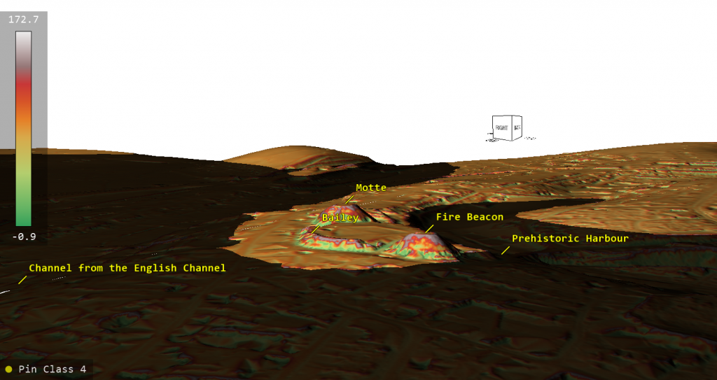
Moreover, the strategic utility of this Motte is further called into question by its location. It is situated 100 meters from the main highway, beyond the effective crossbow range (typically 50 to 60 meters), diminishing its purported defensive capability. If the intent was genuinely defensive, the choice of this site appears illogical, especially given that LiDAR imaging suggests flatter, more strategically advantageous ground is available closer to the highway. This would have been a more influential position for a defensive structure intended to control or monitor the road.

Top Ten misidentified Fire Beacons in British History
When the prehistoric waters are added, then you see why it’s positioned where it is! – Top Ten misidentified Fire Beacons in British History

The decision to place the Motte out of effective range on the edge of a deep gully suggests either a misinterpretation of the site’s original purpose or a lack of understanding of the tactical demands of medieval fortifications. This scenario underscores the need for a more nuanced and evidence-based approach in archaeological practice, moving away from fitting ambiguous sites into broad, pre-defined categories without adequate justification. It suggests that alternative, non-defensive interpretations should be considered preferable for understanding such structures’ historical and practical context.

Top Ten misidentified Fire Beacons in British History
Is this really a defensive castle? – Top Ten misidentified Fire Beacons in British History
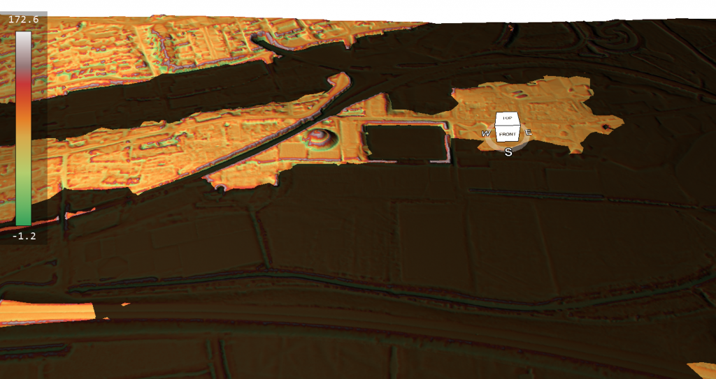
10. Pilsbury Castle – Motte and Bailey Castle

According to EH – “The monument is a medieval motte and bailey castle whose remains include a conical motte or castle mound, three baileys enclosed by ramparts and ditches, an outwork on the south side and an open area on the north side containing a variety of earthworks interpreted as the remains of pens and structures associated with the castle. The castle is situated on a spur overlooking the River Dove and utilises the steep natural slope on its north-west side as part of its defences. From this side the motte is c.12m high and the ramparts up to 10m high. From inside the castle, the motte is c.5m high and 30m wide across the top. The breadth of the summit indicates that it was the site of a shell keep; a type of castle keep in which timber buildings were arranged round the inside of a circular wall or palisade. Internally, the ramparts vary between 2m and 5m high. Internal ditches flank the ramparts of the central and south-west baileys and vary between 3m and 5m deep and 5m to 10m wide. A 15m wide ditch encloses the foot of the motte on its east and south sides and branches north-eastward along the north-west side of the north bailey where it reaches a width of 10m. The motte ditch also branches to create a 10m wide external ditch round the south side of the north bailey, where it varies between 2m and 3m deep. The north bailey is the largest and most massively defended of the three enclosures. Its ramparts are up to 5m high and a similar width across the top. Projections facing north and eastward were the sites of towers. Blocks of limestone on the surface of these projections are the remains of their foundations or, alternatively, of the curtain wall that formerly enclosed the bailey. Access into the north bailey was via a gateway through the defences on the south-east side. (Top Ten misidentified Fire Beacons in British History) A gate tower would have guarded this entrance and a curving ramp leads down into the interior of the bailey which is roughly square and has an area of 0.25 hectares. The strength of the north bailey indicates that it was the location of the main living accommodation of the lords of Pilsbury Castle, and would have included the lord’s hall and its various service buildings. The smaller central and south-west baileys, with areas of 0.15 hectares and 0.09 hectares respectively, would have contained a variety of workshops, stabling and ancillary buildings, and were most likely enclosed by timber palisades. They are separated from the north bailey by a wide ditch. A drawbridge would have existed to connect the two areas and is believed to have been located at the south-west corner of the north bailey where there is a corresponding earthwork on the opposite side of the ditch. In this way, the highly defensible motte and north bailey could be isolated in the event of attack. The main approach to the castle was via a sunken track that leads from the deserted village of Pilsbury to the south and from Crowdecote to the north. This track passes the entrance into the north bailey and is overlooked by the outwork on the south side of the castle and by the projecting towers in the curtain wall. Traffic wishing to enter the service areas of the castle – that is, the central and south-west baileys – would have circled the castle to the north and approached via a second entrance which lay to the west of the motte. Here a ramp leads from the occupation area north of the castle to a gateway into the south-west bailey. This gate is overlooked by two earthwork mounds interpreted as the sites of towers. The central bailey was then entered by turning east through another gate located at the head of the rampart dividing the two baileys. This rampart would also have carried a palisade. The precise history of the castle is uncertain but, in addition to commanding the Dove Valley between two crossing points, it may, in the last quarter of the thirteenth century, have been the centre of the Hartington estates of Edmund, Earl of Lancaster. No excavation of the site has been carried out but, in c.1880, a number of medieval artefacts were found in a cave below the castle. All modern boundary walls and fencing are excluded from the scheduling though the ground underneath is included.”

Top Ten misidentified Fire Beacons in British History
Top Ten Misidentified Fire Beacons in British History

Characterising a remote site traditionally labelled as a defensive fortification, particularly one distanced from any substantial population centre, raises significant logistical questions. As noted in the Domesday Book, the nearest town was essentially unpopulated, consisting only of agricultural land and meadows, which raises the question: what exactly was this fortification defending?

A deeper examination of the site’s geography and resources provides a more plausible explanation. The area, known for its limestone reef, is mineral-rich and marked by numerous caves and pits that were historically used for mining. The discovery of a single Norman tile in one of these caves, which helped date the site, may be less indicative of a defensive structure and more of an occasional Norman presence or activity.

Top Ten misidentified Fire Beacons in British History
Top Ten Misidentified Fire Beacons in British History

Furthermore, the LiDAR mapping of the area reveals the absence of any significant roads leading to or from the so-called castle, suggesting alternative means of access and utility. A once-significant river channel nearby supports the hypothesis that this site was more likely used as a trading post. Boats could have utilised the river for transport, making the site an ideal location for trading activities associated with the mining operations. Rather than serving as a defensive feature, the area designated as a bailey might have functioned as storage for the mined materials awaiting transportation via the river.

This interpretation shifts the narrative from a traditional defensive stronghold to a commercial and industrial hub, highlighting the importance of considering all environmental and archaeological clues when assessing historical sites. Such a perspective aligns better with the geographical and economic realities and enriches our understanding of the diverse functions historical structures could serve.

(Top Ten misidentified Fire Beacons in British History)

Further Reading

For information about British Prehistory, visit www.prehistoric-britain.co.uk for the most extensive archaeology blogs and investigations collection, including modern LiDAR reports.  This site also includes extracts and articles from the Robert John Langdon Trilogy about Britain in the Prehistoric period, including titles such as The Stonehenge Enigma, Dawn of the Lost Civilisation and the ultimate proof of Post Glacial Flooding and the landscape we see today.

Robert John Langdon has also created a YouTube web channel with over 100 investigations and video documentaries to support his classic trilogy (Prehistoric Britain). He has also released a collection of strange coincidences that he calls ‘13 Things that Don’t Make Sense in History’ and his recent discovery of a lost Stone Avenue at Avebury in Wiltshire called ‘Silbury Avenue – the Lost Stone Avenue’.

Langdon has also produced a series of ‘shorts’, which are extracts from his main body of books:

The Ancient Mariners

Stonehenge Built 8300 BCE

Old Sarum

Prehistoric Rivers

Dykes ditches and Earthworks

Echoes of Atlantis

Homo Superior

(Top Ten misidentified Fire Beacons in British History)

Other Blogs

s

t

Silbury Hill / Sanctuary – Avebury Phase 3

Video Transcript (Silbury Hill / Sanctuary – Avebury Phase 3)

This week we look at Avebury phase 3 which is the construction of Silbury Hill the largest man-made mound in Europe, and the Avenues that led to it.  Before we do this, we need to do a quick recap just in case you haven’t looked at the previous two videos on this area; now, this is Avebury and the site around Avebury, and here, you can see quite clearly Windmill Hill which in the first video we show that these ditches around the edge at an angle met the river connects this is the river Kennet this is not sea level people get baffled this is a river.  This river which runs over the contours of the landscape, ran down here towards the Avon and this way towards the Bristol Channel; this is the Kennet as it was in the Mesolithic period, and you can see; therefore, Windmill Hill would have been constructed in the Mesolithic period as it was built on the edge of the river as we know it then.

Silbury Hill / Sanctuary - Avebury Phase 3
Avebury Landscape

That’s roughly about 180 meters high at this point here; we then saw that during the Mesolithic, the rivers would have dropped, and we get to a position in the Neolithic period where all the early, very early Neolithic period where the waters would have dropped to about we’ve got about 56 meters here.

Now that’s this point, access to this site was impossible, and therefore they built a new location here, which we know as Avebury with its massive ditches and its massive ditches would have been filled with water because the river Kennet which runs this way would have cut into the west of the site into the large ditches, and this is what we showed in great detail on video number two phase two as I call it

Avebury showing River Kennet filling the Ditches - Silbury Hill / Sanctuary - Avebury Phase 3
Avebury showing River Kennet filling the Ditches

This week we’re going to look at Silbury Hill and phase three because what happened during the Neolithic and probably maybe the early Bronze Age -dating is complicated, the rivers would have dropped even lower, and so this access point would have finished,  you can’t get boats into Avebury and so we have to find another route.

Now logically you say well why don’t you just uh it’s probably a little bit lower than this model it’s gone too far why don’t you drag the boats across land now this will be pretty marshy this would have been there they may have once upon a time a Dyke coming across and I’ll imagine that there would have been a Dike here which is now covered by the road which would try to keep the access open as long as possible but eventually as you see here it dries up rather rapidly and now we’re looking at just that 152 meters this landscape dries up quickly and therefore when the river’s dropped access to this site would have been limited and so what they’ve done they’ve actually built the harbour which needs deep water it’s not it’s not a little bit of water obviously ample water therefore we can surmise that the boats may actually be ships these could be pretty big now if you’re the the boats or ships that took the large stones to a rather must be quite massive they’re not canoes and therefore what we have a look what we see here is that a new site was created about here we know this is all being channelled out by hand and this is what’s called Silbury Hill.

Silbury Hill showing channelled harbour - Silbury Hill / Sanctuary - Avebury Phase 3
Silbury Hill showing channelled harbour

Now, what do we do we’ll have a quick look at this Silbury; this is Silbury Hill Mound here; as you see, it’s quite prominent and what we see underneath here is the effort was which was made to dig out this area to make sure that this was a natural hub for boots if I now change the angle of this to give it a bit a better representation.  What we find is that the best way to get to this mooring site here would be directly over the top of what’s known as Waden Hill, or now there’s been a stone Avenue that goes this way, but it would have gone through this marshy ground which makes you believe that this was actually headed at a much later date.

Beckhampton Ave going through the town - Silbury Hill / Sanctuary - Avebury Phase 3
Beckhampton Ave going through the town

It’s entirely possible, and I wouldn’t ignore the fact that once this had dried up, you would have had a procession, a sort of causeway procession of stones going from this point here to Avebury, as you know and because they still exist.  One or two stones through it say there, but unfortunately, they’re all being dug up by, but the ones that did happen have all been dug up by the town that we know along this path here is the famous West Kennet Avenue of huge stones.

But the logic you say you’ve got the most significant man-made structure in Europe here now it’s been made for a particular reason now archaeology seem to ignore the connection between Silbury Hill and Avebury which I find rather annoying because it’s in the same see the same locality for goodness sake, so it’s not rocket science to believe that one is connected to the other back to date well up to nine up to 2014 archaeologists have failed to find a connection between the two and so it’s been left very separate.

Avebury's Lost Stone Avenue book
Avebury’s Lost Stone Avenue book

Fortunately, on one of my summer trips, I actually found Lost Stone Avenue, and there’s a book which is up here which you can see, and I published pictures.  But unfortunately, I didn’t have my drone available; several years later, I’ve been going back to try and find the stones, and I’ve been I’m successful but what I found is that there is a pathway of stones well stone holes – the stone houses have left their mark which is usually a green surface against a yellow background which you see in the photographs that’s because they’re deeper.  They’re deeper holes, obviously because they’ve taken these large assassins when they’ve been filled in there’s more because it’s a very short background there’s more subsoil in the holes, which makes them go greener and shows up as a crop mark.

Stone Holes over Waden Hill

Now, these go across as you see here and down Waden Hill, which is cool  because what we have found from my discovery is that if we turn this round, if we go down to the natural end, I don’t know.  So hence, it leaves here it goes over one hill there’s all there’s all at the top here barrows so let’s go and have a look at that here so a closer look at the barrows we’ve got we’ve got going across this hill here we know it’s been used because here are empty barrows they’ve been ploughed through this is all someone’s big field and has spent the last I don’t know 5 000 years ploughing it up.  Hence, there’s not a lot left; we got a little remember something there; who knows what that is you’re not allowed to its private property.

Barrows on top of Waden Hill

In fact, quite interesting, a friend of mine, Bob was walking here up here, and he found people excavating this area here, and he thinks they found a recumbent stone that’s flat in the ground; he did ask about it, but they refused to tell him anything because they want to claim the discovery some ten years after I found it – but then again that’s archaeology for you.

Silbury Avenue over Waden Hill

Eventually, when they published their paper, you’ll find there was a path that went across there and down there.  What I find interesting about this pathway because it could have gone this way that’s steep, and if you’re taking goods by the cart, which it would have been, it’d be like a cart if you’re taking in goods by a cart going down you know you’ll need ABS brakes it’s not going to happen – this is a much sensible longer but more shallow root and it this comes down it’s a nice little bump there oh turn this off again there’s a nice little bump there don’t know where that is it’s pretty interesting but we find that it all comes down and it ends here now this as I put in the book is quite interesting this was always believed to be a this is the Roman Road A4

Silbaby (Waden Mound)

This was what’s being seen as a rubbish dump for the road apparently this that was the logic it’s clearly very large you know it’s not small as we see from Silbury Hill this is not a tiny little landscape feature this is quite big now in 2012 a photographer sent details he took photographs and sent details off this is a river Kennet underneath here so this is the Kennet so there’s all springs around here huge springs which was a filled in the Bronze Age Neolithic and the Mesolithic age this mound here he called Silbaby because it’s baby of Silbury which is it’s fine and he put forward the proposition that is actually historically prehistoric which was pooh pooh’d  because they said no it’s just just a mound but what we find that it’s actually on of the old maps Stukeley’s maps he shows these this this mount so it’s been around longer than the A4 certainly and it’s probably very unlikely that the Romans were piled all their rubbish in a big heap to the side of one road like that because it’s just it’s pure nonsense really.

Silbably on Stukeley's map (right of Silbury Hill at bottom)
Silbably on Stukeley’s map (right of Silbury Hill at bottom)

So they’ve taken core samples they haven’t excavated it which is a shame because that the only way you’re going to get proper dates is through excavator it they took core samples and they’re now freely admit that it’s at least medieval at least maybe why because you know at the end of the day the only way you’re going to find out the date of this is to actually get to the put a core sample from here all the way down the base they’ve been putting ones into the side which is lovely but this base has clearly if this has been around for 5 000 years some of this will get eroded some bits will have been dumped on with people who’ve had campfires on top and you know full hardy archaeology the only way you’re gonna get a proper real scientific date is to take that all the way down to the bottom find out where the original level is and take a core sample from there and get that radio carbon dated that has not been done and until that is done we’ll never get a real date for this but clearly clearly we see we have already seen one of these on would you believe Old Sarum if you go and look at my my Langdon investigates on Old Sarum you find identical and with the river around it landing it’s a landing point for ships.

Landing Site at Old Sarum - identical to Silbaby
Landing Site at Old Sarum – identical to Silbaby

Ships would have come in landed here unloaded their goods and take it via what I call Silbury Avenue which I’m sure the archaeologists will renamed because they don’t like me – for obvious reasons can’t have that sceptic naming something – so they would have unloaded take that across all the way down to Avebury and that saved them obviously when this river dried up they couldn’t get their boats this these would have dried up as well and be the large dishes we see today and and that’s that’s the problem when you start dating these ditches you’re dating ditches when they were last used and the last used at the end of the Neolithic so you’re gonna get at best at best late neolithic date it’s rather than the dates when they were first constructed because the only way you can do that is same as Silbury is to take excavation through that that mound and find the bottom of where they the original land surface is and you date stuff from there do not date bits from ditches their their modus operandi of archaeologists is fundamentally flawed because they date sites from what’s in a ditch and the ditch has been open for so many years it’s going to have a multitude of dates it’s a it’s a complete nonsense sadly.

Silbury Hill Fire Beacon

So that’s Silbury Hill and Silbury Avenue that went over Silbury Hill, so what’s this thing then – why is this here well you know I’ve left it to last because it’s obvious fire beacon what we’ve now found and this you know from time to time when we have to we do proper archaeology fantastic what we found is this looked a lot different in the past it was like a layer cake it was we’ve just down the road is another one called a Marlborough Mound now that’s done in like a layer cake effective it’s something later on in history probably the Christians didn’t like it because I don’t like anything that was pretty quick anything pre-Christian was the work of the devil and so what they’ve probably done in Christian times is made it round they’ve covered up the layers that were in it, but we now know there’s been proper archaeology done this was built over hundreds of years in different layers

Marlborough Mount - just down the river on the Kennet
Marlborough Mount – just down the river on the Kennet

Okay so what do you do what what is built by the edge of a river in different layers to make it go higher and the logic is it’s a fire beacon at the end of the day you start low you light your fight you’ll get people from the vicinity where the the fire shows you know how do you know that the the car boot sale you know local car boot sales on well if if you’ve got a calendar you know it’s on a Sunday fantastic probably didn’t have calendars in them days just guessing on that one but what you can do is look for smoke and if this is smoke you go ah the village The Village car boot sale is on you know the the market is on people have come to sell their wares I’ll get my wares and we go and barter and buy tools or food so the the idea of a fire beacon is to tell people some events happening come along and when they do they were heading for the fire now the fire is on this side they were parked their boats on the deeper waters here they will unload their boats here and wore their boats here and they’ll take their boat their goods to market it’s pretty straightforward.

So Silbury Hill fire Beacon now even during the Neolithic a period the waters would have dropped and certainly by the Bronze Age – Silbury Hill may not being able to be used the water Kennet was carried on but these water levels would have got lower and you can see exactly the the problem you would have you wouldn’t be able to unload your boat unless you want to climb a mountain you know it’s just impractical so they moved themselves to another site and we call that site The Sanctuary and this is the Sanctuary probably in the Bronze Age like maybe later maybe I it could be Iron Age they could maybe use this site up to the eye it’s almost impossible to tell at the moment because there’s such little archaeology but here you’ve got the Sanctuary and the Sanctuary as I said lies at the end lies at the end of the  West Kennet now what I find interesting with is the West Kennet really doesn’t go although it’s there it sort of disappears around this area now that’s not a great surprise because this would have been probably the area you would have actually you never go from top down makes life easier.

This is the area that you would have probably brought your boat; there was this the Sanctuary would have been a mini lighthouse simple enough I’ve done a I’ve done a another Langdon Investigates on Woodhenge if you want details of how they built this structure and the and the the size of the timbers take a look at that but basically you’ve got unnecessary 24 inch two foot wide timbers which take a long time to to chop down unless you’ve got metal tools but even though if you’ve got 24 feet a two meter wide pillars you’re building something high you’re not building something that looks like a little one-story house which I’ve seen as a representation of the Sanctuary it’s just nonsense.

If you’ve got a 24, you know you could do that if you want a 12-foot house, you can do a bit of four by two.  I mean, the biggest tree trunk you need is six inches, not two feet if it’s two feet, it’s going to be a lot higher than a single-story house; it’s common sense; there’s no common sense in archaeology.

Traditional View of the Sanctuary

It’s just speculation people say what the Sanctuary is?  They go, oh it’s ceremonial it’s nonsense absolute it’s a little bit like the ditches at Avebury let me tell you it’s ceremony they do they dug down for 30 35 foot part of the ceremonial you know what’s that ceremony is it the ceremony of the digging of the ditch is that one you know we’ve got nothing better to do in life like hunting food or looking after the kids let’s dig a ditch that is 35 foot because you know yeah it appeases the Gods what a lot of rubbish.

But that’s archaeology today; sadly no common sense.  The Sanctuary was probably a mini lighthouse to show people where to park their boat, particularly at night.  Avebury if you go through every you’re a grounded your boat too late you you wouldn’t have a boat anymore you just pull it on on on the on the on the wasteland marsh and you’ll never get it off you know a bit of a waste of a boat so what you do you would have bought they were built the Sanctuary they might have actually kept that uh them out of you know why not they might have lit this um to get because it’s higher to get a greater view this is quite high as well by the way this is this is almost on on top of the Ridgeway so this this is probably about the same height so actually light in the Sanctuary if the Sanctuary will say I don’t know 50 100 foot high would probably be equivalent of Silbury Hill but people would know because it was lit that they would have to park their boats here or just around the corner from here which is probably this beach here I would imagine if I if that because we can’t get an exact representation of how the river looked in the past I would reckon that what what you have and this is quite interesting because you’ve actually got a lot of uh going on here in LiDAR so it’s always been sort of used at one point.

The Sanctuary
The Sanctuary

I imagine that would probably be the river level at the time of the Sanctuary.  Don’t you don’t use the Sanctuary.  The interesting thing is there is little to no evidence of West Kenner Avenue past at this point here you’ve got them up to here everybody’s walked to this part it stops here you’ve got one over here somewhere you’ve got this sort of little pathway here which is quite interesting I would imagine people would have beached their boats all along here and then walked to Avebury and walked to Avebury from this beached area.  That beached area would have been highlighted by the Sanctuary the boats would come in you would see that all we here were parked as close as this as possible the the the large stones will show them this is the way to Avebury you know, so it’s not rocket science.

So you park your boat, use the West Kennet, and go to your trading point at Avebury, which kept it alive for another maybe a thousand years.  So I mean, we’re talking about a long extended period there.  Okay well that’s it; this is we’ve now given you Avebury phase one, Windmill Hill phase two the main site phase three Silbury Hill and The Sanctuary with Commandments one because the same thing these are mooring points for uh beacons ones one’s a land Beacon and one will probably be one of the first lighthouses in the world.

 For more information about British Prehistory and other articles/books, go to our BLOG WEBSITE for daily updates or our VIDEO CHANNEL for interactive media and documentaries. The TRILOGY of books that ‘changed history’ can be found with chapter extracts at DAWN OF THE LOST CIVILISATION, THE STONEHENGE ENIGMA and THE POST-GLACIAL FLOODING HYPOTHESIS. Other associated books are also available such as 13 THINGS THAT DON’T MAKE SENSE IN HISTORY and other ‘short’ budget priced books can be found on our AUTHOR SITE or on our PRESS RELEASE PAGE. For active discussion on the findings of the TRILOGY and recent LiDAR investigations that is published on our WEBSITE you can join our FACEBOOK GROUP.