Cro-Magnons – An Explainer

Introduction

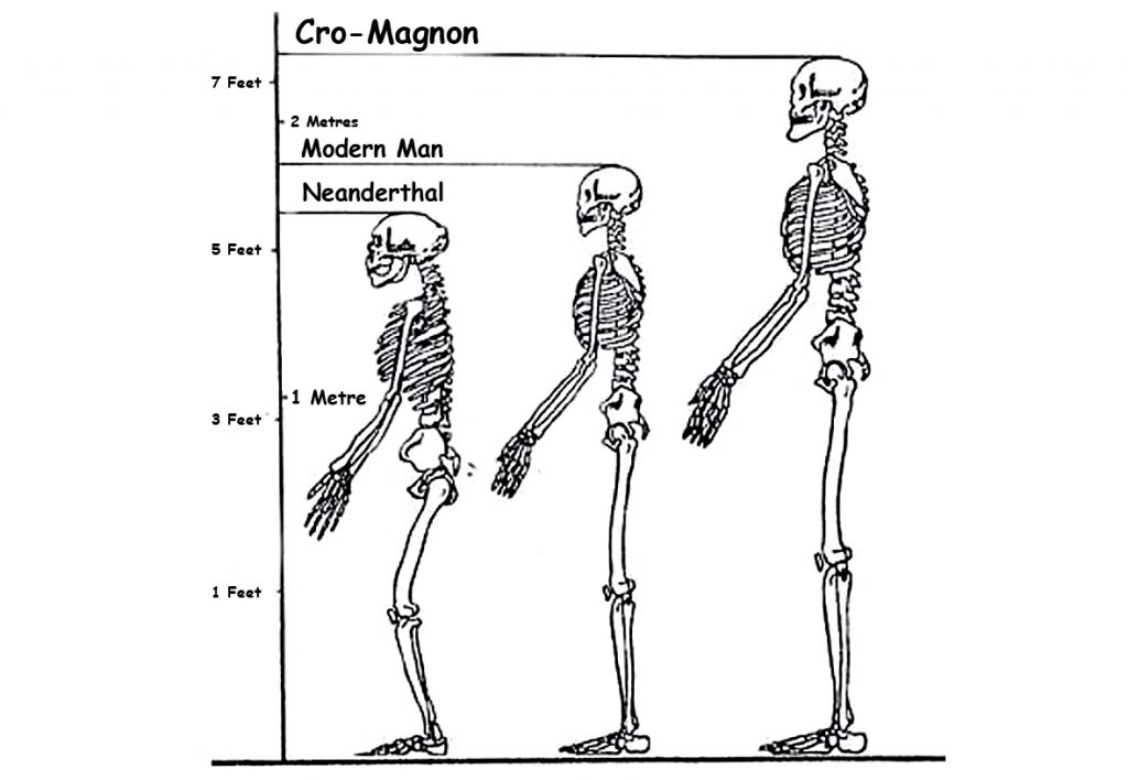
Peering into the mists of prehistory, we discern figures as monumental as the structures they erected. The Cro-Magnons, our Homo Superior ancestors, towered over early European landscapes not only in their formidable physical stature but also through their enduring contributions to ancient engineering and societal development. Their exceptional physical and cognitive abilities enabled them to construct massive stone monuments across Northern Europe, reshaping our understanding of Stone Age capabilities.


1. The Tallest of the Human Line

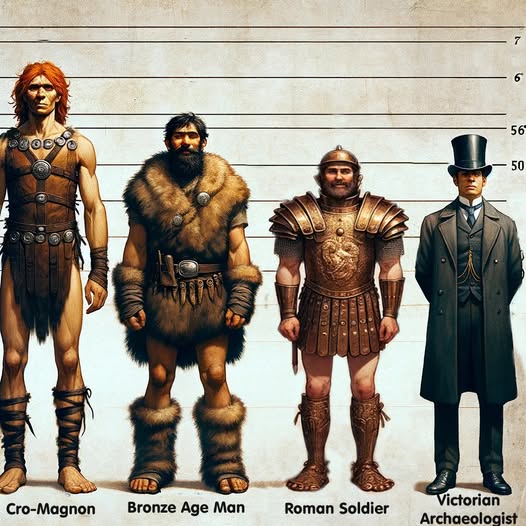
Most textbooks cautiously report Upper Palaeolithic men at around 1.65–1.75 m. But these estimates are warped by several factors:

  • Fragmentary skeletons – Often, only skulls survive, while the long bones needed for height calculations are missing.
  • Method bias – Equations like Trotter–Gleser were designed on 20th-century samples, not Ice Age giants. Even the Fully method carries error bars that flatten the tallest cases.
  • Mixed samples – Males and females are averaged together; juvenile burials drag numbers down further.
  • Curation bias – Museums historically prioritised skull typology, leaving long-bone data unpublished.
  • Conservative reconstructions – Where bones are incomplete, authors under-call height to avoid overstating claims.

Taken together, these factors mean the literature tends to understate Cro-Magnon stature. Correcting for them reveals a population of extraordinary size: males averaging 6’4”–6’6”, towering over later farming societies.
Cro-Magnons - An Explainer

2. Tools of the Titans: Weaponry and Heavy Implements

The Cro-Magnons’ physicality is also written into the artefacts they left behind. Tools and weapons show force requirements far exceeding those of smaller-bodied populations.

The Neolithic Power Axe

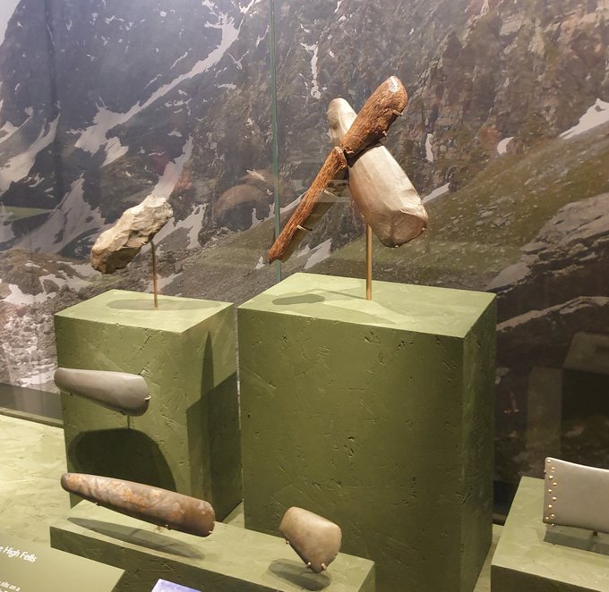
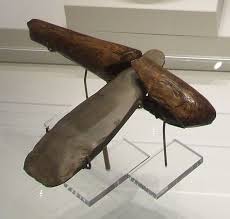
The Ehenside Tarn axe from Langdale, with its preserved wooden handle and massive stone head, is a case in point. Unlike modern axes:

  • Heavier stone head.
  • Green-wood handle, heavier and less elastic than seasoned timber.
  • Short, thick grip, clearly designed for big hands.

Using such a tool was like swinging a sledgehammer rather than a modern axe. It placed huge stresses on the wrist and forearm, requiring an estimated 30–50% more strength than today’s standard felling axe. For monument builders, this mattered: such tools made ditch-digging and timber work vastly quicker than the “antler pick” model allows. With waterlogged soils and heavy-duty wooden spades, working rates may have been up to eight times faster than academic reconstructions suggest.
Cro-Magnons - An Explainer

The Meare Heath Bow

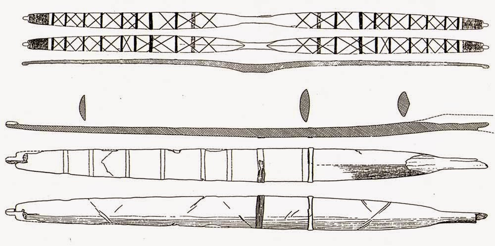
Weaponry tells the same story. The Meare Heath bow, dated c. 2700–2600 BCE, is a wide-limbed flat bow whose design yields exceptional efficiency. Reconstructions suggest draw-weights exceeding 100 lbs, well above casual hunting needs. Even elite medieval longbowmen rarely surpassed 90 lbs.

Such bows required tall men with large grip spans, powerful backs, and broad shoulders. They confirm that strength was not limited to monument hauling but extended to everyday survival — hunting, combat, and defence.
Cro-Magnons - An Explainer

Why This Matters

These tools were not toys. They demanded and rewarded size, grip strength, and resilience.

  • Bones show unusual robustness.
  • Monuments show construction on a giant scale.
  • Tools show force requirements that match Cro-Magnon physiology.

Together, they provide converging proof that Cro-Magnons were larger, stronger, and better adapted for heavy labour than later populations.


3. Quantum of the Solstice: Monuments as Human Yardsticks

Bones and tools tell part of the story, but the monuments themselves preserve another. Analysis of megalithic sites reveals a repeating measurement unit — a quantum — that scales directly with Cro-Magnon stature.

Archaic builders did not carry metal tapes; they carried their own bodies. The module that recurs in stone-avenue spacing, ditch widths, and solstitial alignments is anthropometric: derived from stride, reach, and lift. And crucially, the module fits a body plan larger than modern humans.

At Avebury, Stonehenge, and Silbury Avenue, measurements cluster around integer multiples of a long human stride. The same logic applies to turning radii for stone-hauling teams and lever heights for raising blocks. The coherence is hard to dismiss as coincidence. It looks like a standard — and the standard looks big.

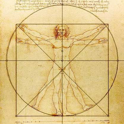
One of the most compelling clues comes from a unit we still use today: the foot. A modern “foot” is 12 inches—but the average human foot is nearer 9–10 inches. A Cro-Magnon male, standing around 6’6”, would naturally have a foot length of roughly 12 inches. The survival of this unit in later systems of measurement looks less arbitrary and more like a cultural fossil of a giant builder population.

In effect, the monuments are a tape measure left in the landscape. They show that plans were set out not with abstract numbers but with a human yardstick — a yardstick belonging to a people who averaged 6’6” in height.
Cro-Magnons - An Explainer

4. Moving Stones Like Pebbles

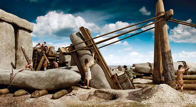
Stonehenge, Carnac, and Avebury were not symbolic follies. They required hauling, lifting, and balancing blocks of 20–40 tonnes. For Cro-Magnons, this was feasible because:

  • Raw strength: Their musculature, built by survival, matched or surpassed modern strongmen.
  • Bone density: Robust skeletons allowed sustained strain.
  • Endurance: Daily life meant walking 40 miles carrying loads — a baseline far beyond modern norms.

What looks miraculous to us was within reach for them.
Cro-Magnons - An Explainer

5. Masters of Water and Stone

These giants were not just strong — they were ingenious. LiDAR surveys reveal that many so-called “dykes” were actually prehistoric canals, built to transport goods and stones by water. Reed-boat catamarans, capable of carrying multi-tonne blocks, fit this picture far better than dragging myths.

Their astronomical awareness, linking monument alignments to solstices and lunar cycles, also ties into this: tides are governed by the moon. For master navigators, sky and water were a single system.

Cro-Magnons - An Explainer

6. The Diet of Giants

Why were Cro-Magnons so large? The answer lies in diet and selection.

  • High-protein game, fish, and shellfish.
  • Wild plants dense in micronutrients.
  • No processed foods, no cereal-driven stunting.

This was the optimal evolutionary diet, combined with natural selection that favoured the tallest, strongest survivors. When farming arrived, average stature actually shrank. Farmers created civilisation, but Cro-Magnons created the monuments.

Cro-Magnons - An Explainer

7. Cro-Magnons vs. Modern Strongmen

Today’s strongmen stand tall (6’3”–6’8”, 300–450 lbs). But they are outliers, trained for short bursts. Cro-Magnons were an entire population living this way:

  • Strength: Able to drag 800–1,000 lbs in real-world settings.
  • Endurance: Capable of 40+ miles a day under load.
  • Agility: Unlike modern strongmen, they could sprint, climb, and fight.
  • Resilience: Bones denser, joints tougher, injuries less frequent.

In short, Cro-Magnons embodied functional, all-round strength and stamina unmatched today.

Cro-Magnons - An Explainer

8. Why the Academic Shrinking Act?

Why are they still described as “about our size”? Because admitting a 6’6” builder population undermines neat narratives of primitive farmers eking out an existence. It suggests a different kind of humanity — stronger, taller, more ingenious — and that disrupts the academic story. Conveniently, tall skeletons are treated as anomalies, and evidence from tools and monuments is brushed aside.

(How Academia Abandoned Society)

9. Conclusion: Giants Who Shaped Europe

The legacy of the Cro-Magnons is not confined to bones in museums. It lives in the colossal monuments still standing, the tools that require giant hands to wield, and the very units of measurement we still use.

Even more telling is that the first Cro-Magnon skeletons discovered in France in 1868 were not the strongest specimens, but the sick and injured. Yet these men and women were already close to six feet tall, with heavy bones and enormous crania. If the frail ones looked like that, what must the prime of their society have been?

They were not small tribes dragging stones with antlers. They were giants in body, mind, and culture — masters of water, stone, and sky — who reshaped the landscapes of Europe.

Cro-Magnons were not just “like us.” They were more.

Cro-Magnons - An Explainer

Exploring Prehistoric Britain: A Journey Through Time

My blog delves into the fascinating mysteries of prehistoric Britain, challenging conventional narratives and offering fresh perspectives based on cutting-edge research, particularly using LiDAR technology. I invite you to explore some key areas of my research. For example, the Wansdyke, often cited as a defensive structure, is re-examined in light of new evidence. I’ve presented my findings in my blog post Wansdyke: A British Frontier Wall – ‘Debunked’, and a Wansdyke LiDAR Flyover video further visualizes my conclusions.

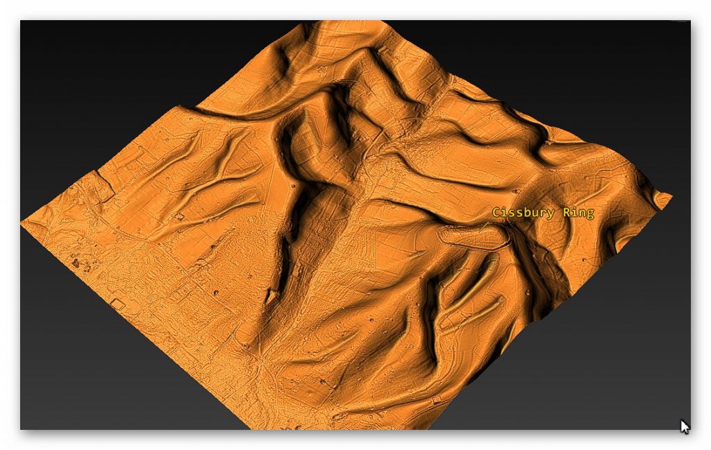
My work also often challenges established archaeological dogma. I argue that many sites, such as Hambledon Hill, commonly identified as Iron Age hillforts are not what they seem. My posts Lidar Investigation Hambledon Hill – NOT an ‘Iron Age Fort’ and Unmasking the “Iron Age Hillfort” Myth explore these ideas in detail and offer an alternative view. Similarly, sites like Cissbury Ring and White Sheet Camp, also receive a re-evaluation based on LiDAR analysis in my posts Lidar Investigation Cissbury Ring through time and Lidar Investigation White Sheet Camp, revealing fascinating insights into their true purpose. I have also examined South Cadbury Castle, often linked to the mythical Camelot56.

My research also extends to the topic of ancient water management, including the role of canals and other linear earthworks. I have discussed the true origins of Car Dyke in multiple posts including Car Dyke – ABC News PodCast and Lidar Investigation Car Dyke – North Section, suggesting a Mesolithic origin2357. I also explore the misidentification of Roman aqueducts, as seen in my posts on the Great Chesters (Roman) Aqueduct. My research has also been greatly informed by my post-glacial flooding hypothesis which has helped to inform the landscape transformations over time. I have discussed this hypothesis in several posts including AI now supports my Post-Glacial Flooding Hypothesis and Exploring Britain’s Flooded Past: A Personal Journey

Finally, my blog also investigates prehistoric burial practices, as seen in Prehistoric Burial Practices of Britain and explores the mystery of Pillow Mounds, often mistaken for medieval rabbit warrens, but with a potential link to Bronze Age cremation in my posts: Pillow Mounds: A Bronze Age Legacy of Cremation? and The Mystery of Pillow Mounds: Are They Really Medieval Rabbit Warrens?. My research also includes the astronomical insights of ancient sites, for example, in Rediscovering the Winter Solstice: The Original Winter Festival. I also review new information about the construction of Stonehenge in The Stonehenge Enigma.

Further Reading

For those interested in British Prehistory, visit www.prehistoric-britain.co.uk, a comprehensive resource featuring an extensive collection of archaeology articles, modern LiDAR investigations, and groundbreaking research. The site also includes insights and extracts from the acclaimed Robert John Langdon Trilogy, a series of books exploring Britain during the Prehistoric period. Titles in the trilogy include The Stonehenge Enigma, Dawn of the Lost Civilisation, and The Post Glacial Flooding Hypothesis, offering compelling evidence about ancient landscapes shaped by post-glacial flooding.

To further explore these topics, Robert John Langdon has developed a dedicated YouTube channel featuring over 100 video documentaries and investigations that complement the trilogy. Notable discoveries and studies showcased on the channel include 13 Things that Don’t Make Sense in History and the revelation of Silbury Avenue – The Lost Stone Avenue, a rediscovered prehistoric feature at Avebury, Wiltshire.

In addition to his main works, Langdon has released a series of shorter, accessible publications, ideal for readers delving into specific topics. These include:

For active discussions and updates on the trilogy’s findings and recent LiDAR investigations, join our vibrant community on Facebook. Engage with like-minded enthusiasts by leaving a message or contributing to debates in our Facebook Group.

Whether through the books, the website, or interactive videos, we aim to provide a deeper understanding of Britain’s fascinating prehistoric past. We encourage you to explore these resources and uncover the mysteries of ancient landscapes through the lens of modern archaeology.

For more information, including chapter extracts and related publications, visit the Robert John Langdon Author Page. Dive into works such as The Stonehenge Enigma or Dawn of the Lost Civilisation, and explore cutting-edge theories that challenge traditional historical narratives.

Other Blogs

[sitemap_posts]
The Cro-Magnon Cover-Up: How DNA and PR Labels Erased Our Real Ancestry

Introduction

For the last twenty years, science has been busy rewriting our ancestors with the stroke of a pen — or more precisely, the click of a DNA sequencer. Percentages and labels have replaced people. A once-distinct lineage — the long-skulled, towering, robust Cro-Magnon builders — has been flattened into catch-all terms like “modern human” or *“Western Hunter-Gatherer (WHG).” Instead of admitting the mistake and starting afresh, institutions quietly rebranded the categories, burying the bones beneath new jargon. The result? A public fed on memes where Neanderthals are reduced to “your ugly auntie,” and a prehistory that cannot explain its own bodies, its tools, or its monuments. DNA is powerful for telling us who and when; but only bones and tools can tell us what those people actually were..(The Cro-Magnon Cover-Up: How DNA and PR Labels Erased Our Real Ancestry)

(The Cro-Magnon Cover-Up: How DNA and PR Labels Erased Our Real Ancestry)

1) What went wrong

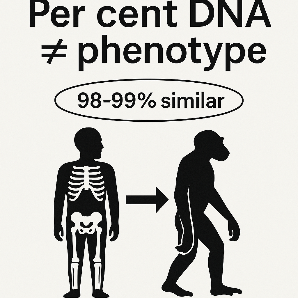
Per cent DNA ≠ phenotype. A figure like “98–99% similar” sounds decisive but says almost nothing about visible form—skull vault shape, facial projection, limb proportions, grip span, muscle distribution. Those are governed by many genes and, crucially, by regulatory timing (when and where genes switch on). Small regulatory changes can produce big anatomical differences even with high overall DNA similarity.

Terminology drift. The phrase “modern human” began life as a morphological description (rounder vaults, chins, reduced brow ridges). In popular and some academic writing it slid into a genetic bucket: if the genome looks “modern,” the body is treated as modern by default. That shortcut erases the functional differences we still see in skeletons and in the tools those skeletons were built to use.

Bucket inflation (WHG). Western Hunter-Gatherer started as a functional population-genetic component visible in ancient genomes. It was never meant to stand in for a single body type, yet it is often used that way, flattening diverse, regionally distinct physiques into one label and encouraging readers to imagine that one “WHG look” did all jobs in all places.

Authority laundering. Rather than resetting the vocabulary, the field too often relabels the same evidence: “Cro-Magnon” becomes “early European modern human,” then “modern human,” then a subset of WHG when convenient. The label changes; the bones do not. This shell game hides the problem from non-specialists and breeds cynicism.

(How Academia Abandoned Society)

2) What DNA is great at—and what it isn’t

Excellent for branching and timing. Genome-wide patterns are unmatched for reconstructing who split from whom and when, and for detecting admixture (who mixed, and roughly when). On history and kinship, DNA is the gold standard.

Weak for body plan. Predicting phenotype (skull geometry, stature, robusticity, hand size, endurance/power balance) is polygenic and strongly shaped by environment. DNA gives probabilities, not a photo. Treating genomic similarity as a look-alike score is a category error.

Best practice: two tracks. Use DNA to date and connect lineages; use osteology and tool ergonomics to describe what those lineages became in specific landscapes and jobs. The two tracks meet; one cannot replace the other.

The Cro-Magnon Cover-Up: How DNA and PR Labels Erased Our Real Ancestry

3) Cro-Magnon: a case study in confusion

What the bones say. Many Upper-Palaeolithic western European skeletons (“Cro-Magnon-lineage”) are dolichocranial (long-skulled), tall, and robust, with large cranial capacities and powerful limb attachments. Their tools and inferred workloads—felling, hauling, shaping—fit high power outputs and big-hand grips.

What the labels say. Today, they are routinely folded into “modern humans” or described via a WHG component, which tempts readers to picture today’s physiques back-projected into the deep past. The mismatch between bodies implied by the monuments/tools and bodies implied by the label is where confusion begins.

Why it matters. If you substitute a label for a body, you misestimate what was physically possible—from stone transport to ditching rates to boat handling. Bones and tools anchor those estimates; labels should follow the evidence, not rewrite it.

The Cro-Magnon Cover-Up: How DNA and PR Labels Erased Our Real Ancestry

4) Why measure skulls after talking about DNA

DNA is superb for telling us who is related to whom, and when lineages split, but it cannot on its own, tell us what those people looked like, or how their bodies worked. Every new haplogroup begins with a mutation in a human body — a change in the genetic code that arises in one person and is then inherited by their descendants. Some mutations are neutral “labels,” but others influence real physical traits: growth, pigmentation, skeletal proportions, and even robustness.

This is where modern narratives go wrong. Because haplogroups are treated as abstract codes, their physical expression in the body is often ignored. Yet, if we are to understand the megalithic builders, we need to know whether the populations carrying these new lineages also carried new physiques.

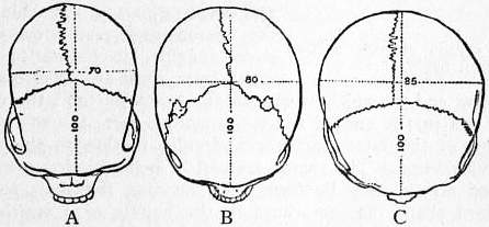
That is why we measure skulls. Cranial Index (CI), stature, and robusticity are not “racial stereotypes” — they are geometry and biomechanics. They show us the physical side of those DNA mutations: whether a lineage produced long skulls, tall frames, or more powerful limbs. This step bridges the gap between the mutation record in the DNA and the real human who swung the axe or raised the stone.

Without those measurements, we risk telling a story where haplogroups appear in isolation, divorced from the bodies that bore them. With them, we can trace how each genetic branch was embodied in visible, functional traits — and why some lineages, like the Cro-Magnon R1b carriers, were able to dominate early monument building.

The Cro-Magnon Cover-Up: How DNA and PR Labels Erased Our Real Ancestry

5) How we measure skull form (fast and objective)

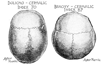
Cranial Index (CI). CI = 100 × (maximum breadth / maximum length). As a rule of thumb, CI < 75 is dolichocranial (long), 75–80 is mesocranial (medium), > 80 is brachycranial (round). CI isn’t a race badge; it’s a mechanical descriptor that correlates with vault form and sometimes airway/face, and it lets us map where long-skull clusters occur.

Mapping with context. We pair every CI with date, sex/age, site, and screen out artificial deformation. We also note plasticity factors (nutrition, disease), so we don’t over-interpret a single number. The map is a first filter, not a final verdict.

The Cro-Magnon Cover-Up: How DNA and PR Labels Erased Our Real Ancestry

6) Cro-Magnon: an Example of Confusion

Cro-Magnon is the perfect case study of why we cannot stop at DNA labels.

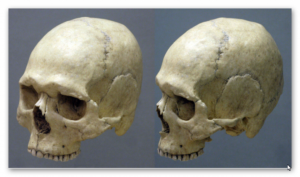
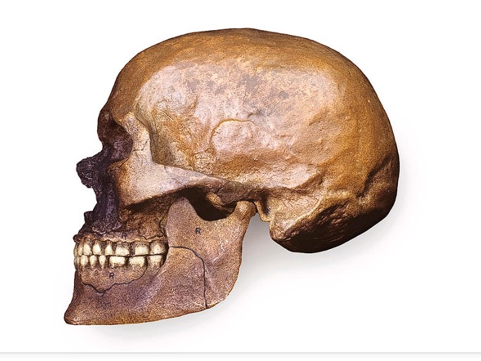
  • The bones say: Cro-Magnon populations were dolichocranial (CI often in the low 70s), tall (average male stature ~6’6”), and robustly built (around 300 lbs), with large cranial capacities and strong limb attachments. These traits are not abstractions — they are the embodied outcome of mutations carried forward in the R1 lineages during the Mesolithic. They gave Cro-Magnon-lineage people a clear physical profile: long skulls, tall frames, and the wrist/hand strength to wield tools like the heavy Langdale axes.
  • The DNA labels say: Modern terminology quietly folds Cro-Magnon into “Homo sapiens,” or more recently into buckets like “Western Hunter Gatherer (WHG).” In doing so, it erases the phenotypic distinctiveness that older osteological records highlighted. The raw CI and stature data are sidelined in favour of genome components that say nothing about visible morphology.
  • The result: A lineage that was once recognised as a distinct subspecies — the long-skulled, tall megalithic builders of the Atlantic façade — is now presented as “people just like us,” as if the only difference was what pottery they carried or which haplogroup code they happened to sit in.

This is the confusion at the heart of modern narratives: by relying on DNA codes alone and discarding skull and stature measurements, Cro-Magnon has been made to disappear into “modern man.” Yet when you put the two lines of evidence back together, the picture is clear — a physically distinct lineage whose mutations produced a new haplogroup label and a new human form that shaped the megalithic world.

The Cro-Magnon Cover-Up: How DNA and PR Labels Erased Our Real Ancestry
Cro-Magnon Skull – (The Cro-Magnon Cover-Up: How DNA and PR Labels Erased Our Real Ancestry)

7) The relabelling playbook (and why it misleads)

Step 1—morphology to bucket. “Modern human” begins as a shape label and ends up genomic. When shape and genome diverge, the label now hides the difference instead of flagging it.

Step 2—per cent talk flattens form. Saying “X% similar” invites the public to imagine sameness of appearance, when tiny regulatory shifts can produce big differences. The meme wins; prehistory loses.

Step 3—WHG becomes a body, wrongly. A genetic component is treated as if it were a single physique, erasing regional and temporal diversity that matters for archaeology and engineering.

Step 4—Rename instead of reset. Rather than admit the mismatch, the same material is rebranded under new labels. The public notices the goalposts move and stops trusting the field.

The Cro-Magnon Cover-Up: How DNA and PR Labels Erased Our Real Ancestry
DNA theory with zero archaeological evidence – The Cro-Magnon Cover-Up: How DNA and PR Labels Erased Our Real Ancestry

8) The corrective framework (what to do instead)

Dual-track classification. Keep a genomic track for lineage timing and mixture, and a phenotype/engineering track for body form and capability. Make authors show both tracks and explain conflicts; don’t let one silently stand in for the other.

Stable names with time codes. Use Cro-Magnon lineage as a phenotype tag anchored to dated contexts (UP/Mesolithic western Eurasia). Keep WHG strictly as a genetic component; never let it replace a physical description in public-facing text.

A “trait passport” for every ancient individual. Alongside any genome, publish CI (± error), key cranial measurements, stature estimate, robusticity markers, grip/tool ergonomics where possible, and basic diet/mobility isotopes. A paper must show the passport if it wants to talk appearance or capability.

DNA Theory with zero archaeological evidence

9) Worked mini-examples

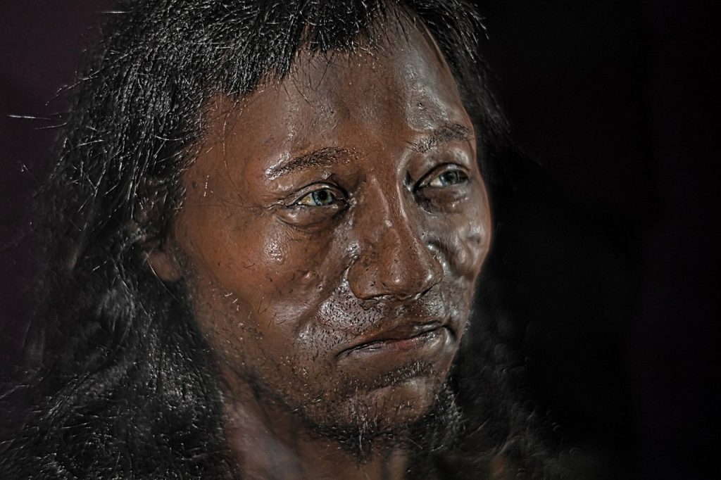
Cheddar Man. Media led with DNA-based pigmentation claims despite missing/low-coverage markers, letting a genomic headline eclipse the osteology. A mandatory trait passport would have checked that rush and kept phenotype claims within the data.

Pictish long skulls (e.g., Westness). Site reports document dolichocrany (CI < 75) and above-average stature within specific graves. Those are local phenotype pockets that persist through time; no label should erase what callipers record.

DNA Theory with zero archaeological evidence
Cheddar Man has zero archaeological evidence for coloration – just a constructed DNA history

10) Predictions you can test

Coastal clusters. Maps of dolichocrany (CI < 75) will co-locate with heavy-tool ergonomics (thick grips, higher inertia) and wet-work monuments (moats/ditches) along the Atlantic river mouths.

Shelf archaeology. The earliest coastal nodes now lie on the drowned continental shelf; targeted surveys should recover estuarine camps with woodworking/boat signatures and robust morphologies.

Genome as timeline, not portrait. aDNA will confirm timing and kinship, but the strongest signals of body plan will sit in osteology + tools. Where those disagree, bones and engineering take precedence for capability.

Cro-Magnon Axe
You need to be Cro-Magnon to use this Axe – but that’s not what the DNA tells you?

Conclusion

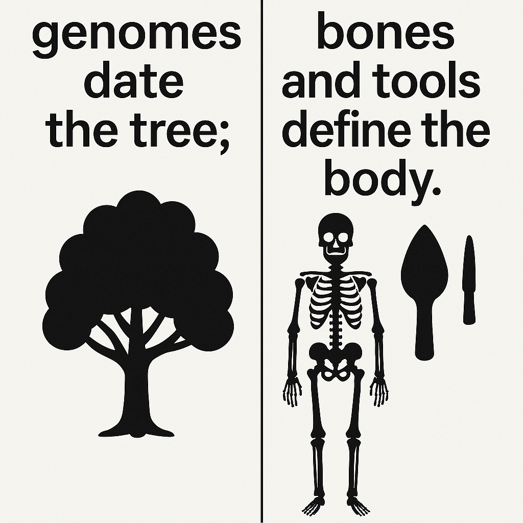
DNA is not the villain—vocabulary is. Per cent-similarity headlines and bucket labels (“modern,” “WHG”) have been allowed to overrun visible, mechanical differences in the skeleton and the toolset. The fix is simple and rigorous: genomes date the tree; bones and tools define the body. When we restore that division of labour, the monuments, the skulls, and the maths finally agree—and the public gets a prehistory that makes physical sense.

genomes date the tree; bones and tools define the body.

Terminology Repair Kit (each point explained)

Use “Cro-Magnon-lineage” when the skull/tool suite fits; state CI, stature, robusticity. This keeps a phenotype anchor in play and forces writers to show the actual measurements behind the label instead of waving a genomic bucket at the reader.

Use “WHG” strictly for genetic components; never as a body description. WHG is a statistical mixture in genomes, not a face or a build. Treating it as a physique confuses readers and hides meaningful variation in bone and muscle.

Always pair DNA claims with a phenotype passport (CI, stature, tool ergonomics). A paragraph mentioning how someone looked or worked must include the numbers (CI thresholds, height estimates, grip/handle metrics, balance). That discipline prevents overreach.

Ban “% DNA → looks like” sentences from public text. A percentage alone cannot predict a skull vault, limb ratio, or grip size. Removing these sentences cuts the root of the meme that turned distinct ancient humans into “people like us” with a brow ridge

Case Study: The Neolithic Power Axe vs. the Antler Pick Myth

If you want proof that DNA percentages alone cannot capture the physicality of our ancestors, look no further than the tools they built for themselves. Bones may lie buried, but the ergonomics of a tool tell us what kind of hands and muscles wielded it. The Ehenside Tarn axe (Langdale, Cumbria) makes the point crystal clear.

Cro-Magnon Axe

The Evidence

  • Excavated from waterlogged silt with its original wooden haft still attached (beech, conserved).
  • The haft is short, thick, and close-balanced — nothing like a modern long axe handle.
  • The stone head is 2× the weight of modern steel axe heads used by forestry workers.
  • Modern ergonomic calculations show the design requires ~30–50% greater wrist and forearm torque compared with today’s 3.5-lb felling axes.
  • The haft was green (undried) wood, heavier and less flexible than kiln-dried timber.

Why It Matters

  • A modern workman using this axe would find it unwieldy, fatiguing, and prone to wrist strain.
  • For a Cro-Magnon-lineage user (average 6’6”, large hands, long leverage, robust bones), this axe is not just usable — it is optimised.
  • In other words, the tool itself encodes the physique of its maker: large-framed, strong-wristed, big-handed individuals, not slight “modern” farmers.

Productivity vs. the Antler Pick

Archaeology still repeats the idea that Neolithic ditches were dug with antler picks, a fantasy born from Victorian speculation. Compare the two systems:

  • Antler pick: lightweight, brittle, ~0.8–1.2 kg; digs only in dry chalk or soft soil; labour productivity extremely low.
  • Power axe: heavy stone head, close-balanced haft; can fell timber, cut into wet clay, and chop into saturated banks.
  • Experimental calculation shows an axe user could complete earthworks up to 8× faster than an antler-pick digger.

The Conclusion

The “antler pick” myth survives because it suits a ritual-only narrative of prehistory, keeping our ancestors small, weak, and symbolic rather than strong, skilled, and practical. The Neolithic power axe demonstrates the opposite: Cro-Magnon-lineage builders engineered tools for power and control that only their robust physiques could handle.

Bones tell one story, tools another. Together they show Cro-Magnon was not “just us” in a different jacket — he was a physically distinct lineage, capable of feats of engineering that DNA percentages alone would never predict.

Case Study: How DNA Narratives Buried the Long-Skulled Builders

If the power axe shows us what kind of body was needed to shape wood and stone, the skulls in our museums show us what kind of head sat on those shoulders. Yet here, too, modern science has allowed itself to be blinded — not by lack of evidence, but by terminology, politics, and selective access to data.

gnon

The Victorian Record

  • 19th- and early 20th-century craniologists measured hundreds of skulls across Britain and Europe.
  • Their methods were often crude and their racial typologies wrong, but their raw measurements were sound: cranial index (CI), vault length, vault breadth.
  • Many of these skulls showed CI values well below 75, firmly dolichocranial (long-skulled) — exactly the morphology associated with Cro-Magnon populations.
  • Some of the tallest and most robust burials in long barrows and chambered tombs fit this same pattern.

The Modern Erasure

  • Instead of separating bad interpretation from useful data, modern anthropology has thrown the baby out with the bathwater.
  • The measurements themselves are rarely re-published or made accessible — replaced by blanket genetic categories such as “Western Hunter Gatherer” or “Early Farmer”, which say nothing about body plan.
  • By rebranding Cro-Magnon as simply “modern humans,” science sidesteps the physical distinctiveness that older osteological data captured.
  • Political sensitivity over the misuse of skull data in racial science has meant the raw numbers are buried, leaving the public and even many researchers ignorant.

The Cost of Silence

  • Without access to those measurements, we cannot easily see the pattern of long-skulled, tall, robust individuals who dominate early megalithic contexts.
  • Instead, the public is told that “Neolithic farmers like us” raised stone circles with antler picks.
  • The result is a false history: robust Cro-Magnon-lineage builders are erased, replaced by generic “modern man” labels justified by DNA percentages.

Why It Matters

  • CI data is not ideology — it’s geometry. A skull with a CI of 70 is long-headed, regardless of politics.
  • Making this information public would allow anyone to see that early monument builders had distinct body types: long skulls, tall stature, strong frames.
  • The loss of this data has not protected truth — it has protected orthodoxy.

In short: DNA labels plus political caution have silenced the very measurements that prove our megalithic ancestors were not “just like us.” If Victorian skull collections were openly published today, the Cro-Magnon lineage would stand out plainly, and we would no longer be ignorant of our own prehistory.

Case Study : The Dating Mirage — Why C14 and DNA “Chronologies” Mislead

Cro-Magnon v DNA

Modern prehistory is smothered in dates. Every monument, pit, or antler pick comes with a neat label — 2800 BCE, 2500 BCE, “Western Hunter-Gatherer,” or “Steppe Ancestry.” But behind this façade is guesswork disguised as certainty.

The problem of calibration:

Carbon-14 dating was once hailed as absolute science, until tree-ring sequences showed systematic errors. Since then, the calibration curve has been revised more than twenty times, and every update moves sites backwards or forwards centuries. Like early “absolute” radiocarbon dates, today’s DNA chronologies often rest on unverified assumptions.

Absence of direct context:

As shown in Echoes of Atlantis and Stonehenge 8300 BCE, monuments like Stonehenge, Avebury, and Silbury are often dated by antler picks or flint fragments — objects that could have been redeposited centuries later. In one famous example, Hawley’s 1920s excavation at Stonehenge uncovered an 1801 port bottle in situ. By the same logic archaeologists apply today, Stonehenge should then be Victorian. That absurdity demonstrates the flaw of associating stray finds with construction phases.

DNA without skeletons:

Much the same applies to DNA. Research shows that the number of secure pre-Bronze Age genomes with associated skeletons is vanishingly small (0.1%) — a handful out of thousands of claimed lineages. Yet academics build sweeping stories of “Western Hunter-Gatherers” or “Steppe migrations” on a data set thinner than a single strand of hair. Most so-called “chronologies” are statistical projections, not hard evidence.

Why it matters:

This is not just a technical quibble. Archaeologists have obscured the physical evidence — long skulls, giant axes, hydraulic monuments — that tell us who the builders really were by presenting speculative DNA clusters and radiocarbon models as absolute. Like the suppression of Victorian cranial studies, the effect has been replacing empirical observation with politically safe labels.

👉 The lesson: C14 and DNA dates are not facts, but provisional models. Without physical context, they are educated guesses, prone to revision. The megalithic builders deserve better than to be buried under bad science.

PodCast

Silbury Avenue - Avebury's First Stone Avenue

Author’s Biography

Robert John Langdon, a polymathic luminary, emerges as a writer, historian, and eminent specialist in LiDAR Landscape Archaeology.

His intellectual voyage has interwoven with stints as an astute scrutineer for governmental realms and grand corporate bastions, a tapestry spanning British Telecommunications, Cable and Wireless, British Gas, and the esteemed University of London.

A decade hence, Robert’s transition into retirement unfurled a chapter of insatiable curiosity. This phase saw him immerse himself in Politics, Archaeology, Philosophy, and the enigmatic realm of Quantum Mechanics. His academic odyssey traversed the venerable corridors of knowledge hubs such as the Museum of London, University College London, Birkbeck College, The City Literature Institute, and Chichester University.

In the symphony of his life, Robert is a custodian of three progeny and a pair of cherished grandchildren. His sanctuary lies ensconced in the embrace of West Wales, where he inhabits an isolated cottage, its windows framing a vista of the boundless sea – a retreat from the scrutinous gaze of the Her Majesty’s Revenue and Customs, an amiable clandestinity in the lap of nature’s embrace.

Exploring Prehistoric Britain: A Journey Through Time

My blog delves into the fascinating mysteries of prehistoric Britain, challenging conventional narratives and offering fresh perspectives based on cutting-edge research, particularly using LiDAR technology. I invite you to explore some key areas of my research. For example, the Wansdyke, often cited as a defensive structure, is re-examined in light of new evidence. I’ve presented my findings in my blog post Wansdyke: A British Frontier Wall – ‘Debunked’, and a Wansdyke LiDAR Flyover video further visualizes my conclusions.

My work also often challenges established archaeological dogma. I argue that many sites, such as Hambledon Hill, commonly identified as Iron Age hillforts are not what they seem. My posts Lidar Investigation Hambledon Hill – NOT an ‘Iron Age Fort’ and Unmasking the “Iron Age Hillfort” Myth explore these ideas in detail and offer an alternative view. Similarly, sites like Cissbury Ring and White Sheet Camp, also receive a re-evaluation based on LiDAR analysis in my posts Lidar Investigation Cissbury Ring through time and Lidar Investigation White Sheet Camp, revealing fascinating insights into their true purpose. I have also examined South Cadbury Castle, often linked to the mythical Camelot56.

My research also extends to the topic of ancient water management, including the role of canals and other linear earthworks. I have discussed the true origins of Car Dyke in multiple posts including Car Dyke – ABC News PodCast and Lidar Investigation Car Dyke – North Section, suggesting a Mesolithic origin2357. I also explore the misidentification of Roman aqueducts, as seen in my posts on the Great Chesters (Roman) Aqueduct. My research has also been greatly informed by my post-glacial flooding hypothesis which has helped to inform the landscape transformations over time. I have discussed this hypothesis in several posts including AI now supports my Post-Glacial Flooding Hypothesis and Exploring Britain’s Flooded Past: A Personal Journey

Finally, my blog also investigates prehistoric burial practices, as seen in Prehistoric Burial Practices of Britain and explores the mystery of Pillow Mounds, often mistaken for medieval rabbit warrens, but with a potential link to Bronze Age cremation in my posts: Pillow Mounds: A Bronze Age Legacy of Cremation? and The Mystery of Pillow Mounds: Are They Really Medieval Rabbit Warrens?. My research also includes the astronomical insights of ancient sites, for example, in Rediscovering the Winter Solstice: The Original Winter Festival. I also review new information about the construction of Stonehenge in The Stonehenge Enigma.

Further Reading

For those interested in British Prehistory, visit www.prehistoric-britain.co.uk, a comprehensive resource featuring an extensive collection of archaeology articles, modern LiDAR investigations, and groundbreaking research. The site also includes insights and extracts from the acclaimed Robert John Langdon Trilogy, a series of books exploring Britain during the Prehistoric period. Titles in the trilogy include The Stonehenge Enigma, Dawn of the Lost Civilisation, and The Post Glacial Flooding Hypothesis, offering compelling evidence about ancient landscapes shaped by post-glacial flooding.

To further explore these topics, Robert John Langdon has developed a dedicated YouTube channel featuring over 100 video documentaries and investigations that complement the trilogy. Notable discoveries and studies showcased on the channel include 13 Things that Don’t Make Sense in History and the revelation of Silbury Avenue – The Lost Stone Avenue, a rediscovered prehistoric feature at Avebury, Wiltshire.

In addition to his main works, Langdon has released a series of shorter, accessible publications, ideal for readers delving into specific topics. These include:

For active discussions and updates on the trilogy’s findings and recent LiDAR investigations, join our vibrant community on Facebook. Engage with like-minded enthusiasts by leaving a message or contributing to debates in our Facebook Group.

Whether through the books, the website, or interactive videos, we aim to provide a deeper understanding of Britain’s fascinating prehistoric past. We encourage you to explore these resources and uncover the mysteries of ancient landscapes through the lens of modern archaeology.

For more information, including chapter extracts and related publications, visit the Robert John Langdon Author Page. Dive into works such as The Stonehenge Enigma or Dawn of the Lost Civilisation, and explore cutting-edge theories that challenge traditional historical narratives.

Other Blogs

[sitemap_posts]
Stonehenge Phase 1 — Britain’s First Monument

      1. Introduction — The Forgotten Phase

      Most people imagine Stonehenge as the great sarsen trilithons. In fact, those belong to Phase 2, constructed around 4300 BCE. The real story begins much earlier — Phase 1, built around 8300 BCE, and it was entirely different in form and function.

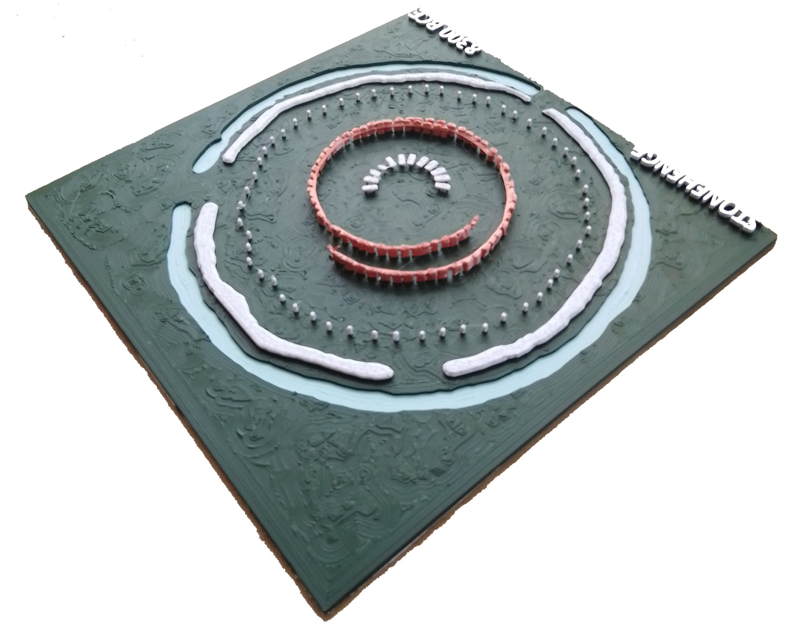
      This earliest version of Stonehenge was a working health and mortuary site. It featured a chalk-cut moat that held water, 58 imported Preseli bluestones, and a timber palisade enclosing raised stone platforms for excarnation. Birds were allowed to clean the dead — a practice still seen today in India’s towers of silence. The Y and Z holes marked the outer limits of the palisade; the Q and R holes defined where excarnation slabs once stood. The entire setup was pragmatic, not ritualistic.

      Stonehenge Phase 1 — Britain's First Monument
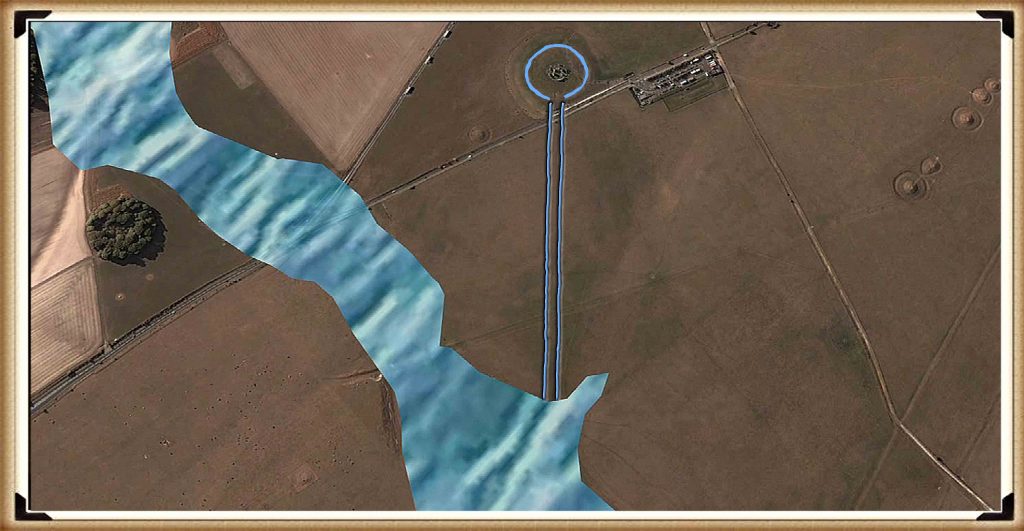
      The Monument was surrounded by a watery moat and 58 Bluestones – Stonehenge Phase 1 — Britain’s First Monument

      2. How We Know Stonehenge Phase 1 Was Built in 8300 BCE

      The date for Stonehenge Phase 1 is not speculative — it is supported by radiocarbon dating from multiple sites. Charcoal samples from postholes discovered in the Stonehenge car park excavation have been dated to around 8300 BCE. This corresponds closely with two quarry sites in the Preseli Hills of Wales, where evidence of human activity — including hearths associated with stone extraction — has also produced C14 dates from the same period. These sites are not random campfires but appear to be linked directly to quarrying activity associated with the bluestones.

      This level of coordination between quarrying and monument construction suggests an advanced society operating across hundreds of miles, capable of planning and logistics long before the Neolithic. The matched radiocarbon dates from the quarry and monument provide strong empirical support for the theory that bluestones were transported and erected at Stonehenge in the 9th millennium BCE.

      While hydrological modelling still reinforces the idea that this was the only period when the chalk aquifer would have provided a permanent water source at the monument, it is the radiocarbon evidence — independently dated at both source and site — that fixes Stonehenge Phase 1 to approximately 8300 BCE. This makes it the earliest scientifically verified monumental construction in the British Isles.

      Stonehenge Phase 1 — Britain's First Monument
      C14 dates reveal a 10,000 year old secret – Stonehenge Phase 1 — Britain’s First Monument

      3. Layout and Function — The Real Purpose of the Site

      The layout of Phase 1 was deliberate and practical. At the centre were the Q and R holes, which supported dolmen-style excarnation slabs — single flat stones balanced precisely on pointed supports to deter rodents. These slabs were used to expose bodies to the elements and scavenger birds, an efficient and sanitary method of processing the dead. The palisade surrounding the structure, marked by the Y and Z holes, enclosed this inner space to protect the area while allowing avian access. The design shows a clear understanding of decomposition cycles and scavenger behaviour.

      The northwest orientation of the Q and R hole alignment corresponds to the moon’s setting position, reinforcing the functional connection to death and timing. The number of bluestones — 58 — was not arbitrary. It matches the synodic cycle of the moon, used to track its 18.6-year cycle of eclipses and nodal variation. This was likely vital for excarnation timing, navigation, tidal awareness, and critical knowledge for a riverine trading society.

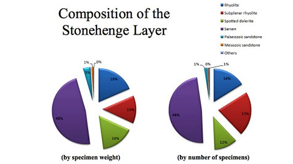
      The bluestones themselves were never meant to remain intact. As noted by Darvill and Wainwright, the bluestones were chipped down almost immediately. Over 3,675 fragments have been discovered — a remarkable total given that only half the site has been excavated. These fragments were deliberately introduced into the chalk moat. With their high rock salt content, the bluestone chips enriched the water with medicinal minerals, enhancing its curative potential. This suggests that Stonehenge Phase 1 was not a ceremonial temple, but a sophisticated facility for managing death, disease, and recovery.

      The Platforms are facing the Solstice Moon Setting NW Location – Stonehenge Phase 1 — Britain’s First Monument

      4. The Bluestones — Transport, Composition, and Use

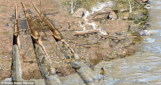
      The Preseli bluestones used at Stonehenge were transported from southwest Wales, likely via river and canal networks, rather than being dragged over land. The discovery of an ancient prehistoric catamaran boatyard dating to the Neolithic in Wales suggests they were moved by double-hulled craft suitable for carrying heavy loads. Britain’s river levels were significantly higher at the time, which enabled direct water transport to the site without the need for sea voyages.

      What matters more than their origin is their composition. The Preseli stones are rich in rock salt, copper, and trace minerals, which leach into water when submerged or broken. This is not theoretical — over 3,675 bluestone fragments have been found in the moat area. This suggests the stones were intentionally broken up to release minerals into the water, creating a kind of early mineral spa.

      This theory is further supported by Darvill and Wainwright, who observed that the stones were being chipped away from the time of their erection and even proposed the site may have served as a healing centre. This evidence strengthens the argument that Stonehenge functioned primarily as a public health structure, specifically for sepsis and infection, the leading causes of death in prehistoric times.

      (The Oldest Boatyard in the World Uncovered)
      Welsh Catamarans made to carry stones on rivers – Stonehenge Phase 1 — Britain’s First Monument

      5. The Water — How It Worked, and Why It Mattered

      The chalk-cut ditch surrounding the central enclosure was not ornamental. It was a functional water feature, drawing from a naturally high water table during the Mesolithic. The aquifer-fed ditch would have constantly circulated mineral-rich water through the site, turning the enclosed area into a therapeutic environment.

      Bluestone chippings, deliberately broken and deposited in this moat, would have slowly released rock salt and trace elements into the water. Salt has antiseptic properties and is still used today in wound care. Soaking in this solution could have helped prevent or treat infections in a world without antibiotics.

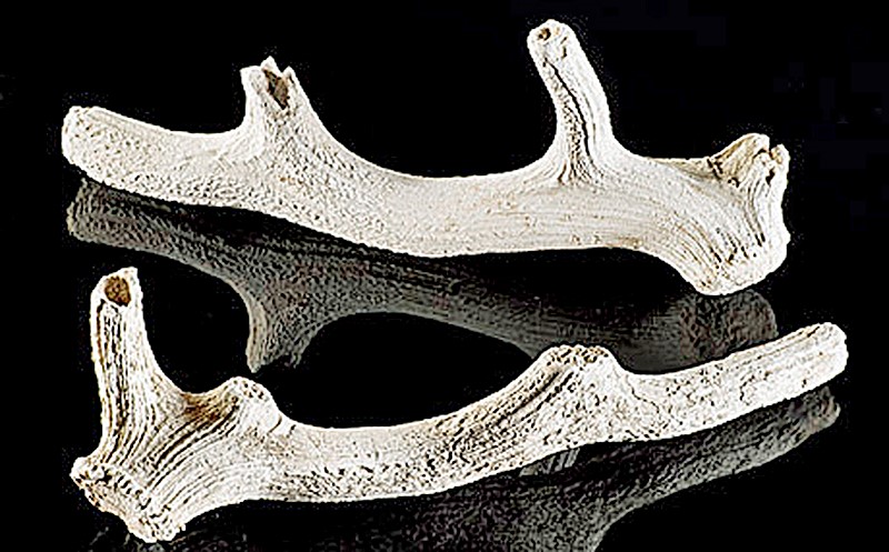
      The antler picks found in the ditch have been misinterpreted as construction tools. In fact, they are more logically explained as dredging tools used to maintain the flow and clarity of the water system. These were found in later layers, suggesting periodic cleaning of the moat rather than its original excavation.

      Stonehenge Phase 1 — Britain's First Monument
      Found in the ditch at Stonehenge (not made to dig in chalk) Stonehenge Phase 1 — Britain’s First Monument

      6. The Evidence of Reuse and Replacement

      Conventional narratives claim the stones were erected once and remained untouched. However, C14 dating and excavation records tell a different story. The bluestones were replaced multiple times over a long period, not just transported once and left to stand. Dating of stone socket fills shows repeated insertion events, sometimes centuries apart.

      This supports the idea that the site was actively maintained, not abandoned or commemorated. Replacement intervals appear tied to mineral depletion — once enough salt and trace minerals had leached out of the existing stones, they were broken up and replaced. This explains the high number of fragments despite limited excavation.

      With only around 50% of the site dug, over 3,600 fragments have been recovered — meaning the actual number is likely double. These are not random breakages or damage from collapse; they were systematically chipped and deposited into the water.

      Stonehenge Phase 1 — Britain's First Monument
      3,600 fragments from only 50% of the Site – Stonehenge Phase 1 — Britain’s First Monument

      7. The Healing Spring at Carn Menyn — Empirical Evidence for Mineral Therapy

      A major criticism of the “healing stones” hypothesis has been the supposed lack of empirical evidence. But recent research at Carn Menyn in the Preseli Mountains — one of the key sources of the Stonehenge bluestones — reveals a now-dry sacred springhead that may hold the key to understanding the stones’ original purpose.

      Gordon Freeman’s 2013 fieldwork identified a collapsed cromlech and associated cairn built directly over a once-flowing freshwater spring known locally as Pen y Tarddiant Sanctaidd (Holy Springhead). This spring fed a stone-lined stream channel called Rhestr Gerrig (“Stone Row”), wounding through the landscape toward a marshy area called Fat Hazelnut Bog. While this water source has since dried up, its historical importance is undeniable. The spring was sacred enough to warrant a formal burial monument, and the fact that a cromlech capped it suggests a long tradition of ritualised — and likely therapeutic — use.

      But this is more than symbolic. The springhead sits directly within the geological formation from which spotted dolerite (bluestone) was quarried — and critically, analysis of this dolerite reveals it contains natural rock salt and trace minerals. This means the spring water would likely have been slightly brined, absorbing salts and mineral ions as it passed through and over the bluestone deposits. Wound irrigation with mineral water would have had antiseptic and soothing properties — a fact observable by prehistoric peoples even without modern biochemistry.

      This context gives physical, testable logic to why the same rock was selected and transported over 200 km to the chalk aquifer basin of Stonehenge: to recreate the medicinal properties of the Preseli spring. The deliberate chipping of bluestones into fragments and depositing them into the moat — as confirmed by Darvill and Wainwright — wasn’t ceremonial destruction. It was chemical replication. The stones infused the water with trace minerals, producing a brine bath system that matched the healing waters of the original spring in Wales.

      Taken together — the presence of a prehistoric sacred spring, the saline-rich composition of bluestone, and the evidence of engineered mineral dissolution at Stonehenge — make this a rare case where archaeology, geology, and hydrology converge into an empirical explanation for a so-called “ritual” monument. Stonehenge Phase One was not a temple. It was Britain’s first public health sanctuary, and the spring at Carn Menyn was its biochemical blueprint.

      Stonehenge Phase 1 — Britain's First Monument
      The Healing Spring at Carn Menyn – Stonehenge Phase 1 — Britain’s First Monument

      8. The Pallisade and the Silent Towers

      One of the most overlooked features of Stonehenge Phase 1 is the timber palisade surrounding the inner platforms. This structure wasn’t defensive — it was functional and hygienic, containing excarnation within the central area while restricting access.

      This enclosure is clearly defined by the Y and Z holes, which are too consistent and evenly spaced to be symbolic. They formed the foundation for a pair of stone uprights, making the interior a raised series of protected platforms. Birds — especially carrion feeders (mainly Jackdaws, Ravens, and Crows)— were allowed access to clean the bodies. The cleaned bones were then taken to nearby Long Barrows for entombment.

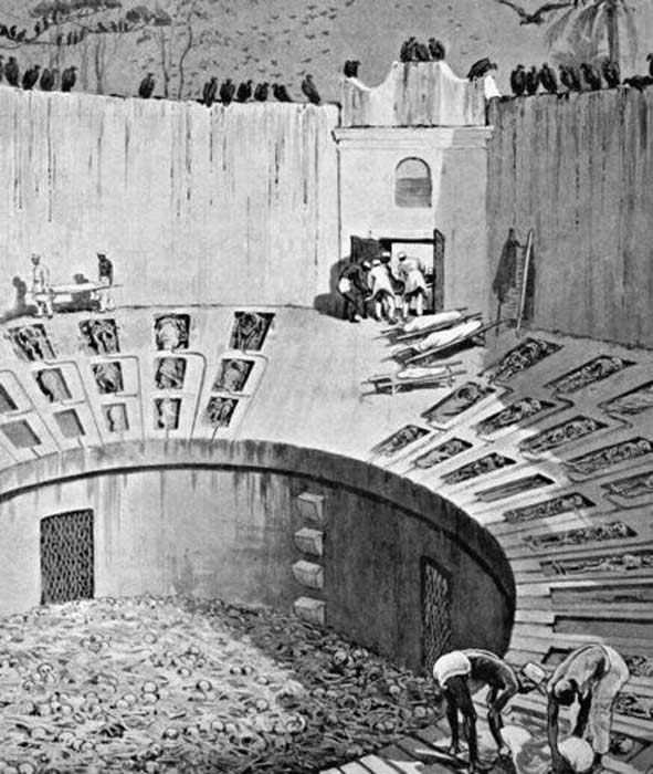
      This practice mirrors India’s “silent towers”, where sky burial traditions continue. It reflects a belief not in symbolism but in natural decomposition and purification. Stonehenge’s setup provided a sanitary, repeatable method for body disposal — highly advanced for its time.

      The Healing Spring at Carn Menyn
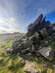
      Towers of Silence (Silent Towers) – Stonehenge Phase 1 — Britain’s First Monument

      9. Decline and Transition to Phase 2

      Over time, the water table dropped as the aquifer drained and post-glacial rebound altered the landscape. The once-functioning moat began drying up, and the mineral bath lost efficacy. This environmental shift marks the end of Phase 1 and the beginning of a new chapter in the site’s life.

      The bluestones were gradually replaced by larger sarsen stones, marking a transition from a practical medical site to something more monumental. These sarsens were installed around 4300 BCE, beginning what most people today incorrectly consider the start of Stonehenge.

      This change is visible in the construction of The Avenue, a wide processional route that leads away from the original riverfront location to the new shoreline further northeast. This redirection reflects both cosmic alignments and the simple reality of hydrological change.

      The Avon shrank to just Stonehenge Bottom were they connected a road for Phase 2 -Stonehenge Phase 1 — Britain’s First Monument

      10. Conclusion — A Monument Built on Function, Not Fantasy

      The first phase of Stonehenge was not a mystical temple, a ceremonial gathering place, or a stone calendar. It was a public health structure, grounded in the harsh realities of Mesolithic life — infection, injury, and death. Its foundation wasn’t spiritual conjecture, but practical science: built on a prehistoric shoreline, maintained by a saturated aquifer, and enriched by mineral-laden bluestone chips dissolved into the water. It was a place of triage, treatment, and transformation.

      Thanks to a new mathematical dating model — one grounded in radiocarbon evidence from quarry hearths, site postholes, and hydrological mapping — we now know Phase 1 began around 8300 BCE. This places Stonehenge among the oldest monumental structures in Europe, second only to Carnac in France, and dismantles the false timeline held by mainstream archaeology. It was not a late Neolithic curiosity but a pioneering Mesolithic achievement. And this was a rational, functional innovation centuries ahead, unlike the speculative calendars or solar temples peddled by tradition.

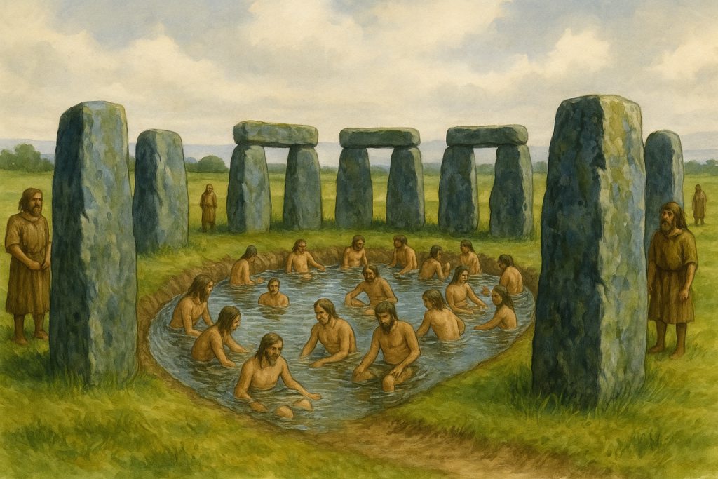
      Archaeologists have consistently failed to interpret key features of the site. Once thought irrelevant, the postholes forming the central crescent pattern align exactly with where excarnation slabs would have stood. Their curious shape and placement remain unacknowledged in academic literature. Even the surrounding palisade, indicated by the Y and Z holes, has gone largely ignored, despite its obvious protective function. Traditionally described as ceremonial, the ditch is no ditch at all — it is a ring of pits, designed to house seating platforms below water level for therapeutic bathing. This unique design, found nowhere else in Britain, is left undiscussed because it breaks too many taboos about what Stonehenge might truly have been.

      The fog is lifting with advances in LiDAR, mineral analysis, hydrology, and radiocarbon calibration. Stonehenge Phase 1 must now be recognised as Britain’s first scientific structure — a masterpiece of Mesolithic engineering, biology, and community medicine — misunderstood for thousands of years by a profession still reluctant to let go of fantasy.

      Stonehenge Phase 1 — Britain's First Monument
      Bathing at health spas are prehistoric in origin – Stonehenge Phase 1 — Britain’s First Monument

      PodCast

      Silbury Avenue - Avebury's First Stone Avenue

      Author’s Biography

      Robert John Langdon, a polymathic luminary, emerges as a writer, historian, and eminent specialist in LiDAR Landscape Archaeology.

      His intellectual voyage has interwoven with stints as an astute scrutineer for governmental realms and grand corporate bastions, a tapestry spanning British Telecommunications, Cable and Wireless, British Gas, and the esteemed University of London.

      A decade hence, Robert’s transition into retirement unfurled a chapter of insatiable curiosity. This phase saw him immerse himself in Politics, Archaeology, Philosophy, and the enigmatic realm of Quantum Mechanics. His academic odyssey traversed the venerable corridors of knowledge hubs such as the Museum of London, University College London, Birkbeck College, The City Literature Institute, and Chichester University.

      In the symphony of his life, Robert is a custodian of three progeny and a pair of cherished grandchildren. His sanctuary lies ensconced in the embrace of West Wales, where he inhabits an isolated cottage, its windows framing a vista of the boundless sea – a retreat from the scrutinous gaze of the Her Majesty’s Revenue and Customs, an amiable clandestinity in the lap of nature’s embrace.

      Exploring Prehistoric Britain: A Journey Through Time

      My blog delves into the fascinating mysteries of prehistoric Britain, challenging conventional narratives and offering fresh perspectives based on cutting-edge research, particularly using LiDAR technology. I invite you to explore some key areas of my research. For example, the Wansdyke, often cited as a defensive structure, is re-examined in light of new evidence. I’ve presented my findings in my blog post Wansdyke: A British Frontier Wall – ‘Debunked’, and a Wansdyke LiDAR Flyover video further visualizes my conclusions.

      My work also often challenges established archaeological dogma. I argue that many sites, such as Hambledon Hill, commonly identified as Iron Age hillforts are not what they seem. My posts Lidar Investigation Hambledon Hill – NOT an ‘Iron Age Fort’ and Unmasking the “Iron Age Hillfort” Myth explore these ideas in detail and offer an alternative view. Similarly, sites like Cissbury Ring and White Sheet Camp, also receive a re-evaluation based on LiDAR analysis in my posts Lidar Investigation Cissbury Ring through time and Lidar Investigation White Sheet Camp, revealing fascinating insights into their true purpose. I have also examined South Cadbury Castle, often linked to the mythical Camelot56.

      My research also extends to the topic of ancient water management, including the role of canals and other linear earthworks. I have discussed the true origins of Car Dyke in multiple posts including Car Dyke – ABC News PodCast and Lidar Investigation Car Dyke – North Section, suggesting a Mesolithic origin2357. I also explore the misidentification of Roman aqueducts, as seen in my posts on the Great Chesters (Roman) Aqueduct. My research has also been greatly informed by my post-glacial flooding hypothesis which has helped to inform the landscape transformations over time. I have discussed this hypothesis in several posts including AI now supports my Post-Glacial Flooding Hypothesis and Exploring Britain’s Flooded Past: A Personal Journey

      Finally, my blog also investigates prehistoric burial practices, as seen in Prehistoric Burial Practices of Britain and explores the mystery of Pillow Mounds, often mistaken for medieval rabbit warrens, but with a potential link to Bronze Age cremation in my posts: Pillow Mounds: A Bronze Age Legacy of Cremation? and The Mystery of Pillow Mounds: Are They Really Medieval Rabbit Warrens?. My research also includes the astronomical insights of ancient sites, for example, in Rediscovering the Winter Solstice: The Original Winter Festival. I also review new information about the construction of Stonehenge in The Stonehenge Enigma.

      Further Reading

      For those interested in British Prehistory, visit www.prehistoric-britain.co.uk, a comprehensive resource featuring an extensive collection of archaeology articles, modern LiDAR investigations, and groundbreaking research. The site also includes insights and extracts from the acclaimed Robert John Langdon Trilogy, a series of books exploring Britain during the Prehistoric period. Titles in the trilogy include The Stonehenge Enigma, Dawn of the Lost Civilisation, and The Post Glacial Flooding Hypothesis, offering compelling evidence about ancient landscapes shaped by post-glacial flooding.

      To further explore these topics, Robert John Langdon has developed a dedicated YouTube channel featuring over 100 video documentaries and investigations that complement the trilogy. Notable discoveries and studies showcased on the channel include 13 Things that Don’t Make Sense in History and the revelation of Silbury Avenue – The Lost Stone Avenue, a rediscovered prehistoric feature at Avebury, Wiltshire.

      In addition to his main works, Langdon has released a series of shorter, accessible publications, ideal for readers delving into specific topics. These include:

      For active discussions and updates on the trilogy’s findings and recent LiDAR investigations, join our vibrant community on Facebook. Engage with like-minded enthusiasts by leaving a message or contributing to debates in our Facebook Group.

      Whether through the books, the website, or interactive videos, we aim to provide a deeper understanding of Britain’s fascinating prehistoric past. We encourage you to explore these resources and uncover the mysteries of ancient landscapes through the lens of modern archaeology.

      For more information, including chapter extracts and related publications, visit the Robert John Langdon Author Page. Dive into works such as The Stonehenge Enigma or Dawn of the Lost Civilisation, and explore cutting-edge theories that challenge traditional historical narratives.

      Other Blogs

      [sitemap_posts]
      Ten Things You Didn’t Know About Britain’s Prehistoric Flooded Past


      Introduction — The Britain You Know Is a Fake

      (Ten Things You Didn’t Know About Britain’s Prehistoric Flooded Past)

      We look at our hills, rivers, and coasts… and think they’ve always been there.
      Stable. Permanent.

      But that picture… is a lie.
      At the end of the last Ice Age, Britain was a land in chaos.
      Seas surged sixty metres higher. Rivers swelled beyond imagination. Entire countries… disappeared beneath the waves.

      Archaeology often ignores this truth. Too many theories are drawn on a modern map — a map our ancestors would barely recognise.
      After two decades of fieldwork and over two hundred and sixty research blogs, I can tell you: to understand prehistoric Britain… you must redraw it.
      Here are ten things you probably didn’t know about the drowned, shifting, waterlogged world our ancestors truly lived in.

      (Ten Things You Didn’t Know About Britain’s Prehistoric Flooded Past)
      A Landscape full of enlarged rivers – (Ten Things You Didn’t Know About Britain’s Prehistoric Flooded Past)

      1 — The Britain You Know Is Only 8,000 Years Old

      When the Holocene began, Britain wasn’t an island.
      A land bridge linked us to Europe — until rising seas finally severed it around six thousand BCE.
      The change wasn’t gentle.
      Meltwater pulses sent the tide racing inland, flooding valleys in years… not centuries.

      Sea levels rose faster than our worst climate forecasts for 2100.
      Every coastline shifted. The mouth of the Thames moved inland. Estuaries formed where farmland now lies.
      Your hometown… could have been seabed

      If you stood there then, your mental map of Britain would be unrecognisable.
      The “island nation” idea? A very recent reality.
      For most of prehistory… Britain was part of a wider European landscape.

      (Ten Things You Didn’t Know About Britain’s Prehistoric Flooded Past)
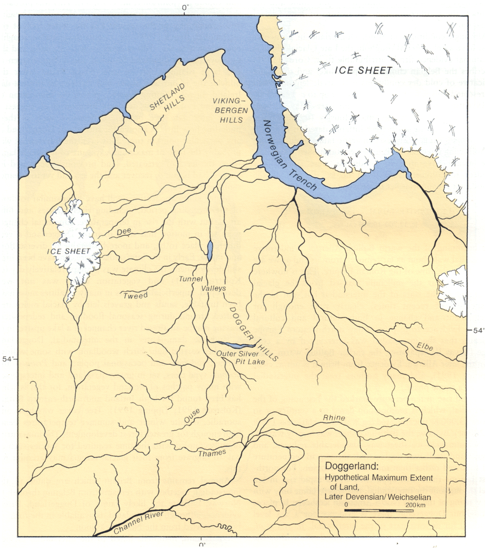
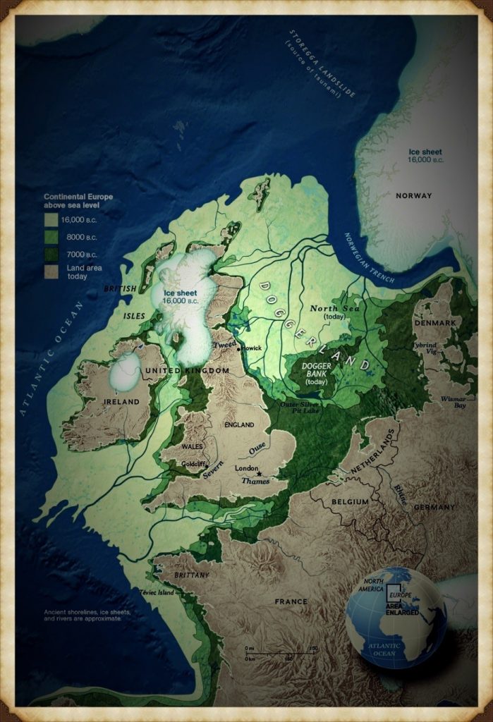
      Doggerland was once jus one enlarged continent (Ten Things You Didn’t Know About Britain’s Prehistoric Flooded Past)

      2 — Stonehenge’s Bluestones Couldn’t Have Rolled Here

      The romantic image is familiar: teams of men with ropes and ox-carts dragging stones two hundred kilometres from Preseli to Salisbury Plain.
      But around eight thousand BCE, ninety percent of that “route” was deep wildwood.
      Valleys in between? Bog-soaked mires.
      Wheels would have sunk without a trace.

      The real transport network wasn’t overland — it was water.
      Seasonal floods. Frost-hardened winter ground. And above all… rivers.
      LiDAR mapping shows prehistoric waterways were the true highways.

      This single fact changes the Stonehenge story entirely.
      It wasn’t a land-locked haul of brute force — it was a calculated, water-based operation using the landscape to its advantage.

      (Ten Things You Didn’t Know About Britain’s Prehistoric Flooded Past)
      The idea of dragging Stones of 20 – 30 tonnes is pure folly – (Ten Things You Didn’t Know About Britain’s Prehistoric Flooded Past)

      3 — Britain Once Had a Country Twice the Size of Wales — and Lost It Overnight

      Doggerland was no myth. It was a vast lowland stretching from East Anglia to the Netherlands.
      Its marshes, rivers, and lakes supported thousands of people. For centuries, it was a bridge between Britain and Europe.

      Then it drowned. Whether through steady sea rise, sudden flooding, or both — the result was the same.
      Communities found themselves separated by water where there had once been solid ground.

      That shock forced a new reality.
      Boats were no longer optional… they were survival.
      In my Maritime Diffusion Model, this moment explains why megalithic architecture suddenly spread so quickly along Atlantic coasts — the sea became the new road.

      (Ten Things You Didn’t Know About Britain’s Prehistoric Flooded Past)
      The drowning of Doggerland was a major catastrophic event in History of the World – (Ten Things You Didn’t Know About Britain’s Prehistoric Flooded Past)

      4 — Raised Beaches… Or the Fingerprints of a Flooded Britain?

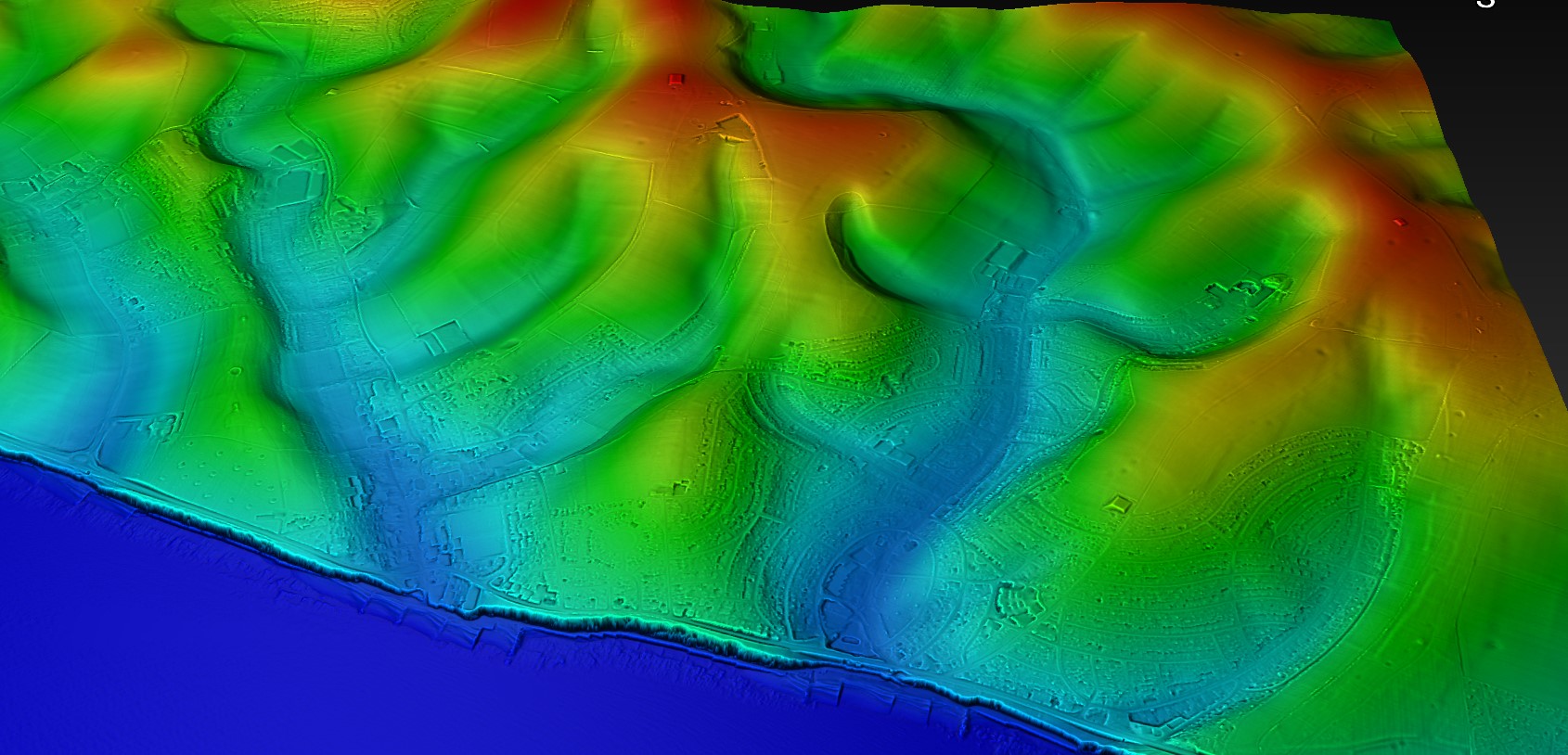
      On Britain’s south coast, geologists point to “raised beaches” — sand and gravel layers perched far above today’s tide line.
      The standard explanation is a mix of ancient shorelines and “isostatic rebound.” But the data… doesn’t match the story.

      My research shows these aren’t fossil beaches at all. They’re concave, river-shaped deposits.
      They sit under layers of unstructured chalk — exactly what you’d expect if catastrophic meltwater floods carved paleochannels down to the sea.
      British Geological Survey maps confirm the pattern: huge branching flows, not static coastlines.

      Once you see it, you can’t unsee it.
      These are not tranquil remnants of a higher tide… they are scars of a country in flood</emphasis>.
      And they tell a far more dynamic, violent story than the textbooks admit.

      (Ten Things You Didn’t Know About Britain’s Prehistoric Flooded Past)
      If geologists used Lidar such misidentification would be avoided – (Ten Things You Didn’t Know About Britain’s Prehistoric Flooded Past)

      5 — The Thames Was Once Seven Kilometres Wide

      Beneath London, boreholes reveal up to ten metres of early-Holocene silt.
      This was not the neat, channelled Thames we know — it was a vast, braided tidal delta up to seven kilometres across.

      Such a river wasn’t just wider… it was a different creature entirely.
      Settlements clung to the high ground like islands. Boats connected them. Trade and travel followed water channels, not overland tracks.
      This wasn’t an obstacle — it was a superhighway.

      And here’s the myth-buster: London’s lack of prehistoric sites isn’t due to modern building wiping them out.
      LiDAR shows that much of the Thames Valley floor was too wide and flood-prone to build on.
      Only a few habitable high points existed — the places we now call the “Home Counties.”

      London (The Thames) through time
      The Thames was not swollen it was swamped in the Mesolithic – (Ten Things You Didn’t Know About Britain’s Prehistoric Flooded Past)

      6 — The Isle of Wight Was Cut Off by a Flooded River Valley

      The Solent started as a river.
      Then, around seven thousand five hundred years ago, rising seas burst through the valley, flooding it completely.
      A short walk became an open-water crossing — and life on both sides changed overnight.

      Suddenly, trade required boats. Communities reorganised. Control of crossing points likely meant influence and power.
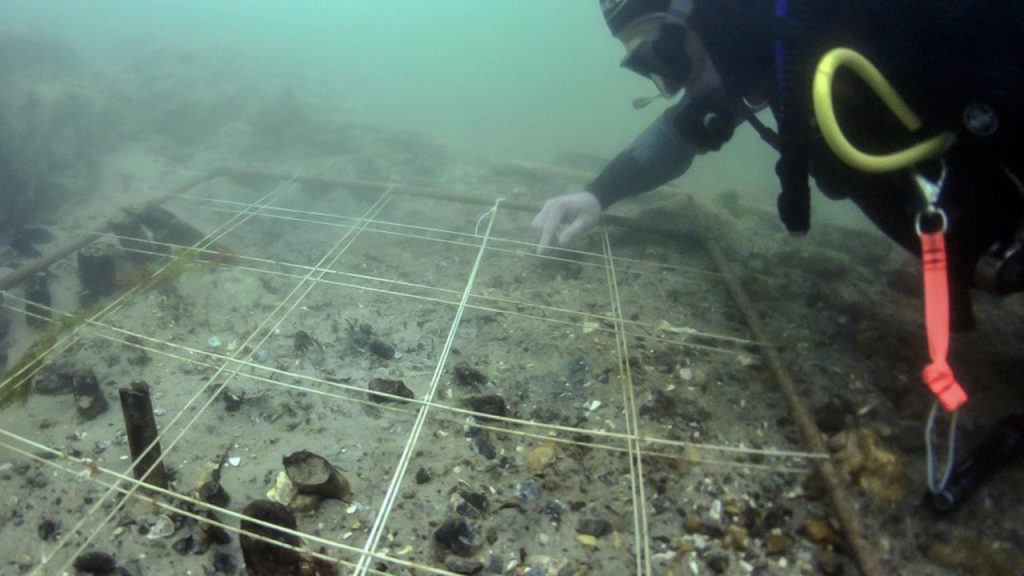
      Archaeology along the submerged Solent shows drowned forests, hearths, and even worked timbers… frozen in place beneath the waves.

      Most extraordinary of all is Bouldnor Cliff.
      Here, eleven metres underwater, lies the world’s first known boat-building site — a sixth-millennium BCE harbour that imported Einkorn wheat from mainland Europe.
      This was no primitive backwater… it was a maritime hub centuries ahead of its time.

      Bouldnor Cliff - Einkorn wheat
      Bouldnor Cliff – Einkorn wheat – (Ten Things You Didn’t Know About Britain’s Prehistoric Flooded Past)

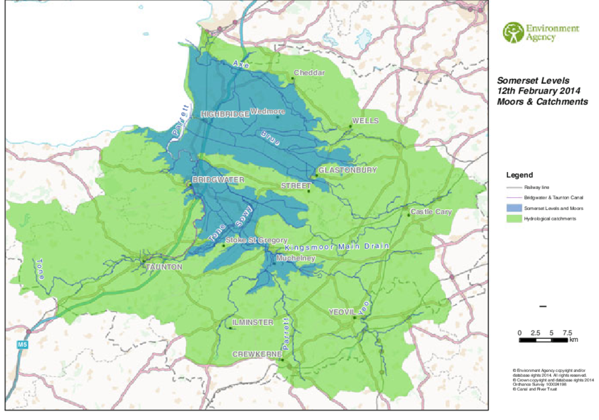
      7 — Somerset’s Levels Were a Salt-Water Swamp

      Between 5600 and 4450 BCE, the Somerset Levels were not the patchwork of fields we know today.
      They were alder-carr woodland slowly drowning under advancing salt marsh.

      Peat cores show the shift layer by layer — from fresh water to brackish tidal intrusion.
      To prehistoric people, this meant constant adaptation: moving camps, changing food sources, finding safe ground.

      Centuries later, societies would turn this swamp into a managed landscape of canals and raised trackways.
      But in its early days, it was a shifting, dangerous maze of water… a place that could swallow your settlement in a season.

      (Ten Things You Didn’t Know About Britain’s Prehistoric Flooded Past)
      It started as freshwater swamp then turned into salt water swamp – (Ten Things You Didn’t Know About Britain’s Prehistoric Flooded Past)

      8 — Stonehenge Stood on a Peninsula Fed by a Healing Spring

      Stonehenge didn’t stand beside a ceremonial pool or a “ritual lagoon.”
      It was built on a peninsula jutting into the River Avon, fed by a natural spring at Stonehenge Bottom.
      This fresh, flowing water made the site an ideal meeting place and a reliable refuge.

      The bluestones, brought from Preseli, were more than decorative.
      They contain minerals with natural antibacterial properties.
      In a world where sepsis from a cut could be fatal, those stones were medicine.

      Water from the spring flowing past them created a setting believed to aid recovery from infections and wounds.
      Forget the star-gazing theories — Stonehenge was a healing centre, built with purpose and grounded in survival.

      (Ten Things You Didn’t Know About Britain’s Prehistoric Flooded Past)
      The Bluestones were broken up like bath salts when they arrived at Stonehenge – (Ten Things You Didn’t Know About Britain’s Prehistoric Flooded Past)

      9 — Our “Iron Age Hillforts” May Be Older — and Wetter — Than We Think

      From the air, hillforts look like defensive enclosures.
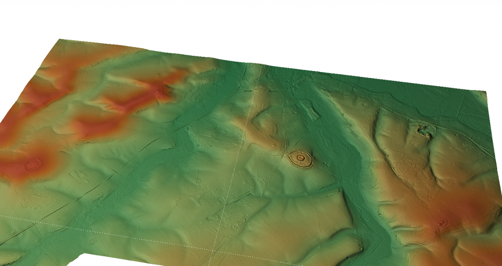
      But LiDAR tells a different story — many sit in wet, low-lying areas with evidence of ditches that once held water.

      These weren’t forts braced for battle… they were moated settlements designed for trade and control of water routes.
      In a wetter prehistoric Britain, that was often more important than any wall.

      Re-examining these sites with hydrology in mind reveals a network of connected hubs — places where goods, people, and ideas moved not along ridge-tops, but through waterways.
      It’s a complete rethink of “forts” as we know them.

      (Ten Things You Didn’t Know About Britain’s Prehistoric Flooded Past)
      Old Sarum is in the middle of a River – although its called an ‘Iron Age Fort’? – (Ten Things You Didn’t Know About Britain’s Prehistoric Flooded Past)

      10 — The Map in Your Head Is a Mirage

      When we think of Britain, we picture a static shape — familiar coastlines, steady rivers.
      But in prehistory, those lines were always on the move.

      Rivers cut new paths. Valleys flooded. Islands appeared and vanished.
      The Britain of twelve thousand years ago was nothing like the Britain of eight thousand years ago — and both were strangers to the Britain we know now.

      The Post-Glacial Flooding Hypothesis forces us to redraw that mental map.
      Once you do, everything changes — from how Stonehenge was built, to why Doggerland mattered, to the true nature of “hillforts.”
      It’s not just a new map… it’s a new past.

      (Ten Things You Didn’t Know About Britain’s Prehistoric Flooded Past)
      Boats were the only way to travel and trade in the Mesolithic Period – (Ten Things You Didn’t Know About Britain’s Prehistoric Flooded Past)

      Conclusion — Redraw the Map. Rethink the Past.

      Prehistoric Britain was not a gentle green land.
      It was a place of rapid change, flooded valleys, and disappearing coasts.
      Ignore that… and you get bad archaeology.

      Factor it in — and new explanations open up for the monuments, settlements, and journeys of our ancestors.
      The evidence is there. The map is wrong.
      <emphasis level=”moderate”>It’s time to set it right</emphasis>.

      (Ten Things You Didn’t Know About Britain’s Prehistoric Flooded Past)
      (Ten Things You Didn’t Know About Britain’s Prehistoric Flooded Past)

      Update

      Where to see Britain’s post-glacial high water table

      The caves are the evidence. Karst systems preserve the height of former water tables:

      Mendip Hills (Cheddar Gorge / Wookey Hole): Relic phreatic levels high above modern flow routes show earlier pressurised groundwater; silted tubes and scallops mark sustained high head after deglaciation.

      Yorkshire Dales (Malham–Ingleborough): Abandoned risings and perched conduits around Malham Cove & Gaping Gill record higher Holocene heads; modern springs sit lower as the aquifer discharged over millennia.

      Peak District (Castleton): Upper fossil passages in Peak Cavern/Speedwell are stranded above active streams—classic regression from a post-glacial high stand.

      Chalk Winterbournes (Downs/Chilterns): The Misbourne, Chess, Kennet headwaters and Dorset winterbournes switch on when the head rises—same physics, small timescale. Early Holocene = the “on” position for much longer.

      Chalk dew-ponds: Longevity on permeable chalk relies on self-sealing skins—the same lining behavior that helps Phase-1 Stonehenge’s moat retain water under high head.

      Why this matters for Stonehenge Phase 1

      Mechanism: High head + chalk colmation = standing water in the ditch.

      Analogue: Cave high-stands are the geological logbook of that head.

      Fit: The moat enables the mineralised bluestone baths and excarnation workflow documented in the Phase-1 model.

      Quick Evidence: Britain’s Aquifers, Made Visible

      Karst plumbing on show. In chalk/limestone belts, groundwater carved conduits, phreatic tubes, risings, and sinkholes—the aquifer made visible in places like the Mendips, Yorkshire Dales, and the Peak District.

      High-stand markers. Abandoned phreatic passages perched high on cave walls, scalloped ceilings (pressurised flow), and silt beds record past water-table positions—higher than today during the early Holocene.

      Seasonal analogue. Modern winterbournes (dry valleys that flow only when the head rises) prove the mechanism: when the potentiometric surface sits above cut level, water holds—exactly what Phase 1 required.

      Self-sealing ditches. Fresh chalk cuts develop clay/carbonate skins (colmation), reducing leakage. With high head + recharge, a “ditch” becomes a moat.


      PodCast

      Silbury Avenue - Avebury's First Stone Avenue

      Author’s Biography

      Robert John Langdon, a polymathic luminary, emerges as a writer, historian, and eminent specialist in LiDAR Landscape Archaeology.

      His intellectual voyage has interwoven with stints as an astute scrutineer for governmental realms and grand corporate bastions, a tapestry spanning British Telecommunications, Cable and Wireless, British Gas, and the esteemed University of London.

      A decade hence, Robert’s transition into retirement unfurled a chapter of insatiable curiosity. This phase saw him immerse himself in Politics, Archaeology, Philosophy, and the enigmatic realm of Quantum Mechanics. His academic odyssey traversed the venerable corridors of knowledge hubs such as the Museum of London, University College London, Birkbeck College, The City Literature Institute, and Chichester University.

      In the symphony of his life, Robert is a custodian of three progeny and a pair of cherished grandchildren. His sanctuary lies ensconced in the embrace of West Wales, where he inhabits an isolated cottage, its windows framing a vista of the boundless sea – a retreat from the scrutinous gaze of the Her Majesty’s Revenue and Customs, an amiable clandestinity in the lap of nature’s embrace.

      (The Stonehenge Code)

      Exploring Prehistoric Britain: A Journey Through Time

      My blog delves into the fascinating mysteries of prehistoric Britain, challenging conventional narratives and offering fresh perspectives based on cutting-edge research, particularly using LiDAR technology. I invite you to explore some key areas of my research. For example, the Wansdyke, often cited as a defensive structure, is re-examined in light of new evidence. I’ve presented my findings in my blog post Wansdyke: A British Frontier Wall – ‘Debunked’, and a Wansdyke LiDAR Flyover video further visualizes my conclusions.

      My work also often challenges established archaeological dogma. I argue that many sites, such as Hambledon Hill, commonly identified as Iron Age hillforts are not what they seem. My posts Lidar Investigation Hambledon Hill – NOT an ‘Iron Age Fort’ and Unmasking the “Iron Age Hillfort” Myth explore these ideas in detail and offer an alternative view. Similarly, sites like Cissbury Ring and White Sheet Camp, also receive a re-evaluation based on LiDAR analysis in my posts Lidar Investigation Cissbury Ring through time and Lidar Investigation White Sheet Camp, revealing fascinating insights into their true purpose. I have also examined South Cadbury Castle, often linked to the mythical Camelot56.

      My research also extends to the topic of ancient water management, including the role of canals and other linear earthworks. I have discussed the true origins of Car Dyke in multiple posts including Car Dyke – ABC News PodCast and Lidar Investigation Car Dyke – North Section, suggesting a Mesolithic origin2357. I also explore the misidentification of Roman aqueducts, as seen in my posts on the Great Chesters (Roman) Aqueduct. My research has also been greatly informed by my post-glacial flooding hypothesis which has helped to inform the landscape transformations over time. I have discussed this hypothesis in several posts including AI now supports my Post-Glacial Flooding Hypothesis and Exploring Britain’s Flooded Past: A Personal Journey

      Finally, my blog also investigates prehistoric burial practices, as seen in Prehistoric Burial Practices of Britain and explores the mystery of Pillow Mounds, often mistaken for medieval rabbit warrens, but with a potential link to Bronze Age cremation in my posts: Pillow Mounds: A Bronze Age Legacy of Cremation? and The Mystery of Pillow Mounds: Are They Really Medieval Rabbit Warrens?. My research also includes the astronomical insights of ancient sites, for example, in Rediscovering the Winter Solstice: The Original Winter Festival. I also review new information about the construction of Stonehenge in The Stonehenge Enigma.

      (The Stonehenge Code)

      Further Reading

      For those interested in British Prehistory, visit www.prehistoric-britain.co.uk, a comprehensive resource featuring an extensive collection of archaeology articles, modern LiDAR investigations, and groundbreaking research. The site also includes insights and extracts from the acclaimed Robert John Langdon Trilogy, a series of books exploring Britain during the Prehistoric period. Titles in the trilogy include The Stonehenge Enigma, Dawn of the Lost Civilisation, and The Post Glacial Flooding Hypothesis, offering compelling evidence about ancient landscapes shaped by post-glacial flooding.

      To further explore these topics, Robert John Langdon has developed a dedicated YouTube channel featuring over 100 video documentaries and investigations that complement the trilogy. Notable discoveries and studies showcased on the channel include 13 Things that Don’t Make Sense in History and the revelation of Silbury Avenue – The Lost Stone Avenue, a rediscovered prehistoric feature at Avebury, Wiltshire.

      In addition to his main works, Langdon has released a series of shorter, accessible publications, ideal for readers delving into specific topics. These include:

      For active discussions and updates on the trilogy’s findings and recent LiDAR investigations, join our vibrant community on Facebook. Engage with like-minded enthusiasts by leaving a message or contributing to debates in our Facebook Group.

      Whether through the books, the website, or interactive videos, we aim to provide a deeper understanding of Britain’s fascinating prehistoric past. We encourage you to explore these resources and uncover the mysteries of ancient landscapes through the lens of modern archaeology.

      For more information, including chapter extracts and related publications, visit the Robert John Langdon Author Page. Dive into works such as The Stonehenge Enigma or Dawn of the Lost Civilisation, and explore cutting-edge theories that challenge traditional historical narratives.

      (The Stonehenge Code)

      Other Blogs

      [sitemap_posts]

      Hambledon Hill – NOT an ‘Iron Age Fort’

      Introduction

      According to Wikipedia (Hambledon Hill)

      Location

      Hambledon Hill is a prehistoric hill fort in Dorset, England, in the Blackmore Vale five miles northwest of Blandford Forum. The hill itself is a chalk outcrop, on the southwestern corner of Cranborne Chase, separated from the Dorset Downs by the River Stour. It is owned by the National Trust.

      Prehistory

      Its earliest occupation was in the Neolithic when a pair of causewayed enclosures were dug at the top of the hill, one smaller than the other. They were linked by a bank and ditch running northwest-southeast. Two long barrows, one 68 m (223 ft) in length, also stood within the complex, and a third enclosure is now known to underlie later earthworks. The area of activity covered more than 1 km2 (0.39 sq mi).

      Excavations in the 1970s and 1980s by Roger Mercer produced large quantities of Neolithic material. Environmental analysis indicated the site was occupied whilst the area was still wooded with forest clearances coming later, in the Bronze Age. The charcoal recovered seems to have come from timber lacing within the Neolithic earthworks.

      Radiocarbon analysis gives a date of 2850 BC. At least one skeleton of a young man killed by an arrow was found, seemingly connected with the burning of the timber defences and suggesting at least one phase of violence. A single grape pip and a leaf fragment are evidence of vine cultivation, and the occupants seem to have traded with sites further to the southwest.

      The ditches of the enclosures also contained significant quantities of pottery as well as red deer antler picks used to excavate them. Human skulls had been placed right at the bottom of one of the enclosure ditches, possibly as a dedicatory or ancestral offering. Animal bone analysis suggests that most of the meat was consumed in late summer and early autumn, possibly indicating seasonal use of the site. Different material was found in different areas of the site suggesting that Hambledon Hill was divided into zones of activity. The original interpretation was that the large causewayed enclosure was used as a mortuary enclosure for the ritual disposal of the dead and veneration of the ancestors, with attendant feasting and social contact taking place in the smaller enclosure.

      Little remains of the Neolithic activity and the site is more easily identified as a prime example of an Iron Age hill fort. It was originally univallate but further circuits of banks and ditches were added increasing its size to 125,000 m2 (1,350,000 sq ft). Three entrances served the fort, the southwestern with a 100 m (330 ft) long hornwork surrounding it. Hut platforms can be seen on the hillside. The site appears to have been abandoned around 300 BC, possibly in favour of the nearby site of Hod Hill.

      Hambledon Hill is the first in a series of Iron Age earthworks, which continues with Hod Hill, Spetisbury Rings, Buzbury Rings, Badbury Rings and Dudsbury Camp. The Iron Age port at Hengistbury Head forms a final Iron Age monument in this small chain of sites.

      Battle of Hambledon Hill
      The Clubmen were a third force in the English Civil War, aligned to neither crown nor parliament but striving to protect their land from being despoiled by foraging troops of either side. They armed themselves with clubs and agricultural implements and gathered in large numbers to protect their fields, especially in Dorset. Between 2,000 and 4,000 of them encamped on Hambledon Hill in August 1645. Many of Cromwell’s troops were in the area at that time after the siege of Sherborne Castle. Cromwell ordered that the Clubmen be dispersed, and his well-equipped New Model Army soon drove them away on August 4. The leaders were arrested, but Cromwell sent most home, saying they were ‘poor silly creatures’.

      (Hambledon Hill)

      Excavations/History

      Early Investigations (1970s): Excavations began with the renowned archaeologist Roger Mercer, who conducted a series of investigations in the 1970s. These excavations provided some of the earliest detailed insights into the site. Mercer’s work revealed the presence of complex ramparts, ditches, and pits, alongside evidence of prolonged human occupation.

      1980s–1990s Investigations: More focused studies were undertaken in these decades, particularly looking at the defensive structures and domestic spaces within the hillfort. These studies revealed substantial evidence of Neolithic activity, including food storage pits, animal bones, and pottery, suggesting that Hambledon Hill was not only a defensive site but also a thriving settlement.

      English Heritage (2000s): English Heritage took significant interest in Hambledon Hill and facilitated further studies in the early 2000s. Their work was more about preservation, mapping, and surveying than excavation. The findings confirmed that the site played an essential role in regional trade and communication.

      Modern Excavations: Recently, there have been limited but more technologically advanced studies, including ground-penetrating radar and aerial surveys, which have enhanced understanding without large-scale excavation.

      Key Findings
      Defensive Structures: Hambledon Hill has evidence of some of the earliest known fortifications in Britain, with intricate ditches and bank systems indicating organized labor.

      Human Remains: The site contains burial pits with skeletal remains, often showing evidence of violent death, likely reflecting skirmishes between groups.
      Artifacts: Pottery fragments, tools, and animal bones have been found, offering insights into Neolithic diet, technology, and trade.
      Key References

      Mercer, Roger J. “Hambledon Hill: A Neolithic Landscape” (1980) – This publication provides a detailed overview of Mercer’s early work and initial findings on the site.
      Healy, Frances (Editor). “Hambledon Hill, Dorset, England: Excavation and Survey of a Neolithic Monument Complex and its Landscape” (2014) – This is a comprehensive volume on the more recent findings, with contributions from various archaeologists detailing specific aspects of the site.

      English Heritage Research Reports—These reports provide updated survey data and conservation efforts for the site and are valuable for understanding the noninvasive approaches used in recent decades.

      (Hambledon Hill)

      Maps

      1800s OS Map

      Hambledon Hill - os 1800s
      Hambledon Hill – 1800s OS Map (click map to enlarge)

      GE Satellite Map

      Hambledon Hill ge
      Hambledon Hill GE Map (click map to enlarge)

      LiDAR Map

      Hambledon Hill
      Hambledon Hill- LiDAR Map

      Investigation

      Site Flyaround

      (Hambledon Hill)

      Site Flyover

      (Hambledon Hill)

      Lidar Map showing Mesolithic/Neolithic River Levels

      (Hambledon Hill)

      LiDAR Map showing Neolithic/Bronze Age

      Hod Hill is just 1735m from Hambledon Hill, but it is still given a separate stataus as another ‘Iron Age Hillfort’.

      (Hambledon Hill)

      Defence Strategy 101

      Roman Defense System

      Roman defences (of the same period as the ‘Iron Age’ ), we notice the ditches were relatively small and narrow. These ditches were called ‘Ankle Breaker’ as the purpose was for the assailant to fall into the ditch (usually containing pointed wooden stakes to either injure or kill the assailant) or to at least break their ankle from the fall, making them immobile. These ditches would be 3 to 4 m wide and about 2m deep and could be dug quickly.

      Roman Ankle Breaker

      The spoil from the ditch would be placed on the defended side of the ditch to give the defendants higher ground and be able to look and fight down against their assailants. Finally, as standing on higher ground without any other defence would make you a clear target, they constructed a fortification of either wood stakes or, later on, if the defence was to be more permanent and substantial of stone so that you could hide looking down above the conflict giving you the needed cover from spears, arrows or stones. This is a basic 1-1 defence that has not changed in thousands of early years as we saw a thousand years onwards with the Normans who had Castles with moats who wanted to slow down assailants so they could use their cross-bows if they attempted to sail across the wide moats as it was too deep to wade across.

      Classic Roman Fort With Ditch and Palisade

      Lidar Maps Showing No Defences

      Ditches (Hambledon Hill)

      Ditch is banked on the wrong side

      The LiDAR Maps also show that the ditch of the ditches indicate that they were built for water, as shown by the blue on these images – this then allows us to look at the design of the earthwork in detail, which shows that the banks have been cut by not roads but other ditches. These ditches that cut across the circumference moats cut into them that, suggest that if water had been contained in these ditches, then the vertical dykes could have been used to gaol boats up from the bottom of the dyke ditch to one of these upper moat levels. These same LiDAR maps also show how the soil was distributed to the outside of the moats to enhance and make the feature deeper.

      It’s A quarry site with hundreds of pits, and so uses the edge as a dyke to transport minerals by boat

      (Hambledon Hill)

      Water Table

      This hypothesis of using these ditches can only be proven if we find the natural springs that could have fed these earthworks in the past. We know from our work in studying Rivers such as The Thames and Avon that they were both much higher and of greater volume in the past and at their highest directly after the last ice age and continued to be much higher than today for ten thousand years. This greater height in Rivers is reflected and caused by a higher water table. Within these water tables, natural springs are formed, and water leaks into the land, creating rivers and streams. Although we do not have geological information that allows us to trace past springs, we do find existing springs in this location (still active today at a time of Britain’s lowest water levels ), which suggests our hypothesis is correct.

      B. Holes are the remains of Natural Springs in the bedrock showing a higher water table in the past

      Dykes

      As we have already suggested, other undocumented features show that this is far from being defensive and used as a trading site. We have noticed that this trading was achieved by creating other earthworks called Linear Earthworks (also known as Dykes). Dykes were introduced when the waters of the Prehistoric fell, and they wanted to continue to use the trading sites, and also they used the Dykes to transport minerals extracted from the many quarries that uncommonly surround these Dykes. Here in South Cadbury Castle, we see not only Dykes feeding the local quarry sites but also placed on the side of the Trading side to allow boats to be parked/moored on the moats of the site ready for unloading/loading.

      Slipway built to feed the moats in the upper levels with trading boats
      Shows Dykes were cut at a very late stage to connect to the moats

      Conclusion

      In conclusion, Hambledon Hill’s significance as a prehistoric site continues to reshape our understanding of early Britain. Far from a simple Iron Age hillfort, the site reveals a complex history with roots in the Mesolithic period, dating back around 8,000 years. Recent findings challenge the earlier classification of a causewayed enclosure, instead uncovering a landscape marked by multiple pits and quarries, which suggests a hub for trade and social activity rather than a defensive stronghold.

      This thriving trade at Hambledon Hill was likely facilitated by higher river levels in prehistoric times. The elevated rivers meant that features now appearing as moated and high on the hillsides were originally situated along ancient shorelines, providing ideal access points for trade routes. This would have allowed communities to transport goods by boat, explaining Hambledon Hill’s strategic importance as a trading center rather than as a military outpost. This interpretation aligns with other sites across Britain where similar elevated features reveal former shorelines, now receded, that were once vibrant hubs of interaction.

      Modern archaeological tools, such as LiDAR, continue to uncover these nuances, reshaping our understanding of Hambledon Hill and its role in a network of dynamic, interconnected societies across prehistoric Britain. Far from isolated or purely defensive, these communities were engaged in sophisticated trade and social networks, drawing on the natural waterways that once connected them directly to other settlements across the region.

      AI Assessment

      AI’s View and Dating on Hambledon Hill

      Ditches made for moats as soil is on the outside

      The Dorchester site presents an archaeological narrative from the Neolithic to the Iron Age, marked by significant phases of construction, modification, and varied usage. Here’s a summary of the site’s history up to the Iron Age:

      Neolithic Period

      The earliest phases at the site date back to the Neolithic, evidenced by the foundational ditches and cross-dykes that indicate extensive early activity. The Neolithic features include causewayed enclosures and long barrows, suggesting the site’s ceremonial or communal functions. Radiocarbon dating from charcoal and faunal remains places these structures within the Neolithic, which aligns with similar causewayed camps in Wessex, an area known for its Neolithic monuments. (source: HAMBLEDON HILL, DORSET, ENGLAND. Excavation and survey of a Neolithic monument complex and its surrounding landscape. Vol 1. English Heritage)

      The landscape surrounding the site during this period is believed to have been a mixture of woodland and cleared areas. Molluscan analysis suggests a partly wooded environment, contradicting earlier models of fully cleared landscapes around causewayed camps. This diverse vegetation profile likely provided a setting that accommodated both Neolithic agriculture and ceremonial use, supporting a mix of pastoral and crop-growing activities​.

      Bronze Age Developments

      As the site transitioned into the Bronze Age, there were modifications and additions to the existing structures. Evidence from pottery and faunal remains indicates a shift toward more domestic and agricultural functions. Midden-like deposits, including pottery, animal bones, and burnt flint, were found in the ditch fills, particularly around significant areas like entrances, which may have retained symbolic or functional importance through the early Bronze Age​(a-source-of-confusion-n…).

      Further evidence of Bronze Age activity includes small quantities of early Bronze Age pottery, along with rare artifacts like a copper alloy awl and decorated bone or antler beads. These findings reflect the site’s continued, albeit evolving, significance during the Bronze Age. It seems that some of the Neolithic ditches were recut during this period, and ploughsoils accumulated in certain areas, indicating agricultural usage and clearance of nearby land.

      Iron Age Modifications

      By the Iron Age, the site saw further transformation. While the volume of Iron Age artifacts is relatively limited, the presence of early Iron Age pottery and evidence of field systems on the Stepleton spur suggest a shift towards more structured, agricultural land use. The Iron Age material primarily includes pottery and animal remains, indicative of a community that may have used the area for grazing or agricultural production​.

      In this period, modifications to ditches and banks reflect an adaptation of the existing Neolithic and Bronze Age structures rather than a complete reconstruction. This continued use and adaptation without major redevelopment into a fortified hillfort is noteworthy, as it suggests that the site’s function evolved in line with changing social and economic needs rather than as a military fortification.

      Summary

      In summary, the Dorchester site initially served a ceremonial or communal role in the Neolithic, which evolved through the Bronze Age into a mixed-use landscape of agricultural and possibly ritual significance. By the Iron Age, while surrounding areas saw more defined agricultural practices, the site maintained a continuity of use with adaptations rather than a transformation into a typical Iron Age hillfort. This layered history underscores the site’s complex, multi-phase development, challenging its classification as an Iron Age fort and highlighting its importance across multiple prehistoric periods.

      Further Reading

      For information about British Prehistory, visit www.prehistoric-britain.co.uk for the most extensive archaeology blogs and investigations collection, including modern LiDAR reports.  This site also includes extracts and articles from the Robert John Langdon Trilogy about Britain in the Prehistoric period, including titles such as The Stonehenge Enigma, Dawn of the Lost Civilisation and the ultimate proof of Post Glacial Flooding and the landscape we see today.

      Robert John Langdon has also created a YouTube web channel with over 100 investigations and video documentaries to support his classic trilogy (Prehistoric Britain). He has also released a collection of strange coincidences that he calls ‘13 Things that Don’t Make Sense in History’ and his recent discovery of a lost Stone Avenue at Avebury in Wiltshire called ‘Silbury Avenue – the Lost Stone Avenue’.

      Langdon has also produced a series of ‘shorts’, which are extracts from his main body of books:

      The Ancient Mariners

      Stonehenge Built 8300 BCE

      Old Sarum

      Prehistoric Rivers

      Dykes ditches and Earthworks

      Echoes of Atlantis

      Homo Superior

      Other Blogs

      [sitemap_posts]
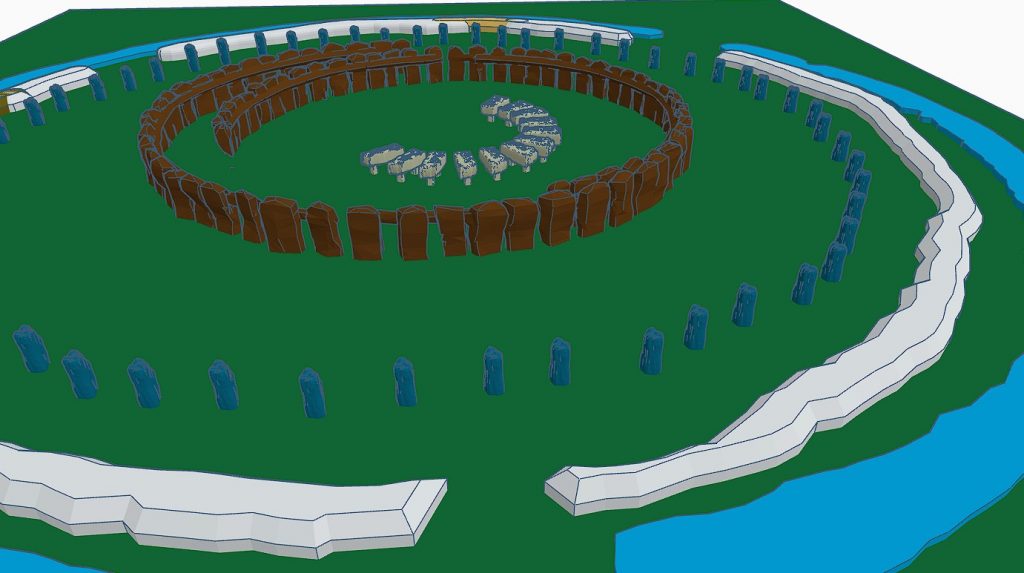
      (Hambledon Hill)

      Cissbury Ring through time

      Introduction

      This is a journey through time looking at the prehistoric site of CISSBURY RING and its surrounding Landscape based on the new third (2020) edition book of the best seller – that contains conclusive and extended evidence of Robert John Langdon’s hypothesis, that rivers of the past were higher than today – which changes the history of not only Britain, but the world. In his first book of the trilogy ‘The Post-Glacial Hypothesis’, Langdon discovered that Britain was flooded directly after the last Ice Age, which remained waterlogged in to the Holocene period through raised river levels, not only in Britain, but worldwide.

      Cissbury Ring – Summary

      Traditionally classified as an Iron Age hill fort, is actually one of the oldest and largest Neolithic flint mining sites in Britain, covering an impressive 65 acres. It ranks second only to Maiden Castle in terms of size. However, its primary historical significance lies not in its defensive role, but in its function as a major center for flint extraction and trade. This site represents one of the earliest known industrial landscapes in prehistoric Britain, with mining activity that dates back to around 4000 BCE, challenging the conventional Iron Age classification.

      The site contains approximately 200 flint shafts, some extending as deep as 12 meters, and mining activities here spanned an extraordinary 900-year period. These shafts were dug into the chalk bedrock to access high-quality flint, a critical resource in the Neolithic era for tool-making and other practical purposes. Flint extraction at Cissbury was a meticulous process, involving the excavation of large shafts and tunnels to reach the valuable deposits. Skilled miners likely used bone and stone tools to carve through the chalk, carefully extracting flint nodules that would have been in high demand across Britain and beyond.

      The surrounding landscape is marked by a series of interconnected ditches and dykes that connect ancient paleochannels to the site’s main ditch, forming an intricate transportation network. This system likely facilitated the movement of flint from the mines to boats for trade, indicating Cissbury’s role as a strategic trading hub. These channels would have allowed the extracted flint to be efficiently transported to nearby waterways, where it could be shipped to other regions.

      The sheer scale and complexity of the mining operations at Cissbury Ring provide a glimpse into the sophisticated logistical organization of Neolithic communities. This site was not merely a fortified settlement, but a bustling center of industry, resource management, and trade in prehistoric Britain.

      Cissbury Ring through time
      Maps to not show the extent of mining at Cissbury – Cissbury Ring through time

      Flint Mines, Radiocarbon Dates, and Archaeological Insights

      Cissbury Ring in West Sussex, one of Britain’s largest hillforts, is a window into ancient Britain, encompassing Neolithic, Iron Age, and Romano-British activities. Covering 60 acres, this site has yielded an extensive collection of evidence that informs us about early mining practices and settlement patterns. The flint mines here date back to around 4000 BC and have provided valuable insights into Neolithic industrial activity and ritual practices.

      Cissbury Ring through time

      The Beginnings of Flint Mining

      The flint mines at Cissbury, dating to the Neolithic period, span over 9 hectares, with more than 270 shafts identified in surveys. These shafts, measuring between 3 and 36 meters in diameter, formed a crescent shape across the hillside. Flint extraction here was extensive, as Cissbury was a vital source of high-quality flint, essential for tool-making in ancient Britain. Miners used red deer antlers and shoulder blades as tools, effectively chiseling through layers of chalk to reach seams of flint.

      Excavation History

      Cissbury Ring through time

      Early excavations at Cissbury began in the 1850s with George Irving, who initially misinterpreted the shafts as water reservoirs. In the 1860s, A.H. Lane-Fox correctly identified the pits as Neolithic flint mines, providing a more accurate interpretation of the site. Excavations continued with John Pull in the 1950s, although his findings were not fully published. Nevertheless, Pull’s work was pivotal in expanding our understanding of flint mining techniques used at Cissbury.

      Structure of the Flint Mines

      The shafts at Cissbury led to a complex network of underground galleries, which were typically 3 feet high and supported by chalk pillars. The miners worked in hazardous conditions, as evidenced by skeletons found within collapsed galleries. The shafts were often backfilled with chalk rubble after extraction. Galleries interconnected the shafts, allowing for multiple points of access and exit. Excavators found evidence of flint knapping on-site, as well as animal bones and other artifacts, suggesting that the pits might have had secondary uses.

      Cissbury Ring through time
      The Mining was deep and extensive – you can’t do this with an antler pick!

      Radiocarbon Dating Evidence

      Radiocarbon dating of antler picks from the site provided dates of 4720±150 BP, 4650±150 BP, and 4730±150 BP, which correspond to 3900-3030 BCE and 3780-2920 BCE. These dates confirm that the flint mines were in use during the Neolithic period, solidifying Cissbury’s importance as a prehistoric mining center. The discovery of animal bones, including ox, pig, and wild boar, within these pits indicates that miners were using the site not only for extraction but possibly for ritualistic purposes as well.

      Artifacts and Findings

      The tools used at Cissbury were mainly made from red deer antlers, adapted for use as picks and shovels. Excavators found other unique items, including miniature flint axes and chalk carvings, with one shaft containing a woman’s skeleton buried feet-first, accompanied by bones of various animals. This implies a possible ritualistic burial, as several of these pits contained remains in arrangements suggesting ceremonial depositions.

      Cissbury Ring through time
      Stone axe – what was used to cut the mineshafts and channels

      The Iron Age Transformation

      In the Iron Age, around 700 BC, fortifications were constructed around the site, enclosing approximately 24 hectares. These defenses consisted of ramparts and ditches, forming a formidable barrier. Excavations revealed Romano-British pottery and oyster shells, indicating continued occupation and use for agriculture and defense. The hillfort was later fortified during WWII, and the site has undergone minimal modern excavation due to its status as a scheduled ancient monument.

      Lynchets and the Dyke Debate

      A particularly intriguing aspect of Cissbury is the lynchets, terraced formations traditionally associated with ancient agriculture. However, some propose that these features might actually be misidentified dykes, suggesting ancient water levels. While dykes usually include raised embankments and drainage systems, the lynchets at Cissbury lack these structural elements. Moreover, the area’s chalk soil would make long-term water retention impractical, raising doubts about the water-management hypothesis.

      Cissbury Ring through time
      It is not A defensive ditch but a system used to move minerals via boat, as these are moats, not ditches

      Pits and Deposit Sites

      Archaeologists speculate another layer to Cissbury’s history as pits for ritual deposition. One of the fascinating discoveries is a pit containing an assortment of artefacts, including chalk loom weights, an iron knife, and sling stones. These objects hint at ceremonial uses, possibly related to agricultural or religious practices. The pit aligns with similar features at Mount Caburn, suggesting ritual depositions were a shared practice among nearby communities. Sadly, the reality is this is an industrial site for processing minerals, and so this is just ‘industrial waste’ at best.

      The Saxon Mint Hypothesis

      Cissbury might have housed a Saxon mint, as coins from Ethelred II and Cnut bearing mint marks have been linked to the area. Although no direct archaeological evidence supports this claim, the suggestion adds another layer of historical intrigue to the site. Such mints were typically moved to fortifications during times of conflict, underscoring the strategic significance of Cissbury in the early medieval period. The better solution is that more than flint can be found in the mines – sadly, archaeology does not possess the techniques or experience to look for such minerals, as they do not excavate quarries.

      Folklore and Myths

      Local legends attribute Cissbury’s construction to the Devil, who allegedly flung earth around the Downs, creating the hillforts. Other stories speak of treasure guarded by serpents and even UFO sightings, adding a sense of mystery and complete nonsense to the site. There are also tales of fairies dancing at Cissbury, blending folklore with historical intrigue and showing how the site has captured imaginations for centuries.

      A Concluding Perspective

      Cissbury Ring through time
      The Mines are Extensive showing that they were used in the Roman Period and beyond

      Cissbury Ring remains an essential site for understanding ancient Britai,n, with its flint mines, Iron Age ramparts, and complex web of myths. While the theory of lynchets as dykes is interesting, it is unlikely given the physical characteristics of these features. Archaeological evidence supports the interpretation of lynchets as agricultural, with no clear indicators of water-management systems in place. Yet, Cissbury’s diverse history, from flint mining to potential Saxon minting, reflects a multifaceted legacy that continues to inspire research and speculation.

      In conclusion, Cissbury Ring is more than a hillfort—it is a testament to the ingenuity, resilience, and cultural depth of ancient peoples. The site’s layers of history provide a tangible link to the past, offering insights that span millennia and spark continued interest in Britain’s ancient heritage.

      Post-Glacial Flooding

      Cissbury Ring through time
      The Prehistoric Waters show that the dykes (not Lynchets) were used to link the site to rivers and harbours

      In this second book of the series ‘The Stonehenge Enigma’, he also shows that a new civilisation known to archaeologists as the ‘megalithic builders’ adapted to this landscape, to build sites like Stonehenge, Avebury, Woodhenge and Old Sarum, where carbon dating has now shown that these sites were constructed about five thousand years earlier than previously believed. Within the trilogy ‘Prehistoric Britain’, Langdon looks at the anthropology, archaeology and landscape of Britain and the attributes and engineering skills of the builders of these megalithic structures. (Cissbury Ring through time)

      Including finding and dating the original bluestones of Stonehenge Phase I from the quarry of Craig-Rhos-Y-Felin in Wales, five thousand year earlier than current archaeological theory and how this civilisation used the sites surrounding Stonehenge at a time of these raised river levels. This unique insight into how the prehistoric world looked in the ‘Mesolithic Period’ allows Langdon to explain archaeological mysteries that have confused archaeologist since the beginning of the science and allows us to make sense of these sites, allowing us to understand their function for this society for the first time. (Cissbury Ring through time).

      With over thirty ‘proofs’ of his hypothesis and one hundred and twenty-five peer-reviewed references – Langdon uses existing excavation findings and carbon dating to forward a new understanding of the environment and our ancient society, which consequently rewrites our history books and allows us to find more conclusive and persuasive evidence which is currently trapped in our landscape, ready to be discovered by future students of archaeology. Articles on this Trilogy and an Active FaceBook Group where you can leave comments and get feedback can be found at:

      Articles: http://prehistoric-britain.co.uk/

      FaceBook Group: https://www.facebook.com/groups/prehistoricbritain

      Further Reading

      For information about British Prehistory, visit www.prehistoric-britain.co.uk for the most extensive archaeology blogs and investigations collection, including modern LiDAR reports.  This site also includes extracts and articles from the Robert John Langdon Trilogy about Britain in the Prehistoric period, including titles such as The Stonehenge Enigma, Dawn of the Lost Civilisation and the ultimate proof of Post Glacial Flooding and the landscape we see today.

      Robert John Langdon has also created a YouTube web channel with over 100 investigations and video documentaries to support his classic trilogy (Prehistoric Britain). He has also released a collection of strange coincidences that he calls ‘13 Things that Don’t Make Sense in History’ and his recent discovery of a lost Stone Avenue at Avebury in Wiltshire called ‘Silbury Avenue – the Lost Stone Avenue’.

      Langdon has also produced a series of ‘shorts’, which are extracts from his main body of books:

      The Ancient Mariners

      Stonehenge Built 8300 BCE

      Old Sarum

      Prehistoric Rivers

      Dykes ditches and Earthworks

      Echoes of Atlantis

      Homo Superior

      For active discussions on the findings of the TRILOGY and recent LiDAR investigations that are published on our WEBSITE, you can join our and leave a message or join the debate on our Facebook Group.

      Unlocking the Mysteries of British Prehistory

      Delve into the depths of time, as we embark on a captivating voyage into the enigmatic world of British prehistory. www.prehistoric-britain.co.uk is your portal to a treasure trove of archaeological wonders, modern LiDAR reports, and fascinating insights from the Robert John Langdon Trilogy. This immersive digital hub is your key to unlocking the secrets of Britain’s ancient past.

      A Glimpse into the Robert John Langdon Trilogy

      Step into the shoes of Robert John Langdon, a dedicated explorer of Britain’s prehistoric mysteries. His trilogy, comprising “The Stonehenge Enigma,” “Dawn of the Lost Civilization,” and “The Post-Glacial Flooding Hypothesis,” is a literary marvel that unravels the untold tales of our ancestors. These books take you on an exhilarating journey through time, meticulously researched and backed by over 125 references from esteemed scientists, archaeological experts, and geological researchers.

      Dive into the World of LiDAR

      At www.prehistoric-britain.co.uk, we harness the power of LiDAR technology to unearth hidden landscapes and archaeological marvels. Our LiDAR reports offer a modern lens through which you can peer into ancient history. Explore the effects of flooding on the British environment after the great ice age melt, a phenomenon that has shaped the landscape we see today. Join us in decoding the mysteries of our past using cutting-edge technology.

      A Multimedia Experience

      Our commitment to storytelling extends beyond the written word. Robert John Langdon has curated a rich multimedia experience, including a YouTube web channel featuring over 100 investigations and video documentaries. These visual journeys complement his classic trilogy, providing a multi-dimensional understanding of prehistoric Britain. From Stonehenge’s construction in 8300 BCE to the lost Stone Avenue at Avebury in Wiltshire known as ‘Silbury Avenue,’ these documentaries offer an immersive experience that brings history to life.

      Explore the ’13 Things that Don’t Make Sense in Ancient History’

      History is replete with anomalies and enigmas that defy explanation. Robert John Langdon has curated a collection of such historical curiosities in ’13 Things that Don’t Make Sense in History.’ These peculiar occurrences and unanswered questions will leave you pondering the mysteries of the past, inviting you to join the debate on their possible interpretations.

      Cissbury Ring through time
      Cissbury Ring through time

      Cissbury Ring through time

      More Blogs

      [sitemap_posts]