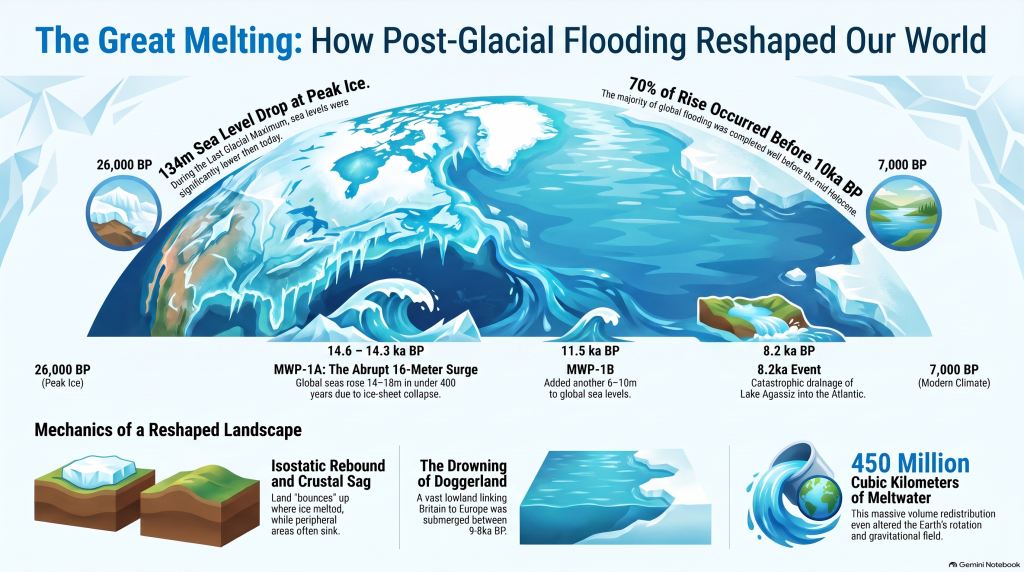
Roughly twenty-six thousand years ago, the Earth entered the final phase of the last ice age, when more than 30 million square kilometres of the northern continents were mantled by ice. Sea level dropped by over a hundred metres, continents expanded, and the atmosphere became drier and dustier. When the climate warmed, that frozen water returned to the ocean basins, transforming every river and shoreline on the planet. Understanding the magnitude and tempo of this transition is fundamental to reconstructing the landscapes that Holocene societies inherited. (The Post-Glacial Flooding Hypothesis)
The scientific history of sea-level research stretches back more than a century. Fairbridge (1961) first proposed that global “drowned terraces” recorded former sea levels. Oxygen-isotope analysis later provided a direct measure of global ice volume (Shackleton & Opdyke 1973; Chappell & Shackleton 1986). By the 1990s, uranium-thorium dating of coral reefs (Bard et al., 1990) and glacio-isostatic models (Lambeck & Chappell 2001) produced continuous global sea-level curves for the late Quaternary. Satellite altimetry and GRACE gravimetry now track present-day mass exchange between ice sheets and oceans with millimetre precision (Watkins et al., 2015; Cazenave et al., 2018).
These cumulative datasets reveal that the transformation from the Last Glacial Maximum (LGM) to the modern interglacial was neither instantaneous nor globally uniform. The following sections examine the evidence for the magnitude of the LGM, the deglacial rise in sea level, and the feedbacks that coupled ice, ocean, and atmosphere into a single dynamic system.
The Post-Glacial Flooding Hypothesis
2. The Last Glacial Maximum
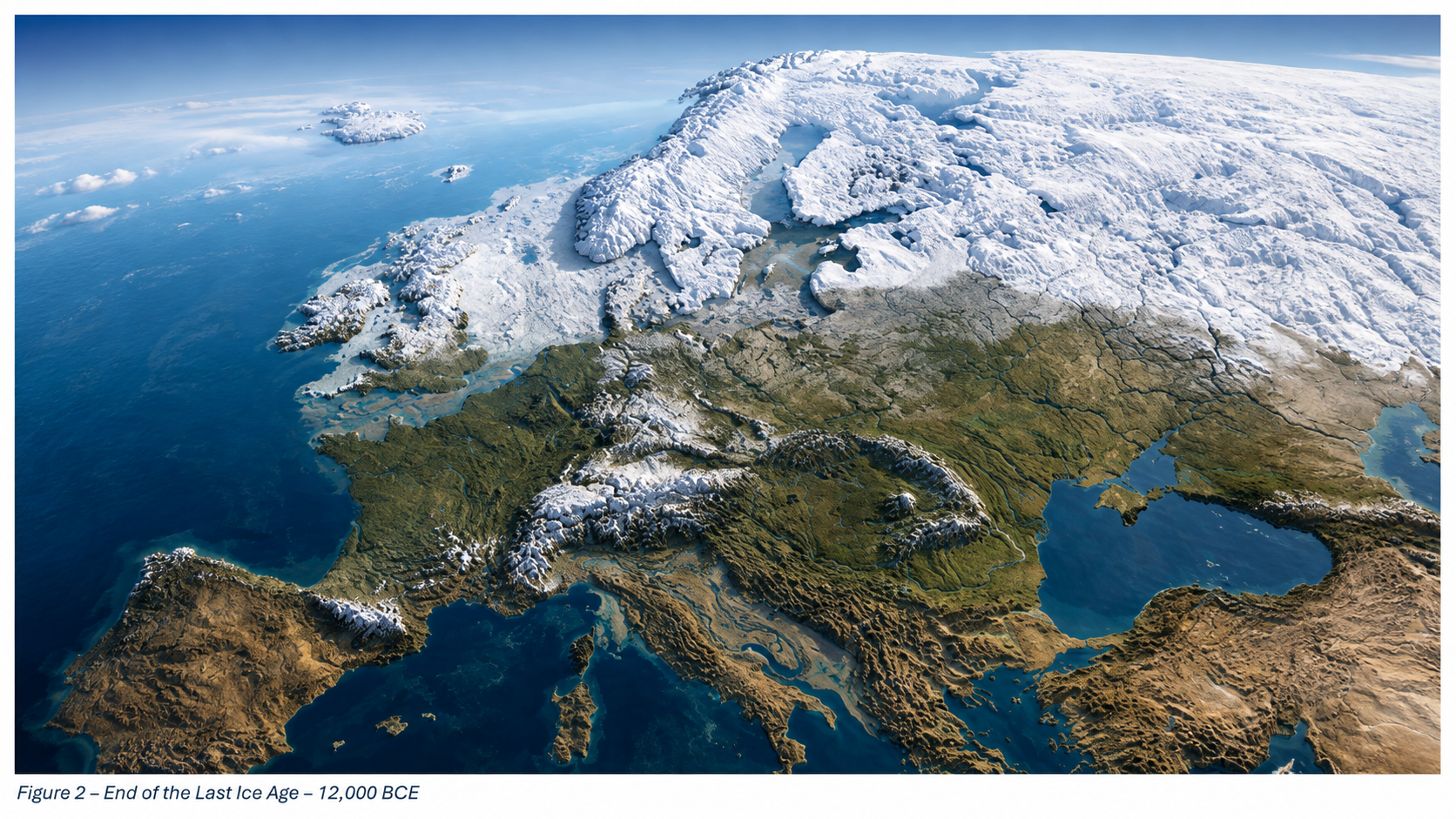
The LGM, dated between ~26 000 and 19 000 years BP, represents the maximum combined extent of Northern Hemisphere ice sheets. Reconstructions by Ehlers et al. (2018) show the Laurentide Ice Sheet extending south of the Great Lakes, the Fennoscandian complex covering Scandinavia, northern Britain, and the Baltic, and separate domes over the Barents and Kara Seas. In the Southern Hemisphere, the Patagonian, New Zealand, and Antarctic ice sheets expanded simultaneously. Global mean air temperature was about 5–6 °C lower than today (Tierney et al., 2020).
Cosmogenic-nuclide dating of moraines indicates near-synchronous maxima in both hemispheres within 1–2 kyr (Balco et al., 2009). Ice cores from Antarctica record atmospheric CO₂ concentrations of only ~190 ppm, the lowest of the last 800 kyr (Lüthi et al., 2008). The increased planetary albedo and reduced greenhouse forcing locked the Earth into a radiative imbalance until orbital precession increased summer insolation at high latitudes around 21 ka BP, initiating melting.
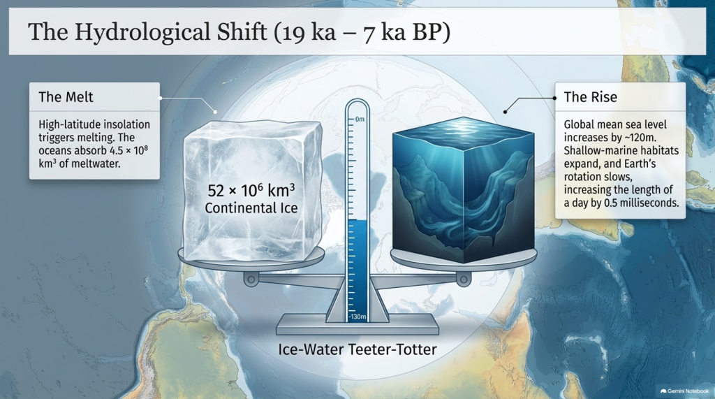
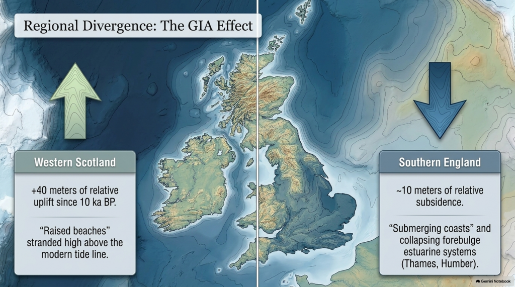
Sea level at the LGM stood 134 ± 5 m below present (Rohling et al., 2009; Lambeck et al., 2014), implying an extra ~52 × 10⁶ km³ of continental ice—roughly triple modern Antarctic volume. The load depressed the lithosphere by up to a kilometre and generated a peripheral forebulge hundreds of kilometres wide. When deglaciation began, these distortions created regional variations in relative sea level (RSL) of tens of metres—a problem that still complicates correlation between sites.
The Post-Glacial Flooding Hypothesis
3. Quantifying Global Ice and Sea-Level Change
High-resolution oxygen-isotope records from the Red Sea (Rohling et al., 2009) and global benthic stacks (Lisiecki & Raymo, 2005) define the eustatic component of sea-level change. Grant et al. (2014) extended the Red Sea curve to 500 kyr BP and confirmed an approximately linear relation between δ¹⁸O and global mean sea level within ±140 m. Combined with coral-reef U/Th dates (Peltier & Fairbanks 2006) and glacio-isostatic modelling (ICE-6G v2; Peltier et al., 2015), these data yield the following deglacial sequence:
The Post-Glacial Flooding Hypothesis
Stable minimum (26–19 ka) — Sea level constant near −130 m; ice volume at maximum.
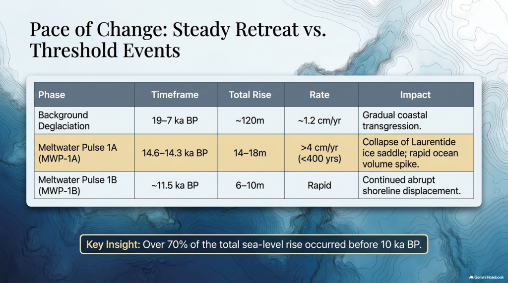
Deglacial rise (19–7 ka) — Global mean increase ~120 m; average rate ~1.2 cm yr⁻¹.
Waelbroeck et al. (2019) and Gowan et al. (2021) further improved resolution, showing that roughly 70% of the total rise occurred before 10 ka BP and that rates exceeded 4 cm yr⁻¹ during short meltwater pulses. These figures quantify the pace of global hydrological reorganisation that followed the LGM.
The Post-Glacial Flooding Hypothesis
4. Meltwater Pulses and Deglacial Chronology
Superimposed on the long-term trend are several abrupt accelerations known as Meltwater Pulses (MWPs). MWP-1A (14.6–14.3 ka BP) raised global sea level by 14–18 m in < 400 years (Deschamps et al., 2012). Coral cores from Tahiti and Barbados capture the event as a distinct change in growth depth and isotope composition. MWP-1B, centred near 11.5 ka BP, added another 6–10 m (Liu et al., 2019). A later, smaller pulse (~8.2 ka BP) corresponded to catastrophic drainage of pro-glacial Lake Agassiz into the North Atlantic (Teller et al., 2002).
Numerical models (Gregoire et al., 2012) indicate that collapse of the Laurentide ice saddle triggered MWP-1A, releasing freshwater at ~0.3 Sverdrups—enough to disrupt the Atlantic Meridional Overturning Circulation (AMOC) and cause short-lived cooling across the Northern Hemisphere (Liu et al., 2009). Geomorphic evidence of megafloods, such as the Missoula outburst channels in North America (Bretz 1969; Baker 2013), provides analogues for the required discharge scale.
MWPs demonstrate that deglaciation was a series of threshold events rather than a steady retreat. The timing of pulses aligns closely with abrupt climatic shifts seen in Greenland ice cores (NGRIP Members 2004), underscoring the tight coupling between ice dynamics and global climate.
5. Isostatic Rebound and Crustal Adjustment
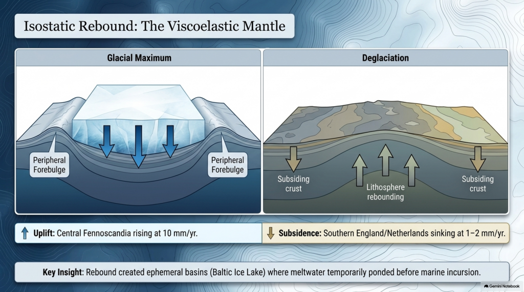
Once surface loads were removed, the lithosphere began to rebound. The process is governed by viscoelastic relaxation of the mantle with characteristic times of 1–5 kyr (Milne et al., 2006). Modern GPS and tide-gauge data show uplift of 10 mm yr⁻¹ in central Fennoscandia and subsidence of 1–2 mm yr⁻¹ in southern England and the Netherlands—the collapsing forebulge. Modelling (Lambeck et al., 2014; Peltier et al., 2015) reproduces these patterns when mantle viscosities of 3–5 × 10²¹ Pa s are used.
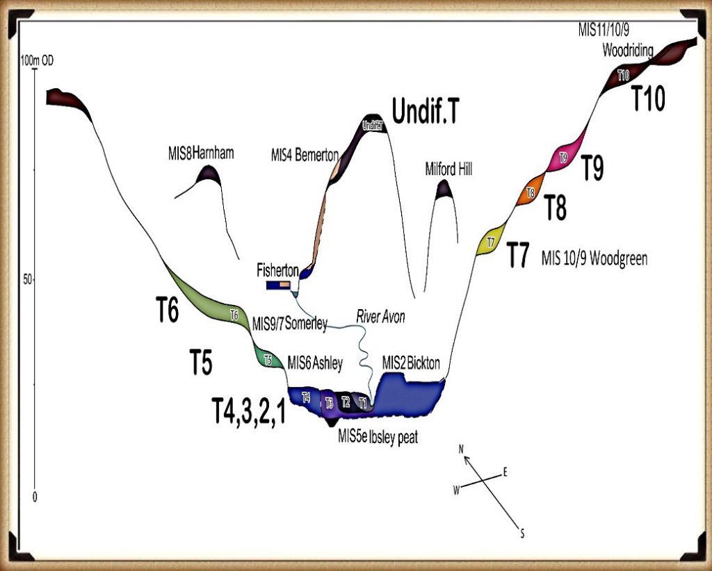
Rebound created ephemeral basins along glacial margins where meltwater ponded before marine incursion. The Baltic Ice Lake and the Champlain Sea are classic examples, forming as differential uplift temporarily dammed drainage routes (Saarnisto & Salonen 1995; Parent & Occhietti 1999). Many present-day estuaries owe their origins to these basins. Sediment cores from the Humber, Thames, and Rhine estuaries contain alternating freshwater and brackish layers that track the balance between isostasy and eustasy (Shennan et al., 2018).
The Post-Glacial Flooding Hypothesis
6. The Rebirth of the Oceans
Between 19 ka and 7 ka BP, the oceans absorbed roughly 4.5 × 10⁸ km³ of meltwater, raising mean sea level by ~120 m. Coral records from Tahiti, Huon Peninsula, and the Sunda Shelf show a remarkably consistent transgression curve (Deschamps et al., 2012; Hanebuth et al., 2000). By 7 ka BP, sea level stabilised within a few metres of the modern datum.
The redistribution of this mass altered Earth’s rotation and gravitational field, increasing the length of day by 0.5 milliseconds (Mitrovica & Munk 2003) and displacing the geoid by several decimetres. More tangibly, flooding of continental shelves expanded shallow-marine habitats and enhanced nutrient exchange between land and sea, fuelling mid-Holocene marine productivity (Haug et al., 2001). The creation of new estuarine and lagoonal systems also provided nursery grounds for species that later became critical to human subsistence.
7. Climate Feedbacks During Deglaciation
Ice-core and modelling studies reveal that the deglacial rise in greenhouse gases both responded to and accelerated warming. CO₂ increased from 190 ppm at the LGM to 270 ppm by 11 ka BP (Lüthi et al., 2008). Methane doubled from 350 to 700 ppb (Loulergue et al., 2008). The combined radiative forcing of ~2.5 W m⁻² produced a global temperature increase of ~4 °C (IPCC AR6 2021). Shakun et al. (2012) demonstrated that Antarctic warming led the CO₂ rise by several centuries, implying that oceanic outgassing initiated the feedback loop.
Freshwater discharges into the North Atlantic weakened the AMOC and triggered millennial-scale climate reversals. The Younger Dryas (12.9–11.7 ka BP) involved a 5–7 °C drop in Greenland temperatures followed by rapid recovery within a few decades (Severinghaus et al., 1998). Numerical experiments show that such shifts require freshwater fluxes of 0.05–0.1 Sverdrups (Liu et al., 2009). Once meltwater routing shifted southward and AMOC strength recovered, interglacial stability was achieved.
The Post-Glacial Flooding Hypothesis
8. The Transformation of North-West Europe
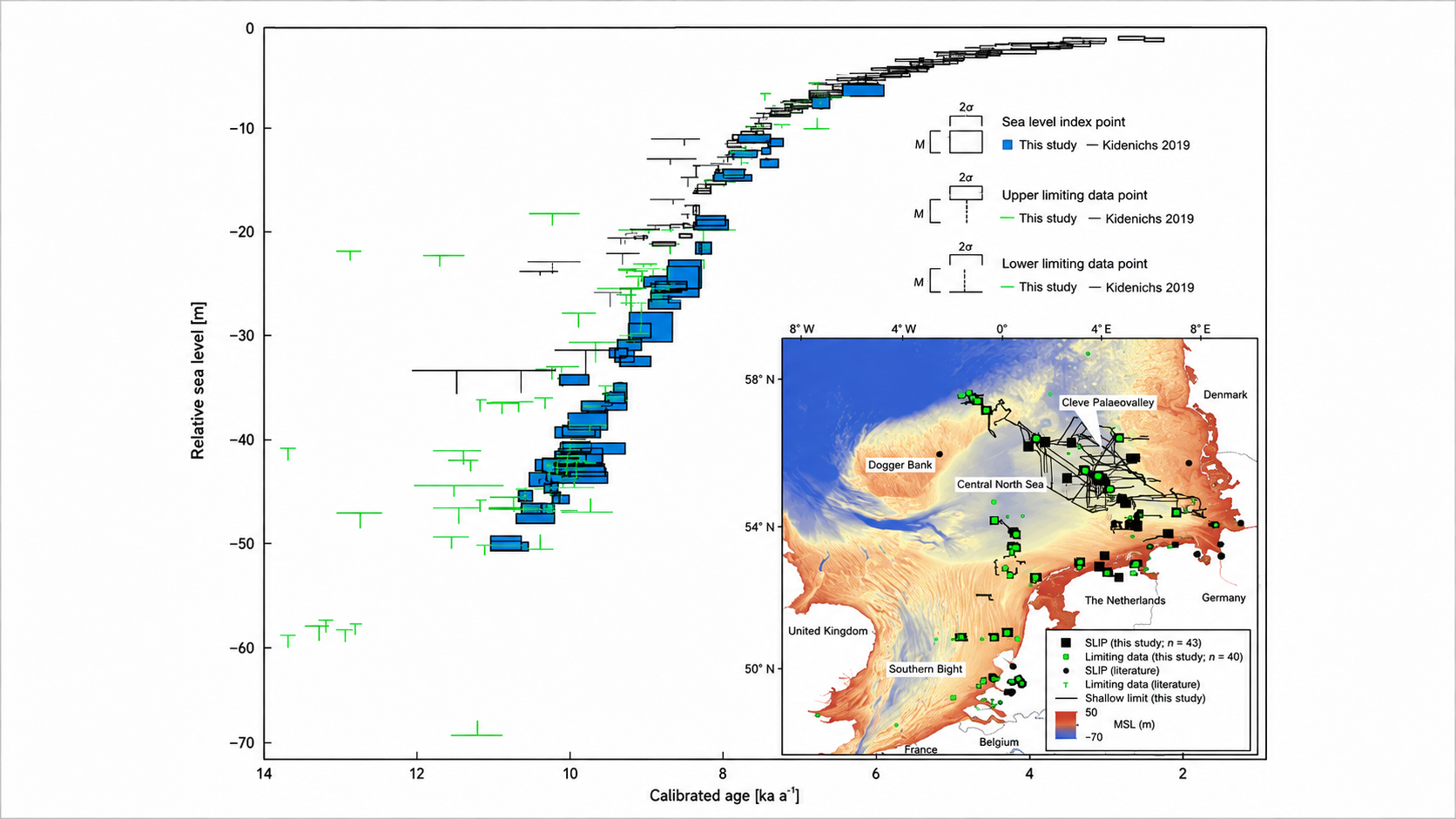
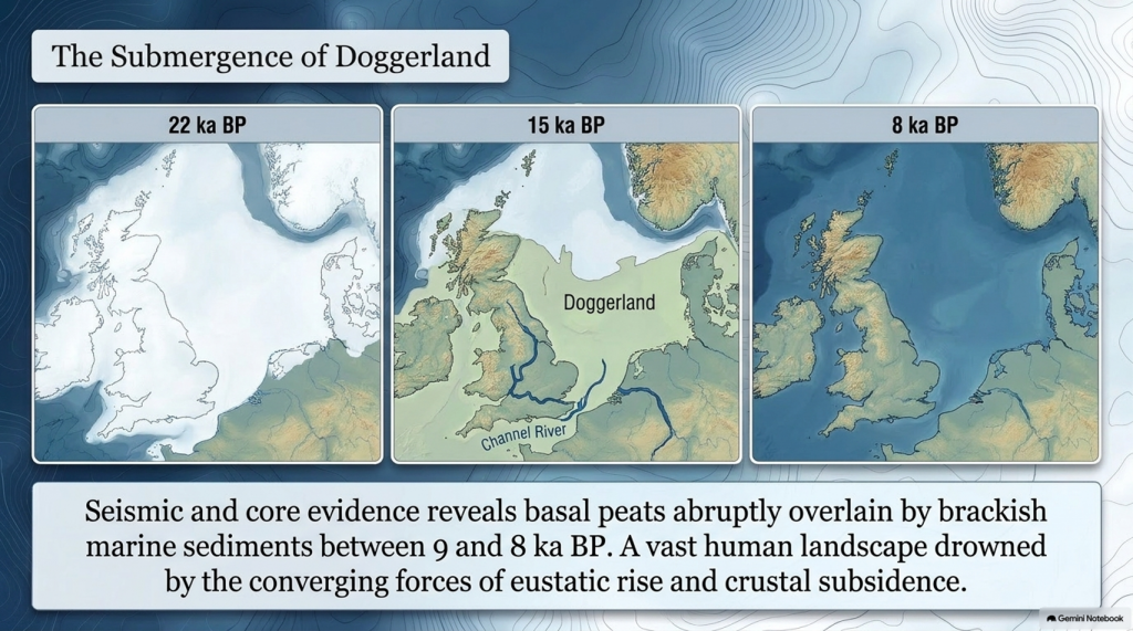
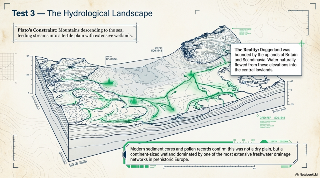
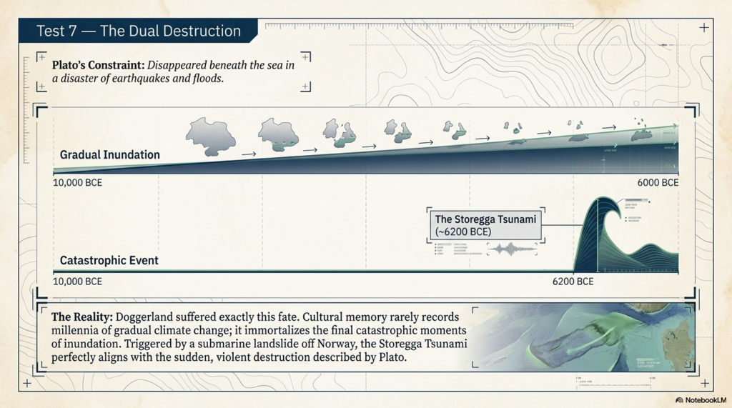
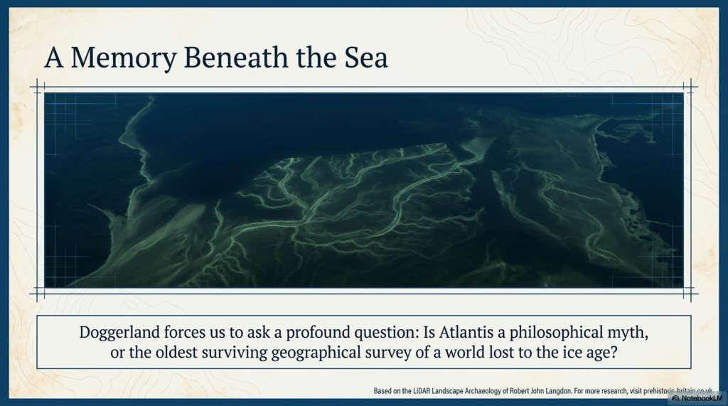
Retreat of the British–Irish Ice Sheet began near 22 ka BP and concluded by 15 ka BP (Clark et al., 2012). Deglaciation exposed outwash plains and periglacial lakes that evolved into estuaries and wetlands as sea level rose. Seismic and core evidence from the southern North Sea shows basal peats overlain by brackish and marine sediments between 9 and 8 ka BP (Hijma & Cohen 2011). These sequences chart the drowning of Doggerland—a vast lowland linking Britain to Europe. Pollen and macrofossil data indicate temperate woodland colonisation prior to submergence (Gaffney et al., 2009).
Regional RSL curves diverge sharply due to GIA: western Scotland has risen > 40 m since 10 ka, while southern England has subsided by ~10 m (Bradley et al., 2020). Raised beaches in the north and submerged forests in the south reflect this differential motion. In the English Channel, fluvial erosion during early deglaciation carved the “Channel River,” later flooded by 8 ka (Mellett et al., 2013). Similar sequences occur along the Irish and Danish coasts, documenting the progressive marine transgression of northwest Europe.
The Post-Glacial Flooding Hypothesis
9. Towards a Global–Regional Synthesis
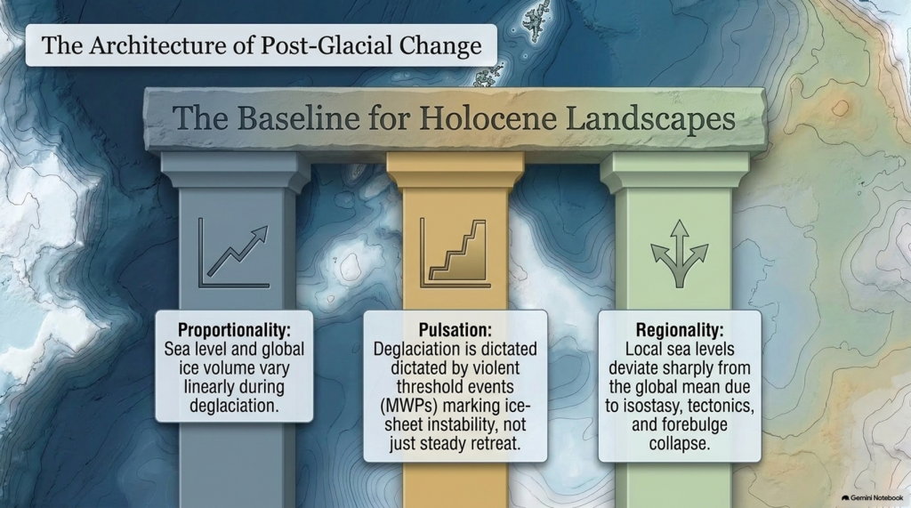
By combining isotopic, coral, and geodetic datasets, modern reconstructions achieve decimetre precision for Holocene sea level (Gowan et al., 2021). Three principles emerge:
Proportionality — Sea level and global ice volume vary linearly during deglaciation.
Pulsation — Superimposed meltwater pulses mark thresholds in ice-sheet stability.
Regionality — Local deviations result from isostasy, tectonics, and sediment compaction.
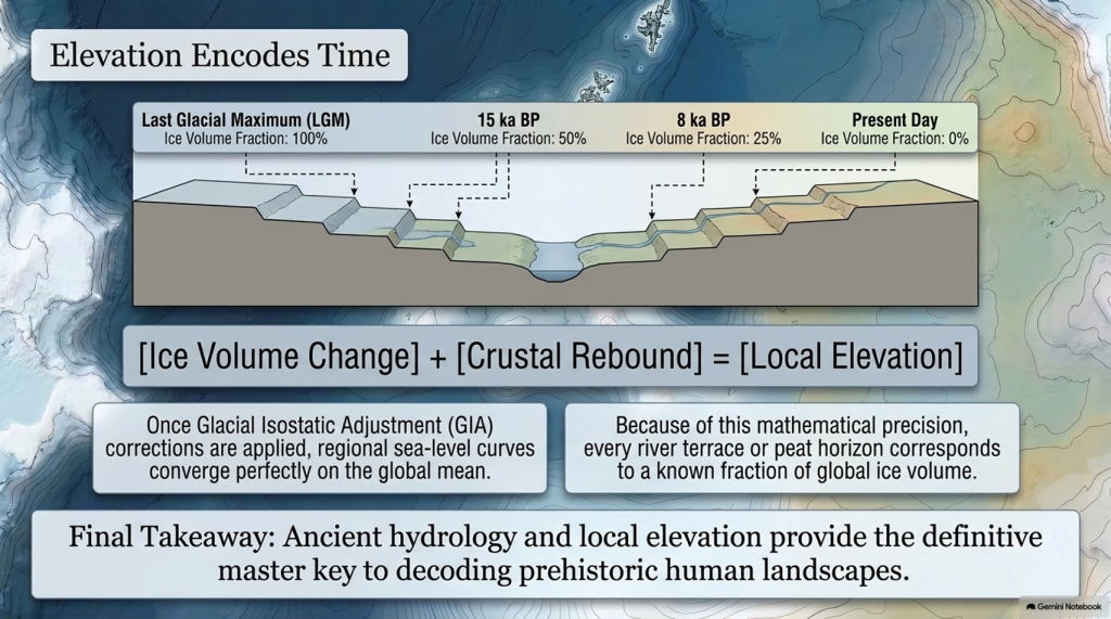
Shennan et al. (2018) synthesised over 500 Holocene RSL indicators for the British Isles, demonstrating that once GIA corrections are applied, regional curves converge on the global mean within analytical error. These findings provide a quantitative baseline for analysing river-terrace altitudes and groundwater histories in later chapters.
Equally important, comparison with modern sea-level observations highlights the extraordinary pace of contemporary change. Satellite altimetry records a mean rise of 3.4 ± 0.4 mm yr⁻¹ since 1993 (Cazenave et al., 2018)—an order of magnitude faster than the late-Holocene background rate (Kopp et al., 2016). The processes that ended the last ice age therefore remain relevant to current climate dynamics.
The Post-Glacial Flooding Hypothesis
10. Conclusion
The end of the last ice age was a planetary event in which ice, water, and rock interacted on colossal scales. Between 26 ka and 7 ka BP, sea level rose more than 120 m, ice sheets vanished from most temperate latitudes, and the hydrological cycle intensified. The evidence—oxygen-isotope curves, coral terraces, basal peats, and glacio-isostatic models—forms a coherent narrative of gradual yet punctuated change.
These quantitative reconstructions define the environmental backdrop for all Holocene landscapes. They also establish a principle crucial to later chapters: that elevation within fluvial and coastal systems encodes time, because each terrace or peat horizon corresponds to a known fraction of global ice volume. The following chapter therefore turns from global physics to the mathematical description of flooding itself—the equations that translate ice-volume change into measurable hydrological response.
Plain-Language Conclusion
The ice age was like the planet putting a huge amount of the world’s water into giant freezers on land. When those freezers started to melt:
All that stored water went back into the oceans.
The seas rose by about 120 metres.
The weight of the ice came off the land, so some places bounced up, others sagged down.
Scientists can see this story in:
tiny shells on the sea floor,
old coral reefs now sitting at the “wrong” depths,
layers of mud and peat around coasts.
Put simply:
We froze the oceans on land, then poured them back in. The combination of rising seas and bouncing crust rearranged coastlines everywhere, and we can measure it.
Robert John Langdon, a polymathic luminary, emerges as a writer, historian, and eminent specialist in LiDAR Landscape Archaeology.
His intellectual voyage has been interwoven with stints as an astute scrutineer in government and grand corporate bastions, a tapestry spanning British Telecommunications, Cable and Wireless, British Gas, and the esteemed University of London.
A decade hence, Robert’s transition into retirement unfurled a chapter of insatiable curiosity. This phase saw him immerse himself in Politics, Archaeology, Philosophy, and the enigmatic realm of Quantum Mechanics. His academic odyssey traversed the venerable corridors of knowledge hubs such as the Museum of London, University College London, Birkbeck College, The City Literature Institute, and Chichester University.
In the symphony of his life, Robert is a custodian of three progeny and a pair of cherished grandchildren. His sanctuary lies ensconced in the embrace of West Wales, where he inhabits an isolated cottage, its windows framing a vista of the boundless sea – a retreat from the scrutinising gaze of Her Majesty’s Revenue and Customs, an amiable clandestinity in the lap of nature.
Exploring Prehistoric Britain: A Journey Through Time
My blog delves into the fascinating mysteries of prehistoric Britain, challenging conventional narratives and offering fresh perspectives grounded in cutting-edge research, particularly LiDAR technology. I invite you to explore some key areas of my research. For example, the Wansdyke, often cited as a defensive structure, is re-examined in light of new evidence. I’ve presented my findings in my blog post Wansdyke: A British Frontier Wall – ‘Debunked’, and a Wansdyke LiDAR Flyover video further visualises my conclusions.
My work also often challenges established archaeological dogma. I argue that many sites, such as Hambledon Hill, commonly identified as Iron Age hillforts, are not what they seem. My posts Lidar Investigation Hambledon Hill – NOT an ‘Iron Age Fort’ and Unmasking the “Iron Age Hillfort” Myth explore these ideas in detail and offer an alternative view. Similarly, sites like Cissbury Ring and White Sheet Camp receive re-evaluations based on LiDAR analysis in my posts “Lidar Investigation Cissbury Ring through time”and “Lidar Investigation White Sheet Camp,“ revealing fascinating insights into their true purpose. I have also examined South Cadbury Castle, often linked to the mythical Camelot56.
My research also extends to ancient water management, including the role of canals and other linear earthworks. I have discussed the true origins of Car Dyke in multiple posts, including Car Dyke – ABC News Podcast and Lidar Investigation Car Dyke – North Section, which suggest a Mesolithic origin 2357. I also explore the misidentification of Roman aqueducts, as seen in my posts on the Great Chesters (Roman) Aqueduct. My research has also been greatly informed by my post-glacial flooding hypothesis, which has helped explain landscape transformations over time. I have discussed this hypothesis in several posts, including AI now supports my Post-Glacial Flooding Hypothesis and Exploring Britain’s Flooded Past: A Personal Journey
For those interested in British Prehistory, visit www.prehistoric-britain.co.uk, a comprehensive resource featuring an extensive collection of archaeology articles, modern LiDAR investigations, and groundbreaking research. The site also includes insights and excerpts from the acclaimed Robert John Langdon Trilogy, a series of books that explore Britain during the Prehistoric period. Titles in the trilogy include The Stonehenge Enigma, Dawn of the Lost Civilisation, and The Post-Glacial Flooding Hypothesis, which offer compelling evidence of ancient landscapes shaped by post-glacial flooding.
To further explore these topics, Robert John Langdon has developed a dedicated YouTube channel featuring over 100 video documentaries and investigations that complement the trilogy. Notable discoveries and studies showcased on the channel include 13 Things that Don’t Make Sense in History and the revelation of Silbury Avenue – The Lost Stone Avenue, a rediscovered prehistoric feature at Avebury, Wiltshire.
In addition to his main works, Langdon has released a series of shorter, accessible publications, ideal for readers delving into specific topics. These include:
For active discussions and updates on the trilogy’s findings and recent LiDAR investigations, join our vibrant community on Facebook. Engage with like-minded enthusiasts by leaving a message or contributing to debates in our Facebook Group.
Whether through the books, the website, or interactive videos, we aim to provide a deeper understanding of Britain’s fascinating prehistoric past. We encourage you to explore these resources and uncover the mysteries of ancient landscapes through the lens of modern archaeology.
For more information, including chapter extracts and related publications, visit the Robert John Langdon Author Page. Dive into works such as The Stonehenge Enigma or Dawn of the Lost Civilisation, and explore cutting-edge theories that challenge traditional historical narratives.
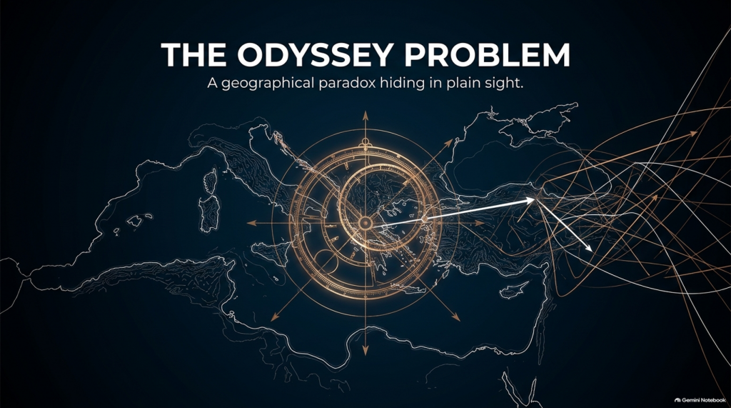
If Troy was really at Hisarlık, Homer has given us a geographical problem hiding in plain sight
Before We Follow Odysseus: How Old Is the Story We Are Actually Reading?
Before attempting to place Troy, Ithaca or any of the strange lands described in the Odyssey on a modern map, there is a more fundamental question that is rarely given enough attention:
What exactly are the Iliad and Odyssey?
THE ODYSSEY PROBLEM
Today we encounter them as books. They have numbered books, fixed lines, recognised place-names and an author conventionally called Homer. That creates the natural impression that somebody sat down approximately 2,700 years ago and wrote the stories much as a modern novelist would.
Almost certainly, that is not how they began.
Modern Homeric scholarship broadly accepts that the Iliad and Odyssey emerged from a much older oral performance tradition. For generations before the poems became stable written texts, professional singers told and retold stories about Troy, Achilles, Helen, Odysseus and the other heroes. The tradition operated over a wide geographical area and for hundreds of years; some scholars allow that parts of the underlying poetic tradition may reach back into the Bronze Age, while aspects of the poetic language itself may preserve still older Indo-European inheritances.
That distinction is crucial to this investigation.
We are therefore probably not reading an eyewitness report written shortly after a war.
Nor, however, are we necessarily reading a completely invented story created in the eighth century BCE.
What we have is something much more interesting:
A VERY OLD STORY THAT WAS KEPT ALIVE BY HUMAN MEMORY BEFORE IT BECAME A BOOK.
THE ODYSSEY PROBLEM
🗣️ HOW COULD A STORY THIS LARGE SURVIVE WITHOUT WRITING?
At first this sounds almost impossible.
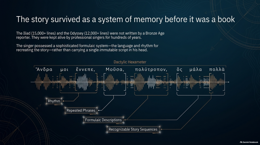
The Iliad contains more than 15,000 lines and the Odyssey more than 12,000. How could stories of this scale survive for centuries before being written down?
The answer lies in the way oral poetry worked.
The pioneering studies of Milman Parry and Albert Lord demonstrated that oral epic singers did not normally memorise a gigantic text word-for-word in the way an actor memorises a script.
Instead, they mastered a specialised system of:
rhythm,
repeated phrases,
formulaic descriptions,
stock scenes,
traditional characters,
recognisable story sequences
and
metrical structures.
Thus Achilles can repeatedly be described by a familiar epithet, ships can be introduced through standard phrases, dawn arrives through recognised verbal formulas, and battles, feasts, departures and assemblies follow structures that both singer and audience understand.
The metre itself—dactylic hexameter—acted as part of the memory system.
The singer possessed the story and the language for recreating it, rather than carrying a single immutable script in his head. Parry and Lord’s work on surviving oral traditions showed that a trained singer could reconstruct an enormous epic during performance using this formulaic system.
This produces a very important consequence.
Each performance could preserve the essential story while changing some of its details.
An episode might become longer.
Another could be shortened.
A hero could receive greater prominence.
A description could change.
And details meaningful to one audience could be emphasised more heavily than details important to another.
The story could therefore remain recognisably the same story for centuries without remaining exactly the same text.
THE ODYSSEY PROBLEM
⏳ HOW FAR BACK COULD THE TROJAN STORY GO?
This is where matters become particularly interesting.
The poems we possess are usually associated in something close to their recognisable monumental form with the late eighth or early seventh century BCE, although exactly when they first became written texts remains heavily debated.
But the traditions from which they were created are considerably older.
Cambridge’s modern guide to Homer describes the poems as products of songs composed and recomposed over many hundreds of years, potentially drawing on traditions extending much deeper into prehistory. Some scholarship has specifically argued that Greek epic traditions may have been developing from the middle or later Bronze Age.
That creates a possible chronological gap of several centuries between:
whatever historical events originally generated the tradition
and
the written geographical names we eventually inherit.
If the conventional Trojan War date of around the late second millennium BCE were approximately correct, then several hundred years may separate an original conflict from the period in which the surviving poems began crystallising into something resembling our texts.
And during those centuries the story was travelling.
🌍 STORIES TRAVEL — AND GEOGRAPHY CAN TRAVEL WITH THEM
This point is central to our investigation.
An oral epic does not survive in a vacuum.
It survives because people want to hear it.
A singer performs before an audience. That audience knows its own towns, rulers, landscapes, ancestors and political rivalries.
Successful oral storytelling therefore contains an unavoidable process of adaptation.
Modern Homeric scholarship explicitly recognises that the flexibility of oral performance allowed heroic tales to be adapted to their immediate contexts. The Homeric language itself demonstrates this history: it is not the ordinary language of one place or date but a remarkable composite containing predominantly Ionic forms together with older Aeolic and Arcado-Cypriot elements and later Attic features.
In other words:
THE LANGUAGE ITSELF HAS A HISTORY OF MOVEMENT AND MODIFICATION.
Why should we automatically assume every geographical label escaped the same process untouched?
Suppose an ancient story originally described a distant king, harbour, island or people whose original name had become meaningless to an audience centuries later.
A performer had several choices.
He could preserve a meaningless archaic name.
He could reinterpret it.
He could associate it with a place his listeners knew.
Or different regional traditions could gradually absorb their own places and heroes into the greater Trojan story.
We cannot prove that this happened to every disputed Homeric town.
But critically:
WE KNOW THE ORAL SYSTEM WAS CAPABLE OF DOING IT.
That alone means geographical names cannot be treated with the same evidential weight as physical descriptions.
THE ODYSSEY PROBLEM
🏛️ COULD LOCAL TOWNS HAVE BEEN ADDED TO PLEASE LOCAL AUDIENCES?
Yes—it is a genuine possibility, although it must be treated as a hypothesis rather than assumed.
There were even disputes in antiquity and later scholarship concerning possible Athenian additions to Homer. Passages involving Athens and Salamis in the Catalogue of Ships have attracted particularly long-running arguments about interpolation and political influence. Modern scholarship does not simply agree that these lines were inserted, but the fact that such passages remain controversial demonstrates that alteration of local geographical material is not some outrageous modern suggestion.
And there was an obvious incentive.
Imagine performing this great heroic story before an audience in a particular Greek city.
Which version is likely to receive the better reception?
One saying:
“Your people played no part in the greatest war in heroic history.”
Or one announcing:
“Your ancestors were there too.”
The Catalogue of Ships is especially interesting in this respect because it gives an extraordinary roll-call of communities incorporated into the expedition.
That does not prove the Catalogue was fabricated.
But it means we should recognise its social function.
The Trojan story eventually became a shared heroic past through which numerous Greek communities could locate themselves inside history.
That creates exactly the circumstances in which local geographical incorporation becomes plausible.
💰 WAS THERE A COMMERCIAL MOTIVE?
Not initially in the modern sense of an author writing a book and hoping to sell thousands of copies.
For much of the poem’s early existence, the product being consumed was the:
PERFORMANCE.
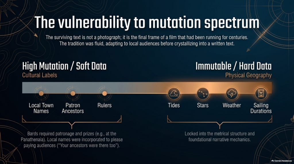
Bards performed at elite households, feasts and public occasions. Later professional rhapsodes performed Homeric poetry competitively at major festivals such as the Panathenaia, where contests and prizes existed. For most people in Archaic and Classical Greece, Homer would originally have been encountered through performance rather than privately reading a book.
So although we should avoid imagining a Bronze Age publishing company selling copies of the Iliad, there was still an economic reality.
A successful performer needed:
patronage,
invitations,
prestige,
prizes
and above all:
AN AUDIENCE THAT WANTED TO HEAR HIS VERSION.
That provides exactly the same commercial pressure that exists in entertainment today.
Tell people a story that relates to them, and they are more likely to listen.
Eventually the oral tradition increasingly became textual. The poems became books, educational texts and cultural possessions, while regulated festival performances also helped constrain what had previously been a much more fluid tradition. Yet even by the second century BCE, textual variation had not disappeared completely.
So the surviving text is better imagined not as a photograph taken at one moment in history, but as the final surviving frame of a film that had already been running for centuries.
📜 FROM BARD TO “HOMER”
There is another uncomfortable problem.
We do not actually know who Homer was.
Ancient cities competed to claim him as their own, particularly communities in Ionia such as Smyrna and Chios. Even the association of the name “Homer” with the Iliad and Odyssey developed within the later tradition.
Modern scholarship continues to debate whether:
one extraordinary poet monumentalised each epic,
different poets created the Iliad and Odyssey,
the poems were dictated by oral singers,
or their written forms emerged progressively from a much wider performance tradition.
What is considerably less controversial is that the tradition preceding the surviving text was oral.
That fact changes how geographical evidence should be handled.
THE ODYSSEY PROBLEM
🧭 NAMES ARE NOT THE SAME AS GEOGRAPHY
This is why, throughout this investigation, we will not begin by saying:
“Homer mentions a place later identified as being in Greece, therefore the story happened in Greece.”
That is circular reasoning.
A place-name can be:
preserved,
translated,
reapplied,
updated,
misunderstood
or
incorporated during centuries of oral retelling.
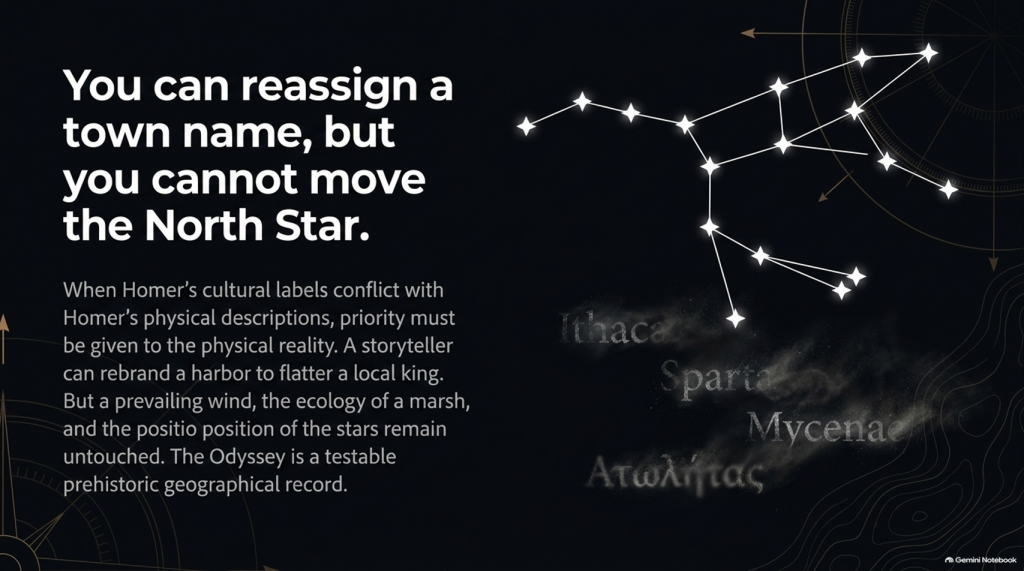
A river behaving in a particular way cannot.
A tide cannot.
A seventeen-day voyage cannot.
The position of a star cannot.
A prevailing wind cannot.
The length of winter darkness cannot.
The ecology of a marsh cannot.
A mountain visible after a stated number of sailing days cannot.
Those are the clues that deserve greater weight.
So our methodology deliberately separates:
🏛️ CULTURAL LABELS
from
🌍 PHYSICAL GEOGRAPHY.
The names remain important.
But they do not get to prove themselves.
THE ODYSSEY PROBLEM
🔍 THE STORY MAY BE OLDER THAN ITS MAP
And this leads directly to the central problem of the Odyssey.
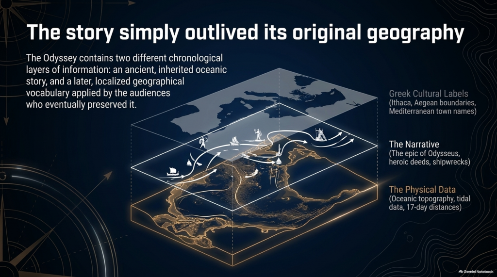
It is entirely possible that the written poem contains two different chronological layers of information:
an ancient inherited story,
and
a later geographical vocabulary familiar to the audiences who eventually preserved and recorded it.
If so, conflicts between Homer’s names and Homer’s physical descriptions become extremely important.
Which should we trust?
The town name that could have travelled through centuries of human storytelling?
Or the description of:
🌊 the sea,
🌫️ the climate,
⭐ the stars,
🧭 the sailing direction,
⏳ the voyage duration,
🌲 the vegetation,
🏔️ the landscape
and
👥 the people?
Our investigation gives priority to the latter.
Because oral tradition can move a name.
IT CANNOT MOVE THE NORTH STAR.
THE ODYSSEY PROBLEM
And once that distinction is understood, the Odyssey stops being merely one of the world’s greatest stories.
It becomes something else:
🧭 A POTENTIALLY TESTABLE PREHISTORIC GEOGRAPHICAL RECORD.
That is where our investigation begins.
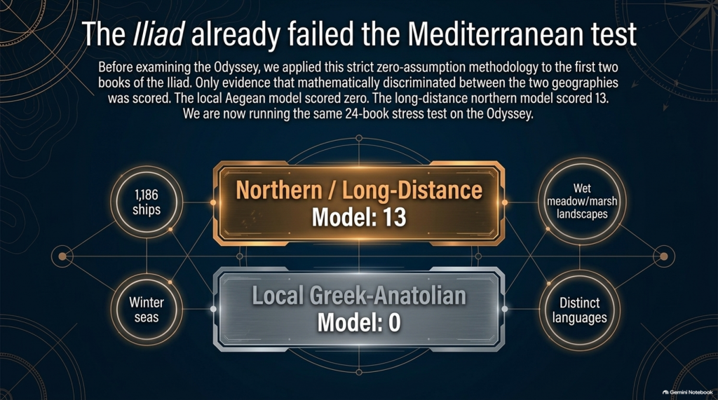
Our examination of the first two books of Homer’s Iliad has already produced an unexpected result.
After removing traditional place-name assumptions and scoring only evidence that actually discriminates between the competing geographical models, the result currently stands at:
🌊 NORTHERN / LONG-DISTANCE MODEL: 13
☀️ LOCAL GREEK–ANATOLIAN MODEL: 0
But we may have overlooked an even more powerful test.
Because Homer didn’t only leave us the story of the war.
He also left us:
🧭 THE JOURNEY HOME.
And that creates a very awkward question for the traditional identification of Troy.
🚢 THE JOURNEY SHOULD BE SIMPLE
The conventional interpretation tells us:
🏛️ Troy = Hisarlık in north-western Turkey
and
🏠 Odysseus’ home = Ithaca in western Greece.
So when Troy falls, Odysseus has a straightforward objective:
TROY ➡️ ITHACA
Nothing mysterious about that.
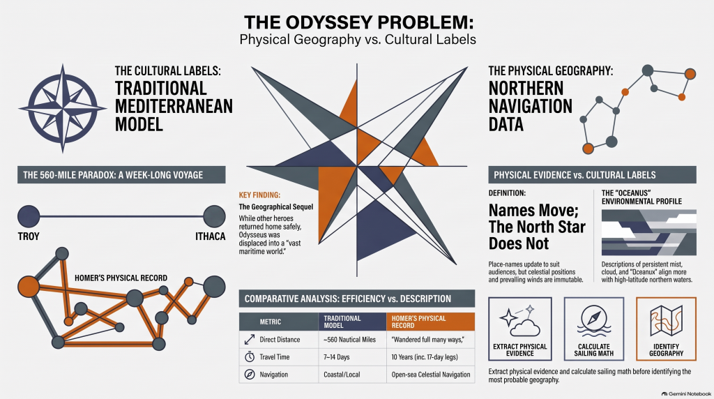
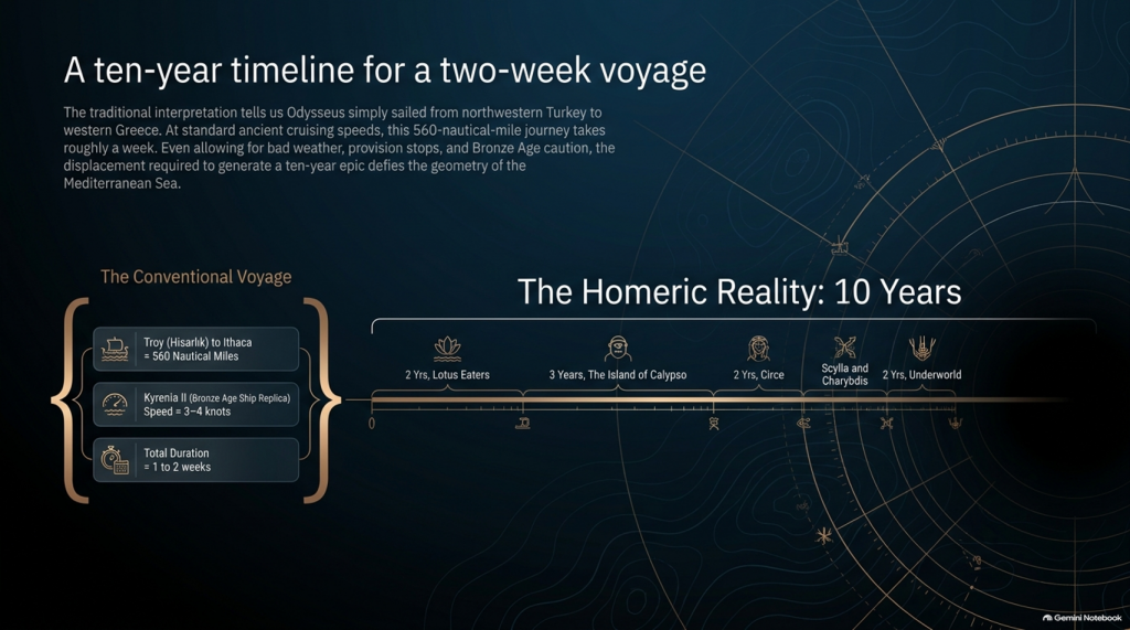
The conventional sea distance is approximately:
🌊 560 NAUTICAL MILES
roughly 645 statute miles
Now compare that with experimental ancient Mediterranean sailing.
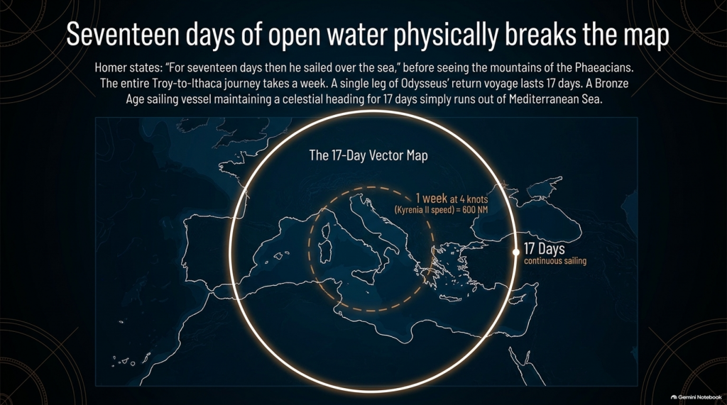
The reconstructed fourth-century BC merchant vessel Kyrenia II demonstrated cruising speeds around 3–4 knots, sometimes considerably faster. On its experimental voyage from Piraeus to Cyprus it covered almost 600 nautical miles despite stops, tests and variable conditions.
At that sort of speed, a direct 560-mile voyage is not a journey measured in years.
It is measured in:
📅 DAYS.
Allow for poor winds, overnight stops, provisioning and Bronze Age caution and perhaps we are looking at roughly:
ONE TO TWO WEEKS
under reasonably favourable circumstances.
And yet Homer gives us:
⏳ TEN YEARS.
Immediately people will say:
“But Odysseus didn’t spend ten years sailing!”
Correct.
And that distinction actually makes the geographical problem more interesting.
THE ODYSSEY PROBLEM
⏳ THE TEN YEARS WERE NOT TEN YEARS OF CONTINUOUS SAILING
Odysseus gets delayed.
He is shipwrecked.
He loses companions.
He encounters hostile populations.
He becomes stranded.
He spends years unable to get home.
So it would be scientifically wrong to calculate:
ship speed × ten years = distance from Troy.
We aren’t doing that.
The real question is much more basic:
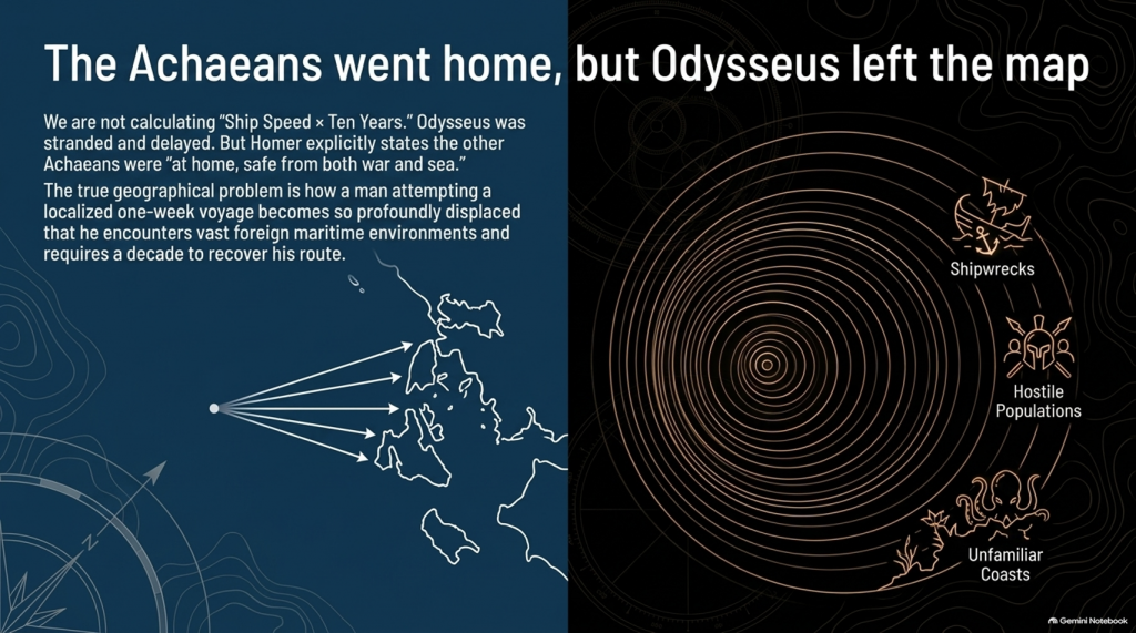
How does a man attempting a voyage whose conventional start and finish are only about a week’s sailing apart become so geographically displaced that returning home consumes ten years?
That is the problem.
📖 HOMER TELLS US FROM THE FIRST LINES THAT THIS IS A GEOGRAPHICAL JOURNEY
The Odyssey opens by describing Odysseus as the man who:
“wandered full many ways”
after he had destroyed Troy.
Homer says:
“Many were the men whose cities he saw”
and tells us that he suffered repeatedly:
“upon the sea.”
This isn’t simply a story about somebody stuck around the corner.
It is explicitly a story about:
🌍 travelling through different lands
👥 encountering different peoples
🌊 crossing seas
🌪️ experiencing extreme maritime conditions
and
🧭 struggling to recover the route home.
THE ODYSSEY PROBLEM
🚨 EVEN MORE IMPORTANTLY — EVERYONE ELSE HAS ALREADY GONE HOME
Book 1 gives us another striking statement.
Homer says that the other surviving Achaeans were:
“at home, safe from both war and sea.”
Odysseus alone remained unable to complete his return.
This is extremely important.
The war is finished.
The surviving coalition disperses.
The men undertake their return journeys from Troy.
That means the Odyssey isn’t some unrelated maritime fantasy.
It is the geographical sequel to the Trojan War.
We therefore have another independent dataset with which to test the location of Troy.
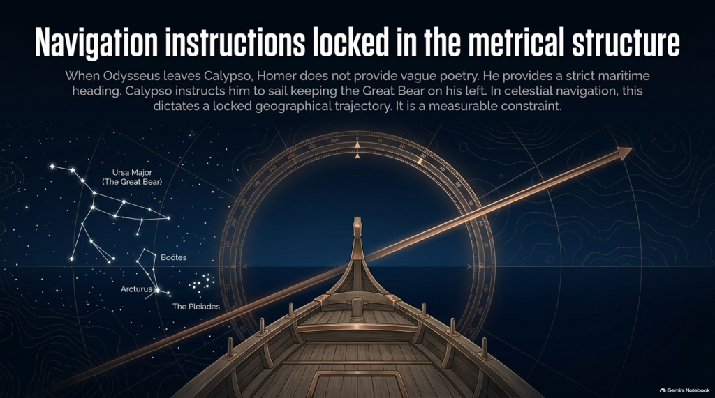
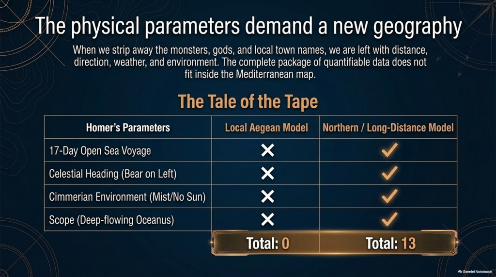
🧭 AND HOMER ACTUALLY GIVES US NAVIGATION INSTRUCTIONS
This is where things become particularly interesting.
When Odysseus finally leaves Calypso, Homer doesn’t simply say:
“He sailed away.”
He tells us how he navigated.
Odysseus watches:
⭐ the Pleiades
⭐ Boötes
⭐ Orion
⭐ the Great Bear.
And Calypso instructs him to keep the Bear:
ON HIS LEFT
while sailing.
That is potentially geographical evidence.
Because now we have:
⭐ CELESTIAL NAVIGATION
🧭 DIRECTION
🌊 OPEN-SEA TRAVEL
⏳ AND SAILING DURATION.
That can potentially be tested mathematically.
THE ODYSSEY PROBLEM
🚢 THEN HOMER GIVES US THE NUMBER: SEVENTEEN DAYS
Odysseus sails continuously enough for Homer to state:
“For seventeen days then he sailed over the sea”
and on the eighteenth he finally sees the mountains of the Phaeacians.
Stop there.
The entire conventional Troy-to-Ithaca journey could potentially be completed in something around a week or somewhat longer under reasonable sailing conditions.
Yet one single later leg of Odysseus’ wandering lasts:
🌊 17 DAYS AT SEA
before land appears.
That doesn’t automatically prove the Atlantic.
But scientifically it demands investigation.
Where had he travelled?
How far away from Ithaca had he become?
What heading does keeping the Great Bear on the left imply?
What distance can a Bronze Age sailing vessel cover in seventeen days?
And does the conventional Mediterranean reconstruction actually satisfy those constraints?
These are measurable questions.
🌫️ THEN WE REACH THE CIMMERIANS
And the environment becomes even stranger.
Odysseus reaches the land of the Cimmerians.
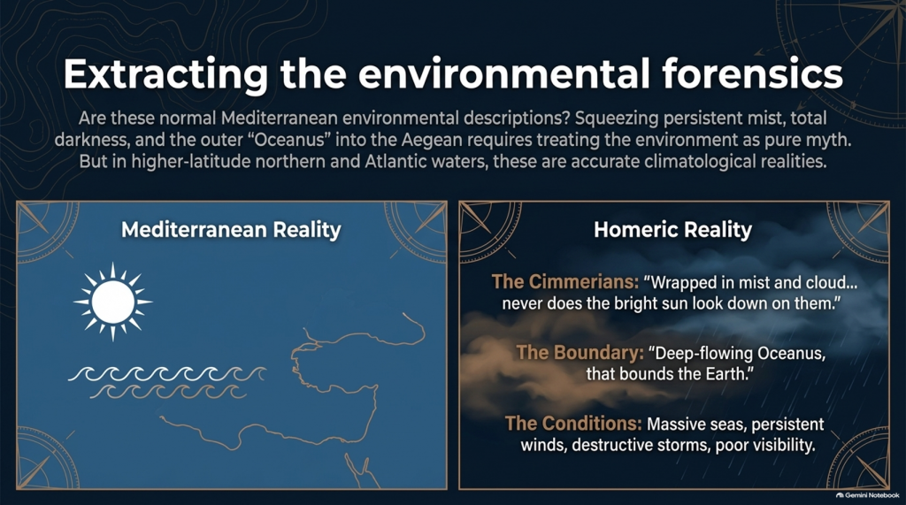
Homer describes it as:
“wrapped in mist and cloud.”
Then he says:
“Never does the bright sun look down on them”
and describes oppressive darkness hanging over the inhabitants.
Again, we must be careful.
This could be mythological geography.
It could represent Homer’s conception of the edge of the world.
We cannot simply announce:
Cimmerians = Britain.
But scientifically we are entitled to ask:
🌞 Is this a normal Mediterranean environmental description?
Or is:
🌫️ persistent mist
☁️ cloud
🌑 darkness
and
🌊 the remote Ocean
more naturally compatible with the traditions of higher-latitude northern waters?
That becomes another test.
🌊 HOMER EVEN TAKES US TO “OCEANUS”
Immediately before reaching the Cimmerians, Homer says Odysseus’ vessel reaches:
“deep-flowing Oceanus, that bounds the Earth.”
This is extremely significant conceptually.
The poem’s geography has now expanded far beyond an ordinary little voyage between Turkey and western Greece.
We are being taken to what Homer’s tradition regards as the outer ocean.
Whether Oceanus represents a literal Atlantic geography, mythical world-ocean, or a mixture of inherited geographical memory and mythology is precisely what needs testing.
But simply squeezing every episode into the Mediterranean because we have already decided Troy belongs there is not evidence.
It is circular reasoning.
THE ODYSSEY PROBLEM
🌪️ THE WEATHER NEEDS TESTING TOO
Throughout the Odyssey, maritime conditions aren’t background decoration.
They drive the story.
Odysseus encounters:
🌊 enormous seas
🌬️ persistent winds
⛈️ destructive storms
🌫️ mist and poor visibility
🏝️ unfamiliar coasts
and repeated difficulty determining his position.
Mediterranean storms can unquestionably be severe.
So:
storm = Atlantic
is not acceptable science.
But just as with our Iliad investigation, the correct question is:
Which maritime environment produces the complete collection of conditions more naturally and more frequently?
The Mediterranean?
Or the Atlantic/North Sea world?
🗺️ THE PEOPLE ARE JUST AS IMPORTANT AS THE WEATHER
The journey takes Odysseus through populations whose cultures and lifestyles differ radically.
We meet:
👥 Cimmerians
👥 Phaeacians
👥 Cyclopes
👥 Laestrygonians
and numerous other populations and communities.
Some may be mythical.
Some may preserve distorted memories of real peoples.
Some may combine both.
But we should not begin by assigning them to Mediterranean locations simply because later scholars did so.
Instead we should record:
🏠 housing
⛵ boat technology
🌾 agriculture
🐄 animals
🍖 diet
👕 clothing
🗣️ language
🌲 vegetation
🌦️ climate
🏔️ geography
and then ask:
WHERE DOES THAT COMPLETE PACKAGE FIT BEST?
THE ODYSSEY PROBLEM
⚠️ THIS IS THE SAME MISTAKE WE FOUND WITH THE ILIAD
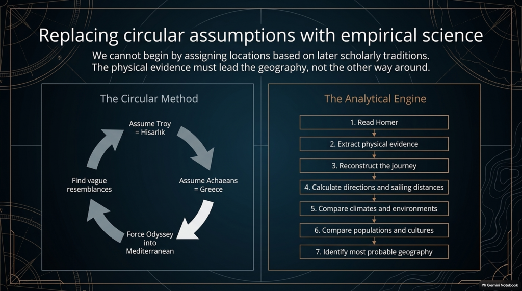
Traditional scholarship frequently begins with:
Troy = Hisarlık
therefore:
Achaeans = Greece
therefore:
the war must be Mediterranean
therefore:
the Odyssey must largely be Mediterranean
and then attempts to find Mediterranean locations resembling Homer’s descriptions.
That reverses the scientific process.
The correct sequence should be:
1️⃣ Read Homer.
2️⃣ Extract the physical evidence.
3️⃣ Reconstruct the journey.
4️⃣ Calculate directions and sailing distances.
5️⃣ Compare climates and environments.
6️⃣ Compare populations and cultures.
7️⃣ THEN identify the most probable geography.
Not the other way around.
🔬 AND THIS TIME WE CAN ACTUALLY DO THE MATHEMATICS
The Iliad gave us powerful clues such as:
🌍 “far from home”
🌊 mountains and sea separating populations
🚢 1,186 ships
🗣️ different languages
🌍 allies “from afar”
👱 repeated xanthos individuals
🌧️ winter seas
🌿 wet meadow and marsh landscapes.
But the Odyssey potentially gives us something even stronger.
It gives us:
⏱️ TIME
🧭 DIRECTION
⭐ NAVIGATION
🌊 DISTANCE
🌬️ WEATHER
🌍 ENVIRONMENT.
Those are quantifiable.
🚨 THE CENTRAL PROBLEM
Strip away all the monsters and gods for a moment.
The basic story says:
Odysseus leaves Troy.
He intends to sail home.
Home is Ithaca.
Other Achaeans successfully make their own returns.
Odysseus becomes displaced through a vast maritime world.
He encounters numerous foreign peoples and environments.
He reaches extraordinarily remote locations.
One later sailing leg alone lasts seventeen days.
His complete return takes ten years.
And the conventional interpretation asks us to place the beginning and end of that extraordinary adventure only about:
560 NAUTICAL MILES APART.
That doesn’t prove the traditional map is wrong.
But scientifically:
IT IS A PROBLEM THAT DEMANDS AN EXPLANATION.
THE ODYSSEY PROBLEM
🧪 SO WE ARE GOING TO TEST THE ODYSSEY TOO
After our detailed examination of the 24 books of the Iliad, we will now have a second investigation:
📚 ALL 24 BOOKS OF THE ODYSSEY
And we will use exactly the same rules.
No points for traditional names.
No location accepted because “experts agree”.
No northern point merely because something also happens in Britain.
No Mediterranean point merely because something can happen in Greece.
If both environments fit:
0–0
If one environment is substantially more probable:
it scores.
And where Homer gives us distances, directions and sailing durations:
WE DO THE MATHS.
🔥 THIS MAY BECOME THE BIGGER PROBLEM
After two books of the Iliad our score currently stands at:
🌊 NORTH / LONG-DISTANCE: 13
☀️ LOCAL AEGEAN: 0
Twenty-two Iliad books remain.
But after that we now have another twenty-four books containing the actual journey home.
That means this investigation is no longer simply:
“Where was Troy?”
THE ODYSSEY PROBLEM
The bigger question has become:
🧭 DOES HOMER’S ENTIRE GEOGRAPHICAL WORLD FIT INSIDE THE MAP WE HAVE BEEN GIVEN?
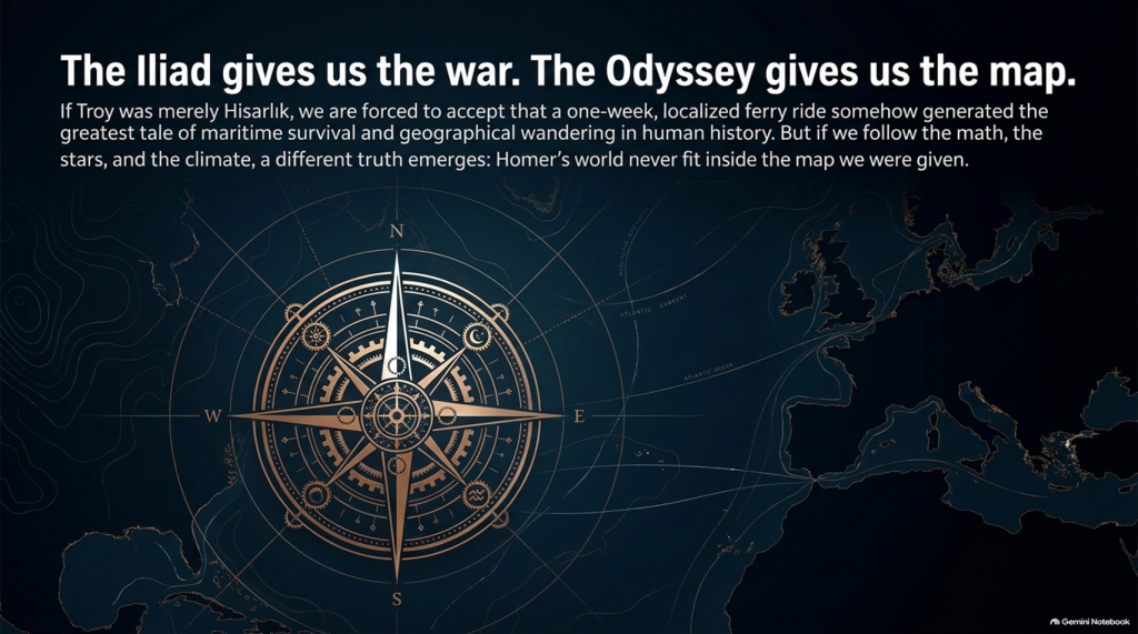
Because if Troy really was Hisarlık and Ithaca really was Odysseus’ destination, then a journey whose conventional endpoints are roughly a week or two of ordinary ancient sailing apart somehow generated one of the greatest tales of geographical wandering ever written.
Perhaps mythology explains everything.
Perhaps the Mediterranean really does reproduce Homer’s journey.
Perhaps the traditional geography eventually wins.
But those are hypotheses.
They now need testing.
And if the sailing directions, durations, climates, peoples and landscapes repeatedly point outside the Mediterranean, then the traditional identification of this as an obviously local Greek–Anatolian conflict becomes increasingly difficult to defend scientifically.
🌊 THE ILIAD GIVES US THE WAR.
🧭 THE ODYSSEY MAY GIVE US THE MAP.
And that may prove to be the most important test of them all. 🔍🌍⚔️
THE ODYSSEY PROBLEM
PODCAST
Author’s Biography
Robert John Langdon, a polymathic luminary, emerges as a writer, historian, and eminent specialist in LiDAR Landscape Archaeology.
His intellectual voyage has been interwoven with stints as an astute scrutineer in government and grand corporate bastions, a tapestry spanning British Telecommunications, Cable and Wireless, British Gas, and the esteemed University of London.
A decade hence, Robert’s transition into retirement unfurled a chapter of insatiable curiosity. This phase saw him immerse himself in Politics, Archaeology, Philosophy, and the enigmatic realm of Quantum Mechanics. His academic odyssey traversed the venerable corridors of knowledge hubs such as the Museum of London, University College London, Birkbeck College, The City Literature Institute, and Chichester University.
In the symphony of his life, Robert is a custodian of three progeny and a pair of cherished grandchildren. His sanctuary lies ensconced in the embrace of West Wales, where he inhabits an isolated cottage, its windows framing a vista of the boundless sea – a retreat from the scrutinising gaze of Her Majesty’s Revenue and Customs, an amiable clandestinity in the lap of nature.
Exploring Prehistoric Britain: A Journey Through Time
My blog delves into the fascinating mysteries of prehistoric Britain, challenging conventional narratives and offering fresh perspectives grounded in cutting-edge research, particularly LiDAR technology. I invite you to explore some key areas of my research. For example, the Wansdyke, often cited as a defensive structure, is re-examined in light of new evidence. I’ve presented my findings in my blog post Wansdyke: A British Frontier Wall – ‘Debunked’, and a Wansdyke LiDAR Flyover video further visualises my conclusions.
My work also often challenges established archaeological dogma. I argue that many sites, such as Hambledon Hill, commonly identified as Iron Age hillforts, are not what they seem. My posts Lidar Investigation Hambledon Hill – NOT an ‘Iron Age Fort’ and Unmasking the “Iron Age Hillfort” Myth explore these ideas in detail and offer an alternative view. Similarly, sites like Cissbury Ring and White Sheet Camp receive re-evaluations based on LiDAR analysis in my posts “Lidar Investigation Cissbury Ring through time”and “Lidar Investigation White Sheet Camp,“ revealing fascinating insights into their true purpose. I have also examined South Cadbury Castle, often linked to the mythical Camelot56.
My research also extends to ancient water management, including the role of canals and other linear earthworks. I have discussed the true origins of Car Dyke in multiple posts, including Car Dyke – ABC News Podcast and Lidar Investigation Car Dyke – North Section, which suggest a Mesolithic origin 2357. I also explore the misidentification of Roman aqueducts, as seen in my posts on the Great Chesters (Roman) Aqueduct. My research has also been greatly informed by my post-glacial flooding hypothesis, which has helped explain landscape transformations over time. I have discussed this hypothesis in several posts, including AI now supports my Post-Glacial Flooding Hypothesis and Exploring Britain’s Flooded Past: A Personal Journey
For those interested in British Prehistory, visit www.prehistoric-britain.co.uk, a comprehensive resource featuring an extensive collection of archaeology articles, modern LiDAR investigations, and groundbreaking research. The site also includes insights and excerpts from the acclaimed Robert John Langdon Trilogy, a series of books that explore Britain during the Prehistoric period. Titles in the trilogy include The Stonehenge Enigma, Dawn of the Lost Civilisation, and The Post-Glacial Flooding Hypothesis, which offer compelling evidence of ancient landscapes shaped by post-glacial flooding.
To further explore these topics, Robert John Langdon has developed a dedicated YouTube channel featuring over 100 video documentaries and investigations that complement the trilogy. Notable discoveries and studies showcased on the channel include 13 Things that Don’t Make Sense in History and the revelation of Silbury Avenue – The Lost Stone Avenue, a rediscovered prehistoric feature at Avebury, Wiltshire.
In addition to his main works, Langdon has released a series of shorter, accessible publications, ideal for readers delving into specific topics. These include:
For active discussions and updates on the trilogy’s findings and recent LiDAR investigations, join our vibrant community on Facebook. Engage with like-minded enthusiasts by leaving a message or contributing to debates in our Facebook Group.
Whether through the books, the website, or interactive videos, we aim to provide a deeper understanding of Britain’s fascinating prehistoric past. We encourage you to explore these resources and uncover the mysteries of ancient landscapes through the lens of modern archaeology.
For more information, including chapter extracts and related publications, visit the Robert John Langdon Author Page. Dive into works such as The Stonehenge Enigma or Dawn of the Lost Civilisation, and explore cutting-edge theories that challenge traditional historical narratives.
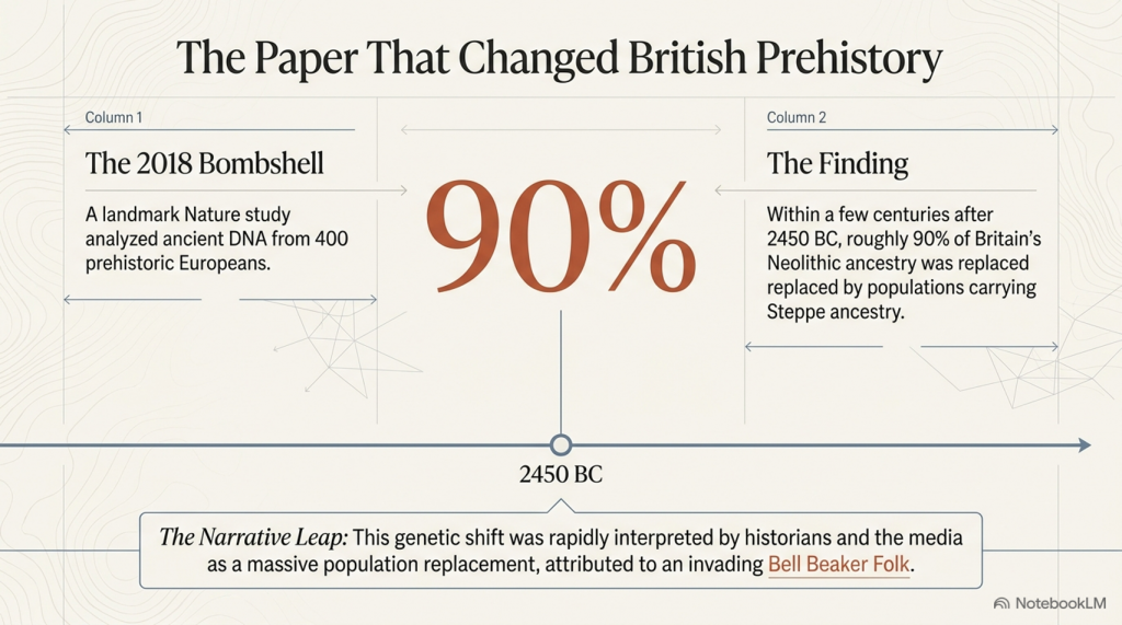
In 2018, a single scientific paper fundamentally changed the accepted history of prehistoric Britain.
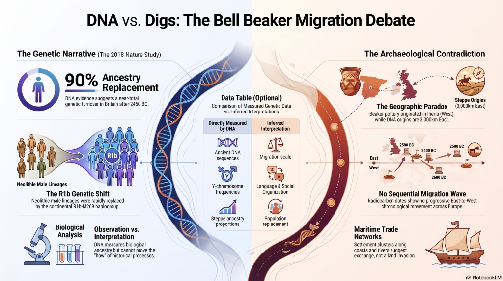
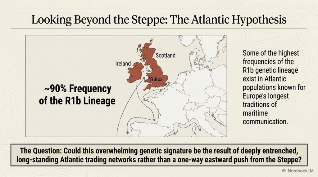
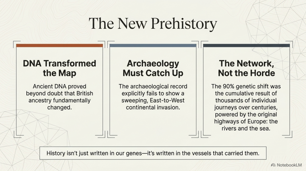
Published in Nature, the study analysed ancient DNA from hundreds of prehistoric individuals across Europe and concluded that around 90% of Britain’s Neolithic ancestry had been replaced within a few centuries after approximately 2450 BC. The proposed mechanism was the arrival of people associated with the Bell Beaker phenomenon, transforming what had previously been viewed largely as a cultural development into one of the largest population replacements ever suggested for prehistoric Europe. (The Great Bell Beaker Migration Myth – Haplogroup R1b)
The implications were enormous.
If correct, the builders of Britain’s great Neolithic monuments were largely replaced by an incoming population shortly after the final phases of Stonehenge. For many archaeologists, the debate appeared settled. Bell Beaker pottery was no longer viewed simply as evidence of trade or cultural exchange, but as the archaeological signature of a substantial migration.
Since its publication, the paper has become the cornerstone of the modern Beaker migration hypothesis. Its conclusions are now widely repeated in books, documentaries, museums and artificial intelligence systems as established fact.
Yet scientific papers do not become facts through repetition.
(The Great Bell Beaker Migration Myth – Haplogroup R1b)
They remain interpretations of evidence.
This distinction is critical because the 2018 study contains two very different components. The first is the genetic evidence itself, generated using sophisticated laboratory techniques and robust statistical analysis. The second is the archaeological interpretation built upon those genetic results.
These are not the same thing.
The genetic data reveal changes in ancestry through time. They do not directly reveal how those changes occurred, how many people migrated, whether migration was peaceful or gradual, whether technology spread independently of populations, or whether long-established communities continued alongside newcomers. Those questions require archaeological interpretation, and it is here that debate remains both possible and necessary.
This article does not challenge the quality of the genetic research. On the contrary, the laboratory science represents a remarkable achievement and provides an invaluable dataset for understanding prehistoric populations. The question it raises is whether the historical conclusions drawn from that dataset are the only ones supported by the evidence.
To answer that question, we return to the original publication itself.
(The Great Bell Beaker Migration Myth – Haplogroup R1b)
Rather than relying on popular summaries or inherited archaeological narratives, we will examine what the paper actually demonstrates, what it explicitly acknowledges as uncertain, and where interpretation extends beyond observation. We will then compare those conclusions with independent evidence from archaeology, chronology, maritime capability, engineering, long-distance exchange networks and anthropometric analysis.
Only by considering all of the evidence together can we assess whether Britain’s Bell Beaker story is truly one of wholesale population replacement—or whether a more complex and more plausible explanation has been overlooked.
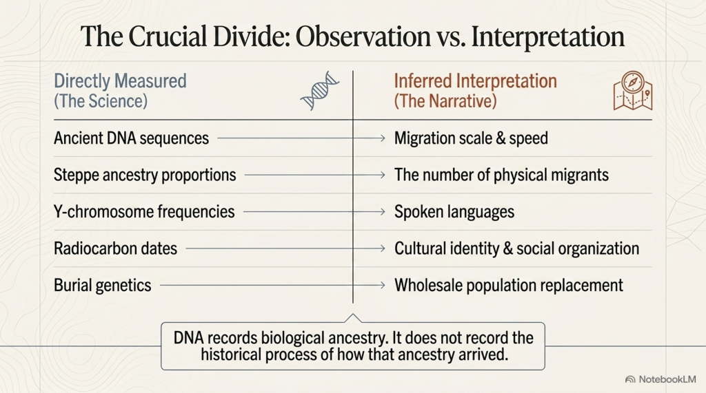
Table 1.1 – What the 2018 Paper Claims vs What It Directly Measures
Directly Measured
Inferred Interpretation
Ancient DNA sequences
Migration scale
Steppe ancestry proportions
Number of migrants
Y-chromosome frequencies
Language
Radiocarbon dates
Cultural identity
Genetic similarity
Social organisation
Burial genetics
Population replacement
(The Great Bell Beaker Migration Myth – Haplogroup R1b)
Section 1 — The Paper That Changed British Prehistory
In March 2018, the scientific journal Nature published one of the most influential archaeological papers of the twenty-first century: The Beaker Phenomenon and the Genomic Transformation of Northwest Europe by Olalde et al. The study analysed genome-wide DNA from 400 prehistoric individuals across Europe, including 226 associated with the Bell Beaker phenomenon, making it the largest ancient DNA investigation of the Beaker period to date.
The headline conclusion was dramatic. The authors proposed that Britain underwent a genetic transformation shortly after 2450 BC, estimating that around 90% of the existing Neolithic gene pool was replaced within a few centuries following the arrival of populations associated with the Bell Beaker Complex. This conclusion rapidly became accepted as the defining explanation for one of the most important transitions in British prehistory.
The impact extended far beyond academic archaeology. Museums rewrote their displays. Television documentaries presented the migration as an established fact. Popular history books adopted the new narrative, while artificial intelligence systems now routinely repeat the claim that Britain was almost entirely repopulated by incoming Beaker migrants around 4,500 years ago.
The influence of a paper published in one of the world’s most respected scientific journals is entirely understandable. Ancient DNA has transformed archaeology over the last decade, allowing researchers to investigate prehistoric relationships with a level of precision unimaginable only a generation ago. The laboratory methods employed by Olalde and colleagues represent an outstanding scientific achievement, and the genetic dataset itself remains one of the most important resources available for studying prehistoric Europe.
(The Great Bell Beaker Migration Myth – Haplogroup R1b)
However, scientific data and historical interpretation are not the same thing.
The DNA recovered from ancient skeletons measures biological ancestry. It identifies patterns of genetic similarity, estimates ancestral components and tracks changes in populations through time. What it cannot directly measure is the historical process responsible for those changes. Genetics cannot determine whether ancestry shifted through invasion, peaceful migration, elite dominance, gradual population mixing, long-term trade networks, demographic expansion, disease, social selection or a combination of several processes. Those explanations lie outside the laboratory and belong instead to archaeology, anthropology and historical interpretation.
This distinction is crucial because much of the public discussion has blurred the line between what the paper actually measured and what the authors inferred from those measurements. The genetic observations themselves are objective scientific results. The reconstruction of Britain’s prehistoric history from those results is necessarily interpretative.
To be fair to the authors, they acknowledge this limitation themselves. In their discussion, they conclude by calling for further archaeological research into the social, technological, climatic and demographic processes that may have produced the observed genetic patterns, recognising that DNA alone cannot explain why those changes occurred.
That acknowledgement is often absent from popular accounts.
Instead, a more nuanced scientific conclusion has gradually become simplified into a much stronger historical claim: that the arrival of the Bell Beaker phenomenon represents a near-complete replacement of Britain’s population. Once repeated often enough, that interpretation has acquired the appearance of an established fact, despite relying on assumptions that extend beyond the genetic evidence itself.
This article does not dispute the quality of the genetic science. Nor does it deny that Britain’s genetic composition changed during the late third millennium BC. Instead, it asks a different question:
Does the evidence actually require the historical narrative that has been built upon it?
To answer that question, we shall examine the original paper in detail before comparing its conclusions with independent archaeological evidence, including long-distance trade networks, maritime capabilities, monument construction, engineering continuity, chronology, and anthropology. Only then can we determine whether the modern Beaker migration model is the only explanation—or simply one possible interpretation of the available evidence.
(The Great Bell Beaker Migration Myth – Haplogroup R1b)
Section 2 – What the DNA Actually Demonstrates
One of the biggest mistakes made by both supporters and critics of the Beaker migration hypothesis is failing to distinguish between observations and interpretations. Before questioning any conclusion, we must first establish what the genetic evidence genuinely shows.
The Olalde et al. study analysed genome-wide DNA from 400 prehistoric Europeans, including 226 individuals associated with the Bell Beaker phenomenon. These samples were drawn from sites across Britain, the Netherlands, Germany, Hungary, Spain, Portugal, France, Italy and several other regions, providing an unprecedented dataset for examining population relationships during the third millennium BC.
Using standard population genetics techniques, including Principal Component Analysis (PCA), ADMIXTURE modelling, and qpAdm ancestry estimation, the authors compared the genetic signatures of these ancient individuals with those of earlier Neolithic populations and contemporary groups across Europe. These methods are widely accepted within archaeogenetics and are not, in themselves, controversial.
The results revealed several clear observations.
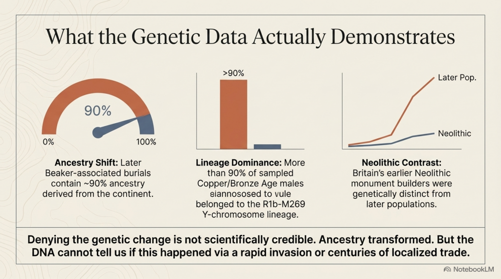
First, Britain’s Neolithic population differed genetically from the majority of later Bell Beaker-associated individuals found after approximately 2450 BC. Whereas earlier Neolithic Britons showed little or no detectable Steppe-related ancestry, later Beaker-associated burials contained substantially higher proportions.
Second, the Y-chromosome composition changed dramatically. Neolithic males were dominated by earlier European lineages, whereas more than ninety per cent of sampled males from the Copper and Bronze Ages belonged to the R1b-M269 lineage, a haplogroup already common among Beaker-associated populations on the European mainland.
Third, statistical modelling suggested that by the Middle Bronze Age, most sampled individuals derived the majority of their ancestry from populations already present in continental Europe before approximately 2450 BC. On the basis of these ancestry models, the authors estimated that Britain’s Neolithic gene pool had been replaced by approximately ninety per cent.
(The Great Bell Beaker Migration Myth – Haplogroup R1b)
These findings are significant.
They demonstrate that Britain’s genetic composition changed substantially during the late third millennium BC. Any interpretation of British prehistory must therefore account for this transformation. Simply denying the existence of genetic change is no longer a scientifically credible position.
However, the study also produced another important result that receives far less public attention.
The Bell Beaker phenomenon was not genetically uniform.
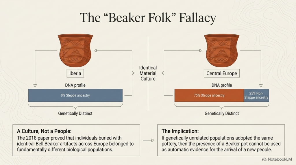
One of the paper’s most important discoveries was that Beaker-associated populations differed markedly across Europe. Individuals buried with Bell Beaker artefacts in Iberia shared little genetic affinity with Beaker-associated populations from Central Europe. In Hungary, individuals buried within the same archaeological tradition displayed Steppe ancestry ranging from virtually zero to approximately seventy-five per cent. Even within individual cemeteries, substantial genetic variation existed between people buried only a short distance apart.
This finding fundamentally overturned the older nineteenth-century concept of a single “Beaker Folk.”
Instead, the evidence demonstrated that Bell Beaker material culture was adopted by populations with different genetic backgrounds across Europe.
The authors therefore concluded that both cultural transmission and human migration contributed to the spread of the Beaker phenomenon, with their relative importance varying between different regions. In Iberia, they argued that Beaker culture spread largely without major migration, whereas Britain appeared to represent a very different demographic pattern.
Up to this point, the paper remains firmly grounded in its genetic observations.
The crucial question, however, is whether the next step in the argument necessarily follows.
Does a change in genetic ancestry automatically demonstrate a mass migration that replaced Britain’s population?
Or does the DNA simply demonstrate that ancestry changed, leaving the mechanism responsible still open to investigation?
That distinction lies at the heart of the modern Beaker debate, because the evidence presented by Olalde and colleagues answers the first question with confidence while leaving the second dependent upon archaeological interpretation.
The following section examines precisely where that transition occurs.
Section 3 – Where Observation Becomes Interpretation
The distinction between scientific observation and historical interpretation is fundamental to every discipline. Astronomy measures the movement of planets but must interpret how solar systems formed. Geology measures rock strata but must interpret the processes that created them. Archaeogenetics is no different. DNA provides powerful evidence about biological ancestry, but history cannot be reconstructed from genetics alone.
This distinction becomes increasingly important as we move through the conclusions of Olalde et al.
The genetic evidence demonstrates that Britain’s genetic composition changed substantially during the late third millennium BC. That observation is supported by the ancient DNA itself and is not disputed here. The question is not whether ancestry changed, but how that change occurred.
Unfortunately, much of the subsequent discussion has treated these two questions as though they were identical.
They are not.
Ancient DNA can identify genetic relationships between populations and estimate the proportion of ancestry they share. It can show whether individuals buried in Britain around 2000 BC were genetically more similar to populations living on the European mainland than to Britain’s earlier Neolithic inhabitants. It can estimate when those ancestral components first appear within the archaeological record. These are measurable scientific observations.
However, DNA cannot identify the historical mechanism responsible for those observations.
(The Great Bell Beaker Migration Myth – Haplogroup R1b)
It cannot determine whether people arrived peacefully or violently. It cannot establish whether movement occurred over two generations or twenty. It cannot reveal whether migrants arrived as farmers, traders, craftsmen, political elites or small family groups. It cannot determine whether newcomers absorbed existing communities or whether existing communities absorbed the newcomers. Most importantly, it cannot distinguish between demographic replacement and genetic replacement.
These are archaeological questions, not genetic ones.
This distinction may appear subtle, but it is crucial.
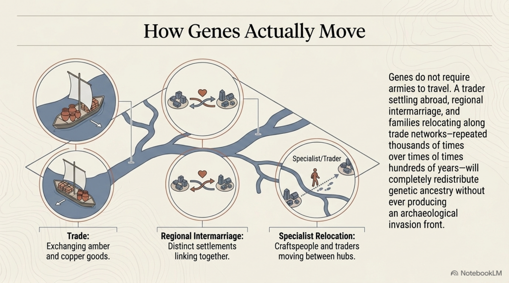
Imagine a small incoming population possessing a social or economic advantage that results in greater reproductive success over many generations. Their genetic contribution could eventually dominate the population while leaving much of the existing society, its engineering, language, traditions and landscape knowledge intact. Conversely, a large migration might leave relatively little long-term genetic impact if it failed to establish itself. Genetics records ancestry, not history.
The Olalde paper itself recognises these limitations.
In the discussion, the authors suggest that archaeology must investigate factors such as social organisation, technology, subsistence, climate, population size and even pathogen exposure to explain the demographic changes observed in the DNA. In other words, the genetic evidence identifies that a change occurred but does not explain why or how it happened.
Yet popular accounts rarely preserve this distinction.
Instead, a series of assumptions has gradually become embedded within the archaeological narrative:
Genetic change becomes migration.
Migration becomes mass migration.
Mass migration becomes population replacement.
Population replacement becomes cultural replacement.
Cultural replacement becomes the explanation for every major archaeological change after 2450 BC.
Each step moves progressively further from the direct evidence.
At no point does the DNA itself demonstrate that ninety per cent of Britain’s inhabitants physically disappeared within a few centuries. It demonstrates that approximately 90 per cent of the ancestry measured in later-sampled individuals can be modelled as deriving from populations already present on the continent before approximately 2450 BC. Those are not identical statements, however similar they may initially appear.
This distinction becomes even more significant when viewed alongside the archaeological record. Monument construction, long-distance exchange, advanced engineering and sophisticated maritime activity all continue across the period in question. If Britain experienced one of the largest population replacements in European prehistory, we must ask whether the archaeological evidence reflects such a profound societal disruption.
That question has rarely been asked because the genetic interpretation has been so rapidly accepted that it has begun to shape the reading of archaeology itself.
Science should proceed in the opposite direction.
Independent lines of evidence should be compared to determine whether they converge on the same conclusion or suggest alternative explanations. Genetics provides one line of evidence. Archaeology provides another. Engineering, maritime capability, chronology, settlement continuity and biological anthropology each contribute further pieces of the puzzle.
Only when all of these independent datasets point towards the same conclusion can a historical interpretation be regarded as robust.
The remainder of this article, therefore, moves beyond genetics alone. Rather than questioning laboratory science, we shall examine whether the broader archaeological evidence supports the modern Beaker migration narrative—or whether an alternative interpretation can explain both the genetic observations and the archaeological record equally well.
Section 4 – Bell Beaker: A Culture or a People?
Before examining Britain, we must first ask a more fundamental question.
What exactly is the Bell Beaker phenomenon?
For more than a century, archaeology treated Bell Beaker pottery as the archaeological signature of a distinct people. Wherever the characteristic bell-shaped pottery appeared, it was widely assumed that the “Beaker Folk” had arrived with it. This interpretation became deeply embedded in archaeological literature and survived well into the twentieth century.
Modern genetics has fundamentally changed that view.
One of the most important conclusions of Olalde et al. is not that Britain experienced a major genetic transformation, but that the Bell Beaker phenomenon itself was genetically heterogeneous. Individuals buried with Bell Beaker artefacts in Iberia, Central Europe and Britain did not belong to a single biological population. Instead, they represented communities with markedly different genetic ancestries who nevertheless shared similar pottery styles, burial customs and aspects of material culture.
This finding has profound implications.
If Bell Beaker artefacts can be adopted by genetically unrelated populations across Europe, then the presence of Beaker pottery cannot automatically be taken as evidence for the arrival of a new people. At the very least, the archaeological label “Bell Beaker” must be distinguished from any assumption of biological identity.
The distribution of Bell Beaker material culture reinforces this conclusion.
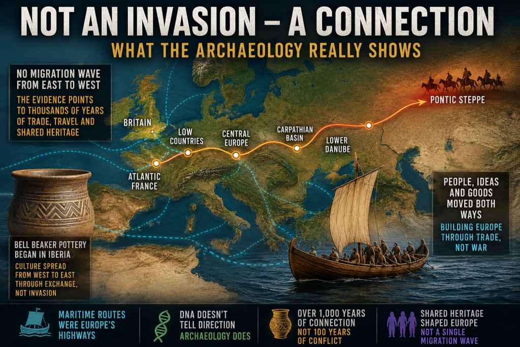
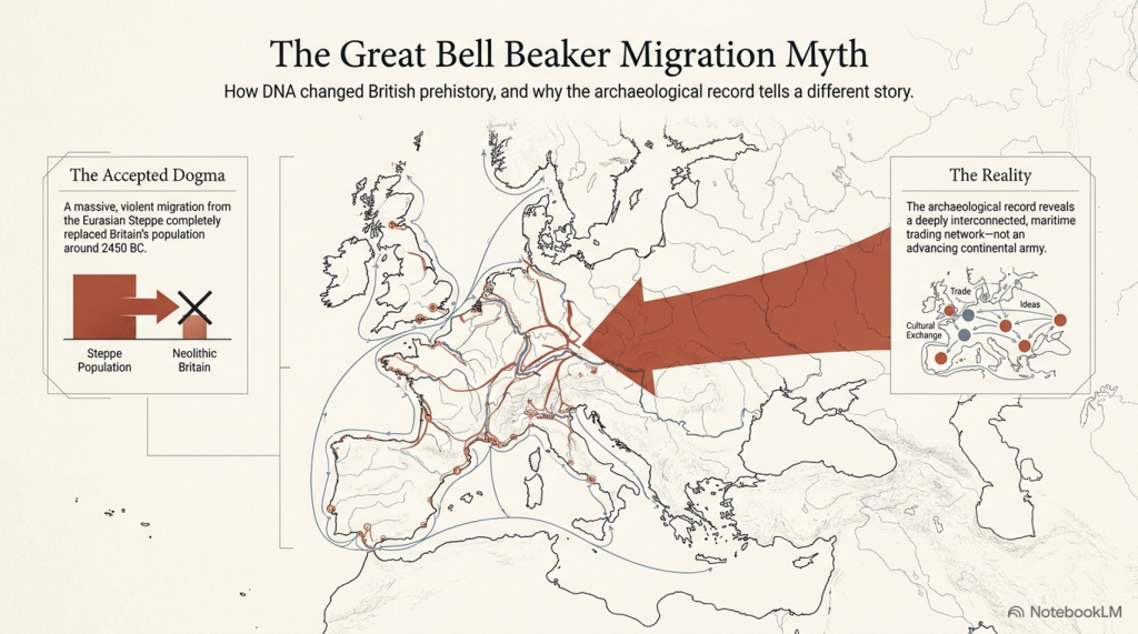
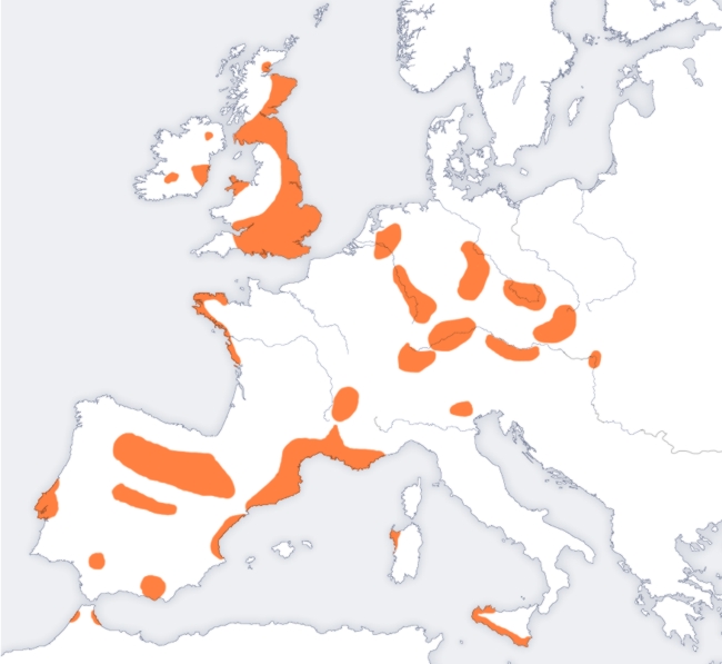
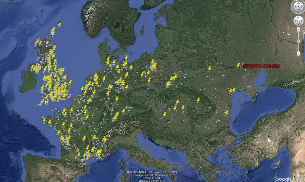
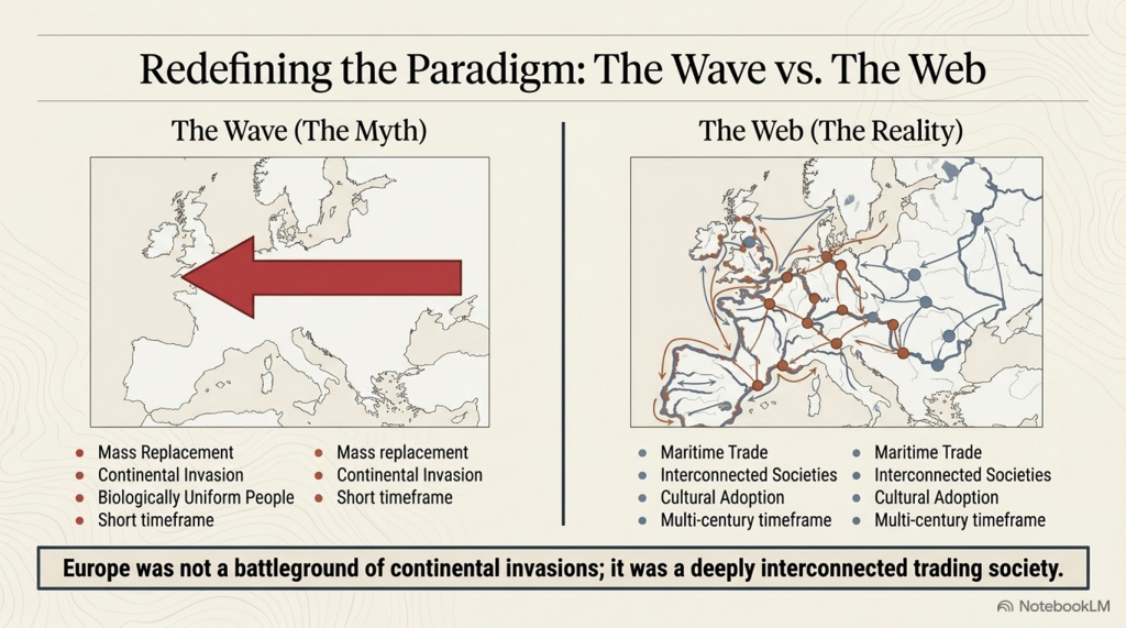
Figure 4.1 shows the geographical spread of Bell Beaker sites across Europe. Rather than forming a continuous wave advancing steadily across the continent, the distribution is fragmented into regional clusters. Strong concentrations occur around the Atlantic façade, the Iberian Peninsula, southern Britain and Ireland, while inland Europe contains numerous isolated concentrations separated by large areas where Beaker material is scarce or absent.
(The Great Bell Beaker Migration Myth)
Equally striking is the relationship with Europe’s principal transport routes. Many of these concentrations follow major river systems, estuaries and coastlines that would have formed the prehistoric highways of the third millennium BC. Such a distribution is entirely consistent with the movement of people, ideas and goods through established communication networks.
The map alone cannot determine the mechanism responsible. A clustered distribution may result from trade, seasonal mobility, cultural adoption, small-scale migration or combinations of all these processes. However, it does demonstrate that the Bell Beaker phenomenon did not spread as a simple, uniform expansion of a single homogeneous population across Europe.
This observation aligns closely with the genetic evidence.
Olalde et al. demonstrated that Beaker-associated individuals in Iberia remained genetically similar to earlier local populations, whereas those elsewhere possessed much higher proportions of Steppe ancestry. Even within the same cemeteries, individuals could display markedly different ancestral compositions. In other words, the archaeological phenomenon spread far more widely than any single genetic lineage.
Taken together, the archaeology and genetics point towards a more complex picture than the nineteenth-century concept of a migrating “Beaker Folk.” They reveal a cultural horizon adopted by populations with diverse biological backgrounds rather than a single people expanding uniformly across Europe.
This distinction is critical because it changes the question we should be asking.
The issue is no longer whether Bell Beaker culture moved across Europe—it clearly did.
The question is how it moved.
Did its remarkable spread depend primarily upon the movement of entire populations?
Or did it travel along the same maritime and riverine exchange networks that already connected prehistoric Europe, with ideas, technologies and people moving together in varying proportions depending upon local circumstances?
The distribution map cannot answer that question by itself.
However, it establishes an important framework for the remainder of this investigation. If the Bell Beaker culture was transmitted through extensive communication networks elsewhere in Europe, we should expect Britain to be examined within that same context rather than being treated as an isolated exception.
The next step is therefore to investigate Britain’s archaeological record and ask whether it resembles the disruption expected from a near-complete population replacement, or whether it instead reflects continuity within an already sophisticated and well-connected prehistoric society.
5. The Great Archaeological Contradiction
In 2018, the publication of The Beaker Phenomenon and the Genomic Transformation of Northwest Europe fundamentally changed the debate surrounding the Bell Beaker phenomenon. Ancient DNA demonstrated that Britain experienced a dramatic genetic transformation after approximately 2450 BC, with around 90% of the ancestry of later Bronze Age populations ultimately deriving from continental populations carrying Steppe ancestry. Few now dispute the genetic evidence itself.
The contradiction lies elsewhere.
It lies in archaeology.
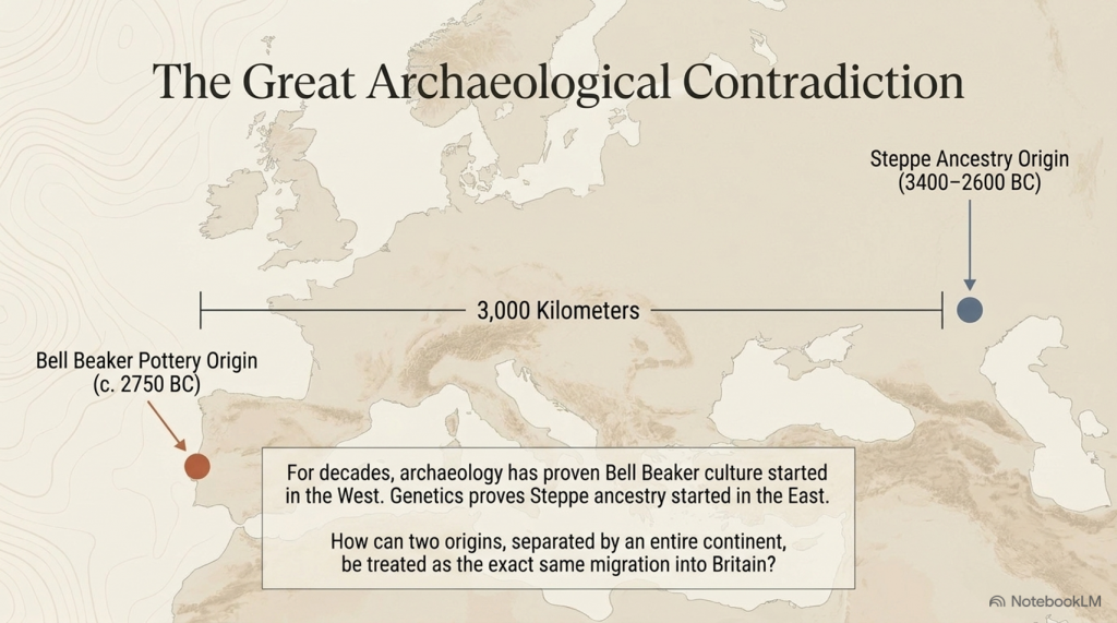
For more than fifty years, archaeologists have consistently argued that the earliest Bell Beaker pottery originated in Atlantic Iberia, not on the Eurasian Steppe. The chronology is remarkably consistent across the literature.
3400–2600 BC – The Yamnaya horizon occupies the Pontic–Caspian Steppe.
c. 3000–2600 BC – Steppe ancestry expands westwards into northern and central Europe through populations associated with the Corded Ware Culture.
c. 2750 BC – The earliest Bell Beaker pottery appears in Atlantic Iberia.
2500–2450 BC – Bell Beaker material culture spreads across western Europe before reaching Britain around 2450 BC.
(The Great Bell Beaker Migration Myth – Haplogroup R1b)
That sequence creates an obvious archaeological problem.
If Bell Beaker pottery originated in Iberia, then it did not originate on the Steppe.
If Steppe ancestry originated on the Eurasian Steppe, then it did not originate in Iberia.
These are two completely different geographical origins separated by more than 3,000 kilometres.
Yet they are frequently presented as though they describe the same migration.
Archaeology says one thing.
The genetics says another.
The interpretation combines them into a single historical event.
Remarkably, Armit and Reich themselves recognise this problem. Reviewing the genetic evidence, they explicitly note that Bell Beaker communities in Iberia and those in Central Europe possessed fundamentally different genetic ancestries. They conclude that the Bell Beaker phenomenon “did not, therefore, spread principally through migration, but must have involved the movement of ideas between populations of distinct genetic heritage.”
That statement has profound implications.
If the Bell Beaker culture spread between genetically distinct populations, then Bell Beaker pottery cannot itself be used as evidence for the movement of a single people.
Indeed, the authors go further. Rather than presenting a single explanation, they explicitly warn archaeologists, “we must be careful not to conflate them” when discussing the relationship between Steppe ancestry and the Beaker Complex.
To address this, they propose two competing hypotheses.
The first, Beaker Colonisation, argues that migrants associated with the Beaker Complex introduced Steppe ancestry into Britain after approximately 2450 BC.
The second, Steppe Drift, argues that these were two independent continental processes. Steppe ancestry gradually moved westwards through Europe, while the Beaker Complex spread culturally from Iberia. Britain represents the point at which these separate histories intersected.
This admission is extraordinary.
It recognises that archaeology and genetics do not automatically describe the same phenomenon.
Yet neither hypothesis answers the most fundamental archaeological question.
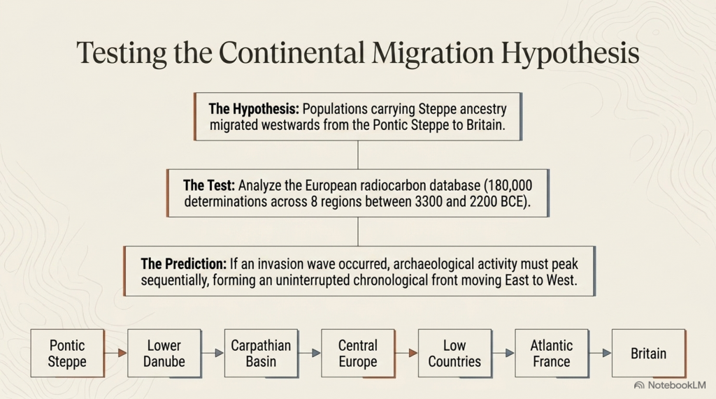
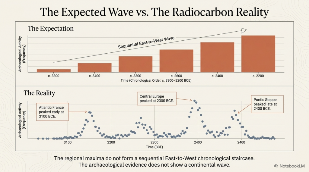
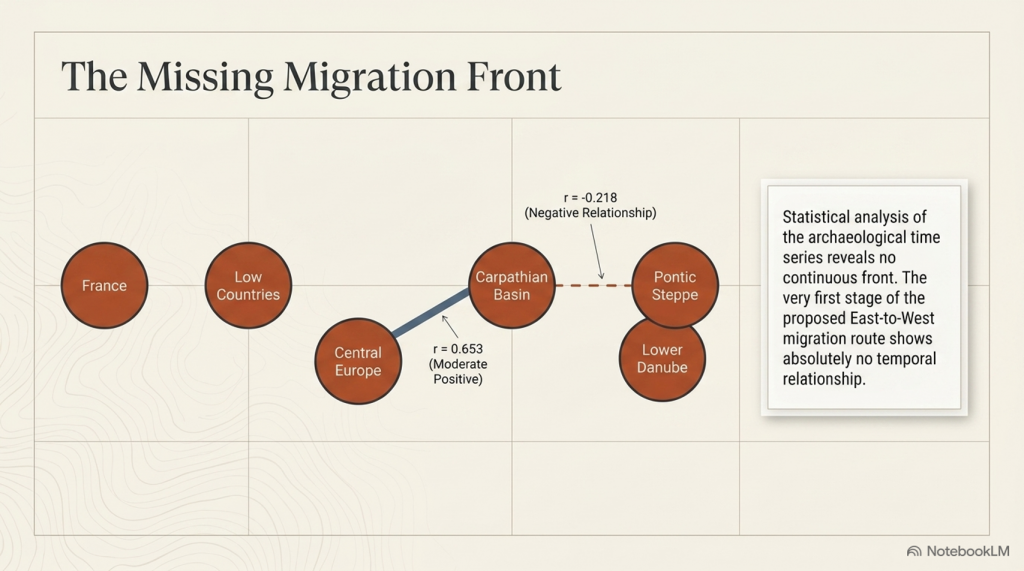
If Steppe-derived populations progressively expanded from the Pontic–Caspian Steppe into Britain, where is the archaeological record documenting that journey?
Where are the intermediate waves of archaeological expansion?
Where is the progressive chronological front expected from one of the largest proposed prehistoric migrations in Europe?
Instead, the archaeological record begins with Bell Beaker pottery in Atlantic Iberia, while the genetic narrative begins over three thousand kilometres away on the Eurasian Steppe.
The gap between those two origins is not an inconvenience.
It is the central archaeological problem.
For decades, archaeology argued that the Bell Beaker culture spread from Atlantic Europe.
Ancient DNA then demonstrated a major genetic transformation in Britain.
The result has been an uneasy fusion of two independent datasets into a single explanatory narrative. Armit and Reich deserve credit for recognising that this conflation exists and for proposing alternative hypotheses rather than assuming the answer.
The obvious next step, however, has never been undertaken.
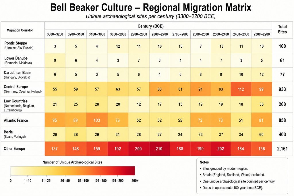
If either hypothesis is correct, both make a clear archaeological prediction. A migration extending thousands of kilometres across Europe should leave a measurable chronological signature as it progresses westwards.
That prediction can now be tested directly.
The following chapter applies calibrated radiocarbon diffusion analysis to determine whether the archaeological record preserves the progressive continental expansion expected from the Steppe migration hypothesis.
(The Great Bell Beaker Migration Myth – Haplogroup R1b)
Chapter 6 – Testing the Steppe Migration Hypothesis
6.1 Introduction
The Steppe migration hypothesis proposes that populations carrying Steppe ancestry expanded westwards from the Pontic–Caspian Steppe through the Lower Danube, the Carpathian Basin, Central Europe, the Low Countries and Atlantic France before reaching Britain during the Late Neolithic and Early Bronze Age.
If this represents a substantial migration of people, then it should leave an archaeological signature independent of ancient DNA. Specifically, radiocarbon-dated archaeological sites should display a progressive spatial and temporal wave moving westwards across Europe.
This chapter tests that prediction using the European radiocarbon database rather than genetic evidence.
(The Great Bell Beaker Migration Myth – Haplogroup R1b)
6.2 Predicted Archaeological Pattern
If the migration hypothesis is correct, four independent archaeological signatures are expected:
Prediction
Expected Result
Sequential peaks
Activity should peak first in the Steppe and progressively later towards Britain.
Westward gradient
Archaeological intensity should shift westward over time.
Travelling centroid
The geographical centre of archaeological activity should migrate westwards.
Strong regional continuity
Adjacent regions should display consistent temporal progression.
Failure of these predictions would indicate that the archaeological record does not independently reproduce the proposed migration corridor.
6.3 Regional Archaeological Activity
Table 6.1. Radiocarbon-dated archaeological sites by 100-year intervals.
Migration Corridor
Total Sites
Pontic Steppe
100
Lower Danube
61
Carpathian Basin
77
Central Europe
933
Low Countries
260
Atlantic France
858
Iberia (control)
403
Other Europe
2161
Figure 6.1. Regional heat map ordered along the proposed migration corridor.
(The Great Bell Beaker Migration Myth – Haplogroup R1b)
6.4 Century of Maximum Archaeological Activity
Rather than displaying a progressive westward sequence, the regional maxima occur in markedly different periods.
Table 6.2. Peak archaeological activity.
Region
Peak Century
Peak Sites
Pontic Steppe
2400 BCE
13
Lower Danube
3300 BCE
9
Carpathian Basin
2200 BCE
12
Central Europe
2300 BCE
112
Low Countries
2200 BCE
39
Atlantic France
3100 BCE
103
Iberia
2200 BCE
60
Other Europe
2800 BCE
210
The regional peaks do not form a chronological east-to-west sequence. Atlantic France reaches its highest level before Central Europe, while the Pontic Steppe reaches its maximum relatively late within the study period.
6.5 Testing the Migration Corridor
If a migration wave had progressed from the Steppe into Britain, the archaeological maxima would be expected to occur in approximately the following order:
Pontic Steppe → Lower Danube → Carpathian Basin → Central Europe → Low Countries → Atlantic France → Britain
The observed sequence is instead:
Lower Danube → Atlantic France → Other Europe → Pontic Steppe → Central Europe → Carpathian Basin / Low Countries
No progressive westward trend is evident.
6.6 Discussion
The radiocarbon database does not exhibit the temporal progression predicted by a simple migration wave extending from the Pontic Steppe to western Europe. Instead, archaeological activity appears to fluctuate independently between regions, with several areas reaching maximum intensity contemporaneously or in an order inconsistent with the proposed migration corridor.
This finding does not refute the genetic evidence for Steppe ancestry. Rather, it indicates that the archaeological record examined here does not independently reproduce the spatial-temporal pattern expected from a continent-wide migration. Any model proposing large-scale population movement must therefore explain why the archaeological chronology fails to display the anticipated east-to-west progression.
6.7 Conclusions
The archaeological test produced four observations:
Regional maxima do not occur in east-to-west chronological order.
No continuous migration front is visible in the radiocarbon record.
Archaeological activity appears regionally asynchronous rather than progressively westward.
The archaeological evidence alone does not independently verify a simple Steppe-to-Britain migration model.
Database Used
**Bird, D., Miranda, L., Vander Linden, M., Robinson, E., Bocinsky, R.K., Nicholson, C., Capriles, J.M., Finley, J.B., Gayo, E.M., Gil, A., d’Alpoim Guedes, J., Hoggarth, J.A., Kay, A., Loftus, E., Lombardo, U., Mackie, M., Palmisano, A., Solheim, S., Kelly, R.L. & Freeman, J. (2022). p3k14c, a synthetic global database of archaeological radiocarbon dates. Scientific Data, 9, 27. https://doi.org/10.1038/s41597-022-01118-7. Dataset used: p3k14c_2022_01.
(The Great Bell Beaker Migration Myth – Haplogroup R1b)
Chapter 7 – Conclusions – A Different View of Bell Beaker Europe
For more than two decades, the dominant explanation for the Bell Beaker phenomenon has been one of large-scale population replacement. Ancient DNA studies have demonstrated that Steppe ancestry became widespread across north-west Europe during the Late Neolithic and Early Bronze Age, and this has often been interpreted as evidence of a rapid migration moving westwards from the Pontic Steppe through Central Europe before finally reaching Britain.
This study has not attempted to challenge the genetic evidence. Instead, it has asked a different question:
Does the archaeological record independently support that model?
Using almost 180,000 radiocarbon determinations from across Europe, archaeological activity was reconstructed century by century between 3300 and 2200 BCE along the accepted migration corridor.
Pontic Steppe
↓
Lower Danube
↓
Carpathian Basin
↓
Central Europe
↓
Low Countries
↓
Atlantic France
↓
Britain
If the traditional migration model is correct, the archaeological evidence should display a progressive wave of activity moving westwards across Europe.
It does not.
(The Great Bell Beaker Migration Myth – Haplogroup R1b)
The archaeological evidence
Four independent tests were applied.
1. Regional chronological peaks
The periods of maximum archaeological activity do not progress steadily from east to west.
Atlantic France reaches its highest archaeological intensity before several eastern regions, while the Pontic Steppe itself reaches its maximum comparatively late within the study period.
Rather than a travelling wave, the archaeological record shows regional fluctuations occurring at different times across Europe.
2. Pearson correlation analysis
The archaeological time series for adjacent regions were compared using Pearson correlation coefficients.
Adjacent Regions
Pearson r
Interpretation
Pontic Steppe – Lower Danube
−0.218
Weak negative relationship
Lower Danube – Carpathian Basin
0.135
Very weak relationship
Carpathian Basin – Central Europe
0.653
Moderate positive relationship
Central Europe – Low Countries
0.181
Weak relationship
Low Countries – Atlantic France
0.555
Moderate relationship
If a single migration front had advanced steadily across Europe, consistently strong positive correlations would be expected throughout the corridor. Instead, the first stages of the proposed migration route show virtually no temporal relationship, while only one regional comparison shows a statistically significant correlation.
The archaeological chronology therefore fails to reproduce the continuous east-to-west progression predicted by the traditional migration model.
3. Bell Beaker settlement distribution
The geographical distribution of Bell Beaker settlements presents a second inconsistency.
Rather than forming a continuous advancing land frontier, settlements are concentrated around major rivers, estuaries and coastlines. These are precisely the environments expected to support long-distance communication and exchange by water.
This pattern is entirely consistent with maritime and riverine transport but less consistent with the simple picture of a continental invasion progressing across Europe.
(The Great Bell Beaker Migration Myth – Haplogroup R1b)
4. The origin of Bell Beaker pottery
Perhaps the most significant archaeological observation is that the earliest Bell Beaker pottery is found in Iberia, not on the Pontic Steppe.
The defining archaeological signature of the Bell Beaker phenomenon therefore originates in western Europe before appearing across much of the rest of the continent.
Culture, therefore, is demonstrably spreading from west to east as well as east to west.
What archaeology suggests
Taken together, these four independent observations present a remarkably consistent picture.
The archaeological record does not resemble the footprint of a rapidly advancing population replacement.
Instead, it resembles an extensive interaction network linking communities over many centuries.
Boats, rivers and coastlines provided Europe’s prehistoric highways.
Goods moved.
Ideas moved.
Technologies moved.
People also moved.
Unlike pottery, genes require only small numbers of people to travel.
A trader settling abroad…
A marriage between neighbouring communities…
Families relocating along established trade routes…
Repeated thousands of times over many centuries.
Such processes are entirely capable of redistributing genetic ancestry across Europe without producing the sharply defined archaeological migration front expected from a rapid invasion.
Ancient DNA demonstrates that ancestry became widespread.
It does not, by itself, determine how that redistribution occurred or the direction in which people moved. Those questions require archaeological context.
(The Great Bell Beaker Migration Myth – Haplogroup R1b)
A different interpretation
The archaeological evidence assembled in this study is consistent with an alternative explanation.
Rather than a single migration carrying Bell Beaker culture westwards from the Pontic Steppe, Europe may have consisted of interconnected trading societies exchanging goods and people over a prolonged period extending across many centuries.
Within such a network, genes would inevitably spread through repeated episodes of mobility and intermarriage.
The archaeological evidence presented here shows no requirement for a single, short-lived demographic wave.
Instead, it is compatible with long-term interaction between established populations connected by river and maritime trade.
Looking beyond the Steppe
One further observation deserves careful consideration.
Today, some of the highest frequencies of the R1b lineage occur in Atlantic populations, particularly in Ireland, Wales, and Scotland, where they commonly approach 90%.
These Atlantic communities are also associated with some of Europe’s longest traditions of maritime communication.
This study has not attempted to determine the direction of genetic movement. The archaeological evidence analysed here cannot, on its own, establish that. However, neither does it independently support a simple one-way migration from east to west.
(The Great Bell Beaker Migration Myth – Haplogroup R1b)
The combination of:
the Iberian origin of Bell Beaker pottery,
the maritime distribution of Bell Beaker settlements,
the absence of an archaeological migration wave,
and the weak chronological correlations between regions,
suggests that alternative models deserve serious investigation.
One possibility is that long-established Atlantic trading networks played a far greater role in shaping Europe’s genetic landscape than has generally been recognised.
Testing that hypothesis lies beyond the scope of this blog.
It forms the basis of the next stage of this research.
Final Conclusion
Ancient DNA has transformed our understanding of prehistoric Europe.
Archaeology must now catch up.
The evidence presented in this study does not deny the presence of Steppe ancestry in Britain. Instead, it demonstrates that the archaeological record does not independently reproduce the simple east-to-west migration model that has frequently been used to explain it.
The Bell Beaker phenomenon appears less like the trace of a continental invasion and more like the product of a Europe already connected by rivers, coastlines and maritime trade.
If that interpretation is correct, then the movement of genes across prehistoric Europe may have been the cumulative result of thousands of individual journeys rather than a single great migration.
Understanding those journeys—and the trading networks that made them possible—may ultimately prove to be the key to understanding the true origins of prehistoric Europe.
I think the “smoking gun” isn’t that your hypothesis is proven. The smoking gun is that the traditional model fails its own archaeological test. Then you can present your Doggerland model as the explanation that currently best fits the evidence.
I’d write it more like this:
(The Great Bell Beaker Migration Myth – Haplogroup R1b)
Author’s Comment – The Smoking Gun
For almost twenty years, the public has been told a simple story.
A population from the Pontic-Caspian Steppe migrated westward, carrying R1b and the Bell Beaker culture across Europe before replacing much of Britain’s existing population.
It is an elegant theory.
The problem is that the archaeology refuses to cooperate.
If Bell Beaker people really carried this migration, then the archaeological record should reveal a clear trail from east to west. It should begin on or near the Steppe, strengthen through Central Europe and culminate in Atlantic Europe.
It does not.
The Bell Beaker phenomenon begins in Atlantic Europe, not on the Steppe.
There are no Bell Beaker communities in the Steppe heartland.
There is no Bell Beaker archaeological origin in the east.
And when nearly 180,000 radiocarbon dates are analysed, the predicted migration wave simply fails to appear.
That is not a minor inconsistency.
It is the central prediction of the entire model.
If archaeology cannot demonstrate the migration, then archaeology cannot be used as evidence that Bell Beaker people carried Steppe populations across Europe.
Once that assumption is removed, the accepted explanation for the spread of R1b is no longer the only interpretation available.
In fact, the archaeological evidence points in precisely the opposite direction.
The earliest Bell Beaker pottery appears along the Atlantic façade. The strongest maritime connections lie around the coasts of western Europe. The mathematical analysis presented in this book consistently identifies Atlantic Europe—not the Pontic Steppe—as the primary centre of expansion.
That observation leads to a different hypothesis.
Rather than populations moving west from the Steppe, the evidence is equally consistent with populations, technologies and paternal lineages expanding outwards from the North Sea basin and the now-submerged landscape of Doggerland, using the extensive maritime trading networks that already connected Atlantic Europe.
Unlike the traditional model, this hypothesis does not require that Bell Beaker pottery originated hundreds of kilometres from the people supposedly carrying it. It does not require the archaeological record to contain a migration that cannot be found. And it does not ask archaeology to support a demographic event that the archaeological chronology itself fails to reproduce.
This blog does not claim that the Doggerland hypothesis has been fully proven.
It demonstrates something just as important.
The traditional Bell Beaker migration model fails its own archaeological test.
When a scientific model no longer fits the evidence, science does not defend the model.
It builds a better one.
That deserves investigation, rather than being presented as an already established fact.
PODCAST
Author’s Biography
Robert John Langdon, a polymathic luminary, emerges as a writer, historian, and eminent specialist in LiDAR Landscape Archaeology.
His intellectual voyage has been interwoven with stints as an astute scrutineer in government and grand corporate bastions, a tapestry spanning British Telecommunications, Cable and Wireless, British Gas, and the esteemed University of London.
A decade hence, Robert’s transition into retirement unfurled a chapter of insatiable curiosity. This phase saw him immerse himself in Politics, Archaeology, Philosophy, and the enigmatic realm of Quantum Mechanics. His academic odyssey traversed the venerable corridors of knowledge hubs such as the Museum of London, University College London, Birkbeck College, The City Literature Institute, and Chichester University.
In the symphony of his life, Robert is a custodian of three progeny and a pair of cherished grandchildren. His sanctuary lies ensconced in the embrace of West Wales, where he inhabits an isolated cottage, its windows framing a vista of the boundless sea – a retreat from the scrutinising gaze of Her Majesty’s Revenue and Customs, an amiable clandestinity in the lap of nature.
Exploring Prehistoric Britain: A Journey Through Time
My blog delves into the fascinating mysteries of prehistoric Britain, challenging conventional narratives and offering fresh perspectives grounded in cutting-edge research, particularly LiDAR technology. I invite you to explore some key areas of my research. For example, the Wansdyke, often cited as a defensive structure, is re-examined in light of new evidence. I’ve presented my findings in my blog post Wansdyke: A British Frontier Wall – ‘Debunked’, and a Wansdyke LiDAR Flyover video further visualises my conclusions.
My work also often challenges established archaeological dogma. I argue that many sites, such as Hambledon Hill, commonly identified as Iron Age hillforts, are not what they seem. My posts Lidar Investigation Hambledon Hill – NOT an ‘Iron Age Fort’ and Unmasking the “Iron Age Hillfort” Myth explore these ideas in detail and offer an alternative view. Similarly, sites like Cissbury Ring and White Sheet Camp receive re-evaluations based on LiDAR analysis in my posts “Lidar Investigation Cissbury Ring through time”and “Lidar Investigation White Sheet Camp,“ revealing fascinating insights into their true purpose. I have also examined South Cadbury Castle, often linked to the mythical Camelot56.
My research also extends to ancient water management, including the role of canals and other linear earthworks. I have discussed the true origins of Car Dyke in multiple posts, including Car Dyke – ABC News Podcast and Lidar Investigation Car Dyke – North Section, which suggest a Mesolithic origin 2357. I also explore the misidentification of Roman aqueducts, as seen in my posts on the Great Chesters (Roman) Aqueduct. My research has also been greatly informed by my post-glacial flooding hypothesis, which has helped explain landscape transformations over time. I have discussed this hypothesis in several posts, including AI now supports my Post-Glacial Flooding Hypothesis and Exploring Britain’s Flooded Past: A Personal Journey
For those interested in British Prehistory, visit www.prehistoric-britain.co.uk, a comprehensive resource featuring an extensive collection of archaeology articles, modern LiDAR investigations, and groundbreaking research. The site also includes insights and excerpts from the acclaimed Robert John Langdon Trilogy, a series of books that explore Britain during the Prehistoric period. Titles in the trilogy include The Stonehenge Enigma, Dawn of the Lost Civilisation, and The Post-Glacial Flooding Hypothesis, which offer compelling evidence of ancient landscapes shaped by post-glacial flooding.
To further explore these topics, Robert John Langdon has developed a dedicated YouTube channel featuring over 100 video documentaries and investigations that complement the trilogy. Notable discoveries and studies showcased on the channel include 13 Things that Don’t Make Sense in History and the revelation of Silbury Avenue – The Lost Stone Avenue, a rediscovered prehistoric feature at Avebury, Wiltshire.
In addition to his main works, Langdon has released a series of shorter, accessible publications, ideal for readers delving into specific topics. These include:
For active discussions and updates on the trilogy’s findings and recent LiDAR investigations, join our vibrant community on Facebook. Engage with like-minded enthusiasts by leaving a message or contributing to debates in our Facebook Group.
Whether through the books, the website, or interactive videos, we aim to provide a deeper understanding of Britain’s fascinating prehistoric past. We encourage you to explore these resources and uncover the mysteries of ancient landscapes through the lens of modern archaeology.
For more information, including chapter extracts and related publications, visit the Robert John Langdon Author Page. Dive into works such as The Stonehenge Enigma or Dawn of the Lost Civilisation, and explore cutting-edge theories that challenge traditional historical narratives.
Before we examine Bulford itself, one point must be made clear.
The archaeology is not the problem. The postholes, pits, circular features and later activity are real and important. What is being challenged here is the story built on top of them.
Once again, the Stonehenge landscape is being interpreted backwards. A few physical features are lifted from their environmental setting, joined by lines on a plan, wrapped in ritual language, and then presented to the public as another breakthrough in sacred Neolithic astronomy.
But prehistoric landscapes were not flat ceremonial diagrams. They were working environments shaped by rivers, groundwater, dry valleys, palaeochannels, springs, ditches, routeways and changing water levels. Before any feature is called a temple, a henge, a sacred boundary, or an “older Stonehenge,” the physical landscape must be understood first.
That is the failure this article addresses.
Bulford may be important for archaeology. It may even tell us something valuable about the wider Stonehenge landscape. But it does not yet prove a Stonehenge prototype, a solar monument, or a lost ceremonial masterplan.
It proves something far more revealing: how quickly archaeology can turn holes in the ground into a belief system.
The Bulford Hoax: The “Simpler, Older Stonehenge” That Wasn’t
1. The Discovery Is Real — The Story Is the Problem
The Bulford discovery should not be dismissed. It is real archaeology, found in a genuinely important part of the wider Stonehenge landscape. The site lies only a few kilometres from Stonehenge, within a landscape already packed with prehistoric activity: pits, postholes, ring ditches, circular features, burials, routeways, river valleys and later reuse. Nobody serious should pretend that Bulford is insignificant. The issue is not whether something was found. The issue is what has been claimed from it.
At the centre of the new story are two substantial postholes, positioned about 120 metres apart. These are interpreted as the remains of two large timber posts, possibly standing several metres high. When a line is drawn between them, the axis is said to match the midsummer sunrise in one direction and the midwinter sunset in the other, around 2950 BC. From that observation, the public story has grown quickly: Bulford becomes a solar monument, perhaps a ritual gathering place, perhaps even a prototype for Stonehenge’s later solstitial alignment.
That is the point where caution should begin.
Two postholes are evidence for two posts. They are not, by themselves, proof of a monument. A line drawn between two posts is evidence of geometry. It is not, by itself, proof of prehistoric intention. A possible alignment with the sun is interesting, but it does not automatically prove religion, ceremony, sacred architecture, or a direct ancestral link to Stonehenge.
The difference matters because archaeology often changes shape as it moves from excavation report to media headline. In the ground, the evidence is limited and physical: holes, fills, deposits, artefacts, relationships, levels, cuts and dates. In the headline, that evidence can become something much larger: belief systems, sacred landscapes, cosmic order and lost temples. The danger is not that archaeologists find nothing. The danger is that they find something real, then overload it with meaning before the basic physical questions have been answered.
Bulford is a perfect example of that problem.
The site was not a simple empty field containing two isolated posts. It contained numerous other features: smaller pits, late Neolithic activity, animal bone, pottery, flint, prehistoric ring ditches and later phases of landscape use. That complexity should make interpretation slower, not faster. A crowded archaeological landscape increases the danger of selection. If many pits, cuts, alignments and later features exist within the same excavated area, then choosing two large postholes and drawing a meaningful line between them requires strong independent support. Otherwise, the interpretation risks becoming circular: the posts are important because they align, and the alignment is important because the posts are assumed to be important.
The date also needs care. A Late Neolithic date of around 2950–3000 BC may place the feature in a significant period, but a date alone does not automatically explain its function. Radiocarbon dating can tell us when the sampled material died or entered a deposit. It does not automatically tell us why a post was erected, how long it stood, whether it belonged to a wider structure, or whether later activity has been folded into the same story. The more complex the site, the more dangerous it becomes to treat one attractive date as a label for the entire interpretation.
The same caution applies to the word “prototype.” That word sounds exciting, but it smuggles in a historical relationship that has not yet been proven. To call Bulford a prototype for Stonehenge implies developmental sequence: first Bulford, then Stonehenge; first timber posts, then stones; first simple alignment, then monumental architecture. That may be possible, but possibility is not proof. Similarity is not descent. Earlier is not necessarily ancestral. Nearby is not necessarily connected.
This does not make the Bulford discovery unimportant. It may be very important. It may show that people in this part of Salisbury Plain were using timber posts, pits and landscape markers before the later stone phases of Stonehenge. It may show that the solstitial axis mattered to some communities earlier than usually assumed. It may even eventually prove part of a wider prehistoric pattern.
But that has not yet been demonstrated.
The excavation is real. The archaeology is valuable. The postholes deserve serious study. But the interpretation has already moved beyond the secure evidence. Before Bulford can be called an older Stonehenge, a solar temple, or a ceremonial prototype, the basic questions must be answered.
Why only two posts?
Why 120 metres apart?
Why this exact location?
What was the surrounding landscape like at the time? Were the nearby pits, ring ditches and circular features contemporary, or are separate phases being compressed into one narrative? Was the alignment designed by the builders, or recognised later by modern researchers looking back across a crowded plan?
Until those questions are answered, Bulford proves something important, but much narrower than the headline suggests.
It proves repeated prehistoric activity in a significant landscape.
It does not yet prove the existence of an older Stonehenge.
The Bulford Hoax: The “Simpler, Older Stonehenge” That Wasn’t
2. From Two Postholes to an Older Stonehenge
The problem with the Bulford story is not that the postholes are imaginary. The problem is the speed at which two postholes have been converted into an “older Stonehenge.”
The interpretive chain is easy to see. First, two substantial postholes are identified. Then a line is drawn between them. That line is said to align with the midsummer sunrise and midwinter sunset around 2950 BC. The alignment is then treated as deliberate. Once deliberate, it becomes astronomical. Once astronomical, it becomes ritual. Once a ritual, it becomes ceremonial. Once ceremonial, it becomes a possible prototype for Stonehenge itself, given its proximity.
That is a very long journey from two holes in the ground.
Each step in that chain needs proof. It is not enough for each step to sound interesting. Archaeology should not work by accumulating attractive possibilities until they begin to look like a conclusion. The question is not whether the Bulford line can be drawn. Of course it can. The question is whether the line was intended by the people who dug the postholes.
That is a much harder thing to prove.
Two points always create a line. That is geometry, not archaeology. If the two points are large postholes, the line may be worth examining. If that line corresponds to a solar event, it becomes more interesting. But “interesting” is not the same as “proven.” To move from coincidence to intention, there must be supporting evidence: repeated alignment, structured layout, associated sighting features, restricted viewing position, consistent construction logic, or independent evidence that the same alignment governed other features at the site.
Without that support, the interpretation risks becoming backwards. Instead of starting with the whole site and asking what pattern the evidence produces, the process begins with an attractive alignment and then searches for meaning around it.
The Bulford Hoax: The “Simpler, Older Stonehenge” That Wasn’t
This is especially dangerous in a dense archaeological landscape. Bulford was not an empty field containing only two posts. It contained many pits, postholes, finds, ring ditches and later prehistoric activity. In such a landscape, selection is everything. If enough features exist, lines can be drawn between them. Some will point to something interesting. Some may match the sun, moon, horizon, river, valley, hilltop or another monument. The existence of a line does not prove that the line was the site’s purpose.
That is why the “gunsight” idea needs caution. Two posts 120 metres apart could create a visual axis, but they could also have served another function entirely. They may have marked a route, entrance, boundary, landing point, working area, viewing corridor, territorial signal, seasonal marker, or something more practical connected to the local river landscape. They may not even have belonged to the same original conceptual phase as later features now being drawn into the interpretation.
The problem becomes worse when the alignment is turned into a solar monument.
A solar alignment does not automatically make a monument religious. Prehistoric people certainly observed the sky. Nobody needs to deny that. Seasonal knowledge mattered in every farming, hunting, fishing, travelling and trading society. The movement of the sun helped organise time, weather, light, animal behaviour, plant growth and movement through the landscape. But recognising the importance of the sun is not the same as proving that a specific pair of posts formed a ceremonial temple.
This is where modern language starts doing too much work. Once words such as “ritual,” “ceremonial,” “sacred,” and “cosmological” are introduced, the evidence becomes harder to challenge because the claim becomes less physical. A posthole can be measured. A fill can be sampled. A date can be tested. A horizon can be modelled. But “ritual significance” can expand to cover almost anything. It becomes a label placed over uncertainty.
Then comes the final leap: Bulford as an older Stonehenge.
That is the weakest step of all. For Bulford to be an older Stonehenge, it is not enough to say it is older, nearby and possibly aligned. There must be a demonstrated structural or functional relationship between the two sites. Otherwise, the phrase “older Stonehenge” is doing more media work than archaeological work. It borrows the fame of Stonehenge to inflate the importance of Bulford before Bulford has been understood on its own terms.
This is a common problem in the Stonehenge landscape. Every new discovery is tempted into the same orbit. A pit becomes a ritual pit. A post becomes a solar marker. A ditch becomes ceremonial. A circular feature becomes a henge. A henge becomes a sacred site. And once Stonehenge is mentioned, the interpretation begins to feel larger than the evidence.
Bulford deserves better than that.
The correct starting point is not Stonehenge. It is Bulford itself: its topography, its water setting, its local features, its sequence, its fills, its dates, its relationship to the Nine Mile River and Avon landscape, and the possibility that later activity has been compressed into a single attractive story.
A line between two postholes is interesting.
It is not proof of intention by itself.
And it is certainly not proof of an older Stonehenge.
The Bulford Hoax: The “Simpler, Older Stonehenge” That Wasn’t
3. The Durrington Warning: When Pits Become Cosmology
Bulford is not the first time the Stonehenge landscape has produced this problem. Durrington Walls provides the warning.
In 2020, archaeologists announced what was described as a major new prehistoric structure around Durrington Walls. The claim was dramatic: a circuit of large pits or shafts, more than two kilometres across, apparently arranged around Durrington Walls and Woodhenge. Some of these features were described as more than ten metres wide and up to five metres deep. The suggested date was around 2500 BC, broadly contemporary with major Late Neolithic activity in the Stonehenge landscape.
That was the physical claim.
The interpretation then moved much further.
The pits were not simply presented as pits. They became a boundary. The boundary became a sacred precinct. The sacred precinct was linked to Durrington Walls, Woodhenge and the earlier Larkhill Causewayed Enclosure. The spacing was then interpreted as evidence of planning, counting, pacing and cosmological order. What began as a group of subsurface features evolved into a vast sacred landscape organised around religious meaning.
That is the same interpretive inflation now being seen at Bulford.
The issue is not whether Durrington contains real archaeology. It clearly does. Nor is the issue whether some of the large features may have been human-made or modified. They may well have been. The problem is the leap from physical evidence to cosmology. A large pit is not automatically a ritual shaft. A group of pits is not automatically a sacred boundary. A wide arc of features does not automatically prove a planned religious enclosure. And a relationship to nearby monuments does not automatically make the whole arrangement ceremonial.
This matters because the Stonehenge landscape is not a flat drawing board. It is a chalk landscape cut by valleys, dry river systems, solution hollows, palaeochannels, springs, slopes, buried deposits and former water routes. Features that look convincing when plotted on a plan may have been shaped by the physical landscape long before they were given ritual meaning.
That is the hydrology problem at Durrington.
Some of the Durrington features sit in or near valley systems trending towards the Avon. Others have been discussed in relation to natural solution features, sinkholes, soft patches, head deposits or complex subsurface formations. Once that is admitted, the interpretation changes. The question is no longer simply, “Do these pits form a circle?” The better question is, “Are we looking at a single sacred boundary, or a mixture of pits, modified hollows, water-related features, palaeochannel activity, extraction cuts and later reuse being forced into one monumental pattern?”
That question was never properly allowed to lead the discussion.
If an ancient water landscape existed around Durrington, then the so-called pit circle may not represent a sacred exclusion zone at all. Some features may relate to former drainage lines, water access, shoreline positions, dykes, routeways or changing river levels. A palaeochannel can create lines. A former river edge can attract repeated activity. A changing water table can expose, fill, preserve and distort features across long periods. None of this requires a cosmological boundary.
The Bulford Hoax: The “Simpler, Older Stonehenge” That Wasn’t
The shell dates make this harder to ignore.
In the published Durrington radiocarbon data, shell samples from cored features produced Holocene dates. One shell sample from 4.80–4.85 metres produced a calibrated date of 6080–5990 BC. Another, from 1.50–1.55 metres, produced 4710–4550 BC. A third, from 4.35–4.40 metres, yielded a date of around 3810–3690 BC.
These are not Cretaceous fossil numbers. They are Holocene numbers.
That matters enormously for the wider Stonehenge debate. One of the standard objections to shell evidence in Stonehenge boreholes is that shells in chalk must be ancient fossils and therefore irrelevant to recent water activity. But Durrington creates a problem for that dismissal. Here, a shell was recovered from deep chalkland contexts, submitted for radiocarbon dating, and produced dates in the post-glacial and early/mid-Holocene window.
The official response was to treat the early shell dates as unreliable, possibly affected by calcium in the sediment. That may be possible. But it does not remove the problem. It simply exposes it. If shell dates support a neat Neolithic monument story, they are useful. If shell dates suggest an older water-rich landscape, they become inconvenient.
That is not good enough.
The correct response should have been a further environmental investigation. What species of shell were recovered? Were they freshwater, terrestrial, intrusive, redeposited, or connected to standing water? Why were they present at those depths? What do they say about water, sediment movement and local hydrology? And why should similar shell evidence in the Stonehenge borehole record be dismissed as meaningless fossil contamination before it has been properly tested?
This is why Durrington matters for Bulford.
Durrington shows how easily a complicated physical landscape can be converted into sacred geometry. It also shows how water-related evidence can be pushed aside when it does not fit the preferred ceremonial model. Bulford risks repeating the same mistake on a smaller scale. Two postholes become an alignment. The alignment becomes solar. The solar axis becomes ritual. The ritual interpretation becomes an older Stonehenge.
But before that chain is accepted, the physical landscape must come first.
The lesson from Durrington is simple: do not turn pits into cosmology until the water has been explained.
Paleochannels show water activity in Late Prehistory -The Bulford Hoax: The “Simpler, Older Stonehenge” That Wasn’t
4. The Missing Water at Bulford
The first question at Bulford should not be astronomical. It should be geographical.
Where was the water?
That question is almost absent from the public interpretation, yet it should come before any claim about ceremony, solar worship or a Stonehenge prototype. Bulford sits within the wider Avon landscape, close to the Nine Mile River system and within a region where dry valleys, palaeochannels, river terraces, springs, groundwater movement and changing post-glacial water levels all matter. A prehistoric feature cannot be properly understood if it is lifted out of that physical setting and treated as if it stood in the same dry, open landscape we see today.
This is the central failure. The interpretation begins with two postholes and a solar line, then moves quickly towards ritual meaning. But before that line is made sacred, the entire terrain needs to be reconstructed to match its condition when the posts were built. Was the valley wetter? Was the Nine Mile River larger? Were there seasonal floods, marsh edges, channels, routeways or landing points nearby? Did the site overlook a water corridor? Were people moving through this landscape by river, along river edges, or between water-connected activity zones?
Without answering those questions, the interpretation is incomplete.
Water is not a decorative background to prehistoric life. It is infrastructure. Rivers are routes. Springs are resources. Wetlands are food zones. River edges are working margins. Palaeochannels preserve memory in the landscape long after active water has gone. If post-glacial rivers and groundwater levels were higher, then many features that now seem stranded in dry fields may originally have stood beside water, above water, or in relation to former channels.
That matters directly at Bulford.
If the two large posts stood near a route through the river landscape, their function may have been practical before it was symbolic. They could have marked access, direction, visibility, landing, movement, boundary, crossing, warning, gathering, or seasonal use connected to water. A tall post beside a water route is not automatically a religious object. It may be a marker. It may be a signal. It may be part of a working landscape.
The same applies to the so-called henges or circular features nearby. Before they are labelled ceremonial, their position and orientation need to be tested against the water landscape. If their entrances, openings, or strongest lines of access face the river system rather than Stonehenge, the usual interpretation changes. They may not be facing a sacred monument at all. They may be facing the practical landscape that made the site useful.
The size of the so-called Bulford henges should also make us cautious. Historic England records the western example as only about 17.5 metres across and the eastern example as about 16 metres in internal width, each with a northern entrance. These are not grand henge monuments. They are very small penannular enclosures, later encircled by Bronze Age ring ditches that enlarged them to about 27-30 metres in diameter.
That matters. Henges commonly range far larger, with even a 30-metre example described as being at the small end of the scale. By contrast, Bronze Age round barrows and ring ditches commonly fall within the 20–30 metre range. So when Bulford’s later ring ditches enlarge the features to 27 and 30 metres, they begin to look far more like barrow/ring-ditch reuse than a clear ceremonial henge pair.
This does not prove they were barrows. No central burial was found, and the western example only appears to have had a low internal bank or mound. But it does show that the word “henge” is carrying too much authority. A small penannular ditch with a northern entrance, later remodelled by Bronze Age ring ditches, overlooking the Nine Mile River, should not be rushed into the same ceremonial category as Stonehenge.
The better question is not “what ritual did these henges serve?”
The Bulford Hoax: The “Simpler, Older Stonehenge” That Wasn’t
The better question is: were these small river-facing features later reused, enlarged, altered, or reclassified as part of a ceremonial story because the landscape is now being interpreted backwards from Stonehenge?
This is where the “older Stonehenge” claim becomes especially weak. Stonehenge is being used as the interpretive magnet. Because Bulford is near Stonehenge, its features are pulled into a Stonehenge-centred story. But proximity is not a function. A feature near Stonehenge does not automatically exist because of Stonehenge, point to Stonehenge, anticipate Stonehenge, or explain Stonehenge. It may belong to an older and broader water-based system that Stonehenge itself later reused.
That possibility is far more important than the headline.
The same mistake recurs in the landscape of Stonehenge. Durrington becomes a sacred boundary before its hydrology is fully understood. Shell dates are considered inconvenient when they indicate older, water-rich conditions. Palaeochannels and dry valleys are treated as background geology rather than active prehistoric infrastructure. Linear earthworks are dismissed or mislabelled rather than tested as water-management features. Then the remaining unexplained features are wrapped in ritual language.
Bulford should not be allowed to follow the same path.
The correct method is simple. First, reconstruct the Mesolithic and Neolithic landscape. Map the Nine Mile River and Avon relationship. Identify former channels, springs, terraces, damp zones, routeways and possible shoreline positions. Compare the posts, pits, ring ditches and circular features against that reconstructed water system. Only then, ask whether a solar alignment was primary, secondary, coincidental, or later imposed by interpretation.
Until that work is done, the water explanation has not been eliminated.
And if the water explanation has not been eliminated, the ceremonial explanation has not been proven.
Bulford may still prove significant. But its significance may lie not in being an older Stonehenge, but in preserving another fragment of the working water landscape that existed before Stonehenge became the centre of the story.
The paleochannel data show that these were active in the Mesolithic – The Bulford Hoax: The “Simpler, Older Stonehenge” That Wasn’t
5. Dating and Alignment Do Not Prove Function
Two things are being asked to carry the Bulford interpretation: a date and a line.
Both may be important. Neither proves the story by itself.
The public claim gives Bulford a Late Neolithic date, usually around 2950–3000 BC. That date is then attached to the proposed alignment between the two large postholes and used to suggest an early solar monument, possibly older than Stonehenge. But this is where the first major problem appears.
At present, the public information does not clearly show that the two large postholes themselves were directly dated from secure primary contexts. The published publicity refers to a wider group of pits radiocarbon dated to around 2950 BC. That is not the same thing as saying that the two large postholes were directly dated by material from their original post-packing, post-pipes, construction deposits, or base fills.
That distinction is crucial.
A date from the wider pit group is not automatically a date for the two-post alignment. It may date activity in the same landscape. It may date rubbish deposition. It may date to nearby occupation, feasting, burning, discarding, or later infilling. It may date material associated with the broader Bulford activity complex. But unless the dated samples came from secure contexts directly tied to the two large postholes, the alignment has been dated by association.
Association is not proof.
This is not a small technical objection. It goes to the centre of the claim. If the postholes were not directly dated, then the argument becomes a chain of assumptions: nearby pits are dated to around 2950 BC; two larger postholes are identified within the same excavated area; a line is drawn between them; that line is modelled against the sky at 2950 BC; the alignment is then interpreted as intentional; and finally the whole thing is presented as a possible prototype for Stonehenge.
That is not a secure sequence. It is an interpretive staircase, and every step needs evidence.
The correct question is simple: what exactly was dated?
The Bulford Hoax: The “Simpler, Older Stonehenge” That Wasn’t
Was the sample taken from the bottom of one of the two large postholes? Was it from primary post-packing? Was it from a post-pipe left by a decayed timber? Was it from the earliest fill after the post was removed? Was it from a later fill? Was it from nearby rubbish pits? Was it charcoal, bone, pottery-associated material, or something redeposited? Was there old wood? Was there later contamination? Were both postholes dated independently, or is one date being stretched across both?
Until those details are available, the claimed date should be treated as a date for Bulford’s wider Late Neolithic activity, not as a secure direct date for the supposed solar alignment.
This matters because prehistoric landscapes are often reused. A posthole can be earlier than surrounding pits, later than them, cut through them, respected by them, ignored by them, or reinterpreted by later activity. A landscape can contain several phases compressed into one archaeological plan. Without a clear formation sequence, a date becomes a label rather than proof.
The same caution applies to the alignment.
Two points always create a line. That is geometry, not archaeology. A line between two substantial postholes may be interesting, especially if it appears to match a solar event. But a solar match is not enough. To prove intention, there must be independent supporting evidence: repeated layout, associated sighting positions, consistent structural design, horizon control, entrance alignment, matching features, or a pattern too strong to be explained by selection.
Without that support, the alignment risks becoming retrospective. A modern researcher looks at a complex plan, notices two larger features, draws a line, checks the sky, and finds a possible match. That may be worth investigating. It is not yet proven that Neolithic builders created a solar monument.
The danger increases because the landscape contains many features. Bulford was not a clean two-post structure standing alone. It contained numerous pits, finds and later activity. In a crowded plan, some alignments will always appear meaningful if enough points are available. The more features there are, the more important it becomes to prove that the selected line was meaningful to the builders, not merely attractive to the interpreter.
This is where the claim becomes too ambitious.
A possible date does not prove a function. A possible alignment does not prove intention. Together, they still do not prove an older Stonehenge unless the connection is demonstrated by context, sequence and structure.
The date must be direct.
The alignment must be intentional.
The function must be evidenced.
Until then, Bulford remains an important Late Neolithic activity site with two substantial postholes and a possible solar alignment. That is interesting enough. It does not need to be inflated into a Stonehenge prototype before the basic archaeological chain has been proven.
The Bulford Hoax: The “Simpler, Older Stonehenge” That Wasn’t
6. What Bulford Actually Proves
Bulford proves that this part of the Stonehenge landscape was important. That is the strongest safe conclusion. It does not need dressing up as an older Stonehenge to matter.
The site contains substantial postholes, numerous pits, finds of pottery, flint, animal bone, and charcoal, later ring ditches, and evidence of repeated prehistoric activity. That is already significant. It shows that people returned to this landscape, cut into it, deposited material, marked it, reused it and altered it across time. The archaeology deserves serious attention.
But that is exactly why the public claim should have waited for proper publication.
The Bulford excavations were carried out between 2015 and 2017. Yet in 2026, the full major publication is still not available, with the report promised later in the year. That means nearly a decade has passed since the excavation ended, and eleven years since it began, before the public has been given the detailed evidence needed to test the claims now being made.
That is not a minor issue. It is a fundamental archaeological weakness.
Before the plans, sections, context sheets, sample positions, radiocarbon tables, environmental data, stratigraphy and post-excavation reasoning are publicly available, the public is already being asked to accept a story: two posts become a solar alignment, the alignment becomes a religious monument, the religious monument becomes a Stonehenge prototype, and the whole thing becomes a breakthrough in our understanding of the ceremonial landscape.
But where is the published evidential chain?
Were the two large postholes directly dated from secure primary contexts, or has the date been imposed from associated pits? Were both postholes dated independently? Were the samples taken from post-pipes, packing deposits, base fills or later infill? What is the full sequence of the surrounding pits? Which features are contemporary and which belong to later reuse? How were the nearby ring ditches phased? How was the Nine Mile River landscape reconstructed? What was the local hydrology? Were former channels, springs, terraces or shoreline positions mapped before the solar interpretation was imposed?
Until those questions are answered in a full report, the headline is ahead of the archaeology.
This is the old Stonehenge problem in a new field. The interpretation is released first. The evidence follows later. By the time the technical report appears, the public story has already hardened into “fact.” Journalists have repeated it. Websites have archived it. Documentaries will quote it. Social media will simplify it. And critics will then be told they are challenging accepted archaeology, even though the original claim was accepted before the evidence was fully available.
That is how weak hypotheses become historical furniture.
Bulford may eventually prove part of an early solstitial tradition. It may show that timber markers were used in the wider Stonehenge landscape before the stone monument took its later form. It may even show that people gathered here seasonally. But those are conclusions that must come from the published evidence, not from a press release wrapped around a famous name.
At present, Bulford proves repeated prehistoric importance.
It proves activity.
It proves complexity.
It proves that the area needs proper publication and independent scrutiny.
It proves that the river-facing landscape east of Stonehenge has been underestimated.
It does not yet prove the existence of an older Stonehenge.
It has not yet proved to be a solar temple.
It does not yet prove a ceremonial masterplan.
It does not yet prove a Stonehenge prototype.
And it does not prove a dry ritual landscape detached from water, palaeochannels, groundwater, river access and post-glacial environmental change.
The proper conclusion is not that Bulford is unimportant. The proper conclusion is that it is too important to be sold by headline before the evidence can be tested.
Archaeology should not work on a press-release-first, proof-later basis.
Bulford does not reveal an older Stonehenge.
It reveals how quickly two holes in the ground can become a belief system — and how slowly archaeology sometimes publishes the evidence needed to challenge it.
They missed that Bulford Henges was on the edge of the Avon like Durrington Walls in the Mesolithic – The Bulford Hoax: The “Simpler, Older Stonehenge” That Wasn’t
PODCAST
Author’s Biography
Robert John Langdon, a polymathic luminary, emerges as a writer, historian, and eminent specialist in LiDAR Landscape Archaeology.
His intellectual voyage has been interwoven with stints as an astute scrutineer in government and grand corporate bastions, a tapestry spanning British Telecommunications, Cable and Wireless, British Gas, and the esteemed University of London.
A decade hence, Robert’s transition into retirement unfurled a chapter of insatiable curiosity. This phase saw him immerse himself in Politics, Archaeology, Philosophy, and the enigmatic realm of Quantum Mechanics. His academic odyssey traversed the venerable corridors of knowledge hubs such as the Museum of London, University College London, Birkbeck College, The City Literature Institute, and Chichester University.
In the symphony of his life, Robert is a custodian of three progeny and a pair of cherished grandchildren. His sanctuary lies ensconced in the embrace of West Wales, where he inhabits an isolated cottage, its windows framing a vista of the boundless sea – a retreat from the scrutinising gaze of Her Majesty’s Revenue and Customs, an amiable clandestinity in the lap of nature.
Exploring Prehistoric Britain: A Journey Through Time
My blog delves into the fascinating mysteries of prehistoric Britain, challenging conventional narratives and offering fresh perspectives grounded in cutting-edge research, particularly LiDAR technology. I invite you to explore some key areas of my research. For example, the Wansdyke, often cited as a defensive structure, is re-examined in light of new evidence. I’ve presented my findings in my blog post Wansdyke: A British Frontier Wall – ‘Debunked’, and a Wansdyke LiDAR Flyover video further visualises my conclusions.
My work also often challenges established archaeological dogma. I argue that many sites, such as Hambledon Hill, commonly identified as Iron Age hillforts, are not what they seem. My posts Lidar Investigation Hambledon Hill – NOT an ‘Iron Age Fort’ and Unmasking the “Iron Age Hillfort” Myth explore these ideas in detail and offer an alternative view. Similarly, sites like Cissbury Ring and White Sheet Camp receive re-evaluations based on LiDAR analysis in my posts “Lidar Investigation Cissbury Ring through time”and “Lidar Investigation White Sheet Camp,“ revealing fascinating insights into their true purpose. I have also examined South Cadbury Castle, often linked to the mythical Camelot56.
My research also extends to ancient water management, including the role of canals and other linear earthworks. I have discussed the true origins of Car Dyke in multiple posts, including Car Dyke – ABC News Podcast and Lidar Investigation Car Dyke – North Section, which suggest a Mesolithic origin 2357. I also explore the misidentification of Roman aqueducts, as seen in my posts on the Great Chesters (Roman) Aqueduct. My research has also been greatly informed by my post-glacial flooding hypothesis, which has helped explain landscape transformations over time. I have discussed this hypothesis in several posts, including AI now supports my Post-Glacial Flooding Hypothesis and Exploring Britain’s Flooded Past: A Personal Journey
For those interested in British Prehistory, visit www.prehistoric-britain.co.uk, a comprehensive resource featuring an extensive collection of archaeology articles, modern LiDAR investigations, and groundbreaking research. The site also includes insights and excerpts from the acclaimed Robert John Langdon Trilogy, a series of books that explore Britain during the Prehistoric period. Titles in the trilogy include The Stonehenge Enigma, Dawn of the Lost Civilisation, and The Post-Glacial Flooding Hypothesis, which offer compelling evidence of ancient landscapes shaped by post-glacial flooding.
To further explore these topics, Robert John Langdon has developed a dedicated YouTube channel featuring over 100 video documentaries and investigations that complement the trilogy. Notable discoveries and studies showcased on the channel include 13 Things that Don’t Make Sense in History and the revelation of Silbury Avenue – The Lost Stone Avenue, a rediscovered prehistoric feature at Avebury, Wiltshire.
In addition to his main works, Langdon has released a series of shorter, accessible publications, ideal for readers delving into specific topics. These include:
For active discussions and updates on the trilogy’s findings and recent LiDAR investigations, join our vibrant community on Facebook. Engage with like-minded enthusiasts by leaving a message or contributing to debates in our Facebook Group.
Whether through the books, the website, or interactive videos, we aim to provide a deeper understanding of Britain’s fascinating prehistoric past. We encourage you to explore these resources and uncover the mysteries of ancient landscapes through the lens of modern archaeology.
For more information, including chapter extracts and related publications, visit the Robert John Langdon Author Page. Dive into works such as The Stonehenge Enigma or Dawn of the Lost Civilisation, and explore cutting-edge theories that challenge traditional historical narratives.
(Book Extract, The Stonehenge Hoax – Summer Solstice)
The Problem
When we think about Stonehenge, our minds go to the mass gatherings of people who meet at the stones to celebrate the Summer and Winter Solstices, as if the monument were built for this single purpose. But the structure was not made for this purpose, as shown by The Avenue and The ‘Heel Stone’( where the sun appears from behind it on midsummer’s day), for it is not in the centre of the Avenue (as some imagine) and consequently, it has been tilted at an angle to meet the sun at a later date.(Stonehenge Hoax – Summer Solstice)
The Solution
The Avenue follows a path to the River Avon, but the river reached the East of the site in Neolithic times; therefore, in theory, the Avenue could have been built anywhere.
Why did they build it in that particular direction?
The original entrance to Phase I of Stonehenge was in the North-West, towards the midwinter moonset, perceived as the place of the dead and the afterlife, where they built a mooring station (the old car park) to take the Bluestones from Craig-Rhos-Y-Felin.
But after 4,000 years, the monument changed its purpose. Four thousand years is a colossal amount of time – the same period before now, we were in the Bronze Age, living in mud huts and dancing to druid music. In the landscape, we see this change with the disuse of Long Barrows for the collection of excarnated bones in favour of Round Barrows and the cremation of bodies.
Stukley’s Drawing of the Avenue – (Stonehenge Hoax – Summer Solstice)
If so, perhaps they decided to use the ancient monument from ‘curing the sick’ to ‘celebrating life’ and rebirth through the Sun. This may explain why the Avenue was oriented towards the summer sunrise, and, in this case, gives us a clue to the date when Phase II (the Sarsen Stones uprights and lintels) were laid.
We are familiar with the masses who welcome the midsummer sunrise over Stonehenge – people wait in expectation, and then (if you’re lucky) the Sun creeps over the Heel Stone to greet midsummer’s day; everyone’s happy, then goes home drunk or stoned. BUT, when you look at the Heel Stone, it is on the extreme right-hand side of the Avenue, bent over at a silly angle. Our ancestors did not build it that way – the monument was nearly completely rebuilt at the end of the last century, and stones were moved and restored, which has happened throughout Stonehenge’s long history.(Stonehenge Hoax – Summer Solstice)
Solar Alignment
The most sensible solstice alignment is straight down the middle of the Avenue. However, archaeologists have only partially investigated this apparent alignment, and as a result, the construction date of Phase II has never been fully resolved.
The Sun does not always rise and set in the same place throughout the year or over the course of history, as you may expect. The Earth ‘wobbles’ on its axis in a process known as ‘procession’ – I will not go into detail here, but all you need to understand is that the Sun and Moon rise and set in different positions on the horizon on solstice day over a 43,000-year period.
Solstice Sunrise Changes over Time – (Stonehenge Hoax – Summer Solstice)
This means that the summer and winter solstices move in relation to the horizon a fraction every year. This movement is TINY; it’s .0002 of a degree every year, but over a long time, say 10,000 years, it’s a full two degrees. It may not sound much, but when you consider that the moon is half a degree in diameter, then two degrees is the same as four moons (or suns) in a row on the horizon.
Dating of The Avenue and Stage II of Stonehenge
We can also ‘reverse engineer’ this figure to determine the date of the Avenue’s construction. The problem with the accuracy of this measurement is that the point of sunrise is somewhat subjective, as trees obscure the horizon at Stonehenge, so the first rays of sunlight can never be fully seen. What current observers accept is the position of the ‘Heel Stone’, which obscures the sunrise until the point at which it appears to rise above the stone’s upper part (the peak point).
If we accept that this is the correct point for today’s Summer solstice sunrise and plot this point on Google Earth, we obtain a reading of 50.81 degrees. If we now take a reading along the Avenue’s centre with the same software, we get 49.57 degrees. This is a difference of 1.24 degrees since the Avenue was first constructed. If the Sun moves 0.0002 degrees per annum, then we will have an approximate date (when the Sun is at the centre of the Avenue). This gives us a construction date of 6200 years ago or 4180 BCE.
Sun Rise down the Avenue and over the Heel Stone – (Stonehenge Hoax – Summer Solstice)
This is thousands of years earlier than the archaeologists have told the public, so it is not mentioned in their literature. However, one antler bone was found under a Sarsen stone, which does not support the current dating. Now this one can’t be explained away like the other anomalies found on the site, as a 12-ton stone was on top of it for thousands of years, ensuring it couldn’t have been placed there later or floated/moved there from another part of the site.
It was found in the ‘packing’ for Sarsen Stone 27 (OxA-4902). This gives us a carbon-dating range of 4342–4039 (IntCal20) or 4191 BCE ± 152, which is remarkably similar to the Avenue dating method. The experts suggest that the antler was placed there by ‘accident’ and was found in the vicinity of the stone hole when the hole was first constructed – sadly, this is very improbable as the antler would have been some 1700 years old (if current theory dates are correct) and would have rotted and decomposed, even if found on or near the surface.
Therefore, I am happy to conclude that Stonehenge phase two started around 4185 BCE.
Stonehenge and the Summer Solstice: Are We Celebrating the Wrong Event?
Every year, thousands gather at Stonehenge to celebrate the summer solstice sunrise. Cameras point towards the Heel Stone, crowds cheer as the sun appears, and the monument is presented once again as Britain’s great prehistoric solar temple.
But what if that entire modern celebration is aimed at the wrong event?
The popular story assumes that Stonehenge was built as a circular solar temple, designed to greet the rising midsummer sun. The problem is that the stones themselves do not comfortably fit that story. Stonehenge was not a perfectly completed circle of uprights and lintels. Not all stones are present, not all holes support the idea of a complete ring, and some surviving stones appear too small or unsuitable to have carried lintels at all. This creates a serious problem for the standard reconstruction.
The usual answer is that Stonehenge was unfinished, robbed, damaged, or partly destroyed. But that explanation may be avoiding the more obvious possibility: Stonehenge was never meant to be a complete solar circle in the first place.
The monument makes far more sense if we stop treating it as a temple of the living sun and start seeing it as a monument to the dead.
Across many ancient cultures, the sun is associated with life, strength, fertility, kingship and daily renewal. The moon, by contrast, is repeatedly linked with death, night, spirit journeys, rebirth and the passage into the afterlife. A crescent moon is one of the oldest and most natural symbols of that transition: the death of one phase, followed by return, renewal and resurrection.
This is why the crescent form at Stonehenge matters.
Rather than being a failed circle, Stonehenge may have been deliberately designed as a crescent-shaped monument. Its symbolic focus would not have been the summer solstice sunrise, but the winter solstice sunset — the moment of greatest darkness, when the year reaches its lowest point, and the return of light begins. For a mortuary monument, that is a far more powerful idea. It is not a celebration of summer life but a turning point between death and rebirth.
Incomplete Circle and Stone 10 is too small for a lintel – The Stonehenge Hoax
This interpretation also explains why the south-western quadrant of Stonehenge is so important. The supposed “missing” stones are concentrated in the area most relevant to the winter solstice sunset alignment. If these stones had simply been robbed for building material, why would removal begin with the stones furthest from convenient access? Why would the pattern of loss fit the symbolic and astronomical weakness in the conventional solar-temple model?
The answer may be that they were not “missing” at all in the way archaeologists assume. Their absence may reflect the original design, later disturbance, or a deliberate alteration of the monument’s meaning.
The surviving trilithon arrangement also supports this argument. The great horseshoe of stones creates a crescent within a crescent. This inner form faces towards the summer solstice sunrise, but that does not necessarily make Stonehenge a summer temple. Instead, it may represent the rebirth element within a wider death-and-return system: the dead pass into darkness, but life continues through the descendants and survivors.
That message becomes even stronger when placed within the wider landscape. Stonehenge was surrounded by barrows, long barrows, burial routes and mortuary practices. It sits not as an isolated solar clock, but within a ritual landscape concerned with death, ancestry, movement, memory and transformation. The idea that the monument was simply built so people could watch the midsummer sunrise is far too narrow.
The modern summer solstice celebration may therefore be celebrating a later misunderstanding — or even a later alteration — of the monument’s original purpose.
The Heel Stone alignment is often treated as the great proof of a summer sunrise temple. But if the monument’s deeper symbolic structure was lunar, crescent-shaped and connected with winter sunset, then the Heel Stone may represent a later reorientation of meaning. In other words, the public spectacle we see today may not preserve the original purpose of Stonehenge. It may preserve the moment when that purpose was changed.
Stonehenge, in this reading, was not built to celebrate the longest day.
It was built to confront the shortest one.
It was not a monument to summer crowds, sunlight and spectacle. It was a monument to death, darkness, ancestry and the return of life after loss. The winter solstice sunset, not the summer sunrise, is the event that matches its mortuary symbolism.
So when thousands gather at Stonehenge in June, they may be standing in the right place, but looking in the wrong direction.
The real Stonehenge was not a festival stage for the midsummer sun. It was a prehistoric monument to the dead — a crescent-shaped statement in stone, aligned with the deepest darkness of the year and the hope that light, life and memory would return.
The Stonehenge Hoax
Audio PodCast
Unearth the Astonishing Secrets of Stonehenge (The Stonehenge Hoax)
BookVideo
Synopsys
Stonehenge, a timeless enigma etched in stone and earth, has stood as a formidable puzzle challenging the intellects of archaeologists and historians alike. Despite the myriad attempts, including books, TV programs, and academic conferences, the secrets of these ancient stones and their encircling ditches have proven elusive. Against this backdrop, we scrutinise the existing thirteen hypotheses, each presenting its narrative but collectively lacking a coherent thread.
In adopting the deductive reasoning akin to Sherlock Holmes, we endeavour to weave these disparate threads into a unified tapestry that not only unravels the mystery of Stonehenge but also shakes the foundations of established academic narratives. This intellectual journey may induce some discomfort as we challenge conventional perceptions and invite a reevaluation of our understanding of the past. Apologies are extended in advance for any cognitive dissonance, but the pursuit of truth and reason mandates an unfiltered presentation of the facts.
So, fasten your seatbelts for an expedition into the archaeological unknown.
As we navigate this intellectual rollercoaster, be prepared for a revelation that might reshape our understanding of Stonehenge and question the foundations of our historical narratives. The dawn of a new archaeological era awaits promising insights that could leave even the most curious minds astonished. As we delve into this intellectual rabbit hole, be ready for a revelation that could make Alice astonished.
Robert John Langdon (2023) – (The Stonehenge Hoax)
The Journey
Langdon’s journey was marked by meticulous mapping and years of research, culminating in a hypothesis that would reshape our understanding of prehistoric Britain. He proposed that much of the British Isles had once been submerged in the aftermath of the last ice age, with these ancient sites strategically positioned along the ancient shorelines. His groundbreaking maps offered a fresh perspective, suggesting that Avebury had functioned as a bustling trading hub for our ancient ancestors. This audacious theory challenged the prevailing notion that prehistoric societies were isolated and disconnected, instead highlighting their sophistication in trade and commerce.
In the realm of historical discovery, the audacious thinkers, the mavericks who dare to question established narratives, propel our understanding forward. Robert John Langdon is undeniably one of these thinkers. With a deep passion for history and an unyielding commitment to his research, he has unearthed a hidden chapter in the story of Avebury that transcends the boundaries of time and offers fresh insights into our shared human history.
As Langdon’s trilogy, ‘The Stonehenge Enigma,’ continues to explore these groundbreaking theories, it beckons us to embark on a journey of discovery, to challenge our assumptions, and to embrace the possibility that the past is far more complex and interconnected than we ever imagined. With its ancient stones and enigmatic avenues, Avebury continues to whisper its secrets to those who dare to listen, inviting us to see history through a new lens—one illuminated by the audacious vision of Robert John Langdon.
The Book
The Great Stonehenge Hoax
Exploring Prehistoric Britain: A Journey Through Time
My blog delves into the fascinating mysteries of prehistoric Britain, challenging conventional narratives and offering fresh perspectives based on cutting-edge research, particularly using LiDAR technology. I invite you to explore some key areas of my research. For example, the Wansdyke, often cited as a defensive structure, is re-examined in light of new evidence. I’ve presented my findings in my blog post Wansdyke: A British Frontier Wall – ‘Debunked’, and aWansdyke LiDAR Flyover video further visualizes my conclusions.
For those interested in British Prehistory, visit www.prehistoric-britain.co.uk, a comprehensive resource featuring an extensive collection of archaeology articles, modern LiDAR investigations, and groundbreaking research. The site also includes insights and extracts from the acclaimed Robert John Langdon Trilogy, a series of books exploring Britain during the Prehistoric period. Titles in the trilogy include The Stonehenge Enigma, Dawn of the Lost Civilisation, and The Post Glacial Flooding Hypothesis, offering compelling evidence about ancient landscapes shaped by post-glacial flooding.
To further explore these topics, Robert John Langdon has developed a dedicated YouTube channel featuring over 100 video documentaries and investigations that complement the trilogy. Notable discoveries and studies showcased on the channel include 13 Things that Don’t Make Sense in History and the revelation of Silbury Avenue – The Lost Stone Avenue, a rediscovered prehistoric feature at Avebury, Wiltshire.
In addition to his main works, Langdon has released a series of shorter, accessible publications, ideal for readers delving into specific topics. These include:
For active discussions and updates on the trilogy’s findings and recent LiDAR investigations, join our vibrant community on Facebook. Engage with like-minded enthusiasts by leaving a message or contributing to debates in our Facebook Group.
Whether through the books, the website, or interactive videos, we aim to provide a deeper understanding of Britain’s fascinating prehistoric past. We encourage you to explore these resources and uncover the mysteries of ancient landscapes through the lens of modern archaeology.
For more information, including chapter extracts and related publications, visit the Robert John Langdon Author Page. Dive into works such as The Stonehenge Enigma or Dawn of the Lost Civilisation, and explore cutting-edge theories that challenge traditional historical narratives.
Could Antler Picks build these Monuments……………….. (Extract from the Book -The Great Stonehenge Hoax)
The Problem
The first time real science could be used to date the ancient monument was when archaeologists ‘carbon-dated’ the antler picks found within the ditch of the site, as it was assumed that these were the tools used to dig the ditches, which had been discarded as a ‘ritual’ at the bottom of the trench once it was completed. Since then, archaeologists have attempted to justify these dates with all new finds on the site and have rejected as anomalies all other radiocarbon dates that don’t match its ‘established’ timescale.
The Solution
A type of tool widely found at Neolithic sites in North-Western Europe. They are formed from a red deer antler from which all but the brow tine has been removed; the beam forms the handle, and the brow tine the ‘pick’. They were used for excavating soil and quarrying out stone and bedrock. The marks left by their use have been detected on the sides of ditches, pits, and shafts. Experiments suggest that they were used more like levers than the kind of pickaxe swung from over the shoulder. (Oxford Dictionary of Archaeology)
If you read any book or watch a program about archaeology and the construction of their monuments and sites, you will hear the experts talk about finding antler picks in the general vicinity and linking the structure with these objects. As the description above indicates, these ‘tools’ are from red deer, which shed these natural growths annually.
According to archaeologists, this was the primary tool of prehistoric people – a natural resource that became a handy tool in excavating the ditches and digging holes in the chalk bedrock that surrounded most of their sites. This is where the Victorian term ‘antler picks’ originates and still exists today, but for an unknown reason, this tool has now changed its use (but not its name), as archaeologists have now realised that if these ‘antlers’ were used to cut into hard bedrock chalk, they would leave blunt ends and scars from flint re-sharpening, which there is no evidence.
Yet, if you look at any prehistoric report about the monument’s construction, you find a degree of ‘acceptance’ that antlers were used as the primary source of digging out the chalk downlands. For example, here is a typical report from English Heritage’s ‘bible’ (Stonehenge in its landscape, 1995, Cleal et al.) and the use of Antler picks. (Stonehenge Hoax – Dating the Monument)
“Over 130 antler implements are known to survive from excavations by Gowland, Hawley, and Atkinson et al. Antler implements have frequently been associated with Neolithic and Early Bronze Age monuments in Britain located on chalk or limestone, and it is generally assumed that they were the principal implements used in the digging of ditches, postholes and stone holes.
In a paper on the Neolithic, engineer Atkinson (1961) wrote, “the tools used – antler picks, bone wedges and occasionally stone axes – are well-known and require no further discussion. However, some of the generalisations made in the literature about antler implements require modification in the light of the finds from Stonehenge.”
The Victorian Archaeologists found antlers throughout Stonehenge, particularly in the ditches that had filled over the years. So, the conclusion was that no other tools – apart from antlers and bone parts had been used as these were the only remains found. However, the only part of the antler that could successfully break the solid chalk is the harder ‘tines’. (Stonehenge Hoax – Dating the Monument)
The problem with the tines is that they all grow the same way, and so they would not naturally allow a clean strike at the chalk bedrock if used like a ‘pickaxe’ unless you removed two of the three tines. And hence the ‘gobbledygook’ sorry line in Atkinson’s report, which says that “methods of modification and the forms of the picks are more varied than has been hitherto appreciated”.
If we are seeing systematic use and preparation of these tools (as has been suggested by archaeologists in the past), we should first see two clean cuts with a stone axe or cutter to ‘prune’ the antler and then secondly blunt and reshaped tines with compression strikes from a stone or another blunted instrument on the antler stem behind the tine spike – but we don’t! (Stonehenge Hoax – Dating the Monument)
How an Antler pick should look if it were to work – Dating the Monument (Stonehenge)
Of the 118 antler picks found at Stonehenge, 82 antlers had the harder tines attached. Of the 82 with tines, only 25 had the other two smaller tines removed to make them usable; this is only 21% of the antler finds. Moreover, none of the 25 picks that could have been used had compression marks or signs of sharpening. (Stonehenge Hoax – Dating the Monument)
Remembering that these 25 picks were the only finds within the Stonehenge area, which archaeologists have suggested was constructed in three phases over 700 years.
Grimes Graves Antler with flat point from use – Dating the Monument (Stonehenge)
Moreover, in Phase I of the Ditch, Bank and the construction of the Aubrey holes (which would have contained the Bluestones from Wales). It has been estimated that these tools are needed to remove 87,000 cubic feet of chalk, taking 30,000 working hours. Yet, depending on the location where the discarded antlers were found, only seven suitable antlers were available with the correct tines removed; this would mean that each whole antler had removed 12,429 cubic feet of material without damage.
Sadly, even more implausible, we have not even considered the size of the antler. The bigger, the better (more robust), and the longer the antler, the better the levering motion and the easier the ability to remove the chalk blocks.
This being the case, they must have used the largest antlers possible, especially given the enormous number of Deer in Britain in prehistoric times compared to today. Furthermore, bucks shed their antlers annually; there are 1.5 million Red Deers in Britain – therefore, the builders of Stonehenge could have chosen the best from at least a million shed antlers.
However, the evidence shows that this was far from the truth. The distribution analysis shows that the sizes varied greatly with the number of antlers found. The average length of a typical antler found at Stonehenge is just 210mm (8.5″), and some antlers are as small as 150mm (6 inches) in size – compared to the most significant found, which was 299mm (12 inches) in length, and only one of this size was found. Antlers typically measure 710mm (28 in) in total length, although large ones can grow to 1150 mm (45 in). Consequently, they used the inferior antlers available?
The statistics we have obtained from English Heritage ‘could be much better’ and more accurate as they only measure the distance between the bur (the thickest part attached to the head) and the trez, which is the third tine up from the base bur. The Trez is not the strongest tine on the antler – that is the brow. However, there are so few antlers cut to this correct and more effective way that EH decided on this unorthodox method to compare sizes – even so, we can see these antlers were not selected for their size. The Average size (distance from Bur to Trez) was 190mm (7.5″), some as small as 110mm (4″) – compared to the largest available of 410mm (16″).
This strange lack of evidence can also be seen in other monuments where even greater numbers of ‘antler picks’ would be required – but have not been found. Such as Avebury, which has one of the most significant monuments in Britain, containing three stone circles within. Current archaeological estimates suggest that it took 1.5 million working hours to build the Avebury monument, including digging out 3.4 million cubic feet of chalk, which is forty times larger than Stonehenge. (Stonehenge Hoax – Dating the Monument)
1922 Avebury excavation – Dating the monument (Stonehenge)
Excavation at Avebury has been limited. In 1894, Sir Henry Meux put a trench through the bank, which gave the first indication that the earthwork was built in two phases. The site was surveyed and excavated intermittently between 1908 and 1922 by a team of workmen under the direction of Harold St George Gray. He could demonstrate that the Avebury builders had dug down 11 metres (36 ft) into the natural chalk using ‘red deer antlers’ as their primary digging tool, producing a henge ditch with a 9-metre (30 ft) high bank around its perimeter. Gray recorded the base of the ditch as being four metres (13 ft) wide and flat, but later archaeologists have questioned his use of untrained labour to excavate the ditch and suggested that its form may have been different. Gray found few artefacts in the ditch-fill, but he did recover scattered human bones, among which jawbones were particularly well represented. At a depth of about two metres (7 ft), Gray found the complete skeleton of a 1.5-metre (5 ft) tall woman. (Wikipedia)
Grey cut through the ditch and suggests the tools that built this structure, but the expected vast amounts of abandoned antler picks from their labour are minimal to non-existent. The reality is that he found more human bones than antlers. (Stonehenge Hoax – Dating the Monument)
To highlight the absurdity of this antler myth, we need not look any further than English Heritage’s publication called ‘Radiocarbon Dates, from samples funded by English Heritage from 1981 – 1988’ – one would imagine that if we scratch below the surface of these monuments, the broken remains of the tools used to build these magnificent constructions would be obvious. Instead, however, the book tells another story.
Of all the samples found, ‘Antler’ was the second-smallest, behind Animal Bone, Human Bone, Wood, and Charcoal, by a large margin. Animal bone fragments were three times larger than antlers. However, human bones were five times the most significant find – the reality is they found only three pieces of antler (one from the bank of Avebury in 1937, one from West Kennet Avenue and one from the Avebury ditch in 1909), and even then, we are not sure what parts of the antler were found. (Stonehenge Hoax – Dating the Monument)
What was found in the Avebury Ditch – Dating the monument (Stonehenge)
Therefore, how can a scientific discipline claim that these features were made from antler picks and shoulder blade shovels when only one antler fragment was ever carbon-dated at Avebury?
The truth is that this myth has grown around the excavations at Stonehenge in the last century, when archaeologists found antler picks in the ditches. Carbon dating was a new science in the 1950s, and only organic samples could be dated – therefore, antler picks were perfect for testing out this unique dating process, and the site had just been ‘revamped’ by the Ministry of Works in 1958, to become a new tourist attraction – adding paths, concreting prehistoric sarsen stones and rehanging lintels. (Stonehenge Hoax – Dating the Monument)
Stone Axe used to cut ditches – Dating the Monument (Stonehenge)
Therefore, a new date in the distant past was excellent news for the media, and, consequently, the archaeological circus began and has never ended, with a constant need for publicity rather than sound science.
The reality is that rather than using antler picks to build these monuments, the workers used a much more resilient and more practical tool, which we know does not break as often and was abundant at the time of the construction of these sites – the stone axe.
This is the ONLY tool that could have been used to cut down the trees for these monuments – yet they put it away and used an inefficient antler tool to dig pits or ditches? Such an idea is so absurd that it calls into question the expertise of those who continually suggest that the antler pick was used for such tasks and that the construction dates based on these tools are accurate.
Moreover, some have broken ranks in recent years and offered tantalising clues on a more rational explanation of our history and the deception game being played by academia. Mike Parker-Pearson in his book ‘Stonehenge’ revealed that they found ‘cut marks’ in the chalk in an excavation at Durrington Walls (Woodhenge) that looked like it was made from a ‘metal’ instrument.
This would make a lot more sense than current archaeological theories – but what is the big deal if this was true. Why not accept the evidence and go forward with these more practical metal tools?
Well, this is when archaeology digs itself into a giant theoretical hole, as metals (such as Bronze) were supposedly not invented until AFTER 2500 BCE in Britain (hence the Victorian term of the ‘Bronze Age’ – 2500BCE to 70 BCE), 800 years before the supposed build date of Stonehenge.
However, we now know that bronze and copper axes were available elsewhere in Central Europe and the Mediterranean thousands of years earlier. And it is pretty feasible that these tools were available, as we now believe we have been trading with Europe since the Mesolithic period. We have found boat yards (at the bottom of the Solent) that travelled to Anatolia for grain in the 6th Millennium BCE.
Central Mesolithic European Grave with Bronze Axes 5000 BCE – Dating the Monument (Stonehenge)
Stonehenge Phase 1 Dating
The traditional story of Stonehenge places its construction firmly in the Neolithic period, beginning around 3000 BC and reaching its famous stone phase around 2500 BC. However, The Stonehenge Code argues that a growing body of radiocarbon evidence points to a much earlier origin, suggesting that the monument’s first phase dates back to the Mesolithic period, around 8300 BC.
The foundation of this argument rests on several independent lines of evidence.
The first comes from the famous Mesolithic postholes discovered near Stonehenge’s old visitor car park. Excavated in 1966, these large postholes initially appeared to belong to the Neolithic period. However, later analysis of pine charcoal recovered from them yielded radiocarbon dates ranging from approximately 8860 to 6590 BC. Since pine was believed to have disappeared from the local landscape long before the conventional date of Stonehenge’s construction, these results posed a major chronological problem. Rather than redefining Stonehenge’s origins, the postholes were interpreted as unrelated Mesolithic structures.
Stonehenge Car Park Post Hole – Dating the Monument (Stonehenge)
Additional evidence emerged in 1988–89 when another Mesolithic posthole was discovered by Wessex Archaeology. This feature produced a date between 7737 and 7454 BC and contained a piece of rhyolite, a stone type linked to the Welsh bluestones later found at Stonehenge.
Perhaps the most significant evidence comes from Stonehenge itself. Excavations by Tim Darvill and Geoffrey Wainwright recovered charcoal from the socket of Stone 10. This sample produced a radiocarbon date between 7330 and 7060 BC, placing activity directly associated with a stone setting thousands of years earlier than the accepted chronology. According to the hypothesis, this is not evidence of isolated activity but part of a much larger Mesolithic phase of construction.
Stonehole 10 -Dating the Monument (Stonehenge)
The argument is strengthened by evidence from the Welsh bluestone quarries at Craig Rhos-y-Felin and Carn Goedog. Excavations at these sites revealed numerous Mesolithic hearths and occupation layers dating between approximately 8550 and 6840 BC. These dates overlap closely with the Stonehenge posthole dates. Rather than indicating casual occupation, the hypothesis proposes that these communities were actively quarrying and transporting stones during the Mesolithic period.
To test whether these overlaps were coincidental, the blog applies a statistical model to compare radiocarbon dates from Stonehenge with those from the quarry sites. Five Stonehenge samples and twenty-seven quarry samples were analysed. The results suggest an extraordinarily small probability that the overlaps occurred by chance, leading to the conclusion that the Stonehenge activity and quarry activity belong to the same broad Mesolithic horizon.
Quarry Hearths in Red – Dating the Monument (Stonehenge)
Based on this evidence, the proposed date for Stonehenge Phase I is approximately 8300 BC. This date is derived from the earliest cluster of overlapping radiocarbon dates found at Stonehenge and the Welsh quarry sites, particularly those centred around 8550–8000 BC. The argument is that these dates mark the initial establishment of a bluestone monument linked to a Mesolithic river-based transport network, rather than to a later Neolithic farming society.
If correct, this interpretation would fundamentally change our understanding of Stonehenge. Instead of being a product of early agriculture, it would become a monument originating in the Mesolithic world of hunter-gatherers. Such a revision would push the monument’s origins back by roughly five thousand years and require a complete reassessment of the chronology of prehistoric Britain.
Stonehenge Phase 1 – Dating the Monument (Stonehenge)
Stonehenge Phase 2 Dating
The date of Stonehenge Phase II is one of the most important questions in British prehistory. Conventional archaeology places the construction of the major stone monument around 2500 BCE, based largely on artefacts and antler picks associated with later phases of activity. However, when the evidence directly associated with the monument’s geometry and construction is examined, a significantly earlier date emerges. Two independent lines of evidence point towards a construction date around 4200 BCE: the radiocarbon evidence from Stone 27 and the astronomical alignment of the Avenue.
Evidence 1: Stone 27
One of the strongest chronological indicators comes from Stone 27 itself. During excavation, material (3547) sealed within the stone socket produced a radiocarbon date of approximately 4342–4039 BCE, with a central value around 4191 BCE. Unlike many dates recovered from secondary deposits, this material was associated directly with the stone-setting process.
Stone 27 with packing and C14 sample – 3547 – Dating the Monument (Stonehenge)
This distinction is critical. Archaeological dates are only as useful as their context. Dates from occupation layers, later disturbances, or residual material may indicate when people were present at a site, but they do not necessarily date the monument itself. In contrast, material sealed within a stone socket is directly related to the stone’s erection.
The conventional explanation is that the dated material was residual and happened to be incorporated into the socket during construction many centuries later. While this remains possible, it introduces an additional assumption. The simpler explanation is that the material relates to the activity that created the socket itself.
If accepted, Stone 27 provides direct evidence that major stone-setting activity was occurring around 4200 BCE, more than a millennium earlier than the traditional chronology suggests.
Evidence 2: The Avenue Alignment
The second line of evidence comes from the Stonehenge Avenue. Unlike the circular arrangement of the earlier monument, the Avenue establishes a clear directional axis towards the midsummer sunrise.
This alignment is important because the position of the solstice sunrise is not fixed through time. Changes in the Earth’s axial tilt gradually alter the azimuth of the rising sun. As a result, an accurately aligned monument can potentially provide chronological information.
When the measured alignment of the Avenue is compared with reconstructed positions of the midsummer sunrise through time, the closest correspondence occurs around 4180 BCE. The significance of this result lies not merely in the alignment itself but in the date it produces.
Solar alignments are common throughout archaeology. What matters here is that the alignment generates a date that closely matches the radiocarbon evidence from Stone 27.
Dating the Monument (Stonehenge)
Independent Convergence
Either line of evidence could be challenged in isolation.
Critics may argue that the Stone 27 date represents residual material rather than construction activity. Equally, they may question whether an earthwork alignment can provide sufficient precision for dating purposes.
However, the strength of the argument lies in the convergence of the two methods.
Radiocarbon dating and astronomical reconstruction are entirely independent techniques. One relies upon radioactive decay; the other relies upon celestial mechanics. Yet both point towards virtually the same period, approximately 4200 BCE.
This agreement is difficult to dismiss as a coincidence. Rather than relying on a single sample or a single interpretation, the proposed date emerges from two distinct lines of evidence that reach the same conclusion.
A New Chronology
If Stonehenge Phase II dates to around 4200 BCE, the implications are profound. The monument would predate the conventional chronology by more than 1,500 years and belong to a period when Britain was still emerging from the final stages of post-glacial flooding.
Within this framework, the construction of the great stone monument represents not the beginning of Stonehenge but its transformation. The earlier Phase I monument was already in place. Phase II marked its redesign into a permanent stone memorial, preserving the memory of a changing landscape and a disappearing world.
The combined evidence from Stone 27 and the Avenue therefore places the most likely date for Stonehenge Phase II at approximately 4200 BCE, providing a chronology supported by both radiocarbon science and astronomical alignment.
Unearth the Astonishing Secrets of Stonehenge (The Stonehenge Hoax)
Introduction
Video
Synopsys
Stonehenge, a timeless enigma etched in stone and earth, has stood as a formidable puzzle challenging the intellects of archaeologists and historians alike. Despite the myriad attempts, including books, TV programs, and academic conferences, the secrets of these ancient stones and their encircling ditches have proven elusive. Against this backdrop, we scrutinise the existing thirteen hypotheses, each presenting its narrative but collectively lacking a coherent thread.
In adopting the deductive reasoning akin to Sherlock Holmes, we endeavour to weave these disparate threads into a unified tapestry that not only unravels the mystery of Stonehenge but also shakes the foundations of established academic narratives. This intellectual journey may induce some discomfort as we challenge conventional perceptions and invite a reevaluation of our understanding of the past. Apologies are extended in advance for any cognitive dissonance, but the pursuit of truth and reason mandates an unfiltered presentation of the facts.
So, fasten your seatbelts for an expedition into the archaeological unknown.
As we navigate this intellectual rollercoaster, be prepared for a revelation that might reshape our understanding of Stonehenge and question the foundations of our historical narratives. The dawn of a new archaeological era awaits promising insights that could leave even the most curious minds astonished. As we delve into this intellectual rabbit hole, be ready for a revelation that could astonish Alice.
Robert John Langdon (2023) – (The Stonehenge Hoax)
The Journey
Langdon’s journey was marked by meticulous mapping and years of research, culminating in a hypothesis that would reshape our understanding of prehistoric Britain. He proposed that much of the British Isles had once been submerged in the aftermath of the last ice age, with these ancient sites strategically positioned along the ancient shorelines. His groundbreaking maps offered a fresh perspective, suggesting that Avebury had functioned as a bustling trading hub for our ancient ancestors. This audacious theory challenged the prevailing notion that prehistoric societies were isolated and disconnected, instead highlighting their sophistication in trade and commerce.
In the realm of historical discovery, the audacious thinkers, the mavericks who dare to question established narratives, propel our understanding forward. Robert John Langdon is undeniably one of these thinkers. With a deep passion for history and an unyielding commitment to his research, he has unearthed a hidden chapter in the story of Avebury that transcends time and offers fresh insights into our shared human history.
As Langdon’s trilogy, ‘The Stonehenge Enigma,’ continues to explore these groundbreaking theories, it beckons us to embark on a journey of discovery, to challenge our assumptions, and to embrace the possibility that the past is far more complex and interconnected than we ever imagined. With its ancient stones and enigmatic avenues, Avebury continues to whisper its secrets to those who dare to listen, inviting us to see history through a new lens—one illuminated by the audacious vision of Robert John Langdon.
(The Stonehenge Hoax – Periglacial Stripes)
The Book
The Great Stonehenge Hoax
Author’s Biography
Robert John Langdon, a polymathic luminary, emerges as a writer, historian, and eminent specialist in LiDAR Landscape Archaeology.
His intellectual voyage has been interwoven with stints as an astute scrutineer in government and grand corporate bastions, a tapestry spanning British Telecommunications, Cable and Wireless, British Gas, and the esteemed University of London.
A decade hence, Robert’s transition into retirement unfurled a chapter of insatiable curiosity. This phase saw him immerse himself in Politics, Archaeology, Philosophy, and the enigmatic realm of Quantum Mechanics. His academic odyssey traversed the venerable corridors of knowledge hubs such as the Museum of London, University College London, Birkbeck College, The City Literature Institute, and Chichester University.
In the symphony of his life, Robert is a custodian of three progeny and a pair of cherished grandchildren. His sanctuary lies ensconced in the embrace of West Wales, where he inhabits an isolated cottage, its windows framing a vista of the boundless sea – a retreat from the scrutinising gaze of Her Majesty’s Revenue and Customs, an amiable clandestinity in the lap of nature.
Exploring Prehistoric Britain: A Journey Through Time
My blog delves into the fascinating mysteries of prehistoric Britain, challenging conventional narratives and offering fresh perspectives grounded in cutting-edge research, particularly LiDAR technology. I invite you to explore some key areas of my research. For example, the Wansdyke, often cited as a defensive structure, is re-examined in light of new evidence. I’ve presented my findings in my blog post Wansdyke: A British Frontier Wall – ‘Debunked’, and a Wansdyke LiDAR Flyover video further visualises my conclusions.
My work also often challenges established archaeological dogma. I argue that many sites, such as Hambledon Hill, commonly identified as Iron Age hillforts, are not what they seem. My posts Lidar Investigation Hambledon Hill – NOT an ‘Iron Age Fort’ and Unmasking the “Iron Age Hillfort” Myth explore these ideas in detail and offer an alternative view. Similarly, sites like Cissbury Ring and White Sheet Camp receive re-evaluations based on LiDAR analysis in my posts “Lidar Investigation Cissbury Ring through time”and “Lidar Investigation White Sheet Camp,“ revealing fascinating insights into their true purpose. I have also examined South Cadbury Castle, often linked to the mythical Camelot56.
My research also extends to ancient water management, including the role of canals and other linear earthworks. I have discussed the true origins of Car Dyke in multiple posts, including Car Dyke – ABC News Podcast and Lidar Investigation Car Dyke – North Section, which suggest a Mesolithic origin 2357. I also explore the misidentification of Roman aqueducts, as seen in my posts on the Great Chesters (Roman) Aqueduct. My research has also been greatly informed by my post-glacial flooding hypothesis, which has helped explain landscape transformations over time. I have discussed this hypothesis in several posts, including AI now supports my Post-Glacial Flooding Hypothesis and Exploring Britain’s Flooded Past: A Personal Journey
For those interested in British Prehistory, visit www.prehistoric-britain.co.uk, a comprehensive resource featuring an extensive collection of archaeology articles, modern LiDAR investigations, and groundbreaking research. The site also includes insights and excerpts from the acclaimed Robert John Langdon Trilogy, a series of books that explore Britain during the Prehistoric period. Titles in the trilogy include The Stonehenge Enigma, Dawn of the Lost Civilisation, and The Post-Glacial Flooding Hypothesis, which offer compelling evidence of ancient landscapes shaped by post-glacial flooding.
To further explore these topics, Robert John Langdon has developed a dedicated YouTube channel featuring over 100 video documentaries and investigations that complement the trilogy. Notable discoveries and studies showcased on the channel include 13 Things that Don’t Make Sense in History and the revelation of Silbury Avenue – The Lost Stone Avenue, a rediscovered prehistoric feature at Avebury, Wiltshire.
In addition to his main works, Langdon has released a series of shorter, accessible publications, ideal for readers delving into specific topics. These include:
For active discussions and updates on the trilogy’s findings and recent LiDAR investigations, join our vibrant community on Facebook. Engage with like-minded enthusiasts by leaving a message or contributing to debates in our Facebook Group.
Whether through the books, the website, or interactive videos, we aim to provide a deeper understanding of Britain’s fascinating prehistoric past. We encourage you to explore these resources and uncover the mysteries of ancient landscapes through the lens of modern archaeology.
For more information, including chapter extracts and related publications, visit the Robert John Langdon Author Page. Dive into works such as The Stonehenge Enigma or Dawn of the Lost Civilisation, and explore cutting-edge theories that challenge traditional historical narratives.
The Stonehenge ditch is something the archaeologists don’t frequently (if at all) discuss or publicise as it is not a ditch as we commonly know it, which has baffled them since its first excavation. The fact that this Ditch is ‘unique’ in the world, which you would imagine would be promoted as such, but they prefer to hide their lack of understanding of this feature and say nothing, for the Stonehenge Ditch is not a ditch but a series of pits with walls, seats and stone holes in the base that goes against the current theories about the site.
The Solution
If groundwater was contemporary in the past, then some evidence should still be present. Consequently, one of the more fascinating facts found when studying any prehistoric site is that the constructors spent disproportionate time digging ditches to surround their monuments, whether around henges or barrows.
This practice would be considered strange, even if the prehistoric builders had practical, modern, labour-saving tools. But unfortunately, our ancestors only benefited from stone tools, bones, and antlers, making such excavation exceptionally slow, cumbersome, and even more bewildering.
Looking at Avebury (a henge monument) as an example, the most conservative archaeological estimation suggests that the ditches surrounding Avebury would have taken 1.5 million working hours to build. That’s equivalent to 100 people working 12 hours daily, every day, for 3.5 years. On the other hand, making a wooden palisade using the same tools would have taken less than one month, merely 2% of the time and exhaustion.
Current archaeological theories surrounding these ditches maintain that they were used either as a defensive fortification and/or a landscape feature to keep animals in/out, or, more recently, as a ‘ceremonial’ feature to ward off evil spirits.
This shows the levels of desperation the archaeologists have descended into in recent years in an abortive attempt to understand basic structures, such as a moat. Moreover, these quaint ideas strike me as somewhat flawed, as a ditch is significantly less effective than a palisade (a long line of sharpened wooden stakes planted into the ground), which would have been considerably more straightforward, quicker to construct and more effective. As for evil spirits, would not a tiny 6-inch channel achieve the same symbolic purpose as a huge five-metre ditch? (The Stonehenge Hoax – The Ditch)
Lt-Col Willaim Hawley and team 1920s – (The Stonehenge Hoax – The Ditch)
Lt-Col William Hawley was one of the amateur archaeologists employed by the Ministry of Works to undertake excavations at our famous monuments, Stonehenge and Avebury, in the 1920s. But unfortunately, he was not the most ‘careful’ of archaeologists. This was a view shared by colleagues such as Atkinson in his book, ‘Stonehenge’, 3rd edition, London 1979, where he suggests that Hawley’s methods were somewhat ‘inadequate’.
Despite this accusation of carelessness, he could still find some strange features, which can be seen as evidence of a moat. For example, below a layer of chalk rubble infill (chalk which would have fallen naturally into the Moat when it was disused) under a layer of flint, he discovered ‘foot-trampled mud’ (Cleal et al., 1995,p.68) – found in an area of chalkland which has no natural mud/clay, with an associated ‘layer of struck flint’ – which he found in many segments.
Now, this sounds quite interesting, if not conclusive as evidence of the existence of a moat, until you look for other landscape features with similar foundations, which, when analysed, start to build up a much more conclusive picture. Such landscape features can be found in ‘dew ponds’. (The Stonehenge Hoax – The Ditch)
A dew pond is an artificial pond usually sited on the top of a hill, intended for watering livestock. Dew ponds are used in areas where a natural supply of surface water may not be readily available. The name dew pond (sometimes cloud pond or mist pond) was first found in the Journal of the Royal Agricultural Society in 1865. Despite the name, their primary source of water is believed to be rainfall rather than dew or mist.
The mystery of dew ponds has drawn the interest of many historians and scientists, but until recent times, there has been little agreement on their early origins. It was widely believed that the technique for building dew ponds had been understood from the earliest times, as Kipling tells us in Puck of Pook’s Hill. The two Chanctonbury Hill dew ponds were dated to the Neolithic period by nearby flint tools and by their similarity to other dated earthworks.
They are usually shallow, saucer-shaped, lined with puddled clay, chalk or marl on an insulating straw layer over a bottom layer of chalk or lime. To deter earthworms from their natural tendency to burrow upwards, which would, in a short while, make the clay lining porous, a layer of soot would be incorporated or lime mixed with the clay. The clay is usually covered with straw to prevent cracking by the Sun, and a final layer of chalk rubble or broken stone to protect the lining from the hoofs of sheep or cattle.
In 1877, Mr H. P. Slade discarded the term ” dew-ponds ” in favour of ” artificial rain-ponds” and scouted the idea that dew had any part in filling ponds. His remarks dealt practically with one pond, the greatest diameter of which was 69½ feet, which was constructed in 1836 at the cost of £40. It was bedded in the Thorpe Downs, near Loughborough, on the Berkshire Hills, at a height of 450 feet above the sea level. Being “fed from the heavens,” this probably gave rise to its being classed as a dew-pond. The base of this pond was a layer of thick clay (mixed with lime to prevent the working of earthworms, a coating of straw “to prevent the Sun cracking the clay,” and, thirdly, a layer of loose rubble. Moreover, for 40 years, until 1876, the pond had been dry only once.
Nonetheless, Hawley can be forgiven for not recognising that this clay lining feature was being used to stop the water from being absorbed through the porous chalk back into the bedrock, as he was not looking for a moat, as he was ‘reliably’ informed by his geologists, that the surrounding area, (Stonehenge Bottom) has been dry for over half a million years and therefore did not have a raised water table in the past.
Hawley also found evidence of what he called a strange ‘dark soil layer’ which existed within the primary fill; in many parts of the ditch, I would strongly suggest that this ‘dark soil layer’ consisted of decayed remains and sediment, possibly the hay which is traditionally lined with the clay to stop cracking. Moreover, organic matter would have naturally settled to the bottom (as in a pond) over time, especially if it had not been cleaned regularly. This would naturally have left a lining of dark soil at the bottom of the moat, if it fell into disuse and became dry
By 1923, Hawley reported that this ‘ubiquitous dark layer’ was found throughout his excavations, sometimes up to 8″ thick, suggesting its existence in water would have been for some considerable length of time, and it was resting directly at the bottom of the moated ditch. This ‘Dark Layer’ was also observed by Atkinson in 1954 when they recut a piece of Hawley’s trench (segment 98) and found the same dark layer – not flint this time, but a stone layer. Moreover, he described the soils above as loamy (sand and clay) (Evans et al., 1984, 7-30) and that this layer (like the construction of dew ponds) was “often associated with a ‘layer’ of struck flint, which was found in many segments” (Cleal et al., 1995, p.68), to protect the clay lining. (The Stonehenge Hoax – The Ditch)
It has now been established that Stonehenge had, at some stage, a layer of waterproofing, the ‘layer of foot-trampled mud’ plus a ‘layer of struck flint’ added to the ditch. It’s also been established that this ditch was, at some point, filled with water for quite some considerable amount of time, as evidenced by the deep ‘dark layer’ sediment.
The Ditch is really a series of Pits
(The Stonehenge Hoax – The Ditch)
It is commonly agreed amongst both geologists and archaeologists that ‘dew ponds’ could be used in areas without natural springs for drinking water, so why didn’t our ancestors build a “dew pond”– why go through the enormous and challenging task of building a 100-foot ring ditch full of freshwater pits?
Moreover, from the archaeological evidence, I would suggest that the active moat from the start of the Phase 1 period at Stonehenge (when the water table was at its highest) and the river Avon was 30m higher than today, changed as the river levels dropped in the Neolithic Period, so did consequently, the height of the Moat. Therefore, this civilisation decided to line the moat with clay and flint to keep the waters high and preserve its use, but eventually it became impossible to maintain it. Phase 2 of the site, involving the introduction of the massive sarsen stones and the construction of the avenue, marked the beginning of the site’s adaptation and its purpose.
However, the mystery of this ring ditch/moat deepens when you look at the other ditches in the prehistoric world, which show that the ditch is not a single cut, but a series of individual pits interlinking to each other, with walls and seats cut into the chalk, which is not seen anywhere in the prehistoric world.
Hawley’s finding of other moats that surrounded the north and south mounds, which ‘connected’ to the Stonehenge moated ditch, escalated this use of the ditch as a moat.
On the shallow associated banks of the ditches, he finds lots of what he calls ‘yellow marl’ – “there was a quantity of the yellowish marl within the ditch and about the site of the palisade” (Cleal et al., 1995, p.278) – Marl was originally an old term loosely applied to a variety of materials, most of which occur as loose, earthy deposits consisting chiefly of an intimate mixture of clay and calcium carbonate, formed under freshwater conditions; specifically an earthy substance containing 35–65% clay and 65–35% carbonate. (Pettijohn, F. J. (1957). p.410)
Southern Mound Moat – (The Stonehenge Hoax – The Ditch)
As this marl contained fragments of Blue and Sarsen stones, this clearly shows that ‘freshwater’ was in the moat and present at the time of construction.
If you look at the remains of the Stonehenge moat today, it appears very shallow and uneven, but when excavated, it looks very different. It is, in fact, a series of ‘individual pits’, which, in places, are connected by shallow walls.
This opens up a series of fascinating unanswered questions:
Was the ditch half-finished, for the pits differ in size, shape and depth, or perhaps they were ‘dodgy Welsh builders’ who did not know what they were doing?
If the ditch is defensive or symbolic, as some archaeologists suggest, why not pile the chalk on one side rather than both sides?
Why are their seats or shelves left in the ditch?
Why are there stone holes at the bottom of the moated ditch?
The ability to build defensive structures was available to our ancestors. Still, they decided not to use it on this occasion, as clearly it was made for another purpose, and that purpose was as a groundwater-filled moat.
The only reason you would cut the ditch down to different levels is to search for the groundwater level under the chalk bedrock. As chalk is a porous substance and water travels freely through it, the groundwater table over an area like Stonehenge can vary by a metre or so depending on the makeup of the chalk, as water runs through the fault lines in the chalk strata, leading to varying groundwater levels over an area.
This variation in groundwater tables would also explain why the builders left shallow walls and why none of the walls reached the surface, so water could flow between the individual pits.
Why did the builders then choose the Stonehenge area to build a site?
CHALK
Our ancestors needed a place with chalk subsoil because it has two exceptional properties – its porosity and its resistance to dissolution in water.
The problem with chalk is that it’s difficult to excavate, almost impossible. So, if Mesolithic Man wanted an easy time and needed a large defensive ditch, he would have chosen a site with soft soil, unless he was insane or had nothing better to do for the next few years!
These builders were attracted to chalk and its unique characteristics. Not only is it porous, but it is SLOW porous, which means that a pit or hole below the local groundwater table would gradually fill with or empty with water at a consistent rate. In addition, because it’s part of the limestone family, it would not crumble and dissolve.
(The Stonehenge Hoax – The Ditch)
If these moats are used in conjunction with natural groundwater reeds (Phragmites australis is one of the main wetland plant species used for phytoremediation water treatment) and placed on the shelves within the ditch, the result is pure, clean freshwater good enough to drink, comparable to modern tap water. This type of water purification would not be seen in Britain for another 8,000 years. It would also leave Hawley’s unidentified ‘dark layer’.
Ground Water
Groundwater tables were much higher than they are today due to meltwater from the last ice age, which raised them. For a site like Stonehenge, this would mean the monument would have been surrounded by groundwater on three sides, as the springs at the bottom of Stonehenge would have leaked thousands of litres of water per second over thousands of years.
Recent geological studies have recognised the multitude of Springs and groundwater in this area “Geology has a great influence on landscape, including the shape of the ground, vegetation and groundwater in terms of potential springs and water sources….. Stonehenge is located on a plateau area with groundwater draining east towards the River Avon and south towards and beneath dry valleys, including Stonehenge Bottom (Fig. 28). Water supply would have been plentiful… Having discovered this new geology in the Chalk at Stonehenge, further studies are required to assess its implications for landscape evolution and habitation.” Rory N. Mortimore, et. al. Stonehenge—a unique Late Cretaceous phosphatic Chalk geology: implications for sea-level, climate and tectonics and impact on engineering and archaeology, Proceedings of the Geologists’ Association, Volume 128, Issue 4, 2017
So much groundwater was found that the paper pointed out that: “Cancellation of the original proposed A303 Stonehenge Tunnels and the Amesbury to Winterbourne Stoke improvements was in large part due to the unexpected geology and unexpected groundwater conditions around Stonehenge, which led to construction costs more than doubling to £470 million in July 2005.
Stonehenge Bottom Springs – (The Stonehenge Hoax – The Ditch)
A303 Stonehenge tunnel area conceptual groundwater flow regime. Stonehenge Bottom acts as a drain to the area, with a spring located downstream at Spring Bottom. A farm and a seasonal pond in Lake Bottom close to the River Avon. During the rapid rise in groundwater levels in 2002, the floor of Stonehenge became flooded up to the A303 crossing and Trial Pits on the west side, partly filled with water
This high groundwater would permeate into any pits or ditches dug below the water table, and this water would be FILTERED by the chalk; as recent findings at Blick Mead have found, the water temperature is fixed at a constant 50F throughout the seasons, even in the coldest winters, where the water would steam in the colder atmosphere. Therefore, the ditches surrounding Stonehenge were deliberately cut by our ancestors below the groundwater table to allow them to fill with warm, filtered, clean drinkable water.
It is commonly agreed amongst both geologists and archaeologists that ‘dew ponds’ could be used in areas without natural springs for drinking water, so why didn’t our ancestors build a “dew pond”– why go through the enormous and challenging task of building a 100-foot ring ditch full of freshwater pits?
Moreover, from the archaeological evidence, I would suggest that the active moat from the start of the Phase 1 period at Stonehenge (when the water table was at its highest) and the river Avon was 30m higher than today, changed as the river levels dropped in the Neolithic Period, so did consequently, the height of the moat. Therefore, this civilisation decided to line the moat with clay and flint to keep the waters high and preserve its use until, eventually, it was impossible to protect, and at this point, Phase 2 of the site involved the introduction of the massive sarsen stones and construction of the Avenue, as they adapted the site for a new purpose.
However, the mystery of this ring ditch/moat deepens when you look at the other ditches in the prehistoric world, which show that the ditch is not a single cut, but a series of individual pits interlinking to each other, with walls and seats cut into the chalk, which is not seen anywhere in the prehistoric world.
Wiltshire Aquifer system – (The Stonehenge Hoax – The Ditch)
Unearth the Astonishing Secrets of Stonehenge (The Stonehenge Hoax)
Introduction
Video
The Book
The Great Stonehenge Hoax – (The Stonehenge Hoax – The Stonehenge Layer)
Synopsys
Stonehenge, a timeless enigma etched in stone and earth, has stood as a formidable puzzle challenging the intellects of archaeologists and historians alike. Despite the myriad attempts, including books, TV programs, and academic conferences, the secrets of these ancient stones and their encircling ditches have proven elusive. Against this backdrop, we scrutinise the existing thirteen hypotheses, each presenting its narrative but collectively lacking a coherent thread.
In adopting the deductive reasoning akin to Sherlock Holmes, we endeavour to weave these disparate threads into a unified tapestry that not only unravels the mystery of Stonehenge but also shakes the foundations of established academic narratives. This intellectual journey may induce some discomfort as we challenge conventional perceptions and invite a reevaluation of our understanding of the past. Apologies are extended in advance for any cognitive dissonance, but the pursuit of truth and reason mandates an unfiltered presentation of the facts.
So, fasten your seatbelts for an expedition into the archaeological unknown.
As we navigate this intellectual rollercoaster, be prepared for a revelation that might reshape our understanding of Stonehenge and question the foundations of our historical narratives. The dawn of a new archaeological era awaits promising insights that could leave even the most curious minds astonished. As we delve into this intellectual rabbit hole, be ready for a revelation that could astonish Alice.
Robert John Langdon (2023) – (The Stonehenge Hoax)
Author’s Biography
Robert John Langdon, a polymathic luminary, emerges as a writer, historian, and eminent specialist in LiDAR Landscape Archaeology.
His intellectual voyage has been interwoven with stints as an astute scrutineer in government and grand corporate bastions, a tapestry spanning British Telecommunications, Cable and Wireless, British Gas, and the esteemed University of London.
A decade hence, Robert’s transition into retirement unfurled a chapter of insatiable curiosity. This phase saw him immerse himself in Politics, Archaeology, Philosophy, and the enigmatic realm of Quantum Mechanics. His academic odyssey traversed the venerable corridors of knowledge hubs such as the Museum of London, University College London, Birkbeck College, The City Literature Institute, and Chichester University.
In the symphony of his life, Robert is a custodian of three progeny and a pair of cherished grandchildren. His sanctuary lies ensconced in the embrace of West Wales, where he inhabits an isolated cottage, its windows framing a vista of the boundless sea – a retreat from the scrutinising gaze of Her Majesty’s Revenue and Customs, an amiable clandestinity in the lap of nature.
Exploring Prehistoric Britain: A Journey Through Time
My blog delves into the fascinating mysteries of prehistoric Britain, challenging conventional narratives and offering fresh perspectives grounded in cutting-edge research, particularly LiDAR technology. I invite you to explore some key areas of my research. For example, the Wansdyke, often cited as a defensive structure, is re-examined in light of new evidence. I’ve presented my findings in my blog post Wansdyke: A British Frontier Wall – ‘Debunked’, and a Wansdyke LiDAR Flyover video further visualises my conclusions.
My work also often challenges established archaeological dogma. I argue that many sites, such as Hambledon Hill, commonly identified as Iron Age hillforts, are not what they seem. My posts Lidar Investigation Hambledon Hill – NOT an ‘Iron Age Fort’ and Unmasking the “Iron Age Hillfort” Myth explore these ideas in detail and offer an alternative view. Similarly, sites like Cissbury Ring and White Sheet Camp receive re-evaluations based on LiDAR analysis in my posts “Lidar Investigation Cissbury Ring through time”and “Lidar Investigation White Sheet Camp,“ revealing fascinating insights into their true purpose. I have also examined South Cadbury Castle, often linked to the mythical Camelot56.
My research also extends to ancient water management, including the role of canals and other linear earthworks. I have discussed the true origins of Car Dyke in multiple posts, including Car Dyke – ABC News Podcast and Lidar Investigation Car Dyke – North Section, which suggest a Mesolithic origin 2357. I also explore the misidentification of Roman aqueducts, as seen in my posts on the Great Chesters (Roman) Aqueduct. My research has also been greatly informed by my post-glacial flooding hypothesis, which has helped explain landscape transformations over time. I have discussed this hypothesis in several posts, including AI now supports my Post-Glacial Flooding Hypothesis and Exploring Britain’s Flooded Past: A Personal Journey
For those interested in British Prehistory, visit www.prehistoric-britain.co.uk, a comprehensive resource featuring an extensive collection of archaeology articles, modern LiDAR investigations, and groundbreaking research. The site also includes insights and excerpts from the acclaimed Robert John Langdon Trilogy, a series of books that explore Britain during the Prehistoric period. Titles in the trilogy include The Stonehenge Enigma, Dawn of the Lost Civilisation, and The Post-Glacial Flooding Hypothesis, which offer compelling evidence of ancient landscapes shaped by post-glacial flooding.
To further explore these topics, Robert John Langdon has developed a dedicated YouTube channel featuring over 100 video documentaries and investigations that complement the trilogy. Notable discoveries and studies showcased on the channel include 13 Things that Don’t Make Sense in History and the revelation of Silbury Avenue – The Lost Stone Avenue, a rediscovered prehistoric feature at Avebury, Wiltshire.
In addition to his main works, Langdon has released a series of shorter, accessible publications, ideal for readers delving into specific topics. These include:
For active discussions and updates on the trilogy’s findings and recent LiDAR investigations, join our vibrant community on Facebook. Engage with like-minded enthusiasts by leaving a message or contributing to debates in our Facebook Group.
Whether through the books, the website, or interactive videos, we aim to provide a deeper understanding of Britain’s fascinating prehistoric past. We encourage you to explore these resources and uncover the mysteries of ancient landscapes through the lens of modern archaeology.
For more information, including chapter extracts and related publications, visit the Robert John Langdon Author Page. Dive into works such as The Stonehenge Enigma or Dawn of the Lost Civilisation, and explore cutting-edge theories that challenge traditional historical narratives.
Extract from the book…………………… The Great Stonehenge Hoax – Conundrum 8 (The Stonehenge Layer)
“Chips are Us”
The Problem
During the limited excavations at Stonehenge undertaken in the early part of the last century, archaeologists were amazed by the number and distribution of the bluestones scattered across the site and lying within the soil. The number of stones was so great that the archaeologists called it the ‘Stonehenge layer.’ Chippings from the faces of the stones (particularly the larger Sarsen stones) would be expected, but the greater number of chippings came from the smaller, less frequent Bluestones, which has baffled the experts even today.
The Solution
Timothy Darvill, Professor of Archaeology at Bournemouth University, has revealed research that he believes shows that Stonehenge was an ancient healing place. In his book, ‘Stonehenge: The Biography of a Landscape’, the Professor cites that human remains excavated from burial mounds near Stonehenge reveal that many of the buried had been ill before their death.
Darvill also suggests that these remains are not those of local people but of people who had come and travelled from far and wide. For example, the Amesbury Archer, the name given to one of the identified remains, originated in what is now Switzerland. The Professor believes that Stonehenge would have been predominantly used during the winter solstice when our ancestors believed it was occupied by Apollo, the Greek and Roman God of healing. (The Stonehenge Hoax – The Stonehenge Layer)
However, I would suggest that it was not the gods alone at Stonehenge that encouraged people from across the known world to travel such vast distances. Another feature of Stonehenge that still survives today is the legendary Bluestone.
Darvill 2008 – (The Stonehenge Hoax – The Stonehenge Layer)
Bluestones are unexceptional, igneous rocks, such as Dolerite and Rhyolite. They are so-called because they take on a bluish hue when ‘WET’. Over the centuries, legends have endowed these stones with mystical properties.
The British poet Layamon, inspired by the folklore accounts of 12th-century cleric Geoffrey of Monmouth, wrote in 1215:
The stones are great
And magic power they have
Men that are sick
Fare to that stone
And they wash that stone
And with that water bathe away their sickness
This ancient poem clearly shows that the sick would BATHE away their illnesses. I find it surprising that Professor Darvill never linked this revealing poem to his hypothesis. Recently, findings by Professor Mike Parker Pearson of Sheffield University have revealed a smaller version of Stonehenge, confirming the link between Bluestones and WATER. (The Stonehenge Hoax – The Stonehenge Layer)
The BBC reported that:
‘About a mile away from Stonehenge, at the end of the ‘Avenue’ that connects it to the River Avon, archaeologists have discovered a smaller prehistoric site, named – appropriately, after the colour of the 27 Welsh stones it was made of – ‘Bluehenge’. The newly discovered stone circle is thought to have been put up 5,000 years ago – which is around the same time work on Stonehenge began – and appears to be a miniature version of it.’
Bluehenge moved to the edge of the River Avon – The Stonehenge Layer
Hawley discovered that another exciting aspect of the moat at Stonehenge was the number of ‘craters’ found at the bottom of the ditch. These craters were large enough to have accommodated quite large Bluestones. Hawley, in one particular part of the Moat, found a two-metre wide hole which he described as a post hole – this, however, is too big for a post, but it could easily have been a stone hole as its size and shape were similar to the remaining standing Bluestones we see today in front of the Sarsen Stone circle.
It should be remembered that Bluestones aren’t the same size as the Sarsen Stones; they’re much smaller, and an average visitor to the Stonehenge monument may quite quickly scan them without really noticing their presence. Archaeologists currently believe that their small size is due to damage from souvenir hunters over the years.
But I propose that they may not have been small when originally brought to Stonehenge, for they have little to no building quality, serving instead as a healing agent to be placed at the edge and in the Moat to initiate their medical remedy. As an indication of how these stones were initially used, archaeologists have identified a colossal amount of Bluestone chippings covering the entire site at Stonehenge, 3,600 in fact, so many that they call the soil surrounding which contains these shards ‘The Stonehenge Layer’.
Stonehenge Layer – (The Stonehenge Hoax – The Stonehenge Layer)
I would suggest that just as we enjoy adding a variety of salts to our baths today, so did the Mesolithic people – they would have added a small amount of Bluestone chippings into the moat as they bathed. Their healing qualities would have been enhanced by chipping the Bluestones and revealing the inner core.
The traditional view of why these quantities of Bluestone chippings are abundant is that they were ‘worked’ upon and reshaped to fit the holes that had already been prepared. This seems completely illogical – why would anyone in their right mind undertake the gruelling task of working on this burdensome stone to fit into the holes when it would have been so much easier to have dug the chalk soil first to accommodate the shape of the stones? Another traditional view is that the many chippings found were remnants from ‘dressing’ by reshaping these Bluestones.
We know that the more massive Sarsen Stones were dressed on the inner side of the stone circle, as the flake marks are still visible, but there is no evidence to date that the bluestones were also dressed.
Given that archaeologists believe that the Bluestone chips exist only because of the re-working by our ancestors or the results of Victorian souvenir hunters, it would be interesting to compare their number (3,675) to the number of chippings discovered from the softer, easier-to-break, more famous and more plentiful Sarsen Stones, which we know were re-worked. (The Stonehenge Hoax – The Stonehenge Layer)
You would think, proportionately (251 cubic metres of Sarsen Stones v 28 metric metres of Bluestones), there would be a lot more Sarsen stone chipping to Bluestones – but you would be wrong!! Only 2,173 Sarsen Stone pieces have been found, despite there being over nine times as many Sarsen Stones as Bluestones.
So, assuming there would have been a similar level of interest in Blue and Sarsen Stones by souvenir hunters and an equal amount of reworking of the stones by our ancestors, you would expect to find at least 30,000 Sarsen Stone fragments, but only a paltry 2,173 have been discovered. Or, if 2,173 Sarsen stone pieces were the norm for both re-working and souvenir hunters, they should have found only 240 bluestone fragments and not the 3,675 (Cleal et al.,1995, pp. 379 – 387).
I can, therefore, very confidently conclude that the Bluestones were deliberately broken up to be used in the moat. Our ancestors likely believed that once the outer covering of the Bluestones had been thoroughly exhausted, their beneficial properties would diminish, and so they were abandoned.
This is confirmed by Tim Darvill and Geoffrey Wainwright, who stated, “Our excavations within Stonehenge in 2008 confirmed what earlier excavations had hinted at: namely that the Bluestones started to be broken up and chipped away more or less from the time they were set up in each successive arrangement.”
The concept of a prehistoric person bathing away his ills may seem absurd to some, but throughout history, humanity has been attracted to this type of treatment. For example, during the Roman Empire, some 2,000 years ago, it became commonplace in Britain for every large villa to have a spa. (The Stonehenge Hoax – The Stonehenge Layer)
Therefore, is it a giant leap to imagine that the origin of such activities could have been introduced at an early period?
When the moat at Stonehenge had eventually dried up in the Bronze Age and could no longer be used as a spa, these smaller Bluestones were abandoned and scattered throughout the site. The larger Bluestones at the bottom of the dried moat were probably moved to the stone circle, explaining the considerable variation in the shapes and sizes of the stones we see at the Stonehenge monument today. (The Stonehenge Hoax – The Stonehenge Layer)
AI Update (2026)
The Stonehenge Layer Reveals a Remarkable Anomaly
Darvill’s analysis of the Stonehenge Layer provides one of the most important clues yet discovered regarding the treatment of the Bluestones at Stonehenge.
The fragment assemblage is composed approximately of:
Sarsen: 48%
Rhyolite: 16%
Subplanar Rhyolite: 22%
Spotted Dolerite: 12%
Palaeozoic Sandstone: 1%
Mesozoic Sandstone: 1%
Collectively, the Bluestones account for approximately 52% of all identified fragments, while Sarsens account for 48%.
At first glance, this appears unremarkable.
However, when the size of the stones is taken into account, a major problem emerges.
The Sarsens Were Vastly Larger
Stonehenge originally contained approximately:
80 Sarsens
70–80 Bluestones
At first glance, this appears to be a balanced arrangement.
But the stones themselves were anything but equal.
A typical Bluestone weighs approximately 2–4 tonnes.
A typical Sarsen weighs approximately 20–25 tonnes, with some considerably larger.
In other words, the average Sarsen contains roughly six to ten times more stone than the average Bluestone.
If both groups had simply been shaped and dressed during construction, the Stonehenge Layer should be dominated by Sarsen waste.
After all, there was vastly more Sarsen material available to chip away.
Yet this is not what Darvill found.
Instead, Bluestone fragments occur in almost exactly the same proportion as Sarsen fragments.
Why Is This Important?
The accepted interpretation is that the Sarsens were dressed into shape, naturally producing flakes and chips during construction.
The Bluestones present a different problem.
If they had simply been shaped like the Sarsens, their fragment representation should be far lower because there was far less stone available to work.
Instead, they produce almost the same number of fragments.
The simplest explanation is that the Bluestones were not merely dressed.
They were deliberately broken up.
This conclusion aligns closely with Darvill’s observation that many of the Bluestone fragments appear to derive from activity that occurred almost immediately after the stones arrived at Stonehenge.
Estimating the Original Bluestone Composition
Using Darvill’s fragment proportions, the Bluestone assemblage can be divided approximately as follows:
Subplanar Rhyolite: 42%
Rhyolite: 31%
Spotted Dolerite: 23%
Palaeozoic Sandstone: 2%
Mesozoic Sandstone: 2%
Assuming an original total of approximately 80 Bluestones, this suggests:
Stone Type
Estimated Number
Subplanar Rhyolite
~34
Rhyolite
~25
Spotted Dolerite
~18
Palaeozoic Sandstone
1–2
Mesozoic Sandstone
1–2
The pattern is immediately apparent.
Most of the Bluestones appear to have been rhyolitic in origin, with Spotted Dolerite forming a substantial minority and only a small number of sandstone blocks present.
Quarry Evidence and Stone-Type Match
The estimated stone distribution aligns remarkably well with the known quarry evidence from Wales.
Confirmed Quarry Site
Stone Type(s)
Approximate Number of Original Stones
Carn Goedog, Preseli Hills
Spotted Dolerite
~20–30 stones
Craig Rhos-y-felin, Preseli Hills
Rhyolite and Subplanar Rhyolite
~30–40 stones
This correspondence is important.
The Stonehenge Layer does not produce a random assortment of rock types.
Instead, the fragment evidence is dominated by exactly the lithologies identified at the known Bluestone quarry sites.
The debris, therefore, appears to preserve a genuine signature of the imported stones rather than representing later contamination or accidental breakage.
The Quarry Dating Problem
The quarry evidence presents another puzzle rarely discussed within traditional archaeology.
Radiocarbon dates from the Preseli quarry sites indicate activity extending from approximately the 9th millennium BCE through to the 5th millennium BCE.
In other words, the Bluestones appear to have been extracted and transported for thousands of years.
Then something changed.
By the late Mesolithic, quarry activity appears to decline dramatically, creating a gap of roughly a thousand years before the traditionally accepted construction dates for Stonehenge.
This creates an awkward question.
If the Bluestones were primarily intended as standing stones for the famous monument we see today, why were they being quarried and transported thousands of years before Stonehenge was supposedly built?
And why does quarry activity appear to cease long before the monument reaches its accepted construction date?
The chronology appears back-to-front.
Under the conventional model:
The stones are quarried.
Quarry activity largely ceases.
A substantial gap follows.
Stonehenge was then constructed.
Yet the Stonehenge Layer indicates extensive Bluestone fragmentation occurring at the monument itself.
The evidence, therefore, appears to describe a long period of Bluestone use followed by decline, rather than a sudden burst of quarrying immediately before construction.
A Different Interpretation
If Bluestones were required for a practical purpose associated with a water-dominated landscape, their importance would naturally decline as water levels fell and river systems stabilised during the late Mesolithic.
Under such a model:
Quarrying is intensive while the system is needed.
Bluestones are transported and utilised.
Water levels gradually fall.
Demand for replacement stones declines.
Quarry activity eventually ceases.
The quarry chronology, therefore, appears easier to explain as the decline of an existing system than as preparation for a monument supposedly constructed many centuries or even millennia later.
This does not prove the hypothesis.
However, it does raise an important question:
Why does the Bluestone quarry evidence peak during the Mesolithic and then fade away long before the conventional date assigned to Stonehenge?
The Key Observation
The significance of Darvill’s work lies not simply in allowing us to estimate the number and types of Bluestones originally present.
The significance is that the fragment assemblage appears far too rich in Bluestone material relative to the stones’ size.
The Sarsens were enormous.
The Bluestones were comparatively small.
Yet both produced similar quantities of debris.
That should not have happened if both groups were simply being shaped into monuments.
It does happen if one group is being systematically broken into smaller pieces.
The Stonehenge Layer, therefore, appears to preserve evidence that the Bluestones were treated very differently from the Sarsens.
Taken together with the quarry chronology, this suggests that the traditional narrative does not yet fully explain how, when, or why these remarkable stones were transported to Stonehenge in the first place.
Unearth the Astonishing Secrets of Stonehenge (The Stonehenge Hoax)
Video
(The Stonehenge Hoax – The Stonehenge Layer)
The Book
The Great Stonehenge Hoax – (The Stonehenge Hoax – The Stonehenge Layer)
Synopsys
Stonehenge, a timeless enigma etched in stone and earth, has stood as a formidable puzzle challenging the intellects of archaeologists and historians alike. Despite the myriad attempts, including books, TV programs, and academic conferences, the secrets of these ancient stones and their encircling ditches have proven elusive. Against this backdrop, we scrutinise the existing thirteen hypotheses, each presenting its narrative but collectively lacking a coherent thread. (The Stonehenge Hoax – The Stonehenge Layer)
In adopting the deductive reasoning akin to Sherlock Holmes, we endeavour to weave these disparate threads into a unified tapestry that not only unravels the mystery of Stonehenge but also shakes the foundations of established academic narratives. This intellectual journey may induce some discomfort as we challenge conventional perceptions and invite a reevaluation of our understanding of the past. Apologies are extended in advance for any cognitive dissonance, but the pursuit of truth and reason mandates an unfiltered presentation of the facts.
So, fasten your seatbelts for an expedition into the archaeological unknown.
As we navigate this intellectual rollercoaster, be prepared for a revelation that might reshape our understanding of Stonehenge and question the foundations of our historical narratives. The dawn of a new archaeological era awaits promising insights that could leave even the most curious minds astonished. As we delve into this intellectual rabbit hole, be ready for a revelation that could astonish Alice. (The Stonehenge Hoax – The Stonehenge Layer)
Robert John Langdon (2023) – (The Stonehenge Hoax)
Author’s Biography
Robert John Langdon, a polymathic luminary, emerges as a writer, historian, and eminent specialist in LiDAR Landscape Archaeology.
His intellectual voyage has been interwoven with stints as an astute scrutineer in government and grand corporate bastions, a tapestry spanning British Telecommunications, Cable and Wireless, British Gas, and the esteemed University of London.
A decade hence, Robert’s transition into retirement unfurled a chapter of insatiable curiosity. This phase saw him immerse himself in Politics, Archaeology, Philosophy, and the enigmatic realm of Quantum Mechanics. His academic odyssey traversed the venerable corridors of knowledge hubs such as the Museum of London, University College London, Birkbeck College, The City Literature Institute, and Chichester University.
In the symphony of his life, Robert is a custodian of three progeny and a pair of cherished grandchildren. His sanctuary lies ensconced in the embrace of West Wales, where he inhabits an isolated cottage, its windows framing a vista of the boundless sea – a retreat from the scrutinising gaze of Her Majesty’s Revenue and Customs, an amiable clandestinity in the lap of nature.
Exploring Prehistoric Britain: A Journey Through Time
My blog delves into the fascinating mysteries of prehistoric Britain, challenging conventional narratives and offering fresh perspectives grounded in cutting-edge research, particularly LiDAR technology. I invite you to explore some key areas of my research. For example, the Wansdyke, often cited as a defensive structure, is re-examined in light of new evidence. I’ve presented my findings in my blog post Wansdyke: A British Frontier Wall – ‘Debunked’, and a Wansdyke LiDAR Flyover video further visualises my conclusions.
My work also often challenges established archaeological dogma. I argue that many sites, such as Hambledon Hill, commonly identified as Iron Age hillforts, are not what they seem. My posts Lidar Investigation Hambledon Hill – NOT an ‘Iron Age Fort’ and Unmasking the “Iron Age Hillfort” Myth explore these ideas in detail and offer an alternative view. Similarly, sites like Cissbury Ring and White Sheet Camp receive re-evaluations based on LiDAR analysis in my posts “Lidar Investigation Cissbury Ring through time”and “Lidar Investigation White Sheet Camp,“ revealing fascinating insights into their true purpose. I have also examined South Cadbury Castle, often linked to the mythical Camelot56.
My research also extends to ancient water management, including the role of canals and other linear earthworks. I have discussed the true origins of Car Dyke in multiple posts, including Car Dyke – ABC News Podcast and Lidar Investigation Car Dyke – North Section, which suggest a Mesolithic origin 2357. I also explore the misidentification of Roman aqueducts, as seen in my posts on the Great Chesters (Roman) Aqueduct. My research has also been greatly informed by my post-glacial flooding hypothesis, which has helped explain landscape transformations over time. I have discussed this hypothesis in several posts, including AI now supports my Post-Glacial Flooding Hypothesis and Exploring Britain’s Flooded Past: A Personal Journey
For those interested in British Prehistory, visit www.prehistoric-britain.co.uk, a comprehensive resource featuring an extensive collection of archaeology articles, modern LiDAR investigations, and groundbreaking research. The site also includes insights and excerpts from the acclaimed Robert John Langdon Trilogy, a series of books that explore Britain during the Prehistoric period. Titles in the trilogy include The Stonehenge Enigma, Dawn of the Lost Civilisation, and The Post-Glacial Flooding Hypothesis, which offer compelling evidence of ancient landscapes shaped by post-glacial flooding.
To further explore these topics, Robert John Langdon has developed a dedicated YouTube channel featuring over 100 video documentaries and investigations that complement the trilogy. Notable discoveries and studies showcased on the channel include 13 Things that Don’t Make Sense in History and the revelation of Silbury Avenue – The Lost Stone Avenue, a rediscovered prehistoric feature at Avebury, Wiltshire.
In addition to his main works, Langdon has released a series of shorter, accessible publications, ideal for readers delving into specific topics. These include:
For active discussions and updates on the trilogy’s findings and recent LiDAR investigations, join our vibrant community on Facebook. Engage with like-minded enthusiasts by leaving a message or contributing to debates in our Facebook Group.
Whether through the books, the website, or interactive videos, we aim to provide a deeper understanding of Britain’s fascinating prehistoric past. We encourage you to explore these resources and uncover the mysteries of ancient landscapes through the lens of modern archaeology.
For more information, including chapter extracts and related publications, visit the Robert John Langdon Author Page. Dive into works such as The Stonehenge Enigma or Dawn of the Lost Civilisation, and explore cutting-edge theories that challenge traditional historical narratives.
Atlantis is one of the most investigated mysteries in history.
For more than two thousand years, researchers have searched for the civilisation described by Plato. Hundreds of locations have been proposed, from the Mediterranean and Spain to Antarctica and the Caribbean. Yet despite thousands of books, documentaries, websites, and personal theories, no consensus has ever emerged. (Testing Plato’s Atlantis Against Reality)
The reason is simple.
Most Atlantis investigations begin with a location and then search for evidence to support it.
This study reverses the process.
Rather than asking where Atlantis was, it begins by asking what Plato actually described.
Using the original texts of Timaeus and Critias, every geographical, environmental, engineering, economic, and hydrological description is treated as an independent test. The objective is not to prove a theory but to examine whether any known prehistoric landscape satisfies the greatest number of Plato’s descriptions simultaneously.
Modern archaeological discoveries, seabed mapping, geological surveys, and AI-assisted analysis now allow Plato’s account to be examined in ways that were impossible even a decade ago.
The question is no longer whether Atlantis existed.
The question is whether Plato’s description corresponds to a real prehistoric landscape.
To answer that question, we must begin with the evidence itself.
(Testing Plato’s Atlantis Against Reality)
1. The Atlantis Problem
Few subjects have generated more speculation than Atlantis.
Since Plato first recorded the story over two thousand years ago, hundreds of locations have been proposed as the site of the lost civilisation. Atlantis has been placed in the Mediterranean, Spain, the Azores, Antarctica, the Caribbean, the Sahara, and even beyond the Atlantic Ocean. Entire industries have developed around the search for Atlantis, yet no location has achieved universal acceptance.
The reason is not a lack of theories.
The problem is that most investigations begin with a conclusion.
A researcher selects a preferred location and then searches for evidence that supports it. Features that appear to match Plato’s description are highlighted, while features that do not are often ignored, reinterpreted, or dismissed as symbolism. As a result, Atlantis research has become dominated by confirmation bias, with each new theory selecting only the evidence that supports its own conclusion.
This approach creates an impossible situation.
A location may possess mountains but lack the great plain described by Plato.
Another may contain evidence of flooding but have no connection to the sea routes he describes.
A third may fit the chronology but fail the geographical requirements.
Each theory can explain some aspects of Plato’s account, but none can explain all of it.
The consequence is that Atlantis has become less an archaeological investigation and more a competition among competing interpretations.
Yet Plato’s account provides a solution to this problem.
Rather than treating Atlantis as a mystery to be solved through speculation, it can be approached as a series of measurable constraints. Plato describes the size of the landscape, its relationship to the sea, the existence of mountains, rivers, lakes, marshes, canals, harbours, shipping, trade, natural resources, wildlife, and ultimately its destruction by flooding. These are not opinions. They are observations recorded within the text.
The question, therefore, changes completely.
Instead of asking whether a particular location could be Atlantis, we can ask a far more objective question:
How many of Plato’s descriptions does that location actually satisfy?
This simple change transforms Atlantis from a debate about belief into a testable investigation.
The objective of this study is therefore not to prove Atlantis existed, nor to defend a preconceived theory.
It is to examine Plato’s descriptions one by one and determine whether any known prehistoric landscape satisfies the greatest number of independent constraints simultaneously.
Only then can we begin to assess whether Plato was describing fiction, memory, or a real place lost beneath the sea.
(Testing Plato’s Atlantis Against Reality)
2. What Did Plato Actually Say?
Before Atlantis can be investigated, a more fundamental question must be answered.
What exactly did Plato describe?
This may appear to be a simple question, yet it lies at the heart of the Atlantis mystery. For more than two thousand years, researchers have debated the location of Atlantis, often overlooking the only source that truly matters. Every claim about Atlantis ultimately depends upon the writings of a single individual: Plato.
The surviving account appears in two dialogues, Timaeus and Critias, written during the fourth century BCE. Everything that is known about Atlantis originates from these texts. There are no surviving Atlantean records, no inscriptions, no maps, and no independent historical accounts describing the civilisation. Whether Atlantis was real, fictional, exaggerated, or based upon cultural memory, the investigation must begin with Plato because Plato is the only witness we possess.
This immediately creates an important distinction between evidence and interpretation.
Over the centuries, Atlantis has accumulated layer upon layer of speculation. It has been transformed into a lost continent, an advanced technological civilisation, a spiritual kingdom, an alien colony, and even a prehistoric superpower possessing knowledge beyond modern science. Yet none of these claims originates with Plato. They are later additions imposed upon the story.
When the original text is examined, a very different picture emerges.
Plato’s Atlantis is not described through myths or miracles. Instead, it is described in geographic terms. He provides measurements for the plain. He describes mountains, rivers, lakes, marshes, fertile land, canals, harbours, shipping routes, wildlife, natural resources, agriculture, engineering works, and political organisation. The account reads less like a legend and more like a geographical survey.
This is an important observation because geography can be tested.
A statement such as “Atlantis lay beyond the Pillars of Heracles” can be examined against real locations.
A statement describing a plain measuring approximately two thousand by three thousand stadia can be compared against modern maps.
Descriptions of waterways, marshes, canals, and harbours can be compared against geological and archaeological evidence.
Even Plato’s observations regarding flooding and the eventual destruction of the landscape can be examined using modern sea-level reconstructions.
This transforms the investigation completely.
Most Atlantis theories focus on individual details that appear to support a preferred location. One researcher may focus on flooding. Another may focus on volcanic activity. A third may focus on the shape of a harbour. The result is a collection of theories that often explain one aspect of Plato’s account while ignoring the rest.
A more rigorous approach is to treat every description as part of a larger system.
Plato did not describe a mountain.
He described a landscape.
He did not describe a flood.
He described a civilisation connected to rivers, waterways, shipping, trade, resources, agriculture, and ultimately destruction by water.
The significance lies not in any single observation but in the cumulative pattern created when all of the observations are considered together.
For this reason, the purpose of this study is not to prove that Plato was correct in every detail. Nor is it to assume that Atlantis existed before the evidence is examined.
Instead, Plato’s account will be treated as a series of independent constraints.
Each description becomes a test.
If a proposed location satisfies the description, it passes.
If it does not, it fails.
The objective is not to find evidence that supports a theory. The objective is to determine whether any known prehistoric landscape satisfies the greatest number of Plato’s descriptions simultaneously.
Before examining maps, archaeology, geology, hydrology, trade networks, and environmental reconstruction, we must therefore establish the criteria against which every Atlantis theory will be measured.
Those criteria come directly from the only surviving source that matters.
Plato’s own words.
(Testing Plato’s Atlantis Against Reality)
3. The Rules of the Investigation
Most Atlantis investigations begin with a map.
A researcher selects a promising location and then searches for similarities between that landscape and Plato’s account. If a mountain matches, it is highlighted. If evidence of flooding is found, it is presented as confirmation. If an inconsistency appears, it is often explained away as symbolism, mistranslation, exaggeration, or myth.
This approach has produced hundreds of competing theories about Atlantis and very little agreement.
The reason is simple.
Almost every investigation begins with a conclusion.
The objective of this study is different.
Rather than starting with a location, it starts with a set of measurable constraints derived directly from Plato’s text. Every geographical, environmental, engineering, economic, and hydrological description is treated as an independent test that any proposed Atlantis location must satisfy.
This transforms Atlantis from a mystery into a problem that can be examined systematically.
For example, Plato states that Atlantis lay “beyond the Pillars of Heracles”. Any location within the Mediterranean immediately fails that test.
Plato describes “a vast plain approximately two thousand by three thousand stadia in size“. Any proposed landscape lacking a comparable plain fails that test.
Plato describes mountains, rivers, lakes, marshes, navigable waterways, engineered canals, harbours, shipping, abundant natural resources, wildlife, and eventual destruction by flooding. Each description becomes another independent constraint against which candidate locations can be measured.
The importance of this approach lies in the cumulative effect.
A single match proves very little.
Many locations contain mountains.
Many locations contain rivers.
Many locations have experienced flooding.
The question is not whether a location satisfies one description.
The question is whether it satisfies many descriptions simultaneously.
This distinction is crucial because Atlantis is not described through a single characteristic. Plato presents an integrated landscape in which geography, hydrology, engineering, trade, agriculture, and society are interconnected.
The mountains matter because they feed the rivers.
The rivers matter because they support the plains.
The plains matter because they support agriculture.
The waterways matter because they support transport and trade.
The flooding matters because it explains the destruction of the entire system.
Each component is linked to the others.
The investigation, therefore, focuses not on individual observations but on patterns.
Modern archaeological and geological research now provides an unprecedented opportunity to perform this analysis. Seabed mapping has revealed the submerged landscapes beneath the North Sea. LiDAR surveys have transformed our understanding of prehistoric earthworks. Geological investigations have reconstructed ancient river systems, coastlines, and sea-level changes. Archaeological discoveries continue to provide evidence for long-distance trade, large-scale engineering, and sophisticated social organisation.
At the same time, modern analytical techniques allow large quantities of information to be compared systematically. Rather than relying upon isolated observations, entire datasets can be examined together to determine how closely a proposed location aligns with Plato’s description.
This is where the investigation differs from traditional Atlantis research.
The objective is not to prove Doggerland was Atlantis.
The objective is to test Doggerland against the same criteria that apply to every other proposed location.
If Doggerland fails the tests, it should be rejected.
If it passes the tests, that result must also be acknowledged.
The process is therefore simple.
Extract Plato’s descriptions.
Compare them with the evidence.
Record the result.
Repeat the process for every major characteristic of Atlantis.
Only then can a meaningful conclusion be reached.
With the methodology established, the investigation can now begin with the first and most fundamental question:
Where did Plato place Atlantis?
(Testing Plato’s Atlantis Against Reality)
4. Beyond the Pillars of Heracles
The first test is also the simplest.
Where did Plato place Atlantis?
This question matters because it immediately eliminates many popular theories about Atlantis. Before examining plains, canals, elephants, trade networks, or flooding, we must first establish the geographical location described in the original text.
Plato is remarkably clear on this point.
“This power came forth out of the Atlantic Ocean, for in those days the Atlantic was navigable; and there was an island situated in front of the straits which are by you called the Pillars of Heracles.”
This statement establishes the first and most important geographical constraint.
Atlantis was located beyond the Pillars of Heracles.
Traditionally, the Pillars of Heracles are identified with the Strait of Gibraltar. If this interpretation is correct, Atlantis must lie outside the Mediterranean rather than within it.
This creates a significant problem for many popular Atlantis theories.
Santorini, one of the most frequently proposed candidates, lies firmly within the Mediterranean basin. The same problem applies to numerous locations in Greece, Turkey, Italy, and other parts of the eastern Mediterranean. Regardless of their archaeological significance, they fail Plato’s first geographical test.
The importance of this passage is reinforced by what follows.
Plato continues:
“From it travellers could pass to the other islands, and from the islands to the whole of the opposite continent which surrounded the true ocean.”
This second statement introduces additional constraints.
Atlantis was not described as an isolated island.
Instead, it formed part of a wider geographical system connecting other islands and a larger landmass beyond.
For centuries, this passage has caused considerable debate. Some researchers have interpreted it as evidence of trans-Atlantic voyages. Others have suggested that Plato was describing a chain of islands leading westward into the Atlantic Ocean.
Regardless of interpretation, the description requires a location that can serve as a geographical bridge rather than a remote destination.
This is where Doggerland becomes particularly interesting.
Prior to its inundation, Doggerland occupied the centre of a vast landscape linking Britain, continental Europe, and Scandinavia. Rather than existing as an isolated island, it formed part of a connected North European peninsula extending across much of the present-day North Sea basin. Movement through this landscape naturally linked multiple regions through both land and water routes.
The significance of this arrangement is often overlooked.
Most theories about Atlantis focus on finding an island.
Plato, however, spends considerable time describing connections between islands, neighbouring lands, and larger continental regions. The emphasis is not isolation but connectivity.
This observation becomes increasingly important when examined alongside the archaeological evidence discussed later in this study. Trade routes, transport networks, and material movement all suggest that prehistoric Europe was far more interconnected than traditionally believed.
Doggerland occupied the centre of that network.
It linked Britain to mainland Europe.
It linked the Atlantic to the North Sea.
It linked multiple river systems into a single hydrological landscape.
In short, it occupied precisely the sort of strategic position one might expect from the civilisation Plato describes.
This does not prove that Doggerland was Atlantis.
It does, however, satisfy the first major geographical requirement.
Unlike many proposed locations, Doggerland lies beyond the Mediterranean world, forms part of a wider interconnected landscape, and occupies a position that can link islands, coastlines, and continental regions into a single system.
The first test, therefore, produces an intriguing result.
Plato’s description places Atlantis beyond the Pillars of Heracles and connects it to a broader geographical network.
Doggerland satisfies both requirements.
The investigation can therefore proceed to the next question.
Did Plato’s description of Atlantis match the physical shape and dimensions of the lost landscape beneath the North Sea?
NB. A Curious Linguistic Clue
One detail is often overlooked.
When Plato describes Atlantis, he simultaneously refers to the surrounding body of water as the Atlantic Ocean.
“For in those days the Atlantic was navigable…”
This raises an obvious question.
Which came first?
Did the island receive its name from the ocean, or did the ocean receive its name from the island?
Whatever the answer, the association is significant because more than two thousand years later, we still refer to the same body of water as the Atlantic Ocean. The spelling has evolved through successive Greek, Latin, and European translations, but the root name remains essentially unchanged.
This observation does not prove the existence of Atlantis, but it does reinforce an important point. Plato was not describing an isolated island detached from its surroundings. He was describing a location embedded within a much larger Atlantic system, comprising oceans, islands, coastlines, and continental landmasses.
The investigation must therefore consider not only the island itself, but the wider landscape to which Plato repeatedly refers.
(Testing Plato’s Atlantis Against Reality)
5. Measuring Atlantis
The description of Atlantis becomes considerably more interesting once Plato begins discussing the central plain.
Unlike many ancient writers, Plato does not simply describe a fertile landscape. He provides dimensions.
This is important because measurements can be tested.
They are not matters of opinion.
They either correspond to a real landscape or they do not.
In Critias, Plato describes the central plain of Atlantis:
“The plain around the city was level and smooth, and of an oblong shape, extending in one direction three thousand stadia, and in the centre inland across it two thousand stadia.”
This is one of the most precise geographical descriptions in the entire account of Atlantis.
Using the standard Greek stadion, these dimensions equate to approximately 550 kilometres by 370 kilometres.
For centuries, researchers have attempted to identify a landscape matching these proportions.
Many proposed locations for Atlantis immediately encounter difficulties.
Some are too small.
Others lack a significant plain entirely.
Many require extensive reinterpretation of Plato’s measurements in order to fit the available geography.
The advantage of a numerical description is that it can be compared directly against modern mapping.
When bathymetric surveys of the North Sea are examined, a striking pattern emerges.
Prior to inundation, Doggerland occupied a vast low-lying region stretching between Britain and continental Europe. At its centre lay an enormous plain surrounded by higher ground associated with Britain, Scandinavia, and mainland Europe.
Reconstructions of this central landscape produce dimensions remarkably similar to those described by Plato.
Modern estimates place the principal Doggerland plain at approximately 375 kilometres by 560 kilometres.
The correspondence is extraordinary.
Across both axes, the difference between Plato’s measurements and the reconstructed dimensions of Doggerland is less than two per cent.
This does not prove that Doggerland was Atlantis.
However, it raises an obvious question.
If Plato was inventing a fictional landscape, how did he arrive at dimensions that correspond so closely to one of the largest submerged plains in Europe?
The significance of this match extends beyond simple size.
Plato does not describe a circular landscape, a mountain range, or an irregular island chain.
He describes an oblong plain.
That distinction matters because shape is an independent constraint.
A landscape may match the dimensions but fail the shape.
Equally, it may match the shape but fail the dimensions.
Doggerland appears to satisfy both simultaneously.
Plato continues by describing the plain as exceptionally fertile and traversed by waterways descending from the surrounding uplands.
This observation becomes increasingly important when examined alongside modern environmental reconstructions.
Far from being a barren landscape, Doggerland is now understood to have contained extensive river systems, wetlands, lakes, estuaries, and productive alluvial environments capable of supporting abundant wildlife and human populations.
The plain, therefore, does not stand alone.
It forms part of a larger geographical system.
The mountains feed the rivers.
The rivers cross the plain.
The plain supports agriculture and settlement.
The waterways provide transport and communication.
This interconnected landscape is precisely the type of environment Plato describes.
Critics often focus on individual details while overlooking the cumulative significance of the evidence.
The importance of the plain is not simply that it exists.
The importance is that its dimensions, shape, position, and environmental setting all align with Plato’s description simultaneously.
This is exactly the type of test outlined in the previous chapter.
A single correspondence proves little.
Multiple independent correspondences are more difficult to dismiss.
The central plain, therefore, represents the first major quantitative comparison between Plato’s account and a real prehistoric landscape.
The result is striking.
Plato describes an oblong plain measuring approximately 550 by 370 kilometres.
The reconstructed plain of Doggerland measures approximately 560 by 375 kilometres.
The difference is so small that it falls within the uncertainties associated with both ancient measurements and modern reconstruction.
For the first time in this investigation, Plato’s description is not merely similar to the evidence.
It is measurable against it.
And the match is remarkably close.
(Testing Plato’s Atlantis Against Reality)
6. Mountains, Rivers and Wetlands
Having established that Doggerland satisfies Plato’s description of a vast central plain, the next question is whether the surrounding landscape also matches his account.
This is where many Atlantis theories begin to encounter difficulties.
A location may contain a plain, but Plato does not describe Atlantis as a plain in isolation. He describes a complete environmental system in which mountains, rivers, lakes, marshes, and fertile lowlands are interconnected. Each component supports the others, creating a landscape that functions as a single geographical unit.
Plato writes:
“The surrounding mountains descended towards the sea.”
He further describes streams flowing down from these uplands into the plain below.
“Receiving the streams which came down from the mountains.”
These statements immediately create another set of measurable constraints.
Atlantis must possess:
A large central plain.
Higher ground surrounds parts of that plain.
Rivers descending from those uplands.
Extensive water systems distributed across the landscape.
For many years, critics of the Doggerland hypothesis have focused on the mountain requirement. They argue that the North Sea contains no mountains and therefore cannot be Atlantis.
The objection appears convincing only when the entire landscape is considered, rather than the modern seabed alone.
Doggerland did not exist in isolation.
Before inundation, it formed part of a much larger North European landscape bounded by the uplands of Britain, Scotland, Norway, and Scandinavia. These elevated regions surrounded the lower-lying basin that now forms the North Sea. Water naturally flowed from these uplands into the central lowlands, creating one of the most extensive river systems in prehistoric Europe.
Modern seabed surveys have revealed that the North Sea floor preserves the remains of this lost hydrological network.
Buried beneath the sea are the traces of rivers, tributaries, lakes, estuaries, and wetlands that once crossed Doggerland. Some river systems were comparable in scale to major modern European rivers. Others combined to form vast drainage networks flowing through the centre of the landscape before eventually reaching the Atlantic.
This is not speculation.
It is visible on modern bathymetric maps.
The significance of these discoveries cannot be overstated.
For centuries, Atlantis was often imagined as a small island surrounded by open ocean. The emerging picture of Doggerland is entirely different. It was not a solitary island but a continent-sized wetland environment dominated by freshwater systems.
This distinction is important because Plato repeatedly emphasises water.
He describes rivers.
He describes canals.
He describes harbours.
He describes fertile plains sustained by water.
He describes a civilisation organised around waterways rather than isolated from them.
The environmental reconstruction of Doggerland aligns remarkably well with this picture.
Evidence from sediment cores, pollen records, peat deposits, and submerged landscapes indicates that Doggerland supported extensive woodland, grassland, marshes, lakes, and river valleys. These environments would have provided abundant resources for both humans and animals.
Plato’s description of a fertile landscape, therefore, finds support within the geological evidence.
The same is true of the wetlands.
Throughout his account, Plato describes a landscape rich in water and natural productivity. Modern reconstructions consistently portray Doggerland as exactly such an environment. Rather than a dry plain, it appears to have been characterised by interconnected waterways, elevated groundwater, seasonal flooding, and extensive marsh systems.
This observation becomes increasingly significant when combined with the evidence presented in earlier chapters.
The dimensions of the plain match.
The geographical position matches.
The surrounding uplands match.
The river systems match.
The wetland environment matches.
Individually, each correspondence might be dismissed as a coincidence.
Together, they form a coherent pattern.
Most theories about Atlantis focus on a single feature.
Doggerland continues to satisfy multiple independent constraints simultaneously.
More importantly, the evidence reveals not merely a location but a functioning landscape.
The mountains feed the rivers.
The rivers cross the plain.
The wetlands support wildlife.
The waterways provide transport.
The entire system operates exactly as Plato describes.
The result is that Atlantis begins to look less like a mythical kingdom and more like a recognisable prehistoric environment.
Having established that the geography and environmental reconstruction closely correspond to Plato’s account, we can now turn to one of the most overlooked aspects of the story of Atlantis.
The waterways themselves.
Because Plato was not simply describing rivers.
He was describing a civilisation built around them.
(Testing Plato’s Atlantis Against Reality)
7. The Waterway Civilisation
The traditional image of prehistoric Europe is one of scattered communities separated by forests, mountains, and vast distances. According to this model, movement was slow, local, and difficult. Rivers are generally viewed as obstacles to be crossed rather than infrastructure to be used.
Plato describes something very different.
Throughout Critias, waterways recur as central features of the Atlantean landscape. They are not incidental features but fundamental elements of how the civilisation functioned.
Plato writes:
“They cut canals…”
He further states:
“They brought a canal from the sea…”
And then adds:
“The canal was of such a depth and width as to admit the largest vessels.”
These statements are extraordinary.
Most discussions of Atlantis focus on the destruction of the civilisation while paying little attention to the infrastructure Plato describes. Yet canals, harbours, and navigable waterways imply something far more significant than a simple settlement. They imply a society organised around the movement of people, materials, and resources by water.
This distinction is critical.
Roads require continuous maintenance and are limited by terrain.
Waterways perform the same function naturally.
A boat can move far greater loads than can be transported overland, particularly in heavily forested landscapes. In a world dominated by rivers, estuaries, lakes, and shallow seas, water is the most efficient means of transport.
This is precisely the environment reconstructed for Doggerland.
Modern seabed surveys reveal an extensive network of rivers and channels linking the North Sea basin to Europe’s major river systems. The Rhine, Thames, Elbe, Meuse, and numerous smaller waterways formed an interconnected transport network stretching across north-west Europe.
Rather than acting as barriers, these waterways would have functioned as highways.
This interpretation is reinforced by settlement patterns.
When Mesolithic sites are plotted geographically, a striking pattern emerges. The overwhelming majority occur on active waterways or on palaeo-water systems that were once navigable. Settlements repeatedly cluster along rivers, estuaries, coastal margins, and wetland environments.
This distribution is unlikely to be accidental.
It reflects the underlying infrastructure of the civilisation itself.
The implications extend far beyond simple travel.
A water-based transport system explains the movement of materials across enormous distances. Amber travelled from the Baltic. Obsidian moved from volcanic regions into central Europe. Alpine jade appeared thousands of kilometres from its source. Wheat reached Britain from Anatolia. Large stones were transported across landscapes that conventional archaeology often struggles to explain.
Viewed through a maritime framework, these movements cease to be mysterious.
The waterways provide the answer.
The significance of this observation becomes even greater when considered alongside Britain’s great linear earthworks.
Features such as Car Dyke, Wansdyke, Offa’s Dyke, and the Vallum have traditionally been interpreted as defensive structures. Yet many possess characteristics that are equally consistent with hydrological engineering. Their scale, route selection, gradients, and relationship to water raise the possibility that at least some formed part of a much larger water-management system.
Whether every dyke served such a purpose remains open to debate.
What matters is that Plato repeatedly describes a civilisation that engineered waterways for transport and communication.
The concept, therefore, exists within the original account of Atlantis itself.
This is one of the strongest correspondences between Plato’s description and the emerging picture of prehistoric north-west Europe.
Both depict landscapes organised around water.
Both depict movement occurring primarily through waterways.
Both depict engineering directed toward the control and use of water.
Most importantly, both describe societies whose success depended upon mastering the hydrological environment in which they lived.
The traditional image of Atlantis is often that of a lost city.
Plato’s account suggests something much larger.
It suggests a waterway civilisation.
A civilisation whose rivers, canals, harbours, and maritime routes formed the foundation of its economy, communication, and survival.
If this interpretation is correct, then Atlantis was not defined by its buildings.
It was defined by its network.
And that network extended across an entire landscape.
The next question is therefore obvious.
If waterways connected the civilisation, what exactly was moving through them?
(Testing Plato’s Atlantis Against Reality)
8. The Trade Network
If Atlantis was organised around waterways, then an obvious question follows.
What was moving through them?
Plato repeatedly describes Atlantis as a wealthy civilisation possessing access to resources on a scale unmatched by its contemporaries. He writes:
“They had such an amount of wealth as was never before possessed by kings and potentates.”
This statement is often treated as an exaggeration. Yet wealth does not emerge in isolation. It is the product of production, movement, and exchange. If Atlantis possessed extraordinary wealth, then it must also have possessed extraordinary infrastructure capable of acquiring, transporting, and distributing resources.
Plato reinforces this observation when describing the natural abundance available to the Atlanteans.
“They dug out of the earth whatever was to be found there, solid as well as fusile.”
He also describes abundant timber, agricultural production, and animal resources.
These descriptions are significant because they imply a civilisation that actively exploits and manages a wide range of materials rather than simply consuming local resources.
When the archaeological evidence from Mesolithic and Neolithic Europe is examined, a remarkably similar picture emerges.
Materials repeatedly appear far beyond their natural sources.
Baltic amber is found throughout Britain, central Europe, and the Mediterranean.
Alpine jade axes occur thousands of kilometres from the quarries where the stone originated.
Obsidian can be traced geochemically to specific volcanic regions yet appears across large areas of Europe.
Copper, gold, and tin all exhibit long-distance movement patterns that require organised transport systems.
Viewed individually, each example appears unusual.
Viewed collectively, they reveal something far more significant.
They reveal a network.
The scale of this network is often underestimated.
The transport of jade from the Italian Alps to Britain required passage across rivers, along coastlines, and through multiple regions. Baltic amber travelled from northern Europe into southern markets. Obsidian was carried hundreds, and sometimes thousands, of kilometres. These journeys were not isolated events. They occurred repeatedly across long periods of time.
This suggests that movement was systematic rather than occasional.
One of the most compelling examples comes from Bouldnor Cliff off the Isle of Wight.
Archaeologists recovered evidence of domesticated einkorn wheat dating to approximately 6000 BCE. Genetic analysis linked this wheat to farming populations in Anatolia.
At that time, Britain showed no evidence of domestic agriculture.
The wheat, therefore, had to arrive from elsewhere.
There is no plausible overland route.
The implication is clear.
Maritime connections between Britain and continental Europe existed long before conventional models would predict.
This discovery is important because it demonstrates that materials, knowledge, and potentially people were moving through extensive transport networks thousands of years before the Bronze Age.
The same principle applies to the movement of stone.
Large megaliths appear at locations far removed from their geological source. The Altar Stone at Stonehenge is a notable example. Moving such materials through dense woodland by purely overland methods presents enormous logistical challenges.
Transport by water offers a far simpler solution.
Rivers, estuaries, and coastal routes enable the efficient transport of heavy loads over considerable distances.
The significance of these observations becomes increasingly apparent when compared with Plato’s account.
Atlantis is not described as an isolated settlement.
It is described as a civilisation connected to other islands and distant lands.
“From it they passed to the other islands, and from the islands to the whole of the opposite continent.”
This statement implies movement.
It implies communication.
Most importantly, it implies connectivity.
The archaeological evidence points toward exactly the same conclusion.
Europe was not a collection of isolated communities.
It was linked through a network of rivers, coastlines, estuaries, and maritime routes that facilitated the movement of materials over extraordinary distances.
Doggerland occupied the centre of that network.
Situated between Britain and continental Europe, connected to major river systems, and positioned within the North Sea basin, it formed a natural hub through which people, resources, and ideas could circulate.
The importance of this observation extends beyond trade itself.
Trade requires boats.
Boats require engineering.
Engineering requires organisation.
Organisation requires knowledge.
The movement of materials, therefore, provides indirect evidence for a much larger system operating behind the scenes.
This is precisely the type of organised, interconnected society described by Plato.
The materials themselves are not the story.
They are the evidence.
What they reveal is a civilisation capable of linking distant regions into a single functioning network.
A civilisation whose wealth was not created by isolation, but by connectivity.
The next question is whether Plato’s description extends beyond trade and infrastructure into the natural world itself.
Among his most surprising observations is one that many critics have dismissed entirely.
The presence of elephants.
(Testing Plato’s Atlantis Against Reality)
9. The Elephant Problem
Few passages in Plato’s account have been attacked more frequently than his reference to elephants.
For generations, critics have treated a single sentence as sufficient reason to dismiss any northern European location for Atlantis.
Plato writes:
“Moreover, there were a great number of elephants in the island.”
The conclusion appears obvious.
Britain has no elephants.
Therefore, Atlantis cannot have been Britain, Doggerland, or anywhere within the North Sea basin.
At first glance, the argument appears convincing.
The problem is that it depends upon assumptions that become increasingly difficult to defend when examined against the archaeological evidence.
The first issue is that elephant-family species are already accepted within the British fossil record. Straight-tusked elephants, mammoths, hippopotamus, rhinoceros, lions, hyenas, and numerous other large mammals have all been recovered from Britain and the landscapes surrounding the North Sea. Their existence is not disputed. Museums throughout Britain contain the evidence.
The debate, therefore, is not about whether these animals existed.
They did.
The debate concerns how they got there.
According to the conventional model, many of these animals occupied Britain during warm interglacial periods, particularly the Eemian. During this period, Britain is frequently portrayed as a warm environment capable of supporting species normally associated with much more southerly regions.
Yet this explanation immediately creates a contradiction.
The same model often requires sea levels to be substantially higher than present levels. As sea levels rise, the land connections linking Britain to continental Europe become progressively restricted. The very animals used as evidence of a warm climate require migration routes that are increasingly difficult to explain.
The result is an uncomfortable paradox.
The archaeological evidence demonstrates that the animals existed.
The environmental model struggles to explain how such large populations repeatedly arrived.
This problem becomes even greater when the wider geographical distribution of these animals is considered. Elephant remains are not confined to Britain. Similar evidence exists throughout north-west Europe bordering the North Sea basin. The pattern suggests a much larger landscape supporting extensive animal populations rather than isolated pockets of wildlife trapped on an island.
This is precisely what Doggerland represents.
A vast interconnected landmass linking Britain to continental Europe.
A landscape through which both animals and humans could move freely.
The significance of this observation becomes even more apparent when viewed alongside Plato’s wider description of Atlantis.
Critics often isolate the elephant passage as though it exists independently of the rest of the account.
It does not.
By this stage of the investigation, Plato has already described a civilisation connected by waterways, supported by maritime transport, and operating across an extensive geographical network. The archaeological evidence points towards the movement of obsidian across Europe, Baltic amber into distant regions, Alpine jade over thousands of kilometres, Anatolian wheat into Britain, and the transport of massive stones across substantial distances.
Materials moved.
Resources moved.
People moved.
Ideas moved.
Entire trade networks operated across rivers, coastlines, and shallow seas.
Against this backdrop, the suggestion that large animals could also be moved becomes far less remarkable than critics often imply.
Indeed, elephants were not confined to Africa. Throughout antiquity, elephant populations occupied regions much closer to Europe, including parts of the eastern Mediterranean. The modern tendency to associate elephants exclusively with Africa is, therefore, misleading when discussing prehistoric and ancient landscapes.
More importantly, Plato’s reference is not primarily zoological.
It is economic.
Large animals consume enormous quantities of food and water. A landscape capable of supporting significant elephant populations is, by definition, a landscape of abundance.
This is exactly the point Plato is making.
The elephant passage forms part of a wider description of exceptional productivity. Throughout Critias, Atlantis is portrayed as a land rich in water, wildlife, natural resources, agriculture, and wealth. The elephants are not presented as curiosities. They are presented as evidence of the extraordinary prosperity of the landscape itself.
When viewed in this context, the criticism begins to collapse.
The fossil evidence demonstrates that elephant-family species existed within Britain and the wider North Sea region.
The conventional explanation for their presence contains unresolved contradictions.
The geographical reconstruction of Doggerland provides a more coherent mechanism for both animal and human movement.
And Plato’s description of elephants forms part of a broader picture of abundance that aligns closely with the productive environments reconstructed for the drowned landscapes of north-west Europe.
Far from disproving the existence of a northern Atlantis, the elephant passage may preserve one of the clearest memories of a world that has long since disappeared.
A world of vast plains, interconnected waterways, abundant wildlife, and rich ecosystems stretching across what is now the floor of the North Sea.
NB. The Hyperborea Problem
One possible explanation for Atlantis is that Plato simply invented a mythical land beyond the known world. However, this explanation encounters an unexpected difficulty.
Greek literature already contained examples of distant northern paradises, the most famous of which was Hyperborea. Like Atlantis, Hyperborea was described as a prosperous land located beyond the ordinary limits of the Greek world. It was associated with abundance, favourable conditions, and a people living in harmony with the gods.
Yet Hyperborea contains no elephants.
This is significant because it demonstrates that Greek writers did not normally populate northern legendary lands with elephant herds. If Plato simply wanted to create another distant paradise, elephants were not a necessary part of the story.
Indeed, Hyperborea shares several broad themes with Atlantis while lacking many of Atlantis’s most distinctive features. There are no great engineering works, no vast canal systems, no maritime empire, no imperial ambitions, and no large elephant populations.
The question, therefore, becomes difficult to avoid.
Why did Plato include elephants?
If they were merely a literary invention, they represent a surprisingly specific addition to a narrative that did not require them. If they originated within an earlier tradition known to Plato, then the problem changes completely. The question is no longer why Plato added elephants, but why the source tradition contained them in the first place.
Hyperborea demonstrates that Greeks could imagine northern utopias without elephants.
The elephant passage, therefore, remains one of the most unusual and difficult-to-explain details within the Atlantis account.
And if Plato’s description of the environment continues to align with the evidence, attention must now turn to the most dramatic claim of all.
According to Plato, this entire landscape was ultimately destroyed by water.
(Testing Plato’s Atlantis Against Reality)
10. The Great Flood
No aspect of Plato’s account has received more attention than the destruction of Atlantis.
For many researchers, it is the defining event of the story. Entire theories have been built around earthquakes, volcanic eruptions, tsunamis, and sudden catastrophes. Yet before attempting to explain the destruction, it is essential to establish exactly what Plato wrote.
In Timaeus, the Egyptian priest tells Solon:
“There occurred violent earthquakes and floods; and in a single day and night of misfortune all your warlike men in a body sank into the earth, and the island of Atlantis in like manner disappeared beneath the sea.”
This passage is frequently misunderstood.
The phrase “your warlike men” does not refer to the Atlanteans. The priest is speaking directly to Solon and is referring to the prehistoric Athenians who supposedly opposed Atlantis. Plato is therefore describing two separate losses.
First, the destruction of the ancient Athenian force:
“all your warlike men in a body sank into the earth.”
Second, the destruction of Atlantis:
“the island of Atlantis in like manner disappeared beneath the sea.”
The distinction is important because the two events are described differently. The Athenians are said to sink into the earth, while Atlantis disappears beneath the sea. Although Plato links the events together, he does not explicitly state that they occurred through the same mechanism.
This observation immediately complicates the traditional interpretation of Atlantis being destroyed in a single catastrophic moment.
The text may instead preserve memories of different processes combined within a single narrative.
This becomes particularly significant when compared with the geological evidence.
Unlike most proposed locations for Atlantis, Doggerland is known to have suffered the exact fate Plato describes.
It disappeared beneath the sea.
For thousands of years following the end of the last Ice Age, Doggerland formed a vast low-lying landscape connecting Britain to continental Europe. Rivers crossed its plains. Forests covered large areas. Lakes, marshes, and wetlands supported abundant wildlife and human populations. Archaeological discoveries from the North Sea continue to demonstrate that this landscape was inhabited for millennia.
Today, it lies beneath the sea.
This is not a theory.
It is a geological fact.
The significance of this cannot be overstated.
Many theories about Atlantis attempt to explain how a civilisation might have been destroyed.
Doggerland requires no such explanation.
Its destruction is already accepted.
The debate concerns how that destruction occurred.
The conventional model describes a gradual process. As the Ice Age ended, melting glaciers caused global sea levels to rise. Over thousands of years, coastlines retreated, and low-lying regions became increasingly vulnerable to flooding. Rivers expanded into estuaries. Wetlands spread across the landscape. Eventually, large portions of Doggerland were submerged.
At first glance, this appears inconsistent with Plato’s dramatic description.
However, this comparison may be misleading.
Human societies rarely preserve memories of gradual environmental change.
They remember disasters.
A coastline may retreat slowly over centuries, but a major flood, storm surge, or sudden inundation can become fixed within cultural memory for generations. What survives in oral tradition is often not the process itself but the final catastrophe.
This distinction is crucial.
Doggerland was not lost through a single mechanism.
It was lost through a combination of processes acting over long periods.
Sea levels rose.
Coastlines retreated.
Settlements were abandoned.
Communities migrated.
Then, on top of these gradual changes, catastrophic events occurred.
The most famous of these was the Storegga tsunami around 6200 BCE. Triggered by a massive submarine landslide off the coast of Norway, the resulting tsunami impacted large areas of the North Atlantic and North Sea basin. Evidence of its effects has been identified around the coasts of Britain and neighbouring regions.
What matters is that it demonstrates something often overlooked.
The North Sea basin experienced both gradual inundation and sudden catastrophic flooding.
The landscape was therefore subject to precisely the combination of processes capable of generating the type of memory preserved in Plato’s account.
A long decline.
Followed by dramatic losses.
The more closely Doggerland is examined, the more unusual the comparison becomes. The geographical location corresponds. The dimensions of the plain correspond. The rivers, wetlands, maritime networks, trade routes, and environmental evidence all show remarkable similarities to Plato’s description.
Now the destruction itself reveals another correspondence.
Unlike Atlantis, Doggerland is not a legend.
Its existence is accepted.
Its flooding is accepted.
Its disappearance beneath the sea is accepted.
The only remaining question is whether Plato’s account preserves a distant memory of that lost landscape.
And it is here that Plato provides one final clue—one so unusual that many Atlantis researchers simply ignore it.
According to Plato, the destruction of Atlantis left behind something very specific.
Not an open sea.
But a sea of mud.
(Testing Plato’s Atlantis Against Reality)
11. The Muddy Sea Mystery
If the flooding of Atlantis is the most famous part of Plato’s account, the muddy sea is undoubtedly the most neglected.
Yet it may also be one of the most important.
Following his description of Atlantis’s destruction, Plato records a curious consequence:
“For in consequence of the subsidence of the island, the sea in those parts became impassable and impenetrable, because there is a shoal of mud in the way; and this was caused by the subsidence of the island.”
This statement is remarkable.
Unlike the great plain, the canals, the elephants, or the flooding itself, the muddy sea serves no obvious literary purpose. It contributes nothing to Plato’s moral lesson concerning the rise and fall of civilisations. It does not glorify Atlantis. It does not explain its destruction.
Instead, it appears to be an observational detail.
A practical problem.
A navigational hazard.
This immediately raises an important question.
Why include it at all?
Most Atlantis theories struggle to answer.
If Atlantis were destroyed by a volcanic eruption, the expected consequence would be volcanic debris rather than a vast muddy shoal. If Atlantis existed in the deep Atlantic Ocean, the disappearance of an island would not normally leave behind an impassable sea of mud. If Atlantis were merely a philosophical invention, the muddy sea would become an oddly specific detail with little narrative value.
Yet when examined against Doggerland, the description becomes surprisingly familiar.
Doggerland was not a rocky island rising from deep water.
It was a vast low-lying plain composed largely of sediments deposited by rivers, glaciers, wetlands, and coastal processes. For thousands of years, enormous quantities of silt, clay, peat, and organic material accumulated across the North Sea basin.
As sea levels rose, these landscapes did not simply vanish.
They eroded.
River valleys became estuaries.
Peat beds were broken apart.
Coastal sediments were redistributed.
Vast quantities of material were mobilised by tides, storms, and flooding events.
The result was not a clean transition from land to sea.
It was a landscape of shifting banks, shoals, shallows, and submerged hazards.
This characteristic remains visible today.
Dogger Bank itself stands as the most obvious example. Stretching across a huge area of the central North Sea, it represents one of the largest sandbank systems in the world. Other features, including Brown Bank and numerous submerged ridges and shoals, continue to influence navigation and sediment movement throughout the region.
To a mariner unfamiliar with the area, these features could indeed make parts of the sea difficult or dangerous to traverse.
This observation becomes even more significant when viewed through the perspective of memory.
Imagine a civilisation witnessing the gradual loss of a vast lowland landscape. Rivers become estuaries. Forests become marshes. Settlements retreat from advancing waters. Eventually, the land disappears.
What remains?
Not an open ocean.
Not a deep abyss.
But a shallow, sediment-rich seascape filled with banks, mudflats, submerged channels, and navigational hazards.
In other words, precisely the environment Plato describes.
The significance of this passage extends beyond simple geography.
Throughout this investigation, many of Plato’s major descriptions have found parallels within the reconstructed landscape of Doggerland. Critics may argue that large features such as plains, rivers, mountains, or flooding are common and therefore unsurprising.
The muddy sea is different.
It is oddly specific.
It is not a feature that appears in most lost-civilisation myths.
Nor is it an obvious detail for a philosopher inventing a moral allegory.
Instead, it reads like the sort of practical observation one might expect from sailors operating in a drowned, sediment-filled landscape.
This is precisely why the muddy sea deserves more attention than it usually receives.
It may be one of the few details within the Atlantis account that serves no literary function at all.
Its value lies entirely in its description of the physical world.
And when that description is compared with the submerged landscapes of the North Sea, the correspondence is striking.
A great plain.
A network of rivers.
A maritime civilisation.
A flooded landscape.
And finally, a shallow sea made it difficult to navigate through mud and shoals.
Each individual match may be debated.
The cumulative pattern is harder to dismiss.
After more than two thousand years of speculation, we can finally ask the question that should have been asked from the beginning.
How many of Plato’s descriptions does Doggerland actually satisfy?
(Testing Plato’s Atlantis Against Reality)
12. The Date Problem
Among all the details recorded by Plato, none has generated more controversy than the date of Atlantis.
For many researchers, it is also the easiest detail to dismiss.
According to the Egyptian priests who related the story to Solon, the war between Atlantis and the ancestors of the Athenians occurred:
“9,000 years before.”
When combined with Solon’s visit to Egypt around the sixth century BCE, this places the destruction of Atlantis at approximately 9600 BCE.
For generations, this date has been regarded as impossible.
Various explanations have been proposed. Some suggest that the Egyptian priests confused lunar years with solar years. Others argue that a copying error occurred during transmission. Some simply dismiss the figure entirely and focus on other parts of the story.
Yet this creates an obvious problem.
If Plato’s measurements are accepted when they support a theory, but rejected when they do not, the investigation becomes subjective. The same standard must be applied throughout.
The date, therefore, deserves to be examined rather than dismissed.
The first observation is that Plato treats the chronology as factual information rather than symbolism. The Egyptian priests do not present the date as a metaphor, an allegory, or a philosophical concept. They present it as a historical interval spanning from Solon’s time to the destruction of Atlantis.
The second observation is more interesting.
If the date is accepted, even approximately, it points towards a very specific period in European prehistory.
Around 9600 BCE, the world was emerging from the last Ice Age.
Glaciers were retreating.
Sea levels were rising.
Coastlines were changing.
Entire landscapes were being transformed.
Most importantly, the North Sea basin was still largely dry land.
Doggerland existed.
This creates a remarkable correspondence.
Many proposed Atlantis locations fail immediately upon consideration of chronology. Bronze Age settlements are thousands of years too recent. Classical and Iron Age sites are even further removed. The entire theory depends upon ignoring Plato’s date altogether.
Doggerland does not suffer from this problem.
The chronology points directly to the period when Doggerland flourished.
This does not mean the date is exact.
Ancient chronologies are rarely exact.
Nor does it mean every event described by Plato occurred precisely in 9600 BCE.
What matters is the broad agreement between the period recorded by the Egyptian priests and the period during which the Doggerland landscape existed.
The significance becomes even greater when viewed alongside the evidence presented in previous chapters.
The location aligns.
The dimensions align.
The environmental reconstruction aligns.
The waterways align.
The trade networks align.
The flooding aligns.
The muddy sea aligns.
Now the chronology aligns as well.
This cumulative pattern is difficult to ignore.
Indeed, one of the most striking aspects of the Doggerland hypothesis is that it does not require Plato’s date to be rewritten, corrected, or discarded. Unlike many competing theories, it can accommodate the chronology largely as recorded.
This raises an important question.
If Plato’s figure is wrong, how do we know?
And if it is broadly correct, why does it point so directly towards the very period in which a vast North European landscape existed before being lost beneath the sea?
The answer remains uncertain.
What is clear, however, is that the date presents a challenge for almost every Atlantis theory except one.
For the first time, the chronology, geography, environment, and fate of the landscape all appear to be pointing towards the same place.
Doggerland.
The question is no longer whether individual elements of Plato’s account resemble the evidence.
The question is how many of those elements can be explained by the same landscape simultaneously.
That is the issue to which we now turn.
next section
(Testing Plato’s Atlantis Against Reality)
13. Testing Plato Against Reality
After more than two thousand years of speculation, the Atlantis debate remains as divided as ever.
This is not because there is a shortage of theories.
The problem is that most Atlantis investigations begin with a conclusion. A location is selected first, and evidence is then gathered to support it. Features that appear to fit Plato’s description are highlighted. Features that do not are explained away, ignored, or reinterpreted.
The result is a landscape of competing theories, each claiming success while explaining only part of the story.
This investigation has followed a different approach.
Rather than beginning with Doggerland, it began with Plato.
The objective was not to prove Atlantis existed.
The objective was to examine Plato’s account as a series of geographical, environmental, engineering, and historical observations and ask a simple question:
How many of these observations correspond with a known prehistoric landscape?
The answer is surprising.
Plato places Atlantis beyond the Pillars of Heracles within the Atlantic realm.
Doggerland satisfies that requirement.
Plato describes a vast oblong plain measuring approximately 3,000 by 2,000 stadia.
Doggerland possesses a central plain of remarkably similar dimensions.
Plato describes mountains surrounding parts of the landscape and feeding rivers that crossed the plain.
Doggerland was bordered by the uplands of Britain and Scandinavia and contained one of the largest river systems in prehistoric Europe.
Plato describes abundant waterways, canals, harbours, and maritime activity.
The archaeological evidence increasingly points towards a civilisation organised around rivers, estuaries, shallow seas, and water transport.
Plato describes extensive trade and movement across large distances.
The archaeological record reveals obsidian, amber, jade, copper, wheat, tin, gold, and other materials moving across continental-scale networks.
Plato describes exceptional fertility and abundant wildlife.
The environmental reconstruction of Doggerland reveals one of the richest prehistoric ecosystems known from Europe.
Plato describes elephants.
The wider North Sea basin has produced evidence of elephant-family species alongside numerous other large mammals. More importantly, the presence of elephants appears as an unusual detail rather than a standard feature of Greek mythical geography.
Plato describes a landscape lost beneath the sea.
Doggerland is one of the few proposed Atlantis candidates known to have suffered precisely that fate.
Plato describes a muddy, difficult sea that remains after the destruction.
The North Sea contains some of the largest sediment banks, shoals, and submerged landscapes in Europe.
Finally, Plato records a date approximately 9,000 years before Solon.
Whether exact or approximate, the chronology points directly to the period when Doggerland existed and was undergoing a profound environmental transformation.
Individually, none of these observations proves that Doggerland was Atlantis.
Historical investigations rarely operate in such a simple manner.
The significance lies in the cumulative pattern.
Again and again, Plato’s descriptions appear to converge on the same landscape.
This is where the Doggerland hypothesis differs from many competing theories.
Most Atlantis candidates satisfy one or two major criteria.
Some satisfy the flooding.
Others satisfy aspects of the geography.
A few satisfy isolated archaeological observations.
Doggerland is unusual because multiple independent lines of evidence appear to point towards the same location.
This raises a question that becomes increasingly difficult to avoid.
If Plato invented Atlantis, why does the account contain so many details that correspond with a prehistoric landscape unknown to both Plato and the modern world until the development of marine archaeology?
The dimensions of the plain.
The maritime setting.
The flooding.
The muddy sea.
The chronology.
The environmental reconstruction.
The trade network.
The question becomes even more intriguing when compared with other Greek traditions.
The Greeks already possessed mythical lands beyond the known world. Hyperborea is perhaps the best-known example. Yet Hyperborea lacks many of the distinctive features that define Atlantis. There are no great canals, no maritime empire, no immense engineering works, no detailed geography, and no elephant populations.
If Plato simply wished to invent a distant paradise, he already had models available.
Instead, Atlantis contains a remarkable collection of specific observations that often appear unnecessary for a purely fictional narrative.
This does not prove the account is historical.
Nor does it prove that every detail must be literally correct.
What it does suggest is that Atlantis deserves to be examined more seriously than it often is.
For perhaps the first time, modern archaeology, geology, and environmental reconstruction allow Plato’s account to be tested against a real landscape.
The results are remarkable.
The final question, therefore, remains.
Does Doggerland ultimately pass Plato’s test?
Verdict: Does Doggerland Pass Plato’s Test?
At the beginning of this investigation, a simple principle was established.
The objective was not to prove Atlantis existed.
Nor was it to defend a predetermined theory.
Instead, the objective was to test Plato’s account against the evidence and determine whether any known prehistoric landscape satisfies the descriptions he recorded.
The results have been unexpected.
For more than two thousand years, Atlantis has occupied an unusual position in history. To some, it is a myth. To others, it is a philosophical allegory. To others, still, it is a lost civilisation waiting to be discovered. Entire libraries have been written attempting to locate Atlantis in the Mediterranean, the Atlantic, the Caribbean, Antarctica, and countless other locations.
Yet one problem remains constant.
Most proposed Atlantis locations satisfy only fragments of Plato’s account.
Some explain the flooding.
Some explain parts of the geography.
Some explain isolated archaeological observations.
Very few explain the entire narrative.
Throughout this investigation, Plato’s descriptions have been examined individually before being compared against the reconstructed landscape of Doggerland.
(Testing Plato’s Atlantis Against Reality)
Again and again, the same pattern emerged.
The location corresponds.
The dimensions of the plain correspond.
The surrounding uplands correspond.
The rivers and wetlands correspond.
The maritime setting corresponds.
The trade networks correspond.
The environmental reconstruction corresponds.
The flooding corresponds.
The muddy sea corresponds.
Even the chronology points to the period when Doggerland existed and was ultimately lost.
Individually, any one of these observations might be dismissed as a coincidence.
Collectively, they become increasingly difficult to ignore.
This is perhaps the most important conclusion of the entire study.
The strength of the Doggerland hypothesis does not rest upon a single piece of evidence.
It rests upon convergence.
Multiple independent descriptions recorded by Plato appear to point towards the same landscape.
This is precisely what should be expected if the account preserves a genuine memory of a real place.
It is also where the traditional explanation begins to encounter difficulties.
If Atlantis were entirely fictional, many of Plato’s details would become surprisingly specific.
The dimensions of the plain were unnecessary.
The muddy sea was unnecessary.
The elephant populations were unnecessary.
The extensive waterways were unnecessary.
The chronology was unnecessary.
The description of a drowned landscape was unnecessary.
Plato could have written a moral tale about pride and decline without any of these details.
Indeed, Greek literature already possessed examples of distant and idealised lands. Hyperborea is perhaps the best known. Yet Hyperborea lacks many of the distinctive features that define Atlantis. There are no vast engineering works, no maritime empire, no extensive canal systems, no detailed geography, and no elephant populations.
This observation does not prove Atlantis was historical.
It does, however, create a question that every sceptical interpretation must answer.
Why include so many specific details if they served no purpose?
More importantly, why do so many of those details correspond with a prehistoric landscape that remained unknown until the development of modern marine archaeology?
No one in Plato’s time knew Doggerland existed.
No one in the Middle Ages knew Doggerland existed.
No one in the nineteenth century knew Doggerland existed.
Only within the last few decades has the scale of the lost North Sea landscape become apparent.
Yet many of the characteristics described by Plato appear remarkably familiar when viewed against this newly reconstructed world.
This does not mean every aspect of the Atlantis story must be accepted literally.
Oral traditions evolve.
Chronologies become compressed.
Events separated by centuries may become combined within a single narrative. Historical memories merge with symbolism, politics, and mythology. Such processes are common throughout human history.
The question is therefore not whether Plato preserved a perfect historical account.
The question is whether a historical memory exists beneath the narrative.
The evidence presented throughout this investigation suggests that the possibility can no longer be dismissed.
For the first time, there exists a prehistoric landscape that satisfies a substantial proportion of Plato’s descriptions without requiring major alterations to the text itself.
The landscape is real.
Its flooding is real.
Its disappearance is real.
Its chronology broadly fits.
Its environment broadly fits.
Its geography broadly fits.
Its maritime character broadly fits.
Whether that landscape should ultimately be called Atlantis remains a matter for debate.
But the conclusion is unavoidable.
Doggerland passes Plato’s test more successfully than any Atlantis candidate proposed so far.
The significance of that result extends beyond Atlantis itself.
If Plato’s account preserves even a fragment of genuine memory, then the lost landscapes beneath the North Sea may represent one of the most important chapters of human history still waiting to be fully understood.
The Atlantis question, therefore, remains open.
But for the first time in over two thousand years, it is no longer a question without a plausible answer.
(Testing Plato’s Atlantis Against Reality)
PODCAST
Author’s Biography
Robert John Langdon, a polymathic luminary, emerges as a writer, historian, and eminent specialist in LiDAR Landscape Archaeology.
His intellectual voyage has been interwoven with stints as an astute scrutineer in government and grand corporate bastions, a tapestry spanning British Telecommunications, Cable and Wireless, British Gas, and the esteemed University of London.
A decade hence, Robert’s transition into retirement unfurled a chapter of insatiable curiosity. This phase saw him immerse himself in Politics, Archaeology, Philosophy, and the enigmatic realm of Quantum Mechanics. His academic odyssey traversed the venerable corridors of knowledge hubs such as the Museum of London, University College London, Birkbeck College, The City Literature Institute, and Chichester University.
In the symphony of his life, Robert is a custodian of three progeny and a pair of cherished grandchildren. His sanctuary lies ensconced in the embrace of West Wales, where he inhabits an isolated cottage, its windows framing a vista of the boundless sea – a retreat from the scrutinising gaze of Her Majesty’s Revenue and Customs, an amiable clandestinity in the lap of nature.
Exploring Prehistoric Britain: A Journey Through Time
My blog delves into the fascinating mysteries of prehistoric Britain, challenging conventional narratives and offering fresh perspectives grounded in cutting-edge research, particularly LiDAR technology. I invite you to explore some key areas of my research. For example, the Wansdyke, often cited as a defensive structure, is re-examined in light of new evidence. I’ve presented my findings in my blog post Wansdyke: A British Frontier Wall – ‘Debunked’, and a Wansdyke LiDAR Flyover video further visualises my conclusions.
My work also often challenges established archaeological dogma. I argue that many sites, such as Hambledon Hill, commonly identified as Iron Age hillforts, are not what they seem. My posts Lidar Investigation Hambledon Hill – NOT an ‘Iron Age Fort’ and Unmasking the “Iron Age Hillfort” Myth explore these ideas in detail and offer an alternative view. Similarly, sites like Cissbury Ring and White Sheet Camp receive re-evaluations based on LiDAR analysis in my posts “Lidar Investigation Cissbury Ring through time”and “Lidar Investigation White Sheet Camp,“ revealing fascinating insights into their true purpose. I have also examined South Cadbury Castle, often linked to the mythical Camelot56.
My research also extends to ancient water management, including the role of canals and other linear earthworks. I have discussed the true origins of Car Dyke in multiple posts, including Car Dyke – ABC News Podcast and Lidar Investigation Car Dyke – North Section, which suggest a Mesolithic origin 2357. I also explore the misidentification of Roman aqueducts, as seen in my posts on the Great Chesters (Roman) Aqueduct. My research has also been greatly informed by my post-glacial flooding hypothesis, which has helped explain landscape transformations over time. I have discussed this hypothesis in several posts, including AI now supports my Post-Glacial Flooding Hypothesis and Exploring Britain’s Flooded Past: A Personal Journey
For those interested in British Prehistory, visit www.prehistoric-britain.co.uk, a comprehensive resource featuring an extensive collection of archaeology articles, modern LiDAR investigations, and groundbreaking research. The site also includes insights and excerpts from the acclaimed Robert John Langdon Trilogy, a series of books that explore Britain during the Prehistoric period. Titles in the trilogy include The Stonehenge Enigma, Dawn of the Lost Civilisation, and The Post-Glacial Flooding Hypothesis, which offer compelling evidence of ancient landscapes shaped by post-glacial flooding.
To further explore these topics, Robert John Langdon has developed a dedicated YouTube channel featuring over 100 video documentaries and investigations that complement the trilogy. Notable discoveries and studies showcased on the channel include 13 Things that Don’t Make Sense in History and the revelation of Silbury Avenue – The Lost Stone Avenue, a rediscovered prehistoric feature at Avebury, Wiltshire.
In addition to his main works, Langdon has released a series of shorter, accessible publications, ideal for readers delving into specific topics. These include:
For active discussions and updates on the trilogy’s findings and recent LiDAR investigations, join our vibrant community on Facebook. Engage with like-minded enthusiasts by leaving a message or contributing to debates in our Facebook Group.
Whether through the books, the website, or interactive videos, we aim to provide a deeper understanding of Britain’s fascinating prehistoric past. We encourage you to explore these resources and uncover the mysteries of ancient landscapes through the lens of modern archaeology.
For more information, including chapter extracts and related publications, visit the Robert John Langdon Author Page. Dive into works such as The Stonehenge Enigma or Dawn of the Lost Civilisation, and explore cutting-edge theories that challenge traditional historical narratives.
Archaeologists fail to mention, in their many publications and documentaries, the mystery of Stonehenge’s location in the landscape. One would imagine that such a massive undertaking and monument would be placed in the most prominent position in the landscape, such as atop a hill. The elevated position would help showcase its magnificence and support its astronomical function, as it would be clear of trees and foliage, which it currently encounters during times such as the Solstice celebrations.
The Solution
Looking at the most important prehistoric site in Britain, Stonehenge, we are asked by archaeologists to consider that it is an astronomical calendar showing the rising and setting of the Sun, Moon, etc. This assumption may be partially correct, but why would you place the site in an area where trees would obscure your view? If you wish to study the sunrise and sunset with any great accuracy, would you not choose a site at the highest available point?
So why was Stonehenge built where it is, rather than at the top of the hill just 500 metres away that is 30 metres higher – especially considering that the builders took the trouble to get stones from 200 miles away in Wales, for what possible reason would they stop short of obtaining the best setting?
As there is no observational advantage to placing the site here, we must conclude that access to the area was paramount. If we look at a standard Ordnance Survey (OS) map of Stonehenge, it outlines the landscape and topology of the surrounding area by showing the contours of the hillsides. But it does not give you a clear idea of how Stonehenge sits in the landscape; for that, we need to look at a profile of the area. (The Stonehenge Hoax – Stonehenge’s Location)
Amazingly, these profiles of Stonehenge show that it was built on the shoreline of a vast river complex. We can see this evidence on any elevation map, where we find that Stonehenge is sited halfway up a ‘Dry River Valley’ (Palaeochannel) known as ‘Stonehenge Bottom’.
My Post-Glacial Flooding Hypothesis and case study on the River Avon indicate that groundwater tables during the Mesolithic and Neolithic periods were as high as river terrace T9 (Egberts et al., 2019), at 100m. This would mean that the river Avon would have filled the dry river valley with groundwater to a depth of 30m above the existing groundwater table – when this happens, the profile changes dramatically.
Avon River Terraces – (The Stonehenge Hoax – Stonehenge’s Location)
And so suddenly, the impossible becomes possible, the implausible becomes credible, and myth becomes fact, for these profiles can only indicate one conclusion – Stonehenge was built on the side of a hill surrounded by water!
Profiles of Stonehenge in the Landscape North to South and NW to SE – (The Stonehenge Hoax – Stonehenge’s Location)
These remarkable features are not found on a single side of the monument; we can see them around the entire circumference. I believe these profiles tell the entire story of Stonehenge. A picture is said to be worth a thousand words; these pictures show that our most famous ancient monument was once a magnificent feature of the landscape on the edge of a peninsula, surrounded by water. Now that we have shown that water existed at the Stonehenge site during the Mesolithic and Neolithic periods, we can resequence the events and building phases.
LiDAR Map of Stonehenge Bottom showing Dry River Valley – (The Stonehenge Hoax – Stonehenge’s Location)How Stonehenge would have looked in the Mesolithic period – (The Stonehenge Hoax – Stonehenge’s Location)
** End of Extract **
The Enigmatic Location of Stonehenge
Positioned atop a chalk plateau, Stonehenge’s location is not merely a matter of chance. The monument is situated near a dry river valley known as Stonehenge Bottom. In the Mesolithic era, this valley was not dry but featured an active tributary fed by natural springs that flowed south to the River Avon.
Mesolithic Stonehenge’s water levels – (The Stonehenge Hoax – Stonehenge’s Location)
This proximity to water sources likely influenced the builders’ choice of location, providing both practical resources and possible ceremonial significance.
Stonehenge Bottom: A Historical Junction
Stonehenge Bottom, also referred to as Stonehenge Fork, is a deeply incised valley that predates the monument itself. Historically, it served as a significant road junction, which some suggest may have influenced the builders’ decision to construct Stonehenge at this particular site.
The ancient pathways converging at this point underscore its longstanding importance in the landscape.- (The Stonehenge Hoax – Stonehenge’s Location)
Archaeological Oversights
The complex interplay of natural and man-made features around Stonehenge has occasionally led to archaeological oversights. The presence of Stonehenge Bottom, with its historical significance and changing environmental conditions, may have obscured certain archaeological features, leading to misinterpretations or missed discoveries. The valley’s transformation from a wet environment in the Mesolithic to its current dry state adds layers of complexity to archaeological investigations.
The Stonehenge Tunnel and High Water Table Challenges
Modern infrastructure projects near Stonehenge have faced significant challenges due to the area’s unique geology and hydrology. The proposed A303 road tunnel aimed to divert traffic away from the monument, thereby restoring its tranquil setting. However, the project encountered complications due to the high water table and naturally occurring fissures in the surrounding landscape. These conditions necessitated the installation of extensive drainage and settlement facilities to manage water flow without causing environmental harm.
The unpredictable water table, combined with the soft chalk substrate, posed risks such as potential sinkholes, further complicating construction efforts – (The Stonehenge Hoax – Stonehenge’s Location)
Reevaluating Stonehenge’s Significance
The intricate relationship among Stonehenge’s location, its surrounding landscape features such as Stonehenge Bottom, and the area’s geological conditions highlights the monument’s enduring complexity. These factors not only influenced the site’s original selection but also continue to impact both archaeological understanding and modern-day preservation efforts. As research progresses, a deeper appreciation of how natural landscapes and human activities intertwine at Stonehenge will undoubtedly emerge, offering richer insights into this ancient marvel.
Borehole data that supports a Flooded Stonehenge Bottom
Borehole BGS IDs
📊 MATRIX MATERIALS WITHIN ±5 m OF 92.6 m OD
(87.6–97.6 m OD envelope)
The OD ranges shown are only those that lie within the envelope.
🟢 SHELL FRAGMENTS
These boreholes contain shells within 87.6–97.6 m OD:
SU14SW24 (P1) Shells 95.12–96.12 m
SU14SW48 (R4) Shells 95.90–97.60 m
SU14SW52 (R8) Shells 96.80–97.60 m
SU14SW53 (R9) Shells 89.40–97.60 m
SU14SW56 (R12) Shells 90.40–92.40 m
SU14SW62 (R18) Shells 87.60–96.50 m ✅ crosses 92.6 m directly
SU14SW64 (R20) Shells 97.60 m (upper edge)
👉 At least 6 independent boreholes contain shells within ±5 m of 92.6 m. This is no longer arguable as “isolated”.
🟡 PEBBLES / GRAVEL
SU14SW48 (R4) — 87.6–95.9 m
SU14SW52 (R8) — 87.6–96.8 m
SU14SW56 (R12) — 87.6–90.4 m
SU14SW64 (R20) — 87.6–97.6 m
SU14SW100 (R158) — 93.3–97.6 m
🟠 COBBLES
SU14SW100 (R158) — 91.3–93.3 m ✅ direct overlap with pole level
🔵 SAND / SILT / MARL
SU14SW65 (R21) — 92.9–97.6 m
SU14SW66 (R22) — 95.1–97.6 m
🟣 ORGANIC STAINING / PEAT
SU14SW26 (P3) — 92.48–97.48 m ✅ almost exact coincidence with 92.6 m
⚫ SOLUTION FEATURES / VOIDS
SU14SW66 (R22) — 87.6–94.1 m
✅ FACTUAL SUMMARY (NO INTERPRETATION)
Within ±5 m of 92.6 m OD:
Shell fragments occur in 6+ boreholes
R18 shells explicitly span the pole elevation
Cobbles (R158) sit directly on the target height
Gravels, sands, organics, and solution features all overlap
This is a dense, multi-material, multi-borehole water-active band
Borehole Matrix Data
Boreholes Used in This Analysis
This section draws on 22 boreholes from the Stonehenge Bottom and the immediate surrounding slopes. Together, they form a vertically stacked, laterally distributed dataset spanning the valley floor, interior basin, transport corridors, chemical circulation zones, and upper saturation limits.
Boreholes included:
SU14SW24 (P1)
SU14SW25 (P2)
SU14SW26 (P3)
SU14SW48 (R4)
SU14SW52 (R8)
SU14SW53 (R9)
SU14SW56 (R12)
SU14SW59 (R15a)
SU14SW60 (R16)
SU14SW62 (R18)
SU14SW63 (19A)
SU14SW64 (R20)
SU14SW65 (R21)
SU14SW66 (R22)
SU14SW91 (R132)
SU14SW99 (R157)
SU14SW100 (R158)
SU14SW101 (R172)
(Additional shallow or control boreholes are referenced where relevant in the matrix summary.)
Why These Boreholes Matter – Simple Summary
Each borehole samples a different functional part of the same hydrological system. None is interpreted in isolation.
Valley floor / deep basin cores
P2 (SU14SW25) and R172 (SU14SW101) These show extreme saturation and dissolution, with over half (and in one case almost all) of the stratigraphy water-affected. They define the deep, long-term flooded core of the system.
Interior basin and basin walls
R12 (SU14SW56), P1 (SU14SW24) These records sustained standing or slow-circulating water with massive chalk dissolution, fine sedimentation, and organic accumulation. They represent the stable interior of the flooded landscape.
Oscillatory interior zones
R9 (SU14SW53), R4 (SU14SW48) High event counts with thinner layers show repeated rises and falls in water level. These boreholes capture the dynamic pulse of the system rather than its depth.
Chemical dissolution cores
R8 (SU14SW52), R22 (SU14SW66), R132 (SU14SW91) Dominated by chalk paste, flint sand, and solution features, these show prolonged saturation and internal circulation, not transport or surface runoff.
Transport corridors
R157 (SU14SW99) and R158 (SU14SW100) Gravel- and cobble-dominated records with large average event sizes identify where water moved through the system, not where it ponded.
Marginal retreat and downslope contraction
R15a (SU14SW59), R16 (SU14SW60) These documents declining water levels and reduced event frequency, marking the retreat phase of post-glacial flooding.
Upper saturation limits
P3 (SU14SW26), R21 (SU14SW65), 19A (SU14SW63) Despite elevations above 105–109 m OD, these boreholes still record gravel transport, organics, solution features, and shell events. They define the maximum vertical reach of the system.
Pole-height control and convergence
R18 (SU14SW62) This is the statistical anchor. Shells, flood indicators, and event density all converge at ~92.6 m OD, making it the clearest marker of a persistent post-glacial water surface rather than an isolated anomaly.
Why This Dataset Is Important
Taken together, these boreholes show:
Water activity across all elevations, not just valley bottoms
Ordered transitions from deep saturation → transport → retreat
Repeated, fine-scale events are incompatible with single floods
Convergence at specific OD levels, especially ~92.6 m
This is not a collection of wet patches. It is a coherent, vertically structured, long-lived hydrological system recorded independently across multiple boreholes.
Audio Blog
Unearth the Astonishing Secrets of Stonehenge (The Stonehenge Hoax)
Video
Synopsys
Stonehenge, a timeless enigma etched in stone and earth, has stood as a formidable puzzle challenging the intellects of archaeologists and historians alike. Despite the myriad attempts, including books, TV programs, and academic conferences, the secrets of these ancient stones and their encircling ditches have proven elusive. Against this backdrop, we scrutinise the existing thirteen hypotheses, each presenting its narrative but collectively lacking a coherent thread.
In adopting the deductive reasoning akin to Sherlock Holmes, we endeavour to weave these disparate threads into a unified tapestry that not only unravels the mystery of Stonehenge but also shakes the foundations of established academic narratives. This intellectual journey may induce some discomfort as we challenge conventional perceptions and invite a reevaluation of our understanding of the past. Apologies are extended in advance for any cognitive dissonance, but the pursuit of truth and reason mandates an unfiltered presentation of the facts.
So, fasten your seatbelts for an expedition into the archaeological unknown.
As we navigate this intellectual rollercoaster, be prepared for a revelation that might reshape our understanding of Stonehenge and question the foundations of our historical narratives. The dawn of a new archaeological era awaits promising insights that could leave even the most curious minds astonished. As we delve into this intellectual rabbit hole, be ready for a revelation that could astonish Alice.
Robert John Langdon (2023) – (The Stonehenge Hoax)
The Book
The Great Stonehenge Hoax
Biography
Robert John Langdon, a polymathic luminary, emerges as a writer, historian, and eminent specialist in LiDAR Landscape Archaeology.
His intellectual voyage has been interwoven with stints as an astute scrutineer in government and grand corporate bastions, a tapestry spanning British Telecommunications, Cable and Wireless, British Gas, and the esteemed University of London.
A decade hence, Robert’s transition into retirement unfurled a chapter of insatiable curiosity. This phase saw him immerse himself in Politics, Archaeology, Philosophy, and the enigmatic realm of Quantum Mechanics. His academic odyssey traversed the venerable corridors of knowledge hubs such as the Museum of London, University College London, Birkbeck College, The City Literature Institute, and Chichester University.
In the symphony of his life, Robert is a custodian of three progeny and a pair of cherished grandchildren. His sanctuary lies ensconced in the embrace of West Wales, where he inhabits an isolated cottage, its windows framing a vista of the boundless sea – a retreat from the scrutinising gaze of Her Majesty’s Revenue and Customs, an amiable clandestinity in the lap of nature.
Exploring Prehistoric Britain: A Journey Through Time
My blog delves into the fascinating mysteries of prehistoric Britain, challenging conventional narratives and offering fresh perspectives grounded in cutting-edge research, particularly LiDAR technology. I invite you to explore some key areas of my research. For example, the Wansdyke, often cited as a defensive structure, is re-examined in light of new evidence. I’ve presented my findings in my blog post Wansdyke: A British Frontier Wall – ‘Debunked’, and a Wansdyke LiDAR Flyover video further visualises my conclusions.
My work also often challenges established archaeological dogma. I argue that many sites, such as Hambledon Hill, commonly identified as Iron Age hillforts, are not what they seem. My posts Lidar Investigation Hambledon Hill – NOT an ‘Iron Age Fort’ and Unmasking the “Iron Age Hillfort” Myth explore these ideas in detail and offer an alternative view. Similarly, sites like Cissbury Ring and White Sheet Camp receive re-evaluations based on LiDAR analysis in my posts “Lidar Investigation Cissbury Ring through time”and “Lidar Investigation White Sheet Camp,“ revealing fascinating insights into their true purpose. I have also examined South Cadbury Castle, often linked to the mythical Camelot56.
My research also extends to ancient water management, including the role of canals and other linear earthworks. I have discussed the true origins of Car Dyke in multiple posts, including Car Dyke – ABC News Podcast and Lidar Investigation Car Dyke – North Section, which suggest a Mesolithic origin 2357. I also explore the misidentification of Roman aqueducts, as seen in my posts on the Great Chesters (Roman) Aqueduct. My research has also been greatly informed by my post-glacial flooding hypothesis, which has helped explain landscape transformations over time. I have discussed this hypothesis in several posts, including AI now supports my Post-Glacial Flooding Hypothesis and Exploring Britain’s Flooded Past: A Personal Journey
For those interested in British Prehistory, visit www.prehistoric-britain.co.uk, a comprehensive resource featuring an extensive collection of archaeology articles, modern LiDAR investigations, and groundbreaking research. The site also includes insights and excerpts from the acclaimed Robert John Langdon Trilogy, a series of books that explore Britain during the Prehistoric period. Titles in the trilogy include The Stonehenge Enigma, Dawn of the Lost Civilisation, and The Post-Glacial Flooding Hypothesis, which offer compelling evidence of ancient landscapes shaped by post-glacial flooding.
To further explore these topics, Robert John Langdon has developed a dedicated YouTube channel featuring over 100 video documentaries and investigations that complement the trilogy. Notable discoveries and studies showcased on the channel include 13 Things that Don’t Make Sense in History and the revelation of Silbury Avenue – The Lost Stone Avenue, a rediscovered prehistoric feature at Avebury, Wiltshire.
In addition to his main works, Langdon has released a series of shorter, accessible publications, ideal for readers delving into specific topics. These include:
For active discussions and updates on the trilogy’s findings and recent LiDAR investigations, join our vibrant community on Facebook. Engage with like-minded enthusiasts by leaving a message or contributing to debates in our Facebook Group.
Whether through the books, the website, or interactive videos, we aim to provide a deeper understanding of Britain’s fascinating prehistoric past. We encourage you to explore these resources and uncover the mysteries of ancient landscapes through the lens of modern archaeology.
For more information, including chapter extracts and related publications, visit the Robert John Langdon Author Page. Dive into works such as The Stonehenge Enigma or Dawn of the Lost Civilisation, and explore cutting-edge theories that challenge traditional historical narratives.