THE ODYSSEY PROBLEM: WHY DID A WEEK-LONG VOYAGE BECOME A TEN-YEAR EPIC?

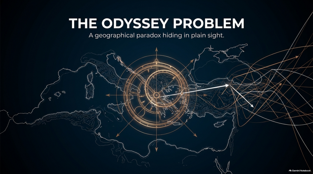
If Troy was really at Hisarlık, Homer has given us a geographical problem hiding in plain sight

Before We Follow Odysseus: How Old Is the Story We Are Actually Reading?

Before attempting to place Troy, Ithaca or any of the strange lands described in the Odyssey on a modern map, there is a more fundamental question that is rarely given enough attention:

What exactly are the Iliad and Odyssey?
THE ODYSSEY PROBLEM
THE ODYSSEY PROBLEM

Today we encounter them as books. They have numbered books, fixed lines, recognised place-names and an author conventionally called Homer. That creates the natural impression that somebody sat down approximately 2,700 years ago and wrote the stories much as a modern novelist would.

Almost certainly, that is not how they began.

Modern Homeric scholarship broadly accepts that the Iliad and Odyssey emerged from a much older oral performance tradition. For generations before the poems became stable written texts, professional singers told and retold stories about Troy, Achilles, Helen, Odysseus and the other heroes. The tradition operated over a wide geographical area and for hundreds of years; some scholars allow that parts of the underlying poetic tradition may reach back into the Bronze Age, while aspects of the poetic language itself may preserve still older Indo-European inheritances.

That distinction is crucial to this investigation.

We are therefore probably not reading an eyewitness report written shortly after a war.

Nor, however, are we necessarily reading a completely invented story created in the eighth century BCE.

What we have is something much more interesting:

A VERY OLD STORY THAT WAS KEPT ALIVE BY HUMAN MEMORY BEFORE IT BECAME A BOOK.
THE ODYSSEY PROBLEM
THE ODYSSEY PROBLEM

🗣️ HOW COULD A STORY THIS LARGE SURVIVE WITHOUT WRITING?

At first this sounds almost impossible.

The Iliad contains more than 15,000 lines and the Odyssey more than 12,000. How could stories of this scale survive for centuries before being written down?

The answer lies in the way oral poetry worked.

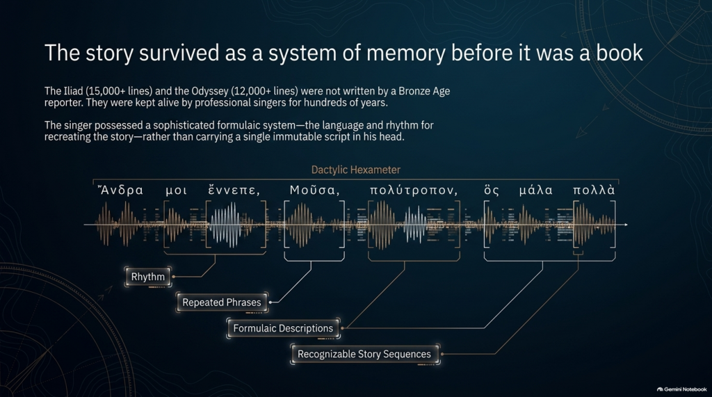
The pioneering studies of Milman Parry and Albert Lord demonstrated that oral epic singers did not normally memorise a gigantic text word-for-word in the way an actor memorises a script.

Instead, they mastered a specialised system of:

rhythm,

repeated phrases,

formulaic descriptions,

stock scenes,

traditional characters,

recognisable story sequences

and

metrical structures.

Thus Achilles can repeatedly be described by a familiar epithet, ships can be introduced through standard phrases, dawn arrives through recognised verbal formulas, and battles, feasts, departures and assemblies follow structures that both singer and audience understand.

The metre itself—dactylic hexameter—acted as part of the memory system.

The singer possessed the story and the language for recreating it, rather than carrying a single immutable script in his head. Parry and Lord’s work on surviving oral traditions showed that a trained singer could reconstruct an enormous epic during performance using this formulaic system.

This produces a very important consequence.

Each performance could preserve the essential story while changing some of its details.

An episode might become longer.

Another could be shortened.

A hero could receive greater prominence.

A description could change.

And details meaningful to one audience could be emphasised more heavily than details important to another.

The story could therefore remain recognisably the same story for centuries without remaining exactly the same text.

THE ODYSSEY PROBLEM
THE ODYSSEY PROBLEM

⏳ HOW FAR BACK COULD THE TROJAN STORY GO?

This is where matters become particularly interesting.

The poems we possess are usually associated in something close to their recognisable monumental form with the late eighth or early seventh century BCE, although exactly when they first became written texts remains heavily debated.

But the traditions from which they were created are considerably older.

Cambridge’s modern guide to Homer describes the poems as products of songs composed and recomposed over many hundreds of years, potentially drawing on traditions extending much deeper into prehistory. Some scholarship has specifically argued that Greek epic traditions may have been developing from the middle or later Bronze Age.

That creates a possible chronological gap of several centuries between:

whatever historical events originally generated the tradition

and

the written geographical names we eventually inherit.

If the conventional Trojan War date of around the late second millennium BCE were approximately correct, then several hundred years may separate an original conflict from the period in which the surviving poems began crystallising into something resembling our texts.

And during those centuries the story was travelling.


🌍 STORIES TRAVEL — AND GEOGRAPHY CAN TRAVEL WITH THEM

This point is central to our investigation.

An oral epic does not survive in a vacuum.

It survives because people want to hear it.

A singer performs before an audience. That audience knows its own towns, rulers, landscapes, ancestors and political rivalries.

Successful oral storytelling therefore contains an unavoidable process of adaptation.

Modern Homeric scholarship explicitly recognises that the flexibility of oral performance allowed heroic tales to be adapted to their immediate contexts. The Homeric language itself demonstrates this history: it is not the ordinary language of one place or date but a remarkable composite containing predominantly Ionic forms together with older Aeolic and Arcado-Cypriot elements and later Attic features.

In other words:

THE LANGUAGE ITSELF HAS A HISTORY OF MOVEMENT AND MODIFICATION.

Why should we automatically assume every geographical label escaped the same process untouched?

Suppose an ancient story originally described a distant king, harbour, island or people whose original name had become meaningless to an audience centuries later.

A performer had several choices.

He could preserve a meaningless archaic name.

He could reinterpret it.

He could associate it with a place his listeners knew.

Or different regional traditions could gradually absorb their own places and heroes into the greater Trojan story.

We cannot prove that this happened to every disputed Homeric town.

But critically:

WE KNOW THE ORAL SYSTEM WAS CAPABLE OF DOING IT.

That alone means geographical names cannot be treated with the same evidential weight as physical descriptions.
THE ODYSSEY PROBLEM
THE ODYSSEY PROBLEM

🏛️ COULD LOCAL TOWNS HAVE BEEN ADDED TO PLEASE LOCAL AUDIENCES?

Yes—it is a genuine possibility, although it must be treated as a hypothesis rather than assumed.

There were even disputes in antiquity and later scholarship concerning possible Athenian additions to Homer. Passages involving Athens and Salamis in the Catalogue of Ships have attracted particularly long-running arguments about interpolation and political influence. Modern scholarship does not simply agree that these lines were inserted, but the fact that such passages remain controversial demonstrates that alteration of local geographical material is not some outrageous modern suggestion.

And there was an obvious incentive.

Imagine performing this great heroic story before an audience in a particular Greek city.

Which version is likely to receive the better reception?

One saying:

“Your people played no part in the greatest war in heroic history.”

Or one announcing:

“Your ancestors were there too.”

The Catalogue of Ships is especially interesting in this respect because it gives an extraordinary roll-call of communities incorporated into the expedition.

That does not prove the Catalogue was fabricated.

But it means we should recognise its social function.

The Trojan story eventually became a shared heroic past through which numerous Greek communities could locate themselves inside history.

That creates exactly the circumstances in which local geographical incorporation becomes plausible.


💰 WAS THERE A COMMERCIAL MOTIVE?

Not initially in the modern sense of an author writing a book and hoping to sell thousands of copies.

For much of the poem’s early existence, the product being consumed was the:

PERFORMANCE.

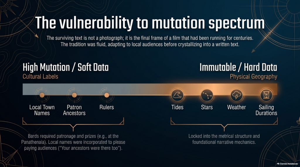
Bards performed at elite households, feasts and public occasions. Later professional rhapsodes performed Homeric poetry competitively at major festivals such as the Panathenaia, where contests and prizes existed. For most people in Archaic and Classical Greece, Homer would originally have been encountered through performance rather than privately reading a book.

So although we should avoid imagining a Bronze Age publishing company selling copies of the Iliad, there was still an economic reality.

A successful performer needed:

patronage,

invitations,

prestige,

prizes

and above all:

AN AUDIENCE THAT WANTED TO HEAR HIS VERSION.

That provides exactly the same commercial pressure that exists in entertainment today.

Tell people a story that relates to them, and they are more likely to listen.

Eventually the oral tradition increasingly became textual. The poems became books, educational texts and cultural possessions, while regulated festival performances also helped constrain what had previously been a much more fluid tradition. Yet even by the second century BCE, textual variation had not disappeared completely.

So the surviving text is better imagined not as a photograph taken at one moment in history, but as the final surviving frame of a film that had already been running for centuries.


📜 FROM BARD TO “HOMER”

There is another uncomfortable problem.

We do not actually know who Homer was.

Ancient cities competed to claim him as their own, particularly communities in Ionia such as Smyrna and Chios. Even the association of the name “Homer” with the Iliad and Odyssey developed within the later tradition.

Modern scholarship continues to debate whether:

one extraordinary poet monumentalised each epic,

different poets created the Iliad and Odyssey,

the poems were dictated by oral singers,

or their written forms emerged progressively from a much wider performance tradition.

What is considerably less controversial is that the tradition preceding the surviving text was oral.

That fact changes how geographical evidence should be handled.

THE ODYSSEY PROBLEM
THE ODYSSEY PROBLEM

🧭 NAMES ARE NOT THE SAME AS GEOGRAPHY

This is why, throughout this investigation, we will not begin by saying:

“Homer mentions a place later identified as being in Greece, therefore the story happened in Greece.”

That is circular reasoning.

A place-name can be:

preserved,

translated,

reapplied,

updated,

misunderstood

or

incorporated during centuries of oral retelling.

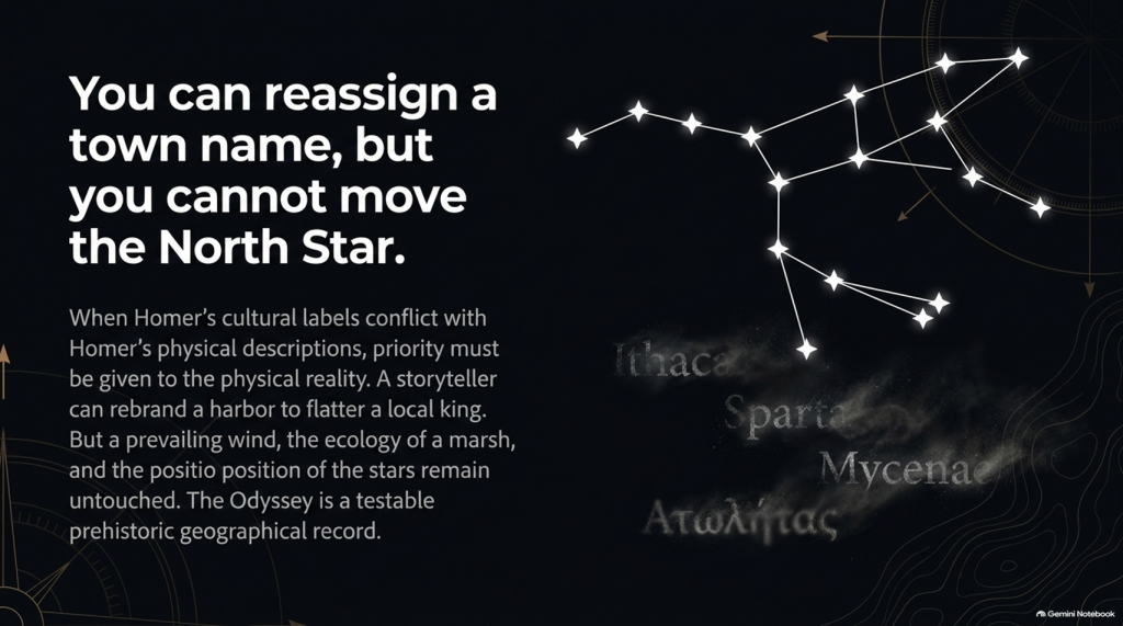
A river behaving in a particular way cannot.

A tide cannot.

A seventeen-day voyage cannot.

The position of a star cannot.

A prevailing wind cannot.

The length of winter darkness cannot.

The ecology of a marsh cannot.

A mountain visible after a stated number of sailing days cannot.

Those are the clues that deserve greater weight.

So our methodology deliberately separates:

🏛️ CULTURAL LABELS

from

🌍 PHYSICAL GEOGRAPHY.

The names remain important.

But they do not get to prove themselves.

THE ODYSSEY PROBLEM
THE ODYSSEY PROBLEM

🔍 THE STORY MAY BE OLDER THAN ITS MAP

And this leads directly to the central problem of the Odyssey.

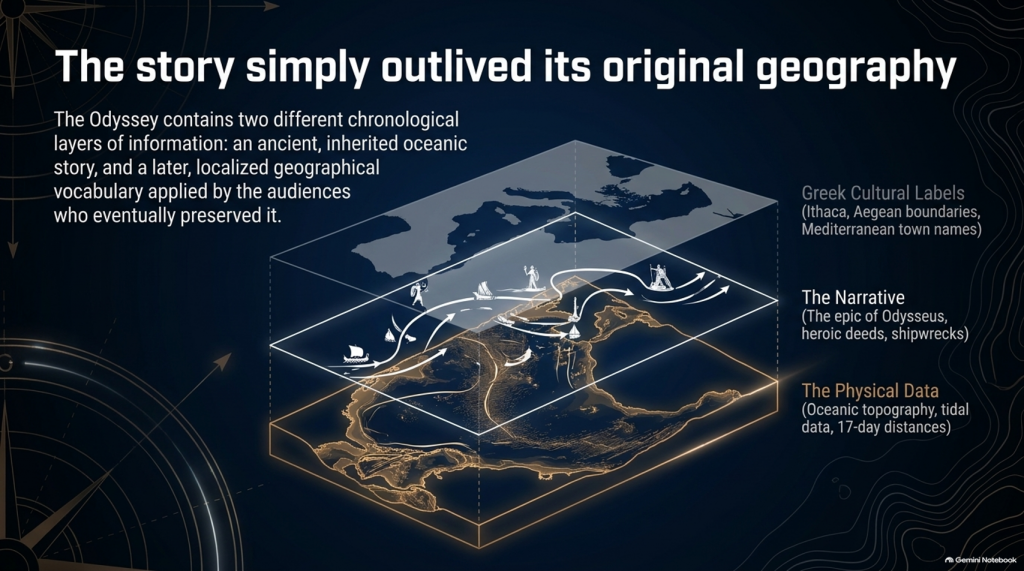
It is entirely possible that the written poem contains two different chronological layers of information:

an ancient inherited story,

and

a later geographical vocabulary familiar to the audiences who eventually preserved and recorded it.

If so, conflicts between Homer’s names and Homer’s physical descriptions become extremely important.

Which should we trust?

The town name that could have travelled through centuries of human storytelling?

Or the description of:

🌊 the sea,

🌫️ the climate,

⭐ the stars,

🧭 the sailing direction,

⏳ the voyage duration,

🌲 the vegetation,

🏔️ the landscape

and

👥 the people?

Our investigation gives priority to the latter.

Because oral tradition can move a name.

IT CANNOT MOVE THE NORTH STAR.
THE ODYSSEY PROBLEM
THE ODYSSEY PROBLEM

And once that distinction is understood, the Odyssey stops being merely one of the world’s greatest stories.

It becomes something else:

🧭 A POTENTIALLY TESTABLE PREHISTORIC GEOGRAPHICAL RECORD.

That is where our investigation begins.

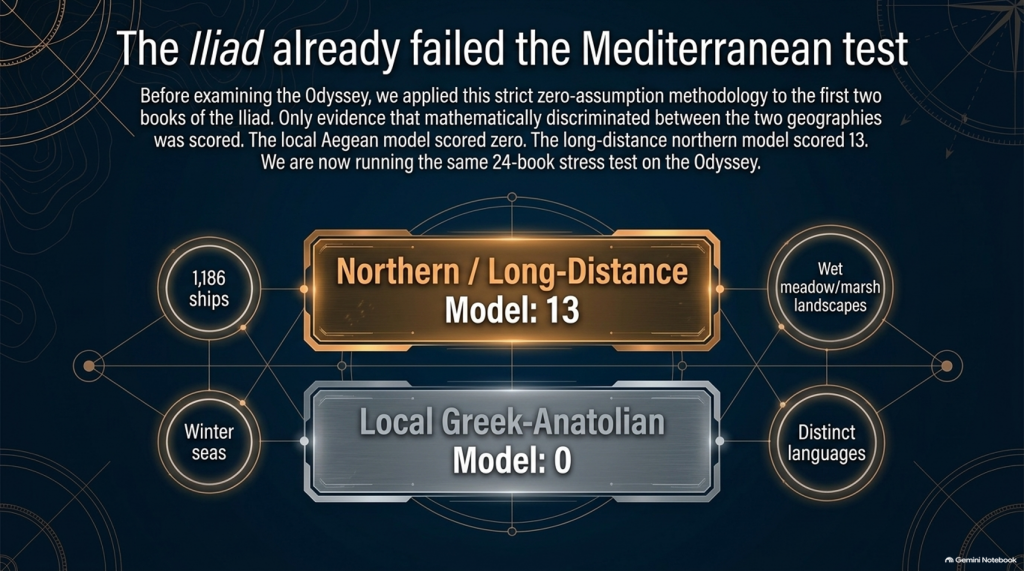
Our examination of the first two books of Homer’s Iliad has already produced an unexpected result.

After removing traditional place-name assumptions and scoring only evidence that actually discriminates between the competing geographical models, the result currently stands at:

🌊 NORTHERN / LONG-DISTANCE MODEL: 13

☀️ LOCAL GREEK–ANATOLIAN MODEL: 0

But we may have overlooked an even more powerful test.

Because Homer didn’t only leave us the story of the war.

He also left us:

🧭 THE JOURNEY HOME.

And that creates a very awkward question for the traditional identification of Troy.


🚢 THE JOURNEY SHOULD BE SIMPLE

The conventional interpretation tells us:

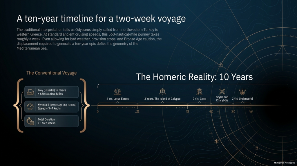
🏛️ Troy = Hisarlık in north-western Turkey

and

🏠 Odysseus’ home = Ithaca in western Greece.

So when Troy falls, Odysseus has a straightforward objective:

TROY ➡️ ITHACA

Nothing mysterious about that.

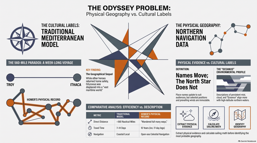
The conventional sea distance is approximately:

🌊 560 NAUTICAL MILES

roughly 645 statute miles

Now compare that with experimental ancient Mediterranean sailing.

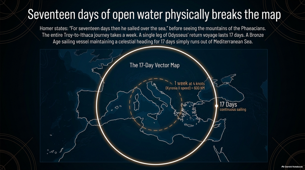
The reconstructed fourth-century BC merchant vessel Kyrenia II demonstrated cruising speeds around 3–4 knots, sometimes considerably faster. On its experimental voyage from Piraeus to Cyprus it covered almost 600 nautical miles despite stops, tests and variable conditions.

At that sort of speed, a direct 560-mile voyage is not a journey measured in years.

It is measured in:

📅 DAYS.

Allow for poor winds, overnight stops, provisioning and Bronze Age caution and perhaps we are looking at roughly:

ONE TO TWO WEEKS

under reasonably favourable circumstances.

And yet Homer gives us:

⏳ TEN YEARS.

Immediately people will say:

“But Odysseus didn’t spend ten years sailing!”

Correct.

And that distinction actually makes the geographical problem more interesting.

THE ODYSSEY PROBLEM
THE ODYSSEY PROBLEM

⏳ THE TEN YEARS WERE NOT TEN YEARS OF CONTINUOUS SAILING

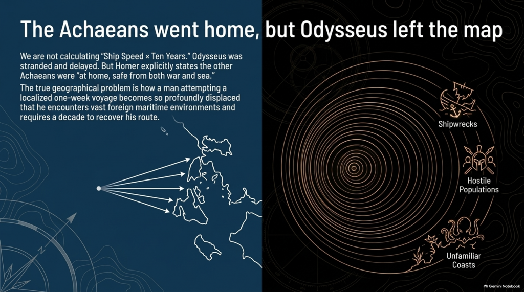
Odysseus gets delayed.

He is shipwrecked.

He loses companions.

He encounters hostile populations.

He becomes stranded.

He spends years unable to get home.

So it would be scientifically wrong to calculate:

ship speed × ten years = distance from Troy.

We aren’t doing that.

The real question is much more basic:

How does a man attempting a voyage whose conventional start and finish are only about a week’s sailing apart become so geographically displaced that returning home consumes ten years?

That is the problem.


📖 HOMER TELLS US FROM THE FIRST LINES THAT THIS IS A GEOGRAPHICAL JOURNEY

The Odyssey opens by describing Odysseus as the man who:

“wandered full many ways”

after he had destroyed Troy.

Homer says:

“Many were the men whose cities he saw”

and tells us that he suffered repeatedly:

“upon the sea.”

This isn’t simply a story about somebody stuck around the corner.

It is explicitly a story about:

🌍 travelling through different lands

👥 encountering different peoples

🌊 crossing seas

🌪️ experiencing extreme maritime conditions

and

🧭 struggling to recover the route home.

THE ODYSSEY PROBLEM
THE ODYSSEY PROBLEM

🚨 EVEN MORE IMPORTANTLY — EVERYONE ELSE HAS ALREADY GONE HOME

Book 1 gives us another striking statement.

Homer says that the other surviving Achaeans were:

“at home, safe from both war and sea.”

Odysseus alone remained unable to complete his return.

This is extremely important.

The war is finished.

The surviving coalition disperses.

The men undertake their return journeys from Troy.

That means the Odyssey isn’t some unrelated maritime fantasy.

It is the geographical sequel to the Trojan War.

We therefore have another independent dataset with which to test the location of Troy.


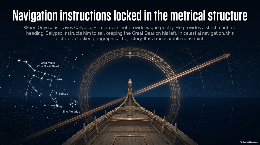
🧭 AND HOMER ACTUALLY GIVES US NAVIGATION INSTRUCTIONS

This is where things become particularly interesting.

When Odysseus finally leaves Calypso, Homer doesn’t simply say:

“He sailed away.”

He tells us how he navigated.

Odysseus watches:

⭐ the Pleiades

⭐ Boötes

⭐ Orion

⭐ the Great Bear.

And Calypso instructs him to keep the Bear:

ON HIS LEFT

while sailing.

That is potentially geographical evidence.

Because now we have:

⭐ CELESTIAL NAVIGATION

🧭 DIRECTION

🌊 OPEN-SEA TRAVEL

⏳ AND SAILING DURATION.

That can potentially be tested mathematically.

THE ODYSSEY PROBLEM
THE ODYSSEY PROBLEM

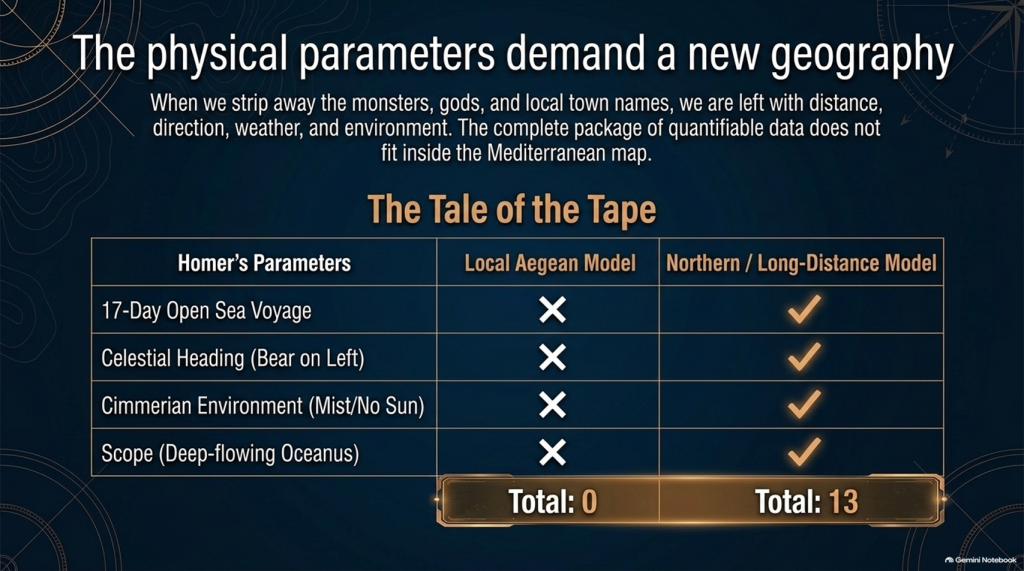
🚢 THEN HOMER GIVES US THE NUMBER: SEVENTEEN DAYS

Odysseus sails continuously enough for Homer to state:

“For seventeen days then he sailed over the sea”

and on the eighteenth he finally sees the mountains of the Phaeacians.

Stop there.

The entire conventional Troy-to-Ithaca journey could potentially be completed in something around a week or somewhat longer under reasonable sailing conditions.

Yet one single later leg of Odysseus’ wandering lasts:

🌊 17 DAYS AT SEA

before land appears.

That doesn’t automatically prove the Atlantic.

But scientifically it demands investigation.

Where had he travelled?

How far away from Ithaca had he become?

What heading does keeping the Great Bear on the left imply?

What distance can a Bronze Age sailing vessel cover in seventeen days?

And does the conventional Mediterranean reconstruction actually satisfy those constraints?

These are measurable questions.


🌫️ THEN WE REACH THE CIMMERIANS

And the environment becomes even stranger.

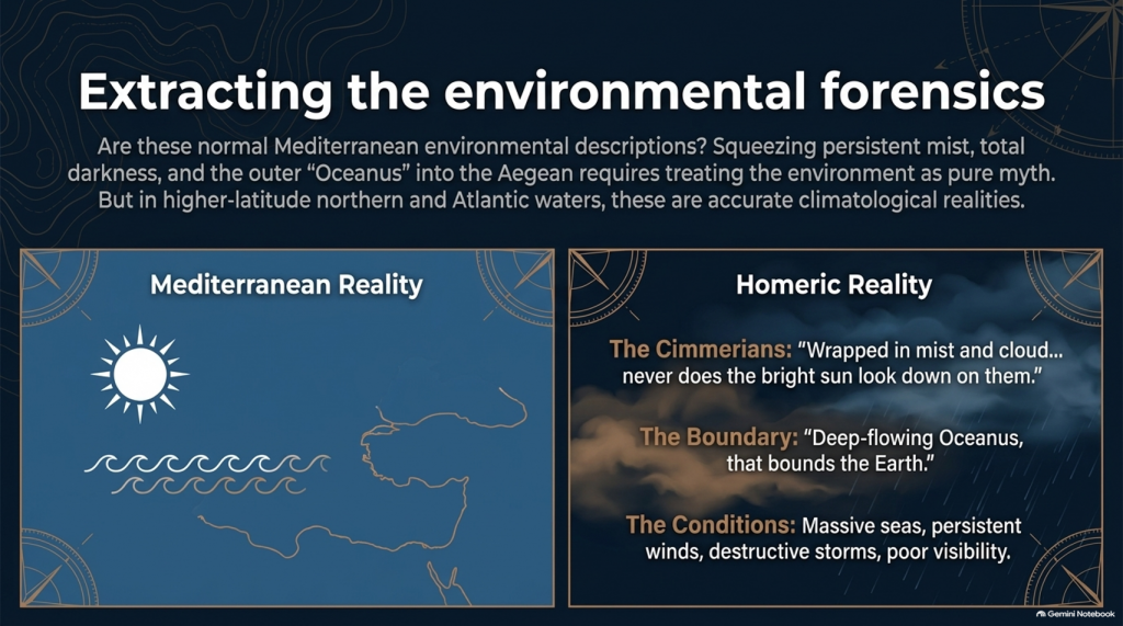
Odysseus reaches the land of the Cimmerians.

Homer describes it as:

“wrapped in mist and cloud.”

Then he says:

“Never does the bright sun look down on them”

and describes oppressive darkness hanging over the inhabitants.

Again, we must be careful.

This could be mythological geography.

It could represent Homer’s conception of the edge of the world.

We cannot simply announce:

Cimmerians = Britain.

But scientifically we are entitled to ask:

🌞 Is this a normal Mediterranean environmental description?

Or is:

🌫️ persistent mist

☁️ cloud

🌑 darkness

and

🌊 the remote Ocean

more naturally compatible with the traditions of higher-latitude northern waters?

That becomes another test.


🌊 HOMER EVEN TAKES US TO “OCEANUS”

Immediately before reaching the Cimmerians, Homer says Odysseus’ vessel reaches:

“deep-flowing Oceanus, that bounds the Earth.”

This is extremely significant conceptually.

The poem’s geography has now expanded far beyond an ordinary little voyage between Turkey and western Greece.

We are being taken to what Homer’s tradition regards as the outer ocean.

Whether Oceanus represents a literal Atlantic geography, mythical world-ocean, or a mixture of inherited geographical memory and mythology is precisely what needs testing.

But simply squeezing every episode into the Mediterranean because we have already decided Troy belongs there is not evidence.

It is circular reasoning.

THE ODYSSEY PROBLEM
THE ODYSSEY PROBLEM

🌪️ THE WEATHER NEEDS TESTING TOO

Throughout the Odyssey, maritime conditions aren’t background decoration.

They drive the story.

Odysseus encounters:

🌊 enormous seas

🌬️ persistent winds

⛈️ destructive storms

🌫️ mist and poor visibility

🏝️ unfamiliar coasts

and repeated difficulty determining his position.

Mediterranean storms can unquestionably be severe.

So:

storm = Atlantic

is not acceptable science.

But just as with our Iliad investigation, the correct question is:

Which maritime environment produces the complete collection of conditions more naturally and more frequently?

The Mediterranean?

Or the Atlantic/North Sea world?


🗺️ THE PEOPLE ARE JUST AS IMPORTANT AS THE WEATHER

The journey takes Odysseus through populations whose cultures and lifestyles differ radically.

We meet:

👥 Cimmerians

👥 Phaeacians

👥 Cyclopes

👥 Laestrygonians

and numerous other populations and communities.

Some may be mythical.

Some may preserve distorted memories of real peoples.

Some may combine both.

But we should not begin by assigning them to Mediterranean locations simply because later scholars did so.

Instead we should record:

🏠 housing

⛵ boat technology

🌾 agriculture

🐄 animals

🍖 diet

👕 clothing

🗣️ language

🌲 vegetation

🌦️ climate

🏔️ geography

and then ask:

WHERE DOES THAT COMPLETE PACKAGE FIT BEST?
THE ODYSSEY PROBLEM
THE ODYSSEY PROBLEM

⚠️ THIS IS THE SAME MISTAKE WE FOUND WITH THE ILIAD

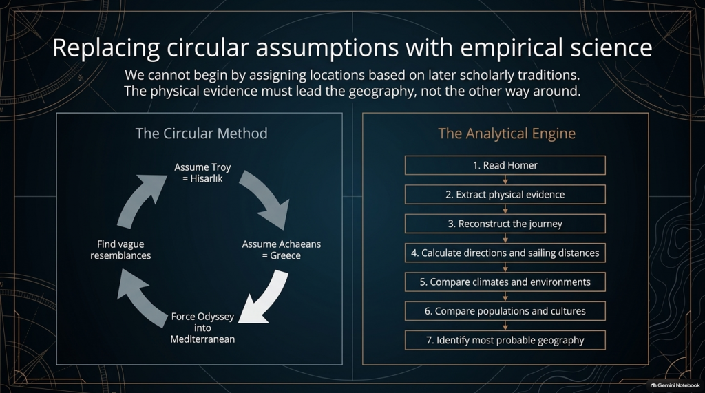
Traditional scholarship frequently begins with:

Troy = Hisarlık

therefore:

Achaeans = Greece

therefore:

the war must be Mediterranean

therefore:

the Odyssey must largely be Mediterranean

and then attempts to find Mediterranean locations resembling Homer’s descriptions.

That reverses the scientific process.

The correct sequence should be:

1️⃣ Read Homer.

2️⃣ Extract the physical evidence.

3️⃣ Reconstruct the journey.

4️⃣ Calculate directions and sailing distances.

5️⃣ Compare climates and environments.

6️⃣ Compare populations and cultures.

7️⃣ THEN identify the most probable geography.

Not the other way around.


🔬 AND THIS TIME WE CAN ACTUALLY DO THE MATHEMATICS

The Iliad gave us powerful clues such as:

🌍 “far from home”

🌊 mountains and sea separating populations

🚢 1,186 ships

🗣️ different languages

🌍 allies “from afar”

👱 repeated xanthos individuals

🌧️ winter seas

🌿 wet meadow and marsh landscapes.

But the Odyssey potentially gives us something even stronger.

It gives us:

⏱️ TIME

🧭 DIRECTION

⭐ NAVIGATION

🌊 DISTANCE

🌬️ WEATHER

🌍 ENVIRONMENT.

Those are quantifiable.


🚨 THE CENTRAL PROBLEM

Strip away all the monsters and gods for a moment.

The basic story says:

Odysseus leaves Troy.

He intends to sail home.

Home is Ithaca.

Other Achaeans successfully make their own returns.

Odysseus becomes displaced through a vast maritime world.

He encounters numerous foreign peoples and environments.

He reaches extraordinarily remote locations.

One later sailing leg alone lasts seventeen days.

His complete return takes ten years.

And the conventional interpretation asks us to place the beginning and end of that extraordinary adventure only about:

560 NAUTICAL MILES APART.

That doesn’t prove the traditional map is wrong.

But scientifically:

IT IS A PROBLEM THAT DEMANDS AN EXPLANATION.
THE ODYSSEY PROBLEM
THE ODYSSEY PROBLEM

🧪 SO WE ARE GOING TO TEST THE ODYSSEY TOO

After our detailed examination of the 24 books of the Iliad, we will now have a second investigation:

📚 ALL 24 BOOKS OF THE ODYSSEY

And we will use exactly the same rules.

No points for traditional names.

No location accepted because “experts agree”.

No northern point merely because something also happens in Britain.

No Mediterranean point merely because something can happen in Greece.

If both environments fit:

0–0

If one environment is substantially more probable:

it scores.

And where Homer gives us distances, directions and sailing durations:

WE DO THE MATHS.


🔥 THIS MAY BECOME THE BIGGER PROBLEM

After two books of the Iliad our score currently stands at:

🌊 NORTH / LONG-DISTANCE: 13

☀️ LOCAL AEGEAN: 0

Twenty-two Iliad books remain.

But after that we now have another twenty-four books containing the actual journey home.

That means this investigation is no longer simply:

“Where was Troy?”
THE ODYSSEY PROBLEM
THE ODYSSEY PROBLEM

The bigger question has become:

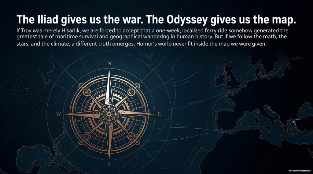
🧭 DOES HOMER’S ENTIRE GEOGRAPHICAL WORLD FIT INSIDE THE MAP WE HAVE BEEN GIVEN?

Because if Troy really was Hisarlık and Ithaca really was Odysseus’ destination, then a journey whose conventional endpoints are roughly a week or two of ordinary ancient sailing apart somehow generated one of the greatest tales of geographical wandering ever written.

Perhaps mythology explains everything.

Perhaps the Mediterranean really does reproduce Homer’s journey.

Perhaps the traditional geography eventually wins.

But those are hypotheses.

They now need testing.

And if the sailing directions, durations, climates, peoples and landscapes repeatedly point outside the Mediterranean, then the traditional identification of this as an obviously local Greek–Anatolian conflict becomes increasingly difficult to defend scientifically.

🌊 THE ILIAD GIVES US THE WAR.

🧭 THE ODYSSEY MAY GIVE US THE MAP.

And that may prove to be the most important test of them all. 🔍🌍⚔️
THE ODYSSEY PROBLEM
THE ODYSSEY PROBLEM

PODCAST

Author’s Biography

Robert John Langdon, a polymathic luminary, emerges as a writer, historian, and eminent specialist in LiDAR Landscape Archaeology.

His intellectual voyage has been interwoven with stints as an astute scrutineer in government and grand corporate bastions, a tapestry spanning British Telecommunications, Cable and Wireless, British Gas, and the esteemed University of London.

A decade hence, Robert’s transition into retirement unfurled a chapter of insatiable curiosity. This phase saw him immerse himself in Politics, Archaeology, Philosophy, and the enigmatic realm of Quantum Mechanics. His academic odyssey traversed the venerable corridors of knowledge hubs such as the Museum of London, University College London, Birkbeck College, The City Literature Institute, and Chichester University.

In the symphony of his life, Robert is a custodian of three progeny and a pair of cherished grandchildren. His sanctuary lies ensconced in the embrace of West Wales, where he inhabits an isolated cottage, its windows framing a vista of the boundless sea – a retreat from the scrutinising gaze of Her Majesty’s Revenue and Customs, an amiable clandestinity in the lap of nature.

Exploring Prehistoric Britain: A Journey Through Time

My blog delves into the fascinating mysteries of prehistoric Britain, challenging conventional narratives and offering fresh perspectives grounded in cutting-edge research, particularly LiDAR technology. I invite you to explore some key areas of my research. For example, the Wansdyke, often cited as a defensive structure, is re-examined in light of new evidence. I’ve presented my findings in my blog post Wansdyke: A British Frontier Wall – ‘Debunked’, and a Wansdyke LiDAR Flyover video further visualises my conclusions.

My work also often challenges established archaeological dogma. I argue that many sites, such as Hambledon Hill, commonly identified as Iron Age hillforts, are not what they seem. My posts Lidar Investigation Hambledon Hill – NOT an ‘Iron Age Fort’ and Unmasking the “Iron Age Hillfort” Myth explore these ideas in detail and offer an alternative view. Similarly, sites like Cissbury Ring and White Sheet Camp receive re-evaluations based on LiDAR analysis in my posts “Lidar Investigation Cissbury Ring through time” and “Lidar Investigation White Sheet Camp,“ revealing fascinating insights into their true purpose. I have also examined South Cadbury Castle, often linked to the mythical Camelot56.

My research also extends to ancient water management, including the role of canals and other linear earthworks. I have discussed the true origins of Car Dyke in multiple posts, including Car Dyke – ABC News Podcast and Lidar Investigation Car Dyke – North Section, which suggest a Mesolithic origin 2357. I also explore the misidentification of Roman aqueducts, as seen in my posts on the Great Chesters (Roman) Aqueduct. My research has also been greatly informed by my post-glacial flooding hypothesis, which has helped explain landscape transformations over time. I have discussed this hypothesis in several posts, including AI now supports my Post-Glacial Flooding Hypothesis and Exploring Britain’s Flooded Past: A Personal Journey

Finally, my blog also investigates prehistoric burial practices, as seen in Prehistoric Burial Practices of Britain and explores the mystery of Pillow Mounds, often mistaken for medieval rabbit warrens, but with a potential link to Bronze Age cremation in my posts: Pillow Mounds: A Bronze Age Legacy of Cremation? and The Mystery of Pillow Mounds: Are They Really Medieval Rabbit Warrens?. My research also includes astronomical insights into ancient sites, for example, in Rediscovering the Winter Solstice: The Original Winter Festival. I also review new information about the construction of Stonehenge in The Stonehenge Enigma.

Further Reading

For those interested in British Prehistory, visit www.prehistoric-britain.co.uk, a comprehensive resource featuring an extensive collection of archaeology articles, modern LiDAR investigations, and groundbreaking research. The site also includes insights and excerpts from the acclaimed Robert John Langdon Trilogy, a series of books that explore Britain during the Prehistoric period. Titles in the trilogy include The Stonehenge Enigma, Dawn of the Lost Civilisation, and The Post-Glacial Flooding Hypothesis, which offer compelling evidence of ancient landscapes shaped by post-glacial flooding.

To further explore these topics, Robert John Langdon has developed a dedicated YouTube channel featuring over 100 video documentaries and investigations that complement the trilogy. Notable discoveries and studies showcased on the channel include 13 Things that Don’t Make Sense in History and the revelation of Silbury Avenue – The Lost Stone Avenue, a rediscovered prehistoric feature at Avebury, Wiltshire.

In addition to his main works, Langdon has released a series of shorter, accessible publications, ideal for readers delving into specific topics. These include:

For active discussions and updates on the trilogy’s findings and recent LiDAR investigations, join our vibrant community on Facebook. Engage with like-minded enthusiasts by leaving a message or contributing to debates in our Facebook Group.

Whether through the books, the website, or interactive videos, we aim to provide a deeper understanding of Britain’s fascinating prehistoric past. We encourage you to explore these resources and uncover the mysteries of ancient landscapes through the lens of modern archaeology.

For more information, including chapter extracts and related publications, visit the Robert John Langdon Author Page. Dive into works such as The Stonehenge Enigma or Dawn of the Lost Civilisation, and explore cutting-edge theories that challenge traditional historical narratives.

Other Blogs

s

t

Plato Was Right: The Archaeological Evidence the Academics Never Expected

Introduction

For more than a century, archaeology has treated Plato’s Atlantis as little more than an allegory. Students are taught that Atlantis was a philosophical invention. A morality tale. A fictional society created to demonstrate the dangers of arrogance and imperial ambition. (Plato’s Atlantis)

The problem with this explanation is simple.

Plato’s story contains an extraordinary number of specific claims.

He described a powerful maritime civilisation existing around 9,000 years before Solon. He placed it beyond the Pillars of Hercules in a sea that bears its name to this day – the Atlantic Ocean. He claimed it possessed fleets capable of travelling vast distances, maintained contact with distant lands, and ultimately disappeared beneath the sea following catastrophic flooding.

Most importantly, Plato claimed the survivors of this lost civilisation seeded both Egypt and Greece.

For generations, academics dismissed the entire account as fiction.

The archaeology now suggests they may have been wrong.

(Plato's Atlantis)
(Plato’s Atlantis)

1. Atlantis and the Atlantic

One of the most overlooked aspects of Plato’s account is geography.

Atlantis was not described as a Mediterranean civilisation.

It lay beyond the Pillars of Hercules in the Atlantic Ocean.

Today, the ocean itself still carries the name.

Whether the ocean was named after Atlantis or Atlantis after the ocean is ultimately irrelevant. What matters is that Plato was clearly describing a civilisation connected to the Atlantic world rather than the eastern Mediterranean.

That distinction becomes critically important when we consider what archaeology has discovered during the last few decades.

(Plato's Atlantis)
(Plato’s Atlantis)

2. The Lost World Beneath the North Sea

When Plato wrote his account, nobody knew that an enormous inhabited landscape once existed beneath the North Sea.

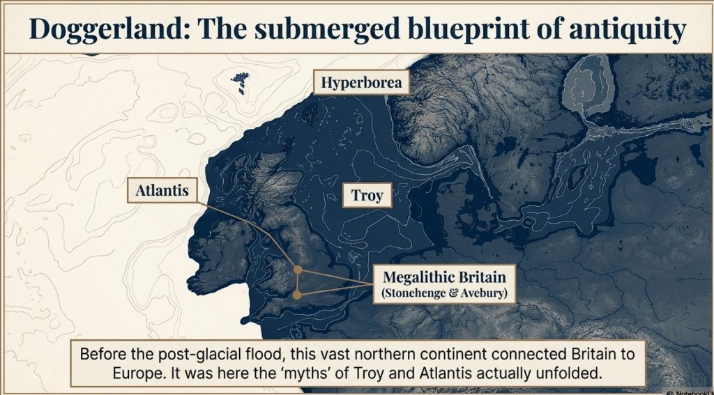
Today, we call it Doggerland.

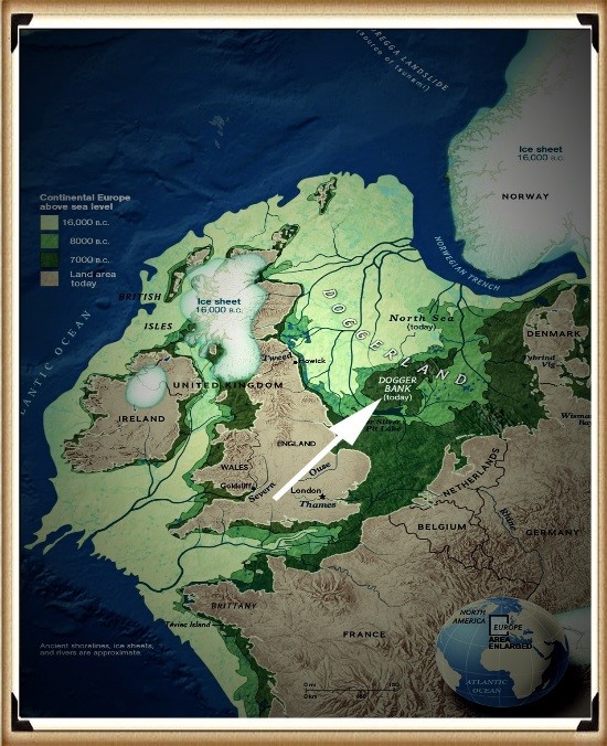
During the Late Ice Age, Britain was connected to Europe by a vast plain crossed by rivers, lakes, forests and wetlands. This was not a small island. It was an entire country-sized landscape supporting human populations for thousands of years.

Then the climate changed.

The ice sheets melted.

Sea levels rose.

The land disappeared beneath the waves.

For centuries, such a drowned world would have been dismissed as fantasy.

Today, it is accepted in archaeology.

The existence of Doggerland alone demonstrates that Plato’s central premise – that large inhabited lands were lost beneath the sea – was not fantasy at all.

(Plato's Atlantis)
(Plato’s Atlantis)

3. The Great Flooding Event

Around 6200 BCE the Storegga tsunami and associated post-glacial flooding transformed the landscapes of north-west Europe.

Although flooding was not a single event, the combined effects of sea-level rise, coastal erosion and catastrophic inundation dramatically reduced the habitable land available to prehistoric populations.

The significance of this cannot be overstated.

An entire world disappeared.

Rivers vanished.

Coastlines moved.

Settlements were destroyed.

Migration became inevitable.

If a sophisticated maritime culture existed within Doggerland, it would have faced a simple choice:

Adapt, relocate or perish.

(Plato's Atlantis)
(Plato’s Atlantis)

4. Bouldnor Cliff Changes Everything

The discovery at Bouldnor Cliff is one of the most important archaeological finds ever made in Britain.

Dating to the seventh millennium BC, the site revealed evidence of advanced woodworking, boat use and long-distance connections.

Most remarkably, researchers recovered evidence of einkorn wheat.

This is not a trivial discovery.

Einkorn was not adopted in Britain for approximately another 3,000 years.

The presence of einkorn demonstrates contact with regions where the crop was already known and cultivated.

In other words, maritime connections already existed between Britain and distant communities long before conventional history would have us believe.

This single discovery destroys the notion that Mesolithic Britain was isolated from the wider world.

(Plato's Atlantis)
(Plato’s Atlantis)

5. Maritime Routes Create Ports

There is another implication that is rarely discussed.

Boats travelling between Britain and the Near East do not operate by magic.

They require food.

Fresh water.

Repairs.

Shelter.

Replacement crews.

Trade goods.

Every historical maritime network in history produced ports and anchorages.

The Phoenicians did it.

The Greeks did it.

The Romans did it.

The Vikings did it.

The Elizabethans did it.

There is no reason to imagine prehistoric sailors behaved differently.

Repeated voyages between the Atlantic and Anatolia would naturally create stopping points along the coasts of Iberia, southern France, Italy, Greece, and Egypt.

Over generations, these temporary anchorages would evolve into permanent trading communities.

Sailors would settle.

Families would form.

Local populations would mix.

Knowledge would spread.

This is how maritime civilisations have always operated.

(Plato's Atlantis)
(Plato’s Atlantis)

6. Plato’s Most Important Claim

Plato did not merely describe a lost civilisation.

He claimed that the survivors seeded both Egypt and Greece.

This is an astonishingly specific statement.

It creates a testable archaeological prediction.

If the account preserves genuine historical memory, then traces of unusual founder populations should appear in both Egypt and Greece during the period following the destruction of the Atlantic homeland.

Remarkably, that is exactly what the archaeology appears to reveal.

(Plato's Atlantis)
(Plato’s Atlantis)

7. Egypt: The First Foundation

The Egyptian evidence is striking.

The chronology reveals continuity rather than replacement.

EgyptGreece
Qarunian (7570–6200 BC)Aceramic Neolithic
Transitional Phase (6200–5550 BC)Early Neolithic
Early Faiyumian (5550–4650 BC)Nea Nikomedeia
Merimde (c.5000–4300 BC)Proto-Sesklo / Sesklo
Tasian (c.4500 BC onwards)Prodromos / Dimini

The populations associated with Merimde and the Tasian culture have been described as:

  • Long-headed.
  • Robust.
  • Physically distinct from many later Egyptians.
  • Generally taller than later predynastic populations.

Excavation reports also recorded individuals with sandy, ginger and even golden hair, leading archaeologists to suggest the existence of a fair strain within the population.

These are not modern interpretations.

They are observations recorded by the excavators themselves.

(Plato's Atlantis)
(Plato’s Atlantis)

8. Greece: The Second Foundation

The Greek evidence follows a remarkably similar pattern.

Early Neolithic populations appear on a timeline virtually identical to that of Egypt.

Sites such as Nea Nikomedeia, Sesklo and Prodromos represent some of the earliest organised communities in Europe.

Anthropological studies repeatedly describe Thessalian populations as predominantly long-headed.

At Prodromos, archaeologists discovered a remarkable cache of eleven human skulls deliberately placed beneath a house floor.

Dedicated anthropological investigations were conducted into these populations, exactly as occurred in Egypt.

The similarities are difficult to ignore.

EgyptGreece
Merimde long-headedThessalian populations described as long-headed
Tasian long-headedProdromos skull assemblage
Robust populationsFounder populations under anthropological study
Taller than later EgyptiansStature evidence incomplete
Fair-haired individualsEvidence currently absent
Continuity from earlier populationsContinuity from Early Neolithic founder settlements
(Plato's Atlantis)
(Plato’s Atlantis)

9. The Chronology Fits

When the chronology is compared directly, the pattern becomes even more remarkable.

DateNorth Sea / Atlantis ModelGreece
8000–7000 BCDoggerland extensiveMesolithic hunter-gatherers
7000–6500 BCPopulation displacement possibleEarliest Neolithic begins
6500–6000 BCLowland reductions continuingThessaly settlements expanding
6200–5500 BCTransitional phaseSesklo emerging
5500–5000 BCDoggerland fragmentedMajor Sesklo centre
5000–4500 BCSurvivor periodDimini and advanced settlements
4500–4000 BCMegalithic Structures EndIncreasing Aegean complexity
3500–3000 BCFarmers take over BritainCycladic maritime culture

The sequence is not proof.

But it is exactly the pattern we would expect if populations displaced from the Atlantic world contributed to later civilisations.

(Plato's Atlantis)
(Plato’s Atlantis)

10. The Allegory Has a Problem

The academic explanation has always been simple.

Atlantis was fictional.

The difficulty is that fictional stories are not supposed to generate accurate archaeological predictions.

Plato described:

  • A maritime civilisation.
  • An Atlantic homeland.
  • Catastrophic flooding.
  • A date close to the end of the Ice Age.
  • Survivors.
  • Egypt.
  • Greece.

Archaeology has now confirmed:

  • The drowned landscape.
  • The flooding.
  • The maritime networks.
  • Long-distance contacts.
  • Founder populations in Egypt.
  • Founder populations in Greece.

Nobody is claiming that every detail of Plato’s account has been proven.

What can no longer be maintained is the lazy assumption that the story was merely an allegory.

Two thousand four hundred years ago, Plato described a lost maritime world destroyed by rising seas whose survivors helped shape the civilisations that followed.

Today, archaeology is beginning to uncover evidence that such a world may have existed.

The greatest irony of all may be that the man historians dismissed as a storyteller was closer to the truth than the experts who spent a century insisting he was wrong.

(Plato's Atlantis)
(Plato’s Atlantis)

🌊 19 Reasons Why Doggerland Was Atlantis 🌊

The Atlantis Mystery Archaeology Doesn’t Want to Solve

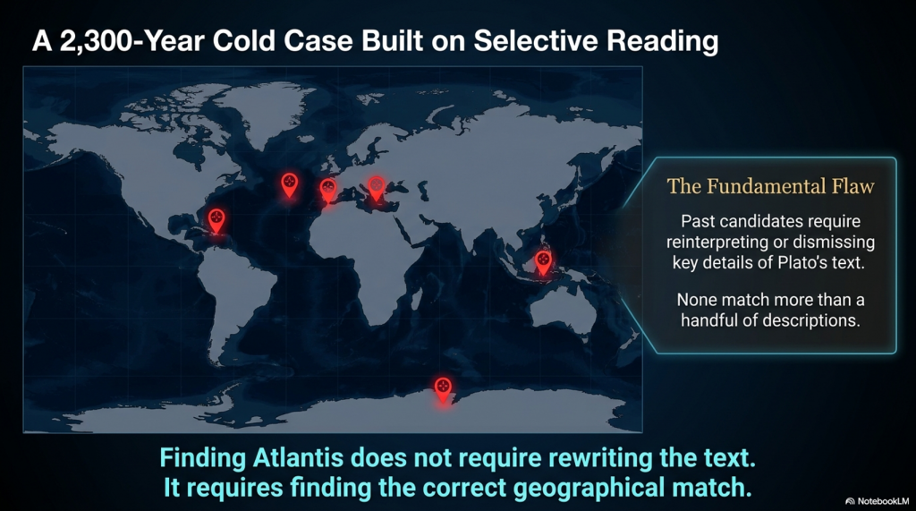
For over 2,300 years, people have searched for Atlantis.

They have looked in the Mediterranean, the Atlantic Ocean, Antarctica, the Caribbean, Spain, Morocco, the Azores, and even Indonesia.

Yet there is a problem.

None of these proposed locations matches more than a handful of Plato’s descriptions.

Most require selective reading, reinterpretation, or outright dismissal of key details.

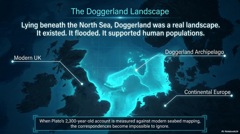
Doggerland is different.

Lying beneath the North Sea between Britain and Europe, Doggerland was a real landscape. It existed. It flooded. It supported human populations. And remarkably, when Plato’s account is compared to measurable evidence, the number of correspondences becomes difficult to ignore.

Here are 19 reasons why Doggerland remains the strongest candidate for Atlantis ever identified.


1️⃣ A Large Island Beyond the Mediterranean

Plato describes a vast landmass beyond the familiar world of the Mediterranean.

Doggerland once connected Britain to continental Europe and formed one of the largest habitable landscapes in north-west Europe before it disappeared beneath the sea.


2️⃣ A Vast Central Plain

Plato gives dimensions of approximately 2,000 by 3,000 stadia.

When converted into modern measurements, this equates to roughly 370 by 550 kilometres.

The reconstructed Doggerland plateau measures approximately 375 by 560 kilometres.

Few Atlantis candidates come anywhere close.


3️⃣ Mountains to the North

Plato describes mountains surrounding the northern edge of the plain.

Scotland, Norway and Scandinavia form exactly such a northern mountainous boundary around the North Sea basin.


4️⃣ A Landscape Dominated by Water

Atlantis was described as a landscape of rivers, channels and waterways.

Doggerland was criss-crossed by major river systems, wetlands, lakes, estuaries and palaeochannels now mapped beneath the North Sea.


5️⃣ A Maritime Civilisation

Plato repeatedly emphasises ships and seafaring.

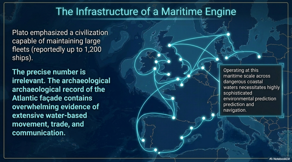
The Atlantic façade and North Sea region contain overwhelming evidence for water-based movement, trade and communication.


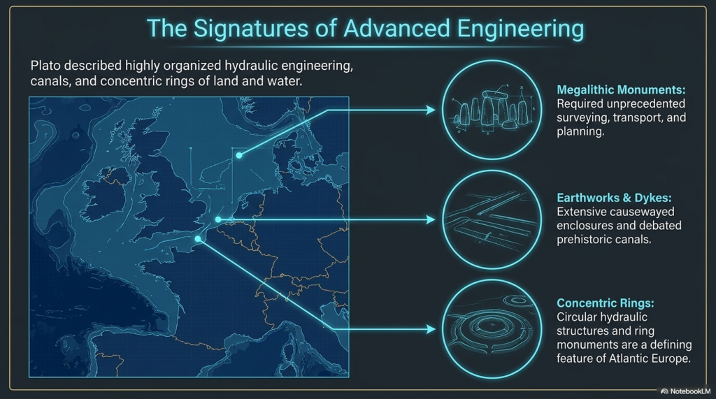
6️⃣ Large-Scale Hydraulic Engineering

Plato describes canals and water management on a huge scale.

Britain and north-west Europe preserve extensive dykes, canals, causewayed enclosures and engineered earthworks whose original purposes remain debated.


7️⃣ Concentric Rings of Land and Water

One of Atlantis’s most famous features.

Concentric enclosures, ring monuments and circular hydraulic structures occur throughout Atlantic Europe.


8️⃣ A Fertile Plain

Plato describes a rich agricultural landscape.

Pollen records, peat deposits and sediment analysis reveal that Doggerland supported extensive woodland, grassland and productive river valleys.


9️⃣ Marshes and Wetlands

Atlantis was rich in freshwater.

Geological reconstruction consistently shows Doggerland as a landscape dominated by lakes, marshes, rivers and elevated groundwater systems.


🔟 Elephants

Critics often dismiss this detail.

Yet elephant remains are not only known from Europe—they are known from Britain.

Elephant, mammoth and hippopotamus remains have all been recovered from Britain and the North Sea basin.


1️⃣1️⃣ Advanced Engineering

Plato describes a highly organised civilisation.

The megalithic monuments of north-west Europe required surveying, transport, planning and engineering on a remarkable scale.


1️⃣2️⃣ Large Fleets

Atlantis supposedly maintained a fleet of around 1,200 ships.

Whether the exact number is correct is irrelevant.

Any maritime civilisation operating at this scale would require sophisticated navigation and environmental prediction.


1️⃣3️⃣ Environmental Monitoring Systems

This is where Stonehenge becomes important.

Stonehenge Phase 1 appears to function as a predictive lunar and tidal system operating within a water-dominated landscape.

Such infrastructure would be essential to a maritime culture.


1️⃣4️⃣ Progressive Flooding

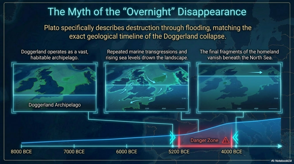
Plato does not describe Atlantis disappearing overnight.

He describes destruction through flooding.

Doggerland vanished over thousands of years through repeated marine transgressions and rising sea levels.


1️⃣5️⃣ The Loss of the Homeland

Eventually, only fragments remained.

Between approximately 5200 and 4200 BCE the final Doggerland archipelago disappeared beneath the North Sea.


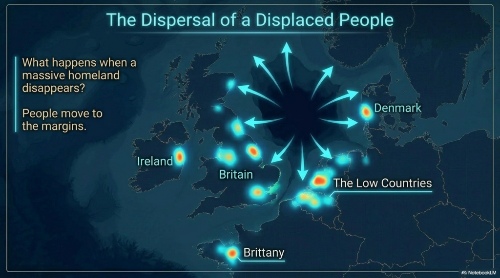
1️⃣6️⃣ Population Dispersal

What happens when a homeland disappears?

People move.

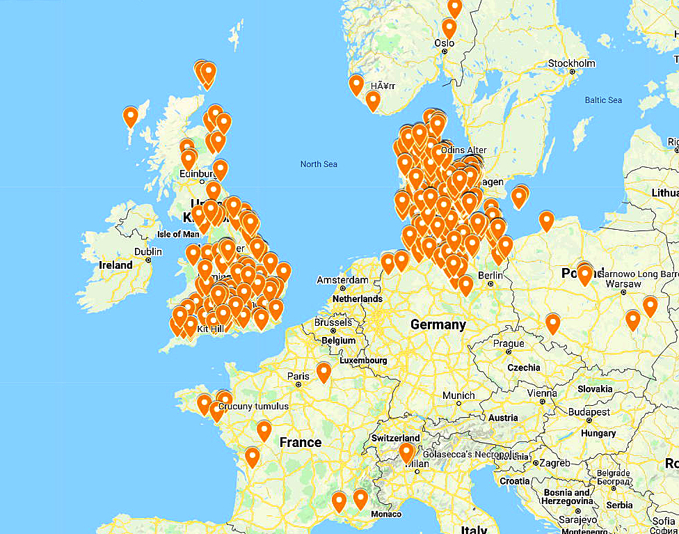
The concentration of megalithic monuments across Britain, Ireland, Brittany, Denmark, and the Low Countries is consistent with populations relocating along the margins of the former basin.


1️⃣7️⃣ Preservation of Memory

Civilisations remember disasters.

Stonehenge Phase 2 may represent the monumentalisation of that memory, transforming an earlier functional system into a permanent stone memorial.


1️⃣8️⃣ Physical Links to the Lost Land

Memory is often preserved through objects.

The Altar Stone may provide a physical connection between Stonehenge and the broader northern landscape associated with Doggerland.


1️⃣9️⃣ A Great Civilisation Remembered

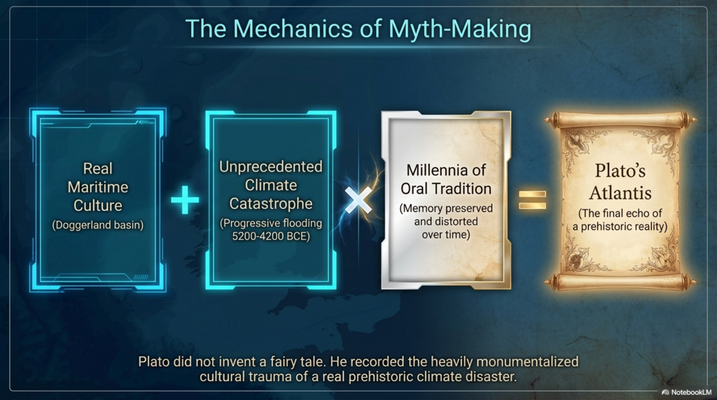
Plato claimed Atlantis survived as a story long after the land itself disappeared.

If a maritime culture occupied Doggerland and its destruction became embedded within oral tradition, Plato’s account may preserve the final echo of a real prehistoric catastrophe.


The Real Question

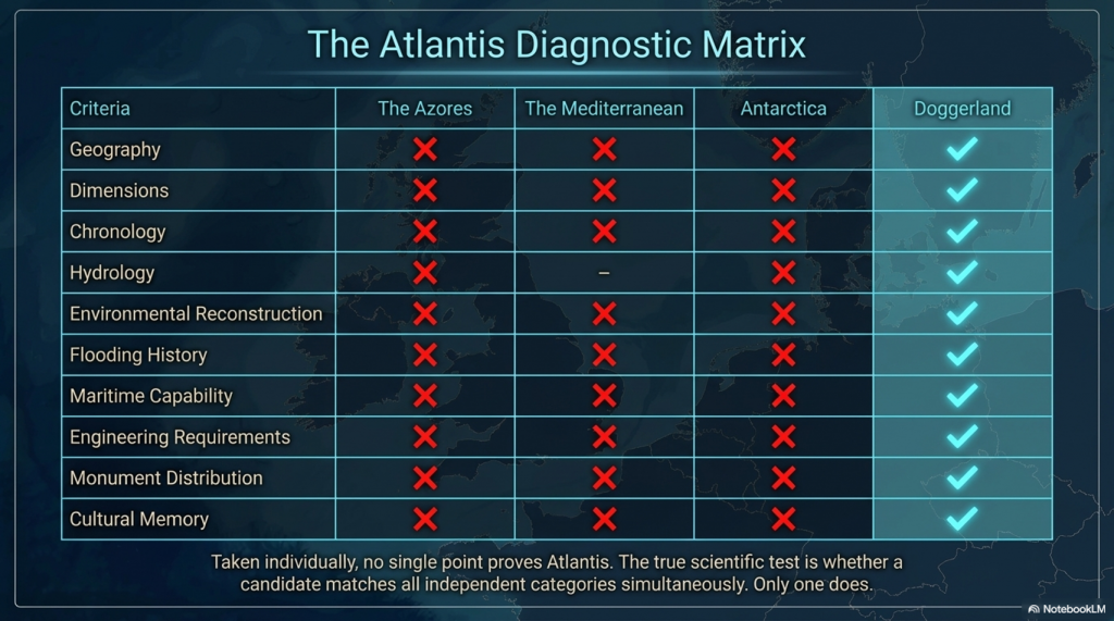
Taken individually, none of these points proves the existence of Atlantis.

But that is not the test.

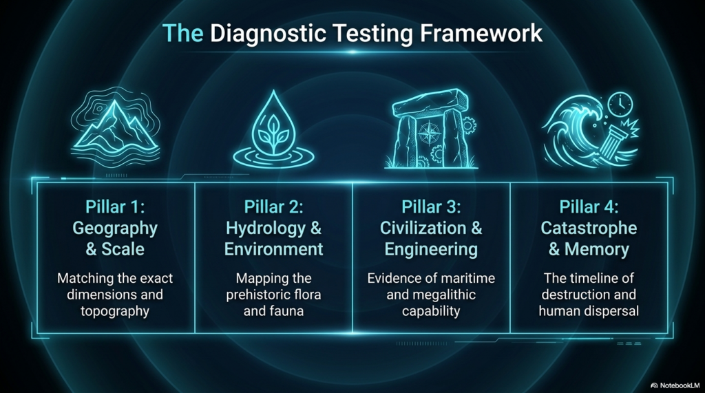
The test is whether any other Atlantis candidate matches so many independent categories simultaneously.

✅ Geography

✅ Dimensions

✅ Chronology

✅ Hydrology

✅ Environmental reconstruction

✅ Flooding history

✅ Maritime capability

✅ Engineering requirements

✅ Monument distribution

✅ Cultural memory

Most Atlantis theories match one or two features.

Doggerland matches nearly all of them.

The question is no longer:

“Could Plato have described a flooded landscape?”

The evidence suggests he probably did.

The real question is:

What other known landscape matches Plato’s description better than Doggerland?

So far, nobody has produced one.


PODCAST

Author’s Biography

Robert John Langdon, a polymathic luminary, emerges as a writer, historian, and eminent specialist in LiDAR Landscape Archaeology.

His intellectual voyage has been interwoven with stints as an astute scrutineer in government and grand corporate bastions, a tapestry spanning British Telecommunications, Cable and Wireless, British Gas, and the esteemed University of London.

A decade hence, Robert’s transition into retirement unfurled a chapter of insatiable curiosity. This phase saw him immerse himself in Politics, Archaeology, Philosophy, and the enigmatic realm of Quantum Mechanics. His academic odyssey traversed the venerable corridors of knowledge hubs such as the Museum of London, University College London, Birkbeck College, The City Literature Institute, and Chichester University.

In the symphony of his life, Robert is a custodian of three progeny and a pair of cherished grandchildren. His sanctuary lies ensconced in the embrace of West Wales, where he inhabits an isolated cottage, its windows framing a vista of the boundless sea – a retreat from the scrutinising gaze of Her Majesty’s Revenue and Customs, an amiable clandestinity in the lap of nature.

Exploring Prehistoric Britain: A Journey Through Time

My blog delves into the fascinating mysteries of prehistoric Britain, challenging conventional narratives and offering fresh perspectives grounded in cutting-edge research, particularly LiDAR technology. I invite you to explore some key areas of my research. For example, the Wansdyke, often cited as a defensive structure, is re-examined in light of new evidence. I’ve presented my findings in my blog post Wansdyke: A British Frontier Wall – ‘Debunked’, and a Wansdyke LiDAR Flyover video further visualises my conclusions.

My work also often challenges established archaeological dogma. I argue that many sites, such as Hambledon Hill, commonly identified as Iron Age hillforts, are not what they seem. My posts Lidar Investigation Hambledon Hill – NOT an ‘Iron Age Fort’ and Unmasking the “Iron Age Hillfort” Myth explore these ideas in detail and offer an alternative view. Similarly, sites like Cissbury Ring and White Sheet Camp receive re-evaluations based on LiDAR analysis in my posts “Lidar Investigation Cissbury Ring through time” and “Lidar Investigation White Sheet Camp,“ revealing fascinating insights into their true purpose. I have also examined South Cadbury Castle, often linked to the mythical Camelot56.

My research also extends to ancient water management, including the role of canals and other linear earthworks. I have discussed the true origins of Car Dyke in multiple posts, including Car Dyke – ABC News Podcast and Lidar Investigation Car Dyke – North Section, which suggest a Mesolithic origin 2357. I also explore the misidentification of Roman aqueducts, as seen in my posts on the Great Chesters (Roman) Aqueduct. My research has also been greatly informed by my post-glacial flooding hypothesis, which has helped explain landscape transformations over time. I have discussed this hypothesis in several posts, including AI now supports my Post-Glacial Flooding Hypothesis and Exploring Britain’s Flooded Past: A Personal Journey

Finally, my blog also investigates prehistoric burial practices, as seen in Prehistoric Burial Practices of Britain and explores the mystery of Pillow Mounds, often mistaken for medieval rabbit warrens, but with a potential link to Bronze Age cremation in my posts: Pillow Mounds: A Bronze Age Legacy of Cremation? and The Mystery of Pillow Mounds: Are They Really Medieval Rabbit Warrens?. My research also includes astronomical insights into ancient sites, for example, in Rediscovering the Winter Solstice: The Original Winter Festival. I also review new information about the construction of Stonehenge in The Stonehenge Enigma.

Further Reading

For those interested in British Prehistory, visit www.prehistoric-britain.co.uk, a comprehensive resource featuring an extensive collection of archaeology articles, modern LiDAR investigations, and groundbreaking research. The site also includes insights and excerpts from the acclaimed Robert John Langdon Trilogy, a series of books that explore Britain during the Prehistoric period. Titles in the trilogy include The Stonehenge Enigma, Dawn of the Lost Civilisation, and The Post-Glacial Flooding Hypothesis, which offer compelling evidence of ancient landscapes shaped by post-glacial flooding.

To further explore these topics, Robert John Langdon has developed a dedicated YouTube channel featuring over 100 video documentaries and investigations that complement the trilogy. Notable discoveries and studies showcased on the channel include 13 Things that Don’t Make Sense in History and the revelation of Silbury Avenue – The Lost Stone Avenue, a rediscovered prehistoric feature at Avebury, Wiltshire.

In addition to his main works, Langdon has released a series of shorter, accessible publications, ideal for readers delving into specific topics. These include:

For active discussions and updates on the trilogy’s findings and recent LiDAR investigations, join our vibrant community on Facebook. Engage with like-minded enthusiasts by leaving a message or contributing to debates in our Facebook Group.

Whether through the books, the website, or interactive videos, we aim to provide a deeper understanding of Britain’s fascinating prehistoric past. We encourage you to explore these resources and uncover the mysteries of ancient landscapes through the lens of modern archaeology.

For more information, including chapter extracts and related publications, visit the Robert John Langdon Author Page. Dive into works such as The Stonehenge Enigma or Dawn of the Lost Civilisation, and explore cutting-edge theories that challenge traditional historical narratives.

Other Blogs

s

t

Stonehenge, Doggerland and Atlantis connection

Introduction

The third book in my trilogy aims to weave together the discoveries made across Britain, with a particular focus on Stonehenge, to shed light on a civilisation that archaeologists have termed the ‘megalithic builders.’ This civilisation is markedly distinct from those that came after, showcasing an extraordinary level of capability and engineering skill in moving vast stones and constructing earthworks that have endured for nearly ten thousand years. These achievements are even more striking when compared to the structures left by the Romans, who occupied these lands for hundreds of years yet left behind fewer enduring monuments. (Stonehenge, Doggerland and Atlantis connection)

Video

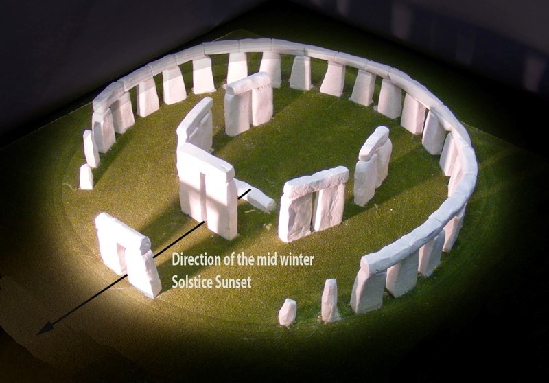
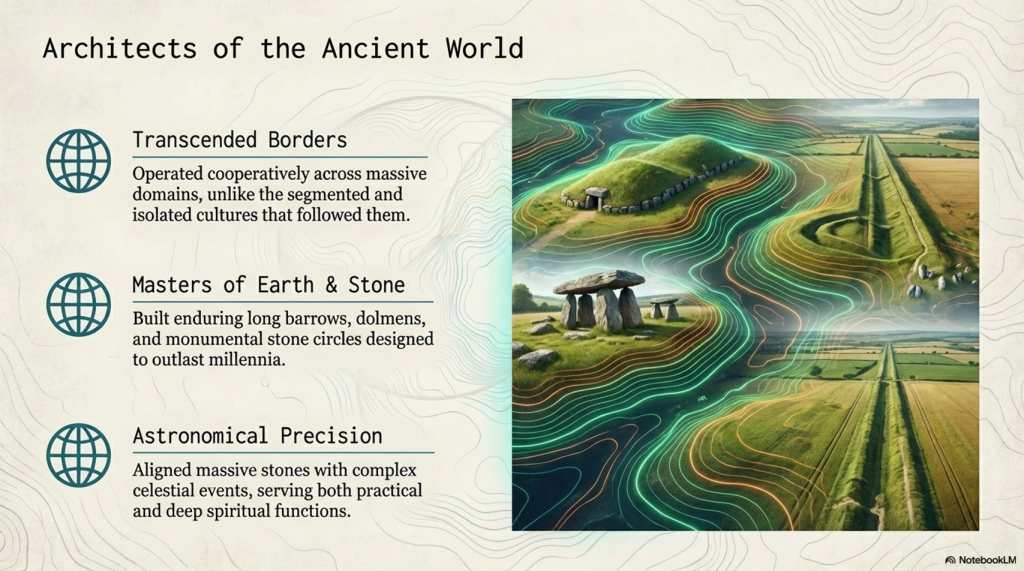
The megalithic builders’ legacy, characterised by iconic structures such as Stonehenge, reveals a sophisticated understanding of both engineering and astronomy. Their ability to align massive stones with celestial events suggests a deep connection to their environment and a complex societal organisation capable of undertaking such monumental projects. This civilisation’s accomplishments in stone construction and earthwork highlight their technical prowess and cultural and spiritual values, as many of these sites are believed to have served practical purposes.

(Stonehenge, Doggerland and Atlantis connection)
Long Barrows of Europe – centred over The North Sea (Doggerland) – (Stonehenge, Doggerland and Atlantis connection)

In writing this third book, I aimed to connect the dots between various megalithic sites across Britain and explore the knowledge, skills, and motivations of the people who built them. By examining the evidence left by the megalithic builders, from the stones they transported and erected to the earthworks they shaped, we can gain insights into a civilisation that continues to fascinate and inspire despite its distance in time.

(Stonehenge, Doggerland and Atlantis connection)

This exploration is an academic exercise and a journey into the heart of a civilisation whose creations still stand as a testament to human ingenuity and perseverance. The megalithic builders may have vanished into the mists of time, but their legacy endures, inviting us to marvel at their achievements and to contemplate our own place in the continuum of human history.

(Stonehenge, Doggerland and Atlantis connection)

The Megalthic Builders

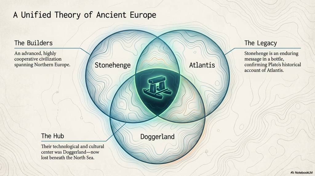
The megalithic builders, a fascinating civilisation from our prehistoric past, operated on a scale and with a level of cooperation that transcends modern conceptions of boundaries and nation-states. Their domain spanned northern Europe, a testament to their widespread influence and shared cultural or technological practices. Unlike the segmented and often isolated cultures that followed, these ancient builders engaged in monumental constructions that served both the living and the dead, creating long barrows and dolmens as eternal resting places and linear earthwork canals and stone trading circles for the living.

(Stonehenge, Doggerland and Atlantis connection)

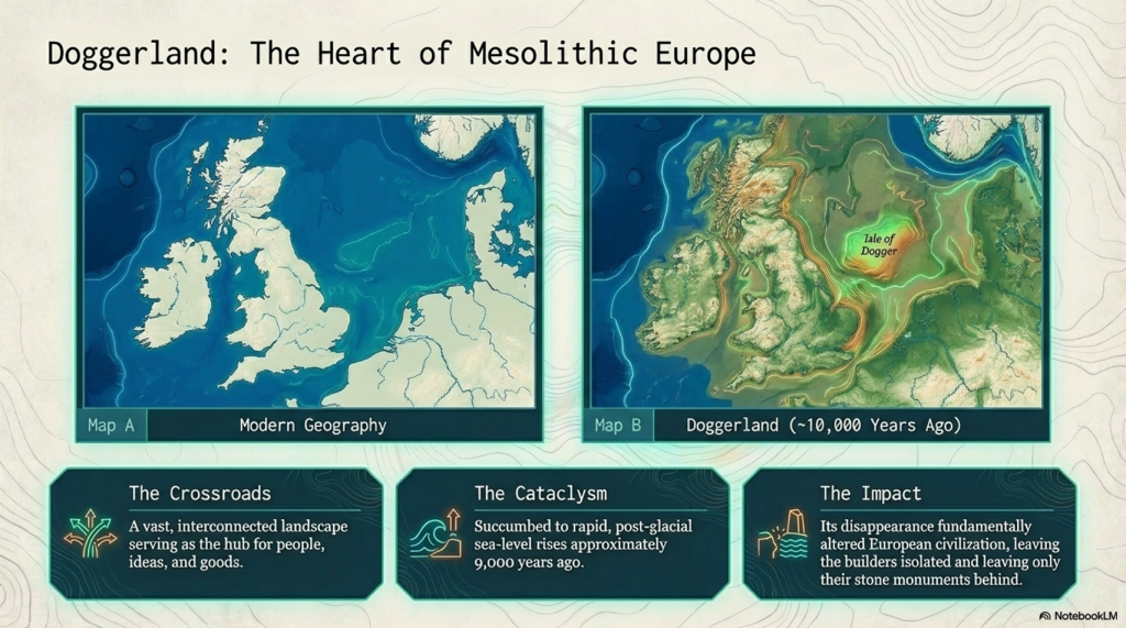
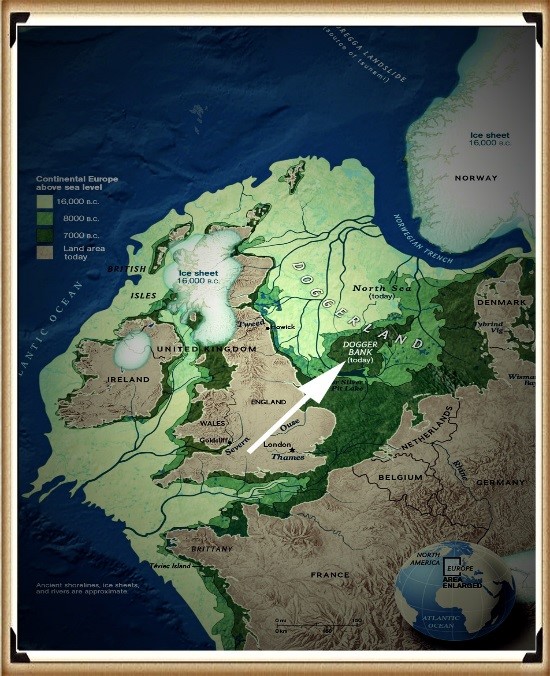
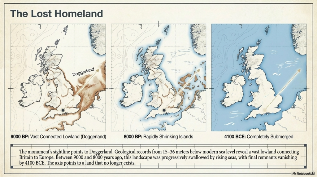
One of the most intriguing aspects of their civilisation is the central role played by an area now submerged beneath the North Sea, known as Doggerland. This now-lost land, which started to succumb to rising sea levels approximately 9,000 years ago, was once a vital part of a massive Mesolithic landscape. Doggerland connected the British Isles to mainland Europe, serving as a crossroads for people, ideas, and goods. The remnants of this landscape, including the Dogger Bank, provide a tantalising glimpse into a world where megalithic builders thrived, interacting with their environment and with one another in sophisticated ways.

Temple to the dead and mid-winter solstice
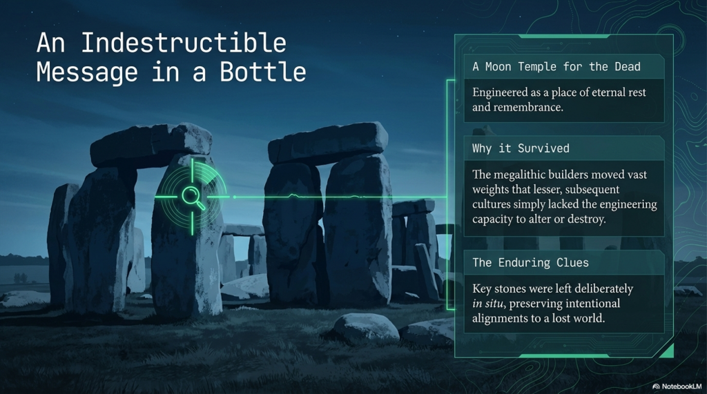
Stonehenge is a moon temple made for the dead – (Stonehenge, Doggerland and Atlantis connection)

The disappearance of Doggerland due to post-glacial sea level rise did not merely result in the loss of land; it marked the end of a significant chapter in human history. This transformation from a vast, interconnected landscape to a series of islands fundamentally altered the trajectory of European civilisation. The megalithic builders’ legacy, however, remains etched in the stone and earthworks that dot the landscape of northern Europe, enduring monuments to their engineering prowess and cosmopolitan outlook.

(Stonehenge, Doggerland and Atlantis connection)

Their achievements compel us to reconsider our understanding of prehistoric societies, challenging us to appreciate the complexity and depth of human ingenuity long before the advent of written history. The megalithic builders remind us that the desire to connect, communicate, and commemorate is a fundamental aspect of the human condition, transcending time, space, and the ever-changing contours of the earth.

The Stonehenge Connection

We can see from their greatest achievement, Stonehenge, a ‘message in a bottle’ that the megalithic builders left us some 5,000 years ago.  Although subsequent civilisations reused and altered aspects of the Stonehenge Monument, some of the most influential stones and structures still survive in situ, owing to the megalithic ability to manoeuvre vast weights, which effectively hindered lesser cultures in their attempts to radically alter the site’s significance.

(Stonehenge, Doggerland and Atlantis connection)

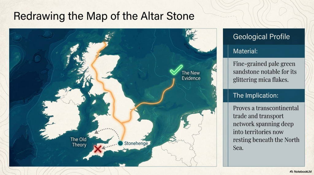
The origins of the Altar Stone at Stonehenge, described by Professor Hawkins as a “fine-grained pale green sandstone” notable for its mica flakes and glitter”, have long been a subject of speculation among experts. The prevailing theories had pointed towards Wales or Devon as the stone’s source. However, recent findings challenge this perspective, suggesting the stone could have originated much farther afield, potentially as far north as Scotland. This revelation aligns with my hypothesis, presented in my book over a decade ago, proposing an even more dramatic provenance for the Altar Stone—not just from the north, but from the northeast, specifically from the submerged landscapes of Doggerland.

Alter Stone recumbent stone - one of just two
The Altar is one of only two recumbents

Doggerland, the now-submerged landmass that once connected the British Isles to mainland Europe, represents a significant part of Mesolithic Europe’s landscape. The suggestion that the Altar Stone might have originated in this ancient, lost territory adds a fascinating layer to our understanding of Stonehenge’s construction. It implies that the builders of Stonehenge not only could transport massive stones over vast distances but also that their network of trade or cultural exchange spanned a far greater area than previously thought, encompassing regions that are now beneath the sea.

(Stonehenge, Doggerland and Atlantis connection)

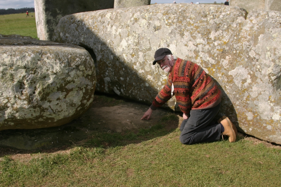
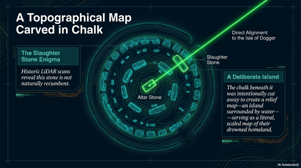
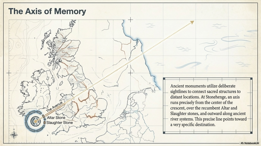
The connection between Doggerland and Stonehenge, particularly through the Altar Stone, hints at a deeply intertwined prehistoric landscape that extends beyond current geographical boundaries. The intriguing alignment from the Altar Stone towards the last vestiges of Doggerland, known as the Isle of Dogger, intersects with another enigmatic feature of Stonehenge: the Slaughter Stone. This stone, distinctively recumbent and partially buried by the surrounding ditch, has long puzzled archaeologists. Its unique position within the Stonehenge complex and the name attributed to it by the Druids suggest a significant ceremonial or symbolic role.

Altar Stone and slaughter stone points to doggerland
Altar Stone and Slaughter Stone align with Doggerland

The deliberate placement of the Slaughter Stone, when considered in relation to the direction towards the remnants of Doggerland, could indicate a symbolic gesture by the builders of Stonehenge, perhaps to commemorate or maintain a connection with their ancestral lands now submerged beneath the North Sea. This alignment and the specific use of stones from distant locations underscore the profound sense of purpose and meaning the Stonehenge builders invested in the site’s construction.

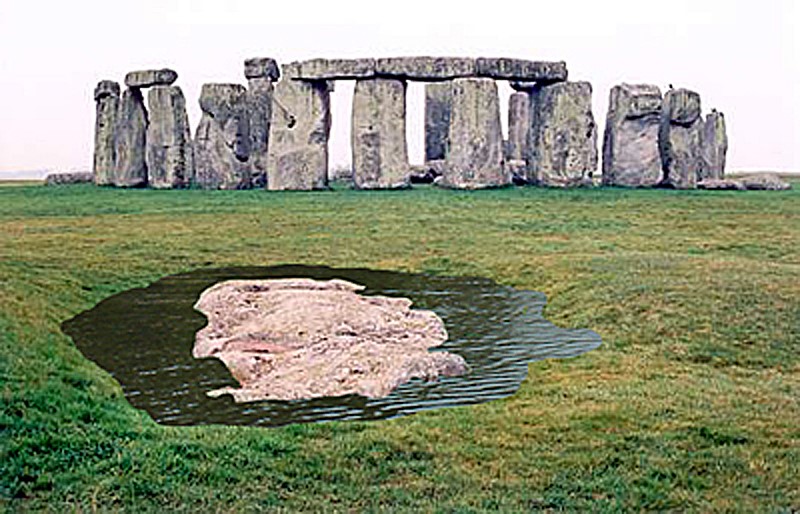
Slaughter stone - burried in shallow ditch of water
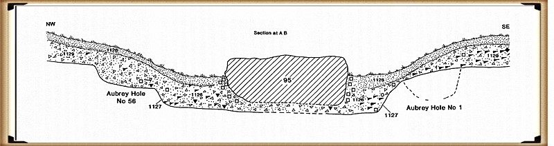
The chalk under the Slaugher stone was cut away for a purpose

These potential connections to Doggerland not only expand our understanding of Stonehenge’s geographical and cultural significance but also invite us to consider the broader networks of communication, travel, and exchange that existed in prehistoric Europe. The use of stones from such distant sources and the possible alignments with lost lands hint at an intricate web of relationships and a deep historical consciousness among the people who constructed Stonehenge.

(Stonehenge, Doggerland and Atlantis connection)

As we continue to unravel the mysteries of Stonehenge and its stones, the importance of considering wider landscapes and connections becomes clear. The potential links to Doggerland offer a tantalising glimpse into the minds of the megalithic builders, revealing a world where memory, landscape, and the movement of materials were intimately connected. These insights challenge us to look beyond the immediate vicinity of prehistoric monuments and to consider the vast, now-hidden landscapes that were once integral to the lives and beliefs of ancient peoples.

Slaughter Stone - a relief map of doggerland
The Slaughrer stone is in fact a relief map (found after a HE scan) and not natural – the ground has been removed so to create an island surrounded by water

This hypothesis challenges the conventional archaeological narrative and suggests a level of sophistication and reach in prehistoric societies that is only now being understood. It underscores the importance of reconsidering and expanding our investigation into the origins and connections of the materials and people involved in creating monumental structures like Stonehenge. As we continue to uncover more about these ancient builders, their methods, and their world, it becomes increasingly clear that their achievements were far more complex and interconnected than once imagined, bridging lands now separated by waters but once part of a vast, interconnected landscape.

The Atlantis Connection

The completion of the quest to pinpoint the homeland of the megalithic builders marks a significant milestone in our understanding of this remarkable civilisation. The evidence of their extraordinary engineering achievements, from constructing monumental stone structures like Stonehenge to creating extensive earthworks such as Silbury Hill, underscores the sophistication and capabilities of these ancient architects and engineers. Without the modern machinery and technology we rely on today, their achievements in construction speak to a profound understanding of their environment and a remarkable ability to manipulate natural materials to their will.

(Stonehenge, Doggerland and Atlantis connection)

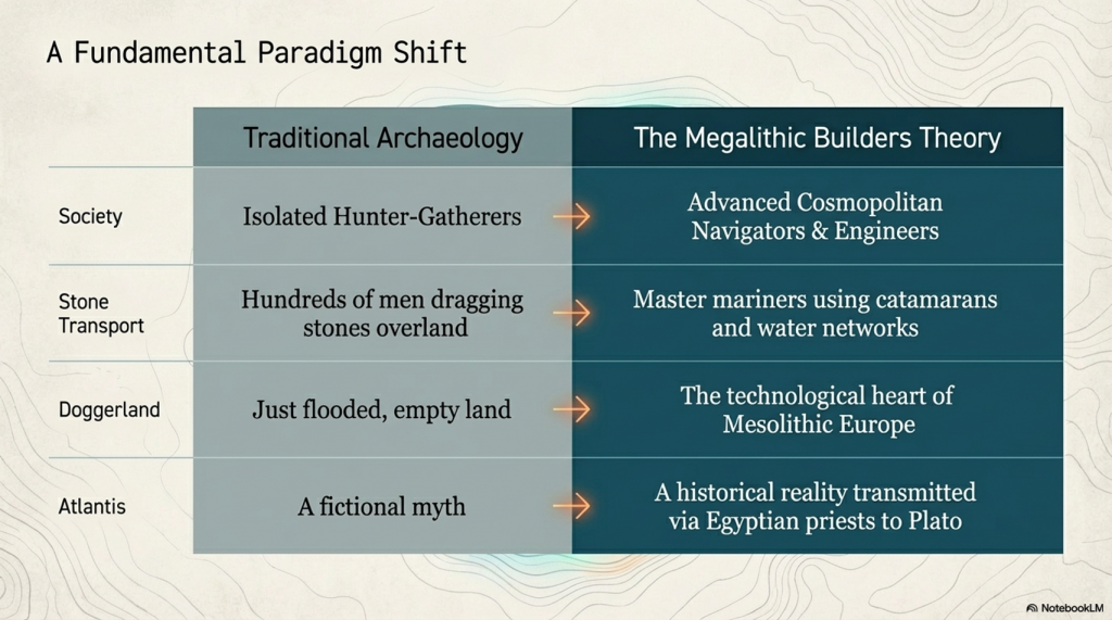
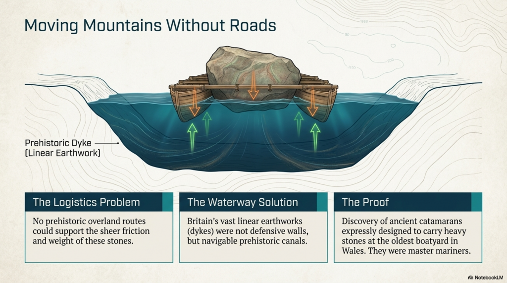
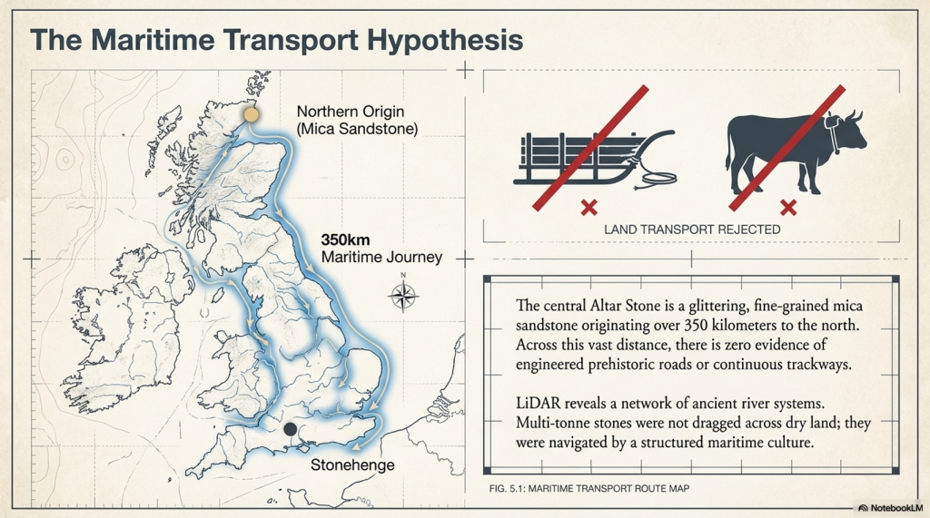
Given the scale of their constructions and the distances over which materials, such as the stones used in megaliths, were transported, it becomes clear that these builders possessed sophisticated transportation methods. The absence of roads for moving such massive stones over vast distances suggests that ships and boats were essential to their way of life. Waterways would have served as the arteries of trade, travel, and communication, connecting distant communities and facilitating the exchange of goods, ideas, and cultural practices across Europe.

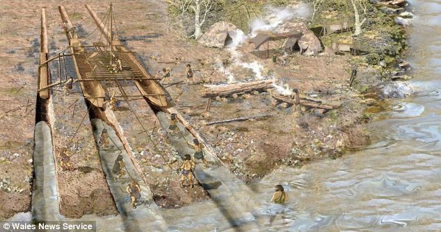
Wales oldest Boat Yard
We have found prehistoric Catamarans made to carry stones – Wales oldest Boat Yard

This reliance on maritime technology indicates that the megalithic builders were skilled engineers, architects, and adept sailors and navigators. Using boats would have allowed them to traverse prehistoric Europe’s coastal and riverine landscapes, enabling the widespread distribution of their megalithic culture. Such capabilities would have been crucial for orchestrating the large-scale cooperative efforts to construct the monumental stone structures that define their legacy.

(Stonehenge, Doggerland and Atlantis connection)

The comparison with the maritime achievements of the Greeks and Romans, celebrated for their advancements in shipbuilding and navigation, underscores the significance of the megalithic builders’ accomplishments. Their ability to harness the power of water for transportation and communication is a testament to their ingenuity and a critical factor in their success as a civilisation.

(Stonehenge, Doggerland and Atlantis connection)

The megalithic builders’ reliance on maritime technology for movement and communication across Europe highlights a sophisticated understanding of their environment and an unparalleled ability to manipulate it to their advantage. This aspect of their civilisation offers valuable insights into the complexity of prehistoric societies and challenges us to expand our appreciation of their technological and cultural achievements.

Plato

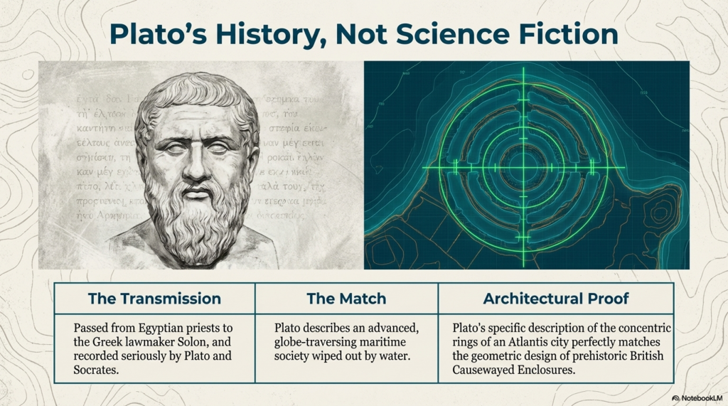
The tale of Atlantis, as recounted by Plato, stands as one of the most captivating stories from antiquity, blurring the line between historical account and mythological narrative. Over time, the story of this advanced civilisation that supposedly sank into the sea around 9,000 years ago has been transformed by modern interpretations and entertainment into something more akin to science fiction. This transformation has, unfortunately, obscured the significance of Plato’s account, relegating it to the realm of mere fantasy in the eyes of many.

Plato

Plato, a philosopher of unparalleled influence in Western thought, presented the story of Atlantis not as a myth but as a recounting of historical fact told to him by Solon, who had learned it from Egyptian priests. According to the narrative, Atlantis was a civilisation of great power and technological prowess, with ships that traversed the globe and a highly advanced society.

(Stonehenge, Doggerland and Atlantis connection)

The comparison between the story of Atlantis and the archaeological evidence of Doggerland and the megalithic builders is striking. Like the Atlanteans, the people of Doggerland, who lived around 10,000 years ago, exhibited advanced capabilities, particularly in maritime technology. They built monumental structures and possessed the knowledge to navigate and sail to distant lands. This evidence challenges the prevailing academic view of prehistoric societies as simplistic hunter-gatherer tribes and aligns with Plato’s description of Atlantis as a great and advanced civilisation.

Stonehenge Debunked

Moreover, the presence of notable figures such as Solon, a key figure in the development of democracy in ancient Greece, and Socrates, celebrated for his wisdom, in the dialogues discussing Atlantis, lends credibility to the account. Their involvement suggests that the story was taken seriously by some of the most respected thinkers of the time, who did not dismiss it as mere fiction.

Some academics’ reluctance to accept the possibility of advanced prehistoric civilisations is perhaps understandable, given the scarcity of direct archaeological evidence and the challenge of separating historical fact from myth. However, the megalithic stones and the submerged landscapes of Doggerland offer tangible links to a past that may have been far more complex and interconnected than previously acknowledged.

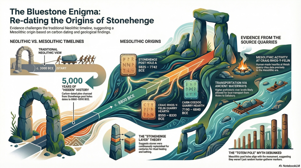
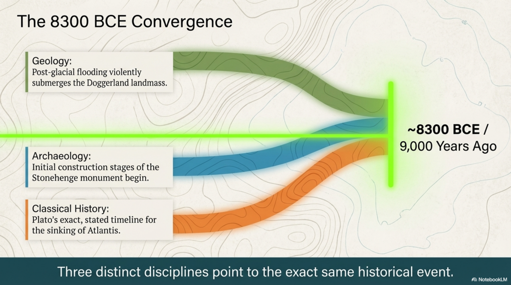
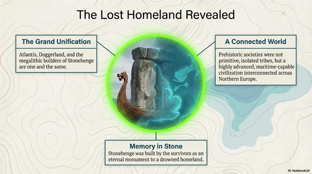
The possible connection between Doggerland, the story of Atlantis told by Plato, and the initial stages of Stonehenge’s construction around 8300 BCE suggests that these ancient events might be related or share a common origin. Dating the beginning of Stonehenge to such an early era aligns with the timeline of Plato’s Atlantean civilisation, suggesting a potential connection or shared features between the Stonehenge builders and the advanced society described in the Atlantis legend.

(Stonehenge, Doggerland and Atlantis connection)

This theory challenges commonly accepted beliefs about the achievements and timelines of prehistoric humans. It suggests that Stonehenge, a monument that has fascinated scholars and visitors for centuries, might have originated during the same period as the legendary civilisation of Atlantis. This discovery prompts a reassessment of human activities during the Mesolithic period.

It is possible to imagine a prehistoric world where societies were not only technologically advanced but also well-connected across vast distances, given the architectural complexity and navigational skills demonstrated in the stories of these civilisations. The hypothesis that the megalithic builders, who were capable of maritime travel and of constructing monumental structures like Stonehenge, might have shared a cultural or historical link with the Atlanteans adds depth to the narrative of human history during the Mesolithic era.

This viewpoint emphasises a more inclusive and transparent approach to archaeology, emphasising the significance of sustained inquiry and the readiness to question conventional historical accounts. With the emergence of new findings challenging long-standing assumptions, the links among Doggerland, Atlantis, and Stonehenge exemplify the intricate and multifaceted nature of early human civilisation’s accomplishments.

Plato’s description of an Atlantis city fits the design of Causewayed Enclosures

PodCast

Author’s Biography

Robert John Langdon, a polymathic luminary, emerges as a writer, historian, and eminent specialist in LiDAR Landscape Archaeology.

His intellectual voyage has been interwoven with stints as an astute scrutineer in government and grand corporate bastions, a tapestry spanning British Telecommunications, Cable and Wireless, British Gas, and the esteemed University of London.

A decade hence, Robert’s transition into retirement unfurled a chapter of insatiable curiosity. This phase saw him immerse himself in Politics, Archaeology, Philosophy, and the enigmatic realm of Quantum Mechanics. His academic odyssey traversed the venerable corridors of knowledge hubs such as the Museum of London, University College London, Birkbeck College, The City Literature Institute, and Chichester University.

In the symphony of his life, Robert is a custodian of three progeny and a pair of cherished grandchildren. His sanctuary lies ensconced in the embrace of West Wales, where he inhabits an isolated cottage, its windows framing a vista of the boundless sea – a retreat from the scrutinising gaze of Her Majesty’s Revenue and Customs, an amiable clandestinity in the lap of nature.

Exploring Prehistoric Britain: A Journey Through Time

My blog delves into the fascinating mysteries of prehistoric Britain, challenging conventional narratives and offering fresh perspectives grounded in cutting-edge research, particularly LiDAR technology. I invite you to explore some key areas of my research. For example, the Wansdyke, often cited as a defensive structure, is re-examined in light of new evidence. I’ve presented my findings in my blog post Wansdyke: A British Frontier Wall – ‘Debunked’, and a Wansdyke LiDAR Flyover video further visualises my conclusions.

My work also often challenges established archaeological dogma. I argue that many sites, such as Hambledon Hill, commonly identified as Iron Age hillforts, are not what they seem. My posts Lidar Investigation Hambledon Hill – NOT an ‘Iron Age Fort’ and Unmasking the “Iron Age Hillfort” Myth explore these ideas in detail and offer an alternative view. Similarly, sites like Cissbury Ring and White Sheet Camp receive re-evaluations based on LiDAR analysis in my posts “Lidar Investigation Cissbury Ring through time” and “Lidar Investigation White Sheet Camp,“ revealing fascinating insights into their true purpose. I have also examined South Cadbury Castle, often linked to the mythical Camelot56.

My research also extends to ancient water management, including the role of canals and other linear earthworks. I have discussed the true origins of Car Dyke in multiple posts, including Car Dyke – ABC News Podcast and Lidar Investigation Car Dyke – North Section, which suggest a Mesolithic origin 2357. I also explore the misidentification of Roman aqueducts, as seen in my posts on the Great Chesters (Roman) Aqueduct. My research has also been greatly informed by my post-glacial flooding hypothesis, which has helped explain landscape transformations over time. I have discussed this hypothesis in several posts, including AI now supports my Post-Glacial Flooding Hypothesis and Exploring Britain’s Flooded Past: A Personal Journey

Finally, my blog also investigates prehistoric burial practices, as seen in Prehistoric Burial Practices of Britain and explores the mystery of Pillow Mounds, often mistaken for medieval rabbit warrens, but with a potential link to Bronze Age cremation in my posts: Pillow Mounds: A Bronze Age Legacy of Cremation? and The Mystery of Pillow Mounds: Are They Really Medieval Rabbit Warrens?. My research also includes astronomical insights into ancient sites, for example, in Rediscovering the Winter Solstice: The Original Winter Festival. I also review new information about the construction of Stonehenge in The Stonehenge Enigma.

Further Reading

For those interested in British Prehistory, visit www.prehistoric-britain.co.uk, a comprehensive resource featuring an extensive collection of archaeology articles, modern LiDAR investigations, and groundbreaking research. The site also includes insights and excerpts from the acclaimed Robert John Langdon Trilogy, a series of books that explore Britain during the Prehistoric period. Titles in the trilogy include The Stonehenge Enigma, Dawn of the Lost Civilisation, and The Post-Glacial Flooding Hypothesis, which offer compelling evidence of ancient landscapes shaped by post-glacial flooding.

To further explore these topics, Robert John Langdon has developed a dedicated YouTube channel featuring over 100 video documentaries and investigations that complement the trilogy. Notable discoveries and studies showcased on the channel include 13 Things that Don’t Make Sense in History and the revelation of Silbury Avenue – The Lost Stone Avenue, a rediscovered prehistoric feature at Avebury, Wiltshire.

In addition to his main works, Langdon has released a series of shorter, accessible publications, ideal for readers delving into specific topics. These include:

For active discussions and updates on the trilogy’s findings and recent LiDAR investigations, join our vibrant community on Facebook. Engage with like-minded enthusiasts by leaving a message or contributing to debates in our Facebook Group.

Whether through the books, the website, or interactive videos, we aim to provide a deeper understanding of Britain’s fascinating prehistoric past. We encourage you to explore these resources and uncover the mysteries of ancient landscapes through the lens of modern archaeology.

For more information, including chapter extracts and related publications, visit the Robert John Langdon Author Page. Dive into works such as The Stonehenge Enigma or Dawn of the Lost Civilisation, and explore cutting-edge theories that challenge traditional historical narratives.

Other Blogs

s

t

The Stonehenge Crescent: A Monument to a Lost World

A Monument to the Dead — Not the Sun

One of the most recognisable images in archaeology is that of a perfect circular Stonehenge — a continuous ring of upright stones capped with lintels. (The Stonehenge Crescent: A Monument to a Lost World)

You’ve seen it everywhere:

  • Textbooks
  • Reconstructions
  • Documentaries

It has become the accepted version of the monument.

There is just one problem.

Stonehenge was never built that way.

(The Stonehenge Crescent: A Monument to a Lost World)

The Myth of the Perfect Circle

The circular Stonehenge exists more in illustration than in reality.

When we examine the monument itself, the physical evidence tells a very different story:

  • Several stones required to complete the circle are missing
  • Others are too small to support lintels
  • Some are incorrectly positioned for a continuous ring
  • Stone holes reveal uprights that do not conform to a circular design

This creates a fundamental contradiction.

If Stonehenge was intended to be a perfect solar temple, then:

  1. It was never completed
  2. Or it was deliberately dismantled

Both explanations are unsatisfactory.

There is a far simpler solution.

It was never meant to be a complete circle.

(The Stonehenge Crescent: A Monument to a Lost World)

Structural Proof: Stone 11 Breaks the Model

This conclusion is not just interpretive — it is structural.

One stone alone exposes the flaw in the circular theory.

Stone 11.

This stone is:

  • Smaller than its neighbours
  • Structurally inadequate
  • Incapable of supporting a lintel

This is critical.

A continuous lintel ring requires every upright to meet a basic engineering condition:

It must support load.

Stone 11 cannot.

This is not a minor anomaly. It is a mechanical failure within the supposed design.

There are only two possible explanations:

  • The builders made a fundamental structural mistake
  • The circle was never intended to be continuous

Given the precision elsewhere in the monument, the first option is highly unlikely.

Which leaves only one conclusion:

Stone 11 is not an error — it is evidence.

It proves that the monument was never designed as a complete ring.

(The Stonehenge Crescent: A Monument to a Lost World)

A Different Shape Emerges

When we examine all surviving stones and stone holes together, a new pattern appears.

Not a circle.

A crescent.

The Sarsen arrangement — particularly the inner trilithon horseshoe — reinforces this, forming a crescent within a crescent.

This is deliberate.

And its orientation matters.

(The Stonehenge Crescent: A Monument to a Lost World)

Death, Not the Sun

Across ancient cultures:

  • The sun represents life and continuity
  • The circle reflects that — endless and complete

But death is different.

Death is transition.

And that transition is often symbolised by the crescent moon — a passage between darkness and renewal.

Stonehenge aligns with this symbolism precisely.

The structure faces the Winter Solstice sunset:

  • The lowest point of the sun
  • The moment of greatest darkness
  • The turning point before light returns

This is not a monument to life.

It is a monument to transition.

(The Stonehenge Crescent: A Monument to a Lost World)

The Missing Stones Tell the Story

The pattern of missing stones strengthens this interpretation.

If stones had been removed later, we would expect:

  • Random distribution
  • Removal from accessible locations

But instead:

  • The majority of missing stones occur in the south-western quadrant
  • This is the least accessible area

This is not random.

It is intentional.

The monument was designed to be open in this direction — forming a crescent aligned with the Winter Solstice sunset.

(The Stonehenge Crescent: A Monument to a Lost World)

The Altar Stone and the Slaughter Stone

At the centre of the monument lies the Altar Stone:

  • Fine-grained sandstone
  • Rich in mica
  • Distinct from all other stones

It is also placed flat.

This is unusual — but not unique.

Near the entrance lies the Slaughter Stone, also recumbent.

Excavations in the 1920s showed:

  • The chalk beneath it was deliberately levelled
  • It was always intended to lie flat

Even more importantly:

  • It sits in a shallow depression
  • Connected to the ditch system
  • Likely water-filled under higher groundwater conditions

This would have made the stone appear as a small island in water.

(The Stonehenge Crescent: A Monument to a Lost World)

A Monument Built in Water

This aligns directly with the hydrological model of early Holocene Britain.

Evidence shows that:

  • Water tables were significantly higher
  • River systems were larger
  • Floodplains dominated the landscape

Stonehenge was not a dry site.

It existed within a water-controlled environment

(The Stonehenge Crescent: A Monument to a Lost World)

The Altar Stone: A Geological Clue

The Altar Stone introduces another layer of evidence.

It is widely accepted that:

  • It originates from outside the local region
  • It travelled over long distances

Traditional explanations suggest land transport.

But there is a problem.

Across hundreds of kilometres:

  • No prehistoric roads
  • No engineered trackways
  • No infrastructure for overland movement

What we do find is:

  • Extensive river systems
  • Floodplains
  • Palaeochannels

The conclusion is straightforward:

The stones were transported by water.

(The Stonehenge Crescent: A Monument to a Lost World)

The Doggerland Origin Hypothesis

There is an additional, often overlooked possibility.

The geological composition of the Altar Stone matches:

  • Bedrock found in northern Britain
  • And bedrock mapped beneath the North Sea

This is critical.

Because during the early Holocene:

  • The North Sea was not fully submerged
  • It was a vast landmass

Doggerland.

If the Altar Stone originated from this region, then:

  • It was not just transported across distance
  • It was brought from a landscape that no longer exists
(The Stonehenge Crescent: A Monument to a Lost World)

A Lost Source Beneath the Sea

Geological evidence shows that Doggerland:

  • Contained exposed bedrock
  • Shared lithological characteristics with the Altar Stone
  • Was progressively flooded between ~9000 and 8000 years ago

This reframes the stone completely.

It is no longer just imported material.

It becomes:

a fragment of a lost homeland.

(The Stonehenge Crescent: A Monument to a Lost World)

A Deliberate Sightline

The Altar Stone and Slaughter Stone form a direct alignment:

  • From the centre
  • Through the entrance
  • Along the Avenue
  • Toward the ancient river system

When extended beyond the monument, this line points toward:

Doggerland.

This is not coincidence.

Ancient monuments frequently connect:

  • Structure
  • Landscape
  • Memory

Stonehenge does all three.

(The Stonehenge Crescent: A Monument to a Lost World)

A Monument Built from Memory

When combined:

  • Crescent design
  • Solstice alignment
  • Directional sightline
  • Geological connection

The interpretation becomes clear.

Stonehenge is not simply pointing toward a lost world.

It may contain material from it.

(The Stonehenge Crescent: A Monument to a Lost World)

The Hidden Interior: Stonehenge as a Painted Space

There is another overlooked feature.

The inner faces of the Sarsen stones are flattened.

This required:

  • Significant labour
  • Controlled shaping
  • Time investment across multiple stones

This was not done casually.

It was done for a reason.

(The Stonehenge Crescent: A Monument to a Lost World)

The Effort Behind the Surfaces

Flattening stone with prehistoric tools would have taken:

  • Weeks per stone
  • Possibly months across the structure

Prehistoric societies do not waste effort.

Every action has purpose.

These surfaces were prepared for something important.

(The Stonehenge Crescent: A Monument to a Lost World)

A Cultural Memory Lost

Before the Ice Age, the ancestors of these builders created:

  • Complex cave art
  • Symbolic imagery
  • Advanced visual culture

After this period, the art seems to disappear.

But it didn’t.

The medium changed

(The Stonehenge Crescent: A Monument to a Lost World)

The Missing Medium

We know:

  • Pigments were used
  • Bodies were painted
  • Symbolism was central

But open-air artwork does not survive:

  • Rain erodes it
  • Sunlight fades it
  • Time destroys it

Over 10,000 years, it vanishes.

(The Stonehenge Crescent: A Monument to a Lost World)

Stonehenge as an Art Space

Now reconsider the monument:

  • Flattened inner stone surfaces
  • Enclosed space
  • Controlled environment

These are perfect conditions for:

painting

(The Stonehenge Crescent: A Monument to a Lost World)

A Prehistoric Gallery

Instead of bare stone, imagine:

  • Painted surfaces
  • Symbolic imagery
  • Cultural storytelling
  • Ancestral representation

Stonehenge becomes:

a sacred visual environment


From Cold Stone to Living Culture

What we see today:

  • Weathered stone
  • Empty surfaces
  • Structural remains

What once existed:

  • Colour
  • Meaning
  • Cultural expression

Not a ruin.

But a gallery of memory and identity.

(The Stonehenge Crescent: A Monument to a Lost World)

A Memorial to a Lost World

When all evidence is combined:

  • The crescent form reflects death
  • The solstice alignment marks transition
  • The sightline points toward Doggerland
  • The Altar Stone may originate from that drowned land
  • The interior may have been painted with cultural memory

The meaning becomes clear.

Stonehenge is not a solar temple.

It is a memorial.

(The Stonehenge Crescent: A Monument to a Lost World)

Final Conclusion

Stonehenge was not built to mark the movement of the sun.

It was built to remember.

To record a moment in human history when:

  • A landscape was lost
  • A homeland disappeared
  • A civilisation adapted

The stones do not just stand.

They point.

They align.

They remember.

And once you remove the myth of the circle, the monument finally makes sense.

Stonehenge was never a circle.
It was a message.

(The Stonehenge Crescent: A Monument to a Lost World)

PodCast

Author’s Biography

Robert John Langdon, a polymathic luminary, emerges as a writer, historian, and eminent specialist in LiDAR Landscape Archaeology.

His intellectual voyage has been interwoven with stints as an astute scrutineer in government and grand corporate bastions, a tapestry spanning British Telecommunications, Cable and Wireless, British Gas, and the esteemed University of London.

A decade hence, Robert’s transition into retirement unfurled a chapter of insatiable curiosity. This phase saw him immerse himself in Politics, Archaeology, Philosophy, and the enigmatic realm of Quantum Mechanics. His academic odyssey traversed the venerable corridors of knowledge hubs such as the Museum of London, University College London, Birkbeck College, The City Literature Institute, and Chichester University.

In the symphony of his life, Robert is a custodian of three progeny and a pair of cherished grandchildren. His sanctuary lies ensconced in the embrace of West Wales, where he inhabits an isolated cottage, its windows framing a vista of the boundless sea – a retreat from the scrutinising gaze of Her Majesty’s Revenue and Customs, an amiable clandestinity in the lap of nature.

Exploring Prehistoric Britain: A Journey Through Time

My blog delves into the fascinating mysteries of prehistoric Britain, challenging conventional narratives and offering fresh perspectives grounded in cutting-edge research, particularly LiDAR technology. I invite you to explore some key areas of my research. For example, the Wansdyke, often cited as a defensive structure, is re-examined in light of new evidence. I’ve presented my findings in my blog post Wansdyke: A British Frontier Wall – ‘Debunked’, and a Wansdyke LiDAR Flyover video further visualises my conclusions.

My work also often challenges established archaeological dogma. I argue that many sites, such as Hambledon Hill, commonly identified as Iron Age hillforts, are not what they seem. My posts Lidar Investigation Hambledon Hill – NOT an ‘Iron Age Fort’ and Unmasking the “Iron Age Hillfort” Myth explore these ideas in detail and offer an alternative view. Similarly, sites like Cissbury Ring and White Sheet Camp receive re-evaluations based on LiDAR analysis in my posts “Lidar Investigation Cissbury Ring through time” and “Lidar Investigation White Sheet Camp,“ revealing fascinating insights into their true purpose. I have also examined South Cadbury Castle, often linked to the mythical Camelot56.

My research also extends to ancient water management, including the role of canals and other linear earthworks. I have discussed the true origins of Car Dyke in multiple posts, including Car Dyke – ABC News Podcast and Lidar Investigation Car Dyke – North Section, which suggest a Mesolithic origin 2357. I also explore the misidentification of Roman aqueducts, as seen in my posts on the Great Chesters (Roman) Aqueduct. My research has also been greatly informed by my post-glacial flooding hypothesis, which has helped explain landscape transformations over time. I have discussed this hypothesis in several posts, including AI now supports my Post-Glacial Flooding Hypothesis and Exploring Britain’s Flooded Past: A Personal Journey

Finally, my blog also investigates prehistoric burial practices, as seen in Prehistoric Burial Practices of Britain and explores the mystery of Pillow Mounds, often mistaken for medieval rabbit warrens, but with a potential link to Bronze Age cremation in my posts: Pillow Mounds: A Bronze Age Legacy of Cremation? and The Mystery of Pillow Mounds: Are They Really Medieval Rabbit Warrens?. My research also includes astronomical insights into ancient sites, for example, in Rediscovering the Winter Solstice: The Original Winter Festival. I also review new information about the construction of Stonehenge in The Stonehenge Enigma.

Further Reading

For those interested in British Prehistory, visit www.prehistoric-britain.co.uk, a comprehensive resource featuring an extensive collection of archaeology articles, modern LiDAR investigations, and groundbreaking research. The site also includes insights and excerpts from the acclaimed Robert John Langdon Trilogy, a series of books that explore Britain during the Prehistoric period. Titles in the trilogy include The Stonehenge Enigma, Dawn of the Lost Civilisation, and The Post-Glacial Flooding Hypothesis, which offer compelling evidence of ancient landscapes shaped by post-glacial flooding.

To further explore these topics, Robert John Langdon has developed a dedicated YouTube channel featuring over 100 video documentaries and investigations that complement the trilogy. Notable discoveries and studies showcased on the channel include 13 Things that Don’t Make Sense in History and the revelation of Silbury Avenue – The Lost Stone Avenue, a rediscovered prehistoric feature at Avebury, Wiltshire.

In addition to his main works, Langdon has released a series of shorter, accessible publications, ideal for readers delving into specific topics. These include:

For active discussions and updates on the trilogy’s findings and recent LiDAR investigations, join our vibrant community on Facebook. Engage with like-minded enthusiasts by leaving a message or contributing to debates in our Facebook Group.

Whether through the books, the website, or interactive videos, we aim to provide a deeper understanding of Britain’s fascinating prehistoric past. We encourage you to explore these resources and uncover the mysteries of ancient landscapes through the lens of modern archaeology.

For more information, including chapter extracts and related publications, visit the Robert John Langdon Author Page. Dive into works such as The Stonehenge Enigma or Dawn of the Lost Civilisation, and explore cutting-edge theories that challenge traditional historical narratives.

Other Blogs

s

t

The Troy, Hyperborea and Atlantis Connection

Introduction

The connections between the legends of Atlantis and Hyperborea and the works of Homer represent a fascinating intersection of myth, philosophy, and epic narrative in ancient Greek literature. These stories not only provide insights into the Greeks’ geographical and cultural understanding but also reflect deeper philosophical and ethical concerns that permeate Greek thought. Below, we explore these themes in greater detail, delving into how these mythical and literary works intertwine and what they signify about ancient Greek civilisation. (The Troy, Hyperborea and Atlantis Connection)

 (The Troy, Hyperborea and Atlantis Connection)
(The Troy, Hyperborea and Atlantis Connection)

Homer’s Influence and the Greek Mythical Landscape

Homer’s literary works, namely the “Iliad” and the “Odyssey,” are of great importance in ancient Greek literature. These works provide a multifaceted depiction of heroism, divine intervention, and the human condition. It’s important to note that these epic stories are not standalone, but are part of a larger collection of Greek mythology that includes legends about Atlantis and Hyperborea. Although Homer doesn’t directly mention these myths, his themes of heroism, the impact of divine will, and the imperfection of humanity provide a foundation for later philosophical explorations by scholars such as Plato.

Geographical and Mythological Explorations

Homer’s epics describe real and mythical locations, which expand the boundaries of the Greek world and beyond. These places often blend factual geography with fantastical elements, creating a world full of possibilities and dangers that reflect the Greeks’ curious and exploratory nature.

 (The Troy, Hyperborea and Atlantis Connection)
(The Troy, Hyperborea and Atlantis Connection)

Similarly, Atlantis and Hyperborea are described as lands at the margins of the known world. Plato’s Atlantis, as mentioned in his dialogues “Timaeus” and “Critias,” is a powerful island nation beyond the Pillars of Hercules, rich in resources but doomed by its moral failings. Hyperborea, mentioned in sources such as Herodotus and later Greek lore, is portrayed as a northern paradise, untouched by war or disease, where people live exceptionally long lives in peace—a stark contrast to the often brutal world depicted by Homer.

 (The Troy, Hyperborea and Atlantis Connection)
(The Troy, Hyperborea and Atlantis Connection)

Themes of Heroism and Hubris

In Homer’s works, heroism plays a central role. Characters are often defined by their bravery, strength, and, sometimes, overconfidence. The gods frequently intervene in these epics, either supporting or hindering heroes based on divine justice or whims. The theme of excessive pride, known as hubris, leading to downfall, is particularly prominent, serving as a moral lesson on the limitations of human ambition.

The story of Atlantis presents a similar theme to this idea. Plato describes a society that starts off living in an idyllic state and enjoying divine favour. However, as Atlantis grows in power and pride, it falls prey to greed and corruption. This ultimately attracts divine wrath, leading to its destruction. This narrative echoes Homeric themes where divine justice ultimately restores the balance disrupted by human arrogance.

 (The Troy, Hyperborea and Atlantis Connection)
(The Troy, Hyperborea and Atlantis Connection)

Divine Favour and Moral Order

The gods play a significant role in human affairs in both Homer’s epics and the tales of Hyperborea and Atlantis. In Homer’s works, the gods are unpredictable and often act on personal motives, reflecting the Greeks’ belief that divine favour is fleeting and must be continually earned through piety and sacrifice.

Compared with other myths, the myths of Hyperborea and Atlantis portray divine favour as initially more stable, yet still requiring adherence to a moral order. Hyperborea is considered a favoured land as long as it remains isolated from the greed and corruption of the outside world. This suggests that societal perfection depends on both geographical isolation and moral purity. In contrast, Atlantis loses its divine favour not because of isolation but because of moral failure. This highlights a philosophical perspective where ethical decay leads to ruin.

 (The Troy, Hyperborea and Atlantis Connection)
(The Troy, Hyperborea and Atlantis Connection)

Literary and Cultural Influence

The ancient Greek myths and narratives not only conveyed historical experiences but also shaped their perceptions of the world and the cosmos. They blended mythological interpretation with reality to teach important lessons of morality, ethics, and human limitations.

Plato’s works “Timaeus” and “Critias” utilise the mythical city of Atlantis as a philosophical allegory to explore the ideal state and the consequences of moral decay. This is an extension of Homeric exploration of heroism and divine justice, but Plato takes it a step further. While Homer focuses on individual fate and divine intervention, Plato broadens the scope to societal destiny, where the collective actions of a society determine its ultimate fate.

 (The Troy, Hyperborea and Atlantis Connection)
(The Troy, Hyperborea and Atlantis Connection)

Conclusion

Let’s stop pretending these are just stories.

The legends of Atlantis and Hyperborea are not abstract myths or philosophical inventions. They are cultural memories—distorted over time, but rooted in real events, real places, and real people.

Plato gives us the key. He states clearly that this lost civilisation existed around 9500 years ago. That date is not negotiable, and it is not symbolic. It lands exactly at the end of the last Ice Age—precisely when the physical evidence shows catastrophic environmental change across north-west Europe.

At that moment in time, Doggerland existed.

And then it didn’t.

We know—measurably—that this landscape was flooded, fragmented, and ultimately destroyed by rising sea levels and sustained hydrological pressure. This is not speculation. It is supported by geological, sea-level, and sedimentary evidence. The land was there, and then it was gone.

Now combine that with archaeology.

 (The Troy, Hyperborea and Atlantis Connection)
(The Troy, Hyperborea and Atlantis Connection)

Stonehenge is no longer explainable as ritual nonsense or symbolic guesswork. When examined properly, it behaves as a functional system—engineered, repeatable, and practical. The so-called “Stonehenge computer” demonstrates predictive capability, environmental integration, and structured design. That is not primitive behaviour. That is applied knowledge.

So we have a date.
We have an event.
And we have a level of capability that matches the description.

This is where the academic narrative collapses.

Because once you accept the timing and the evidence, the conclusion becomes unavoidable:

Atlantis is Doggerland.

 (The Troy, Hyperborea and Atlantis Connection)
(The Troy, Hyperborea and Atlantis Connection)

Hyperborea is the same memory, seen from another direction.

And the “gods” described by the Greeks were not gods at all—they were the survivors of a lost civilisation whose knowledge far exceeded that of the cultures that came after them.

When Doggerland drowned, its people did not disappear. They moved. They carried knowledge of engineering, navigation, landscape, and time—knowledge that later cultures preserved as myth because they no longer understood its origin.

This is why the stories persist.
This is why they are consistent.
And this is why they refuse to go away.

Because they are not fiction.

They are memories.

And once you place them back into their correct context—time, landscape, and physical evidence—the mystery disappears.

What remains is not mythology.

It is history.

PodCast

Author’s Biography

Robert John Langdon, a polymathic luminary, emerges as a writer, historian, and eminent specialist in LiDAR Landscape Archaeology.

His intellectual voyage has been interwoven with stints as an astute scrutineer for governmental realms and grand corporate bastions, a tapestry spanning British Telecommunications, Cable and Wireless, British Gas, and the esteemed University of London.

A decade hence, Robert’s transition into retirement unfurled a chapter of insatiable curiosity. This phase saw him immerse himself in Politics, Archaeology, Philosophy, and the enigmatic realm of Quantum Mechanics. His academic odyssey traversed the venerable corridors of knowledge hubs such as the Museum of London, University College London, Birkbeck College, The City Literature Institute, and Chichester University.

In the symphony of his life, Robert is a custodian of three progeny and a pair of cherished grandchildren. His sanctuary lies ensconced in the embrace of West Wales, where he inhabits an isolated cottage, its windows framing a vista of the boundless sea – a retreat from the scrutinous gaze of Her Majesty’s Revenue and Customs, an amiable clandestinity in the lap of nature’s embrace.

Exploring Prehistoric Britain: A Journey Through Time

My blog delves into the fascinating mysteries of prehistoric Britain, challenging conventional narratives and offering fresh perspectives grounded in cutting-edge research, particularly LiDAR technology. I invite you to explore some key areas of my research. For example, the Wansdyke, often cited as a defensive structure, is re-examined in light of new evidence. I’ve presented my findings in my blog post Wansdyke: A British Frontier Wall – ‘Debunked’, and aWansdyke LiDAR Flyover video further visualises my conclusions.

My work also often challenges established archaeological dogma. I argue that many sites, such as Hambledon Hill, commonly identified as Iron Age hillforts, are not what they seem. My posts Lidar Investigation Hambledon Hill – NOT an ‘Iron Age Fort’ and Unmasking the “Iron Age Hillfort” Myth explore these ideas in detail and offer an alternative view. Similarly, sites like Cissbury Ring and White Sheet Camp also receive a re-evaluation based on LiDAR analysis in my posts “Lidar Investigation Cissbury Ring through time” and “Lidar Investigation White Sheet Camp,“ revealing fascinating insights into their true purpose. I have also examined South Cadbury Castle, often linked to the mythical Camelot56.

My research also extends to ancient water management, including the role of canals and other linear earthworks. I have discussed the true origins of Car Dyke in multiple posts, including Car Dyke – ABC News Podcast and Lidar Investigation Car Dyke – North Section, which suggest a Mesolithic origin 2357. I also explore the misidentification of Roman aqueducts, as seen in my posts on the Great Chesters (Roman) Aqueduct. My research has also been greatly informed by my post-glacial flooding hypothesis, which has helped explain landscape transformations over time. I have discussed this hypothesis in several posts, including AI now supports my Post-Glacial Flooding Hypothesis and Exploring Britain’s Flooded Past: A Personal Journey

Finally, my blog also investigates prehistoric burial practices, as seen in Prehistoric Burial Practices of Britain and explores the mystery of Pillow Mounds, often mistaken for medieval rabbit warrens, but with a potential link to Bronze Age cremation in my posts: Pillow Mounds: A Bronze Age Legacy of Cremation? and The Mystery of Pillow Mounds: Are They Really Medieval Rabbit Warrens?. My research also includes astronomical insights into ancient sites, for example, in Rediscovering the Winter Solstice: The Original Winter Festival. I also review new information about the construction of Stonehenge in The Stonehenge Enigma.

Further Reading

For those interested in British Prehistory, visit www.prehistoric-britain.co.uk, a comprehensive resource featuring an extensive collection of archaeology articles, modern LiDAR investigations, and groundbreaking research. The site also includes insights and excerpts from the acclaimed Robert John Langdon Trilogy, a series of books that explore Britain during the Prehistoric period. Titles in the trilogy include The Stonehenge Enigma, Dawn of the Lost Civilisation, and The Post-Glacial Flooding Hypothesis, which offer compelling evidence of ancient landscapes shaped by post-glacial flooding.

To further explore these topics, Robert John Langdon has developed a dedicated YouTube channel featuring over 100 video documentaries and investigations that complement the trilogy. Notable discoveries and studies showcased on the channel include 13 Things that Don’t Make Sense in History and the revelation of Silbury Avenue – The Lost Stone Avenue, a rediscovered prehistoric feature at Avebury, Wiltshire.

In addition to his main works, Langdon has released a series of shorter, accessible publications, ideal for readers delving into specific topics. These include:

For active discussions and updates on the trilogy’s findings and recent LiDAR investigations, join our vibrant community on Facebook. Engage with like-minded enthusiasts by leaving a message or contributing to debates in our Facebook Group.

Whether through the books, the website, or interactive videos, we aim to provide a deeper understanding of Britain’s fascinating prehistoric past. We encourage you to explore these resources and uncover the mysteries of ancient landscapes through the lens of modern archaeology.

For more information, including chapter extracts and related publications, visit the Robert John Langdon Author Page. Dive into works such as The Stonehenge Enigma or Dawn of the Lost Civilisation, and explore cutting-edge theories that challenge traditional historical narratives.

Other Blogs

s

t

Durrington Walls Revisited: Platforms, Fish Traps, and a Managed Mesolithic Landscape

Introduction

Durrington Walls has long been treated as a problem site. Despite decades of excavation, reinterpretation, and popular retelling, it has never settled comfortably into any single explanatory model. It is alternately described as a village, a ritual aggregation centre, a ceremonial counterpart to Stonehenge, or a symbolic landscape without a clear economic function. Each interpretation resolves one difficulty only by creating several others. The result is a site that is endlessly described, but never fully explained.

At the heart of this problem lies a single, rarely challenged assumption: that Durrington Walls was fundamentally a dry-land site.

Once this assumption is adopted, everything else follows automatically. Timber circles must be buildings. Ditches must be boundaries. Irregular features must be symbolic, incomplete, or poorly preserved. Water becomes incidental, a backdrop rather than an organising force. The site is then interpreted through analogy with later prehistoric monuments built on stable ground in fundamentally different environmental conditions.

But if that initial assumption is wrong, then the entire interpretive framework collapses.

Durrington Walls Revisited

This essay re-examines Durrington Walls not as a dry ceremonial complex, but as a managed wetland landscape, operating within a Mesolithic or early Neolithic hydrological regime characterised by elevated groundwater, seasonal flooding, and an expanded River Avon system. When water is treated as an active variable rather than an inconvenience, features that once appeared anomalous begin to behave coherently. Structures that resisted architectural explanation begin to make functional sense.

Crucially, this reassessment does not rely on speculation, symbolism, or ethnographic metaphor. It is driven by structure: by the physical geometry of post-holes, the mechanics of timber insertion and removal, the engineering logic of ditches, and the spatial relationships between features. The question throughout is not “what did this mean?” but “what does this do?”

Previous discussions have already demonstrated that the Southern Circle at Durrington Walls does not conform to the construction logic of a domestic “great house.” Its post-holes show evidence of driven piles rather than excavated sockets, repeated refitment, extraction scars, and maintenance over time—behaviour entirely inconsistent with a single-phase roofed structure, but entirely consistent with a load-bearing platform operating in wet or unstable ground. That argument will be summarised here, not repeated in full.

What has received far less attention, however, is the Northern Circle.

The North Circle has always been awkward for orthodox interpretations. It is irregular, incomplete, and structurally incoherent if treated as architecture. It lacks symmetry, closure, and any plausible roof logic. As a result, it has often been marginalised in discussion, treated as a secondary or failed monument, or folded into vague ceremonial narratives that demand little mechanical explanation.

This essay takes a different approach.

Instead of asking why the North Circle fails to resemble a building, it asks whether it was ever intended to be one.

When the North Circle post-hole pattern is examined without architectural preconceptions, a very different structure emerges. The arrangement is directional rather than radial. Post density varies by position rather than by ritual importance. Open-ended alignments replace enclosed rings. Linear elements appear that make no sense as walls, but perfect sense as access routes. In plan, the structure resembles neither a house nor a monument, but a capture and control system.

Specifically, it resembles a stake-built fish trap or weir, integrated into a seasonally flooded landscape and connected—directly or indirectly—to the Avon system.

This proposal is not based solely on analogy. Fish traps across riverine and wetland environments worldwide share a remarkably consistent structural logic: converging stake lines, funnel geometries, selective reinforcement, open ends, and maintenance walkways. These traits recur because they work. When these same traits appear at Durrington, they deserve to be evaluated functionally rather than dismissed symbolically.

The argument developed in the sections that follow is therefore straightforward, but far-reaching. Durrington Walls was not a village decorated with monuments. It was a working landscape, engineered to manage water, movement, and resources. The Southern Circle and Northern Circle were not paired symbols, but paired components within a single operational system: one concerned with capture and provisioning, the other with unloading, staging, and redistribution.

Once this is recognised, Durrington ceases to be enigmatic.

It becomes intelligible.

Durrington Walls Revisited

The Southern Circle Revisited: Why It Was Never a “Great House”

The interpretation of the Southern Circle at Durrington Walls as a monumental timber “great house” has become so familiar that it is rarely interrogated at a mechanical level. The idea is attractive: a vast roofed hall, domestic or ceremonial in nature, forming a symbolic counterpart to Stonehenge. Yet when the excavation evidence is examined in detail—particularly the published section drawings rather than the interpretive summaries—the great house model begins to fail almost immediately.

The most revealing comparison lies only a short distance away. Woodhenge provides a genuine example of dry-land timber construction in the same landscape. There, the post-holes behave exactly as expected for excavated sockets: bases are flat or gently scooped, profiles widen with depth, and the construction appears largely single-phase. There is no evidence for repeated refitment, no extraction scars, and no need for structural revision once the building was complete. This is what dry-ground timber architecture looks like.

The Southern Circle shows none of these characteristics.

Instead, a significant proportion of its post-holes display pointed or strongly convergent basal profiles. This is not a minor detail. In chalk geology, a pointed base cannot be created—or preserved—by excavation using antler picks or stone tools. Digging necessarily destroys such geometry almost immediately: chalk fractures, loosens, and collapses under levering action. The only reliable way to create and preserve a pointed basal profile in chalk is through percussive insertion—repeatedly driving a sharpened timber pole vertically into the ground.

In other words, these posts were driven, not dug.

This single observation has far-reaching consequences. Driven posts imply a construction method closer to pile-driving than pit excavation. They imply a concern with vertical load transfer rather than lateral stability. And they imply ground conditions in which excavation was either impractical or unnecessary—conditions consistent with saturated or semi-saturated substrates, not dry stable ground.

The Southern Circle also shows extensive evidence of refitment and maintenance. Many post-holes were re-cut, enlarged, or overlapped by later insertions. Some show multiple phases of intervention, with earlier sockets truncated or partially reused. This behaviour is incompatible with a roofed hall. Large timber buildings are constructed once, used for their lifespan, and then abandoned or dismantled. They are not repeatedly re-engineered at the level of individual load-bearing elements.

Durrington Walls Revisited
The Graet House – being constructed at the Stonehenge Visitors site – Durrington Walls Revisited

Platforms, by contrast, are.

A load-bearing platform operating in wet ground is subject to continual stress. Timber piles rot, shift, or fail below the waterline. Loads change seasonally. Maintenance is not optional; it is a structural necessity. The Southern Circle’s pattern of intervention fits this logic precisely. It behaves like a working structure that requires periodic repair, not like a symbolic or domestic building.

The so-called “ramps” associated with many of the Southern Circle post-holes reinforce this conclusion. These features have traditionally been interpreted as construction aids, used to insert large timbers into excavated pits. Mechanically, this interpretation is weak. A pointed timber pile does not require a ramp to be driven vertically. It does, however, require leverage and access when being removed—especially from wet or compacted ground.

The ramps at Durrington are irregular in orientation, inconsistent in form, and closely associated with refitment episodes. They make little sense as planned construction features. They make perfect sense as extraction scars, created when failing piles were levered out at oblique angles prior to replacement.

Water also resolves several subsidiary problems that have long accompanied the Southern Circle. The relative absence of charcoal, often cited as anomalous for a timber structure, is easily explained in wet conditions, where organic debris is floated away, oxidised, or redeposited elsewhere. The preservation of pointed basal profiles becomes more plausible when chalk fines slump and seal around driven posts in saturated ground. Even the subtlety of the ramps themselves is better explained by soft, infilling sediments than by erosion on dry surfaces.

Finally, the location of the Southern Circle is deeply uncomfortable for a “great house” interpretation. It sits at the head of a coombe, above the River Avon, on chalk geology prone to elevated groundwater, and within a broad flat-bottomed ditch. This is a poor location for a monumental roofed building. It is an excellent location for a pile-supported platform designed to interface with water.

When all of these observations are taken together, the conclusion is difficult to avoid. The Southern Circle at Durrington Walls was not constructed like a house, not maintained like one, and not positioned like one. It behaves instead as a load-bearing, wet-ground-adapted platform, built using driven timber piles and maintained through repeated intervention.

This reclassification is not speculative. It follows directly from the published excavation evidence. And once accepted, it provides the foundation for understanding the rest of the site—particularly the Northern Circle—not as isolated monuments, but as components within a single, coherent system.

Durrington Walls Revisited

The Ditch That Isn’t a Henge

Encircling much of Durrington Walls is a substantial ditch, approximately six metres wide, flat-bottomed, and conspicuously lacking many of the features usually associated with a defensive or symbolic enclosure. For decades, this feature has been described almost reflexively as a “henge ditch.” Yet this label explains little. Instead, it obscures a series of mechanical and spatial problems that have never been satisfactorily resolved.

If the ditch is examined as part of a conventional henge monument, its design is baffling. It has no associated bank, either internal or external. It does not create a visual boundary, nor does it restrict movement in any meaningful way. In places, it terminates abruptly, particularly near the Southern Circle, rather than forming a closed circuit. Its scale is excessive for symbolism alone, yet insufficient for defence. These inconsistencies have been noted repeatedly, but they are usually brushed aside as idiosyncrasies or later disturbances.

The difficulty lies not in the ditch itself, but in the assumption that it must be a boundary.

Boundaries—whether defensive, ritual, or social—require continuity. They are designed to enclose, exclude, or demarcate. They demand banks, palisades, or visual markers that signal a transition from one space to another. The Durrington ditch does none of these things. It is flat-bottomed rather than V-shaped, open rather than enclosed, and discontinuous rather than circuital. As a boundary, it fails on every functional criterion.

As an element of water infrastructure, however, it begins to make sense almost immediately.

Flat-bottomed channels are not arbitrary. They are used where predictable draft matters, where grounding without capsizing is desirable, and where loading and unloading must occur repeatedly. A flat base allows small craft to settle safely as water levels fluctuate. It facilitates the transfer of people, animals, or goods. And crucially, it will enable vessels to wait—either moored or grounded—without blocking movement elsewhere in the system.

Durrington Walls Revisited
Inadequate representation of the ditch – for Propaganda purposes – Durrington Walls Revisited

In such a context, a bank would be a liability rather than an asset. Banks restrict access, create instability through slumping, and impede lateral movement. The absence of a bank at Durrington is not an omission; it is a design choice.

The ditch also stops where it stops being useful. Near the Southern Circle platform, where water-managed access converges, the ditch terminates rather than looping neatly around the structure. This behaviour is inexplicable in symbolic terms, but entirely logical if the ditch functions as an access basin or secondary channel — infrastructure ends where function ends, not where geometry demands closure.

Further reinforcing this interpretation is the presence of smaller, narrow linear ditches within the enclosure. These features cut across activity areas, vary in depth according to slope, do not enclose anything, and extend beyond the immediate vicinity of the Southern Circle. They are often dismissed as later intrusions, drainage attempts, or poorly understood disturbances. Such labels may account for reuse, but they do not explain origin.

 Durrington Walls Revisited
The site drawings are not the same as the excvation Record view of the ditch – Durrington Walls Revisited

In a dry landscape, these features are indeed awkward. They serve no obvious purpose. In a seasonally flooded chalk landscape, however, they behave exactly as secondary redistribution channels. They guide shallow flows, drain saturated areas, and create controlled pathways for water, people, or small craft moving between functional zones.

The critical point is that none of this infrastructure makes sense unless water was a recurring and significant presence. In permanently dry conditions, the ditch is redundant. The platform is unnecessary. The engineering is absurd. In wet conditions—where wheeled transport fails, livestock must be controlled, and movement across saturated ground is hazardous—water becomes the safest and most efficient route. The ditch, the channels, and the platform together form a coherent system.

This reinterpretation also dissolves the artificial separation between the ditch and the Southern Circle. Traditionally, the ditch is treated as a framing device, a symbolic container for the monument within. Under a functional reading, the relationship is reversed. The ditch exists for the platform, not around it. It facilitates access, movement, and staging at the point where loads are transferred between water and land, or vice versa.

Once the ditch is understood as an access basin rather than a boundary, it becomes clear that Durrington Walls was never intended to be enclosed in the conventional sense. It was designed to be entered, exited, and worked within. Control was achieved not through exclusion, but through channelling movement along predictable routes.

This reframing is not radical. It simply requires taking the physical form of the ditch seriously and asking what it is mechanically suited to do. When that question is asked honestly, the answer is no longer “henge,” but hydraulic infrastructure.

And that infrastructure, as the next section will show, connects directly to the site’s most misunderstood element: the Northern Circle.

Durrington Walls Revisited
Durrington is NOT a Henge as it has no banks and it’s a natural water feature – Durrington Walls Revisited

Introducing the North Circle: The Forgotten Half of the System

If the Southern Circle has been misread because it was forced into the category of a “great house,” then the North Circle has been misread because it has never fit comfortably into any category at all. Its awkwardness is not accidental. It is the clearest signal that the interpretive framework applied to Durrington Walls has been wrong from the outset.

The North Circle has typically been described in vague or dismissive terms: an incomplete timber circle, a subsidiary structure, a poorly preserved monument, or a ceremonial feature whose purpose remains unclear. These descriptions all share a common trait—they treat the North Circle as a failed version of something else, rather than asking what it actually is.

When examined on its own terms, the North Circle does not behave like architecture.

Architectural timber circles, whether domestic or ceremonial, tend to display several consistent characteristics. They favour regular spacing, because loads must be distributed predictably. They favour symmetry because roof structures require balanced support. They favour closure, because walls and roofs must enclose space. And they usually exhibit clear entrance logic aligned with internal organisation.

Durrington Walls Revisited

The North Circle exhibits none of these traits.

Instead, its post-holes are irregularly spaced, with zones of dense clustering and zones of relative absence. The arrangement is incomplete rather than closed. There is no coherent radial symmetry, no central focus, and no plausible roof geometry that could span the pattern without extraordinary and unnecessary complexity. Attempts to “complete” the circle or impose a regular geometry on it require heavy interpretive intervention—joining dots that the ground itself does not join.

This failure has often been attributed to truncation, later disturbance, or erosion. Yet this explanation becomes increasingly strained when the pattern is viewed as a whole. The irregularities are not random. They are structured. They display directionality, not decay.

Several alignments within the North Circle converge or taper, forming subtle V- or funnel-like shapes. These are not centred on a focal point, but biased toward particular orientations. Post density increases in some areas precisely where a structural or functional constraint would be expected, and decreases where openness would be advantageous. The plan reads not as a ring, but as a system of guidance and control.

Equally telling is what the North Circle does not attempt to do. It does not demarcate a sacred interior. It does not create an enclosed performance space. It does not separate inside from outside. Instead, it remains porous, open-ended, and accessible. These are not failures of design; they are the opposite. They indicate that containment was never the goal.

The persistent mistake has been to assume that posts must define walls.

Posts can just as easily define routes, channels, funnels, and working edges. In wetland and riverine environments, timber stakes are rarely used to enclose space. They are used to shape the movement of water, animals, and people. When the North Circle is read with this in mind, its structure stops looking defective and starts looking purposeful.

The spatial relationship between the North and South Circles reinforces this interpretation. The two are not redundant repetitions of the same idea. They occupy different positions within the enclosure, relate differently to slope and hydrology, and exhibit radically different construction logic. If they were both ceremonial timber monuments, built by the same community for the same symbolic purpose, this divergence would be inexplicable.

If they are components of a functional system, it is expected.

The Southern Circle, with its deep driven piles and heavy maintenance signature, behaves like a load-bearing interface—a place where weight, stress, and repeated use demanded structural robustness. The North Circle, by contrast, exhibits lighter construction, selective reinforcement, and directional geometry. It appears designed to work with movement rather than resist it.

This distinction has important implications. It suggests that Durrington Walls was not organised around a single focal monument, but around distributed functions. Different tasks required different structures, each optimised for its role within a larger operational landscape. In such a system, symmetry and monumentality are irrelevant. Efficiency and adaptability matter far more.

The North Circle has been forgotten not because it is unimportant, but because it does not conform to expectations. It does not announce itself as a monument. It does not demand reverence. It looks messy, irregular, and practical. In other words, it looks like infrastructure.

Recognising the North Circle as such does more than rehabilitate a neglected feature. It completes the picture begun with the Southern Circle and the ditch. It suggests that Durrington Walls was organised around movement and control, not static display. And it prepares the ground for a closer examination of the North Circle’s post-hole structure—an examination that points, quite consistently, toward a specific functional model.

That model is not architectural.


It is economic.


And it is aquatic

Simplistic Archaeologist’s View of The Southern Circle – Durrington Walls Revisited

Reading the Post-Hole Structure Correctly

The North Circle at Durrington Walls has resisted interpretation primarily because it has been read as architecture. Once that assumption is removed, the post-hole pattern stops appearing chaotic and begins to behave coherently. The key is to read the structure directionally, not radially.

This section does not argue by analogy or symbolism. It reads the geometry as preserved in plan.

Durrington Walls Revisited
A Crannog lives in water and has an evident footprint – Durrington Walls Revisited

5.1 Directionality, Not Radial Design

Architectural timber circles—whether domestic or ceremonial—are organised radially. Posts are arranged around a centre, spacing is broadly consistent, and geometry prioritises balance. The North Circle does none of this.

Instead, the post-holes form directional alignments.

Several lines of posts converge, narrowing toward specific zones rather than orbiting a central point. These alignments do not mirror one another, nor do they divide space evenly. They are biased in orientation, favouring particular directions across the enclosure rather than reinforcing a circular interior.

Most importantly, these converging lines form funnel-like geometries.

Funnels are not architectural devices. They are control devices. They are used to guide movement—of water, animals, or material—toward predictable points. In buildings, funnels are undesirable; they create uneven load and instability. In capture systems, they are essential.

The absence of any true radial symmetry is therefore not a problem to be explained away. It is diagnostic. The structure was never intended to define a central space.

Durrington Walls Revisited
Northern Circle showing a classic Crannog connected walkway- Durrington Walls Revisited

5.2 Variable Density and Open Ends

Equally revealing is the uneven density of post-holes across the structure.

Some zones show closely spaced posts, reinforced and clustered. Other areas are sparse, open, or entirely absent of posts. This pattern is inconsistent with walls or supports, which demand relatively uniform spacing to function structurally.

Instead, the density varies where stress or control would be required.

Reinforced zones occur at points of convergence and directional change. These are precisely the locations where pressure—hydraulic, biological, or mechanical—would be concentrated. Open zones occur where flow must continue unimpeded. This is not accidental variation; it is selective reinforcement.

Just as important is what the structure does not do.

The North Circle does not close.

There is no continuous ring, no sealed boundary, and no attempt to demarcate an “inside” and “outside.” Gaps are not randomly distributed but aligned with the directional geometry of the posts themselves. These open ends allow movement through the structure rather than confinement within it.

Containment is the defining feature of architecture.
Controlled permeability is the defining feature of movement systems.

The North Circle is consistently permeable.


5.3 Structural Implication

Taken together, these characteristics are decisive:

  • Converging lines rather than radial symmetry
  • Funnel-shaped geometries rather than enclosed spaces
  • Biased orientation rather than balanced layout
  • Reinforced zones paired with deliberate openness
  • Absence of closure

This is not architectural geometry.

It is movement-control geometry.

The posts do not define walls. They define paths.
They do not enclose space. They shape flow.

Once read correctly, the North Circle ceases to be an “incomplete monument” and becomes a purpose-built control structure designed to operate within a fluid, changing environment. The geometry is functional, not symbolic, and it does exactly what it needs to do—no more, no less.

The remaining question is therefore not whether this structure controlled movement, but what kind of movement it was designed to control.

The answer to that question lies in a close comparison with known prehistoric and ethnographic examples of stake-built capture systems—specifically, fish traps and weirs.

That comparison is structural, not metaphorical, and it is the subject of the next section.

Durrington Walls Revisited

Fish Traps, Weirs, and Walkways: A Structural Match

Once the North Circle is read as movement-control geometry rather than architecture, the range of plausible functions narrows rapidly. Among known prehistoric structures, one class matches the observed geometry with remarkable consistency: stake-built fish traps and weirs in riverine and wetland environments.

This is not a loose analogy. It is a structural correspondence.

Across Europe and beyond, fish traps built from driven wooden stakes share a small number of invariant design principles. These principles recur because they solve the same physical problems—guiding aquatic movement, managing variable water levels, and allowing human access for maintenance and harvesting. The North Circle conforms to these principles point by point.


6.1 Core Structural Traits of Stake-Built Fish Traps

Fish traps are not enclosures. They are guidance systems.

Their defining features include:

  • Converging stake lines forming V- or funnel-shaped geometries
  • Biased orientation aligned to current, slope, or tidal movement
  • Selective reinforcement at points of pressure or convergence
  • Open ends to prevent blockage and allow controlled release
  • Replaceable driven posts, not permanent load-bearing timbers

These systems are designed to be worked, not admired. Stakes are driven, removed, replaced, and re-set as conditions change. Precision is functional, not geometric. Symmetry is irrelevant.

This description matches the North Circle far more closely than any architectural model ever proposed for it.

Durrington Walls Revisited

6.2 Funnel Geometry and Capture Logic

At the heart of most fish traps lies a simple idea: narrowing space increases predictability.

Fish moving with current, tide, or seasonal flow tend to follow the path of least resistance. Converging stake lines exploit this behaviour, reducing lateral escape while avoiding complete obstruction. The narrowing geometry concentrates fish into a manageable zone where they can be collected, speared, netted, or temporarily held.

The North Circle exhibits precisely this behaviour.

Its post alignments converge rather than encircle. Density increases toward specific zones rather than around a centre. There is no attempt to close the structure, because closure would be counterproductive. A fully enclosed trap risks blockage, damage, and loss of control during high flow.

Instead, permeability is engineered.

Durrington Walls Revisited

6.3 Walkways and Working Edges

A further diagnostic feature of fish traps is the presence of access routes.

Fish traps require continual human intervention:

  • clearing debris
  • repairing or replacing stakes
  • harvesting catch
  • adjusting geometry to seasonal conditions

For this reason, many prehistoric traps incorporate walkways or linear access edges—not formal platforms, but narrow zones where people can move alongside or into the structure without disrupting flow.

The North Circle includes precisely such linear elements.

These alignments do not contribute to enclosure or support. They make no sense as walls or screens. But as working edges, they are entirely intelligible. They allow access to key points within the structure while maintaining the integrity of the funnel geometry.

This feature is difficult to explain symbolically. It is trivial to explain functionally.


6.4 Driven Posts and Maintenance Cycles

Fish traps almost universally employ driven stakes rather than excavated post-holes. Speed of construction, ease of replacement, and adaptability matter more than permanence. Stakes are sharpened, driven into soft or saturated ground, and replaced as needed.

This construction logic mirrors what has already been observed at Durrington, particularly in the Southern Circle, but at a lighter scale appropriate to a capture system rather than a load-bearing platform.

Crucially, fish traps leave minimal artefactual signatures. They are economic infrastructure, not ritual deposition sites. Their primary archaeological trace is geometric: the pattern of post-holes themselves. This explains both the long-standing interpretive discomfort and the lack of “confirmatory” finds.

Durrington Walls Revisited

6.5 Structural Conclusion

The correspondence between the North Circle and known fish-capture systems is not based on superficial resemblance. It is grounded in:

  • Directional funnel geometry
  • Variable post density
  • Open, non-enclosing design
  • Evidence for driven, replaceable posts
  • Presence of access alignments

Taken together, these traits identify the North Circle as a capture and control structure operating in a wetland context. Fish traps are not the only structures that control movement, but they are the only ones that match all of the observed characteristics without forcing the evidence.

The remaining task is to situate this structure within its environmental setting. Geometry alone suggests function; hydrology makes it inevitable.

That context—specifically the relationship between the North Circle, seasonal flooding, and the River Avon—is the focus of the next section.

6.6 Stakes Alone Do Not Capture Fish: The Role of Nets and Panels

Durrington Walls Revisited

It is essential to clarify a common misconception when interpreting prehistoric fish traps. Wooden stakes by themselves do not usually trap fish. Their primary role is to define geometry—to create funnels, guide movement, and provide anchoring points. Actual capture is achieved through flexible barriers fixed between those stakes.

Across ethnographic and archaeological examples, fish traps consistently combine:

  • driven poles or stakes
  • nets, woven reed panels, or wattle screens
  • removable or seasonal barriers

These soft components perform the critical work. Nets stretch between adjacent stakes, forming semi-permeable walls that allow water to pass while restricting fish movement. Wattle panels can be lifted, lowered, or removed entirely, enabling selective harvesting and preventing damage during high flow.

This distinction is crucial for interpreting the North Circle at Durrington Walls.

The post-hole pattern defines where barriers were anchored, not the barriers themselves. The absence of preserved nets or panels is therefore not a problem. Organic woven materials decay rapidly, particularly in fluctuating wet–dry conditions. What survives archaeologically is the system’s structural skeleton: the stake pattern.

This also explains the variable spacing observed in the North Circle. Where fine control was needed—such as at funnel throats or retention zones—posts are closer together, providing frequent anchor points for nets or woven screens. Where guidance alone was sufficient, spacing increases, allowing flow without excessive material resistance.

Importantly, this arrangement allows for adaptive management. Nets can be tightened or slackened. Panels can be reconfigured seasonally. Sections can be opened to release non-target species or to clear debris. The post system remains, while the soft infrastructure changes.

This behaviour aligns precisely with what is seen at Durrington. The North Circle shows:

  • permanent stake positions
  • selective reinforcement
  • no attempt at full enclosure
  • evidence for ongoing maintenance

These traits are incompatible with rigid architectural forms, but entirely consistent with net-assisted capture systems.

The presence of linear access alignments—interpreted in the previous section as walkways or working edges—becomes even more significant in this context. Nets must be set, checked, lifted, repaired, and cleared. This requires controlled human access along the structure. The North Circle provides that access structurally, without interfering with flow or capture zones.

Finally, this model explains why such a system would coexist with the Southern Circle platform rather than replace it. Fish traps capture and concentrate fish; platforms are needed to:

  • process catches
  • distribute food
  • store or dry fish
  • provision larger groups

The two structures are complementary, not redundant.

Durrington Walls Revisited

Hydrology and the Avon Connection

The functional interpretation of the North Circle as a net-assisted fish capture system only becomes fully coherent when placed within its hydrological context. Without water, the structure is inexplicable. With water, it is inevitable. The controlling variable is not symbolism or ritual intent, but the behaviour of the River Avon system during the Mesolithic and early Holocene.

Post-glacial Britain was not a dry, stable landscape punctuated by neatly contained rivers. It was a wet, dynamic environment characterised by elevated groundwater tables, seasonally inundated floodplains, and laterally mobile channels. Chalk landscapes in particular respond to rising water tables by spreading water across broad areas rather than confining it to discrete banks. Springs emerge unpredictably, coombes fill, and low gradients produce slow-moving, shallow flows ideal for fish movement—and capture.

In such conditions, the Avon would not have been the narrow, incised river seen today. It would have occupied a much broader floodplain, with multiple shallow channels, seasonal overbank flow, and temporary wetlands forming and dissipating across the valley floor. This is precisely the kind of environment in which stake-built fish traps are most effective.

Durrington Walls’ location places it at a critical junction within this system. Situated above the Avon, at the head of a coombe, the site occupies a natural transition zone between higher ground and floodplain. This is where water slows, spreads, and becomes manageable. Fish moving upstream or laterally with seasonal flooding are naturally funnelled into such areas. Human intervention needs only enhance an existing pattern.

The North Circle sits downslope from the main enclosure, in a position consistent with intermittent or seasonal water flow rather than permanent submersion. This is important. Fish traps are rarely placed in deep, fast-flowing channels. They are placed where water is shallow enough to control, slow enough to guide, and predictable enough to exploit repeatedly. The North Circle occupies exactly such a zone.

Durrington Walls Revisited

The Southern Circle platform, by contrast, occupies a slightly higher and more stable position. This spatial separation is not accidental. Capture systems are messy, dynamic, and exposed to fluctuating conditions. Processing and redistribution require firmer footing. The two structures are therefore arranged along a hydrological gradient rather than a ceremonial axis.

When the ditch system is reintroduced into this picture, the integration becomes clearer still. The broad flat-bottomed ditch functions as a controlled water body—part basin, part channel—linking capture zones, working areas, and access points. Smaller linear ditches act as secondary channels, draining or redistributing water as conditions change. Together, these features create a managed waterscape rather than a bounded monument.

This model also explains why Durrington Walls does not behave like a settlement. Permanent domestic occupation is poorly suited to fluctuating wet ground. Infrastructure, however, thrives on predictability rather than permanence. Fish runs are seasonal but reliable. Flooding is disruptive but cyclical. A site organised around provisioning and aggregation does not need year-round habitation; it requires timing.

The Avon connection further explains the scale of the system. Fish capture at this level is not a subsistence afterthought. It is provisioning infrastructure capable of supporting large numbers of people over short periods. This aligns neatly with isotopic evidence from nearby sites indicating the movement of cattle over long distances. Aggregation events require reliable food sources. Fish, preserved by drying or smoking, provide exactly that.

Crucially, none of this requires speculative reconstructions of ritual behaviour. It requires only an honest assessment of how water behaves in chalk landscapes and how people respond to it. Once hydrology is treated as an active force rather than a passive backdrop, the site stops fragmenting into unrelated anomalies and starts functioning as a system.

The North Circle does not need to be reimagined as symbolic.
The Southern Circle does not need to be elevated into a hall.
The ditch does not need to enclose anything.

They need only to be wet.

With the hydrological framework in place, the final step is to integrate all components—North Circle, Southern Circle, ditch, and channels—into a single operational model. That integration, and its wider implications for how Durrington Walls is understood, forms the basis of the next section.

Avon in the Mesolithic – Durrington Walls Revisited

One System, Not Two Monuments

Once the North Circle is understood as a net-assisted fish capture structure operating within a flooded landscape, and the Southern Circle as a pile-supported platform adapted to wet ground, the most important interpretive shift becomes unavoidable: these were not two monuments serving parallel symbolic roles. They were two components within a single operational system, each designed for a different task but dependent on the other to function effectively.

Traditional interpretations have treated the two circles as variants of the same idea—timber equivalents of stone monuments, perhaps reflecting social or ritual dualism. This approach struggles to explain why the two structures differ so profoundly in construction logic, geometry, maintenance signature, and placement. If they were built by the same community, at roughly the same time, for the same symbolic purpose, such divergence would be inexplicable.

If they were built for different functions, it is exactly what we should expect.

The North Circle, with its directional geometry, variable post density, open ends, and reliance on nets or panels fixed between stakes, is optimised for capture and control. It operates in shallow, slow-moving water. It is light, adaptable, and continuously reworked. Its success depends on guiding movement rather than resisting it.

The Southern Circle, by contrast, is heavy, vertical, and structurally intensive. Driven piles, pointed bases, extraction scars, and repeated refitment indicate a structure designed to carry load and withstand repeated use. It is not concerned with guiding movement, but with supporting weight—people, animals, goods, or equipment—above unstable ground.

These are not alternative expressions of monumentality. They are complementary solutions to different problems posed by the same environment.

Durrington Walls Revisited

The spatial relationship between the two reinforces this reading. They are positioned along a hydrological gradient rather than a symbolic axis. Capture occurs where water spreads and slows; processing and redistribution occur where footing is more reliable. Movement between the two is short, direct, and controlled, minimising loss and maximising efficiency. This is how working landscapes are organised.

The ditch system binds these elements together. Far from enclosing or separating, it facilitates the circulation of water, people, and resources. The broad flat-bottomed ditch provides a holding basin and access route. Smaller linear ditches redistribute flow internally. Together, they create a managed network rather than a ceremonial boundary.

This integrated system also explains features that have long resisted interpretation. The absence of domestic architecture ceases to be a problem once the site is recognised as seasonal or task-specific rather than permanently inhabited. The lack of ritual deposition around the North Circle becomes irrelevant once its function is understood as economic rather than symbolic. The repeated maintenance of the Southern Circle stops being anomalous and becomes expected.

Importantly, this model does not diminish the social or cultural importance of Durrington Walls. On the contrary, it elevates it. The infrastructure of this scale implies coordination, planning, and shared knowledge. Fish capture systems require an understanding of seasonal cycles, water behaviour, and animal movement. Platforms that support heavy, repeated use demand engineering competence and long-term investment.

What it does reject is the idea that meaning must always precede function.

In many prehistoric contexts, function generates meaning, not the other way around. Aggregation sites become socially significant because they work—because they feed people, enable exchange, and bring groups together at predictable times. Ritualisation follows success; it does not replace it.

Seen in this light, Durrington Walls begins to resemble other large-scale provisioning landscapes known from wetland contexts worldwide. These are places where food is captured, processed, and distributed; where people gather seasonally; where social bonds are renewed around shared labour rather than abstract symbolism.

The persistent attempt to read Durrington as a dry ceremonial complex has obscured this possibility for decades. Once water is reintroduced as the organising force, the site stops fragmenting into unrelated anomalies. The North Circle, Southern Circle, ditch, and channels lock together into a coherent whole.

They were never meant to be read separately.

The next question, then, is not how this system functioned internally—that is now clear—but what it was capable of supporting. The answer lies in the scale of provisioning required to sustain aggregation, movement, and long-distance exchange. That evidence comes from the animals themselves.

Durrington Walls Revisited

Provisioning, Not Symbolism: Fish, Cattle, and Aggregation

The integrated model proposed for Durrington Walls—combining fish capture, water-managed access, and load-bearing platforms—only makes sense if it served a substantial provisioning role. Infrastructure of this scale is not built to support small household groups. It is built to sustain aggregation: the periodic gathering of large numbers of people for social, economic, or logistical purposes. The archaeological evidence strongly supports this interpretation.

One of the most compelling lines of evidence comes from animal remains, particularly cattle. Isotopic analysis of cattle teeth from the Durrington area has demonstrated that animals were brought to the site from hundreds of kilometres away, including regions as distant as northern Britain. This level of movement cannot be explained by casual exchange or local herding. It implies planned transport, coordination across landscapes, and a clear reason for convergence.

Moving cattle over such distances presents a fundamental logistical challenge: feeding people during aggregation events. Large numbers of humans and animals arriving simultaneously create immediate provisioning demands. Terrestrial resources alone are insufficient unless extensive storage or long-term settlement is present. Durrington Walls shows no convincing evidence for either.

Durrington Walls Revisited

Fish solve this problem elegantly.

Riverine and wetland fish resources are highly productive, predictable, and scalable. Seasonal runs concentrate biomass naturally, allowing capture systems to harvest large quantities with relatively low labour input once infrastructure is in place. Fish can be consumed fresh, but more importantly, they can be preserved—dried or smoked—for use over extended periods. This makes them ideal for supporting short-term population spikes.

The presence of a dedicated fish capture system adjacent to a processing and redistribution platform transforms Durrington from a symbolic gathering place into a functional provisioning hub. Fish provide the caloric baseline that allows cattle to be moved and exchanged without exhausting local resources. In this context, cattle become socially and economically meaningful assets rather than primary food sources.

This also clarifies why the North Circle shows no signs of ritual elaboration. Fish traps are invisible when they work well. Their success is measured in output, not display. What mattered was reliability, not monumentality. The South Circle, by contrast, may well have acquired social significance over time—not because it was symbolic in origin, but because it became central to the site’s functioning.

Aggregation sites do not need to be permanently occupied to be socially powerful. In many ethnographic and archaeological examples, the opposite is true. Places that are visited seasonally, but reliably, acquire meaning precisely because they structure time, movement, and interaction. Durrington Walls fits this pattern far better than that of a permanent village.

The combined fish-and-cattle model also resolves the persistent question of scale. Why build such large earthworks and timber structures if they were not continuously inhabited? The answer is that scale reflects capacity, not population. Infrastructure is built to accommodate peak demand, not average use. The apparent over-engineering of the ditch, the maintenance-heavy nature of the Southern Circle, and the extensiveness of the enclosure all make sense once the site is understood as an aggregation and provisioning landscape.

This interpretation further undermines attempts to explain Durrington solely through ritual or cosmology. Ritual does not require such logistical redundancy. Symbolism does not demand maintenance cycles. Meaning does not require fish traps.

Provisioning does.

None of this denies the possibility that social or ceremonial activities occurred at Durrington Walls. On the contrary, they almost certainly did. But those activities were enabled by an infrastructure that worked first. The sequence matters. Food precedes feast; logistics precede ceremony.

By reframing Durrington as a provisioning hub rather than a symbolic centre, long-standing interpretive tensions dissolve. The absence of domestic architecture is no longer a problem. The scale of construction is no longer puzzling. The presence of multiple specialised structures becomes expected rather than anomalous.

The final issue to address is not whether this model fits the evidence—it does—but why it has been so persistently overlooked. That question speaks less to the site itself and more to the habits of the discipline that has studied it.

Durrington Walls Revisited

Woodhenge Reconsidered: Why a Real Timber Monument Was Built

Any serious reinterpretation of Durrington Walls must confront an uncomfortable but decisive fact: Woodhenge exists only metres away, and it behaves entirely differently. This proximity removes any excuse for misinterpretation. If archaeologists wish to argue that the Southern Circle and the North Circle are misunderstood timber monuments, they must also explain why Woodhenge—built in the same landscape, by the same culture, using the same materials—follows a completely different construction logic.

When the excavation evidence is read honestly, Woodhenge is exactly what orthodox archaeology claims it to be: a dry-land timber monument. Its post-holes are excavated, not driven. Bases are flat or scooped. Spacing is regular and concentric. Construction appears largely single-phase. There is no evidence of refitment, no extraction scars, and no requirement for continual maintenance. This is what architecture looks like when it is built on stable ground.

In other words, Woodhenge behaves precisely as a monument should.

This matters because it means cultural incompetence, technological limitations, or preservation bias cannot explain away the anomalous behaviour observed at the Southern Circle. The builders clearly understood how to construct dry-land timber structures when they wanted to. They did so successfully at Woodhenge.

The question, then, is not whether they could build a great house or ceremonial monument at Durrington.

It is why they chose not to – The answer lies in function.

Durrington Walls Revisited

Woodhenge occupies a slightly higher, drier position in the landscape, removed from the most unstable ground and from the immediate water interface. Its geometry is regular, enclosed, and inward-facing. It defines a space rather than guiding movement. Everything about it suggests a static, symbolic structure—a place designed to be stood within, observed, or marked, rather than worked.

By contrast, the Southern Circle is engineered for load, not enclosure. Its driven piles, pointed bases, extraction scars, and repeated refitment demonstrate adaptation to unstable ground and continual stress. It is outward-facing, practical, and structurally redundant. These are not symbolic choices; they are engineering responses.

The North Circle pushes this contrast even further. Where Woodhenge is concentric and enclosed, the North Circle is directional and open. Where Woodhenge emphasises symmetry, the North Circle emphasises flow. Where Woodhenge creates a place, the North Circle creates a process.

Seen together, the three structures form a deliberate functional triad:

  • Woodhenge: a true dry-land timber monument, static and symbolic
  • Southern Circle: a pile-supported working platform, load-bearing and maintained
  • North Circle: a net-assisted capture system, guiding movement in water

This arrangement is not accidental, nor is it contradictory. It reflects task differentiation within a single managed landscape.

Woodhenge demonstrates that symbolism had a place here—but not everywhere. Meaning was spatially segregated from function. Ritual did not need to sit on unstable ground. Infrastructure did not need to be monumental. Each structure was optimised for its role, not forced into a single interpretive category.

This observation alone dismantles the “timber monument everywhere” assumption that has distorted interpretations of Durrington Walls for decades. The presence of Woodhenge proves that the builders were capable of symbolic timber architecture. The absence of similar behaviour at the Southern and North Circles proves that those structures were intended for something else.

Woodhenge is not the key to explaining Durrington by analogy.
It is the key to explaining why analogy fails.

Durrington Walls Revisited

Why the Site Is There: Woodhenge as Beacon, Durrington Walls as Harbour

Once the structures at Durrington Walls are understood functionally—rather than symbolically—the final and most important question can finally be adequately asked: why here? Not why these monuments look the way they do, but why this landscape was chosen in the first place.
The answer lies not in cosmology, ritual abstraction, or seasonal feasting alone, but in navigation, visibility, and access.

The relationship between Woodhenge and Durrington Walls has been consistently mischaracterised as a symbolic pairing. In reality, it is a functional pairing—beacon and harbour, signal and destination.

Woodhenge as a Beacon, Not a Gathering Place

Woodhenge occupies a slightly elevated, dry position in the landscape, visible across the surrounding floodplain. Its regular concentric structure, excavated post-holes, and lack of maintenance scars indicate a static, dry-land monument rather than a working platform. This alone sets it apart from the Southern Circle at Durrington.

But crucially, Woodhenge also occupies the wrong position to be economically useful in provisioning, capture, or water management. It does not sit at a hydrological interface. It does not control movement. It does not support load. It does not guide flow.

What it does do exceptionally well is stand.

When the post heights implied by the excavated sockets are reconstructed, Woodhenge becomes a tall vertical structure in an otherwise low-relief landscape. In a flooded or waterlogged plain, such verticality is not ornamental—it is navigational. A timber ring supporting a raised superstructure, fire platform, or beacon would have been visible from a considerable distance across open water or marsh.

This places Woodhenge firmly within a known class of prehistoric structures: fire beacons and navigation markers, used to attract, guide, and signal to approaching vessels. Such beacons are not inventions of historic or classical societies. They are a logical response wherever waterborne movement dominates, and shorelines are unstable or indistinct.

Woodhenge does not need to be interpreted as exclusively ritual to fulfil this role. A beacon is both practical and symbolic. Fire marks presence. Height marks authority. Visibility marks safety.

Durrington Walls as Harbour and Trading Point

If Woodhenge is the signal, Durrington Walls is the destination.

The scale, layout, and infrastructure of Durrington Walls are entirely consistent with a harbour complex rather than a village. The broad flat-bottomed ditch functions as a controlled basin. The Southern Circle provides a pile-supported platform for unloading, staging, and redistribution. The North Circle captures and concentrates aquatic resources. Linear channels manage movement internally.

This is what harbours look like before stone quays and masonry piers.

In a Mesolithic or early Holocene environment dominated by water transport, harbours do not require monumental stonework. They require predictable access, controlled grounding, and reliable provisioning. Durrington provides all three.

The presence of long-distance cattle movement reinforces this interpretation. Harbours are exchange points. They are where inland routes meet water routes. They are where goods arrive, are processed, redistributed, and moved on. Cattle arriving from hundreds of kilometres away do not converge on ritual centres by accident. They converge on logistical hubs.

Durrington Walls occupies precisely such a node: accessible from the Avon system, provisioned by fish capture, stabilised by platforms, and signalled by a visible beacon.

Dual-Purpose Monuments and Excarnation

This civilisation did not separate function and meaning. It layered them.

The same structures that guided ships and provisioned people could also serve mortuary functions. Elevated timber platforms—especially those associated with fire and visibility—are ideal for excarnation. This practice is well attested ethnographically, including the Silent Towers of India, where bodies are exposed on raised structures for defleshing by birds.

Woodhenge’s elevated, open timber form is well suited to such use. Fire, height, and exposure are not contradictions; they are complementary. A beacon can signal to the living while serving the dead. A harbour can receive goods and bodies alike. In water-based cultures, the boundary between journey, trade, and afterlife is often deliberately thin.

This dual-purpose logic explains why these structures were invested with care but not rebuilt endlessly. Their power lay in continuity, not replacement.

Durrington Walls Revisited

Conclusion: A Coastal Logic Inland

Woodhenge and Durrington Walls together form a system that only looks strange if interpreted through dry-land assumptions.

Seen through the lens of navigation and water management, the logic is simple:

  • Woodhenge marks the place
  • Durrington Walls services the place
  • Water connects the place

This is not a ritual landscape with accidental practicality.
It is a maritime landscape with embedded meaning.

The site exists where it does because it had to.

Podcast

Author’s Biography

Robert John Langdon, a polymathic luminary, emerges as a writer, historian, and eminent specialist in LiDAR Landscape Archaeology.

His intellectual voyage has interwoven with stints as an astute scrutineer for governmental realms and grand corporate bastions, a tapestry spanning British Telecommunications, Cable and Wireless, British Gas, and the esteemed University of London.

A decade hence, Robert’s transition into retirement unfurled a chapter of insatiable curiosity. This phase saw him immerse himself in Politics, Archaeology, Philosophy, and the enigmatic realm of Quantum Mechanics. His academic odyssey traversed the venerable corridors of knowledge hubs such as the Museum of London, University College London, Birkbeck College, The City Literature Institute, and Chichester University.

In the symphony of his life, Robert is a custodian of three progeny and a pair of cherished grandchildren. His sanctuary lies ensconced in the embrace of West Wales, where he inhabits an isolated cottage, its windows framing a vista of the boundless sea – a retreat from the scrutinous gaze of the Her Majesty’s Revenue and Customs, an amiable clandestinity in the lap of nature’s embrace.

Exploring Prehistoric Britain: A Journey Through Time

My blog delves into the fascinating mysteries of prehistoric Britain, challenging conventional narratives and offering fresh perspectives based on cutting-edge research, particularly using LiDAR technology. I invite you to explore some key areas of my research. For example, the Wansdyke, often cited as a defensive structure, is re-examined in light of new evidence. I’ve presented my findings in my blog post Wansdyke: A British Frontier Wall – ‘Debunked’, and a Wansdyke LiDAR Flyover video further visualizes my conclusions.

My work also often challenges established archaeological dogma. I argue that many sites, such as Hambledon Hill, commonly identified as Iron Age hillforts are not what they seem. My posts Lidar Investigation Hambledon Hill – NOT an ‘Iron Age Fort’ and Unmasking the “Iron Age Hillfort” Myth explore these ideas in detail and offer an alternative view. Similarly, sites like Cissbury Ring and White Sheet Camp, also receive a re-evaluation based on LiDAR analysis in my posts Lidar Investigation Cissbury Ring through time and Lidar Investigation White Sheet Camp, revealing fascinating insights into their true purpose. I have also examined South Cadbury Castle, often linked to the mythical Camelot56.

My research also extends to the topic of ancient water management, including the role of canals and other linear earthworks. I have discussed the true origins of Car Dyke in multiple posts including Car Dyke – ABC News PodCast and Lidar Investigation Car Dyke – North Section, suggesting a Mesolithic origin2357. I also explore the misidentification of Roman aqueducts, as seen in my posts on the Great Chesters (Roman) Aqueduct. My research has also been greatly informed by my post-glacial flooding hypothesis which has helped to inform the landscape transformations over time. I have discussed this hypothesis in several posts including AI now supports my Post-Glacial Flooding Hypothesis and Exploring Britain’s Flooded Past: A Personal Journey

Finally, my blog also investigates prehistoric burial practices, as seen in Prehistoric Burial Practices of Britain and explores the mystery of Pillow Mounds, often mistaken for medieval rabbit warrens, but with a potential link to Bronze Age cremation in my posts: Pillow Mounds: A Bronze Age Legacy of Cremation? and The Mystery of Pillow Mounds: Are They Really Medieval Rabbit Warrens?. My research also includes the astronomical insights of ancient sites, for example, in Rediscovering the Winter Solstice: The Original Winter Festival. I also review new information about the construction of Stonehenge in The Stonehenge Enigma.
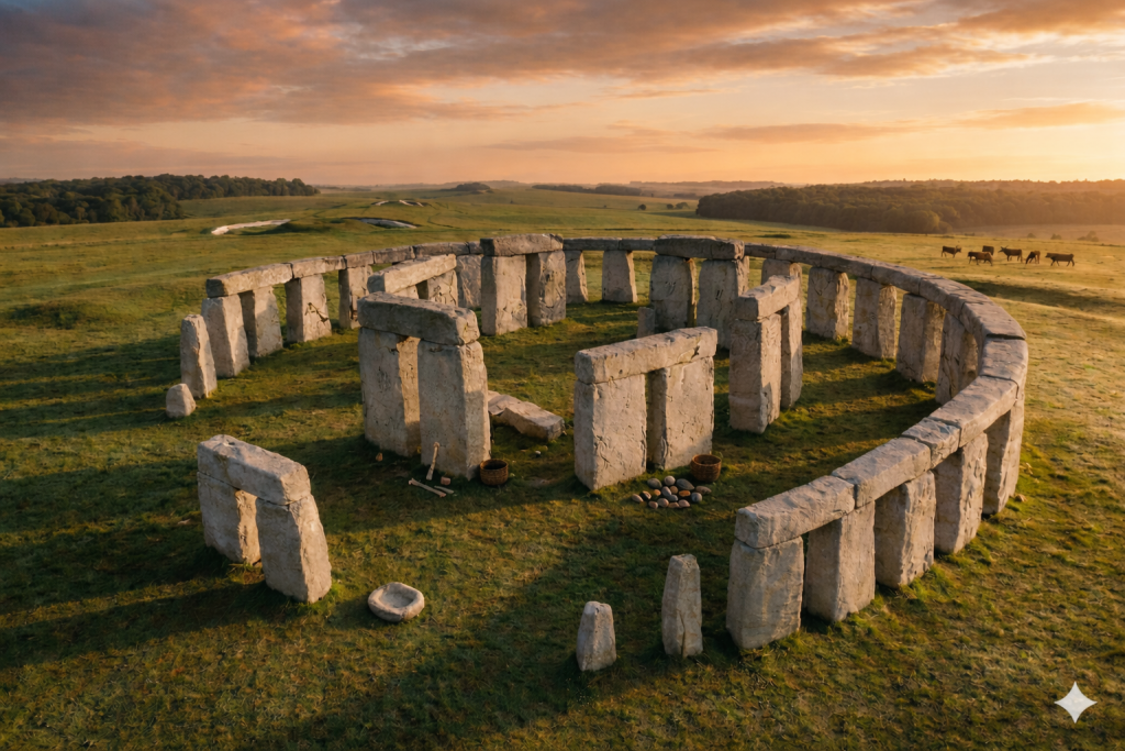
Further Reading

For those interested in British Prehistory, visit www.prehistoric-britain.co.uk, a comprehensive resource featuring an extensive collection of archaeology articles, modern LiDAR investigations, and groundbreaking research. The site also includes insights and extracts from the acclaimed Robert John Langdon Trilogy, a series of books exploring Britain during the Prehistoric period. Titles in the trilogy include The Stonehenge Enigma, Dawn of the Lost Civilisation, and The Post Glacial Flooding Hypothesis, offering compelling evidence about ancient landscapes shaped by post-glacial flooding.

To further explore these topics, Robert John Langdon has developed a dedicated YouTube channel featuring over 100 video documentaries and investigations that complement the trilogy. Notable discoveries and studies showcased on the channel include 13 Things that Don’t Make Sense in History and the revelation of Silbury Avenue – The Lost Stone Avenue, a rediscovered prehistoric feature at Avebury, Wiltshire.

In addition to his main works, Langdon has released a series of shorter, accessible publications, ideal for readers delving into specific topics. These include:

For active discussions and updates on the trilogy’s findings and recent LiDAR investigations, join our vibrant community on Facebook. Engage with like-minded enthusiasts by leaving a message or contributing to debates in our Facebook Group.

Whether through the books, the website, or interactive videos, we aim to provide a deeper understanding of Britain’s fascinating prehistoric past. We encourage you to explore these resources and uncover the mysteries of ancient landscapes through the lens of modern archaeology.

For more information, including chapter extracts and related publications, visit the Robert John Langdon Author Page. Dive into works such as The Stonehenge Enigma or Dawn of the Lost Civilisation, and explore cutting-edge theories that challenge traditional historical narratives.

Other Blogs

s

t