Plato Was Right: The Archaeological Evidence the Academics Never Expected

Introduction

For more than a century, archaeology has treated Plato’s Atlantis as little more than an allegory. Students are taught that Atlantis was a philosophical invention. A morality tale. A fictional society created to demonstrate the dangers of arrogance and imperial ambition. (Plato’s Atlantis)

The problem with this explanation is simple.

Plato’s story contains an extraordinary number of specific claims.

He described a powerful maritime civilisation existing around 9,000 years before Solon. He placed it beyond the Pillars of Hercules in a sea that bears its name to this day – the Atlantic Ocean. He claimed it possessed fleets capable of travelling vast distances, maintained contact with distant lands, and ultimately disappeared beneath the sea following catastrophic flooding.

Most importantly, Plato claimed the survivors of this lost civilisation seeded both Egypt and Greece.

For generations, academics dismissed the entire account as fiction.

The archaeology now suggests they may have been wrong.
(Plato's Atlantis)
(Plato’s Atlantis)

1. Atlantis and the Atlantic

One of the most overlooked aspects of Plato’s account is geography.

Atlantis was not described as a Mediterranean civilisation.

It lay beyond the Pillars of Hercules in the Atlantic Ocean.

Today, the ocean itself still carries the name.

Whether the ocean was named after Atlantis or Atlantis after the ocean is ultimately irrelevant. What matters is that Plato was clearly describing a civilisation connected to the Atlantic world rather than the eastern Mediterranean.

That distinction becomes critically important when we consider what archaeology has discovered during the last few decades.
(Plato's Atlantis)
(Plato’s Atlantis)

2. The Lost World Beneath the North Sea

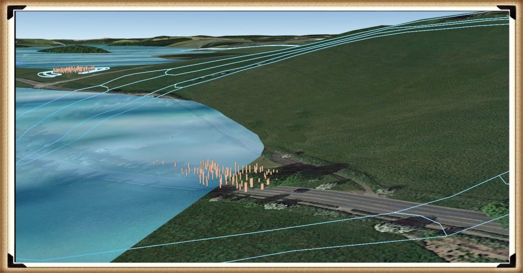
When Plato wrote his account, nobody knew that an enormous inhabited landscape once existed beneath the North Sea.

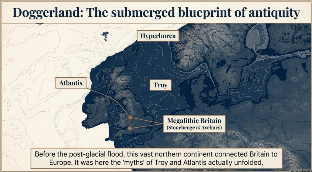
Today, we call it Doggerland.

During the Late Ice Age, Britain was connected to Europe by a vast plain crossed by rivers, lakes, forests and wetlands. This was not a small island. It was an entire country-sized landscape supporting human populations for thousands of years.

Then the climate changed.

The ice sheets melted.

Sea levels rose.

The land disappeared beneath the waves.

For centuries, such a drowned world would have been dismissed as fantasy.

Today, it is accepted in archaeology.

The existence of Doggerland alone demonstrates that Plato’s central premise – that large inhabited lands were lost beneath the sea – was not fantasy at all.
(Plato's Atlantis)
(Plato’s Atlantis)

3. The Great Flooding Event

Around 6200 BCE the Storegga tsunami and associated post-glacial flooding transformed the landscapes of north-west Europe.

Although flooding was not a single event, the combined effects of sea-level rise, coastal erosion and catastrophic inundation dramatically reduced the habitable land available to prehistoric populations.

The significance of this cannot be overstated.

An entire world disappeared.

Rivers vanished.

Coastlines moved.

Settlements were destroyed.

Migration became inevitable.

If a sophisticated maritime culture existed within Doggerland, it would have faced a simple choice:

Adapt, relocate or perish.
(Plato's Atlantis)
(Plato’s Atlantis)

4. Bouldnor Cliff Changes Everything

The discovery at Bouldnor Cliff is one of the most important archaeological finds ever made in Britain.

Dating to the seventh millennium BC, the site revealed evidence of advanced woodworking, boat use and long-distance connections.

Most remarkably, researchers recovered evidence of einkorn wheat.

This is not a trivial discovery.

Einkorn was not adopted in Britain for approximately another 3,000 years.

The presence of einkorn demonstrates contact with regions where the crop was already known and cultivated.

In other words, maritime connections already existed between Britain and distant communities long before conventional history would have us believe.

This single discovery destroys the notion that Mesolithic Britain was isolated from the wider world.
(Plato's Atlantis)
(Plato’s Atlantis)

5. Maritime Routes Create Ports

There is another implication that is rarely discussed.

Boats travelling between Britain and the Near East do not operate by magic.

They require food.

Fresh water.

Repairs.

Shelter.

Replacement crews.

Trade goods.

Every historical maritime network in history produced ports and anchorages.

The Phoenicians did it.

The Greeks did it.

The Romans did it.

The Vikings did it.

The Elizabethans did it.

There is no reason to imagine prehistoric sailors behaved differently.

Repeated voyages between the Atlantic and Anatolia would naturally create stopping points along the coasts of Iberia, southern France, Italy, Greece, and Egypt.

Over generations, these temporary anchorages would evolve into permanent trading communities.

Sailors would settle.

Families would form.

Local populations would mix.

Knowledge would spread.

This is how maritime civilisations have always operated.
(Plato's Atlantis)
(Plato’s Atlantis)

6. Plato’s Most Important Claim

Plato did not merely describe a lost civilisation.

He claimed that the survivors seeded both Egypt and Greece.

This is an astonishingly specific statement.

It creates a testable archaeological prediction.

If the account preserves genuine historical memory, then traces of unusual founder populations should appear in both Egypt and Greece during the period following the destruction of the Atlantic homeland.

Remarkably, that is exactly what the archaeology appears to reveal.
(Plato's Atlantis)
(Plato’s Atlantis)

7. Egypt: The First Foundation

The Egyptian evidence is striking.

The chronology reveals continuity rather than replacement.

EgyptGreece
Qarunian (7570–6200 BC)Aceramic Neolithic
Transitional Phase (6200–5550 BC)Early Neolithic
Early Faiyumian (5550–4650 BC)Nea Nikomedeia
Merimde (c.5000–4300 BC)Proto-Sesklo / Sesklo
Tasian (c.4500 BC onwards)Prodromos / Dimini

The populations associated with Merimde and the Tasian culture have been described as:

  • Long-headed.
  • Robust.
  • Physically distinct from many later Egyptians.
  • Generally taller than later predynastic populations.

Excavation reports also recorded individuals with sandy, ginger and even golden hair, leading archaeologists to suggest the existence of a fair strain within the population.

These are not modern interpretations.

They are observations recorded by the excavators themselves.
(Plato's Atlantis)
(Plato’s Atlantis)

8. Greece: The Second Foundation

The Greek evidence follows a remarkably similar pattern.

Early Neolithic populations appear on a timeline virtually identical to that of Egypt.

Sites such as Nea Nikomedeia, Sesklo and Prodromos represent some of the earliest organised communities in Europe.

Anthropological studies repeatedly describe Thessalian populations as predominantly long-headed.

At Prodromos, archaeologists discovered a remarkable cache of eleven human skulls deliberately placed beneath a house floor.

Dedicated anthropological investigations were conducted into these populations, exactly as occurred in Egypt.

The similarities are difficult to ignore.

EgyptGreece
Merimde long-headedThessalian populations described as long-headed
Tasian long-headedProdromos skull assemblage
Robust populationsFounder populations under anthropological study
Taller than later EgyptiansStature evidence incomplete
Fair-haired individualsEvidence currently absent
Continuity from earlier populationsContinuity from Early Neolithic founder settlements
(Plato's Atlantis)
(Plato’s Atlantis)

9. The Chronology Fits

When the chronology is compared directly, the pattern becomes even more remarkable.

DateNorth Sea / Atlantis ModelGreece
8000–7000 BCDoggerland extensiveMesolithic hunter-gatherers
7000–6500 BCPopulation displacement possibleEarliest Neolithic begins
6500–6000 BCLowland reductions continuingThessaly settlements expanding
6200–5500 BCTransitional phaseSesklo emerging
5500–5000 BCDoggerland fragmentedMajor Sesklo centre
5000–4500 BCSurvivor periodDimini and advanced settlements
4500–4000 BCMegalithic Structures EndIncreasing Aegean complexity
3500–3000 BCFarmers take over BritainCycladic maritime culture

The sequence is not proof.

But it is exactly the pattern we would expect if populations displaced from the Atlantic world contributed to later civilisations.
(Plato's Atlantis)
(Plato’s Atlantis)

10. The Allegory Has a Problem

The academic explanation has always been simple.

Atlantis was fictional.

The difficulty is that fictional stories are not supposed to generate accurate archaeological predictions.

Plato described:

  • A maritime civilisation.
  • An Atlantic homeland.
  • Catastrophic flooding.
  • A date close to the end of the Ice Age.
  • Survivors.
  • Egypt.
  • Greece.

Archaeology has now confirmed:

  • The drowned landscape.
  • The flooding.
  • The maritime networks.
  • Long-distance contacts.
  • Founder populations in Egypt.
  • Founder populations in Greece.

Nobody is claiming that every detail of Plato’s account has been proven.

What can no longer be maintained is the lazy assumption that the story was merely an allegory.

Two thousand four hundred years ago, Plato described a lost maritime world destroyed by rising seas whose survivors helped shape the civilisations that followed.

Today, archaeology is beginning to uncover evidence that such a world may have existed.

The greatest irony of all may be that the man historians dismissed as a storyteller was closer to the truth than the experts who spent a century insisting he was wrong.

(Plato's Atlantis)
(Plato’s Atlantis)

🌊 19 Reasons Why Doggerland Was Atlantis 🌊

The Atlantis Mystery Archaeology Doesn’t Want to Solve

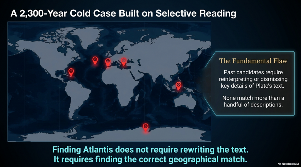
For over 2,300 years, people have searched for Atlantis.

They have looked in the Mediterranean, the Atlantic Ocean, Antarctica, the Caribbean, Spain, Morocco, the Azores, and even Indonesia.

Yet there is a problem.

None of these proposed locations matches more than a handful of Plato’s descriptions.

Most require selective reading, reinterpretation, or outright dismissal of key details.

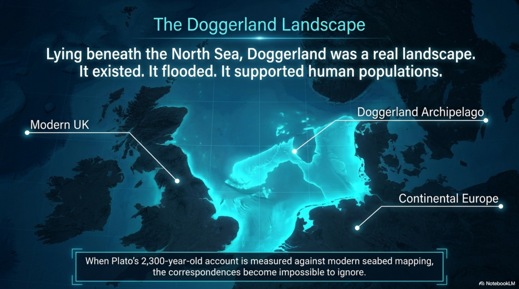
Doggerland is different.

Lying beneath the North Sea between Britain and Europe, Doggerland was a real landscape. It existed. It flooded. It supported human populations. And remarkably, when Plato’s account is compared to measurable evidence, the number of correspondences becomes difficult to ignore.

Here are 19 reasons why Doggerland remains the strongest candidate for Atlantis ever identified.


1️⃣ A Large Island Beyond the Mediterranean

Plato describes a vast landmass beyond the familiar world of the Mediterranean.

Doggerland once connected Britain to continental Europe and formed one of the largest habitable landscapes in north-west Europe before it disappeared beneath the sea.


2️⃣ A Vast Central Plain

Plato gives dimensions of approximately 2,000 by 3,000 stadia.

When converted into modern measurements, this equates to roughly 370 by 550 kilometres.

The reconstructed Doggerland plateau measures approximately 375 by 560 kilometres.

Few Atlantis candidates come anywhere close.


3️⃣ Mountains to the North

Plato describes mountains surrounding the northern edge of the plain.

Scotland, Norway and Scandinavia form exactly such a northern mountainous boundary around the North Sea basin.


4️⃣ A Landscape Dominated by Water

Atlantis was described as a landscape of rivers, channels and waterways.

Doggerland was criss-crossed by major river systems, wetlands, lakes, estuaries and palaeochannels now mapped beneath the North Sea.


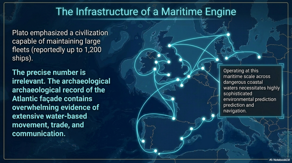
5️⃣ A Maritime Civilisation

Plato repeatedly emphasises ships and seafaring.

The Atlantic façade and North Sea region contain overwhelming evidence for water-based movement, trade and communication.


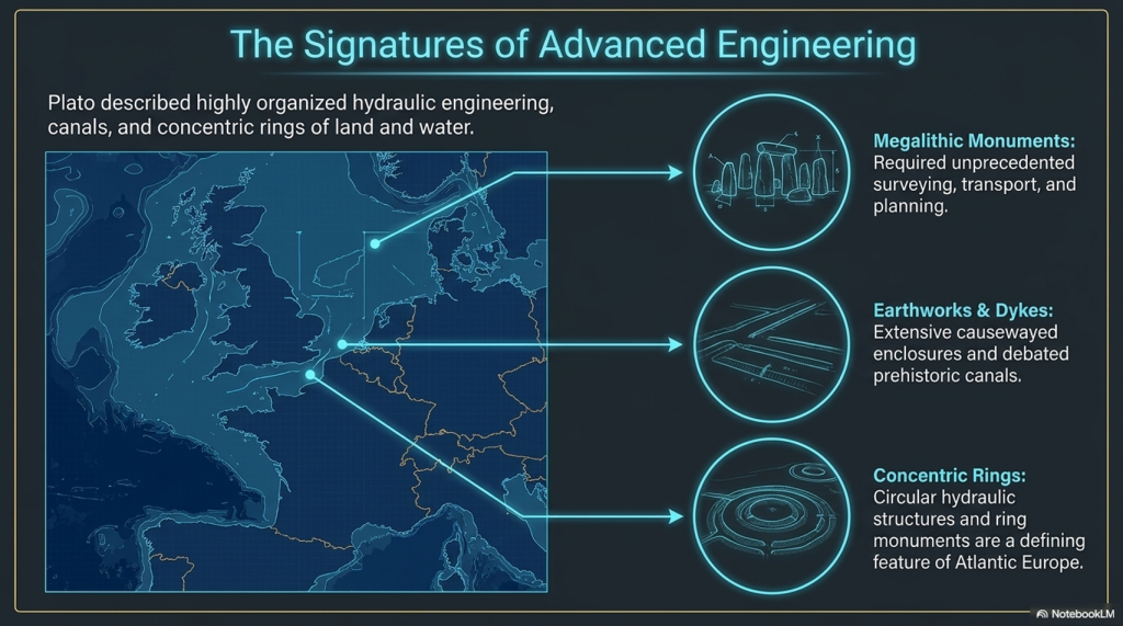
6️⃣ Large-Scale Hydraulic Engineering

Plato describes canals and water management on a huge scale.

Britain and north-west Europe preserve extensive dykes, canals, causewayed enclosures and engineered earthworks whose original purposes remain debated.


7️⃣ Concentric Rings of Land and Water

One of Atlantis’s most famous features.

Concentric enclosures, ring monuments and circular hydraulic structures occur throughout Atlantic Europe.


8️⃣ A Fertile Plain

Plato describes a rich agricultural landscape.

Pollen records, peat deposits and sediment analysis reveal that Doggerland supported extensive woodland, grassland and productive river valleys.


9️⃣ Marshes and Wetlands

Atlantis was rich in freshwater.

Geological reconstruction consistently shows Doggerland as a landscape dominated by lakes, marshes, rivers and elevated groundwater systems.


🔟 Elephants

Critics often dismiss this detail.

Yet elephant remains are not only known from Europe—they are known from Britain.

Elephant, mammoth and hippopotamus remains have all been recovered from Britain and the North Sea basin.


1️⃣1️⃣ Advanced Engineering

Plato describes a highly organised civilisation.

The megalithic monuments of north-west Europe required surveying, transport, planning and engineering on a remarkable scale.


1️⃣2️⃣ Large Fleets

Atlantis supposedly maintained a fleet of around 1,200 ships.

Whether the exact number is correct is irrelevant.

Any maritime civilisation operating at this scale would require sophisticated navigation and environmental prediction.


1️⃣3️⃣ Environmental Monitoring Systems

This is where Stonehenge becomes important.

Stonehenge Phase 1 appears to function as a predictive lunar and tidal system operating within a water-dominated landscape.

Such infrastructure would be essential to a maritime culture.


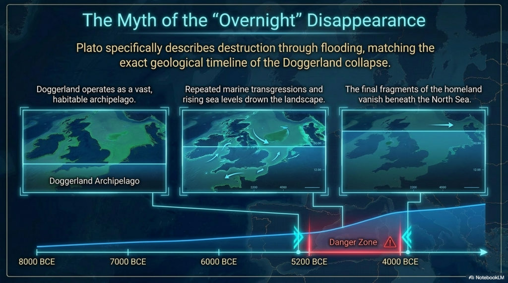
1️⃣4️⃣ Progressive Flooding

Plato does not describe Atlantis disappearing overnight.

He describes destruction through flooding.

Doggerland vanished over thousands of years through repeated marine transgressions and rising sea levels.


1️⃣5️⃣ The Loss of the Homeland

Eventually, only fragments remained.

Between approximately 5200 and 4200 BCE the final Doggerland archipelago disappeared beneath the North Sea.


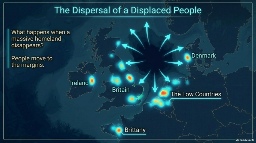
1️⃣6️⃣ Population Dispersal

What happens when a homeland disappears?

People move.

The concentration of megalithic monuments across Britain, Ireland, Brittany, Denmark, and the Low Countries is consistent with populations relocating along the margins of the former basin.


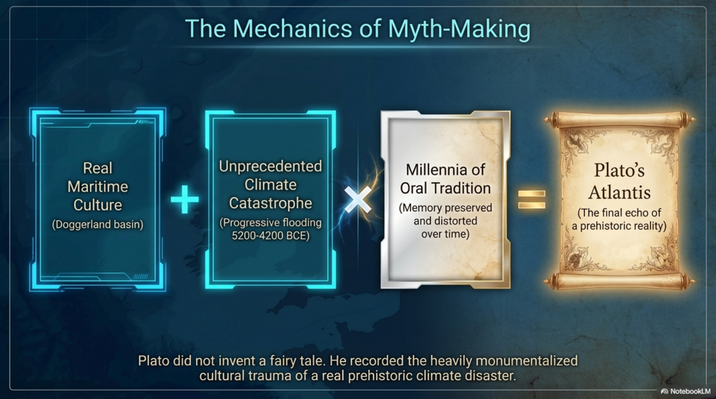
1️⃣7️⃣ Preservation of Memory

Civilisations remember disasters.

Stonehenge Phase 2 may represent the monumentalisation of that memory, transforming an earlier functional system into a permanent stone memorial.


1️⃣8️⃣ Physical Links to the Lost Land

Memory is often preserved through objects.

The Altar Stone may provide a physical connection between Stonehenge and the broader northern landscape associated with Doggerland.


1️⃣9️⃣ A Great Civilisation Remembered

Plato claimed Atlantis survived as a story long after the land itself disappeared.

If a maritime culture occupied Doggerland and its destruction became embedded within oral tradition, Plato’s account may preserve the final echo of a real prehistoric catastrophe.


The Real Question

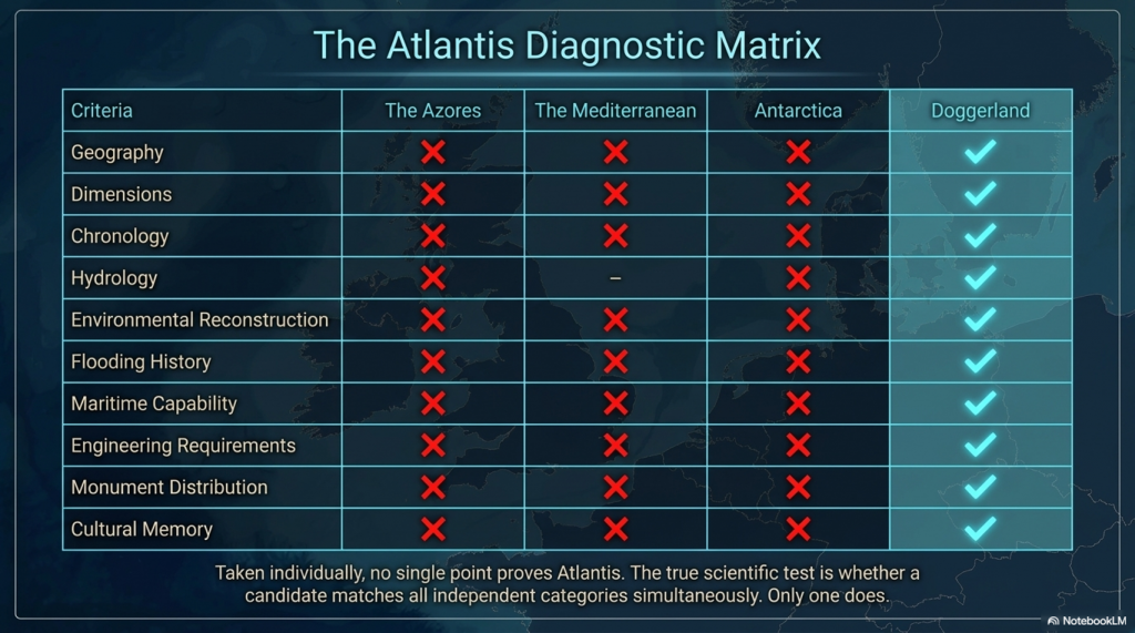
Taken individually, none of these points proves the existence of Atlantis.

But that is not the test.

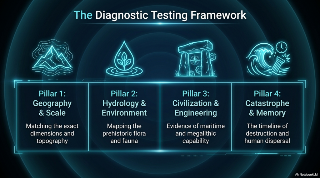
The test is whether any other Atlantis candidate matches so many independent categories simultaneously.

✅ Geography

✅ Dimensions

✅ Chronology

✅ Hydrology

✅ Environmental reconstruction

✅ Flooding history

✅ Maritime capability

✅ Engineering requirements

✅ Monument distribution

✅ Cultural memory

Most Atlantis theories match one or two features.

Doggerland matches nearly all of them.

The question is no longer:

“Could Plato have described a flooded landscape?”

The evidence suggests he probably did.

The real question is:

What other known landscape matches Plato’s description better than Doggerland?

So far, nobody has produced one.


PODCAST

Author’s Biography

Robert John Langdon, a polymathic luminary, emerges as a writer, historian, and eminent specialist in LiDAR Landscape Archaeology.

His intellectual voyage has been interwoven with stints as an astute scrutineer in government and grand corporate bastions, a tapestry spanning British Telecommunications, Cable and Wireless, British Gas, and the esteemed University of London.

A decade hence, Robert’s transition into retirement unfurled a chapter of insatiable curiosity. This phase saw him immerse himself in Politics, Archaeology, Philosophy, and the enigmatic realm of Quantum Mechanics. His academic odyssey traversed the venerable corridors of knowledge hubs such as the Museum of London, University College London, Birkbeck College, The City Literature Institute, and Chichester University.

In the symphony of his life, Robert is a custodian of three progeny and a pair of cherished grandchildren. His sanctuary lies ensconced in the embrace of West Wales, where he inhabits an isolated cottage, its windows framing a vista of the boundless sea – a retreat from the scrutinising gaze of Her Majesty’s Revenue and Customs, an amiable clandestinity in the lap of nature.

Exploring Prehistoric Britain: A Journey Through Time

My blog delves into the fascinating mysteries of prehistoric Britain, challenging conventional narratives and offering fresh perspectives grounded in cutting-edge research, particularly LiDAR technology. I invite you to explore some key areas of my research. For example, the Wansdyke, often cited as a defensive structure, is re-examined in light of new evidence. I’ve presented my findings in my blog post Wansdyke: A British Frontier Wall – ‘Debunked’, and a Wansdyke LiDAR Flyover video further visualises my conclusions.

My work also often challenges established archaeological dogma. I argue that many sites, such as Hambledon Hill, commonly identified as Iron Age hillforts, are not what they seem. My posts Lidar Investigation Hambledon Hill – NOT an ‘Iron Age Fort’ and Unmasking the “Iron Age Hillfort” Myth explore these ideas in detail and offer an alternative view. Similarly, sites like Cissbury Ring and White Sheet Camp receive re-evaluations based on LiDAR analysis in my posts “Lidar Investigation Cissbury Ring through time” and “Lidar Investigation White Sheet Camp, revealing fascinating insights into their true purpose. I have also examined South Cadbury Castle, often linked to the mythical Camelot56.

My research also extends to ancient water management, including the role of canals and other linear earthworks. I have discussed the true origins of Car Dyke in multiple posts, including Car Dyke – ABC News Podcast and Lidar Investigation Car Dyke – North Section, which suggest a Mesolithic origin 2357. I also explore the misidentification of Roman aqueducts, as seen in my posts on the Great Chesters (Roman) Aqueduct. My research has also been greatly informed by my post-glacial flooding hypothesis, which has helped explain landscape transformations over time. I have discussed this hypothesis in several posts, including AI now supports my Post-Glacial Flooding Hypothesis and Exploring Britain’s Flooded Past: A Personal Journey

Finally, my blog also investigates prehistoric burial practices, as seen in Prehistoric Burial Practices of Britain and explores the mystery of Pillow Mounds, often mistaken for medieval rabbit warrens, but with a potential link to Bronze Age cremation in my posts: Pillow Mounds: A Bronze Age Legacy of Cremation? and The Mystery of Pillow Mounds: Are They Really Medieval Rabbit Warrens?. My research also includes astronomical insights into ancient sites, for example, in Rediscovering the Winter Solstice: The Original Winter Festival. I also review new information about the construction of Stonehenge in The Stonehenge Enigma.

Further Reading

For those interested in British Prehistory, visit www.prehistoric-britain.co.uk, a comprehensive resource featuring an extensive collection of archaeology articles, modern LiDAR investigations, and groundbreaking research. The site also includes insights and excerpts from the acclaimed Robert John Langdon Trilogy, a series of books that explore Britain during the Prehistoric period. Titles in the trilogy include The Stonehenge Enigma, Dawn of the Lost Civilisation, and The Post-Glacial Flooding Hypothesis, which offer compelling evidence of ancient landscapes shaped by post-glacial flooding.

To further explore these topics, Robert John Langdon has developed a dedicated YouTube channel featuring over 100 video documentaries and investigations that complement the trilogy. Notable discoveries and studies showcased on the channel include 13 Things that Don’t Make Sense in History and the revelation of Silbury Avenue – The Lost Stone Avenue, a rediscovered prehistoric feature at Avebury, Wiltshire.

In addition to his main works, Langdon has released a series of shorter, accessible publications, ideal for readers delving into specific topics. These include:

For active discussions and updates on the trilogy’s findings and recent LiDAR investigations, join our vibrant community on Facebook. Engage with like-minded enthusiasts by leaving a message or contributing to debates in our Facebook Group.

Whether through the books, the website, or interactive videos, we aim to provide a deeper understanding of Britain’s fascinating prehistoric past. We encourage you to explore these resources and uncover the mysteries of ancient landscapes through the lens of modern archaeology.

For more information, including chapter extracts and related publications, visit the Robert John Langdon Author Page. Dive into works such as The Stonehenge Enigma or Dawn of the Lost Civilisation, and explore cutting-edge theories that challenge traditional historical narratives.

Other Blogs

s

t

The Fury of the Past: Natural Disasters in Historical and Prehistoric Britain

Introduction

Over recent years, there’s been a growing tendency… to present images of climate in crisis.

Storms tearing through communities…
floods overwhelming towns…
weather described not just as severe… but as something almost theatrical in its intensity.

And alongside these images… comes a familiar language.

We hear about record-breaking rainfall…
unprecedented wind speeds…
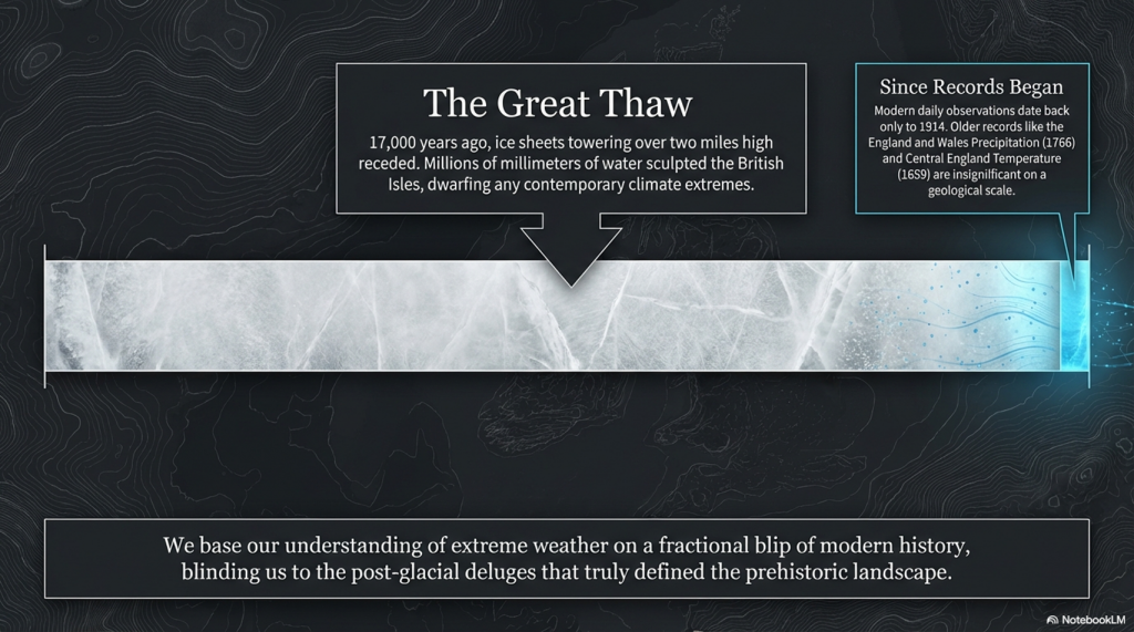
and that now well-worn phrase… “since records began.”

It sounds authoritative.
It sounds definitive.

The Fury of the Past: Natural Disasters in Historical and Prehistoric Britain

But it’s worth pausing… just for a moment… to ask a simple question:

What records… exactly… are we talking about?

Because in many cases… those “records” begin surprisingly recently.
Daily observational data, in its most widely used form, only really starts in the early twentieth century — around 1914.

So when we describe a modern year… like 2023… as extreme or unprecedented… we are often comparing it to just over a century of detailed measurement.

And that… is a very narrow window… in the context of climate.

Because the story doesn’t begin there.

We have the England and Wales Precipitation series… stretching back to 1766.
We have the Central England Temperature record… reaching all the way back to 1659.

These are not trivial datasets.
They are the result of generations of careful observation… often by dedicated amateur meteorologists… people who simply watched the skies… and wrote it down.

Together, they offer something far more valuable than a snapshot.

They offer perspective.

A long, continuous conversation between humanity… and the weather.

And yet… paradoxically… these longer records are often pushed aside.
Quietly ignored… or treated as secondary… in favour of modern datasets that fit more neatly into contemporary narratives.

Which raises an important point.

If we are serious about understanding climate…
about understanding flooding…
about understanding extremes…

Then we cannot afford to work from fragments of the record.

We need the full canvas.

The Fury of the Past: Natural Disasters in Historical and Prehistoric Britain

Because without that depth… without that historical context…
we risk mistaking variability for anomaly…
and short-term patterns for long-term change.

Perhaps this is where a figure like Jacob Bronowski would urge caution.

Not to dismiss modern science… but to place it within the wider human story.

To recognise that knowledge is cumulative…
that understanding comes from continuity… not selectivity…

And that if we truly want to understand the forces shaping our world…
we must listen not just to the present…

…but to the long memory of the past.

Sky News Online:

“England and Wales have seen the wettest summer for 100 years, according to MeteoGroup. Rainfall for June, July and August was 362mm (14.25in), making it the wettest summer since 1912. The average summer rainfall across the UK is 226.9mm (8.9in).  MeteoGroup forecaster Nick Prebble said this summer is set to be the fourth wettest since records began in 1727. The record for the UK’s wettest summer is 1912, when 384.4mm (15.1in) of rain fell.” (The Fury of the Past: Natural Disasters in Historical and Prehistoric Britain)

(The Fury of the Past: Natural Disasters in Historical and Prehistoric Britain)
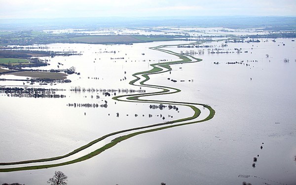
Somerset Flooding – (The Fury of the Past: Natural Disasters in Historical and Prehistoric Britain)

Let us delve into the fabric of the British summer, as narrated by the Met Office, revealing a tapestry less illuminated by the sun’s grace than in years past. A summer, they tell us, that may be recorded in the annals as one of the dullest, with a mere 399 hours of sunshine until the twilight of August, shadowed only by the year 1980’s modest 396 hours. This narrative unfolds in the aftermath of a Bank Holiday painted in the hues of unsettled weather, where rain and flood alerts draped many parts of the UK.

Joanna Robinson, a sage of weather from Sky News, recounts a tale of a season that began with the wettest June recorded, followed by a July that, too, was cradled in wetness. Yet, as the days of summer waned, the weather found a semblance of calm, only to be disturbed once again as August drew to a close. She speaks of the jet stream, that ethereal conveyor of weather, which, in its wanderings, steered storms across the British Isles that might have otherwise passed us by.

The summer of 2007 looms large in recent memory, its rainfall second only to records dating back to 1912, yet August of this summer hints at being the driest and sunniest. Such observations provoke exclamations of dismay and declarations of the grip of climate change on our world. Yet, a closer scrutiny, a peering into the depths of our climatic past, reveals a narrative less singular in its direction. The year 2007, while remarkable for its summer deluge, does not rank among the highest in annual rainfall, settling instead into the seventeenth position over the last century.

Our engagement with the elements, marked by the ebb and flow of rainfall, stretches back over centuries, with periods of intense precipitation, such as the decade spanning 1870 to 1880, punctuating our history. And between the notable years of 2007 and 2012, 2010 emerged as the eleventh-driest, a reminder of the natural oscillations that characterise our climate.

Grote Mandrenke

Turning our gaze to the winds and gales that sculpt our coastlines, history offers us a lens through which to view these forces in a broader context. The ‘Grote Mandrenke’, a tempest from the annals of the fourteenth century, wrought unparalleled devastation, claiming thousands of lives and altering landscapes and architecture. This event, among others, serves as a testament to the dynamic and often turbulent relationship between humanity and the environment.

In this reflection, inspired by the thoughtful considerations, we are invited to contemplate the narratives of weather and climate not as isolated phenomena but as part of a complex interplay of natural forces, historical events, and human experiences. Through this lens, we gain a deeper appreciation for the intricacies of our world and the myriad ways in which the past informs our understanding of the present and the future.

(Extreme weather and Ancient Subterranean shelters)
Grote Mandrenke 1362 – Extreme weather


In the reflective prose, let us explore the further reaches of our historical and environmental saga, where the dance between humanity and nature continues its timeless rhythm. As the great storm of 1362 stretched its wrath into the North Sea, it conspired with the tides to birth a tempestuous offspring—the storm surge. This phenomenon, a marauder of the coasts, reshaped the contours of the European shore, leaving ports from England to Denmark in ruins, and forever altering the dialogue between land and sea.

Yet, this cataclysm, while monumental, is not an isolated whisper in the annals of our planet’s climatic history. It echoes a more ancient, more profound narrative that commenced with the first settlers in the Mesolithic period. These early denizens of the land faced the capricious moods of a world freshly emerged from the clutches of the last Ice Age—a time when the land itself was a protagonist in a story of transformation and survival.

The landscape, a silent historian, bears the scars and tales of these epochal changes. The retreat of the ice sheets some ten thousand years ago unleashed waters that dwarf our contemporary rainfall measurements, inundating the land with a deluge that would reshape its very skeleton. The annual rainfall pales in comparison to the volumes discharged during this great thaw, when millions of millimetres of water sculpted the British Isles into a new form, carving out riverbeds and creating the floodplains we know today.

The Fury of the Past: Natural Disasters in Historical and Prehistoric Britain

British Geological Society

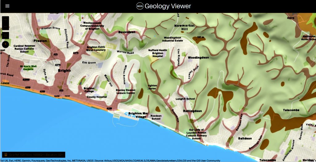
These ancient watercourses, now hidden beneath layers of sediment and time, are revealed to us through the meticulous cartography of the British Geological Society (BGS). Their maps unfurl a tapestry of geological memory, revealing the remnants of vast paleo-river systems that once cradled the waters of the past. The floodplains, marked by their unique sedimentary compositions, are not merely areas prone to contemporary flooding but are the fingerprints of ancient rivers that once dominated the landscape.

Our Mesolithic ancestors, attuned to the rhythm of this waterlogged world, chose the margins of these floodplains for their sacred sites and communal gatherings. Stonehenge, that enigmatic structure, stands as a testament to its profound connection with the land and its waterways. They navigated the flooded realms, moving from isle to isle, their lives intertwined with the ebb and flow of the waters.

The Fury of the Past: Natural Disasters in Historical and Prehistoric Britain

The evidence of these ancient flood plains and their impact on human settlement and activity is etched into the very bedrock of our island. A study of the BGS maps reveals a subterranean network of what were once mighty rivers and channels, especially in areas of chalk bedrock like Stonehenge. These geological whispers invite us to consider how our landscape has been shaped by water’s forceful hand, guiding our ancestors and shaping the course of our collective history.

In this contemplation, inspired by Bronowski’s reverence for the intertwining of science, history, and human endeavour, we are reminded of the enduring legacy of our planet’s natural forces. They beckon us to view our present and future through the lens of the deep past, understanding that the stories of storm surges, flooding, and climate are chapters in a much longer narrative of Earth and humanity.

(Extreme weather and Ancient Subterranean shelters)
Paleochannels – (The Fury of the Past: Natural Disasters in Historical and Prehistoric Britain)

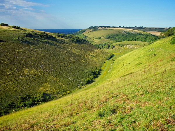
Embarking on a journey of inquiry and reflection, we delve into the enigma of Britain’s dry river valleys. These landscapes, now silent and devoid of flowing waters, serve as a testament to the dynamic and ever-changing canvas of our planet’s geological and climatic history. Known to archaeologists, geologists, and the curious layperson alike as ‘Dry River Valleys,’ these formations beckon us to ponder the forces that sculpted them and the epochs they have witnessed.

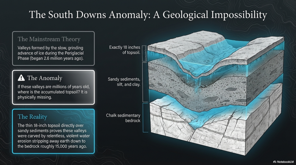
Conventional wisdom held that the distinctive contours of these valleys, nestled within the chalk hills, were the handiwork of the Periglacial Phase of the Quaternary Period—a vast expanse of time that began around 2.6 million years ago. Yet the precise moment of their birth remains shrouded in the mists of prehistory, with no concrete evidence to mark their genesis.

Geology, a discipline ever ripe with evolving theories and reinterpretations, suggests these dry valleys were carved by the relentless flow of water, eroding topsoil and smoothing the underlying chalk during the thaw that followed an ice age. Yet the Quaternary Period is marked by a succession of ice ages, each leaving an indelible mark on the land. This presents a quandary for those who seek to understand not just the creation of these valleys, but the epochs in which they thrummed with the lifeblood of flowing rivers.

Post-Glacial Flooding

For archaeologists and geologists, the puzzle lies in discerning which ice age’s thaw sculpted these valleys into the landscape. The challenge is not merely academic; it bears significant implications for understanding the human story intertwined with these natural features. The timing of water coursing through these valleys could illuminate periods of human activity, migration, and settlement, shedding light on the ancient peoples who once lived alongside these now-vanished rivers.

Geological maps and studies suggest the existence of great rivers that once traversed the British Isles, sculpted by the monumental release of water at the end of the ice ages. The last great thaw, occurring some 17,000 years ago as the ice sheets, towering over two miles high in places, receded, would have unleashed floods of epic proportions. This deluge, the most significant in recent geological history, would have transformed the landscape, including the Valleys of the South Downs, far from the ice sheet’s edge.

The intrigue of these dry river valleys lies not solely in their geological formation but in the stories they hold of a world dramatically different from our own. To understand when these valleys last echoed with the sound of flowing water is to peel back layers of time, revealing insights into the climatic shifts that have shaped the earth and influenced the course of human civilisation.

(Extreme weather and Ancient Subterranean shelters)
Dry River Valley – Extreme Weather

We are witnessing a paradigm shift in our understanding of Britain’s dry river valleys. Modern geological consensus now acknowledges that these features were carved not by the slow, grinding advance of ice but by the dynamic, erosive power of water. This revelation comes from observing the profound examples of soil erosion and the creation of valleys, where millions of gallons of water, moving with relentless force, stripped away layers of earth down to the bedrock.

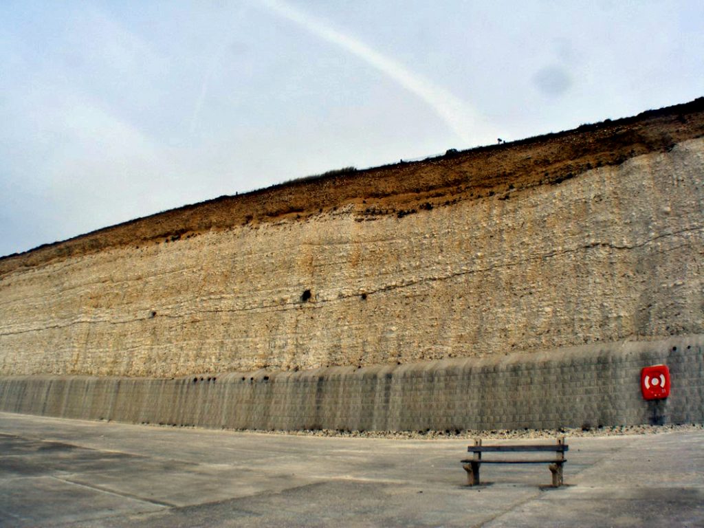
This narrative finds vivid illustration in the South Downs, where the cliffs and valleys bear silent testimony to ancient, post-glacial rivers. The region, much like the area surrounding Stonehenge, rests upon chalk sedimentary bedrock, shaped by the flows of yesteryear. The presence of these ancient watercourses is betrayed by the layers of sand, silt, and clay that comprise the subsoil, visible in the dales (valleys) of the South Downs and, most strikingly, on the faces of the chalky white cliffs. These cliffs, sculpted by the sea, offer a cross-sectional view into the past, revealing the sedimentary layers left by prehistoric rivers.

Contrary to earlier interpretations that attributed the formation of these geological features to windblown loess or wash from valley walls, the evidence suggests a different story. The discovery of sandy sediments, embedded within the chalk and lying in close proximity to the current topsoil, points to a more dramatic origin. These remnants of ancient rivers, dating back approximately 15,000 years to the aftermath of the last great melt, challenge the prevailing theories.

The puzzle for geologists and archaeologists alike lies in the thin veil of topsoil that covers these ancient sediments. If these valleys were as ancient as previously believed, the question arises: where has the expected accumulation of topsoil gone? Furthermore, if topsoil erosion occurs at the rate some experts claim, how do we account for the presence of 18 inches of topsoil atop the chalk in the present day?

These questions invite a reevaluation of our understanding of the landscape’s history, suggesting that erosion and sedimentation may not conform to the simplistic models previously proposed. The narrative of the South Downs and similar landscapes across Britain is not merely a tale of geological change but a reflection of the complex interplay between the earth’s natural forces and the passage of time.

(Extreme weather and Ancient Subterranean shelters)
Paleochannel on South Downs cliff – (The Fury of the Past: Natural Disasters in Historical and Prehistoric Britain)

We find ourselves at a crossroads of questions concerning the sedimentary timelines and the environmental narratives of our ancient landscapes. The enigma of the seemingly scant topsoil overlaying the remnants of prehistoric river beds in places like the South Downs raises profound questions about our understanding of climatic events and geological processes. Are we on the brink of uncovering evidence of a massive climatic upheaval yet to come, one that could dramatically alter the topsoil? Or, perhaps more intriguingly, have we misdated the dry river valleys and the prehistoric river beds that cradle the foundations of our ancient history?

The puzzle deepens as we consider the architectural legacies of our ancestors, such as Woodhenge and the enigmatic site known as Durrington Walls. These ancient monuments, constructed with a profound understanding of their environmental context, may hold clues to the climatic and geological conditions of their time. The location and design of these structures, aligned with natural features and possibly informed by an awareness of floodplains and waterways, suggest a sophisticated interaction with the landscape that transcends mere habitation and ventures into the realm of reverence and ritual.

The construction of Woodhenge, positioned near the curious formation of Durrington Walls, invites speculation about the relationship between human society and the natural world in prehistoric times. Were these monuments erected in response to the environmental challenges faced by their builders, such as flooding or the need to navigate and control water resources? Or did they serve as markers of significant geological features, such as dry river valleys, embedding coded knowledge of the landscape’s history and cyclical transformations in their construction?

These questions compel us to reexamine our interpretations of the archaeological record, challenging us to integrate geological evidence with the cultural and spiritual dimensions of ancient constructions. The apparent discrepancy in the sedimentary record, marked by the proximity of ancient river sediments to the present-day topsoil, may not only point to gaps in our geological dating but also to a more complex understanding of how our ancestors interacted with and adapted to their environment.

Durrington Walls

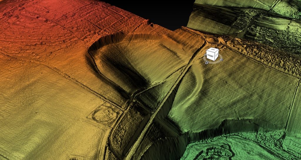
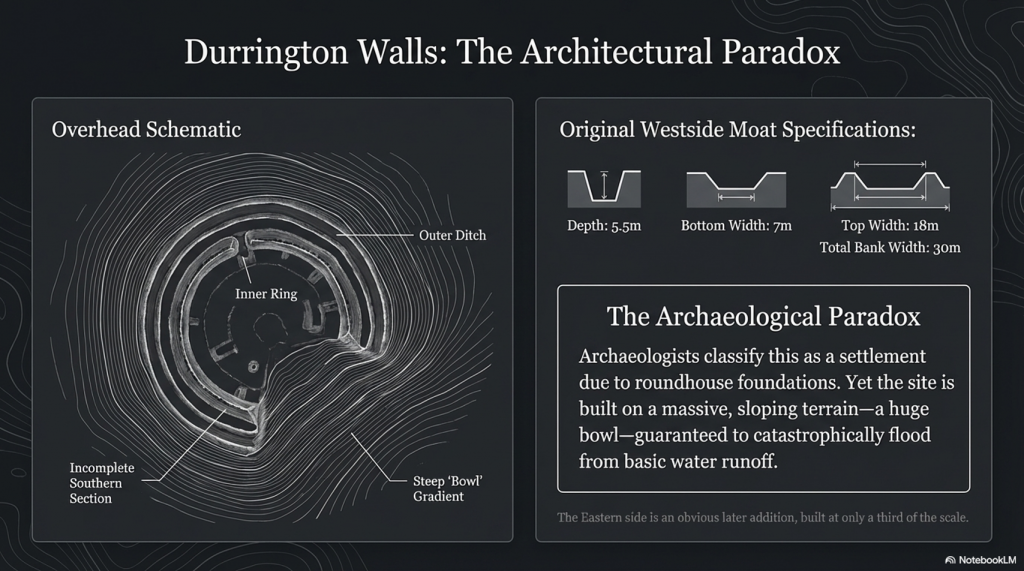
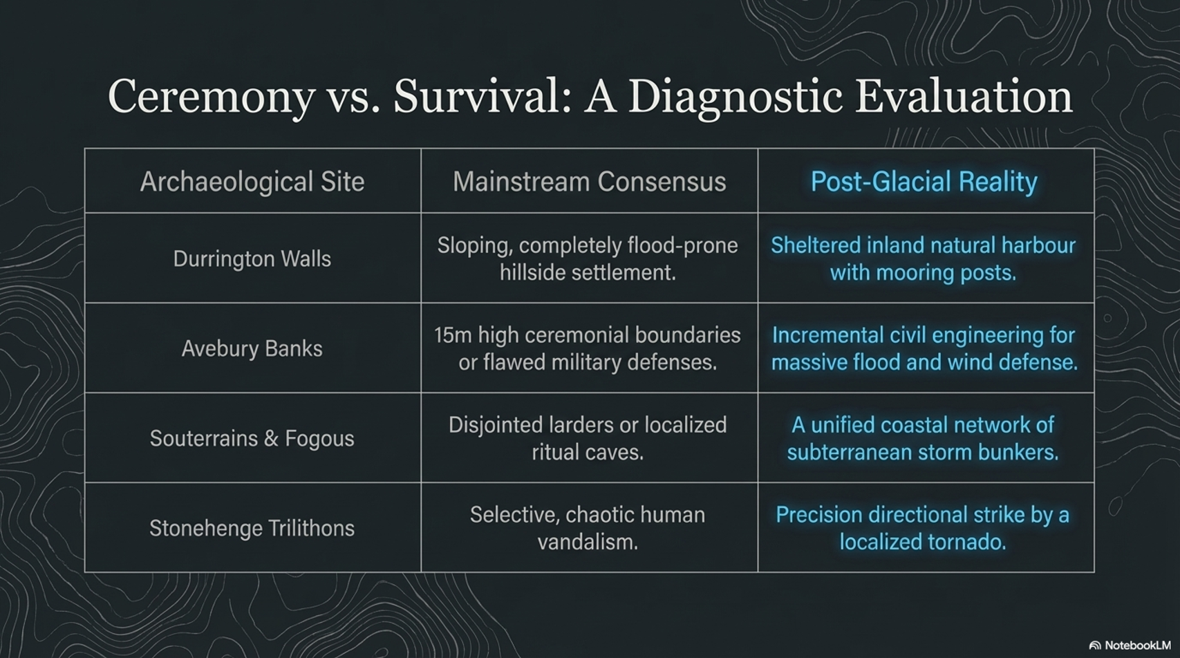
When you look at Durrington Walls, the first thing that strikes you is that it seems incomplete; it appears as a half-circle in aerial photographs, and from the ground, you get a sense that it is only half-finished. However, most illustrations include the easterly section because magnetometer surveys show more ditches beneath the surface, although you might question their purpose, as they are not apparent.  The easterly side of the site was clearly built much later than the original Westside. The East bank is smaller and does not match the initial ditch-and-moat specifications, which were roughly 5.5 m deep, 7 m wide at the bottom, and 18 m wide at the top. (The Fury of the Past: Natural Disasters in Historical and Prehistoric Britain)

(Extreme weather and Ancient Subterranean shelters)
Durrington Walls showing harbour in the dip – (The Fury of the Past: Natural Disasters in Historical and Prehistoric Britain)

The bank was 30 m wide in some areas. The bank and ditch indicated by the magnetometer surveys are less than half that depth; the bank is only about a third the size of the one on the Northern side.  The current theory and plan for Durrington Walls do not stand up to investigation, for clearly the Eastern side of the camp was added later, when the prehistoric groundwater had begun to recede.

So what was its original use?

 To answer that question, you must look at the site’s terrain, position and layout. The first thing that hits you is that the site is not flat! In fact, it’s a huge bowl.

The Fury of the Past: Natural Disasters in Historical and Prehistoric Britain
Woodhenge & Durrington Walls Harbour- (The Fury of the Past: Natural Disasters in Historical and Prehistoric Britain)

The suggestion that our forebears might have chosen to establish settlements in locations that, to the modern eye, appear prone to flooding, invites a deeper investigation into the logic and environmental understanding of these ancient communities.

The case of Durrington Walls, traditionally interpreted as a settlement due to the discovery of roundhouse foundations, challenges contemporary notions of ideal habitation sites. The prevailing wisdom that discourages camping on a slope due to the risk of water runoff highlights a modern bias towards flat, stable ground. Yet the archaeological insistence on Durrington Walls as a settlement, despite its topographical peculiarities, might overlook the site’s strategic significance in relation to the environmental conditions of the time.

Harbour

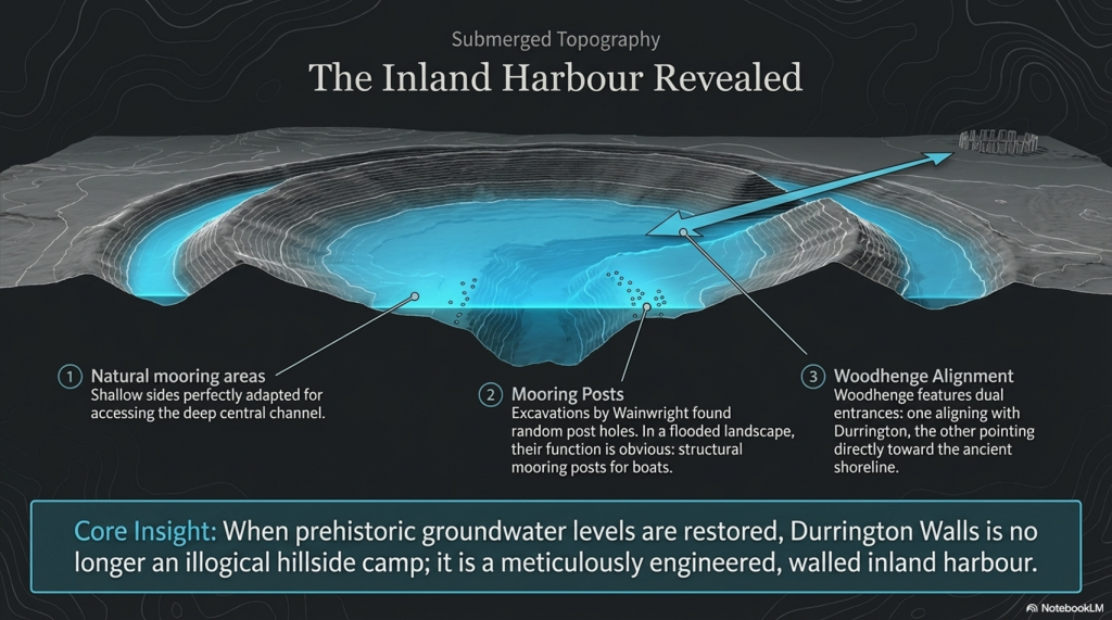
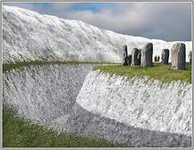
If we entertain the notion of significantly higher prehistoric groundwater levels, Durrington Walls transforms from a seemingly ill-chosen settlement into a potential natural harbour. The site’s configuration, with shallow sides ideal for mooring boats and a central ravine providing depth for watercraft, coupled with the remains of substantial external walls, suggests a sophisticated understanding of landscape and water management by its builders. Such a harbour, protected by formidable chalk walls, would have been a marvel of prehistoric engineering, offering shelter from the elements and facilitating trade or travel.

Woodhenge’s dual entrances further support the hypothesis of a water-centric landscape. One entrance aligns with Durrington Walls, suggesting a terrestrial connection, while the other, leading towards what would have been the ancient shoreline, implies a relationship with waterways. The presence of groundwater at Woodhenge, inferred from magnetometer surveys and the peculiarities of the site’s layout, underscores the adaptability and ingenuity of prehistoric peoples in harnessing their environment.

The evolution of the landscape, mirrored in the receding shoreline over millennia and the adaptation of human structures to these changes, reveals a dynamic interaction between our ancestors and their surroundings. The modern road, tracing the ancient shoreline’s path, serves as a tangible reminder of the deep history embedded in the land.

This reconsideration of Durrington Walls and Woodhenge as components of a prehistoric landscape intimately connected with water challenges us to think beyond conventional archaeological interpretations. It suggests that our ancestors were far from foolish in their choice of settlement locations. Instead, they possessed a profound understanding of their environment, selecting sites based on a complex array of factors, including access to water, natural protection, and the strategic advantages these locations offered.

(Extreme weather and Ancient Subterranean shelters)
Woodhenge and Durrington Walls Harbour – (The Fury of the Past: Natural Disasters in Historical and Prehistoric Britain)

We should not be too surprised by this, as lakeshores and coastlines still have paths along with them today so that we can fully enjoy them. There is no reason to believe that prehistoric people did anything different 8,000 years ago, and such a path would also have a practical purpose, as the shorelines were used as a mooring site.  If we are correct about the road and the mooring points, is it possible to find post holes here underground?

Unbelievably, the answer is yes!

Wainwright, in his excavations of Durrington Walls, discovered lots of them. Without a shoreline, the post holes would look random and not make much sense. However, as soon as the groundwater flooding is added, their function becomes apparent: they held mooring posts, as that is the natural landing area for boats coming to and from Stonehenge, Avebury or Old Sarum.  But are there other sites that have walls to protect them from the weather?

Avebury

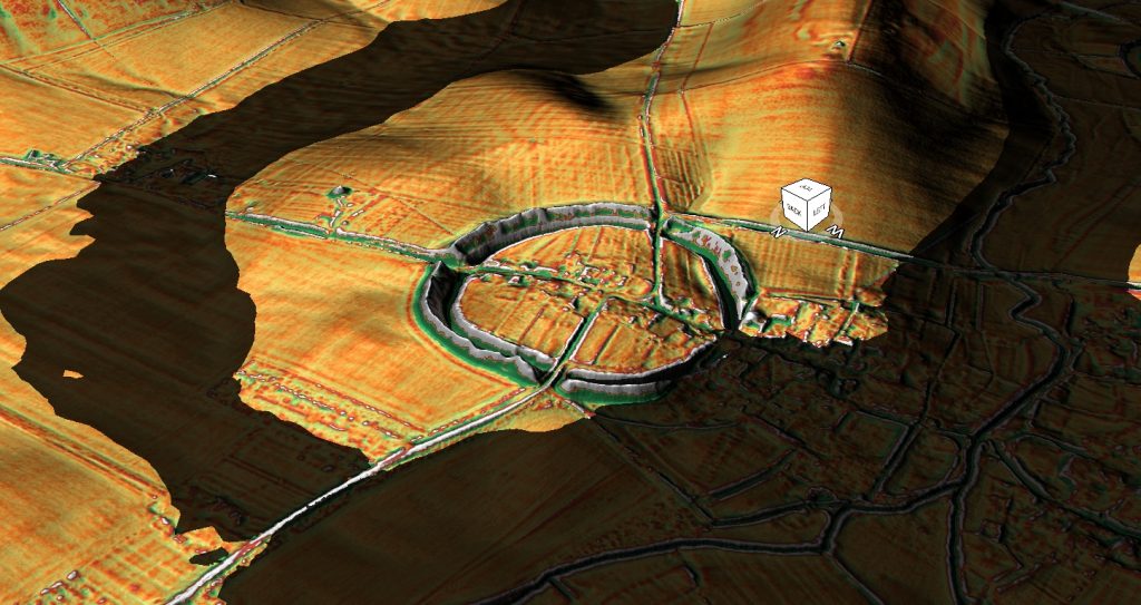
Navigating through the mysteries of Avebury and its ancient landscapes, we find ourselves in the midst of a dialogue that blends the profound insights of archaeology with the nuanced understanding of geology, much in the spirit of Jacob Bronowski’s interdisciplinary exploration. Avebury, nestled within the chalkland of the Upper Kennet Valley, presents a fascinating case study of human interaction with a dynamically changing environment.

The positioning of Avebury on a low chalk ridge, elevated above the surrounding landscape, and its proximity to the Marlborough Downs, speak to the strategic selection of this site by our ancestors. The discovery of flint artefacts dating to the late Mesolithic period suggests a long history of human presence, perhaps drawn by the natural resources and the strategic vantage point this location offers.

The Fury of the Past: Natural Disasters in Historical and Prehistoric Britain

The post-glacial flooding that reshaped the landscape around Avebury, transforming it into an almost island-like monument surrounded by waterways, highlights the profound impact of natural forces on human settlements. The effort to maintain Avebury’s island status through the construction of ditches and large banks reflects a determined human response to a changing environment, aimed at preserving the site’s symbolic or functional significance.

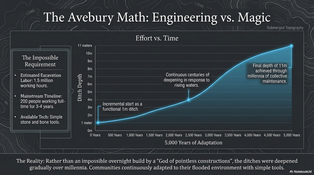
The estimated 1.5 million working hours required to construct the Avebury monument, involving 200 people working full-time for three to four years, underscores the monumental effort invested in this endeavour. This contrasts sharply with the even more staggering effort estimated for the construction of Silbury Hill, suggesting a remarkable dedication of resources and labour to these ancient projects. The discrepancy in the estimated working hours needed to move the respective volumes of chalk at Avebury and Silbury Hill raises intriguing questions about the methods, technologies, and organisational structures of prehistoric societies.

These ancient monuments, Avebury and Silbury Hill, stand as testaments to the ingenuity and resilience of our ancestors, who, faced with a world marked by extreme weather events and changing landscapes, sought to leave their mark through these colossal earthworks. The monumental scale of these projects, achieved without the modern machinery or technological aids available today, invites us to reconsider the capabilities of ancient societies and their profound connection to the landscapes they inhabited.

(Extreme weather and Ancient Subterranean shelters)
Avebury Harbour- (The Fury of the Past: Natural Disasters in Historical and Prehistoric Britain)

This is just another fact that does not make sense! –

There is just no consistency in archaeological findings; it’s all subjective, and quite frankly, wrong!

The suggestion that monuments like Avebury evolved gradually over centuries, with their ditches deepening from a modest one meter to the monumental eleven meters over 5,000 years, presents a compelling narrative of continuous human engagement with these sites. This slow but persistent expansion and deepening of the ditches could indeed offer a plausible explanation for the archaeological conundrum of the tools used in their construction.

The incremental growth of these monuments suggests a process deeply intertwined with the rhythms of prehistoric life, in which the maintenance and expansion of the ditches became part of the community’s ongoing relationship with their environment and heritage. The gradual excavation of the ditches, possibly for ritual cleansing, defence, or to expand the monument’s scope, would have allowed the use of simple tools available at the time. This contrasts with the daunting task of constructing such massive earthworks within a single generation, which would have required resources and coordination levels that seem less plausible without sophisticated tools and technologies.

The Fury of the Past: Natural Disasters in Historical and Prehistoric Britain

Giant Ditches

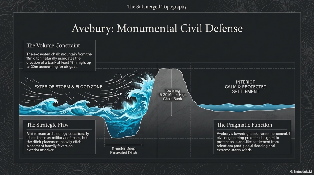
The analysis of the ‘chalk mountain’ formed from excavated material offers fascinating insights into the monument’s purpose and symbolism. The calculation that the bank could originally have stood at least 15 meters high, with the potential to reach 20 meters when accounting for chalk compression and air gaps, underscores the monumental effort invested in these structures. This towering presence would have dominated the landscape, serving as a potent symbol of the community’s identity, beliefs, and capabilities.

The bank’s considerable height, derived from the volume of chalk moved from the ditches, also speaks to the technical understanding and engineering skills of the people who built these monuments. The manipulation of the landscape on such a scale, with the tools and knowledge available at the time, demonstrates a sophisticated grasp of materials and a deep connection to the land itself.

This perspective, which sees the monuments growing organically over time, enriches our understanding of the relationship between prehistoric societies and their monumental creations. It suggests that these structures were not static symbols imposed on the landscape but dynamic, evolving entities that reflected the changing needs, beliefs, and aspirations of their builders.

(Extreme weather and Ancient Subterranean shelters)
Avebury Harbour Walls- (The Fury of the Past: Natural Disasters in Historical and Prehistoric Britain)


The endeavour to construct a 15-meter-high wall, especially within the context of ancient monumental architecture, invites a nuanced exploration that bridges the gap between archaeological theory and the lived realities of prehistoric communities. The suggestion that such walls were defensive structures, yet paradoxically positioned to ostensibly favour attackers, propels us into a deeper inquiry into the motivations and environmental challenges faced by these ancient builders.

The comparison with Durrington, where a high wall ostensibly serves a protective function for boats against wind and storms, suggests a pragmatic approach to construction that transcends mere defensive purposes. This insight challenges the notion of monumental walls as solely ceremonial or defensive and invites consideration of their role in mitigating the era’s environmental conditions.

The archaeological pivot to ‘ceremonial’ explanations in the face of such paradoxes, while often serving as a placeholder for the unknown, may indeed overlook the practical interactions between these ancient communities and their volatile climates. The humorously termed “God of pointless constructions and practices” belies a critical gap in our understanding of the symbiotic relationship between human societies and their environments.

Underground Bunkers

The suggestion that past weather was more severe and that the construction of shelters and walls was a response to these conditions is compelling. This perspective is supported by the presence of souterrains, or underground structures, which served as refuges from harsh weather. These structures, varying in design and function across regions, exemplify the adaptability and ingenuity of ancient communities in the face of climatic adversity.

The regional variation in the design of souterrains, from fogous in Cornwall that served as larders to other forms of underground shelter, underscores the diversity of responses to environmental challenges. This diversity not only highlights the practical considerations that drove the construction of monumental and subterranean structures but also reflects the rich tapestry of cultural practices that evolved in tandem with changing landscapes and climates.

(Extreme weather and Ancient Subterranean shelters)
Souterrains- (The Fury of the Past: Natural Disasters in Historical and Prehistoric Britain)


The souterrains of Ireland, often colloquially termed ‘caves’, constitute a fascinating part of the archaeological and cultural landscape, rich in historical significance and imbued with the mysteries of the past. The scholarly works of individuals such as A.T. Lucas and the comprehensive study by Clinton in 2001 have provided invaluable insights into these subterranean structures, offering a window into their distribution, associated settlements, functions, and the chronology of their use.

Originating from the French term for “underground passageway,” souterrains were integral to the communities that constructed them, serving purposes that extended beyond the mere architectural or ceremonial. These underground galleries, often associated with settlements and ringforts, reflect a blend of ingenuity and necessity, designed to withstand the trials of their times.

Constructed by excavating earth and lining the resulting spaces with stone slabs or wood, souterrains were reburied to integrate seamlessly with the landscape. In instances where they were carved directly into rock, such elaborate preparations were unnecessary. Their functions, far removed from burial or ritualistic uses, leaned towards the practical, serving primarily as food stores or refuges during periods of conflict. The presence of souterrains within or adjacent to ringforts, and their dating to periods contemporary with these structures, suggests a synchronisation of defensive strategies and domestic planning.

The Fury of the Past: Natural Disasters in Historical and Prehistoric Britain

The utilisation of ogham stones as structural elements within souterrains, and the repurposing of ancient script-bearing stones as roofing lintels or doorposts, underscores a fascinating intersection of cultural heritage and architectural necessity. Such practices highlight the adaptive reuse of materials and the deep-rooted connection between the physical and the symbolic in Irish heritage. The ‘cave of the cats’ at Rathcrogan stands as a prominent example, where the widened natural limestone fissure incorporates ogham stones, weaving together the threads of history, architecture, and mythology.

The distribution of souterrains in Ireland, particularly concentrated in certain counties, speaks to the geographical and environmental factors that influenced their construction. These underground structures, with their often obvious entrances, challenge our modern perceptions of secrecy and security, suggesting that their protective function was balanced with the practical needs of accessibility and use.

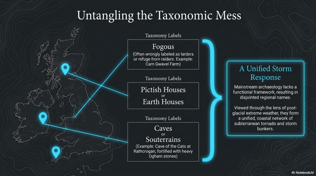
The first thing that strikes you as strange is the fact that these landscape features are categorised with different names in different locations:

Earth Houses – Modern use

Fogous – Cornwall

Pictish Houses – Found in Scotland (confusion arises here as some are only partially subterranean), unlike the Earth Houses in the same region.

Caves – Ireland

It’s quite literally an archaeological mess.  And the reason for this mess is that archaeologists don’t understand why they were built, so they gave them local names, unlike barrows, Stone circles and henges, which appear in the same areas but with a unified name to save confusion.  So, what can we find out about these structures that will help us understand why they were built?

Location, Location, Location

If we look at the minimal archaeological evidence, we do see a defined pattern of construction. For example, in Cornwall, we have found to date a collection of fifteen ‘fogous’.  According to archaeologists, this is a proposed use for fogous, a refuge during raiding trips, as they are close to the sea.  Sadly, if you look more closely, you see them in non-coastal areas and even in the middle of Dartmoor (Lade Hill Brook), where it’s called a Beehive Hut. 

The problem with looking for such objects in Devon is that hundreds of ‘caves’ are dotted around from the days of tin mining, and therefore it is almost impossible to distinguish a prehistoric mine opening from a fogou.

(Extreme weather and Ancient Subterranean shelters)
Fogou- (The Fury of the Past: Natural Disasters in Historical and Prehistoric Britain)


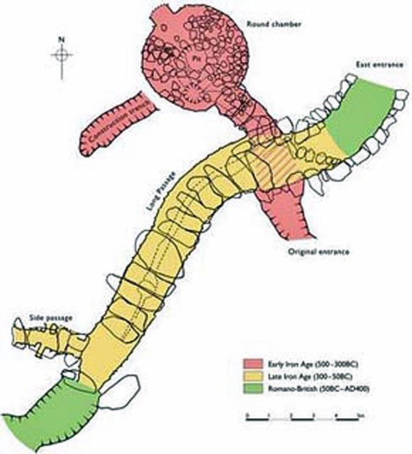
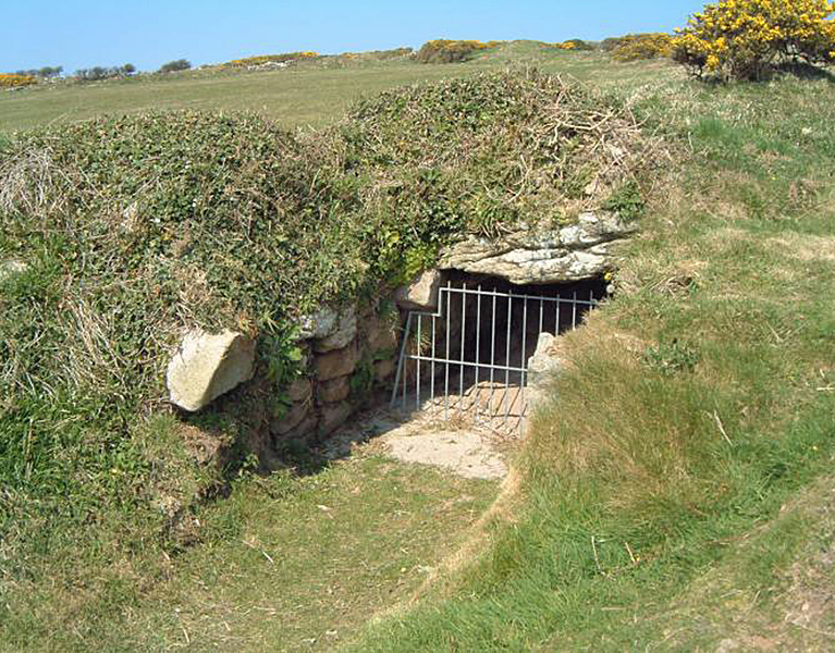
The exploration of subterranean structures across the British Isles and their potential functions opens a fascinating chapter in the study of prehistoric human adaptation to environmental challenges. The presence of fogous in Cornwall, notably the example at Carn Gwavel Farm on the Isle of Scilly, exemplifies the ingenuity of ancient communities in creating shelters that blend seamlessly with the landscape. These underground chambers, with their distinctive S-shaped curves and corbelled construction, suggest a level of architectural sophistication designed to address specific needs, whether for storage, habitation, or protection.

The orientation of fogous towards the SW-NE axis raises intriguing questions about their purpose. While some might speculate a religious or ceremonial significance, the practical considerations of climate and environmental exposure cannot be overlooked. The architectural similarities between fogous, chamber cairns, and passage chambers across different regions—each adapted to local conditions and available materials—underscore a widespread practice of constructing subterranean spaces for varied uses.

In regions like Ireland and Scotland, where these structures are more commonly found and referred to as ‘caves’ or ‘earth houses,’ their abundance points to a shared cultural practice of utilising underground spaces. The absence of similar structures in areas like Devon, Dorset, Somerset, and Wiltshire, juxtaposed with the concentration of other prehistoric monuments, suggests regional variations in responses to environmental and social pressures.

The situation in Wales, with its chambered cairns and passage chambers, adds another layer to this complex tapestry. The discovery of bodies within these structures has led to their classification as burial sites, yet the possibility that their original purpose evolved over time warrants consideration. The comparison to modern bunkers, which have found new uses beyond their original intent, illustrates the fluidity of human interactions with built environments.

Tornadoes

The hypothesis that these subterranean shelters were constructed in response to severe storm conditions, akin to practices in contemporary hurricane-prone areas of the USA, highlights a timeless human priority: the need for protection against the elements. This perspective offers a compelling narrative of prehistoric resilience and adaptability, suggesting that the construction of such shelters was a rational response to the challenges posed by a dynamic and sometimes hostile environment.

Understanding the motivations behind the construction of fogous and similar structures requires an interdisciplinary approach that considers archaeological evidence, environmental science, and historical climatology. The severity of prehistoric storms, as inferred from geological indicators of post-glacial flooding and climate change, provides a backdrop against which the necessity and ingenuity of these ancient shelters can be fully appreciated.

In contemplating these ancient structures, we are reminded of the enduring human capacity to innovate and adapt to the world’s ever-changing face. The legacy of fogous and their counterparts across the British Isles and beyond speaks to a deep-seated human instinct to seek shelter and safety in the face of nature’s fury, a testament to the ingenuity and resilience of our ancestors that continues to inspire and inform our understanding of human history.

But is there any other evidence that tornadoes hit Britain?

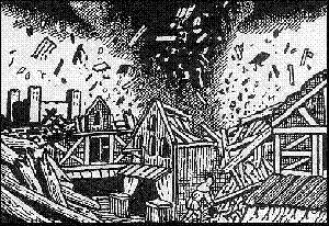
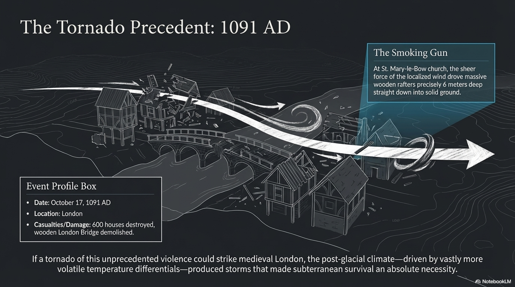
On 17th October 1091, London was hit by a vicious tornado.

The Fury of the Past: Natural Disasters in Historical and Prehistoric Britain
(The Fury of the Past: Natural Disasters in Historical and Prehistoric Britain)

The historical records describing the destruction wrought upon London, including the demolition of the wooden London Bridge, the devastation of 600 houses, and the severe damage to St. Mary-le-Bow church, underscore the formidable power of natural forces. The detail of rafters being driven six meters into the ground at St. Mary-le-Bow vividly illustrates the intensity of the event, likely a tornado, which also resulted in loss of life and widespread homelessness. This account provides a stark reminder of the vulnerability of even the most seemingly permanent human constructions to the whims of nature.

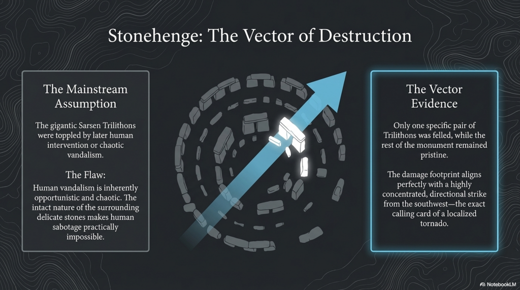
The enduring mystery surrounding Stonehenge, particularly the toppling of the gigantic Sarsen Trilithon Stones, invites a reconsideration of the forces capable of such feats. The traditional assumption that human intervention aimed at dismantling the monument falls short in light of the damage’s selective nature. The hypothesis of a tornado strike from the southwest offers a compelling alternative explanation, aligning with the directional pattern of damage observed at the site. The fact that only one pair of the trilithons was felled, while the rest of the monument remained relatively intact, suggests an event that combined immense power with precise directionality, characteristics emblematic of tornadoes.

The Fury of the Past: Natural Disasters in Historical and Prehistoric Britain

Tornadoes, though not commonly associated with Britain’s climate in the popular imagination, are indeed part of the British weather landscape, albeit on a smaller scale than in regions like the United States. The potential for a tornado to have caused the specific pattern of destruction observed at Stonehenge challenges preconceived notions about the stability of such ancient structures and the range of natural disasters that have affected them throughout history.

The observation made by Stukeley in the 16th century and the subsequent ‘repairs’ at the turn of the last century underscore the ongoing interaction between human efforts to preserve or restore ancient monuments and the natural processes that continue to shape them. This dynamic interplay highlights the fragility of our cultural heritage and the importance of understanding the human and natural factors that have influenced these iconic structures over millennia.

In exploring the possibility that tornadoes could impact Stonehenge, we are reminded of the broader implications of climate and environmental forces for archaeological sites. Such considerations not only enrich our understanding of the past but also inform preservation strategies for safeguarding our cultural heritage against future natural events. The case of Stonehenge serves as a poignant example of the complex relationship between human history, natural phenomena, and the ongoing efforts to interpret and preserve the legacies of ancient civilisations in the face of nature’s capricious power.

The Fury of the Past: Natural Disasters in Historical and Prehistoric Britain

PodCast

Author’s Biography

Robert John Langdon, a polymathic luminary, emerges as a writer, historian, and eminent specialist in LiDAR Landscape Archaeology.

His intellectual voyage has been interwoven with stints as an astute scrutineer in government and grand corporate bastions, a tapestry spanning British Telecommunications, Cable and Wireless, British Gas, and the esteemed University of London.

A decade hence, Robert’s transition into retirement unfurled a chapter of insatiable curiosity. This phase saw him immerse himself in Politics, Archaeology, Philosophy, and the enigmatic realm of Quantum Mechanics. His academic odyssey traversed the venerable corridors of knowledge hubs such as the Museum of London, University College London, Birkbeck College, The City Literature Institute, and Chichester University.

In the symphony of his life, Robert is a custodian of three progeny and a pair of cherished grandchildren. His sanctuary lies ensconced in the embrace of West Wales, where he inhabits an isolated cottage, its windows framing a vista of the boundless sea – a retreat from the scrutinising gaze of Her Majesty’s Revenue and Customs, an amiable clandestinity in the lap of nature.

Exploring Prehistoric Britain: A Journey Through Time

My blog delves into the fascinating mysteries of prehistoric Britain, challenging conventional narratives and offering fresh perspectives grounded in cutting-edge research, particularly LiDAR technology. I invite you to explore some key areas of my research. For example, the Wansdyke, often cited as a defensive structure, is re-examined in light of new evidence. I’ve presented my findings in my blog post Wansdyke: A British Frontier Wall – ‘Debunked’, and a Wansdyke LiDAR Flyover video further visualises my conclusions.

My work also often challenges established archaeological dogma. I argue that many sites, such as Hambledon Hill, commonly identified as Iron Age hillforts, are not what they seem. My posts Lidar Investigation Hambledon Hill – NOT an ‘Iron Age Fort’ and Unmasking the “Iron Age Hillfort” Myth explore these ideas in detail and offer an alternative view. Similarly, sites like Cissbury Ring and White Sheet Camp receive re-evaluations based on LiDAR analysis in my posts “Lidar Investigation Cissbury Ring through time” and “Lidar Investigation White Sheet Camp, revealing fascinating insights into their true purpose. I have also examined South Cadbury Castle, often linked to the mythical Camelot56.

My research also extends to ancient water management, including the role of canals and other linear earthworks. I have discussed the true origins of Car Dyke in multiple posts, including Car Dyke – ABC News Podcast and Lidar Investigation Car Dyke – North Section, which suggest a Mesolithic origin 2357. I also explore the misidentification of Roman aqueducts, as seen in my posts on the Great Chesters (Roman) Aqueduct. My research has also been greatly informed by my post-glacial flooding hypothesis, which has helped explain landscape transformations over time. I have discussed this hypothesis in several posts, including AI now supports my Post-Glacial Flooding Hypothesis and Exploring Britain’s Flooded Past: A Personal Journey

Finally, my blog also investigates prehistoric burial practices, as seen in Prehistoric Burial Practices of Britain and explores the mystery of Pillow Mounds, often mistaken for medieval rabbit warrens, but with a potential link to Bronze Age cremation in my posts: Pillow Mounds: A Bronze Age Legacy of Cremation? and The Mystery of Pillow Mounds: Are They Really Medieval Rabbit Warrens?. My research also includes astronomical insights into ancient sites, for example, in Rediscovering the Winter Solstice: The Original Winter Festival. I also review new information about the construction of Stonehenge in The Stonehenge Enigma.

Further Reading

For those interested in British Prehistory, visit www.prehistoric-britain.co.uk, a comprehensive resource featuring an extensive collection of archaeology articles, modern LiDAR investigations, and groundbreaking research. The site also includes insights and excerpts from the acclaimed Robert John Langdon Trilogy, a series of books that explore Britain during the Prehistoric period. Titles in the trilogy include The Stonehenge Enigma, Dawn of the Lost Civilisation, and The Post-Glacial Flooding Hypothesis, which offer compelling evidence of ancient landscapes shaped by post-glacial flooding.

To further explore these topics, Robert John Langdon has developed a dedicated YouTube channel featuring over 100 video documentaries and investigations that complement the trilogy. Notable discoveries and studies showcased on the channel include 13 Things that Don’t Make Sense in History and the revelation of Silbury Avenue – The Lost Stone Avenue, a rediscovered prehistoric feature at Avebury, Wiltshire.

In addition to his main works, Langdon has released a series of shorter, accessible publications, ideal for readers delving into specific topics. These include:

For active discussions and updates on the trilogy’s findings and recent LiDAR investigations, join our vibrant community on Facebook. Engage with like-minded enthusiasts by leaving a message or contributing to debates in our Facebook Group.

Whether through the books, the website, or interactive videos, we aim to provide a deeper understanding of Britain’s fascinating prehistoric past. We encourage you to explore these resources and uncover the mysteries of ancient landscapes through the lens of modern archaeology.

For more information, including chapter extracts and related publications, visit the Robert John Langdon Author Page. Dive into works such as The Stonehenge Enigma or Dawn of the Lost Civilisation, and explore cutting-edge theories that challenge traditional historical narratives.

Other Blogs

s

t

The Troy, Hyperborea and Atlantis Connection

Introduction

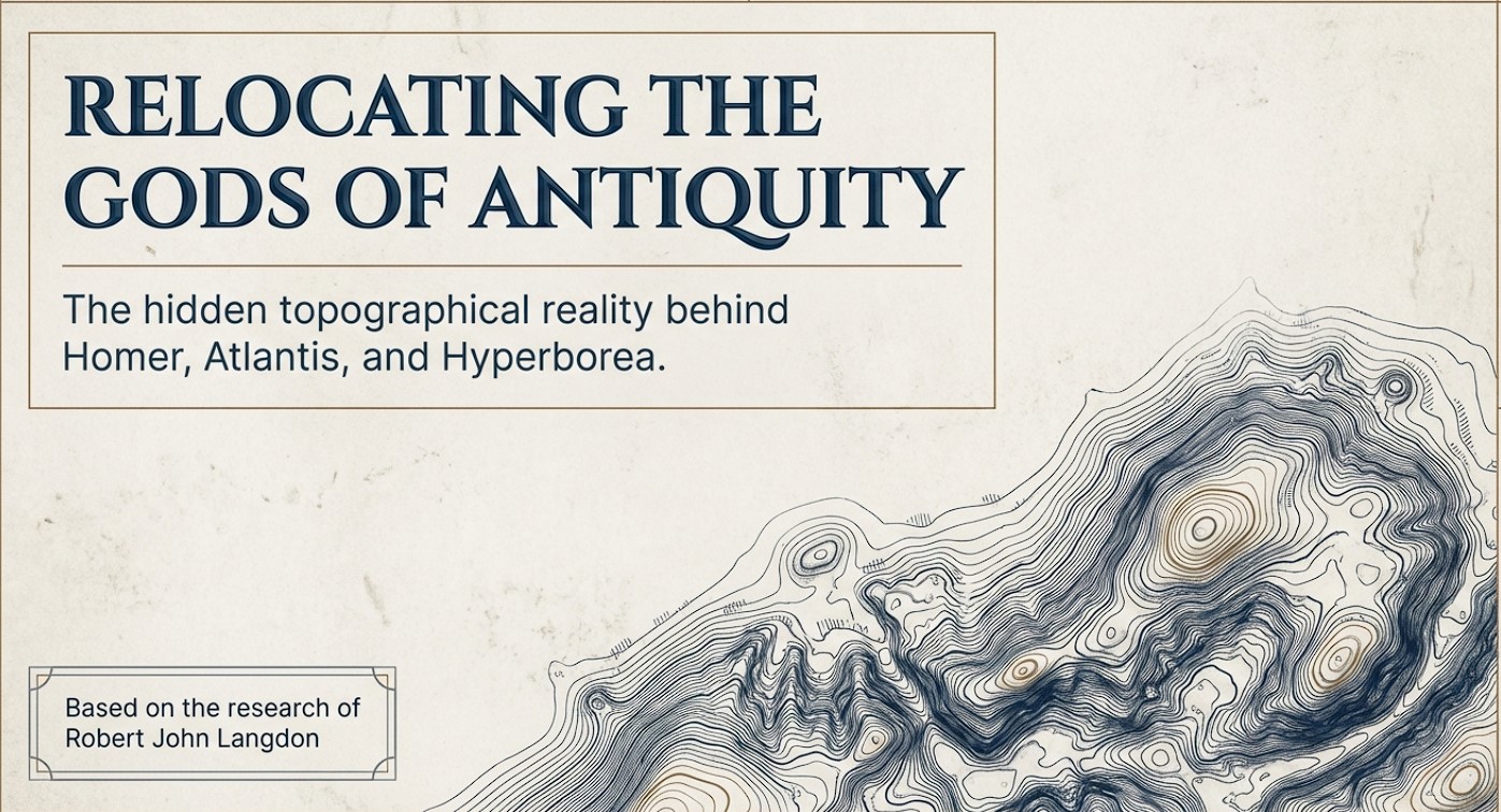
The connections between the legends of Atlantis and Hyperborea and the works of Homer represent a fascinating intersection of myth, philosophy, and epic narrative in ancient Greek literature. These stories not only provide insights into the Greeks’ geographical and cultural understanding but also reflect deeper philosophical and ethical concerns that permeate Greek thought. Below, we explore these themes in greater detail, delving into how these mythical and literary works intertwine and what they signify about ancient Greek civilisation. (The Troy, Hyperborea and Atlantis Connection)

 (The Troy, Hyperborea and Atlantis Connection)
(The Troy, Hyperborea and Atlantis Connection)

Homer’s Influence and the Greek Mythical Landscape

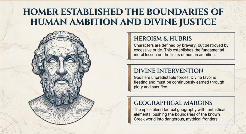
Homer’s literary works, namely the “Iliad” and the “Odyssey,” are of great importance in ancient Greek literature. These works provide a multifaceted depiction of heroism, divine intervention, and the human condition. It’s important to note that these epic stories are not standalone, but are part of a larger collection of Greek mythology that includes legends about Atlantis and Hyperborea. Although Homer doesn’t directly mention these myths, his themes of heroism, the impact of divine will, and the imperfection of humanity provide a foundation for later philosophical explorations by scholars such as Plato.

Geographical and Mythological Explorations

Homer’s epics describe real and mythical locations, which expand the boundaries of the Greek world and beyond. These places often blend factual geography with fantastical elements, creating a world full of possibilities and dangers that reflect the Greeks’ curious and exploratory nature.

 (The Troy, Hyperborea and Atlantis Connection)
(The Troy, Hyperborea and Atlantis Connection)

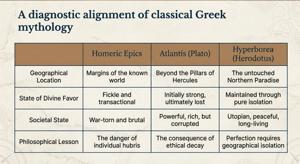
Similarly, Atlantis and Hyperborea are described as lands at the margins of the known world. Plato’s Atlantis, as mentioned in his dialogues “Timaeus” and “Critias,” is a powerful island nation beyond the Pillars of Hercules, rich in resources but doomed by its moral failings. Hyperborea, mentioned in sources such as Herodotus and later Greek lore, is portrayed as a northern paradise, untouched by war or disease, where people live exceptionally long lives in peace—a stark contrast to the often brutal world depicted by Homer.

 (The Troy, Hyperborea and Atlantis Connection)
(The Troy, Hyperborea and Atlantis Connection)

Themes of Heroism and Hubris

In Homer’s works, heroism plays a central role. Characters are often defined by their bravery, strength, and, sometimes, overconfidence. The gods frequently intervene in these epics, either supporting or hindering heroes based on divine justice or whims. The theme of excessive pride, known as hubris, leading to downfall, is particularly prominent, serving as a moral lesson on the limitations of human ambition.

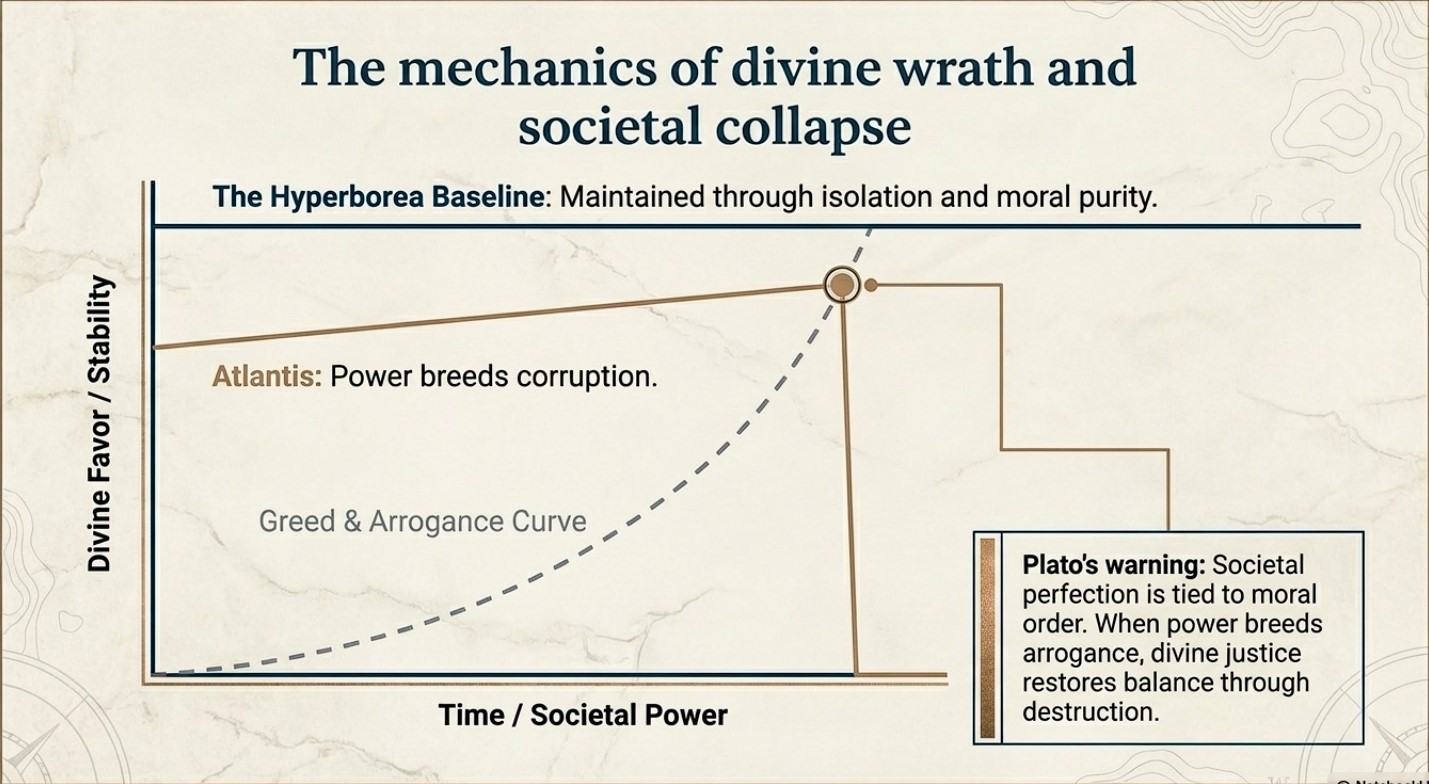
The story of Atlantis presents a similar theme to this idea. Plato describes a society that starts off living in an idyllic state and enjoying divine favour. However, as Atlantis grows in power and pride, it falls prey to greed and corruption. This ultimately attracts divine wrath, leading to its destruction. This narrative echoes Homeric themes where divine justice ultimately restores the balance disrupted by human arrogance.

 (The Troy, Hyperborea and Atlantis Connection)
(The Troy, Hyperborea and Atlantis Connection)

Divine Favour and Moral Order

The gods play a significant role in human affairs in both Homer’s epics and the tales of Hyperborea and Atlantis. In Homer’s works, the gods are unpredictable and often act on personal motives, reflecting the Greeks’ belief that divine favour is fleeting and must be continually earned through piety and sacrifice.

Compared with other myths, the myths of Hyperborea and Atlantis portray divine favour as initially more stable, yet still requiring adherence to a moral order. Hyperborea is considered a favoured land as long as it remains isolated from the greed and corruption of the outside world. This suggests that societal perfection depends on both geographical isolation and moral purity. In contrast, Atlantis loses its divine favour not because of isolation but because of moral failure. This highlights a philosophical perspective where ethical decay leads to ruin.

 (The Troy, Hyperborea and Atlantis Connection)
(The Troy, Hyperborea and Atlantis Connection)

Literary and Cultural Influence

The ancient Greek myths and narratives not only conveyed historical experiences but also shaped their perceptions of the world and the cosmos. They blended mythological interpretation with reality to teach important lessons of morality, ethics, and human limitations.

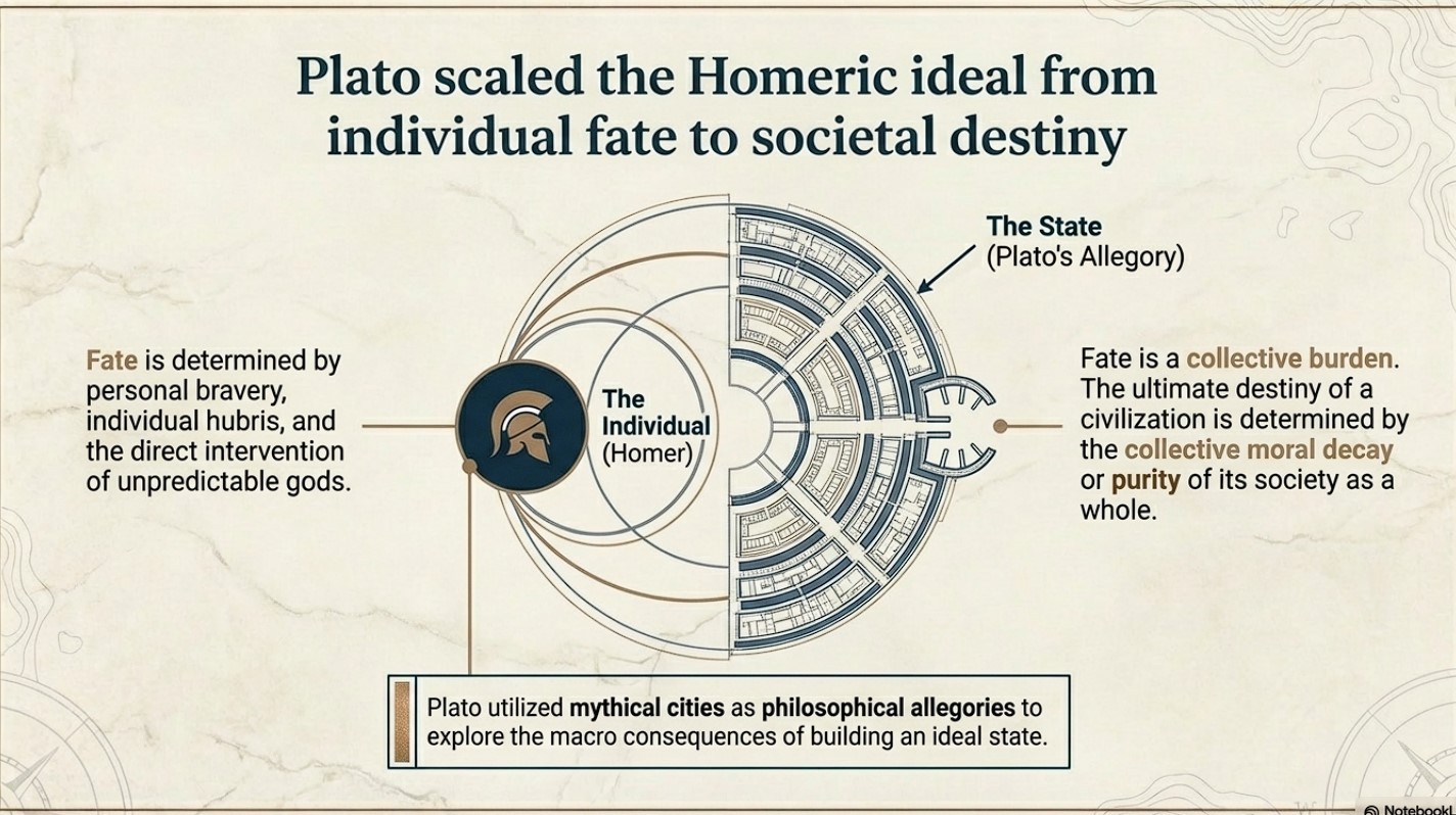
Plato’s works “Timaeus” and “Critias” utilise the mythical city of Atlantis as a philosophical allegory to explore the ideal state and the consequences of moral decay. This is an extension of Homeric exploration of heroism and divine justice, but Plato takes it a step further. While Homer focuses on individual fate and divine intervention, Plato broadens the scope to societal destiny, where the collective actions of a society determine its ultimate fate.

 (The Troy, Hyperborea and Atlantis Connection)
(The Troy, Hyperborea and Atlantis Connection)

Conclusion

Let’s stop pretending these are just stories.

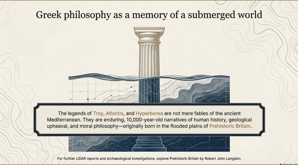
The legends of Atlantis and Hyperborea are not abstract myths or philosophical inventions. They are cultural memories—distorted over time, but rooted in real events, real places, and real people.

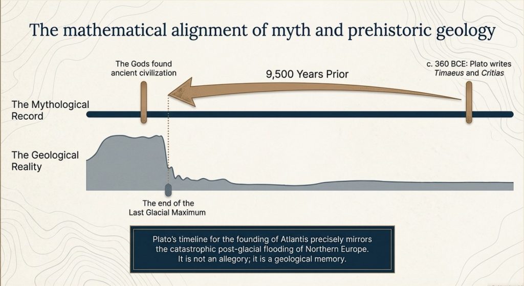
Plato gives us the key. He states clearly that this lost civilisation existed around 9500 years ago. That date is not negotiable, and it is not symbolic. It lands exactly at the end of the last Ice Age—precisely when the physical evidence shows catastrophic environmental change across north-west Europe.

At that moment in time, Doggerland existed.

And then it didn’t.

We know—measurably—that this landscape was flooded, fragmented, and ultimately destroyed by rising sea levels and sustained hydrological pressure. This is not speculation. It is supported by geological, sea-level, and sedimentary evidence. The land was there, and then it was gone.

Now combine that with archaeology.

 (The Troy, Hyperborea and Atlantis Connection)
(The Troy, Hyperborea and Atlantis Connection)

Stonehenge is no longer explainable as ritual nonsense or symbolic guesswork. When examined properly, it behaves as a functional system—engineered, repeatable, and practical. The so-called “Stonehenge computer” demonstrates predictive capability, environmental integration, and structured design. That is not primitive behaviour. That is applied knowledge.

So we have a date.
We have an event.
And we have a level of capability that matches the description.

This is where the academic narrative collapses.

Because once you accept the timing and the evidence, the conclusion becomes unavoidable:

Atlantis is Doggerland.

 (The Troy, Hyperborea and Atlantis Connection)
(The Troy, Hyperborea and Atlantis Connection)

Hyperborea is the same memory, seen from another direction.

And the “gods” described by the Greeks were not gods at all—they were the survivors of a lost civilisation whose knowledge far exceeded that of the cultures that came after them.

When Doggerland drowned, its people did not disappear. They moved. They carried knowledge of engineering, navigation, landscape, and time—knowledge that later cultures preserved as myth because they no longer understood its origin.

This is why the stories persist.
This is why they are consistent.
And this is why they refuse to go away.

Because they are not fiction.

They are memories.

And once you place them back into their correct context—time, landscape, and physical evidence—the mystery disappears.

What remains is not mythology.

It is history.

PodCast

Author’s Biography

Robert John Langdon, a polymathic luminary, emerges as a writer, historian, and eminent specialist in LiDAR Landscape Archaeology.

His intellectual voyage has been interwoven with stints as an astute scrutineer for governmental realms and grand corporate bastions, a tapestry spanning British Telecommunications, Cable and Wireless, British Gas, and the esteemed University of London.

A decade hence, Robert’s transition into retirement unfurled a chapter of insatiable curiosity. This phase saw him immerse himself in Politics, Archaeology, Philosophy, and the enigmatic realm of Quantum Mechanics. His academic odyssey traversed the venerable corridors of knowledge hubs such as the Museum of London, University College London, Birkbeck College, The City Literature Institute, and Chichester University.

In the symphony of his life, Robert is a custodian of three progeny and a pair of cherished grandchildren. His sanctuary lies ensconced in the embrace of West Wales, where he inhabits an isolated cottage, its windows framing a vista of the boundless sea – a retreat from the scrutinous gaze of Her Majesty’s Revenue and Customs, an amiable clandestinity in the lap of nature’s embrace.

Exploring Prehistoric Britain: A Journey Through Time

My blog delves into the fascinating mysteries of prehistoric Britain, challenging conventional narratives and offering fresh perspectives grounded in cutting-edge research, particularly LiDAR technology. I invite you to explore some key areas of my research. For example, the Wansdyke, often cited as a defensive structure, is re-examined in light of new evidence. I’ve presented my findings in my blog post Wansdyke: A British Frontier Wall – ‘Debunked’, and aWansdyke LiDAR Flyover video further visualises my conclusions.

My work also often challenges established archaeological dogma. I argue that many sites, such as Hambledon Hill, commonly identified as Iron Age hillforts, are not what they seem. My posts Lidar Investigation Hambledon Hill – NOT an ‘Iron Age Fort’ and Unmasking the “Iron Age Hillfort” Myth explore these ideas in detail and offer an alternative view. Similarly, sites like Cissbury Ring and White Sheet Camp also receive a re-evaluation based on LiDAR analysis in my posts “Lidar Investigation Cissbury Ring through time” and “Lidar Investigation White Sheet Camp, revealing fascinating insights into their true purpose. I have also examined South Cadbury Castle, often linked to the mythical Camelot56.

My research also extends to ancient water management, including the role of canals and other linear earthworks. I have discussed the true origins of Car Dyke in multiple posts, including Car Dyke – ABC News Podcast and Lidar Investigation Car Dyke – North Section, which suggest a Mesolithic origin 2357. I also explore the misidentification of Roman aqueducts, as seen in my posts on the Great Chesters (Roman) Aqueduct. My research has also been greatly informed by my post-glacial flooding hypothesis, which has helped explain landscape transformations over time. I have discussed this hypothesis in several posts, including AI now supports my Post-Glacial Flooding Hypothesis and Exploring Britain’s Flooded Past: A Personal Journey

Finally, my blog also investigates prehistoric burial practices, as seen in Prehistoric Burial Practices of Britain and explores the mystery of Pillow Mounds, often mistaken for medieval rabbit warrens, but with a potential link to Bronze Age cremation in my posts: Pillow Mounds: A Bronze Age Legacy of Cremation? and The Mystery of Pillow Mounds: Are They Really Medieval Rabbit Warrens?. My research also includes astronomical insights into ancient sites, for example, in Rediscovering the Winter Solstice: The Original Winter Festival. I also review new information about the construction of Stonehenge in The Stonehenge Enigma.

Further Reading

For those interested in British Prehistory, visit www.prehistoric-britain.co.uk, a comprehensive resource featuring an extensive collection of archaeology articles, modern LiDAR investigations, and groundbreaking research. The site also includes insights and excerpts from the acclaimed Robert John Langdon Trilogy, a series of books that explore Britain during the Prehistoric period. Titles in the trilogy include The Stonehenge Enigma, Dawn of the Lost Civilisation, and The Post-Glacial Flooding Hypothesis, which offer compelling evidence of ancient landscapes shaped by post-glacial flooding.

To further explore these topics, Robert John Langdon has developed a dedicated YouTube channel featuring over 100 video documentaries and investigations that complement the trilogy. Notable discoveries and studies showcased on the channel include 13 Things that Don’t Make Sense in History and the revelation of Silbury Avenue – The Lost Stone Avenue, a rediscovered prehistoric feature at Avebury, Wiltshire.

In addition to his main works, Langdon has released a series of shorter, accessible publications, ideal for readers delving into specific topics. These include:

For active discussions and updates on the trilogy’s findings and recent LiDAR investigations, join our vibrant community on Facebook. Engage with like-minded enthusiasts by leaving a message or contributing to debates in our Facebook Group.

Whether through the books, the website, or interactive videos, we aim to provide a deeper understanding of Britain’s fascinating prehistoric past. We encourage you to explore these resources and uncover the mysteries of ancient landscapes through the lens of modern archaeology.

For more information, including chapter extracts and related publications, visit the Robert John Langdon Author Page. Dive into works such as The Stonehenge Enigma or Dawn of the Lost Civilisation, and explore cutting-edge theories that challenge traditional historical narratives.

Other Blogs

s

t