The Stonehenge Transportation Mystery

Introduction

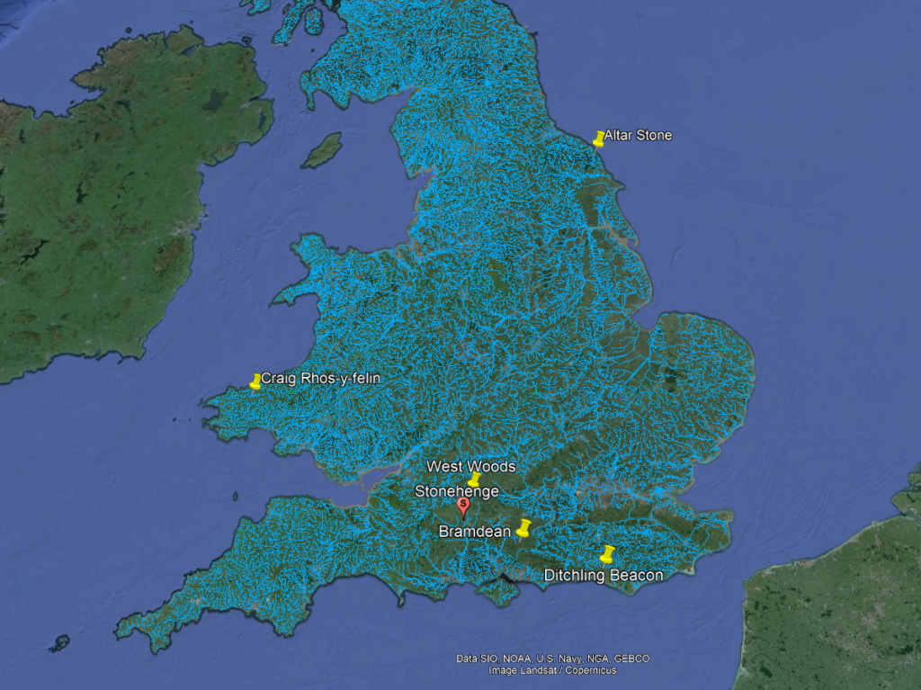
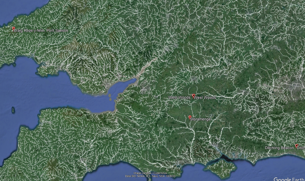
Exploring the origins and transport of the stones used to construct Stonehenge remains a fascinating subject, rife with theories and controversies. The viral interest generated by my blog post this week, which highlighted a map showing three known sites of the stones’ origins, barely scratches the surface of this complex logistical puzzle. Indeed, there are stones from even greater distances, raising myriad questions about how these megaliths were transported to their final resting place at Stonehenge. This essay aims to delve into these logistics, providing a comprehensive overview grounded in the latest research and theories. (The Stonehenge Transportation Mystery)
The Stonehenge Transportation Mystery

The Bluestones

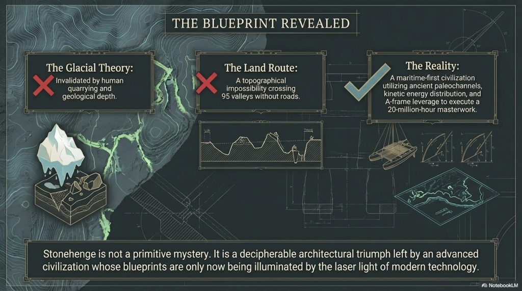
Recent advancements in micro-spectrum analysis have significantly contributed to our understanding of the origins of bluestones. However, this is not an exact science, as the movement of rocks due to glacial activity and post-ice age water flows complicates their traceability. Some academics have proposed that the bluestones found at Stonehenge were not quarried and transported from Wales but deposited nearby by glacial action. This theory, however, conflicts with geological evidence indicating that the last ice age glaciers did not reach as far as Stonehenge, stopping instead at the Bristol Channel. This discrepancy casts doubt on the glacier transport theory, suggesting the need to consider earlier ice ages, such as the Anglian, which occurred over 500,000 years ago. Yet the immense timescale involved means that any stones moved by such glaciers would be deeply buried beneath millennia of soil, making their discovery improbable.
The Stonehenge Transportation Mystery

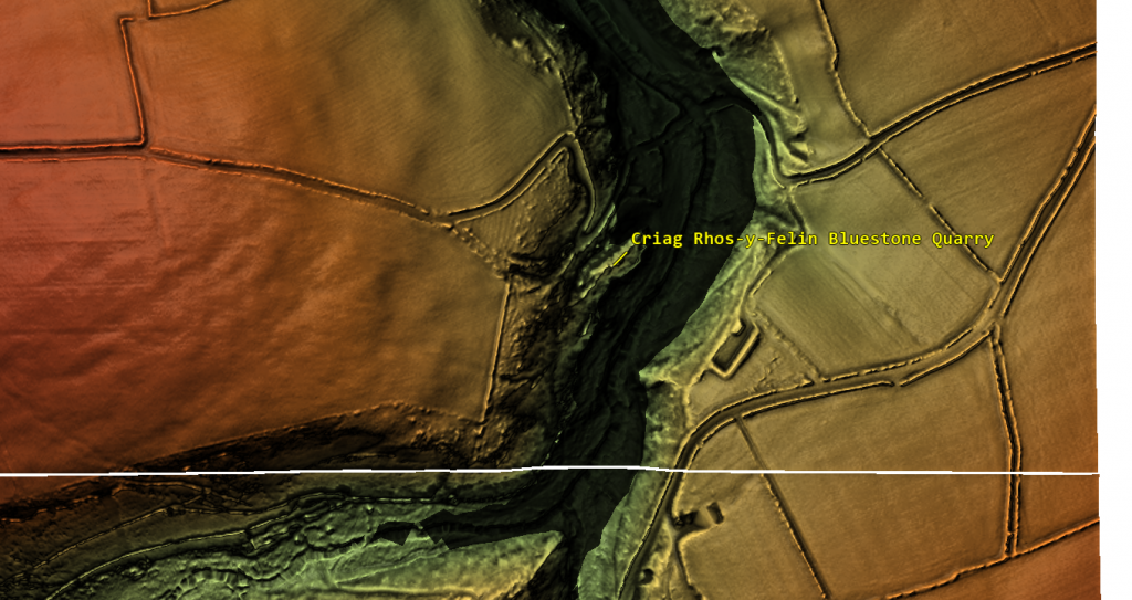
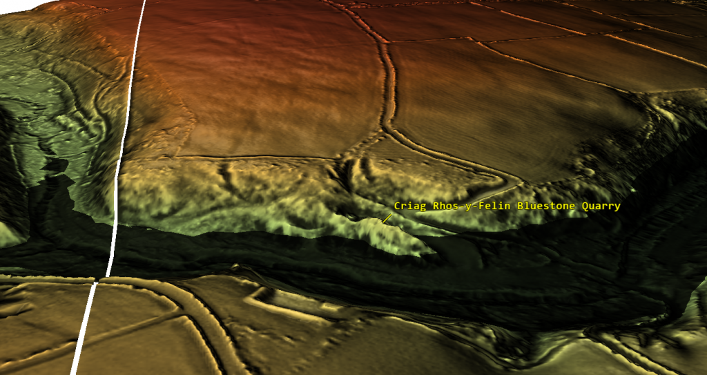
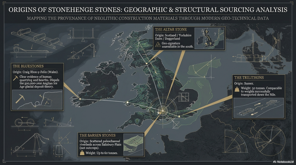
Furthermore, the lack of bluestone erratics in the vicinity of Stonehenge further challenges the idea of glacial transport. The site at Craig Rhos-Y-Felin, identified as a source of the bluestones, shows clear evidence of human quarrying activity, contradicting the theory that these stones were randomly picked up from glacial deposits. The discovery of human hearths and quarrying tools at Craig Rhos-Y-Felin, along with a partially quarried bluestone, strongly suggests that these stones were intentionally selected and transported for use at Stonehenge.
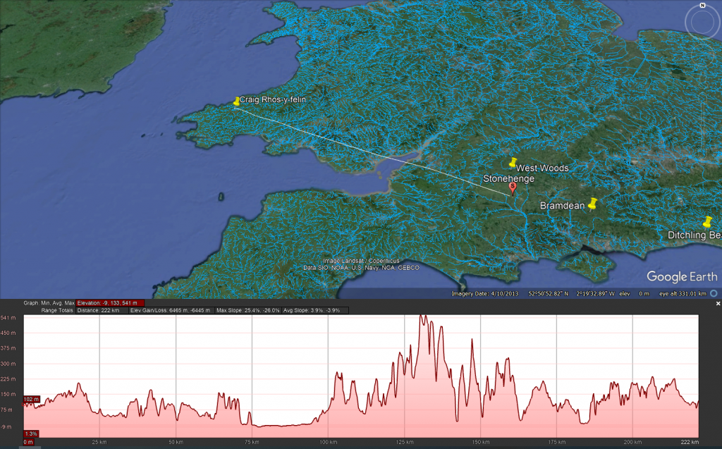
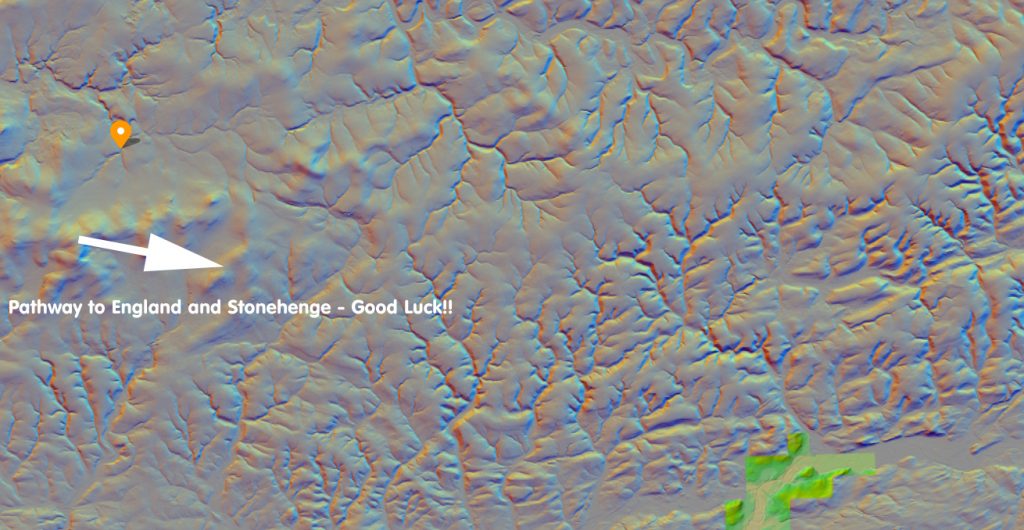
Craig Rhos-y-felin to Stonehenge
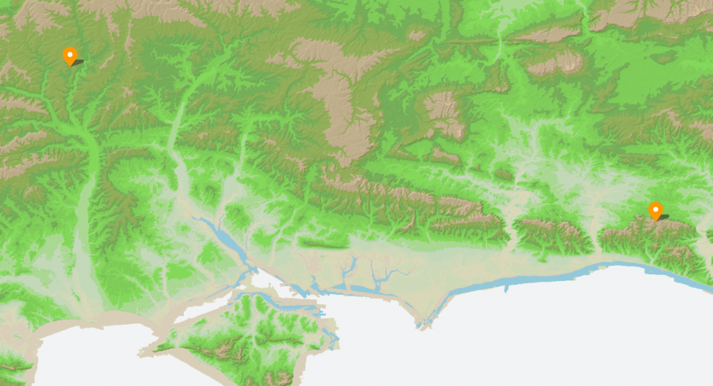
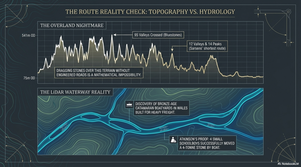
The overland path from Craig Rhos-y-felin to Stonehenge is insane. It goes from 75m OD to 541 OD and crosses 95 valleys – the idea that you can either roll, drag or ox-cart such a route without a road is bonkers!!

The Sarsen Stones

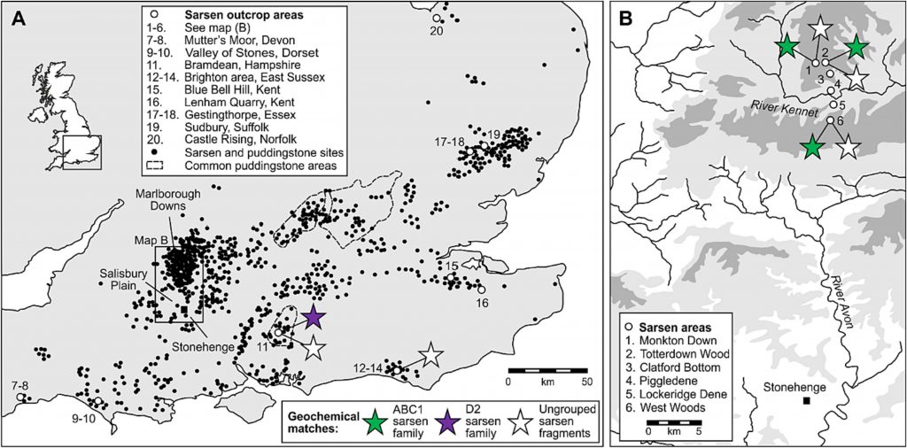
The origin and transportation of the sarsen stones present a different set of challenges. These stones are found scattered across the Salisbury Plain and further afield, in areas never reached by the ice sheets that covered Britain during the last ice age. The popular theory that the sarsen stones came from West Woods near Avebury suggests that they could have been dragged to their current location. However, recent observations indicate that many of these stones are in paleochannel riverbeds rather than rock outcrops. This suggests that they were transported by ice-age floodwaters rather than being quarried from nearby outcrops.
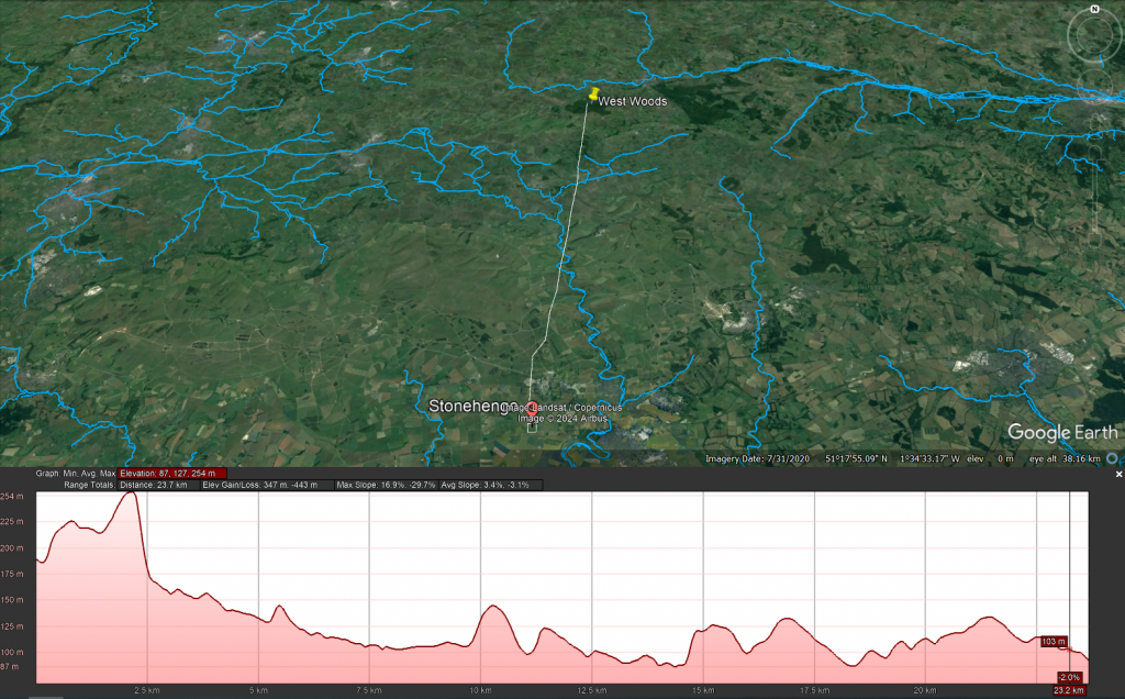
West Woods to Stonehenge
Even the shortest route known to transport these stones is difficult to follow, as the 12 valleys and 14 peaks shown on this map testify.

Theories of Transportation

The theory that the stones could have been moved over frozen rivers during the ice age is intriguing but fraught with logistical issues. The absence of a significant human population capable of organising such an endeavour, coupled with the challenges of moving heavy stones over potentially thin ice, makes this theory less plausible. Additionally, the radiocarbon dating of Stonehenge would be significantly off if the stones had been transported at the end of the ice age.
The Stonehenge Transportation Mystery

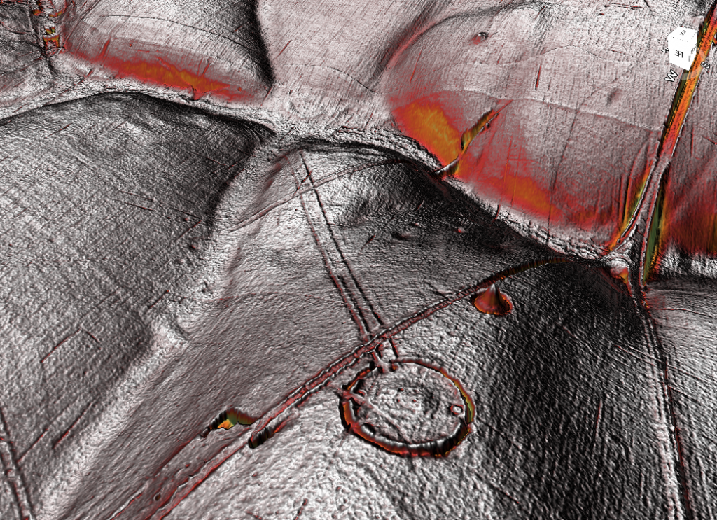
LiDAR, or Light Detection and Ranging, is a remote sensing technology that uses laser light to densely sample the earth’s surface, creating highly accurate topographic maps. It has revolutionised archaeological surveys by uncovering features difficult or impossible to see from the ground or through traditional surveying methods. Regarding Stonehenge and the transportation of the stones used in its construction, LiDAR technology offers invaluable insights into the landscape and potential transport routes used by ancient peoples.
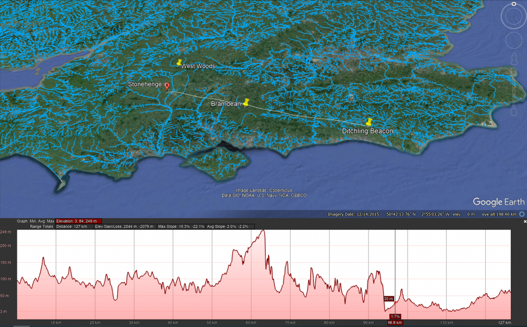
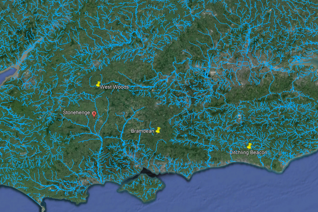
Ditching to Stonehenge
The trilithon stones, weighing around 50 tonnes, reportedly come from Sussex. Such weights were successfully transported down the Nile on boats.

LiDAR Evidence and Stonehenge

LiDAR has been instrumental in mapping the landscape around Stonehenge, revealing details that have remained hidden for millennia under vegetation or soil. This technology has the potential to identify old riverbeds, trackways, and other features that could suggest routes for transporting the massive sarsen stones and bluestones used in the monument’s construction. However, despite its capabilities, LiDAR has not yet provided definitive evidence of prehistoric roads or paths leading directly from the quarries to Stonehenge.
The Stonehenge Transportation Mystery

Key Findings from LiDAR Surveys

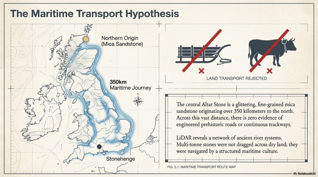
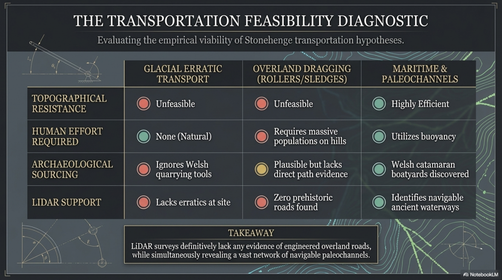
No Prehistoric Roads from Quarries: LiDAR surveys have not found any evidence of engineered roads or paths originating from the bluestone quarries in Wales or from locations where sarsen stones are found. This absence challenges theories that rely on overland transport of the stones using rollers, sledges, or ox-carts over vast distances and rugged terrain.

Ancient Waterways and Paleochannels: One significant contribution of LiDAR is the identification of ancient waterways and paleochannels. These features are crucial for understanding the prehistoric landscape, suggesting that rivers and watercourses may have played a significant role in transporting the stones. The larger rivers identified by LiDAR, which were navigable in the past, support the theory that water transport was a feasible and preferred method for moving the stones.
Atkinson's Method
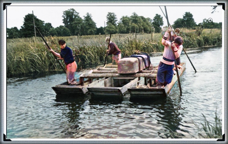
Atkinson proved with just four small schoolboys that a 4-tonne stone can easily be moved by boat down to the River Avon

Landscape Features: LiDAR has revealed the complexity of the landscape through which any transportation route would have had to navigate, including valleys, dense forests, and waterlogged areas. This detailed mapping underscores the logistical challenges faced by ancient builders, further calling into question the practicality of relying solely on land-based transport methods.

The Stonehenge Transportation Mystery
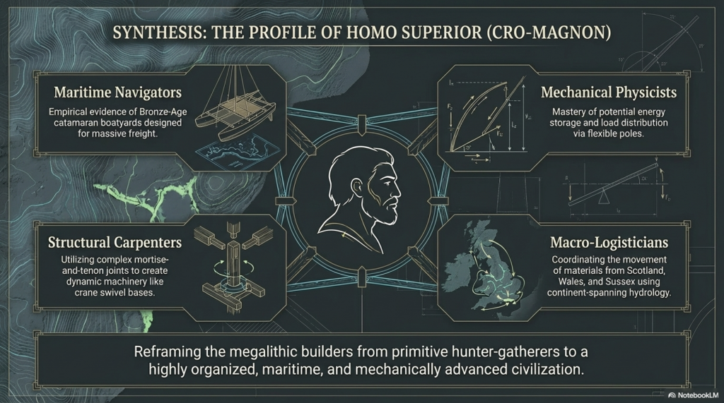
We have now found empirical evidence of boat yards in which catamaran design is made to carry large weights in Wales, dating back to the Bronze Age and beyond

Implications of LiDAR Evidence

The evidence from LiDAR surveys, particularly the absence of prehistoric roads and the emphasis on natural watercourses, suggests a reevaluation of how the stones were transported to Stonehenge. The lack of direct routes from quarries to the site and the identification of navigable ancient rivers and paleochannels lend weight to theories prioritising water transport. This perspective aligns with the understanding that ancient peoples were highly adept at utilising their natural environment to achieve monumental feats of construction.
Alter Stone to Stonehenge
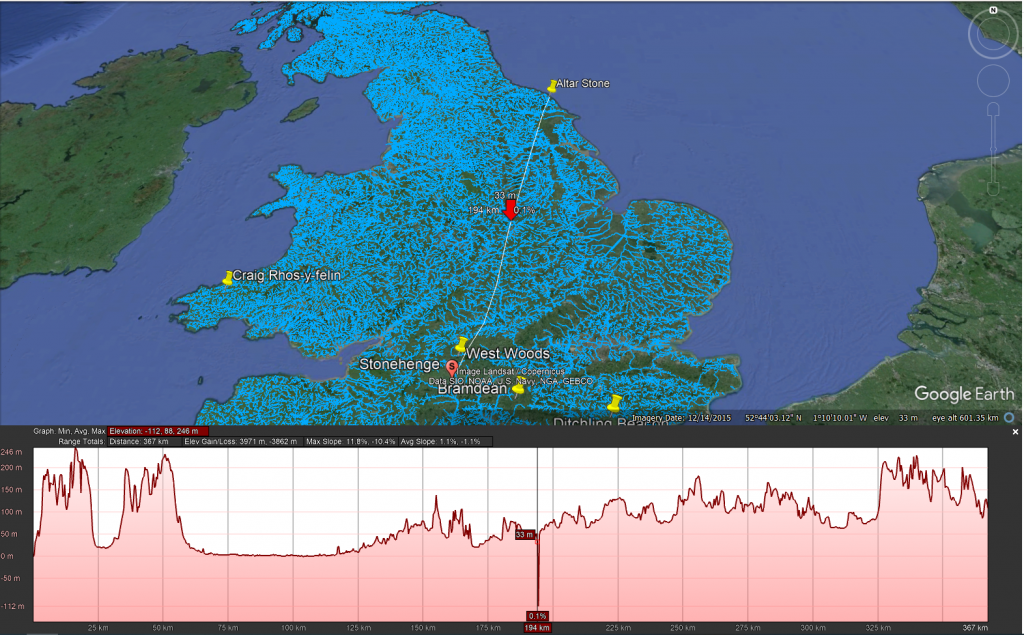
The Altar Stone is now suspected of coming from as far as Scotland, as its Geo signature is not available down south (I would guess Doggerland for obvious reasons), but even if it just came from the Yorkshire Dales, the idea of l, and transportation is pure nonsense

Short Transportation systems from the boat harbours to the Monument

Mechanical Advantage of Poles (from the book – Dawn of the Lost Civilisation)

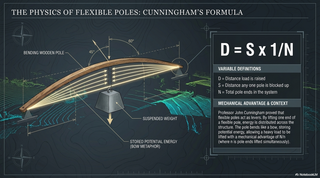
The principle of leverage, applied through poles, provides a mechanical advantage when handling heavy weights. Professor John Cunningham, an art professor at Skidmore College, has introduced a novel concept, creating a new class of simple machines based on flexible rods. Unlike traditional machines, Cunningham’s design not only multiplies force but also distributes it and stores mechanical energy.
The Stonehenge Transportation Mystery

Consider a scenario with a 20,000-pound stone. If you attempt to support it on two rigid beams, each will bear half the weight (10,000 pounds), posing a risk of fracture. Now, imagine spreading the load across 20 solid, parallel beams, each supporting only a fraction of the total weight, making the burden manageable. Cunningham’s innovation takes this idea further by replacing solid beams with flexible poles.
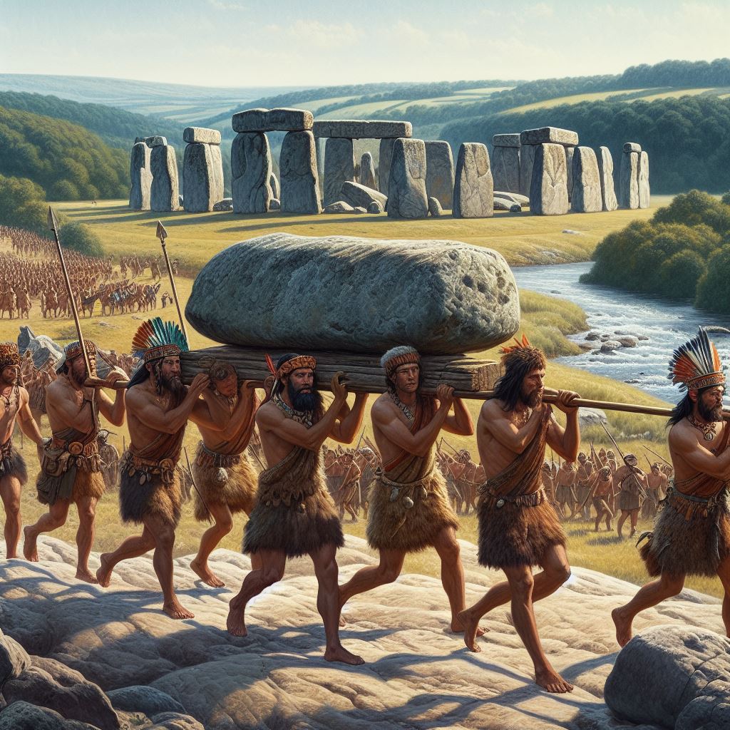
Stone Transportation and Dumb Censorship
The Bluestones were carried, not dragged, to Stonehenge

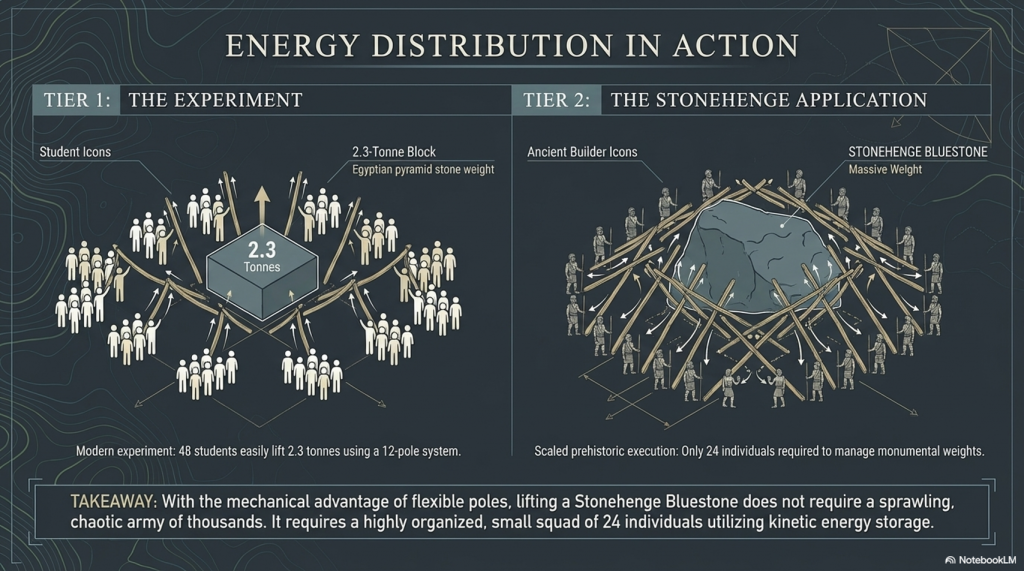
In the flexible pole structure, each pole can be raised independently without affecting the others. By lifting one end of a pole, a small amount of extra energy is imparted to that pole, and the energy is distributed across the structure. The weight rises by a fraction of the raised end, divided by the number of pole ends. If one end is lifted by a foot, the weight on each of the other pole ends diminishes by a corresponding fraction. Using this method, heavy loads can be lifted with significantly fewer people, as each person is only moving a fraction of the weight at a time.

This innovative approach enables efficient handling of substantial weights, offering a unique perspective on the use of mechanical advantage in lifting and distributing loads. (Stone transportation and censorship)
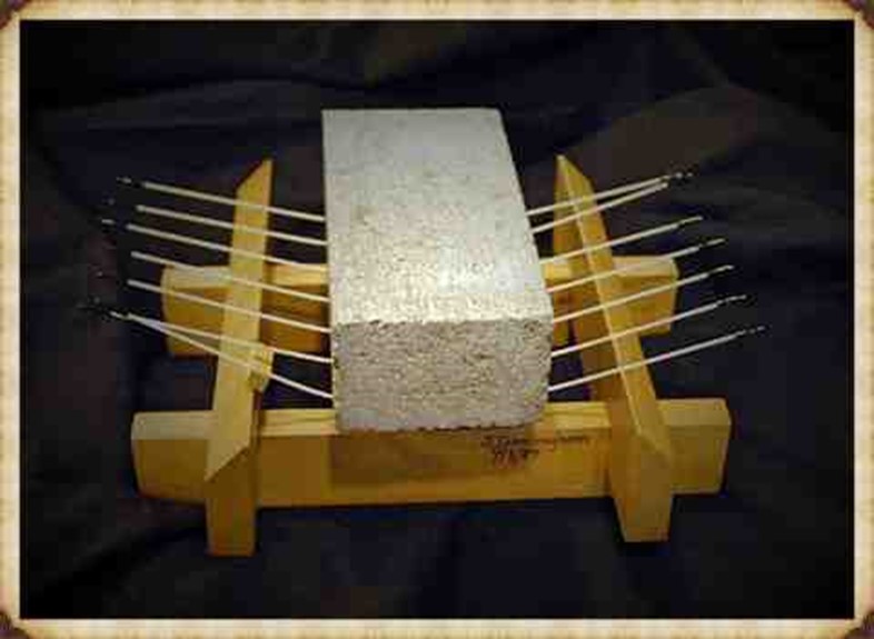
The Stonehenge Transportation Mystery

Cunningham has distilled the concept to a formula:
D = S x 1/N

Where D is the distance, the load is raised, s is the distance any one pole is blocked up, and N is the total number of pole ends in the system. Given n is the number of pole ends lifted simultaneously, the mechanical advantage for any symmetrical pole configuration will be N/n.
The Stonehenge Transportation Mystery


So, the fact that a pole bends like a bow, storing energy, makes it easier to carry. So easy in fact, that it acts as a lever and gives you a mechanical advantage. This principle would be well known as it is the same principle as how a bow works as it is a store of potential energy, you can’t throw an arrow 100 metres, but the bowing of the wood channelled through a small area (the string) give you the potential energy.

Walk like an Egyptian

The experiment showed that 48 students ( four x 12 poles) could lift 2.3 tonnes, which was the weight of one of the pyramid’s building stones. The larger the stone, the more poles and men you need, but it was quite easy even for wimpish students. In prehistoric Days with Cro-Magnon works you would need only 24 people to move a Pyramid stone or a Bluestone at Stonehenge without the rest blocks the video has included in their H & S safety assessment….LOL!!

A-Frames and Cranes

The advancement of technology and the movement of massive stones, such as the Sarsen stones at Stonehenge, Avebury, and Carnac, demand a closer examination of the engineering and logistical challenges faced by the ancient civilisation of Homo Superior, also known as Cro-Magnons. The Sarsen stones, weighing up to 60 tonnes, were not merely transported but meticulously erected, presenting a feat that even modern attempts struggle to replicate.


In our exploration of ancient technology, we encounter the question of how to transport and handle colossal loads. The Sarsen stones serve as an illustrative example due to their significant size, and it is perplexing that historians and archaeologists often overlook the intricacies of moving and placing these stones. This oversight persists even though, even with today’s technology, replicating the achievements of Homo Superior at Stonehenge remains a daunting challenge.
The Stonehenge Transportation Mystery


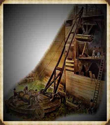
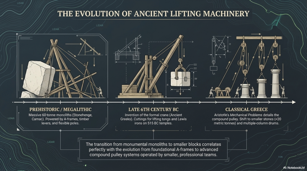
The crane, a machine designed to lift and move heavy materials, is pivotal in the transport and construction industries. Equipped with a hoist, wire ropes or chains, and sheaves, a crane utilises mechanical advantages to lift and lower materials beyond the capacity of human effort. Historically, the invention of the crane is attributed to the Ancient Greeks in the late 6th century BC, as evidenced by cuttings for lifting tongs and Lewis irons on stone blocks of Greek temples dating to around 515 BC.

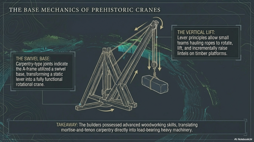
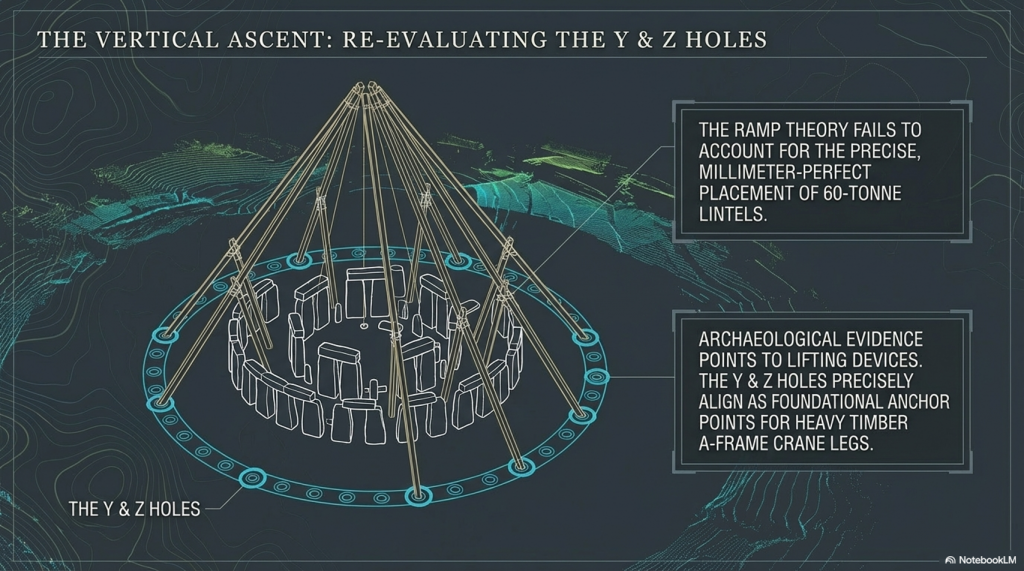
However, when scrutinising Stonehenge, we encounter a fascinating divergence. In contrast, archaeological evidence points to the use of lifting devices, particularly with cuttings indicating the application of cranes, the peculiarities of Stonehenge’s construction challenge conventional narratives. Notably, the placement of lintels on Sarsen uprights and the presence of holes like Y & Z, potentially serving as foundations for A-frame crane legs, hint at a more sophisticated lifting apparatus.
The Stonehenge Transportation Mystery

The reluctance of some scholars to acknowledge advanced lifting devices in the historical context of Homo Superior may stem from the challenge they pose to established historical frameworks. Nevertheless, the investigation into the engineering marvels of Stonehenge encourages us to reassess the capabilities of this ancient civilisation, prompting a deeper understanding of their technological prowess and organisational acumen.
The Stonehenge Transportation Mystery

The transition from ramps to the more sophisticated winch-and-pulley hoist marked a significant shift in ancient construction technology. The emergence of the compound pulley system, attributed to Aristotle in the Mechanical Problems, coincided with a notable decrease in the weights of stones handled on Greek building sites. This transformative period saw the prevalence of smaller stones, weighing less than 15–20 metric tonnes, in contrast to the archaic era’s trend of using larger blocks.

The adoption of the crane, facilitated by the compound pulley system, introduced a more efficient and practical method of vertical motion. Grecian temples of the classical age, exemplified by the Parthenon, favoured using several smaller stones rather than fewer larger ones. Monolithic columns, a prominent feature in earlier constructions, were gradually replaced by multiple-column drums.
The Stonehenge Transportation Mystery

The reasons behind this technological evolution are not entirely clear. It raises intriguing questions about whether the shift from larger to smaller stones was due to the loss of past techniques, improved quarrying methods that enabled faster cutting of shorter blocks, or other factors influencing construction practices. The shift in societal dynamics, with smaller, professional construction teams being favoured over larger bodies of unskilled labour, is proposed as a potential contributing factor. The crane, with its efficiency in handling smaller stones, became preferable in the more volatile social and political conditions of ancient Greece.

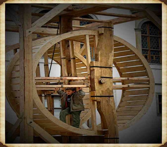
While the exact circumstances of this transition remain uncertain, the historical record indicates that the compound pulley system and the crane became integral to Greek construction sites. The literary evidence from Aristotle’s Mechanical Problems and the resurgence of larger block sizes at Greek temples suggests a correlation between the adoption of the compound pulley and advancements in construction techniques. The earliest construction cranes, likely powered by humans or beasts of burden like donkeys, marked a transformative period in ancient construction methods.
(Stone transportation and censorship)
The Stonehenge Transportation Mystery

The evolution of cranes played a crucial role in the construction of tall buildings, enabling the lifting of heavier loads. In the High Middle Ages, harbour cranes emerged to facilitate ship loading and unloading, often integrated into stone towers for enhanced strength and stability. The earliest cranes were crafted from wood, but with the advent of the Industrial Revolution, materials like cast iron and steel became predominant.

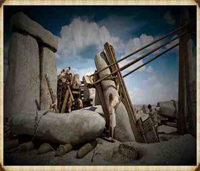
At Stonehenge, the construction methods are a subject of speculation, with suggestions that timber A-frames were employed to raise the stones. Teams of individuals may have hauled the stones upright using ropes, and the topmost stones (lintels) could have been incrementally raised on timber platforms and slid or pushed into place. Carpentry-type joints on the stones indicate a high level of woodworking skill among the builders.
The Stonehenge Transportation Mystery

The idea of A-frames finds support in demonstrations by individuals such as Wally Wallington, a retired construction worker, who showcased techniques based on lever principles for rotating, lifting, and positioning heavy monoliths. An A-frame, essentially a basic crane without a pulley or winch, operates on similar principles to facilitate vertical movement. Adding a swivel base could transform it into a fully functional crane, a concept compatible with the mortise-and-tenon joints observed at Stonehenge.
(Stone transportation and censorship)
The Stonehenge Transportation Mystery

Estimates of the manpower required for Stonehenge’s construction suggest a substantial effort, with millions of hours of work. The various phases of Stonehenge’s construction, from the initial to the third phase, may have required extensive human labour, amounting to up to 20 million hours spent working the stones. The primitive tools available at the time necessitated considerable effort, highlighting the strong will and advanced social organisation required to build and maintain such a monumental site. Stonehenge stands as a testament to the ingenuity and determination of its ancient builders. (Stone transportation and censorship)
The Stonehenge Transportation Mystery

PodCast

Author’s Biography

Robert John Langdon, a polymathic luminary, emerges as a writer, historian, and eminent specialist in LiDAR Landscape Archaeology.

His intellectual voyage has been interwoven with stints as an astute scrutineer in government and grand corporate bastions, a tapestry spanning British Telecommunications, Cable and Wireless, British Gas, and the esteemed University of London.

A decade hence, Robert’s transition into retirement unfurled a chapter of insatiable curiosity. This phase saw him immerse himself in Politics, Archaeology, Philosophy, and the enigmatic realm of Quantum Mechanics. His academic odyssey traversed the venerable corridors of knowledge hubs such as the Museum of London, University College London, Birkbeck College, The City Literature Institute, and Chichester University.

In the symphony of his life, Robert is a custodian of three progeny and a pair of cherished grandchildren. His sanctuary lies ensconced in the embrace of West Wales, where he inhabits an isolated cottage, its windows framing a vista of the boundless sea – a retreat from the scrutinising gaze of Her Majesty’s Revenue and Customs, an amiable clandestinity in the lap of nature.

Exploring Prehistoric Britain: A Journey Through Time

My blog delves into the fascinating mysteries of prehistoric Britain, challenging conventional narratives and offering fresh perspectives grounded in cutting-edge research, particularly LiDAR technology. I invite you to explore some key areas of my research. For example, the Wansdyke, often cited as a defensive structure, is re-examined in light of new evidence. I’ve presented my findings in my blog post Wansdyke: A British Frontier Wall – ‘Debunked’, and a Wansdyke LiDAR Flyover video further visualises my conclusions.

My work also often challenges established archaeological dogma. I argue that many sites, such as Hambledon Hill, commonly identified as Iron Age hillforts, are not what they seem. My posts Lidar Investigation Hambledon Hill – NOT an ‘Iron Age Fort’ and Unmasking the “Iron Age Hillfort” Myth explore these ideas in detail and offer an alternative view. Similarly, sites like Cissbury Ring and White Sheet Camp receive re-evaluations based on LiDAR analysis in my posts “Lidar Investigation Cissbury Ring through time” and “Lidar Investigation White Sheet Camp, revealing fascinating insights into their true purpose. I have also examined South Cadbury Castle, often linked to the mythical Camelot56.

My research also extends to ancient water management, including the role of canals and other linear earthworks. I have discussed the true origins of Car Dyke in multiple posts, including Car Dyke – ABC News Podcast and Lidar Investigation Car Dyke – North Section, which suggest a Mesolithic origin 2357. I also explore the misidentification of Roman aqueducts, as seen in my posts on the Great Chesters (Roman) Aqueduct. My research has also been greatly informed by my post-glacial flooding hypothesis, which has helped explain landscape transformations over time. I have discussed this hypothesis in several posts, including AI now supports my Post-Glacial Flooding Hypothesis and Exploring Britain’s Flooded Past: A Personal Journey

Finally, my blog also investigates prehistoric burial practices, as seen in Prehistoric Burial Practices of Britain and explores the mystery of Pillow Mounds, often mistaken for medieval rabbit warrens, but with a potential link to Bronze Age cremation in my posts: Pillow Mounds: A Bronze Age Legacy of Cremation? and The Mystery of Pillow Mounds: Are They Really Medieval Rabbit Warrens?. My research also includes astronomical insights into ancient sites, for example, in Rediscovering the Winter Solstice: The Original Winter Festival. I also review new information about the construction of Stonehenge in The Stonehenge Enigma.

Further Reading

For those interested in British Prehistory, visit www.prehistoric-britain.co.uk, a comprehensive resource featuring an extensive collection of archaeology articles, modern LiDAR investigations, and groundbreaking research. The site also includes insights and excerpts from the acclaimed Robert John Langdon Trilogy, a series of books that explore Britain during the Prehistoric period. Titles in the trilogy include The Stonehenge Enigma, Dawn of the Lost Civilisation, and The Post-Glacial Flooding Hypothesis, which offer compelling evidence of ancient landscapes shaped by post-glacial flooding.

To further explore these topics, Robert John Langdon has developed a dedicated YouTube channel featuring over 100 video documentaries and investigations that complement the trilogy. Notable discoveries and studies showcased on the channel include 13 Things that Don’t Make Sense in History and the revelation of Silbury Avenue – The Lost Stone Avenue, a rediscovered prehistoric feature at Avebury, Wiltshire.

In addition to his main works, Langdon has released a series of shorter, accessible publications, ideal for readers delving into specific topics. These include:

For active discussions and updates on the trilogy’s findings and recent LiDAR investigations, join our vibrant community on Facebook. Engage with like-minded enthusiasts by leaving a message or contributing to debates in our Facebook Group.

Whether through the books, the website, or interactive videos, we aim to provide a deeper understanding of Britain’s fascinating prehistoric past. We encourage you to explore these resources and uncover the mysteries of ancient landscapes through the lens of modern archaeology.

For more information, including chapter extracts and related publications, visit the Robert John Langdon Author Page. Dive into works such as The Stonehenge Enigma or Dawn of the Lost Civilisation, and explore cutting-edge theories that challenge traditional historical narratives.

Other Blogs

s

t

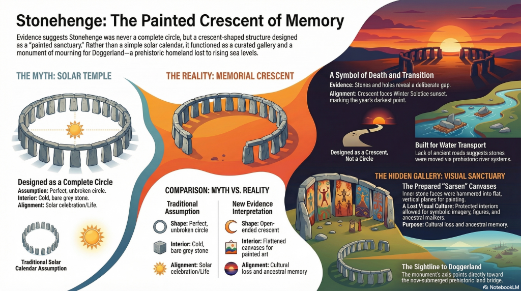
The Stonehenge Crescent: A Monument to a Lost World

A Monument to the Dead — Not the Sun

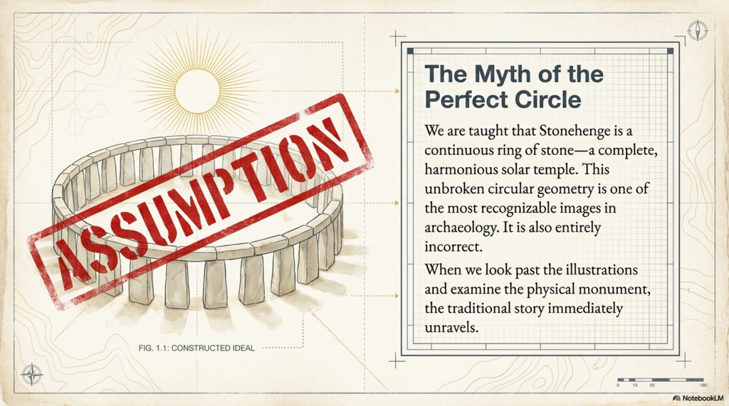
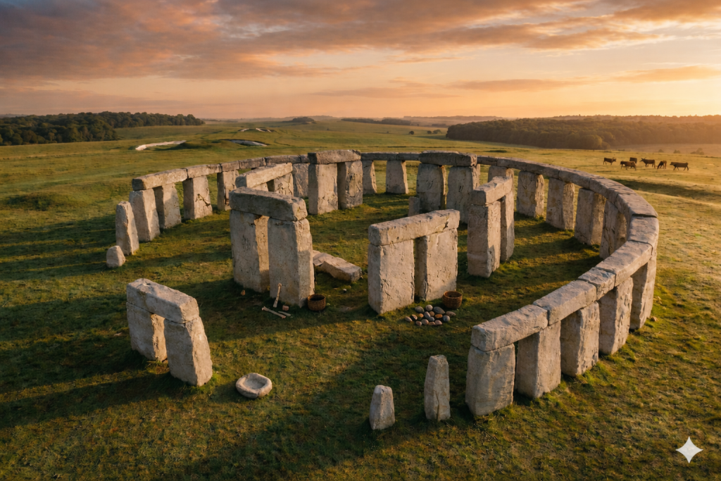
One of the most recognisable images in archaeology is that of a perfect circular Stonehenge — a continuous ring of upright stones capped with lintels. (The Stonehenge Crescent: A Monument to a Lost World)

You’ve seen it everywhere:

  • Textbooks
  • Reconstructions
  • Documentaries

It has become the accepted version of the monument.

There is just one problem.

Stonehenge was never built that way.

(The Stonehenge Crescent: A Monument to a Lost World)

The Myth of the Perfect Circle

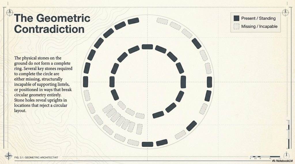
The circular Stonehenge exists more in illustration than in reality.

When we examine the monument itself, the physical evidence tells a very different story:

  • Several stones required to complete the circle are missing
  • Others are too small to support lintels
  • Some are incorrectly positioned for a continuous ring
  • Stone holes reveal uprights that do not conform to a circular design

This creates a fundamental contradiction.

If Stonehenge was intended to be a perfect solar temple, then:

  1. It was never completed
  2. Or it was deliberately dismantled

Both explanations are unsatisfactory.

There is a far simpler solution.

It was never meant to be a complete circle.

(The Stonehenge Crescent: A Monument to a Lost World)

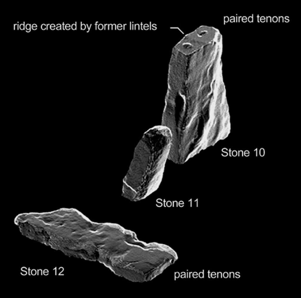
Structural Proof: Stone 11 Breaks the Model

This conclusion is not just interpretive — it is structural.

One stone alone exposes the flaw in the circular theory.

Stone 11.

This stone is:

  • Smaller than its neighbours
  • Structurally inadequate
  • Incapable of supporting a lintel

This is critical.

A continuous lintel ring requires every upright to meet a basic engineering condition:

It must support load.

Stone 11 cannot.

This is not a minor anomaly. It is a mechanical failure within the supposed design.

There are only two possible explanations:

  • The builders made a fundamental structural mistake
  • The circle was never intended to be continuous

Given the precision elsewhere in the monument, the first option is highly unlikely.

Which leaves only one conclusion:

Stone 11 is not an error — it is evidence.

It proves that the monument was never designed as a complete ring.

(The Stonehenge Crescent: A Monument to a Lost World)

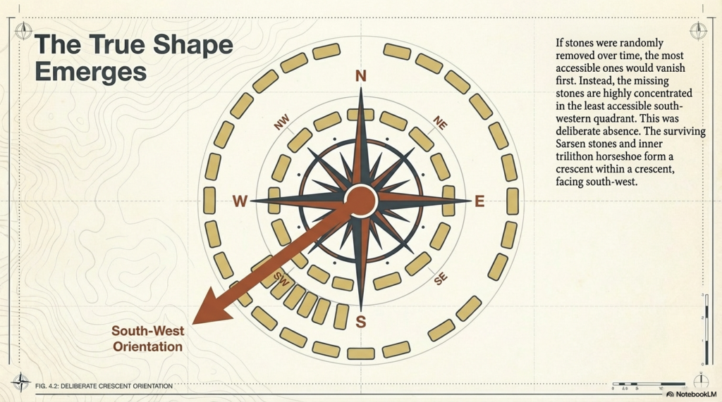
A Different Shape Emerges

When we examine all surviving stones and stone holes together, a new pattern appears.

Not a circle.

A crescent.

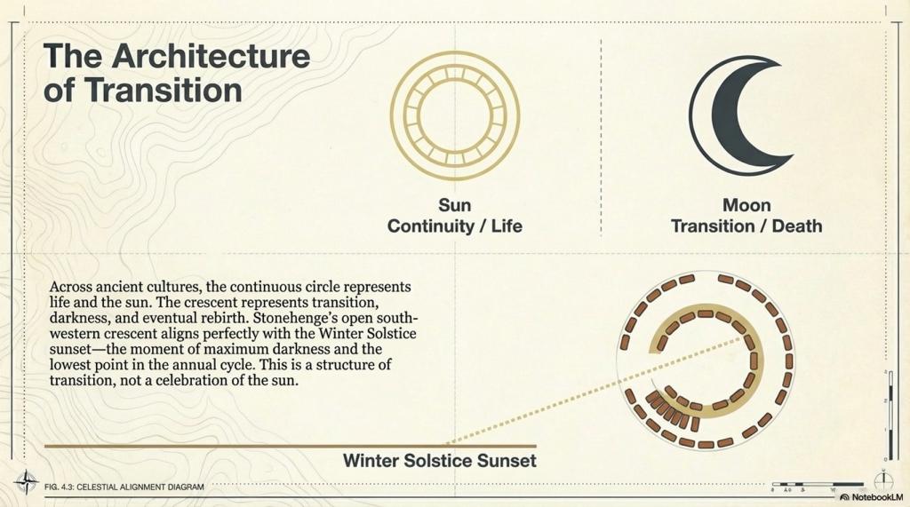
The Sarsen arrangement — particularly the inner trilithon horseshoe — reinforces this, forming a crescent within a crescent.

This is deliberate.

And its orientation matters.

(The Stonehenge Crescent: A Monument to a Lost World)

Death, Not the Sun

Across ancient cultures:

  • The sun represents life and continuity
  • The circle reflects that — endless and complete

But death is different.

Death is transition.

And that transition is often symbolised by the crescent moon — a passage between darkness and renewal.

Stonehenge aligns with this symbolism precisely.

The structure faces the Winter Solstice sunset:

  • The lowest point of the sun
  • The moment of greatest darkness
  • The turning point before light returns

This is not a monument to life.

It is a monument to transition.

(The Stonehenge Crescent: A Monument to a Lost World)

The Missing Stones Tell the Story

The pattern of missing stones strengthens this interpretation.

If stones had been removed later, we would expect:

  • Random distribution
  • Removal from accessible locations

But instead:

  • The majority of missing stones occur in the south-western quadrant
  • This is the least accessible area

This is not random.

It is intentional.

The monument was designed to be open in this direction — forming a crescent aligned with the Winter Solstice sunset.

(The Stonehenge Crescent: A Monument to a Lost World)

The Altar Stone and the Slaughter Stone

At the centre of the monument lies the Altar Stone:

  • Fine-grained sandstone
  • Rich in mica
  • Distinct from all other stones

It is also placed flat.

This is unusual — but not unique.

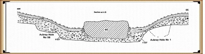
Near the entrance lies the Slaughter Stone, also recumbent.

Excavations in the 1920s showed:

  • The chalk beneath it was deliberately levelled
  • It was always intended to lie flat

Even more importantly:

  • It sits in a shallow depression
  • Connected to the ditch system
  • Likely water-filled under higher groundwater conditions

This would have made the stone appear as a small island in water.

(The Stonehenge Crescent: A Monument to a Lost World)

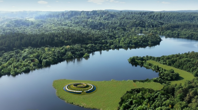
A Monument Built in Water

This aligns directly with the hydrological model of early Holocene Britain.

Evidence shows that:

  • Water tables were significantly higher
  • River systems were larger
  • Floodplains dominated the landscape

Stonehenge was not a dry site.

It existed within a water-controlled environment

(The Stonehenge Crescent: A Monument to a Lost World)

The Altar Stone: A Geological Clue

The Altar Stone introduces another layer of evidence.

It is widely accepted that:

  • It originates from outside the local region
  • It travelled over long distances

Traditional explanations suggest land transport.

But there is a problem.

Across hundreds of kilometres:

  • No prehistoric roads
  • No engineered trackways
  • No infrastructure for overland movement

What we do find is:

  • Extensive river systems
  • Floodplains
  • Palaeochannels

The conclusion is straightforward:

The stones were transported by water.

(The Stonehenge Crescent: A Monument to a Lost World)

The Doggerland Origin Hypothesis

There is an additional, often overlooked possibility.

The geological composition of the Altar Stone matches:

  • Bedrock found in northern Britain
  • And bedrock mapped beneath the North Sea

This is critical.

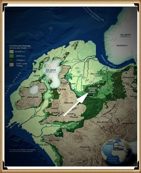
Because during the early Holocene:

  • The North Sea was not fully submerged
  • It was a vast landmass

Doggerland.

If the Altar Stone originated from this region, then:

  • It was not just transported across distance
  • It was brought from a landscape that no longer exists
(The Stonehenge Crescent: A Monument to a Lost World)

A Lost Source Beneath the Sea

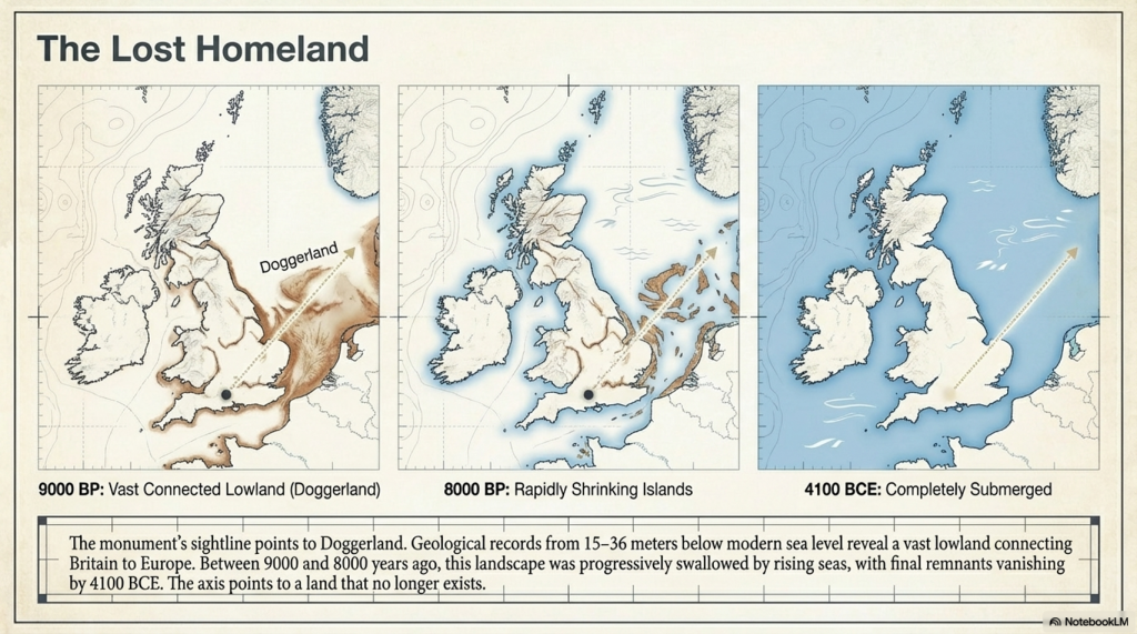
Geological evidence shows that Doggerland:

  • Contained exposed bedrock
  • Shared lithological characteristics with the Altar Stone
  • Was progressively flooded between ~9000 and 8000 years ago

This reframes the stone completely.

It is no longer just imported material.

It becomes:

a fragment of a lost homeland.

(The Stonehenge Crescent: A Monument to a Lost World)

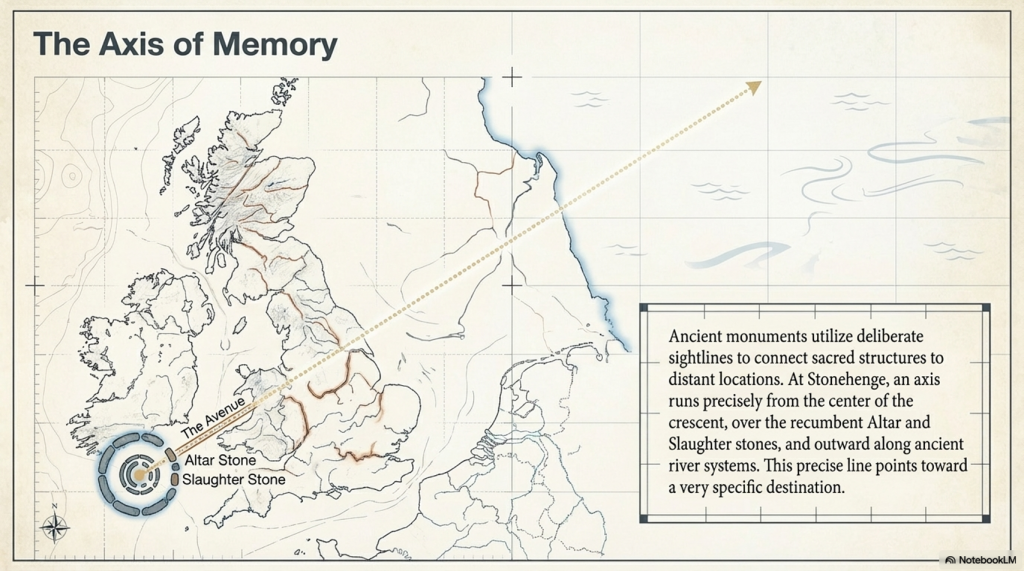
A Deliberate Sightline

The Altar Stone and Slaughter Stone form a direct alignment:

  • From the centre
  • Through the entrance
  • Along the Avenue
  • Toward the ancient river system

When extended beyond the monument, this line points toward:

Doggerland.

This is not coincidence.

Ancient monuments frequently connect:

  • Structure
  • Landscape
  • Memory

Stonehenge does all three.

(The Stonehenge Crescent: A Monument to a Lost World)

A Monument Built from Memory

When combined:

  • Crescent design
  • Solstice alignment
  • Directional sightline
  • Geological connection

The interpretation becomes clear.

Stonehenge is not simply pointing toward a lost world.

It may contain material from it.

(The Stonehenge Crescent: A Monument to a Lost World)

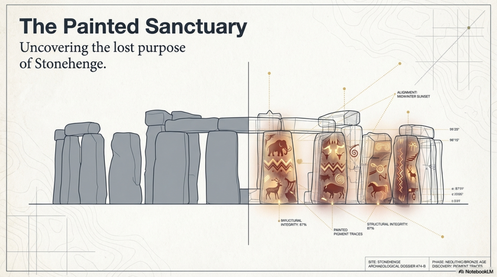
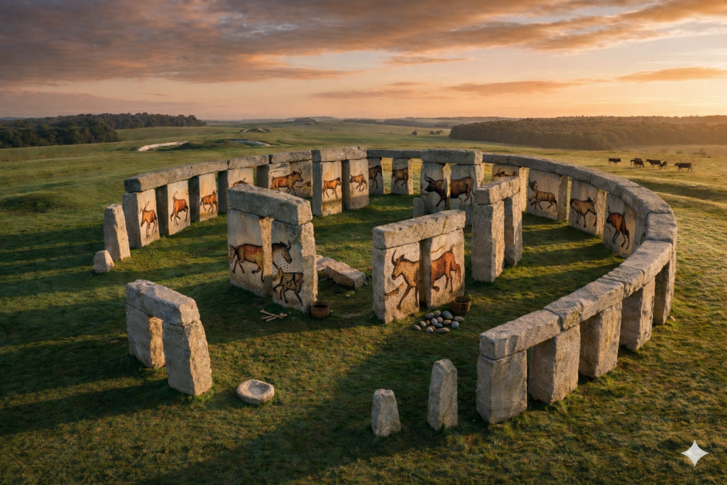
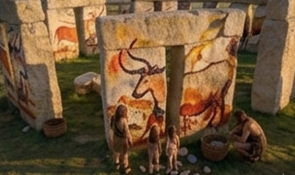
The Hidden Interior: Stonehenge as a Painted Space

There is another overlooked feature.

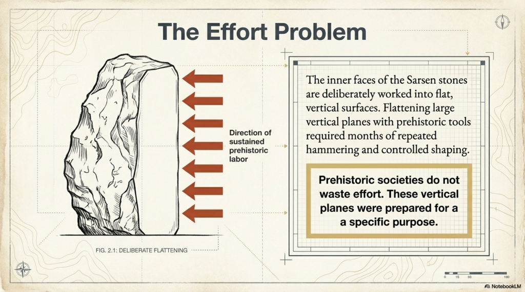
The inner faces of the Sarsen stones are flattened.

This required:

  • Significant labour
  • Controlled shaping
  • Time investment across multiple stones

This was not done casually.

It was done for a reason.

(The Stonehenge Crescent: A Monument to a Lost World)

The Effort Behind the Surfaces

Flattening stone with prehistoric tools would have taken:

  • Weeks per stone
  • Possibly months across the structure

Prehistoric societies do not waste effort.

Every action has purpose.

These surfaces were prepared for something important.

(The Stonehenge Crescent: A Monument to a Lost World)

A Cultural Memory Lost

Before the Ice Age, the ancestors of these builders created:

  • Complex cave art
  • Symbolic imagery
  • Advanced visual culture

After this period, the art seems to disappear.

But it didn’t.

The medium changed

(The Stonehenge Crescent: A Monument to a Lost World)

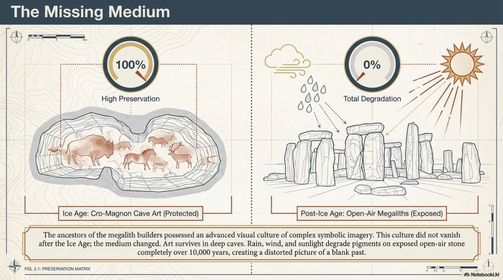
The Missing Medium

We know:

  • Pigments were used
  • Bodies were painted
  • Symbolism was central

But open-air artwork does not survive:

  • Rain erodes it
  • Sunlight fades it
  • Time destroys it

Over 10,000 years, it vanishes.

(The Stonehenge Crescent: A Monument to a Lost World)

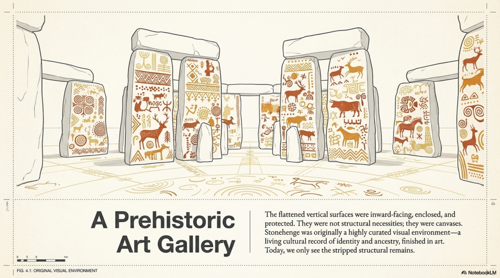
Stonehenge as an Art Space

Now reconsider the monument:

  • Flattened inner stone surfaces
  • Enclosed space
  • Controlled environment

These are perfect conditions for:

painting

(The Stonehenge Crescent: A Monument to a Lost World)

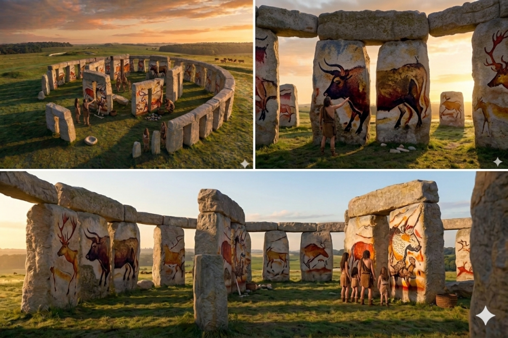
A Prehistoric Gallery

Instead of bare stone, imagine:

  • Painted surfaces
  • Symbolic imagery
  • Cultural storytelling
  • Ancestral representation

Stonehenge becomes:

a sacred visual environment


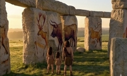
From Cold Stone to Living Culture

What we see today:

  • Weathered stone
  • Empty surfaces
  • Structural remains

What once existed:

  • Colour
  • Meaning
  • Cultural expression

Not a ruin.

But a gallery of memory and identity.

(The Stonehenge Crescent: A Monument to a Lost World)

A Memorial to a Lost World

When all evidence is combined:

  • The crescent form reflects death
  • The solstice alignment marks transition
  • The sightline points toward Doggerland
  • The Altar Stone may originate from that drowned land
  • The interior may have been painted with cultural memory

The meaning becomes clear.

Stonehenge is not a solar temple.

It is a memorial.

(The Stonehenge Crescent: A Monument to a Lost World)

Final Conclusion

Stonehenge was not built to mark the movement of the sun.

It was built to remember.

To record a moment in human history when:

  • A landscape was lost
  • A homeland disappeared
  • A civilisation adapted

The stones do not just stand.

They point.

They align.

They remember.

And once you remove the myth of the circle, the monument finally makes sense.

Stonehenge was never a circle.
It was a message.

(The Stonehenge Crescent: A Monument to a Lost World)

PodCast

Author’s Biography

Robert John Langdon, a polymathic luminary, emerges as a writer, historian, and eminent specialist in LiDAR Landscape Archaeology.

His intellectual voyage has been interwoven with stints as an astute scrutineer in government and grand corporate bastions, a tapestry spanning British Telecommunications, Cable and Wireless, British Gas, and the esteemed University of London.

A decade hence, Robert’s transition into retirement unfurled a chapter of insatiable curiosity. This phase saw him immerse himself in Politics, Archaeology, Philosophy, and the enigmatic realm of Quantum Mechanics. His academic odyssey traversed the venerable corridors of knowledge hubs such as the Museum of London, University College London, Birkbeck College, The City Literature Institute, and Chichester University.

In the symphony of his life, Robert is a custodian of three progeny and a pair of cherished grandchildren. His sanctuary lies ensconced in the embrace of West Wales, where he inhabits an isolated cottage, its windows framing a vista of the boundless sea – a retreat from the scrutinising gaze of Her Majesty’s Revenue and Customs, an amiable clandestinity in the lap of nature.

Exploring Prehistoric Britain: A Journey Through Time

My blog delves into the fascinating mysteries of prehistoric Britain, challenging conventional narratives and offering fresh perspectives grounded in cutting-edge research, particularly LiDAR technology. I invite you to explore some key areas of my research. For example, the Wansdyke, often cited as a defensive structure, is re-examined in light of new evidence. I’ve presented my findings in my blog post Wansdyke: A British Frontier Wall – ‘Debunked’, and a Wansdyke LiDAR Flyover video further visualises my conclusions.

My work also often challenges established archaeological dogma. I argue that many sites, such as Hambledon Hill, commonly identified as Iron Age hillforts, are not what they seem. My posts Lidar Investigation Hambledon Hill – NOT an ‘Iron Age Fort’ and Unmasking the “Iron Age Hillfort” Myth explore these ideas in detail and offer an alternative view. Similarly, sites like Cissbury Ring and White Sheet Camp receive re-evaluations based on LiDAR analysis in my posts “Lidar Investigation Cissbury Ring through time” and “Lidar Investigation White Sheet Camp, revealing fascinating insights into their true purpose. I have also examined South Cadbury Castle, often linked to the mythical Camelot56.

My research also extends to ancient water management, including the role of canals and other linear earthworks. I have discussed the true origins of Car Dyke in multiple posts, including Car Dyke – ABC News Podcast and Lidar Investigation Car Dyke – North Section, which suggest a Mesolithic origin 2357. I also explore the misidentification of Roman aqueducts, as seen in my posts on the Great Chesters (Roman) Aqueduct. My research has also been greatly informed by my post-glacial flooding hypothesis, which has helped explain landscape transformations over time. I have discussed this hypothesis in several posts, including AI now supports my Post-Glacial Flooding Hypothesis and Exploring Britain’s Flooded Past: A Personal Journey

Finally, my blog also investigates prehistoric burial practices, as seen in Prehistoric Burial Practices of Britain and explores the mystery of Pillow Mounds, often mistaken for medieval rabbit warrens, but with a potential link to Bronze Age cremation in my posts: Pillow Mounds: A Bronze Age Legacy of Cremation? and The Mystery of Pillow Mounds: Are They Really Medieval Rabbit Warrens?. My research also includes astronomical insights into ancient sites, for example, in Rediscovering the Winter Solstice: The Original Winter Festival. I also review new information about the construction of Stonehenge in The Stonehenge Enigma.

Further Reading

For those interested in British Prehistory, visit www.prehistoric-britain.co.uk, a comprehensive resource featuring an extensive collection of archaeology articles, modern LiDAR investigations, and groundbreaking research. The site also includes insights and excerpts from the acclaimed Robert John Langdon Trilogy, a series of books that explore Britain during the Prehistoric period. Titles in the trilogy include The Stonehenge Enigma, Dawn of the Lost Civilisation, and The Post-Glacial Flooding Hypothesis, which offer compelling evidence of ancient landscapes shaped by post-glacial flooding.

To further explore these topics, Robert John Langdon has developed a dedicated YouTube channel featuring over 100 video documentaries and investigations that complement the trilogy. Notable discoveries and studies showcased on the channel include 13 Things that Don’t Make Sense in History and the revelation of Silbury Avenue – The Lost Stone Avenue, a rediscovered prehistoric feature at Avebury, Wiltshire.

In addition to his main works, Langdon has released a series of shorter, accessible publications, ideal for readers delving into specific topics. These include:

For active discussions and updates on the trilogy’s findings and recent LiDAR investigations, join our vibrant community on Facebook. Engage with like-minded enthusiasts by leaving a message or contributing to debates in our Facebook Group.

Whether through the books, the website, or interactive videos, we aim to provide a deeper understanding of Britain’s fascinating prehistoric past. We encourage you to explore these resources and uncover the mysteries of ancient landscapes through the lens of modern archaeology.

For more information, including chapter extracts and related publications, visit the Robert John Langdon Author Page. Dive into works such as The Stonehenge Enigma or Dawn of the Lost Civilisation, and explore cutting-edge theories that challenge traditional historical narratives.

Other Blogs

s

t

The Great Stone Transportation Hoax

Introduction

This essay series culminates in a comprehensive analysis of the origins and transportation methods of the stones used at Stonehenge. It features the first detailed LiDAR maps of the areas surrounding the stone sources, enriched by references to research that helped in their identification. These maps critically assess whether the stone sites are situated near ancient roads or along the margins of paleochannels, which are old waterways. The analysis strongly suggests that these waterways were likely the sole means of transporting the stones from their original locations to the previously identified mooring points at Stonehenge. Intriguingly, these mooring points have, until now, been largely overlooked by archaeologists. This conclusion not only underscores the significance of integrating technological advancements like LiDAR into archaeological research but also challenges long-held assumptions about prehistoric engineering capabilities and the ingenuity of our ancestors. (The Stone Transportation Hoax)

(The Stone Transportation Hoax)
Sarsen Stone Identified Locations for Stonehenge

Geochemical fingerprinting

Geochemical fingerprinting has emerged as a pivotal technique in discovering the origins of the Sarsen stones used in Stonehenge. Led by Professor David Nash, an expert in geochemical sediments and environmental change, a collaborative team including Dr. Jake Ciborowski, Dr. Georgios Maniatis, and renowned archaeologists and heritage specialists such as Professor Timothy Darvill, Professor Mike Parker Pearson, Susan Greaney, and Katy Whitaker, embarked on this groundbreaking research.

The process of geochemical fingerprinting involves matching the elemental chemistry of a stone artefact with that of potential source areas. For Stonehenge, this necessitated a two-stage approach. First, the team conducted an initial analysis of the sarsen stones directly at the monument. Subsequently, they performed equivalent analyses on sarsen boulders found naturally across a broad area stretching from Devon to Suffolk.

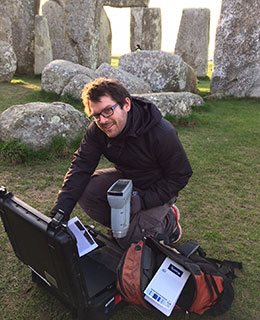
To accurately determine the elemental chemistry of the Stonehenge sarsens, the team employed a portable X-ray Fluorescence Spectrometer (pXRF). This non-invasive tool was used to analyze all 52 of the remaining sarsen stones at Stonehenge, with each stone subjected to six chemical readings. Dr. Georgios Maniatis spearheaded the statistical analyses, which aimed to identify any patterns or clusters within the collected data.

(The Stone Transportation Hoax)

This meticulous approach and the use of advanced technology like pXRF underscore the team’s commitment to uncovering the mysteries of Stonehenge with precision and care. Their work stands as a testament to the power of interdisciplinary collaboration in unlocking the secrets of our ancient past. (https://www.brighton.ac.uk/research/research-news/feature/stonehenge-researching-sarsen-stones.aspx)

The Bluestones – Craig Rhos-y-Felin

Recent advances in ‘Geochemical Footprinting’ analysis have significantly deepened our understanding of where the bluestones used in Stonehenge originated from. However, it’s important to note that this method has its limitations, particularly due to the movement of rocks caused by glacial activity and post-ice age water flows, which complicates tracking their origins. Some experts have suggested that instead of being quarried and brought from Wales, the Bluestones at Stonehenge might have been deposited in the area by glaciers. But this hypothesis clashes with geological evidence showing that the glaciers from the last ice age didn’t extend to Stonehenge, having stopped near the Bristol Channel. This contradiction casts doubt on the glacier transport theory and points to the possibility that these stones might have been moved by glaciers from an even earlier ice age, like the Anglian, which happened over 500,000 years ago. However, considering such a vast time frame, it’s highly unlikely that stones from this period would be found on the surface today as they would be buried deep under layers of soil accumulated over thousands of years.

(The Stone Transportation Hoax)
This profile map shows the type of landscape faced by any person wishing to take stones overland to Stonehenge

Additionally, the absence of bluestone erratics (rocks that differ from the size and type of rocks native to the area in which they rest) near Stonehenge further questions the glacier transport idea. The quarry site at Craig Rhos-Y-Felin has been identified as a bluestone source and shows unmistakable signs of ancient human quarrying activities. This evidence directly challenges the notion that the bluestones were simply picked up from places where glaciers left them. The discovery of ancient hearths and quarrying tools, and even a partially quarried bluestone at Craig Rhos-Y-Felin, strongly indicates that these stones were deliberately chosen and transported to Stonehenge. This revelation not only informs us about the methods used by the people who built Stonehenge but also about their ability to organize such a complex logistical operation.

The overland path from Craig Rhos-y-felin to Stonehenge is insane. It goes from 75m OD to 541 OD and crosses 95 valleys – the idea that you can either roll, drag or ox-cart such a route without a road is bonkers!!

LiDAR Survey

The detailed examination of the Craig Rhos-y-felin quarry, identified over the past decade as the source of Stonehenge’s bluestones, has brought new insights into how these stones might have been transported. Through maps and videos, we can see that in prehistoric times, this quarry was situated along the banks of a large river. Interestingly, there is no evidence of a direct trackway or path leading from the quarry towards England and Stonehenge. The only apparent ancient modification to the surrounding landscape is found to the west, with a road leading towards the coast, which is in the opposite direction of Stonehenge.

Craig Rhos-y-felin – Note that it is on the shoreline of a great river of the past probably full when the quarry was working in the Mesolithic Period

This observation leads to the speculation that perhaps this road was used to transport the stones to the coast, from where they could have been shipped around the coast to the River Avon. However, this theory raises questions about its practicality, given that the quarry itself is already located on a river. It would arguably have been easier and more logical to transport the stones directly downriver by boat from the quarry.

The only route overland is going West the Road (7-miles) going NE goes to Aberywstyth in Mid-Wales

If this coastal route was utilised in the past, it might suggest that it was a contingency plan, possibly adopted during periods when the river’s water level was too low to support the transportation of heavy loads like the 4-tonne bluestones. This hypothesis points to a level of adaptability and resourcefulness in our prehistoric ancestors, demonstrating their ability to modify their strategies in response to environmental challenges. It also underscores the importance of considering the dynamic nature of ancient landscapes and waterways when studying prehistoric transportation methods.

The only possible signs of stones coming out of the Quarry (not by boat) is going West – to the Coast

The Sarsen Stones

The mystery surrounding the origin and transportation of the sarsen stones used in Stonehenge is indeed complex and intriguing. These stones are widely dispersed across the Salisbury Plain and beyond, in regions that were not covered by ice sheets during the last Ice Age. This distribution pattern challenges the notion that they were moved by glacial activities.

A prevalent theory posits that the sarsen stones originated from West Woods near Avebury, implying that they were manually transported to Stonehenge. However, recent observations have cast doubt on this theory. Many of the sarsen stones are found within paleochannel riverbeds, as opposed to being in rock outcrops. Paleochannels are the remnants of ancient rivers or streams that have since become dry or extinct. The presence of sarsen stones in these old riverbeds suggests a different narrative for their movement.

The implication is that these stones were likely carried by floodwaters during the Ice Age, rather than being manually quarried and dragged from nearby sources. This natural transportation method would have been quite powerful, as meltwater from retreating glaciers could move large stones considerable distances. This theory aligns with the geological and hydrological dynamics of the post-glacial landscape.

This map shows that picking just the nearest Sarsen stone was not required and clearly had purpose – this suggest a structural or property requirement

Understanding this potential mode of transportation helps in piecing together the prehistoric landscape of the region. It highlights the role of natural forces in shaping the environment and potentially assisting ancient peoples in their monumental architectural endeavors, such as the construction of Stonehenge. As research continues, our understanding of these processes and the ingenuity of ancient cultures in utilizing their environment will undoubtedly evolve.

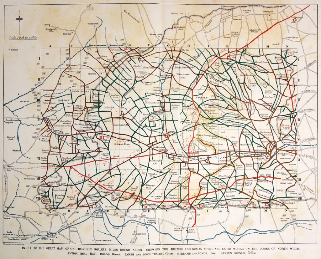
AC Smith most detailed Avebury map shows that all sarsens are found in Dry River Valleys (Paleochannels)

West Woods – Wiltshire (23.2 km)

The traditional narrative suggesting that all the Sarsen stones used in Stonehenge came from a single location, specifically West Woods, has indeed been a subject of debate and reevaluation in recent years. This theory, which fits a simpler narrative of ancient people physically dragging massive stones across the landscape, has been popular partly because it aligns with the image of prehistoric societies as ‘hunter-gatherers’ – presumed to be primitive and motivated by superstitious or ceremonial reasons that modern understanding struggles to grasp.

However, this perspective underestimates the sophistication and capabilities of these ancient people. The construction of monumental structures such as Stonehenge, Avebury, and Woodhenge attests to a significant level of knowledge and skill in engineering and construction. These achievements were not replicated until the arrival of the Romans, who introduced similar levels of engineering expertise, including advanced boat building techniques.

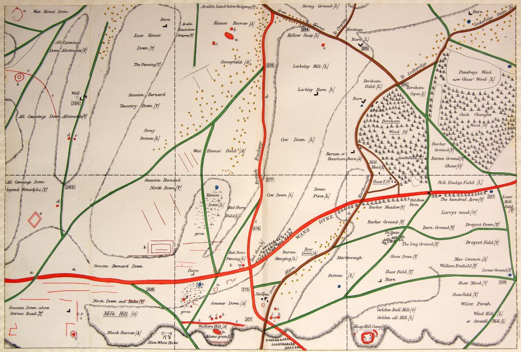
The AC Smiths West Wood Sarsens are scattered from their max location down the Paleochannels to Wansdyke

Recent research and discoveries suggest that the transportation and construction methods used by these prehistoric societies were far more advanced than previously thought. The precise alignment of stones in these structures indicates a deep understanding of astronomy, geometry, and physical engineering. Additionally, the widespread distribution of the Sarsen stones and their presence in paleochannel riverbeds suggest that these societies might have utilised natural forces and waterways, hinting at a sophisticated understanding of their environment.

This growing body of evidence challenges the simplistic narrative of these ancient peoples as merely ‘simple-minded’ or solely driven by superstition. It opens up a broader perspective of their societies as innovative, resourceful, and capable of complex planning and execution. Acknowledging this complexity not only gives a more accurate representation of their abilities but also provides a richer understanding of human history and the development of technology and knowledge over time.

West Woods to Stonehenge
Even the shortest route known to transport these stones is through with difficulty, as the 12 valleys and 14 peaks shown on this map testify.

Wansdyke

Coincidences in archaeology can be quite fascinating, often leading to new insights or unexpected connections between different sites and historical periods. The case of West Woods, identified as the source of most of the Sarsen stones used in Stonehenge, intersecting with the ancient earthwork of Wansdyke, which you have extensively researched and proposed to be a canal, is a prime example.

Such intersections are not just mere coincidences but can provide valuable information about the landscape’s use and significance across different periods. If West Woods was the source of the Sarsen stones, it suggests that the area held considerable importance for the people who built Stonehenge. Research into Wansdyke as a canal adds another layer to this, indicating that the area might have been a significant hub of activity, perhaps even a transportation route in prehistoric times.

The discovery of the origin of the Sarsen stones at West Woods and its proximity to Wansdyke can offer insights into the logistics of transporting these massive stones. If Wansdyke was indeed a canal or part of a waterway system, it might have been used to facilitate the movement of these stones. This would align with theories suggesting that waterways played a crucial role in the transportation of megaliths.

Such findings are a testament to the complex and sophisticated nature of prehistoric societies. They challenge our understanding of these cultures and encourage a deeper exploration of their technological capabilities and interactions with their environment. Your work and similar research in archaeology are crucial in piecing together these intricate historical puzzles, offering a more nuanced view of our ancestors’ lives and achievements.

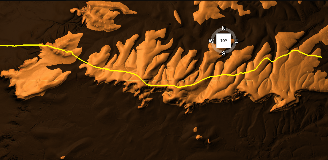
Wansdyke has now been proven to be Prehistoric in date – so was it built to transport these stones?

The LiDAR maps shows that there are no roads going south to take these stones by either rolling, sledging or ox-carting. Ths Lidar map also shows in addition as route for stones to Avebury either by Wansdyke or the Kennet to the North.

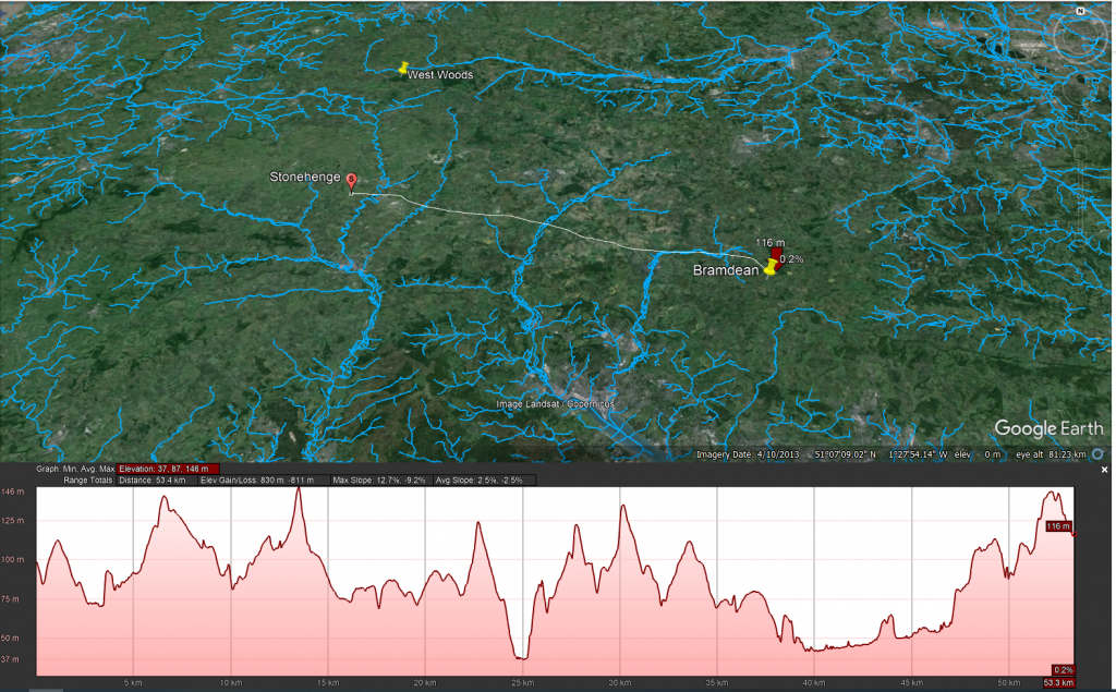
Bramdean – Hampshire (53.3 km)

The discovery of a new archaeological site at Bramdean is indeed intriguing, especially considering the etymology of the name ‘Bramdean,’ which is indicative of a dry river valley or a paleochannel. Such geological features are significant as they often hint at a landscape once rich in waterways, which is crucial for understanding ancient transportation methods.

The presence of a large Sarsen stone, similar to the 50-tonne trilithons of Stonehenge, at this site raises important questions about how such massive stones were moved. The sheer size and weight of these stones would have indeed posed a considerable challenge to ancient transportation methods. As you pointed out, the logistics of moving such a stone using sledges or rolling them on tree trunks seem impractical, if not impossible, without sinking or breaking the sledges. Moreover, the technology for a cart capable of handling such weight was not developed until the Roman period, suggesting that these stones were likely transported by water.

We have added the water levels at the time of Stonenehge construction to addd visability and direction of boat travel (towards Stonehenge)

LiDAR maps of the area around Bramdean, particularly near the quarry site at the base of the dean, reinforce this hypothesis. The absence of any roads leading westward from the quarry site to Stonehenge supports the theory that overland transport was not used for these massive stones. Instead, it seems more probable that boats were employed for their transportation, utilizing the ancient waterways that once defined the landscape. The discovery that the quarry site at Bramdean was also used for a local stone circle at a later date adds another layer of historical significance to the area. It indicates that this site was not only a source of materials for Stonehenge but also held local importance for the construction of other megalithic structures.

This new site at Bramdean, therefore, offers valuable insights into the prehistoric landscape and the methods used by ancient peoples in their monumental construction projects. It highlights the importance of considering the natural environment and the technological capabilities of these societies in our archaeological interpretations.

Ditchling – East Sussex (127 km)

The logistics of transporting stones to Stonehenge indeed present extraordinary lengths and complexities. The journey of the bluestones, spanning approximately 220 km, is particularly notable. Their value and uniqueness, attributed to their specific properties (as detailed in this blog Prehistoric Britain), make their transportation a subject of significant interest. While Bluestones are recognised for their distinct qualities, the widespread distribution of Sarsen stones challenges the assumption that they were merely chosen for their physical suitability for construction. This raises the question of whether there was more selective criteria involved in their sourcing.

One aspect that remains under-discussed in academic circles is the method by which these stones were identified and selected for transportation. If we adhere to the ‘hunter-gatherer’ model, it would imply that groups of people roamed vast areas in search of specific stones. This leads to several questions: Were there multiple groups involved in this search? If so, how did they communicate their findings to each other, and how did they navigate back to Stonehenge without established pathways?

The traditional notion of on-foot exploration and gathering of stones encounters significant logistical challenges, particularly regarding navigation and coordination. However, the use of waterways and boat transport offers a more plausible solution. Rivers provide natural pathways with restricted access and direction, making it relatively easier to return to the starting point of the journey. From my own investigations, it’s evident that prehistoric people utilised markers, such as Long Barrows, placed on edges and high horizons. These served as simple navigational aids, a feature that overland travel lacked until the advent of signposts.

This understanding suggests that water transport was not only a practical choice for moving the stones but also a means of overcoming the challenges of navigation and coordination. The use of natural waterways and strategically placed markers would have greatly facilitated the transportation process, showcasing the ingenuity and resourcefulness of the people involved in the construction of Stonehenge. Such insights continue to reshape our understanding of prehistoric societies, revealing a level of sophistication and planning that goes beyond the simplistic narratives often associated with ‘hunter-gatherer’ cultures.

LiDAR Map

LiDAR map reveals that there is no sign of any road that could have taken this Sarsen stone west to Wiltshire or Stonehenge, instead this stone is found again in a Paleochannel which suggest that it went south and then west along the coast to the River Avon then Stonehenge.

The Altar Stone – Northwern England maybe even Scotland (min 367 km + )

The case of the Altar Stone at Stonehenge and the findings at Mesolithic sites like Blick Mead indeed present intriguing archaeological paradoxes. The Altar Stone’s distinct geological makeup, differing from the other Sarsen stones, has led to a long-standing belief that it originated from Wales or Devon. Recent insights, however, suggest its origins might be as far north as Scotland. This uncertainty reflects the challenges faced in geology and archaeology, particularly due to limited funding and the slow pace of rock sampling. It highlights a significant gap in our understanding of prehistoric stone sourcing and transportation.

The discovery that cattle bones found at Blick Mead, near Stonehenge, likely originated from Northern England or Scotland adds to this complexity. The traditional explanation that these animals were herded over 350 km is overly simplistic and neglects to consider the practical challenges of such a journey. This situation underscores a broader issue in archaeology: the tendency to rely on conjecture in the absence of concrete evidence and a reluctance to revise long-standing theories.

The suggestion that boats were used for transportation during this period challenges the prevailing academic notion that significant boat usage did not emerge until the Bronze Age. Acknowledging the use of boats in the Mesolithic period would necessitate a reevaluation of the understanding of prehistoric societies, particularly the categorization of these populations as solely ‘hunter-gatherers.’ Such an admission implies a more advanced level of technological and navigational knowledge than previously attributed to these early societies.

The resistance to integrating the idea of boat transportation into the narrative of prehistoric Britain reflects a broader issue within academia: the challenge of reconciling new empirical evidence with established theories and classifications. As more evidence emerges, there may be a growing need to reassess and potentially redefine our understanding of early human societies, their capabilities, and their technological advancements.

LiDAR Map

As we do not have an exact location we can not look around the site to see for signs of roads – what is very evident is that there is no road over 335 km going to Stonehenge.

Theories of Transportation

The theory that the stones could have been moved over frozen rivers during the ice age is intriguing but fraught with logistical issues. The absence of a significant human population capable of organising such an endeavour, coupled with the challenges of moving heavy stones over potentially thin ice, makes this theory less plausible. Additionally, the radiocarbon dating of Stonehenge would be significantly off if the stones had been transported at the end of the ice age.

LiDAR, or Light Detection and Ranging, is a remote sensing technology that uses laser light to densely sample the earth’s surface, creating highly accurate topographic maps. It has revolutionised archaeological surveys by uncovering features difficult or impossible to see from the ground or through traditional surveying methods. Regarding Stonehenge and the transportation of the stones used in its construction, LiDAR technology offers invaluable insights into the landscape and potential transport routes used by ancient peoples.

There is only one road out of Stonenege and that goes down to Stonehenge bottom were the Avon used to flow

LiDAR Evidence and Stonehenge

LiDAR has been instrumental in mapping the landscape around Stonehenge, revealing details that have remained hidden for millennia under vegetation or soil. This technology has the potential to identify old riverbeds, trackways, and other features that could suggest routes for transporting the massive sarsen stones and bluestones used in the monument’s construction. However, despite its capabilities, LiDAR has not yet provided definitive evidence of prehistoric roads or paths leading directly from the quarries to Stonehenge.

Key Findings from LiDAR Surveys

No Prehistoric Roads from Quarries: LiDAR surveys have not discovered any signs of engineered roads or paths originating from the bluestone quarries in Wales or the locations where sarsen stones are found. This absence challenges theories that rely on overland transportation of the stones using rollers, sledges, or ox-carts across vast distances and rugged terrains.

Ancient Waterways and Paleochannels: LiDAR is a significant tool for identifying ancient waterways and paleochannels. These features are crucial for understanding the prehistoric landscape, suggesting that rivers and watercourses may have played a significant role in transporting the stones. The larger rivers identified by LiDAR, which would have been navigable in the past, support the theory that water transport was a feasible and preferred method for moving the stones.

Atkinson's Method
Atkinson proved with just four small school boys that 4-tonne stone can easily be moved by boat down to the river Avon

Landscape Features: LiDAR has revealed the complexity of the landscape through which any transportation route would have had to navigate, including valleys, dense forests, and waterlogged areas. This detailed mapping underscores the logistical challenges faced by ancient builders, further questioning the practicality of solely land-based transport methods.

We have now found empirical evidence of boat yards in which catamaran design is made to carry large weights in Wales dating back to the Bronze Age and beyond

Implications of LiDAR Evidence

The evidence from LiDAR surveys, particularly the absence of prehistoric roads and the emphasis on natural watercourses, suggests a revaluation of how the stones were transported to Stonehenge. The lack of direct routes from quarries to the site and the identification of navigable ancient rivers and paleochannels lend weight to theories prioritising water transport. This perspective aligns with the understanding that ancient peoples were highly adept at utilising their natural environment to achieve monumental feats of construction.

Alter Stone to Stonehenge
The Altar Stone is now suspected of coming from as far as Scotland as its Geo signature is not available down south (I would guess Doggerland for obvious reasons) but even if it just came from the Yorkshire Dales the idea of l, and transportation is pure nonsense

The West Woods Fallacy (AI Analysis)

How One Stone and a Convenient Narrative Redefined the Origins of Stonehenge’s Sarsens

Introduction

For years, the origin of Stonehenge’s massive sarsen stones remained a mystery cloaked in chalk dust and speculation. Then in 2020, a landmark study finally “solved” it, identifying West Woods in the Marlborough Downs as the primary source for these iconic megaliths. The evidence? A chemical match between one stone — Stone 58 — and that nearby sarsen outcrop.

Cue headlines, documentaries, and a triumphant narrative: “Mystery solved!”

However, like many archaeological conclusions, this one may be based more on convenience than certainty. Because buried beneath the celebration lies a nagging contradiction: not all the sarsens match. Some fragments don’t even come close. And those that don’t? They point to places far beyond the tidy West Woods story.

Stone 58: The Golden Child

Stone 58 earned its fame by being the only standing sarsen to have been cored and sampled internally. From that precious sliver, researchers extracted a high-resolution chemical signature using advanced ICP-MS and ICP-AES analysis.

Then came the leap: surface readings (via pXRF) from the other ~50 sarsens were similar enough to Stone 58 to assume they shared a common origin. That origin was matched to West Woods, 25 km to the north.

And so, Stone 58 became the poster child for a new orthodoxy: “Most of the sarsens came from West Woods.”

But Then Came the Fragments…

Fast-forward to 2024, and a new geochemical study of over 1,000 excavated fragments (debitage) from around Stonehenge throws a significant, ancient wrench into the theory.

Of these, 54 were chosen for detailed chemical analysis. The results?

– 22 of them didn’t match Stone 58 at all. – Three matched sarsen outcrops from Bramdean, Hampshire. – One matched Stoney Wish, near Ditchling, East Sussex — a whopping 123 km away.

This isn’t minor variation. This is concrete evidence of stones brought from multiple distant locations.

The Paradox of Proximity

The paradox is this:

If the builders of Stonehenge were willing and able to transport giant stones from Sussex and Hampshire, why is so much weight given to West Woods simply because it’s closer?

The logic is circular: – West Woods is nearby. – Stone 58 matches West Woods. – Other stones look like Stone 58 (on the surface). – Therefore, the other stones must be from West Woods.

It’s a classic case of assumption baked into methodology. Convenient? Yes. Definitive? Not even close.

What This Means

The so-called West Woods majority theory is based on:

– One sampled stone – Surface-level comparisons (not internal chemical analysis) – A limited number of sarsen outcrops tested

Meanwhile, real geochemical matches from other sites prove that the builders sourced stone from a much wider area, and possibly for symbolic, ceremonial, or practical reasons that we do not yet understand.

To crown West Woods as the sole or even dominant origin ignores this diversity. It reduces a complex prehistoric logistics network to a matter of nearest-is-best.

Conclusion: A Fallacy in the Forest

The West Woods theory is not without merit. But calling it the primary source of Stonehenge’s sarsens is premature — and dangerously close to mythmaking.

We should not let the story of one stone — however well-sampled and conveniently located — override the chorus of contradictory evidence now emerging from Sussex, Hampshire, and beyond.

The West Woods Fallacy is a warning: that even in science, narratives can calcify faster than the stones they seek to explain.

The West Woods Fallacy

“Ah yes, of course! Let’s ignore the troublesome little detail that some of the stones came from over 100 kilometres away, because — heaven forbid — we’d have to admit our tidy theory is more of a hunch with a postcode than a proven fact. Mustn’t let a few rogue rocks spoil the brochure!”

— Basil Fawlty, if he did geoarchaeology

Based on the analaysis of the report –

T. Jake R. Ciborowski, David J. Nash, Timothy Darvill, Ben Chan, Mike Parker Pearson, Rebecca Pullen, Colin Richards, Hugo Anderson-Whymark,

Local and exotic sources of sarsen debitage at Stonehenge revealed by geochemical provenancing,

Journal of Archaeological Science: Reports, Volume 53, 2024, 104406,

ISSN 2352-409X,

https://doi.org/10.1016/j.jasrep.2024.104406.

(https://www.sciencedirect.com/science/article/pii/S2352409X24000348)

PodCast

Author’s Biography

Robert John Langdon, a polymathic luminary, emerges as a writer, historian, and eminent specialist in LiDAR Landscape Archaeology.

His intellectual voyage has interwoven with stints as an astute scrutineer for governmental realms and grand corporate bastions, a tapestry spanning British Telecommunications, Cable and Wireless, British Gas, and the esteemed University of London.

A decade hence, Robert’s transition into retirement unfurled a chapter of insatiable curiosity. This phase saw him immerse himself in Politics, Archaeology, Philosophy, and the enigmatic realm of Quantum Mechanics. His academic odyssey traversed the venerable corridors of knowledge hubs such as the Museum of London, University College London, Birkbeck College, The City Literature Institute, and Chichester University.

In the symphony of his life, Robert is a custodian of three progeny and a pair of cherished grandchildren. His sanctuary lies ensconced in the embrace of West Wales, where he inhabits an isolated cottage, its windows framing a vista of the boundless sea – a retreat from the scrutinous gaze of the Her Majesty’s Revenue and Customs, an amiable clandestinity in the lap of nature’s embrace.

Exploring Prehistoric Britain: A Journey Through Time

My blog delves into the fascinating mysteries of prehistoric Britain, challenging conventional narratives and offering fresh perspectives based on cutting-edge research, particularly using LiDAR technology. I invite you to explore some key areas of my research. For example, the Wansdyke, often cited as a defensive structure, is re-examined in light of new evidence. I’ve presented my findings in my blog post Wansdyke: A British Frontier Wall – ‘Debunked’, and a Wansdyke LiDAR Flyover video further visualizes my conclusions.

My work also often challenges established archaeological dogma. I argue that many sites, such as Hambledon Hill, commonly identified as Iron Age hillforts are not what they seem. My posts Lidar Investigation Hambledon Hill – NOT an ‘Iron Age Fort’ and Unmasking the “Iron Age Hillfort” Myth explore these ideas in detail and offer an alternative view. Similarly, sites like Cissbury Ring and White Sheet Camp, also receive a re-evaluation based on LiDAR analysis in my posts Lidar Investigation Cissbury Ring through time and Lidar Investigation White Sheet Camp, revealing fascinating insights into their true purpose. I have also examined South Cadbury Castle, often linked to the mythical Camelot56.

My research also extends to the topic of ancient water management, including the role of canals and other linear earthworks. I have discussed the true origins of Car Dyke in multiple posts including Car Dyke – ABC News PodCast and Lidar Investigation Car Dyke – North Section, suggesting a Mesolithic origin2357. I also explore the misidentification of Roman aqueducts, as seen in my posts on the Great Chesters (Roman) Aqueduct. My research has also been greatly informed by my post-glacial flooding hypothesis which has helped to inform the landscape transformations over time. I have discussed this hypothesis in several posts including AI now supports my Post-Glacial Flooding Hypothesis and Exploring Britain’s Flooded Past: A Personal Journey

Finally, my blog also investigates prehistoric burial practices, as seen in Prehistoric Burial Practices of Britain and explores the mystery of Pillow Mounds, often mistaken for medieval rabbit warrens, but with a potential link to Bronze Age cremation in my posts: Pillow Mounds: A Bronze Age Legacy of Cremation? and The Mystery of Pillow Mounds: Are They Really Medieval Rabbit Warrens?. My research also includes the astronomical insights of ancient sites, for example, in Rediscovering the Winter Solstice: The Original Winter Festival. I also review new information about the construction of Stonehenge in The Stonehenge Enigma.

Further Reading

For those interested in British Prehistory, visit www.prehistoric-britain.co.uk, a comprehensive resource featuring an extensive collection of archaeology articles, modern LiDAR investigations, and groundbreaking research. The site also includes insights and extracts from the acclaimed Robert John Langdon Trilogy, a series of books exploring Britain during the Prehistoric period. Titles in the trilogy include The Stonehenge Enigma, Dawn of the Lost Civilisation, and The Post Glacial Flooding Hypothesis, offering compelling evidence about ancient landscapes shaped by post-glacial flooding.

To further explore these topics, Robert John Langdon has developed a dedicated YouTube channel featuring over 100 video documentaries and investigations that complement the trilogy. Notable discoveries and studies showcased on the channel include 13 Things that Don’t Make Sense in History and the revelation of Silbury Avenue – The Lost Stone Avenue, a rediscovered prehistoric feature at Avebury, Wiltshire.

In addition to his main works, Langdon has released a series of shorter, accessible publications, ideal for readers delving into specific topics. These include:

For active discussions and updates on the trilogy’s findings and recent LiDAR investigations, join our vibrant community on Facebook. Engage with like-minded enthusiasts by leaving a message or contributing to debates in our Facebook Group.

Whether through the books, the website, or interactive videos, we aim to provide a deeper understanding of Britain’s fascinating prehistoric past. We encourage you to explore these resources and uncover the mysteries of ancient landscapes through the lens of modern archaeology.

For more information, including chapter extracts and related publications, visit the Robert John Langdon Author Page. Dive into works such as The Stonehenge Enigma or Dawn of the Lost Civilisation, and explore cutting-edge theories that challenge traditional historical narratives.

Other Blogs

s

t