Stonehenge’s The Lost Circle Revealed – DEBUNKED

13 things that don’t make sense about Waun Mawn (Stonehenge’s The Lost Circle Revealed)

Introduction

According to the BBC documentary, the discovery of the bluestone quarry in Wales was presented as a major breakthrough in understanding Stonehenge. At face value, that seems fair enough. Identifying a potential source for the stones is important.

But this is where the problem begins.

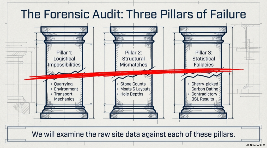
Because from that point onward, the investigation appears to shift away from asking what the evidence actually shows… and toward trying to make the evidence fit an already established timeline.

Instead of examining the quarry independently and comparing it objectively with Stonehenge, the focus becomes finding dates that support a pre-existing conclusion. That is not how science works. When you start with the answer and work backwards, you are no longer testing a hypothesis — you are trying to confirm one.

Craig Rhos-y-Felin is a good example of this.
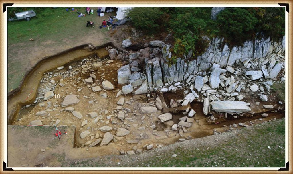
Craig Rhos-Y-Felin from Stonehenge: The Lost Circle Revealed - Stonehenge's the lost circle
Craig Rhos-Y-Felin: Stonehenge: The Lost Circle Revealed

The site contains clear evidence of Mesolithic activity, particularly in the form of man-made hearths. That should be the starting point for interpretation. Yet the emphasis is instead placed on a small number of later samples that fall closer to the desired Neolithic timeframe.

When those dates still don’t quite align, the solution is not to question the model — it is to introduce another one. A “prototype” stone circle in Wales was later moved to Stonehenge. A theory designed not from evidence, but from necessity.

And so begins a decade-long search for that missing link.

Sites are proposed… then quietly dropped when the dates don’t match. New locations are suggested… then abandoned for the same reason. The pattern repeats. The goal is no longer discovery — it is validation.

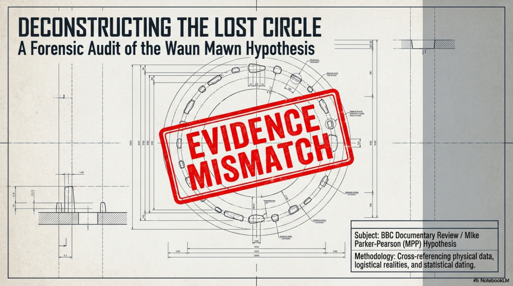
Eventually, everything converges on Waun Mawn.
(Stonehenge's The Lost Circle Revealed)
(Stonehenge’s The Lost Circle Revealed)

This is presented as the long-awaited solution. But when you strip it back, the physical evidence is extremely limited. A handful of stones. A small number of possible stone holes. Nowhere near enough to replicate what exists at Stonehenge.

So the gaps are filled in.

Estimates are extended beyond what is actually present. Missing stones are assumed. Layouts are reconstructed from partial data. And suddenly, a fragment becomes a full circle.

Then we come to the dating.

Among a broad range of results spanning several millennia, one sample is highlighted as aligning with the proposed timeline. The rest — which do not support the theory — receive far less attention.

This is the core issue. You cannot treat a single favourable result as definitive while ignoring the wider dataset. That is not strengthening an argument — it is narrowing it.

The same pattern appears in other parts of the interpretation.
(Stonehenge's The Lost Circle Revealed)
(Stonehenge’s The Lost Circle Revealed)

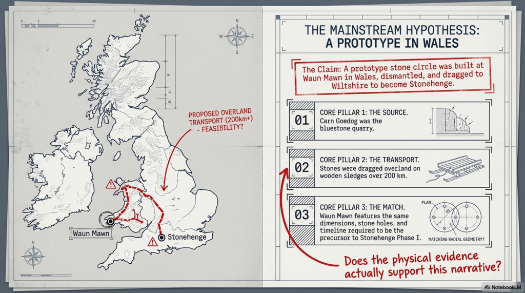
Large stones at the quarry are presented as the source of Stonehenge’s bluestones, despite clear differences in size and shape. No explanation is provided for how they were reduced or reworked.

Transport by water is dismissed, despite experimental demonstrations showing it is entirely possible. Instead, overland transport through heavily forested and waterlogged terrain is presented as the more feasible option — a claim that raises more questions than it answers.

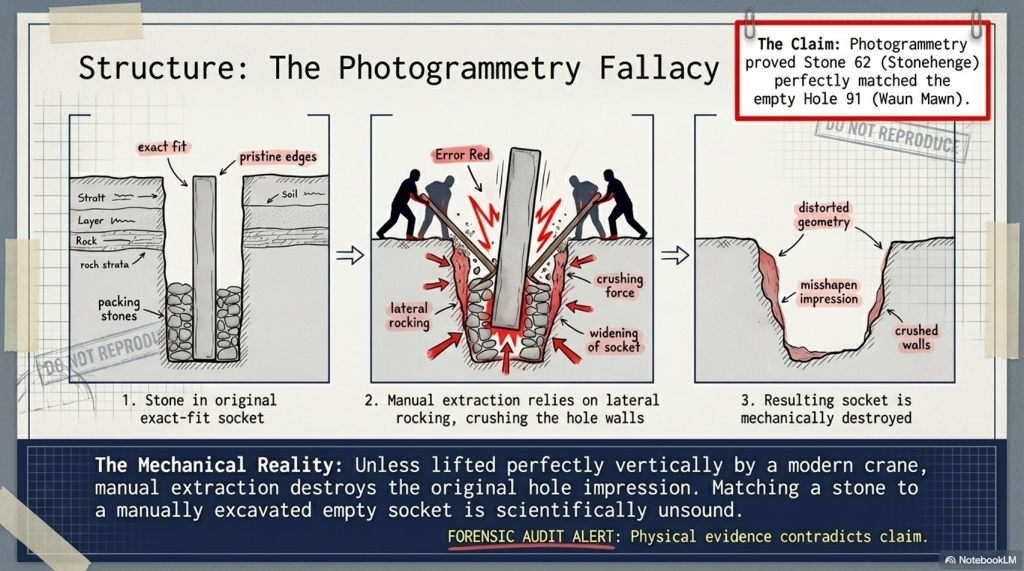
Even the more technical aspects, such as photogrammetry, are used in ways that assume ideal conditions. A stone is said to match a socket, without addressing the simple fact that removing a stone alters the shape of that socket. Basic mechanical realities are overlooked.

And then, towards the end, the programme drifts into broader speculation — cultural movements, symbolic alignments, and generalised astronomical claims. These are presented confidently, but without the level of supporting evidence required to justify them.

Meanwhile, key inconsistencies remain unresolved.

Stonehenge contains 56 bluestone positions. Waun Mawn does not. The construction methods differ. The depth of the stone holes differs. The overall structure is not the same.

These are not small details. There are fundamental differences.
(Stonehenge's The Lost Circle Revealed)
(Stonehenge’s The Lost Circle Revealed)

So what are we left with?

Not a clear, evidence-led conclusion — but a narrative built around selective interpretation. Certain data points are emphasised. Others are downplayed. Gaps are filled with theory rather than evidence.

The result is compelling television.

But it is not robust science.

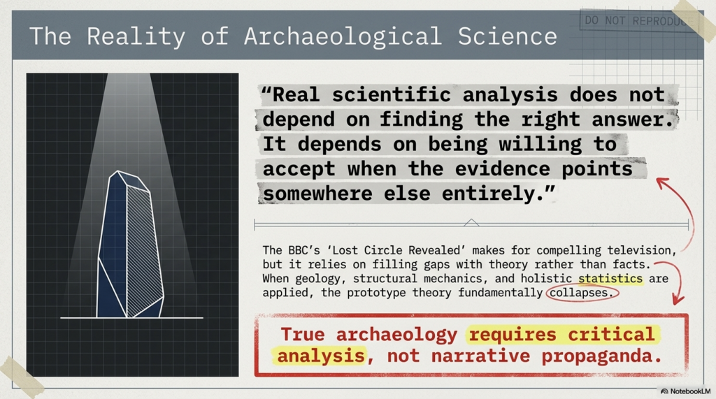
Because real scientific analysis does not depend on finding the right answer.

It depends on being willing to accept when the evidence points somewhere else entirely.
(Stonehenge's The Lost Circle Revealed)
(Stonehenge’s The Lost Circle Revealed)

The Documentary

Therefore, the last hope for MPP’s reputation and his ’10-year search’ fell upon Waun Mawn, culminating in the BBC documentary “Stonehenge: The Lost Circle Revealed”, shown on the 12th February 2021. In it, he claimed many so-called ‘facts’ which I shall now highlight as ‘not making sense’, with the reasons why.

1. At (13:20) MPP shows signs of human-made quarrying and splitting of Bluestones at Carn Goedog in Wales – unfortunately, there are no extensive excavation reports on this site, just a published review showing that of the 31 carbon dates, only three random samples support his theory and none of the man-made hearths which are Mesolithic (like Craig Rhos-Y-Felin) or late Neolithic.

2. The program showed the suggested quarried stones at Carn Goedog, which are over 12 feet long and 5 feet wide, weighing therefore around 20+ tonnes. The Stonehenge bluestones are, on average, less than six feet high and about 18–24 inches wide, weighing 1-3 tonnes. The review on the site offered no evidence that the stones were cut down and reshaped for the journey to Stonehenge or elsewhere. (Stonehenge’s The Lost Circle Revealed)
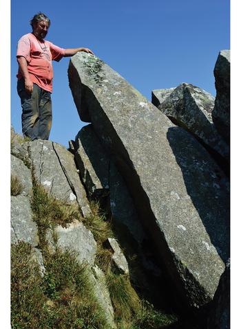
Carn Goedog from Stonehenge: The Lost Circle Revealed (Stonehenge's The Lost Circle Revealed)
Carn Goedog – Stonehenge: The Lost Circle Revealed

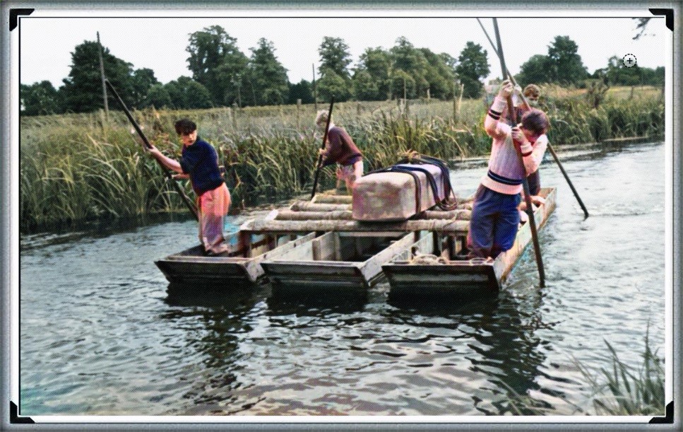
3. MPP claims that the boat transport method (14.50) was infeasible as they did not have sturdy enough boats to carry the stones on such a journey – Sadly, you do not need a ‘boat’ to transport stones in a river as shown by Atkinson in the 1960’s who employed just four school kids to punt a raft with a 3 tonne stone attached down the Avon. Moreover, he has failed to recognise that the oldest boatyard in the world, located in the Solent (at the end of the Avon), was found with planked wood (and associated wheat grain from Turkey), indicating that substantial seafaring boats were available by the 7th Millennium BCE.

Punting Bluestone down the Avon from Stonehenge: The Lost Circle Revealed (Stonehenge's The Lost Circle Revealed)
Clearly MPP was too young to see this punt down the Avon?

4. Mike Parker-Pearson also suggested that an ‘ox-cart’ route that followed the current A40 was the most feasible way of transporting these stones to Stonehenge. He believed that they dragged these stones over 200 km on wooden sledges – unfortunately, the example shown on the program shows schoolboys dragging a small stone over flat grassland, which would not be available for another 4000+ years and after Stonehenge’s initial construction. At the time of Phase I construction, the environment (as indicated by pollen analysis) shows that 70% of the terrain was woodland and forest, and the remaining 30% was mostly rivers and swampland, making such an endeavour impossible.

5. The Discovery (21:15) of ‘random’ hazel nuts at Craig Rhos-Y-Felin provides MPP’s required date for Stonehenge of 3300 BCE (which is still 500 years before MPP’s supposed construction date) – This clear ‘cherry picking’ of the archaeological evidence is ‘Bad Science’. To take just two carbon dates from over 40 at the Craig-Rhos-Y-Felin site and ignoring the more solid man-made hearth dates, which are Mesolithic and moreover, compatible with 26 carbon dates found at Stonehenge, is plainly a falsehood.

6. When they eventually found their target site (36:15), Waun Mawn (after many claims that other sites were “the one we have been looking for” to eventually find that the carbon dating on these sites did not match the required date), they found just four bluestones, and so went on a stone hunt and found 10 further stone HOLES! – This is clearly a sad attempt to fit a square peg into a round hole. The excavation was flawed as it only identified 14 possible stone locations and the remainder of the estimated 15 – 25 stones was a ‘guesstimation’ based on the known 14 holes – two of which had non-bluestone stones in situ.

Waun Maun from Stonehenge: The Lost Circle Revealed (Stonehenge's The Lost Circle Revealed)
Nowhere near the 56 stones needed to create Stonehenge Phase I

7. The BBC reconstruction shows just 28 stones (38:05) of the 56 Bluestones required for the Aubrey holes to be filled at Stonehenge, and MPP goes on to suggest, that the stone circle is of equal size and dimensions as Stonehenge, quote “the chances of the two sites having the EXACT dimensions are very slim”- This sadly, is another falsehood, the Moat/Ditch at Stonehenge is approximately 110 metres in diameter, NOT the Aubrey holes which are 90 metres in diameter. Moreover, Stonehenge has a ditch/moat surrounding the stones (for a good reason) Waun Mawn does not!!

8. MPPs then used a new, unused tool in archaeology to prove their hypothesis, ‘photogrammetry’, and suggested that Stone 62 at Stonehenge fitted the stone hole 91 at Waun Mawn. The reason this method is not used is somewhat obvious to even non-academics. You would need a crane to lift the stone vertically out of the hole to get an exact imprint. If you are taking out a stone by hand and/or with levers, you will rock it from side to side, destroying the stone hole impression, as we have seen with post holes in numerous excavations.

9. The program fails to report that the 40 carbon dates from wood found on the site did not come up with MPP’s magic date, and so he employed another form of Dating OSL (40:17) to find this single piece of evidence he desperately required. – Sadly, watching Dr Kim Kinnaird’s efforts to get a light, uncontaminated sample from over a fallen Stone summed up the state of archaeology as a science for me. Armed with a black weed blocker and a bicycle light on his head, he set forth to get a sample to prove MPP’s hypothesis. Anyone who considers this an effective way of obtaining an OSL sample is beyond scientific redemption, as logic would suggest; doing it at night would perhaps be more suitable. This was finally compounded when we saw him transporting the sample in his hand into the detector in daylight, which was pure icing on that flawed cake.

10. Roberts indicated (quite rightly) that ALL the dates were “way out” and all hopes were put on this one sample, MPP then claimed (42:20) “we had dated the thing, and it just before Stonehenge’s construction” (3300 BCE) – Sadly, and not report in the program, but within the Waun Mawn excavation report, there was not one OSL samples taken but 18, which gave results in the range of 6980+/- 2120 BCE to AD 1900 +/- 20. So the 17 dating sample did not verify MPP’s hypothesis, only a single one, which was dated 3530 +/- 330 (with that date range, the probability it’s 3300 BCE is slim!!).In fact, the OSL data in the review document suggested “removal of the stones” in 2120 +/- 520 BCE, long after the Stonehenge phase I.

11. The program then went onto a flight of fantasy for 15 minutes (25% OF AIR TIME) with unscientific mythology and astroarchaeology (which proved MORE that astroarchaeology doesn’t have any significance as the ‘expert’ suggested that the stones were ‘in the general direction’ of an alignment  – which by the very nature of a stone circle of 360 degrees – every stone circle in the world is in the general direction of all astrological alignments!! Even more ludicrous came an idea that the Welsh culturally invaded England in 3300 BCE and took the stones of Waun Mawn with them –Sadly, at no point did the experts attempt to justify why Stonehenge had 56 Bluestones and the site at Waun Mawn had less than 30 at the most. Even if this idea were remotely true, why would you leave four stones behind when you are already going to be 30 stones short and need to go back and get some more from the quarry site?

12. The program never went into any detail of the OTHER carbon dates found at Waun Mawn, which would have allowed a balanced scientific program, allowing the viewer to decide whether MPP’s hypothesis was actually feasible. It presented speculation as fact, with a number of site workers and the presenter agreeing on MPP’s ideas without question or qualification – this is commonly known as ‘propaganda’ rather than scientific methodology.  Moreover, the REAL evidence can be found in the report and shows that of the carbon dating evidence at Waun Mawn (the OSL data was excluded from the report accept a small paragraph without all data!) shows that of the 42 samples taken:

  • 1 – sample were of 9th Millennium BCE
  • 3 – samples were of the 8th Millennium BCE
  • 8 – samples were of the 7th Millennium BCE
  • 4 – samples were of the 6th Millennium BCE
  • 10 – samples were of the 5th Millennium BCE
  • 6 – samples were of the 4th Millennium BCE
  • 11- samples from the 4th Millennium BCE to 17 AD.

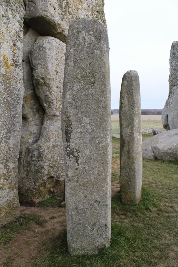
13. The report on Waun Mawn contains other questionable evidence, which was excluded from the program. This includes the fact that the Aubrey holes at Stonehenge are ALL two to three times deeper than at Waun Mawn.  This indicates that the Stonehenge Bluestones were made from larger bluestones than those at Waun Mawn (Stonehenge Bluestone hole 69 is over 1.5m deep, as it is long and thin). It looks as if the original stone circle at Waun Mawn was made up of stones similar in shape to the existing recumbent stone 13, which is 6– 7 feet tall and surrounded by a moat. The shape of recumbent 13 indicates that rather than the long thin bluestones as at Stonehenge, Waun Mawn had ‘fat bottomed’ domed ends and hence the need for only shallow ditches.
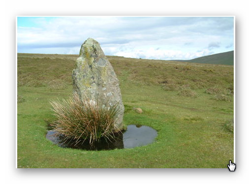
Recumbent Stone 13 Waun Mawn from Stonehenge: The Lost Circle Revealed
recumbent stone 13; Stonehenge: The Lost Circle Revealed
Stonehenge Bluestone 69 from Stonehenge: The Lost Circle Revealed
Stonehenge Bluestone 69 – a third is underground. Stonehenge: The Lost Circle Revealed

Conclusion

In conclusion, it seems that the BBC has produced a nice piece of archaeological propaganda that supports the current false ‘archaeological narrative’ of mythology and speculation, rather than tested and qualified scientific fact. This lack of ‘critical analysis’ is a clear indication of why the ‘science’ of archaeology has not progressed much over the last 50 years, even with modern technology, which it has incorporated to very limited success.
(Stonehenge's The Lost Circle Revealed)
(Stonehenge’s The Lost Circle Revealed)

Memoir

I first met MPP on his excavation dig on the Avon in 2009, where he was preparing to announce his bluestone site, ‘Bluestonehenge’. At the time, we had a discussion about the date of the site, as he was convinced that (at that time) he believed it predated Stonehenge Phase I (we now know this was the first of many claims of a predated Stonehenge bluestone circle). I did point out that at the meeting that I thought this date would be incorrect as according to my research (of the surrounding 50 sites around Stonehenge) which was included in my published book and post-glacial flooded environment hypothesis ‘The Stonehenge Enigma’ in 2013 – that this site would have been below water as the River Avon would remain flooded throughout the Neolithic period. At this point, he ended the meeting and disappeared at such a rapid speed – it looked as if he thought I was clearly mad.

Later carbon dating proved my point and supported my hypothesis, as it is now accepted that Bluehenge was constructed between 2840 and 2230 BCE, in the Early Bronze Age.

PODCAST

Author’s Biography

Robert John Langdon, a polymathic luminary, emerges as a writer, historian, and eminent specialist in LiDAR Landscape Archaeology.

His intellectual voyage has been interwoven with stints as an astute scrutineer in government and grand corporate bastions, a tapestry spanning British Telecommunications, Cable and Wireless, British Gas, and the esteemed University of London.

A decade hence, Robert’s transition into retirement unfurled a chapter of insatiable curiosity. This phase saw him immerse himself in Politics, Archaeology, Philosophy, and the enigmatic realm of Quantum Mechanics. His academic odyssey traversed the venerable corridors of knowledge hubs such as the Museum of London, University College London, Birkbeck College, The City Literature Institute, and Chichester University.

In the symphony of his life, Robert is a custodian of three progeny and a pair of cherished grandchildren. His sanctuary lies ensconced in the embrace of West Wales, where he inhabits an isolated cottage, its windows framing a vista of the boundless sea – a retreat from the scrutinising gaze of Her Majesty’s Revenue and Customs, an amiable clandestinity in the lap of nature.

Exploring Prehistoric Britain: A Journey Through Time

My blog delves into the fascinating mysteries of prehistoric Britain, challenging conventional narratives and offering fresh perspectives grounded in cutting-edge research, particularly LiDAR technology. I invite you to explore some key areas of my research. For example, the Wansdyke, often cited as a defensive structure, is re-examined in light of new evidence. I’ve presented my findings in my blog post Wansdyke: A British Frontier Wall – ‘Debunked’, and a Wansdyke LiDAR Flyover video further visualises my conclusions.

My work also often challenges established archaeological dogma. I argue that many sites, such as Hambledon Hill, commonly identified as Iron Age hillforts, are not what they seem. My posts Lidar Investigation Hambledon Hill – NOT an ‘Iron Age Fort’ and Unmasking the “Iron Age Hillfort” Myth explore these ideas in detail and offer an alternative view. Similarly, sites like Cissbury Ring and White Sheet Camp receive re-evaluations based on LiDAR analysis in my posts “Lidar Investigation Cissbury Ring through time” and “Lidar Investigation White Sheet Camp,“ revealing fascinating insights into their true purpose. I have also examined South Cadbury Castle, often linked to the mythical Camelot56.

My research also extends to ancient water management, including the role of canals and other linear earthworks. I have discussed the true origins of Car Dyke in multiple posts, including Car Dyke – ABC News Podcast and Lidar Investigation Car Dyke – North Section, which suggest a Mesolithic origin 2357. I also explore the misidentification of Roman aqueducts, as seen in my posts on the Great Chesters (Roman) Aqueduct. My research has also been greatly informed by my post-glacial flooding hypothesis, which has helped explain landscape transformations over time. I have discussed this hypothesis in several posts, including AI now supports my Post-Glacial Flooding Hypothesis and Exploring Britain’s Flooded Past: A Personal Journey

Finally, my blog also investigates prehistoric burial practices, as seen in Prehistoric Burial Practices of Britain and explores the mystery of Pillow Mounds, often mistaken for medieval rabbit warrens, but with a potential link to Bronze Age cremation in my posts: Pillow Mounds: A Bronze Age Legacy of Cremation? and The Mystery of Pillow Mounds: Are They Really Medieval Rabbit Warrens?. My research also includes astronomical insights into ancient sites, for example, in Rediscovering the Winter Solstice: The Original Winter Festival. I also review new information about the construction of Stonehenge in The Stonehenge Enigma.

Further Reading

For those interested in British Prehistory, visit www.prehistoric-britain.co.uk, a comprehensive resource featuring an extensive collection of archaeology articles, modern LiDAR investigations, and groundbreaking research. The site also includes insights and excerpts from the acclaimed Robert John Langdon Trilogy, a series of books that explore Britain during the Prehistoric period. Titles in the trilogy include The Stonehenge Enigma, Dawn of the Lost Civilisation, and The Post-Glacial Flooding Hypothesis, which offer compelling evidence of ancient landscapes shaped by post-glacial flooding.

To further explore these topics, Robert John Langdon has developed a dedicated YouTube channel featuring over 100 video documentaries and investigations that complement the trilogy. Notable discoveries and studies showcased on the channel include 13 Things that Don’t Make Sense in History and the revelation of Silbury Avenue – The Lost Stone Avenue, a rediscovered prehistoric feature at Avebury, Wiltshire.

In addition to his main works, Langdon has released a series of shorter, accessible publications, ideal for readers delving into specific topics. These include:

For active discussions and updates on the trilogy’s findings and recent LiDAR investigations, join our vibrant community on Facebook. Engage with like-minded enthusiasts by leaving a message or contributing to debates in our Facebook Group.

Whether through the books, the website, or interactive videos, we aim to provide a deeper understanding of Britain’s fascinating prehistoric past. We encourage you to explore these resources and uncover the mysteries of ancient landscapes through the lens of modern archaeology.

For more information, including chapter extracts and related publications, visit the Robert John Langdon Author Page. Dive into works such as The Stonehenge Enigma or Dawn of the Lost Civilisation, and explore cutting-edge theories that challenge traditional historical narratives.

Other Blogs

s

t

The Stonehenge Transportation Mystery

Introduction

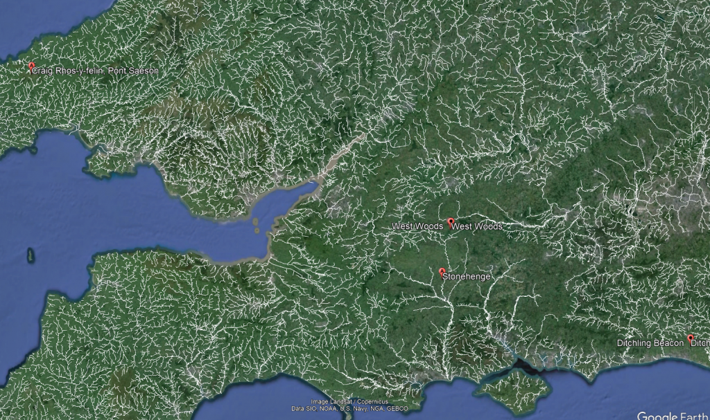
Exploring the origins and transport of the stones used to construct Stonehenge remains a fascinating subject, rife with theories and controversies. The viral interest generated by my blog post this week, which highlighted a map showing three known sites of the stones’ origins, barely scratches the surface of this complex logistical puzzle. Indeed, there are stones from even greater distances, raising myriad questions about how these megaliths were transported to their final resting place at Stonehenge. This essay aims to delve into these logistics, providing a comprehensive overview grounded in the latest research and theories. (The Stonehenge Transportation Mystery)

The Stonehenge Transportation Mystery

The Bluestones

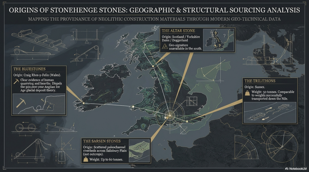
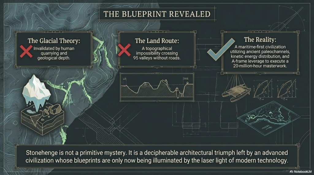
Recent advancements in micro-spectrum analysis have significantly contributed to our understanding of the origins of bluestones. However, this is not an exact science, as the movement of rocks due to glacial activity and post-ice age water flows complicates their traceability. Some academics have proposed that the bluestones found at Stonehenge were not quarried and transported from Wales but deposited nearby by glacial action. This theory, however, conflicts with geological evidence indicating that the last ice age glaciers did not reach as far as Stonehenge, stopping instead at the Bristol Channel. This discrepancy casts doubt on the glacier transport theory, suggesting the need to consider earlier ice ages, such as the Anglian, which occurred over 500,000 years ago. Yet the immense timescale involved means that any stones moved by such glaciers would be deeply buried beneath millennia of soil, making their discovery improbable.

The Stonehenge Transportation Mystery

Furthermore, the lack of bluestone erratics in the vicinity of Stonehenge further challenges the idea of glacial transport. The site at Craig Rhos-Y-Felin, identified as a source of the bluestones, shows clear evidence of human quarrying activity, contradicting the theory that these stones were randomly picked up from glacial deposits. The discovery of human hearths and quarrying tools at Craig Rhos-Y-Felin, along with a partially quarried bluestone, strongly suggests that these stones were intentionally selected and transported for use at Stonehenge.

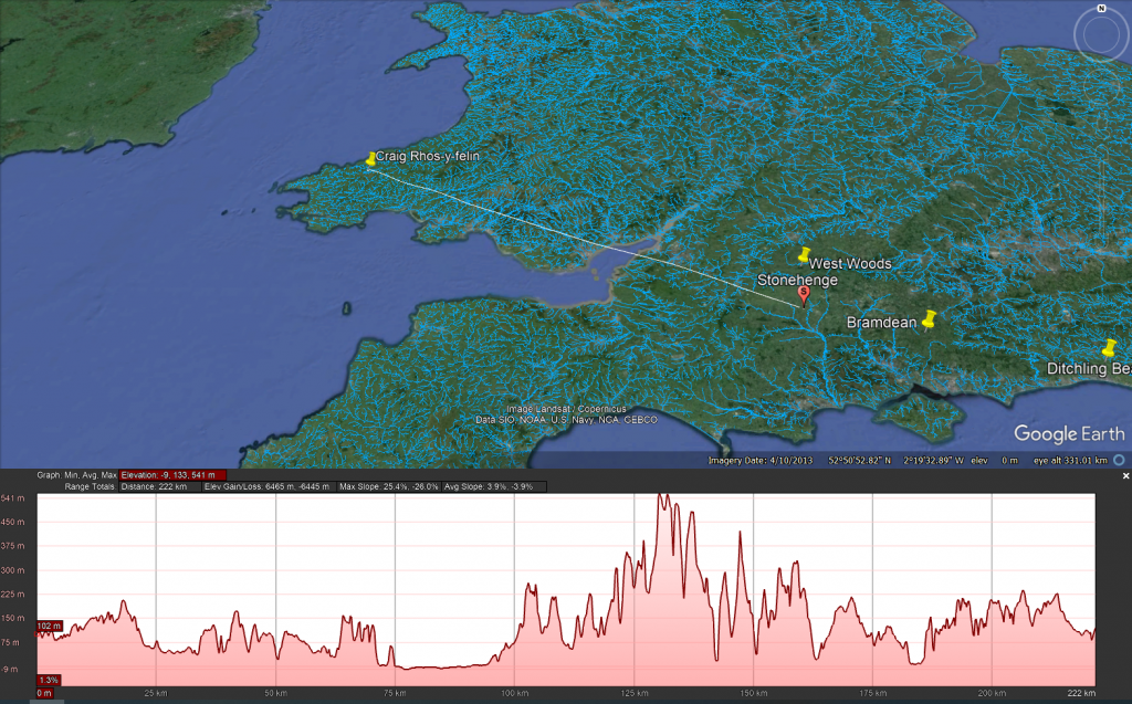
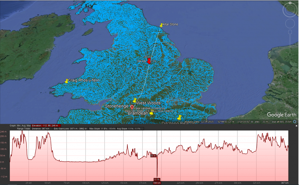
Craig Rhos-y-felin to Stonehenge
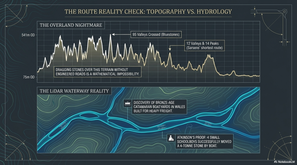
The overland path from Craig Rhos-y-felin to Stonehenge is insane. It goes from 75m OD to 541 OD and crosses 95 valleys – the idea that you can either roll, drag or ox-cart such a route without a road is bonkers!!

The Sarsen Stones

The origin and transportation of the sarsen stones present a different set of challenges. These stones are found scattered across the Salisbury Plain and further afield, in areas never reached by the ice sheets that covered Britain during the last ice age. The popular theory that the sarsen stones came from West Woods near Avebury suggests that they could have been dragged to their current location. However, recent observations indicate that many of these stones are in paleochannel riverbeds rather than rock outcrops. This suggests that they were transported by ice-age floodwaters rather than being quarried from nearby outcrops.

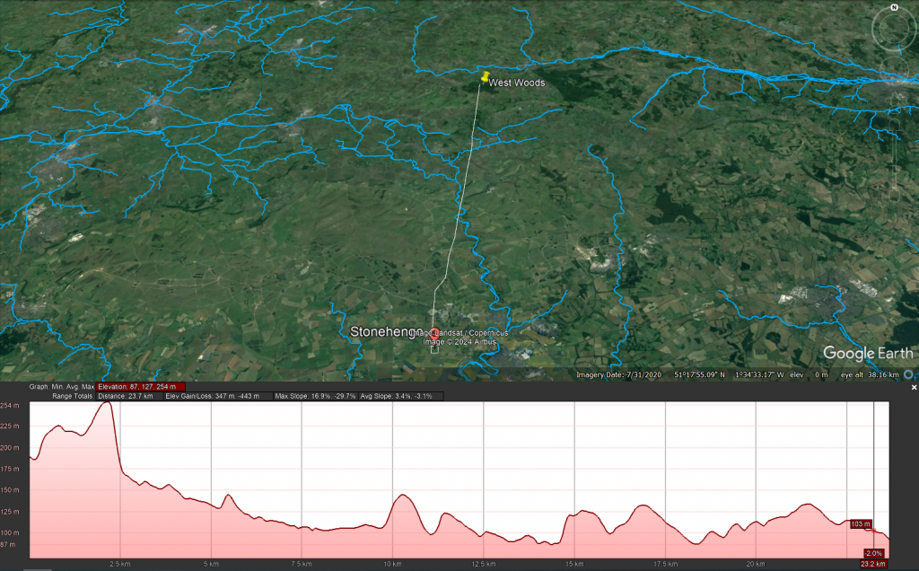
West Woods to Stonehenge
Even the shortest route known to transport these stones is difficult to follow, as the 12 valleys and 14 peaks shown on this map testify.

Theories of Transportation

The theory that the stones could have been moved over frozen rivers during the ice age is intriguing but fraught with logistical issues. The absence of a significant human population capable of organising such an endeavour, coupled with the challenges of moving heavy stones over potentially thin ice, makes this theory less plausible. Additionally, the radiocarbon dating of Stonehenge would be significantly off if the stones had been transported at the end of the ice age.

The Stonehenge Transportation Mystery

LiDAR, or Light Detection and Ranging, is a remote sensing technology that uses laser light to densely sample the earth’s surface, creating highly accurate topographic maps. It has revolutionised archaeological surveys by uncovering features difficult or impossible to see from the ground or through traditional surveying methods. Regarding Stonehenge and the transportation of the stones used in its construction, LiDAR technology offers invaluable insights into the landscape and potential transport routes used by ancient peoples.

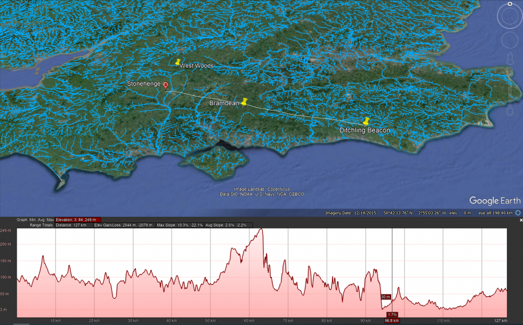
Ditching to Stonehenge
The trilithon stones, weighing around 50 tonnes, reportedly come from Sussex. Such weights were successfully transported down the Nile on boats.

LiDAR Evidence and Stonehenge

LiDAR has been instrumental in mapping the landscape around Stonehenge, revealing details that have remained hidden for millennia under vegetation or soil. This technology has the potential to identify old riverbeds, trackways, and other features that could suggest routes for transporting the massive sarsen stones and bluestones used in the monument’s construction. However, despite its capabilities, LiDAR has not yet provided definitive evidence of prehistoric roads or paths leading directly from the quarries to Stonehenge.

The Stonehenge Transportation Mystery

Key Findings from LiDAR Surveys

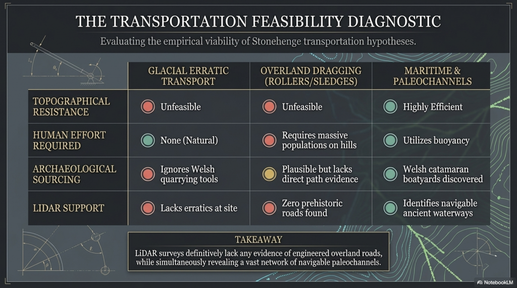
No Prehistoric Roads from Quarries: LiDAR surveys have not found any evidence of engineered roads or paths originating from the bluestone quarries in Wales or from locations where sarsen stones are found. This absence challenges theories that rely on overland transport of the stones using rollers, sledges, or ox-carts over vast distances and rugged terrain.

Ancient Waterways and Paleochannels: One significant contribution of LiDAR is the identification of ancient waterways and paleochannels. These features are crucial for understanding the prehistoric landscape, suggesting that rivers and watercourses may have played a significant role in transporting the stones. The larger rivers identified by LiDAR, which were navigable in the past, support the theory that water transport was a feasible and preferred method for moving the stones.

Atkinson's Method
Atkinson proved with just four small schoolboys that a 4-tonne stone can easily be moved by boat down to the River Avon

Landscape Features: LiDAR has revealed the complexity of the landscape through which any transportation route would have had to navigate, including valleys, dense forests, and waterlogged areas. This detailed mapping underscores the logistical challenges faced by ancient builders, further calling into question the practicality of relying solely on land-based transport methods.

The Stonehenge Transportation Mystery
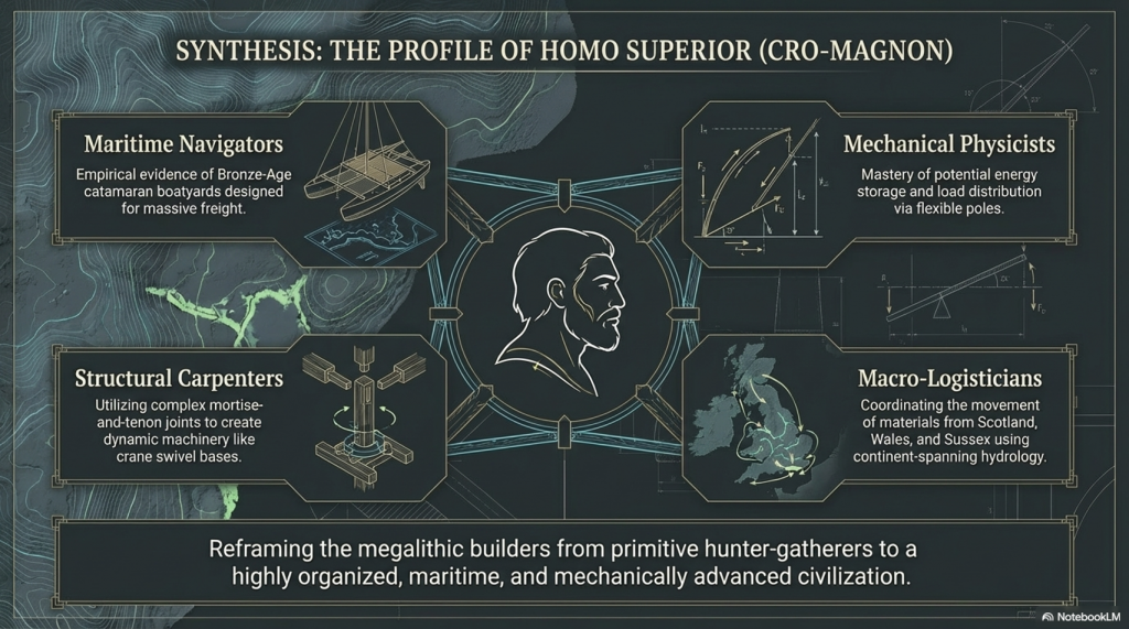
We have now found empirical evidence of boat yards in which catamaran design is made to carry large weights in Wales, dating back to the Bronze Age and beyond

Implications of LiDAR Evidence

The evidence from LiDAR surveys, particularly the absence of prehistoric roads and the emphasis on natural watercourses, suggests a reevaluation of how the stones were transported to Stonehenge. The lack of direct routes from quarries to the site and the identification of navigable ancient rivers and paleochannels lend weight to theories prioritising water transport. This perspective aligns with the understanding that ancient peoples were highly adept at utilising their natural environment to achieve monumental feats of construction.

Alter Stone to Stonehenge
The Altar Stone is now suspected of coming from as far as Scotland, as its Geo signature is not available down south (I would guess Doggerland for obvious reasons), but even if it just came from the Yorkshire Dales, the idea of l, and transportation is pure nonsense

Short Transportation systems from the boat harbours to the Monument

Mechanical Advantage of Poles (from the book – Dawn of the Lost Civilisation)

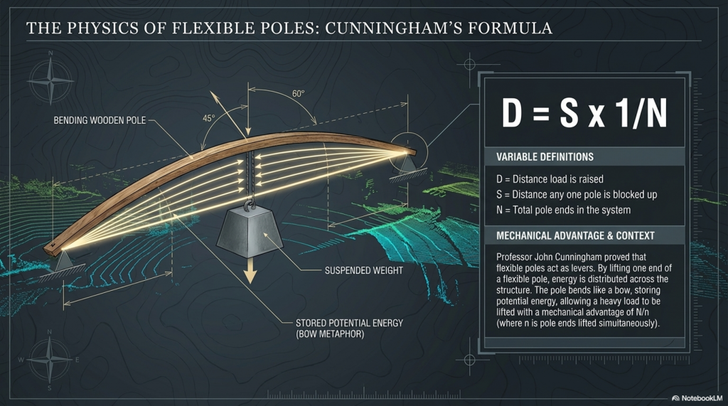
The principle of leverage, applied through poles, provides a mechanical advantage when handling heavy weights. Professor John Cunningham, an art professor at Skidmore College, has introduced a novel concept, creating a new class of simple machines based on flexible rods. Unlike traditional machines, Cunningham’s design not only multiplies force but also distributes it and stores mechanical energy.

The Stonehenge Transportation Mystery

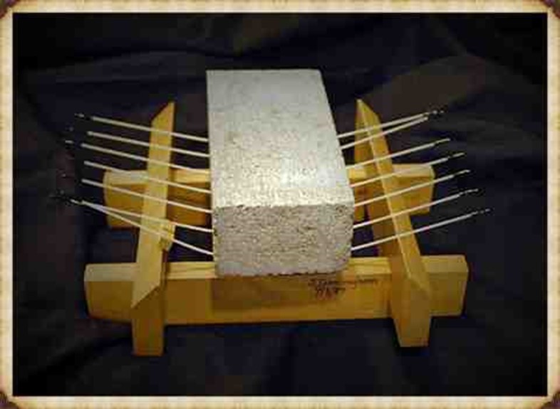
Consider a scenario with a 20,000-pound stone. If you attempt to support it on two rigid beams, each will bear half the weight (10,000 pounds), posing a risk of fracture. Now, imagine spreading the load across 20 solid, parallel beams, each supporting only a fraction of the total weight, making the burden manageable. Cunningham’s innovation takes this idea further by replacing solid beams with flexible poles.

Stone Transportation and Dumb Censorship
The Bluestones were carried, not dragged, to Stonehenge

In the flexible pole structure, each pole can be raised independently without affecting the others. By lifting one end of a pole, a small amount of extra energy is imparted to that pole, and the energy is distributed across the structure. The weight rises by a fraction of the raised end, divided by the number of pole ends. If one end is lifted by a foot, the weight on each of the other pole ends diminishes by a corresponding fraction. Using this method, heavy loads can be lifted with significantly fewer people, as each person is only moving a fraction of the weight at a time.

This innovative approach enables efficient handling of substantial weights, offering a unique perspective on the use of mechanical advantage in lifting and distributing loads. (Stone transportation and censorship)

The Stonehenge Transportation Mystery

Cunningham has distilled the concept to a formula:
D = S x 1/N

Where D is the distance, the load is raised, s is the distance any one pole is blocked up, and N is the total number of pole ends in the system. Given n is the number of pole ends lifted simultaneously, the mechanical advantage for any symmetrical pole configuration will be N/n.

The Stonehenge Transportation Mystery


So, the fact that a pole bends like a bow, storing energy, makes it easier to carry. So easy in fact, that it acts as a lever and gives you a mechanical advantage. This principle would be well known as it is the same principle as how a bow works as it is a store of potential energy, you can’t throw an arrow 100 metres, but the bowing of the wood channelled through a small area (the string) give you the potential energy.

Walk like an Egyptian

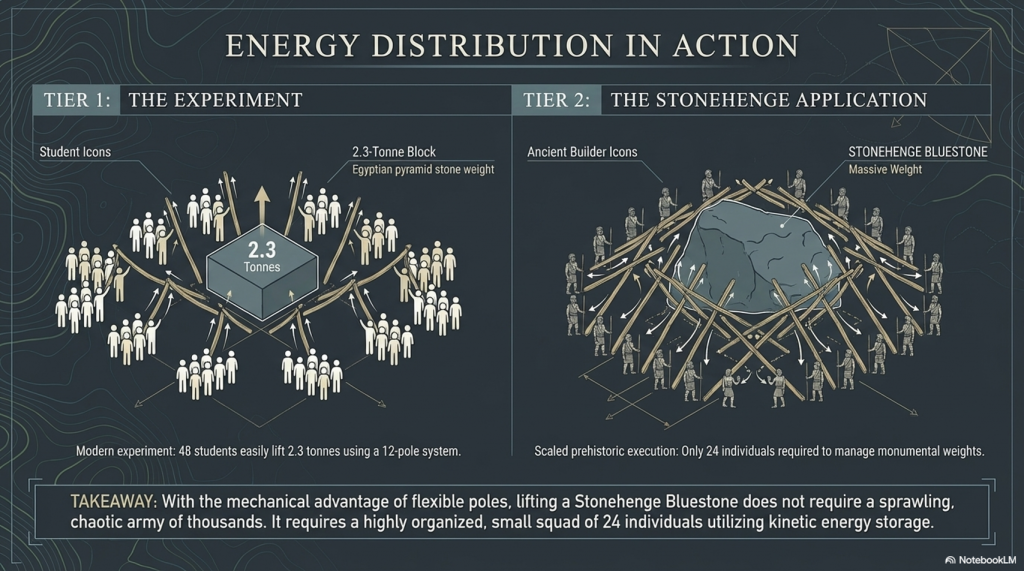
The experiment showed that 48 students ( four x 12 poles) could lift 2.3 tonnes, which was the weight of one of the pyramid’s building stones. The larger the stone, the more poles and men you need, but it was quite easy even for wimpish students. In prehistoric Days with Cro-Magnon works you would need only 24 people to move a Pyramid stone or a Bluestone at Stonehenge without the rest blocks the video has included in their H & S safety assessment….LOL!!

A-Frames and Cranes

The advancement of technology and the movement of massive stones, such as the Sarsen stones at Stonehenge, Avebury, and Carnac, demand a closer examination of the engineering and logistical challenges faced by the ancient civilisation of Homo Superior, also known as Cro-Magnons. The Sarsen stones, weighing up to 60 tonnes, were not merely transported but meticulously erected, presenting a feat that even modern attempts struggle to replicate.


In our exploration of ancient technology, we encounter the question of how to transport and handle colossal loads. The Sarsen stones serve as an illustrative example due to their significant size, and it is perplexing that historians and archaeologists often overlook the intricacies of moving and placing these stones. This oversight persists even though, even with today’s technology, replicating the achievements of Homo Superior at Stonehenge remains a daunting challenge.

The Stonehenge Transportation Mystery


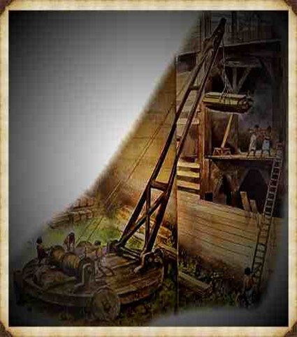
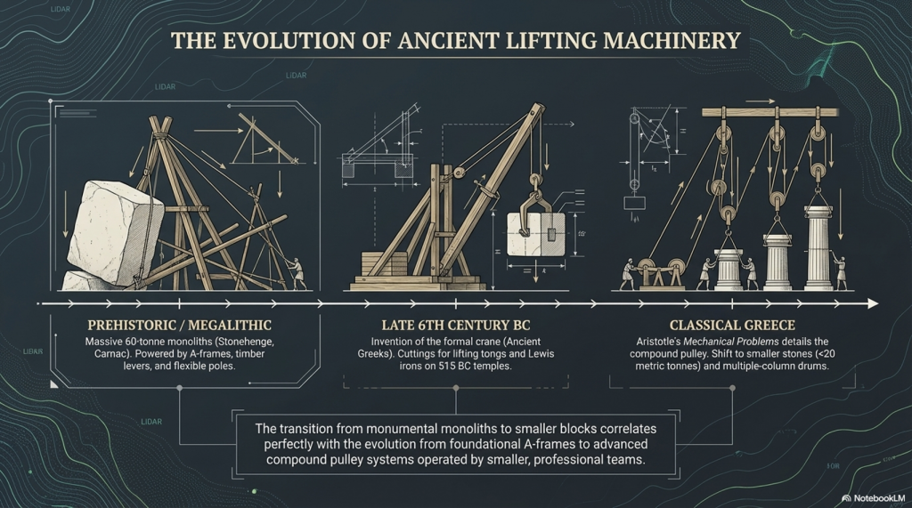
The crane, a machine designed to lift and move heavy materials, is pivotal in the transport and construction industries. Equipped with a hoist, wire ropes or chains, and sheaves, a crane utilises mechanical advantages to lift and lower materials beyond the capacity of human effort. Historically, the invention of the crane is attributed to the Ancient Greeks in the late 6th century BC, as evidenced by cuttings for lifting tongs and Lewis irons on stone blocks of Greek temples dating to around 515 BC.

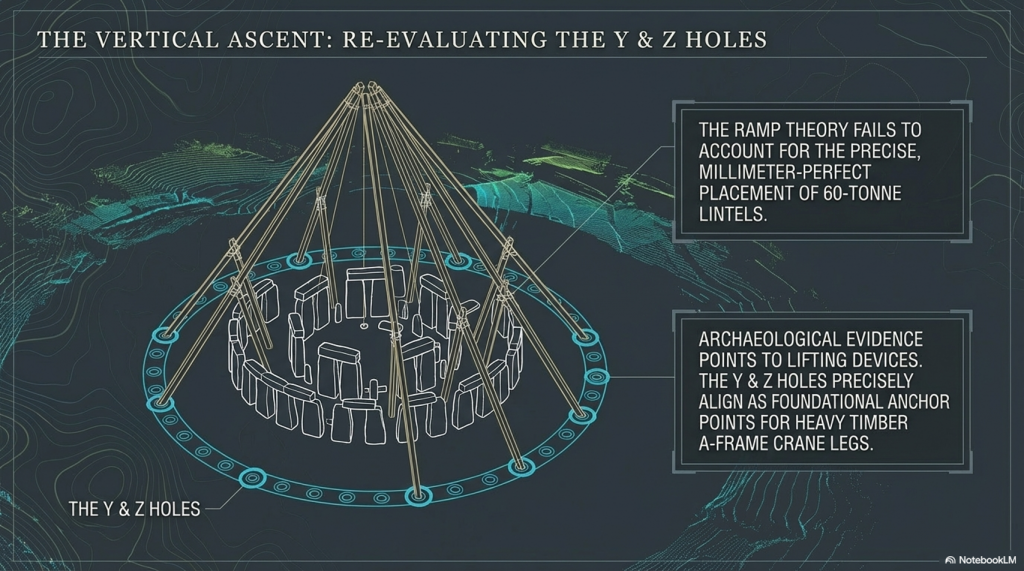
However, when scrutinising Stonehenge, we encounter a fascinating divergence. In contrast, archaeological evidence points to the use of lifting devices, particularly with cuttings indicating the application of cranes, the peculiarities of Stonehenge’s construction challenge conventional narratives. Notably, the placement of lintels on Sarsen uprights and the presence of holes like Y & Z, potentially serving as foundations for A-frame crane legs, hint at a more sophisticated lifting apparatus.

The Stonehenge Transportation Mystery

The reluctance of some scholars to acknowledge advanced lifting devices in the historical context of Homo Superior may stem from the challenge they pose to established historical frameworks. Nevertheless, the investigation into the engineering marvels of Stonehenge encourages us to reassess the capabilities of this ancient civilisation, prompting a deeper understanding of their technological prowess and organisational acumen.

The Stonehenge Transportation Mystery

The transition from ramps to the more sophisticated winch-and-pulley hoist marked a significant shift in ancient construction technology. The emergence of the compound pulley system, attributed to Aristotle in the Mechanical Problems, coincided with a notable decrease in the weights of stones handled on Greek building sites. This transformative period saw the prevalence of smaller stones, weighing less than 15–20 metric tonnes, in contrast to the archaic era’s trend of using larger blocks.

The adoption of the crane, facilitated by the compound pulley system, introduced a more efficient and practical method of vertical motion. Grecian temples of the classical age, exemplified by the Parthenon, favoured using several smaller stones rather than fewer larger ones. Monolithic columns, a prominent feature in earlier constructions, were gradually replaced by multiple-column drums.

The Stonehenge Transportation Mystery

The reasons behind this technological evolution are not entirely clear. It raises intriguing questions about whether the shift from larger to smaller stones was due to the loss of past techniques, improved quarrying methods that enabled faster cutting of shorter blocks, or other factors influencing construction practices. The shift in societal dynamics, with smaller, professional construction teams being favoured over larger bodies of unskilled labour, is proposed as a potential contributing factor. The crane, with its efficiency in handling smaller stones, became preferable in the more volatile social and political conditions of ancient Greece.

While the exact circumstances of this transition remain uncertain, the historical record indicates that the compound pulley system and the crane became integral to Greek construction sites. The literary evidence from Aristotle’s Mechanical Problems and the resurgence of larger block sizes at Greek temples suggests a correlation between the adoption of the compound pulley and advancements in construction techniques. The earliest construction cranes, likely powered by humans or beasts of burden like donkeys, marked a transformative period in ancient construction methods.

(Stone transportation and censorship)
The Stonehenge Transportation Mystery

The evolution of cranes played a crucial role in the construction of tall buildings, enabling the lifting of heavier loads. In the High Middle Ages, harbour cranes emerged to facilitate ship loading and unloading, often integrated into stone towers for enhanced strength and stability. The earliest cranes were crafted from wood, but with the advent of the Industrial Revolution, materials like cast iron and steel became predominant.

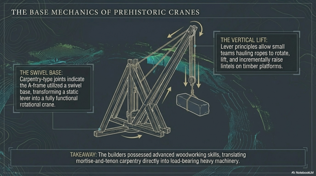
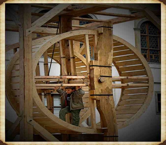
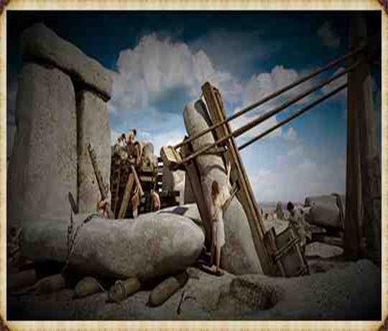
At Stonehenge, the construction methods are a subject of speculation, with suggestions that timber A-frames were employed to raise the stones. Teams of individuals may have hauled the stones upright using ropes, and the topmost stones (lintels) could have been incrementally raised on timber platforms and slid or pushed into place. Carpentry-type joints on the stones indicate a high level of woodworking skill among the builders.

The Stonehenge Transportation Mystery

The idea of A-frames finds support in demonstrations by individuals such as Wally Wallington, a retired construction worker, who showcased techniques based on lever principles for rotating, lifting, and positioning heavy monoliths. An A-frame, essentially a basic crane without a pulley or winch, operates on similar principles to facilitate vertical movement. Adding a swivel base could transform it into a fully functional crane, a concept compatible with the mortise-and-tenon joints observed at Stonehenge.

(Stone transportation and censorship)
The Stonehenge Transportation Mystery

Estimates of the manpower required for Stonehenge’s construction suggest a substantial effort, with millions of hours of work. The various phases of Stonehenge’s construction, from the initial to the third phase, may have required extensive human labour, amounting to up to 20 million hours spent working the stones. The primitive tools available at the time necessitated considerable effort, highlighting the strong will and advanced social organisation required to build and maintain such a monumental site. Stonehenge stands as a testament to the ingenuity and determination of its ancient builders. (Stone transportation and censorship)

The Stonehenge Transportation Mystery

PodCast

Author’s Biography

Robert John Langdon, a polymathic luminary, emerges as a writer, historian, and eminent specialist in LiDAR Landscape Archaeology.

His intellectual voyage has been interwoven with stints as an astute scrutineer in government and grand corporate bastions, a tapestry spanning British Telecommunications, Cable and Wireless, British Gas, and the esteemed University of London.

A decade hence, Robert’s transition into retirement unfurled a chapter of insatiable curiosity. This phase saw him immerse himself in Politics, Archaeology, Philosophy, and the enigmatic realm of Quantum Mechanics. His academic odyssey traversed the venerable corridors of knowledge hubs such as the Museum of London, University College London, Birkbeck College, The City Literature Institute, and Chichester University.

In the symphony of his life, Robert is a custodian of three progeny and a pair of cherished grandchildren. His sanctuary lies ensconced in the embrace of West Wales, where he inhabits an isolated cottage, its windows framing a vista of the boundless sea – a retreat from the scrutinising gaze of Her Majesty’s Revenue and Customs, an amiable clandestinity in the lap of nature.

Exploring Prehistoric Britain: A Journey Through Time

My blog delves into the fascinating mysteries of prehistoric Britain, challenging conventional narratives and offering fresh perspectives grounded in cutting-edge research, particularly LiDAR technology. I invite you to explore some key areas of my research. For example, the Wansdyke, often cited as a defensive structure, is re-examined in light of new evidence. I’ve presented my findings in my blog post Wansdyke: A British Frontier Wall – ‘Debunked’, and a Wansdyke LiDAR Flyover video further visualises my conclusions.

My work also often challenges established archaeological dogma. I argue that many sites, such as Hambledon Hill, commonly identified as Iron Age hillforts, are not what they seem. My posts Lidar Investigation Hambledon Hill – NOT an ‘Iron Age Fort’ and Unmasking the “Iron Age Hillfort” Myth explore these ideas in detail and offer an alternative view. Similarly, sites like Cissbury Ring and White Sheet Camp receive re-evaluations based on LiDAR analysis in my posts “Lidar Investigation Cissbury Ring through time” and “Lidar Investigation White Sheet Camp,“ revealing fascinating insights into their true purpose. I have also examined South Cadbury Castle, often linked to the mythical Camelot56.

My research also extends to ancient water management, including the role of canals and other linear earthworks. I have discussed the true origins of Car Dyke in multiple posts, including Car Dyke – ABC News Podcast and Lidar Investigation Car Dyke – North Section, which suggest a Mesolithic origin 2357. I also explore the misidentification of Roman aqueducts, as seen in my posts on the Great Chesters (Roman) Aqueduct. My research has also been greatly informed by my post-glacial flooding hypothesis, which has helped explain landscape transformations over time. I have discussed this hypothesis in several posts, including AI now supports my Post-Glacial Flooding Hypothesis and Exploring Britain’s Flooded Past: A Personal Journey

Finally, my blog also investigates prehistoric burial practices, as seen in Prehistoric Burial Practices of Britain and explores the mystery of Pillow Mounds, often mistaken for medieval rabbit warrens, but with a potential link to Bronze Age cremation in my posts: Pillow Mounds: A Bronze Age Legacy of Cremation? and The Mystery of Pillow Mounds: Are They Really Medieval Rabbit Warrens?. My research also includes astronomical insights into ancient sites, for example, in Rediscovering the Winter Solstice: The Original Winter Festival. I also review new information about the construction of Stonehenge in The Stonehenge Enigma.

Further Reading

For those interested in British Prehistory, visit www.prehistoric-britain.co.uk, a comprehensive resource featuring an extensive collection of archaeology articles, modern LiDAR investigations, and groundbreaking research. The site also includes insights and excerpts from the acclaimed Robert John Langdon Trilogy, a series of books that explore Britain during the Prehistoric period. Titles in the trilogy include The Stonehenge Enigma, Dawn of the Lost Civilisation, and The Post-Glacial Flooding Hypothesis, which offer compelling evidence of ancient landscapes shaped by post-glacial flooding.

To further explore these topics, Robert John Langdon has developed a dedicated YouTube channel featuring over 100 video documentaries and investigations that complement the trilogy. Notable discoveries and studies showcased on the channel include 13 Things that Don’t Make Sense in History and the revelation of Silbury Avenue – The Lost Stone Avenue, a rediscovered prehistoric feature at Avebury, Wiltshire.

In addition to his main works, Langdon has released a series of shorter, accessible publications, ideal for readers delving into specific topics. These include:

For active discussions and updates on the trilogy’s findings and recent LiDAR investigations, join our vibrant community on Facebook. Engage with like-minded enthusiasts by leaving a message or contributing to debates in our Facebook Group.

Whether through the books, the website, or interactive videos, we aim to provide a deeper understanding of Britain’s fascinating prehistoric past. We encourage you to explore these resources and uncover the mysteries of ancient landscapes through the lens of modern archaeology.

For more information, including chapter extracts and related publications, visit the Robert John Langdon Author Page. Dive into works such as The Stonehenge Enigma or Dawn of the Lost Civilisation, and explore cutting-edge theories that challenge traditional historical narratives.

Other Blogs

s

t

Caerfai Promontory Fort – Archaeological Nonsense

Introduction

The a repeat episode of Digging for Britain (Season 11) turns its gaze to Caerfai Promontory Fort—also called Penpleidiau—a dramatic headland just southeast of St David’s. On paper, it ticks the usual boxes of a coastal ‘hillfort’. In reality, a closer look reveals that nothing about this site behaves like a fort at all. In fact, its earthworks contradict the defensive story archaeologists keep repeating.(Caerfai Promontory Fort)

All the banks are in the wrong place for a ‘fort’

Perched on a 500-metre-long promontory with cliffs plunging 20 metres into St Bride’s Bay, Caerfai looks impressive. But the classification rests almost entirely on a pair of southern ramparts that supposedly once protected the interior. Two neatly aligned gaps on the eastern side are then assumed—without real evidence—to be the original entrances. (Caerfai Promontory Fort)

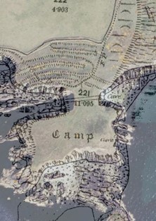
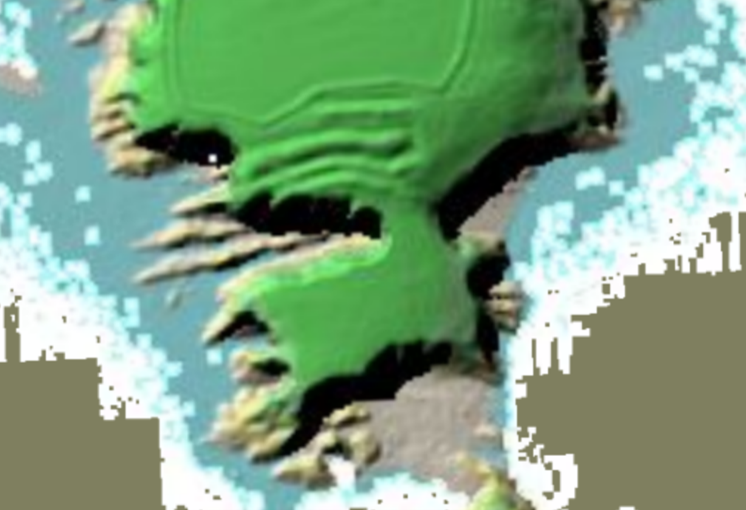
Caerfai promontory fort
All the banks are in the wrong place for a ‘Fort’ – Caerfai promontory fort – archaeological nonsense

Things start to unravel once you examine the broader landscape. The crucial eastern sector isn’t shown on LiDAR at all, because archaeologists believe a significant portion of the headland has eroded away. Yet if half the ‘fort’ slid into the sea, why were the remaining earthworks built in positions that made no tactical sense in the first place?

Why fortify sheer cliffs? Why build higher, more exposed banks on the northern side, where an attack is least likely? None of this sits comfortably with a defensive interpretation.

LiDAR makes the ‘fort’ idea even stranger

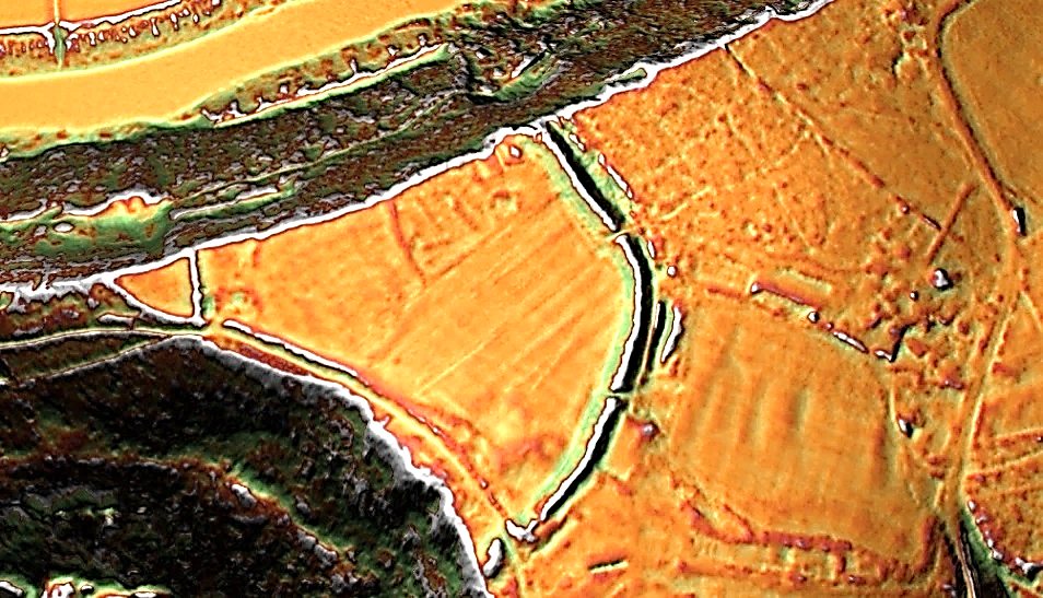
LiDAR finally gives us the clarity the traditional model avoids. A well-cut external ditch curves from the western cliff edge around to the east, dipping noticeably deeper as it progresses. For a defensive feature, that is the wrong way around. You would expect a consistent depth—or a deeper western section, where an attacker could approach. Instead, the ditch continues beyond the supposed defensive banks, as though it had a purpose unrelated to warfare.

This inconsistent geometry is the hallmark not of a fort, but of a practical working landscape—one shaped by people who were managing boats, not armies. (Caerfai Promontory Fort)

A better explanation: Caerfai as a mooring and haulage site

Caerfai promontory fort
Lidar shows its not defensive – Caerfai promontory fort – archaeological nonsense

Once you strip away the inherited assumptions, a far more coherent picture emerges. The layout makes perfect sense if Caerfai was never meant to be a stronghold, but a coastal facility. A cross-dyke used for mooring, hauling and sheltering boats explains:

  • why the ditch deepens toward the east (for controlled drainage and haulage)
  • why the earthworks extend beyond the ‘entrance gaps’
  • why the cliffs needed no defensive attention
  • and why the banks sit where they do—on the access side, not the seaward side

In rough weather, boats could be pulled up the slope using ropes anchored to the banks, protected from the swell and wind. When conditions improved, they could be lowered back into the water with equal ease.

This interpretation fits the broader maritime pattern emerging across prehistoric Britain: earthworks used not as military constructions, but as practical coastal installations built by seafaring communities who knew the shoreline intimately.

Caerfai is not a fort. It’s archaeological nonsense to call it one. It is, instead, another overlooked piece of Britain’s maritime prehistory—a working harbour in miniature, disguised for decades by the persistence of an outdated story. (Caerfai Promontory Fort)

Offa’s Dyke

This can be seen very clearly in our investigation into Offa’s Dyke where the promortory fort near Chepstow has a similar cross-dyke section that was once interpreted as a ‘defensive ditch’ – the problem is that it is the wrong way if it is defending against the Welsh – so can only have been a cross-dyke for boats to moor at the site.

Caerfai promontory fort - archaeological nonsense
Cross-dyke as is facing away from the Welsh!! -Caerfai promontory fort – archaeological nonsense

In conclusion, the Caerfai Promontory Fort challenges the conventional ‘Hill Fort’ narrative, urging archaeologists to reconsider the purposes of coastal structures. This case study highlights the importance of questioning established interpretations and exploring alternative perspectives in archaeological studies. By unraveling the complexities of Caerfai, we gain valuable insights into the practical functions that may have shaped our ancient landscapes, ultimately enriching our understanding of the past.

(Caerfai Promontory Fort)

Podcast

Author’s Biography

Robert John Langdon, a polymathic luminary, emerges as a writer, historian, and eminent specialist in LiDAR Landscape Archaeology.

His intellectual voyage has interwoven with stints as an astute scrutineer for governmental realms and grand corporate bastions, a tapestry spanning British Telecommunications, Cable and Wireless, British Gas, and the esteemed University of London.

A decade hence, Robert’s transition into retirement unfurled a chapter of insatiable curiosity. This phase saw him immerse himself in Politics, Archaeology, Philosophy, and the enigmatic realm of Quantum Mechanics. His academic odyssey traversed the venerable corridors of knowledge hubs such as the Museum of London, University College London, Birkbeck College, The City Literature Institute, and Chichester University.

In the symphony of his life, Robert is a custodian of three progeny and a pair of cherished grandchildren. His sanctuary lies ensconced in the embrace of West Wales, where he inhabits an isolated cottage, its windows framing a vista of the boundless sea – a retreat from the scrutinous gaze of the Her Majesty’s Revenue and Customs, an amiable clandestinity in the lap of nature’s embrace.

Exploring Prehistoric Britain: A Journey Through Time

My blog delves into the fascinating mysteries of prehistoric Britain, challenging conventional narratives and offering fresh perspectives based on cutting-edge research, particularly using LiDAR technology. I invite you to explore some key areas of my research. For example, the Wansdyke, often cited as a defensive structure, is re-examined in light of new evidence. I’ve presented my findings in my blog post Wansdyke: A British Frontier Wall – ‘Debunked’, and a Wansdyke LiDAR Flyover video further visualizes my conclusions.

My work also often challenges established archaeological dogma. I argue that many sites, such as Hambledon Hill, commonly identified as Iron Age hillforts are not what they seem. My posts Lidar Investigation Hambledon Hill – NOT an ‘Iron Age Fort’ and Unmasking the “Iron Age Hillfort” Myth explore these ideas in detail and offer an alternative view. Similarly, sites like Cissbury Ring and White Sheet Camp, also receive a re-evaluation based on LiDAR analysis in my posts Lidar Investigation Cissbury Ring through time and Lidar Investigation White Sheet Camp, revealing fascinating insights into their true purpose. I have also examined South Cadbury Castle, often linked to the mythical Camelot56.

My research also extends to the topic of ancient water management, including the role of canals and other linear earthworks. I have discussed the true origins of Car Dyke in multiple posts including Car Dyke – ABC News PodCast and Lidar Investigation Car Dyke – North Section, suggesting a Mesolithic origin2357. I also explore the misidentification of Roman aqueducts, as seen in my posts on the Great Chesters (Roman) Aqueduct. My research has also been greatly informed by my post-glacial flooding hypothesis which has helped to inform the landscape transformations over time. I have discussed this hypothesis in several posts including AI now supports my Post-Glacial Flooding Hypothesis and Exploring Britain’s Flooded Past: A Personal Journey

Finally, my blog also investigates prehistoric burial practices, as seen in Prehistoric Burial Practices of Britain and explores the mystery of Pillow Mounds, often mistaken for medieval rabbit warrens, but with a potential link to Bronze Age cremation in my posts: Pillow Mounds: A Bronze Age Legacy of Cremation? and The Mystery of Pillow Mounds: Are They Really Medieval Rabbit Warrens?. My research also includes the astronomical insights of ancient sites, for example, in Rediscovering the Winter Solstice: The Original Winter Festival. I also review new information about the construction of Stonehenge in The Stonehenge Enigma.

Further Reading

For those interested in British Prehistory, visit www.prehistoric-britain.co.uk, a comprehensive resource featuring an extensive collection of archaeology articles, modern LiDAR investigations, and groundbreaking research. The site also includes insights and extracts from the acclaimed Robert John Langdon Trilogy, a series of books exploring Britain during the Prehistoric period. Titles in the trilogy include The Stonehenge Enigma, Dawn of the Lost Civilisation, and The Post Glacial Flooding Hypothesis, offering compelling evidence about ancient landscapes shaped by post-glacial flooding.

To further explore these topics, Robert John Langdon has developed a dedicated YouTube channel featuring over 100 video documentaries and investigations that complement the trilogy. Notable discoveries and studies showcased on the channel include 13 Things that Don’t Make Sense in History and the revelation of Silbury Avenue – The Lost Stone Avenue, a rediscovered prehistoric feature at Avebury, Wiltshire.

In addition to his main works, Langdon has released a series of shorter, accessible publications, ideal for readers delving into specific topics. These include:

For active discussions and updates on the trilogy’s findings and recent LiDAR investigations, join our vibrant community on Facebook. Engage with like-minded enthusiasts by leaving a message or contributing to debates in our Facebook Group.

Whether through the books, the website, or interactive videos, we aim to provide a deeper understanding of Britain’s fascinating prehistoric past. We encourage you to explore these resources and uncover the mysteries of ancient landscapes through the lens of modern archaeology.

For more information, including chapter extracts and related publications, visit the Robert John Langdon Author Page. Dive into works such as The Stonehenge Enigma or Dawn of the Lost Civilisation, and explore cutting-edge theories that challenge traditional historical narratives.

Other Blogs

s

t

From the Rhône to Wansdyke: The Case for a Standardised Canal Boat in Prehistoric Britain

Introduction

In 2004, archaeologists working near Arles in southern France discovered a remarkable Roman barge buried in the silt of the Rhône River. Named the Arles Rhône 3, this 1st-century AD vessel is a masterpiece of Roman-era inland water transport. But beyond its craftsmanship lies a deeper story—one that could reshape how we view Britain’s ancient linear earthworks.

Was this boat design truly Roman? Or did it originate earlier, as part of a pan-European river and canal culture? And if so, could Britain’s dykes and waterways—like the Car Dyke, Wansdyke, and the Vallum—have used similar vessels? Let’s dive in. (Rhône to Wansdyke).

From the Rhône to Wansdyke
Arles Rhône 3– From the Rhône to Wansdyke

The Arles Rhône 3: A Flat-Bottomed Marvel

The Arles Rhône 3 is about 31 meters long and 3 meters wide, with a flat-bottomed hull, shallow draft, and a side rudder for steering. These traits make it ideal for shallow rivers and canals—not the open sea. It was built with robust oak planks using mortise-and-tenon joinery, a technique consistent with Roman construction standards, though not unique to them.

This barge wasn’t designed for speed or waves. It was built to carry cargo—up to 30 tonnes—downriver efficiently, and then be towed back upstream by oxen, slaves, or ropes along towpaths. This was standard practice across the empire.

But here’s the crucial detail: this design predates Roman occupation. Flat-bottomed boats were used by Gauls and other European cultures for centuries before the Romans arrived. The Romans didn’t invent the design—they simply adopted and refined it. (Rhône to Wansdyke).

From the Rhône to Wansdyke
Arles Rhône 3– From the Rhône to Wansdyke

Roman Shipbuilding: The Great Inheritor

The Romans were not seafaring pioneers. Their naval tradition was built by copying and improving on the technologies of others—Carthaginians, Greeks, Celts, and Phoenicians. Even the famed Roman quinqueremes were based on captured Carthaginian ships.

What the Romans excelled at was standardisation and replication. Once they saw something that worked—be it a road, aqueduct, or barge—they duplicated it across the empire. The Arles Rhône 3 represents not an isolated invention, but a functional watercraft refined for mass deployment across inland Europe. (Rhône to Wansdyke).

From the Rhône to Wansdyke
Arles Rhône 3– From the Rhône to Wansdyke

Britain’s Dykes and Waterways: Built for Boats?

One of the strongest pieces of evidence supporting the canal hypothesis lies in the geography of Britain itself. Much of the island’s landscape is hilly and fed by abundant natural springs, particularly at higher elevations. These springs would have provided a consistent water source at altitude, ideal for feeding manmade waterways through gravity alone.

Now consider this: many quarries and prehistoric stone sources are found at the tops of hills. Flat-bottomed barges like the Arles Rhône 3, when used in this context, make perfect engineering sense. They could be dragged uphill while empty—a task made easier by constructing a large earthen bank or causeway—and then floated downhill fully loaded, using gravity and spring-fed water flow to move cargo efficiently.

This system would eliminate the need for locks or complex water-lifting infrastructure. The consistent gradient and the known spring-fed terrain match perfectly with this form of gravity-assisted water transport. It fits so well with the physical structure of earthworks like Wansdyke and the Vallum that it goes a long way to support the idea that these were never just boundaries or defensive moats—they were engineered canals, tailored for one-way barge traffic designed for the landscape.

Now let’s look at Britain. The Car Dyke, Wansdyke, and Vallum are long, linear earthworks that resemble canals more than fortifications. They run through low-lying, sloping terrain, have consistent gradients, and in many cases, align with rivers and spring sources. (Rhône to Wansdyke).

These are precisely the conditions that suit flat-bottomed barges like the Arles Rhône 3:

  • Shallow water: ✔️
  • Gentle gradients: ✔️
  • Cargo transport potential: ✔️
  • Limited need for locks: ✔️

If the Romans were using this design in Gaul and the Rhine, why wouldn’t they use the same boats in Britain’s engineered water routes?

Even more compelling—what if these British earthworks predate Roman occupation, and the Romans simply inherited them, just as they did the boat design?

From the Rhône to Wansdyke
Arles Rhône 3– From the Rhône to Wansdyke

The Logic of a Pan-European Canal Culture

Flat-bottomed barges are functionally inevitable in any society using water transport through shallow inland terrain. If Gauls had them before the Romans, and Romans used them everywhere from the Rhône to the Po, there’s every reason to think that prehistoric Britons used them too.

Perhaps the real question isn’t whether Roman barges came to Britain—but whether Britain’s prehistoric canal system inspired the very model the Romans used elsewhere. (Rhône to Wansdyke).


Arles Rhône 3: Evidence of One-Way Flow Design

🔻 1. Hull Design: One-Way Flow Bias
The flat-bottomed hull is ideal for shallow, slow-moving water.

But crucially: this shape is not suited to sailing upstream—especially in rivers with even modest currents.

The boat’s structure lacks features (like a deep keel or robust rigging) needed to tack against the flow—meaning it could go downstream easily, but upstream only with assistance.

🐂 2. Towpaths and Towing Evidence
Roman documents (like those by Pliny the Elder) describe towpaths along rivers and canals.

In many parts of the empire (e.g. the Moselle, Po, Tiber, Rhône), goods were floated downstream, and barges were then dragged back by animals or slaves.

Archaeological traces of towpaths—flattened, eroded soil tracks along riverbanks—appear alongside known Roman transport routes.

🔄 3. Wear Patterns and Construction
The wear on the hull of Arles Rhône 3 is consistent with slow, controlled navigation, not being battered by surf or fast-moving water.

Its broad beam and robust timber joinery would have made it sturdy under lateral stress—ideal for being dragged when empty.

📦 4. Transport Economics: Gravity Efficiency
Roman freight economics favoured downhill bulk movement (grains, wine, amphorae) from inland settlements toward ports like Arles, where goods could be offloaded to sea vessels.

It was far more efficient to send heavy goods downstream and then haul the empty barge back uphill.

Example: A full barge might carry 15–30 tonnes of goods downstream, but return empty or lightly loaded—making overland or riverbank hauling feasible.

🧾 5. Roman Textual Support
The Codex Theodosianus and other Roman records refer to barge haulers (tractores or halatores) as part of commercial operations.

Writings from the late Empire reference teams of oxen or slaves towing barges upstream, including detailed provisions for how and when they were paid or taxed.

🏞️ 6. Rhône Geography
The Rhône is a strongly flowing river—even today.

Before modern locks and dams, upstream sailing was nearly impossible for heavy vessels.

Barges like Arles Rhône 3 were almost certainly floated downstream from Roman workshops or upriver loading points, then dragged back to repeat the cycle.

🧠 Conclusion:
They put the pieces together logically:

  • The design says “downstream floater.”
  • The Roman transport economy says “drag it back up.”
  • The archaeological context shows towpath-compatible riverbanks.
  • The written sources say “yes, we hauled stuff.”

So the idea that Arles Rhône 3 and its ilk were floated with gravity and hauled by muscle is not just theory—it’s a conclusion based on design pragmatism, textual evidence, and site context. (Rhône to Wansdyke).


Reclaiming the Narrative

The Arles Rhône 3 doesn’t just tell us about Roman logistics. It gives us a template for understanding the practicality of prehistoric British water transport.

Roman or not, the boat’s design proves one thing: if you have a canal, you need a barge like this. And if Britain has thousands of kilometres of mysterious linear earthworks designed for water—then we know exactly what kind of boat would have sailed through them.

It’s time to stop calling them ditches and start recognising them for what they may truly be: the ancient motorways of a forgotten seafaring civilisation. (Rhône to Wansdyke).

Exploring Prehistoric Britain: A Journey Through Time

My blog delves into the fascinating mysteries of prehistoric Britain, challenging conventional narratives and offering fresh perspectives based on cutting-edge research, particularly using LiDAR technology. I invite you to explore some key areas of my research. For example, the Wansdyke, often cited as a defensive structure, is re-examined in light of new evidence. I’ve presented my findings in my blog post Wansdyke: A British Frontier Wall – ‘Debunked’, and a Wansdyke LiDAR Flyover video further visualizes my conclusions.

My work also often challenges established archaeological dogma. I argue that many sites, such as Hambledon Hill, commonly identified as Iron Age hillforts are not what they seem. My posts Lidar Investigation Hambledon Hill – NOT an ‘Iron Age Fort’ and Unmasking the “Iron Age Hillfort” Myth explore these ideas in detail and offer an alternative view. Similarly, sites like Cissbury Ring and White Sheet Camp, also receive a re-evaluation based on LiDAR analysis in my posts Lidar Investigation Cissbury Ring through time and Lidar Investigation White Sheet Camp, revealing fascinating insights into their true purpose. I have also examined South Cadbury Castle, often linked to the mythical Camelot56.

My research also extends to the topic of ancient water management, including the role of canals and other linear earthworks. I have discussed the true origins of Car Dyke in multiple posts including Car Dyke – ABC News PodCast and Lidar Investigation Car Dyke – North Section, suggesting a Mesolithic origin2357. I also explore the misidentification of Roman aqueducts, as seen in my posts on the Great Chesters (Roman) Aqueduct. My research has also been greatly informed by my post-glacial flooding hypothesis which has helped to inform the landscape transformations over time. I have discussed this hypothesis in several posts including AI now supports my Post-Glacial Flooding Hypothesis and Exploring Britain’s Flooded Past: A Personal Journey

Finally, my blog also investigates prehistoric burial practices, as seen in Prehistoric Burial Practices of Britain and explores the mystery of Pillow Mounds, often mistaken for medieval rabbit warrens, but with a potential link to Bronze Age cremation in my posts: Pillow Mounds: A Bronze Age Legacy of Cremation? and The Mystery of Pillow Mounds: Are They Really Medieval Rabbit Warrens?. My research also includes the astronomical insights of ancient sites, for example, in Rediscovering the Winter Solstice: The Original Winter Festival. I also review new information about the construction of Stonehenge in The Stonehenge Enigma. (Rhône to Wansdyke).

Further Reading

For those interested in British Prehistory, visit www.prehistoric-britain.co.uk, a comprehensive resource featuring an extensive collection of archaeology articles, modern LiDAR investigations, and groundbreaking research. The site also includes insights and extracts from the acclaimed Robert John Langdon Trilogy, a series of books exploring Britain during the Prehistoric period. Titles in the trilogy include The Stonehenge Enigma, Dawn of the Lost Civilisation, and The Post Glacial Flooding Hypothesis, offering compelling evidence about ancient landscapes shaped by post-glacial flooding.

To further explore these topics, Robert John Langdon has developed a dedicated YouTube channel featuring over 100 video documentaries and investigations that complement the trilogy. Notable discoveries and studies showcased on the channel include 13 Things that Don’t Make Sense in History and the revelation of Silbury Avenue – The Lost Stone Avenue, a rediscovered prehistoric feature at Avebury, Wiltshire. (Rhône to Wansdyke).

In addition to his main works, Langdon has released a series of shorter, accessible publications, ideal for readers delving into specific topics. These include:

For active discussions and updates on the trilogy’s findings and recent LiDAR investigations, join our vibrant community on Facebook. Engage with like-minded enthusiasts by leaving a message or contributing to debates in our Facebook Group.

Whether through the books, the website, or interactive videos, we aim to provide a deeper understanding of Britain’s fascinating prehistoric past. We encourage you to explore these resources and uncover the mysteries of ancient landscapes through the lens of modern archaeology.

For more information, including chapter extracts and related publications, visit the Robert John Langdon Author Page. Dive into works such as The Stonehenge Enigma or Dawn of the Lost Civilisation, and explore cutting-edge theories that challenge traditional historical narratives. (Rhône to Wansdyke).

Other Blogs

s

t

(Rhône to Wansdyke).