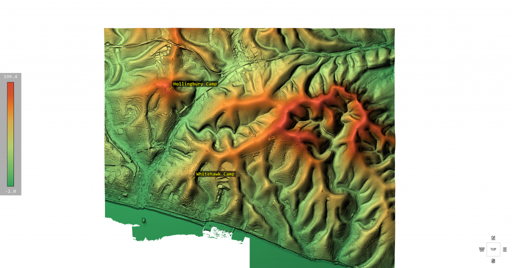
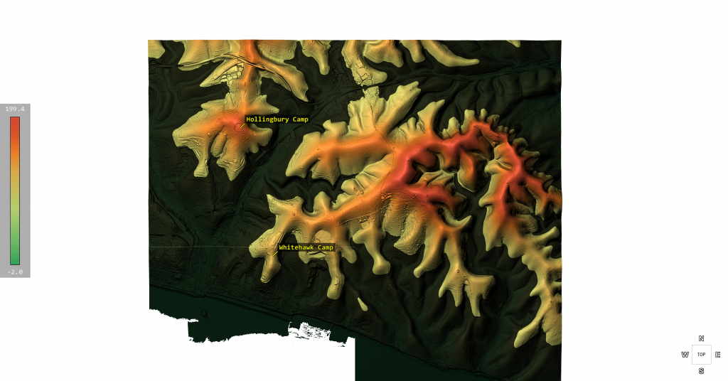
Pinkery Canal

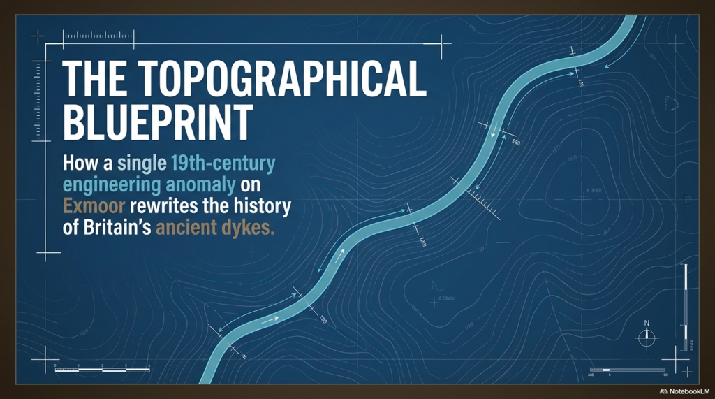
The Victorian Engineering Project That Challenges Everything We Thought We Knew About Britain’s Ancient Dykes


Introduction

For years, one of the most common objections to Britain’s great prehistoric dykes has been remarkably simple. (Pinkery Canal: The Victorian Engineering Project)

“They’re too high.”

“There wouldn’t have been enough water.”

“They couldn’t have been used for transport.”

Pinkery Canal on Exmoor changes that debate forever.

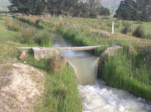
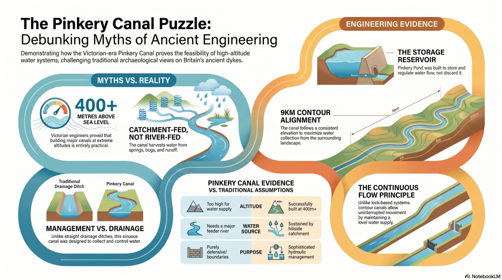
Built around 1820, this remarkable engineering project carried water across one of the highest stretches of land in southern Britain. Its purpose remains debated, but the engineering itself is undeniable. Victorian engineers considered it entirely practical to construct a canal more than 400 metres above sea level, collecting water from reservoirs, springs, bogs and hillside runoff as it crossed the moor.

That single fact removes one of archaeology’s favourite objections.

More interesting still is why it was built.

Several interpretations suggest the canal formed part of a wider system intended to move or support the movement of minerals and other resources across difficult terrain, linking extraction sites with the estate’s developing transport network. Whether for transport, water power, or land improvement, the principle is the same: using water engineering to connect remote upland resources with places where they can be processed, distributed, or exported.
 (Pinkery Canal: The Victorian Engineering Project)
(Pinkery Canal: The Victorian Engineering Project)

That concept should sound familiar.

Across Britain, more than 1,500 ancient linear dykes cross the landscape. They are usually described as defensive boundaries, yet many display engineering characteristics that are difficult to reconcile with purely military functions. Could at least some have formed part of much earlier transport and water-management systems, linking quarries, rivers and settlements in much the same way that Victorian engineers attempted on Exmoor?

This article isn’t about proving Pinkery Canal is prehistoric, yet it should be noted that there are aspects of this canal that predate the Victorian construction date and maybe where the engineers obtained the original idea?

It’s about recognising that a documented nineteenth-century engineering project demonstrates something archaeologists have often dismissed—that high-altitude canals are entirely feasible, that they can be supplied by catchment water rather than a single river, and that long-distance water engineering for moving resources across the landscape is not only possible, but historically documented.

Perhaps it’s time to stop asking whether such systems could have existed…

...and start asking where else we should be looking.

 (Pinkery Canal: The Victorian Engineering Project)
(Pinkery Canal: The Victorian Engineering Project)

1. The Myth

For years, critics of Britain’s prehistoric dykes have repeated the same two objections.

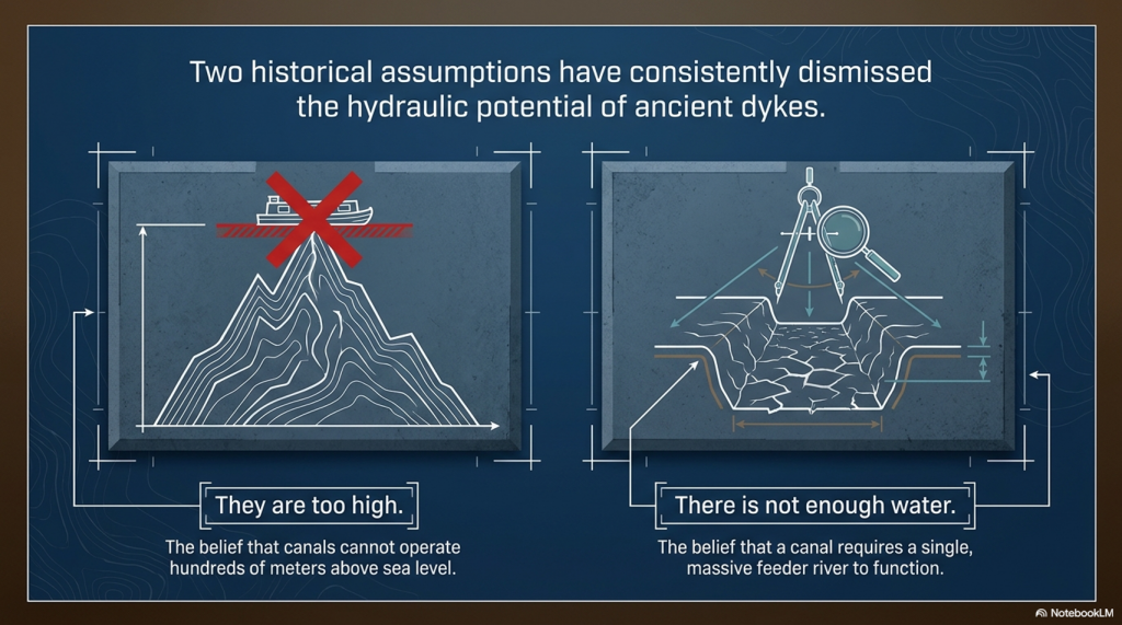
“Nobody would build a canal hundreds of metres above sea level.”

“There wouldn’t be enough water to keep it supplied.”

Pinkery Canal on Exmoor demolishes both arguments.

Not because it became a great commercial success.

Not because every detail of its purpose is understood.

But because Victorian engineers actually designed and constructed it.

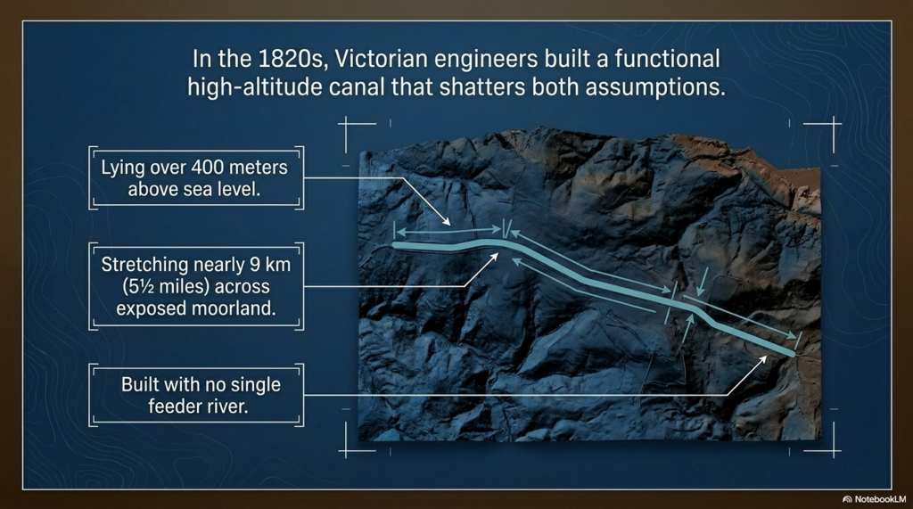
Nearly 9 km (5½ miles) long and lying over 400 metres above sea level, Pinkery Canal is undeniable proof that engineers considered high-altitude water engineering both practical and achievable.

That fact alone changes the debate.

Whether the canal ultimately fulfilled its intended purpose is almost irrelevant. Its existence proves that altitude was not considered an insurmountable obstacle, and that upland landscapes could provide sufficient water through reservoirs, bogs, springs, and intercepted surface runoff to justify the construction of a major canal.

In other words, two of the most frequently repeated objections to prehistoric canals are no longer objections at all.

The question is no longer:

“Could people build canals at high altitude?”

Pinkery Canal answers that with a resounding yes.

The real question is:

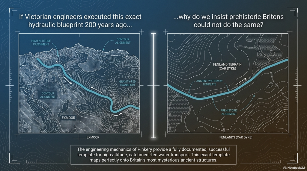
If the Victorians considered this perfectly feasible less than 200 years ago, why do archaeologists still insist prehistoric engineers could not have done the same?
 (Pinkery Canal: The Victorian Engineering Project)
(Pinkery Canal: The Victorian Engineering Project)

2. The Engineering

Forget the archive for a moment.

Forget the arguments over dates.

Imagine Pinkery Canal had just been discovered using modern LiDAR, with no nineteenth-century documents to guide us. How would an engineer interpret the monument purely from its design?

The first impression is its sheer ambition.

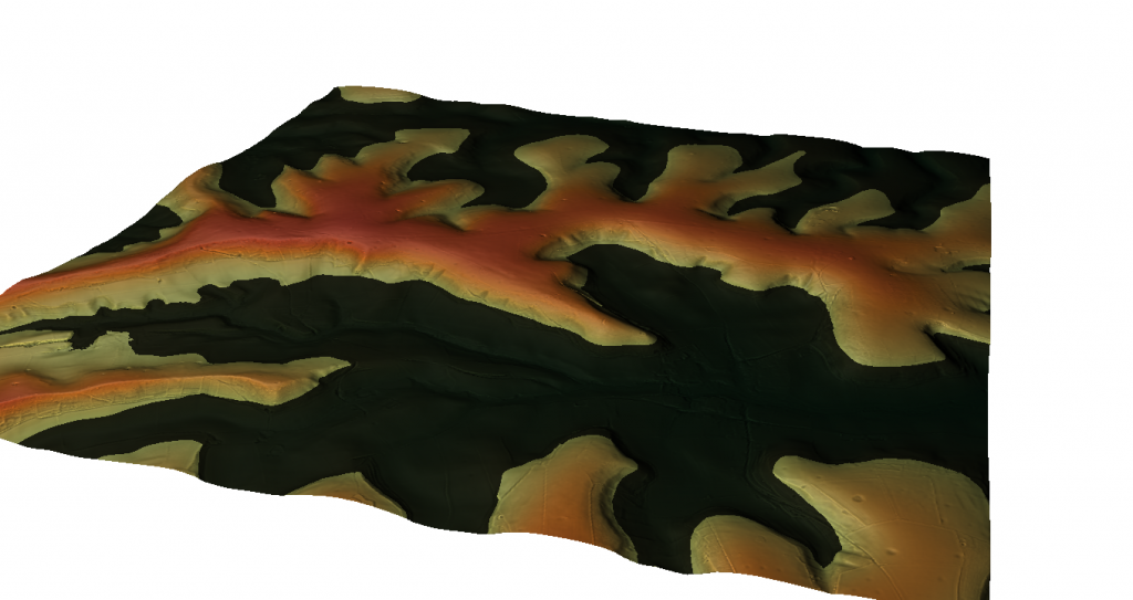
Stretching for almost 9 km (5½ miles) across the southern slopes of Exmoor at more than 400 metres above sea level, Pinkery Canal is one of the most remarkable examples of upland hydraulic engineering ever attempted in Britain. It crosses exposed moorland, deep peat, boggy ground and numerous valley heads. This was not a casual drainage ditch dug by local farmers. It required planning, surveying, labour, and a clear engineering objective.

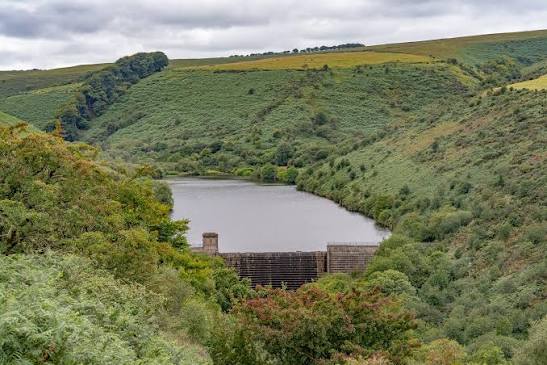
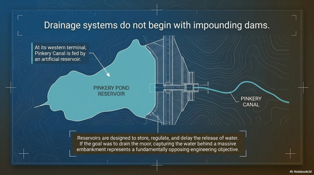
The canal begins at its western end with an artificial reservoir created behind a substantial embankment or dam. That single feature immediately challenges one of the proposed interpretations.
 (Pinkery Canal: The Victorian Engineering Project)
The reservoir – (Pinkery Canal: The Victorian Engineering Project)

Drainage systems are designed to remove water.

Reservoirs are designed to store it.

Those are fundamentally different engineering objectives.

If the intention had simply been to drain the moor, why begin by constructing a dam capable of impounding water? The reservoir suggests that water itself was regarded as a valuable resource requiring collection, regulation and controlled distribution rather than something to be discarded.

The route itself is equally revealing.

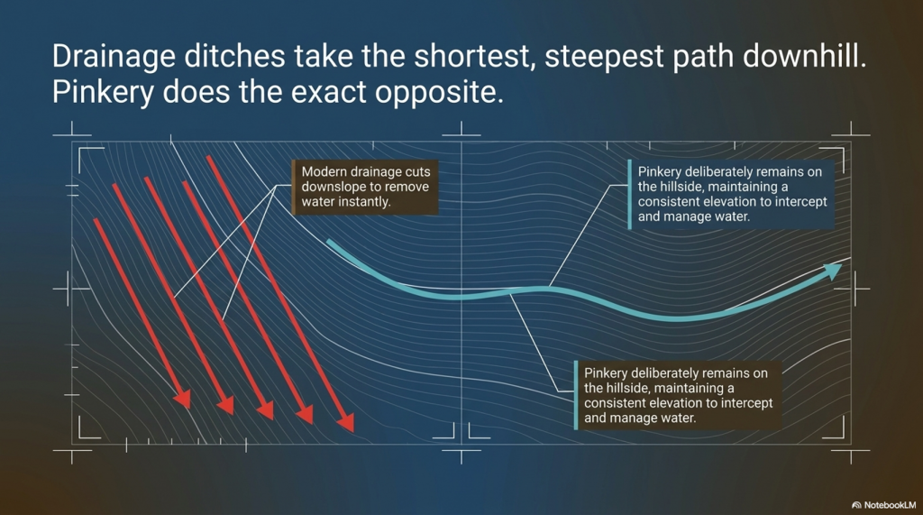
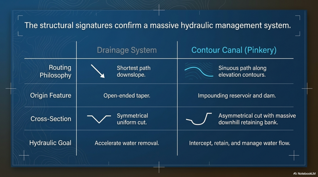
Rather than taking the shortest downhill path, as every modern drainage ditch on Exmoor does today, Pinkery Canal follows a long, sweeping contour across the hillside. Modern drainage channels cut almost directly downslope because their purpose is obvious: to remove water from the land as quickly and efficiently as possible.
 (Pinkery Canal: The Victorian Engineering Project)
(Pinkery Canal: The Victorian Engineering Project)

Pinkery does the exact opposite.

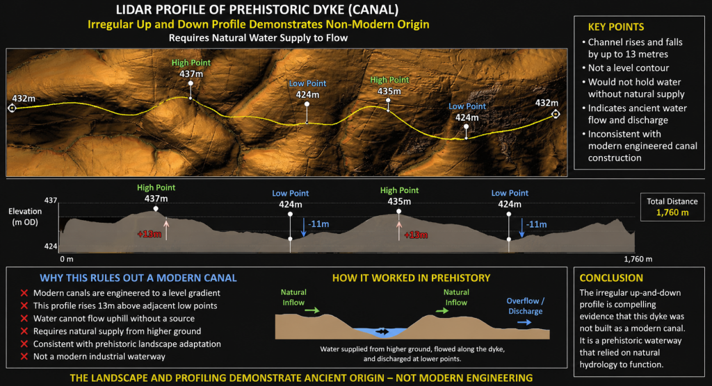
It deliberately remains on the hillside, maintaining a remarkably consistent elevation over many kilometres while gently curving around the contours. Every bend represents additional surveying, excavation and labour. Engineers do not introduce unnecessary curves into a project of this scale. Every deviation must therefore have served a purpose.

That purpose may lie in the hydrology itself.

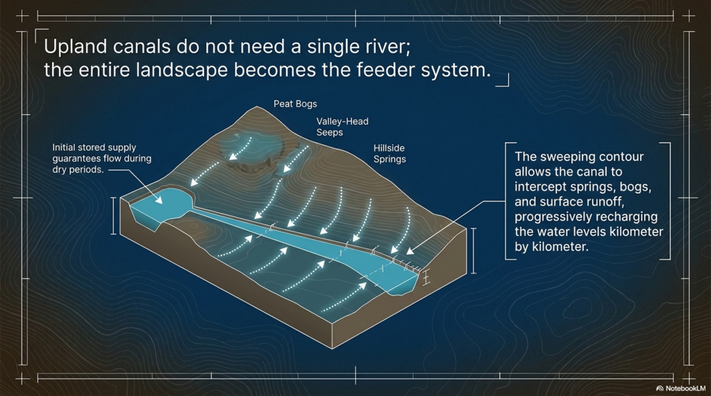
Unlike a river-fed canal supplied by a single large watercourse, a contour canal can collect water progressively along its entire length. Every spring, emerging from the hillside, every bog, every valley-head seep, every small stream, and every episode of surface runoff flowing down the slope contribute additional water. Rather than relying on a single source, the canal effectively harvests water from its entire catchment.

This is one of Pinkery’s most important engineering lessons.

For years, critics have argued that high-altitude canals would never have possessed sufficient water. Pinkery demonstrates another solution entirely. In a wet upland landscape, rainfall, springs, peat bogs, and intercepted runoff constitute the water supply. The canal itself becomes a collector, gradually increasing its flow as it crosses the hillside.

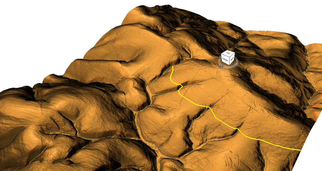
The LiDAR evidence also reveals that the canal is far more sophisticated than the phrase “contour leat” suggests.

Detailed examination shows changing widths, varying bank forms and an undulating longitudinal profile rather than a perfectly level line. The route repeatedly approaches the heads of valleys and drainage features. Modern maps also show later north-south drainage channels cutting across the canal, demonstrating that subsequent engineers adopted a completely different solution to reclaim the moor. Their drains are short, straight and steep. Pinkery is long, sinuous and almost level.

These are two entirely different engineering philosophies.

The terminal arrangements are equally intriguing.

At both ends, the canal appears closely associated with quarry workings or extraction areas. At least one location has a defined track linking the quarry directly to the canal. At another, the canal appears to terminate in a carefully engineered widening adjacent to a palaeochannel rather than simply continuing into the valley below. If drainage had been the objective, extending the ditch a short distance downhill would have been the simplest solution. Instead, the engineering appears far more elaborate than a straightforward drainage outlet.
 (Pinkery Canal: The Victorian Engineering Project)
(Pinkery Canal: The Victorian Engineering Project)

Whether these features relate to transport, water management, construction, or another purpose remains uncertain, but they deserve far greater attention than they have received.

Perhaps the most striking conclusion is that, despite detailed archaeological surveys, no single interpretation successfully explains every aspect of the monument.

Transport explains some features but not others.

Drainage explains some features but struggles with the reservoir and the geometry.

Water power requires hydraulic calculations that have yet to be convincingly demonstrated.

Irrigation raises unanswered questions about distribution.

Each hypothesis explains part of the engineering.

No one yet explains the complete system.

That is precisely why Pinkery Canal remains so fascinating.

It is not simply an archaeological site.

It is a large-scale engineering puzzle.

And whatever its ultimate purpose, one conclusion is beyond dispute. Victorian engineers considered it entirely practical to build and supply a major contour canal more than 400 metres above sea level. In doing so, they demolished two of archaeology’s favourite objections in a single project: that high-altitude canals could not be built, and that there would never have been sufficient water to sustain them.

The real challenge now is no longer asking whether such engineering was possible.

Pinkery has already answered that question.

The challenge is understanding why it was designed exactly as it was.

 (Pinkery Canal: The Victorian Engineering Project)
(Pinkery Canal: The Victorian Engineering Project)

3. Pinkery and Car Dyke – More Similar Than You Might Think

At first glance, Pinkery Canal and Car Dyke appear to have nothing in common.

One crosses the high moorland of Exmoor.

The other traverses the low-lying Fenlands of eastern England.

One is traditionally regarded as Victorian.

The other has long been attributed to Roman engineers.

Yet when viewed as engineering projects rather than archaeological labels, the similarities become surprisingly difficult to ignore.

Both were constructed to move water across the landscape rather than simply allowing it to flow naturally downhill.

(Car Dyke - North Section)
Car Dyke reused in a similar fashion as Pinkery Canal – (Pinkery Canal: The Victorian Engineering Project)

Both follow carefully selected routes designed to exploit the surrounding topography rather than take the shortest possible course.

Both have uncertain purposes despite decades of archaeological investigation.

And both have been linked to the movement of heavy materials from extraction areas towards wider transport networks.

That last point is particularly interesting.

Several interpretations of Pinkery Canal suggest it formed part of a system for moving lime, minerals, or other resources across Exmoor. Whether by boat, a water-powered incline, or another engineering solution, the underlying objective appears to have been the same: to overcome difficult terrain and connect remote resources to the estate’s developing transport network.

That is remarkably similar to the engineering questions surrounding Car Dyke.

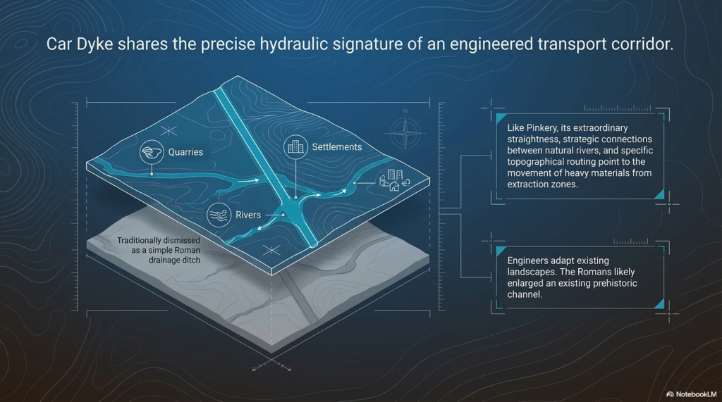
For generations, archaeologists have regarded Car Dyke simply as a Roman drainage canal.

Yet its extraordinary scale, remarkable straightness and strategic connections between rivers have always hinted at a far more ambitious purpose. Our own investigation concluded that Car Dyke makes far more sense as a transport corridor linking quarries, settlements, rivers and distribution centres across the Fenlands. Rather than creating an entirely new waterway, the Romans may have enlarged and engineered an existing prehistoric channel, transforming it into Britain’s largest canal-like transport route.

(Britain's Giant Prehistoric Waterways)

Pinkery demonstrates that this approach is neither unusual nor implausible.

Throughout history, engineers have repeatedly adapted existing landscapes rather than starting with a blank slate. Rivers have been canalised. Ancient roads have become Roman roads. Medieval tracks became turnpikes. Victorian railways often followed much older routeways.

Why should canals be any different?

Pinkery therefore provides something that has been missing from the debate over Britain’s prehistoric dykes.

It offers a documented example of engineers modifying a landscape, harvesting water from multiple natural sources and constructing a substantial canal in terrain that many archaeologists would previously have dismissed as impossible.

Pinkery demonstrate that the engineering principles behind our Car Dyke hypothesis are entirely realistic.

Instead of asking whether prehistoric engineers could have built such systems, perhaps archaeology should begin asking whether later engineers simply inherited, enlarged, and improved landscapes whose origins stretch much further back than the surviving documents.
 (Pinkery Canal: The Victorian Engineering Project)
(Pinkery Canal: The Victorian Engineering Project)

4. The Second Myth Falls – Where Did the Water Come From?

Perhaps the most common criticism of prehistoric canals is not their height, but their supposed lack of water.

The argument is usually presented as though every canal requires a single obvious source—a large river, a lake, or a permanent reservoir.

Without one, the idea is dismissed.

Pinkery Canal demonstrates that this assumption is far too simplistic.

When viewed from the ground, Exmoor appears to be little more than open moorland.

Viewed using modern LiDAR and historical mapping, however, an entirely different landscape emerges.

Pinkery crosses one of the wettest upland environments in southern Britain.

Its route intersects extensive peat deposits, blanket bog, spring lines, valley-head seepages, small streams and countless natural drainage pathways. Historical maps also show large areas of marshy ground surrounding parts of the canal, while later land reclamation introduced numerous straight drainage ditches to drain the landscape.
 (Pinkery Canal: The Victorian Engineering Project)
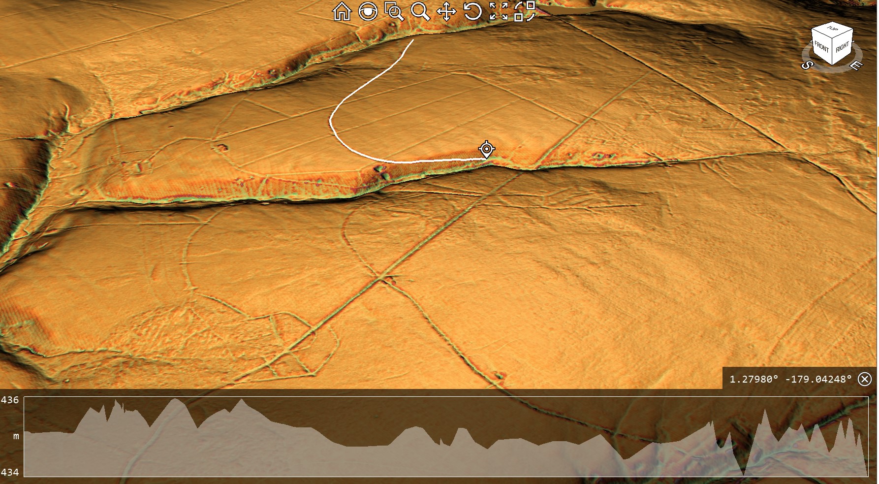
First Section By the Reservoir – (Pinkery Canal: The Victorian Engineering Project)

In other words, this was never a dry hillside.

It was a giant natural catchment.

That distinction is crucial.

Rather than relying on a single river to supply it, Pinkery appears to have been designed to collect water progressively as it crossed the landscape. Every period of rainfall generated surface runoff from the higher ground above. Every spring emerging from the peat contributed additional flow. Every valley head intercepted by the canal became another source of water.

The canal itself became the collector.

This is a completely different hydraulic principle from the one usually imagined by archaeologists.

Instead of asking:

“Where is the river feeding the canal?”

Perhaps the better question is:

“How much water does the entire catchment above the canal produce?”

Once viewed in that way, the engineering begins to make far more sense.

The long, curving alignment is no longer simply following a contour.

It is harvesting water from an entire hillside.

Every bend allows the canal to intercept another small drainage system. Every kilometre increases the contributing catchment. Rather than relying on a single large source, the available water gradually accumulates along the route.
 (Pinkery Canal: The Victorian Engineering Project)

This also explains why the western reservoir becomes so important.

The dam provided an initial stored supply, ensuring water was available even during drier periods, while the remainder of the canal progressively collected additional inflows from springs, bogs and hillside runoff.

Together they formed a single hydraulic system.

Ironically, the modern drainage network demonstrates the exact opposite of the engineering philosophy.

Today’s straight north-south drainage ditches were constructed to remove water from the moor as quickly as possible. They cut directly downslope, rapidly carrying water away from the peat and into the valleys below.

Pinkery does the reverse.

Instead of losing water, it captures it.

Instead of accelerating drainage, it intercepts it.

Instead of taking the shortest route downhill, it deliberately remains on the contour, collecting water from every natural drainage feature it encounters.

This distinction is fundamental.

The canal was not simply crossing a wet landscape.

It appears to have been designed around it.

For students of Britain’s prehistoric dykes, this observation is particularly significant.

One of the most common objections to their interpretation as waterways has always been the supposed absence of a large feeder river. Pinkery demonstrates another engineering solution entirely. A canal does not necessarily require a single major water source. Given the right landscape, it can harvest countless smaller sources distributed across an entire catchment.

Whether Victorian engineers consciously calculated this in modern hydrological terms is almost irrelevant.

Their design shows they understood the principle.

And if nineteenth-century engineers recognised that an upland landscape of springs, bogs and runoff could sustain a canal, perhaps archaeologists should think more carefully before dismissing similar possibilities elsewhere in Britain.

 (Pinkery Canal: The Victorian Engineering Project)
(Pinkery Canal: The Victorian Engineering Project)

5. If It Was Simply Drainage, Why Doesn’t It Behave Like a Drain?

One of the most revealing aspects of the Pinkery Canal is not where it begins or ends.

It is the shape of the engineering itself.

For nearly two centuries, the canal has frequently been described as a contour leat, with drainage often forming part of the explanation. Yet when the surrounding landscape is examined using modern LiDAR, an obvious question emerges.

If the objective was simply to drain the moor, why wasn’t it designed like every other drainage system on Exmoor?

The answer is surprisingly simple.

Because it wasn’t.
 (Pinkery Canal: The Victorian Engineering Project)
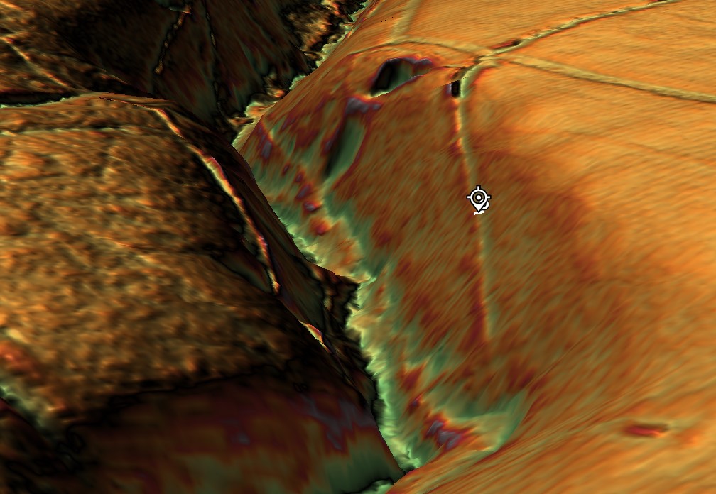
The end of Section One goes into a quarry past two other quarries – (Pinkery Canal: The Victorian Engineering Project)

Modern drainage ditches are easy to recognise. They follow the most efficient engineering solution possible. They are generally straight or only gently curved, taking the shortest practical route downhill. Their purpose is to quickly remove water from the land, reducing waterlogging and reclaiming boggy ground for agriculture.

The later drainage channels that cross the Pinkery Canal demonstrate exactly this principle.

Cutting almost directly north-to-south, they ignore the contours and descend rapidly into the valleys below. They waste no effort. They take the shortest available route because every unnecessary metre represents additional excavation and cost.

That is exactly what engineers designing a drainage system would be expected to do.

Pinkery Canal is completely different.

Instead of descending the hillside, it clings to it.

Instead of taking the shortest route, it extends for almost 9 kilometres in a broad sweeping curve.

Instead of accelerating water downhill, it appears to intercept it, retaining a remarkably consistent elevation across the landscape.

From an engineering perspective, those are not small differences.

They are fundamental.

Every bend required additional surveying.

Every curve required additional excavation.

Every extra metre increased both labour and construction costs.

Engineers simply do not introduce that level of complexity unless it serves a practical purpose.
 (Pinkery Canal: The Victorian Engineering Project)
(Pinkery Canal: The Victorian Engineering Project)

The obvious question, therefore, becomes:

What was the canal trying to achieve that a series of straight drainage ditches could not?

This is where the modern drainage network becomes unexpectedly useful.

Far from supporting the drainage interpretation, it provides a direct comparison between two completely different engineering philosophies.

The modern drains remove water.

Pinkery appears to manage it.

The modern drains cut across the landscape.

Pinkery works with it.

The modern drains dispose of water as quickly as possible.

Pinkery appears designed to collect water progressively from the surrounding catchment while preventing its immediate loss downslope.

These are not variations of the same design.

They are solutions to different engineering problems.

This distinction also helps explain why the canal repeatedly approaches the heads of valleys and natural drainage features. Rather than avoiding them, the alignment appears to exploit them. Every small stream, spring, or area of surface runoff that the canal intercepts becomes another potential source of water entering the system.

That behaviour makes perfect sense for a contour channel intended to harvest water.

It makes far less sense for a ditch whose sole purpose was drainage.

Perhaps the most telling observation is that Victorian engineers later constructed entirely different drainage works across the same landscape. If a simple drainage ditch had been the original objective, why wasn’t Pinkery built in the same way as the later drains?

The answer appears to be that it was never solving the same problem.

Pinkery Canal may ultimately have failed to achieve its intended purpose, but its geometry reveals something important.

It was not engineered as the quickest way to drain Exmoor.

It was engineered to control water.

Understanding that distinction is the key to understanding the monument itself—and perhaps to understanding many of Britain’s much older linear earthworks as well.

 (Pinkery Canal: The Victorian Engineering Project)
(Pinkery Canal: The Victorian Engineering Project)

6. The Reservoir – Storing Water or Removing It?

Perhaps the single most overlooked feature of the entire Pinkery Canal system lies at its western end.

Before the canal even began, the Victorian engineers constructed a substantial embankment, creating what is now known as Pinkery Pond. This artificial reservoir formed the head of the entire system, storing water before it entered the canal.

At first glance, this may appear entirely unremarkable.

In reality, it may be one of the most important engineering clues on the site.

Think about the logic.

If your primary objective is to drain a wet upland landscape, why begin by constructing a dam?

Drainage and reservoirs represent two fundamentally different engineering philosophies.

A drainage system is designed to remove water from the landscape as efficiently as possible. Every engineering decision seeks to accelerate the movement of water downhill, reducing flooding, drying peat and reclaiming land for agriculture.
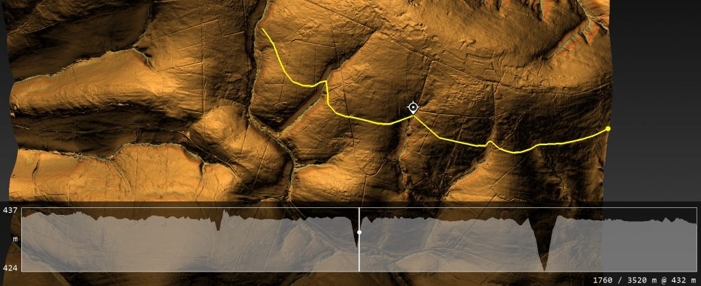
 (Pinkery Canal: The Victorian Engineering Project)
The Canal can not operate as a single entity without the paleochannel being full of water – (Pinkery Canal: The Victorian Engineering Project)

A reservoir does exactly the opposite.

It captures water.

It stores water.

It regulates water.

It delays its release.

Those are not minor differences.

They are completely different engineering objectives.

This immediately raises an obvious question.

Was Pinkery Canal ever intended to function as a simple drainage ditch?

The reservoir suggests otherwise.
 (Pinkery Canal: The Victorian Engineering Project)
(Pinkery Canal: The Victorian Engineering Project)

Instead of treating water as a nuisance, the engineer appears to regard it as a valuable resource that requires careful management. Water could be impounded during wetter periods, creating a reserve that could maintain flow through the canal even when natural runoff declined.

That interpretation fits remarkably well with the canal’s overall design.

As discussed previously, the canal follows a long contour across one of the wettest landscapes in southern Britain. Rather than rapidly discharging water into the nearest valley, it intercepts springs, bogs, valley-head seepages and surface runoff along its entire route. The reservoir therefore appears to provide the initial supply, while the surrounding catchment progressively replenishes the system as it continues eastwards.

Viewed together, the dam and canal form a single hydraulic network rather than two unrelated engineering works.

This also explains why the reservoir should not be dismissed as merely a convenient pond.

It was an integral part of the design.

Without stored water at the head of the system, the canal would have been entirely dependent upon seasonal rainfall. By constructing a reservoir first, Victorian engineers introduced a degree of hydraulic control, allowing water levels to be managed instead of simply reacting to whatever nature provided.

Once again, this differs fundamentally from the later drainage ditches that now cross the moor. Those channels require no reservoirs because their purpose is simply to remove water from the landscape. Gravity performs all the work.

Pinkery required something far more sophisticated.

It required water to be available when needed.
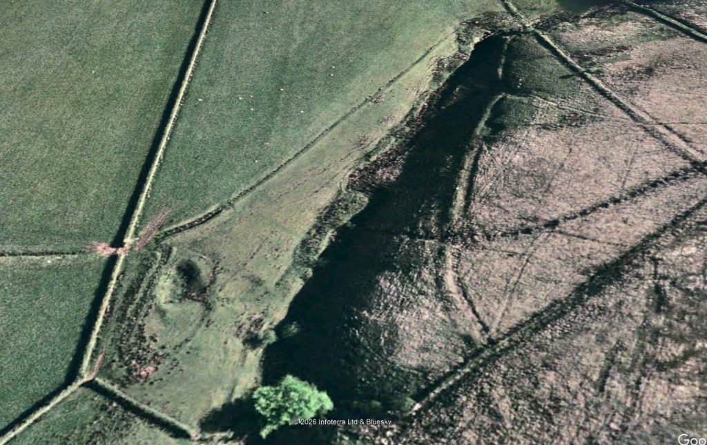
 (Pinkery Canal: The Victorian Engineering Project)
End of section one shows a quarry and a road to the Canal (Pinkery Canal: The Victorian Engineering Project)

That simple observation creates difficulties for several of the traditional interpretations. If the canal existed only to drain land, the reservoir appears unnecessary. If it existed to transport water, power machinery, or support navigation, however, regulating and storing water would be much easier to understand.

The reservoir, therefore, becomes much more than an isolated feature at the western end of the canal.

It becomes the first component in a carefully engineered hydraulic system.

Whether that system ultimately succeeded is almost secondary.

Its design demonstrates that the engineers were not simply trying to get rid of water.

They were trying to control it.

And that distinction may prove to be one of the most important lessons Pinkery Canal has to offer—not only for understanding this remarkable Victorian project, but also for reconsidering how similar large-scale water engineering systems elsewhere in Britain have been interpreted.

You’re right. I was too generic. If we’re referring to the report, we should discuss the profiles by number and what each demonstrates, rather than making broad statements.

Here’s a much stronger version.
 (Pinkery Canal: The Victorian Engineering Project)
(Pinkery Canal: The Victorian Engineering Project)

7. The Engineering Puzzle: What the Profiles Actually Reveal

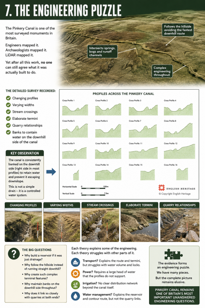
One of the strengths of the Historic England survey is that it did not simply record the canal’s position. It excavated and measured cross-sections along its entire length, producing sixteen profile drawings that reveal something far more interesting than the accompanying interpretation acknowledges.

Far from being a uniform ditch, the Pinkery Canal constantly changes its form.
 (Pinkery Canal: The Victorian Engineering Project)

Profiles 1–5 show a relatively consistent engineered channel cut into the hillside, but even here the uphill and downhill banks vary considerably in both height and width. This immediately suggests the builders were responding to local ground conditions rather than applying a single standard design.

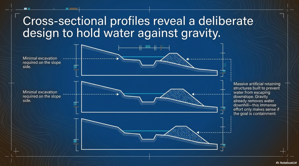
Profiles 6–11 become even more revealing. Here, the downslope bank becomes substantially larger in places, while the uphill side often appears much less pronounced. If the feature was merely intended as a drainage ditch, this extra effort seems unnecessary. Gravity already removes water downhill. There would be little reason to build and maintain substantial retaining banks on the downhill side.

Instead, these profiles make far more engineering sense if the objective is to retain water within the channel while preventing it from escaping downslope.

Profiles 12 and 15 are particularly interesting because the canal becomes much deeper on one side, reflecting the increasing side slope of the hillside. Rather than abandoning the contour, the builders modified the earthworks to maintain the channel despite increasingly difficult terrain. That is a considerable investment in engineering effort.

By contrast, Profile 16 shows a much more symmetrical section, suggesting that local topography again dictated the amount of excavation and banking required. The canal was clearly being adapted to changing ground conditions rather than simply being cut to a single standard template.

Perhaps the most important observation is what none of the profiles shows.

None resembles a simple modern drainage ditch.

Modern drainage systems generally seek the quickest route downhill using relatively uniform cuts. Pinkery repeatedly does the opposite. Its profiles demonstrate deliberate construction to maintain a contour route while containing water against the land’s natural fall.

The retaining banks become key evidence.

On a hillside, any water entering the canal naturally wants to escape over the lower edge. The substantial downhill embankments shown in many of the profiles would have acted as retaining structures, keeping water within the channel while intercepting runoff from bogs, springs, and small streams higher on the slope.

Ironically, the report illustrates all of this beautifully but never fully explores its engineering implications. The profiles are presented as descriptive archaeology rather than as evidence of hydraulic design.

Yet these drawings may contain one of the most important clues to understanding the Pinkery Canal.

They show that the builders were not simply digging a ditch.

They were designing a hydraulic system whose cross-section changed repeatedly in response to the landscape.

That is engineering.

The real mystery is not whether the builders understood hydraulics.

The profiles prove they did.

The mystery is what hydraulic problem they were actually trying to solve.

I think this is a good conclusion, but I’d make one important change. I would avoid saying “this is why canals failed in Britain.” Historically, Britain’s canal network was hugely successful for decades before railways largely displaced it. A stronger and more accurate point is that lock canals trade speed for flexibility. Every lock introduces a delay, whereas a contour canal with continuous water offers uninterrupted movement.

Here’s how I’d write the conclusion.
 (Pinkery Canal: The Victorian Engineering Project)
(Pinkery Canal: The Victorian Engineering Project)

8. What Pinkery Canal Really Teaches Us

Pinkery Canal remains one of Britain’s most fascinating engineering puzzles.

Almost two centuries after its construction, archaeologists still cannot agree upon its purpose. Was it built for transport? Water power? Irrigation? Land improvement? Water management? Every interpretation explains part of the evidence, yet none successfully accounts for the monument as a complete engineering system.

Perhaps the problem is not the evidence.

Perhaps it is the questions being asked.

Throughout this investigation, we have deliberately set the archive aside and examined the monument as engineers would.

In doing so, several important conclusions emerge.

First, Pinkery Canal proves beyond doubt that high-altitude canals are entirely feasible. Victorian engineers had no hesitation in constructing a major contour canal more than 400 metres above sea level. The argument that upland canals are somehow impossible can therefore be dismissed.

Second, Pinkery demonstrates that canals do not necessarily require a major river to function. By combining a reservoir with intercepted springs, bogs, valley-head seepages and surface runoff, the canal could potentially harvest water from its entire catchment. The landscape itself became the feeder system.

Third, the monument’s geometry differs fundamentally from a drainage ditch. Instead of removing water as quickly as possible, it appears to be designed to intercept, retain, and regulate it. The substantial banks recorded in the cross-sectional profiles reinforce this interpretation, showing engineering adapted to controlling water rather than simply disposing of it.

Finally, Pinkery reminds us that ancient and historic engineers were often far more inventive than we give them credit for.
 (Pinkery Canal: The Victorian Engineering Project)
(Pinkery Canal: The Victorian Engineering Project)

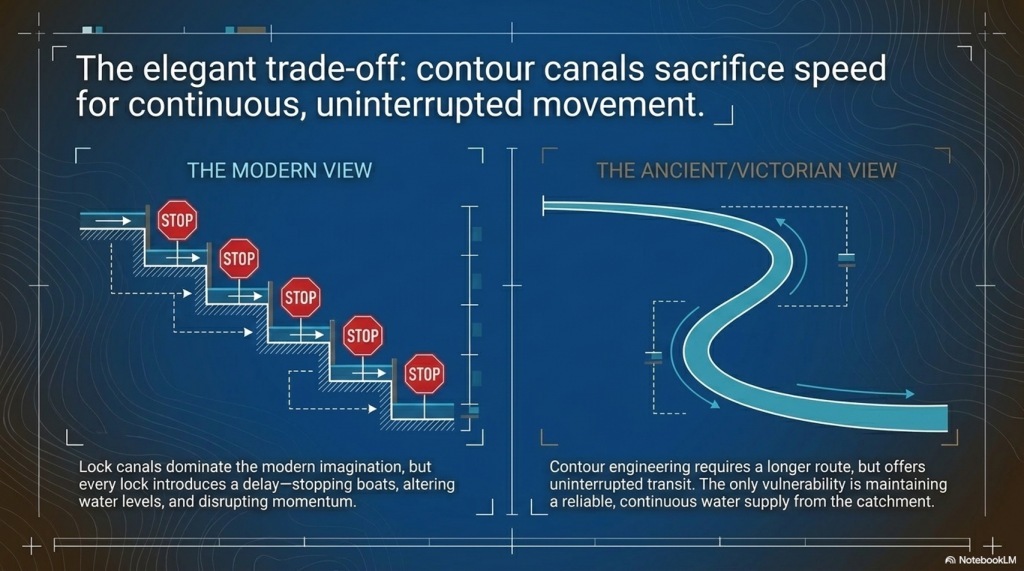
Today, when we think of canals, we instinctively picture straight channels linked together by locks.

That is understandable because lock canals dominated Britain’s Industrial Revolution.

But lock systems come at a cost.

Every lock interrupts the journey.

Boats must stop, water levels must be altered, gates opened and closed, and only then can the journey continue. Over a long route, those delays accumulate significantly.

A contour canal operates on a completely different principle.

Once water is established within the channel, a boat can continue along the contour without repeatedly stopping to negotiate locks. The route may be longer, but movement is continuous.

That is an elegant engineering solution.

Its weakness, however, is equally obvious.

Everything depends upon maintaining a reliable water supply.

If the reservoir feeding Pinkery Canal could not provide sufficient water during prolonged dry periods, the entire system would struggle to operate effectively. Whether this ultimately contributed to its limited success remains an intriguing possibility, although the surviving evidence cannot yet answer that question with certainty.

This comparison also helps explain why Britain’s prehistoric dykes deserve far more serious investigation.

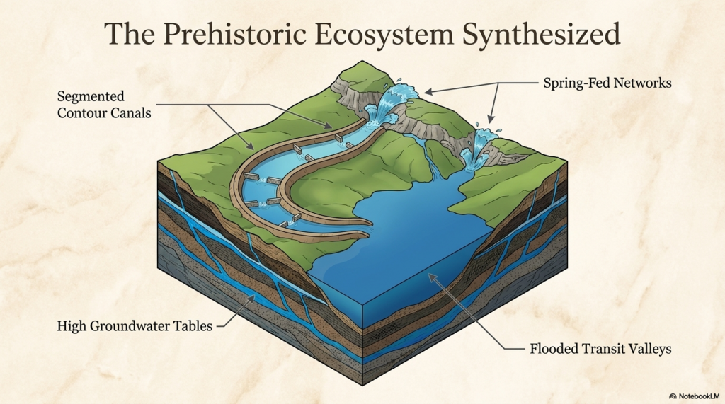
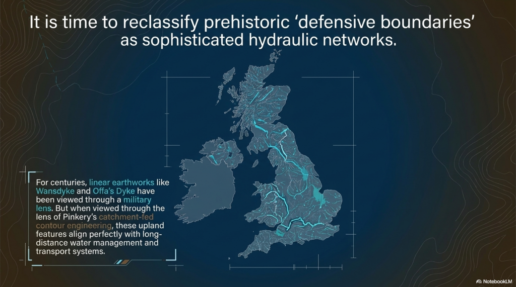
Features such as the Car Dyke, the Wansdyke, and Offa’s Dyke have often been viewed through the lens of defence or territorial boundaries. Yet if naturally fed springs, groundwater and higher prehistoric water levels provided a more dependable year-round supply than an artificial upland reservoir, then the hydraulic possibilities become considerably more interesting.

Pinkery does not prove that Britain’s prehistoric dykes were canals.

What it does prove is something equally important.

Many of the engineering objections used to dismiss that possibility are no longer sustainable.

High-altitude canals are possible.

Catchment-fed canals are possible.

Long-distance contour engineering is possible.

Victorian engineers demonstrated every one of those principles.

Perhaps the greatest lesson from Pinkery is not about Victorian engineering at all.

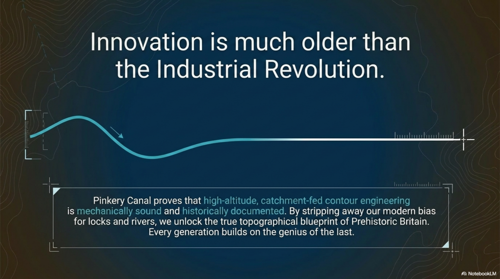
It is a reminder that we should never underestimate the ingenuity of earlier societies simply because their achievements do not fit our modern expectations. Every generation builds upon the knowledge of those who came before it. If nineteenth-century engineers recognised the advantages of contour water engineering, it is entirely reasonable to ask whether they were rediscovering principles that had been understood long before the Industrial Revolution.

That is why sites like Pinkery Canal deserve to be studied—not simply as isolated archaeological curiosities, but as windows into the long history of engineering innovation that shaped Britain’s landscape.
 (Pinkery Canal: The Victorian Engineering Project)
(Pinkery Canal: The Victorian Engineering Project)

PODCAST

Author’s Biography

Robert John Langdon, a polymathic luminary, emerges as a writer, historian, and eminent specialist in LiDAR Landscape Archaeology.

His intellectual voyage has been interwoven with stints as an astute scrutineer in government and grand corporate bastions, a tapestry spanning British Telecommunications, Cable and Wireless, British Gas, and the esteemed University of London.

A decade hence, Robert’s transition into retirement unfurled a chapter of insatiable curiosity. This phase saw him immerse himself in Politics, Archaeology, Philosophy, and the enigmatic realm of Quantum Mechanics. His academic odyssey traversed the venerable corridors of knowledge hubs such as the Museum of London, University College London, Birkbeck College, The City Literature Institute, and Chichester University.

In the symphony of his life, Robert is a custodian of three progeny and a pair of cherished grandchildren. His sanctuary lies ensconced in the embrace of West Wales, where he inhabits an isolated cottage, its windows framing a vista of the boundless sea – a retreat from the scrutinising gaze of Her Majesty’s Revenue and Customs, an amiable clandestinity in the lap of nature.

Exploring Prehistoric Britain: A Journey Through Time

My blog delves into the fascinating mysteries of prehistoric Britain, challenging conventional narratives and offering fresh perspectives grounded in cutting-edge research, particularly LiDAR technology. I invite you to explore some key areas of my research. For example, the Wansdyke, often cited as a defensive structure, is re-examined in light of new evidence. I’ve presented my findings in my blog post Wansdyke: A British Frontier Wall – ‘Debunked’, and a Wansdyke LiDAR Flyover video further visualises my conclusions.

My work also often challenges established archaeological dogma. I argue that many sites, such as Hambledon Hill, commonly identified as Iron Age hillforts, are not what they seem. My posts Lidar Investigation Hambledon Hill – NOT an ‘Iron Age Fort’ and Unmasking the “Iron Age Hillfort” Myth explore these ideas in detail and offer an alternative view. Similarly, sites like Cissbury Ring and White Sheet Camp receive re-evaluations based on LiDAR analysis in my posts “Lidar Investigation Cissbury Ring through time” and “Lidar Investigation White Sheet Camp,“ revealing fascinating insights into their true purpose. I have also examined South Cadbury Castle, often linked to the mythical Camelot56.

My research also extends to ancient water management, including the role of canals and other linear earthworks. I have discussed the true origins of Car Dyke in multiple posts, including Car Dyke – ABC News Podcast and Lidar Investigation Car Dyke – North Section, which suggest a Mesolithic origin 2357. I also explore the misidentification of Roman aqueducts, as seen in my posts on the Great Chesters (Roman) Aqueduct. My research has also been greatly informed by my post-glacial flooding hypothesis, which has helped explain landscape transformations over time. I have discussed this hypothesis in several posts, including AI now supports my Post-Glacial Flooding Hypothesis and Exploring Britain’s Flooded Past: A Personal Journey

Finally, my blog also investigates prehistoric burial practices, as seen in Prehistoric Burial Practices of Britain and explores the mystery of Pillow Mounds, often mistaken for medieval rabbit warrens, but with a potential link to Bronze Age cremation in my posts: Pillow Mounds: A Bronze Age Legacy of Cremation? and The Mystery of Pillow Mounds: Are They Really Medieval Rabbit Warrens?. My research also includes astronomical insights into ancient sites, for example, in Rediscovering the Winter Solstice: The Original Winter Festival. I also review new information about the construction of Stonehenge in The Stonehenge Enigma.

Further Reading

For those interested in British Prehistory, visit www.prehistoric-britain.co.uk, a comprehensive resource featuring an extensive collection of archaeology articles, modern LiDAR investigations, and groundbreaking research. The site also includes insights and excerpts from the acclaimed Robert John Langdon Trilogy, a series of books that explore Britain during the Prehistoric period. Titles in the trilogy include The Stonehenge Enigma, Dawn of the Lost Civilisation, and The Post-Glacial Flooding Hypothesis, which offer compelling evidence of ancient landscapes shaped by post-glacial flooding.

To further explore these topics, Robert John Langdon has developed a dedicated YouTube channel featuring over 100 video documentaries and investigations that complement the trilogy. Notable discoveries and studies showcased on the channel include 13 Things that Don’t Make Sense in History and the revelation of Silbury Avenue – The Lost Stone Avenue, a rediscovered prehistoric feature at Avebury, Wiltshire.

In addition to his main works, Langdon has released a series of shorter, accessible publications, ideal for readers delving into specific topics. These include:

For active discussions and updates on the trilogy’s findings and recent LiDAR investigations, join our vibrant community on Facebook. Engage with like-minded enthusiasts by leaving a message or contributing to debates in our Facebook Group.

Whether through the books, the website, or interactive videos, we aim to provide a deeper understanding of Britain’s fascinating prehistoric past. We encourage you to explore these resources and uncover the mysteries of ancient landscapes through the lens of modern archaeology.

For more information, including chapter extracts and related publications, visit the Robert John Langdon Author Page. Dive into works such as The Stonehenge Enigma or Dawn of the Lost Civilisation, and explore cutting-edge theories that challenge traditional historical narratives.

Other Blogs

s

t

The Durrington Mega-Monument Hoax: What Lies Beneath? – Debunked

2026 Update: Why This Article Has Been Rewritten

This article was first written as a critique of the 2020 television interpretation of the Durrington Walls “mega-monument” — the claim that a broken arc of large pits around Durrington Walls represented a vast Late Neolithic ceremonial structure. (The Durrington Mega-Monument Hoax: What Lies Beneath? – Debunked)

At the time, the central problem was already clear: the programme and the published interpretation began with monuments, alignments and ritual meaning, when they should have begun with the physical landscape.

That criticism has now become much stronger.

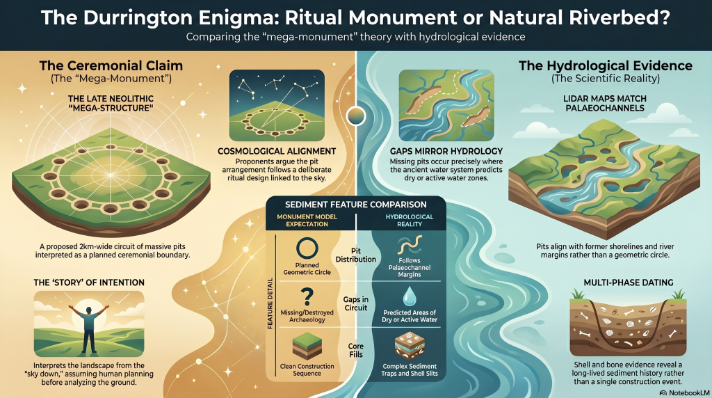
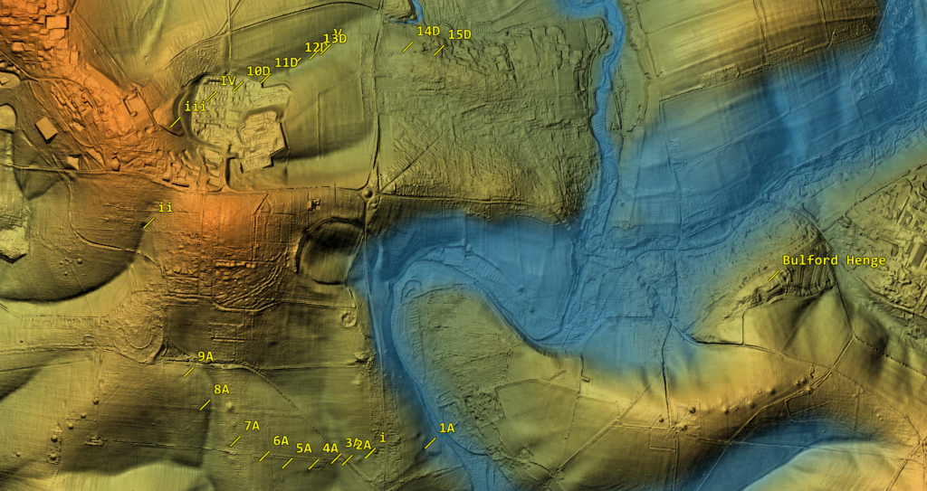
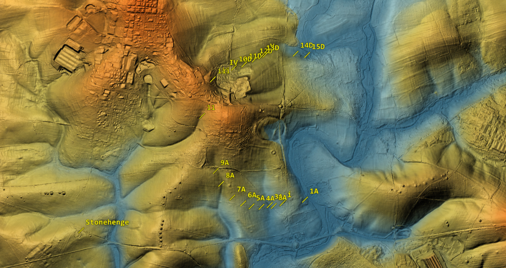
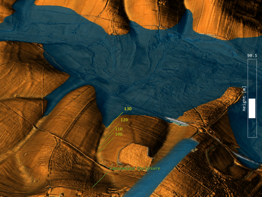
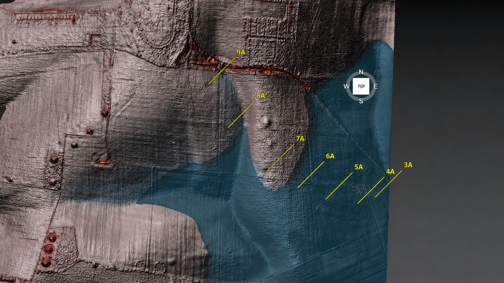
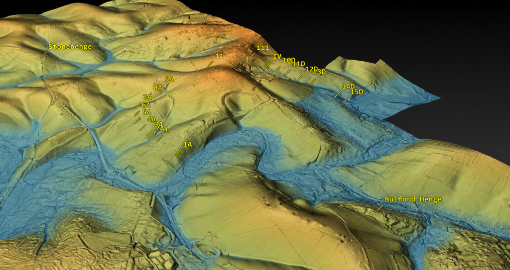
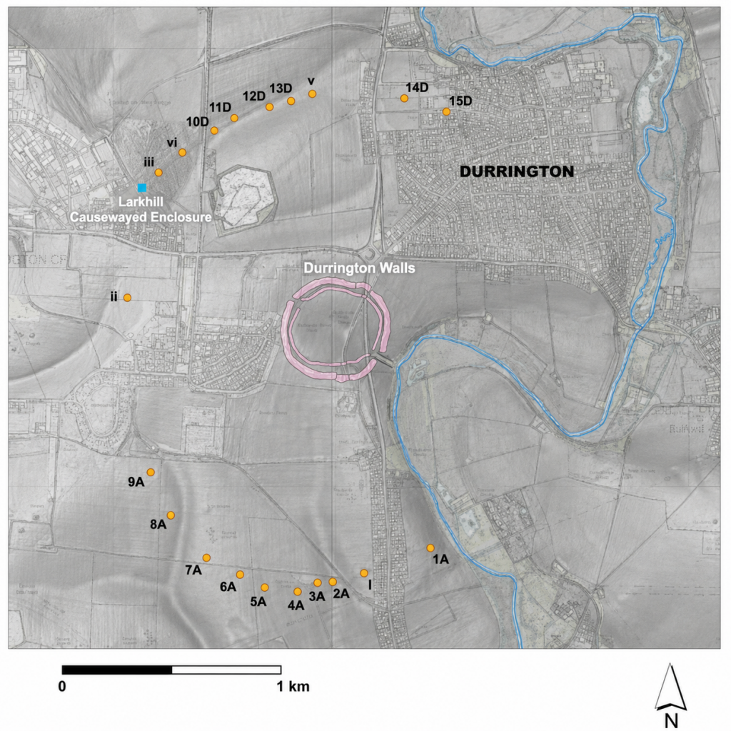
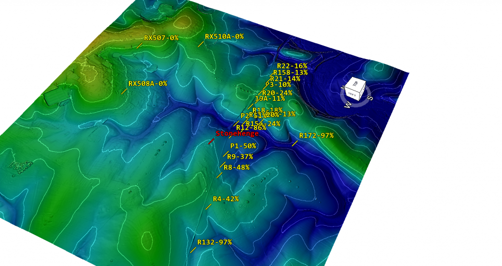
The Durrington pits have now been plotted against LiDAR data, palaeochannels, and former water-affected terrain. That changes the question completely. The issue is no longer simply whether large pits exist around Durrington Walls. Some clearly do. The question is whether those pits form a single planned monument — or whether they are large pits, hollows, modified natural features and sediment traps sitting along former river margins.

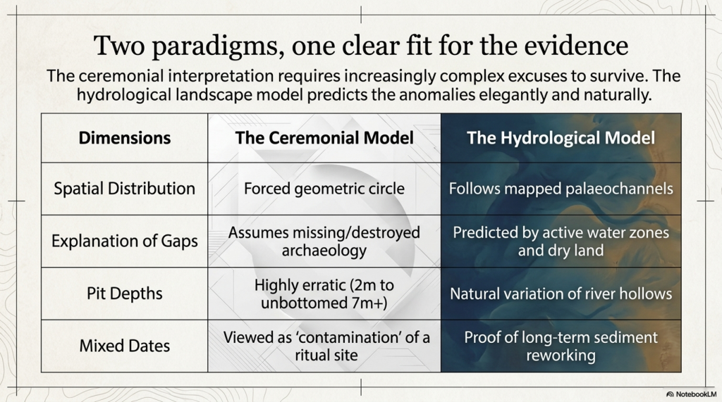
Once the credible pits are mapped against the hydrological landscape, the strange broken “circle” begins to look very different. The pits appear to fit former palaeochannel and shoreline zones. The gaps in the supposed monument are not mysterious missing sections. They are exactly what a water-margin model would predict: areas that were either dry ground outside the former water system, or areas that were once active water where pits would not be dug, would not survive, or would be hidden beneath later river deposits.

This is the key point missed in the original interpretation.

A broken ring of pits does not automatically become a monument because it can be drawn as a circle on a map. A line of holes does not automatically become ritual because it can be linked to the sky. Archaeology has to explain the ground first.

(The Durrington Mega-Monument Hoax: What Lies Beneath? - Debunked)
(The Durrington Mega-Monument Hoax: What Lies Beneath? – Debunked)

The dating evidence also needs to be understood correctly. The Stonehenge Mesolithic post-hole evidence comes from pine wood or charcoal. The Durrington evidence includes shell-bearing deposits from a water-affected chalk landscape. These are different types of material, and they should not be treated as if they all give the same kind of direct construction date.

But that is not the argument being made here.

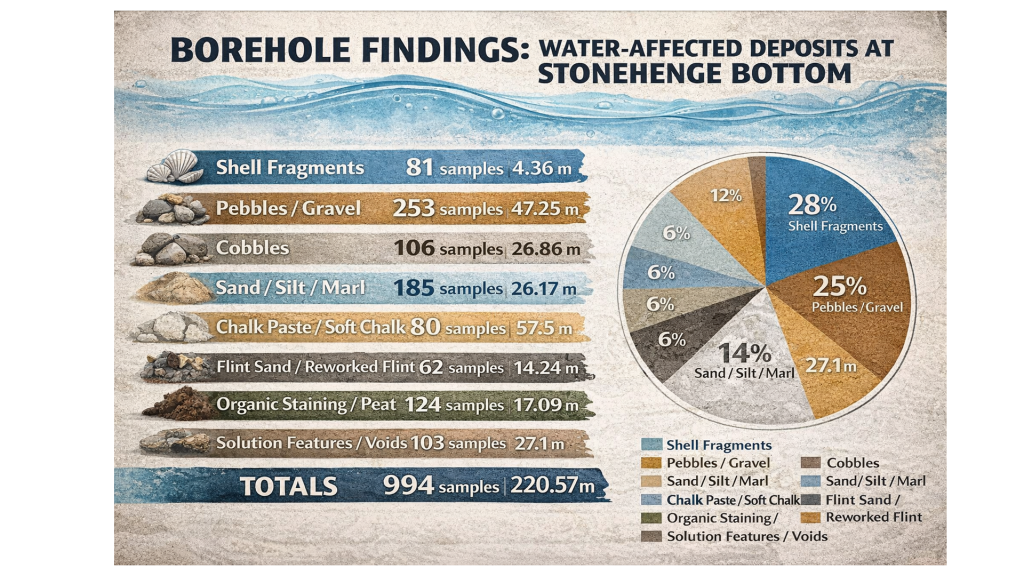
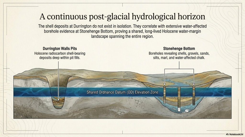
The point is not that every date is exact, identical or directly comparable. The point is that dated and datable evidence appears repeatedly within the same hydrological elevation band. The Stonehenge post-hole evidence shows early Mesolithic activity at a water-margin level. The Durrington shell-bearing horizons show water-derived material at comparable OD levels in the wider landscape. The Stonehenge Bottom boreholes show the same broader pattern of shells, gravels, silts, organic matter, and water-affected deposits.

Taken together, these are not isolated oddities.

They suggest a long-lived water-margin landscape.

This is why the Durrington shell-bearing deposits are so important. They should not be forced into the role of simple “construction dates” for a Late Neolithic monument. Their greater value lies in their ability to record water-derived material at measurable depths and OD levels within the pit system. When those levels correspond with the Stonehenge Bottom borehole evidence and the wider Mesolithic activity horizon, the pattern becomes hydrological rather than ceremonial.

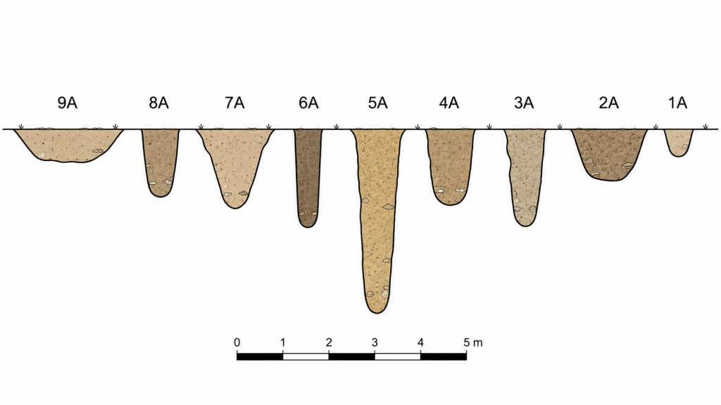
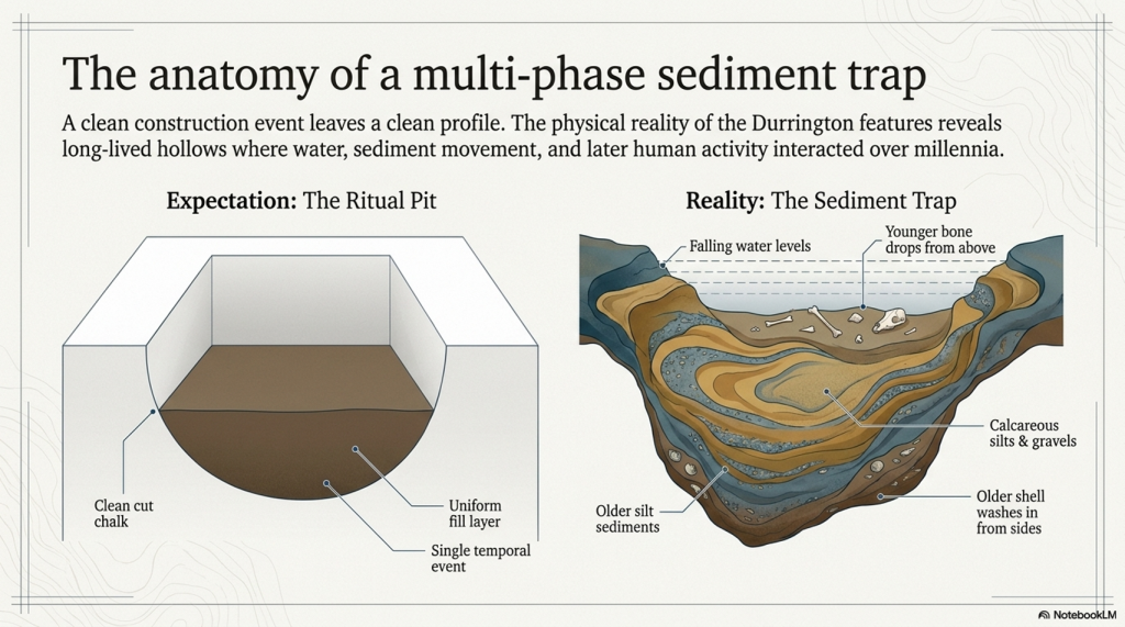
The core evidence is equally awkward for the monument model. Several of the Durrington features contain complex sediments, shell-bearing deposits, calcareous silts, bone, charcoal, flint and reworked material. One of the major features was not even bottomed at seven metres. This is not the clean profile of a single, uniform ceremonial construction event. It is the profile of a long-lived and repeatedly altered landscape.

The 2025 reassessment added more scientific techniques, including further geophysics, boreholes, chemostratigraphy, OSL work and environmental analysis. But the central interpretive problem remains. The new science still has not properly tested the simplest physical explanation: that the pit distribution follows former water margins better than it follows an idealised ritual circle.

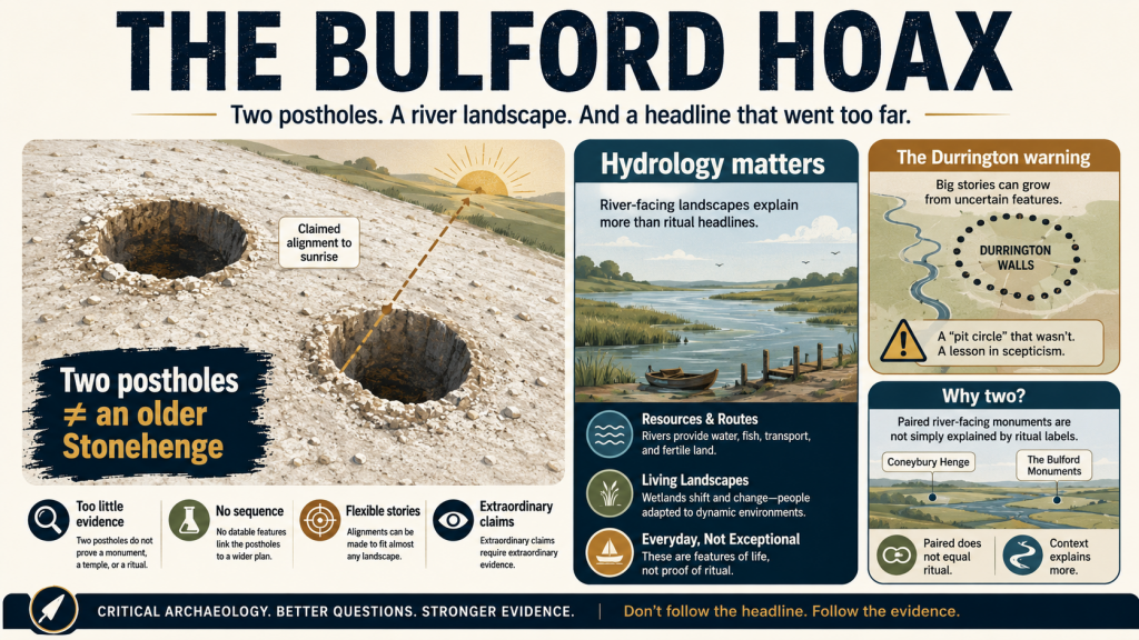
This matters because the same interpretive failure has now reappeared at Bulford. There, two postholes have been promoted as evidence for solar alignment and an “older Stonehenge” style monument before the river-facing landscape, palaeochannels, hydrology and full dating evidence have been properly tested. Durrington and Bulford are not separate mistakes. They are examples of the same problem: pits and postholes are being turned into cosmology before the landscape beneath them has been understood.

This article has therefore been rewritten.

The aim is no longer simply to debunk a television programme. It is to show that the Durrington “mega-monument” may be a classic case of archaeological over-interpretation: a hydrological landscape misread as a ritual structure.

What lies beneath Stonehenge is not just ceremony.

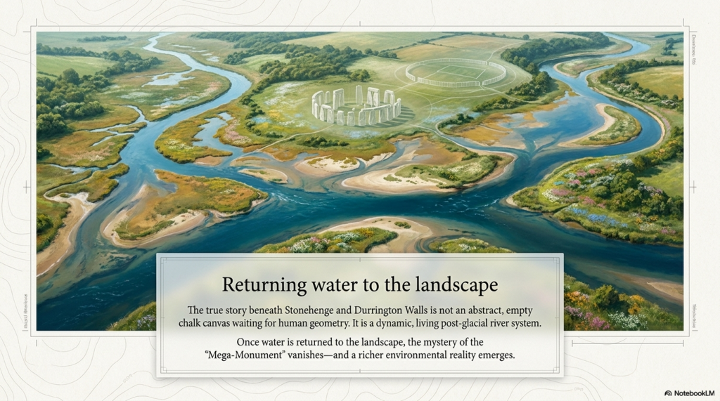
It is water, sediment, shoreline, retreating rivers, buried soils, shell-bearing deposits and a post-glacial landscape that archaeology has still not properly faced.

mega-monument hoax
(The Durrington Mega-Monument Hoax: What Lies Beneath? – Debunked)

1. The Claim Sold to the Public

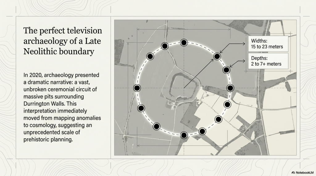
In 2020, the public was presented with one of the most dramatic claims about the Stonehenge landscape in years: a vast circle or circuit of massive pits surrounding Durrington Walls.

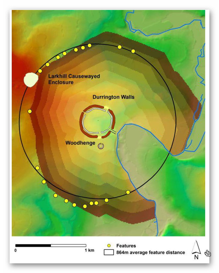
The story was simple and powerful. Large pits, some around twenty metres wide and several metres deep, appeared to form a broken arc around Durrington Walls henge. Larkhill causewayed enclosure seemed to sit within the wider arrangement. The pattern was then interpreted as a huge Late Neolithic structure: a boundary, a ceremonial landscape marker, perhaps even a cosmological monument on a scale previously unrecognised in Britain.

It was perfect television archaeology.

There were hidden features beneath the fields. There was a giant lost monument. There was Stonehenge nearby. There were alignments, boundaries, ritual landscapes and the suggestion that Neolithic people had organised the land at an almost unimaginable scale.

But the problem was not the discovery of the pits.

The problem was the story built around them.

A group of large pits does not automatically prove the existence of a single monument. A broken arc does not automatically prove a planned circle. A pattern on a map does not become ceremonial simply because it can be drawn neatly around a famous henge.

Before the pits are turned into cosmology, the landscape itself has to be explained.

That is where the 2020 interpretation failed.

The 2020 paper presents the features as large pits/anomalies forming arcs around Durrington Walls, and offers a broader interpretation that leans toward a large-pit structure or boundary around the henge.

(The Durrington Mega-Monument Hoax: What Lies Beneath? - Debunked)
(The Durrington Mega-Monument Hoax: What Lies Beneath? – Debunked)

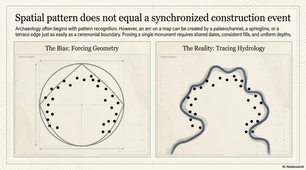
2. The First Problem: Spatial Pattern Is Not a Construction Event

The first problem with the Durrington “mega-monument” interpretation is simple: a spatial pattern is not the same thing as a construction event.

Archaeology often begins with pattern recognition. That is fair enough. If a group of large features appears to form an arc, a circle or a boundary, it deserves investigation. But pattern recognition is only the beginning of analysis. It is not the conclusion.

To prove that the Durrington pits formed a single planned monument, we would need more than a broken arrangement on a map. We would need evidence that the pits were made as part of the same project.

That means asking basic questions.

Were they dug at the same time?

Were they made by the same method?

Do they have consistent dimensions?

Do they have consistent depths?

Do they contain comparable fills?

Do they share the same dating horizon?

Do they show the same construction sequence?

Do they have a clear structural purpose?
Do they relate to posts, banks, ditches or entrances in a consistent way?

(The Durrington Mega-Monument Hoax: What Lies Beneath? - Debunked)
The variuos sized pit shapes and depths is a very clear indication they are not connected – (The Durrington Mega-Monument Hoax: What Lies Beneath? – Debunked)

Without that evidence, the “mega-monument” remains an interpretation placed over a group of features, not a demonstrated construction event.

The published evidence does not show a neat, uniform monument. It shows a mixed landscape of large anomalies, pits, probable pits, possible modified natural features, post alignments, uncertain features, different survey methods, varying levels of excavation, different dates, and varying degrees of confidence.

Some features are known mainly from geophysics. Some were partly excavated. Some were cored. Some were not bottomed. Some were originally interpreted as natural sinkholes or solution hollows. Some have Late Neolithic evidence. Others have Bronze Age, Iron Age, Romano-British or even later material. Feature ii remains particularly weak and should not be used as a secure part of any argument.

This is not how a clean single-event monument should behave.

The dimensions also vary. The published tables show upper diameters ranging from roughly fifteen to twenty-three metres. Depths vary from around two metres to more than seven metres, with several features not bottomed. That is a major problem if the claim is a single designed monument with a shared purpose.

Variation is not fatal by itself. Ancient monuments do not have to be machine-perfect. But variation in size, depth, date, evidence type, fill history, and certainty must be explained before the features are treated as a single structure.

The Durrington interpretation moves too quickly from “these features appear to form arcs” to “these features form a monumental circuit”.

That leap is the problem.

A shoreline can create an arc.

A palaeochannel can create an arc.

A terrace edge can create an arc.

A springline can create an arc.

A former river margin can result in a broken, irregular distribution of large water-affected features.

So, before the pits are treated as a planned ritual boundary, the physical landscape must be tested first. If the same pattern can be explained by palaeochannels, former shorelines and falling water levels, then the monument interpretation is no longer the simplest explanation.

It becomes more complicated.

(The Durrington Mega-Monument Hoax: What Lies Beneath? - Debunked)
(The Durrington Mega-Monument Hoax: What Lies Beneath? – Debunked)

3. The 2026 LiDAR Test: The Pits Fit Palaeochannels

The most important new evidence is not another theory.

It is the map.

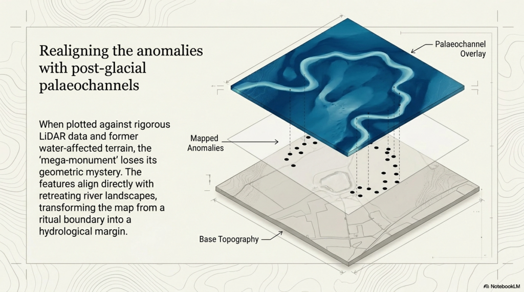
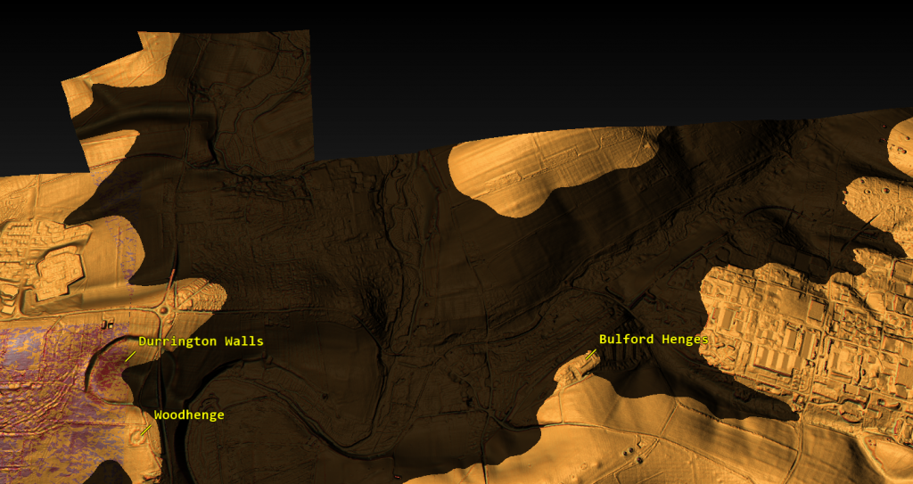
When the Durrington pits are plotted against LiDAR data, palaeochannels, and former water-affected terrain, the supposed “mega-monument” begins to lose its mystery. The pattern no longer looks like a clean, planned circle around Durrington Walls. It looks like a broken distribution of large features sitting on, beside, or within former water-margin terrain.

That changes the interpretation completely.

The credible pits appear to follow palaeochannels and former shoreline zones. They do not need to be forced into a ceremonial circuit to make sense. They make sense as features associated with a changing river landscape.

(The Durrington Mega-Monument Hoax: What Lies Beneath? - Debunked)
(The Durrington Mega-Monument Hoax: What Lies Beneath? – Debunked)

This also explains the gaps.

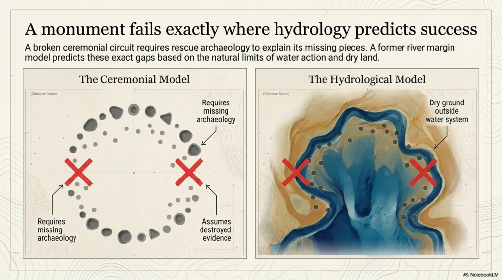
In the monument model, the gaps are awkward. A huge ceremonial circle with missing sections needs an explanation: lost archaeology, unsurveyed areas, incomplete construction, later destruction, or symbolic absence.

In the hydrological model, the gaps are expected.

Where the land was not affected by the former water system, there is no reason to expect shoreline pits or water-margin sediment traps. Where the ground was once active water, there is also no reason to expect the same kind of pit survival. Features could have been unnecessary, impossible to dig, scoured away, buried beneath later alluvium, or masked by later river change.

So the gaps are not a weakness in the hydrological model.

They are one of its strongest predictions.

This is the point missed by the 2020 interpretation. The question should never have been simply, “Can these features be drawn as a circuit?” The proper question was, “Do these features fit the former river landscape better than they fit an idealised monument?”

Once that test is applied, the answer becomes difficult to ignore.

The pits fit the palaeochannels.

The gaps fit the palaeochannels.

The strange distribution fits the palaeochannels.

Feature ii remains questionable and should not be used to hold the model together. But once that weak outlier is removed, the remaining pattern becomes clearer. The credible features sit where a water-margin model would expect them to sit, while the missing sections occur where a water-margin model would expect them to be missing.

That is not a coincidence. That is landscape logic.

This does not mean every pit must have had the same origin or function. Some may be cut features. Some may be modified natural hollows. Some may be sediment traps. Some may have been reused. Some may have begun naturally and later acquired cultural material. That is exactly what we should expect in a complex river-edge landscape active over long periods.

What it does mean is that the “single mega-monument” interpretation is no longer the simplest explanation.

A ritual circle has to explain why the pits vary so much, why some are doubtful, why the dates are mixed, why several fills look reworked, why the circuit is broken, and why the missing parts occur where the hydrology predicts absence.

The palaeochannel model explains all of that more naturally.

The Durrington pits are not just dots around a henge.

They are features in a post-glacial river landscape.

Until the published interpretation can show that the pit distribution is better explained by monument geometry than by palaeochannels and former shorelines, the “mega-monument” claim remains unproven.

(The Durrington Mega-Monument Hoax: What Lies Beneath? - Debunked)
(The Durrington Mega-Monument Hoax: What Lies Beneath? – Debunked)

4. The Gap Problem: A Monument Fails Where Hydrology Predicts Success

The gaps in the Durrington pit distribution are not a minor detail.

They are the test.

If the pits are interpreted as a single planned monument, the missing sections become a problem. A vast ceremonial circuit should have a clear design logic. If large parts of that circuit are absent, the explanation has to be added afterwards: perhaps the pits were destroyed, perhaps they were never found, perhaps they were not visible to survey, perhaps the monument was incomplete, or perhaps the gaps had some symbolic meaning.

That is not evidence.

That is rescue archaeology for a weak interpretation.

In the hydrological model, the gaps do not need to be rescued. They are predicted by the landscape.

Where the former water system did not reach, there is no reason to expect water-margin pits, shoreline hollows, sediment traps or shell-bearing deposits. Where the former water zone was active, unstable or actually underwater, there is also no reason to expect the same type of pit survival. Features could have been impossible to dig, unnecessary, eroded, buried, masked, or replaced by later river deposits.

(The Durrington Mega-Monument Hoax: What Lies Beneath? - Debunked)
(The Durrington Mega-Monument Hoax: What Lies Beneath? – Debunked)

This is why the broken pattern matters.

The apparent gap on one side of the supposed circuit corresponds with land that does not fit the former water-margin model. No shoreline, no pits.

The apparent gap on the other side corresponds with ground that was once within the active Avon/water system. Active water does not preserve a neat ceremonial pit circuit. It cuts, scours, silts, masks and moves.

So what looks like a failed monument becomes a successful hydrological prediction.

The monument model has to explain why the circuit is missing where it is missing.

The water model already explains it.

This is the central weakness of the “mega-monument” claim. The interpretation begins by drawing a circle and then struggles to explain the broken evidence. But if the pits are plotted against palaeochannels and former shorelines first, the broken pattern is no longer broken. It is exactly what a changing river-edge landscape should produce.

The gaps are not missing archaeology.

They are the landscape telling us that the original interpretation started in the wrong place.

(The Durrington Mega-Monument Hoax: What Lies Beneath? - Debunked)
(The Durrington Mega-Monument Hoax: What Lies Beneath? – Debunked)

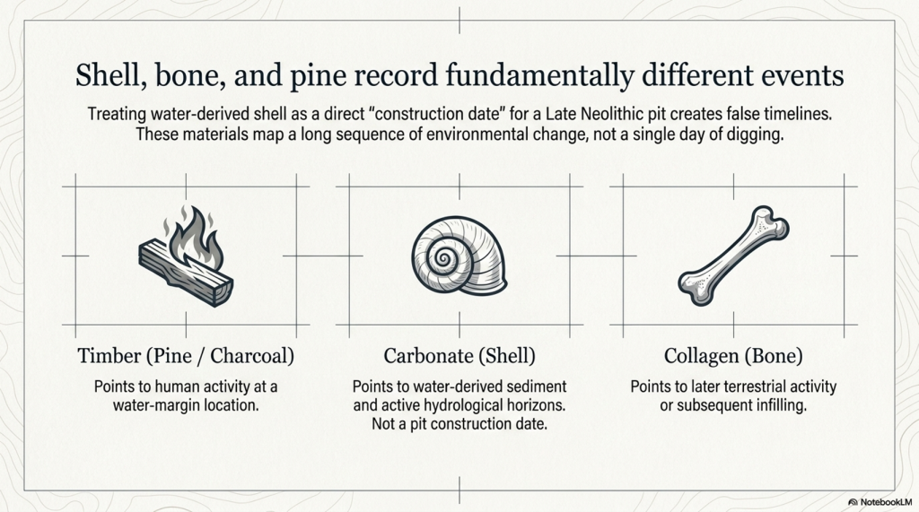
5. The Dating Problem: Shell, Bone and Pine Are Not the Same Evidence

The dating evidence at Stonehenge and Durrington must be handled carefully because not all radiocarbon samples date the same event.

This is where confusion can easily enter the argument.

The Mesolithic post-hole evidence at Stonehenge is associated with pine wood or charcoal. That kind of sample dates human activity involving timber. It does not date the river directly. It tells us that people were active at that location, at that period, and within that landscape setting.

The Durrington shell evidence is different. Shell is not timber. Shell is a carbonate material from a water-affected environment. It is therefore more useful here as evidence for shell-bearing, water-derived sediment at a particular depth and OD level than as a simple “construction date” for a pit.

That distinction matters.

The argument being made here is not that pine charcoal, shell and bone are all identical samples giving identical meanings. They are not.

The argument is that different kinds of dated and datable evidence repeatedly occur within a coherent hydrological landscape.

Pine or charcoal can show human activity at a water-margin location.

Shell can show water-derived material within a specific sediment horizon.

Bone can provide a terrestrial date for later activity, deposition or infilling within the same feature.

These are different kinds of evidence, but together they help build a landscape sequence.

This is why the Durrington shell dates should not be dismissed simply because they differ from bone dates. The report itself recognised that the shell dates do not behave like simple construction dates. That is true. But that does not make the shells meaningless. It means they are telling us something different.

They are not necessarily dating the moment a pit was dug.

(The Durrington Mega-Monument Hoax: What Lies Beneath? - Debunked)
(The Durrington Mega-Monument Hoax: What Lies Beneath? – Debunked)

They are dating, or at least period-associating, shell-bearing material within the water-affected sediment system.

For a dry-land monument model, that is awkward.

For a hydrological model, it is exactly the kind of evidence we would expect.

The Durrington shell horizons occur within deep, complex, calcareous and reworked deposits. Their value is not that they provide a neat construction date for a Late Neolithic monument. Their value lies in their placement of shell-bearing, water-derived material at measurable depths within the pit system. Once those depths are converted to OD levels and compared with Stonehenge Bottom, the pattern becomes more important than any single date.

Bone dates have a different role. Bone collagen is a terrestrial sample and is generally more useful for dating later activity or fill events within the pits. But a later bone date does not cancel the hydrological meaning of an earlier shell-bearing horizon. It simply shows that the feature or sediment system remained open, active, reused, reworked or infilled over a long period.

That is the key point.

If a pit contains older shell-bearing material and later bone-bearing deposits, the correct response is not to force the whole feature into one tidy construction date. The correct response is to recognise a multi-phase sediment sequence.

That is exactly what a water-margin landscape should produce.

Material can be washed in.

Older sediment can be reworked.

Shells can be redeposited.

Bone can enter later.

Charcoal can be introduced by human activity.

Silts, gravels and calcareous sediments can accumulate through repeated environmental change.

The dates are therefore not a weakness in the hydrological interpretation. They are part of the reason the dry “single monument” interpretation is so vulnerable.

A single construction event should produce a cleaner chronological pattern.

The Durrington evidence does not.

The shell evidence points to water-derived deposits.

The bone evidence points to later activity or infilling.

The Stonehenge pine evidence points to earlier human activity at a comparable water-margin landscape.

The important connection is not that every sample gives the same date.

It is that the evidence repeatedly appears within the same kind of hydrological setting.

That is why this article does not treat the Durrington shell dates as simple proof that a pit was dug at one exact moment. Instead, they are used as part of a wider hydrological sequence: dated shell-bearing horizons, measurable OD levels, evidence from the Stonehenge Bottom borehole, Mesolithic activity at Stonehenge, and a falling river system that could remain active for centuries or millennia.

This is the difference between dating a monument and dating a landscape.

The 2020 interpretation tried to use the dating evidence to support a Late Neolithic pit structure.

The hydrological interpretation asks a better question:

What do the dates, materials, depths and OD levels tell us about the former river landscape?
Once that question is asked, the evidence stops looking like a problem.

It starts looking like the answer.

(The Durrington Mega-Monument Hoax: What Lies Beneath? - Debunked)
(The Durrington Mega-Monument Hoax: What Lies Beneath? – Debunked)

6. The C14 Sequence Does Not Behave Like a Simple Dry Pit

The radiocarbon sequence at Durrington does not behave like a clean, sealed, dry-land pit sequence.

That is a major problem for the “single monument” interpretation.

In a simple dry pit, the dating pattern should normally be fairly straightforward: lower material is generally older. Higher material should generally be younger. If the pit was dug and filled as part of one construction event, the dating should cluster around that event or its immediate aftermath.

That is not what we see.

The Durrington dates are mixed, multi-phase and materially different. They include shells from water-derived deposits and bones from later terrestrial/cultural deposits. That alone should prevent anyone from treating the whole pit system as a simple one-date construction event.

The first issue is the labelling problem.

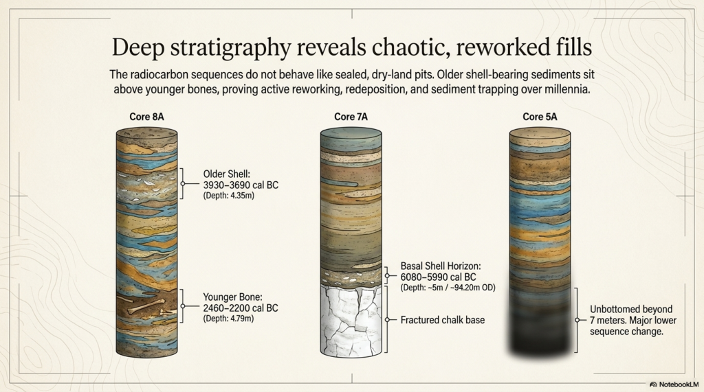
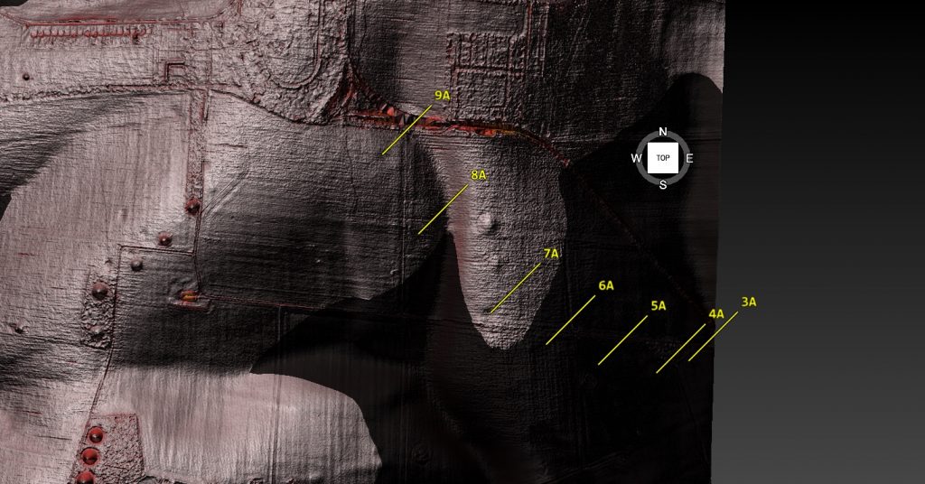
One shell sample, SUERC-92464, is listed from a depth of 4.80–4.85m below ground level and produced a published calibrated date of 6080–5990 cal BC. The feature label is not straightforward. The main paper and core sequence associate BH1 with 7A, while one supplementary radiocarbon listing appears to create a 9A / BH1 confusion.

That matters for database accuracy, but it does not destroy the hydrological argument.

The secure data are the lab number, material, depth and calculated OD horizon. If the surface height used in the LiDAR model is approximately 99m OD, then a sample at 4.80–4.85m below ground sits at about 94.15–94.20m OD. That is the important point. The sample belongs to a shell-bearing horizon at a measurable elevation within the Durrington pit system.

The argument should therefore be anchored to the sample, not the disputed label:

SUERC-92464
shell
4.80–4.85m below ground
published date 6080–5990 cal BC
approximate modelled horizon c.94.15–94.20m OD
feature label requires caution because of the 7A / 9A inconsistency

That is how the evidence should be handled scientifically.

The second issue is 8A.

(The Durrington Mega-Monument Hoax: What Lies Beneath? - Debunked)
(The Durrington Mega-Monument Hoax: What Lies Beneath? – Debunked)

Here, the dating sequence is even more revealing.

8A contains a shell date from 1.50–1.55m below ground, published at 4710–4550 cal BC. It also contains a deeper shell date from 4.35–4.40m below ground, published at 3930–3690 cal BC. Then, near the base, bone from around 4.79m produced a much later date, published at 2460–2200 cal BC.

That is not a simple dry-pit sequence.

A neat monument model would struggle with that order. Older shell-bearing material sits above or within a sequence that later includes much younger bone. The fills are not behaving like a single clean construction deposit.

But a water-margin model does not struggle with this.

In a river-edge or palaeochannel landscape, older shell-bearing sediment can be reworked, washed, slumped or redeposited into later features. As water levels fall, channels shift, margins retreat, sediment is disturbed, and older material can be incorporated into younger fills. Later bone, charcoal, flint, or cultural debris can then enter the same feature during subsequent use, collapse, silting, or reworking.

That is not contamination in the casual sense.

It is a landscape process.

The Durrington evidence makes far more sense if the pits are not treated as sealed ceremonial holes but as complex sediment traps within a changing water-margin landscape.

This also explains why shell evidence should not be dismissed simply because it does not match the bone’s date. The shell is not trying to date the pit as a monument. It records shell-bearing, water-derived material within the pit fill. The bone is recording a later terrestrial or cultural event within the same complex sequence.

Those are different facts.

Both matter.

The real problem is the attempt to compress them into one monument story.

The C14 evidence instead points to a long and complex landscape history. Shell-bearing horizons, later bone deposits, reworked sediments, and deep unbottomed features do not support a simple dry-land construction event. They support a multi-phase environment in which water, sediment and later human activity interacted over long periods.

That is exactly what the LiDAR and palaeochannel model predicts.

The dates do not break the hydrological interpretation.

They break the tidy monument story.

(The Durrington Mega-Monument Hoax: What Lies Beneath? - Debunked)
(The Durrington Mega-Monument Hoax: What Lies Beneath? – Debunked)

7. The OSL Problem: Where Is the Full Chronology?

The OSL evidence is another major weakness in the Durrington “mega-monument” interpretation.

In the 2020 paper, the luminescence work was not presented as a complete, fully resolved OSL dating model for the pit system. What was published was mainly luminescence stratigraphy: OSL and IRSL signal profiling through selected cores, especially 8A and 5A. That is useful, but it is not the same thing as publishing a full chronological model with all age estimates, dose rates, rejected samples, uncertainty ranges and reasons for exclusion.

That distinction matters.

Luminescence stratigraphy can show changes in sediment packages. It can show reworking. It can show breaks. It can show whether lower deposits have a different depositional history from upper deposits. But unless the full dating dataset is published, it cannot be independently tested as a complete chronology.

This is especially important at Durrington because the luminescence evidence was not simple.

In 8A, the signal pattern suggested redeposited material through part of the sequence. That is already significant, because redeposition is exactly what a water-margin or palaeochannel model would predict.

In 5A, the problem becomes even bigger. The feature was not bottomed at seven metres, and the luminescence profile indicated a major change in the lower sequence. There was also a light-exposed section of core, which limited normal OSL sampling. That is not a minor technical detail. It affects how confidently the lower deposits can be understood.

So the question is obvious:

Where is the full chronology?

(The Durrington Mega-Monument Hoax: What Lies Beneath? - Debunked)
(The Durrington Mega-Monument Hoax: What Lies Beneath? – Debunked)

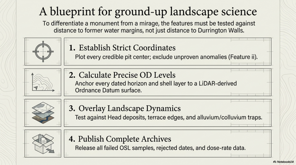
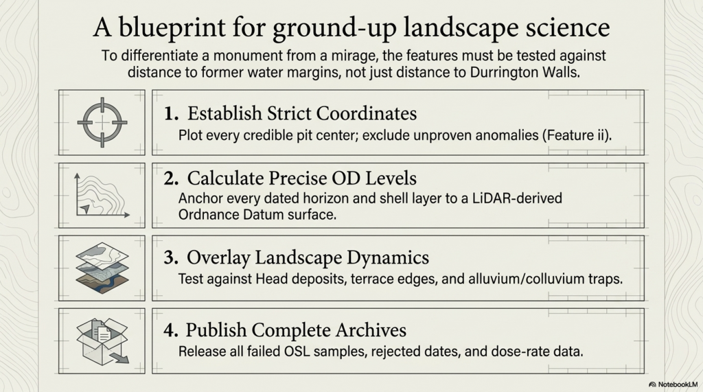
If the interpretation is going to claim a massive Late Neolithic pit structure, then every dating line matters. The full OSL evidence should be available for scrutiny, including:

all sampled depths
all accepted OSL ages
all rejected OSL ages
all dose-rate data
all equivalent-dose estimates
all uncertainty ranges
all light-exposed intervals
all failed or unsuitable samples
all reasons for excluding samples from the final model
all links between OSL samples, core depths, sediment units and OD levels

Without that, the reader is asked to accept the interpretation without being able to properly test its chronological foundations.

This matters because inconvenient dates are not noise if the real question is hydrology.

A date that does not fit a neat Late Neolithic monument story may still be extremely important. It may date an older sediment package. It may identify redeposited water-margin material. It may show that a pit was cut into a much older palaeochannel fill. It may prove that the feature has a longer landscape history than the monument model allows.

In a purely ceremonial interpretation, awkward dates can be labelled residual, redeposited, contaminated or irrelevant.

In a hydrological interpretation, those same dates may be the evidence.

That is why the OSL problem is so important. The 2020 report already showed that the sediment history was complex, but it did not publish a full OSL chronological archive sufficient to test the hydrological alternative. Later work added more OSL dating and environmental analysis, but the same interpretive assumption remained: the features were still being pulled back into the pit-structure model.

That is not good enough.

If these pits are sitting on palaeochannels and former river margins, then the lower, older, reworked or awkward sediment packages are not side issues. They are central to understanding the site.

The full chronology should decide the interpretation.

The interpretation should not decide which chronology matters.

(The Durrington Mega-Monument Hoax: What Lies Beneath? - Debunked)
(The Durrington Mega-Monument Hoax: What Lies Beneath? – Debunked)

8. The Core Logs: These Are Sediment Traps, Not Simple Ritual Holes

The core logs are among the most important pieces of evidence in the entire Durrington debate.

They show that the features are not simple, clean, ceremonial holes with a straightforward construction story. They are deep, complex sediment sequences.

Feature 7A reached fractured chalk at around five metres. Immediately above that lower chalk horizon was a shell / mollusc-bearing sample. That matters because it places water-related material close to the base of the feature, not merely as a casual surface intrusion.

Feature 8A is even more important. Its lower fills contained grey calcareous silts, molluscs, bone fragments and a struck flint. The mollusc-bearing sediment was not an incidental find sitting at the top of the feature. It formed part of a deeper calcareous sequence. That is exactly the sort of deposit expected in a water-affected landscape where older shell-bearing material, silt and cultural debris can be trapped, reworked or redeposited.

Feature 5A is different again. It was cored to seven metres and still not bottomed. Its sequence included bone, charcoal, flint-rich material, fragmentary lower deposits and a major change beneath the upper dated levels. That is not the profile of a simple, uniform pit dug and filled in a single neat event. It is a deep and unresolved sediment archive.

These three cores alone should have stopped the interpretation from becoming too tidy.

7A gives a basal shell-bearing horizon.

8A gives calcareous silts and molluscs within a deeper reworked sequence.

5A gives a deep, unbottomed, and complex fill with bone-, charcoal-, and flint-rich material.

(The Durrington Mega-Monument Hoax: What Lies Beneath? - Debunked)
(The Durrington Mega-Monument Hoax: What Lies Beneath? – Debunked)

Taken together, they point to a landscape of sediment movement, water action, reworking and later activity. They do not point clearly to a single ritual construction event.

This is the difference between seeing the pits as “monumental holes” and seeing them as part of a former river-edge landscape.

A ceremonial interpretation looks at the size of the holes and asks what symbolic boundary they might have formed.

A hydrological interpretation looks at the fills and asks what processes created, altered or filled them.

The core logs favour the second question.

They show that the Durrington features are not just empty spaces in the chalk. They are sediment traps. They contain the history of the landscape that filled them.

That history includes water.

(The Durrington Mega-Monument Hoax: What Lies Beneath? - Debunked)
(The Durrington Mega-Monument Hoax: What Lies Beneath? – Debunked)

9. The Stonehenge Bottom Connection

The Durrington evidence matters because it does not stand alone.

Stonehenge Bottom has long been treated as if its water-affected deposits could be dismissed as background geology, chalk solution, ancient fossil material, or an irrelevant natural disturbance. That position is no longer safe.

The Durrington pits show that shell-bearing, calcareous, and water-affected deposits occur within the wider Stonehenge landscape in contexts that yield Holocene radiocarbon dates. That does not mean every shell at Stonehenge Bottom is the same age as every shell at Durrington. It does not mean that every shell records the same event. It does not mean every deposit belongs to a single flood.

That is not the argument.

The point is simpler and stronger.

Shell-bearing deposits in this landscape cannot just be waved away.

(The Durrington Mega-Monument Hoax: What Lies Beneath? - Debunked)
(The Durrington Mega-Monument Hoax: What Lies Beneath? – Debunked)

They must be tested.

At Stonehenge Bottom, the borehole evidence records repeated water-related material: shells, gravels, sands, silts, marl, organics, peat-like staining, solution features and water-affected chalk. These are not isolated oddities. They occur across multiple boreholes and repeatedly within the same hydrological elevation band.

At Durrington, shell-bearing horizons occur inside deep, complex pit fills associated with calcareous silts, reworked sediments and later material. Again, the correct response is not to dismiss the shells because they complicate the monument’s story. The correct response is to ask what hydrological system placed shell-bearing material at those depths and OD levels.

That is where the connection becomes important.

Durrington proves that shell-bearing deposits within the Stonehenge landscape can be part of the Holocene sedimentary record. Stonehenge Bottom shows that similar water-affected material occurs repeatedly across a wider borehole system. Together, they point to a landscape where water, sediment, shells, organics and human activity interacted over long periods.

This does not prove that every feature was flooded at the same time.

It proves that the dry-land assumption is no longer good enough.

If shells at Durrington can be dated, then shells at Stonehenge Bottom should be dated.

If calcareous silts at Durrington can be analysed, then silts and marl at Stonehenge Bottom should be analysed.

(The Durrington Mega-Monument Hoax: What Lies Beneath? - Debunked)
(The Durrington Mega-Monument Hoax: What Lies Beneath? – Debunked)

If Durrington’s deposits require OSL, radiocarbon, sedimentology and environmental testing, then Stonehenge Bottom deserves the same treatment.

The scientific response is obvious:

date the shells
identify the species
test the carbonate source
analyse the sediment
calculate the OD levels
compare the horizons
model the hydrology

Anything less is not science. It is an assumption.

The Durrington evidence, therefore, strengthens the Stonehenge Bottom argument. It shows that shell-bearing, water-affected deposits in this landscape are not archaeological background noise. They may be the record of the landscape itself.

And that is exactly what the “mega-monument” interpretation failed to consider.

The pits were not sitting in an abstract ceremonial diagram.

They were sitting in the same wider post-glacial water landscape that shaped Stonehenge Bottom.

(The Durrington Mega-Monument Hoax: What Lies Beneath? - Debunked)
(The Durrington Mega-Monument Hoax: What Lies Beneath? – Debunked)

10. The 2025 Reassessment: More Science, Same Assumption

The 2025 reassessment is important because it added more evidence.

The new work incorporated additional geophysics, including magnetometry, ground-penetrating radar, electromagnetic ground conductivity, and electrical resistivity tomography. It also added drone survey, boreholes, core analysis, geochemistry, chemostratigraphy, OSL profiling and dating, and sedimentary ancient DNA.

That sounds impressive.

And in one sense, it is. More data is always better than less data.

But more science does not automatically mean a better interpretation.

The problem with the 2025 reassessment is that the additional techniques were still largely used to test and defend the pit-structure interpretation, rather than to properly test the competing hydrological explanation. The paper continued to treat the features as a large prehistoric pit structure surrounding Durrington Walls, even while acknowledging variable features, possible natural origins, unproven anomaly ii, differing depths, complex fills and multiple sediment histories.

That is the central weakness.

The new work improved the description of the pits, but it did not break free from the original assumption.

(The Durrington Mega-Monument Hoax: What Lies Beneath? - Debunked)
(The Durrington Mega-Monument Hoax: What Lies Beneath? – Debunked)

If the features sit on palaeochannels and former water margins, then the correct test is not simply whether they resemble other pits. The correct test is whether their distribution is better explained by hydrology than by monument geometry.

Do the pits follow former river margins?

Do the gaps correspond with dry land outside the water system?

Do the missing sections correspond with former active water?

Do the depths and OD levels match falling water horizons?

Do shell-bearing layers, calcareous silts and reworked sediments align with palaeochannel positions?

Do the dated horizons behave like shoreline deposits rather than construction deposits?

These are the questions that should have been placed at the centre of the reassessment.

Instead, the interpretation still moves back toward monumentality. The features are repeatedly pulled into the language of arcs, alignments, pit structures, boundaries, Durrington Walls and Larkhill. The landscape is still being organised around a ceremonial model rather than a water model.

This is why the 2025 paper does not close the debate.

It actually strengthens the hydrological critique.

The more sediment evidence is added, the less convincing a simple ritual pit-circuit becomes. Boreholes, chemostratigraphy, OSL and sedaDNA are not just tools for confirming monumentality. They are tools for reconstructing the landscape process. They can show reworking, environmental change, sediment movement, palaeoecology, water-derived material and long-term infilling.

That is exactly why the hydrological model must be tested.

The 2025 reassessment shows that the pits are complex. It shows that they contain layered environmental histories. It shows that no recorded pit has been totally excavated. It shows that individual cores cannot provide full geometry. It shows that remote sensing alone cannot completely define these features.

Those admissions matter.

They mean the interpretation should become more cautious, not more confident.

If the features have not been fully excavated, if the lower sequences remain complex, if some pits are unbottomed, if natural origins remain possible, and if the spatial distribution has not been tested against former water margins, then the “mega-monument” claim remains unproven.

The 2025 reassessment added more science.

But it did not ask the most important question:

Are these really the remains of a planned ceremonial pit structure, or are they the archaeological trace of a changing Avon river landscape?

Until that test is done, the extra science has not solved the problem.

It has simply given us more evidence that the original interpretation may have been based on the wrong assumption.

(The Durrington Mega-Monument Hoax: What Lies Beneath? - Debunked)
(The Durrington Mega-Monument Hoax: What Lies Beneath? – Debunked)

11. The Bulford Repeat: Same Mistake, Smaller Site

The Durrington problem is not an isolated case.

The same interpretive failure has now reappeared at Bulford.

At Durrington, large pits, hollows and uncertain features were drawn into a vast “mega-monument” story. The pattern was pushed toward boundary, ceremony, cosmology and large-scale Neolithic planning before the hydrological landscape was properly tested.

At Bulford, the scale is smaller, but the method is familiar.

Two postholes have been promoted as evidence for solar alignment, with suggestions of an earlier Stonehenge-style monument. Once again, the story moves quickly from holes in the ground to sunrise, ritual and Stonehenge.

The problem is not the archaeology.

The problem is the interpretation.

Real features exist at Bulford. Real features exist at Durrington. But real features do not automatically prove the story being built around them.

At Durrington, pits became cosmology.

At Bulford, two postholes became an older Stonehenge.

In both cases, the same method appears:

select a limited number of features
draw a line or circuit
notice a sunrise or horizon relationship
invoke ritual or ceremonial meaning
connect it to Stonehenge
treat the physical landscape as background scenery

That is backwards.

The correct order should be:

landscape first
hydrology second
dating third
interpretation last

Before Bulford is turned into a solar monument, the river-facing landscape must be tested. Its relationship to the Nine Mile River, the Avon, local topography, former water levels, routeways, palaeochannels and sediment history must come first.

(The Durrington Mega-Monument Hoax: What Lies Beneath? - Debunked)
(The Durrington Mega-Monument Hoax: What Lies Beneath? – Debunked)

Before Durrington is turned into a cosmological pit circle, the same test must be applied there. Do the pits form a monument, or do they fit former palaeochannels and shoreline zones? Do the gaps prove missing ceremony, or do they mark areas of dry land and former active water?

That is why the Bulford case matters.

It shows that the same mistake is still being made.

The Stonehenge landscape is being read from the sky down, when it should be read from the ground up.

This is not how science should work. Two points always make a line. Some lines will point at the sun. A broken arc can always be turned into a symbolic circle if the missing parts are explained away. But that does not prove prehistoric intention.

It proves only that modern interpreters are very good at drawing patterns.

The Bulford Hoax article deals with that problem directly. It shows how quickly a limited set of features can be turned into a headline claim before the full landscape evidence has been published and tested.

Durrington is the larger version of the same failure.

At both sites, the archaeology should have been tested against water, terrain, sediment, dating and palaeochannels before it was dressed up as monumentality.

Until that happens, the lesson is simple:

Stop turning holes into cosmology before the landscape has been understood.

(The Durrington Mega-Monument Hoax: What Lies Beneath? - Debunked)
(The Durrington Mega-Monument Hoax: What Lies Beneath? – Debunked)

12. What Proper Science Would Test

The Durrington debate does not need more storytelling.

It needs a proper test.

If the pits are indeed a planned Late Neolithic monument, then that interpretation should withstand comparison with the physical landscape. If the hydrological model is wrong, then the evidence should show that too. But that requires testing the two models against each other, not simply assuming the monument model from the start.

The first requirement is simple: plot every credible pit centre accurately.

Not approximate dots.

Not symbolic positions.

Not selected examples.

Every credible feature needs a fixed coordinate, a confidence rating and a source trail. Questionable features, especially ii, should be excluded from the main model unless they are independently proved.

The second requirement is elevation.

Each pit needs a LiDAR-derived surface OD. Each dated or sampled horizon then needs its own calculated OD, based on depth below ground. The same applies to bases, basal chalk contacts, shell-bearing layers, bone horizons, OSL samples, calcareous silts and lower sediment breaks.

Without OD levels, there is no real hydrological test.

The third requirement is a landscape overlay.

The pit map must be tested against:

palaeochannels
former Avon water levels
former shoreline margins
Head deposits
dry valleys
flow accumulation
slope breaks
terrace edges
springline potential
alluvium and colluvium
sediment traps and solution features

Only then can the interpretation be tested properly.

(The Durrington Mega-Monument Hoax: What Lies Beneath? - Debunked)
(The Durrington Mega-Monument Hoax: What Lies Beneath? – Debunked)

The key comparison is not whether the pits can be drawn around Durrington Walls. We already know they can be made to look like arcs. The real question is whether their distribution is better predicted by distance from Durrington Walls or by distance from former water margins.

That is the test.

If the pits cluster more strongly by distance to Durrington Walls, then the monument model gains strength.

If the pits cluster more strongly by palaeochannel edges, shoreline zones, OD bands and former water levels, then the hydrological model gains strength.

At the moment, the hydrological explanation has not been properly falsified.

That is the failure.

The same applies to the dating evidence. All dating data should be published or archived for scrutiny: radiocarbon lab numbers, material type, sample depths, calibration curves, rejected dates, OSL age estimates, dose-rate data, light-exposed intervals, equivalent-dose values, failed samples and reasons for exclusion.

A scientific chronology does not hide awkward results.

It explains them.

This is especially important because inconvenient dates are not noise if the real question is hydrology. An old shell date, a reworked sediment signal, a light-exposed lower unit, or a mixed fill may be awkward for a simple monument story, but it may be exactly the evidence needed to reconstruct a former river landscape.

The proper test is therefore straightforward.

Plot the pits.

Calculate the OD levels.

Map the palaeochannels.

Overlay the former water levels.

Publish the full dating archive.

Remove unproven ii from the core model.

Then compare two explanations:

Do the pits form a planned monument around Durrington Walls?

Or do they fit a former Avon shoreline and palaeochannel system?

Until that test is done, the “mega-monument” is not a proven archaeological conclusion.

It is an interpretation awaiting landscape review.

(The Durrington Mega-Monument Hoax: What Lies Beneath? - Debunked)
(The Durrington Mega-Monument Hoax: What Lies Beneath? – Debunked)

13. Conclusion: What Really Lies Beneath?

The Durrington “mega-monument” has not been proved by the pits.

It is an interpretation placed over a broken pattern.

Large pits exist. That is not in dispute. Some are deep. Some are impressive. Some contain important archaeological and environmental evidence. But none of that automatically proves a single planned Late Neolithic ceremonial circuit.

The monument interpretation depends on treating a scattered, uneven and incomplete distribution of features as if it were a designed whole. It takes arcs and turns them into a circle. It takes gaps and explains them away. It takes complex fills and pulls them back into a single story. It treats water-affected sediment as background rather than evidence.

That is the failure.

Once the same features are plotted against LiDAR, palaeochannels, former water margins and dated water-derived deposits, the pattern looks very different.

It no longer looks like a sacred circle.

It looks like a river landscape.

(The Durrington Mega-Monument Hoax: What Lies Beneath? - Debunked)
(The Durrington Mega-Monument Hoax: What Lies Beneath? – Debunked)

The credible pits sit where a changing water-margin landscape would predict them. The gaps occur where a hydrological model would expect gaps: dry ground outside the former water system, or active water zones where pits would not be dug, would not survive, or would be hidden beneath later deposits.

The dating evidence does not rescue the monument model. It exposes its weakness. Shell, bone, charcoal, OSL signals and sediment layers do not form a clean single construction sequence. They point to a longer, messier and more realistic landscape history — one involving water, reworking, sediment movement, later activity and repeated environmental change.

That is what the original interpretation failed to face.

The Stonehenge landscape was not an abstract ceremonial diagram waiting to be decoded from the sky. It was a post-glacial landscape of rivers, springs, palaeochannels, shorelines, gravels, silts, shells, buried soils and changing water levels.

Durrington was part of that landscape.

Stonehenge Bottom was part of that landscape.

Bulford was part of that landscape.

And until archaeological tests of that landscape are conducted, every new “ritual monument”, every sunrise alignment, and every sacred circle should be treated with extreme caution.

The real question is not whether prehistoric people had beliefs, rituals or ceremonies. Of course they did.

The question is whether modern archaeology is mistaking the physical remains of a hydrological landscape for ceremonial architecture.

At Durrington, that is exactly what appears to have happened.

The “mega-monument” may not be a monument at all.

It may be the archaeological shadow of a former Avon river system — a broken pattern of pits, hollows, sediment traps and modified features surviving along palaeochannels and retreating shorelines.

What really lies beneath Stonehenge is not just ritual.

It is water.

And once water is returned to the landscape, the Durrington mystery stops looking mysterious.

It starts looking obvious.

(The Durrington Mega-Monument Hoax: What Lies Beneath? - Debunked)
(The Durrington Mega-Monument Hoax: What Lies Beneath? – Debunked)

Old Article for Reference

How Durrington Walls, Larkhill and the “Mega-Monument” Forgot the Water (2020)

The fundamental problem with the modern interpretation of Stonehenge and its wider landscape is simple.

Archaeologists still do not understand the basic infrastructure of prehistoric society.

They look at pits, ditches, earthworks, dry valleys and monument alignments, but too often interpret them as ritual, ceremonial or symbolic before asking the more important question:

What did the landscape actually look like when these features were built?

Imagine a future historian trying to understand our society without knowing what roads were. They might find motorways, lanes, junctions, roundabouts, bridges and service roads confusing. Some roads are straight. Some curve. Some are wide. Some are narrow. Some stop suddenly. Some have been widened, reused, bypassed or abandoned. Without understanding transport, that historian would never understand the structure of our world.

The same mistake is being made with prehistoric Britain.

The infrastructure was not roads.

It was water.

Rivers, palaeochannels, marshes, flooded valleys, landing places, shoreline routes and dykes were the transport system of early Britain. If that is not understood, then the archaeology becomes distorted before interpretation even begins.

This is precisely the problem with Channel 5’s documentary, The Stonehenge Enigma: What Lies Beneath? The title was cheekily close to my own Stonehenge work, but the interpretation repeated the same old archaeological problem: it treated a changing post-glacial landscape as if it were a mostly dry modern chalkland.

Once that assumption is made, the rest of the story goes wrong.

The Documentary Claim

The Stonehenge Enigma: What Lies Beneath? - Debunked
Suggested Pit structure -The Stonehenge Enigma: What Lies Beneath? – Debunked

The programme promoted the idea that new research had identified a huge arc or ring of massive pits beneath fields near Durrington Walls. These were said to form part of a two-kilometre-wide structure, with the great Neolithic settlement of Durrington Walls at its centre.

The popular version was dramatic.

Durrington Walls became a “party city”.

The pits became a monumental boundary.

The wider landscape became part of a sacred ceremonial system.

The implication was that archaeologists had found another giant prehistoric structure in the Stonehenge landscape.

The programme synopsis presented this as another remarkable addition to the Stonehenge mystery. The pits, it suggested, formed part of a huge ring around Durrington Walls, perhaps enclosing or defining a special landscape used during seasonal gatherings.

The academic paper behind the claim, A Massive, Late Neolithic Pit Structure associated with Durrington Walls, argued that the surviving pits might represent an elaboration of the monument complex at a massive and unexpected scale. It also suggested that the pits may have been laid out with respect to the recently discovered Larkhill causewayed enclosure, and that some evidence might even show maintenance of the structure into the Middle Bronze Age.

That sounds impressive.

But it only works if the environmental assumptions are correct.

They are not.

The Landscape Is the Missing Evidence

The interpretation assumes that these pits, hollows, and alignments primarily belong to a monumental or ceremonial system.

But if the landscape were water-active, the same evidence would look very different.

Dry valleys were not always dry.

Palaeochannels were not irrelevant background geology.

Ditches were not automatically symbolic.

Pits were not automatically ritual.

Linear earthworks were not automatically boundaries.

And river-facing monuments were not necessarily ceremonial theatres.

They may have been part of a practical water-based landscape of access, movement, drainage, supply, landing, extraction and trade.

That is the missing context in the Durrington interpretation.

The modern Stonehenge landscape is relatively dry. The prehistoric landscape was not. During the Mesolithic and Neolithic, rivers and groundwater systems were operating under very different post-glacial conditions. Water tables were higher. Valleys were wetter. Springs and seasonal channels were more active. Palaeochannels continued to hold environmental significance long after their formation.

If archaeologists ignore this, they will continue to turn working landscapes into sacred fantasies.

Larkhill: The Supposed Boundary That Follows Water

The Larkhill causewayed enclosure is crucial because it was used in the argument for the Durrington pit structure.

But when we examine the site with LiDAR, the landscape tells a different story.

The supposed northern section of the Durrington pit-circle does not behave like part of a neat circular boundary. It sits within and follows a palaeochannel or dry valley system. These features form a line connected with the ancient water landscape rather than a convincing monumental ring.

That matters.

If the pits are aligned within a palaeochannel, then they are not simply arbitrary points on a ceremonial circle. They may be following the physical logic of an earlier watercourse.

The Larkhill causewayed enclosure itself sits in relation to this water system. It is not isolated on empty chalkland. It is positioned where a water-linked route would have mattered.

This supports a very different interpretation.

Causewayed enclosures may not have been mysterious ceremonial camps. They may have functioned as trading and gathering sites positioned on water-connected routes. Their interrupted ditches make far more sense if we understand them as moated or water-fed enclosures rather than simply symbolic boundaries.

Boats could approach.

Goods could be exchanged.

People could gather.

The enclosure could be supplied, defended, accessed and identified from the water.

That is a practical explanation rooted in landscape use.

The Dyke Problem

The Durrington and Larkhill interpretation also ignores one of the most important but least understood prehistoric feature-types in Britain:

the dyke.

Linear earthworks are everywhere in the British landscape. There are more than 1,500 scheduled sections of dykes and linear earthworks across Britain and Ireland. My own LiDAR research has identified thousands more that remain unclassified or misunderstood. If correct, Britain may contain more than 2,000 miles of ancient dyke systems — a greater total length than the known Roman road network in Britain.

Yet archaeology still struggles to explain them.

Some are called defensive.

Some are called territorial.

Some are called boundaries.

Some are called lynchets.

Some are simply ignored.

But the word dyke itself is water-related. A dyke is a water-management feature. In many cases, that older meaning may be the clue archaeologists have missed.

At Larkhill, the linear earthwork associated with the palaeochannel makes far more sense as part of a water-management or water-supply system than as a symbolic boundary.

At Durrington Walls, the same problem appears again.

The Durrington “Lynchet” That Runs the Wrong Way

Within the Durrington Walls landscape, there is a linear earthwork that once connected the River Avon to the henge’s ditch or moat.

In the report, this feature was described as a modern lynchet.

That interpretation is weak.

Durrington Walls 'DYKE' - see LiDAR Video for more details - The Stonehenge Enigma: What Lies Beneath? - Debunked
Durrington Walls ‘DYKE’ – see LiDAR Video for more details – The Stonehenge Enigma: What Lies Beneath? – Debunked

A lynchet is normally an agricultural feature formed by ploughing across a slope. Lynchets generally run along the contour of a hillside.

This feature does the opposite.

It runs down the slope towards the River Avon, some 30 metres below.

That is not how a typical lynchet behaves.

It is exactly how a water-linked dyke, channel or supply feature would behave.

LiDAR shows this clearly. The feature is not simply a random agricultural scar. It connects the monument to the river system. If Durrington Walls had a water-fed ditch or moat, it would be logical.

Again, the problem is not a lack of evidence.

The problem is the interpretive framework.

If archaeologists expect ritual, they see ritual.

If they expect agriculture, they see lynchets.

If they begin with hydrology, the landscape suddenly makes more sense.

Removing the Northern Section

Once the northern “pit-circle” elements are understood as features associated with a palaeochannel and possible dyke system linked to Larkhill, the supposed two-kilometre circle begins to weaken.

The “monument” is no longer a clean ring.

It becomes a mixed landscape of natural hollows, palaeochannels, pits, reused features, dykes and water-related deposits.

That does not make the archaeology unimportant.

It makes it more interesting.

But it is no longer the simple story sold to the public: a giant sacred boundary surrounding Durrington Walls.

The remaining southern features then need to be assessed on their own terms. When examined against LiDAR, topography and reconstructed Mesolithic/Neolithic water levels, many of them appear to relate more logically to the raised shoreline and hydrological history of the River Avon than to a single monumental circuit.

Some of these features sit at levels that would have been strongly affected by earlier water regimes.

That brings us to the dating evidence.

The C14 Dates Do Not Support a Simple Monument

The radiocarbon dates associated with these features are not neat.

They range across a long period.

Larkhill Causewayed Camp and its paleochannel with pits - The Stonehenge Enigma: What Lies Beneath? - Debunked
Larkhill Causewayed Camp and its paleochannel with pits – The Stonehenge Enigma: What Lies Beneath? – Debunked

Some of the most important dates come from shell and bone material recovered from the Durrington features. The shell samples are especially important because they produced Holocene dates rather than meaningless ancient fossil ages.

Feature 7A produced a shell date around 6080–5990 cal BC.

Feature 8A produced another shell date around 4710–4550 cal BC.

A further shell date from feature 8A produced a result around 3930–3690 cal BC.

Feature 5A produced later material, with dates reaching into the Bronze Age.

That is not a single construction event.

That is a long-lived, water-affected landscape sequence.

Southern Pits reflect the post-glacial flooding in the area – Stonehenge enigma

The original authors were cautious about the shell dates, suggesting they may be affected by geological calcium or reservoir effects and therefore should not be used as direct dates for the pits’ excavation.

That caution is reasonable.

But it also proves the point.

If shell carbonate is affected by geological calcium or reservoir effects, then hydrology is not a side issue.

It is the issue.

Reservoir effects are hydrological evidence.

Carbonate movement is hydrological evidence.

Shell-bearing sediments are hydrological evidence.

Water-affected pits are hydrological evidence.

The shell dates should not be dismissed. They should force a proper environmental reconstruction of the entire Stonehenge landscape.

The Core Logs Show More Than Three Shell Dates

The Durrington evidence is even stronger when the core logs are examined in detail. The important point is not simply that three shell samples were radiocarbon dated. The sediment descriptions themselves show that these features were water-affected environmental deposits.

In pit 7A, the mollusc sample came from 4.80–4.85m, immediately above fractured chalk bedrock. Above it lay loose, unconsolidated, chalky silts with clasts of flint and chalk. That is not the description of a clean, dry, sealed ritual feature. It is a sediment sequence.

Pit 8A is even more significant. Between 2.60m and 4.35m, the core log records grey calcareous silts, described as structureless and massive, with molluscs present throughout. That is not one stray shell fragment. That is a thick mollusc-bearing calcareous silt deposit nearly two metres deep. Below it, the same feature produced grey silts, bone fragments and a flint artefact.

This matters because mollusc-bearing calcareous silts are environmental evidence. They point towards water, groundwater chemistry, slow silting, carbonate movement, ponding, palaeochannel activity or wet hollow conditions. Even if the shells are treated cautiously for dating purposes, their presence still demands a hydrological explanation.

Pit 5A adds another complication. It was cored to 7m without clearly reaching chalk bedrock. Its lower fills included brown clay silt with charcoal and bone, followed by flint gravel with many bone fragments, charcoal and burnt flints, and then possible bedding with darker horizons. That is a complex sediment trap, not a simple ceremonial hole.

So the Durrington evidence is not just three shell dates.

It is a wider pattern of grey silts, calcareous deposits, molluscs, bone-rich layers, unconsolidated sediments, gravel, possible bedding and deep unresolved stratigraphy.

That is exactly why the “mega-monument” interpretation is premature.

Before these features become a sacred boundary around Durrington Walls, they must first be understood as physical features within a water-shaped landscape.

The core logs do not weaken the hydrology argument.

They strengthen it.

The most remarkable weakness in the Durrington “mega-monument” claim is the mismatch between the scale of the interpretation and the scale of the physical testing.

The proposed monument includes numerous features arranged around a two-kilometre circuit, yet the core logs relate to only three sampled features: 7A, 8A and 5A. Those cores are important, but they cannot carry the whole interpretation. They show that selected features contained deep sediment sequences, molluscs, calcareous silts, bone, flint and complex fills. They do not prove that every anomaly in the proposed circuit was the same type of feature, dug at the same time, used for the same purpose, or maintained as part of one planned monument.

Three cores can ground-truth three features. They cannot prove a mega-monument.

The Stonehenge Bottom Connection

This is where the Durrington evidence becomes far more important.

At Stonehenge Bottom, the borehole evidence records a repeated cluster of water-related deposits: shell fragments, gravels, sands, silts, organic staining, chalk disturbance and other sediments sitting within a comparable elevation band. These deposits have been criticised as irrelevant, with the usual dismissal being that the shells are probably just ancient fossils from the chalk.

But the Durrington evidence now makes that dismissal much weaker.

The Durrington core logs do not simply record three isolated shell samples. They record a broader sedimentary pattern that closely resembles the material identified in the Stonehenge Bottom boreholes.

In pit 7A, the mollusc sample was taken from 4.80–4.85m, immediately above fractured chalk bedrock. Above it lay loose, unconsolidated, chalky silts with clasts of flint and chalk. This is not the description of a clean, dry, sealed ceremonial feature. It is a sediment sequence sitting directly over broken chalk.

In pit 8A, the evidence is even stronger. Between 2.60m and 4.35m, the core log records grey calcareous silts described as structureless and massive, with molluscs present throughout. That is not one stray shell fragment. It is a thick mollusc-bearing calcareous silt deposit nearly two metres deep. Below this, the same feature produced grey silts, bone fragments and a flint artefact.

In pit 5A, the borehole reached 7m without clearly reaching chalk bedrock. The lower fills included brown clay silts with charcoal and bone, flint gravel with many bone fragments, charcoal fragments, burnt flints and possible bedding with darker horizons. That is a complex, deep sediment trap, not a simple ritual pit.

These details matter because they show that the Durrington features were not just “holes”. They contained water-related sediment signatures: calcareous silts, molluscs, loose unconsolidated fills, gravels, bone-rich layers and possible bedding. These are precisely the kinds of deposits that require hydrological explanation.

That links directly to Stonehenge Bottom.

At Stonehenge Bottom, the boreholes identify shell fragments and water-laid or water-affected materials within a repeated elevation band. At Durrington, the core logs identify mollusc-bearing calcareous silts, grey silts, gravels and deep sediment sequences within major landscape features. In both cases, we are looking at subsurface deposits that make most sense within a water-shaped landscape.

The difference is that some of the Durrington shell material was radiocarbon dated.

And the results were not millions of years old.

They produced Holocene dates, including Mesolithic and Neolithic results.

That does not prove that every Stonehenge Bottom shell is the exact same age as the Durrington shells.

But it does prove something extremely important.

Shell-bearing deposits in the wider Stonehenge landscape can be Holocene environmental evidence. They cannot simply be dismissed as meaningless chalk fossils without testing.

The proper scientific response is obvious:

date them.

If the Stonehenge Bottom shells return Holocene dates, then the traditional dry-land interpretation of Stonehenge Bottom has a serious problem.

The Durrington evidence, therefore, supports the broader hydrological model in two ways.

First, the C14 shell results show that Holocene shell-bearing deposits exist within the wider Stonehenge landscape.

Second, the core logs show that these shells occur within grey calcareous silts, chalky silts, gravels, bone-rich layers and deep sediment sequences — exactly the kind of deposits expected in wet hollows, palaeochannels, ponded pits, groundwater-fed depressions or slow-silting water-affected features.

This means Stonehenge Bottom should no longer be treated as an isolated anomaly.

It sits within a wider pattern.

Durrington has mollusc-bearing calcareous silts.

Stonehenge Bottom has shell-bearing borehole horizons.

Durrington has grey silts, gravels, bone and deep unresolved sediment sequences.

Stonehenge Bottom has sands, gravels, silts, organic material and water-affected deposits.

Durrington has Holocene C14 shell dates.

Stonehenge Bottom has comparable shell-bearing deposits that now urgently require direct dating.

Together, these two datasets point towards the same conclusion: the Stonehenge landscape was hydrologically active, chemically complex and environmentally dynamic during the Mesolithic and Neolithic.

The shells are not the weakness in the argument.

They are the clue.

The real weakness lies in any interpretation of Stonehenge, Durrington or Larkhill that treats this landscape as dry ceremonial chalkland before first explaining the water.

The Real Shape of the Landscape

The Channel 5 documentary and the Durrington pit-circle claim both suffer from the same problem.

They start with monuments.

They should have started with water.

Once we properly reconstruct the landscape, the supposed mysteries become less mysterious.

Larkhill sits on a water-linked route.

Durrington Walls connect to the River Avon.

The so-called lynchet behaves more like a dyke.

The northern “pit-circle” follows a palaeochannel rather than a clean ceremonial boundary.

The southern pits correspond with changing water levels and long-term landscape activity.

The shell dates show Holocene environmental signals.

The Stonehenge Bottom boreholes record similar water-related signatures.

Together, these do not point towards a simple two-kilometre sacred ring.

They point towards a changing post-glacial river landscape.

Causewayed Enclosures as Trading Sites

This also changes how we view causewayed enclosures.

The traditional explanation treats them as ceremonial gathering places.

But their structure makes far more sense in a water-based economy.

Causewayed enclosures are often found in prominent landscape positions, near river systems, valleys, routeways or water access points. Their segmented ditches could control access, manage water, organise movement and define trading areas.

If boats were central to prehistoric transport, then causewayed enclosures were not isolated religious sites.

They were meeting points.

Markets.

Landing zones.

Exchange hubs.

Controlled spaces where goods, animals, people and information moved through the landscape.

This also explains why later communities reused and reinterpreted these places. Important practical sites often become important symbolic sites. The mistake is assuming they were symbolic from the start.

The Problem With “Ceremonial”

Modern archaeology often uses “ceremonial” when it cannot explain the function.

This is not good enough.

A pit is not ceremonial because it contains bone.

A ditch is not ceremonial because it surrounds space.

A line is not ceremonial because it can be drawn on a map.

A river-facing monument is not ceremonial because archaeologists have not reconstructed the water system.

The word ceremonial has become a dustbin for unresolved evidence.

The Durrington pit-circle claim is a perfect example.

Large features became pits.

Pits became a circuit.

The circuit became a boundary.

The boundary became sacred.

The sacred boundary became cosmology.

But each step required assumptions.

Once the hydrology is restored, those assumptions become much weaker.

The Failure of the Original Paper

The original Durrington pit-circle paper did not use LiDAR as it should have.

That is a serious weakness.

LiDAR is one of the most powerful tools available for understanding prehistoric landscapes. It reveals routeways, dykes, palaeochannels, earthworks, slope relationships, shoreline levels and subtle features that cannot be understood from geophysics alone.

If you are proposing a two-kilometre monumental structure across a complex chalk landscape, LiDAR should not be optional.

Without it, natural hollows, palaeochannels, dykes and landscape features can be misread as components of a monument.

That appears to be exactly what happened.

What the Evidence Actually Shows

The evidence does not show a simple sacred boundary.

It shows a complex, reused, water-shaped landscape.

It shows palaeochannels.

It shows pits.

It shows shell-bearing deposits.

It shows long-term activity from the Mesolithic through the Neolithic and into the Bronze Age.

It shows features connected to the River Avon.

It shows a possible dyke at Durrington misidentified as a lynchet.

It shows Larkhill linked to a water route rather than neatly incorporated into a circular monument.

It shows that dry valleys were still archaeologically active.

It shows that hydrology has been badly underestimated.

In other words, the Durrington pit structure may not be a giant monument at all.

It may be an archaeological misunderstanding of a water-shaped landscape.

Conclusion: What Really Lies Beneath?

What lies beneath Stonehenge and Durrington is not simply another sacred monument.

It is water.

Water shaped the landscape.

Water shaped movement.

Water shaped settlement.

Water shaped access.

Water shaped trade.

Water shaped where monuments were built.

Water shaped how pits filled.

Water shaped what survived.

Water shaped the dates.

And water has been largely ignored.

The problem with modern interpretations of Stonehenge is not that archaeologists lack data. They have excavation, geophysics, radiocarbon dates, boreholes, environmental samples, LiDAR and landscape surveys.

The problem is that the evidence is repeatedly forced through the same old interpretive filter:

ritual,

ceremony,

religion,

sacred landscape,

cosmology.

This has led archaeology away from physical explanation and towards storytelling.

The Durrington “mega-monument” is not proof of a vast sacred boundary.

It is proof of how easily a complex hydrological landscape can be turned into a headline.

Archaeology should not begin by asking what ancient people believed.

It should begin by asking how the landscape worked.

At Stonehenge, Durrington and Larkhill, the answer is clear.

The landscape worked through water.

Until that is understood, every documentary, every headline and every “new discovery” will continue making the same mistake.

They will keep finding sacred landscapes where they should have been finding shorelines.

PODCAST

Author’s Biography

Robert John Langdon, a polymathic luminary, emerges as a writer, historian, and eminent specialist in LiDAR Landscape Archaeology.

His intellectual voyage has been interwoven with stints as an astute scrutineer in government and grand corporate bastions, a tapestry spanning British Telecommunications, Cable and Wireless, British Gas, and the esteemed University of London.

A decade hence, Robert’s transition into retirement unfurled a chapter of insatiable curiosity. This phase saw him immerse himself in Politics, Archaeology, Philosophy, and the enigmatic realm of Quantum Mechanics. His academic odyssey traversed the venerable corridors of knowledge hubs such as the Museum of London, University College London, Birkbeck College, The City Literature Institute, and Chichester University.

In the symphony of his life, Robert is a custodian of three progeny and a pair of cherished grandchildren. His sanctuary lies ensconced in the embrace of West Wales, where he inhabits an isolated cottage, its windows framing a vista of the boundless sea – a retreat from the scrutinising gaze of Her Majesty’s Revenue and Customs, an amiable clandestinity in the lap of nature.

Exploring Prehistoric Britain: A Journey Through Time

My blog delves into the fascinating mysteries of prehistoric Britain, challenging conventional narratives and offering fresh perspectives grounded in cutting-edge research, particularly LiDAR technology. I invite you to explore some key areas of my research. For example, the Wansdyke, often cited as a defensive structure, is re-examined in light of new evidence. I’ve presented my findings in my blog post Wansdyke: A British Frontier Wall – ‘Debunked’, and a Wansdyke LiDAR Flyover video further visualises my conclusions.

My work also often challenges established archaeological dogma. I argue that many sites, such as Hambledon Hill, commonly identified as Iron Age hillforts, are not what they seem. My posts Lidar Investigation Hambledon Hill – NOT an ‘Iron Age Fort’ and Unmasking the “Iron Age Hillfort” Myth explore these ideas in detail and offer an alternative view. Similarly, sites like Cissbury Ring and White Sheet Camp receive re-evaluations based on LiDAR analysis in my posts “Lidar Investigation Cissbury Ring through time” and “Lidar Investigation White Sheet Camp,“ revealing fascinating insights into their true purpose. I have also examined South Cadbury Castle, often linked to the mythical Camelot56.

My research also extends to ancient water management, including the role of canals and other linear earthworks. I have discussed the true origins of Car Dyke in multiple posts, including Car Dyke – ABC News Podcast and Lidar Investigation Car Dyke – North Section, which suggest a Mesolithic origin 2357. I also explore the misidentification of Roman aqueducts, as seen in my posts on the Great Chesters (Roman) Aqueduct. My research has also been greatly informed by my post-glacial flooding hypothesis, which has helped explain landscape transformations over time. I have discussed this hypothesis in several posts, including AI now supports my Post-Glacial Flooding Hypothesis and Exploring Britain’s Flooded Past: A Personal Journey

Finally, my blog also investigates prehistoric burial practices, as seen in Prehistoric Burial Practices of Britain and explores the mystery of Pillow Mounds, often mistaken for medieval rabbit warrens, but with a potential link to Bronze Age cremation in my posts: Pillow Mounds: A Bronze Age Legacy of Cremation? and The Mystery of Pillow Mounds: Are They Really Medieval Rabbit Warrens?. My research also includes astronomical insights into ancient sites, for example, in Rediscovering the Winter Solstice: The Original Winter Festival. I also review new information about the construction of Stonehenge in The Stonehenge Enigma.

Further Reading

For those interested in British Prehistory, visit www.prehistoric-britain.co.uk, a comprehensive resource featuring an extensive collection of archaeology articles, modern LiDAR investigations, and groundbreaking research. The site also includes insights and excerpts from the acclaimed Robert John Langdon Trilogy, a series of books that explore Britain during the Prehistoric period. Titles in the trilogy include The Stonehenge Enigma, Dawn of the Lost Civilisation, and The Post-Glacial Flooding Hypothesis, which offer compelling evidence of ancient landscapes shaped by post-glacial flooding.

To further explore these topics, Robert John Langdon has developed a dedicated YouTube channel featuring over 100 video documentaries and investigations that complement the trilogy. Notable discoveries and studies showcased on the channel include 13 Things that Don’t Make Sense in History and the revelation of Silbury Avenue – The Lost Stone Avenue, a rediscovered prehistoric feature at Avebury, Wiltshire.

In addition to his main works, Langdon has released a series of shorter, accessible publications, ideal for readers delving into specific topics. These include:

For active discussions and updates on the trilogy’s findings and recent LiDAR investigations, join our vibrant community on Facebook. Engage with like-minded enthusiasts by leaving a message or contributing to debates in our Facebook Group.

Whether through the books, the website, or interactive videos, we aim to provide a deeper understanding of Britain’s fascinating prehistoric past. We encourage you to explore these resources and uncover the mysteries of ancient landscapes through the lens of modern archaeology.

For more information, including chapter extracts and related publications, visit the Robert John Langdon Author Page. Dive into works such as The Stonehenge Enigma or Dawn of the Lost Civilisation, and explore cutting-edge theories that challenge traditional historical narratives.

Other Blogs

s

t

Sky Maps of Prehistoric Britain

Were the Constellations Originally a Navigational System?

A Long-Term Research Project for 2026/7


Introduction

For thousands of years, humanity has looked upward and seen stories written in the stars.

Ancient cultures named constellations after animals, heroes, gods, monsters, hunters and mythical creatures. Archaeologists and historians generally assume these star patterns were primarily symbolic, religious, or mythological in nature. (Sky Maps of Prehistoric Britain)

But there is a major problem.

Most constellations do not actually resemble the creatures they supposedly represent.

The Great Bear resembles neither a bear nor a wagon.
Orion does not resemble a hunter.
Leo looks nothing like a lion.
Draco barely resembles a dragon.

In many cases, the supposed shapes appear forced, inconsistent, or entirely dependent on later artistic interpretation.

This raises an important question:

What if the original purpose of many stellar patterns was not mythology at all?

What if they were functional?

More specifically:

What if ancient star systems originally formed part of a navigational framework used by an early maritime civilisation operating across the flooded landscapes of post-glacial Europe?

This article outlines a new long-term research project planned for 2026, investigating whether the stars themselves may once have formed part of an integrated navigational system connected to prehistoric waterways, coastlines, monuments, and seasonal movement.

The purpose of this project is not to make unsupported claims, but to establish whether this idea can be scientifically investigated using measurable evidence.

(Sky Maps of Prehistoric Britain)

The Foundation of the Hypothesis

The idea emerges naturally from the Post-Glacial Flooding Hypothesis (PGFH).

The PGFH proposes that Britain and north-west Europe remained significantly wetter for thousands of years after the end of the last Ice Age.

According to the model:

  • rivers were substantially larger,
  • groundwater tables were higher,
  • floodplains remained saturated,
  • estuaries extended far inland,
  • and water formed the dominant transport infrastructure.

If this model is broadly correct, then prehistoric populations would have depended heavily upon:

  • boats,
  • tidal systems,
  • river navigation,
  • shoreline movement,
  • seasonal travel,
  • and reliable orientation systems.

This immediately creates a practical problem.

How does a civilisation operating across a vast wetland and maritime environment navigate consistently over long distances without maps, compasses, or written instructions?

The answer may already be known.

Historically, maritime cultures throughout the world repeatedly used the stars.


 (Sky Maps of Prehistoric Britain)
(Sky Maps of Prehistoric Britain)

The Stars as Navigation

The use of stars for navigation is not speculative.
It is a historical fact.

Examples include:

  • Polynesian ocean navigation
  • Viking maritime navigation
  • Arab stellar navigation
  • Phoenician trade routes
  • Aboriginal Australian songlines
  • Mediterranean celestial navigation

In many cases, navigation was not based on maps in the modern sense, but on memorised stellar pathways tied to:

  • direction,
  • season,
  • tides,
  • winds,
  • coastlines,
  • and landmark sequences.

This is critical.

Ancient navigation often functioned as a memory system.

The sky became a stable framework onto which travel knowledge could be encoded.

Unlike coastlines or rivers, the stars moved predictably.
They provided consistency across generations.

If prehistoric Britain operated as a water-based civilisation during the early Holocene, then a stellar navigation framework becomes not only plausible, but potentially inevitable.


 (Sky Maps of Prehistoric Britain)
(Sky Maps of Prehistoric Britain)

The Missing Maps Problem

One of the great mysteries of prehistoric maritime movement is the apparent absence of navigational maps.

We know prehistoric populations travelled extraordinary distances.

Examples include:

  • Bluestone transport from Wales to Stonehenge
  • Maritime movement along Atlantic Europe
  • Doggerland migration networks
  • Long-distance exchange systems
  • Coastal monument distributions
  • River corridor settlements

Yet no conventional cartographic systems survive.

This may be because navigation itself was never primarily map-based.

Instead, route knowledge may have been embedded within:

  • oral traditions,
  • landscape markers,
  • astronomical cycles,
  • monument chains,
  • and stellar memory systems.

This possibility becomes especially interesting when viewed alongside the repeated placement of prehistoric monuments near:

  • rivers,
  • estuaries,
  • coastlines,
  • valley entrances,
  • tidal zones,
  • and elevated shoreline positions.

Long barrows, standing stones, beacon hills, avenues, dykes, and henges may not simply represent ritual locations.

Some may have functioned as navigational infrastructure.

 (Sky Maps of Prehistoric Britain)
(Sky Maps of Prehistoric Britain)

Long Barrows and Landscape Markers

One of the most intriguing aspects of prehistoric Britain is the repeated positioning of monuments along visible movement corridors.

Long barrows in particular often occupy:

  • ridge lines,
  • valley edges,
  • coastal approaches,
  • elevated viewpoints,
  • or route intersections.

Traditionally, these sites are interpreted almost exclusively through ritual or funerary frameworks.

But there is another possibility.

In a landscape dominated by wetlands and waterways, elevated monuments would naturally function as:

  • directional markers,
  • navigation points,
  • horizon indicators,
  • territorial signals,
  • or route beacons.

This does not exclude symbolic meaning.

The same structure can serve both practical and cultural purposes simultaneously.

Indeed, this dual-function model is common throughout human history.

Church towers, lighthouses, harbour beacons, hill forts, and even modern skyscrapers operate as both symbols and navigational markers.

The same may have applied in prehistory.


 (Sky Maps of Prehistoric Britain)
(Sky Maps of Prehistoric Britain)

Why the Constellations Matter

The more complex question is whether the constellations themselves formed part of this navigational architecture.

This project proposes a cautious working hypothesis:

The original meanings of some constellation systems may have been practical rather than mythological.

Over time, as the original navigational framework was forgotten, later cultures may have reinterpreted older stellar systems through:

  • mythology,
  • religion,
  • folklore,
  • and storytelling.

This process is not unusual.

Throughout history, practical systems often evolve into symbolic traditions once their original functions are lost.

Examples include:

  • flood myths,
  • agricultural festivals,
  • sacred geometry,
  • pilgrimage routes,
  • and ancient calendrical systems.

The same process may explain why many modern constellation interpretations appear visually unconvincing.

The animals and heroes may represent later narrative overlays applied onto much older orientation frameworks.

 (Sky Maps of Prehistoric Britain)
(Sky Maps of Prehistoric Britain)

Current Evidence Supporting the Idea

At present, there is no direct proof that constellations encoded prehistoric navigation routes.

However, several independent lines of evidence support the broader possibility.

1. Proven Stellar Navigation in Ancient Cultures

The use of stars for navigation is universally documented.

This establishes that:

  • stars can encode movement systems,
  • oral navigation is possible,
  • and complex route memory can operate without maps.

2. Water-Dominated Early Holocene Landscapes

The PGFH and associated geological evidence suggest:

  • extensive wetlands,
  • enlarged river systems,
  • inland tidal environments,
  • and maritime dependency.

Such environments strongly favour navigation-based societies.


3. Monument Distribution Along Water Systems

Many prehistoric sites cluster around:

  • rivers,
  • floodplains,
  • estuaries,
  • coastal corridors,
  • and elevated shoreline terrain.

This pattern is more consistent with movement infrastructure than isolated ritual placement.


4. Horizon Astronomy in Prehistory

Prehistoric societies demonstrably tracked:

  • solar cycles,
  • lunar cycles,
  • solstices,
  • equinoxes,
  • and horizon alignments.

Once astronomical observation is accepted, the application to navigation becomes entirely plausible.


5. Seasonal Movement Systems

Maritime societies depend upon predictable seasonal timing.

Stars naturally provide:

  • seasonal indicators,
  • directional consistency,
  • and long-distance orientation.

6. Ethnographic Parallels

Multiple indigenous cultures linked:

  • landscape movement,
  • memory systems,
  • navigation,
  • and stars.

This provides real-world functional parallels.


What This Project Will Attempt to Test

The 2026 project will focus on measurable and testable questions rather than speculation.

Key research areas include:

GIS Route Analysis

Testing whether:

  • monument chains,
  • river systems,
  • long barrows,
  • beacon hills,
  • and prehistoric movement corridors

show statistically significant astronomical relationships.


Seasonal Navigation Modelling

Investigating whether:

  • key stars,
  • heliacal risings,
  • lunar cycles,
  • or stellar azimuths

correspond to practical travel windows within prehistoric water systems.


Horizon Visibility Studies

Using LiDAR and digital terrain models to reconstruct:

  • prehistoric horizons,
  • sightlines,
  • beacon visibility,
  • and navigational marker ranges.

Maritime Route Reconstruction

Reconstructing:

  • post-glacial coastlines,
  • flooded valleys,
  • inland estuaries,
  • and navigable river systems.

The aim is to determine whether major monuments occupy logical positions within ancient transport networks.


Statistical Testing

This is essential.

Any proposed alignment or pattern must be tested against random distributions.

Without statistical controls, pattern recognition rapidly becomes subjective.

The project, therefore, intends to:

  • establish falsifiable criteria,
  • use control datasets,
  • compare against random models,
  • and avoid arbitrary alignment selection.

What This Project Is NOT Claiming

This research does not claim:

  • that every constellation is a map,
  • that mythology is irrelevant,
  • or that all prehistoric monuments were navigational.

Nor does it claim direct proof already exists.

Instead, the project asks a more careful scientific question:

Could an aquatic civilisation operating across flooded post-glacial landscapes have encoded navigational knowledge into stable stellar frameworks?

At present, the answer appears plausible.

Whether it is correct remains to be tested.


Why This Matters

If even part of this hypothesis proves correct, the implications would be profound.

It would suggest that:

  • prehistoric Britain possessed far more advanced navigational systems than traditionally assumed,
  • monuments may have functioned as infrastructure as well as symbolism,
  • astronomy was practical rather than purely ceremonial,
  • and early maritime societies may have operated sophisticated memory-based route systems long before formal cartography.

Most importantly, it would further support the emerging picture of a civilisation shaped not by isolated ritual sites, but by movement, water, navigation, and environmental adaptation.

In short:

The stars may not simply have inspired prehistoric civilisation.

They may have guided it.


Future Research Updates

This article represents the beginning of a long-term research project planned for 2026.

Future work will include:

  • GIS modelling
  • Hydrological reconstruction
  • Stellar simulation analysis
  • Monument alignment databases
  • Statistical testing
  • Maritime route reconstruction
  • LiDAR visibility studies
  • Ethnographic comparison

Updates will be published through:

Prehistoric Britain

and associated research publications.


Final Thought

Modern civilisation separates:

  • astronomy,
  • geography,
  • navigation,
  • religion,
  • engineering,
  • and landscape.

Prehistoric societies may not have.

For people living in a flooded world of rivers, marshes, estuaries, tides, and coastlines, the sky itself may have functioned as the oldest navigation system humanity ever created.

And perhaps, hidden within the stars, fragments of those ancient water routes still remain.

PODCAST

Author’s Biography

Robert John Langdon, a polymathic luminary, emerges as a writer, historian, and eminent specialist in LiDAR Landscape Archaeology.

His intellectual voyage has been interwoven with stints as an astute scrutineer in government and grand corporate bastions, a tapestry spanning British Telecommunications, Cable and Wireless, British Gas, and the esteemed University of London.

A decade hence, Robert’s transition into retirement unfurled a chapter of insatiable curiosity. This phase saw him immerse himself in Politics, Archaeology, Philosophy, and the enigmatic realm of Quantum Mechanics. His academic odyssey traversed the venerable corridors of knowledge hubs such as the Museum of London, University College London, Birkbeck College, The City Literature Institute, and Chichester University.

In the symphony of his life, Robert is a custodian of three progeny and a pair of cherished grandchildren. His sanctuary lies ensconced in the embrace of West Wales, where he inhabits an isolated cottage, its windows framing a vista of the boundless sea – a retreat from the scrutinising gaze of Her Majesty’s Revenue and Customs, an amiable clandestinity in the lap of nature.

Exploring Prehistoric Britain: A Journey Through Time

My blog delves into the fascinating mysteries of prehistoric Britain, challenging conventional narratives and offering fresh perspectives grounded in cutting-edge research, particularly LiDAR technology. I invite you to explore some key areas of my research. For example, the Wansdyke, often cited as a defensive structure, is re-examined in light of new evidence. I’ve presented my findings in my blog post Wansdyke: A British Frontier Wall – ‘Debunked’, and a Wansdyke LiDAR Flyover video further visualises my conclusions.

My work also often challenges established archaeological dogma. I argue that many sites, such as Hambledon Hill, commonly identified as Iron Age hillforts, are not what they seem. My posts Lidar Investigation Hambledon Hill – NOT an ‘Iron Age Fort’ and Unmasking the “Iron Age Hillfort” Myth explore these ideas in detail and offer an alternative view. Similarly, sites like Cissbury Ring and White Sheet Camp receive re-evaluations based on LiDAR analysis in my posts “Lidar Investigation Cissbury Ring through time” and “Lidar Investigation White Sheet Camp,“ revealing fascinating insights into their true purpose. I have also examined South Cadbury Castle, often linked to the mythical Camelot56.

My research also extends to ancient water management, including the role of canals and other linear earthworks. I have discussed the true origins of Car Dyke in multiple posts, including Car Dyke – ABC News Podcast and Lidar Investigation Car Dyke – North Section, which suggest a Mesolithic origin 2357. I also explore the misidentification of Roman aqueducts, as seen in my posts on the Great Chesters (Roman) Aqueduct. My research has also been greatly informed by my post-glacial flooding hypothesis, which has helped explain landscape transformations over time. I have discussed this hypothesis in several posts, including AI now supports my Post-Glacial Flooding Hypothesis and Exploring Britain’s Flooded Past: A Personal Journey

Finally, my blog also investigates prehistoric burial practices, as seen in Prehistoric Burial Practices of Britain and explores the mystery of Pillow Mounds, often mistaken for medieval rabbit warrens, but with a potential link to Bronze Age cremation in my posts: Pillow Mounds: A Bronze Age Legacy of Cremation? and The Mystery of Pillow Mounds: Are They Really Medieval Rabbit Warrens?. My research also includes astronomical insights into ancient sites, for example, in Rediscovering the Winter Solstice: The Original Winter Festival. I also review new information about the construction of Stonehenge in The Stonehenge Enigma.

Further Reading

For those interested in British Prehistory, visit www.prehistoric-britain.co.uk, a comprehensive resource featuring an extensive collection of archaeology articles, modern LiDAR investigations, and groundbreaking research. The site also includes insights and excerpts from the acclaimed Robert John Langdon Trilogy, a series of books that explore Britain during the Prehistoric period. Titles in the trilogy include The Stonehenge Enigma, Dawn of the Lost Civilisation, and The Post-Glacial Flooding Hypothesis, which offer compelling evidence of ancient landscapes shaped by post-glacial flooding.

To further explore these topics, Robert John Langdon has developed a dedicated YouTube channel featuring over 100 video documentaries and investigations that complement the trilogy. Notable discoveries and studies showcased on the channel include 13 Things that Don’t Make Sense in History and the revelation of Silbury Avenue – The Lost Stone Avenue, a rediscovered prehistoric feature at Avebury, Wiltshire.

In addition to his main works, Langdon has released a series of shorter, accessible publications, ideal for readers delving into specific topics. These include:

For active discussions and updates on the trilogy’s findings and recent LiDAR investigations, join our vibrant community on Facebook. Engage with like-minded enthusiasts by leaving a message or contributing to debates in our Facebook Group.

Whether through the books, the website, or interactive videos, we aim to provide a deeper understanding of Britain’s fascinating prehistoric past. We encourage you to explore these resources and uncover the mysteries of ancient landscapes through the lens of modern archaeology.

For more information, including chapter extracts and related publications, visit the Robert John Langdon Author Page. Dive into works such as The Stonehenge Enigma or Dawn of the Lost Civilisation, and explore cutting-edge theories that challenge traditional historical narratives.

Other Blogs

s

t

Hydrology 101 Simplified: Why Britain’s Dykes Worked Without Rivers

The Problem No One Can Explain (Hydrology 101 Simplified: Why Britain’s Dykes Worked Without Rivers)

Britain’s Dykes – Hydrology 101

Across Britain, there are over 1,400 recorded linear earthworks.

They run:

  • Over hills
  • Across ridges
  • Into valleys
  • And then… stop

Today, they are dry.

So the question always asked is:

👉 “How could these ever have carried water?”

And the answer has been consistently wrong.

 (Hydrology 101 Simplified: Why Britain’s Dykes Worked Without Rivers)
(Hydrology 101 Simplified: Why Britain’s Dykes Worked Without Rivers)

The Fundamental Mistake

Almost everyone — including archaeologists — assumes one thing:

👉 Water behaves like a flat surface

Like a bath.

So they imagine:

  • Water sits level
  • It flows downhill
  • It collects at the lowest point

From that assumption, dykes make no sense.

Because:

👉 Many run uphill
👉 Many sit high in the landscape
👉 Many don’t connect to rivers

So they are dismissed as:

  • Boundaries
  • Defences
  • Or “ritual” features
 (Hydrology 101 Simplified: Why Britain’s Dykes Worked Without Rivers)
(Hydrology 101 Simplified: Why Britain’s Dykes Worked Without Rivers)

The Reality: Water Does NOT Behave Like a Bathtub

Water on the surface behaves like that.

But water in the ground does not.

And this is the part almost everyone misses.

A huge proportion of the world’s fresh water is underground, stored in soils and rock layers

Think of the landscape not as dry land with rivers…

But as:

👉 A soaked sponge


 (Hydrology 101 Simplified: Why Britain’s Dykes Worked Without Rivers)
(Hydrology 101 Simplified: Why Britain’s Dykes Worked Without Rivers)

A Simple Test Anyone Can Do

Go into your garden.

Dig a hole.

What happens?

👉 It fills with water

Now ask yourself:

  • Are you in a river?
  • Are you at sea level?
  • Are you even in a valley?

No.

Yet water appears.

That is groundwater.


 (Hydrology 101 Simplified: Why Britain’s Dykes Worked Without Rivers)
(Hydrology 101 Simplified: Why Britain’s Dykes Worked Without Rivers)

The Critical Concept: Water Follows the Landscape

Here is the key idea that unlocks everything:

👉 Groundwater is not level — it follows the shape of the land

This is why:

  • Springs start high on hills
  • Wells work at all elevations
  • Water can exist just below the surface almost anywhere

 (Hydrology 101 Simplified: Why Britain’s Dykes Worked Without Rivers)
(Hydrology 101 Simplified: Why Britain’s Dykes Worked Without Rivers)

Why This Is So Hard to Understand

Because we are trained to think in visible water:

👉 Rivers
👉 Lakes
👉 Seas

But these are only places where water escapes from the ground.

Before that point:

👉 It is contained
👉 Pressurised
👉 Moving through rock


 (Hydrology 101 Simplified: Why Britain’s Dykes Worked Without Rivers)
(Hydrology 101 Simplified: Why Britain’s Dykes Worked Without Rivers)

Springs: The Proof

Rivers do not begin at the bottom of valleys.

They begin:

👉 At springs

And many springs occur:

👉 High in the landscape

This alone proves:

👉 Water exists at an elevation

 (Hydrology 101 Simplified: Why Britain’s Dykes Worked Without Rivers)
(Hydrology 101 Simplified: Why Britain’s Dykes Worked Without Rivers)

Wells Prove the Same Thing

Wells have been dug for thousands of years.

And they work:

  • On hills
  • On slopes
  • On plateaus

Why?

Because they tap into:

👉 Water already in the ground


 (Hydrology 101 Simplified: Why Britain’s Dykes Worked Without Rivers)
(Hydrology 101 Simplified: Why Britain’s Dykes Worked Without Rivers)

Now Apply This to Dykes

A dyke is nothing more than:

👉 A long ditch

If you dig a ditch into saturated ground:

👉 It fills with water

Not from a river…

👉 But from the ground itself

Hydrology 101 Simplified: Why Britain’s Dykes Worked Without Rivers)

Turning Wells Into a Canal

Think of it like this:

👉 One hole fills with water = a well

Now connect multiple wells:

👉 You get a continuous water-filled ditch

👉 A canal


The Missing Piece: The Ice Age

Everything changes when we place this into the correct time period.

After the last Ice Age:

  • Britain was saturated
  • Water tables were extremely high
  • Rivers were far larger than today

This is not speculation — it is the core basis of the hydrological model

So in the Mesolithic:

👉 Digging even a shallow ditch would hit water


(Hydrology 101 Simplified: Why Britain’s Dykes Worked Without Rivers)

What Britain Actually Looked Like

Around 8000 BCE:

  • Up to 90% woodland cover
  • Extensive wetlands
  • Flooded valleys
  • High groundwater

This was not open farmland.

It was:

👉 A wet, wooded, water-dominated landscape


(Hydrology 101 Simplified: Why Britain’s Dykes Worked Without Rivers)

Why Dykes Are Not Continuous

Walkers often notice:

👉 Dykes stop at valley edges
👉 Then reappear on the other side

This is seen as a flaw.

It isn’t.

It’s evidence.

Because at the time:

👉 The valley was full of water

So there was no need to dig.

You simply:

👉 Floated across

(Hydrology 101 Simplified: Why Britain’s Dykes Worked Without Rivers)

Modern Comparison: Abandoned Canals

Even today, canals abandoned for just 100 years:

👉 Look like dry ditches

Many people struggle to believe they were once:

👉 Major transport systems

Now apply:

👉 Thousands of years of decay

And the misunderstanding becomes obvious.

(Hydrology 101 Simplified: Why Britain’s Dykes Worked Without Rivers)

The Valley Gradient Problem

Another objection:

👉 “Water would just run to the bottom”

Again, this assumes surface water.

But dykes were:

👉 Groundwater-fed

And often:

👉 Segmented

Meaning:

👉 Water is held in sections
👉 Not allowed to drain away


(Hydrology 101 Simplified: Why Britain’s Dykes Worked Without Rivers)

Evidence from Offa’s Dyke (Chepstow)

At Chepstow:

  • The dyke changes form in the valley
  • It is not continuous
  • Sections differ in construction

But one thing remains:

👉 The bank width

This suggests:

👉 Original function changed over time


(Hydrology 101 Simplified: Why Britain’s Dykes Worked Without Rivers)

Later Adaptation

As water levels fell:

👉 The ditch became less important
👉 The bank became more important

And eventually:

👉 The dyke became a road

This is confirmed by:

👉 1800s OS maps marked it as an “ancient road”

(Hydrology 101 Simplified: Why Britain’s Dykes Worked Without Rivers)

Springs and the Vallum (Hadrian’s Wall)

The Vallum work is critical here.

You’ve identified:

👉 ~65 springs along ~70 miles

That’s roughly:

👉 One spring per mile

And that’s just today’s springs.

In a higher water table environment:

👉 There would have been many more

This means:

👉 Continuous water supply


(Hydrology 101 Simplified: Why Britain’s Dykes Worked Without Rivers)

The Power of Springs

A single strong spring can produce:

👉 Up to 2,800 litres per second

Now multiply that across a system.

This is not a trickle.

👉 It is a constant water source


(Hydrology 101 Simplified: Why Britain’s Dykes Worked Without Rivers)

Managing the Flow

No locks required.

Instead:

  • Small weirs
  • Narrow channels
  • Segmented ponds

These:

👉 Slow the flow
👉 Hold water in place
👉 Allow movement between sections


(Hydrology 101 Simplified: Why Britain’s Dykes Worked Without Rivers)

The Ice Age Legacy

At the peak:

👉 Britain sat under miles of ice

When it melted:

👉 Water saturated the land

And crucially:

👉 It took thousands of years to drain

(Hydrology 101 Simplified: Why Britain’s Dykes Worked Without Rivers)

The Key Evidence

  • Raised peat deposits
  • Flooded valleys
  • Dry river channels (palaeochannels)
  • Borehole water signatures

All point to:

👉 A long period of high water


(Hydrology 101 Simplified: Why Britain’s Dykes Worked Without Rivers)

Why Archaeology Gets This Wrong

Because it relies on:

👉 Today’s landscape

Instead of:

👉 Reconstructing the past one

(Hydrology 101 Simplified: Why Britain’s Dykes Worked Without Rivers)

Final Conclusion

Once you understand groundwater, everything changes.

Dykes no longer need:

❌ Rivers
❌ Locks
❌ Complex engineering

They only require:

👉 A saturated landscape


The One Sentence That Explains Everything

👉 Prehistoric Britain wasn’t dry land with rivers — it was wet land slowly draining.

Author’s Biography

Robert John Langdon, a polymathic luminary, emerges as a writer, historian, and eminent specialist in LiDAR Landscape Archaeology.

His intellectual voyage has been interwoven with stints as an astute scrutineer in government and grand corporate bastions, a tapestry spanning British Telecommunications, Cable and Wireless, British Gas, and the esteemed University of London.

A decade hence, Robert’s transition into retirement unfurled a chapter of insatiable curiosity. This phase saw him immerse himself in Politics, Archaeology, Philosophy, and the enigmatic realm of Quantum Mechanics. His academic odyssey traversed the venerable corridors of knowledge hubs such as the Museum of London, University College London, Birkbeck College, The City Literature Institute, and Chichester University.

In the symphony of his life, Robert is a custodian of three progeny and a pair of cherished grandchildren. His sanctuary lies ensconced in the embrace of West Wales, where he inhabits an isolated cottage, its windows framing a vista of the boundless sea – a retreat from the scrutinising gaze of Her Majesty’s Revenue and Customs, an amiable clandestinity in the lap of nature.

Exploring Prehistoric Britain: A Journey Through Time

My blog delves into the fascinating mysteries of prehistoric Britain, challenging conventional narratives and offering fresh perspectives grounded in cutting-edge research, particularly LiDAR technology. I invite you to explore some key areas of my research. For example, the Wansdyke, often cited as a defensive structure, is re-examined in light of new evidence. I’ve presented my findings in my blog post Wansdyke: A British Frontier Wall – ‘Debunked’, and a Wansdyke LiDAR Flyover video further visualises my conclusions.

My work also often challenges established archaeological dogma. I argue that many sites, such as Hambledon Hill, commonly identified as Iron Age hillforts, are not what they seem. My posts Lidar Investigation Hambledon Hill – NOT an ‘Iron Age Fort’ and Unmasking the “Iron Age Hillfort” Myth explore these ideas in detail and offer an alternative view. Similarly, sites like Cissbury Ring and White Sheet Camp receive re-evaluations based on LiDAR analysis in my posts “Lidar Investigation Cissbury Ring through time” and “Lidar Investigation White Sheet Camp,“ revealing fascinating insights into their true purpose. I have also examined South Cadbury Castle, often linked to the mythical Camelot56.

My research also extends to ancient water management, including the role of canals and other linear earthworks. I have discussed the true origins of Car Dyke in multiple posts, including Car Dyke – ABC News Podcast and Lidar Investigation Car Dyke – North Section, which suggest a Mesolithic origin 2357. I also explore the misidentification of Roman aqueducts, as seen in my posts on the Great Chesters (Roman) Aqueduct. My research has also been greatly informed by my post-glacial flooding hypothesis, which has helped explain landscape transformations over time. I have discussed this hypothesis in several posts, including AI now supports my Post-Glacial Flooding Hypothesis and Exploring Britain’s Flooded Past: A Personal Journey

Finally, my blog also investigates prehistoric burial practices, as seen in Prehistoric Burial Practices of Britain and explores the mystery of Pillow Mounds, often mistaken for medieval rabbit warrens, but with a potential link to Bronze Age cremation in my posts: Pillow Mounds: A Bronze Age Legacy of Cremation? and The Mystery of Pillow Mounds: Are They Really Medieval Rabbit Warrens?. My research also includes astronomical insights into ancient sites, for example, in Rediscovering the Winter Solstice: The Original Winter Festival. I also review new information about the construction of Stonehenge in The Stonehenge Enigma.

Further Reading

For those interested in British Prehistory, visit www.prehistoric-britain.co.uk, a comprehensive resource featuring an extensive collection of archaeology articles, modern LiDAR investigations, and groundbreaking research. The site also includes insights and excerpts from the acclaimed Robert John Langdon Trilogy, a series of books that explore Britain during the Prehistoric period. Titles in the trilogy include The Stonehenge Enigma, Dawn of the Lost Civilisation, and The Post-Glacial Flooding Hypothesis, which offer compelling evidence of ancient landscapes shaped by post-glacial flooding.

To further explore these topics, Robert John Langdon has developed a dedicated YouTube channel featuring over 100 video documentaries and investigations that complement the trilogy. Notable discoveries and studies showcased on the channel include 13 Things that Don’t Make Sense in History and the revelation of Silbury Avenue – The Lost Stone Avenue, a rediscovered prehistoric feature at Avebury, Wiltshire.

In addition to his main works, Langdon has released a series of shorter, accessible publications, ideal for readers delving into specific topics. These include:

For active discussions and updates on the trilogy’s findings and recent LiDAR investigations, join our vibrant community on Facebook. Engage with like-minded enthusiasts by leaving a message or contributing to debates in our Facebook Group.

Whether through the books, the website, or interactive videos, we aim to provide a deeper understanding of Britain’s fascinating prehistoric past. We encourage you to explore these resources and uncover the mysteries of ancient landscapes through the lens of modern archaeology.

For more information, including chapter extracts and related publications, visit the Robert John Langdon Author Page. Dive into works such as The Stonehenge Enigma or Dawn of the Lost Civilisation, and explore cutting-edge theories that challenge traditional historical narratives.

Other Blogs

s

t

Digging for Britain – Cerne Abbas

Introduction

In a recent instalment of Digging for Britain, Alice Roberts stirred the archaeological debate by asserting that the Dorset Chalk Giant at Cerne Abbas had Saxon origins rather than prehistoric roots. This added a layer of intrigue, especially from a landscape archaeology perspective. At first glance, the giant’s features appear to echo a much earlier connection, reminiscent of other chalk figures found elsewhere in Britain, where their placement within the landscape suggests a deeper, functional context.

Curiosity led to a closer look at the methods used to date this iconic figure, and the findings raise several important questions. While the programme presents a clear and confident conclusion, a deeper inspection reveals fundamental issues and omissions that call into question its reliability. This is not just about one site but about broader methodological problems in archaeology, particularly the uncritical acceptance of dating approaches that underpin many historical assumptions.

Small trenches for dating evidence

The primary technique involved excavating four small trenches and penetrating approximately 1 m into the topsoil to extract samples. The underlying assumption is that the surface beneath the chalk line represents the original ground level and therefore provides the latest possible date for the figure’s creation. While the theory itself is not unreasonable, the reliance on just four sampling points raises serious concerns about the representativeness of the results.

To fully support such a method, variations across the entire area beneath the figure would need to be taken into account. Limited sampling introduces the risk of missing key variations in the soil and sediment, which could significantly alter the dating outcome. Scientific investigation depends on comprehensive data, and without it, conclusions remain open to question.

 (Digging for Britain - Cerne Abbas)
Snail used to date the chalk figuare

In addition, the programme does not fully explore alternative interpretations or the potential impact of environmental processes on the site. This becomes particularly important when considering evidence from other studies, in which larger datasets have shown a wide range of dates from similar contexts. In one such case, forty-two samples produced dates ranging from the ninth millennium BCE through to the historic period, yet only a subset was used to support the final interpretation. This raises an obvious question about the selection and exclusion of data.

The reliance on a very small number of samples for OSL dating introduces a substantial margin of uncertainty. Across a large area such as this, variation is expected. With such limited data, the resulting data range cannot be considered definitive. The methodology, including how samples are collected and interpreted, does not meet the level of precision expected in modern scientific analysis.

There is also a fundamental geological factor that appears to have been overlooked. The site sits on a steep slope, where soil creep is an ongoing process. Even at a conservative rate, soil can move approximately one metre over a thousand years. This means that materials such as snails and sediments beneath the figure are not necessarily in their original position. Over long periods, they can be displaced downslope, disconnecting them from the original context to which they were dated.

The physical construction of the figure itself also raises questions. The current form sits within topsoil rather than being cut directly into the underlying chalk bedrock. From a practical perspective, a prehistoric construction would be more logically cut into solid chalk to ensure durability and reduce maintenance needs. The fact that the figure requires ongoing upkeep suggests a different history, potentially involving phases of covering and reworking.

 (Digging for Britain - Cerne Abbas)

Historical accounts suggest that subsequent activity may have altered or preserved the figure, raising the possibility that what is visible today is not the original construction. This opens the question of whether an earlier figure existed beneath the current one, potentially modified or replaced at a later date.

The landscape context adds further complexity. The figure is positioned at the edge of a range of hills rather than at its highest point, and its full form is clearly visible only from elevated viewpoints. This challenges the idea of it functioning as a simple ground-level marker and instead suggests that its placement may relate to a broader landscape system that is no longer immediately visible.

 (Digging for Britain - Cerne Abbas)

When all of these factors are considered together, the conclusion presented in the programme appears far less certain than initially suggested. The evidence does not point to a simple, single-phase construction, but rather to a more complex history influenced by geological processes, environmental change, and possible later modification.

Archaeological interpretation must remain grounded in robust, testable methods. When conclusions rely on limited data, untested assumptions, or incomplete consideration of environmental factors, they risk presenting certainty where uncertainty remains.

 (Digging for Britain - Cerne Abbas)
The current Figuare sits on top of the soil with broken chalk that needs constant maintenance

The Dorset Chalk Giant is not a straightforward case. It is a reminder that understanding the past requires not just data, but careful evaluation of how that data is gathered, interpreted, and applied.

The next stage of analysis will examine the wider landscape using LiDAR data, with the aim of reconstructing how this site functioned in a prehistoric environment and what it may originally have represented.

Digging for Britain - Cerne Abbas
The Giant is to the far right of the Hill Range and near the bottom – why not at the top of the middle if it’s a marker?

Part 2

Now, in this second part, our focus shifts to the professionalism of archaeologists involved in such endeavours and, by extension, the broader state of the archaeological profession in the 21st century. A critical lens is turned towards the National Trust’s excavation efforts, particularly the four trenches dedicated to OSL dating. Despite the extensive timeframe of over two years for this undertaking, the conspicuous absence of an official report raises concerns about transparency and the ability of other knowledgeable individuals to conduct scrutiny. This delay in producing and sharing findings with the wider community calls into question the efficiency and accessibility of archaeological information.

The quality of documentation further comes into question, as hand-drawn cross-sections, seemingly rushed and lacking the meticulous detail expected in rigorous scientific practices, were presented. This not only reveals an apparent ‘back of an envelope’ approach but also underscores a profound oversight by the experts. Despite having two years for scrutiny and examination, critical questions were left unexplored, a shortcoming magnified by the collaboration with the BBC for the televised program.

Digging for Britain Debunked - Cerne Abbas
Digging for Britain Debunked – Cerne Abbas

Cerne Abbas

The absence of a comprehensive and timely report, coupled with the apparent lack of attention to detail in documentation, casts doubt on the thoroughness and professionalism of the archaeological efforts surrounding Cerne Abbas. The urgency to present findings to the media and create a documentary may have compromised the meticulousness required in archaeological endeavours.

This prompts a broader reflection on the state of the archaeological profession itself. The slow pace of report publication, potential gaps in expertise, and a seeming reluctance to subject findings to rigorous scrutiny raise concerns about the discipline’s agility and accountability in contemporary times.

The deficiencies in the excavation process around Cerne Abbas become more apparent when we scrutinise the placement of the trenches and the sampling locations. The hand-drawn illustrations (which I consider ‘outdated’ in an era of affordable, widely available 3D high-definition cameras) indicate that samples were taken from the topsoil just above the chalk bedrock. However, a photograph reveals a more accurate location at the bottom of the topsoil, near the chalk bedrock, leading to the conclusion that it is Saxon.

Digging for Britain Debunked - Cerne Abbas

Poor Conclusions

A critical oversight emerges when we consider the implications of the Saxon date. If accurate, the absence of topsoil dating back thousands of years raises intriguing questions. Three plausible scenarios are explored: the deliberate removal of soil before the construction of Cerne Abbas, the initial absence of soil, or inaccuracies in OSL dating.

Option one, soil removal, implies an intention to obliterate what was originally present, raising logistical questions about the necessity for such an extensive process compared to the simplicity of laying new lines on existing chalk.

Option two speculates on the absence of soil due to something atop the bedrock, a theory we will delve into further.

Option three questions the accuracy of OSL dates, which, if proven, could cast doubt on the entire OSL science.

Option two gains credence when exploring the Post-Glacial Hypothesis, which is grounded in the notion of elevated sea levels in prehistoric times. LiDAR imagery of the site reveals a landscape shaped by Mesolithic waters, with identified natural harbours and Neolithic camps indicating the higher historical river levels. Archaeological findings, including tools and earthworks, support the hypothesis that the river running parallel to the figure was significantly higher during the Neolithic period.

Digging for Britain Debunked - Cerne Abbas
Mesolithic Coastline – Digging for Britain Debunked – Cerne Abbas

Prehistoric Landscape

This scenario accounts for approximately 7,000 years with no topsoil in the figure. Examining the bedrock reveals signs of extensive water weathering, consistent with chalk erosion over thousands of years. The excavation report and photographs reveal broken chalk at the base of the topsoil, indicating water-induced erosion and redeposition. The darkened appearance, a result of drying after being broken and re-laid on top, mirrors the common impact of water on solid chalk.

Digging for Britain Debunked - Cerne Abbas
Digging for Britain Debunked – Cerne Abbas

Further evidence points to Post-Glacial Flooding and a Neolithic origin of the figure, which strategically marks the entrance to the harbour. LiDAR maps suggest a man balancing a load on his shoulders or head, potentially representing a trading centre surrounded by quarries and mining pits.

Digging for Britain Debunked - Cerne Abbas
Lidar showing the deep chalk cuttings – Digging for Britain Debunked – Cerne Abbas
Original Cerne Abbas figure according to AI – Digging for Britain Debunked – Cerne Abbas

The intricacies of Cerne Abbas, when viewed through the lens of geological processes and archaeological evidence, unfold a narrative of ancient landscapes shaped by water, a figure emerging from millennia of erosion, and a Neolithic trading hub leaving its mark on the chalky canvas of history.

Long Man of Wilmington

NB. The findings at The Long Man of Wilmington by Prof. Martin Bell show very similar findings and geology as Cerne Abbas –

“Our method was to machine cut a trench at the base of the slope to look at the sediment sequence, then carefully hand excavate an adjoining strip, recording in three dimensions the positions of all artefacts, no matter how modern, in order to date each layer.

At the base of our trench, there were chalk meltwater muds from a time of rapid physical weathering at the end of the last Ice Age. Above these were bowl-shaped features, perhaps tree-throw pits, because they contained land snails from woodland habitats, indicating that this part of the slope had been wooded earlier in the Postglacial. They also contained some flint flakes, so they could be archaeological features.

Over this was a buried soil. Ed Rhodes, formerly of the Research Laboratory for Archaeology at Oxford, now of the Australian National University, has used OSL to date this soil to the mid-2nd millennium BC. The snails show that by this time, the landscape was open. Later in the Bronze Age, the soil was buried by more soil derived from cultivation at the base of the slope. Snails show that the escarpment above was grassland. Many sites on the South Downs show evidence for quite extensive Bronze Age soil erosion. Bronze Age and Neolithic pottery and flints from the basal soil and the colluvium indicate that a settlement was nearby.”

They called the broken chalk we saw in these excavations ‘chalk meltwater muds’, and he is correct, but this kind of deposit can only be produced by thousands of years of water erosion, not a couple of hundred, and his OSL dates confirm this, as just above this level is an OSL date of 2,000 BCE. We have 8,000 years of topsoil missing as the site, like Carne Abbass, was covered with river water, creating another natural harbour – and would you believe it – it also has a Neolithic.

PODCAST

Author’s Biography

Robert John Langdon, a polymathic luminary, emerges as a writer, historian, and eminent specialist in LiDAR Landscape Archaeology.

His intellectual voyage has been interwoven with stints as an astute scrutineer in government and grand corporate bastions, a tapestry spanning British Telecommunications, Cable and Wireless, British Gas, and the esteemed University of London.

A decade hence, Robert’s transition into retirement unfurled a chapter of insatiable curiosity. This phase saw him immerse himself in Politics, Archaeology, Philosophy, and the enigmatic realm of Quantum Mechanics. His academic odyssey traversed the venerable corridors of knowledge hubs such as the Museum of London, University College London, Birkbeck College, The City Literature Institute, and Chichester University.

In the symphony of his life, Robert is a custodian of three progeny and a pair of cherished grandchildren. His sanctuary lies ensconced in the embrace of West Wales, where he inhabits an isolated cottage, its windows framing a vista of the boundless sea – a retreat from the scrutinising gaze of Her Majesty’s Revenue and Customs, an amiable clandestinity in the lap of nature.

Exploring Prehistoric Britain: A Journey Through Time

My blog delves into the fascinating mysteries of prehistoric Britain, challenging conventional narratives and offering fresh perspectives grounded in cutting-edge research, particularly LiDAR technology. I invite you to explore some key areas of my research. For example, the Wansdyke, often cited as a defensive structure, is re-examined in light of new evidence. I’ve presented my findings in my blog post Wansdyke: A British Frontier Wall – ‘Debunked’, and a Wansdyke LiDAR Flyover video further visualises my conclusions.

My work also often challenges established archaeological dogma. I argue that many sites, such as Hambledon Hill, commonly identified as Iron Age hillforts, are not what they seem. My posts Lidar Investigation Hambledon Hill – NOT an ‘Iron Age Fort’ and Unmasking the “Iron Age Hillfort” Myth explore these ideas in detail and offer an alternative view. Similarly, sites like Cissbury Ring and White Sheet Camp receive re-evaluations based on LiDAR analysis in my posts “Lidar Investigation Cissbury Ring through time” and “Lidar Investigation White Sheet Camp,“ revealing fascinating insights into their true purpose. I have also examined South Cadbury Castle, often linked to the mythical Camelot56.

My research also extends to ancient water management, including the role of canals and other linear earthworks. I have discussed the true origins of Car Dyke in multiple posts, including Car Dyke – ABC News Podcast and Lidar Investigation Car Dyke – North Section, which suggest a Mesolithic origin 2357. I also explore the misidentification of Roman aqueducts, as seen in my posts on the Great Chesters (Roman) Aqueduct. My research has also been greatly informed by my post-glacial flooding hypothesis, which has helped explain landscape transformations over time. I have discussed this hypothesis in several posts, including AI now supports my Post-Glacial Flooding Hypothesis and Exploring Britain’s Flooded Past: A Personal Journey

Finally, my blog also investigates prehistoric burial practices, as seen in Prehistoric Burial Practices of Britain and explores the mystery of Pillow Mounds, often mistaken for medieval rabbit warrens, but with a potential link to Bronze Age cremation in my posts: Pillow Mounds: A Bronze Age Legacy of Cremation? and The Mystery of Pillow Mounds: Are They Really Medieval Rabbit Warrens?. My research also includes astronomical insights into ancient sites, for example, in Rediscovering the Winter Solstice: The Original Winter Festival. I also review new information about the construction of Stonehenge in The Stonehenge Enigma.

Further Reading

For those interested in British Prehistory, visit www.prehistoric-britain.co.uk, a comprehensive resource featuring an extensive collection of archaeology articles, modern LiDAR investigations, and groundbreaking research. The site also includes insights and excerpts from the acclaimed Robert John Langdon Trilogy, a series of books that explore Britain during the Prehistoric period. Titles in the trilogy include The Stonehenge Enigma, Dawn of the Lost Civilisation, and The Post-Glacial Flooding Hypothesis, which offer compelling evidence of ancient landscapes shaped by post-glacial flooding.

To further explore these topics, Robert John Langdon has developed a dedicated YouTube channel featuring over 100 video documentaries and investigations that complement the trilogy. Notable discoveries and studies showcased on the channel include 13 Things that Don’t Make Sense in History and the revelation of Silbury Avenue – The Lost Stone Avenue, a rediscovered prehistoric feature at Avebury, Wiltshire.

In addition to his main works, Langdon has released a series of shorter, accessible publications, ideal for readers delving into specific topics. These include:

For active discussions and updates on the trilogy’s findings and recent LiDAR investigations, join our vibrant community on Facebook. Engage with like-minded enthusiasts by leaving a message or contributing to debates in our Facebook Group.

Whether through the books, the website, or interactive videos, we aim to provide a deeper understanding of Britain’s fascinating prehistoric past. We encourage you to explore these resources and uncover the mysteries of ancient landscapes through the lens of modern archaeology.

For more information, including chapter extracts and related publications, visit the Robert John Langdon Author Page. Dive into works such as The Stonehenge Enigma or Dawn of the Lost Civilisation, and explore cutting-edge theories that challenge traditional historical narratives.

Other Blogs

s

t

Real-World Confirmation of Post-Glacial Flooding

Introduction

Recently, I received a message from my friend Chris at Lambourne Photography, who shared new winter photos of Avebury. The landscape, experiencing recorded rainfall, has begun to flood, capturing my keen interest. This flooding aligns with the predictions in my prehistoric Avebury maps, considering the post-glacial flooding during the Mesolithic period (10k to 4k BCE) – (Real-World Confirmation of Post-Glacial Flooding)

(Real-World Confirmation of Post-Glacial Flooding)
Copyright – Lambourne Photography (Real-World Confirmation of Post-Glacial Flooding)

It’s intriguing that Avebury received 70mm (3 inches) of rain over the last 30 days. However, reflecting on the end of the Ice Age and the substantial melt, Avebury would have encountered the equivalent of 98,425 inches of rain. Common sense implies that this area would have experienced significant flooding, corroborated by the British Geological Maps, albeit not entirely accurate, which illustrate the extent of post-glacial flooding, with the Kennet River ten times wider than its present size. (Avebury Post-Glacial Flooding)

Avebury Post-Glacial Flooding

The photographs depict the flooding extending West around the Avebury Stone circle—as indicated on both British Geological Survey (BGS) map but more precisely with the area indicated in my LiDAR maps. This serves as empirical evidence supporting the Post-Glacial Flooding Hypothesis and reinforces my assertion that LiDAR is the paramount landscape-mapping tool, regrettably underutilised by archaeologists to their disadvantage.(Avebury Post-Glacial Flooding)

Avebury Post-Glacial Flooding

The significance of this was underscored in the recent episode of ‘Digging for Britain,’ where a settlement was discovered. The attempt to justify its location and function relied on a modern OS map, leading to an absurd and inaccurate conclusion—namely, that it served a ceremonial purpose rather than a functional trading place at the river’s edge. This further underscores the limitations of traditional mapping methods and the value that LiDAR brings to understanding past topologies. (Avebury Post-Glacial Flooding)

Avebury through time

In the heart of Wiltshire, England, lies the UNESCO World Heritage Site of Avebury, shrouded in mystery and wonder. For years, archaeologists and historians have delved into its enigmatic past, uncovering secrets buried beneath layers of time and earth. Yet, Avebury still held one final, astonishing revelation waiting to be unearthed, and it was the relentless pursuit of author and cartographer Robert John Langdon that would shed light on this long-forgotten secret.

Avebury Post-Glacial Flooding (copyright Lambourne Photography)
Silbury Hill showing how the Kennet Flooded around the base – Avebury Post-Glacial Flooding copyright Lambourne Photography

Avebury, with its iconic stone circles and ancient monuments, has fascinated explorers and scholars for centuries. Among its well-known features are ‘West Kennet Avenue’ and ‘Beckhampton Avenue,’ both adorned with colossal stones that still stand as silent sentinels of a long-gone age. These avenues have been pivotal in our understanding of Avebury’s past, connecting the spiritual and historical aspects of this sacred site. However, Langdon’s unrelenting quest to unravel Avebury’s mysteries led him down an uncharted path, one that would challenge conventional wisdom and rewrite the history of this remarkable place.

Avebury Post-Glacial Flooding (copyright Lambourne Photography)

Langdon’s journey was marked by meticulous mapping and years of research, culminating in a hypothesis that would reshape our understanding of prehistoric Britain. He proposed that much of the British Isles had once been submerged in the aftermath of the last ice age, with these ancient sites strategically positioned along the ancient shorelines. His groundbreaking maps offered a fresh perspective, suggesting that Avebury had functioned as a bustling trading hub for our ancient ancestors. This audacious theory challenged the prevailing notion that prehistoric societies were isolated and disconnected, instead highlighting their sophistication in trade and commerce.

Avebury Post-Glacial Flooding (copyright Lambourne Photography)

At the heart of this newfound understanding was the colossal enigma of Silbury Hill, the largest man-made monument in prehistoric Europe. Silbury Hill had confounded archaeologists for generations, with theories ranging from religious symbolism to ceremonial significance. Yet, Langdon boldly proclaimed that Silbury Hill had a far more practical and ingenious purpose—an ancient ‘Lighthouse’ that guided seafarers to the trading port of Avebury.

Avebury Post-Glacial Flooding (copyright Lambourne Photography)

This notion, while revolutionary, was not without evidence. Langdon explained that his research indicated that Silbury Hill had indeed flooded in the distant past, making it logical to assume that it was repurposed as a harbour when the waters receded from the main Avebury site. The construction of Silbury Hill in stages, starting small and gradually growing taller, suggested a pragmatic approach rather than a symbolic one. According to Langdon, the height of the mound would have served as a beacon, attracting ships and boats to the trading centre and making it an essential feature for maritime navigation.

Avebury Post-Glacial Flooding (copyright Lambourne Photography)
River Kennet to the West of Avebury and Parts of the Stone Circle Ditches Flooding – Avebury Post-Glacial Flooding (copyright Lambourne Photography)

To many, Langdon’s claims may seem audacious, but they align with the findings of dowsers in 2011. At the top of the newly discovered Stone Avenue, these dowsers found a series of stone holes precisely where Langdon’s photographic evidence indicated they were. The convergence of these findings strengthened Langdon’s case, providing compelling support for his audacious theory.

Avebury Post-Glacial Flooding (copyright Lambourne Photography)
Avebuery Stone Circle ditches flooding first time in 6,000 years? -Avebury Post-Glacial Flooding (copyright Lambourne Photography)

While confirmation through excavation is the next logical step, Langdon’s research has already ignited a vibrant discussion within the archaeological and historical communities. His perspective challenges our preconceived notions of prehistoric Britain, revealing a thriving civilisation that engaged in far-reaching trade and commerce. The idea of Avebury as a bustling trading hub paints a picture of interconnectedness and shared culture, where societies traded not only goods but also ideas, beliefs, and traditions.

Avebury Post-Glacial Flooding (copyright Lambourne Photography)
River Kennet returning to its prehistoric width – Avebury Post-Glacial Flooding (copyright Lambourne Photography)

In the realm of historical discovery, it is often the audacious thinkers, the mavericks who dare to question established narratives, who propel our understanding forward. Robert John Langdon is undeniably one of these thinkers. With a deep passion for history and an unyielding commitment to his research, he has unearthed a hidden chapter in the story of Avebury—one that transcends time and offers fresh insights into our shared human history.

Avebury Post-Glacial Flooding (copyright Lambourne Photography)

As Langdon’s trilogy, ‘The Stonehenge Enigma,’ continues to explore these groundbreaking theories, it beckons us to embark on a journey of discovery, to challenge our assumptions, and to embrace the possibility that the past is far more complex and interconnected than we ever imagined. Avebury, with its ancient stones and enigmatic avenues, continues to whisper its secrets to those who dare to listen, inviting us to see history through a new lens—one illuminated by the audacious vision of Robert John Langdon.

(Real-World Confirmation of Post-Glacial Flooding)

The Silbury Lighthouse and the Flooded Stones: 4 Surprising Truths About Prehistoric Avebury

When winter rains recently swept across Avebury, the resulting floods captured by Lambourne Photography did more than just saturate the soil. For those looking closely, the rising waters acted as a real-time simulation of a long-lost era, providing empirical evidence for a landscape we have forgotten. These modern pools align perfectly with prehistoric maps, offering a glimpse into the landscape as it existed during the Mesolithic period between 10,000 and 4,000 BCE.

According to author and cartographer Robert John Langdon, this contemporary flooding is the “ground truth” for his Post-Glacial Flooding Hypothesis. While we see a landscape of dry fields and small streams today, the geological evidence suggests a much more aqueous past. By observing how the water moves now, we can begin to understand why our ancestors chose this specific site for their most massive monuments.

(Real-World Confirmation of Post-Glacial Flooding)

The 98,000-Inch Rain: Reimagining the Post-Glacial Landscape

To understand the scale of the ancient environment, we must look at the sheer volume of water released at the end of the last Ice Age. While Avebury recently made headlines for receiving 3 inches (70mm) of rain in a month, that is a mere drop compared to the post-glacial melt. Langdon calculates that during the ice melt, the region would have encountered the equivalent of 98,425 inches of rain.

This massive influx of water transformed the geography of Wiltshire into something unrecognisable to modern eyes. While British Geological Survey (BGS) maps are not entirely accurate in every respect, they provide vital corroboration of this watery reality.

“Common sense implies that this area would have experienced significant flooding, corroborated by the British Geological Maps, albeit not entirely accurate, illustrating the extent of post-glacial flooding with the Kennet River ten times wider than its present size.”

Traditional archaeological interpretations often lack this “common sense” approach, failing to account for the significant role that higher water levels played in dictating human activity. By ignoring the geological reality of a wider Kennet River, we miss the primary reason why these sites were established. These monuments were not random; they were strategically positioned along the ancient shorelines of a flooded world.

(Real-World Confirmation of Post-Glacial Flooding)

Trading Hub or Temple? The Functional Shift

For decades, the “ceremonial” label has been the default explanation for almost every prehistoric site in Britain. However, Langdon argues that this view is an absurdity born from using modern Ordnance Survey maps to define ancient functions. A recent episode of ‘Digging for Britain’ highlighted this disconnect when a settlement found at the river’s edge was labelled ceremonial simply because its location didn’t make sense on a modern map.

When viewed through the lens of higher water levels, Avebury reveals itself not as an isolated temple but as a bustling trading hub. These colossal stones stand as silent sentinels to an age when the site was a centre for commerce and maritime interaction. This reinterpretation suggests a sophisticated, interconnected society that utilised Britain’s waterways for trade, rather than a collection of isolated, ritual-obsessed tribes.

By acknowledging the strategic placement of the shoreline, we see that the builders were master logisticians. They utilised the landscape’s natural hydrology to facilitate movement and exchange. The whispers of the past suggest that Avebury was the heart of a vibrant, seafaring economic network.

(Real-World Confirmation of Post-Glacial Flooding)

The Silbury Lighthouse: A Beacon for Ancient Mariners

Silbury Hill stands as the largest man-made monument in Europe, yet its purpose has remained one of archaeology’s greatest enigmas. While often dismissed as a religious or symbolic mound, the Post-Glacial Flooding Hypothesis provides a far more pragmatic explanation. Langdon suggests that as the waters receded, Silbury Hill was constructed in stages to serve as maritime infrastructure.

Rather than a silent grave or a place of worship, the mound functioned as a guide for those navigating the flooded plains.

“Silbury Hill had a far more practical and ingenious purpose—an ancient ‘Lighthouse’ that guided seafarers to the trading port of Avebury.”

This maritime theory explains why the hill was built in stages, growing taller over time to remain visible as a beacon for incoming ships. Langdon’s research further indicates that as the climate changed, the site was eventually repurposed as a harbour when the waters receded from the main Avebury site. This transformation into a piece of sophisticated nautical infrastructure completely changes our perspective on the engineering capabilities of prehistoric Britons.

(Real-World Confirmation of Post-Glacial Flooding)

LiDAR: The Paramount Tool Archaeologists Are Missing

The key to unlocking these secrets lies in LiDAR (Light Detection and Ranging) technology, which allows researchers to see “past topologies” hidden by modern development. Langdon asserts that LiDAR is the most important landscape mapping tool available, yet it remains tragically underutilised by traditional archaeologists. This technology revealed exactly where the ancient shorelines met the monuments and identified lost features like “Silbury Avenue – the Lost Stone Avenue.”

The accuracy of this mapping was strikingly confirmed in 2011 by dowsing results at the top of this newly discovered avenue. Dowsers located stone holes in the exact positions that Langdon’s LiDAR-based research had predicted. This convergence of high-tech scans and physical evidence is forcing a total rewrite of British history.

By using LiDAR to strip away modern distractions, we can finally see the strategic logic of the Mesolithic builders. The technology proves that the landscape was shaped by water levels we are only now beginning to map correctly. It is no longer a matter of speculation, but a matter of seeing the evidence hidden in the earth itself.

(Real-World Confirmation of Post-Glacial Flooding)

Conclusion: Whispers from the Ancient Shoreline

The “Post-Glacial Flooding Hypothesis” invites us to view the British landscape not as a static collection of fields but as a dynamic environment. Avebury changes from a site of mystery into a monument of human ingenuity and maritime success. Our ancestors were not just building stone circles; they were constructing a society centred on water.

As we uncover more evidence of this interconnected world, we must ask ourselves: are we ready to see history through a new lens? Are we prepared to accept that the past is far more complex and strategically minded than we ever imagined?

(Real-World Confirmation of Post-Glacial Flooding)

PODCAST

Author’s Biography

Robert John Langdon, a polymathic luminary, emerges as a writer, historian, and eminent specialist in LiDAR Landscape Archaeology.

His intellectual voyage has been interwoven with stints as an astute scrutineer in government and grand corporate bastions, a tapestry spanning British Telecommunications, Cable and Wireless, British Gas, and the esteemed University of London.

A decade hence, Robert’s transition into retirement unfurled a chapter of insatiable curiosity. This phase saw him immerse himself in Politics, Archaeology, Philosophy, and the enigmatic realm of Quantum Mechanics. His academic odyssey traversed the venerable corridors of knowledge hubs such as the Museum of London, University College London, Birkbeck College, The City Literature Institute, and Chichester University.

In the symphony of his life, Robert is a custodian of three progeny and a pair of cherished grandchildren. His sanctuary lies ensconced in the embrace of West Wales, where he inhabits an isolated cottage, its windows framing a vista of the boundless sea – a retreat from the scrutinising gaze of Her Majesty’s Revenue and Customs, an amiable clandestinity in the lap of nature.

Exploring Prehistoric Britain: A Journey Through Time

My blog delves into the fascinating mysteries of prehistoric Britain, challenging conventional narratives and offering fresh perspectives grounded in cutting-edge research, particularly LiDAR technology. I invite you to explore some key areas of my research. For example, the Wansdyke, often cited as a defensive structure, is re-examined in light of new evidence. I’ve presented my findings in my blog post Wansdyke: A British Frontier Wall – ‘Debunked’, and a Wansdyke LiDAR Flyover video further visualises my conclusions.

My work also often challenges established archaeological dogma. I argue that many sites, such as Hambledon Hill, commonly identified as Iron Age hillforts, are not what they seem. My posts Lidar Investigation Hambledon Hill – NOT an ‘Iron Age Fort’ and Unmasking the “Iron Age Hillfort” Myth explore these ideas in detail and offer an alternative view. Similarly, sites like Cissbury Ring and White Sheet Camp receive re-evaluations based on LiDAR analysis in my posts “Lidar Investigation Cissbury Ring through time” and “Lidar Investigation White Sheet Camp,“ revealing fascinating insights into their true purpose. I have also examined South Cadbury Castle, often linked to the mythical Camelot56.

My research also extends to ancient water management, including the role of canals and other linear earthworks. I have discussed the true origins of Car Dyke in multiple posts, including Car Dyke – ABC News Podcast and Lidar Investigation Car Dyke – North Section, which suggest a Mesolithic origin 2357. I also explore the misidentification of Roman aqueducts, as seen in my posts on the Great Chesters (Roman) Aqueduct. My research has also been greatly informed by my post-glacial flooding hypothesis, which has helped explain landscape transformations over time. I have discussed this hypothesis in several posts, including AI now supports my Post-Glacial Flooding Hypothesis and Exploring Britain’s Flooded Past: A Personal Journey

Finally, my blog also investigates prehistoric burial practices, as seen in Prehistoric Burial Practices of Britain and explores the mystery of Pillow Mounds, often mistaken for medieval rabbit warrens, but with a potential link to Bronze Age cremation in my posts: Pillow Mounds: A Bronze Age Legacy of Cremation? and The Mystery of Pillow Mounds: Are They Really Medieval Rabbit Warrens?. My research also includes astronomical insights into ancient sites, for example, in Rediscovering the Winter Solstice: The Original Winter Festival. I also review new information about the construction of Stonehenge in The Stonehenge Enigma.

Further Reading

For those interested in British Prehistory, visit www.prehistoric-britain.co.uk, a comprehensive resource featuring an extensive collection of archaeology articles, modern LiDAR investigations, and groundbreaking research. The site also includes insights and excerpts from the acclaimed Robert John Langdon Trilogy, a series of books that explore Britain during the Prehistoric period. Titles in the trilogy include The Stonehenge Enigma, Dawn of the Lost Civilisation, and The Post-Glacial Flooding Hypothesis, which offer compelling evidence of ancient landscapes shaped by post-glacial flooding.

To further explore these topics, Robert John Langdon has developed a dedicated YouTube channel featuring over 100 video documentaries and investigations that complement the trilogy. Notable discoveries and studies showcased on the channel include 13 Things that Don’t Make Sense in History and the revelation of Silbury Avenue – The Lost Stone Avenue, a rediscovered prehistoric feature at Avebury, Wiltshire.

In addition to his main works, Langdon has released a series of shorter, accessible publications, ideal for readers delving into specific topics. These include:

For active discussions and updates on the trilogy’s findings and recent LiDAR investigations, join our vibrant community on Facebook. Engage with like-minded enthusiasts by leaving a message or contributing to debates in our Facebook Group.

Whether through the books, the website, or interactive videos, we aim to provide a deeper understanding of Britain’s fascinating prehistoric past. We encourage you to explore these resources and uncover the mysteries of ancient landscapes through the lens of modern archaeology.

For more information, including chapter extracts and related publications, visit the Robert John Langdon Author Page. Dive into works such as The Stonehenge Enigma or Dawn of the Lost Civilisation, and explore cutting-edge theories that challenge traditional historical narratives.

Other Blogs

s

t

How Lidar will change Archaeology

Introduction

In the vast tapestry of human history, there are moments when a single technological shift forces us to stop… reassess… and begin again. (How Lidar will change Archaeology)

Innovation in Archaeology has always pushed the boundaries of understanding.

LiDAR is one of those moments.

For centuries, archaeology has relied on what could be seen from the ground — fragments of banks, ditches, crop marks, and partial excavations. From these fragments, entire narratives have been constructed. Boundaries have been drawn. Timelines fixed. Functions assumed.

With tools like LiDAR, the field of Archaeology is evolving rapidly.

But what happens… when we can suddenly see everything?

Not just isolated sections…
but entire landscapes…
in full resolution…
stripped of vegetation…
revealed exactly as they were left.

How Lidar will change Archaeology
Lost Myan Structues found by LiDAR Archaeology

This paradigm shift in Archaeology is crucial for future research.

That is what LiDAR has done.

And what it is revealing… is not a refinement of existing theories.

It is their collapse.


New findings in Archaeology challenge our previous beliefs.

The Illusion of the “Defensive Dyke”

Linear Earthworks have long been interpreted through a single dominant lens:

👉 Defence
👉 Territory
👉 Warfare

From Offa’s Dyke to Wansdyke, from the Antonine Wall to the Vallum, the assumption has remained largely unchanged — these were barriers. Lines in the landscape built to divide people.

But this interpretation was never based on full evidence.

It was based on partial observation.

(How Lidar will change Archaeology)

Ground surveys… fragmented excavation… and most importantly…
a pre-existing belief that these features must be defensive.

LiDAR removes that limitation.

Understanding landscapes through Archaeology offers fresh insights.

These revelations in Archaeology reveal ancient practices.

And when you remove the trees… the crops… and the modern landscape noise…

A very different picture emerges.


Car Dyke — Britain’s Longest Engineered Water System

One of the most striking discoveries is the true scale of Car Dyke.

In Archaeology, understanding water management is critical.

Previously understood as a Roman drainage feature… its full extent was never properly mapped or understood.

LiDAR changes that completely.

For the first time, we can trace its continuous form across the landscape — revealing it not as a fragmented ditch… but as Britain’s longest engineered linear earthwork.

And critically…

Its form is not defensive.

It is hydrological.

(How Lidar will change Archaeology)

Its consistent alignment…
its relationship to natural gradients…
and its integration with surrounding water systems…

Through Archaeology, we can explore human ingenuity.

All point to a single conclusion:

👉 Car Dyke is a canal system.

Not symbolic.
Not territorial.
But functional.

Designed to move water… manage flow… and connect landscapes.

(How Lidar will change Archaeology)

Collaboration in Archaeology is vital for comprehensive studies.


Wansdyke — Not One Dyke, But Two

LiDAR has also resolved one of the long-standing inconsistencies surrounding Wansdyke.

The role of community in Archaeology cannot be overstated.

Traditionally treated as a single continuous defensive structure, its gaps and inconsistencies have always been difficult to explain.

Now we can see why.

Because it isn’t one structure.

👉 It is two completely separate dykes.

(How Lidar will change Archaeology)
The gaps in Wansdyke proves its not a defensive feature but once held water

Constructed in different periods, with thousands of years between them.

Their alignments… their construction profiles… and their landscape relationships do not match.

They have been artificially combined into a single narrative… because that narrative required them to be one.

LiDAR shows they are not.

And once separated…

The defensive model collapses entirely.

(How Lidar will change Archaeology)

Insights from Archaeology reveal the complexities of history.


Offa’s Dyke — The Missing 60%

Perhaps the most telling example of interpretive bias is Offa’s Dyke.

For decades, it has been presented as a continuous Mercian frontier — a monumental defensive barrier dividing England and Wales.

(How Lidar will change Archaeology)
Offa’s Dyke nr Chepstow – shows not only is it not (as reported by Cecil Fox) a defensive structure against the Welsh but a Cross-Dyke

But LiDAR reveals a critical truth:

👉 Around 60% of Offa’s Dyke is missing.

Not eroded.
Not damaged.
Not hidden.

Simply… never there.

What has been presented as a continuous defensive structure is in reality a series of disconnected segments.

And those segments do not behave like a defensive line.

New methodologies in Archaeology enhance our understanding.

They align as cross-dykes — interacting with the landscape rather than dominating it.

The earlier surveys… most notably those influenced by Cecil Fox… were not neutral observations.

They were shaped by the assumption of defence.

And once that assumption is removed…

The structure no longer supports the theory.

(How Lidar will change Archaeology)

The Vallum — Not a Barrier, But a Transport System

The Vallum, running alongside Hadrian’s Wall, has long been described as a defensive ditch — part of a complex military boundary.

But again… this interpretation struggles under scrutiny.

Its position… its scale… and its relationship to the Wall itself raise a fundamental question:

Why build a defensive ditch behind your primary defensive structure?

LiDAR provides the answer.

The Vallum aligns not as a barrier…
but as a controlled linear corridor.

A route.

A system.

(How Lidar will change Archaeology)

👉 A transport mechanism.

Used to move materials — including the massive stones required for Hadrian’s Wall — efficiently across the landscape.

Not defence…

But logistics.

(How Lidar will change Archaeology)

A New Interpretation — Water, Not War

When these examples are brought together, a pattern becomes impossible to ignore:

  • Car Dyke — a canal
  • Wansdyke — multiple phases, not a single barrier
  • Offa’s Dyke — incomplete, non-defensive
  • Vallum — transport, not fortification
(How Lidar will change Archaeology)

These are not isolated anomalies.

They are part of a systemic misinterpretation.

A framework built on the assumption that ancient societies primarily built to defend… divide… and control territory.

LiDAR shows something very different.

👉 They built to manage water
👉 They built to connect landscapes
👉 They built to enable movement and trade

In short…

They engineered environments.

(How Lidar will change Archaeology)

The Hydrological Civilisation

What LiDAR is revealing is not just new data…

But a new type of civilisation.

One that understood:

  • Water flow
  • Landscape gradients
  • Seasonal variation
  • Long-term environmental change

These Linear Earthworks are not crude barriers.

They are precision-built systems.

And when viewed through the lens of hydrology rather than warfare…

They begin to make sense.

(How Lidar will change Archaeology)

Conclusion — The End of Assumption-Based Archaeology

It removes interpretation… and replaces it with visibility.

No longer are we limited to fragments.

No longer can gaps be filled with assumption.

The landscape is now visible in its entirety.

(How Lidar will change Archaeology)
The Antonine Wall was originally a Dyke

And what it shows… is clear:

👉 The defensive model of Linear Earthworks in Archaeology is no longer sustainable
👉 The traditional surveys in Archaeology were incomplete — and in many cases, biased
👉 A hydrological and engineering interpretation fits the evidence more closely

LiDAR does something archaeology has long struggled with:

This is not a minor adjustment.

It is a fundamental shift.

(How Lidar will change Archaeology)

A moment where technology forces us to reconsider everything we thought we knew.

As Jacob Bronowski once championed — knowledge advances not by defending old ideas…

…but by having the courage to replace them.

LiDAR has given us that opportunity.

The question now is:

👉 Will archaeology take it?

(How Lidar will change Archaeology)

PodCast

Author’s Biography

Robert John Langdon, a polymathic luminary, emerges as a writer, historian, and eminent specialist in LiDAR Landscape Archaeology.

His intellectual voyage has been interwoven with stints as an astute scrutineer in government and grand corporate bastions, a tapestry spanning British Telecommunications, Cable and Wireless, British Gas, and the esteemed University of London.

A decade hence, Robert’s transition into retirement unfurled a chapter of insatiable curiosity. This phase saw him immerse himself in Politics, Archaeology, Philosophy, and the enigmatic realm of Quantum Mechanics. His academic odyssey traversed the venerable corridors of knowledge hubs such as the Museum of London, University College London, Birkbeck College, The City Literature Institute, and Chichester University.

In the symphony of his life, Robert is a custodian of three progeny and a pair of cherished grandchildren. His sanctuary lies ensconced in the embrace of West Wales, where he inhabits an isolated cottage, its windows framing a vista of the boundless sea – a retreat from the scrutinising gaze of Her Majesty’s Revenue and Customs, an amiable clandestinity in the lap of nature.

Exploring Prehistoric Britain: A Journey Through Time

My blog delves into the fascinating mysteries of prehistoric Britain, challenging conventional narratives and offering fresh perspectives grounded in cutting-edge research, particularly LiDAR technology. I invite you to explore some key areas of my research. For example, the Wansdyke, often cited as a defensive structure, is re-examined in light of new evidence. I’ve presented my findings in my blog post Wansdyke: A British Frontier Wall – ‘Debunked’, and a Wansdyke LiDAR Flyover video further visualises my conclusions.

My work also often challenges established archaeological dogma. I argue that many sites, such as Hambledon Hill, commonly identified as Iron Age hillforts, are not what they seem. My posts Lidar Investigation Hambledon Hill – NOT an ‘Iron Age Fort’ and Unmasking the “Iron Age Hillfort” Myth explore these ideas in detail and offer an alternative view. Similarly, sites like Cissbury Ring and White Sheet Camp receive re-evaluations based on LiDAR analysis in my posts “Lidar Investigation Cissbury Ring through time” and “Lidar Investigation White Sheet Camp,“ revealing fascinating insights into their true purpose. I have also examined South Cadbury Castle, often linked to the mythical Camelot56.

My research also extends to ancient water management, including the role of canals and other linear earthworks. I have discussed the true origins of Car Dyke in multiple posts, including Car Dyke – ABC News Podcast and Lidar Investigation Car Dyke – North Section, which suggest a Mesolithic origin 2357. I also explore the misidentification of Roman aqueducts, as seen in my posts on the Great Chesters (Roman) Aqueduct. My research has also been greatly informed by my post-glacial flooding hypothesis, which has helped explain landscape transformations over time. I have discussed this hypothesis in several posts, including AI now supports my Post-Glacial Flooding Hypothesis and Exploring Britain’s Flooded Past: A Personal Journey

Finally, my blog also investigates prehistoric burial practices, as seen in Prehistoric Burial Practices of Britain and explores the mystery of Pillow Mounds, often mistaken for medieval rabbit warrens, but with a potential link to Bronze Age cremation in my posts: Pillow Mounds: A Bronze Age Legacy of Cremation? and The Mystery of Pillow Mounds: Are They Really Medieval Rabbit Warrens?. My research also includes astronomical insights into ancient sites, for example, in Rediscovering the Winter Solstice: The Original Winter Festival. I also review new information about the construction of Stonehenge in The Stonehenge Enigma.

Further Reading

For those interested in British Prehistory, visit www.prehistoric-britain.co.uk, a comprehensive resource featuring an extensive collection of archaeology articles, modern LiDAR investigations, and groundbreaking research. The site also includes insights and excerpts from the acclaimed Robert John Langdon Trilogy, a series of books that explore Britain during the Prehistoric period. Titles in the trilogy include The Stonehenge Enigma, Dawn of the Lost Civilisation, and The Post-Glacial Flooding Hypothesis, which offer compelling evidence of ancient landscapes shaped by post-glacial flooding.

To further explore these topics, Robert John Langdon has developed a dedicated YouTube channel featuring over 100 video documentaries and investigations that complement the trilogy. Notable discoveries and studies showcased on the channel include 13 Things that Don’t Make Sense in History and the revelation of Silbury Avenue – The Lost Stone Avenue, a rediscovered prehistoric feature at Avebury, Wiltshire.

In addition to his main works, Langdon has released a series of shorter, accessible publications, ideal for readers delving into specific topics. These include:

For active discussions and updates on the trilogy’s findings and recent LiDAR investigations, join our vibrant community on Facebook. Engage with like-minded enthusiasts by leaving a message or contributing to debates in our Facebook Group.

Whether through the books, the website, or interactive videos, we aim to provide a deeper understanding of Britain’s fascinating prehistoric past. We encourage you to explore these resources and uncover the mysteries of ancient landscapes through the lens of modern archaeology.

For more information, including chapter extracts and related publications, visit the Robert John Langdon Author Page. Dive into works such as The Stonehenge Enigma or Dawn of the Lost Civilisation, and explore cutting-edge theories that challenge traditional historical narratives.

Other Blogs

s

t

Archaeology in the Post-Truth Era

Introduction

Over the past ten years, I’ve faced a constant uphill battle to establish what I consider a straightforward conclusion—that Linear Earthworks are not defensive structures or boundary markers but prehistoric canals. It’s a claim that’s been dismissed repeatedly, often without proper engagement, but that resistance never stopped the work.(Archaeology in the Post-Truth Era)

Instead, it pushed me further. I carried out a full survey of over 1,500 of Historic England’s Scheduled Linear Earthworks, systematically analysing their form, placement, and context. That work eventually led to the first book in what has now become a larger series, focusing specifically on the East Wansdyke area. For me, that publication wasn’t just another book—it was a milestone. It represents a level of detailed, landscape-wide analysis that, to date, no university or research team has attempted at this scale.

(Britain's Giant Prehistoric Waterways)
Archaeology in the Post-Truth Era

The book itself takes a forensic approach. Every aspect of East Wansdyke is examined and placed into a wider framework—what I define as an ancient prehistoric canal system. The aim is simple: to challenge the existing archaeological narrative, not with speculation, but with measurable, testable evidence. The traditional explanations—defensive lines, territorial markers—don’t hold up under scrutiny. They lack physical evidence, contradict their own logic, and fail to explain the most basic characteristics of these structures.

What emerges instead is something far more significant. If these earthworks are canals, then we are looking at a completely different level of engineering capability in prehistory. These were not crude societies marking out land or preparing for war—they were shaping landscapes, managing water, and building infrastructure on a national scale. This not only challenges the archaeological community but also opens the door to a broader re-evaluation of how prehistoric landscapes were understood and used.

Archaeology in the Post-Truth Era

Embarking on this journey was not without its challenges, especially in an era where scepticism often overshadows scientific evidence. The response to my publication, which I had hoped would ignite a meaningful academic debate, was instead largely silent. Despite the use of modern LiDAR technology and a dataset far beyond what had previously been attempted, the work was either ignored or dismissed as speculative.

This resistance was mirrored on social media, where entrenched views dominated discussion. Any attempt to challenge established narratives was met with denial rather than engagement. Peer review, rather than being treated as part of an evolving process, was often presented as a final and unquestionable authority.

The Dyke Myth Collapse
Archaeology in the Post-Truth Era

This kind of blind adherence to established ideas is not unique to archaeology. It is a pattern repeated across disciplines, where existing frameworks are protected rather than tested. New evidence is not examined on its merits but rejected because it disrupts the accepted model.

That was the position in 2014.

Now, two years on, we can assess that position against new evidence—and, more importantly, against the predictions made at the time.

What has emerged since then is not a contradiction of the original work, but a direct reinforcement of it.

The borehole data, when analysed correctly using elevation rather than arbitrary depth, has revealed consistent clustering of water-related deposits at specific heights across multiple independent locations. Statistically, this pattern is highly unlikely to occur by chance and instead points to a structured, elevation-controlled hydrological system operating across the landscape.

Archaeology in the Post-Truth Era

At the same time, the mathematical framework behind the Post-Glacial Flooding Hypothesis has continued to develop. The mass-balance calculations, combined with ice-volume scaling and groundwater discharge modelling, demonstrate that Britain remained in a prolonged state of elevated water tables and enlarged river systems for thousands of years after the end of the last Ice Age.

This confirms a critical point:

The rivers of the past were higher than those we see today.

And once that is understood, the entire interpretation of Linear Earthworks shifts.

Rethinking The Past
Archaeology in the Post-Truth Era

Because these structures are not randomly placed. They align with contours, connect basins, and sit within hydrological positions that make sense only under sustained high water levels. Their form, scale, and distribution are consistent with water management—not defence, not boundaries, but controlled flow.

In other words, the environmental conditions required for canals are now demonstrably present.

This is the key difference between 2014 and 2026.

In 2014, the argument was based on landscape logic, structural analysis, and comparative reasoning.

In 2026, that same argument is now supported by independent physical data and mathematical proof of the environmental conditions required for it to function.

The conclusion, however, has not changed.

Linear Earthworks were constructed in a landscape defined by elevated water tables and expanded river systems. Within that context, their most coherent and evidence-based interpretation remains exactly what was originally proposed.

They were canals.

Archaeology in the Post-Truth Era

And perhaps most importantly, this progression follows the correct scientific sequence.

The prediction came first.

The evidence followed.

And that is not speculation—that is validation.

Archaeology in the Post-Truth Era
Fundamentalist

Wansdyke

In my book, I meticulously addressed every single meter of East Wansdyke, providing compelling evidence that challenges the traditional interpretation of Wansdyke as either a defensive structure or a boundary marker. My research and analysis have convincingly demonstrated that East Wansdyke was, in fact, part of a prehistoric canal system, a finding that significantly alters our understanding of the landscape and the capabilities of the people who engineered it. This conclusion was reached through a combination of detailed survey work, the application of modern technologies such as LiDAR, and a critical review of the archaeological and historical records.

However, one critic, emblematic of the resistance I’ve encountered, sought to undermine my hypothesis by citing a site associated with West Wansdyke. This individual argued that because West Wansdyke was built on a ‘late Iron Age’ fortification, it must, therefore, be of Saxon origin, aiming to cast doubt on my entire thesis by focusing on this one aspect. It’s a classic example of attempting to discredit a comprehensive theory by finding fault with a single, arguably tangential, element.

Archaeology in the Post-Truth Era

In my response, I emphasised that this site, situated in West Wansdyke, falls outside the primary focus of my research on the East Wansdyke segment. More importantly, I had already anticipated such objections and addressed them directly in my book. I concluded that West Wansdyke, while geographically related, was connected to the original canal system at a later date, likely by the Romans. This connection was based on evidence suggesting that West Wansdyke is incomplete, sporadic, and differs in specification from East Wansdyke, indicating a distinct phase of construction and purpose.

The dismissal of West Wansdyke from my primary analysis was not arbitrary but a considered decision grounded in the evidence and the scope of my research. It reflects a methodological approach that prioritises coherence, specificity, and relevance in building a historical narrative. The critique of my work that focuses on West Wansdyke, therefore, misses the mark. It overlooks the rigour of my research process and the clear rationale provided for the conclusions drawn about East Wansdyke and its role within a broader prehistoric canal system.

Archaeology in the Post-Truth Era

This encounter serves as a reminder of the challenges inherent in advancing new theories in archaeology, especially those that significantly depart from established interpretations. It also underscores the importance of clarity, precision, and thoroughness in both research and communication, qualities I strived to embody in my work on East Wansdyke.


West Wansdyke

We have a problem with West Wansdyke – it’s not part of East Wansdyke. This has always been a historical debate over the last 100 years. If we look at the limited archaeological evidence, we find that although it may have been a much later Canal/Dyke it is not contemporary with the East Wansdyke canal and was not built at the same time.

Excavations conclusively show that the Ditches on the East side of Wansdyke are much more profound and twice as broad. In contrast, the Banks on the East Side are much wider. We see that East Dyke was built first, as our River height model shows that most of West Wansdyke would have been flooded or marshland at the time of use.

LocationWansdyke
BankDitchExcavator notes
MaterialsWidthHeightBermWidthDepthCounterscarp 
EAST        
Red ShoreClay/Flints9.52N103.9YGreen 1966
Sheppard’s shore 102.3N103.9YPitt Rivers 1888
Brown’s Barn 92.3N103.9YPitt Rivers 1891
WEST        
Binces Lane WestStoney12.5????3.51.7YErskine 1990s
Binces Lane EastStoney?5?N62.4?Erskine 1990s
Compton GreenClay marl130.8Y5.82.8YErskine 1990s
Blackrock LaneSilty Clay12.51.7Y4.82.7?Erskine 1990s
Park farmStones100.4Y5.52.4YErskine 1990s
Fairy Hill 13?Y6.5? Erskine 1990s
West Wansdyke Excavation

When the waters receded (possibly Early Iron Age period), it is possible that the Dyke was extended, or the more probable event of East Wansdyke after it dried up was turned into a roadway and what we see in West Wansdyke is the extension of the road, and hence it is wider than in the East.

Archaeology in the Post-Truth Era

We also see more shallow ditches as they were not used for water but to obtain soil for the walkway and become drainage ditches.

Indeed, we know the Romans used this as a road and always had drainage ditches, usually on both sides. This is supported by carbon dating at Erskine’s excavation at Blackrock Lane, where the section appeared to have been sealed by the primary bank material. One of these layers contained significant concentrations of woody oak charcoal.

Samples of this material were submitted to the Ancient Monuments Laboratory for radiocarbon dating to provide a possible construction of the bank. Unfortunately, as shown in the table below – sadly, as standard when scientific evidence disproves the current archaeological narrative – it is ignored and classified as an error.

Archaeology in the Post-Truth Era

Table 1. Erskine, Jonathan. (2007). The West Wansdyke: an appraisal of the dating, dimensions and construction techniques in the light of excavated evidence. Archaeological Journal. 164. 80-108.


The other missing aspect, shown in East Wansdyke but not in West Wansdyke, was the massive connection to Barrows and Flint Pits. Again, this connection is not seen on West Wansdyke, which may help date this monument, as the barrows were of the Bronze Age or earlier, and, as we have seen from the carbon dating evidence at Blackrock Lane, much earlier than its 1500 BCE date.

Statonbury Camp near Bath – an example of West Wansdyke

If we look at the Scheduled parts of the Wansdyke – we see that the East is very much intact, but the West is sporadic at best, and it’s hard to find a logical link to all the Dykes that seem to only appear over hills and not in the valley’s – which in my view would have been flooded in the Mesolithic and hence the west sections addition after East Wansdyke’s construction – probably by the roman’s who may have utilised the Dyke system for their own transportation reasons. But for the sake of scientific curiosity, let’s take a detailed look at Stantonbury Hill site, which is classified as an Iron Age Camp, with Wansdyke making up one of the defensive banks – but before we delve deeper into the field archaeology of the site – I feel I must clarify the use of the classification of ‘Iron Age Fort’ by archaeologists.

All sites that sit on top of hills and have ditches are called Iron Age Forts – sadly, I have yet to find a single location that is either ‘Iron Age’ or a ‘Fortification’, as not a single dead body from slaying has ever been found, and all the so-called defensive ditches EVER!! Yet the archaeological world continues to use this misleading classification, which confuses the public, as if it has been qualified and proven. So, back to Statonbury camp. The only investigation of this site was made by Fox and Fox in 1956 as part of their survey of Wansdyke in the publication ‘Wansdyke reconsidered.’ It should be noted that Historic England does not have an account with their scheduling as no excavation work has ever been undertaken, and so only field walking has been undertaken, and so the results are subject to the field walker.

Archaeology in the Post-Truth Era


In Fox’s publication, they also question the linkage of East and West Wansdyke through other, even older publications and field surveys, which call into question the logic of dating this linear earthwork. That great antiquary, Sir Richard Colt Hoare, had his doubts about the identification, which he endeavoured to suppress in his account of the earthwork in Ancient Wiltshire,


‘ Hitherto we have been enabled to trace the course of Wansdyke with certainty and success through Somersetshire, but on approaching the neighbouring county of Wiltshire we enter upon a new and doubtful field of inquiry respecting the direction as well as the formation of this celebrated rampart.’


His own observations in the field had shown him that in this central sector ‘ it bears the decided appearance of a Roman causeway, not of a Belgic or Saxon boundary and yet he felt obliged to support the current view that road and dyke were identical because he was convinced that the Wansdyke was continuous and he could find no alternative course for it in the area. Sir R. C. Hoare also observes that the camps appear to have been added to the Dyke, not the Dyke formed to connect the camps, which may be noticed especially at Stantonbury Camp, the second on the line of the course of Wansdyke through Somersetshire.


They continue
……


General Pitt-Rivers, also had misgivings, ‘ the Dyke he comments, in the Heddington region,’ is of very low relief everywhere on this line and it has often been questioned whether it is a dyke or a road’, and his suspicions were again aroused at a point west of Morgan’s Hill and on Bowden Hill near Lacock’.

Stanton Camp - Not Defensive
Stanton Camp – Not Defensive


On Statonbury Camp, there are not very helpful and report that:

Stantonbury is a univallate Iron Age hill-fort enclosing some 30 acres on the crest of the hill : until very recently it was waste ground going back to thorn scrub and islanded in dense woodland, as can be seen on the air-photo (Pl. VIIIB). The hill top (580 ft.) commands a wide view : from here the whole of the countryside traversed by West Wansdyke can be seen, Maes Knoll to the west. Odd Down to the east, as well as an uninterrupted stretch northwards to the Avon valley and the Cotswolds beyond. From here, the major alignment was probably planned (fig. 19 and p. 37).


In 1956-7 the hill top has been ploughed again, and the much reduced Iron Age defences are visible on the edge of the cultivation. It appears to us that Wansdyke was not constructed along the north-facing hill slope, and that as at Old Oswestry hill-fort, on Wat’s Dyke in Montgomery, the Iron Age defences were deemed sufficient. There is, however, as General Pitt-River’s level section shows, a steep scarp below the traces of the ploughed-in Iron Age ditch, which may be artificial and post-date the hill-fort, but this is uncertain.
East of the fort, in field 20, which is now occupied by a plantation and a pheasantry, the Dyke continues as a scarp for as far as we were able to trace it through the nettles and undergrowth. Below the 500 ft. contour, the large bank and ditch reappear in the dense woodland, and emerge beside the lane leading to the road to Stanton Prior, where the earthwork measures 75 ft. overall.


So, according to Fox and Fox, Wansdyke stops short and accepts the North Face is the Iron Age Site – therefore, if the Wansdyke had been cut to the north of the site, the Iron Age fort replaced it, which is not as the Jihad had claimed?

So where did he get this ‘ground-breaking’ revelation? For this, we must go not to a peer-reviewed book but a website ‘wansdyke21.org.uk’ by Robert Vermaat

He suggests that: It has been suggested by Fox & Fox that Wansdyke did not actually use Stantonbury Camp, the ditch stopping short of the Iron Age defences by several metres. However, Burrow showed in 1982 that this was incorrect. Although the western slope is much disturbed by quarrying and the lower slopes by cultivation, Wansdyke can still be traced quite well at several points on the hill. As with Maes Knoll, the northern defences are more prominent than those on the south side. As Wansdyke joins the defences here, it can be argued that, as was the case at Maes Knoll, the northern defences were refurbished when Wansdyke was constructed, neglecting the south side which was without use for the builders of Wansdyke.

Archaeology in the Post-Truth Era


If only we had £64 to see this so-called evidence from Field walking by burrows (as we know it was not excavated and LiDAR was not in use)!!


Fortunately, we have now obtained high-resolution LiDAR images of Statonbury Camp, and we can see that Wansdyke goes over the hill in a strange ‘wibbly wobbly’ way rather than a straight line – which we see on either side of the hill from much shallower ditches. This suggests that the area was not built entirely at the same time, and that the Hill Dyke is older than the flat ground levels surrounding the hill.

My estimate from the evidence in the smaller ditches is that they are Roman (and hence straight) in origin, which connects to the earlier prehistoric Dyke over Statonbury Hill, which the archaeologists call West Wansdyke (part of). The path over the hill indicates that the builders were attempting to locate natural springs as they built the Dyke to supply it with water, and hence the strange pathway.

Closer inspection of the Dyke as it approaches the ‘Iron Age Site’ suggests that it splits and shifts the bank from north-facing to south-facing, which Fox had seen as a terminus of the Dyke, for it reached the Fort. LiDAR clearly shows that the ditch moves to the south side of the bank and continues to create the East side of the fort, finally terminating in the South.

Also, the shape of the fort is not consistent, as it has rounded edges in the SE and SW regions but flat T-Junctions in the NE and NW, where it meets Wansdyke – indicating it was added to the existing Wansdyke canal either at the time of construction or a later date.

PodCast

Author’s Biography

Robert John Langdon, a polymathic luminary, emerges as a writer, historian, and eminent specialist in LiDAR Landscape Archaeology.

His intellectual voyage has been interwoven with stints as an astute scrutineer in government and grand corporate bastions, a tapestry spanning British Telecommunications, Cable and Wireless, British Gas, and the esteemed University of London.

A decade hence, Robert’s transition into retirement unfurled a chapter of insatiable curiosity. This phase saw him immerse himself in Politics, Archaeology, Philosophy, and the enigmatic realm of Quantum Mechanics. His academic odyssey traversed the venerable corridors of knowledge hubs such as the Museum of London, University College London, Birkbeck College, The City Literature Institute, and Chichester University.

In the symphony of his life, Robert is a custodian of three progeny and a pair of cherished grandchildren. His sanctuary lies ensconced in the embrace of West Wales, where he inhabits an isolated cottage, its windows framing a vista of the boundless sea – a retreat from the scrutinising gaze of Her Majesty’s Revenue and Customs, an amiable clandestinity in the lap of nature.

Exploring Prehistoric Britain: A Journey Through Time

My blog delves into the fascinating mysteries of prehistoric Britain, challenging conventional narratives and offering fresh perspectives grounded in cutting-edge research, particularly LiDAR technology. I invite you to explore some key areas of my research. For example, the Wansdyke, often cited as a defensive structure, is re-examined in light of new evidence. I’ve presented my findings in my blog post Wansdyke: A British Frontier Wall – ‘Debunked’, and a Wansdyke LiDAR Flyover video further visualises my conclusions.

My work also often challenges established archaeological dogma. I argue that many sites, such as Hambledon Hill, commonly identified as Iron Age hillforts, are not what they seem. My posts Lidar Investigation Hambledon Hill – NOT an ‘Iron Age Fort’ and Unmasking the “Iron Age Hillfort” Myth explore these ideas in detail and offer an alternative view. Similarly, sites like Cissbury Ring and White Sheet Camp receive re-evaluations based on LiDAR analysis in my posts “Lidar Investigation Cissbury Ring through time” and “Lidar Investigation White Sheet Camp,“ revealing fascinating insights into their true purpose. I have also examined South Cadbury Castle, often linked to the mythical Camelot56.

My research also extends to ancient water management, including the role of canals and other linear earthworks. I have discussed the true origins of Car Dyke in multiple posts, including Car Dyke – ABC News Podcast and Lidar Investigation Car Dyke – North Section, which suggest a Mesolithic origin 2357. I also explore the misidentification of Roman aqueducts, as seen in my posts on the Great Chesters (Roman) Aqueduct. My research has also been greatly informed by my post-glacial flooding hypothesis, which has helped explain landscape transformations over time. I have discussed this hypothesis in several posts, including AI now supports my Post-Glacial Flooding Hypothesis and Exploring Britain’s Flooded Past: A Personal Journey

Finally, my blog also investigates prehistoric burial practices, as seen in Prehistoric Burial Practices of Britain and explores the mystery of Pillow Mounds, often mistaken for medieval rabbit warrens, but with a potential link to Bronze Age cremation in my posts: Pillow Mounds: A Bronze Age Legacy of Cremation? and The Mystery of Pillow Mounds: Are They Really Medieval Rabbit Warrens?. My research also includes astronomical insights into ancient sites, for example, in Rediscovering the Winter Solstice: The Original Winter Festival. I also review new information about the construction of Stonehenge in The Stonehenge Enigma.

Further Reading

For those interested in British Prehistory, visit www.prehistoric-britain.co.uk, a comprehensive resource featuring an extensive collection of archaeology articles, modern LiDAR investigations, and groundbreaking research. The site also includes insights and excerpts from the acclaimed Robert John Langdon Trilogy, a series of books that explore Britain during the Prehistoric period. Titles in the trilogy include The Stonehenge Enigma, Dawn of the Lost Civilisation, and The Post-Glacial Flooding Hypothesis, which offer compelling evidence of ancient landscapes shaped by post-glacial flooding.

To further explore these topics, Robert John Langdon has developed a dedicated YouTube channel featuring over 100 video documentaries and investigations that complement the trilogy. Notable discoveries and studies showcased on the channel include 13 Things that Don’t Make Sense in History and the revelation of Silbury Avenue – The Lost Stone Avenue, a rediscovered prehistoric feature at Avebury, Wiltshire.

In addition to his main works, Langdon has released a series of shorter, accessible publications, ideal for readers delving into specific topics. These include:

For active discussions and updates on the trilogy’s findings and recent LiDAR investigations, join our vibrant community on Facebook. Engage with like-minded enthusiasts by leaving a message or contributing to debates in our Facebook Group.

Whether through the books, the website, or interactive videos, we aim to provide a deeper understanding of Britain’s fascinating prehistoric past. We encourage you to explore these resources and uncover the mysteries of ancient landscapes through the lens of modern archaeology.

For more information, including chapter extracts and related publications, visit the Robert John Langdon Author Page. Dive into works such as The Stonehenge Enigma or Dawn of the Lost Civilisation, and explore cutting-edge theories that challenge traditional historical narratives.

Other Blogs

s

t

The Stonehenge Transportation Mystery

Introduction

Exploring the origins and transport of the stones used to construct Stonehenge remains a fascinating subject, rife with theories and controversies. The viral interest generated by my blog post this week, which highlighted a map showing three known sites of the stones’ origins, barely scratches the surface of this complex logistical puzzle. Indeed, there are stones from even greater distances, raising myriad questions about how these megaliths were transported to their final resting place at Stonehenge. This essay aims to delve into these logistics, providing a comprehensive overview grounded in the latest research and theories. (The Stonehenge Transportation Mystery)

The Stonehenge Transportation Mystery

The Bluestones

Recent advancements in micro-spectrum analysis have significantly contributed to our understanding of the origins of bluestones. However, this is not an exact science, as the movement of rocks due to glacial activity and post-ice age water flows complicates their traceability. Some academics have proposed that the bluestones found at Stonehenge were not quarried and transported from Wales but deposited nearby by glacial action. This theory, however, conflicts with geological evidence indicating that the last ice age glaciers did not reach as far as Stonehenge, stopping instead at the Bristol Channel. This discrepancy casts doubt on the glacier transport theory, suggesting the need to consider earlier ice ages, such as the Anglian, which occurred over 500,000 years ago. Yet the immense timescale involved means that any stones moved by such glaciers would be deeply buried beneath millennia of soil, making their discovery improbable.

The Stonehenge Transportation Mystery

Furthermore, the lack of bluestone erratics in the vicinity of Stonehenge further challenges the idea of glacial transport. The site at Craig Rhos-Y-Felin, identified as a source of the bluestones, shows clear evidence of human quarrying activity, contradicting the theory that these stones were randomly picked up from glacial deposits. The discovery of human hearths and quarrying tools at Craig Rhos-Y-Felin, along with a partially quarried bluestone, strongly suggests that these stones were intentionally selected and transported for use at Stonehenge.

Craig Rhos-y-felin to Stonehenge
The overland path from Craig Rhos-y-felin to Stonehenge is insane. It goes from 75m OD to 541 OD and crosses 95 valleys – the idea that you can either roll, drag or ox-cart such a route without a road is bonkers!!

The Sarsen Stones

The origin and transportation of the sarsen stones present a different set of challenges. These stones are found scattered across the Salisbury Plain and further afield, in areas never reached by the ice sheets that covered Britain during the last ice age. The popular theory that the sarsen stones came from West Woods near Avebury suggests that they could have been dragged to their current location. However, recent observations indicate that many of these stones are in paleochannel riverbeds rather than rock outcrops. This suggests that they were transported by ice-age floodwaters rather than being quarried from nearby outcrops.

West Woods to Stonehenge
Even the shortest route known to transport these stones is difficult to follow, as the 12 valleys and 14 peaks shown on this map testify.

Theories of Transportation

The theory that the stones could have been moved over frozen rivers during the ice age is intriguing but fraught with logistical issues. The absence of a significant human population capable of organising such an endeavour, coupled with the challenges of moving heavy stones over potentially thin ice, makes this theory less plausible. Additionally, the radiocarbon dating of Stonehenge would be significantly off if the stones had been transported at the end of the ice age.

The Stonehenge Transportation Mystery

LiDAR, or Light Detection and Ranging, is a remote sensing technology that uses laser light to densely sample the earth’s surface, creating highly accurate topographic maps. It has revolutionised archaeological surveys by uncovering features difficult or impossible to see from the ground or through traditional surveying methods. Regarding Stonehenge and the transportation of the stones used in its construction, LiDAR technology offers invaluable insights into the landscape and potential transport routes used by ancient peoples.

Ditching to Stonehenge
The trilithon stones, weighing around 50 tonnes, reportedly come from Sussex. Such weights were successfully transported down the Nile on boats.

LiDAR Evidence and Stonehenge

LiDAR has been instrumental in mapping the landscape around Stonehenge, revealing details that have remained hidden for millennia under vegetation or soil. This technology has the potential to identify old riverbeds, trackways, and other features that could suggest routes for transporting the massive sarsen stones and bluestones used in the monument’s construction. However, despite its capabilities, LiDAR has not yet provided definitive evidence of prehistoric roads or paths leading directly from the quarries to Stonehenge.

The Stonehenge Transportation Mystery

Key Findings from LiDAR Surveys

No Prehistoric Roads from Quarries: LiDAR surveys have not found any evidence of engineered roads or paths originating from the bluestone quarries in Wales or from locations where sarsen stones are found. This absence challenges theories that rely on overland transport of the stones using rollers, sledges, or ox-carts over vast distances and rugged terrain.

Ancient Waterways and Paleochannels: One significant contribution of LiDAR is the identification of ancient waterways and paleochannels. These features are crucial for understanding the prehistoric landscape, suggesting that rivers and watercourses may have played a significant role in transporting the stones. The larger rivers identified by LiDAR, which were navigable in the past, support the theory that water transport was a feasible and preferred method for moving the stones.

Atkinson's Method
Atkinson proved with just four small schoolboys that a 4-tonne stone can easily be moved by boat down to the River Avon

Landscape Features: LiDAR has revealed the complexity of the landscape through which any transportation route would have had to navigate, including valleys, dense forests, and waterlogged areas. This detailed mapping underscores the logistical challenges faced by ancient builders, further calling into question the practicality of relying solely on land-based transport methods.

The Stonehenge Transportation Mystery
We have now found empirical evidence of boat yards in which catamaran design is made to carry large weights in Wales, dating back to the Bronze Age and beyond

Implications of LiDAR Evidence

The evidence from LiDAR surveys, particularly the absence of prehistoric roads and the emphasis on natural watercourses, suggests a reevaluation of how the stones were transported to Stonehenge. The lack of direct routes from quarries to the site and the identification of navigable ancient rivers and paleochannels lend weight to theories prioritising water transport. This perspective aligns with the understanding that ancient peoples were highly adept at utilising their natural environment to achieve monumental feats of construction.

Alter Stone to Stonehenge
The Altar Stone is now suspected of coming from as far as Scotland, as its Geo signature is not available down south (I would guess Doggerland for obvious reasons), but even if it just came from the Yorkshire Dales, the idea of l, and transportation is pure nonsense

Short Transportation systems from the boat harbours to the Monument

Mechanical Advantage of Poles (from the book – Dawn of the Lost Civilisation)

The principle of leverage, applied through poles, provides a mechanical advantage when handling heavy weights. Professor John Cunningham, an art professor at Skidmore College, has introduced a novel concept, creating a new class of simple machines based on flexible rods. Unlike traditional machines, Cunningham’s design not only multiplies force but also distributes it and stores mechanical energy.

The Stonehenge Transportation Mystery

Consider a scenario with a 20,000-pound stone. If you attempt to support it on two rigid beams, each will bear half the weight (10,000 pounds), posing a risk of fracture. Now, imagine spreading the load across 20 solid, parallel beams, each supporting only a fraction of the total weight, making the burden manageable. Cunningham’s innovation takes this idea further by replacing solid beams with flexible poles.

Stone Transportation and Dumb Censorship
The Bluestones were carried, not dragged, to Stonehenge

In the flexible pole structure, each pole can be raised independently without affecting the others. By lifting one end of a pole, a small amount of extra energy is imparted to that pole, and the energy is distributed across the structure. The weight rises by a fraction of the raised end, divided by the number of pole ends. If one end is lifted by a foot, the weight on each of the other pole ends diminishes by a corresponding fraction. Using this method, heavy loads can be lifted with significantly fewer people, as each person is only moving a fraction of the weight at a time.

This innovative approach enables efficient handling of substantial weights, offering a unique perspective on the use of mechanical advantage in lifting and distributing loads. (Stone transportation and censorship)

The Stonehenge Transportation Mystery

Cunningham has distilled the concept to a formula:
D = S x 1/N

Where D is the distance, the load is raised, s is the distance any one pole is blocked up, and N is the total number of pole ends in the system. Given n is the number of pole ends lifted simultaneously, the mechanical advantage for any symmetrical pole configuration will be N/n.

The Stonehenge Transportation Mystery


So, the fact that a pole bends like a bow, storing energy, makes it easier to carry. So easy in fact, that it acts as a lever and gives you a mechanical advantage. This principle would be well known as it is the same principle as how a bow works as it is a store of potential energy, you can’t throw an arrow 100 metres, but the bowing of the wood channelled through a small area (the string) give you the potential energy.

Walk like an Egyptian

The experiment showed that 48 students ( four x 12 poles) could lift 2.3 tonnes, which was the weight of one of the pyramid’s building stones. The larger the stone, the more poles and men you need, but it was quite easy even for wimpish students. In prehistoric Days with Cro-Magnon works you would need only 24 people to move a Pyramid stone or a Bluestone at Stonehenge without the rest blocks the video has included in their H & S safety assessment….LOL!!

A-Frames and Cranes

The advancement of technology and the movement of massive stones, such as the Sarsen stones at Stonehenge, Avebury, and Carnac, demand a closer examination of the engineering and logistical challenges faced by the ancient civilisation of Homo Superior, also known as Cro-Magnons. The Sarsen stones, weighing up to 60 tonnes, were not merely transported but meticulously erected, presenting a feat that even modern attempts struggle to replicate.


In our exploration of ancient technology, we encounter the question of how to transport and handle colossal loads. The Sarsen stones serve as an illustrative example due to their significant size, and it is perplexing that historians and archaeologists often overlook the intricacies of moving and placing these stones. This oversight persists even though, even with today’s technology, replicating the achievements of Homo Superior at Stonehenge remains a daunting challenge.

The Stonehenge Transportation Mystery


The crane, a machine designed to lift and move heavy materials, is pivotal in the transport and construction industries. Equipped with a hoist, wire ropes or chains, and sheaves, a crane utilises mechanical advantages to lift and lower materials beyond the capacity of human effort. Historically, the invention of the crane is attributed to the Ancient Greeks in the late 6th century BC, as evidenced by cuttings for lifting tongs and Lewis irons on stone blocks of Greek temples dating to around 515 BC.

However, when scrutinising Stonehenge, we encounter a fascinating divergence. In contrast, archaeological evidence points to the use of lifting devices, particularly with cuttings indicating the application of cranes, the peculiarities of Stonehenge’s construction challenge conventional narratives. Notably, the placement of lintels on Sarsen uprights and the presence of holes like Y & Z, potentially serving as foundations for A-frame crane legs, hint at a more sophisticated lifting apparatus.

The Stonehenge Transportation Mystery

The reluctance of some scholars to acknowledge advanced lifting devices in the historical context of Homo Superior may stem from the challenge they pose to established historical frameworks. Nevertheless, the investigation into the engineering marvels of Stonehenge encourages us to reassess the capabilities of this ancient civilisation, prompting a deeper understanding of their technological prowess and organisational acumen.

The Stonehenge Transportation Mystery

The transition from ramps to the more sophisticated winch-and-pulley hoist marked a significant shift in ancient construction technology. The emergence of the compound pulley system, attributed to Aristotle in the Mechanical Problems, coincided with a notable decrease in the weights of stones handled on Greek building sites. This transformative period saw the prevalence of smaller stones, weighing less than 15–20 metric tonnes, in contrast to the archaic era’s trend of using larger blocks.

The adoption of the crane, facilitated by the compound pulley system, introduced a more efficient and practical method of vertical motion. Grecian temples of the classical age, exemplified by the Parthenon, favoured using several smaller stones rather than fewer larger ones. Monolithic columns, a prominent feature in earlier constructions, were gradually replaced by multiple-column drums.

The Stonehenge Transportation Mystery

The reasons behind this technological evolution are not entirely clear. It raises intriguing questions about whether the shift from larger to smaller stones was due to the loss of past techniques, improved quarrying methods that enabled faster cutting of shorter blocks, or other factors influencing construction practices. The shift in societal dynamics, with smaller, professional construction teams being favoured over larger bodies of unskilled labour, is proposed as a potential contributing factor. The crane, with its efficiency in handling smaller stones, became preferable in the more volatile social and political conditions of ancient Greece.

While the exact circumstances of this transition remain uncertain, the historical record indicates that the compound pulley system and the crane became integral to Greek construction sites. The literary evidence from Aristotle’s Mechanical Problems and the resurgence of larger block sizes at Greek temples suggests a correlation between the adoption of the compound pulley and advancements in construction techniques. The earliest construction cranes, likely powered by humans or beasts of burden like donkeys, marked a transformative period in ancient construction methods.

(Stone transportation and censorship)
The Stonehenge Transportation Mystery

The evolution of cranes played a crucial role in the construction of tall buildings, enabling the lifting of heavier loads. In the High Middle Ages, harbour cranes emerged to facilitate ship loading and unloading, often integrated into stone towers for enhanced strength and stability. The earliest cranes were crafted from wood, but with the advent of the Industrial Revolution, materials like cast iron and steel became predominant.

At Stonehenge, the construction methods are a subject of speculation, with suggestions that timber A-frames were employed to raise the stones. Teams of individuals may have hauled the stones upright using ropes, and the topmost stones (lintels) could have been incrementally raised on timber platforms and slid or pushed into place. Carpentry-type joints on the stones indicate a high level of woodworking skill among the builders.

The Stonehenge Transportation Mystery

The idea of A-frames finds support in demonstrations by individuals such as Wally Wallington, a retired construction worker, who showcased techniques based on lever principles for rotating, lifting, and positioning heavy monoliths. An A-frame, essentially a basic crane without a pulley or winch, operates on similar principles to facilitate vertical movement. Adding a swivel base could transform it into a fully functional crane, a concept compatible with the mortise-and-tenon joints observed at Stonehenge.

(Stone transportation and censorship)
The Stonehenge Transportation Mystery

Estimates of the manpower required for Stonehenge’s construction suggest a substantial effort, with millions of hours of work. The various phases of Stonehenge’s construction, from the initial to the third phase, may have required extensive human labour, amounting to up to 20 million hours spent working the stones. The primitive tools available at the time necessitated considerable effort, highlighting the strong will and advanced social organisation required to build and maintain such a monumental site. Stonehenge stands as a testament to the ingenuity and determination of its ancient builders. (Stone transportation and censorship)

The Stonehenge Transportation Mystery

PodCast

Author’s Biography

Robert John Langdon, a polymathic luminary, emerges as a writer, historian, and eminent specialist in LiDAR Landscape Archaeology.

His intellectual voyage has been interwoven with stints as an astute scrutineer in government and grand corporate bastions, a tapestry spanning British Telecommunications, Cable and Wireless, British Gas, and the esteemed University of London.

A decade hence, Robert’s transition into retirement unfurled a chapter of insatiable curiosity. This phase saw him immerse himself in Politics, Archaeology, Philosophy, and the enigmatic realm of Quantum Mechanics. His academic odyssey traversed the venerable corridors of knowledge hubs such as the Museum of London, University College London, Birkbeck College, The City Literature Institute, and Chichester University.

In the symphony of his life, Robert is a custodian of three progeny and a pair of cherished grandchildren. His sanctuary lies ensconced in the embrace of West Wales, where he inhabits an isolated cottage, its windows framing a vista of the boundless sea – a retreat from the scrutinising gaze of Her Majesty’s Revenue and Customs, an amiable clandestinity in the lap of nature.

Exploring Prehistoric Britain: A Journey Through Time

My blog delves into the fascinating mysteries of prehistoric Britain, challenging conventional narratives and offering fresh perspectives grounded in cutting-edge research, particularly LiDAR technology. I invite you to explore some key areas of my research. For example, the Wansdyke, often cited as a defensive structure, is re-examined in light of new evidence. I’ve presented my findings in my blog post Wansdyke: A British Frontier Wall – ‘Debunked’, and a Wansdyke LiDAR Flyover video further visualises my conclusions.

My work also often challenges established archaeological dogma. I argue that many sites, such as Hambledon Hill, commonly identified as Iron Age hillforts, are not what they seem. My posts Lidar Investigation Hambledon Hill – NOT an ‘Iron Age Fort’ and Unmasking the “Iron Age Hillfort” Myth explore these ideas in detail and offer an alternative view. Similarly, sites like Cissbury Ring and White Sheet Camp receive re-evaluations based on LiDAR analysis in my posts “Lidar Investigation Cissbury Ring through time” and “Lidar Investigation White Sheet Camp,“ revealing fascinating insights into their true purpose. I have also examined South Cadbury Castle, often linked to the mythical Camelot56.

My research also extends to ancient water management, including the role of canals and other linear earthworks. I have discussed the true origins of Car Dyke in multiple posts, including Car Dyke – ABC News Podcast and Lidar Investigation Car Dyke – North Section, which suggest a Mesolithic origin 2357. I also explore the misidentification of Roman aqueducts, as seen in my posts on the Great Chesters (Roman) Aqueduct. My research has also been greatly informed by my post-glacial flooding hypothesis, which has helped explain landscape transformations over time. I have discussed this hypothesis in several posts, including AI now supports my Post-Glacial Flooding Hypothesis and Exploring Britain’s Flooded Past: A Personal Journey

Finally, my blog also investigates prehistoric burial practices, as seen in Prehistoric Burial Practices of Britain and explores the mystery of Pillow Mounds, often mistaken for medieval rabbit warrens, but with a potential link to Bronze Age cremation in my posts: Pillow Mounds: A Bronze Age Legacy of Cremation? and The Mystery of Pillow Mounds: Are They Really Medieval Rabbit Warrens?. My research also includes astronomical insights into ancient sites, for example, in Rediscovering the Winter Solstice: The Original Winter Festival. I also review new information about the construction of Stonehenge in The Stonehenge Enigma.

Further Reading

For those interested in British Prehistory, visit www.prehistoric-britain.co.uk, a comprehensive resource featuring an extensive collection of archaeology articles, modern LiDAR investigations, and groundbreaking research. The site also includes insights and excerpts from the acclaimed Robert John Langdon Trilogy, a series of books that explore Britain during the Prehistoric period. Titles in the trilogy include The Stonehenge Enigma, Dawn of the Lost Civilisation, and The Post-Glacial Flooding Hypothesis, which offer compelling evidence of ancient landscapes shaped by post-glacial flooding.

To further explore these topics, Robert John Langdon has developed a dedicated YouTube channel featuring over 100 video documentaries and investigations that complement the trilogy. Notable discoveries and studies showcased on the channel include 13 Things that Don’t Make Sense in History and the revelation of Silbury Avenue – The Lost Stone Avenue, a rediscovered prehistoric feature at Avebury, Wiltshire.

In addition to his main works, Langdon has released a series of shorter, accessible publications, ideal for readers delving into specific topics. These include:

For active discussions and updates on the trilogy’s findings and recent LiDAR investigations, join our vibrant community on Facebook. Engage with like-minded enthusiasts by leaving a message or contributing to debates in our Facebook Group.

Whether through the books, the website, or interactive videos, we aim to provide a deeper understanding of Britain’s fascinating prehistoric past. We encourage you to explore these resources and uncover the mysteries of ancient landscapes through the lens of modern archaeology.

For more information, including chapter extracts and related publications, visit the Robert John Langdon Author Page. Dive into works such as The Stonehenge Enigma or Dawn of the Lost Civilisation, and explore cutting-edge theories that challenge traditional historical narratives.

Other Blogs

s

t

Hollingsbury Camp Brighton – A Hillfort… or a Forgotten Harbour?

Introduction

There is a single bank and ditch at Hollingbury, roughly square with rounded corners, enclosing around 9 acres (3.6 ha). The original entrances lie to the east and west, with the western entrance distinctly inturned—classic “defensive” design, we’re told. Pottery recovered during excavation places it neatly in the Iron Age, around 450–250 BC.

And that’s where the story usually stops.

But let’s actually look at the landscape.

Lidar Map of Brighton - Hollingsbury Camp
Lidar Map of Brighton – Hollingsbury Camp

Inside the enclosure sit three Bronze Age bowl barrows, aligned north–south near the centre. That alone tells us the site had significance long before the so-called Iron Age “fort” was constructed. This isn’t a one-phase monument—it’s a reused landscape.

Now here’s where it gets interesting.

The Harbour That Nobody Talks About

Lidar Map of Mesolithic  Brighton - Hollingsbury Camp
LiDAR Map of Hollingbury Camp in the Mesolithic Period – Hollingbury Camp Brighton

When you strip away the modern assumptions and look at the terrain model, Hollingbury reveals something far more compelling—a natural basin, a sheltered hollow with clear defensive sides.

In other words:

➡️ A harbour.

Not a symbolic one. A functional one.

A place where vessels could shelter, protected from prevailing conditions, connected to wider water systems leading toward the Channel.

If you accept—based on measurable hydrology—that early Holocene Britain operated under significantly higher water tables and river levels, then sites like Hollingbury stop being “hillforts” and start being coastal or inland port infrastructure.

This is not speculation—it follows directly from the physics of post-glacial drainage and landscape response.


Trade, Not Tribes

Look around the perimeter and you’ll find pits and quarries.

Archaeology calls them “extraction features.”

But ask the obvious question:

➡️ Extraction for what purpose?
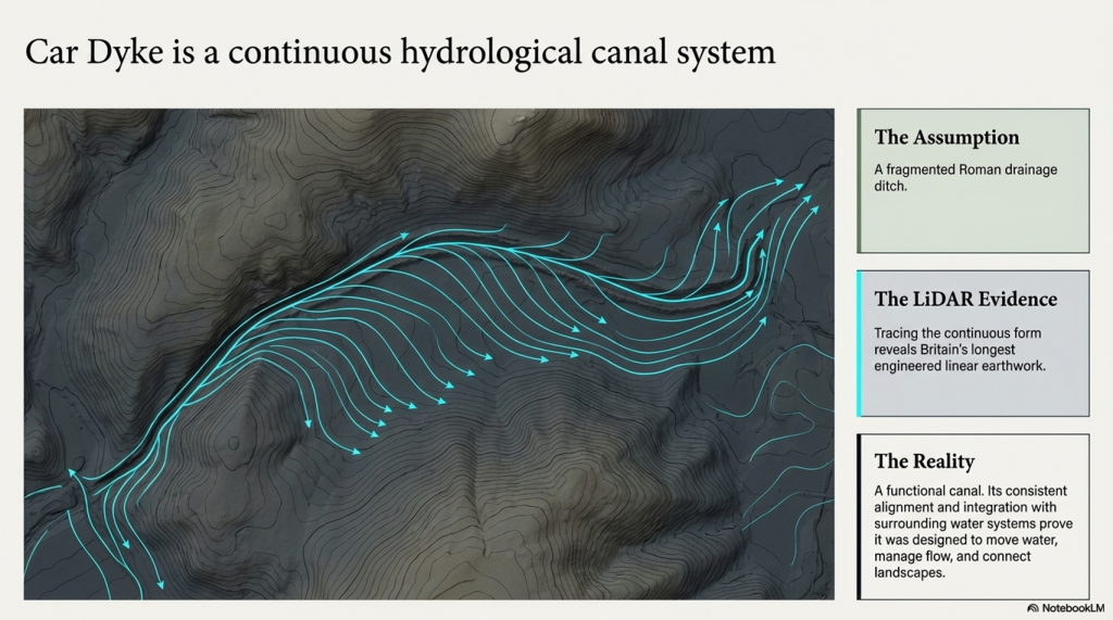
The answer is trade.

Minerals, flint, chalk products—materials that had value and were moved. You don’t build infrastructure like this for isolation. You build it for exchange.


The Dating Problem Nobody Wants to Address

The conventional timeline—Iron Age construction—relies heavily on pottery and standard dating frameworks.

But those frameworks have known limitations:

➡️ Reworked material
➡️ Contamination
➡️ Reservoir effects
➡️ Post-depositional movement

All of which can shift dates significantly, especially in water-influenced environments .

So if the landscape itself was water-dominated for thousands of years after the Ice Age…

➡️ Then the context in which those artefacts were deposited is already compromised.

Which raises the uncomfortable possibility:

👉 The site could be far older than the assigned Iron Age label
👉 Potentially Late Mesolithic / Early Neolithic (~6000 years ago)


Midsummer, Memory, and Meaning

We’re told Hollingbury is a place of ritual—midsummer fires, folklore, Druids, dragons in burial mounds.

And yes, those traditions matter.

But they’re secondary.

They are memory, not origin.

People return to meaningful places. They reuse them. They mythologise them.

But they rarely build them without purpose in the first place.


So What Is Hollingbury?
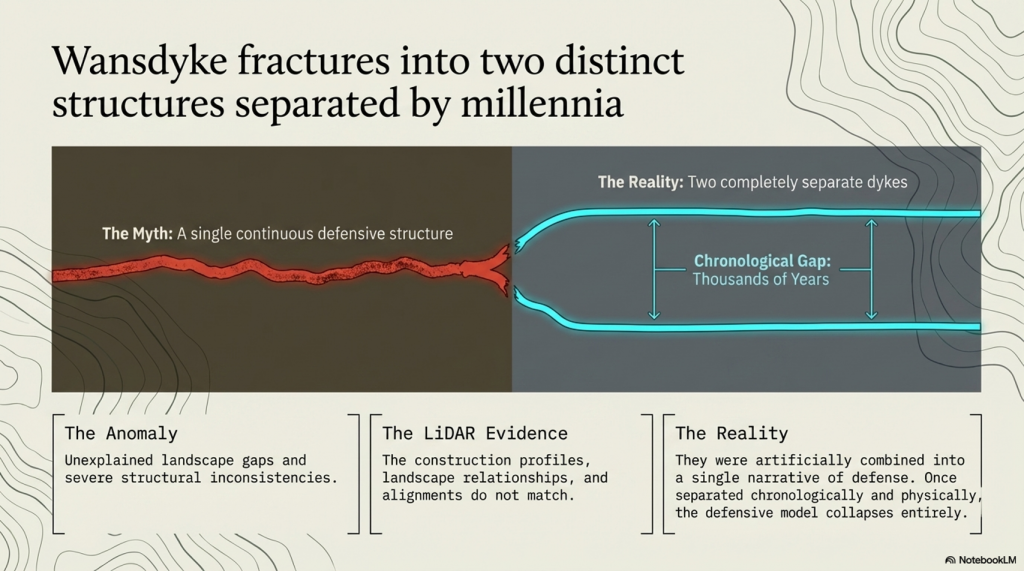
Not just a hillfort.
Not just a burial ground.
Not just a ritual landscape.

➡️ It is infrastructure.
➡️ It is positioned for water.
➡️ It is aligned with trade.
➡️ It is reused across millennia.

And once you factor in post-glacial hydrology, it makes perfect sense.


The Bigger Picture

Hollingbury isn’t unique.

It’s part of a pattern:

➡️ Elevated sites
➡️ Basin-like interiors
➡️ Resource extraction nearby
➡️ Later “defensive” reinterpretation

What archaeology calls “hillforts” may in many cases be the fossilised remains of a water-based transport and trading network—one that existed in a very different Britain.

A Britain that was still draining from the Ice Age.


The question isn’t whether these sites were reused in the Iron Age.

They clearly were.

The question is:

👉 What were they before that?


The Prehistoric AI Team 🤖
(Still following the water… because the archaeology won’t 😎)

Use mouse and Left hand click (Ctrl) to PAN – Mouse and RIGHT hand Click to move UP and Down – and Wheel to zoom in the 3D Image