Stonehenge’s The Lost Circle Revealed – DEBUNKED

13 things that don’t make sense about Waun Mawn (Stonehenge’s The Lost Circle Revealed)

Introduction

According to the BBC documentary, the discovery of the bluestone quarry in Wales was presented as a major breakthrough in understanding Stonehenge. At face value, that seems fair enough. Identifying a potential source for the stones is important.

But this is where the problem begins.

Because from that point onward, the investigation appears to shift away from asking what the evidence actually shows… and toward trying to make the evidence fit an already established timeline.

Instead of examining the quarry independently and comparing it objectively with Stonehenge, the focus becomes finding dates that support a pre-existing conclusion. That is not how science works. When you start with the answer and work backwards, you are no longer testing a hypothesis — you are trying to confirm one.

Craig Rhos-y-Felin is a good example of this.
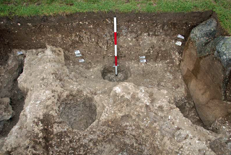
Craig Rhos-Y-Felin from Stonehenge: The Lost Circle Revealed - Stonehenge's the lost circle
Craig Rhos-Y-Felin: Stonehenge: The Lost Circle Revealed

The site contains clear evidence of Mesolithic activity, particularly in the form of man-made hearths. That should be the starting point for interpretation. Yet the emphasis is instead placed on a small number of later samples that fall closer to the desired Neolithic timeframe.

When those dates still don’t quite align, the solution is not to question the model — it is to introduce another one. A “prototype” stone circle in Wales was later moved to Stonehenge. A theory designed not from evidence, but from necessity.

And so begins a decade-long search for that missing link.

Sites are proposed… then quietly dropped when the dates don’t match. New locations are suggested… then abandoned for the same reason. The pattern repeats. The goal is no longer discovery — it is validation.

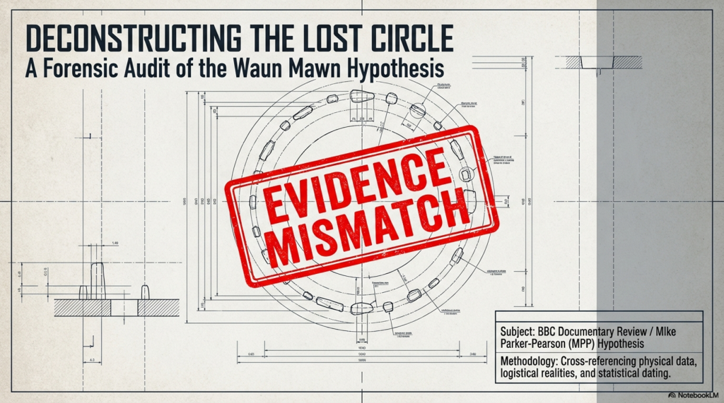
Eventually, everything converges on Waun Mawn.
(Stonehenge's The Lost Circle Revealed)
(Stonehenge’s The Lost Circle Revealed)

This is presented as the long-awaited solution. But when you strip it back, the physical evidence is extremely limited. A handful of stones. A small number of possible stone holes. Nowhere near enough to replicate what exists at Stonehenge.

So the gaps are filled in.

Estimates are extended beyond what is actually present. Missing stones are assumed. Layouts are reconstructed from partial data. And suddenly, a fragment becomes a full circle.

Then we come to the dating.

Among a broad range of results spanning several millennia, one sample is highlighted as aligning with the proposed timeline. The rest — which do not support the theory — receive far less attention.

This is the core issue. You cannot treat a single favourable result as definitive while ignoring the wider dataset. That is not strengthening an argument — it is narrowing it.

The same pattern appears in other parts of the interpretation.
(Stonehenge's The Lost Circle Revealed)
(Stonehenge’s The Lost Circle Revealed)

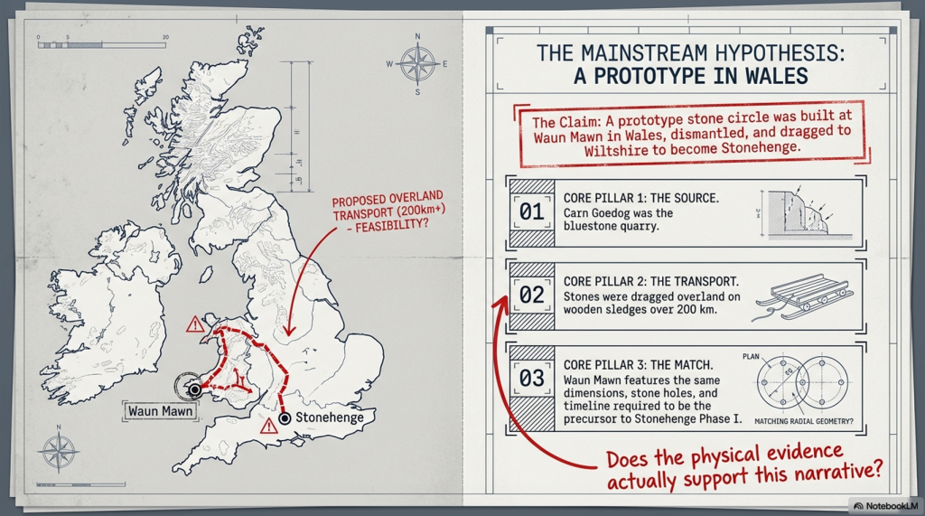
Large stones at the quarry are presented as the source of Stonehenge’s bluestones, despite clear differences in size and shape. No explanation is provided for how they were reduced or reworked.

Transport by water is dismissed, despite experimental demonstrations showing it is entirely possible. Instead, overland transport through heavily forested and waterlogged terrain is presented as the more feasible option — a claim that raises more questions than it answers.

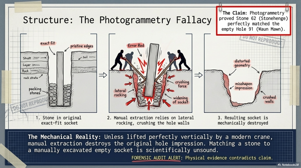
Even the more technical aspects, such as photogrammetry, are used in ways that assume ideal conditions. A stone is said to match a socket, without addressing the simple fact that removing a stone alters the shape of that socket. Basic mechanical realities are overlooked.

And then, towards the end, the programme drifts into broader speculation — cultural movements, symbolic alignments, and generalised astronomical claims. These are presented confidently, but without the level of supporting evidence required to justify them.

Meanwhile, key inconsistencies remain unresolved.

Stonehenge contains 56 bluestone positions. Waun Mawn does not. The construction methods differ. The depth of the stone holes differs. The overall structure is not the same.

These are not small details. There are fundamental differences.
(Stonehenge's The Lost Circle Revealed)
(Stonehenge’s The Lost Circle Revealed)

So what are we left with?

Not a clear, evidence-led conclusion — but a narrative built around selective interpretation. Certain data points are emphasised. Others are downplayed. Gaps are filled with theory rather than evidence.

The result is compelling television.

But it is not robust science.

Because real scientific analysis does not depend on finding the right answer.

It depends on being willing to accept when the evidence points somewhere else entirely.
(Stonehenge's The Lost Circle Revealed)
(Stonehenge’s The Lost Circle Revealed)

The Documentary

Therefore, the last hope for MPP’s reputation and his ’10-year search’ fell upon Waun Mawn, culminating in the BBC documentary “Stonehenge: The Lost Circle Revealed”, shown on the 12th February 2021. In it, he claimed many so-called ‘facts’ which I shall now highlight as ‘not making sense’, with the reasons why.

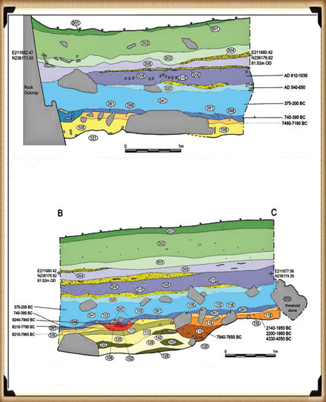
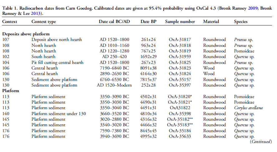
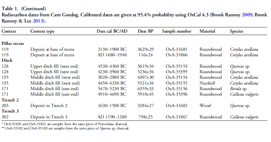
1. At (13:20) MPP shows signs of human-made quarrying and splitting of Bluestones at Carn Goedog in Wales – unfortunately, there are no extensive excavation reports on this site, just a published review showing that of the 31 carbon dates, only three random samples support his theory and none of the man-made hearths which are Mesolithic (like Craig Rhos-Y-Felin) or late Neolithic.

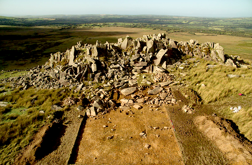
2. The program showed the suggested quarried stones at Carn Goedog, which are over 12 feet long and 5 feet wide, weighing therefore around 20+ tonnes. The Stonehenge bluestones are, on average, less than six feet high and about 18–24 inches wide, weighing 1-3 tonnes. The review on the site offered no evidence that the stones were cut down and reshaped for the journey to Stonehenge or elsewhere. (Stonehenge’s The Lost Circle Revealed)
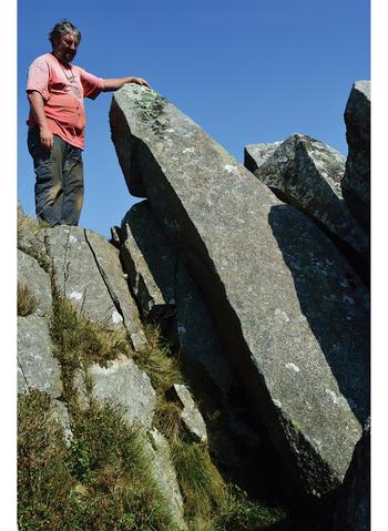
Carn Goedog from Stonehenge: The Lost Circle Revealed (Stonehenge's The Lost Circle Revealed)
Carn Goedog – Stonehenge: The Lost Circle Revealed

3. MPP claims that the boat transport method (14.50) was infeasible as they did not have sturdy enough boats to carry the stones on such a journey – Sadly, you do not need a ‘boat’ to transport stones in a river as shown by Atkinson in the 1960’s who employed just four school kids to punt a raft with a 3 tonne stone attached down the Avon. Moreover, he has failed to recognise that the oldest boatyard in the world, located in the Solent (at the end of the Avon), was found with planked wood (and associated wheat grain from Turkey), indicating that substantial seafaring boats were available by the 7th Millennium BCE.
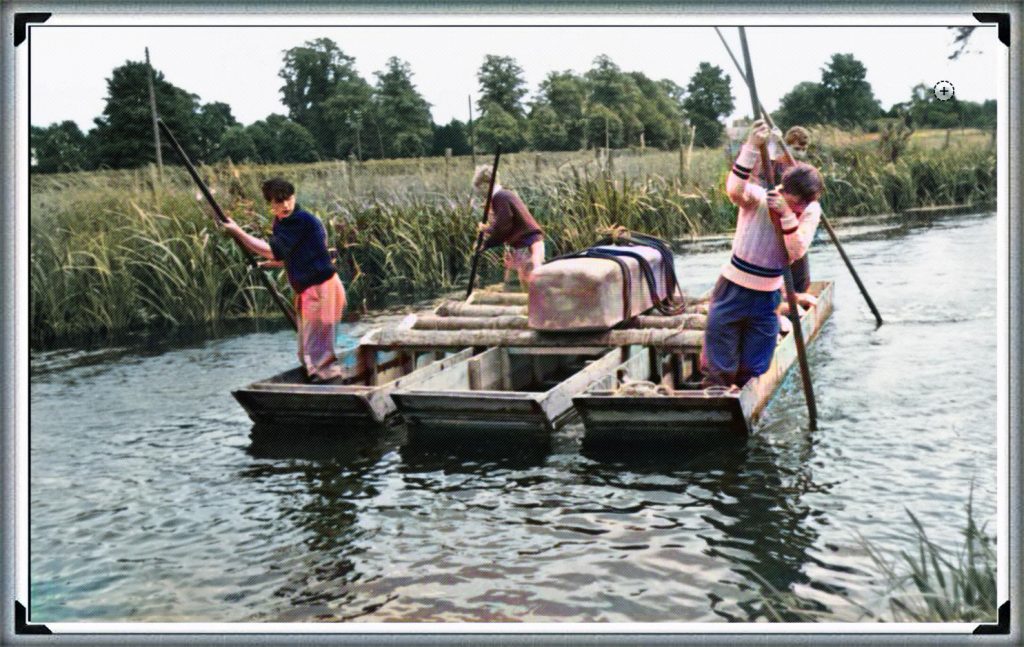
Punting Bluestone down the Avon from Stonehenge: The Lost Circle Revealed (Stonehenge's The Lost Circle Revealed)
Clearly MPP was too young to see this punt down the Avon?

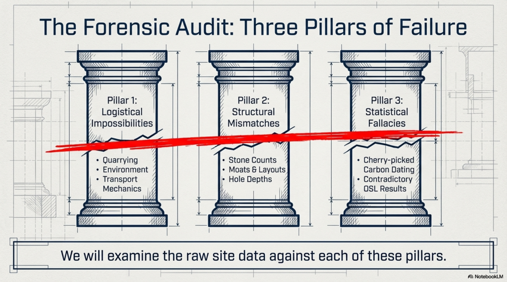
4. Mike Parker-Pearson also suggested that an ‘ox-cart’ route that followed the current A40 was the most feasible way of transporting these stones to Stonehenge. He believed that they dragged these stones over 200 km on wooden sledges – unfortunately, the example shown on the program shows schoolboys dragging a small stone over flat grassland, which would not be available for another 4000+ years and after Stonehenge’s initial construction. At the time of Phase I construction, the environment (as indicated by pollen analysis) shows that 70% of the terrain was woodland and forest, and the remaining 30% was mostly rivers and swampland, making such an endeavour impossible.

5. The Discovery (21:15) of ‘random’ hazel nuts at Craig Rhos-Y-Felin provides MPP’s required date for Stonehenge of 3300 BCE (which is still 500 years before MPP’s supposed construction date) – This clear ‘cherry picking’ of the archaeological evidence is ‘Bad Science’. To take just two carbon dates from over 40 at the Craig-Rhos-Y-Felin site and ignoring the more solid man-made hearth dates, which are Mesolithic and moreover, compatible with 26 carbon dates found at Stonehenge, is plainly a falsehood.

6. When they eventually found their target site (36:15), Waun Mawn (after many claims that other sites were “the one we have been looking for” to eventually find that the carbon dating on these sites did not match the required date), they found just four bluestones, and so went on a stone hunt and found 10 further stone HOLES! – This is clearly a sad attempt to fit a square peg into a round hole. The excavation was flawed as it only identified 14 possible stone locations and the remainder of the estimated 15 – 25 stones was a ‘guesstimation’ based on the known 14 holes – two of which had non-bluestone stones in situ.
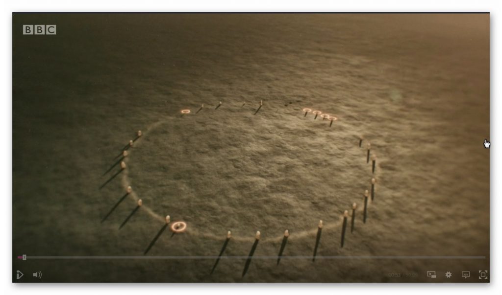
Waun Maun from Stonehenge: The Lost Circle Revealed (Stonehenge's The Lost Circle Revealed)
Nowhere near the 56 stones needed to create Stonehenge Phase I

7. The BBC reconstruction shows just 28 stones (38:05) of the 56 Bluestones required for the Aubrey holes to be filled at Stonehenge, and MPP goes on to suggest, that the stone circle is of equal size and dimensions as Stonehenge, quote “the chances of the two sites having the EXACT dimensions are very slim”- This sadly, is another falsehood, the Moat/Ditch at Stonehenge is approximately 110 metres in diameter, NOT the Aubrey holes which are 90 metres in diameter. Moreover, Stonehenge has a ditch/moat surrounding the stones (for a good reason) Waun Mawn does not!!

8. MPPs then used a new, unused tool in archaeology to prove their hypothesis, ‘photogrammetry’, and suggested that Stone 62 at Stonehenge fitted the stone hole 91 at Waun Mawn. The reason this method is not used is somewhat obvious to even non-academics. You would need a crane to lift the stone vertically out of the hole to get an exact imprint. If you are taking out a stone by hand and/or with levers, you will rock it from side to side, destroying the stone hole impression, as we have seen with post holes in numerous excavations.

9. The program fails to report that the 40 carbon dates from wood found on the site did not come up with MPP’s magic date, and so he employed another form of Dating OSL (40:17) to find this single piece of evidence he desperately required. – Sadly, watching Dr Kim Kinnaird’s efforts to get a light, uncontaminated sample from over a fallen Stone summed up the state of archaeology as a science for me. Armed with a black weed blocker and a bicycle light on his head, he set forth to get a sample to prove MPP’s hypothesis. Anyone who considers this an effective way of obtaining an OSL sample is beyond scientific redemption, as logic would suggest; doing it at night would perhaps be more suitable. This was finally compounded when we saw him transporting the sample in his hand into the detector in daylight, which was pure icing on that flawed cake.

10. Roberts indicated (quite rightly) that ALL the dates were “way out” and all hopes were put on this one sample, MPP then claimed (42:20) “we had dated the thing, and it just before Stonehenge’s construction” (3300 BCE) – Sadly, and not report in the program, but within the Waun Mawn excavation report, there was not one OSL samples taken but 18, which gave results in the range of 6980+/- 2120 BCE to AD 1900 +/- 20. So the 17 dating sample did not verify MPP’s hypothesis, only a single one, which was dated 3530 +/- 330 (with that date range, the probability it’s 3300 BCE is slim!!).In fact, the OSL data in the review document suggested “removal of the stones” in 2120 +/- 520 BCE, long after the Stonehenge phase I.

11. The program then went onto a flight of fantasy for 15 minutes (25% OF AIR TIME) with unscientific mythology and astroarchaeology (which proved MORE that astroarchaeology doesn’t have any significance as the ‘expert’ suggested that the stones were ‘in the general direction’ of an alignment  – which by the very nature of a stone circle of 360 degrees – every stone circle in the world is in the general direction of all astrological alignments!! Even more ludicrous came an idea that the Welsh culturally invaded England in 3300 BCE and took the stones of Waun Mawn with them –Sadly, at no point did the experts attempt to justify why Stonehenge had 56 Bluestones and the site at Waun Mawn had less than 30 at the most. Even if this idea were remotely true, why would you leave four stones behind when you are already going to be 30 stones short and need to go back and get some more from the quarry site?

12. The program never went into any detail of the OTHER carbon dates found at Waun Mawn, which would have allowed a balanced scientific program, allowing the viewer to decide whether MPP’s hypothesis was actually feasible. It presented speculation as fact, with a number of site workers and the presenter agreeing on MPP’s ideas without question or qualification – this is commonly known as ‘propaganda’ rather than scientific methodology.  Moreover, the REAL evidence can be found in the report and shows that of the carbon dating evidence at Waun Mawn (the OSL data was excluded from the report accept a small paragraph without all data!) shows that of the 42 samples taken:

  • 1 – sample were of 9th Millennium BCE
  • 3 – samples were of the 8th Millennium BCE
  • 8 – samples were of the 7th Millennium BCE
  • 4 – samples were of the 6th Millennium BCE
  • 10 – samples were of the 5th Millennium BCE
  • 6 – samples were of the 4th Millennium BCE
  • 11- samples from the 4th Millennium BCE to 17 AD.

13. The report on Waun Mawn contains other questionable evidence, which was excluded from the program. This includes the fact that the Aubrey holes at Stonehenge are ALL two to three times deeper than at Waun Mawn.  This indicates that the Stonehenge Bluestones were made from larger bluestones than those at Waun Mawn (Stonehenge Bluestone hole 69 is over 1.5m deep, as it is long and thin). It looks as if the original stone circle at Waun Mawn was made up of stones similar in shape to the existing recumbent stone 13, which is 6– 7 feet tall and surrounded by a moat. The shape of recumbent 13 indicates that rather than the long thin bluestones as at Stonehenge, Waun Mawn had ‘fat bottomed’ domed ends and hence the need for only shallow ditches.
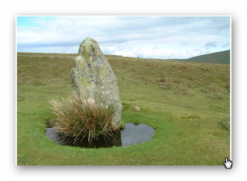
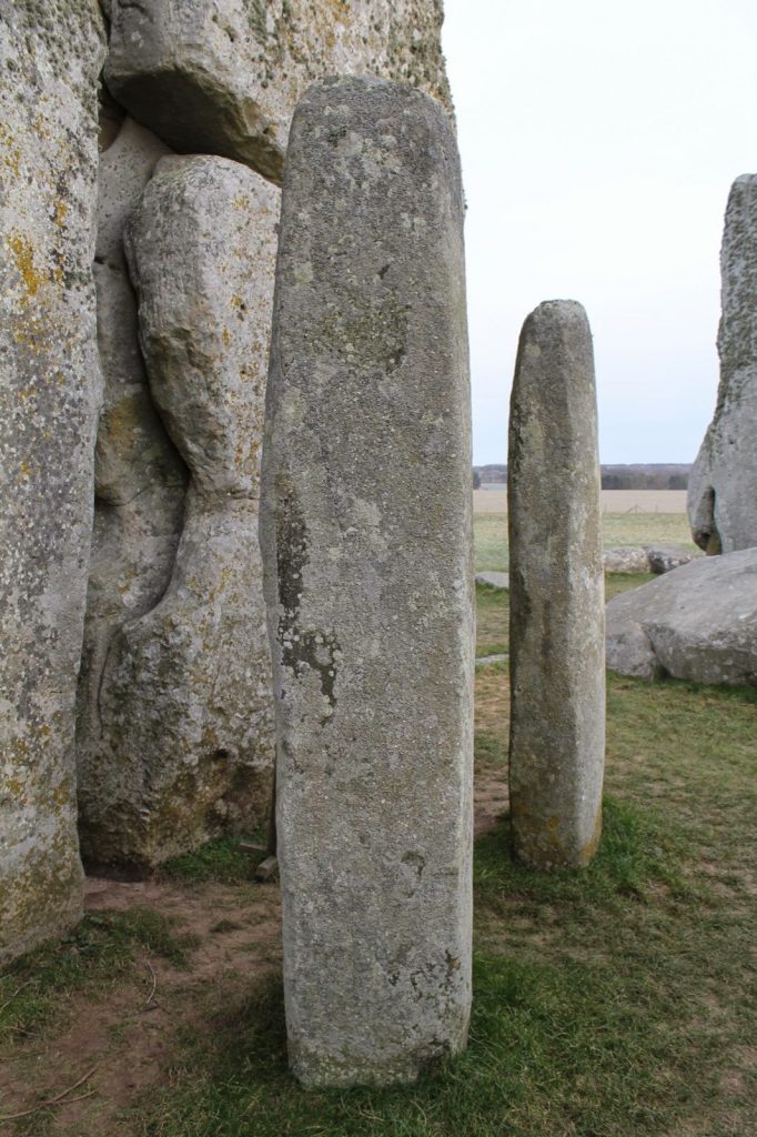
Recumbent Stone 13 Waun Mawn from Stonehenge: The Lost Circle Revealed
recumbent stone 13; Stonehenge: The Lost Circle Revealed
Stonehenge Bluestone 69 from Stonehenge: The Lost Circle Revealed
Stonehenge Bluestone 69 – a third is underground. Stonehenge: The Lost Circle Revealed

Conclusion

In conclusion, it seems that the BBC has produced a nice piece of archaeological propaganda that supports the current false ‘archaeological narrative’ of mythology and speculation, rather than tested and qualified scientific fact. This lack of ‘critical analysis’ is a clear indication of why the ‘science’ of archaeology has not progressed much over the last 50 years, even with modern technology, which it has incorporated to very limited success.
(Stonehenge's The Lost Circle Revealed)
(Stonehenge’s The Lost Circle Revealed)

Memoir

I first met MPP on his excavation dig on the Avon in 2009, where he was preparing to announce his bluestone site, ‘Bluestonehenge’. At the time, we had a discussion about the date of the site, as he was convinced that (at that time) he believed it predated Stonehenge Phase I (we now know this was the first of many claims of a predated Stonehenge bluestone circle). I did point out that at the meeting that I thought this date would be incorrect as according to my research (of the surrounding 50 sites around Stonehenge) which was included in my published book and post-glacial flooded environment hypothesis ‘The Stonehenge Enigma’ in 2013 – that this site would have been below water as the River Avon would remain flooded throughout the Neolithic period. At this point, he ended the meeting and disappeared at such a rapid speed – it looked as if he thought I was clearly mad.

Later carbon dating proved my point and supported my hypothesis, as it is now accepted that Bluehenge was constructed between 2840 and 2230 BCE, in the Early Bronze Age.

PODCAST

Author’s Biography

Robert John Langdon, a polymathic luminary, emerges as a writer, historian, and eminent specialist in LiDAR Landscape Archaeology.

His intellectual voyage has been interwoven with stints as an astute scrutineer in government and grand corporate bastions, a tapestry spanning British Telecommunications, Cable and Wireless, British Gas, and the esteemed University of London.

A decade hence, Robert’s transition into retirement unfurled a chapter of insatiable curiosity. This phase saw him immerse himself in Politics, Archaeology, Philosophy, and the enigmatic realm of Quantum Mechanics. His academic odyssey traversed the venerable corridors of knowledge hubs such as the Museum of London, University College London, Birkbeck College, The City Literature Institute, and Chichester University.

In the symphony of his life, Robert is a custodian of three progeny and a pair of cherished grandchildren. His sanctuary lies ensconced in the embrace of West Wales, where he inhabits an isolated cottage, its windows framing a vista of the boundless sea – a retreat from the scrutinising gaze of Her Majesty’s Revenue and Customs, an amiable clandestinity in the lap of nature.

Exploring Prehistoric Britain: A Journey Through Time

My blog delves into the fascinating mysteries of prehistoric Britain, challenging conventional narratives and offering fresh perspectives grounded in cutting-edge research, particularly LiDAR technology. I invite you to explore some key areas of my research. For example, the Wansdyke, often cited as a defensive structure, is re-examined in light of new evidence. I’ve presented my findings in my blog post Wansdyke: A British Frontier Wall – ‘Debunked’, and a Wansdyke LiDAR Flyover video further visualises my conclusions.

My work also often challenges established archaeological dogma. I argue that many sites, such as Hambledon Hill, commonly identified as Iron Age hillforts, are not what they seem. My posts Lidar Investigation Hambledon Hill – NOT an ‘Iron Age Fort’ and Unmasking the “Iron Age Hillfort” Myth explore these ideas in detail and offer an alternative view. Similarly, sites like Cissbury Ring and White Sheet Camp receive re-evaluations based on LiDAR analysis in my posts “Lidar Investigation Cissbury Ring through time” and “Lidar Investigation White Sheet Camp,“ revealing fascinating insights into their true purpose. I have also examined South Cadbury Castle, often linked to the mythical Camelot56.

My research also extends to ancient water management, including the role of canals and other linear earthworks. I have discussed the true origins of Car Dyke in multiple posts, including Car Dyke – ABC News Podcast and Lidar Investigation Car Dyke – North Section, which suggest a Mesolithic origin 2357. I also explore the misidentification of Roman aqueducts, as seen in my posts on the Great Chesters (Roman) Aqueduct. My research has also been greatly informed by my post-glacial flooding hypothesis, which has helped explain landscape transformations over time. I have discussed this hypothesis in several posts, including AI now supports my Post-Glacial Flooding Hypothesis and Exploring Britain’s Flooded Past: A Personal Journey

Finally, my blog also investigates prehistoric burial practices, as seen in Prehistoric Burial Practices of Britain and explores the mystery of Pillow Mounds, often mistaken for medieval rabbit warrens, but with a potential link to Bronze Age cremation in my posts: Pillow Mounds: A Bronze Age Legacy of Cremation? and The Mystery of Pillow Mounds: Are They Really Medieval Rabbit Warrens?. My research also includes astronomical insights into ancient sites, for example, in Rediscovering the Winter Solstice: The Original Winter Festival. I also review new information about the construction of Stonehenge in The Stonehenge Enigma.

Further Reading

For those interested in British Prehistory, visit www.prehistoric-britain.co.uk, a comprehensive resource featuring an extensive collection of archaeology articles, modern LiDAR investigations, and groundbreaking research. The site also includes insights and excerpts from the acclaimed Robert John Langdon Trilogy, a series of books that explore Britain during the Prehistoric period. Titles in the trilogy include The Stonehenge Enigma, Dawn of the Lost Civilisation, and The Post-Glacial Flooding Hypothesis, which offer compelling evidence of ancient landscapes shaped by post-glacial flooding.

To further explore these topics, Robert John Langdon has developed a dedicated YouTube channel featuring over 100 video documentaries and investigations that complement the trilogy. Notable discoveries and studies showcased on the channel include 13 Things that Don’t Make Sense in History and the revelation of Silbury Avenue – The Lost Stone Avenue, a rediscovered prehistoric feature at Avebury, Wiltshire.

In addition to his main works, Langdon has released a series of shorter, accessible publications, ideal for readers delving into specific topics. These include:

For active discussions and updates on the trilogy’s findings and recent LiDAR investigations, join our vibrant community on Facebook. Engage with like-minded enthusiasts by leaving a message or contributing to debates in our Facebook Group.

Whether through the books, the website, or interactive videos, we aim to provide a deeper understanding of Britain’s fascinating prehistoric past. We encourage you to explore these resources and uncover the mysteries of ancient landscapes through the lens of modern archaeology.

For more information, including chapter extracts and related publications, visit the Robert John Langdon Author Page. Dive into works such as The Stonehenge Enigma or Dawn of the Lost Civilisation, and explore cutting-edge theories that challenge traditional historical narratives.

Other Blogs

[sitemap_posts]

Archaeology in the Post-Truth Era

Introduction

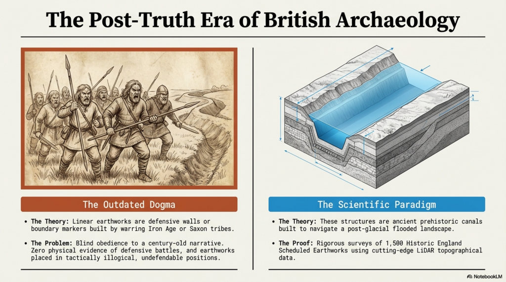
Over the past ten years, I’ve faced a constant uphill battle to establish what I consider a straightforward conclusion—that Linear Earthworks are not defensive structures or boundary markers but prehistoric canals. It’s a claim that’s been dismissed repeatedly, often without proper engagement, but that resistance never stopped the work.(Archaeology in the Post-Truth Era)

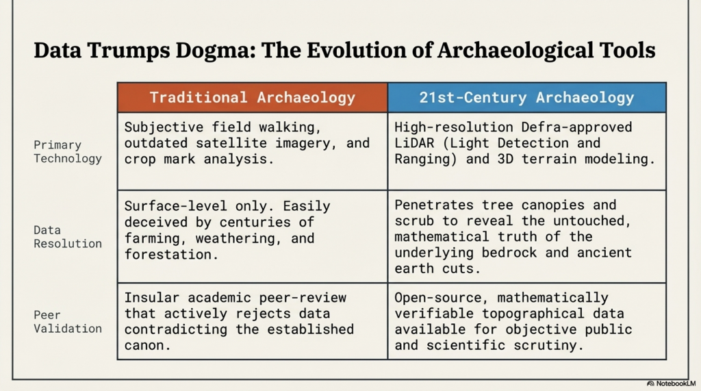
Instead, it pushed me further. I carried out a full survey of over 1,500 of Historic England’s Scheduled Linear Earthworks, systematically analysing their form, placement, and context. That work eventually led to the first book in what has now become a larger series, focusing specifically on the East Wansdyke area. For me, that publication wasn’t just another book—it was a milestone. It represents a level of detailed, landscape-wide analysis that, to date, no university or research team has attempted at this scale.

(Britain's Giant Prehistoric Waterways)
Archaeology in the Post-Truth Era

The book itself takes a forensic approach. Every aspect of East Wansdyke is examined and placed into a wider framework—what I define as an ancient prehistoric canal system. The aim is simple: to challenge the existing archaeological narrative, not with speculation, but with measurable, testable evidence. The traditional explanations—defensive lines, territorial markers—don’t hold up under scrutiny. They lack physical evidence, contradict their own logic, and fail to explain the most basic characteristics of these structures.

What emerges instead is something far more significant. If these earthworks are canals, then we are looking at a completely different level of engineering capability in prehistory. These were not crude societies marking out land or preparing for war—they were shaping landscapes, managing water, and building infrastructure on a national scale. This not only challenges the archaeological community but also opens the door to a broader re-evaluation of how prehistoric landscapes were understood and used.

Archaeology in the Post-Truth Era

Embarking on this journey was not without its challenges, especially in an era where scepticism often overshadows scientific evidence. The response to my publication, which I had hoped would ignite a meaningful academic debate, was instead largely silent. Despite the use of modern LiDAR technology and a dataset far beyond what had previously been attempted, the work was either ignored or dismissed as speculative.

This resistance was mirrored on social media, where entrenched views dominated discussion. Any attempt to challenge established narratives was met with denial rather than engagement. Peer review, rather than being treated as part of an evolving process, was often presented as a final and unquestionable authority.

The Dyke Myth Collapse
Archaeology in the Post-Truth Era

This kind of blind adherence to established ideas is not unique to archaeology. It is a pattern repeated across disciplines, where existing frameworks are protected rather than tested. New evidence is not examined on its merits but rejected because it disrupts the accepted model.

That was the position in 2014.

Now, two years on, we can assess that position against new evidence—and, more importantly, against the predictions made at the time.

What has emerged since then is not a contradiction of the original work, but a direct reinforcement of it.

The borehole data, when analysed correctly using elevation rather than arbitrary depth, has revealed consistent clustering of water-related deposits at specific heights across multiple independent locations. Statistically, this pattern is highly unlikely to occur by chance and instead points to a structured, elevation-controlled hydrological system operating across the landscape.

Archaeology in the Post-Truth Era

At the same time, the mathematical framework behind the Post-Glacial Flooding Hypothesis has continued to develop. The mass-balance calculations, combined with ice-volume scaling and groundwater discharge modelling, demonstrate that Britain remained in a prolonged state of elevated water tables and enlarged river systems for thousands of years after the end of the last Ice Age.

This confirms a critical point:

The rivers of the past were higher than those we see today.

And once that is understood, the entire interpretation of Linear Earthworks shifts.

Rethinking The Past
Archaeology in the Post-Truth Era

Because these structures are not randomly placed. They align with contours, connect basins, and sit within hydrological positions that make sense only under sustained high water levels. Their form, scale, and distribution are consistent with water management—not defence, not boundaries, but controlled flow.

In other words, the environmental conditions required for canals are now demonstrably present.

This is the key difference between 2014 and 2026.

In 2014, the argument was based on landscape logic, structural analysis, and comparative reasoning.

In 2026, that same argument is now supported by independent physical data and mathematical proof of the environmental conditions required for it to function.

The conclusion, however, has not changed.

Linear Earthworks were constructed in a landscape defined by elevated water tables and expanded river systems. Within that context, their most coherent and evidence-based interpretation remains exactly what was originally proposed.

They were canals.

Archaeology in the Post-Truth Era

And perhaps most importantly, this progression follows the correct scientific sequence.

The prediction came first.

The evidence followed.

And that is not speculation—that is validation.

Archaeology in the Post-Truth Era
Fundamentalist

Wansdyke

In my book, I meticulously addressed every single meter of East Wansdyke, providing compelling evidence that challenges the traditional interpretation of Wansdyke as either a defensive structure or a boundary marker. My research and analysis have convincingly demonstrated that East Wansdyke was, in fact, part of a prehistoric canal system, a finding that significantly alters our understanding of the landscape and the capabilities of the people who engineered it. This conclusion was reached through a combination of detailed survey work, the application of modern technologies such as LiDAR, and a critical review of the archaeological and historical records.

However, one critic, emblematic of the resistance I’ve encountered, sought to undermine my hypothesis by citing a site associated with West Wansdyke. This individual argued that because West Wansdyke was built on a ‘late Iron Age’ fortification, it must, therefore, be of Saxon origin, aiming to cast doubt on my entire thesis by focusing on this one aspect. It’s a classic example of attempting to discredit a comprehensive theory by finding fault with a single, arguably tangential, element.

Archaeology in the Post-Truth Era

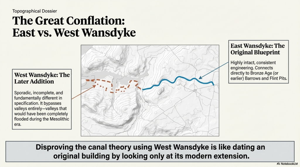
In my response, I emphasised that this site, situated in West Wansdyke, falls outside the primary focus of my research on the East Wansdyke segment. More importantly, I had already anticipated such objections and addressed them directly in my book. I concluded that West Wansdyke, while geographically related, was connected to the original canal system at a later date, likely by the Romans. This connection was based on evidence suggesting that West Wansdyke is incomplete, sporadic, and differs in specification from East Wansdyke, indicating a distinct phase of construction and purpose.

The dismissal of West Wansdyke from my primary analysis was not arbitrary but a considered decision grounded in the evidence and the scope of my research. It reflects a methodological approach that prioritises coherence, specificity, and relevance in building a historical narrative. The critique of my work that focuses on West Wansdyke, therefore, misses the mark. It overlooks the rigour of my research process and the clear rationale provided for the conclusions drawn about East Wansdyke and its role within a broader prehistoric canal system.

Archaeology in the Post-Truth Era

This encounter serves as a reminder of the challenges inherent in advancing new theories in archaeology, especially those that significantly depart from established interpretations. It also underscores the importance of clarity, precision, and thoroughness in both research and communication, qualities I strived to embody in my work on East Wansdyke.


West Wansdyke

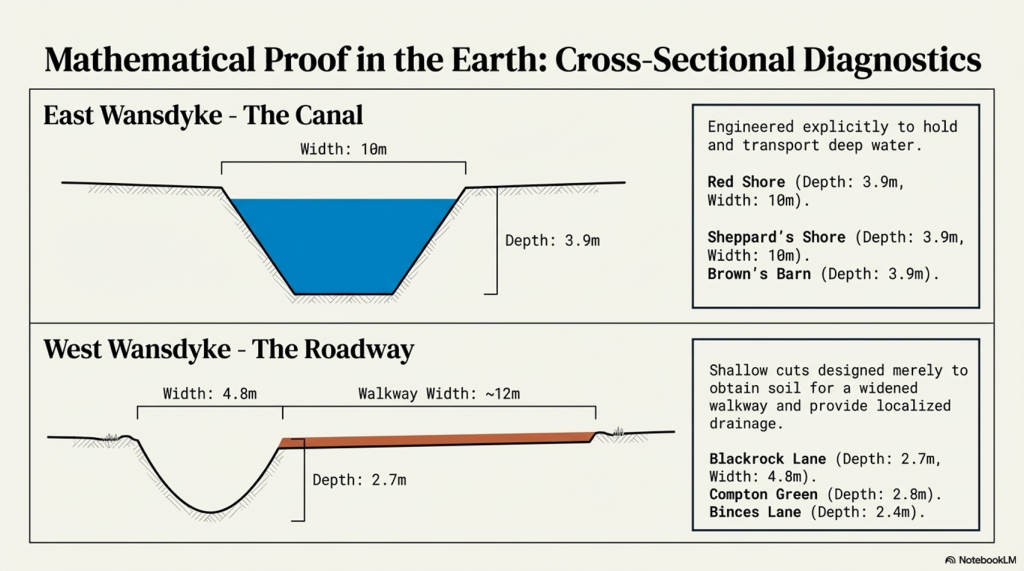
We have a problem with West Wansdyke – it’s not part of East Wansdyke. This has always been a historical debate over the last 100 years. If we look at the limited archaeological evidence, we find that although it may have been a much later Canal/Dyke it is not contemporary with the East Wansdyke canal and was not built at the same time.

Excavations conclusively show that the Ditches on the East side of Wansdyke are much more profound and twice as broad. In contrast, the Banks on the East Side are much wider. We see that East Dyke was built first, as our River height model shows that most of West Wansdyke would have been flooded or marshland at the time of use.

LocationWansdyke
BankDitchExcavator notes
MaterialsWidthHeightBermWidthDepthCounterscarp 
EAST        
Red ShoreClay/Flints9.52N103.9YGreen 1966
Sheppard’s shore 102.3N103.9YPitt Rivers 1888
Brown’s Barn 92.3N103.9YPitt Rivers 1891
WEST        
Binces Lane WestStoney12.5????3.51.7YErskine 1990s
Binces Lane EastStoney?5?N62.4?Erskine 1990s
Compton GreenClay marl130.8Y5.82.8YErskine 1990s
Blackrock LaneSilty Clay12.51.7Y4.82.7?Erskine 1990s
Park farmStones100.4Y5.52.4YErskine 1990s
Fairy Hill 13?Y6.5? Erskine 1990s
West Wansdyke Excavation

When the waters receded (possibly Early Iron Age period), it is possible that the Dyke was extended, or the more probable event of East Wansdyke after it dried up was turned into a roadway and what we see in West Wansdyke is the extension of the road, and hence it is wider than in the East.

Archaeology in the Post-Truth Era

We also see more shallow ditches as they were not used for water but to obtain soil for the walkway and become drainage ditches.

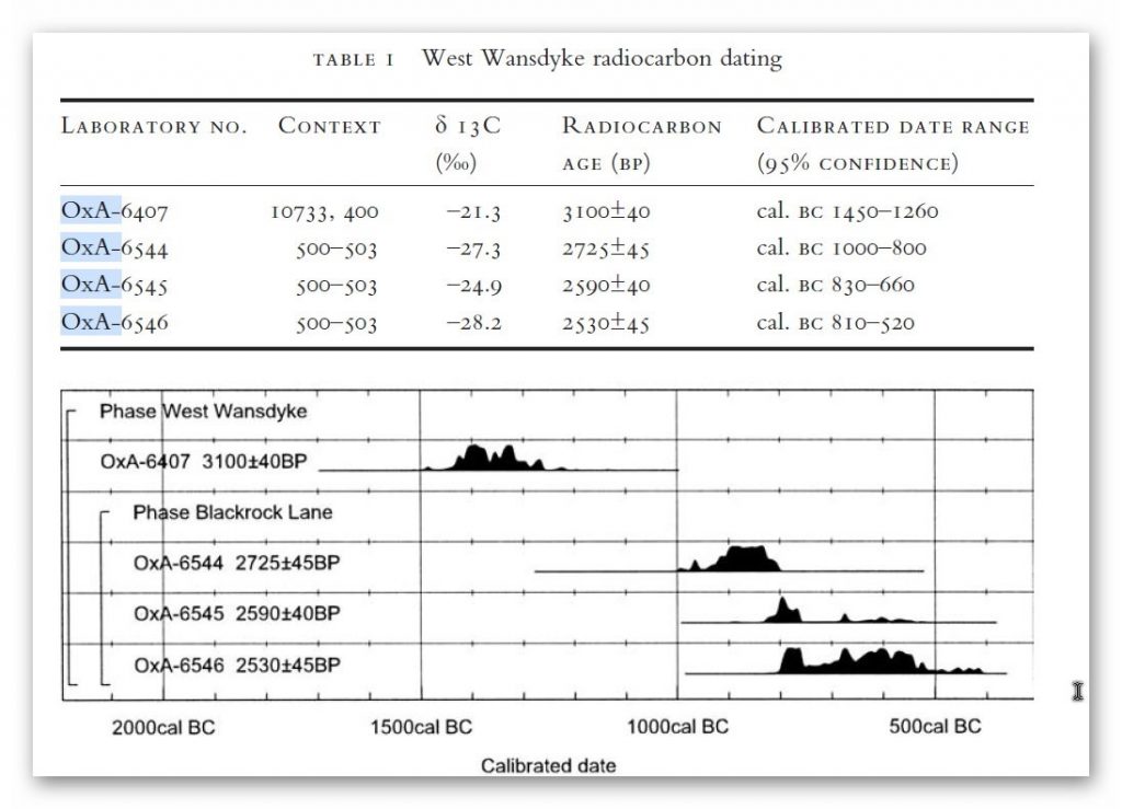
Indeed, we know the Romans used this as a road and always had drainage ditches, usually on both sides. This is supported by carbon dating at Erskine’s excavation at Blackrock Lane, where the section appeared to have been sealed by the primary bank material. One of these layers contained significant concentrations of woody oak charcoal.

Samples of this material were submitted to the Ancient Monuments Laboratory for radiocarbon dating to provide a possible construction of the bank. Unfortunately, as shown in the table below – sadly, as standard when scientific evidence disproves the current archaeological narrative – it is ignored and classified as an error.

Archaeology in the Post-Truth Era

Table 1. Erskine, Jonathan. (2007). The West Wansdyke: an appraisal of the dating, dimensions and construction techniques in the light of excavated evidence. Archaeological Journal. 164. 80-108.


The other missing aspect, shown in East Wansdyke but not in West Wansdyke, was the massive connection to Barrows and Flint Pits. Again, this connection is not seen on West Wansdyke, which may help date this monument, as the barrows were of the Bronze Age or earlier, and, as we have seen from the carbon dating evidence at Blackrock Lane, much earlier than its 1500 BCE date.

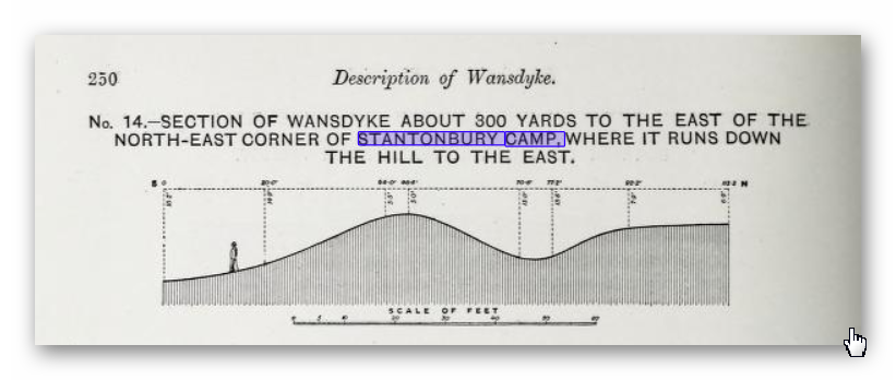
Statonbury Camp near Bath – an example of West Wansdyke

If we look at the Scheduled parts of the Wansdyke – we see that the East is very much intact, but the West is sporadic at best, and it’s hard to find a logical link to all the Dykes that seem to only appear over hills and not in the valley’s – which in my view would have been flooded in the Mesolithic and hence the west sections addition after East Wansdyke’s construction – probably by the roman’s who may have utilised the Dyke system for their own transportation reasons. But for the sake of scientific curiosity, let’s take a detailed look at Stantonbury Hill site, which is classified as an Iron Age Camp, with Wansdyke making up one of the defensive banks – but before we delve deeper into the field archaeology of the site – I feel I must clarify the use of the classification of ‘Iron Age Fort’ by archaeologists.

All sites that sit on top of hills and have ditches are called Iron Age Forts – sadly, I have yet to find a single location that is either ‘Iron Age’ or a ‘Fortification’, as not a single dead body from slaying has ever been found, and all the so-called defensive ditches EVER!! Yet the archaeological world continues to use this misleading classification, which confuses the public, as if it has been qualified and proven. So, back to Statonbury camp. The only investigation of this site was made by Fox and Fox in 1956 as part of their survey of Wansdyke in the publication ‘Wansdyke reconsidered.’ It should be noted that Historic England does not have an account with their scheduling as no excavation work has ever been undertaken, and so only field walking has been undertaken, and so the results are subject to the field walker.

Archaeology in the Post-Truth Era


In Fox’s publication, they also question the linkage of East and West Wansdyke through other, even older publications and field surveys, which call into question the logic of dating this linear earthwork. That great antiquary, Sir Richard Colt Hoare, had his doubts about the identification, which he endeavoured to suppress in his account of the earthwork in Ancient Wiltshire,


‘ Hitherto we have been enabled to trace the course of Wansdyke with certainty and success through Somersetshire, but on approaching the neighbouring county of Wiltshire we enter upon a new and doubtful field of inquiry respecting the direction as well as the formation of this celebrated rampart.’


His own observations in the field had shown him that in this central sector ‘ it bears the decided appearance of a Roman causeway, not of a Belgic or Saxon boundary and yet he felt obliged to support the current view that road and dyke were identical because he was convinced that the Wansdyke was continuous and he could find no alternative course for it in the area. Sir R. C. Hoare also observes that the camps appear to have been added to the Dyke, not the Dyke formed to connect the camps, which may be noticed especially at Stantonbury Camp, the second on the line of the course of Wansdyke through Somersetshire.


They continue
……


General Pitt-Rivers, also had misgivings, ‘ the Dyke he comments, in the Heddington region,’ is of very low relief everywhere on this line and it has often been questioned whether it is a dyke or a road’, and his suspicions were again aroused at a point west of Morgan’s Hill and on Bowden Hill near Lacock’.

Stanton Camp - Not Defensive
Stanton Camp – Not Defensive


On Statonbury Camp, there are not very helpful and report that:

Stantonbury is a univallate Iron Age hill-fort enclosing some 30 acres on the crest of the hill : until very recently it was waste ground going back to thorn scrub and islanded in dense woodland, as can be seen on the air-photo (Pl. VIIIB). The hill top (580 ft.) commands a wide view : from here the whole of the countryside traversed by West Wansdyke can be seen, Maes Knoll to the west. Odd Down to the east, as well as an uninterrupted stretch northwards to the Avon valley and the Cotswolds beyond. From here, the major alignment was probably planned (fig. 19 and p. 37).


In 1956-7 the hill top has been ploughed again, and the much reduced Iron Age defences are visible on the edge of the cultivation. It appears to us that Wansdyke was not constructed along the north-facing hill slope, and that as at Old Oswestry hill-fort, on Wat’s Dyke in Montgomery, the Iron Age defences were deemed sufficient. There is, however, as General Pitt-River’s level section shows, a steep scarp below the traces of the ploughed-in Iron Age ditch, which may be artificial and post-date the hill-fort, but this is uncertain.
East of the fort, in field 20, which is now occupied by a plantation and a pheasantry, the Dyke continues as a scarp for as far as we were able to trace it through the nettles and undergrowth. Below the 500 ft. contour, the large bank and ditch reappear in the dense woodland, and emerge beside the lane leading to the road to Stanton Prior, where the earthwork measures 75 ft. overall.


So, according to Fox and Fox, Wansdyke stops short and accepts the North Face is the Iron Age Site – therefore, if the Wansdyke had been cut to the north of the site, the Iron Age fort replaced it, which is not as the Jihad had claimed?

So where did he get this ‘ground-breaking’ revelation? For this, we must go not to a peer-reviewed book but a website ‘wansdyke21.org.uk’ by Robert Vermaat

He suggests that: It has been suggested by Fox & Fox that Wansdyke did not actually use Stantonbury Camp, the ditch stopping short of the Iron Age defences by several metres. However, Burrow showed in 1982 that this was incorrect. Although the western slope is much disturbed by quarrying and the lower slopes by cultivation, Wansdyke can still be traced quite well at several points on the hill. As with Maes Knoll, the northern defences are more prominent than those on the south side. As Wansdyke joins the defences here, it can be argued that, as was the case at Maes Knoll, the northern defences were refurbished when Wansdyke was constructed, neglecting the south side which was without use for the builders of Wansdyke.

Archaeology in the Post-Truth Era


If only we had £64 to see this so-called evidence from Field walking by burrows (as we know it was not excavated and LiDAR was not in use)!!


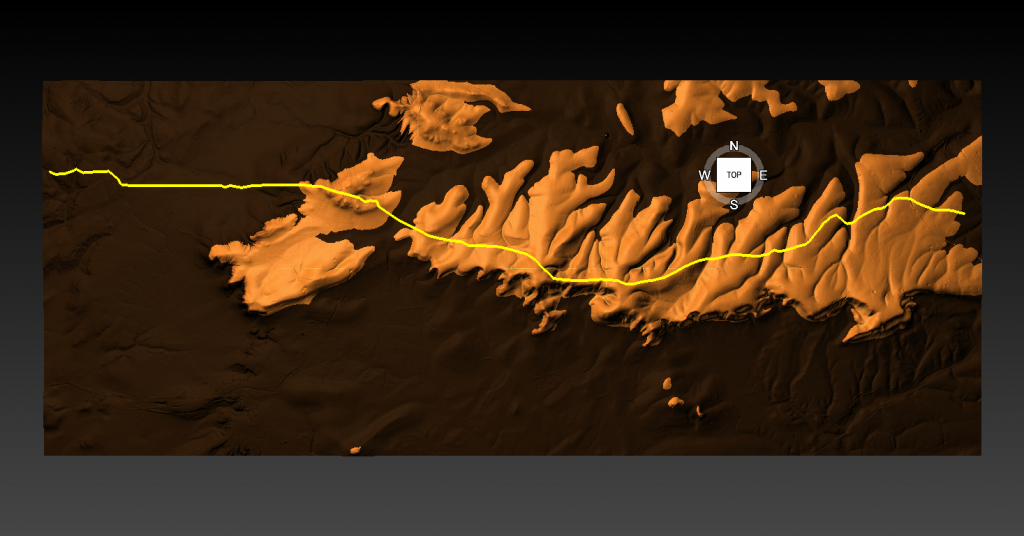
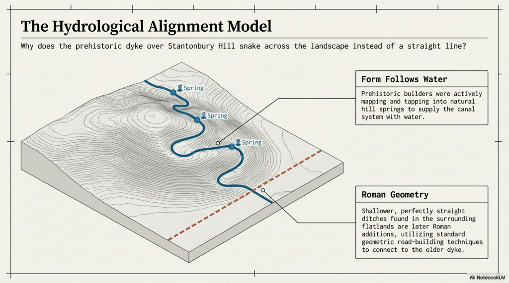
Fortunately, we have now obtained high-resolution LiDAR images of Statonbury Camp, and we can see that Wansdyke goes over the hill in a strange ‘wibbly wobbly’ way rather than a straight line – which we see on either side of the hill from much shallower ditches. This suggests that the area was not built entirely at the same time, and that the Hill Dyke is older than the flat ground levels surrounding the hill.

My estimate from the evidence in the smaller ditches is that they are Roman (and hence straight) in origin, which connects to the earlier prehistoric Dyke over Statonbury Hill, which the archaeologists call West Wansdyke (part of). The path over the hill indicates that the builders were attempting to locate natural springs as they built the Dyke to supply it with water, and hence the strange pathway.

Closer inspection of the Dyke as it approaches the ‘Iron Age Site’ suggests that it splits and shifts the bank from north-facing to south-facing, which Fox had seen as a terminus of the Dyke, for it reached the Fort. LiDAR clearly shows that the ditch moves to the south side of the bank and continues to create the East side of the fort, finally terminating in the South.

Also, the shape of the fort is not consistent, as it has rounded edges in the SE and SW regions but flat T-Junctions in the NE and NW, where it meets Wansdyke – indicating it was added to the existing Wansdyke canal either at the time of construction or a later date.

PodCast

Author’s Biography

Robert John Langdon, a polymathic luminary, emerges as a writer, historian, and eminent specialist in LiDAR Landscape Archaeology.

His intellectual voyage has been interwoven with stints as an astute scrutineer in government and grand corporate bastions, a tapestry spanning British Telecommunications, Cable and Wireless, British Gas, and the esteemed University of London.

A decade hence, Robert’s transition into retirement unfurled a chapter of insatiable curiosity. This phase saw him immerse himself in Politics, Archaeology, Philosophy, and the enigmatic realm of Quantum Mechanics. His academic odyssey traversed the venerable corridors of knowledge hubs such as the Museum of London, University College London, Birkbeck College, The City Literature Institute, and Chichester University.

In the symphony of his life, Robert is a custodian of three progeny and a pair of cherished grandchildren. His sanctuary lies ensconced in the embrace of West Wales, where he inhabits an isolated cottage, its windows framing a vista of the boundless sea – a retreat from the scrutinising gaze of Her Majesty’s Revenue and Customs, an amiable clandestinity in the lap of nature.

Exploring Prehistoric Britain: A Journey Through Time

My blog delves into the fascinating mysteries of prehistoric Britain, challenging conventional narratives and offering fresh perspectives grounded in cutting-edge research, particularly LiDAR technology. I invite you to explore some key areas of my research. For example, the Wansdyke, often cited as a defensive structure, is re-examined in light of new evidence. I’ve presented my findings in my blog post Wansdyke: A British Frontier Wall – ‘Debunked’, and a Wansdyke LiDAR Flyover video further visualises my conclusions.

My work also often challenges established archaeological dogma. I argue that many sites, such as Hambledon Hill, commonly identified as Iron Age hillforts, are not what they seem. My posts Lidar Investigation Hambledon Hill – NOT an ‘Iron Age Fort’ and Unmasking the “Iron Age Hillfort” Myth explore these ideas in detail and offer an alternative view. Similarly, sites like Cissbury Ring and White Sheet Camp receive re-evaluations based on LiDAR analysis in my posts “Lidar Investigation Cissbury Ring through time” and “Lidar Investigation White Sheet Camp,“ revealing fascinating insights into their true purpose. I have also examined South Cadbury Castle, often linked to the mythical Camelot56.

My research also extends to ancient water management, including the role of canals and other linear earthworks. I have discussed the true origins of Car Dyke in multiple posts, including Car Dyke – ABC News Podcast and Lidar Investigation Car Dyke – North Section, which suggest a Mesolithic origin 2357. I also explore the misidentification of Roman aqueducts, as seen in my posts on the Great Chesters (Roman) Aqueduct. My research has also been greatly informed by my post-glacial flooding hypothesis, which has helped explain landscape transformations over time. I have discussed this hypothesis in several posts, including AI now supports my Post-Glacial Flooding Hypothesis and Exploring Britain’s Flooded Past: A Personal Journey

Finally, my blog also investigates prehistoric burial practices, as seen in Prehistoric Burial Practices of Britain and explores the mystery of Pillow Mounds, often mistaken for medieval rabbit warrens, but with a potential link to Bronze Age cremation in my posts: Pillow Mounds: A Bronze Age Legacy of Cremation? and The Mystery of Pillow Mounds: Are They Really Medieval Rabbit Warrens?. My research also includes astronomical insights into ancient sites, for example, in Rediscovering the Winter Solstice: The Original Winter Festival. I also review new information about the construction of Stonehenge in The Stonehenge Enigma.

Further Reading

For those interested in British Prehistory, visit www.prehistoric-britain.co.uk, a comprehensive resource featuring an extensive collection of archaeology articles, modern LiDAR investigations, and groundbreaking research. The site also includes insights and excerpts from the acclaimed Robert John Langdon Trilogy, a series of books that explore Britain during the Prehistoric period. Titles in the trilogy include The Stonehenge Enigma, Dawn of the Lost Civilisation, and The Post-Glacial Flooding Hypothesis, which offer compelling evidence of ancient landscapes shaped by post-glacial flooding.

To further explore these topics, Robert John Langdon has developed a dedicated YouTube channel featuring over 100 video documentaries and investigations that complement the trilogy. Notable discoveries and studies showcased on the channel include 13 Things that Don’t Make Sense in History and the revelation of Silbury Avenue – The Lost Stone Avenue, a rediscovered prehistoric feature at Avebury, Wiltshire.

In addition to his main works, Langdon has released a series of shorter, accessible publications, ideal for readers delving into specific topics. These include:

For active discussions and updates on the trilogy’s findings and recent LiDAR investigations, join our vibrant community on Facebook. Engage with like-minded enthusiasts by leaving a message or contributing to debates in our Facebook Group.

Whether through the books, the website, or interactive videos, we aim to provide a deeper understanding of Britain’s fascinating prehistoric past. We encourage you to explore these resources and uncover the mysteries of ancient landscapes through the lens of modern archaeology.

For more information, including chapter extracts and related publications, visit the Robert John Langdon Author Page. Dive into works such as The Stonehenge Enigma or Dawn of the Lost Civilisation, and explore cutting-edge theories that challenge traditional historical narratives.

Other Blogs

[sitemap_posts]

The Bluestone Enigma

Introduction

The Bluestone quarry sites give us compelling evidence of the Mesolithic construction dates of Stonehenge (The Bluestone Enigma)

The papers published by researchers from the University of London, Southampton, and Manchester, including Mike Parker-Pearson and his team, regarding the discovery of the quarries at Craig Rhos-y-Felin and the bluestone megaliths at Carn Goedog have been a significant contribution to our understanding of Stonehenge’s origins. This research brought to light the fascinating theory that Stonehenge was originally built in Wales and later transported to Salisbury Plain around 500 years later.

This groundbreaking discovery not only captured the attention of archaeologists worldwide but also challenged previous assumptions about the methods and motivations behind Stonehenge’s construction. The idea that these bluestones were quarried and shaped in Wales before making their journey to Salisbury Plain adds a new dimension to our understanding of prehistoric peoples’ capabilities and social organisation.

This revelation suggests a remarkable level of dedication and coordination among ancient communities. The logistical feat of transporting these massive stones over such a distance, and the decision to do so centuries after their initial quarrying, hints at the profound significance these stones—and the monument they came to form—held for the people of the time.

As someone deeply interested in the mysteries of ancient civilisations, I find the implications of this research thrilling. It deepens our appreciation for the ingenuity and spiritual dedication of our ancestors and opens up new avenues for exploring the cultural and religious ties that connected different regions of prehistoric Britain.

The Bluestone Enigma
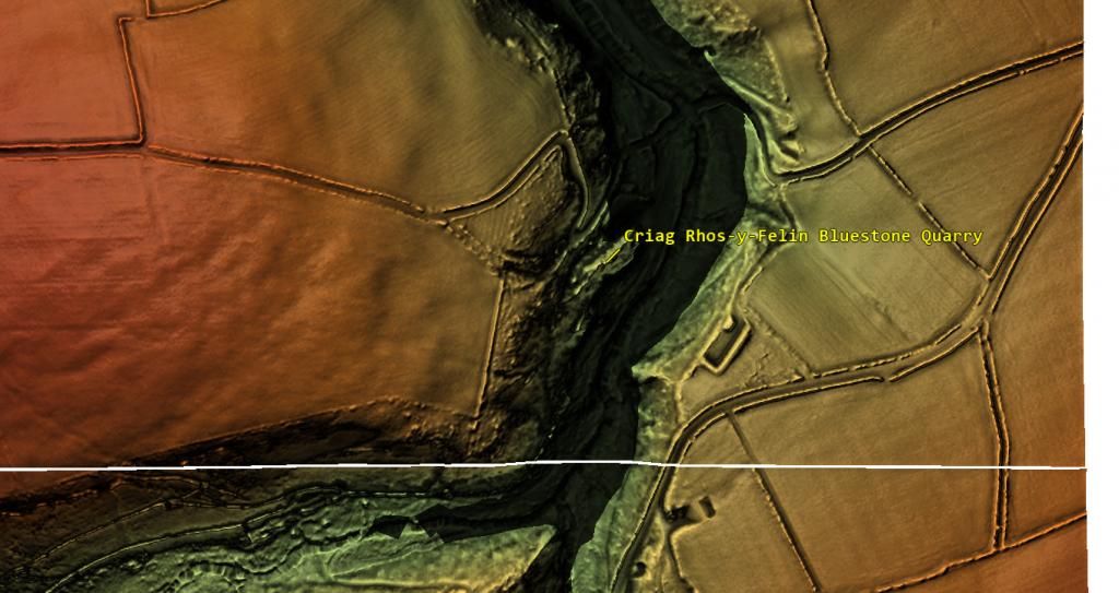
Prescilli Mountains in Wales – The Bluestone Enigma

Craig Rhos-Y-Felin

The publication of the report “Craig Rhos-y-Felin: a Welsh bluestone megalith quarry for Stonehenge” in the December 2016 edition of Antiquity Magazine unveiled intriguing findings about the origins of the bluestones used in Stonehenge. This study, which identified a 4m long monolith at Craig Rhos-y-Felin as microscopically identical to the bluestones at Stonehenge, has sparked significant debate and speculation within the archaeological community and beyond.

Despite the excitement generated by these findings, the report’s focus on two radiocarbon dates that align with the authors’ hypothesis on Stonehenge’s construction date has raised questions about the completeness of the narrative presented to the public. The discrepancy between these dates and the hoped-for evidence led to the speculative suggestion that Stonehenge was originally constructed in Wales and later relocated to Salisbury Plain. This narrative, while intriguing, illustrates the complexities and challenges of interpreting archaeological data, as well as the temptation to fit new evidence into pre-existing hypotheses.

However, a more detailed analysis of the report reveals a wealth of Mesolithic carbon dates obtained from human-made hearths, suggesting a much earlier period of human activity at the site than the two Neolithic dates highlighted. These Mesolithic dates, which significantly predate the construction of Stonehenge as currently understood, were largely overlooked in the public dissemination of the research findings.

The Bluestone Enigma
Quarry Site at Craig Rhos-Y-Felin – The Bluestone Enigma

This oversight raises essential questions about the narrative surrounding Stonehenge’s origins and the methodologies used in archaeological dating. The presence of Mesolithic hearths at Craig Rhos-y-Felin suggests that the site was of importance to human communities thousands of years before the Neolithic period. This evidence challenges the conventional timeline of Stonehenge’s construction and suggests a longer, more complex history of human interaction with the landscape and the bluestones.

Furthermore, the report inadvertently highlights the ongoing debate within archaeology about how best to interpret and present findings to the public. The focus on headline-grabbing narratives, such as the relocation of Stonehenge from Wales, can sometimes overshadow equally significant but less sensational discoveries, such as the evidence of Mesolithic activity at the quarry site.

An Inconvenient TRUTH (Craig Rhos Y Felin)
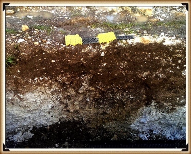
Mesolithic Post Holes at the Old Car Park at Stonehenge – The Bluestone Enigma

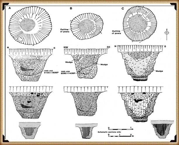
The excavation in 1966 and subsequent discoveries surrounding Stonehenge offer a fascinating and somewhat contentious glimpse into the complex task of accurately dating ancient sites. The initial observations by Lance and Faith Vatcher highlighted the Neolithic character of three holes excavated near Stonehenge, with no datable pottery found. Yet, the characteristics of the holes suggested a Neolithic origin. This assumption was later questioned when a PhD student discovered that the charcoal deposits from these holes, surprisingly composed mostly of pine, could not be Neolithic as initially thought. Pine was believed to be ‘extinct’ in the area by the time of Stonehenge’s supposed construction, according to pollen analysis.

This revelation was startling, especially to the officials of the Historic Buildings and Monuments Commission, later known as English Heritage. The carbon dating of these pine samples placed them squarely in the Mesolithic era, specifically between 8860 to 6590 BCE, challenging the previously accepted timeline for Stonehenge’s construction. Furthermore, the report mentions pine samples from Woodhenge, which, if also Mesolithic, would radically alter our understanding of that site’s age.

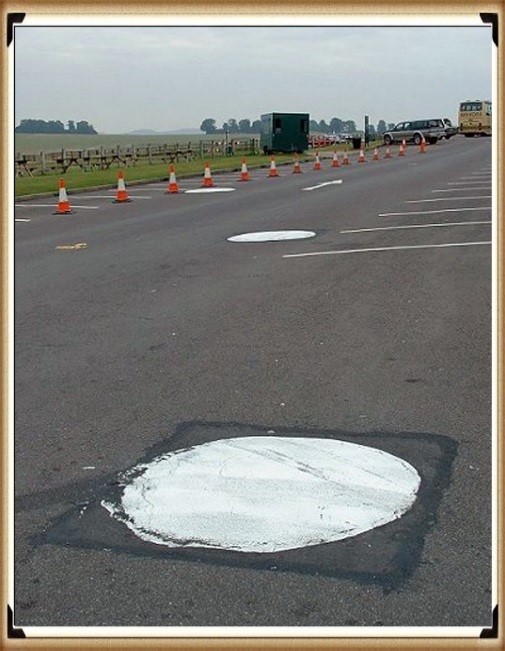
Stonehenge Car Park

Mesolithic Post Holes in Old Car Park – The Bluehenge Enigma

Instead of seizing this opportunity to delve deeper into these findings, a narrative was constructed that dismissed these posts as totem poles from wandering hunter-gatherers, unrelated to Stonehenge. This decision to sideline potentially groundbreaking evidence highlights a reluctance within some parts of the archaeological community to reconsider established narratives, even in the face of new evidence.

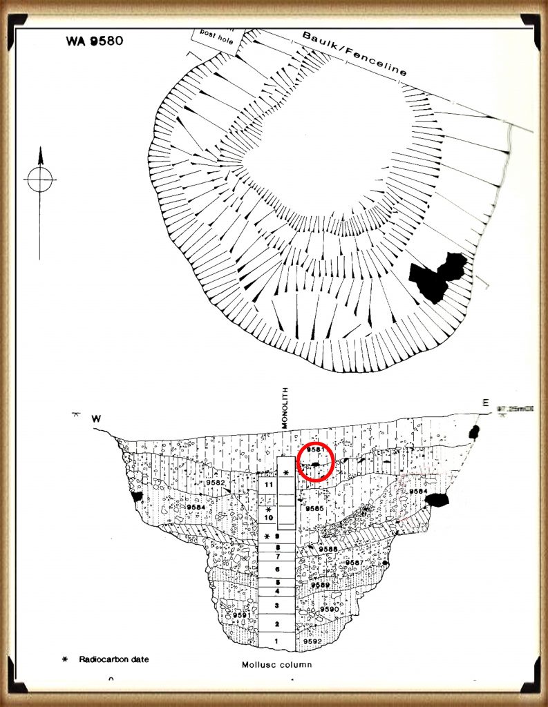
The discovery in 1988-89 by Wessex Archaeology of another Mesolithic post hole, along with a piece of rhyolite dated to 7737 – 7454 BCE, further complicates the timeline for Stonehenge and the surrounding area. This finding should have prompted a reevaluation of the site’s dating. However, attempts to fit this new evidence into the existing narrative of Stonehenge’s construction timeline illustrate the challenges and controversies inherent in archaeological interpretation.

These instances underscore the necessity for openness, curiosity, and a willingness to revise our understanding of history in light of new evidence. They remind us that the story of human history is complex and continually evolving, and our interpretations must adapt as we uncover more about our past.

The Bluestone Enigma
Stone Hole WA9580 shows a piece of Bluestone 5,000 years before they arrived. – The Bluestone Enigma

Discoveries at Stonehenge, including charcoal (OxA-18655) found in the Hole socket of Stone 10, dating to 7330 – 7060 BCE, match the dates of the Mesolithic post holes, with significant implications for our understanding of the site’s history. This evidence, dating to the Mesolithic post holes, suggests that the activities at Stonehenge and its surroundings span much earlier than previously believed. However, the apparent suppression of this news from widespread media coverage raises questions about the narrative presented to the public and in educational materials.

The excavation at Blick Mead, less than a mile from Stonehenge, by the Open University, which uncovered evidence of Mesolithic-period habitation and feasting, further challenges the entrenched views held by some about prehistoric life around Stonehenge. These findings suggest a continuous and significant presence of people in this area during the Mesolithic period, contradicting the simplistic ‘totem pole’ myth still perpetuated in some narratives by English Heritage (EH) through their exhibitions and guidebooks.

Moreover, the recent transformation of the Stonehenge site, including the closure of the B-road past the stones and the relocation of the visitors’ car park to a new, multi-million-pound visitor centre, represents a significant shift in how the site is accessed and experienced by the public. The removal of the old tarmac and the reversion of the land to grass aim to restore a more authentic prehistoric ambience to Stonehenge. This effort to make the site appear more as it did at the time of its construction is commendable, but also highlights the ongoing tension between modern interpretations of the site and the emerging evidence of its ancient past.

These developments at Stonehenge and Blick Mead exemplify the dynamic nature of archaeological research and the complexities involved in interpreting and presenting the past. As new evidence continues to emerge, the narrative of prehistoric Britain needs to evolve accordingly, ensuring a more accurate and nuanced understanding of these ancient landscapes and their significance to human history.

The Bluestone Enigma
In 2008, Stone 10 – Tim Darvill and Geoffrey Wainwright found charcoal dating back to 7330 to 7060 – The Bluestone Enigma

You would indeed think that removing the tarmac from the old visitor car park at Stonehenge, especially given the significant previous findings beneath it, would prompt a comprehensive excavation to unearth more evidence of the site’s Mesolithic history. Such an excavation could potentially transform our understanding of Stonehenge and its origins, providing invaluable insights into its early history and the people who frequented the site during the Mesolithic period.

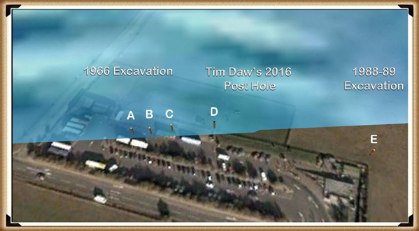
Tim Daw’s role as a warden at Stonehenge, combined with his proactive approach to documenting changes and features of the site through photography, exemplifies the kind of engaged observation that can lead to important discoveries. His finding of patch marks by the central upright stones, indicating the possible positions of missing stones from the Inner Circle, is a testament to the contributions individuals can make to the ongoing investigation of Stonehenge. Daw’s work underscores the value of continuous and attentive observation of archaeological sites, even by those not formally conducting research.

The Bluestone Enigma
Tim Daw’s evidence of yet another Pit in the Old Car Park not investigated! – The Bluehenge Enigma

The discovery of such features and the potential for further findings beneath the former car park area highlights the need for a thorough and systematic archaeological examination whenever opportunities arise. These efforts not only enrich our knowledge of Stonehenge’s past but also contribute to the broader understanding of prehistoric human activity in the region. As we continue to peel back the layers of Stonehenge’s history, each finding adds a piece to the puzzle of this enigmatic monument’s story, emphasising the importance of preserving and exploring our archaeological heritage.

The Bluestone Enigma
The Post Holes would have been on the shoreline of the River Avon in Mesolithic period – The Bluestone Enigma

Tim Daw’s experiences and observations as a warden at Stonehenge, particularly his discovery of additional post holes beneath the old visitor’s car park, highlight the ongoing potential for new findings that can challenge and enrich our understanding of Stonehenge’s history. Despite being warned against publishing his conclusions due to unauthorised blog activity, Daw chose to resign and continue his work, revealing, through ‘unofficial’ pictures, the existence of even more post holes under the car park, aligned with those discovered in 1966.

Bluestone Quarries

These findings, including the newly discovered post hole that aligns with the four others from 1966, support the hypothesis that these structures are situated on what was once the shoreline of the River Avon around 8000 BCE. This suggests that during the Mesolithic period, the stones quarried in Wales could have been transported by boat directly to Stonehenge, navigating along enlarged rivers rather than taking the longer sea route proposed by some archaeologists.

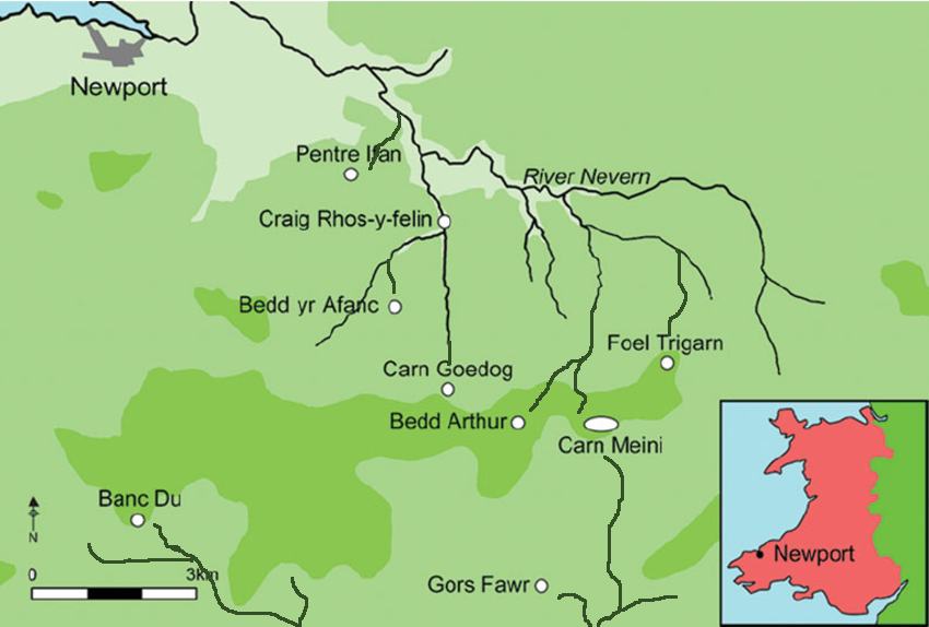
Further complicating the narrative are my analyses of the bluestone structures from other Preseli sites like Carn Goedog and Craig Talfynyydd, which are connected by streams and rivers to the River Nevern. Unfortunately, archaeologists have interpreted this network of waterways primarily through a religious lens rather than considering its practical functionality as a transportation network.

The persistence of the ‘ox-cart’ route theory, which posits a land route along the modern A40, overlooks the logistical challenges posed by the period’s dense woods, swamps, and forests. Such conditions would have made the construction and use of a road system highly impractical, if not impossible.

My critique extends to the inconsistencies and logical inaccuracies in the archaeological narrative, particularly regarding the site layout and geological evidence at Craig Rhos-y-Felin. The assumption that floodwaters in the area were solely the result of ice melt, quickly draining into the sea post-Ice Age, ignores the broader implications of such flooding for the landscape and its inhabitants.

The Bluestone Enigma
Craig Rhos-Y-Felin is on the edge of a gigantic river of the past – The Bluestone Enigma.

We confirm in the report that an old river ran around this quarry as long ago as 5620 – 5460 BCE and possibly as late as 1030 – 910 BCE.

“Most of the site was then covered by a layer of yellow colluvium (035), dated by oak charcoal to 1030–910 cal BC (combine SUERC-46199; 2799±30 BP and SUERC-46203; 2841±28 BP). This deposit is contemporary with the uppermost fill of a palaeochannel of the Brynberian stream that flowed past the northern tip of the outcrop. Charcoal of Corylus and Tilia from the basal fill of this palaeochannel dates to 5800–5640 cal BC (OxA- 32021; 6833±40 BP) and 5620–5460 cal BC (OxA-32022; 6543±37 BP), both at 95.4% probability.”

An Inconvenient TRUTH (Craig Rhos Y Felin)
The only RED hearths in the site are Mesolithic so they must be quarrying at that time – The Bluestone Enigma


The report’s insights suggest that during the Mesolithic Period, an enlarged stream that fed into the River Nevern reached the quarry outcrop rocks. Notably, it was positioned just a few meters away, even as late as 1000 BCE. This geographical configuration suggests that boats were likely the primary means of transporting the large, newly quarried stones to their final destination at Stonehenge, mirroring stone transport methods in other ancient civilisations, such as Egypt.

The site layout at the quarry provides crucial clues about the timing of the stone quarrying. Notably, a single monolith is positioned near the river on the site’s east side, ready for transportation. Nearby, to the south of this monolith, are human-made hearths, precisely where one would expect them to be. However, the challenge arises in dating these hearths as Mesolithic, with three distinct periods identified: 8550 – 8330 BCE; 8220 – 7790 BCE; and 7490 – 7190 BCE. Despite this, the report asserts that there is no evidence of Mesolithic quarrying or working of rhyolite at this site.

This claim overlooks the practical use of tools across different periods. If Mesolithic and Neolithic communities utilised similar tools, distinguishing tool marks from these different periods might be more challenging than the report suggests. Moreover, the presence of these communities at the quarry for over a millennium raises questions about their activities if not quarrying the stones.

The connection between the quarry site and Stonehenge is strengthened by over twenty Carbon-14 dates that align with my hypothesis, in contrast to the mere two samples currently highlighted by experts, which are dated 300 – 500 years older than existing estimates. By analysing these overlapping dates against the latest carbon-dating curve (IntCal20), we can refine the construction date of Stonehenge’s Phase I (the placement of bluestones in the Aubrey holes). By calculating the mean of these probable dates, we aim to obtain a more accurate estimate of when this monumental task was undertaken, potentially rewriting the timeline of one of the world’s most enigmatic prehistoric monuments.

Carbon Dating

StonehengeOld Car Park (Ref. and Date)Craig Rhos-Y-Felin RefCraig Rhos-Y-Felin DatesCarn Goedog Ref & Dates
Post Hole AHAR-455 (8825 – 7742)SUERC-50761
OxA-30507
OxA- 305481
SUERC-51164
SUERC-50760
OxA-30549
SUERC-51165
OxA-30506
OxA-305482
OxA-305062
OxA-30547
OxA-30504
8550 –  8330
8471 – 8285
8286 – 8163
8289 –  8169
8211 – 7955
8238 – 7941
8216 – 7785
8021 – 7792
8122 – 7962
8207 –  8030
8012 – 7711
8281 –  8166
Post Hole BHAR–456 (7377 – 6651)OxA-3050327232 – 7188OxA31823 – 7190 to 6840
WA 9580GU-5109 (8259 – 7742)OxA- 30548
SUERC-51164
SUERC-50760
OxA-30549
SUERC-51165
OxA-30506
OxA-305482
OxA-305062
OxA-30547
OxA-30504
8286 – 8163
8289 – 8169
8211 – 7955
8238 – 7941
8216 – 7785
8021 – 7792
8122 – 7962
8207 –  8030
8012 – 7711
8281 –  8166
WA 9580QxA-4219 (7737 – 7454)Beta-392850
OxA-30547
7944 – 7648
8012 – 7711
OxA-35184 – 7590 to 7380
WA 9580QxA-4220 (7595 – 7178)SUERC-51163
OxA-30523
OxA-3050311
7539 – 7308
7472 – 7182
7485 – 7248
Carbon Dates comparison – note that the sites are linked to different mooring posts, indicating activity dates

Table 1– Matching Carbon Dates

The calculations indicate that work at the quarry began around 8300 BCE, with its main phase of activity around 8000 BCE, and continued for at least a millennium, challenging the conventional narrative about Stonehenge and its Bluestones. This timeline suggests a far more ancient and enduring connection between the quarry site and Stonehenge than previously acknowledged.

Carn Goedog

Initially, Carn Menyn in the Preseli Hills was believed to be the source of Stonehenge’s spotted dolerite, but later analysis pinpointed Carn Goedog as a closer chemical match. Recent geochemical studies have divided the Stonehenge spotted dolerite into two main groups, with one group closely matching the Carn Goedog outcrop. The origin of the second group remains uncertain, potentially deriving from Carn Goedog or nearby outcrops.

Further geological investigations at Stonehenge have identified additional sources for its bluestones. Unspotted dolerite matches with outcrops at Cerrigmarchogion and Craig Talfynydd on the Preseli ridge. Another bluestone variety, “rhyolite with fabric,” traces back to Craig Rhos-y-Felin, while a source of Lower Palaeozoic sandstone has been identified north of the Preseli hills. The origin of volcanic tuffs found at Stonehenge also likely lies in the Preseli area.

Preseli Mountains and Quarry Sites are ALL by rivers – The Bluestone Enigma

Surface indications of post-medieval Quarrying, particularly on its south side, have evidenced Carn Goedog’s accessibility. This historical quarrying, distinguishable by cylindrical drill holes on some quarried blocks at the outcrop’s base, was performed using the ‘plug-and-feather’ technique with metal wedges. The discovery of a worn trade token beneath one of these blocks helps date this activity to around 1800.

In 2014, test trenching along the southern edge of Carn Goedog revealed layers of human activity spanning various periods, from the recent centuries in trench 3 to deeper prehistorical layers in trench 2. Trench 1, strategically positioned at the outcrop’s base and just beyond the eastern limit of the early modern quarry debris, was particularly significant. It was seen as offering a unique opportunity to uncover evidence of prehistoric quarrying that hadn’t been disturbed by later activities.

This layered historical context at Carn Goedog is crucial for understanding the complex human interactions with the site over millennia. The evidence for prehistoric quarrying, undisturbed by later post-medieval activity, provides invaluable insights into the methods and technologies used by ancient peoples to extract and transport the stones that contributed to the construction of monumental structures like Stonehenge.

The Bluestone Enigma
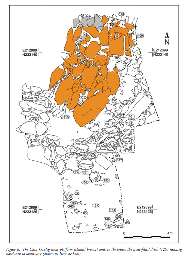
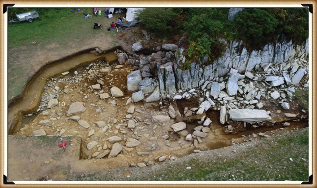
Plan of Excavation 106 is the hearth – The Bluestone Enigma.

Trench 1 was enlarged in 2015 and 2016 to reveal features that may relate to prehistoric quarrying activity. At the southern foot of the outcrop, excavation revealed an artificial platform of flat slabs—many of them split—laid (with the split faces upwards) in a tongue-shaped formation 10m north–south by at least 8m east–west (Figure 6).

Those slabs lying against the face of the outcrop had been pressed into the underlying sediments, presumably by the weight of pillars lowered onto the platform. The platform terminates from the outcrop with a vertical drop of 0.9m to the ground surface beyond. This platform is stratigraphically earlier than a series of deposits that included early modern quarrying debris and hearths of the Roman and medieval periods. One hearth (Figure 6: 105) set within a gap in the platform where a slab had been removed produced charcoal dating to 7190–6840 cal BC (8091±38 BP) and 2890–2630 cal BC (4164±30 BP) (Table 1).

Bluestone Enigma
Bluestone Enigma


The findings across the quarry sites, including Carn Goedog and Craig Rhos-y-Felin, point to a nuanced understanding of how the bluestones were utilised and replenished at Stonehenge. The hearths discovered at these sites, particularly those dating to the Mesolithic and Neolithic periods, suggest ongoing human activity and potentially organised efforts to quarry and transport bluestones over extended periods. This insight challenges the conventional explanation that the transportation of Bluestones to Stonehenge was a singular event.

The Stonehenge Layer

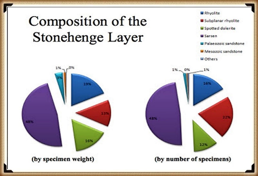
The evidence of modern quarrying at both the northern and southern ends of these sites and the dates from central hearths align with observations made at Craig Rhos-y-felin. Our research, as outlined in published books, supports the theory that ancestors chipped bluestones at Stonehenge for healing, utilising the water in the ditch to bathe their sickness away, as evidenced by the ‘Stonehenge Layer’ discovered by Dervill and Wainwright in 2008. This practice would naturally lead to the depletion of bluestones over time, necessitating periodic replenishment from the quarries.

The conventional narrative, which posits that the bluestones were transported to Stonehenge in a one-off event, needs to account for the scientific data emerging from these quarry sites and the Stonehenge site. The evidence suggests a more complex interaction with these stones, involving repeated quarrying and transportation activities that likely spanned centuries. This ongoing relationship with the bluestones reflects a deeper functional connection to them, underscoring the importance of revisiting and revising our understanding of Stonehenge’s construction and the role of the bluestones within this prehistoric monument.

English Heritage’s significant investment in the Stonehenge Visitors Centre, including the creation of exhibitions that present established theories about the monument’s origins and functions, raises questions about the implications of discoveries that contradict these narratives. If foundational assumptions about Stonehenge are proven incorrect, it could have financial repercussions, particularly if the narrative presented to the public through expensive exhibitions becomes outdated or inaccurate. This situation underscores the complex relationship between archaeological research, public interpretation, and financial investments in heritage sites.

PodCast

Author’s Biography

Robert John Langdon, a polymathic luminary, emerges as a writer, historian, and eminent specialist in LiDAR Landscape Archaeology.

His intellectual voyage has been interwoven with stints as an astute scrutineer in government and grand corporate bastions, a tapestry spanning British Telecommunications, Cable and Wireless, British Gas, and the esteemed University of London.

A decade hence, Robert’s transition into retirement unfurled a chapter of insatiable curiosity. This phase saw him immerse himself in Politics, Archaeology, Philosophy, and the enigmatic realm of Quantum Mechanics. His academic odyssey traversed the venerable corridors of knowledge hubs such as the Museum of London, University College London, Birkbeck College, The City Literature Institute, and Chichester University.

In the symphony of his life, Robert is a custodian of three progeny and a pair of cherished grandchildren. His sanctuary lies ensconced in the embrace of West Wales, where he inhabits an isolated cottage, its windows framing a vista of the boundless sea – a retreat from the scrutinising gaze of Her Majesty’s Revenue and Customs, an amiable clandestinity in the lap of nature.

Exploring Prehistoric Britain: A Journey Through Time

My blog delves into the fascinating mysteries of prehistoric Britain, challenging conventional narratives and offering fresh perspectives grounded in cutting-edge research, particularly LiDAR technology. I invite you to explore some key areas of my research. For example, the Wansdyke, often cited as a defensive structure, is re-examined in light of new evidence. I’ve presented my findings in my blog post Wansdyke: A British Frontier Wall – ‘Debunked’, and a Wansdyke LiDAR Flyover video further visualises my conclusions.

My work also often challenges established archaeological dogma. I argue that many sites, such as Hambledon Hill, commonly identified as Iron Age hillforts, are not what they seem. My posts Lidar Investigation Hambledon Hill – NOT an ‘Iron Age Fort’ and Unmasking the “Iron Age Hillfort” Myth explore these ideas in detail and offer an alternative view. Similarly, sites like Cissbury Ring and White Sheet Camp receive re-evaluations based on LiDAR analysis in my posts “Lidar Investigation Cissbury Ring through time” and “Lidar Investigation White Sheet Camp,“ revealing fascinating insights into their true purpose. I have also examined South Cadbury Castle, often linked to the mythical Camelot56.

My research also extends to ancient water management, including the role of canals and other linear earthworks. I have discussed the true origins of Car Dyke in multiple posts, including Car Dyke – ABC News Podcast and Lidar Investigation Car Dyke – North Section, which suggest a Mesolithic origin 2357. I also explore the misidentification of Roman aqueducts, as seen in my posts on the Great Chesters (Roman) Aqueduct. My research has also been greatly informed by my post-glacial flooding hypothesis, which has helped explain landscape transformations over time. I have discussed this hypothesis in several posts, including AI now supports my Post-Glacial Flooding Hypothesis and Exploring Britain’s Flooded Past: A Personal Journey

Finally, my blog also investigates prehistoric burial practices, as seen in Prehistoric Burial Practices of Britain and explores the mystery of Pillow Mounds, often mistaken for medieval rabbit warrens, but with a potential link to Bronze Age cremation in my posts: Pillow Mounds: A Bronze Age Legacy of Cremation? and The Mystery of Pillow Mounds: Are They Really Medieval Rabbit Warrens?. My research also includes astronomical insights into ancient sites, for example, in Rediscovering the Winter Solstice: The Original Winter Festival. I also review new information about the construction of Stonehenge in The Stonehenge Enigma.

Further Reading

For those interested in British Prehistory, visit www.prehistoric-britain.co.uk, a comprehensive resource featuring an extensive collection of archaeology articles, modern LiDAR investigations, and groundbreaking research. The site also includes insights and excerpts from the acclaimed Robert John Langdon Trilogy, a series of books that explore Britain during the Prehistoric period. Titles in the trilogy include The Stonehenge Enigma, Dawn of the Lost Civilisation, and The Post-Glacial Flooding Hypothesis, which offer compelling evidence of ancient landscapes shaped by post-glacial flooding.

To further explore these topics, Robert John Langdon has developed a dedicated YouTube channel featuring over 100 video documentaries and investigations that complement the trilogy. Notable discoveries and studies showcased on the channel include 13 Things that Don’t Make Sense in History and the revelation of Silbury Avenue – The Lost Stone Avenue, a rediscovered prehistoric feature at Avebury, Wiltshire.

In addition to his main works, Langdon has released a series of shorter, accessible publications, ideal for readers delving into specific topics. These include:

For active discussions and updates on the trilogy’s findings and recent LiDAR investigations, join our vibrant community on Facebook. Engage with like-minded enthusiasts by leaving a message or contributing to debates in our Facebook Group.

Whether through the books, the website, or interactive videos, we aim to provide a deeper understanding of Britain’s fascinating prehistoric past. We encourage you to explore these resources and uncover the mysteries of ancient landscapes through the lens of modern archaeology.

For more information, including chapter extracts and related publications, visit the Robert John Langdon Author Page. Dive into works such as The Stonehenge Enigma or Dawn of the Lost Civilisation, and explore cutting-edge theories that challenge traditional historical narratives.

Other Blogs

[sitemap_posts]
The “Hunter-Gatherer” Myth: Why It’s Time to Bury This Outdated Term

Introduction

Take a moment to picture the average Mesolithic person. What do you see? A ragged figure chasing deer with a spear? A nomad trudging through the forest with a handful of berries? If so, you’ve been sold a myth—a neatly packaged academic fiction known as the “hunter-gatherer.” (The “Hunter-Gatherer” Myth)

It’s time we dismantled it.

The “Hunter-Gatherer” Myth

🔍 Where Did the Term Even Come From?

The label “hunter-gatherer” was coined during the golden age of Victorian anthropology—a time when white men in waistcoats sat in armchairs and categorised human beings into “stages of civilisation.” Their goal? To show how clever and advanced they were by comparison.

They invented a ladder:
• Savagery → Barbarism → Civilisation

And guess who got shoved on the bottom rung? That’s right—any group that didn’t build cities, write in Latin, or farm wheat in rows. The phrase “hunter-gatherer” was born not out of evidence, but out of elitist ideology. It was never meant to explain—it was meant to dismiss.

The “Hunter-Gatherer” Myth

🧱 The House of Cards Begins to Wobble

For decades, the term held firm. Archaeologists casually applied it to all Mesolithic peoples—especially in Britain. They painted a picture of small, mobile bands who survived hand-to-mouth in a wild, untouched land.

But bit by bit, the evidence started punching holes in the story.

• Timber homes and platforms built along rivers and wetlands show long-term habitation and planning.
• Langdale axe-stone was being quarried, shaped, and traded across Britain.
• Obsidian, jet, shells, and ochre were transported over continental distances.
• And most damning of all: boats—used to travel, trade, and connect.

As for the old narratives? They fall apart under scrutiny. Take the supposed “ritual deer masks” of Star Carr—likely just toys or ornaments, given their small size and awkward construction. But rather than rethink their assumptions, many archaeologists default to religious fantasy or shamanic mysticism to avoid confronting a more practical, intelligent society.

The “Hunter-Gatherer” Myth

⛵ Mesolithic Britain Was a Trading Superhighway

Let’s be blunt: you don’t trade obsidian across the Alps or Langdale axes across Britain by wandering aimlessly through the woods. You need:
• Logistics
• Navigation
• Shipbuilding
• And a network

The North Sea and the Channel were not barriers—they were highways. The Mesolithic was maritime.
Fisherfolk became traders. River systems became arterial routes. Trade wasn’t just present—it was foundational.

Yet archaeologists kept repeating “hunter-gatherer” as if these people were somehow less than.

The “Hunter-Gatherer” Myth

❌ Why the Term No Longer Works (and Never Really Did)

Let’s break down why “hunter-gatherer” is not just inaccurate—it’s insulting.

What It ImpliesWhat the Evidence Shows
They wandered aimlesslyThey returned seasonally to established settlements
They lived hand-to-mouthThey had surplus and storage systems
They were isolatedThey traded across hundreds of miles
They lived in temporary sheltersThey built homes, platforms, even causeways
They were simple and passiveThey were engineers, navigators, and diplomats and built megalithic structures

In recent decades, the problem has only worsened. Instead of retiring the term, archaeologists have stretched it—shoehorning in entirely different societies to keep the “hunter-gatherer” model alive. When the evidence for permanent homes, complex structures, or monumental building surfaces (as with the megalithic builders), the explanation is now: “seasonal use.” That term has become a get-out clause—used to explain away the absence of houses while clinging to the myth of nomadism.

What we’re left with is a linguistic mess. “Hunter-gatherer” now means everything and nothing. It includes boatbuilders, ritual architects, and regional traders, but still implies simplicity and mobility. It’s a label too blunt for the evidence we have—and too convenient for the questions archaeologists aren’t willing to ask.

The most striking irony? The term is supposedly abandoned the moment “farmers” arrive in Britain around 4000 BCE. As if a new population suddenly appears and rewrites the story overnight. But the data doesn’t support that. The continuity of settlement, culture, and trade points not to a replacement—but an evolution. Which means the old label was never fit for purpose in the first place.

The “Hunter-Gatherer” Myth

🗣️ What Should We Say Instead?

We need new language. Not just a new box—but no box at all. Context is key.

A few alternatives:
• Maritime Mesolithic communities
• Pre-agrarian traders
• Aquatic resource managers
• Coastal navigators of post-glacial Europe

Better still? Just name the culture or region and describe their actual behaviour. “The people of the Severn Estuary were expert canoe traders who built seasonal fish traps and settled floodplain islands.” Simple. Honest. Accurate.

The “Hunter-Gatherer” Myth

🧠 The Real Damage of Lazy Labels

Words shape thought. If you call someone a “hunter-gatherer,” you’re not just describing their diet—you’re defining their worth, their place in history, and how much respect they get from future generations.

And this term? It’s robbed Mesolithic people of the credit they deserve.

• They weren’t dumb.
• They weren’t backward.
• And they weren’t primitive.

They were adaptable, intelligent, and strategic—surviving and thriving in a flooded, shifting landscape using boats, trade, and ingenuity.

The “Hunter-Gatherer” Myth

🚫 Let’s Retire the Term—For Good

It’s time to stop repeating outdated myths. The archaeological record is clear: Britain’s Mesolithic people were not passive foragers—they were active architects of their world, navigating a post-glacial continent using waterways, knowledge, and exchange.

So next time someone says “hunter-gatherers,” ask them this:
Do you mean the boatbuilders? The traders? The engineers?
Or are you still living in 1877?

PodCast

Silbury Avenue - Avebury's First Stone Avenue

Author’s Biography

Robert John Langdon, a polymathic luminary, emerges as a writer, historian, and eminent specialist in LiDAR Landscape Archaeology.

His intellectual voyage has interwoven with stints as an astute scrutineer for governmental realms and grand corporate bastions, a tapestry spanning British Telecommunications, Cable and Wireless, British Gas, and the esteemed University of London.

A decade hence, Robert’s transition into retirement unfurled a chapter of insatiable curiosity. This phase saw him immerse himself in Politics, Archaeology, Philosophy, and the enigmatic realm of Quantum Mechanics. His academic odyssey traversed the venerable corridors of knowledge hubs such as the Museum of London, University College London, Birkbeck College, The City Literature Institute, and Chichester University.

In the symphony of his life, Robert is a custodian of three progeny and a pair of cherished grandchildren. His sanctuary lies ensconced in the embrace of West Wales, where he inhabits an isolated cottage, its windows framing a vista of the boundless sea – a retreat from the scrutinous gaze of the Her Majesty’s Revenue and Customs, an amiable clandestinity in the lap of nature’s embrace.

(The Stonehenge Code)

Exploring Prehistoric Britain: A Journey Through Time

My blog delves into the fascinating mysteries of prehistoric Britain, challenging conventional narratives and offering fresh perspectives based on cutting-edge research, particularly using LiDAR technology. I invite you to explore some key areas of my research. For example, the Wansdyke, often cited as a defensive structure, is re-examined in light of new evidence. I’ve presented my findings in my blog post Wansdyke: A British Frontier Wall – ‘Debunked’, and a Wansdyke LiDAR Flyover video further visualizes my conclusions.

My work also often challenges established archaeological dogma. I argue that many sites, such as Hambledon Hill, commonly identified as Iron Age hillforts are not what they seem. My posts Lidar Investigation Hambledon Hill – NOT an ‘Iron Age Fort’ and Unmasking the “Iron Age Hillfort” Myth explore these ideas in detail and offer an alternative view. Similarly, sites like Cissbury Ring and White Sheet Camp, also receive a re-evaluation based on LiDAR analysis in my posts Lidar Investigation Cissbury Ring through time and Lidar Investigation White Sheet Camp, revealing fascinating insights into their true purpose. I have also examined South Cadbury Castle, often linked to the mythical Camelot56.

My research also extends to the topic of ancient water management, including the role of canals and other linear earthworks. I have discussed the true origins of Car Dyke in multiple posts including Car Dyke – ABC News PodCast and Lidar Investigation Car Dyke – North Section, suggesting a Mesolithic origin2357. I also explore the misidentification of Roman aqueducts, as seen in my posts on the Great Chesters (Roman) Aqueduct. My research has also been greatly informed by my post-glacial flooding hypothesis which has helped to inform the landscape transformations over time. I have discussed this hypothesis in several posts including AI now supports my Post-Glacial Flooding Hypothesis and Exploring Britain’s Flooded Past: A Personal Journey

Finally, my blog also investigates prehistoric burial practices, as seen in Prehistoric Burial Practices of Britain and explores the mystery of Pillow Mounds, often mistaken for medieval rabbit warrens, but with a potential link to Bronze Age cremation in my posts: Pillow Mounds: A Bronze Age Legacy of Cremation? and The Mystery of Pillow Mounds: Are They Really Medieval Rabbit Warrens?. My research also includes the astronomical insights of ancient sites, for example, in Rediscovering the Winter Solstice: The Original Winter Festival. I also review new information about the construction of Stonehenge in The Stonehenge Enigma.

Further Reading

For those interested in British Prehistory, visit www.prehistoric-britain.co.uk, a comprehensive resource featuring an extensive collection of archaeology articles, modern LiDAR investigations, and groundbreaking research. The site also includes insights and extracts from the acclaimed Robert John Langdon Trilogy, a series of books exploring Britain during the Prehistoric period. Titles in the trilogy include The Stonehenge Enigma, Dawn of the Lost Civilisation, and The Post Glacial Flooding Hypothesis, offering compelling evidence about ancient landscapes shaped by post-glacial flooding.

To further explore these topics, Robert John Langdon has developed a dedicated YouTube channel featuring over 100 video documentaries and investigations that complement the trilogy. Notable discoveries and studies showcased on the channel include 13 Things that Don’t Make Sense in History and the revelation of Silbury Avenue – The Lost Stone Avenue, a rediscovered prehistoric feature at Avebury, Wiltshire.

In addition to his main works, Langdon has released a series of shorter, accessible publications, ideal for readers delving into specific topics. These include:

For active discussions and updates on the trilogy’s findings and recent LiDAR investigations, join our vibrant community on Facebook. Engage with like-minded enthusiasts by leaving a message or contributing to debates in our Facebook Group.

Whether through the books, the website, or interactive videos, we aim to provide a deeper understanding of Britain’s fascinating prehistoric past. We encourage you to explore these resources and uncover the mysteries of ancient landscapes through the lens of modern archaeology.

For more information, including chapter extracts and related publications, visit the Robert John Langdon Author Page. Dive into works such as The Stonehenge Enigma or Dawn of the Lost Civilisation, and explore cutting-edge theories that challenge traditional historical narratives.

Other Blogs

[sitemap_posts]
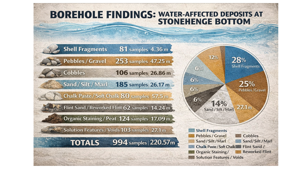
Ivory Tower Collapse: How Academia Abandoned Society – and Took Education, Innovation, and Archaeology Down With It

Introduction:

Once seen as the guardians of progress and truth, our universities have now become detached fortresses — insulated from economic reality, unaccountable to public need, and increasingly irrelevant to the challenges they claim to address.

Instead of saving us from economic decline, social division, and failing education — academia has accelerated these crises through poor management, obsession with internal metrics, and a stubborn refusal to engage with innovation or the real world.

And nowhere is this failure more visible than in the slow suffocation of scientific disciplines like archaeology — now little more than a sandbox for ritual theories, self-referential papers, and tenure-chasing conformity. (How Academia Abandoned Society)


1. Academia’s Betrayal of Purpose

Referencing:
What Are We Good For? – Transforming Society

Academia was meant to be society’s think tank — a crucible for solving the great problems of our time. Instead, most modern academics:

  • Avoid the messy realities of policymaking or enterprise.
  • Prioritise journal metrics over practical outcomes.
  • Retreat into specialist silos, increasingly unreadable even to fellow academics.

Rather than challenge failing systems, they enable them through polite conformity and funding dependency.(How Academia Abandoned Society)

(How Academia Abandoned Society)

2. Universities as Debt Machines, Not Learning Institutions

Referencing:
University Crisis Demands a Complete Reboot – The Times

We were promised education as the golden ticket. What we got instead:

  • £50,000 debts for degrees that don’t deliver.
  • Admin-heavy institutions that divert funding from actual teaching.
  • Graduates pouring out with paper credentials but little practical skill — ending up underemployed, disillusioned, and still paying rent to the people who failed them.

Universities have become degree mills, selling “success” on credit, while absolving themselves of responsibility when reality knocks. (How Academia Abandoned Society)


3. Mismanagement Disguised as Meritocracy

Referencing:
How Management Academics Locked Themselves in an Iron Cage – Global Focus Magazine

The modern university is run less like an educational institution and more like a bloated consultancy firm, helmed by:

  • Academics turned administrators, with no real-world governance experience.
  • Part-educated managers obsessed with “strategy decks” and PowerPoints.
  • Cultures that reward safety and consensus over creativity or challenge.

Result? Conformity masquerading as scholarship, and regression disguised as tradition. (How Academia Abandoned Society)

(How Academia Abandoned Society)

4. The Economic Slump They Didn’t See Coming

Referencing:
Pull Britain Out of the Normie Doom Spiral – The Times

Let’s be blunt — the academics didn’t save us from economic stagnation. Many championed the very policies that contributed to it:

  • Over-credentialisation (degree inflation),
  • Downplaying vocational training,
  • Obsession with theory over innovation.

The truth? Most universities are no longer producing inventors, thinkers, or leaders — but clerks of a broken system. (How Academia Abandoned Society)


5. Archaeology: From Scientific Discipline to Storytelling Seminar

Referencing:

  • [Langdon, R.J. – The Post-Glacial Flooding Hypothesis]
  • OSL/LiDAR studies, EH oversight, unpublished hydrological data.

In no field is the rot more obvious than in archaeology, once a pioneering blend of earth sciences, hydrology, radiocarbon dating, geochemistry, and comparative anthropology. Today?

  • It has devolved into a storytelling discipline — more interested in interpretive dance around “ritual” than in hard evidence.
  • The scientific method has been displaced by literary analysis, with subjective speculation passed off as theory.
  • Worse still, new evidence is actively resisted — especially when it threatens comfortable narratives, tenured positions, or decades-old publications still on university reading lists.

Take LiDAR, for example. You’d think a tool that reveals thousands of previously undocumented prehistoric features across Britain would be welcomed. But no — because it wasn’t unearthed with a trowel by someone with the right initials, it’s often ignored or dismissed outright.

Even more absurd is the continued fetishisation of antler picks, “causewayed enclosures,” and Mesolithic postholes, used to prop up linear, outdated models of Neolithic development that crumble under scrutiny from:

  • OSL (Optically Stimulated Luminescence) dating,
  • Isotopic sourcing,
  • Floodplain regression models,
  • And maritime trade route simulations.

But don’t expect peer review to fix that. The academic gatekeeping system:

  • Relies on old-guard referees with vested interests,
  • Dismisses independent researchers (however well evidenced),
  • And blacklists journals or presses that break ranks.

This is not science. This is career maintenance disguised as scholarship. And it’s strangling progress.

(How Academia Abandoned Society)

🔍 Langdon’s Law:

“If a theory requires ignoring LiDAR, hydrology, carbon dating, and maritime logistics — it’s not archaeology. It’s fan fiction with soil samples.”


Conclusion: From Lighthouse to Lifeboat

The modern university should have been a lighthouse for society. Instead, it’s become a leaking lifeboat, captained by out-of-touch theorists and failed bureaucrats, waving credentials while steering into the iceberg.

We don’t need more qualifications. We need qualified people — trained to think clearly, build boldly, and challenge systems. That won’t come from within academia as it stands. It must come from outside, with real-world thinkers, innovators, and independent researchers willing to challenge the polite silence of decline.

(How Academia Abandoned Society)

Exploring Prehistoric Britain: A Journey Through Time

My blog delves into the fascinating mysteries of prehistoric Britain, challenging conventional narratives and offering fresh perspectives based on cutting-edge research, particularly using LiDAR technology. I invite you to explore some key areas of my research. For example, the Wansdyke, often cited as a defensive structure, is re-examined in light of new evidence. I’ve presented my findings in my blog post Wansdyke: A British Frontier Wall – ‘Debunked’, and a Wansdyke LiDAR Flyover video further visualizes my conclusions.

My work also often challenges established archaeological dogma. I argue that many sites, such as Hambledon Hill, commonly identified as Iron Age hillforts are not what they seem. My posts Lidar Investigation Hambledon Hill – NOT an ‘Iron Age Fort’ and Unmasking the “Iron Age Hillfort” Myth explore these ideas in detail and offer an alternative view. Similarly, sites like Cissbury Ring and White Sheet Camp, also receive a re-evaluation based on LiDAR analysis in my posts Lidar Investigation Cissbury Ring through time and Lidar Investigation White Sheet Camp, revealing fascinating insights into their true purpose. I have also examined South Cadbury Castle, often linked to the mythical Camelot56.

My research also extends to the topic of ancient water management, including the role of canals and other linear earthworks. I have discussed the true origins of Car Dyke in multiple posts including Car Dyke – ABC News PodCast and Lidar Investigation Car Dyke – North Section, suggesting a Mesolithic origin2357. I also explore the misidentification of Roman aqueducts, as seen in my posts on the Great Chesters (Roman) Aqueduct. My research has also been greatly informed by my post-glacial flooding hypothesis which has helped to inform the landscape transformations over time. I have discussed this hypothesis in several posts including AI now supports my Post-Glacial Flooding Hypothesis and Exploring Britain’s Flooded Past: A Personal Journey

Finally, my blog also investigates prehistoric burial practices, as seen in Prehistoric Burial Practices of Britain and explores the mystery of Pillow Mounds, often mistaken for medieval rabbit warrens, but with a potential link to Bronze Age cremation in my posts: Pillow Mounds: A Bronze Age Legacy of Cremation? and The Mystery of Pillow Mounds: Are They Really Medieval Rabbit Warrens?. My research also includes the astronomical insights of ancient sites, for example, in Rediscovering the Winter Solstice: The Original Winter Festival. I also review new information about the construction of Stonehenge in The Stonehenge Enigma. (Rhône to Wansdyke).

Further Reading

For those interested in British Prehistory, visit www.prehistoric-britain.co.uk, a comprehensive resource featuring an extensive collection of archaeology articles, modern LiDAR investigations, and groundbreaking research. The site also includes insights and extracts from the acclaimed Robert John Langdon Trilogy, a series of books exploring Britain during the Prehistoric period. Titles in the trilogy include The Stonehenge Enigma, Dawn of the Lost Civilisation, and The Post Glacial Flooding Hypothesis, offering compelling evidence about ancient landscapes shaped by post-glacial flooding.

To further explore these topics, Robert John Langdon has developed a dedicated YouTube channel featuring over 100 video documentaries and investigations that complement the trilogy. Notable discoveries and studies showcased on the channel include 13 Things that Don’t Make Sense in History and the revelation of Silbury Avenue – The Lost Stone Avenue, a rediscovered prehistoric feature at Avebury, Wiltshire. (Rhône to Wansdyke).

In addition to his main works, Langdon has released a series of shorter, accessible publications, ideal for readers delving into specific topics. These include:

For active discussions and updates on the trilogy’s findings and recent LiDAR investigations, join our vibrant community on Facebook. Engage with like-minded enthusiasts by leaving a message or contributing to debates in our Facebook Group.

Whether through the books, the website, or interactive videos, we aim to provide a deeper understanding of Britain’s fascinating prehistoric past. We encourage you to explore these resources and uncover the mysteries of ancient landscapes through the lens of modern archaeology.

For more information, including chapter extracts and related publications, visit the Robert John Langdon Author Page. Dive into works such as The Stonehenge Enigma or Dawn of the Lost Civilisation, and explore cutting-edge theories that challenge traditional historical narratives. (Rhône to Wansdyke).

Other Blogs

[sitemap_posts]