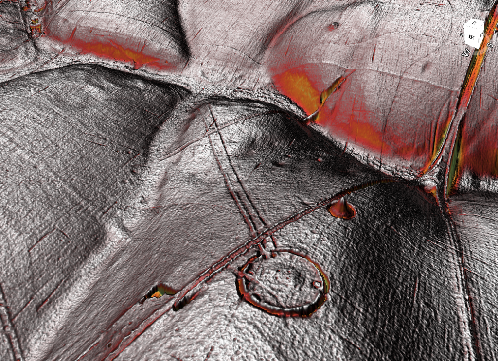
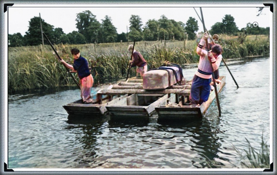
The Stonehenge Enigma: Part 1/6

The Archaeological Evidence – Book Extract

The Post-Glacial Flooding Hypothesis

Chapter 4

What the Early Excavations Found

Long before modern geological surveys were conducted, archaeologists had already begun investigating the interior of the Stonehenge enclosure. Between 1919 and 1926 Lieutenant-Colonel William Hawley carried out the first systematic excavations of the monument. His work was followed by later investigations, most notably those directed by Richard Atkinson during the mid-twentieth century. (The Stonehenge Enigma; The Archaeological Evidence)

These excavations were primarily concerned with understanding the monument’s construction sequence. Trenches were opened across the ditch, around the stone settings, and within many of the features that form the complex layout of Stonehenge. The discoveries made during these investigations established much of the archaeological framework that is still used to interpret the monument today.

However, the excavation reports also contain numerous observations on the soil, sediments, and fills encountered during excavation. At the time, these descriptions were simply recorded as part of the archaeological record. In hindsight, some of these observations provide important clues about the environmental conditions that existed at the site.

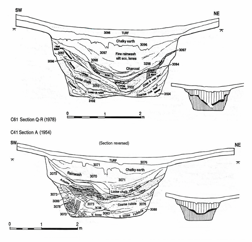
One of the most striking features uncovered during the early excavations was the nature of the ditch surrounding the monument. Rather than being cut into solid chalk alone, the ditch contained a mixture of chalk rubble, silts, and other sediments that had accumulated within it after its construction.
(The Stonehenge Enigma; The Archaeological Evidence)

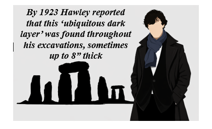
Figure 5 – Hawley’s Ditch Excavations and the ‘Dark Layer’

In places, the lower fills of the ditch were described as soft chalk slurry and silty deposits, suggesting that water had been present within the feature at various times. Such conditions can occur when rainwater or groundwater collects within excavated hollows, gradually depositing fine sediments as the water settles.

Similar observations were made in other features within the monument. Some excavated pits and holes contained deposits of fine silt and mixed sediments, rather than the simple collapse of chalk rubble that might be expected in a completely dry environment.

These details attracted relatively little attention at the time because the primary goal of the excavations was to establish the chronology of the monument rather than reconstruct its environmental setting. Nevertheless, the descriptions recorded in the excavation reports remain valuable pieces of evidence.

When viewed alongside the geological evidence discussed in the previous chapter, these archaeological observations begin to take on a new significance. Features that were once interpreted simply as construction cuts or refuse deposits may also reflect the interaction between the monument and the surrounding hydrological environment.
(The Stonehenge Enigma; The Archaeological Evidence)

In other words, the excavations did not merely reveal the architecture of Stonehenge; they also recorded traces of the landscape conditions in which the monument once stood.

The importance of this relationship between archaeology and environment becomes clearer when the wider Stonehenge landscape is considered. The monument was not an isolated structure but part of a much larger complex of earthworks, avenues, and associated sites that extend across the surrounding countryside.

Understanding how these features relate to one another requires us to look beyond the excavation trenches and examine the broader landscape in which Stonehenge was built.
(The Stonehenge Enigma; The Archaeological Evidence)

For full information see our blog: https://prehistoric-britain.co.uk/the-great-stonehenge-hoax

Chapter 5

The Earthwork Enclosure

The Excavation Record

The earliest structural feature at Stonehenge is the circular earthwork enclosure that surrounds the monument. This enclosure consists of a ditch approximately 100 metres in diameter, with an internal bank formed from the chalk removed during its excavation.

The first systematic investigation of this feature was carried out by Lieutenant-Colonel William Hawley between 1919 and 1926. Hawley opened several trenches across the ditch and bank in order to understand how the monument had been constructed. His excavations confirmed that the ditch had been cut directly into the natural chalk bedrock that underlies Salisbury Plain.

Hawley recorded the ditch as being roughly 6–7 metres wide and up to 2 metres deep, with a steep inner face and a more gradual outer slope. The chalk removed from the ditch had been thrown inward to form the surrounding bank, creating the circular boundary that still defines the monument today.

Later excavations and reassessments of Hawley’s work confirmed that this enclosure represents the earliest construction phase of the monument. The circular earthwork established the basic layout of the site, around which later features—including the stone settings—were arranged.

While the purpose of the ditch and bank has often been interpreted simply as a boundary marker, the excavation reports contain several observations about the ditch fills that deserve closer examination.
(The Stonehenge Enigma; The Archaeological Evidence)
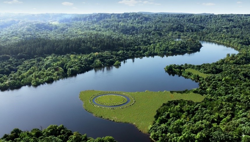
Figure 6 – Phase 1 started with a ditch and bank

Physical Characteristics of the Ditch

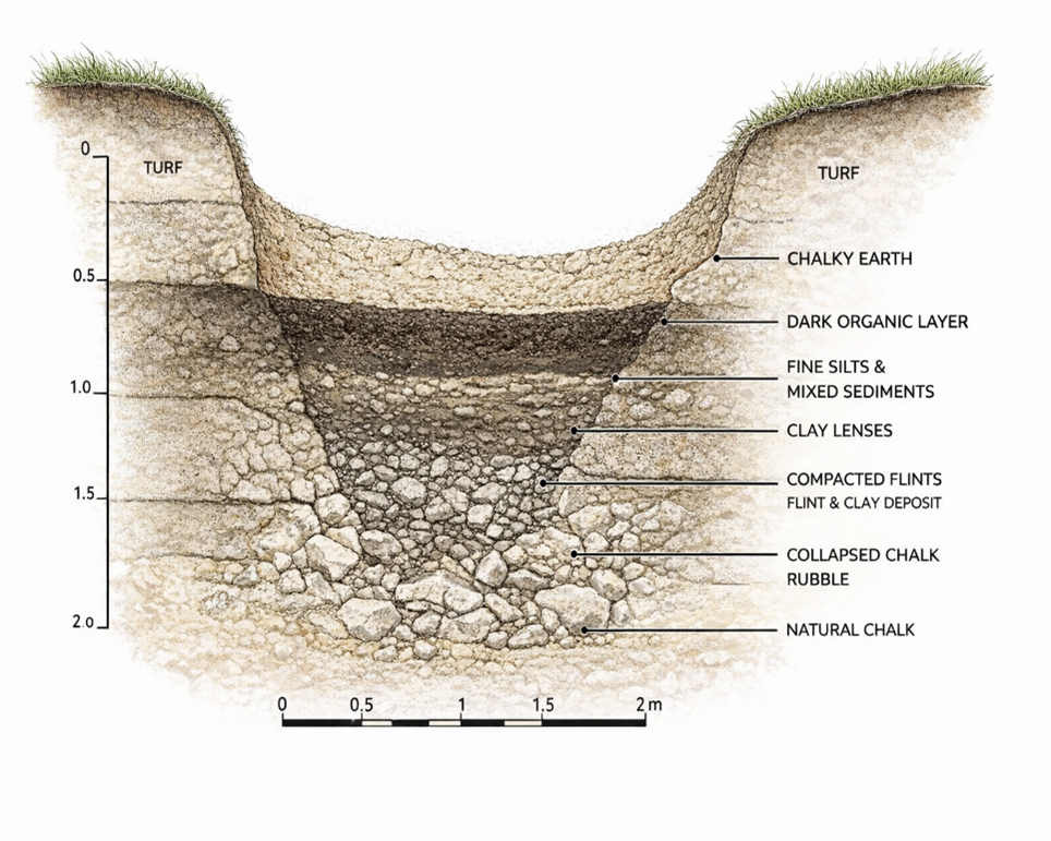
Hawley observed that the lowest fills of the ditch consisted largely of collapsed chalk rubble that had fallen from the sides of the excavation over time. Above this material were layers of fine silts and mixed sediments that had gradually accumulated within the hollow.

In certain sections of the ditch, Hawley also recorded the presence of a dark organic layer lying above the lower chalk deposits. Such layers can develop when water remains within a feature long enough for organic material and fine sediments to settle and accumulate.

Another observation made during the excavations was the presence of clay deposits within parts of the ditch base. Clay is not a common material in the surrounding chalk downland, and its occurrence in the ditch suggests it may have been deliberately introduced.

Perhaps the most unusual feature described in the excavation reports was the occurrence of densely packed flints within sections of the ditch floor. These flints appeared to have been compacted into the underlying sediments, suggesting that they had been trodden or pressed into place rather than simply deposited as loose rubble.
(The Stonehenge Enigma; The Archaeological Evidence)

Taken individually, these observations might appear unremarkable. However, when considered together, they suggest that the ditch experienced conditions quite different from those expected in a permanently dry chalk environment.

Environmental Implications

When the ditch observations are viewed in light of the geological setting described in the previous chapters, a more complex picture begins to emerge.

The Stonehenge enclosure lies within a shallow basin in the chalk plateau of Salisbury Plain. In chalk landscapes, groundwater levels can fluctuate significantly depending on climatic conditions. When groundwater rises, or prolonged rainfall occurs, water may collect in depressions and excavated features before draining away towards nearby river valleys.

Under such circumstances, a ditch cut into chalk bedrock could temporarily hold water. Standing or slow-moving water would allow fine silts and organic material to settle, producing the types of deposits described in the excavation reports.

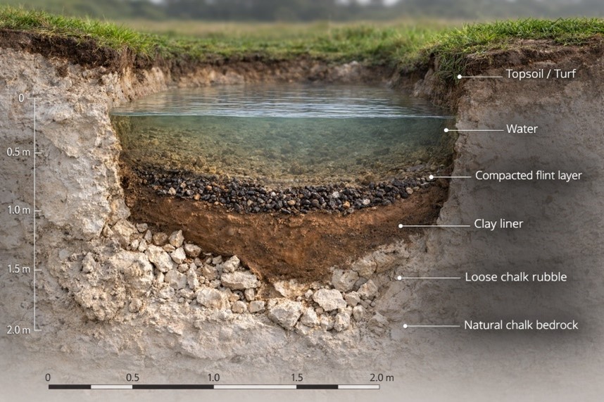
The combination of clay deposits and compacted flints recorded in parts of the ditch is also noteworthy. A similar construction method has long been used to form traditional dew ponds on chalk downlands. In such ponds, a layer of clay is used to seal the basin, while chalk rubble or flints are pressed into the surface to stabilise the lining and prevent erosion.

The resemblance between these construction techniques and the features recorded in the Stonehenge ditch does not necessarily mean that the enclosure was intended to function as a dew pond. However, the similarities suggest that the builders may have been aware of how clay and compacted stone could be used to control or retain water within excavated features.
(The Stonehenge Enigma; The Archaeological Evidence)

Whether the ditch occasionally held water as a result of natural hydrological conditions, or whether aspects of its construction were intended to influence how water behaved within the enclosure, remains an open question. What is clear from the excavation record is that the ditch did not remain a simple dry hollow throughout its history.

These observations provide an important reminder that the archaeological features at Stonehenge cannot be fully understood without considering the environmental conditions of the surrounding landscape

Closer examination of the excavation reports also reveals an important structural detail about the enclosure ditch that is often overlooked. Although the monument is usually described simply as a continuous circular ditch, Hawley’s excavation trenches showed that the feature was not cut as a uniform trench in the manner of a conventional defensive earthwork.

Instead, sections of the ditch appear to have been excavated as a series of adjoining pits or scoops, separated by short chalk walls or uncut partitions. In some places, the sides of these pits formed distinct vertical faces, while the bases contained flattened areas resembling seating ledges or working platforms within the chalk.

This segmented construction is unusual when compared with later defensive or boundary ditches, which are normally dug as continuous trenches designed to maximise obstruction or drainage. The Stonehenge enclosure, by contrast, appears to have been created through a sequence of individual excavation pits that collectively form the circular earthwork seen today.

Such a design raises important questions about how the feature functioned. A series of adjacent pits would behave very differently from a continuous drainage ditch. Individual hollows within the ring could potentially retain water independently, particularly if parts of the base were lined or compacted as suggested by the clay deposits and trodden flints described earlier.
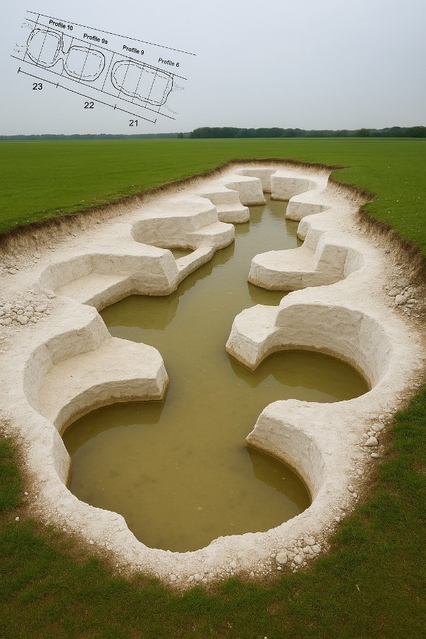
(The Stonehenge Enigma; The Archaeological Evidence)
Figure 7- The UNIQUE ditch showing Pits , Walls and Seats

In this sense, the enclosure may have functioned less like a defensive ditch and more like a chain of shallow basins arranged around the perimeter of the monument. Whether these basins were intentionally designed to interact with water, or whether this behaviour emerged from the way the ditch was excavated into the chalk, remains an important question when considering the environmental setting of Stonehenge.

These observations provide an important reminder that the archaeological features at Stonehenge cannot be fully understood without considering the environmental conditions of the surrounding landscape.

This brings us to one of the most intriguing elements of the monument’s earliest phase: a ring of pits discovered just inside the enclosure ditch. Known today as the Aubrey Holes, these features are among the most distinctive and debated components of the Stonehenge layout.
For full information see our blog: https://prehistoric-britain.co.uk/stonehenge-phase-1-britains-first-monument

Chapter 6

The Aubrey Holes – The Operating Ring of the Stonehenge Computer

The Aubrey Circle

Just inside the enclosure ditch lies a ring of 56 evenly spaced pits, known as the Aubrey Holes. These features are among the earliest structural elements of the monument and define a circle approximately 87 metres in diameter.

The pits were first recognised in the seventeenth century by the antiquarian John Aubrey, but their archaeological significance was confirmed during the excavations of William Hawley in the 1920s. Hawley demonstrated that the features were deliberately excavated pits cut into the chalk bedrock, each roughly 1 metre in diameter and about 1 metre deep.

The precision of their layout is striking. Fifty-six pits are spaced almost perfectly around the interior of the enclosure, producing a regular circular array that would have required careful measurement during construction. The labour required to excavate such a ring into solid chalk also indicates that the feature served a deliberate and specific purpose.

Despite more than a century of study, conventional archaeological interpretations have never provided a convincing explanation for why exactly 56 pits were constructed in this precise circular arrangement.
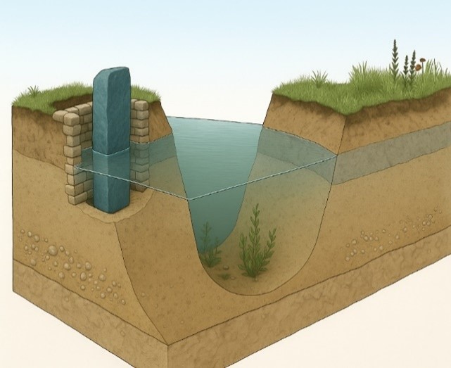
(The Stonehenge Enigma; The Archaeological Evidence)

Figure 8 – Bluestone in an Aubrey Hole and the Ditch Relationship

The Mathematical Structure of the Circle

The number 56 is unlikely to be accidental.

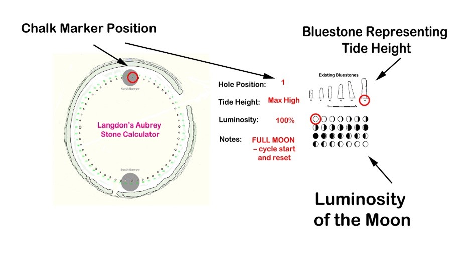
A circle divided into fifty-six positions creates a simple numerical system capable of tracking repeating natural cycles. When used sequentially, the ring allows a marker to move around the circle one position at a time, returning to the starting point after completing the cycle.

The significance of this number becomes clear when compared with the behaviour of tidal and lunar cycles. The circle of 56 positions can represent two consecutive 28-day tidal cycles, allowing the system to track the repeating pattern of tidal strength associated with the Moon.

By advancing a marker one position each day, the circle becomes a continuous counting mechanism. After two 28-day cycles, the marker returns to its starting point and the sequence begins again.

Such a system requires only a simple rule: one movement per day.

The One-Marker Operating System

The Aubrey circle can therefore be operated using a single movable marker.

In this arrangement:

• each Aubrey hole represents one day
• the marker advances one position per day
• the full circle records two tidal cycles
• the sequence then repeats indefinitely

This creates a simple analogue system for tracking the strength of tidal cycles through time.

For societies dependent on water transport, such information would have been highly valuable. Predicting when strong or weak tides would occur allows travellers to plan journeys through shallow waterways, estuaries, and flooded river systems where water levels and currents change dramatically during the lunar cycle.

The Aubrey ring therefore functions not merely as a geometric feature but as a circular counting mechanism capable of encoding natural environmental cycles.
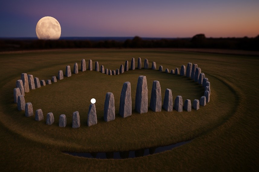
(The Stonehenge Enigma; The Archaeological Evidence)

Stonehenge as an Environmental Computer

When the Aubrey ring is considered within the wider landscape context described earlier in this book, its significance becomes clearer.

If prehistoric Britain possessed higher groundwater levels, expanded river systems, and extensive wetlands—as suggested by geological and borehole evidence—then movement through the landscape would often have depended on water. Travel along rivers, flooded valleys, and coastal inlets would have required knowledge of changing water levels and tidal behaviour.

In such an environment, the ability to predict tidal strength and water movement would have been a practical necessity. The Aubrey circle offers a simple yet effective mechanism for tracking these cycles over time.

Seen in this light, the monument can be interpreted not simply as ceremonial architecture but as an environmental computing device—a fixed geometric structure used to measure and predict the rhythms of the natural world.

A more detailed analysis of this operating system, including the role of the bluestones and the North and South Barrows that are within the ditch ring which helps indicating tidal strength and the full mechanics of the Stonehenge tidal model, is presented in the companion study Stonehenge: The World’s First Computer, where the system is examined in depth.

FREE online Book

From Earthwork to Instrument

The earliest phase of Stonehenge therefore combines two key elements:

• the segmented enclosure ditch
• the 56-hole Aubrey ring

Both were excavated directly into the chalk bedrock and form part of the monument’s ground architecture.

Together they suggest that the earliest builders of Stonehenge were not simply creating a symbolic enclosure but constructing a carefully designed geometric system embedded within the landscape.

In this interpretation, the monument began as a functional instrument, capable of tracking environmental cycles that influenced movement and activity within the surrounding landscape.

Understanding how this early system developed further requires examining the next phase in the monument’s construction: the erection and arrangement of the stone settings that transformed Stonehenge into one of the most recognisable structures of prehistoric Britain.
(The Stonehenge Enigma; The Archaeological Evidence)

For full information see our blog: https://prehistoric-britain.co.uk/stonehenge-the-worlds-first-computer

Chapter 7

The Bluestones – Craig Rhos-y-Felin and the Welsh Quarries

Identifying the Source of the Bluestones

The smaller stones within the Stonehenge monument are known as bluestones, typically weighing between two and four tonnes. Unlike the larger sarsen stones that dominate the later monument, the bluestones are composed of several distinct volcanic and igneous rock types not found on Salisbury Plain.

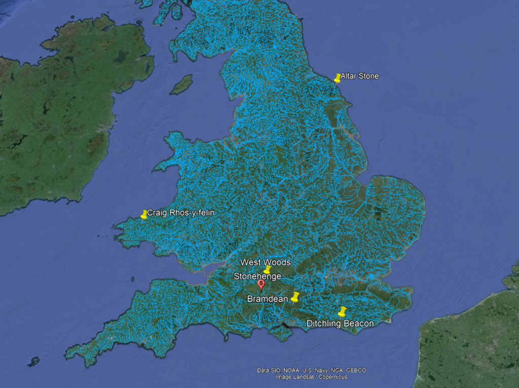
Recent advances in geochemical fingerprinting have allowed archaeologists to match these stones to specific outcrops in the Preseli Hills of western Wales. Among the most significant of these locations is the quarry site at Craig Rhos-y-Felin, along with additional sources such as Carn Goedog and other nearby Preseli outcrops.

These discoveries have confirmed that the bluestones used at Stonehenge originated more than 200 kilometres away from the monument.

Identifying the quarry sources, however, raises a far more important question: when were these stones quarried and transported?

Evidence of Quarrying

Excavations at Craig Rhos-y-Felin and Carn Goedog have revealed clear signs of prehistoric activity associated with the extraction of bluestones.

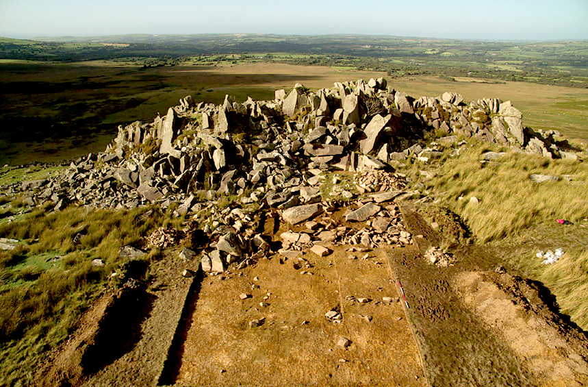
At Craig Rhos-y-Felin archaeologists discovered human-made hearths, stone tools, and a partially quarried monolith still embedded in the rock face. These findings demonstrate that the outcrop was not simply a natural deposit but a location where stone was deliberately worked.

Radiocarbon dating of charcoal from these hearths has produced a series of dates indicating repeated human activity at the quarry sites.

Crucially, many of these dates fall within the Mesolithic period, long before the Neolithic period traditionally associated with the construction of Stonehenge.

The presence of these hearths, together with the quarry features themselves, indicates that people were working these outcrops and interacting with the bluestone deposits thousands of years earlier than previously assumed.
(The Stonehenge Enigma; The Archaeological Evidence)

The Landscape of the Quarry Sites

The geographical setting of the quarry sites provides further clues about how the stones may have been transported.

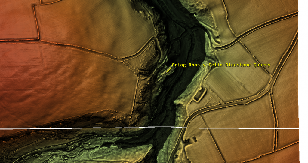
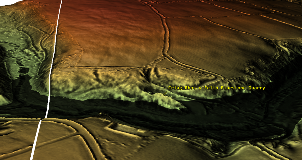
Craig Rhos-y-Felin lies beside what was once a substantial river system feeding into the River Nevern. Radiocarbon dating of the palaeochannel deposits indicates that this watercourse flowed past the quarry outcrop for thousands of years, extending to within a few metres of the rock face.

Evidence from the site suggests that during the Mesolithic period the river was significantly larger than the stream visible today.

This positioning is significant. It places the quarry directly on the edge of a navigable waterway capable of transporting heavy materials.

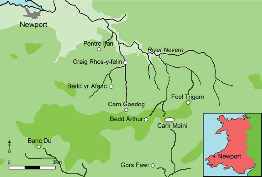
Similar patterns appear elsewhere in the Preseli region. Other bluestone sources, including Carn Goedog and nearby outcrops, are also connected by streams and rivers leading toward larger river systems.

The quarry sites therefore sit within a network of waterways that would have provided natural transport routes across the landscape.

Transport by River

Moving multi-tonne stones across rugged terrain presents enormous logistical challenges if attempted overland. By contrast, transporting heavy loads by water is far more efficient, as buoyancy allows boats or rafts to carry stones with relatively little effort.

The location of the bluestone quarries along river systems suggests that water transport may have been the primary means of moving these stones.

Rather than dragging stones across mountains, forests, and valleys, it would have been far easier to load them onto boats and transport them along the river systems connecting the Preseli region to the wider landscape.

This possibility becomes even more plausible when the environmental conditions of the early Holocene are considered. Higher water levels and expanded river systems would have made river navigation far more practical than it appears today.

(The Stonehenge Enigma; The Archaeological Evidence)

Early Activity at Stonehenge

Evidence from Stonehenge itself also points toward human activity during the Mesolithic period.

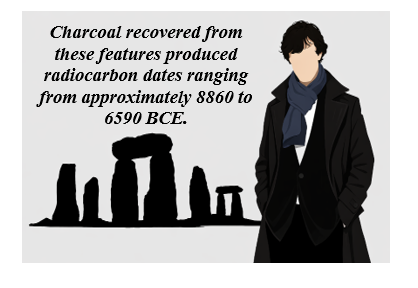
Excavations near the monument, including discoveries around the former visitor car park, revealed a series of postholes associated with the site’s early occupation. Charcoal recovered from these features produced radiocarbon dates ranging from approximately 8860 to 6590 BCE.

Additional discoveries include a piece of rhyolite associated with one of these features and charcoal recovered from stone sockets near the monument.

These findings indicate that the Stonehenge landscape was already a place of human activity thousands of years before the traditionally accepted Neolithic construction date of the monument.
(The Stonehenge Enigma; The Archaeological Evidence)

6. Connecting the Quarry Sites and Stonehenge

When the radiocarbon evidence from the Welsh quarry sites is compared with the Mesolithic dates obtained from Stonehenge, an intriguing pattern emerges.

Both locations show evidence of human activity during overlapping periods of the Mesolithic era.

This overlap raises an important question: could the activity recorded at the quarry sites and the early activity recorded at Stonehenge be connected?

(The Stonehenge Enigma; The Archaeological Evidence)

To answer this question, it is necessary to examine the radiocarbon datasets from both locations in detail and determine whether the similarities between them could have occurred by chance.

The Code

A detailed analysis of the radiocarbon datasets from Stonehenge and the Welsh quarry sites reveals a remarkable statistical relationship between the two.

When the calibrated radiocarbon ranges from the Stonehenge post holes are compared with those from Craig Rhos-y-Felin and Carn Goedog, the probability that the observed overlaps occurred purely by chance becomes extraordinarily small.

Using a probability model that compares the overlapping ranges of these independent radiocarbon samples, the likelihood that the pattern occurred by chance is approximately 1 in 1.27 × 10²⁹.

In practical terms, this probability is so small that it strongly suggests a genuine chronological relationship between the activity recorded at the Welsh quarry sites and the early activity at Stonehenge.

This statistical pattern forms what may be described as The Stonehenge Code.

The mathematical analysis behind this conclusion, and the implications it has for the dating of Stonehenge’s earliest phase, will be examined in detail in the following chapter.

For more detailed information see our blog: https://prehistoric-britain.co.uk/bluestone-enigma

Chapter 8

The Stonehenge Code

The Chronology Problem

The accepted chronology of Stonehenge places its construction within the Neolithic period, beginning around 3000 BCE and continuing through several later phases of modification. This interpretation has remained largely unchanged for decades and forms the basis of most archaeological explanations of the monument.

However, a growing body of radiocarbon evidence challenges this timeline.

Excavations at both Stonehenge and the Welsh bluestone quarry sites have produced a series of dates that extend deep into the Mesolithic period. These dates have often been treated as isolated anomalies because they do not fit comfortably within the accepted Neolithic framework.

Yet when these dates are examined together rather than individually, a striking pattern begins to emerge.

Recent carbon dating at the bluestone quarry sites provides compelling, irrefutable mathematical evidence that Stonehenge’s construction dates to the Mesolithic era. This new data suggests Stonehenge is approximately 5000 years older than experts had previously believed, challenging established views on its origins and adding new depth to our understanding of this ancient monument

Mesolithic Evidence at Stonehenge

Evidence for Mesolithic activity at Stonehenge has been known for decades.

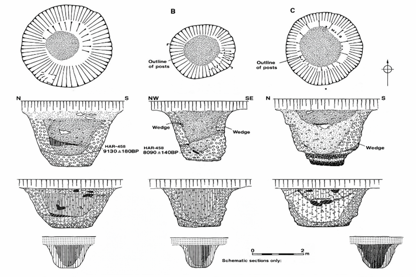
During excavations in 1966, Lance and Faith Vatcher discovered several post holes near Stonehenge, close to the location of the old visitor car park. These holes were initially interpreted as having a Neolithic character, although no datable pottery was found.

Later analysis revealed that charcoal from these features consisted largely of pine. This created a problem for the established chronology, as pollen evidence suggested pine had disappeared from the area before the supposed Neolithic construction of Stonehenge.

Radiocarbon dating eventually placed these pine charcoal samples firmly within the Mesolithic period, producing dates between approximately 8860 BCE and 6590 BCE.
(The Stonehenge Enigma; The Archaeological Evidence)

Figure 9- Old Car Park Post Holes

Rather than prompting a reassessment of Stonehenge’s chronology, these early dates were generally dismissed as evidence of unrelated Mesolithic activity, sometimes interpreted as the remains of totem poles erected by hunter-gatherer groups passing through the landscape.

Further discoveries complicated the situation.

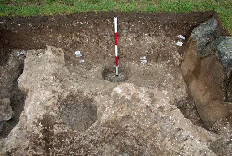
In 1988–89, Wessex Archaeology uncovered another Mesolithic posthole, along with a piece of rhyolite dated between 7737 and 7454 BCE. Additional charcoal discovered in the socket of Stone 10 during excavations by Darvill and Wainwright produced dates between 7330 and 7060 BCE.

These findings indicate that human activity at Stonehenge began thousands of years earlier than the accepted Neolithic construction date.
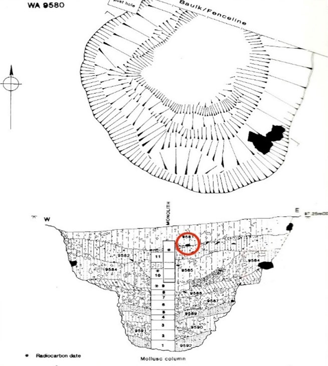
(The Stonehenge Enigma; The Archaeological Evidence)
Figure 10 – Another Old Car Park Post Hole found in 1988

Mesolithic Activity at the Bluestone Quarries

At the same time that early dates were appearing at Stonehenge, excavations in the Preseli Hills of Wales began identifying the sources of the monument’s bluestones.

Quarry sites at Craig Rhos-y-Felin and Carn Goedog revealed evidence of prehistoric quarrying activity, including artificial platforms, quarry debris and human-made hearths.

Radiocarbon dating of these hearths produced a series of Mesolithic dates spanning several millennia.

At Craig Rhos-y-Felin alone, hearths produced dates in three main clusters:

• 8550 – 8330 BCE
• 8220 – 7790 BCE
• 7490 – 7190 BCE

These dates indicate that human activity at the quarry spanned a long period, possibly more than a thousand years.

The layout of the quarry site is also significant. Geological evidence shows that during the Mesolithic period, a large stream that fed the River Nevern flowed directly past the rock outcrop. Charcoal from the basal fill of this palaeochannel dates between 5800–5640 BCE and 5620–5460 BCE, confirming that substantial watercourses existed beside the quarry during the period of human activity.

This geographical arrangement strongly suggests that quarried stones could have been transported directly by boat.
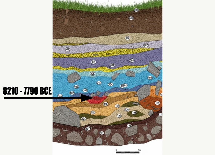
(The Stonehenge Enigma; The Archaeological Evidence)

Figure 11- one of four hearths found on site – all Mesolithic in date

The Problem with Conventional Interpretation

Despite the large number of Mesolithic dates from the quarry sites, archaeological interpretation has tended to focus on a much smaller number of Neolithic samples that better match the traditional Stonehenge chronology.

For example, reports describing Craig Rhos-y-Felin highlighted two radiocarbon dates that appeared consistent with the accepted Neolithic construction phase of Stonehenge. These dates were used to support the theory that the monument may have been constructed in Wales and later dismantled and moved to Salisbury Plain several centuries later.

However, this interpretation largely overlooks the much larger dataset of Mesolithic dates from the same excavation.

The presence of multiple Mesolithic hearths at the quarry raises an obvious question. If the quarry was occupied repeatedly by Mesolithic communities for over a thousand years, what were these people doing at the site if not extracting stone?

The assumption that Mesolithic people could not have quarried or transported large stones reflects modern expectations rather than direct archaeological evidence.

Comparing the Radiocarbon Evidence

When the radiocarbon dates from Stonehenge are compared with those from the Welsh quarry sites, the two datasets begin to overlap in a striking way.

Five radiocarbon samples from Stonehenge post holes fall within the following calibrated ranges:

• HAR-455: 8825 – 7742 BCE
• HAR-456: 7377 – 6651 BCE
• GU-5109: 8259 – 7742 BCE
• QxA-4219: 7737 – 7454 BCE
• QxA-4220: 7595 – 7178 BCE

Meanwhile, more than twenty samples from Craig Rhos-y-Felin and Carn Goedog fall within overlapping Mesolithic ranges between 8550 BCE and 6840 BCE.

If these dates are unrelated, their overlap could theoretically occur by coincidence. Radiocarbon dates always include uncertainty ranges, and overlapping intervals do not automatically prove that two events occurred at the same time.

To test whether this overlap could realistically occur by chance, the datasets can be examined using a statistical probability model.
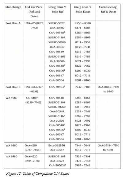
(The Stonehenge Enigma; The Archaeological Evidence)

The Probability Model

To determine whether the matching radiocarbon ranges represent a genuine connection or a random coincidence, the Stonehenge Code applies a probability test.

The model compares each Stonehenge radiocarbon range with the radiocarbon ranges from the quarry samples. A match is counted when the entire quarry range falls within the Stonehenge range.

To estimate the likelihood of such matches occurring by chance, the calculation assumes that any quarry date could fall anywhere within a 10,000-year Mesolithic window spanning 10,500 BCE to 500 BCE.

The probability of a complete overlap is calculated using the following formula:
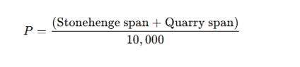
For example:

HAR-455 spans 1083 years.
A quarry sample spans 220 years.

This corresponds to odds of approximately 1 in 7.67.

The probabilities of all observed overlaps are then multiplied together to determine the overall likelihood that the complete pattern of matches could occur by chance.

Statistical Results

Applying this method to the full dataset produces the following combined probabilities:

Stonehenge SampleQuarry MatchesCombined Probability
HAR-455122.29 × 10⁻¹¹
GU-5109104.41 × 10⁻¹²
HAR-45617.70 × 10⁻²
QxA-421923.38 × 10⁻³
QxA-422032.99 × 10⁻⁴

When these probabilities are multiplied together, the overall probability that the observed pattern of overlaps occurred randomly becomes approximately:

1 chance in 1.27 × 10²⁹

In everyday terms, this represents odds of roughly one chance in one hundred and twenty-seven octillions.

Interpretation

Such extremely small probabilities indicate that the matching radiocarbon ranges between Stonehenge and the Welsh quarry sites are unlikely to be coincidental.

Instead, the data strongly suggest that both sets of samples belong to the same period of activity.

If this interpretation is correct, it implies that bluestone quarrying in Wales and activity at Stonehenge took place during the Mesolithic rather than the Neolithic.

This conclusion would push the earliest phase of Stonehenge back to approximately 8300 BCE, making the monument thousands of years older than previously believed.

(The Stonehenge Enigma; The Archaeological Evidence)

Implications

The implications of this shift are profound.

If Stonehenge began in the Mesolithic period, the monument can no longer be understood solely as a construction of early farming communities. Instead, its origins would lie within a much earlier landscape inhabited by hunter-gatherer societies.

This possibility raises fundamental questions about the technological abilities, social organisation and environmental knowledge of Mesolithic populations in Britain.

It also suggests that the rivers and waterways of post-glacial Britain may have played a far greater role in the transport of monumental stones than previously assumed.

The statistical evidence presented in the Stonehenge Code therefore does more than propose an earlier date for Stonehenge. It invites a reconsideration of the entire prehistoric framework within which the monument has traditionally been understood.
(The Stonehenge Enigma; The Archaeological Evidence)

For more detailed information, see our blog: https://prehistoric-britain.co.uk/the-stonehenge-code

PODCAST

Author’s Biography

Robert John Langdon, a polymathic luminary, emerges as a writer, historian, and eminent specialist in LiDAR Landscape Archaeology.

His intellectual voyage has been interwoven with stints as an astute scrutineer in government and grand corporate bastions, a tapestry spanning British Telecommunications, Cable and Wireless, British Gas, and the esteemed University of London.

A decade hence, Robert’s transition into retirement unfurled a chapter of insatiable curiosity. This phase saw him immerse himself in Politics, Archaeology, Philosophy, and the enigmatic realm of Quantum Mechanics. His academic odyssey traversed the venerable corridors of knowledge hubs such as the Museum of London, University College London, Birkbeck College, The City Literature Institute, and Chichester University.

In the symphony of his life, Robert is a custodian of three progeny and a pair of cherished grandchildren. His sanctuary lies ensconced in the embrace of West Wales, where he inhabits an isolated cottage, its windows framing a vista of the boundless sea – a retreat from the scrutinising gaze of Her Majesty’s Revenue and Customs, an amiable clandestinity in the lap of nature.

Exploring Prehistoric Britain: A Journey Through Time

My blog delves into the fascinating mysteries of prehistoric Britain, challenging conventional narratives and offering fresh perspectives grounded in cutting-edge research, particularly LiDAR technology. I invite you to explore some key areas of my research. For example, the Wansdyke, often cited as a defensive structure, is re-examined in light of new evidence. I’ve presented my findings in my blog post Wansdyke: A British Frontier Wall – ‘Debunked’, and a Wansdyke LiDAR Flyover video further visualises my conclusions.

My work also often challenges established archaeological dogma. I argue that many sites, such as Hambledon Hill, commonly identified as Iron Age hillforts, are not what they seem. My posts Lidar Investigation Hambledon Hill – NOT an ‘Iron Age Fort’ and Unmasking the “Iron Age Hillfort” Myth explore these ideas in detail and offer an alternative view. Similarly, sites like Cissbury Ring and White Sheet Camp receive re-evaluations based on LiDAR analysis in my posts “Lidar Investigation Cissbury Ring through time” and “Lidar Investigation White Sheet Camp,“ revealing fascinating insights into their true purpose. I have also examined South Cadbury Castle, often linked to the mythical Camelot56.

My research also extends to ancient water management, including the role of canals and other linear earthworks. I have discussed the true origins of Car Dyke in multiple posts, including Car Dyke – ABC News Podcast and Lidar Investigation Car Dyke – North Section, which suggest a Mesolithic origin 2357. I also explore the misidentification of Roman aqueducts, as seen in my posts on the Great Chesters (Roman) Aqueduct. My research has also been greatly informed by my post-glacial flooding hypothesis, which has helped explain landscape transformations over time. I have discussed this hypothesis in several posts, including AI now supports my Post-Glacial Flooding Hypothesis and Exploring Britain’s Flooded Past: A Personal Journey

Finally, my blog also investigates prehistoric burial practices, as seen in Prehistoric Burial Practices of Britain and explores the mystery of Pillow Mounds, often mistaken for medieval rabbit warrens, but with a potential link to Bronze Age cremation in my posts: Pillow Mounds: A Bronze Age Legacy of Cremation? and The Mystery of Pillow Mounds: Are They Really Medieval Rabbit Warrens?. My research also includes astronomical insights into ancient sites, for example, in Rediscovering the Winter Solstice: The Original Winter Festival. I also review new information about the construction of Stonehenge in The Stonehenge Enigma.

Further Reading

For those interested in British Prehistory, visit www.prehistoric-britain.co.uk, a comprehensive resource featuring an extensive collection of archaeology articles, modern LiDAR investigations, and groundbreaking research. The site also includes insights and excerpts from the acclaimed Robert John Langdon Trilogy, a series of books that explore Britain during the Prehistoric period. Titles in the trilogy include The Stonehenge Enigma, Dawn of the Lost Civilisation, and The Post-Glacial Flooding Hypothesis, which offer compelling evidence of ancient landscapes shaped by post-glacial flooding.

To further explore these topics, Robert John Langdon has developed a dedicated YouTube channel featuring over 100 video documentaries and investigations that complement the trilogy. Notable discoveries and studies showcased on the channel include 13 Things that Don’t Make Sense in History and the revelation of Silbury Avenue – The Lost Stone Avenue, a rediscovered prehistoric feature at Avebury, Wiltshire.

In addition to his main works, Langdon has released a series of shorter, accessible publications, ideal for readers delving into specific topics. These include:

For active discussions and updates on the trilogy’s findings and recent LiDAR investigations, join our vibrant community on Facebook. Engage with like-minded enthusiasts by leaving a message or contributing to debates in our Facebook Group.

Whether through the books, the website, or interactive videos, we aim to provide a deeper understanding of Britain’s fascinating prehistoric past. We encourage you to explore these resources and uncover the mysteries of ancient landscapes through the lens of modern archaeology.

For more information, including chapter extracts and related publications, visit the Robert John Langdon Author Page. Dive into works such as The Stonehenge Enigma or Dawn of the Lost Civilisation, and explore cutting-edge theories that challenge traditional historical narratives.
The Bluestone Enigma

Introduction

The Bluestone quarry sites give us compelling evidence of the Mesolithic construction dates of Stonehenge (The Bluestone Enigma)

The papers published by researchers from the University of London, Southampton, and Manchester, including Mike Parker-Pearson and his team, regarding the discovery of the quarries at Craig Rhos-y-Felin and the bluestone megaliths at Carn Goedog have been a significant contribution to our understanding of Stonehenge’s origins. This research brought to light the fascinating theory that Stonehenge was originally built in Wales and later transported to Salisbury Plain around 500 years later.

This groundbreaking discovery not only captured the attention of archaeologists worldwide but also challenged previous assumptions about the methods and motivations behind Stonehenge’s construction. The idea that these bluestones were quarried and shaped in Wales before making their journey to Salisbury Plain adds a new dimension to our understanding of prehistoric peoples’ capabilities and social organisation.

This revelation suggests a remarkable level of dedication and coordination among ancient communities. The logistical feat of transporting these massive stones over such a distance, and the decision to do so centuries after their initial quarrying, hints at the profound significance these stones—and the monument they came to form—held for the people of the time.

As someone deeply interested in the mysteries of ancient civilisations, I find the implications of this research thrilling. It deepens our appreciation for the ingenuity and spiritual dedication of our ancestors and opens up new avenues for exploring the cultural and religious ties that connected different regions of prehistoric Britain.

The Bluestone Enigma
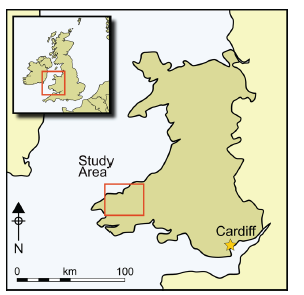
Prescilli Mountains in Wales – The Bluestone Enigma

Craig Rhos-Y-Felin

The publication of the report “Craig Rhos-y-Felin: a Welsh bluestone megalith quarry for Stonehenge” in the December 2016 edition of Antiquity Magazine unveiled intriguing findings about the origins of the bluestones used in Stonehenge. This study, which identified a 4m long monolith at Craig Rhos-y-Felin as microscopically identical to the bluestones at Stonehenge, has sparked significant debate and speculation within the archaeological community and beyond.

Despite the excitement generated by these findings, the report’s focus on two radiocarbon dates that align with the authors’ hypothesis on Stonehenge’s construction date has raised questions about the completeness of the narrative presented to the public. The discrepancy between these dates and the hoped-for evidence led to the speculative suggestion that Stonehenge was originally constructed in Wales and later relocated to Salisbury Plain. This narrative, while intriguing, illustrates the complexities and challenges of interpreting archaeological data, as well as the temptation to fit new evidence into pre-existing hypotheses.

However, a more detailed analysis of the report reveals a wealth of Mesolithic carbon dates obtained from human-made hearths, suggesting a much earlier period of human activity at the site than the two Neolithic dates highlighted. These Mesolithic dates, which significantly predate the construction of Stonehenge as currently understood, were largely overlooked in the public dissemination of the research findings.

The Bluestone Enigma
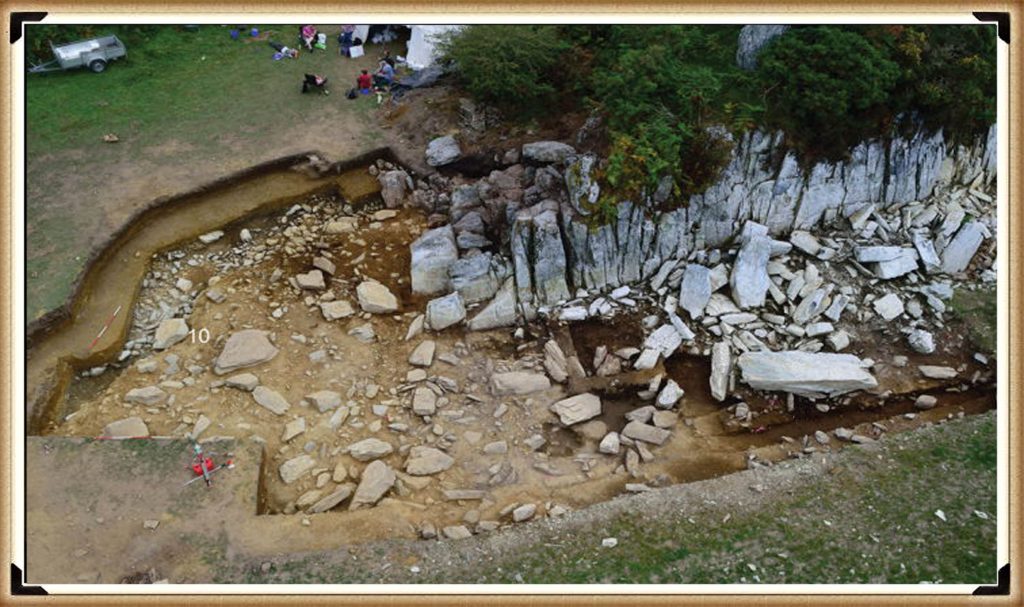
Quarry Site at Craig Rhos-Y-Felin – The Bluestone Enigma

This oversight raises essential questions about the narrative surrounding Stonehenge’s origins and the methodologies used in archaeological dating. The presence of Mesolithic hearths at Craig Rhos-y-Felin suggests that the site was of importance to human communities thousands of years before the Neolithic period. This evidence challenges the conventional timeline of Stonehenge’s construction and suggests a longer, more complex history of human interaction with the landscape and the bluestones.

Furthermore, the report inadvertently highlights the ongoing debate within archaeology about how best to interpret and present findings to the public. The focus on headline-grabbing narratives, such as the relocation of Stonehenge from Wales, can sometimes overshadow equally significant but less sensational discoveries, such as the evidence of Mesolithic activity at the quarry site.

An Inconvenient TRUTH (Craig Rhos Y Felin)
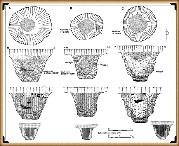
Mesolithic Post Holes at the Old Car Park at Stonehenge – The Bluestone Enigma

The excavation in 1966 and subsequent discoveries surrounding Stonehenge offer a fascinating and somewhat contentious glimpse into the complex task of accurately dating ancient sites. The initial observations by Lance and Faith Vatcher highlighted the Neolithic character of three holes excavated near Stonehenge, with no datable pottery found. Yet, the characteristics of the holes suggested a Neolithic origin. This assumption was later questioned when a PhD student discovered that the charcoal deposits from these holes, surprisingly composed mostly of pine, could not be Neolithic as initially thought. Pine was believed to be ‘extinct’ in the area by the time of Stonehenge’s supposed construction, according to pollen analysis.

This revelation was startling, especially to the officials of the Historic Buildings and Monuments Commission, later known as English Heritage. The carbon dating of these pine samples placed them squarely in the Mesolithic era, specifically between 8860 to 6590 BCE, challenging the previously accepted timeline for Stonehenge’s construction. Furthermore, the report mentions pine samples from Woodhenge, which, if also Mesolithic, would radically alter our understanding of that site’s age.

Stonehenge Car Park

Mesolithic Post Holes in Old Car Park – The Bluehenge Enigma

Instead of seizing this opportunity to delve deeper into these findings, a narrative was constructed that dismissed these posts as totem poles from wandering hunter-gatherers, unrelated to Stonehenge. This decision to sideline potentially groundbreaking evidence highlights a reluctance within some parts of the archaeological community to reconsider established narratives, even in the face of new evidence.

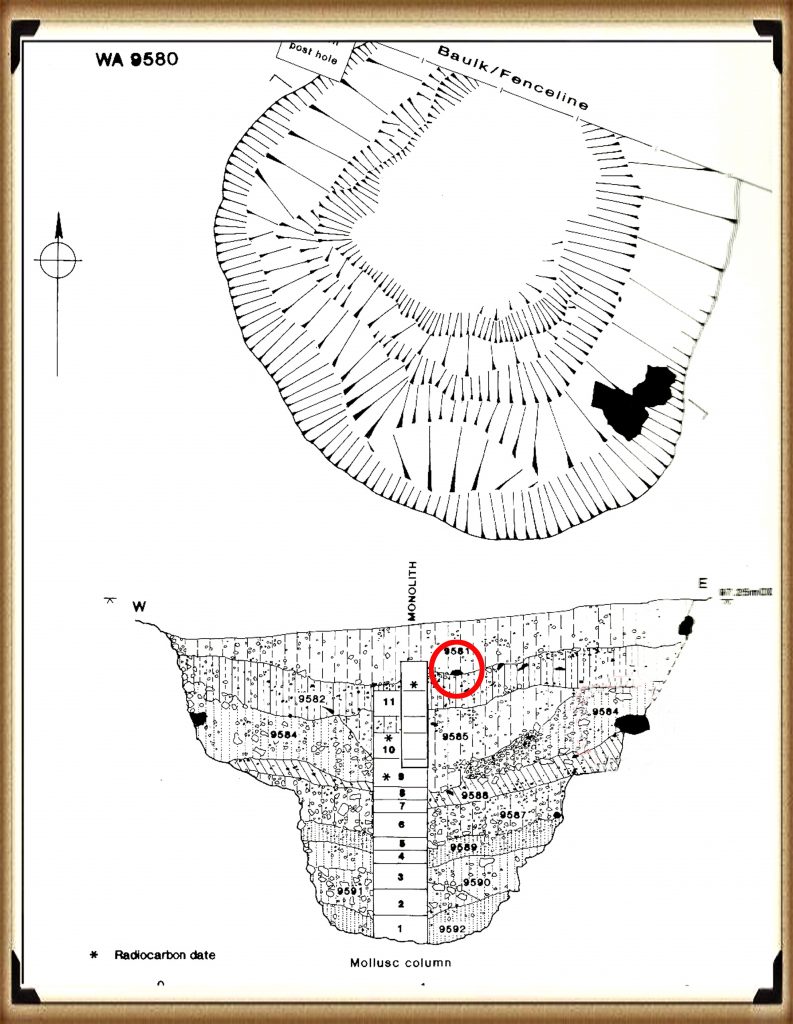
The discovery in 1988-89 by Wessex Archaeology of another Mesolithic post hole, along with a piece of rhyolite dated to 7737 – 7454 BCE, further complicates the timeline for Stonehenge and the surrounding area. This finding should have prompted a reevaluation of the site’s dating. However, attempts to fit this new evidence into the existing narrative of Stonehenge’s construction timeline illustrate the challenges and controversies inherent in archaeological interpretation.

These instances underscore the necessity for openness, curiosity, and a willingness to revise our understanding of history in light of new evidence. They remind us that the story of human history is complex and continually evolving, and our interpretations must adapt as we uncover more about our past.

The Bluestone Enigma
Stone Hole WA9580 shows a piece of Bluestone 5,000 years before they arrived. – The Bluestone Enigma

Discoveries at Stonehenge, including charcoal (OxA-18655) found in the Hole socket of Stone 10, dating to 7330 – 7060 BCE, match the dates of the Mesolithic post holes, with significant implications for our understanding of the site’s history. This evidence, dating to the Mesolithic post holes, suggests that the activities at Stonehenge and its surroundings span much earlier than previously believed. However, the apparent suppression of this news from widespread media coverage raises questions about the narrative presented to the public and in educational materials.

The excavation at Blick Mead, less than a mile from Stonehenge, by the Open University, which uncovered evidence of Mesolithic-period habitation and feasting, further challenges the entrenched views held by some about prehistoric life around Stonehenge. These findings suggest a continuous and significant presence of people in this area during the Mesolithic period, contradicting the simplistic ‘totem pole’ myth still perpetuated in some narratives by English Heritage (EH) through their exhibitions and guidebooks.

Moreover, the recent transformation of the Stonehenge site, including the closure of the B-road past the stones and the relocation of the visitors’ car park to a new, multi-million-pound visitor centre, represents a significant shift in how the site is accessed and experienced by the public. The removal of the old tarmac and the reversion of the land to grass aim to restore a more authentic prehistoric ambience to Stonehenge. This effort to make the site appear more as it did at the time of its construction is commendable, but also highlights the ongoing tension between modern interpretations of the site and the emerging evidence of its ancient past.

These developments at Stonehenge and Blick Mead exemplify the dynamic nature of archaeological research and the complexities involved in interpreting and presenting the past. As new evidence continues to emerge, the narrative of prehistoric Britain needs to evolve accordingly, ensuring a more accurate and nuanced understanding of these ancient landscapes and their significance to human history.

The Bluestone Enigma
In 2008, Stone 10 – Tim Darvill and Geoffrey Wainwright found charcoal dating back to 7330 to 7060 – The Bluestone Enigma

You would indeed think that removing the tarmac from the old visitor car park at Stonehenge, especially given the significant previous findings beneath it, would prompt a comprehensive excavation to unearth more evidence of the site’s Mesolithic history. Such an excavation could potentially transform our understanding of Stonehenge and its origins, providing invaluable insights into its early history and the people who frequented the site during the Mesolithic period.

Tim Daw’s role as a warden at Stonehenge, combined with his proactive approach to documenting changes and features of the site through photography, exemplifies the kind of engaged observation that can lead to important discoveries. His finding of patch marks by the central upright stones, indicating the possible positions of missing stones from the Inner Circle, is a testament to the contributions individuals can make to the ongoing investigation of Stonehenge. Daw’s work underscores the value of continuous and attentive observation of archaeological sites, even by those not formally conducting research.

The Bluestone Enigma
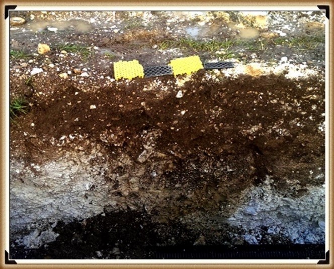
Tim Daw’s evidence of yet another Pit in the Old Car Park not investigated! – The Bluehenge Enigma

The discovery of such features and the potential for further findings beneath the former car park area highlights the need for a thorough and systematic archaeological examination whenever opportunities arise. These efforts not only enrich our knowledge of Stonehenge’s past but also contribute to the broader understanding of prehistoric human activity in the region. As we continue to peel back the layers of Stonehenge’s history, each finding adds a piece to the puzzle of this enigmatic monument’s story, emphasising the importance of preserving and exploring our archaeological heritage.

The Bluestone Enigma
The Post Holes would have been on the shoreline of the River Avon in Mesolithic period – The Bluestone Enigma

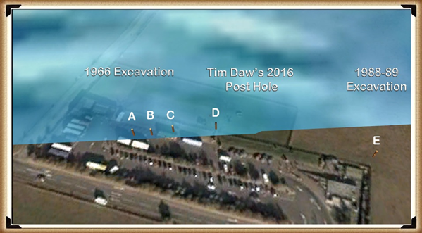
Tim Daw’s experiences and observations as a warden at Stonehenge, particularly his discovery of additional post holes beneath the old visitor’s car park, highlight the ongoing potential for new findings that can challenge and enrich our understanding of Stonehenge’s history. Despite being warned against publishing his conclusions due to unauthorised blog activity, Daw chose to resign and continue his work, revealing, through ‘unofficial’ pictures, the existence of even more post holes under the car park, aligned with those discovered in 1966.

Bluestone Quarries

These findings, including the newly discovered post hole that aligns with the four others from 1966, support the hypothesis that these structures are situated on what was once the shoreline of the River Avon around 8000 BCE. This suggests that during the Mesolithic period, the stones quarried in Wales could have been transported by boat directly to Stonehenge, navigating along enlarged rivers rather than taking the longer sea route proposed by some archaeologists.

Further complicating the narrative are my analyses of the bluestone structures from other Preseli sites like Carn Goedog and Craig Talfynyydd, which are connected by streams and rivers to the River Nevern. Unfortunately, archaeologists have interpreted this network of waterways primarily through a religious lens rather than considering its practical functionality as a transportation network.

The persistence of the ‘ox-cart’ route theory, which posits a land route along the modern A40, overlooks the logistical challenges posed by the period’s dense woods, swamps, and forests. Such conditions would have made the construction and use of a road system highly impractical, if not impossible.

My critique extends to the inconsistencies and logical inaccuracies in the archaeological narrative, particularly regarding the site layout and geological evidence at Craig Rhos-y-Felin. The assumption that floodwaters in the area were solely the result of ice melt, quickly draining into the sea post-Ice Age, ignores the broader implications of such flooding for the landscape and its inhabitants.

The Bluestone Enigma
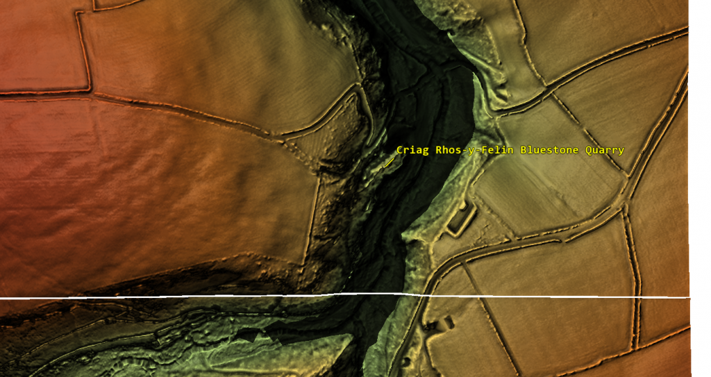
Craig Rhos-Y-Felin is on the edge of a gigantic river of the past – The Bluestone Enigma.

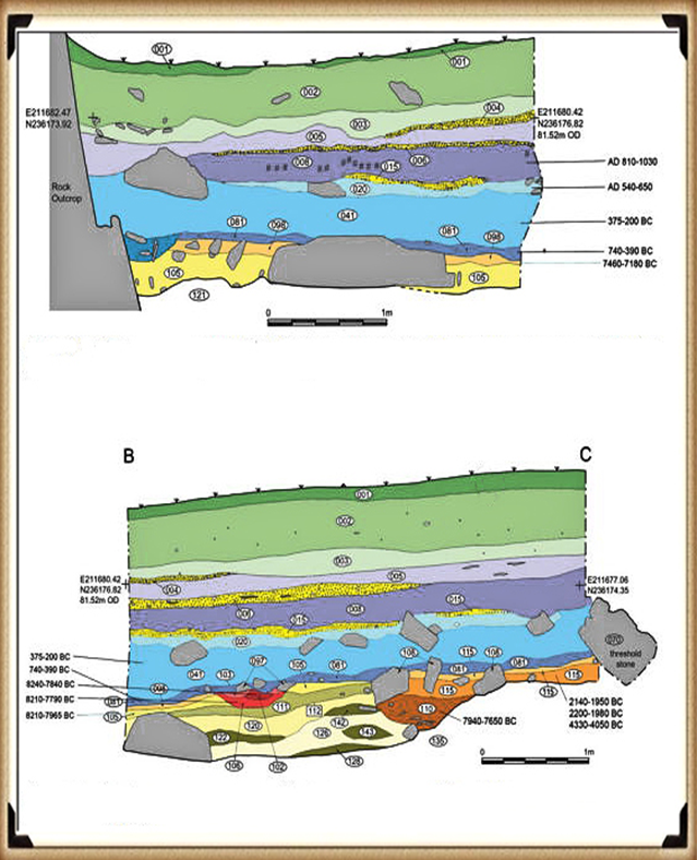
We confirm in the report that an old river ran around this quarry as long ago as 5620 – 5460 BCE and possibly as late as 1030 – 910 BCE.

“Most of the site was then covered by a layer of yellow colluvium (035), dated by oak charcoal to 1030–910 cal BC (combine SUERC-46199; 2799±30 BP and SUERC-46203; 2841±28 BP). This deposit is contemporary with the uppermost fill of a palaeochannel of the Brynberian stream that flowed past the northern tip of the outcrop. Charcoal of Corylus and Tilia from the basal fill of this palaeochannel dates to 5800–5640 cal BC (OxA- 32021; 6833±40 BP) and 5620–5460 cal BC (OxA-32022; 6543±37 BP), both at 95.4% probability.”

An Inconvenient TRUTH (Craig Rhos Y Felin)
The only RED hearths in the site are Mesolithic so they must be quarrying at that time – The Bluestone Enigma


The report’s insights suggest that during the Mesolithic Period, an enlarged stream that fed into the River Nevern reached the quarry outcrop rocks. Notably, it was positioned just a few meters away, even as late as 1000 BCE. This geographical configuration suggests that boats were likely the primary means of transporting the large, newly quarried stones to their final destination at Stonehenge, mirroring stone transport methods in other ancient civilisations, such as Egypt.

The site layout at the quarry provides crucial clues about the timing of the stone quarrying. Notably, a single monolith is positioned near the river on the site’s east side, ready for transportation. Nearby, to the south of this monolith, are human-made hearths, precisely where one would expect them to be. However, the challenge arises in dating these hearths as Mesolithic, with three distinct periods identified: 8550 – 8330 BCE; 8220 – 7790 BCE; and 7490 – 7190 BCE. Despite this, the report asserts that there is no evidence of Mesolithic quarrying or working of rhyolite at this site.

This claim overlooks the practical use of tools across different periods. If Mesolithic and Neolithic communities utilised similar tools, distinguishing tool marks from these different periods might be more challenging than the report suggests. Moreover, the presence of these communities at the quarry for over a millennium raises questions about their activities if not quarrying the stones.

The connection between the quarry site and Stonehenge is strengthened by over twenty Carbon-14 dates that align with my hypothesis, in contrast to the mere two samples currently highlighted by experts, which are dated 300 – 500 years older than existing estimates. By analysing these overlapping dates against the latest carbon-dating curve (IntCal20), we can refine the construction date of Stonehenge’s Phase I (the placement of bluestones in the Aubrey holes). By calculating the mean of these probable dates, we aim to obtain a more accurate estimate of when this monumental task was undertaken, potentially rewriting the timeline of one of the world’s most enigmatic prehistoric monuments.

Carbon Dating

StonehengeOld Car Park (Ref. and Date)Craig Rhos-Y-Felin RefCraig Rhos-Y-Felin DatesCarn Goedog Ref & Dates
Post Hole AHAR-455 (8825 – 7742)SUERC-50761
OxA-30507
OxA- 305481
SUERC-51164
SUERC-50760
OxA-30549
SUERC-51165
OxA-30506
OxA-305482
OxA-305062
OxA-30547
OxA-30504
8550 –  8330
8471 – 8285
8286 – 8163
8289 –  8169
8211 – 7955
8238 – 7941
8216 – 7785
8021 – 7792
8122 – 7962
8207 –  8030
8012 – 7711
8281 –  8166
Post Hole BHAR–456 (7377 – 6651)OxA-3050327232 – 7188OxA31823 – 7190 to 6840
WA 9580GU-5109 (8259 – 7742)OxA- 30548
SUERC-51164
SUERC-50760
OxA-30549
SUERC-51165
OxA-30506
OxA-305482
OxA-305062
OxA-30547
OxA-30504
8286 – 8163
8289 – 8169
8211 – 7955
8238 – 7941
8216 – 7785
8021 – 7792
8122 – 7962
8207 –  8030
8012 – 7711
8281 –  8166
WA 9580QxA-4219 (7737 – 7454)Beta-392850
OxA-30547
7944 – 7648
8012 – 7711
OxA-35184 – 7590 to 7380
WA 9580QxA-4220 (7595 – 7178)SUERC-51163
OxA-30523
OxA-3050311
7539 – 7308
7472 – 7182
7485 – 7248
Carbon Dates comparison – note that the sites are linked to different mooring posts, indicating activity dates

Table 1– Matching Carbon Dates

The calculations indicate that work at the quarry began around 8300 BCE, with its main phase of activity around 8000 BCE, and continued for at least a millennium, challenging the conventional narrative about Stonehenge and its Bluestones. This timeline suggests a far more ancient and enduring connection between the quarry site and Stonehenge than previously acknowledged.

Carn Goedog

Initially, Carn Menyn in the Preseli Hills was believed to be the source of Stonehenge’s spotted dolerite, but later analysis pinpointed Carn Goedog as a closer chemical match. Recent geochemical studies have divided the Stonehenge spotted dolerite into two main groups, with one group closely matching the Carn Goedog outcrop. The origin of the second group remains uncertain, potentially deriving from Carn Goedog or nearby outcrops.

Further geological investigations at Stonehenge have identified additional sources for its bluestones. Unspotted dolerite matches with outcrops at Cerrigmarchogion and Craig Talfynydd on the Preseli ridge. Another bluestone variety, “rhyolite with fabric,” traces back to Craig Rhos-y-Felin, while a source of Lower Palaeozoic sandstone has been identified north of the Preseli hills. The origin of volcanic tuffs found at Stonehenge also likely lies in the Preseli area.

Preseli Mountains and Quarry Sites are ALL by rivers – The Bluestone Enigma

Surface indications of post-medieval Quarrying, particularly on its south side, have evidenced Carn Goedog’s accessibility. This historical quarrying, distinguishable by cylindrical drill holes on some quarried blocks at the outcrop’s base, was performed using the ‘plug-and-feather’ technique with metal wedges. The discovery of a worn trade token beneath one of these blocks helps date this activity to around 1800.

In 2014, test trenching along the southern edge of Carn Goedog revealed layers of human activity spanning various periods, from the recent centuries in trench 3 to deeper prehistorical layers in trench 2. Trench 1, strategically positioned at the outcrop’s base and just beyond the eastern limit of the early modern quarry debris, was particularly significant. It was seen as offering a unique opportunity to uncover evidence of prehistoric quarrying that hadn’t been disturbed by later activities.

This layered historical context at Carn Goedog is crucial for understanding the complex human interactions with the site over millennia. The evidence for prehistoric quarrying, undisturbed by later post-medieval activity, provides invaluable insights into the methods and technologies used by ancient peoples to extract and transport the stones that contributed to the construction of monumental structures like Stonehenge.

The Bluestone Enigma
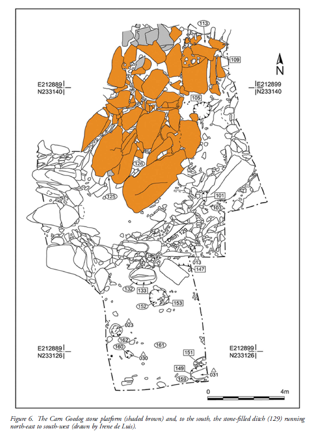
Plan of Excavation 106 is the hearth – The Bluestone Enigma.

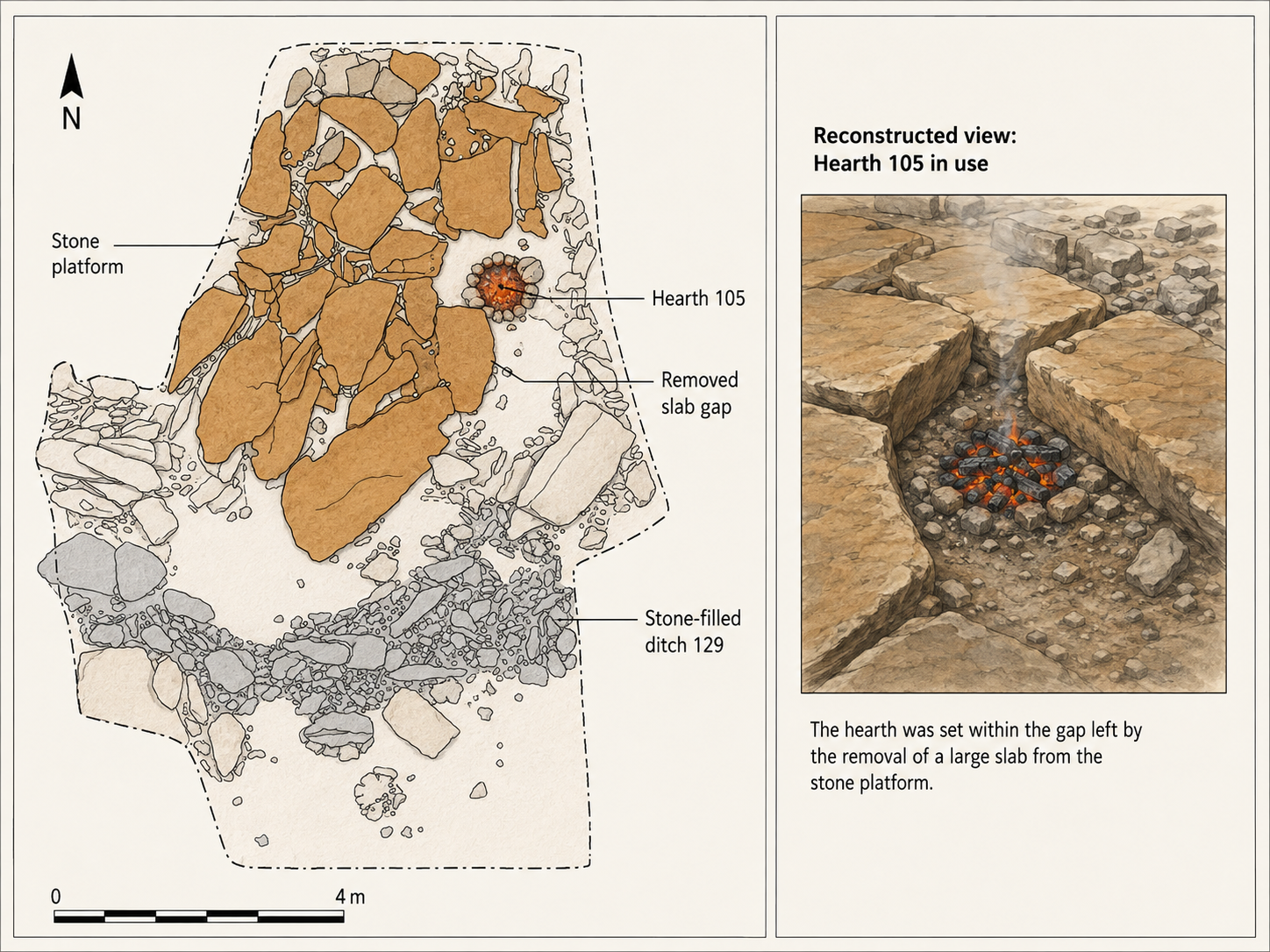
Trench 1 was enlarged in 2015 and 2016 to reveal features that may relate to prehistoric quarrying activity. At the southern foot of the outcrop, excavation revealed an artificial platform of flat slabs—many of them split—laid (with the split faces upwards) in a tongue-shaped formation 10m north–south by at least 8m east–west (Figure 6).

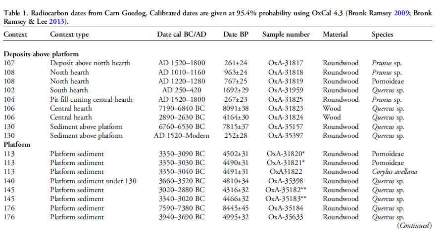
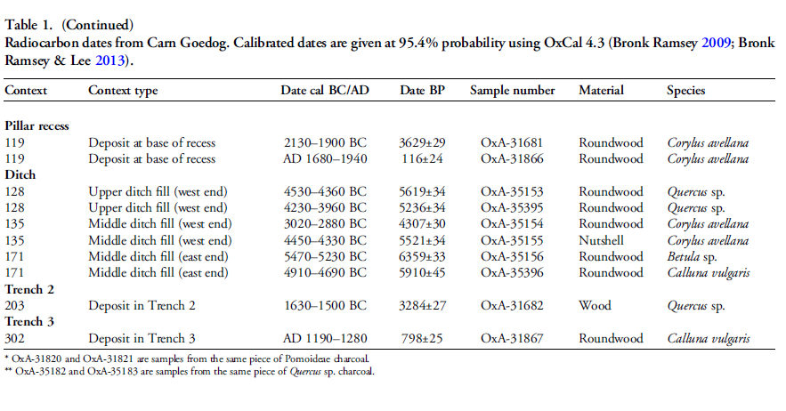
Those slabs lying against the face of the outcrop had been pressed into the underlying sediments, presumably by the weight of pillars lowered onto the platform. The platform terminates from the outcrop with a vertical drop of 0.9m to the ground surface beyond. This platform is stratigraphically earlier than a series of deposits that included early modern quarrying debris and hearths of the Roman and medieval periods. One hearth (Figure 6: 105) set within a gap in the platform where a slab had been removed produced charcoal dating to 7190–6840 cal BC (8091±38 BP) and 2890–2630 cal BC (4164±30 BP) (Table 1).

Bluestone Enigma
Bluestone Enigma


The findings across the quarry sites, including Carn Goedog and Craig Rhos-y-Felin, point to a nuanced understanding of how the bluestones were utilised and replenished at Stonehenge. The hearths discovered at these sites, particularly those dating to the Mesolithic and Neolithic periods, suggest ongoing human activity and potentially organised efforts to quarry and transport bluestones over extended periods. This insight challenges the conventional explanation that the transportation of Bluestones to Stonehenge was a singular event.

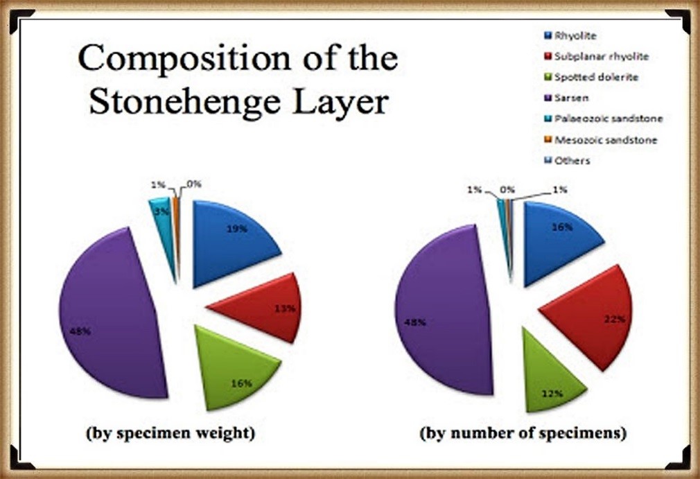
The Stonehenge Layer

The evidence of modern quarrying at both the northern and southern ends of these sites and the dates from central hearths align with observations made at Craig Rhos-y-felin. Our research, as outlined in published books, supports the theory that ancestors chipped bluestones at Stonehenge for healing, utilising the water in the ditch to bathe their sickness away, as evidenced by the ‘Stonehenge Layer’ discovered by Dervill and Wainwright in 2008. This practice would naturally lead to the depletion of bluestones over time, necessitating periodic replenishment from the quarries.

The conventional narrative, which posits that the bluestones were transported to Stonehenge in a one-off event, needs to account for the scientific data emerging from these quarry sites and the Stonehenge site. The evidence suggests a more complex interaction with these stones, involving repeated quarrying and transportation activities that likely spanned centuries. This ongoing relationship with the bluestones reflects a deeper functional connection to them, underscoring the importance of revisiting and revising our understanding of Stonehenge’s construction and the role of the bluestones within this prehistoric monument.

English Heritage’s significant investment in the Stonehenge Visitors Centre, including the creation of exhibitions that present established theories about the monument’s origins and functions, raises questions about the implications of discoveries that contradict these narratives. If foundational assumptions about Stonehenge are proven incorrect, it could have financial repercussions, particularly if the narrative presented to the public through expensive exhibitions becomes outdated or inaccurate. This situation underscores the complex relationship between archaeological research, public interpretation, and financial investments in heritage sites.

PodCast

Author’s Biography

Robert John Langdon, a polymathic luminary, emerges as a writer, historian, and eminent specialist in LiDAR Landscape Archaeology.

His intellectual voyage has been interwoven with stints as an astute scrutineer in government and grand corporate bastions, a tapestry spanning British Telecommunications, Cable and Wireless, British Gas, and the esteemed University of London.

A decade hence, Robert’s transition into retirement unfurled a chapter of insatiable curiosity. This phase saw him immerse himself in Politics, Archaeology, Philosophy, and the enigmatic realm of Quantum Mechanics. His academic odyssey traversed the venerable corridors of knowledge hubs such as the Museum of London, University College London, Birkbeck College, The City Literature Institute, and Chichester University.

In the symphony of his life, Robert is a custodian of three progeny and a pair of cherished grandchildren. His sanctuary lies ensconced in the embrace of West Wales, where he inhabits an isolated cottage, its windows framing a vista of the boundless sea – a retreat from the scrutinising gaze of Her Majesty’s Revenue and Customs, an amiable clandestinity in the lap of nature.

Exploring Prehistoric Britain: A Journey Through Time

My blog delves into the fascinating mysteries of prehistoric Britain, challenging conventional narratives and offering fresh perspectives grounded in cutting-edge research, particularly LiDAR technology. I invite you to explore some key areas of my research. For example, the Wansdyke, often cited as a defensive structure, is re-examined in light of new evidence. I’ve presented my findings in my blog post Wansdyke: A British Frontier Wall – ‘Debunked’, and a Wansdyke LiDAR Flyover video further visualises my conclusions.

My work also often challenges established archaeological dogma. I argue that many sites, such as Hambledon Hill, commonly identified as Iron Age hillforts, are not what they seem. My posts Lidar Investigation Hambledon Hill – NOT an ‘Iron Age Fort’ and Unmasking the “Iron Age Hillfort” Myth explore these ideas in detail and offer an alternative view. Similarly, sites like Cissbury Ring and White Sheet Camp receive re-evaluations based on LiDAR analysis in my posts “Lidar Investigation Cissbury Ring through time” and “Lidar Investigation White Sheet Camp,“ revealing fascinating insights into their true purpose. I have also examined South Cadbury Castle, often linked to the mythical Camelot56.

My research also extends to ancient water management, including the role of canals and other linear earthworks. I have discussed the true origins of Car Dyke in multiple posts, including Car Dyke – ABC News Podcast and Lidar Investigation Car Dyke – North Section, which suggest a Mesolithic origin 2357. I also explore the misidentification of Roman aqueducts, as seen in my posts on the Great Chesters (Roman) Aqueduct. My research has also been greatly informed by my post-glacial flooding hypothesis, which has helped explain landscape transformations over time. I have discussed this hypothesis in several posts, including AI now supports my Post-Glacial Flooding Hypothesis and Exploring Britain’s Flooded Past: A Personal Journey

Finally, my blog also investigates prehistoric burial practices, as seen in Prehistoric Burial Practices of Britain and explores the mystery of Pillow Mounds, often mistaken for medieval rabbit warrens, but with a potential link to Bronze Age cremation in my posts: Pillow Mounds: A Bronze Age Legacy of Cremation? and The Mystery of Pillow Mounds: Are They Really Medieval Rabbit Warrens?. My research also includes astronomical insights into ancient sites, for example, in Rediscovering the Winter Solstice: The Original Winter Festival. I also review new information about the construction of Stonehenge in The Stonehenge Enigma.

Further Reading

For those interested in British Prehistory, visit www.prehistoric-britain.co.uk, a comprehensive resource featuring an extensive collection of archaeology articles, modern LiDAR investigations, and groundbreaking research. The site also includes insights and excerpts from the acclaimed Robert John Langdon Trilogy, a series of books that explore Britain during the Prehistoric period. Titles in the trilogy include The Stonehenge Enigma, Dawn of the Lost Civilisation, and The Post-Glacial Flooding Hypothesis, which offer compelling evidence of ancient landscapes shaped by post-glacial flooding.

To further explore these topics, Robert John Langdon has developed a dedicated YouTube channel featuring over 100 video documentaries and investigations that complement the trilogy. Notable discoveries and studies showcased on the channel include 13 Things that Don’t Make Sense in History and the revelation of Silbury Avenue – The Lost Stone Avenue, a rediscovered prehistoric feature at Avebury, Wiltshire.

In addition to his main works, Langdon has released a series of shorter, accessible publications, ideal for readers delving into specific topics. These include:

For active discussions and updates on the trilogy’s findings and recent LiDAR investigations, join our vibrant community on Facebook. Engage with like-minded enthusiasts by leaving a message or contributing to debates in our Facebook Group.

Whether through the books, the website, or interactive videos, we aim to provide a deeper understanding of Britain’s fascinating prehistoric past. We encourage you to explore these resources and uncover the mysteries of ancient landscapes through the lens of modern archaeology.

For more information, including chapter extracts and related publications, visit the Robert John Langdon Author Page. Dive into works such as The Stonehenge Enigma or Dawn of the Lost Civilisation, and explore cutting-edge theories that challenge traditional historical narratives.
Other Blogs

s

t

The Great Stone Transportation Hoax

Introduction

This essay series culminates in a comprehensive analysis of the origins and transportation methods of the stones used at Stonehenge. It features the first detailed LiDAR maps of the areas surrounding the stone sources, enriched by references to research that helped in their identification. These maps critically assess whether the stone sites are situated near ancient roads or along the margins of paleochannels, which are old waterways. The analysis strongly suggests that these waterways were likely the sole means of transporting the stones from their original locations to the previously identified mooring points at Stonehenge. Intriguingly, these mooring points have, until now, been largely overlooked by archaeologists. This conclusion not only underscores the significance of integrating technological advancements like LiDAR into archaeological research but also challenges long-held assumptions about prehistoric engineering capabilities and the ingenuity of our ancestors. (The Stone Transportation Hoax)

(The Stone Transportation Hoax)
Sarsen Stone Identified Locations for Stonehenge

Geochemical fingerprinting

Geochemical fingerprinting has emerged as a pivotal technique in discovering the origins of the Sarsen stones used in Stonehenge. Led by Professor David Nash, an expert in geochemical sediments and environmental change, a collaborative team including Dr. Jake Ciborowski, Dr. Georgios Maniatis, and renowned archaeologists and heritage specialists such as Professor Timothy Darvill, Professor Mike Parker Pearson, Susan Greaney, and Katy Whitaker, embarked on this groundbreaking research.

The process of geochemical fingerprinting involves matching the elemental chemistry of a stone artefact with that of potential source areas. For Stonehenge, this necessitated a two-stage approach. First, the team conducted an initial analysis of the sarsen stones directly at the monument. Subsequently, they performed equivalent analyses on sarsen boulders found naturally across a broad area stretching from Devon to Suffolk.

To accurately determine the elemental chemistry of the Stonehenge sarsens, the team employed a portable X-ray Fluorescence Spectrometer (pXRF). This non-invasive tool was used to analyze all 52 of the remaining sarsen stones at Stonehenge, with each stone subjected to six chemical readings. Dr. Georgios Maniatis spearheaded the statistical analyses, which aimed to identify any patterns or clusters within the collected data.

(The Stone Transportation Hoax)

This meticulous approach and the use of advanced technology like pXRF underscore the team’s commitment to uncovering the mysteries of Stonehenge with precision and care. Their work stands as a testament to the power of interdisciplinary collaboration in unlocking the secrets of our ancient past. (https://www.brighton.ac.uk/research/research-news/feature/stonehenge-researching-sarsen-stones.aspx)

The Bluestones – Craig Rhos-y-Felin

Recent advances in ‘Geochemical Footprinting’ analysis have significantly deepened our understanding of where the bluestones used in Stonehenge originated from. However, it’s important to note that this method has its limitations, particularly due to the movement of rocks caused by glacial activity and post-ice age water flows, which complicates tracking their origins. Some experts have suggested that instead of being quarried and brought from Wales, the Bluestones at Stonehenge might have been deposited in the area by glaciers. But this hypothesis clashes with geological evidence showing that the glaciers from the last ice age didn’t extend to Stonehenge, having stopped near the Bristol Channel. This contradiction casts doubt on the glacier transport theory and points to the possibility that these stones might have been moved by glaciers from an even earlier ice age, like the Anglian, which happened over 500,000 years ago. However, considering such a vast time frame, it’s highly unlikely that stones from this period would be found on the surface today as they would be buried deep under layers of soil accumulated over thousands of years.

(The Stone Transportation Hoax)
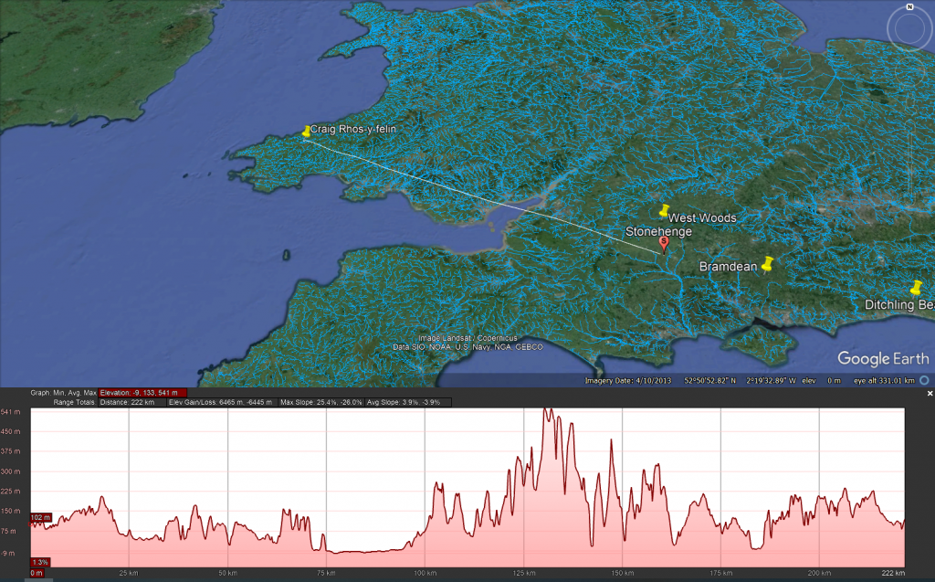
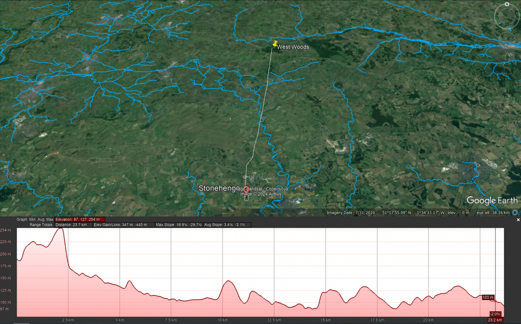
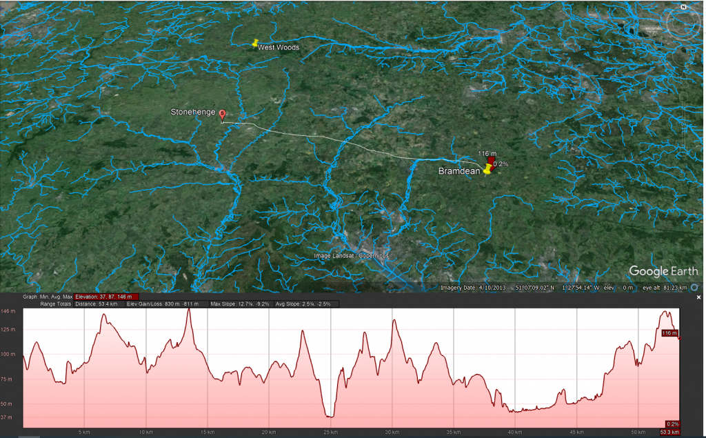
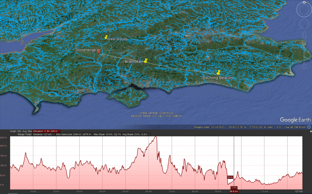
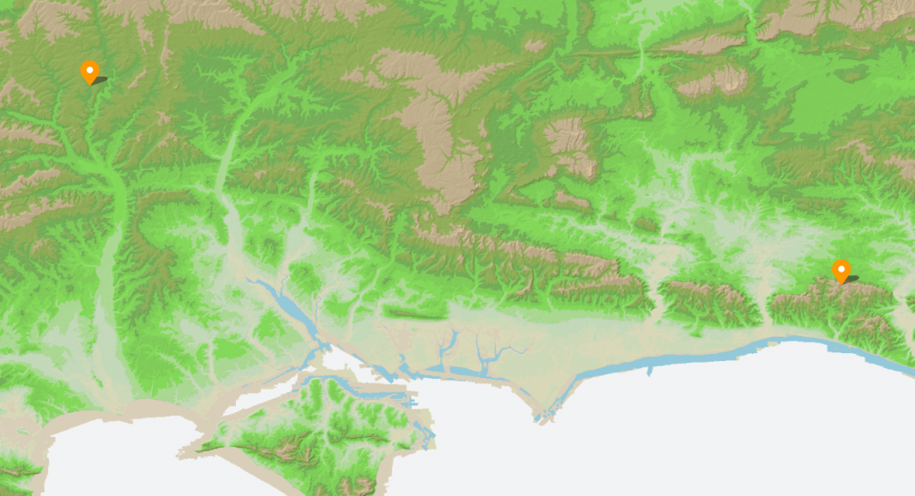
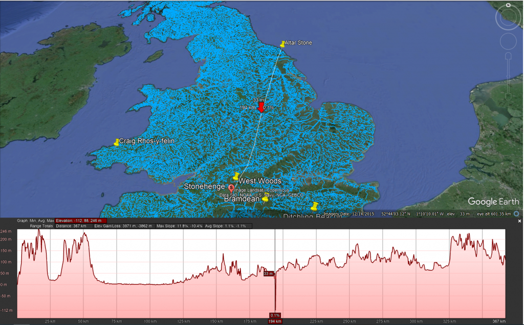
This profile map shows the type of landscape faced by any person wishing to take stones overland to Stonehenge

Additionally, the absence of bluestone erratics (rocks that differ from the size and type of rocks native to the area in which they rest) near Stonehenge further questions the glacier transport idea. The quarry site at Craig Rhos-Y-Felin has been identified as a bluestone source and shows unmistakable signs of ancient human quarrying activities. This evidence directly challenges the notion that the bluestones were simply picked up from places where glaciers left them. The discovery of ancient hearths and quarrying tools, and even a partially quarried bluestone at Craig Rhos-Y-Felin, strongly indicates that these stones were deliberately chosen and transported to Stonehenge. This revelation not only informs us about the methods used by the people who built Stonehenge but also about their ability to organize such a complex logistical operation.

The overland path from Craig Rhos-y-felin to Stonehenge is insane. It goes from 75m OD to 541 OD and crosses 95 valleys – the idea that you can either roll, drag or ox-cart such a route without a road is bonkers!!

LiDAR Survey

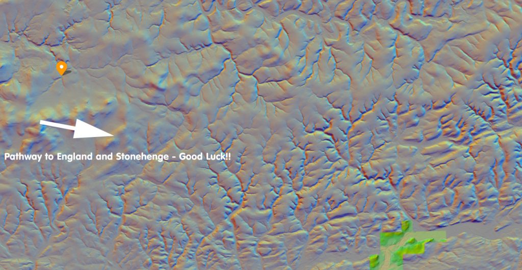
The detailed examination of the Craig Rhos-y-felin quarry, identified over the past decade as the source of Stonehenge’s bluestones, has brought new insights into how these stones might have been transported. Through maps and videos, we can see that in prehistoric times, this quarry was situated along the banks of a large river. Interestingly, there is no evidence of a direct trackway or path leading from the quarry towards England and Stonehenge. The only apparent ancient modification to the surrounding landscape is found to the west, with a road leading towards the coast, which is in the opposite direction of Stonehenge.

Craig Rhos-y-felin – Note that it is on the shoreline of a great river of the past probably full when the quarry was working in the Mesolithic Period

This observation leads to the speculation that perhaps this road was used to transport the stones to the coast, from where they could have been shipped around the coast to the River Avon. However, this theory raises questions about its practicality, given that the quarry itself is already located on a river. It would arguably have been easier and more logical to transport the stones directly downriver by boat from the quarry.

The only route overland is going West the Road (7-miles) going NE goes to Aberywstyth in Mid-Wales

If this coastal route was utilised in the past, it might suggest that it was a contingency plan, possibly adopted during periods when the river’s water level was too low to support the transportation of heavy loads like the 4-tonne bluestones. This hypothesis points to a level of adaptability and resourcefulness in our prehistoric ancestors, demonstrating their ability to modify their strategies in response to environmental challenges. It also underscores the importance of considering the dynamic nature of ancient landscapes and waterways when studying prehistoric transportation methods.

The only possible signs of stones coming out of the Quarry (not by boat) is going West – to the Coast

The Sarsen Stones

The mystery surrounding the origin and transportation of the sarsen stones used in Stonehenge is indeed complex and intriguing. These stones are widely dispersed across the Salisbury Plain and beyond, in regions that were not covered by ice sheets during the last Ice Age. This distribution pattern challenges the notion that they were moved by glacial activities.

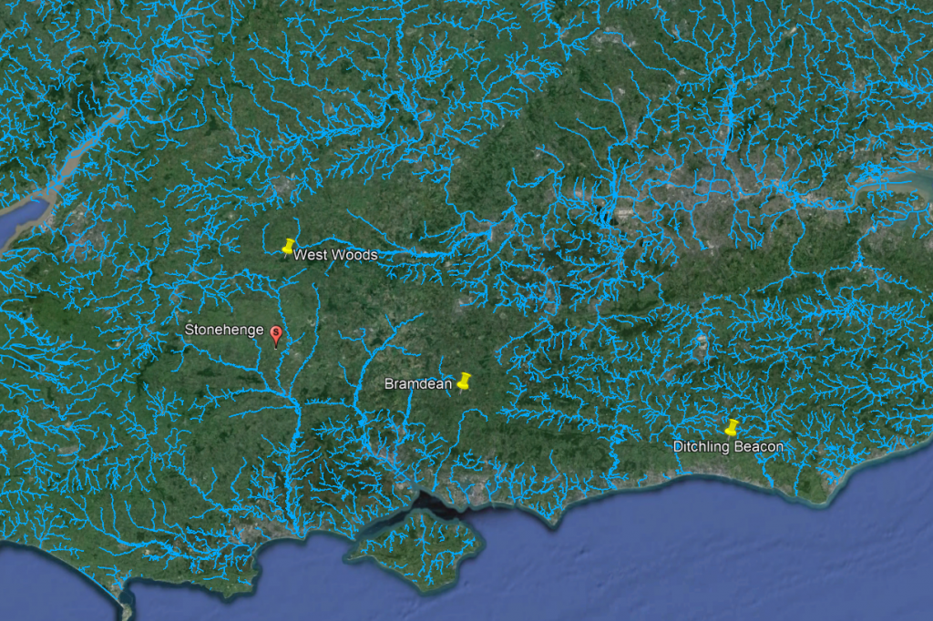
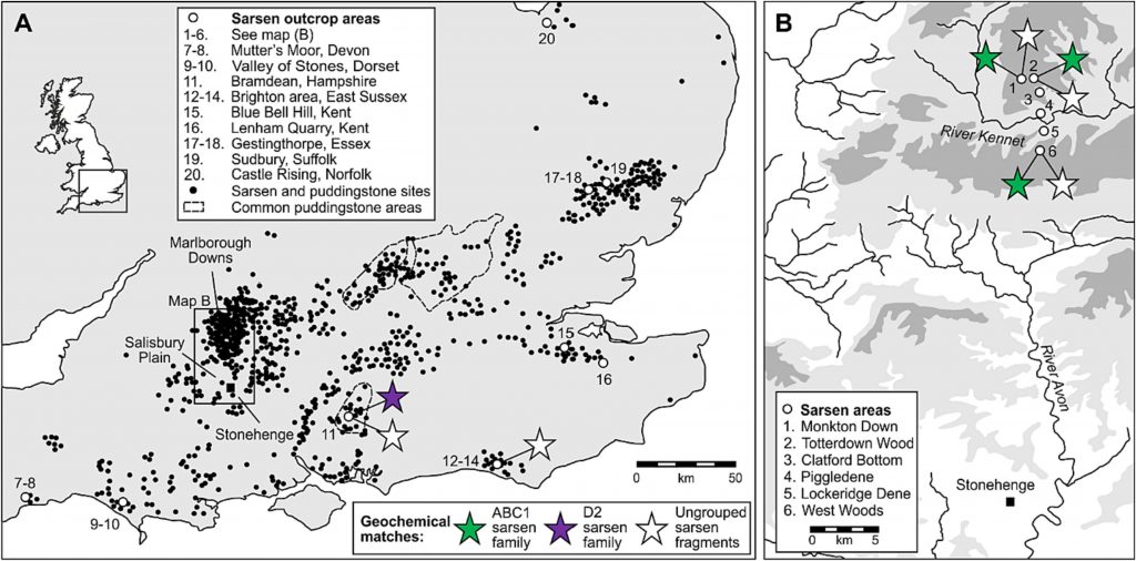
A prevalent theory posits that the sarsen stones originated from West Woods near Avebury, implying that they were manually transported to Stonehenge. However, recent observations have cast doubt on this theory. Many of the sarsen stones are found within paleochannel riverbeds, as opposed to being in rock outcrops. Paleochannels are the remnants of ancient rivers or streams that have since become dry or extinct. The presence of sarsen stones in these old riverbeds suggests a different narrative for their movement.

The implication is that these stones were likely carried by floodwaters during the Ice Age, rather than being manually quarried and dragged from nearby sources. This natural transportation method would have been quite powerful, as meltwater from retreating glaciers could move large stones considerable distances. This theory aligns with the geological and hydrological dynamics of the post-glacial landscape.

This map shows that picking just the nearest Sarsen stone was not required and clearly had purpose – this suggest a structural or property requirement

Understanding this potential mode of transportation helps in piecing together the prehistoric landscape of the region. It highlights the role of natural forces in shaping the environment and potentially assisting ancient peoples in their monumental architectural endeavors, such as the construction of Stonehenge. As research continues, our understanding of these processes and the ingenuity of ancient cultures in utilizing their environment will undoubtedly evolve.

AC Smith most detailed Avebury map shows that all sarsens are found in Dry River Valleys (Paleochannels)

West Woods – Wiltshire (23.2 km)

The traditional narrative suggesting that all the Sarsen stones used in Stonehenge came from a single location, specifically West Woods, has indeed been a subject of debate and reevaluation in recent years. This theory, which fits a simpler narrative of ancient people physically dragging massive stones across the landscape, has been popular partly because it aligns with the image of prehistoric societies as ‘hunter-gatherers’ – presumed to be primitive and motivated by superstitious or ceremonial reasons that modern understanding struggles to grasp.

However, this perspective underestimates the sophistication and capabilities of these ancient people. The construction of monumental structures such as Stonehenge, Avebury, and Woodhenge attests to a significant level of knowledge and skill in engineering and construction. These achievements were not replicated until the arrival of the Romans, who introduced similar levels of engineering expertise, including advanced boat building techniques.

The AC Smiths West Wood Sarsens are scattered from their max location down the Paleochannels to Wansdyke

Recent research and discoveries suggest that the transportation and construction methods used by these prehistoric societies were far more advanced than previously thought. The precise alignment of stones in these structures indicates a deep understanding of astronomy, geometry, and physical engineering. Additionally, the widespread distribution of the Sarsen stones and their presence in paleochannel riverbeds suggest that these societies might have utilised natural forces and waterways, hinting at a sophisticated understanding of their environment.

This growing body of evidence challenges the simplistic narrative of these ancient peoples as merely ‘simple-minded’ or solely driven by superstition. It opens up a broader perspective of their societies as innovative, resourceful, and capable of complex planning and execution. Acknowledging this complexity not only gives a more accurate representation of their abilities but also provides a richer understanding of human history and the development of technology and knowledge over time.

West Woods to Stonehenge
Even the shortest route known to transport these stones is through with difficulty, as the 12 valleys and 14 peaks shown on this map testify.

Wansdyke

Coincidences in archaeology can be quite fascinating, often leading to new insights or unexpected connections between different sites and historical periods. The case of West Woods, identified as the source of most of the Sarsen stones used in Stonehenge, intersecting with the ancient earthwork of Wansdyke, which you have extensively researched and proposed to be a canal, is a prime example.

Such intersections are not just mere coincidences but can provide valuable information about the landscape’s use and significance across different periods. If West Woods was the source of the Sarsen stones, it suggests that the area held considerable importance for the people who built Stonehenge. Research into Wansdyke as a canal adds another layer to this, indicating that the area might have been a significant hub of activity, perhaps even a transportation route in prehistoric times.

The discovery of the origin of the Sarsen stones at West Woods and its proximity to Wansdyke can offer insights into the logistics of transporting these massive stones. If Wansdyke was indeed a canal or part of a waterway system, it might have been used to facilitate the movement of these stones. This would align with theories suggesting that waterways played a crucial role in the transportation of megaliths.

Such findings are a testament to the complex and sophisticated nature of prehistoric societies. They challenge our understanding of these cultures and encourage a deeper exploration of their technological capabilities and interactions with their environment. Your work and similar research in archaeology are crucial in piecing together these intricate historical puzzles, offering a more nuanced view of our ancestors’ lives and achievements.

Wansdyke has now been proven to be Prehistoric in date – so was it built to transport these stones?

The LiDAR maps shows that there are no roads going south to take these stones by either rolling, sledging or ox-carting. Ths Lidar map also shows in addition as route for stones to Avebury either by Wansdyke or the Kennet to the North.

Bramdean – Hampshire (53.3 km)

The discovery of a new archaeological site at Bramdean is indeed intriguing, especially considering the etymology of the name ‘Bramdean,’ which is indicative of a dry river valley or a paleochannel. Such geological features are significant as they often hint at a landscape once rich in waterways, which is crucial for understanding ancient transportation methods.

The presence of a large Sarsen stone, similar to the 50-tonne trilithons of Stonehenge, at this site raises important questions about how such massive stones were moved. The sheer size and weight of these stones would have indeed posed a considerable challenge to ancient transportation methods. As you pointed out, the logistics of moving such a stone using sledges or rolling them on tree trunks seem impractical, if not impossible, without sinking or breaking the sledges. Moreover, the technology for a cart capable of handling such weight was not developed until the Roman period, suggesting that these stones were likely transported by water.

We have added the water levels at the time of Stonenehge construction to addd visability and direction of boat travel (towards Stonehenge)

LiDAR maps of the area around Bramdean, particularly near the quarry site at the base of the dean, reinforce this hypothesis. The absence of any roads leading westward from the quarry site to Stonehenge supports the theory that overland transport was not used for these massive stones. Instead, it seems more probable that boats were employed for their transportation, utilizing the ancient waterways that once defined the landscape. The discovery that the quarry site at Bramdean was also used for a local stone circle at a later date adds another layer of historical significance to the area. It indicates that this site was not only a source of materials for Stonehenge but also held local importance for the construction of other megalithic structures.

This new site at Bramdean, therefore, offers valuable insights into the prehistoric landscape and the methods used by ancient peoples in their monumental construction projects. It highlights the importance of considering the natural environment and the technological capabilities of these societies in our archaeological interpretations.

Ditchling – East Sussex (127 km)

The logistics of transporting stones to Stonehenge indeed present extraordinary lengths and complexities. The journey of the bluestones, spanning approximately 220 km, is particularly notable. Their value and uniqueness, attributed to their specific properties (as detailed in this blog Prehistoric Britain), make their transportation a subject of significant interest. While Bluestones are recognised for their distinct qualities, the widespread distribution of Sarsen stones challenges the assumption that they were merely chosen for their physical suitability for construction. This raises the question of whether there was more selective criteria involved in their sourcing.

One aspect that remains under-discussed in academic circles is the method by which these stones were identified and selected for transportation. If we adhere to the ‘hunter-gatherer’ model, it would imply that groups of people roamed vast areas in search of specific stones. This leads to several questions: Were there multiple groups involved in this search? If so, how did they communicate their findings to each other, and how did they navigate back to Stonehenge without established pathways?

The traditional notion of on-foot exploration and gathering of stones encounters significant logistical challenges, particularly regarding navigation and coordination. However, the use of waterways and boat transport offers a more plausible solution. Rivers provide natural pathways with restricted access and direction, making it relatively easier to return to the starting point of the journey. From my own investigations, it’s evident that prehistoric people utilised markers, such as Long Barrows, placed on edges and high horizons. These served as simple navigational aids, a feature that overland travel lacked until the advent of signposts.

This understanding suggests that water transport was not only a practical choice for moving the stones but also a means of overcoming the challenges of navigation and coordination. The use of natural waterways and strategically placed markers would have greatly facilitated the transportation process, showcasing the ingenuity and resourcefulness of the people involved in the construction of Stonehenge. Such insights continue to reshape our understanding of prehistoric societies, revealing a level of sophistication and planning that goes beyond the simplistic narratives often associated with ‘hunter-gatherer’ cultures.

LiDAR Map

LiDAR map reveals that there is no sign of any road that could have taken this Sarsen stone west to Wiltshire or Stonehenge, instead this stone is found again in a Paleochannel which suggest that it went south and then west along the coast to the River Avon then Stonehenge.

The Altar Stone – Northwern England maybe even Scotland (min 367 km + )

The case of the Altar Stone at Stonehenge and the findings at Mesolithic sites like Blick Mead indeed present intriguing archaeological paradoxes. The Altar Stone’s distinct geological makeup, differing from the other Sarsen stones, has led to a long-standing belief that it originated from Wales or Devon. Recent insights, however, suggest its origins might be as far north as Scotland. This uncertainty reflects the challenges faced in geology and archaeology, particularly due to limited funding and the slow pace of rock sampling. It highlights a significant gap in our understanding of prehistoric stone sourcing and transportation.

The discovery that cattle bones found at Blick Mead, near Stonehenge, likely originated from Northern England or Scotland adds to this complexity. The traditional explanation that these animals were herded over 350 km is overly simplistic and neglects to consider the practical challenges of such a journey. This situation underscores a broader issue in archaeology: the tendency to rely on conjecture in the absence of concrete evidence and a reluctance to revise long-standing theories.

The suggestion that boats were used for transportation during this period challenges the prevailing academic notion that significant boat usage did not emerge until the Bronze Age. Acknowledging the use of boats in the Mesolithic period would necessitate a reevaluation of the understanding of prehistoric societies, particularly the categorization of these populations as solely ‘hunter-gatherers.’ Such an admission implies a more advanced level of technological and navigational knowledge than previously attributed to these early societies.

The resistance to integrating the idea of boat transportation into the narrative of prehistoric Britain reflects a broader issue within academia: the challenge of reconciling new empirical evidence with established theories and classifications. As more evidence emerges, there may be a growing need to reassess and potentially redefine our understanding of early human societies, their capabilities, and their technological advancements.

LiDAR Map

As we do not have an exact location we can not look around the site to see for signs of roads – what is very evident is that there is no road over 335 km going to Stonehenge.

Theories of Transportation

The theory that the stones could have been moved over frozen rivers during the ice age is intriguing but fraught with logistical issues. The absence of a significant human population capable of organising such an endeavour, coupled with the challenges of moving heavy stones over potentially thin ice, makes this theory less plausible. Additionally, the radiocarbon dating of Stonehenge would be significantly off if the stones had been transported at the end of the ice age.

LiDAR, or Light Detection and Ranging, is a remote sensing technology that uses laser light to densely sample the earth’s surface, creating highly accurate topographic maps. It has revolutionised archaeological surveys by uncovering features difficult or impossible to see from the ground or through traditional surveying methods. Regarding Stonehenge and the transportation of the stones used in its construction, LiDAR technology offers invaluable insights into the landscape and potential transport routes used by ancient peoples.

There is only one road out of Stonenege and that goes down to Stonehenge bottom were the Avon used to flow

LiDAR Evidence and Stonehenge

LiDAR has been instrumental in mapping the landscape around Stonehenge, revealing details that have remained hidden for millennia under vegetation or soil. This technology has the potential to identify old riverbeds, trackways, and other features that could suggest routes for transporting the massive sarsen stones and bluestones used in the monument’s construction. However, despite its capabilities, LiDAR has not yet provided definitive evidence of prehistoric roads or paths leading directly from the quarries to Stonehenge.

Key Findings from LiDAR Surveys

No Prehistoric Roads from Quarries: LiDAR surveys have not discovered any signs of engineered roads or paths originating from the bluestone quarries in Wales or the locations where sarsen stones are found. This absence challenges theories that rely on overland transportation of the stones using rollers, sledges, or ox-carts across vast distances and rugged terrains.

Ancient Waterways and Paleochannels: LiDAR is a significant tool for identifying ancient waterways and paleochannels. These features are crucial for understanding the prehistoric landscape, suggesting that rivers and watercourses may have played a significant role in transporting the stones. The larger rivers identified by LiDAR, which would have been navigable in the past, support the theory that water transport was a feasible and preferred method for moving the stones.

Atkinson's Method
Atkinson proved with just four small school boys that 4-tonne stone can easily be moved by boat down to the river Avon

Landscape Features: LiDAR has revealed the complexity of the landscape through which any transportation route would have had to navigate, including valleys, dense forests, and waterlogged areas. This detailed mapping underscores the logistical challenges faced by ancient builders, further questioning the practicality of solely land-based transport methods.

We have now found empirical evidence of boat yards in which catamaran design is made to carry large weights in Wales dating back to the Bronze Age and beyond

Implications of LiDAR Evidence

The evidence from LiDAR surveys, particularly the absence of prehistoric roads and the emphasis on natural watercourses, suggests a revaluation of how the stones were transported to Stonehenge. The lack of direct routes from quarries to the site and the identification of navigable ancient rivers and paleochannels lend weight to theories prioritising water transport. This perspective aligns with the understanding that ancient peoples were highly adept at utilising their natural environment to achieve monumental feats of construction.

Alter Stone to Stonehenge
The Altar Stone is now suspected of coming from as far as Scotland as its Geo signature is not available down south (I would guess Doggerland for obvious reasons) but even if it just came from the Yorkshire Dales the idea of l, and transportation is pure nonsense

The West Woods Fallacy (AI Analysis)

How One Stone and a Convenient Narrative Redefined the Origins of Stonehenge’s Sarsens

Introduction

For years, the origin of Stonehenge’s massive sarsen stones remained a mystery cloaked in chalk dust and speculation. Then in 2020, a landmark study finally “solved” it, identifying West Woods in the Marlborough Downs as the primary source for these iconic megaliths. The evidence? A chemical match between one stone — Stone 58 — and that nearby sarsen outcrop.

Cue headlines, documentaries, and a triumphant narrative: “Mystery solved!”

However, like many archaeological conclusions, this one may be based more on convenience than certainty. Because buried beneath the celebration lies a nagging contradiction: not all the sarsens match. Some fragments don’t even come close. And those that don’t? They point to places far beyond the tidy West Woods story.

Stone 58: The Golden Child

Stone 58 earned its fame by being the only standing sarsen to have been cored and sampled internally. From that precious sliver, researchers extracted a high-resolution chemical signature using advanced ICP-MS and ICP-AES analysis.

Then came the leap: surface readings (via pXRF) from the other ~50 sarsens were similar enough to Stone 58 to assume they shared a common origin. That origin was matched to West Woods, 25 km to the north.

And so, Stone 58 became the poster child for a new orthodoxy: “Most of the sarsens came from West Woods.”

But Then Came the Fragments…

Fast-forward to 2024, and a new geochemical study of over 1,000 excavated fragments (debitage) from around Stonehenge throws a significant, ancient wrench into the theory.

Of these, 54 were chosen for detailed chemical analysis. The results?

– 22 of them didn’t match Stone 58 at all. – Three matched sarsen outcrops from Bramdean, Hampshire. – One matched Stoney Wish, near Ditchling, East Sussex — a whopping 123 km away.

This isn’t minor variation. This is concrete evidence of stones brought from multiple distant locations.

The Paradox of Proximity

The paradox is this:

If the builders of Stonehenge were willing and able to transport giant stones from Sussex and Hampshire, why is so much weight given to West Woods simply because it’s closer?

The logic is circular: – West Woods is nearby. – Stone 58 matches West Woods. – Other stones look like Stone 58 (on the surface). – Therefore, the other stones must be from West Woods.

It’s a classic case of assumption baked into methodology. Convenient? Yes. Definitive? Not even close.

What This Means

The so-called West Woods majority theory is based on:

– One sampled stone – Surface-level comparisons (not internal chemical analysis) – A limited number of sarsen outcrops tested

Meanwhile, real geochemical matches from other sites prove that the builders sourced stone from a much wider area, and possibly for symbolic, ceremonial, or practical reasons that we do not yet understand.

To crown West Woods as the sole or even dominant origin ignores this diversity. It reduces a complex prehistoric logistics network to a matter of nearest-is-best.

Conclusion: A Fallacy in the Forest

The West Woods theory is not without merit. But calling it the primary source of Stonehenge’s sarsens is premature — and dangerously close to mythmaking.

We should not let the story of one stone — however well-sampled and conveniently located — override the chorus of contradictory evidence now emerging from Sussex, Hampshire, and beyond.

The West Woods Fallacy is a warning: that even in science, narratives can calcify faster than the stones they seek to explain.

The West Woods Fallacy

“Ah yes, of course! Let’s ignore the troublesome little detail that some of the stones came from over 100 kilometres away, because — heaven forbid — we’d have to admit our tidy theory is more of a hunch with a postcode than a proven fact. Mustn’t let a few rogue rocks spoil the brochure!”

— Basil Fawlty, if he did geoarchaeology

Based on the analaysis of the report –

T. Jake R. Ciborowski, David J. Nash, Timothy Darvill, Ben Chan, Mike Parker Pearson, Rebecca Pullen, Colin Richards, Hugo Anderson-Whymark,

Local and exotic sources of sarsen debitage at Stonehenge revealed by geochemical provenancing,

Journal of Archaeological Science: Reports, Volume 53, 2024, 104406,

ISSN 2352-409X,

https://doi.org/10.1016/j.jasrep.2024.104406.

(https://www.sciencedirect.com/science/article/pii/S2352409X24000348)

PodCast

Author’s Biography

Robert John Langdon, a polymathic luminary, emerges as a writer, historian, and eminent specialist in LiDAR Landscape Archaeology.

His intellectual voyage has interwoven with stints as an astute scrutineer for governmental realms and grand corporate bastions, a tapestry spanning British Telecommunications, Cable and Wireless, British Gas, and the esteemed University of London.

A decade hence, Robert’s transition into retirement unfurled a chapter of insatiable curiosity. This phase saw him immerse himself in Politics, Archaeology, Philosophy, and the enigmatic realm of Quantum Mechanics. His academic odyssey traversed the venerable corridors of knowledge hubs such as the Museum of London, University College London, Birkbeck College, The City Literature Institute, and Chichester University.

In the symphony of his life, Robert is a custodian of three progeny and a pair of cherished grandchildren. His sanctuary lies ensconced in the embrace of West Wales, where he inhabits an isolated cottage, its windows framing a vista of the boundless sea – a retreat from the scrutinous gaze of the Her Majesty’s Revenue and Customs, an amiable clandestinity in the lap of nature’s embrace.

Exploring Prehistoric Britain: A Journey Through Time

My blog delves into the fascinating mysteries of prehistoric Britain, challenging conventional narratives and offering fresh perspectives based on cutting-edge research, particularly using LiDAR technology. I invite you to explore some key areas of my research. For example, the Wansdyke, often cited as a defensive structure, is re-examined in light of new evidence. I’ve presented my findings in my blog post Wansdyke: A British Frontier Wall – ‘Debunked’, and a Wansdyke LiDAR Flyover video further visualizes my conclusions.

My work also often challenges established archaeological dogma. I argue that many sites, such as Hambledon Hill, commonly identified as Iron Age hillforts are not what they seem. My posts Lidar Investigation Hambledon Hill – NOT an ‘Iron Age Fort’ and Unmasking the “Iron Age Hillfort” Myth explore these ideas in detail and offer an alternative view. Similarly, sites like Cissbury Ring and White Sheet Camp, also receive a re-evaluation based on LiDAR analysis in my posts Lidar Investigation Cissbury Ring through time and Lidar Investigation White Sheet Camp, revealing fascinating insights into their true purpose. I have also examined South Cadbury Castle, often linked to the mythical Camelot56.

My research also extends to the topic of ancient water management, including the role of canals and other linear earthworks. I have discussed the true origins of Car Dyke in multiple posts including Car Dyke – ABC News PodCast and Lidar Investigation Car Dyke – North Section, suggesting a Mesolithic origin2357. I also explore the misidentification of Roman aqueducts, as seen in my posts on the Great Chesters (Roman) Aqueduct. My research has also been greatly informed by my post-glacial flooding hypothesis which has helped to inform the landscape transformations over time. I have discussed this hypothesis in several posts including AI now supports my Post-Glacial Flooding Hypothesis and Exploring Britain’s Flooded Past: A Personal Journey

Finally, my blog also investigates prehistoric burial practices, as seen in Prehistoric Burial Practices of Britain and explores the mystery of Pillow Mounds, often mistaken for medieval rabbit warrens, but with a potential link to Bronze Age cremation in my posts: Pillow Mounds: A Bronze Age Legacy of Cremation? and The Mystery of Pillow Mounds: Are They Really Medieval Rabbit Warrens?. My research also includes the astronomical insights of ancient sites, for example, in Rediscovering the Winter Solstice: The Original Winter Festival. I also review new information about the construction of Stonehenge in The Stonehenge Enigma.

Further Reading

For those interested in British Prehistory, visit www.prehistoric-britain.co.uk, a comprehensive resource featuring an extensive collection of archaeology articles, modern LiDAR investigations, and groundbreaking research. The site also includes insights and extracts from the acclaimed Robert John Langdon Trilogy, a series of books exploring Britain during the Prehistoric period. Titles in the trilogy include The Stonehenge Enigma, Dawn of the Lost Civilisation, and The Post Glacial Flooding Hypothesis, offering compelling evidence about ancient landscapes shaped by post-glacial flooding.

To further explore these topics, Robert John Langdon has developed a dedicated YouTube channel featuring over 100 video documentaries and investigations that complement the trilogy. Notable discoveries and studies showcased on the channel include 13 Things that Don’t Make Sense in History and the revelation of Silbury Avenue – The Lost Stone Avenue, a rediscovered prehistoric feature at Avebury, Wiltshire.

In addition to his main works, Langdon has released a series of shorter, accessible publications, ideal for readers delving into specific topics. These include:

For active discussions and updates on the trilogy’s findings and recent LiDAR investigations, join our vibrant community on Facebook. Engage with like-minded enthusiasts by leaving a message or contributing to debates in our Facebook Group.

Whether through the books, the website, or interactive videos, we aim to provide a deeper understanding of Britain’s fascinating prehistoric past. We encourage you to explore these resources and uncover the mysteries of ancient landscapes through the lens of modern archaeology.

For more information, including chapter extracts and related publications, visit the Robert John Langdon Author Page. Dive into works such as The Stonehenge Enigma or Dawn of the Lost Civilisation, and explore cutting-edge theories that challenge traditional historical narratives.
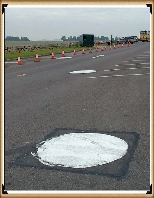
Other Blogs

s

t