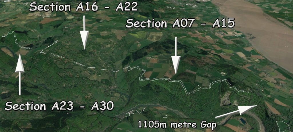
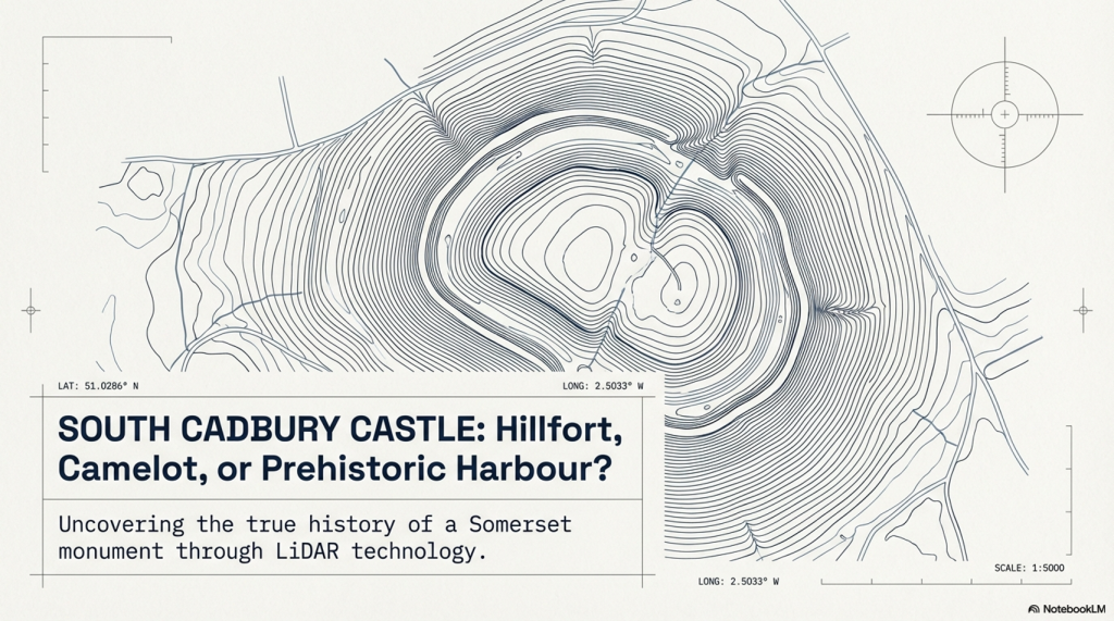
South Cadbury Castle – Camelot

Introduction

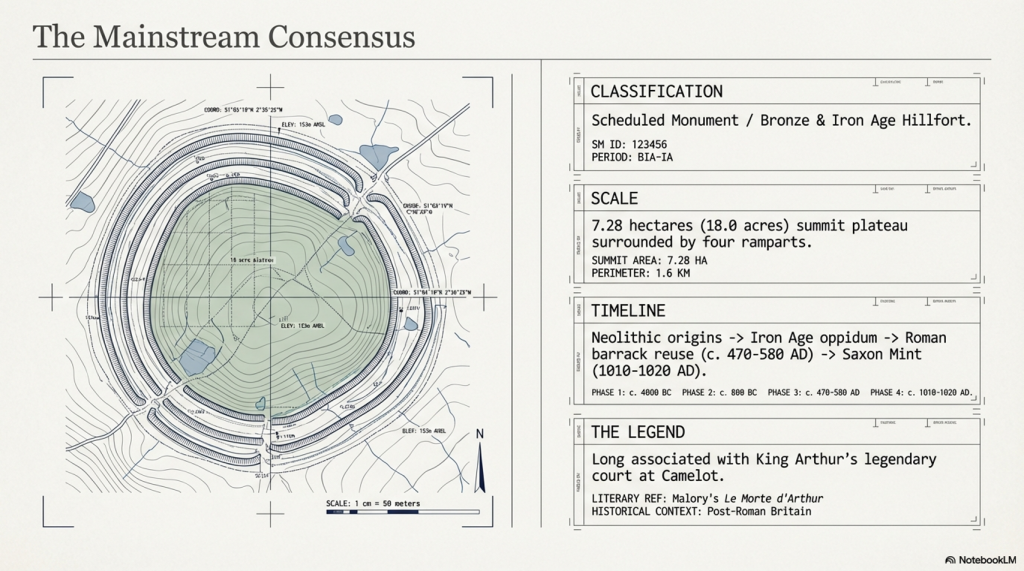
In the traditional archaeological interpretation, Cadbury Castle represents a long-lived settlement that developed gradually over several millennia. The earliest evidence of activity dates to the Neolithic period, where pits and postholes associated with pottery and flint finds suggest a small, unenclosed agricultural community. Radiocarbon dating places this early occupation around 3500–3300 BC, indicating that the hill was already being utilised long before the construction of its later defences.(South Cadbury Castle – Camelot)

The site continued to be occupied into the Bronze Age, where evidence of ovens and metalworking activity points to an increasingly organised settlement. By the Iron Age, Cadbury Castle had developed into a substantial fortified enclosure. Around 300 BC, a stone-built enclosure with timber reinforcements was constructed, later expanded into a complex hillfort with multiple ramparts and elaborate defensive systems. Excavations have revealed both roundhouses and rectangular structures, alongside evidence of industrial activity and possible ritual features, suggesting a permanent and socially complex community—often described as “oppidum-like” in character.
South Cadbury Castle - Camelot
South Cadbury Castle – Camelot

During the 1st century BC and into the early Roman period, the defences were further strengthened. Archaeological evidence indicates that the site may have been violently attacked during the Roman conquest of Britain, around AD 43, with signs of burning and destruction uncovered at key प्रवेश points. Following this, the Romans appear to have reused the hilltop, possibly establishing a military presence and later constructing a temple during the 3rd or 4th century AD.

After the end of Roman administration, Cadbury Castle was reoccupied in the post-Roman period, between approximately AD 470 and 580. Excavations led by Leslie Alcock revealed a large timber “Great Hall,” interpreted within the traditional framework as the residence of a high-status Brittonic ruler. The discovery of imported Mediterranean pottery from this phase suggests long-distance trade connections and reinforces the idea of the site as a regional power centre. It is this phase of occupation that has led to long-standing associations with the legendary Camelot of King Arthur.
South Cadbury Castle - Camelot
South Cadbury Castle – Camelot

The site saw later reuse in the early medieval period, including the establishment of a temporary Saxon mint in the 11th century. Across its long history, Cadbury Castle is therefore understood, in conventional terms, as a multi-period fortified settlement—evolving from a Neolithic farming site into a major Iron Age stronghold, later adapted by Roman and post-Roman communities, and ultimately woven into both historical and legendary narratives.

The Problem with the Traditional Interpretation

The conventional explanation of Cadbury Castle presents a familiar story: a hilltop settlement that gradually evolves from a Neolithic farm into a Bronze Age community, then into an Iron Age hillfort, later reused by Romans and post-Roman elites.

It sounds neat. It reads well. But when examined critically, it raises more problems than it solves.
South Cadbury Castle - Camelot
South Cadbury Castle – Camelot

The core issue is methodological.

The site is treated as a continuous “occupation sequence,” yet the evidence presented is not continuous—it is fragmentary, intermittent, and separated by significant spans of time. A pit here, a posthole there, a later rampart above it—all are grouped together and interpreted as a single evolving settlement. In reality, what is being described is not continuity, but repeated reuse of a prominent landscape feature over thousands of years.

This is a fundamental distinction.

Finding Neolithic pits does not prove a Neolithic settlement in the sense implied. It proves activity. The same applies to Bronze Age ovens, Iron Age ramparts, or post-Roman halls. Each represents a moment in time, not necessarily a continuous tradition of occupation.

Archaeology, however, routinely compresses these separate events into a single narrative—effectively averaging the past into a story that feels coherent but is not supported as a continuous process.
South Cadbury Castle - Camelot
South Cadbury Castle – Camelot

Elevation and Function — The Missing Variable

What is consistently overlooked in the traditional model is the most obvious physical characteristic of Cadbury Castle:

Its elevation.

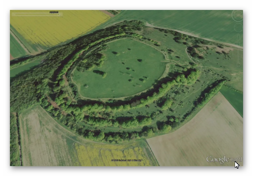
At approximately 153 metres above sea level, the site sits well above the surrounding lowlands, particularly the Somerset Levels to the north. In the conventional interpretation, this is explained purely in terms of defence—height equals visibility, therefore height equals protection.

But this assumption is never tested.

It is simply inherited.

If we step back and apply a physical framework rather than a cultural one, a different question emerges:

Why are the earliest activities consistently located on elevated ground?

This is not unique to Cadbury. Across Britain, early prehistoric activity frequently appears at higher elevations, with later activity progressively occupying lower ground. This pattern is measurable, repeatable, and not dependent on interpretation.
South Cadbury Castle - Camelot
South Cadbury Castle – Camelot

The simplest explanation is not a defence.

It is an environment.

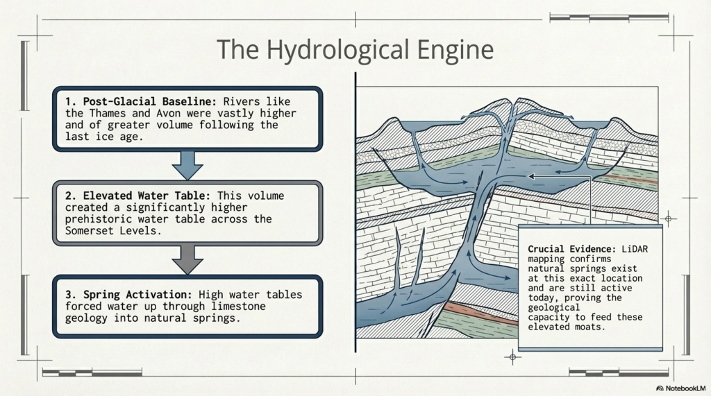
As demonstrated in the broader hydrological model of post-glacial Britain, early Holocene landscapes were characterised by significantly higher groundwater levels and expanded river systems. In such a system, low-lying areas—such as the Somerset Levels—would not have been stable, dry land in the way they are today. They would have been wetlands, floodplains, or standing water environments for extended periods.

Under these conditions, elevated sites like Cadbury Hill are not “defensive choices.”

They are the only viable ground.
South Cadbury Castle - Camelot
South Cadbury Castle – Camelot

Reframing the “Hillfort”

Once elevation is understood as an environmental constraint rather than a defensive preference, the entire interpretation of the site shifts.

The term “hillfort” becomes problematic.

It assumes:

  • conflict
  • territorial defence
  • permanent settlement

Yet none of these are directly proven by the physical evidence alone.

The ramparts, for example, are interpreted as defensive structures—but this is an assumption based on form, not function. Earthworks can serve multiple purposes: hydraulic control, stock management, boundary demarcation, or even phased landscape modification.

At Cadbury, the presence of multiple ramparts is often cited as evidence of increasing conflict. But an alternative explanation is equally plausible: staged construction responding to changing environmental conditions, particularly shifting water levels and drainage patterns.
South Cadbury Castle - Camelot
South Cadbury Castle – Camelot

The traditional model selects one interpretation—warfare—without excluding others.

The Illusion of Continuity

Perhaps the most significant issue is the illusion of continuity created by archaeological phasing.

Cadbury Castle is presented as:

Neolithic → Bronze Age → Iron Age → Roman → Post-Roman → Saxon

But this is not a continuous timeline of occupation.

It is a list of disconnected events.
South Cadbury Castle - Camelot

Between these phases lie gaps—sometimes centuries, sometimes longer—where no evidence of sustained activity exists. These gaps are rarely emphasised, because they disrupt the narrative of an “important settlement.”

Instead, the site is framed as persistently occupied, when the evidence more accurately supports periodic reuse of a prominent, strategically located landscape feature.

In other words, the hill is important.

Not necessarily the settlement.
South Cadbury Castle - Camelot
South Cadbury Castle – Camelot

A Simpler Model

If we remove the assumption and focus only on physical constraints, a more economical explanation emerges:

  • Early activity occurs on high ground because low ground is unstable or flooded
  • Sites are reused over time because elevated locations remain reliable as conditions change
  • Earthworks reflect adaptation to landscape conditions, not necessarily warfare
  • Later cultures reinterpret and reuse earlier features without preserving the original function
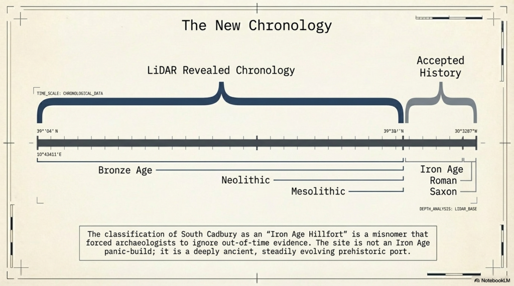
South Cadbury Castle - Camelot

This model requires fewer assumptions and aligns with measurable environmental behaviour.

It also explains why sites like Cadbury Castle appear repeatedly in the archaeological record across different periods without requiring continuous occupation.
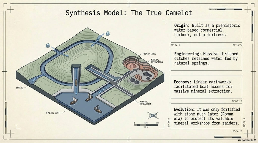
South Cadbury Castle - Camelot
South Cadbury Castle – Camelot

Maps

1800s OS Map

South Cadbury Castle – 1800s OS Map

GE Satellite Map

South Cadbury GE Map

LiDAR Map

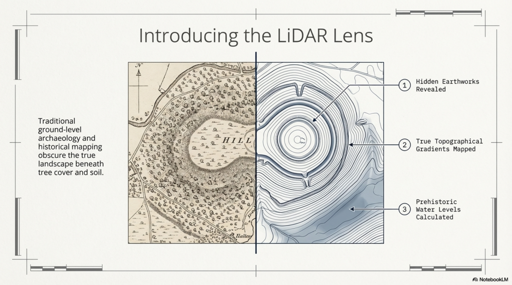
South Cadbury Castle – LiDAR Map

Investigation

Site Flyaround

South Cadbury Castle Flyaround

Site Flyover

South Cadbury Castle Fly Over

Lidar Map showing Bronze Age

South Cadbury Castle – with Bronze Age Water Levels

LiDAR Map showing Mesolithic Period

South Cadbury Castle with Mesloithic Water levels

Defence Strategy 101

Roman Defence System

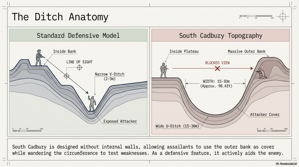
Roman defences (of the same period as the ‘Iron Age’ ), we notice the ditches were relatively small and narrow. These ditches were called ‘Ankle Breaker’ as the purpose was for the assailant to fall into the ditch (usually containing pointed wooden stakes to either injure or kill the assailant) or to at least break their ankle from the fall, making them immobile. These ditches would be 3 to 4 m wide and about 2m deep and could be dug quickly.

Roman Ankle Breaker

The soil excavated from the ditch would be placed on the defensive side to elevate the defenders, allowing them to look down and fight their attackers from a higher position. Simply standing on elevated ground without a barrier would make defenders easy targets. Therefore, they built fortifications using wooden stakes or stone for more permanent and substantial defences. These fortifications provided cover from spears, arrows, or stones while looking down into the conflict zone. This basic defensive strategy has remained unchanged for thousands of years, as seen with the Normans, who used castles and moats. The moats slowed down assailants, allowing defenders to use crossbows effectively against anyone attempting to cross the deep waters.

Classic Roman Fort With Ditch and Palisade

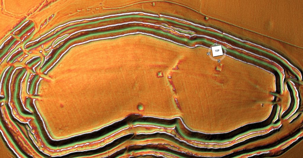
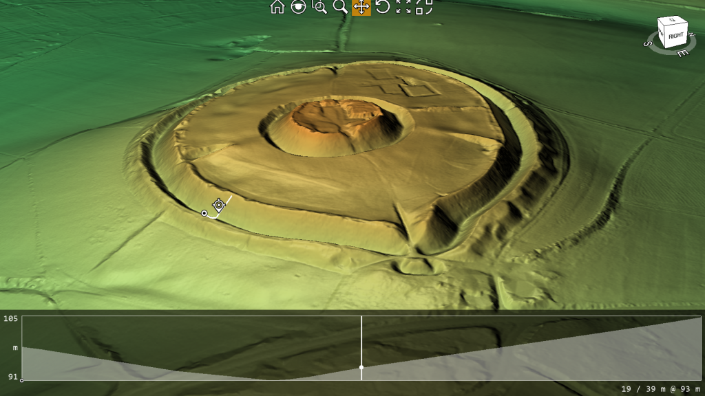
Lidar Maps of Sth Cadbury Castle Show No Defences

Banks

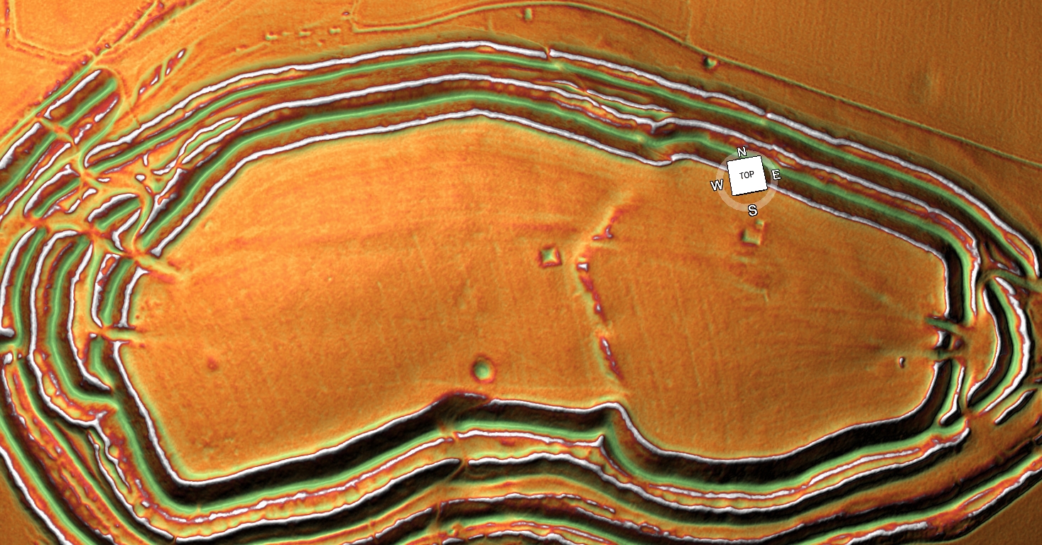
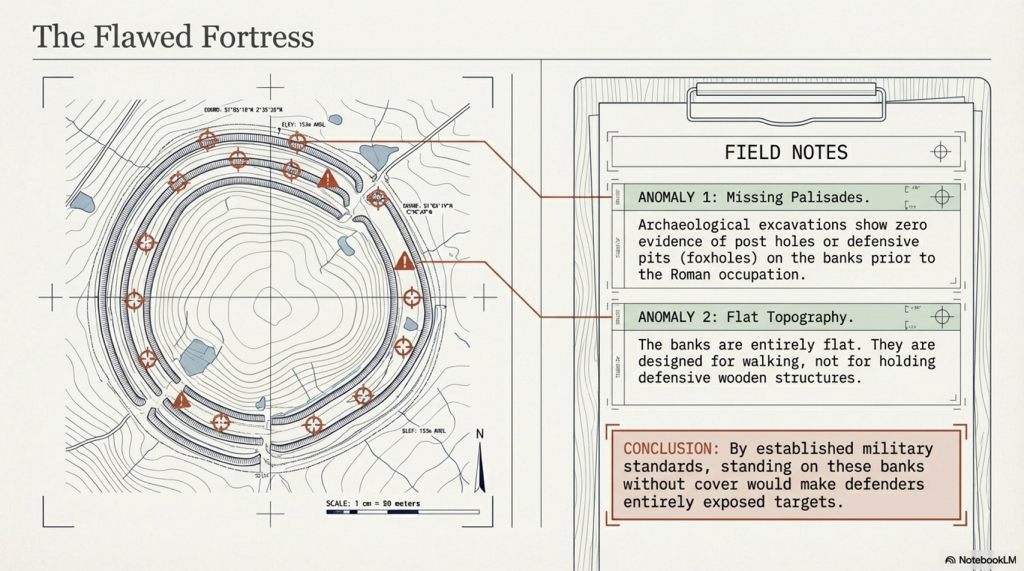
The banks at South Cadbury Castle show no signs of palisades on top of the bank at any stage before the Roman occupation, which brought stone to the very top of the site. The other four banks appear to be quite flat, as if they have been used for walking upon rather than holding any defensive wooden structures or ‘foxholes.’

Importance and Use of Foxholes in Defense

Concealment and Protection: Foxholes are small, dug-out trenches or pits used by soldiers to provide cover and concealment. They protect defenders from enemy fire and other dangers. By being below ground level, soldiers can remain hidden and minimize their exposure to enemy attacks.

Historical Use: Throughout history, foxholes have been a crucial part of defensive strategies in various military contexts: While the term “foxhole” is modern, the concept of digging protective pits or trenches has been used in various forms throughout history. In ancient battles, soldiers would dig pits to defend against archers and other ranged weapons.

Advantages of Foxholes

  • Reduced Visibility: Soldiers in foxholes are less visible to the enemy, making it harder for attackers to target them.
  • Protection from Spears, Rocks and Arrows: Being below ground level the size of the target is greatly reduced.
  • Stability for Firing: Foxholes provide a stable firing position, allowing soldiers to fire and use their weapons more accurately.

South Cadbury Castle Context

The absence of evidence for palisades or foxholes at South Cadbury Castle before the Roman occupation suggests a different use or purpose for the banks. Instead of being purely defensive, the flat banks must have served other functions.

Ditches

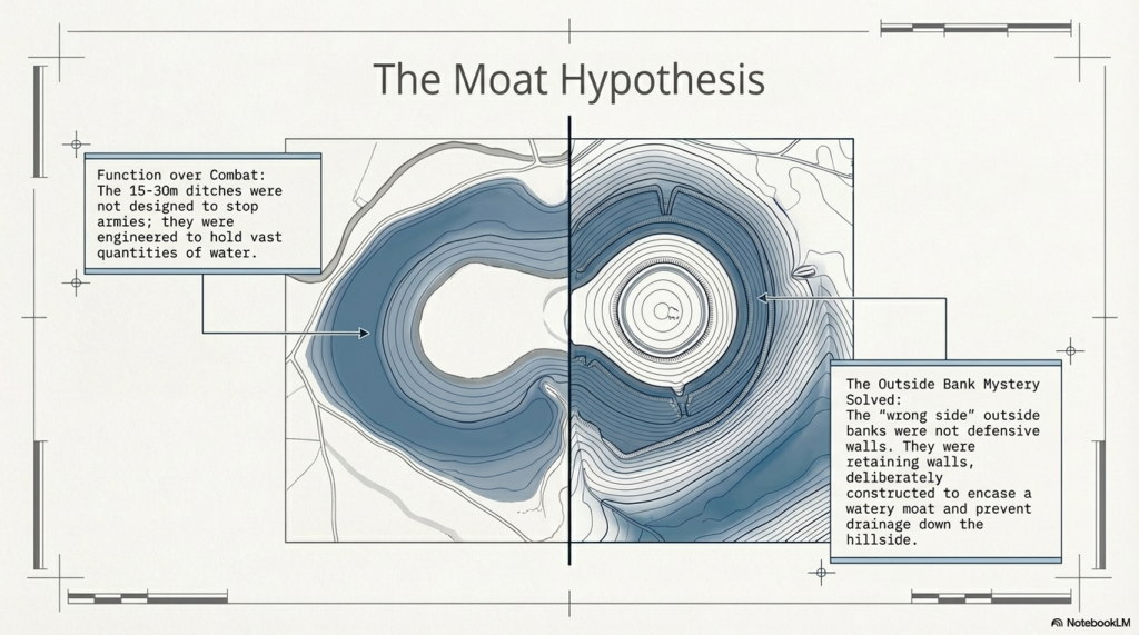
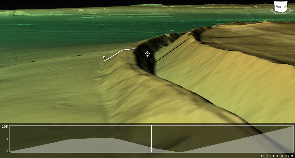
Looking at the construction of the ditches at South Cadbury Castle, we notice that it has no defensive features as expected from a so-called ‘Iron Age Fort’. The ditches are far too broad to be defensive (15m to 30m wide) compared to Roman ‘Ankle Breaker’ of 2m to 3m. The maps show no sign of a wooden or stone barrier, and archaeological excavations have found no evidence of post holes or defensive pits on the banks. Moreover, the Ditch is banked on the wrong side to be defensive, as if it has been built to encase a watery moat. This outside bank would protect any assailants attacking, giving them ample bank coverage. The internal aspect of the Ditch shows no sign of any wooden defensive poles or post holes as seen in Roman Ditches and is designed without internal walls allowing assailants from using the Ditch as cover and the facility to wander around the circumference undercover, testing the weaknesses in the defence. Therefore, as a defensive feature, these types of ditches on so-called ‘Iron Age Forts’ are fundamentally flawed and commonplace.

Ditch is banked on the wrong side

The LiDAR Maps also show that the ditch of the ditches indicate that they were built for water, as shown by the blue on these images – this then allows us to look at the design of the earthwork in detail, which shows that the banks have been cut by not roads but other ditches. These ditches that cut across the circumference moats cut into them that, suggest that if water had been contained in these ditches, then the vertical dykes could have been used to gaol boats up from the bottom of the dyke ditch to one of these upper moat levels. These same LiDAR maps also show how the soil was distributed to the outside of the moats to enhance and make the feature deeper.

South Cadbury Castle – Banks on the outside to keep in the Water

Water Table

This hypothesis of using these ditches as moats can only be proven if we find the natural springs that could have fed these earthworks in the past. We know from our studies into rivers, such as The Thames and Avon, that they were both much higher and of greater volume in the past, and this height was retained for thousands of years after the last ice age. This enhanced height and volume is reflected and caused by a higher water table. Within these water tables, natural springs are formed, and water leaks into the land, creating rivers and streams. Although we do not have geological information that allows us to trace past springs, we find existing springs in this location (still active today), which suggests our hypothesis is correct.

South Cadbury Castle showing Springs still in existence

Dykes

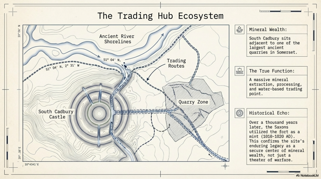
As we have already suggested, the lack of defensive features shows that this is far from being a fortification; instead, it was used as a trading site with moats to facilitate the mooring of boats. The transportation to these moats was achieved by other earthworks called Linear Earthworks (also known as Dykes). Dykes were introduced when the river shorelines of the Prehistoric fell with the water table, and they wanted to continue to use these established trading sites rather than having to build new sites at a lower level. So, Dykes were built (like roads) to transport goods to market and also minerals extracted from the many quarries which uncommonly surround these Dykes. Here in South Cadbury Castle, we see not only Dykes feeding the local quarry sites but also placed on the side of this Trading site to allow access to the moats for the boats coming off the rivers, ready for unloading/loading.

Slipway built to feed the moats in the upper levels with trading boats
Two Possible Slipways – one connecting directly to a Dyke

To reinforce the use of this site as a trading The site as a trading place has a second vertical earthwork identified through LiDAR technology. This secondary slipway is distinguishable from the initial structure by its lack of connection to a dyke or river. The slipway appears to traverse from the lowest moat up to the top of the site. While photographs may provide a visual reference, the full extent and significance of this feature are best understood through LiDAR models, which enhance the landscape to reveal these historical elements with greater clarity.place, a second verticle earthwork has been identified via LiDAR technology is a secondary slipway, distinguishable from the initial structure by its lack of connection to a dyke or river. This slipway appears to traverse from the lowest moat up to the top of the site. While photographs may provide a visual reference, the full extent and significance of this feature are best understood through LiDAR models, which enhance the landscape to reveal these historical elements with greater clarity.

The Dykes seen on the LiDAR map are concentrated on the quarry in the East of the Site

Dating the Site

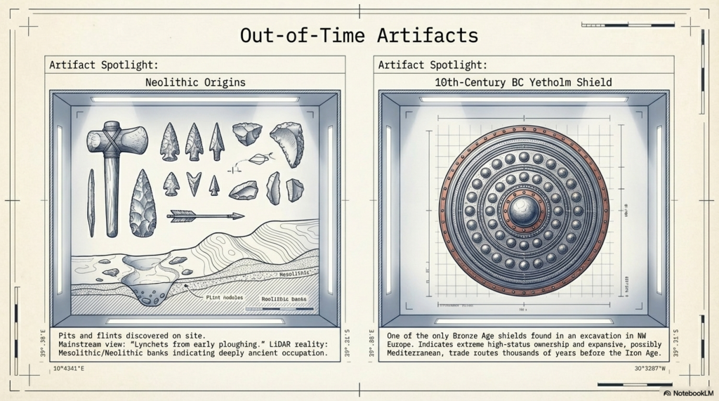
Archaeologists are puzzled by the unexpected dates of this site at South Cadbury Castle, the site that was originally thought to be Iron Age from its classification. Therefore, the discovery of Neolithic pits at the site challenges their previously held beliefs about its functions. However, instead of reconsidering their perceptions, they instead provided speculative explanations for these out-of-time artifacts and features. For example, they have described a bank beneath the Iron Age defenses as a “lynchet or terrace derived from early ploughing,” even though there is no carbon dating evidence to support this claim. In reality, this site is likely to be Neolithic, and the ‘lynchets’ could be Mesolithic banks, indicating its true age.

The discovery of the Bronze Age shield is also an indication of the status of the site and its trading routes – as only one has been found, this would indicate that it was part of the trading or personal ownership of someone in the 10th Century BC at this site. This suggests that this was trading could have been at a much earlier date than current archaeologists suggest, which could too have been with the Mediterranean and a possible source of this unusual artefact, as indicated by the other finds from the late saxon period.

Function of the site

The fact that in the East of this site is one of the largest quarries in Somerset and that the Saxons used the fort as a mint just over a thousand years ago proves that the site’s function was a mineral extraction and trading point. This extraction goes back to the Mesolithic period shown on LiDAR maps with a natural harbour by the Quarries and then Dykes to the Trading site as the prehistoric waters fell. No doubt (as the banks are found not to be defensive), the fort was fortified later during the Roman period with Stone as it was to keep the valuable minerals safe but not as a defensive barrier of warfare as suggested. This would explain the minor disturbances and deaths at a single gate as raiders would have attempted to steal the valuable minerals it contained in its workshops, as described by archaeologists.

PodCast

Author’s Biography

Robert John Langdon, a polymathic luminary, emerges as a writer, historian, and eminent specialist in LiDAR Landscape Archaeology.

His intellectual voyage has been interwoven with stints as an astute scrutineer in government and grand corporate bastions, a tapestry spanning British Telecommunications, Cable and Wireless, British Gas, and the esteemed University of London.

A decade hence, Robert’s transition into retirement unfurled a chapter of insatiable curiosity. This phase saw him immerse himself in Politics, Archaeology, Philosophy, and the enigmatic realm of Quantum Mechanics. His academic odyssey traversed the venerable corridors of knowledge hubs such as the Museum of London, University College London, Birkbeck College, The City Literature Institute, and Chichester University.

In the symphony of his life, Robert is a custodian of three progeny and a pair of cherished grandchildren. His sanctuary lies ensconced in the embrace of West Wales, where he inhabits an isolated cottage, its windows framing a vista of the boundless sea – a retreat from the scrutinising gaze of Her Majesty’s Revenue and Customs, an amiable clandestinity in the lap of nature.

Exploring Prehistoric Britain: A Journey Through Time

My blog delves into the fascinating mysteries of prehistoric Britain, challenging conventional narratives and offering fresh perspectives grounded in cutting-edge research, particularly LiDAR technology. I invite you to explore some key areas of my research. For example, the Wansdyke, often cited as a defensive structure, is re-examined in light of new evidence. I’ve presented my findings in my blog post Wansdyke: A British Frontier Wall – ‘Debunked’, and a Wansdyke LiDAR Flyover video further visualises my conclusions.

My work also often challenges established archaeological dogma. I argue that many sites, such as Hambledon Hill, commonly identified as Iron Age hillforts, are not what they seem. My posts Lidar Investigation Hambledon Hill – NOT an ‘Iron Age Fort’ and Unmasking the “Iron Age Hillfort” Myth explore these ideas in detail and offer an alternative view. Similarly, sites like Cissbury Ring and White Sheet Camp receive re-evaluations based on LiDAR analysis in my posts “Lidar Investigation Cissbury Ring through time” and “Lidar Investigation White Sheet Camp,“ revealing fascinating insights into their true purpose. I have also examined South Cadbury Castle, often linked to the mythical Camelot56.

My research also extends to ancient water management, including the role of canals and other linear earthworks. I have discussed the true origins of Car Dyke in multiple posts, including Car Dyke – ABC News Podcast and Lidar Investigation Car Dyke – North Section, which suggest a Mesolithic origin 2357. I also explore the misidentification of Roman aqueducts, as seen in my posts on the Great Chesters (Roman) Aqueduct. My research has also been greatly informed by my post-glacial flooding hypothesis, which has helped explain landscape transformations over time. I have discussed this hypothesis in several posts, including AI now supports my Post-Glacial Flooding Hypothesis and Exploring Britain’s Flooded Past: A Personal Journey

Finally, my blog also investigates prehistoric burial practices, as seen in Prehistoric Burial Practices of Britain and explores the mystery of Pillow Mounds, often mistaken for medieval rabbit warrens, but with a potential link to Bronze Age cremation in my posts: Pillow Mounds: A Bronze Age Legacy of Cremation? and The Mystery of Pillow Mounds: Are They Really Medieval Rabbit Warrens?. My research also includes astronomical insights into ancient sites, for example, in Rediscovering the Winter Solstice: The Original Winter Festival. I also review new information about the construction of Stonehenge in The Stonehenge Enigma.

Further Reading

For those interested in British Prehistory, visit www.prehistoric-britain.co.uk, a comprehensive resource featuring an extensive collection of archaeology articles, modern LiDAR investigations, and groundbreaking research. The site also includes insights and excerpts from the acclaimed Robert John Langdon Trilogy, a series of books that explore Britain during the Prehistoric period. Titles in the trilogy include The Stonehenge Enigma, Dawn of the Lost Civilisation, and The Post-Glacial Flooding Hypothesis, which offer compelling evidence of ancient landscapes shaped by post-glacial flooding.

To further explore these topics, Robert John Langdon has developed a dedicated YouTube channel featuring over 100 video documentaries and investigations that complement the trilogy. Notable discoveries and studies showcased on the channel include 13 Things that Don’t Make Sense in History and the revelation of Silbury Avenue – The Lost Stone Avenue, a rediscovered prehistoric feature at Avebury, Wiltshire.

In addition to his main works, Langdon has released a series of shorter, accessible publications, ideal for readers delving into specific topics. These include:

For active discussions and updates on the trilogy’s findings and recent LiDAR investigations, join our vibrant community on Facebook. Engage with like-minded enthusiasts by leaving a message or contributing to debates in our Facebook Group.

Whether through the books, the website, or interactive videos, we aim to provide a deeper understanding of Britain’s fascinating prehistoric past. We encourage you to explore these resources and uncover the mysteries of ancient landscapes through the lens of modern archaeology.

For more information, including chapter extracts and related publications, visit the Robert John Langdon Author Page. Dive into works such as The Stonehenge Enigma or Dawn of the Lost Civilisation, and explore cutting-edge theories that challenge traditional historical narratives.

Other Blogs

s

t

Twigs, Charcoal, and the Death of the Saxon Dyke Myth


Introduction

For over a century, British archaeology has repeated the same tale: Offa’s Dyke and Wat’s Dyke were built by Saxon kings to define borders and display royal power. But each time we peel back another layer—literally and figuratively—the data tells a radically different story. This is no longer about interpretation or fringe theory. The scientific evidence, especially from radiocarbon dating, blows the Saxon myth apart.(Twigs, Charcoal, and the Death of the Saxon Dyke Myth)


1. The Mesolithic Nuts Beneath the Bank

At Gobowen, Shropshire, archaeologists uncovered pits beneath Wat’s Dyke filled with charred hazelnut shells and twigs. Radiocarbon dating placed these at 5210–4840 BC—deep into the Mesolithic. This is not “background noise.” It proves the site was in use—and likely managed—thousands of years before any so-called Saxon activity. (Twigs, Charcoal, and the Death of the Saxon Dyke Myth)

(Twigs, Charcoal, and the Death of the Saxon Dyke Myth)
Gobowen Side where they found the Mesolithic Hearths – (Twigs, Charcoal, and the Death of the Saxon Dyke Myth)

2. The “Twigs” and the Bronze Age Pattern

Here’s where things get explosive. Two different digs—at Gobowen and Maes-y-Clawdd—each pulled a charred twig from the primary fill of the dyke’s ditch. Both were sent to modern AMS labs for dating. These were sent to independent AMS labs for testing:

  • Gobowen: 2825 ± 40 BP, calibrated to 1120–890 BC
  • Maes-y-Clawdd: 2855 ± 40 BP, calibrated to 1120–890 BC

Different labs, different sites, nearly identical dates: Late Bronze Age.
Some might claim “residuality” or accident, but when the same date keeps showing up in primary contexts at different sites, the odds of pure coincidence plummet.(Twigs, Charcoal, and the Death of the Saxon Dyke Myth)

(Twigs, Charcoal, and the Death of the Saxon Dyke Myth)
Maes-Y-Clawdd site (Twigs, Charcoal, and the Death of the Saxon Dyke Myth)

3. Erddig and Chirk: More Prehistoric Dates

The new gold standard in the debate is the peer-reviewed Archaeologia Cambrensis study (Malim et al. 2021), which returned:

  • Erddig: Alder charcoal under the bank, 1414–1258 BC (Bronze Age)
  • Chirk: Charcoal at base of bank, 776–543 BC (Iron Age)

These aren’t rogue samples. They are part of a systematic pattern. (Twigs, Charcoal, and the Death of the Saxon Dyke Myth)

(Twigs, Charcoal, and the Death of the Saxon Dyke Myth)
Wats Dyke Excavation – (Twigs, Charcoal, and the Death of the Saxon Dyke Myth)

4. The Car Dyke and Wansdyke Parallels

Our recent research on Car Dyke—summarised in my book, Car Dyke: The Lost Waterways of Prehistoric Britain—shows exactly the same pattern. LiDAR analysis, gradient modeling, and dated artefacts reveal this “Roman” canal sits atop a much older, prehistoric water-management system, later adapted by the Romans. The same sequence—prehistoric construction, Roman enhancement, and later reuse—emerges at other great linear earthworks.

Wansdyke: More than Just a Saxon Bank and Ditch

  • Roman Water System at the Summit:
    Topographic and archaeological evidence shows that a Roman water-management system, likely an aqueduct or channel, was constructed along sections of Wansdyke near Cliffe Pypard and Cherhill. The Roman works appear to incorporate the line and gradient of the existing dyke, indicating that the dyke was already present and subsequently adapted for Roman infrastructure needs. This reuse implies that the dyke is pre-Roman in origin, forming part of an older, possibly prehistoric, water-management landscape. Rather than constructing a new route, the Romans modified what was already there—strong evidence that Wansdyke was not their creation, but an earlier engineering feature they found valuable enough to repurpose.
  • Roman Road Laid On the Dyke:
    To the north of Morgan’s Hill, a documented Roman road is physically laid on top of the Wansdyke bank. The logical sequence? The dyke had to exist before the road. (For detail and field evidence, see: prehistoric-britain.co.uk/prehistoric-canals-dykes-wansdyke4)
  • The Implication:
    These features make it impossible to honestly claim that Wansdyke is purely a Saxon or sub-Roman structure. Instead, we’re seeing a prehistoric engineering work—possibly a canal or water-management feature—repurposed by the Romans, and then again in later centuries.

(Twigs, Charcoal, and the Death of the Saxon Dyke Myth)

(Twigs, Charcoal, and the Death of the Saxon Dyke Myth)
Car Dyke Parrellels – (Twigs, Charcoal, and the Death of the Saxon Dyke Myth)
A Consistent Prehistoric Pattern

The parallels between Car Dyke, Wansdyke, Offa’s Dyke, and Wat’s Dyke are now undeniable:

  • All show prehistoric (Mesolithic, Bronze Age, or Iron Age) dates or structural evidence in primary contexts.
  • All were reused, enlarged, or recut by later societies—be it the Romans, Saxons, or Medievals.
  • All have been misunderstood because traditional narratives refuse to follow the evidence.

(Twigs, Charcoal, and the Death of the Saxon Dyke Myth)
Roman Canal Boat as found at Car Dyke – (Twigs, Charcoal, and the Death of the Saxon Dyke Myth)

(Twigs, Charcoal, and the Death of the Saxon Dyke Myth)

5. Why the Saxon Narrative No Longer Holds

Traditional archaeology claims these dykes were built in the Dark Ages because it’s “what’s always been said” and because a handful of OSL dates cluster in the early medieval period. But with so many radiocarbon dates from secure, primary contexts returning Bronze Age and Iron Age results, the only scientific response is to question the narrative—not the data.

This shift isn’t limited to a few isolated studies. In 2019, Historic England (formerly English Heritage) published a national overview of linear earthworks, concluding that most of the dykes they had investigated dated to the prehistoric period, not the early medieval one. Their guidance document, Prehistoric Linear Boundary Earthworks, situates these features firmly in the Late Neolithic through to the Iron Age, aligning with the growing body of radiocarbon evidence and undermining the traditional Dark Age attribution.

Rather than reinforcing the Saxon story, modern research now supports a much older, more complex landscape—one that was later reused and reinterpreted by the Romans and Saxons alike.

(Twigs, Charcoal, and the Death of the Saxon Dyke Myth)
From the Book by HE – (Twigs, Charcoal, and the Death of the Saxon Dyke Myth)

(Twigs, Charcoal, and the Death of the Saxon Dyke Myth)


6. AI and Modern Method: The Death of Peer-Reviewed Dogma

For years, peer review has failed to challenge inherited assumptions. “Authority” was all that mattered—a single, dramatic radiocarbon date (like the infamous 6.25 kg of charcoal at Maes-y-Clawdd) could define an entire monument’s chronology, regardless of context or contradictory data from other sites.

But now? AI is revolutionising how we check and interpret archaeological evidence.

Take our recent FB post, where we used AI to reassess the Maes-y-Clawdd excavation:

  • Myth: The excavation report’s headline date (c. 400 AD) from the charcoal was endlessly repeated as proof of a “Roman” or “sub-Roman” dyke.
  • AI’s Role:
    • Pulled together site photos, original reports, ditch profiles, and stratigraphy from multiple digs.
    • Flagged the ditch’s V-shape (classic recut) and the heavy truncation of the bank (over half missing)—which undermined the idea that the charcoal was securely “sealed” and contemporary with construction.
    • Cross-referenced other sites (Gobowen, Erddig, Chirk), showing that Bronze Age and Iron Age dates in similar primary contexts kept reappearing—not as random “residuals,” but as a systematic pattern.
  • Outcome:
    • Instead of blindly accepting published “facts,” AI let us validate or reject past interpretations using all the available primary evidence.
    • The “Roman” story now stands exposed as an artefact of interpretation, not of data.

This is not “pseudoscience”—it’s the very definition of the scientific method:

  • Gather all the evidence.
  • Challenge every conclusion.
  • Rebuild the narrative when the facts demand it.

Just as AI is transforming genetics, climate science, and engineering, it’s now arming archaeology with the ability to see through myths, correct errors, and put our past on a solid, evidence-based footing. If you want real history, let the data—and AI—lead the way. (Twigs, Charcoal, and the Death of the Saxon Dyke Myth)

 (Twigs, Charcoal, and the Death of the Saxon Dyke Myth)
Twigs, Charcoal, and the Death of the Saxon Dyke Myth

Conclusion: Follow the Data, Not the Doctrine

The parallels between Offa’s Dyke, Wat’s Dyke, Car Dyke, and Wansdyke are now undeniable:

  • All show prehistoric (Mesolithic, Bronze Age, or Iron Age) evidence in primary contexts
  • All were reused, recut, or adapted by Romans, Saxons, and Medieval societies
  • All have been misunderstood because inherited narratives resisted revision

The story we’ve been told—that Saxon kings built these monuments as borders—is no longer sustainable.

The data demands a paradigm shift. (Twigs, Charcoal, and the Death of the Saxon Dyke Myth)


References

  • Hannaford, H.R. (1997), SCCAS Report no. 111, An Interim Report on Archaeological Excavations on Wat’s Dyke at Maes-y-Clawdd, Oswestry.
  • Malim, T. & Hayes, L. (2008), The Date and Nature of Wat’s Dyke: a reassessment in the light of recent investigations at Gobowen, Shropshire, ASSAH 15.
  • Malim, T., Hoggard, C., et al. (2021). “Offa’s Dyke and Wat’s Dyke: Scientific Dating at Chirk and Erddig, North Wales.” Archaeologia Cambrensis, 170, pp. 93–117.
  • Langdon, R.J. (2024), Car Dyke: The Lost Waterways of Prehistoric Britain.
  • For Wansdyke Roman features and road evidence: prehistoric-britain.co.uk/prehistoric-canals-dykes-wansdyke4

Twigs, Charcoal, and the Death of the Saxon Dyke Myth

Annex: The “Twig” Radiocarbon Dates—Technical Details

For those who want the technical data, here are the exact C14 results from the two most cited Bronze Age “twig” samples:

SiteSample TypeLab CodeRadiocarbon Age (BP)ErrorCalibrated Range (2σ)Context
GobowenCharred twigGU-148662825±401120–890 BCPrimary ditch fill
Maes-y-ClawddCharred twig(various)2855±401120–890 BCLower ditch fill
  • Both dates are from independent, high-quality AMS labs, and ±40 years is standard error for these samples.
  • The calibration uses the most up-to-date IntCal curve.
  • Their remarkable similarity is not a flaw, but evidence for a real prehistoric episode.

Further Reading

For information about British Prehistory, visit www.prehistoric-britain.co.uk for the most extensive archaeology blogs and investigations collection, including modern LiDAR reports.  This site also includes extracts and articles from the Robert John Langdon Trilogy about Britain in the Prehistoric period, including titles such as The Stonehenge Enigma, Dawn of the Lost Civilisation and the ultimate proof of Post Glacial Flooding and the landscape we see today.

Robert John Langdon has also created a YouTube web channel with over 100 investigations and video documentaries to support his classic trilogy (Prehistoric Britain). He has also released a collection of strange coincidences that he calls ‘13 Things that Don’t Make Sense in History’ and his recent discovery of a lost Stone Avenue at Avebury in Wiltshire called ‘Silbury Avenue – the Lost Stone Avenue’.

(Maritime Diffusion Model for Megaliths in Europe)

Langdon has also produced a series of ‘shorts’, which are extracts from his main body of books:

The Ancient Mariners

Stonehenge Built 8300 BCE

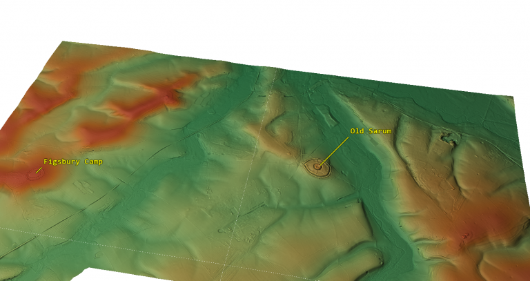
Old Sarum

Prehistoric Rivers

Dykes ditches and Earthworks

Echoes of Atlantis

Homo Superior

(Maritime Diffusion Model for Megaliths in Europe)

Other Blogs

s

t

(Twigs, Charcoal, and the Death of the Saxon Dyke Myth)

13 Things You Didn’t Know About Hillforts — The Real Story Behind Britain’s Ancient Earthworks

Introduction

Hillforts have long been cast as the mighty defensive bastions of prehistoric Britain, iconic symbols of Iron Age tribal warfare and territorial defence. But if you peel back the layers of archaeological evidence, a very different, far more complex picture emerges. While some hillforts were adapted for military use during later periods—particularly during Roman expansion—the majority were multifunctional hubs serving economic, ceremonial, territorial, and social roles rather than purely defensive purposes.

Below, we unravel 13 surprising facts that challenge the traditional fortress narrative, shedding light on the true nature of hillforts across Britain and Ireland. Prepare to rethink what you thought you knew.

13 Things You Didn’t Know About Hillforts
Hillforts have long been cast as the mighty defensive bastions of prehistoric Britain, iconic symbols of Iron Age tribal warfare and territorial defence

1. Hillfort Classifications Are Outdated and Over-Simplified

For nearly a century, archaeologists have tried to neatly categorize hillforts based on size, location, rampart construction, and age. Early scholars like Sir Mortimer Wheeler and later Barry Cunliffe developed classification schemes grouping hillforts into types such as early hilltop enclosures over 10 hectares, smaller settlements of 1–3 hectares, early univallate forts, and more complex multivallate sites. These categories aimed to make sense of the diversity by assigning function and status, often equating larger or more complex sites with defensive importance.

However, these classifications are increasingly questioned because they lean heavily on limited physical evidence and overlook the social and economic functions of these sites. For example, a large enclosure doesn’t necessarily mean a military fortress; it could be a ceremonial gathering place or a centre for trade. Likewise, a simple earthwork might have deep ritual significance rather than being a mere settlement defence. This simplified framework risks distorting the true roles these structures played in prehistoric societies.

By focusing too much on size and fortification features, scholars have missed the multifunctional nature of hillforts. Archaeological evidence now points to a more nuanced understanding: these sites often combined social, economic, political, and ritual functions alongside occasional defensive adaptations. We must therefore treat traditional categories with caution and embrace complexity.

13 Things You Didn’t Know About Hillforts
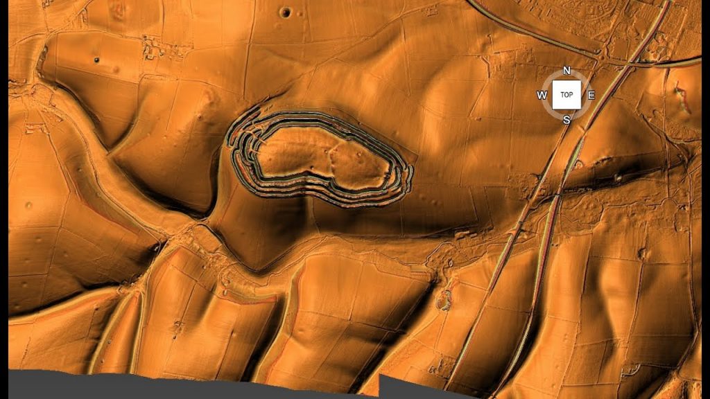
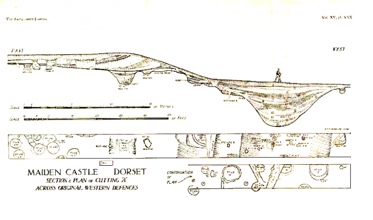
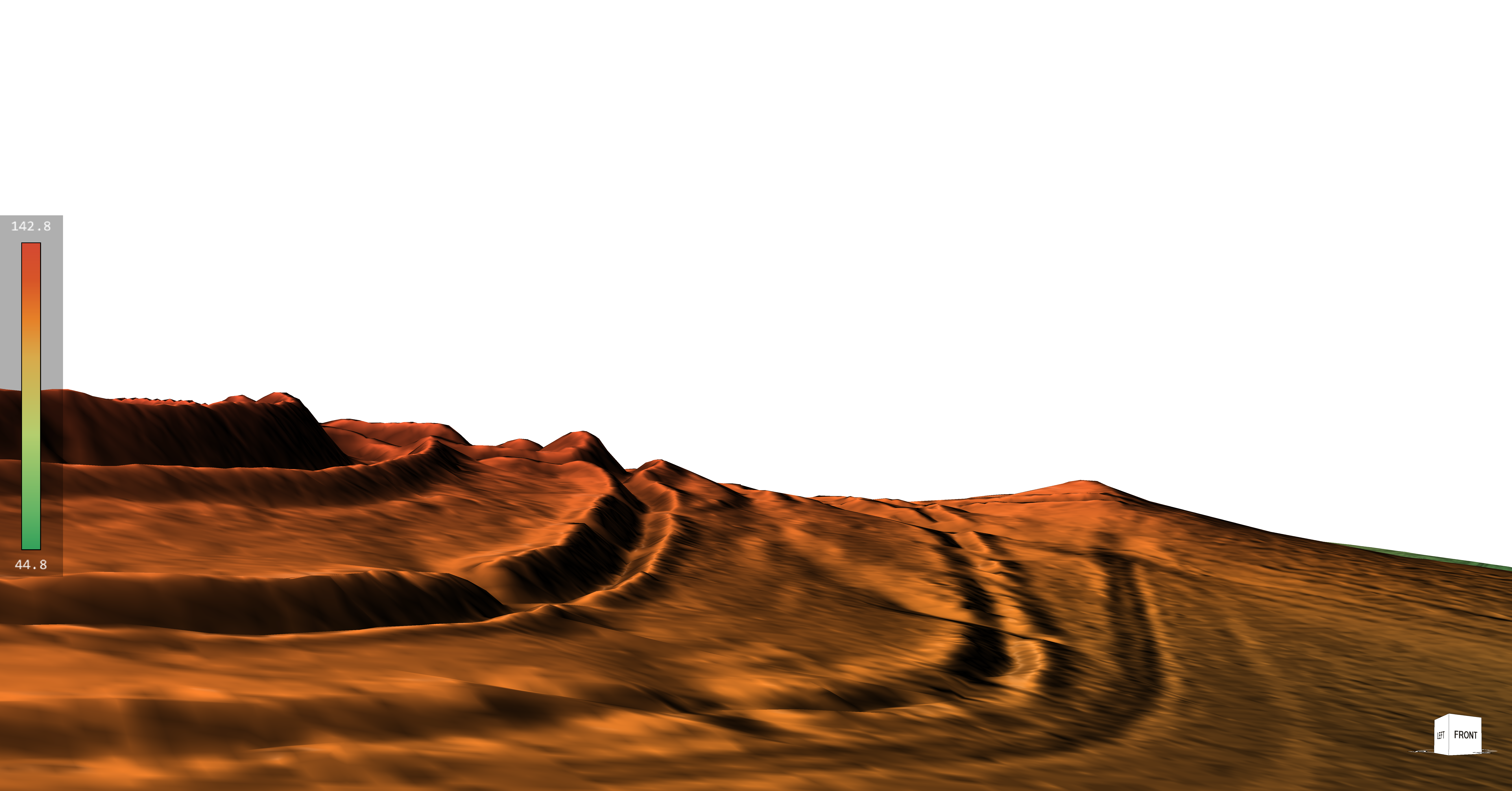
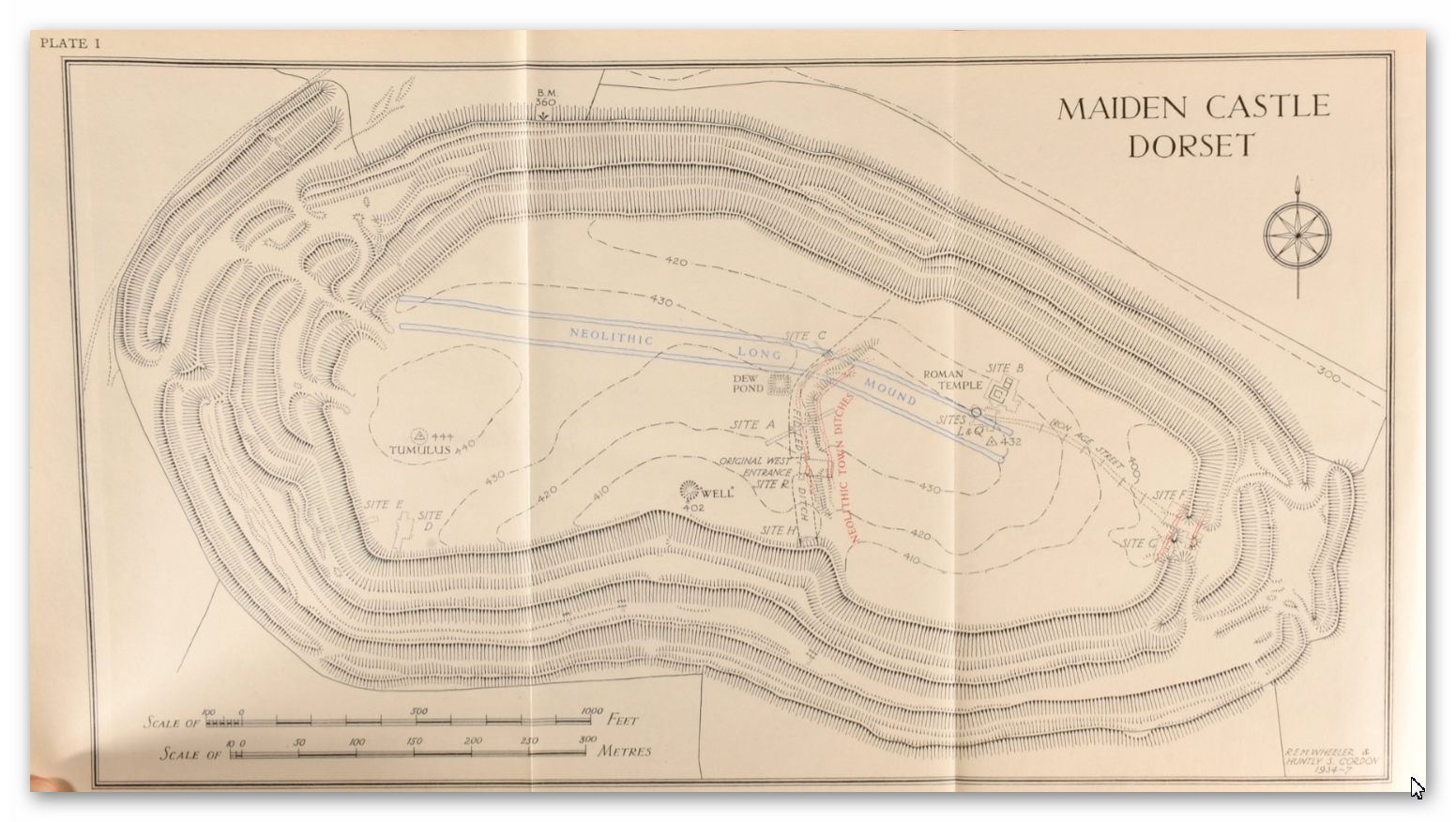
Maiden Castle – Largest ‘Iron Age Fort’ in Britain?

2. The “Fortress” Definition Has Stuck For Too Long

The classical definition of a hillfort, as “a fortified refuge or defended habitation on elevated ground,” still dominates textbooks and popular understanding. Wikipedia and many reference works place hillforts squarely in the Bronze or Iron Age and depict them as military installations designed to control territory and repel attackers. Their defining features are steep earthworks, ramparts, palisades, and ditches, strategically placed to take advantage of high ground.

While this definition neatly fits some later hillforts, it oversimplifies a wide array of prehistoric enclosures that often lack convincing military architecture or evidence of warfare. Moreover, it ignores that many of these sites have much older origins, with some showing continuity of use stretching back thousands of years before the Iron Age, into the Neolithic or even Mesolithic periods. The persistence of this fortress-centric view obscures the diverse social realities of prehistoric communities.

Holding on to this entrenched definition restricts archaeological interpretation and public perception. It encourages viewing hillforts as relics of constant warfare rather than appreciating their complex social, ceremonial, and economic dimensions. The reality, as recent research shows, is far richer and more varied.

13 Things You Didn’t Know About Hillforts
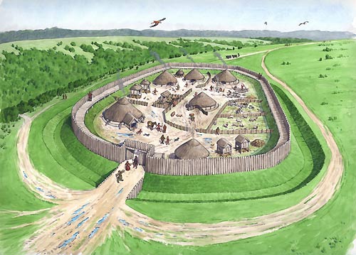
Traditional view as “a fortified refuge or defended habitation on elevated ground”

3. Hillforts Were Around Before the Iron Age

Many people associate hillforts exclusively with the Iron Age, roughly 800 BC to AD 43 in Britain. However, extensive excavations reveal that numerous hillforts have earlier origins, dating back to the Late Bronze Age and even Neolithic times. Cultures such as the Urnfield (1300–750 BC), Hallstatt (1200–500 BC), and La Tène (600 BC–50 AD) saw the proliferation of hillforts, but the groundwork was laid much earlier.

For instance, archaeological layers in famous sites like Maiden Castle and Danebury contain flint tools and pottery shards from the Neolithic and Mesolithic eras. This pushes back their initial construction or use by several millennia before the traditionally accepted Iron Age period.

This deep time depth challenges the fortress narrative by suggesting many hillforts began as community or ritual centres long before any significant tribal warfare. Their repeated reuse over thousands of years indicates multifunctional importance beyond defence and highlights the continuity and adaptation of prehistoric societies.

13 Things You Didn’t Know About Hillforts
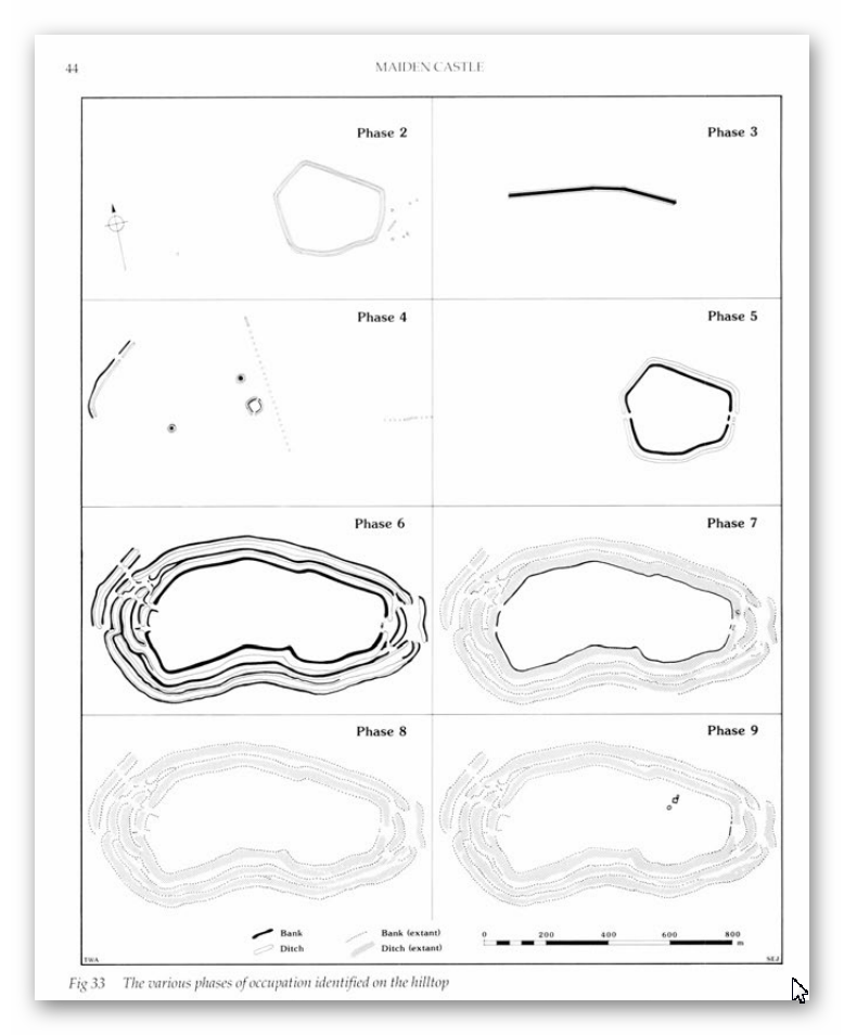
Maiden Castle constructed over several millennia of time

4. Population Growth Doesn’t Match the Fortress Theory

Prehistoric Britain’s population dynamics don’t quite fit with the idea of a landscape littered with defensive forts. Estimates suggest that during the Neolithic (circa 5000 BC), Europe’s population hovered between 2 and 5 million. By the Late Iron Age, it had swelled to roughly 15 to 30 million. But except for dense pockets like Greece and Italy, most settlements in Britain were small, often supporting fewer than 50 people.

Hillforts stand out as exceptions, accommodating communities as large as 1,000, but such numbers were rare. The later appearance of oppida—urban centers housing up to 10,000—reflects increasing societal complexity. However, the distribution and density of hillforts do not correlate with an equally dense, heavily militarized population needing constant defense.

The logistical challenge of defending thousands of these hillforts, each requiring a substantial population of warriors and support staff, becomes apparent when population estimates are compared to fort numbers. There simply weren’t enough people to maintain standing armies or garrisons in every hillfort, undermining the fortress theory.

13 Things You Didn’t Know About Hillforts
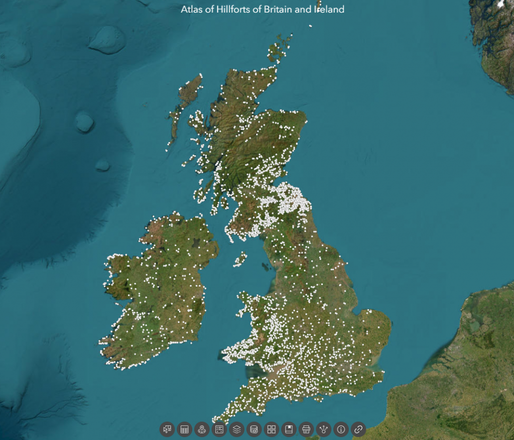
There are 3,300 Hill Forts in Britain according to the ‘Experts’ – the distribution makes no sense?
5. Hillforts Were NOT Evenly Distributed — Which Defies Pure Defence Logic

If hillforts were purely defensive, you’d expect them to be evenly spaced, strategically located to guard borders or resources. But the reality is messier. Over 3,300 hillforts are clustered unevenly across the British Isles. Take the Isle of Man—a tiny island of 572 square kilometres—with an astounding 32 hillforts. That’s roughly one hillfort every 5 to 6 square kilometres, far too dense to be defensible or necessary purely for military protection.

Additionally, about 30% of hillforts hug coastlines, with another 50% near prehistoric river systems. This heavy concentration around water suggests that control of waterways, trade, and communication routes were important considerations. Another 70% are near quarrying or resource extraction zones, linking hillforts to economic activity rather than just defense.

Such distribution patterns are inconsistent with a landscape dominated by warring tribes guarding fixed territories. Instead, they imply hillforts functioned as hubs for trade, social interaction, resource management, and ritual gatherings tied closely to natural and economic landscapes.

13 Things You Didn’t Know About Hillforts
Isle of Man – the most violent place in the prehistoric world with 32 hillforts?

6. Little Evidence of Warfare or Prolonged Occupation

If hillforts were military bastions, we would expect abundant archaeological evidence of sustained occupation, such as permanent housing, weapon caches, and clear defensive structures like palisades or gatehouses. We would also expect to find mass graves or layers of debris from sieges.

Yet, surprisingly, few hillforts show such evidence. Many have signs of only episodic or seasonal occupation. Archaeologists rarely find weapons stockpiles or large-scale battle remains inside hillforts. Defensive architectural features are often minimal or absent, and many ditches have shapes inconsistent with fortification—flat-bottomed, not steep and V-shaped.

This absence of clear martial evidence points to alternative interpretations: hillforts served multiple roles, perhaps acting as gathering places for trade, ritual ceremonies, or political meetings, with defense being a secondary or occasional function.

13 Things You Didn’t Know About Hillforts
Wrong type of Ditch as you could get inside and walk around hidden from the defenders

7. Danebury Hillfort Is Probably Older and Less “Fortress” Than Thought

Danebury in Hampshire is often cited as a classic Iron Age hillfort, extensively excavated by Barry Cunliffe in the 1970s. While traditionally dated to the 6th century BC and used for about 500 years, recent carbon dating and flint finds suggest it began as a Late Bronze Age stock enclosure 3,000 years ago. Some evidence even points to Neolithic or Mesolithic origins.

Excavations uncovered thousands of flints spanning multiple prehistoric periods, alongside Beaker pottery, challenging the notion that Danebury was a purely Iron Age military installation. Furthermore, LiDAR technology revealed a linear earthwork or dyke connected to the fort’s outer ditch—possibly a prehistoric waterway—hinting that Danebury might have been linked by boat transport rather than isolated on a hilltop.

Its ditches have soil deposited mostly on the outside rather than the inside, contradicting standard defensive designs. Together, these facts point towards Danebury functioning as a multifunctional site, involved in trade and social activities, rather than solely as a fortress.

Danbury Showing the Ditches were connected to dykes from the paleochannel below

8. Maiden Castle’s Massive Size Was Logistically Impossible to Defend

Maiden Castle in Dorset is Britain’s largest hillfort, sprawling over 47 hectares. This sheer size would require an enormous number of defenders—estimates suggest 155 soldiers per shift, totaling around 465 to cover 24-hour protection. That’s not counting support personnel, families, and provisions.

Feeding and supplying such a large garrison would be a monumental task. Monthly food needs would include vast amounts of grain and meat, requiring extensive storage, pastureland for livestock (around 516 animals per month), and water—at least 15 deep wells, supplying almost 750,000 litres monthly. Yet, archaeological digs and LiDAR surveys reveal only a handful of residential structures and no evidence of such water management infrastructure.

Additionally, no workshops or industrial sites capable of producing weapons and armour at scale have been found. This logistical void casts serious doubt on the idea that Maiden Castle was a continuously manned military fortress rather than a large social or ritual centre.

13 Things You Didn’t Know About Hillforts
Your looking at 5,000 men to defend the perimeter of this Earthwork – which had no water

9. Maiden Castle’s “Massacre” Is Much Less Clear-Cut Than Popular Tales

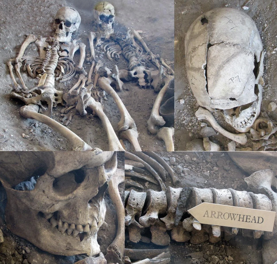
Popular accounts sometimes describe Maiden Castle as the site of a Roman siege massacre. However, excavations found only a handful of burials near entrances, with no mass graves or battlefield debris layers typical of large-scale violence.

Among the burials were an adult male with a debated projectile wound, a young woman with trauma signs, and several children—not typical combatants. Most bodies showed no direct evidence of violent death.

Over 20,000 slingstones discovered near entrances might suggest defensive stockpiles, but their purpose could also be ritualistic or related to hunting. After the supposed Roman attack, the site was largely abandoned, implying that its defensive role, if any, was limited and temporary.

13 Things You Didn’t Know About Hillforts
Once thought to be the ONLY evidence of conflict has been disproven by Bournemouth University

10. Old Sarum Is Misunderstood as a Hillfort

Old Sarum, located in Wiltshire, is often labeled an Iron Age hillfort established around 400 BC. It later became a Roman fort and then a medieval castle site. However, its position on a floodplain island, not a prominent hill, challenges the traditional fortress narrative.

Claims of Roman roads converging there have been questioned by LiDAR and satellite data, which show no clear road leading to Bath or elsewhere. The earthworks around Old Sarum appear more consistent with water management or moated enclosures than defensive ditches. Soil spoil was found mostly outside ditches, suggesting construction to hold water rather than repel enemies.

The ditch spoil is placed on the outside of the site to create a moat not inside to create a defensive bank

11. Many Hillforts May Have Been Waterborne Trade Hubs, Not Forts

Some hillfort ditches and earthworks may have functioned as prehistoric moats or canals, filled naturally due to higher ancient water tables or artificially to facilitate boat traffic. This suggests hillforts could have been accessible by water, acting as trading hubs connected through river networks.

LiDAR scans reveal links between earthworks and ancient waterways, highlighting a landscape adapted for waterborne movement rather than isolated hilltop defense. This theory fits with the frequent coastal and riverine siting of hillforts and their association with quarry and resource sites.

Old Sarum is in the middle of an ancient flood plain surrounded by giant rivers

12. Economic Evidence Contradicts Military Function

True military sites like Roman forts show dense economic footprints: lost coins, markets, bathhouses, workshops, and dense habitation. Hillforts lack this. Coins are extremely rare even after coinage was common. There are no permanent markets or large public buildings supporting garrisoned troops.

Instead, hillforts yield evidence of seasonal occupation: animal enclosures, storage pits, and sparse artefacts, reflecting episodic use for trade, social gatherings, or ritual. This economic silence is a strong indicator that hillforts were not permanent military bases but multifunctional social centres

13 Things You Didn’t Know About Hillforts
Roman Coins are found in ALL military sites – no Iron Age Coins are found in Hillforts

.


13. Hillforts Were Multifunctional Community Centres

All evidence points toward hillforts as dynamic, multifunctional hubs where prehistoric communities gathered seasonally for trade, political negotiation, rituals, and resource management. Defense may have been a later addition or an occasional function but was rarely the primary purpose.

Their diverse roles challenge the simplistic “fortress” label and invite us to rethink prehistoric Britain as a complex network of interconnected social landscapes, not a battlefield scattered with defensive works.

13 Things You Didn’t Know About Hillforts
Hill tops with beacons are natural trading places were people would gather

Conclusion

With new dating methods, LiDAR technology, and detailed excavations, the “hillfort as fortress” idea no longer holds water. We need to embrace a broader, richer understanding of these sites as centers of ancient community life, economy, and ritual.

What Archaeology Must Prove To Call Hillforts “Forts”.

To keep the “fort” label credible, archaeologists must find:.

Large permanent residences and housing clusters.

Reliable water supplies (wells, cisterns).

Dense loss of coins and trade items.

Associated civilian settlements outside gates.

Evidence of workshops making weapons and armor.

Defensible gatehouses and ramparts designed for battle.

Layers showing repeated conflict or siege trauma.

So far? – Those lines of evidence are mostly absent.

Final Thought.

Hillforts aren’t just relics of ancient warfare — they’re dynamic social landscapes, hubs of economy, ritual, and community. It’s time to move beyond outdated militaristic views and embrace their true complexity.

As the saying goes:

“Extraordinary claims require extraordinary evidence — and calling hillforts ‘forts’ without it is no longer credible archaeology.”

Exploring Prehistoric Britain: A Journey Through Time

My blog delves into the fascinating mysteries of prehistoric Britain, challenging conventional narratives and offering fresh perspectives based on cutting-edge research, particularly using LiDAR technology. I invite you to explore some key areas of my research. For example, the Wansdyke, often cited as a defensive structure, is re-examined in light of new evidence. I’ve presented my findings in my blog post Wansdyke: A British Frontier Wall – ‘Debunked’, and a Wansdyke LiDAR Flyover video further visualizes my conclusions.

My work also often challenges established archaeological dogma. I argue that many sites, such as Hambledon Hill, commonly identified as Iron Age hillforts are not what they seem. My posts Lidar Investigation Hambledon Hill – NOT an ‘Iron Age Fort’ and Unmasking the “Iron Age Hillfort” Myth explore these ideas in detail and offer an alternative view. Similarly, sites like Cissbury Ring and White Sheet Camp, also receive a re-evaluation based on LiDAR analysis in my posts Lidar Investigation Cissbury Ring through time and Lidar Investigation White Sheet Camp, revealing fascinating insights into their true purpose. I have also examined South Cadbury Castle, often linked to the mythical Camelot56.

My research also extends to the topic of ancient water management, including the role of canals and other linear earthworks. I have discussed the true origins of Car Dyke in multiple posts including Car Dyke – ABC News PodCast and Lidar Investigation Car Dyke – North Section, suggesting a Mesolithic origin2357. I also explore the misidentification of Roman aqueducts, as seen in my posts on the Great Chesters (Roman) Aqueduct. My research has also been greatly informed by my post-glacial flooding hypothesis which has helped to inform the landscape transformations over time. I have discussed this hypothesis in several posts including AI now supports my Post-Glacial Flooding Hypothesis and Exploring Britain’s Flooded Past: A Personal Journey

Finally, my blog also investigates prehistoric burial practices, as seen in Prehistoric Burial Practices of Britain and explores the mystery of Pillow Mounds, often mistaken for medieval rabbit warrens, but with a potential link to Bronze Age cremation in my posts: Pillow Mounds: A Bronze Age Legacy of Cremation? and The Mystery of Pillow Mounds: Are They Really Medieval Rabbit Warrens?. My research also includes the astronomical insights of ancient sites, for example, in Rediscovering the Winter Solstice: The Original Winter Festival. I also review new information about the construction of Stonehenge in The Stonehenge Enigma.

Further Reading

For those interested in British Prehistory, visit www.prehistoric-britain.co.uk, a comprehensive resource featuring an extensive collection of archaeology articles, modern LiDAR investigations, and groundbreaking research. The site also includes insights and extracts from the acclaimed Robert John Langdon Trilogy, a series of books exploring Britain during the Prehistoric period. Titles in the trilogy include The Stonehenge Enigma, Dawn of the Lost Civilisation, and The Post Glacial Flooding Hypothesis, offering compelling evidence about ancient landscapes shaped by post-glacial flooding.

To further explore these topics, Robert John Langdon has developed a dedicated YouTube channel featuring over 100 video documentaries and investigations that complement the trilogy. Notable discoveries and studies showcased on the channel include 13 Things that Don’t Make Sense in History and the revelation of Silbury Avenue – The Lost Stone Avenue, a rediscovered prehistoric feature at Avebury, Wiltshire.

In addition to his main works, Langdon has released a series of shorter, accessible publications, ideal for readers delving into specific topics. These include:

For active discussions and updates on the trilogy’s findings and recent LiDAR investigations, join our vibrant community on Facebook. Engage with like-minded enthusiasts by leaving a message or contributing to debates in our Facebook Group.

Whether through the books, the website, or interactive videos, we aim to provide a deeper understanding of Britain’s fascinating prehistoric past. We encourage you to explore these resources and uncover the mysteries of ancient landscapes through the lens of modern archaeology.

For more information, including chapter extracts and related publications, visit the Robert John Langdon Author Page. Dive into works such as The Stonehenge Enigma or Dawn of the Lost Civilisation, and explore cutting-edge theories that challenge traditional historical narratives.

Other Blogs

s

t

The Great Iron Age Hill Fort Hoax

Introduction

While some hillforts may have been adapted for defence during later periods — particularly during Roman expansion — the majority were not originally constructed as military installations. Instead, they served multifunctional roles in prehistoric societies: economic, ceremonial, territorial, and social.

In the wake of Hawkes’ renowned treatise ‘Hillforts’ (Hawkes 1931), scholars of archaeology undertook the arduous task of categorising hillforts, drawing upon the limited evidence at their disposal. Primarily, these divisions hinged on considerations of size, location, the construction of ramparts, and chronological context. In a relatively recent endeavour the author Cunliffe, put forth a scheme tailored to the Wessex region (Cunliffe 1984b), which delineated certain overarching classifications for these forts (The Great Iron Age Hill Fort Hoax):

(The Great Iron Age Hill Fort Hoax):
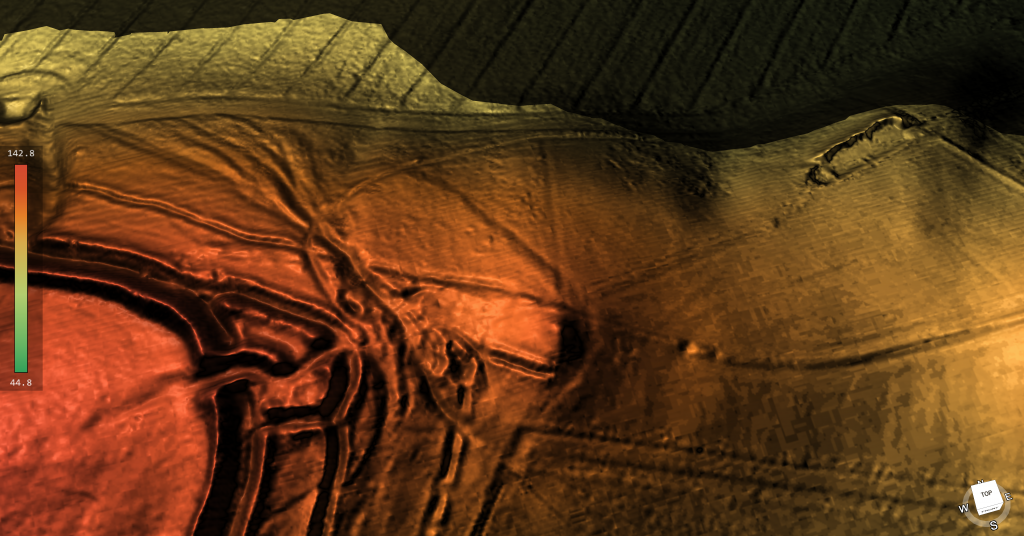
Maiden Castle showing something strange (a neolithic Dyke) in the centre -The Great Iron Age Hill Fort Hoax

Early hilltop enclosures, typically encompassing over 10 hectares of terrain.

Small, strategically fortified settlements, perched prominently, often occupying areas ranging from 1 to 3 hectares.

Early hillforts, characterised by univallate contour works, typically spanning 3 to 7 hectares.

Developed hillforts, generally falling within the 3 to the 7-hectare range but frequently boasting multivallate defences.

The quintessential definition for this prehistoric phenomenon reads as follows: A hillfort constitutes a form of earthwork employed as a fortified sanctuary or defended habitation, strategically positioned to exploit elevated terrain for defensive advantage.

This classification endured unchallenged for more than seven decades – they are now, according to the repository of knowledge that is Wikipedia, primarily of European origin, belonging to either the Bronze Age or Iron Age, with some even extending into the post-Roman era. The fortifications typically trace the natural contours of a hill, comprising one or more tiers of earthworks, fortified by stockades or defensive walls and flanked by external ditches.

Celtic hill forts came into their own during the Late Bronze Age and Early Iron Age, aligning roughly with the inception of the first millennium BC. They continued to proliferate across various Celtic regions of central and western Europe until the advent of the Roman conquest. Their prevalence was most pronounced during the later epochs, including the Urnfield culture and Atlantic Bronze Age (circa 1300 BC – 750 BC), the Hallstatt culture (circa 1200 BC – 500 BC), and the La Tène culture (circa 600 BC – 50 AD).

The Great Iron Age Hill Fort Hoax
Typical View of a Iron Age Hill Fort – The Great Iron Age Hill Fort Hoax

This transformation in our comprehension of hillforts owes a substantial debt to the extensive work undertaken by Barry Cunliffe at Danebury during the 1970s.

Prehistoric Europe witnessed a burgeoning population. Estimates suggest that around 5000 BC, during the Neolithic era, the population of Europe fluctuated between 2 million and 5 million. In the Late Iron Age, this number swelled to an estimated 15 to 30 million. With the exception of Greece and Italy, which were more densely populated, the overwhelming majority of settlements during the Iron Age were relatively diminutive, housing no more than 50 inhabitants. Hillforts, however, stood as an exception, accommodating as many as 1,000 individuals.

With the advent of oppida in the Late Iron Age, settlements expanded to house populations as substantial as 10,000. As the populace swelled, so too did the intricacy of prehistoric societies. Around 1100 BC, hillforts emerged and over the ensuing centuries proliferated throughout Europe. They served a diverse array of functions, functioning variously as tribal hubs, fortified bastions, focal points of ritualistic activities, and centres of production.

The Logistical Impossibility of Fortress Hillforts

A closer examination of hillfort distribution across Britain and Ireland raises serious doubts about the traditional interpretation of these sites as purely defensive structures.

  • There are over 3,300 hillforts spread across the British Isles.
  • Distribution is heavily clustered, not evenly spaced — with extreme examples like the Isle of Man, where 32 enclosures exist in just 572 square kilometres (one hillfort every 5–6 km²).
  • 30% of all known hillforts are located on the coastline, and an estimated 50% more are situated along prehistoric river systems — meaning up to 80% had direct waterborne access.
  • Around 70% of hillforts are associated with quarrying, mining, or resource extraction zones.

If each hillfort was purely a refuge or defensive fort:

  • There would need to be thousands of separate, fortified populations,
  • Thousands of armies ready to defend them,
  • And consistent evidence of sustained regional warfare.

Yet the archaeology shows otherwise:

  • Few hillforts have evidence of prolonged occupation.
  • Evidence of mass conflict is rare and localised.
  • Many sites lack obvious military architecture (such as palisade trenches or true gatehouses).

The only logical explanation is that hillforts were primarily multifunctional hubs — sites of seasonal gathering, trade, ceremony, and political negotiation, with defensive adaptations made only when necessary.

(The Great Iron Age Hill Fort Hoax):
Isle of Man – the most violent place in Britain or a Trading hub?

So, what shall we make of this revelation?

Is it indeed, apt to continue branding them as exclusively Iron Age enclaves? Of course, there are vestiges from the Iron Age to be found within these enclosures, but they also harbour traces of the Middle Ages, Roman artefacts, and, most tellingly, flint relics dating back to the Neolithic/Mesolithic era.

To delve into the heart of this matter, let us focus our attention on the paramount example of an Iron Age fort in Britain – Danebury in Hampshire, and its peer, the grandiose Maiden Castle in Dorset. Together, we shall sift through their findings, unearthing the curious conundrum of archaeological classifications.

Danebury – Case Study

danebury hill fort
Danebury Hill Fort

According to Wikipedia: Danebury is an Iron Age hillfort in Hampshire, England, about 19 kilometres (12 mi) north-west of Winchester (grid reference SU323376). The site, covering 5 hectares (12 acres), was excavated by Barry Cunliffe in the 1970s. Danebury is considered a type-site for hill forts, and was important in developing the understanding of hillforts, as very few others have been so intensively excavated.

Built in the 6th century BC, the fort was used for almost 500 years, during a period when the number of hill forts in Wessex greatly increased. Danebury was remodelled several times, making it more complex and resulting in it becoming a “developed” hill fort. It is a Scheduled Monument and a Local Nature Reserve called Danebury Hillfort. The Scheduled Monument is surrounded by a Site of Special Scientific Interest, designated as Danebury Hill.

Looks pretty straightforward and comprehensive – so what is wrong?

In the annals of Iron Age Britain, a conspicuous absence of historical records compels us to rely solely on the tools of archaeology to reconstruct the rich tapestry of events at sites like Danebury and other ancient forts. Crafting a comprehensive and authoritative historical narrative from a single site becomes a feat of no small magnitude. Typically, in the realm of science, hypotheses are formulated and subjected to rigorous testing and fine-tuning by fellow scientists. But in this case, a unique anomaly emerges.

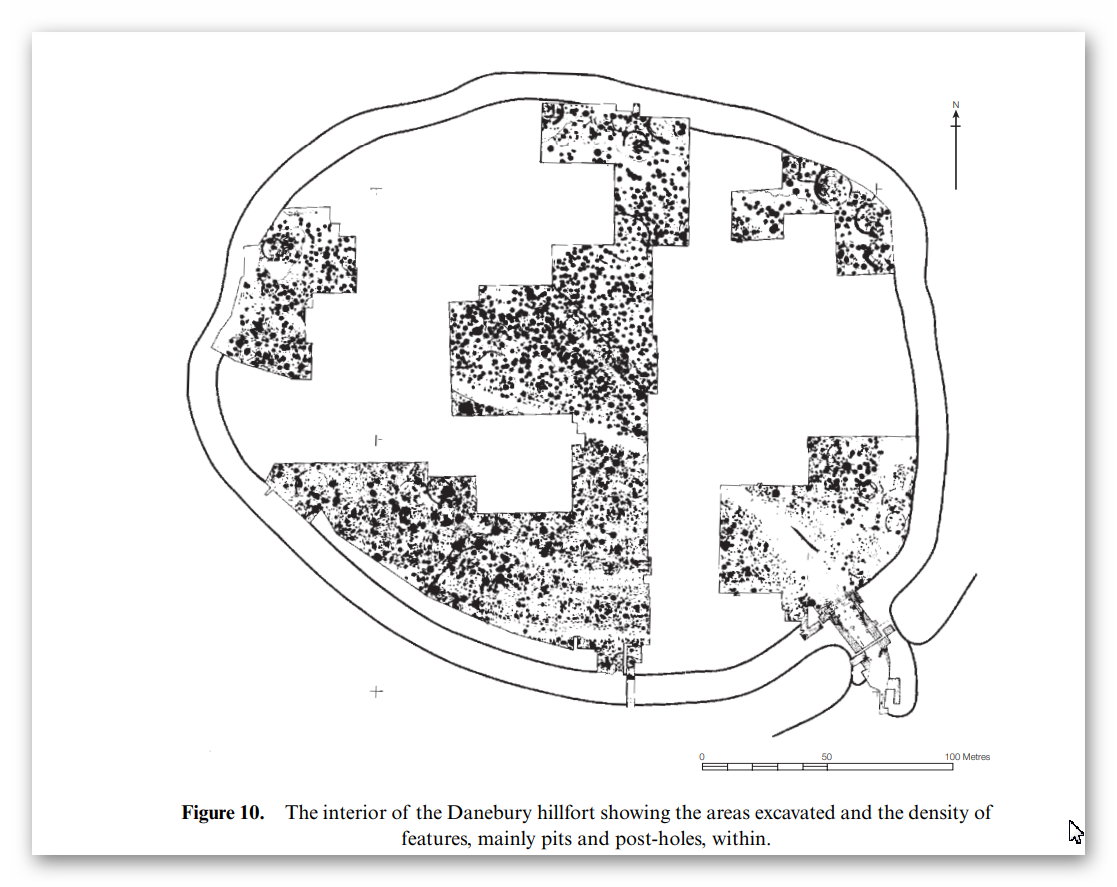
Danebury Excavation map

It is worth noting that the established dates pertain solely to the interior pits of the site. These dates offer insight into the latest period of habitation, for obvious reasons, or at best, the principal period of occupancy, but they do not unveil the secrets of the site’s birth – its construction date.

A cursory search reveals that Hampshire archaeology has, intriguingly, reclassified Danebury as a Bronze Age relic. According to this new classification, “Evidence suggests that Danebury Iron Age Hill Fort was built 3000 years ago. It started life as a Late Bronze Age stock enclosure, while the main defences that are now visible were constructed around 2500 years ago. The fort continued to be in use until around 100 BC, a century and a half before the Roman invasion of AD 43.”

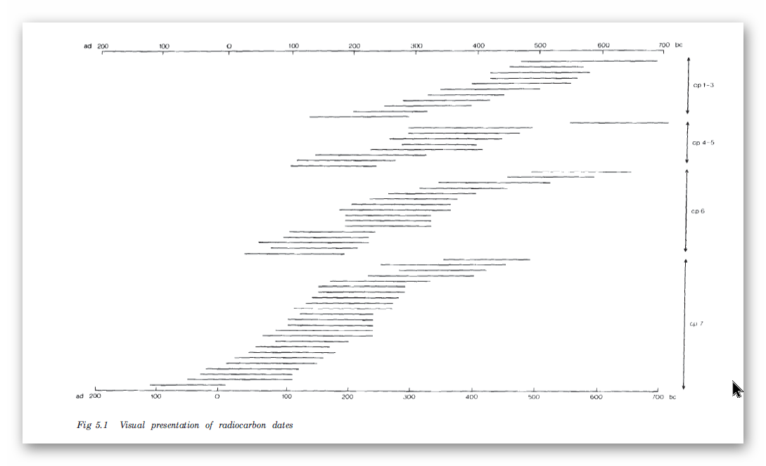
The basis for this shift in classification can be traced to carbon dating, which exposed samples reaching as far back as 700 BCE, leading to the realisation that the site was never truly of the Iron Age.

Radio Carbon Dates of Danebury - the interior dates back to 700 BCE
Radio Carbon Dates of Danebury – the interior dates back to 700 BCE

In fact, during the extensive excavation conducted between 1969 and 1978, which included a rare examination of the ditches outside the fort, a treasure trove of flints spanning from the late Neolithic to the early Bronze Age was unearthed, along with a smattering of Beaker period pottery. Consequently, we find ourselves teetering on the precipice of a profound reevaluation, one that suggests that Danebury might not be Iron Age, nor Bronze Age, but quite possibly a relic from the Neolithic era. The ability to definitively differentiate Neolithic flints from their Mesolithic counterparts is a matter that deserves thorough exploration, even if it may lead us to reject some preconceived notions.

Moreover, the excavations carried out at Danebury between 1979 and 1988 yielded an impressive assemblage of flints, totalling 2,896 items. It is of paramount importance to note that these archaeological endeavours unveiled a linear earthwork. The contours of this earthwork had been accentuated by a worn hollow trackway (F295), reaching a depth of approximately 0.3 meters behind the ditch on the northern side. Regrettably, the age of this feature remains elusive, but it’s conceivable that this trackway might constitute one of the original routes leading to the fort’s entrance.

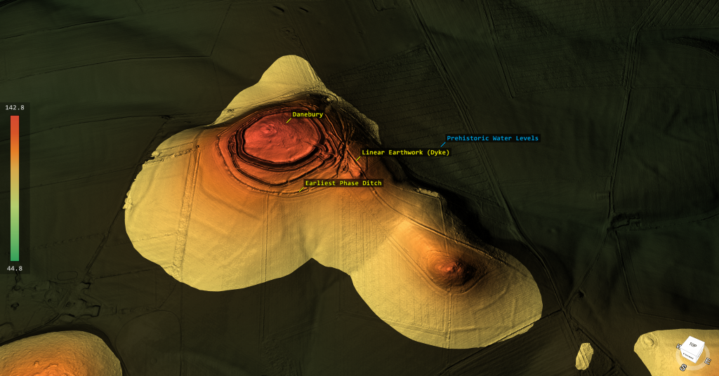
A striking observation made possible by LiDAR technology, although unmentioned in the report, is the linkage between this ‘Dyke’ and the outer ditch of the site. This intriguing connection hints at the possibility of a nautical route to the site, presumably navigable during higher river levels in prehistoric times.

Danebury showing prehistoric water levels and connecting Dyke to the hill site

So it’s Prehistoric and not Iron Age – therefore is it a hillfort at least?

In our quest to ascertain whether this site was initially conceived as a ‘fortification,’ we must examine two critical aspects: its original design and the practical function it served in the past. It is crucial to consider that, like many ancient structures, this site could have been adapted for a new function in later historical periods.

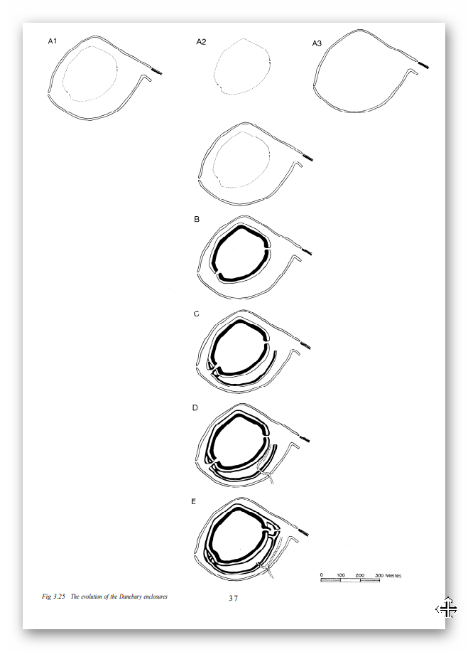
Official schematics detailing the phases of Danebury’s evolution shed light on its original design. Notably, the previously recognised ‘Linear Earthwork’ (Dyke) played a pivotal role in its construction, linking to another ‘defensive’ ditch, designated as A1. However, an intriguing twist emerges.

Danebury Construction periods - traditional model
Danebury Construction periods – traditional model

Regrettably, LiDAR technology uncovers a discrepancy in Barry Cunliffe’s illustrative depictions of the site. It appears that some creative liberties were taken in these drawings. The FULL linear feature was not only omitted from the diagrams but a somewhat exaggerated kink was added to the south of the Dyke, creating the impression of a deliberately planned entrance. In reality, this feature formed a complete circle and did not resemble the ‘banjo entrance’ that Cunliffe sought to convey. The reality is that the straight linear earthwork preceded the outer circle.

The outer Danebury circle and the Linear Dyke is linked - the banjo entrance 'extra' is a later feature
The outer Danbury circle and the Linear Dyke is linked – the banjo entrance ‘extra’ is a later feature

Additionally, it’s worth noting that the original ditch A1 appears to have had more earthwork material deposited on its outer section than on the inner portion. This particular characteristic, where more soil is added to the outer side, raises questions about its viability as a purely ‘defensive’ element.

So, Danebury is probably Neolithic/Mesolithic in date (shown by flint numbers on site) and not defensive as the original ditch was made probably to link a Linear Earthwork to the river system.

The ditches show the excavation spoil is evenly distributed on both side - not defensively designed
The ditches show the excavation spoil is evenly distributed on both side – not defensively designed

Let’s look at Maiden Castle to see if the ‘traditionalists’ have better luck with their hypothesis.

Maiden Castle – Case Study

According to Wikipedia – Maiden Castle is an Iron Age hillfort 1.6 mi (2.6 km) southwest of Dorchester, in the English county of Dorset. Hill forts were fortified hilltop settlements constructed across Britain during the Iron Age.

(The Great Iron Age Hill Fort Hoax):

The earliest archaeological evidence of human activity on the site consists of a Neolithic causewayed enclosure and bank barrow. In about 1800 BC, during the Bronze Age, the site was used for growing crops before being abandoned. Maiden Castle itself was built in about 600 BC; the early phase was a simple and unremarkable site, similar to many other hill forts in Britain and covering 6.4 ha (16 acres).

Around 450 BC it was greatly expanded and the enclosed area nearly tripled in size to 19 ha (47 acres), making it the largest hill fort in Britain and, by some definitions, the largest in Europe. At the same time, Maiden Castle’s defences were made more complex with the addition of further ramparts and ditches. Around 100 BC, habitation at the hill fort went into decline and became concentrated at the eastern end of the site. It was occupied until at least the Roman period, by which time it was in the territory of the Durotriges, a Celtic tribe.

After the Roman conquest of Britain in the 1st century AD, Maiden Castle appears to have been abandoned, although the Romans may have had a military presence on the site. In the late 4th century AD, a temple and ancillary buildings were constructed. In the 6th century AD, the hilltop was entirely abandoned and was used only for agriculture during the medieval period.

The study of hill forts was popularised in the 19th century by archaeologist Augustus Pitt Rivers. In the 1930s, archaeologists Mortimer Wheeler and Tessa Verney Wheeler undertook the first archaeological excavations at Maiden Castle, raising its profile among the public.

Allow me to elucidate our quandary further. Recent excavations in the year 1985 revealed artefacts hailing not only from the Neolithic era but also from a substratum that likely originates in the Mesolithic epoch. Therefore, the label ‘Iron Age’ begins to appear somewhat askew.

The question arises: could this subsequent ‘addition’ truly be classified as a fortification?

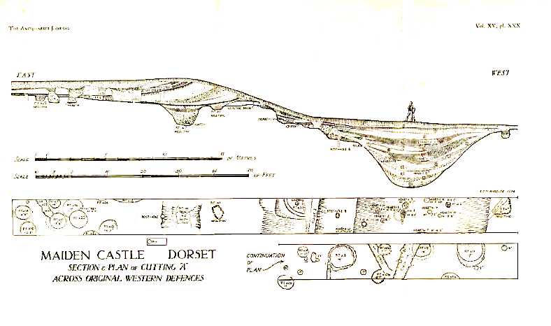
Our scrutiny of the construction once more casts doubt on this notion. The ditches, ostensibly designed for defence, present a conundrum. The sole cross-sectional glimpse into these ‘defensive’ trenches reveals an uncanny resemblance to the flat-bottomed counterparts witnessed in other prehistoric sites like Avebury, Stonehenge, and Old Sarum.

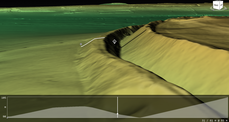
Cross-section of Ditch showing it too flat, deep and wide to be defensive

Maiden Castle and the Myth of the Massacre

Although Maiden Castle is often cited as evidence of Iron Age warfare, the archaeology paints a much more cautious picture.

  • Only a small number of burials were found near the entrances — not mass graves.
  • Among these:
    • One adult male had a projectile wound in his spine (originally thought to be a Roman ballista bolt, now debated).
    • One young woman showed signs of trauma.
    • Several children were also buried — not typical combatants.

Most bodies show no direct evidence of violent death.
There is no layer of battlefield debris, no mass trauma event consistent with a large-scale siege.

Moreover:

  • Over 20,000 slingstones were found stored near the entrances, but their exact purpose remains uncertain. They could represent defensive stockpiles, but also hunting tools, ritual offerings, or symbols of authority.
  • After the supposed Roman assault, Maiden Castle was largely abandoned — suggesting it was not a viable military stronghold, but rather a symbolic centre caught up in a violent moment of change.

In short:

  • One tragic encounter at the end of Maiden Castle’s life does not prove it was built or primarily used as a fortress.

The evidence supports a more complex reality:
Maiden Castle was a trading or community meeting site, possibly adapted hastily for defence when Roman forces arrived — but defence was not its primary, original function.

The Logistical Impossibility of Defending Maiden Castle

Introduction

Maiden Castle, Britain’s largest Iron Age hill fort, has always been a subject of fascination and mystery. Its impressive size and strategic location suggest it was once a significant military stronghold. However, recent advancements in archaeological technology, specifically Light Detection and Ranging (LiDAR), have sparked debates about the actual feasibility of defending such a vast fortification by examining the logistical requirements necessary to sustain a large garrison here, juxtaposed with the lack of physical evidence for such activity, a new narrative emerges, challenging traditional interpretations of Maiden Castle’s historical significance.

The Scale of Maiden Castle

Maiden Castle sprawls across approximately 47 acres, making it one of Europe’s most extensive hill forts. Historically, it’s been portrayed as the last stand of the Britons against the Romans, implying it once hosted a substantial military force. The sheer size of the fortification would require significant human resources to defend and maintain, not to mention the extensive support system needed to sustain such a force over prolonged periods.

Estimating Defence Manpower

Based on the fort’s perimeter, an estimated 155 soldiers per shift would be necessary to effectively guard it, assuming a strategic placement of one soldier every 10 meters. This calculation triples to 465 soldiers when considering three shifts to cover 24-hour defense, without considering the rotation of these soldiers. In comparison, the Roman town of Londinium had 1,000 soldiers to protect it and a supporting population of 30,000 people.

Logistical Support Requirements

Supporting a garrison of this size is no minor feat. Each soldier would require at least 3,000 calories daily, amounting to over 171 million monthly calories for the entire personnel. This would necessitate large-scale food provisions, including grains and meat, which would require extensive storage and preservation facilities.

 Defending Maiden Castle

Water Supply Challenges

One of the most critical logistical requirements is water. For Maiden Castle’s estimated population of 1910 individuals (including soldiers, support staff, and their families), about 745,950 litres of water would be needed monthly – this equates to at least 15 large deep wells. Historical accounts and archaeological evidence must show substantial water sources, such as wells or water management systems, to support this figure.

The Missing Wells

However, LiDAR scans, which are highly effective at identifying even minute changes in landscape and topography, have not revealed evidence of the necessary 15 wells. The absence of such crucial infrastructure raises significant doubts about the sustained military use of Maiden Castle at the scale often depicted in historical narratives.

Livestock and Food Production

The logistics of feeding a large garrison would also involve livestock management. Approximately 516 animals would be required monthly for the meat supply alone, necessitating extensive grazing areas, enclosures, and management systems, none of which have been identified in the LiDAR data.

Manufacturing Weapons and Armour

A garrison’s effectiveness also depends on its ability to arm itself. Producing weapons and armour would require workshops, forges, and considerable quantities of raw materials, along with skilled craftsmen. The fort’s defence would necessitate a continuous supply of spears, arrows, and protective gear. Yet, there is no archaeological evidence of such industrial activity on a scale that the theoretical number of defenders would demand.

(The Great Iron Age Hill Fort Hoax):

Lack of Residential Structures

Moreover, the housing needs (min. 250 structures) for a population this large would be substantial. If Maiden Castle were as populated and active as theorised, we would expect to find numerous residential structures. Yet, archaeological digs and surveys, including LiDAR imaging, have only identified a handful of houses to date, casting further doubt on the historical narratives of a densely populated fort.

The Problem of Evidence

The discrepancy between the logistical requirements for sustaining a significant military presence at Maiden Castle and the lack of physical evidence supporting such activities presents a profound challenge to traditional interpretations. The absence of infrastructure necessary for water, food, and weapon production suggests that either Maiden Castle was not primarily a military fort at the scale often imagined or our understanding of its historical role needs significant revision.

Alternative Theories

It’s possible that Maiden Castle served a different function, perhaps more to do with trading and hence the massive ditches that would have been moated in the past rather than a continuously manned military fortress. This would align more closely with the archaeological evidence, or lack thereof, and help explain the absence of extensive military infrastructure.

Conclusion

The enigma of Maiden Castle reflects the complexities of archaeological interpretation and the importance of integrating new technologies like LiDAR with traditional archaeological methods. The emerging picture is that the logistical viability of Maiden Castle as a large-scale military fortress is not supported by the physical evidence currently available. This case serves as a reminder of archaeological research’s dynamic and evolving nature, where new tools can significantly alter our understanding of the past.

Final Thoughts

As we uncover more about ancient sites like Maiden Castle, it is crucial to remain open to new interpretations and theories that might differ significantly from traditional views. The absence of evidence is not evidence of absence. Still, it does require us to question and reassess historical assumptions, ensuring our understanding of the past is as accurate as possible.

Old Sarum – Case Study

According to English Hertitage who own the site: Old Sarum is an ‘Iron Age hillfort’ may have been established here about 400 BC. It was then occupied shortly after the Roman conquest of Britain (AD 43), when it became known as Sorviodunum.

The Great Iron Age Hill Fort Hoax
EH: A reconstruction showing how the Iron Age hillfort at Old Sarum may have appeared in about 100 BC

Three Roman roads from the north and east converged outside the east gate of the hillfort, and two sizeable Romano-British settlements were also established outside the ramparts. Little is known of this period, though it has been suggested that in the early Roman period a military fort was set up within the earthworks, with a civilian settlement outside. The civilian settlement formed the nucleus of one, or both, of the extra-mural Roman settlements. As the need for a fort dwindled, meanwhile, the area within the ramparts was converted to become the precinct for a Romano-British temple.

We have no evidence of the fate of Sorviodunum at the end of the Roman period, and the Anglo-Saxon period as a whole is poorly recorded. In 1003, however, a mint was sited within the old hillfort; and archaeological finds suggest there was late Anglo-Saxon settlement outside the ramparts. So there is evidence of life in and around Old Sarum before the Conquest.

(The Great Iron Age Hill Fort Hoax):
Old Sarum with supposed Roman roads


In my view, oversimplified interpretations of the past, lacking excavation work to substantiate theories, pose significant challenges. Close examination often reveals fundamental flaws, such as the assumption of Roman roads converging and passing through a particular site. This type of desk-based archaeology, relying solely on OS maps and rulers, can lead to subjective conclusions.

The reality, as demonstrated by my own LiDAR investigation, contradicts these assumptions. The supposed road leading through the site to Bath is absent from both LiDAR maps and satellite photographs. Furthermore, considering the topography, it would be implausible for such a road to exist unless it were the largest land bridge in British Roman history.

It’s crucial to approach archaeological interpretations with a critical eye and to rely on comprehensive research methods to uncover the true complexities of the past. My LiDAR investigation highlights the importance of utilising advanced technologies and conducting thorough fieldwork to refine our understanding of historical landscapes.

Is it a defensive structure?
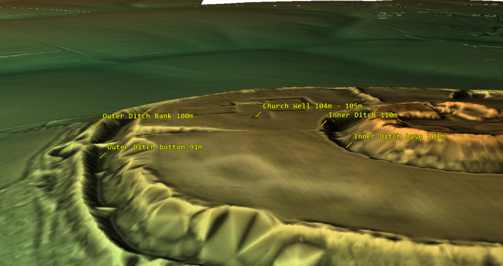
In archaeology, I believe honesty is paramount. Categorising sites under broad labels like “Iron Age Forts” oversimplifies their complexities. Take Old Sarum, for instance—it’s situated in a floodplain on an island, not on a hill as commonly assumed. This challenges our traditional understanding of fortifications and prompts us to reconsider our interpretations.

The Great Iron Age Hill Fort Hoax
Hills are in Red flood plain is in green – Old Sarum is a island in a floodplan on a hillock

The proximity of these supposed defensive forts raises another intriguing question. Why would communities invest considerable time and effort in building multiple forts close to each other? Considering the logistical challenges and the likely limited population of prehistoric Britain, it’s logical to question the necessity of such clustering.
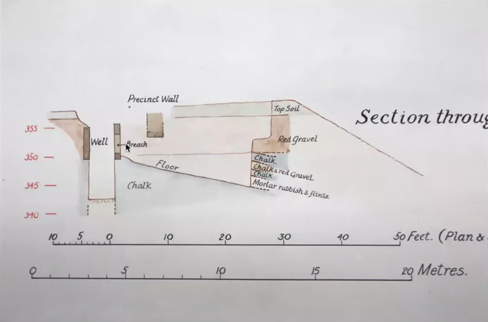
Assuming that manpower was an unlimited and cost-free resource in ancient times is overly simplistic. It overlooks the practical considerations that would have influenced decision-making. By challenging these assumptions, we can gain a deeper understanding of prehistoric society. I believe it’s essential to critically examine these aspects of the past rather than accepting naive interpretations. Let’s strive for a more nuanced understanding that acknowledges the complexities of ancient societies and avoids oversimplification.

Outer Moat constructed to keep in water as a moat?

When we examine the site’s profile using lidar, two major findings become apparent. Firstly, the spoil from the ditch was placed on the outside rather than the inside (as expected if it was defensive), and the base of the spoil was not part of the natural rise of the floodplain, indicating that the outer part of the ditch is actually a bank.

The Great Iron Age Hill Fort Hoax
The Ditch Spoil is on the outside not inside as a defensive structure would expect
The Great Iron Age Hill Fort Hoax
The profile shows that the base is not part of the natural hillock and is in fact a false bank

Water Table

Based on the site’s historical records, we understand that one motive for relocating the church was its water shortage, leading it to tap into the deep well owned by the garrison. This knowledge allows us to assess the state of the moats and comprehend why the inner moat was excavated to a depth of 7 meters. By examining the well discovered during excavation, we ascertain that it was abandoned at a depth of 104m to 105m meters (OD), suggesting that any ditch below this level would have become waterlogged.

The Great Iron Age Hill Fort Hoax
The sites feature with there height over OD specified

The initial depth of the inner ditch was 110 meters (OD), but today it measures 103 meters (OD), which is below the bottom of the Church well. Based on this data, we can scientifically hypothesize that during Norman times, the inner ditch was dug deeper to reach the water table level. It’s also possible that as the water supply for the moat decreased over the church’s lifetime, the moat was excavated unusually deep to access the diminishing water levels.

The Great Iron Age Hill Fort Hoax
Church well going form 108M (OD) to 104m (OD)

This new understanding of the water table also opens up the possibility that the outer ditch was also moated up to the Norman conquest and moreover, during the Roman period – this is something that needs urgent explaination and further study.

The Isle of Man Problem: 32 Hillforts, No War

The Isle of Man presents a striking case study.

Despite its small size (572 km²) and relatively low prehistoric population (likely no more than a few thousand people), the island hosts over 32 known hilltop enclosures.

  • That’s one hillfort for every 5–6 square kilometres.
  • Far more than necessary for true defensive refuges.
  • Far too many for the small, scattered prehistoric communities to man, defend, or maintain.

Furthermore:

  • There is no evidence of widespread conflict, siege layers, or mass trauma on the Isle of Man.
  • The enclosures are clustered near coastlines, rivers, and quarry sites, suggesting trade, ritual, and social functions rather than fortress building.

In reality, these hillforts reflect:

  • Regional gatherings,
  • Resource management hubs,
  • Territorial presence displays,
  • And seasonal ritual activities.

They are part of a complex, multi-layered social system — not remnants of an island bristling with fortresses.

Isle of Sky – the most Violent Island in Britain according to the hillfort hypothesis?

Economic Footprints: What Hillforts Left Behind

If hillforts had been functioning military garrisons, we would expect them to leave behind the kind of economic footprints we see at true military installations. Roman forts along Hadrian’s Wall, for example, show dense concentrations of:

  • Lost coins (due to pay, gambling, markets),
  • Trade goods,
  • Personal items,
  • Infrastructure like bathhouses, workshops, taverns.

Hillforts, however, show none of these patterns:

  • Coin finds are extremely rare — even after coinage became widespread.
  • No dense trade debris typical of garrison towns.
  • No large, permanent marketplaces found inside or immediately outside the earthworks.
  • No taverns, bathhouses, or public structures that would support a standing military population.

Instead, what we do find:

  • Sporadic evidence of seasonal gatherings,
  • Traces of animal enclosures and storage pits,
  • Rare, isolated finds suggesting episodic use, not permanent occupation.

This economic silence reinforces the view that hillforts were not permanent defensive strongholds. They were seasonal gathering places, trading hubs, and symbols of regional power — adapted when necessary, but not built for war.

The Great Iron Age Hillfort Hoax
Lost of Roman Coins at Hadrian’s Wall shows it was militarised

Comparison Chart

This is designed to hammer the point home very clearly:

FeatureRoman FortsMedieval CastlesHillforts
Civilian housing (vicus or town) outside gatesAlways presentAlways presentRare to none
Permanent occupation evidence (housing, workshops)Dense and obviousDense and obviousMinimal, sporadic
Water supply (wells, cisterns, springs)Always presentAlways presentRare, problematic
Markets/trade hubsYes (vici markets)Yes (castle markets)Rare, indirect evidence
Coin loss patterns (economic footprint)Heavy and denseHeavy and denseVery rare
Evidence of siege warfare (mass graves, trauma layers)OccasionallyOccasionallyVery rare, disputed
Garrison infrastructure (barracks, granaries, armouries)Clear and standardClear and standardNone
Ritual or ceremonial useMinorMinorMajor
Symbolic/territorial displayMinorMinorMajor
Primary purposeMilitary defenceMilitary defenceMulti-use social centre

Conclusion

In light of radiocarbon re-dating, landscape logistics, environmental context, and the absence of widespread conflict archaeology, it is clear that the traditional interpretation of hillforts as purely defensive structures does not hold up.

Instead, hillforts were dynamic, multifunctional community centres:

  • Places of trade,
  • Seasonal gathering,
  • Political negotiation,
  • Social rituals,
  • Resource management,
  • And yes, occasional refuge during times of crisis.

The “hillfort hoax” is not merely a minor academic error — it represents a fundamental misunderstanding of the economic sophistication, social complexity, and territorial organization of prehistoric Britain and Ireland.

We must move beyond outdated, militaristic assumptions and embrace the true richness of these ancient landscapes.Curiously, signs of later defensive ditches emerge, and they bear a different, smaller, and V-shaped profile. Their purpose, it seems, was to ensnare any marauding adversaries. The round and conspicuously capacious ditches we encounter here bear a striking resemblance to a singular category of defensive structure in history – Norman Castles. The Normans, however, chose moats, not ditches, as their preferred defensive fortifications. An enigma indeed.

Might we be gazing upon prehistoric moats, which, in the bygone era of elevated water tables, would have readily filled to assume the characteristics of a moat? Could these have served as a defence, or might a more plausible function be inferred – a conduit for waterborne trade, facilitating the ingress of boats?

Finally, let us contemplate a pivotal factor, one I have thus far refrained from disclosing, for I deem it the most crucial piece of evidence, the ‘smoking gun,’ as it were, in our argument against the notion that these sites were constructed for defensive purposes. Not a solitary remains of a life extinguished in conflict has ever been unearthed within the confines of the ditches encircling any of the two thousand so-called ‘Iron Age Forts’ that punctuate history.

And just as importantly, the economic footprint — or lack of it — tells the same story.
Where real garrisons stand, coins, goods, and markets follow. In hillforts, we find quiet, temporary use: more in keeping with seasonal trade, ritual, and social gathering than the steady rhythms of a standing army.

What Archaeology Must Prove to Justify “Fort” Classifications

Given the overwhelming evidence presented here — logistical, economic, landscape, and archaeological — any continued classification of hillforts as primarily defensive must now meet clear evidential standards.

Specifically, archaeologists would need to demonstrate:

  • Consistent presence of large residential structures (for permanent defenders),
  • Multiple reliable and sustainable water sources (wells, cisterns) on site,
  • Dense loss patterns of economic goods (coins, tools, trade items) indicating long-term garrison use,
  • Associated civilian settlements outside gates (traders, farmers, artisans),
  • Workshop remains for armour and weapon manufacturing,
  • Defensible entrances with clear defensive layering (rather than just “complex” layouts),
  • Widespread trauma or siege layers showing repeated military conflict,
  • Evidence that original ditch and bank constructions were designed for defence (e.g., V-shaped ditches, inward-facing ramparts).

Without these elements — and so far, they are largely absent —
the default assumption should shift away from “fortifications” toward “multifunctional ceremonial, trade, and seasonal gathering sites.
You might want a final quick punchy line like:

It is an assertion that prompts us to reconsider their true nature, to entertain the possibility that these were not fortifications but, rather, bustling hubs of trade and commerce.

“Extraordinary claims require extraordinary evidence — and calling hillforts ‘forts’ today without extraordinary evidence is no longer credible archaeology.”

Further Reading

For information about British Prehistory, visit www.prehistoric-britain.co.uk for the most extensive archaeology blogs and investigations collection, including modern LiDAR reports.  This site also includes extracts and articles from the Robert John Langdon Trilogy about Britain in the Prehistoric period, including titles such as The Stonehenge Enigma, Dawn of the Lost Civilisation and the ultimate proof of Post Glacial Flooding and the landscape we see today.

Robert John Langdon has also created a YouTube web channel with over 100 investigations and video documentaries to support his classic trilogy (Prehistoric Britain). He has also released a collection of strange coincidences that he calls ‘13 Things that Don’t Make Sense in History’ and his recent discovery of a lost Stone Avenue at Avebury in Wiltshire called ‘Silbury Avenue – the Lost Stone Avenue’.

Langdon has also produced a series of ‘shorts’, which are extracts from his main body of books:

The Ancient Mariners

Stonehenge Built 8300 BCE

Old Sarum

Prehistoric Rivers

Dykes ditches and Earthworks

Echoes of Atlantis

Homo Superior

For active discussions on the findings of the TRILOGY and recent LiDAR investigations that are published on our WEBSITE, you can join our and leave a message or join the debate on our Facebook Group.

Other Blogs

s

t

Prehistoric Canals (Dykes) – Offa’s Dyke (Chepstow)

Promotional Video – Ancient Prehistoric Canals (Dykes) – Offa’s Dyke ( Offa’s Dyke Chepstow)

Extract From Book……………………… Ancient Prehistoric Canals (Dykes) – Offa’s Dyke

The Introduction

Offa’s Dyke is seen as one of the two significant Linear Earthworks (of Britain) as it is supposed to be over 200 miles from Coast to coast dividing England from Wales and, consequently, was once one of the greatest battle grounds in history with this massive defence required to tame the barbaric hordes (like the Picts in Scotland) from the home of civilisation.

The problem with this flight of fancy is its complete nonsense, which this book can now testify.  Sir Cyril Fox, in the 1950s, was most famous for producing his classic book ‘Offa’s Dyke – A field survey of the Western-Works of Mercia in the Seventh and Eight Centuries A.D.”, which detailed his field walking and observations on this most historic of Earth Battlements, which we have now seen from more scientific evidence available from LiDAR was nothing more than misinterpretations of the landscape to justify hypotheses that ‘didn’t hold water’ – but sadly for him, it did!

The harsh reality is that this ‘swiss cheese’ hypothesis was, as suggested, full of holes – over 200 of them, to be more exact, covering nearly 60% of this supposed Mercia defensive barrier with gaps large enough for people to walk through with ease.

Later archaeologists have attempted to remedy this false claim, yet it still is quoted by the likes of English Heritage, Historic Britain and CADW to fill the void of ignorance and lack of study. Consequently, this FIRST LiDAR study of Offa’s Dyke in detail has revealed many new truths which should progress our understanding of the past.

History

According to Historic England – Offa’s Dyke is the longest linear earthwork in Britain, approximately 220km, running from Treuddyn, near Mold, to Sedbury on the Severn estuary.

It was constructed towards the end of the eighth century AD by the Mercian king Offa, and is believed to have formed a long-lived territorial, and possibly defensive, boundary between the Saxon kingdom of Mercia and the Welsh kingdoms. The Dyke is not continuous and consists of a number of discrete lengths separated by gaps of up to 23km.

It is clear from the nature of certain sections that differences in the scale and character of adjoining portions were the result of separate gangs being employed on different lengths. Where possible, natural topographic features such as slopes or rivers were utilised, and the form of Offa’s Dyke is therefore clearly related to the topography. Along most of its length it consists of a bank with a ditch to the west.

Excavation has indicated that at least some lengths of the bank had a vertical outer face of either laid stonework or turf revetment. The ditch generally seems to have been used to provide most of the bank material, although there is also evidence in some locations of shallow quarries. In places, a berm divides the bank and ditch, and a counterscarp bank may be present on the lip of the ditch. Offa’s Dyke now survives in various states of preservation in the form of earthworks and, where sections have been levelled and infilled, as buried features.

Although some sections of the frontier system no longer survive visibly, sufficient evidence does exist for its position to be accurately identified throughout most of its length. In view of its contribution towards the study of early medieval territorial patterns, all sections of Offa’s Dyke exhibiting significant archaeological remains are considered worthy of protection.

The reality is that Offa’s Dyke is a complete mystery to archaeologists and historians as it is incomplete and varies from section to section. This is the first LiDAR survey of this ‘Earthwork’ undertaken for its entire length and every metre that’s supposedly marked in the Landscape.

The consequences of this survey changes the nature and understanding of this ‘Dyke’ to such an extent that it re-invents the history of this Scheduled Monument, which will have repercussions for decades to come.

But first, we must lay the ground to allow readers to understand what we are seeing in Offa’s Dyke, and so the following three chapters have been written to give the reader this background of understanding.

Offa’s Dyke (Chepstow – A5 to A15)

Figure 50 - Section A05 -A06 as seen in the landscape - Offa’s Dyke (Chepstow)
Figure 50 – Section A05 -A06 as seen in the landscape – Offa’s Dyke (Chepstow)


Name (Section)Chapelhouse Wood, 240m west of the Recreation Ground (A05)
HE:1020639Width(m)Hght/Dth(m)Length(m)
Bank10 – 120.5 – 1.6376
Ditch (facing)10.4NW & SE
Gap/Spring/Quarry104

GE Map

1020639 - Offa’s Dyke (Chepstow) - GE
1020639 – Offa’s Dyke (Chepstow) – GE

OS Map

1020639 - Offa’s Dyke (Chepstow) - os
1020639 – Offa’s Dyke (Chepstow) – OS

LiDAR Map

1020639 - Offa’s Dyke (Chepstow) - lidar
1020639 – Offa’s Dyke (Chepstow) – 1800s

1800s Map

1020639 - Offa’s Dyke (Chepstow) - 1800
1020639 – Offa’s Dyke (Chepstow) – Lidar

In this 376m long section, the Dyke is visible as a bank with a ditch and counterscarp bank to the west and shallow quarry pits to the east.

The bank is between 10m and 12m wide at its base and stands to a maximum height of 1.6m on its western face and 0.5m on its eastern face. To the west of the bank is a ditch, approximately 1m wide and up to 0.4m deep.

The ditch is only visible at the southern end of the section, the stretch to the north having become infilled over time. It will, however, survive as a buried feature.

To the west of the ditch is a counterscarp bank, also only visible at the southern end of the section, which is about 4m wide and 0.4m high.

To the east of the main bank, a contiguous row of quarry pits is visible, surviving to a maximum depth of 1.5m and to a width of 6m.  – Historic England.

Conclusion

The ditch is almost non-existent at this point, although the bank is extensive and of standard width.  This is compounded as the 1800 OS map places the Dyke heading for the two large quarry pits south of the LiDAR map.

The “contiguous row of quarry pits” suggests that this is a later connecting road used to connect the Dykes banks following the path of the river to the quarry pits, which in turn become part of the even later Roman Road, which intersects the earthwork’s bank further south of this Section.

Are we seeing why the Dyke was built initially – to connect to the Quarry pits, which then became a road when the canal dried up?

Figure 51 – Looks more like a raised path with drainage and content pits on both sides?

HE:1004858 – Lancaut Promontory Fort

Name (Section)Lancaut promontory fort, 60m ditch and bank (A06)
HE:1004858Width(m)Hght/Dth(m)Length(m)
Bank10 – 122267
Ditch (facing)182.5ENE
Gap/Spring/Quarry103

GE Map

1004858 - Offa’s Dyke (Chepstow) - GE
1004858 – Offa’s Dyke (Chepstow) – GE

OS Map

1004858 - Offa’s Dyke (Chepstow) - os
1004858 – Offa’s Dyke (Chepstow) – OS

1800 Map

1004858 - Offa’s Dyke (Chepstow) - 1800
1004858 – Offa’s Dyke (Chepstow) – 1800s

Lidar Map

1004858 - Offa’s Dyke (Chepstow) - lidar
1004858 – Offa’s Dyke (Chepstow) – lidar

“The monument includes a promontory fort and part of the medieval frontier defence known as Offa’s Dyke situated on an extremely steeply sloping spur formed by a meander in the River Wye.

The fort survives as a roughly triangular shaped enclosure defined on two sides by steep natural valley scarps and on the landward side by an outer multivallate defence of two concentric rampart banks standing up to 2m high with accompanying ditches up to 2.5m deep and with an outer partial counterscarp bank.

These earthworks are of Iron Age origin but were re-used to form part of Offa’s Dyke in the early medieval period. An inner rampart lies to the west at the narrowest point across the promontory and survives as a bank standing up to 1.4m high with a largely buried outer ditch”. – Historic England

Other sources Suggest:

“300m further to the west is the possible earlier phase of defences to the fort, or perhaps a second line of defence. This can be seen as an earthwork bank on aerial photographs, and measures 50m long. Other features were visible on aerial photographs between the two sets of possible defences. These included a roughly north-south aligned bank, 60m long.

Two further banks aligned NW-SE, each with an ditch on the east side and measure 20m and 18m long respectively. It is possible that these banks are simply Medieval or Post Medieval boundaries, but they could have earlier, possibly late prehistoric, origins and could relate to the fortifications. A small quarry, of uncertain date, and measures 17m across. A large roughly triangular mound is visible along the north side of Lancaut Lane just to the west of where the lane passes through the defences.

The mound measures 65m by 24m at its widest and longest parts and may relate to the construction of the road.

Although, the eastern aspect and the construction of the defences suggest that it has late prehistoric origins it is still likely that they formed part of the defence line known as Offa’s Dyke.

Conclusion

It is quite possible that an additional bank was added at a later date – but looking at the 1800s OS Map, it looks like a classic ‘cross-dyke’ cutting the corner of the River Wye – whether that could be called a part of Offa’s Dyke as we are seeing is questionable, as the northern end of the Dyke heads directly for the River and not around the cliff edge as ‘suggested’.

Figure 52 - Classic 'Cross Dyke' between two water sources as seen throughout Britain
Figure 52 – Classic ‘Cross Dyke’ between two water sources as seen throughout Britain

1020607 – Danehill Wood

Name (Section)Danehill Wood, 300m west of East Vaga (A07)
1020607Width(m)Hght/Dth(m)Length(m)
Bank163.5903
Ditch (facing)6 – 81ENE – SE
Gap/Spring/Quary123

GE Map

1020607 - Offa’s Dyke (Chepstow) - GE
1020607 – Offa’s Dyke (Chepstow) – GE

OS Map

1020607 - Offa’s Dyke (Chepstow) - os
1020607 – Offa’s Dyke (Chepstow) – OS

1800 Map

1020607 - Offa’s Dyke (Chepstow) - 1800
1020607 – Offa’s Dyke (Chepstow) – 1800s

Lidar Map

1020607 - Offa’s Dyke (Chepstow) - lidar
1020607 – Offa’s Dyke (Chepstow) – Lidar

“In this 903m long section the Dyke is visible as a bank with a berm and short section of counterscarp bank to the west and contiguous quarry pits to the east.

The bank is a maximum of 16m wide at its base, standing to 3.5m high on its western face and 1m high on its eastern face. The berm marks a break in slope between the western face of the bank and the natural slope of the hill and is up to 4m wide.

Towards the southern end of the section a counterscarp bank approximately 0.4m high is visible. The quarry pits are between 6m and 8m wide and about 1m deep.

There is a drystone wall to the east of this scheduling, thought to have been built during the 19th century, which marks the line of an old boundary and which now revets part of the monument.

There is a gap in the monument at the northern end of the scheduling at Ordnance Survey NGR ST55069833, which allows access for vehicles to Tintern Quarry to the west of the Dyke. Although the bank has been levelled, evidence for the Dyke’s quarries is visible to the east of the cut. The break is not thought to be the site of an original access point through the monument. To the south of this section, below Dennel Hill, the line of the Dyke has been destroyed by post-medieval quarrying”. – Historic England

Conclusion

We see again the connection of the Dyke with quarry pits in this section – the idea of it being a border marker is also called into question as it’s a cliff face by the River, and the River would have been a better marker than a bank on top of a hill.

The massive gaps should also be noticed in this section as there was a gap of 1.1 km between the two sections of Offa’s Dyke, which again suggests that this was never constructed as a ‘defensive’ earthwork as presented by revered archaeologists of the past such as Fox.

1020606 – Boatwood Plantation

Name (Section)Boatwood Plantation, 320m south west of Chase Farm (A08)
1020606Width(m)Hght/Dth(m)Length(m)
Bank170.8 – 3.5364
Ditch (facing)101NNE
Gap/Spring/Quarry0011

GE Map

1020606 - Offa’s Dyke (Chepstow) - ge
1020606 – Offa’s Dyke (Chepstow) – GE

OS Map

1020606 - Offa’s Dyke (Chepstow) - OS
1020606 – Offa’s Dyke (Chepstow) – OS

LiDAR Map

1020606 - Offa’s Dyke (Chepstow) - lidar
1020606 – Offa’s Dyke (Chepstow) – Lidar

1800 Map

1020606 - Offa’s Dyke (Chepstow) - 1800
1020606 – Offa’s Dyke (Chepstow) – 1800s

“This 364m long section of the Dyke turns from its usual alignment to run north west-south east. It is visible as a bank with a berm on its south side and contiguous quarry pits to the north.

The bank is up to 17m wide at its base and stands to between 2.5m and 3.5m high on its southern face and to between 0.8m and 1.8m on its northern face.

The berm is about 2m wide and represents an artificial break in slope at the base of the earthen bank. The quarries are up to 10m wide and about 1m deep.

A stone boundary wall, which is thought to date from the mid to late 19th century, runs along the top of the bank throughout the length of this scheduling.

There is a gap in the Dyke at Ordnance Survey NGR ST54929845 formed by the cutting of a forestry access road, material from which was thrown up to form a bund. It is not thought to represent an original crossing point through the monument.” – Historic England

Conclusion

The Dyke loses its structure down the river valley, and the ditch moves to the other side of the Dyke, again indicating that it was not used as a defensive earthwork.

Quarries are all around this section indicating the use and function of this Dyke in the past – further investigation needs to be made to understand the dates of these quarries to see if they are Prehistoric, Roman or both.

            To survey this Offa’s Dyke successfully, we need to link to other historic providers’ information and maps. To do this with relevant accuracy, we need to establish a grid system that looks at all the LiDAR, Satellite photography, Old OS maps and excavation evidence to draw new conclusions about the construction of Offa’s Dyke.

Therefore, we have subdivided Offa’s Dyke into five sections and named them A to E – each Section is not equally divided but edited by the breaks within the Dyke. We have named these sections from South to North, which is a bit different from the norm, but in archaeology, information is the best way to approach Offa’s Dyke as you will find when you get to Section E.

These grid sections include the  OS 1800 Map edition (for historical accurately, as new developments are not included), Google Earth Maps (showing Historic England Scheduled Areas and References) and our LiDAR (hi-resolution) maps, which are unique in their clarity and ease of landscape interpretation.

            We will also give you a complete overview of the Dyke by section before the detailed analysis within the appendices.  This will provide you with an understanding of the Dykes construction phases and function, allowing you to understand better how we came to our conclusions about Offa’s Dyke and when it was constructed.

Blank bookcover with clipping path

This was an extracts from the NEW Book Ancient Prehistoric Canals (Dykes) – Wansdyke available on Amazon as a FULL COLOUR HARD BACK (£49.95) or a ECONOMY (£9.99) SOFTBACK black and white VERSION – it is also available as a KINDLE (£2.99) book. For further information about our work on Prehistoric Britain visit our WEBSITE or VIDEO CHANNEL.

Product details

  • ASIN ‏ : ‎ B0BQG7G6CJ
  • Publisher ‏ : ‎ Independently published (24 Nov. 2022)
  • Language ‏ : ‎ English
  • Hardcover ‏ : ‎ 443 pages
  • ISBN-13 ‏ : ‎ 979-8370198236
  • Dimensions ‏ : ‎ 15.24 x 3.33 x 22.86 cm
  • Illustrations: 350+

Further Reading

For those interested in British Prehistory, visit www.prehistoric-britain.co.uk, a comprehensive resource featuring an extensive collection of archaeology articles, modern LiDAR investigations, and groundbreaking research. The site also includes insights and extracts from the acclaimed Robert John Langdon Trilogy, a series of books exploring Britain during the Prehistoric period. Titles in the trilogy include The Stonehenge Enigma, Dawn of the Lost Civilisation, and The Post Glacial Flooding Hypothesis, offering compelling evidence about ancient landscapes shaped by post-glacial flooding.

To further explore these topics, Robert John Langdon has developed a dedicated YouTube channel featuring over 100 video documentaries and investigations that complement the trilogy. Notable discoveries and studies showcased on the channel include 13 Things that Don’t Make Sense in History and the revelation of Silbury Avenue – The Lost Stone Avenue, a rediscovered prehistoric feature at Avebury, Wiltshire.

In addition to his main works, Langdon has released a series of shorter, accessible publications, ideal for readers delving into specific topics. These include:

For active discussions and updates on the trilogy’s findings and recent LiDAR investigations, join our vibrant community on Facebook. Engage with like-minded enthusiasts by leaving a message or contributing to debates in our Facebook Group.

Whether through the books, the website, or interactive videos, we aim to provide a deeper understanding of Britain’s fascinating prehistoric past. We encourage you to explore these resources and uncover the mysteries of ancient landscapes through the lens of modern archaeology.

For more information, including chapter extracts and related publications, visit the Robert John Langdon Author Page. Dive into works such as The Stonehenge Enigma or Dawn of the Lost Civilisation, and explore cutting-edge theories that challenge traditional historical narratives.(Blackhenge: Debunking the Media misinterpretation of the Stonehenge Builders)


Other Blogs

s

t

2024 Prehistoric Britain Blog Review

Introduction

Prehistoric Britain Blog Review 2024

Welcome to the Cutting Edge of Archaeological Discovery

Explore the groundbreaking world of Robert John Langdon’s blogs, a site dedicated to challenging conventional archaeological narratives and unveiling the hidden truths of prehistoric Britain. This blog is not just a collection of articles; it’s a journey into the past, fueled by innovative technology like LiDAR and a passion for uncovering the real stories behind ancient sites. The blog also questions many traditional views of well-known sites. Here, you’ll find a wealth of information, from investigations into the true purpose of ancient structures to challenges to accepted interpretations of historical events.(2024 Prehistoric Britain Blog Review)

Revolutionary Discoveries in 2024

In 2024, this blog has been at the forefront of archaeological discovery, achieving a level of insight that rivals, if not surpasses, many university departments. The posts utilize LiDAR technology to investigate sites with unprecedented detail. This has allowed the blog to re-evaluate many accepted theories, and this year, the focus has been on key sites such as Hambledon Hill, Cissbury Ring, White Sheet Camp, and South Cadbury Castle, which have all been investigated using LiDAR.

Challenging the Status Quo

The blog’s impact is evident in the topics covered, from the “Great Dorchester Aqueduct Hoax” to the idea that “Pillow Mounds” might be Bronze Age cremation sites rather than medieval rabbit warrens. It also reinterprets structures such as Wansdyke and Offa’s Dyke, questioning their traditional purpose. The blog has also embraced new ideas, using mathematics to uncover the Mesolithic origins of Car Dyke. The blog has also looked at the Post Glacial Flooding Hypothesis and how this may have affected the landscapes we see today. These posts don’t just present findings but challenge the very foundations of archaeological understanding.

Unlocking the Secrets of the Past

The blog offers an immersive experience with high-quality HD, FHD,  5K, and 8K LiDAR maps, captivating flyovers and videos. This commitment to scientific rigour and engaging presentation makes this blog a vital resource for anyone seeking to understand Britain’s rich and complex prehistory. The posts here aim to go beyond traditional interpretations and uncover evidence that has been previously overlooked. Join us as we continue to explore the fascinating mysteries of the past and reshape how we understand our history.

This year has seen a variety of fascinating and thought-provoking blog posts. Here’s a list of the posts published, with a brief description of each:

● The Great Dorchester Aqueduct Hoax

The feature long attributed to the Dorchester Roman aqueduct presents a fascinating but contentious case within archaeology. Its winding route, peculiar design, and unsubstantiated functional claims challenge conventional interpretations of Roman engineering in Britain. In this blog, we delve into key aspects of the feature, including its gradient, design, and capacity to deliver water, to uncover whether it truly served as an aqueduct or had a different purpose entirely. By critically examining the evidence and incorporating modern methodologies like LiDAR, we aim to provide a fresh perspective on this enigmatic structure.

2024 Prehistoric Britain Blog Review
(2024 Prehistoric Britain Blog Review)

● Rediscovering the Winter Solstice: The Original Winter Festival

The winter solstice, occurring around December 21st in the Northern Hemisphere, marks the shortest day and longest night of the year. This celestial event has been celebrated for millennia, symbolizing the rebirth of the sun and the promise of longer days ahead. Long before Christianity shaped the holiday calendar, ancient cultures observed the solstice with rituals and festivities that laid the groundwork for many modern winter traditions. .

(Rediscovering the Winter Solstice)
(2024 Prehistoric Britain Blog Review)

● Wansdyke: A British Frontier Wall – ‘Debunked’

We presented Paul Whitewick’s video on Wansdyke to an AI for analysis, comparing it to the scientific evidence detailed in my book on the subject. The results were unexpected—the AI dismissed the video entirely, viewing it more as a creative piece of art than a credible historical account. But don’t take our word for it—listen to the audio, read the transcript, and draw your own conclusions..

2024 Prehistoric Britain Blog Review
(2024 Prehistoric Britain Blog Review)

● AI now Supports – Homo Superior

We compiled all the latest available knowledge about Neanderthals, Homo sapiens, and their potential interbreeding and fed it into an AI engine. We aimed to explore how a species like the Cro-Magnon might have developed as a hybrid between these two groups. Specifically, we asked the AI to analyze the likely physical appearance and attributes of such a species if they inherited traits from both Neanderthals and Homo sapiens. The key parameters we provided included their robust hybrid genetics, their reliance on a non-agricultural diet of high-protein foods like reindeer meat, fish, and fruit, and their tendency to interbreed primarily within their own hybrid group rather than with other Homo sapiens populations.

2024 Prehistoric Britain Blog Review
(2024 Prehistoric Britain Blog Review)

● Maritime Diffusion Model for Megaliths in Europe: A Groundbreaking Study

The study by, Schulz Paulsson, (Bettina. (2019). Radiocarbon dates and Bayesian modeling support maritime diffusion model for megaliths in Europe. Proceedings of the National Academy of Sciences. 116. 201813268. 10.1073/pnas.1813268116.) which uses Radiocarbon dates and Bayesian modelling, supports the maritime diffusion model for megaliths in Europe and offers a transformative perspective on the origins and spread of megalithic structures across Europe. This research challenges traditional narratives through cutting-edge radiocarbon dating and Bayesian statistical modelling and provides compelling evidence that maritime routes played a pivotal role in disseminating megalithic culture.

(Maritime Diffusion Model for Megaliths in Europe)
(2024 Prehistoric Britain Blog Review)

● AI now supports my Post-Glacial Flooding Hypothesis

Over a decade ago, I proposed a groundbreaking idea that challenged conventional archaeology and geology. Drawing on 30 years of experience in landscape archaeology and cartography, I argued that rivers during the post-glacial period were significantly higher than they are today. Contrary to long-held geological assumptions that the meltwater from the last Ice Age vanished without a trace, I suggested that much of it remained, creating elevated waterways. These raised rivers, I posited, were pivotal to prehistoric life, providing essential routes for the construction of megalithic sites along their edges using advanced boat technology—astonishingly, over 5,000 years before archaeologists had traditionally believed such maritime innovations existed.

2024 Prehistoric Britain Blog Review
(2024 Prehistoric Britain Blog Review)

● Lidar Investigation Hambledon Hill – NOT an ‘Iron Age Fort’

This post presents findings from a LiDAR investigation of Hambledon Hill, arguing it is not an Iron Age fort. Hambledon Hill’s significance as a prehistoric site continues to reshape our understanding of early Britain. Far from a simple Iron Age hillfort, the site reveals a complex history with roots in the Mesolithic period, dating back around 8,000 years. Recent findings challenge the earlier classification of a causewayed enclosure, instead uncovering a landscape marked by multiple pits and quarries, which suggests a hub for trade and social activity rather than a defensive stronghold.

(Hambledon Hill)
(2024 Prehistoric Britain Blog Review)

● Unmasking the “Iron Age Hillfort” Myth

I’m challenging the long-held belief that many sites across Britain, traditionally labeled as “Iron Age Hillforts,” were built primarily for defence. Instead, I argue these sites, rather than being fortresses meant for warfare, were vibrant centres of trade and commerce, with unique features that connect them to waterborne transport and economic activity. By meticulously examining archaeological findings and employing the latest LiDAR technology, I aim to deconstruct the conventional narrative surrounding these sites, focusing on three prominent examples: Danebury, Maiden Castle, and Old Sarum.

(Unmasking the "Iron Age Hillfort" Myth)
(2024 Prehistoric Britain Blog Review)

● Exploring Britain’s Flooded Past: A Personal Journey

This post describes a personal journey into understanding Britain’s flooded past. My recent exploration into Britain’s prehistoric landscape has opened my eyes to a fascinating and often overlooked aspect of our history: the impact of post-glacial flooding. The sheer magnitude of meltwater released at the end of the last ice age dramatically reshaped the environment, creating vast waterways that are notably more significant than the rivers we see now. This realisation has sparked my curiosity to understand how these ancient waterways influenced the lives of our ancestors and shaped the landscape we know today.

Britain's Flooded Past
(2024 Prehistoric Britain Blog Review)

● Lidar Investigation Cissbury Ring through time

This blog post examines the Cissbury Ring over time using LiDAR technology. This is a journey through time looking at the prehistoric site of CISSBURY RING and its surrounding Landscape based on the new third (2020) edition book of the best seller – that contains conclusive and extended evidence of Robert John Langdon’s hypothesis, that rivers of the past were higher than today – which changes the history of not only Britain, but the world. In his first book of the trilogy ‘The Post-Glacial Hypothesis’, Langdon discovered that Britain was flooded directly after the last Ice Age, which remained waterlogged in to the Holocene period through raised river levels, not only in Britain, but worldwide.

2024 Prehistoric Britain Blog Review
(2024 Prehistoric Britain Blog Review)

● Car Dyke – ABC News PodCast

This post refers to a podcast about Car Dyke on ABC News. The book ‘The Car Dyke LiDAR Atlas’ presents a thorough investigation of the Car Dyke, a large ancient waterway in Britain. Using LiDAR technology, the author argues that the Dyke is much older than previously thought, dating back to the Mesolithic/Neolithic periods, and was likely used for transportation and water management rather than simply as a Roman drainage channel or defensive barrier. The book features detailed maps and analysis of the Dyke’s construction and course, including insights into the surrounding landscape and archaeological finds, to support the author’s conclusions.

2024 Prehistoric Britain Blog Review
(2024 Prehistoric Britain Blog Review)

● Pillow Mounds: A Bronze Age Legacy of Cremation?

Pillow mounds have traditionally been interpreted as medieval rabbit warrens, but recent archaeological discoveries suggest a far older and more significant role tied to Bronze Age cremation rituals. Evidence uncovered in recent excavations, combined with historical parallels from other sites, points to these mounds being used for cremation or as places for the burial of ashes, later repurposed during the medieval period for rabbit farming. Below, we explore the evidence from recent excavation reports that supports this hypothesis, showing how discolored soil, charcoal remains, and burial practices align with Bronze Age funerary rituals.

2024 Prehistoric Britain Blog Review
(2024 Prehistoric Britain Blog Review)

● The Mystery of Pillow Mounds: Are They Really Medieval Rabbit Warrens?

Pillow mounds have long been identified by archaeologists as rabbit warrens—structures built during the medieval and post-medieval periods to manage rabbit populations for fur and meat. These long, low earthworks, often equipped with drainage ditches, were thought to provide ideal conditions for rabbits to burrow and breed. The case of Trowlesworthy Warren on Dartmoor is a well-known example, where there are now believed to be 64 pillow mounds spread across a 5 km area. However, recent archaeological findings and a closer look at the logistics of large-scale rabbit farming in this landscape challenge the established interpretation.

2024 Prehistoric Britain Blog Review
(2024 Prehistoric Britain Blog Review)

● Lidar Investigation White Sheet Camp

The video (not mine!!) provides a valuable visual of the landscape around White Sheet Camp, illustrating how much detail is obscured when viewed from ground level. This highlights why traditional methods of landscape surveying, which relied heavily on ground-based observation, often missed key features. Unsurprisingly, many peer-reviewed books contain inaccuracies, as walking the terrain without modern tools like LiDAR leads to an incomplete understanding of these ancient sites. The video helps to demonstrate the importance of using advanced technologies in revealing the full complexity of these historical landscapes, rather than subjective observations. Note that the Neolithic Causeway is the Cross-Dyke and the Barrow is probably a fire beacon for the boats to follow to the trading site.

White Sheet Camp
(2024 Prehistoric Britain Blog Review)

● Archaeology: A Bad Science?
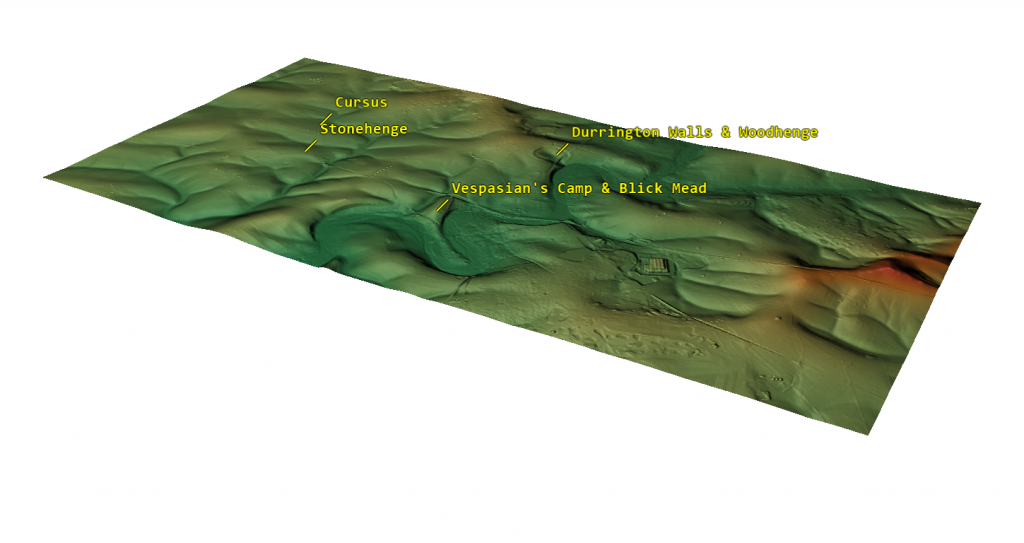
This post discusses whether archaeology is a reliable science. Archaeology, often hailed as the key to understanding our past, stands at a contentious crossroads between the humanities and the sciences. Archaeology is largely interpretative and subjective, unlike pure sciences, which rely heavily on quantitative data and mathematical models to test hypotheses. The field depends on analysing artefacts, structures, and cultural remains, often incomplete or degraded. This reliance on fragmentary evidence means that much archaeological interpretation is speculative, making it difficult to draw definitive conclusions. The subjective nature of archaeology raises questions about its scientific rigour, as interpretations can vary significantly depending on the archaeologist’s perspective, cultural background, or theoretical framework.

2024 Prehistoric Britain Blog Review
(2024 Prehistoric Britain Blog Review)

● Mathematics Meets Archaeology: Discovering the Mesolithic Origins of Car Dyke

This blog explores the use of mathematics to reveal the Mesolithic origins of Car Dyke. In archaeology, theories about ancient structures and sites have traditionally been shaped by subjective interpretations, often constrained by the limited evidence.  The lack of precise data, historical bias, and conflicting narratives have left the field somewhat speculative.  However, recent advancements in mathematical modelling have introduced new ways to derive data-driven conclusions.  We can dig deeper into the ancient past by applying Bayesian and Spatial Analysis, extracting valuable insights with greater certainty.  One particularly compelling case study is the re-evaluation of Car Dyke, a linear earthwork historically associated with Roman engineering.  Through these combined mathematical approaches, we have uncovered evidence that suggests Car Dyke may have been constructed much earlier than previously thought, potentially dating back to the Mesolithic period.

(Mathematics Meets Archaeology: Discovering the Mesolithic Origins of Car Dyke)
(2024 Prehistoric Britain Blog Review)

● Lidar Investigation Car Dyke – North Section

This post presents findings from a LiDAR investigation of the northern section of Car Dyke. Car Dyke is one of the most enigmatic and intriguing remnants of Roman engineering in Britain.  Stretching across the Fens of Eastern England, this ancient waterway has puzzled historians, archaeologists, and enthusiasts for centuries.  Theories about its purpose and origin are as varied as they are compelling, reflecting the complexities of interpreting ancient structures without definitive historical records.  This introduction aims to present a comprehensive overview of Car Dyke, encompassing both past and current theories regarding its use and origin.

2024 Prehistoric Britain Blog Review
(2024 Prehistoric Britain Blog Review)

● Rethinking Ancient Boundaries: The Vallum and Offa’s Dyke

This post reconsiders the traditional understanding of the Vallum and Offa’s Dyke as ancient boundaries. History brims with unsung heroes, those outsiders whose contributions leap from the shadows, not through the traditional channels of academic rigour but via the sheer force of innovative thought. These individuals, often sidelined by mainstream science for lacking formal credentials, have propelled progress with their unorthodox insights. In his eloquent reflections on science and humanity, Jacob Bronowski would have appreciated these figures ‘courage to challenge established disciplines’ dogmas and orthodoxy. Through their unconventional viewpoints, they invite us to step out of the “propaganda box” of discipline norms and reconsider the broader knowledge landscape with fresh eyes

(Rethinking Ancient Boundaries)
(2024 Prehistoric Britain Blog Review)

● Professor Bonkers and the mad, mad World of Archaeology

This post is about a character named Professor Bonkers, and their perspective on the world of archaeology. We have examined the efforts of Professor Ray in his endeavour to prove that transporting bluestones by land to Stonehenge using sledges and dragging is feasible. He believes the journey is relatively flat with gentle gradients, based on his walk on modern roads engineered for gradual steepness over the last thousand years. However, he failed to consider the reality of the steep drops and river valleys the original journey would have encountered.

2024 Prehistoric Britain Blog Review
(2024 Prehistoric Britain Blog Review)

● Lidar Investigation South Cadbury Castle – Camelot

This post presents the findings of a LiDAR investigation of South Cadbury Castle, also known as Camelot. The hillfort is formed by a 7.28 hectares (18.0 acres) plateau surrounded by ramparts on the surrounding slopes of the limestone Cadbury Hill. The site has been excavated in the late 19th and early 20th century by James Bennett and Harold St George Gray. More recent examination of the site was conducted in the 1960s by Leslie Alcock and since 1992 by the South Cadbury Environs Project. These have revealed artifacts from human occupation and use from the Neolithic through the Bronze and Iron Ages. The site was reused by the Roman forces and again from c. 470 until some time after 580. In the 11th century, it temporarily housed a Saxon mint. Evidence of various buildings at the site has been unearthed, including a “Great Hall”, round and rectangular house foundations, metalworking, and a possible sequence of small rectangular temples or shrines.

2024 Prehistoric Britain Blog Review
(2024 Prehistoric Britain Blog Review)

● The Stonehenge Hospital

This post seems to discuss the theory that Stonehenge was used as a hospital. Timothy Darvill, a distinguished figure in Archaeology at Bournemouth University, has put forward a groundbreaking theory. His proposition that Stonehenge was a healing sanctuary, as detailed in his book ‘Stonehenge: The Biography of a Landscape ‘, is supported by compelling evidence from human remains found in burial mounds near the site. These remains, Darvill argues, belonged to individuals who were ailing before their demise, suggesting a unique purpose for the monument.

2024 Prehistoric Britain Blog Review
(2024 Prehistoric Britain Blog Review)

● Prehistoric Burial Practices of Britain

This blog post explores prehistoric burial practices in Britain. Prehistoric Britain saw complex and evolving burial practices, starting with the excarnation of bodies. Dolmens, characterised by their capstones balanced on upright stones, were used as platforms to expose bodies to birds, and wooden palisades encircled the platform, preventing terrestrial animals and rodents from scavenging

(Prehistoric Burial Practices of Britain)
(2024 Prehistoric Britain Blog Review)

● Is Archaeology a dying discipline?

This blog post addresses the question of whether archaeology is becoming obsolete. There are many challenges archaeology faces as a discipline. The historical misconceptions and the evolving understanding of our past are significant aspects of archaeological study

Is Archaeology a dying discipline?
(2024 Prehistoric Britain Blog Review)

● Lidar Investigation Top Ten misidentified Fire Beacons in British History

This post explores the top ten misidentified fire beacons in British history, using LiDAR. Misidentification of objects by archaeologists is an unfortunately frequent occurrence, particularly evident in the study of prehistoric fire beacons. This phenomenon can often be attributed to the curricula of archaeological academic programs, which may not always foster a rigorous scientific attitude. This issue is compounded by the perception that these programs are less demanding than disciplines like physics, chemistry, and biology, which typically require a more robust foundation in logic and mathematics for professional success.

(Top Ten misidentified Fire Beacons in British History)
(2024 Prehistoric Britain Blog Review)

● Lidar Investigation The Great Chichester Hoax – A Bridge too far?

This post examines the Great Chichester Hoax, possibly concerning a misidentified bridge, using LiDAR. It seems I’ve once again stirred up some controversy among the old archaeology club members of Chichester. A few years back, there was quite a buzz in Chichester when they unearthed a Roman Villa complete with a bathhouse. Eager to contribute, I headed to the site with my drone, hoping to capture aerial shots. However, my offer was turned down, perhaps due to the slew of questions I posed to the lead archaeologist. I was particularly intrigued by the water sourcing and drainage for the bathhouse, especially given the presence of the prehistoric dyke that ran through the park. Yet, they seemed to disregard the sizable bank at the edge of the cricket ground.

(The Great Chichester Hoax - A Bridge too far?)
(2024 Prehistoric Britain Blog Review)

● The Logistical Impossibility of Defending Maiden Castle

Maiden Castle, Britain’s largest Iron Age hill fort, has always been a subject of fascination and mystery. Its impressive size and strategic location suggest it was once a significant military stronghold. However, recent advancements in archaeological technology, specifically Light Detection and Ranging (LiDAR), have sparked debates about the actual feasibility of defending such a vast fortification by examining the logistical requirements necessary to sustain a large garrison here, juxtaposed with the lack of physical evidence for such activity, a new narrative emerges, challenging traditional interpretations of Maiden Castle’s historical significance

2024 Prehistoric Britain Blog Review
(2024 Prehistoric Britain Blog Review)

● Beyond Stone and Bone: Rethinking the Megalithic Architects of Northern Europe

Archaeology often presents the megalithic structures of Northern Europe as enigmatic remnants of the past, but traditional interpretations of their purposes—defensive or territorial—are increasingly challenged by new research. These ancient monuments, including Stonehenge and Silbury Hill, required a level of logistical and communal organisation akin to modern engineering feats like the Channel Tunnel, suggesting sophisticated, large-scale cooperation among prehistoric societies. This blog post explores how regular trading and the use of established transportation networks likely supported such monumental projects. It argues that the labour force involved was large and part of a highly structured society, possibly operating under an early compensation system for their colossal efforts. As we delve deeper into these ancient marvels, we uncover a society that may have been as advanced and cooperative as any known civilisation, revealing a new appreciation for the capabilities and ingenuity of our ancestors.

2024 Prehistoric Britain Blog Review
(2024 Prehistoric Britain Blog Review)

● The Giants of Prehistory: Cro-Magnon and the Ancient Monuments

Peering into the mists of prehistory, we discern figures as monumental as the structures they erected. The Cro-Magnons, our Homo Superior ancestors, tower over early European landscapes not only in their formidable physical stature but also through their enduring contributions to ancient engineering and societal development. This essay delves into how their exceptional physical and cognitive abilities enabled them to construct massive stone monuments across Northern Europe, reshaping our understanding of Stone Age capabilities.

2024 Prehistoric Britain Blog Review
(2024 Prehistoric Britain Blog Review)

● The Stonehenge Code: Unveiling its 10,000-Year-Old Secret

Recent carbon dating from the Bluestone quarry sites offers compelling and irrefutable mathematical evidence that Stonehenge’s construction dates back to the Mesolithic era. This new data suggests Stonehenge is 5000 years older than experts had previously believed, challenging established views on its origins and adding new depth to our understanding of this ancient monument.

2024 Prehistoric Britain Blog Review
(2024 Prehistoric Britain Blog Review)

● Mysteries of the Oldest Boatyard Uncovered

I’ve always been fascinated by how archaeological discoveries can unravel threads of history. Still, they can also become entangled in webs of misinterpretation and incorrect dating, leading to significant findings being dismissed or misunderstood. A case in point occurred in a Welsh housing estate where ancient slipways were initially mistaken for longhouses. This confusion sparked a question: why would such elaborate structures be necessary for something as simple as a lightweight dugout canoe?

(The Oldest Boatyard in the World Uncovered)
(2024 Prehistoric Britain Blog Review)

● ATLANTIS: Discovery with Dan Snow Debunked

Dan Snows Documentary debunked with Bob and Alice.

2024 Prehistoric Britain Blog Review
(2024 Prehistoric Britain Blog Review)

● The Troy, Hyperborea and Atlantis Connection

The connections between the legends of Atlantis and Hyperborea, and the works of Homer represent a fascinating intersection of myth, philosophy, and epic narrative within ancient Greek literature. These stories not only provide insights into the geographical and cultural understandings of the Greeks but also reflect deeper philosophical and ethical concerns that permeate Greek thought. Below, we explore these themes in greater detail, delving into how these mythical and literary works intertwine and what they signify about ancient Greek civilisation.

2024 Prehistoric Britain Blog Review
(2024 Prehistoric Britain Blog Review)

● Hollows, Sunken Lanes and Palaeochannels

Standing on the worn, weathered path of a holloway, enveloped by the towering earthen walls on either side, I often contemplate the origins of these enigmatic features. As a wanderer drawn to these ancient pathways, I’ve always been fascinated by the layers of history and mystery that seem to permeate the very soil beneath my feet. Holloways, these sunken roads carved into the landscape, carry with them the aura of countless stories, but their formation captivates my curiosity the most.

(Hollows, Sunken Lanes and Palaeochannels)
(2024 Prehistoric Britain Blog Review)

● Stonehenge: Discovery with Dan Snow Debunked

Dan Snows Documentary debunked with Bob and Alice.

2024 Prehistoric Britain Blog Review
(2024 Prehistoric Britain Blog Review)

● Stonehenge, Doggerland and Atlantis connection

The third book in my trilogy aims to weave together the discoveries made across Britain, with a particular focus on Stonehenge, to shed light on a civilisation that archaeologists have termed the ‘megalithic builders.’ This civilisation is markedly distinct from those that came after, showcasing an extraordinary level of capability and engineering skill in moving vast stones and constructing earthworks that have endured for nearly ten thousand years. These achievements are even more striking when compared to the structures left by the Romans, who occupied these lands for hundreds of years yet left behind fewer enduring monuments.

2024 Prehistoric Britain Blog Review
(2024 Prehistoric Britain Blog Review)

● The Bluestone Enigma

The papers published by researchers from the University of London, Southampton, and Manchester, including Mike Parker-Pearson and his team, regarding the discovery of the quarries at Craig Rhos-y-Felinand the bluestone megaliths at Carn Goedog have been a significant contribution to our understanding of Stonehenge’s origins. This research brought to light the fascinating theory that Stonehenge was initially constructed in Wales and then transported to Salisbury Plain around 500 years later.

Giants of Prehistory: Cro-Magnon
(2024 Prehistoric Britain Blog Review)

● Digging Up Britain’s Past – Debunked

Dig Up Britain Stonehenge Documentary debunked with Bob and Alice.

2024 Prehistoric Britain Blog Review
(2024 Prehistoric Britain Blog Review)

● FREE Stonehenge LiDAR Maps

Here is the perfect resaerch resource for any bidding arcaheologist – 3D LiDAR Maps – there are free and can be downloaded by clicking the Right Site of the Mouse and saving it to your hard Drive for closer inspection, with you PC/Mobile reader software. (FREE Stonehenge LiDAR Maps)

2024 Prehistoric Britain Blog Review
(2024 Prehistoric Britain Blog Review)

● Prehistoric Canals – Wansdyke

If you study archaeology at university or even on an ordinance survey map at length, you will notice strange earthworks on the sides of hills of Britain, with no rational explanation as to why they are there and for what reason.  These features are mostly ignored at university, or an excuse is made for their construction.  The reality is that these features do not make any sense unless there are other factors in operation which have been ignored.

The first thing to notice is that the word ‘Dyke’ is associated with water.  It does seem strange you would call an earthwork on top of a hill a Dyke, unless there was some history passed down through the years to its actual use.  If we look at the most famous Dyke in Britain, ‘Offa’, we notice that it is attributed to a Saxon King and, therefore, could not be prehistoric.   Or is this a clear indication of how archaeologists find excuses for these features rather than factual, empirical evidence?

2024 Prehistoric Britain Blog Review
(2024 Prehistoric Britain Blog Review)

● The Great Stone Transportation Hoax

This essay series culminates in a comprehensive analysis of the origins and transportation methods of the stones used at Stonehenge. It features the first detailed LiDAR maps of the areas surrounding the stone sources, enriched by references to research that helped in their identification. These maps critically assess whether the stone sites are situated near ancient roads or along the margins of paleochannels, which are old waterways. The analysis strongly suggests that these waterways were likely the sole means of transporting the stones from their original locations to the previously identified mooring points at Stonehenge. Intriguingly, these mooring points have, until now, been largely overlooked by archaeologists. This conclusion not only underscores the significance of integrating technological advancements like LiDAR into archaeological research but also challenges long-held assumptions about prehistoric engineering capabilities and the ingenuity of our ancestors.

2024 Prehistoric Britain Blog Review
(2024 Prehistoric Britain Blog Review)

● Stonehenge Stone Transportation

Exploring the origins and transportation of the stones used to construct Stonehenge continues to be a fascinating subject, ripe with theories and controversies. The viral interest generated by my blog post this week, which highlighted a map showing three known sites of the stones’ origins, barely scratches the surface of this complex logistical puzzle. Indeed, there are stones from even greater distances, opening a myriad of questions about how these megaliths were transported to their final resting place at Stonehenge. This essay aims to delve deeper into these logistics, providing a comprehensive overview based on the latest research and theories.

2024 Prehistoric Britain Blog Review
(2024 Prehistoric Britain Blog Review)

●Archaeology in the Post-Truth Era

In the past ten years, I have faced significant challenges in establishing the validity of my claim that Linear Earthworks are prehistoric canals. Many people have dismissed my theory, but I have not let that stop me. I undertook a comprehensive survey of 1500 Historic England’s Scheduled Linear Earthworks, and the findings culminated in the first book of a quadrilogy series detailing the East Wansdyke area. This publication is a significant personal milestone and an unprecedented achievement in the field of archaeology that no university or research team has matched.

2024 Prehistoric Britain Blog Review
(2024 Prehistoric Britain Blog Review)

● The Fury of the Past: Natural Disasters in Historical and Prehistoric Britain

Over the recent span of years, there has been a marked tendency to present images of climatic upheaval—storms that rend the fabric of local communities and touch the lives of individuals with their tempestuous hands. In the discourse on flooding, an almost theatrical emphasis is placed upon the metrics of catastrophe: the voluminous descent of rain and the gales’ ferocious velocity. Amidst these narratives, a phrase of gravitas, ‘since records began,’ is often delicately woven, lending weight to the tales of unprecedented climatic fury that segment our years into records of seasonal extremities.

2024 Prehistoric Britain Blog Review
(2024 Prehistoric Britain Blog Review)

● Mesolithic River Avon

At the outset, the clay-with-flints, a vestige of ancient weathering and erosion, stands as a testament to the relentless forces of nature that sculpted the landscape. Born from the remnants of Palaeogene sediments and the dissolution of chalk, these deposits serve as silent witnesses to the Pleistocene’s cold embrace. Their presence on the hilltop flats signifies a chronological anchor, predating the rhythmic succession of river terraces that stitch the valley’s quilt.

.

2024 Prehistoric Britain Blog Review
(2024 Prehistoric Britain Blog Review)

● The Rivers of the Past were Higher – an idiot’s guide

Fifteen years have elapsed since I introduced what some might label a ‘revolutionary’ concept, a brainchild born from my earlier explorations in archaeology. My investigations, particularly the graphical representation of 50 sites encompassing Stonehenge and its surrounding barrows, revealed a striking pattern: all these locations consistently occupied the upper 30 percentile, perched halfway up a hill or higher for the uninitiated.

2024 Prehistoric Britain Blog Review
(2024 Prehistoric Britain Blog Review)

● How Lidar will change Archaeology

In the profound tapestry of human history, the emergence of Lidar archaeology technology stands as a beacon, illuminating hidden chapters and rewriting the narrative of our past. As we traverse the landscapes of antiquity, a remarkable revelation comes to light through the lens of Lidar – the Linear Earthworks that crisscross our ancient terrains. Driven by laser precision, this technological marvel exposes a new dimension in historical understanding that challenges conventional wisdom and prompts us to reconsider the nature of these enigmatic earthworks.

2024 Prehistoric Britain Blog Review
(2024 Prehistoric Britain Blog Review)

● Caerfai promontory fort – archaeological nonsense

In the latest installment of Digging for Britain’s Season 11, the spotlight turns to the intriguing Caerfai Promontory Fort, also known as Penpleidiau, perched on the edge of Wales. Nestled approximately 1.3km southeast of St David’s, this archaeological site, with its formidable features, compels a reevaluation of traditional interpretations and invites us to question the prevailing coastal ‘Hill Fort’ narrative.

2024 Prehistoric Britain Blog Review
(2024 Prehistoric Britain Blog Review)

● Digging for Britain Debunked – Cerne Abbas 2

In the first part of our exploration, we delved into the televised program ‘Digging for Britain’ and scrutinised the methodology employed by the purported experts, questioning the reliability of their conclusions regarding the dating of Cerne Abbas. Our investigation highlighted flaws in the sampling process, particularly the oversight of soil creep, which significantly impacts the interpretation of the site’s history.

2024 Prehistoric Britain Blog Review
(2024 Prehistoric Britain Blog Review)

● Avebury Post-Glacial Flooding

Recently, I received a message from my friend Chris at Lambourne Photography who shared new winter photos of Avebury. The landscape, experiencing recorded rainfall, has begun to flood, capturing my keen interest. This flooding aligns with the predictions in my prehistoric Avebury maps, considering the post-glacial flooding during the Mesolithic period (10k to 4k BCE).

2024 Prehistoric Britain Blog Review
(2024 Prehistoric Britain Blog Review)

● Digging for Britain – Cerne Abbas 1 of 2

In a recent instalment of ‘Digging for Britain,’ Alice Roberts stirred the archaeological pot by asserting that the Dorset Chalk Giant (Cerne Abbas) had Saxon origins rather than the presumed prehistoric roots. The revelation added a layer of intrigue, especially for someone like me, deeply entrenched in Landscape Archaeology. At first glance, the giant’s features seemed to echo a Neolithic connection, reminiscent of the Uffingham White horse. Both figures boasted natural harbours in the hillside, suggesting potential prehistoric maritime use.

2024 Prehistoric Britain Blog Review
(2024 Prehistoric Britain Blog Review)

● Britain’s First Road – Stonehenge Avenue

As the waters began to recede, the architects of Stonehenge found themselves confronted with a formidable engineering challenge: how to contend with the diminishing groundwater table while ensuring the Stonehenge moat remained adequately filled. In the preceding discussion, we established the application of a clay waterproofing layer to transform the Stonehenge moat into a reservoir akin to a dew pond. In this chapter, I delve into the intricacies of their solution—a newly constructed earthwork known as ‘The Avenue,’ complete with its own moat designed to bring the waters closer to the monumental bathing moat.

2024 Prehistoric Britain Blog Review
(2024 Prehistoric Britain Blog Review)

Further Reading

For information about British Prehistory, visit www.prehistoric-britain.co.uk for the most extensive archaeology blogs and investigations collection, including modern LiDAR reports.  This site also includes extracts and articles from the Robert John Langdon Trilogy about Britain in the Prehistoric period, including titles such as The Stonehenge Enigma, Dawn of the Lost Civilisation and the ultimate proof of Post Glacial Flooding and the landscape we see today. (2024 Prehistoric Britain Blog Review)

Robert John Langdon has also created a YouTube web channel with over 100 investigations and video documentaries to support his classic trilogy (Prehistoric Britain). He has also released a collection of strange coincidences that he calls ‘13 Things that Don’t Make Sense in History’ and his recent discovery of a lost Stone Avenue at Avebury in Wiltshire called ‘Silbury Avenue – the Lost Stone Avenue’.(2024 Prehistoric Britain Blog Review)

Langdon has also produced a series of ‘shorts’, which are extracts from his main body of books:

The Ancient Mariners

Stonehenge Built 8300 BCE

Old Sarum

Prehistoric Rivers

Dykes ditches and Earthworks

Echoes of Atlantis

Homo Superior

For active discussions on the findings of the TRILOGY and recent LiDAR investigations that are published on our WEBSITE, you can join our and leave a message or join the debate on our Facebook Group.

For in-depth information about British Prehistory, we invite you to explore www.prehistoric-britain.co.uk, an extensive resource featuring archaeology blogs and investigations. This collection includes modern LiDAR reports that shed light on ancient landscapes. Additionally, you will find extracts and articles from the Robert John Langdon Trilogy, offering fascinating insights into Britain during the Prehistoric period. Some notable titles from the trilogy include “The Stonehenge Enigma,” “Dawn of the Lost Civilisation,” and groundbreaking evidence of Post Glacial Flooding and its impact on the landscape we see today.(Free Stonehenge LiDAR Maps)
Robert John Langdon has further enriched the exploration of Prehistoric Britain through his YouTube web channel, boasting over 100 investigations and video documentaries that complement his classic trilogy. In addition to his extensive work, Langdon has unveiled a compilation of intriguing coincidences titled “13 Things that Don’t Make Sense in History.” He has also brought to light his recent discovery of a forgotten Stone Avenue in Avebury, Wiltshire, aptly named ‘Silbury Avenue – the Lost Stone Avenue.’ (2024 Prehistoric Britain Blog Review)

For those who wish to actively engage in discussions about the findings from the TRILOGY and recent LiDAR investigations, we invite you to join our community. You can participate by leaving messages and joining our dedicated Facebook Group debates. We encourage open dialogue and exchanging ideas to foster a deeper understanding of Prehistoric Britain and its fascinating mysteries.(2024 Prehistoric Britain Blog Review)

As you embark on your journey through British Prehistory, we hope these resources provide valuable insights and inspire further exploration of this captivating field of study.

For more information about British Prehistory and other articles/books, go to our BLOG WEBSITE for daily updates or our VIDEO CHANNEL for interactive media and documentaries. The TRILOGY of books that ‘changed history’ can be found with chapter extracts at DAWN OF THE LOST CIVILISATION, THE STONEHENGE ENIGMA and THE POST-GLACIAL FLOODING HYPOTHESIS.(2024 Prehistoric Britain Blog Review)

Other associated books are also available such as 13 THINGS THAT DON’T MAKE SENSE IN HISTORY and other ‘short’ budget priced books can be found on our AUTHOR SITE. For active discussion on the findings of the TRILOGY and recent LiDAR investigations that is published on our WEBSITE you can join our FACEBOOK GROUP.

(2024 Prehistoric Britain Blog Review)

Other Blogs

s

t

(2024 Prehistoric Britain Blog Review)

Unmasking the “Iron Age Hillfort” Myth

Introduction

I’m challenging the long-held belief that many sites across Britain, traditionally labeled as “Iron Age Hillforts,” were built primarily for defence. Instead, I argue these sites, rather than being fortresses meant for warfare, were vibrant centres of trade and commerce, with unique features that connect them to waterborne transport and economic activity. By meticulously examining archaeological findings and employing the latest LiDAR technology, I aim to deconstruct the conventional narrative surrounding these sites, focusing on three prominent examples: Danebury, Maiden Castle, and Old Sarum.

At the heart of this reassessment is a fundamental question: were these sites indeed conceived as fortifications, or have modern interpretations mistakenly imposed a militaristic lens onto structures with potentially diverse purposes? While these sites might have been repurposed for defence in later periods, I propose that their original function was far removed from warfare. This theory gains strength by thoroughly examining the three case studies, each offering compelling evidence to support this new perspective.

Unmasking the "Iron Age Hillfort" Myth
Stone Tools found from the Neolithic Period – Unmasking the “Iron Age Hillfort” Myth

Starting with Danebury, located in Hampshire, England, it exemplifies the limits of current archaeological classifications. Often cited as a quintessential Iron Age Hillfort, Danebury’s true origins, as I see it, lie further back in history. Carbon dating of artefacts within the site suggests a history stretching into the Bronze Age, possibly even as far back as the Neolithic, undermining the “Iron Age” label.

I point to the design of Danebury’s ditches as a clue to its original purpose. The fact that more earthwork material is deposited on the outer side of the ditch, unlike a typical defensive design, raises doubts about its purely defensive role. Further, LiDAR analysis reveals a linear earthwork or dyke that connects to the outer ditch, hinting at a possible connection to an ancient river system. I believe this suggests that Danebury may have served as a vital access point to a navigable waterway, facilitating trade and movement along the river.

Unmasking the "Iron Age Hillfort" Myth
A Dyke connects to the Ditches of the site Unmasking the “Iron Age Hillfort” Myth

Then there’s Maiden Castle, Britain’s largest hillfort in Dorset. Its sheer size and strategic location seemingly support the traditional idea of a fortress, yet I highlight the logistical hurdles inherent in defending such a vast space. Maintaining a defensive stance at Maiden Castle would have required an immense workforce and a supporting infrastructure of water sources, food supplies, and facilities for weapon and armour production. However, despite extensive archaeological surveys and detailed LiDAR scans, evidence of such infrastructure is notably absent. This lack of essential defensive elements doubts the idea of Maiden Castle as a military stronghold.

In addition, the flat-bottomed ditches at Maiden Castle resemble those found at other prehistoric sites, like Avebury, Stonehenge, and Old Sarum. These unique ditches weaken the argument for a purely defensive function, hinting instead at a shared purpose across these sites.

Unmasking the "Iron Age Hillfort" Myth
Old Sarum – Unmasking the “Iron Age Hillfort” Myth

Old Sarum, a site in Wiltshire with a rich and layered history, further supports my argument against the simplistic “Iron Age Hillfort” label. Located in a floodplain on an island rather than a hill, as one would expect for a “hillfort,” Old Sarum’s placement raises immediate questions. LiDAR analysis shows that the spoil from its ditch was placed on the outside rather than inside—again, contradicting defensive design conventions. Examining the site’s water table and discovering a deep well suggest that the ditches may have once acted as moats. These moats, filled by a higher water table in the past, could have served as part of a waterborne trade system, allowing boats to navigate to the site.

Another aspect that supports my theory is the logistical impracticality of maintaining multiple “hillforts” close to each other. Given the likely limited population in prehistoric Britain, building and sustaining numerous large-scale defensive structures in a relatively small area would have strained resources and human resources. This suggests these sites may have served purposes that fostered cooperation and economic exchange rather than conflict.

Unmasking the "Iron Age Hillfort" Myth
Shows that the Ditch contents were placed on the outside, NOT inside – Unmasking the “Iron Age Hillfort” Myth

Finally, a compelling “smoking gun” for this theory is the complete absence of human remains within the ditches of these so-called “Iron Age Hillforts.” If battles had occurred at these sites, we would expect to find evidence of casualties within the defensive perimeter. The lack of such evidence is significant, prompting a reconsideration of their true nature.

Drawing on archaeological evidence and insights from LiDAR technology, I present a strong case for a paradigm shift in our understanding of these enigmatic sites. The traditional interpretation of “Iron Age Hillforts” as primarily defensive structures doesn’t hold up under scrutiny, paving the way for a new perspective. Instead, I believe these sites were bustling centres of trade and commerce, intricately connected by waterways and essential hubs for economic activity in prehistoric Britain.

Other Information

Debunking the Iron Age Hill Fort: A Review of Robert John Langdon’s Claims

This briefing document reviews the main themes and arguments presented by independent researcher Robert John Langdon on his website Prehistoric Britain. Langdon challenges the traditional interpretation of numerous archaeological sites in Britain, specifically those categorized as “Iron Age Hill Forts.” He posits that these sites, based on his analysis of LiDAR data and reinterpretations of existing archaeological evidence, pre-date the Iron Age, served purposes other than defense, and are often misclassified. (Unmasking the “Iron Age Hillfort” Myth)

Main Themes:

  • Misclassified as “Iron Age”: Langdon argues that many sites labeled as Iron Age hill forts contain evidence (primarily flint artifacts) pointing to significantly earlier occupation, potentially dating back to the Neolithic or even Mesolithic periods. He uses Danebury and Maiden Castle as primary examples. He states, “a significant proportion of these hillforts, often exceeding a staggering 95%, have unveiled themselves to be significantly more ancient than the Iron Age.”
  • Not Primarily Defensive Structures: Langdon challenges the defensive interpretation of these sites, citing the lack of skeletal remains indicative of warfare found within their ditches. He argues that the shape and size of ditches at some sites, such as Maiden Castle and Old Sarum, are more consistent with moats, suggesting alternative functions like water management, trade, or symbolic boundaries. He emphatically states, “Not a solitary remains of a life extinguished in conflict has ever been unearthed within the confines of the ditches encircling any of the two thousand so-called ‘Iron Age Forts’ that punctuate history.”
  • LiDAR Reveals a Different Story: Langdon heavily relies on LiDAR technology to support his claims. He argues that LiDAR reveals features missed by traditional archaeological methods, such as the true extent of linear earthworks at Danebury and the absence of wells at Maiden Castle, which would have been essential for sustaining a large defending population. He also uses LiDAR to dispute the existence of Roman roads at Old Sarum, challenging established narratives.
  • Logistical Impossibility of Defense: Using Maiden Castle as an example, Langdon argues that defending such a large site would have required an enormous and unsustainable logistical effort in terms of manpower, food, water, and weaponry. He contrasts this with the lack of archaeological evidence for such infrastructure, concluding that the traditional narrative of a heavily defended fortress is untenable.

Important Ideas/Facts:

  • Danebury: While traditionally classified as an Iron Age site, Langdon highlights radiocarbon dating results placing its origins in the Bronze Age. He emphasizes the discovery of Neolithic and early Bronze Age flints and questions the defensive nature of the site’s ditches based on their construction.
  • Maiden Castle: Langdon disputes its Iron Age designation based on the presence of Neolithic artifacts. He argues that the scale of the site would have necessitated a massive logistical network to sustain a large population, which is unsupported by archaeological findings. He also questions the defensive purpose of the ditches based on their shape and the lack of evidence for essential infrastructure like wells.
  • Old Sarum: Langdon challenges its categorization as a hill fort due to its location in a floodplain. He uses LiDAR data to refute the existence of Roman roads through the site and suggests that the ditches might have been moats, potentially used for water management or trade.

(Unmasking the “Iron Age Hillfort” Myth)

Critical Analysis:

While Langdon raises thought-provoking points and emphasizes the potential of LiDAR technology, several aspects of his argument require careful consideration:

  • Overreliance on Absence of Evidence: The lack of skeletal remains within ditches doesn’t definitively rule out the possibility of conflict. Warfare might have occurred elsewhere, bodies could have been removed, or preservation conditions might be unfavorable.
  • Selective Interpretation: While emphasizing inconsistencies in traditional narratives, Langdon’s interpretations of LiDAR data and archaeological evidence may also be subjective. Alternative explanations for the observed features might exist.
  • Lack of Peer Review: As an independent researcher, Langdon’s work hasn’t undergone the rigorous scrutiny of academic peer review, which is essential for validating his claims and interpretations.

Conclusion:

Langdon’s work serves as a reminder that archaeological interpretations are constantly evolving with new discoveries and technologies. His challenges to established narratives, while requiring further scrutiny, highlight the importance of reassessing assumptions and integrating new data into our understanding of the past.

(Unmasking the “Iron Age Hillfort” Myth)

Briefing Doc: Rethinking Prehistoric Britain

Source: Excerpts from “Old Sarum Lidar Map – Prehistoric Britain” and “The Great Iron Age Hill Fort Hoax – Prehistoric Britain” on prehistoric-britain.co.uk

Author: Robert John Langdon

Main Themes:

  • Challenging Conventional Archaeological Narratives: Langdon questions long-held assumptions about prominent prehistoric sites in Britain, particularly the classification and function of “Iron Age Hill Forts.” He utilizes LiDAR technology to re-examine these sites, proposing alternative interpretations based on new evidence.
  • The Post-Glacial Flooding Hypothesis: This hypothesis, central to Langdon’s work, suggests that rising sea levels after the last Ice Age significantly impacted the British landscape and the lives of its inhabitants. He posits that many sites currently categorized as defensive structures may have served different purposes, potentially related to a maritime civilization.
  • The Importance of LiDAR in Archaeological Research: Langdon emphasizes the transformative power of LiDAR technology in revealing hidden landscape features and challenging traditional interpretations. He argues that LiDAR data compels a reevaluation of many archaeological assumptions.

Key Ideas/Facts:

  • Reinterpreting “Iron Age Hill Forts”:Location: Langdon challenges the assumption that these sites were exclusively hilltop fortifications. He cites Old Sarum, located in a floodplain, as an example.
  • Ditch Construction: The construction of ditches at sites like Danebury and Maiden Castle, with more material deposited on the outer side and flat-bottomed profiles, raises questions about their defensive purpose. This construction style resembles Norman castle moats, which were filled with water.
  • Lack of Battle Evidence: The absence of any human remains found within the ditches of these “hill forts” casts doubt on their role in warfare.
  • Alternative Function: Langdon suggests that these sites may have served as centers for trade and transportation, possibly linked by a network of canals and navigable waterways.
  • The Impact of Post-Glacial Flooding:Elevated Water Tables: Higher water tables in prehistoric times would have made the ditches at these sites readily floodable, creating moats.
  • Maritime Civilization: Langdon proposes the existence of a sophisticated maritime civilization in prehistoric Britain, capable of constructing and utilizing these sites for navigation and trade.
  • LiDAR as an Archaeological Tool:Revealing Hidden Features: LiDAR helps uncover previously unknown landscape features, such as the “Dyke” at Danebury, providing new insights into the connections between sites and their potential functions.
  • Challenging Assumptions: LiDAR data forces archaeologists to reconsider traditional interpretations and develop new hypotheses based on a more comprehensive understanding of the landscape.

Supporting Quotes:

  • “In archaeology, I believe honesty is paramount. Categorising sites under broad labels like “Iron Age Forts” oversimplifies their complexities.”
  • “This new understanding of the water table also opens up the possibility that the outer ditch was also moated up to the Norman conquest and moreover, during the Roman period – this is something that needs urgent explanation and further study.”
  • “Might we be gazing upon prehistoric moats, which, in the bygone era of elevated water tables, would have readily filled to assume the characteristics of a moat?”
  • “Not a solitary remains of a life extinguished in conflict has ever been unearthed within the confines of the ditches encircling any of the two thousand so-called ‘Iron Age Forts’ that punctuate history.”

Significance:

Langdon’s work presents a provocative challenge to traditional archaeological interpretations of prehistoric Britain. By utilizing new technologies like LiDAR and questioning long-held assumptions, he opens up new avenues of research and encourages a more nuanced understanding of the past. His work has implications for how we view the capabilities and complexities of prehistoric societies and the forces that shaped the British landscape.

(Unmasking the “Iron Age Hillfort” Myth)

Further Reading

For information about British Prehistory, visit www.prehistoric-britain.co.uk for the most extensive archaeology blogs and investigations collection, including modern LiDAR reports.  This site also includes extracts and articles from the Robert John Langdon Trilogy about Britain in the Prehistoric period, including titles such as The Stonehenge Enigma, Dawn of the Lost Civilisation and the ultimate proof of Post Glacial Flooding and the landscape we see today.

Robert John Langdon has also created a YouTube web channel with over 100 investigations and video documentaries to support his classic trilogy (Prehistoric Britain). He has also released a collection of strange coincidences that he calls ‘13 Things that Don’t Make Sense in History’ and his recent discovery of a lost Stone Avenue at Avebury in Wiltshire called ‘Silbury Avenue – the Lost Stone Avenue’.

(Unmasking the “Iron Age Hillfort” Myth)

Langdon has also produced a series of ‘shorts’, which are extracts from his main body of books:

The Ancient Mariners

Stonehenge Built 8300 BCE

Old Sarum

Prehistoric Rivers

Dykes ditches and Earthworks

Echoes of Atlantis

Homo Superior

(Unmasking the “Iron Age Hillfort” Myth)

For active discussions on the findings of the TRILOGY and recent LiDAR investigations that are published on our WEBSITE, you can join our and leave a message or join the debate on our Facebook Group.

Unlocking the Mysteries of British Prehistory

Delve into the depths of time, as we embark on a captivating voyage into the enigmatic world of British prehistory. www.prehistoric-britain.co.uk is your portal to a treasure trove of archaeological wonders, modern LiDAR reports, and fascinating insights from the Robert John Langdon Trilogy. This immersive digital hub is your key to unlocking the secrets of Britain’s ancient past.

(Unmasking the “Iron Age Hillfort” Myth)

A Glimpse into the Robert John Langdon Trilogy

Step into the shoes of Robert John Langdon, a dedicated explorer of Britain’s prehistoric mysteries. His trilogy, comprising “The Stonehenge Enigma,” “Dawn of the Lost Civilization,” and “The Post-Glacial Flooding Hypothesis,” is a literary marvel that unravels the untold tales of our ancestors. These books take you on an exhilarating journey through time, meticulously researched and backed by over 125 references from esteemed scientists, archaeological experts, and geological researchers.

(Unmasking the “Iron Age Hillfort” Myth)

Dive into the World of LiDAR

At www.prehistoric-britain.co.uk, we harness the power of LiDAR technology to unearth hidden landscapes and archaeological marvels. Our LiDAR reports offer a modern lens through which you can peer into ancient history. Explore the effects of flooding on the British environment after the great ice age melt, a phenomenon that has shaped the landscape we see today. Join us in decoding the mysteries of our past using cutting-edge technology.

(Unmasking the “Iron Age Hillfort” Myth)

A Multimedia Experience

Our commitment to storytelling extends beyond the written word. Robert John Langdon has curated a rich multimedia experience, including a YouTube web channel featuring over 100 investigations and video documentaries. These visual journeys complement his classic trilogy, providing a multi-dimensional understanding of prehistoric Britain. From Stonehenge’s construction in 8300 BCE to the lost Stone Avenue at Avebury in Wiltshire known as ‘Silbury Avenue,’ these documentaries offer an immersive experience that brings history to life.

(Unmasking the “Iron Age Hillfort” Myth)

Explore the ’13 Things that Don’t Make Sense in Ancient History’

History is replete with anomalies and enigmas that defy explanation. Robert John Langdon has curated a collection of such historical curiosities in ’13 Things that Don’t Make Sense in History.’ These peculiar occurrences and unanswered questions will leave you pondering the mysteries of the past, inviting you to join the debate on their possible interpretations.

(Unmasking the “Iron Age Hillfort” Myth)

More Blogs

s

t

(Unmasking the “Iron Age Hillfort” Myth)

Pillow Mounds: A Bronze Age Legacy of Cremation?

Introduction

Pillow mounds have traditionally been interpreted as medieval rabbit warrens, but recent archaeological discoveries suggest a far older and more significant role tied to Bronze Age cremation rituals. Evidence uncovered in recent excavations, combined with historical parallels from other sites, points to these mounds being used for cremation or as places for the burial of ashes, later repurposed during the medieval period for rabbit farming. Below, we explore the evidence from recent excavation reports that supports this hypothesis, showing how discolored soil, charcoal remains, and burial practices align with Bronze Age funerary rituals.

Excavation Reports Supporting the Cremation Hypothesis

1. Linga Fiold, Orkney (Bronze Age Cremation Evidence)

Excavations at Linga Fiold on Orkney provide a compelling comparison to the pillow mounds found at Dartmoor. At Linga Fiold, archaeologists uncovered cremation pyres beneath mounds, with clear evidence of burnt earth and charcoal, alongside cremated human remains. These pyres were constructed directly on the ground with minimal superstructures, similar to the earthworks observed in Dartmoor’s pillow mounds.

The soil beneath the mounds at Linga Fiold showed clear signs of discoloration, indicating that it had been exposed to high temperatures from intense fires. Charcoal deposits and ash layers found in the soil provide direct evidence of burning. These features closely resemble those found in some pillow mounds on Dartmoor, where discolored soils and charcoal layers have been interpreted as remnants of funeral pyres.

In the Linga Fiold excavation, the mound structure and the associated cremated remains suggest a ritualistic function tied to Bronze Age funerary practices, supporting the idea that these mounds were not just for rabbit warrens, but rather cremation sites. The discolored soil and layers of burnt material found at Dartmoor reflect this same ritual use of fire, hinting at a broader cultural practice.

2. Trowlesworthy Warren, Dartmoor (Burnt Layers and Soil Discoloration)

The Mystery of Pillow Mounds
Trowlesworthy Warren is a massive Prehistoric Site with no barrows – Pillow Mounds: A Bronze Age Legacy of Cremation?

The Trowlesworthy Warren site on Dartmoor is home to over 64 pillow mounds. Excavations of these mounds have revealed significant evidence of soil discoloration, similar to what has been found at recognized Bronze Age burial sites. The soil under some of these mounds has distinct layers of charcoal and burnt earth, suggestive of cremation pyres.

During the excavation of one mound, archaeologists discovered a layer of charcoal that radiocarbon dating placed in the Bronze Age, well before the introduction of rabbits to Britain. The charcoal remains were associated with human activity, indicating that fires had been deliberately set. The burnt soil beneath the mound is consistent with the intense heat required for cremation. The placement of these mounds near paleochannels further supports the theory of ritualistic use, as water often played a key role in Bronze Age funerary rites.

3. Bryn Cysegrfan, Wales (Evidence of Cremation Under Mounds)

At Bryn Cysegrfan in Wales, excavations revealed mounds that were initially thought to be medieval earthworks but were later confirmed to be prehistoric. These mounds contained burnt soil, layers of charcoal, and evidence of human cremation. The discovery of cremated human bones beneath the mounds helped redefine their purpose as Bronze Age funerary structures, challenging their original classification as medieval agricultural features.

Pillow Mounds: A Bronze Age Legacy of Cremation?

The burnt material in these mounds mirrored the findings at Dartmoor, where charcoal and burnt soil were found in layers under the mounds. At Bryn Cysegrfan, the cremated remains were intentionally buried beneath a memorial mound, built in much the same way as pillow mounds. This reinforces the idea that the Dartmoor pillow mounds could have similarly been constructed as memorials to cremated individuals.

Pillow Mounds: A Bronze Age Legacy of Cremation?

4. Bronze Age Orkney (Burnt Soils and Ritual Use of Fire)

Further support for the cremation hypothesis comes from Bronze Age sites in Orkney, where archaeologists have found extensive use of fire in burial practices. Excavations at Mousa Broch revealed cremation sites beneath mounds, where the soil had been heavily discolored by intense heat. Layers of charcoal and burnt earth are common across these sites, suggesting a widespread ritual use of fire in burial practices.

The charcoal layers and burnt soil found at Trowlesworthy Warren bear a striking resemblance to the cremation pyres of Orkney. The burning of bodies and subsequent burial of ashes within or beneath the mounds are consistent with the Bronze Age tradition of constructing mounds as funerary memorials.

5. Radiocarbon Dating Evidence of Bronze Age Activity

At several of these sites, including Trowlesworthy and Bryn Cysegrfan, radiocarbon dating has provided clear evidence that the burnt material and soil discoloration found beneath the mounds dates back to the Bronze Age. This further suggests that these structures were originally built as funerary mounds or cremation sites, long before they were repurposed as rabbit warrens in the medieval period.

The layers of burnt material and charcoal deposits found beneath some of the Dartmoor mounds have been dated to 2000-1500 BCE, well within the Bronze Age. These findings, alongside the discolored soils, indicate that the mounds were used for funerary practices long before their presumed medieval use.

Comparing to the Pillow Mounds

The Mystery of Pillow Mounds
Multiple Pillow Mounds are located next to Prehistoric Site (Bronze Age) and 30 – 40 miles away from any medieval town

The evidence from Bryn Cysegrfan, Orkney, and other Bronze Age cremation sites shows a clear pattern of burnt soil, charcoal remains, and cremated bones beneath mounds that were later misinterpreted as agricultural features. This is exactly the scenario unfolding with pillow mounds at sites like Trowlesworthy Warren. The combination of burnt layers, discolored soil, and radiocarbon dating suggests that these mounds served as cremation sites or memorial mounds long before their possible repurposing in the medieval period.

The Cultural Significance of Cremation Mounds

In the Bronze Age, cremation was a common funerary practice across Britain. The dead were often burned on funeral pyres, and the ashes were either scattered or buried under mounds. These mounds served as memorials, marking the resting place of the deceased in a highly visible way. The use of fire in these rituals was symbolic, representing the passage of the soul into the afterlife.

The presence of pillow mounds in landscapes associated with prehistoric activity, particularly near paleochannels and other natural features, suggests that they were part of a larger ritual landscape. The burnt material and discolored soil found beneath many of these mounds are consistent with the Bronze Age practice of constructing cremation mounds, rather than the later rabbit farming explanation.

Conclusion: Reinterpreting Pillow Mounds as Bronze Age Cremation Sites

The growing body of archaeological evidence, including excavation reports from sites like Bryn Cysegrfan, Linga Fiold, and Trowlesworthy Warren, increasingly supports the hypothesis that pillow mounds are not merely medieval rabbit warrens but may have originally been used for Bronze Age cremation practices. The presence of burnt soil, charcoal remains, and cremated bones beneath these mounds, combined with radiocarbon dating to the Bronze Age, suggests that these structures served as cremation pyres or burial mounds long before their potential repurposing in later periods.

This reinterpretation not only challenges the traditional understanding of pillow mounds but also opens up new perspectives on the ritual use of fire and burial practices in Bronze Age Britain. Further excavation and study of these mounds could provide even more evidence to support their role as funerary monuments, adding to the rich tapestry of prehistoric ritual landscapes across the British Isles.Pillow mounds have long been identified by archaeologists as rabbit warrens—structures built during the medieval and post-medieval periods to manage rabbit populations for fur and meat. These long, low earthworks, often equipped with drainage ditches, were thought to provide ideal conditions for rabbits to burrow and breed. The case of Trowlesworthy Warren on Dartmoor is a well-known example, where there are now believed to be 64 pillow mounds spread across a 5 km area. However, recent archaeological findings and a closer look at the logistics of large-scale rabbit farming in this landscape challenge the established interpretation.

This blog will explore the traditional reasons archaeologists classify pillow mounds as rabbit warrens while presenting new evidence—including the scale of the site, environmental challenges, and the discovery of radiocarbon-dated materials—that casts doubt on this interpretation.

Previous Blog

1. Traditional Interpretation: Rabbit Warrens

The identification of pillow mounds as rabbit warrens originates from medieval records describing the practice of rabbit farming, introduced to Britain by the Normans after the 11th century. Rabbits were a valuable resource for both their meat and fur, and the creation of controlled environments for breeding—called warrens—became widespread. Pillow mounds, typically rectangular and accompanied by drainage ditches, resemble natural rabbit burrows and were strategically placed in areas unsuitable for crop farming, such as Dartmoor.

At Trowlesworthy Warren, the extensive number of mounds spread across a large area appeared to reflect the large-scale management of rabbit populations, supporting this traditional view.

2. Characteristics of Pillow Mounds

Pillow Mounds: A Bronze Age Legacy of Cremation?

The pillow mounds at Trowlesworthy Warren follow a typical form—long, narrow mounds constructed of earth, often measuring 20 to 50 meters in length and 5 to 10 meters in width. These mounds are often associated with shallow ditches designed to prevent waterlogging, which is essential for rabbits to thrive. Some mounds even feature stone-lined burrows or tunnels, leading archaeologists to interpret them as deliberately constructed habitats to encourage rabbit breeding.

3. Estimating Rabbit Populations Based on Mound Size

Historically, archaeologists estimated that each average-sized mound could support up to 100 rabbits. However, given the presence of larger mounds at Trowlesworthy, some as long as 50 meters and 10 meters wide, this estimate needs adjustment. Larger mounds could potentially support around 400 rabbits each.

Given that Historic England now recognizes 64 pillow mounds at the site, with an average of 400 rabbits per larger mound, the total rabbit population at Trowlesworthy Warren could have been as high as 25,600 rabbits. This indicates a massive scale of rabbit farming, far beyond the scope of a single small operation. Such an immense population would have required a complex system of management, including trapping, breeding control, and predator management.

4. Logistical Challenges of Large-Scale Rabbit Farming

While the estimated capacity of 25,600 rabbits suggests that Trowlesworthy Warren could have been an industrial-scale rabbit farm, several key logistical challenges make this interpretation difficult to support. Chief among these is the lack of infrastructure. Large-scale rabbit farming would have required roads or well-maintained tracks to transport rabbits from the remote Dartmoor landscape to nearby markets or towns. However, there is no visible evidence of roads or transportation infrastructure around the site.

Additionally, a warren of this size would have required a significant labor force, yet there are no substantial remains of warreners’ lodges or other structures to house workers. In smaller warrens, the warrener often lived on-site to manage the rabbits and prevent predators from attacking them, but the sheer size of Trowlesworthy Warren implies that a single person could not have managed such an extensive operation.

The Mystery of Pillow Mounds
Map of major Pillow Mounds in Britain (none exist in Europe)!!

5. Environmental Unsuitability for Rabbit Warrens

An even more significant issue is the unsuitability of the landscape for rabbit warrening. Many of the pillow mounds at Trowlesworthy Warren are located near paleochannels—ancient riverbeds that are prone to seasonal flooding. Rabbits require dry conditions for burrowing and breeding, and any prolonged exposure to waterlogged soil would be detrimental to their health. The positioning of many mounds near these paleochannels makes them highly vulnerable to flooding during the wet season, raising serious questions about whether these mounds were truly designed for rabbits.

The drainage ditches around the mounds, often cited as evidence of their use as rabbit warrens, are not connected to nearby streams or natural watercourses, meaning they would likely become waterlogged themselves, further exacerbating the problem.

6. Alternative Interpretation: Ritual or Funerary Landscape

Given the unsuitability of the land for rabbit farming, it is worth considering an alternative interpretation. The location of many pillow mounds near paleochannels suggests that these mounds could have served a ritual or funerary purpose. In prehistoric and early historic Britain, water was often associated with rituals and funerary practices, and waterways were seen as symbolic gateways to the afterlife.

The elongated shape of the pillow mounds could be interpreted as excarnation platforms—places where bodies were laid out to decompose naturally before their bones were collected and buried. The proximity to water in the form of paleochannels could have added a spiritual or ceremonial dimension to these activities. In this context, the pillow mounds may have served as burial markers or cremation platforms.

7. Radiocarbon Dating of Earlier Activity

Recent excavations at Trowlesworthy Warren have uncovered evidence that challenges the medieval rabbit warren theory even further. Beneath one of the pillow mounds, archaeologists discovered a hearth containing charcoal that was radiocarbon dated to the Iron Age—long before the introduction of rabbits to Britain. This finding suggests that the site was in use for other purposes well before the construction of the pillow mounds.

The Iron Age activity at the site may indicate that the pillow mounds were built on top of a much older ritual landscape, possibly repurposing prehistoric structures for medieval uses. This layered history raises the possibility that the mounds were originally constructed for ritual purposes and were later either adapted for rabbit farming or remained purely ceremonial.

The Mystery of Pillow Mounds
Trowlesworthy Warren has a massive Prehistoric History and earthworks – but these ‘extras’ are Medieval?

8. Misinterpretation of Structural Features

The structural features of the mounds themselves—particularly the drainage ditches—may have been misinterpreted. While these ditches are often cited as evidence that the mounds were designed for rabbit warrening, they may have served other purposes, such as controlling water flow in a ritual landscape. In prehistoric cultures, the management of water was a significant aspect of both ceremonial and agricultural activities, and the presence of drainage ditches does not necessarily indicate medieval rabbit farming.

9. No Direct Evidence of Rabbits

Although pillow mounds are typically associated with rabbit warrening, not all excavated mounds have produced direct evidence of rabbits, such as bones, droppings, or other remains. The absence of such evidence at some of the mounds at Trowlesworthy Warren raises the possibility that not all of the mounds were used for rabbit farming. Some may have had different, possibly ritual or funerary functions, particularly those located near paleochannels.

10. Reconsidering the Scale and Purpose of the Site

While the traditional interpretation of pillow mounds as rabbit warrens remains plausible for many sites, the scale, layout, and environmental challenges of Trowlesworthy Warren suggest a more complex history. The lack of infrastructure, the unsuitability of the landscape for rabbits, and the discovery of Iron Age activity all indicate that these mounds may have been part of a ritual landscape long before the medieval period.

11. Alternative Use: Cremation or Excarnation Sites

The proximity to paleochannels and the radiocarbon dating of pre-medieval activity beneath some mounds point to the possibility that Trowlesworthy Warren was used for cremation or excarnation practices. The mounds could have served as funerary platforms, where bodies were laid out to decompose or be cremated before being deposited in burial sites. The location and shape of the mounds fit this hypothesis, as does their association with ancient watercourses, which often played a significant role in prehistoric ritual practices.

12. Conclusion: A Complex Legacy of Land Use

While pillow mounds are traditionally identified as rabbit warrens, the case of Trowlesworthy Warren demonstrates that these structures likely have a more complex history. The large scale of the site, the lack of infrastructure, and the unsuitability of the land for rabbit farming suggest that the mounds may have originally been constructed for ritual purposes in the prehistoric period, only later being adapted for or interpreted as medieval warrens. As more evidence emerges, including radiocarbon dating and further excavations, the true purpose of these enigmatic structures continues to evolve, offering a glimpse into the multilayered history of Dartmoor’s landscape.

Further Reading

For information about British Prehistory, visit www.prehistoric-britain.co.uk for the most extensive archaeology blogs and investigations collection, including modern LiDAR reports.  This site also includes extracts and articles from the Robert John Langdon Trilogy about Britain in the Prehistoric period, including titles such as The Stonehenge Enigma, Dawn of the Lost Civilisation and the ultimate proof of Post Glacial Flooding and the landscape we see today.

Robert John Langdon has also created a YouTube web channel with over 100 investigations and video documentaries to support his classic trilogy (Prehistoric Britain). He has also released a collection of strange coincidences that he calls ‘13 Things that Don’t Make Sense in History’ and his recent discovery of a lost Stone Avenue at Avebury in Wiltshire called ‘Silbury Avenue – the Lost Stone Avenue’.

Langdon has also produced a series of ‘shorts’, which are extracts from his main body of books:

The Ancient Mariners

Stonehenge Built 8300 BCE

Old Sarum

Prehistoric Rivers

Dykes ditches and Earthworks

Echoes of Atlantis

Homo Superior

Other Blogs

s

t

The Mystery of Pillow Mounds: Are They Really Medieval Rabbit Warrens?

Introduction

Pillow mounds have long been identified by archaeologists as rabbit warrens—structures built during the medieval and post-medieval periods to manage rabbit populations for fur and meat. These long, low earthworks, often equipped with drainage ditches, were thought to provide ideal conditions for rabbits to burrow and breed. The case of Trowlesworthy Warren on Dartmoor is a well-known example, where there are now believed to be 64 pillow mounds spread across a 5 km area. However, recent archaeological findings and a closer look at the logistics of large-scale rabbit farming in this landscape challenge the established interpretation.

This blog will explore the traditional reasons archaeologists classify pillow mounds as rabbit warrens while presenting new evidence—including the scale of the site, environmental challenges, and the discovery of radiocarbon-dated materials—that casts doubt on this interpretation.

The Mystery of Pillow Mounds
Trowlesworthy Warren is a massive Prehistoric Site with no barrows – The Mystery of Pillow Mounds

1. Traditional Interpretation: Rabbit Warrens

The identification of pillow mounds as rabbit warrens originates from medieval records describing the practice of rabbit farming, introduced to Britain by the Normans after the 11th century. Rabbits were a valuable resource for both their meat and fur, and the creation of controlled environments for breeding—called warrens—became widespread. Pillow mounds, typically rectangular and accompanied by drainage ditches, resemble natural rabbit burrows and were strategically placed in areas unsuitable for crop farming, such as Dartmoor.

At Trowlesworthy Warren, the extensive number of mounds spread across a large area appeared to reflect the large-scale management of rabbit populations, supporting this traditional view.

2. Characteristics of Pillow Mounds

The pillow mounds at Trowlesworthy Warren follow a typical form—long, narrow mounds constructed of earth, often measuring 20 to 50 meters in length and 5 to 10 meters in width. These mounds are often associated with shallow ditches designed to prevent waterlogging, which is essential for rabbits to thrive. Some mounds even feature stone-lined burrows or tunnels, leading archaeologists to interpret them as deliberately constructed habitats to encourage rabbit breeding.

The Mystery of Pillow Mounds
Multiple Pillow Mounds are located next to Prehistoric Site (Bronze Age) and 30 – 40 miles away from any medieval town

3. Estimating Rabbit Populations Based on Mound Size

Historically, archaeologists estimated that each average-sized mound could support up to 100 rabbits. However, given the presence of larger mounds at Trowlesworthy, some as long as 50 meters and 10 meters wide, this estimate needs adjustment. Larger mounds could potentially support around 400 rabbits each.

Given that Historic England now recognizes 64 pillow mounds at the site, with an average of 400 rabbits per larger mound, the total rabbit population at Trowlesworthy Warren could have been as high as 25,600 rabbits. This indicates a massive scale of rabbit farming, far beyond the scope of a single small operation. Such an immense population would have required a complex system of management, including trapping, breeding control, and predator management.

4. Logistical Challenges of Large-Scale Rabbit Farming

While the estimated capacity of 25,600 rabbits suggests that Trowlesworthy Warren could have been an industrial-scale rabbit farm, several key logistical challenges make this interpretation difficult to support. Chief among these is the lack of infrastructure. Large-scale rabbit farming would have required roads or well-maintained tracks to transport rabbits from the remote Dartmoor landscape to nearby markets or towns. However, there is no visible evidence of roads or transportation infrastructure around the site.

Additionally, a warren of this size would have required a significant labor force, yet there are no substantial remains of warreners’ lodges or other structures to house workers. In smaller warrens, the warrener often lived on-site to manage the rabbits and prevent predators from attacking them, but the sheer size of Trowlesworthy Warren implies that a single person could not have managed such an extensive operation.

The Mystery of Pillow Mounds
Map of major Pillow Mounds in Britain (none exist in Europe)!!

5. Environmental Unsuitability for Rabbit Warrens

An even more significant issue is the unsuitability of the landscape for rabbit warrening. Many of the pillow mounds at Trowlesworthy Warren are located near paleochannels—ancient riverbeds that are prone to seasonal flooding. Rabbits require dry conditions for burrowing and breeding, and any prolonged exposure to waterlogged soil would be detrimental to their health. The positioning of many mounds near these paleochannels makes them highly vulnerable to flooding during the wet season, raising serious questions about whether these mounds were truly designed for rabbits.

The drainage ditches around the mounds, often cited as evidence of their use as rabbit warrens, are not connected to nearby streams or natural watercourses, meaning they would likely become waterlogged themselves, further exacerbating the problem.

6. Alternative Interpretation: Ritual or Funerary Landscape

Given the unsuitability of the land for rabbit farming, it is worth considering an alternative interpretation. The location of many pillow mounds near paleochannels suggests that these mounds could have served a ritual or funerary purpose. In prehistoric and early historic Britain, water was often associated with rituals and funerary practices, and waterways were seen as symbolic gateways to the afterlife.

The elongated shape of the pillow mounds could be interpreted as excarnation platforms—places where bodies were laid out to decompose naturally before their bones were collected and buried. The proximity to water in the form of paleochannels could have added a spiritual or ceremonial dimension to these activities. In this context, the pillow mounds may have served as burial markers or cremation platforms.

7. Radiocarbon Dating of Earlier Activity

Recent excavations at Trowlesworthy Warren have uncovered evidence that challenges the medieval rabbit warren theory even further. Beneath one of the pillow mounds, archaeologists discovered a hearth containing charcoal that was radiocarbon dated to the Iron Age—long before the introduction of rabbits to Britain. This finding suggests that the site was in use for other purposes well before the construction of the pillow mounds.

The Iron Age activity at the site may indicate that the pillow mounds were built on top of a much older ritual landscape, possibly repurposing prehistoric structures for medieval uses. This layered history raises the possibility that the mounds were originally constructed for ritual purposes and were later either adapted for rabbit farming or remained purely ceremonial.

The Mystery of Pillow Mounds
Trowlesworthy Warren has a massive Prehistoric History and earthworks – but these ‘extras’ are Medieval?

8. Misinterpretation of Structural Features

The structural features of the mounds themselves—particularly the drainage ditches—may have been misinterpreted. While these ditches are often cited as evidence that the mounds were designed for rabbit warrening, they may have served other purposes, such as controlling water flow in a ritual landscape. In prehistoric cultures, the management of water was a significant aspect of both ceremonial and agricultural activities, and the presence of drainage ditches does not necessarily indicate medieval rabbit farming.

9. No Direct Evidence of Rabbits

Although pillow mounds are typically associated with rabbit warrening, not all excavated mounds have produced direct evidence of rabbits, such as bones, droppings, or other remains. The absence of such evidence at some of the mounds at Trowlesworthy Warren raises the possibility that not all of the mounds were used for rabbit farming. Some may have had different, possibly ritual or funerary functions, particularly those located near paleochannels.

10. Reconsidering the Scale and Purpose of the Site

While the traditional interpretation of pillow mounds as rabbit warrens remains plausible for many sites, the scale, layout, and environmental challenges of Trowlesworthy Warren suggest a more complex history. The lack of infrastructure, the unsuitability of the landscape for rabbits, and the discovery of Iron Age activity all indicate that these mounds may have been part of a ritual landscape long before the medieval period.

11. Alternative Use: Cremation or Excarnation Sites

The proximity to paleochannels and the radiocarbon dating of pre-medieval activity beneath some mounds point to the possibility that Trowlesworthy Warren was used for cremation or excarnation practices. The mounds could have served as funerary platforms, where bodies were laid out to decompose or be cremated before being deposited in burial sites. The location and shape of the mounds fit this hypothesis, as does their association with ancient watercourses, which often played a significant role in prehistoric ritual practices.

12. Conclusion: A Complex Legacy of Land Use

While pillow mounds are traditionally identified as rabbit warrens, the case of Trowlesworthy Warren demonstrates that these structures likely have a more complex history. The large scale of the site, the lack of infrastructure, and the unsuitability of the land for rabbit farming suggest that the mounds may have originally been constructed for ritual purposes in the prehistoric period, only later being adapted for or interpreted as medieval warrens. As more evidence emerges, including radiocarbon dating and further excavations, the true purpose of these enigmatic structures continues to evolve, offering a glimpse into the multilayered history of Dartmoor’s landscape.

Further Reading

For information about British Prehistory, visit www.prehistoric-britain.co.uk for the most extensive archaeology blogs and investigations collection, including modern LiDAR reports.  This site also includes extracts and articles from the Robert John Langdon Trilogy about Britain in the Prehistoric period, including titles such as The Stonehenge Enigma, Dawn of the Lost Civilisation and the ultimate proof of Post Glacial Flooding and the landscape we see today.

Robert John Langdon has also created a YouTube web channel with over 100 investigations and video documentaries to support his classic trilogy (Prehistoric Britain). He has also released a collection of strange coincidences that he calls ‘13 Things that Don’t Make Sense in History’ and his recent discovery of a lost Stone Avenue at Avebury in Wiltshire called ‘Silbury Avenue – the Lost Stone Avenue’.

Langdon has also produced a series of ‘shorts’, which are extracts from his main body of books:

The Ancient Mariners

Stonehenge Built 8300 BCE

Old Sarum

Prehistoric Rivers

Dykes ditches and Earthworks

Echoes of Atlantis

Homo Superior

Other Blogs

s

t