The Maiden Way Hoax – A Closer Look at an Ancient Road’s Hidden History

Promotional Video – Ancient Prehistoric Canals (Dykes) – The Vallum (Maiden Way)

Extract From Book……………………… Ancient Prehistoric Canals (Dykes) – The Vallum

Introduction

In this deep-dive case study, we explore the so-called Maiden Way—a Roman road stretching 6.58 km from the B6318 to the moorlands near High House, featuring not just a road but also a Roman signal station and a post-medieval settlement. Officially recognized as monument HE:1018242, this route is traditionally believed to have linked the Hadrian’s Wall fort at Birdoswald to the more remote outpost of Bewcastle.

The road winds over Waterhead Common and Gillalees Beacon, where a signal station known as Robin Hood’s Butt perches with a clear line of sight to Birdoswald, hinting at a rapid communication system used in the Roman period. But the picture gets muddier as we examine the path’s quirks and oddities—such as its abrupt changes in direction, inconsistencies in width, and curious detours around natural features like river valleys.

What’s especially compelling is the suggestion that the Maiden Way might not be entirely Roman at all. Archaeological evidence describes the road being built on top of earlier earthworks—raised banks known as aggers, hollow ways, and terraced slopes. Such features are commonly associated with prehistoric dykes, raising the tantalizing possibility that Roman engineers simply repurposed a much older network.

The signal station and adjacent Beacon Pasture settlement reveal layered usage through time. From turf-covered stone platforms to lazy-bed agriculture, we see a landscape that evolved, was reused, and finally abandoned by the mid-19th century. Yet the road’s twisty turn—particularly its eastward and then southward veer near the river valley—suggests Roman pragmatism encountering ancient geography and adapting rather than conquering.

So, was the Maiden Way a Roman masterpiece of engineering… or just a makeover of a prehistoric thoroughfare?

As with other “Roman” features like the Vallum and Military Way, the truth might be a lot more ancient—and a lot more complicated—than it first appears.

Hadrians Wall

Traditional archaeologists and archaeological establishments like English Heritage suggest that:

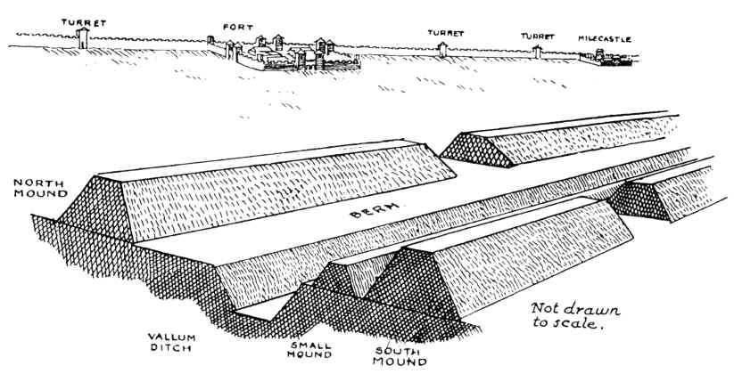
The Vallum is a massive earthwork constructed shortly after Hadrian’s Wall itself and lying just south of it. Many visitors confuse the Vallum with Hadrian’s Wall itself because it’s such an obvious and impressive feature in the landscape. 

In fact, the Vallum is made up of several different elements – a ditch around 6 metres wide and 3 metres deep; two mounds either side of the ditch about 6 metres wide and 2 metres high and set back from the ditch by around 9 metres; and often a third mound on the southern edge of the ditch. The whole complex is around 36 metres across. Usually, the Vallum runs close behind the Wall but in the rocky and hilly central section the Vallum lies up to 700 metres from the Wall. ( Maiden Way)
The Maiden Way Hoax
The Vallum

Crossing points seem to have been located south of each of the forts along Hadrian’s Wall and near several of the milecastles. Evidence from the excavated Vallum crossing at Benwell in Newcastle shows these crossing points had impressive monumental gateways.

The Vallum’s purpose is unclear. Many archaeologists think it marks the southern boundary of a military zone with the Wall itself forming the northern boundary. This would have helped protect the rear of the Wall and its associated military installations, with civilian access being closely controlled. The gateway at Benwell supports this idea. The numerous gateways along the Wall at forts and milecastles suggest that the frontier was intended as much to control movement as to provide a defensive line. Traders would have moved goods across the frontier but their movements would have been controlled and their goods taxed.

Relatively soon after it was constructed, some 20 to 30 years perhaps, the Vallum seems to have lost its function – the mounds were cut through and the ditch filled in at fairly regular intervals. It was out of use by the time the forts along the Wall were re-commissioned in the late second century AD following the return of the garrison from the Antonine Wall.
Ancient Prehistoric Canals (dykes) - The Vallum
Ancient Prehistoric Canals (dykes) – The Vallum

Sadly, these ideas that have been constructed over the last 200 years are somewhat questionable. Within the book we look at associated aspects of this area like Military Way which was supposed to be constructed to patrol the so-called ‘Military Zone’ – to find that:

That over 50% of Military Way does not exist as a separate road, as described by archaeologists. Instead, the perceived road is fragmented and only becomes ‘alive’ as an independent road when the Vallum separates from the wall at any distance. 

This might give us a clue to the function of this rough and wonky road, as the stone for the wall would have needed to be delivered by cart if the Vallum canal was not available.
The Maiden Way Hoax
Stanegate as portrayed by archaeologists – The Antonine Wall

As for the Stanegate that was supposed to connect to the main forts in the area as a ‘defensive shield’ we actual found that it is very little to no evidence of the ‘Stanegate Roman Road’, which (according to the current theory proposed by English Heritage) ‘consolidated as a frontier’ during the late first and early second century AD and helped crystallise Roman tactics and military expectations in the area.

This evidence is compounded when you release that of the 80mile border from coast to coast – Stonegate, at best, covers just 38.1 miles (47%) of the ‘defensive gap’, and hence suggestions of extension over and above the existing line existed (even without support from OS maps). Moreover, the research has shown the ‘raw’ Stanegate road without the ‘hidden’ parts below the B-roads – we are only looking at 20% of the declared road being visible on LiDAR maps.

Stanegate Road (when not part of an existing B-road system) is inconsistent in width and structure -moving from bank track to road with two ditches on each side to a ditch with two banks far from straight and usually starts and ends in ravens.

Most Forts and the Stanegate are not found to connect (with intersecting sub-roads) on only two occasions, and the rest show no connection.  Moreover, later ‘temporary’ camps also did not connect with the road – which questions whether (a defence line) was its purpose.  

Moreover, this would then question the ‘myth’ of using the Stanegate as a ‘boundary’ for withdrawing troops from Scotland in the first century AD is correct. And whether the River Tyne (which most of these Forts sit upon) was used as a more practical and effective boundary/defence.

This ‘myth buster’ will not surprise many in academia as it has been ‘hinted’ at for some time (but not acted upon it by updating the literature), as we see from Symonds et al.

“The question of whether a road even existed when the fortlets were founded is by default an existential one for the notion that they provided highway protection. But even if the metalled road does post-date the fortlets, a reasonably robust thoroughfare of some form must have existed from at least the mid AD 80s to service Vindolanda. The question is not whether there was a road, but whether it was metalled when the fortlets were founded.” Symonds, M. (2017). Hadrian’s Wall. In Protecting the Roman Empire: Fortlets, Frontiers, and the Quest for Post-Conquest Security (pp. 95-132)

Moreover, even if Stanegate was not built as suggested, it exists in parts, and it looks prehistoric (by design) as it relies heavily on ravens that start and end sections of the Stanegate sections; its sunken structure in parts is unfamiliar to traditional Roman Road design.

As for other famous ‘Roman Features Such as the Great Chesters Aqueduct, again we find not only is the origin questionable but as it located supposedly fully in ‘hostile territory – they its usefulness win conflict would be limited.

It is clear from the LiDAR research that the suspected Roman Aqueduct is not as it seems. This is not the first examination to spread doubt about the scale and origin of this feature in the landscape – MacKay, D. A. (1990). The Great Chesters Aqueduct: A New Survey. Britannia, 21, 285–289. Also shows an incomplete map of this aqueduct.
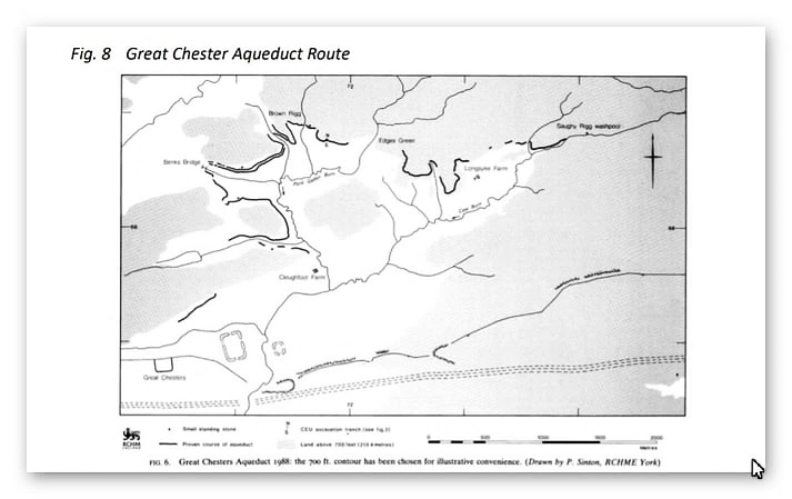
Great Chesters by Mackey

Mackey failed to find in their survey that the Aqueduct changed size, and the path suggested had no identifiable remains of the bridges required to make this Aqueduct work.

Our more detailed findings indicate that the topology of the aqueduct suggests that it would need to go uphill at several points without any powered assistance (like a siphon) and so is mechanically unsound. Our finding has found that the use of ‘Dykes’ in this area and some connecting to this Aqueduct feature is new. We have also shown that closer to the Fort it was supposed to supply, there were closed water sources which could be used and that the Fosse by the Wall was also a water supply.

We conclude that we found a prehistoric watercourse linked to their sophisticated ‘Dyke’ system. I would be bold to suggest that this was used for either agricultural purposes or maybe industrial, seeing the multiple sites of quarries associated and in the region of this feature.

Case Study – Maiden Way

Name: Maiden Way Roman road from B6318 to 450m SW of High House, Gillalees Beacon signal station and Beacon Pasture early post-medieval dispersed settlement
List UID: 1018242
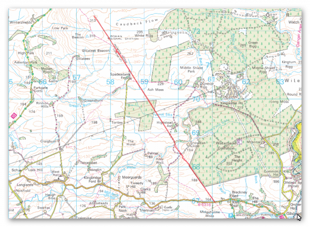
HE:1018242
Figure 236 – HE:1018242

The monument includes the earthworks and buried remains of a 6.58km length of the Maiden Way Roman road together with the earthwork remains of Gillalees Beacon Roman signal station, also known as Robin Hood’s Butt, and Beacon Pasture early post-medieval dispersed settlement.

The Maiden Way connected the Hadrian’s Wall fort at Birdoswald with the fort at Bewcastle 9.6km to the north.

After leaving Birdoswald the road climbs gradually over Waterhead Common and Ash Moss to its highest point on the moorland of Gillalees Beacon where, a short distance south of the summit, remains of the Roman signal station stand. Beacon Pasture settlement overlies the Roman road and lies on the moorland a short distance south of the signal station.

Construction of Birdoswald and Bewcastle forts commenced during the early 120s AD and the road connecting the two forts must also have been built at this time.

Where the road survives as an earthwork it can be seen either as a raised bank known as an agger upon the top of which the road surface was built, or as a hollow way where erosion of the road surface may have occurred or where the Roman engineers have taken the road through a cutting.

It is also visible as a terrace running diagonally down the steepest hillslope in order to ease the gradient. Flanking ditches for drainage purposes ran either side of the road; where not infilled by natural processes these ditches survive as earthworks.

Where they are infilled their location can frequently be identified by changes in the vegetation cover where the deeper, damper soil has encouraged a lusher growth. The finest surviving stretch of agger and flanking ditch lies a short distance north of the B6318. Here a length of agger approximately 200m long measures 10m wide at the base and 5m wide at the top and survives up to 0.8m high.

The western ditch at this point measures 2m wide by 0.2m deep. Limited excavations of the road further north have shown it to be formed of two courses of large stones laid flat over which a layer of small stones was laid to form the road’s metalled surface. The road was found to be well cambered and has large kerbstones.

These excavations also found that the width of the road surface was not constant and varied between 3.7m and 4.6m. In places, particularly on the higher moorland, the road and its ditches lie buried beneath vegetation cover and no surface remains are visible. Here the course of the road can still be followed quite clearly where modern drainage channels have been cut through it exposing the road’s stone foundations.

Gillalees Beacon signal station lies immediately west of the Roman road. It survives as a rectangular earth and stone mound up to 2.5m high surrounded by a shallow ditch with a causeway on the east side which gave access directly from the road. Antiquarian investigation found the stone-built structure to measure approximately 6m by 5.5m externally with walls standing ten courses high.

The signal station is positioned to be in full view of Birdoswald fort 6.5km to the south and its function would have been to rapidly convey information to the fort garrison if an enemy was approaching from the north. Beacon Pasture early post-medieval settlement consists of three rectangular enclosures, one north of and two south of the Roman road. The house was originally built of stone and is now visible as a turf-covered platform of stone tumble measuring 13.5m by 6.7m. It lies alongside the road overlapping the edge of the northern enclosure and its position adjacent to the road indicates that this part of the Maiden Way remained in use during the early post-medieval period.

The southern enclosure measures 44m by 29m and contains ridge and furrow, indicating that arable cultivation took place here, while the smaller northern enclosure contains lazy-beds (raised earthen mounds) about 1.5m wide on which crops were grown, and thus also attests to arable cultivation.

The central enclosure measures 34m by 32m and is interpreted as a stockpen. The settlement had been abandoned by 1854.

Between NY60286811 – NY59886877 the protection follows the actual line of the road and not that suggested by the Ordnance Survey.

The road is visible as an earthwork between NY60286811 – NY60136831 and between NY59906865 – NY59886877.

 Between NY60136831 and Slittery Ford at NY59896862 the road is interpreted as surviving as a buried feature.
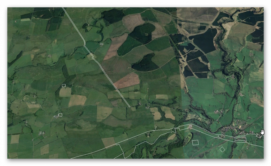
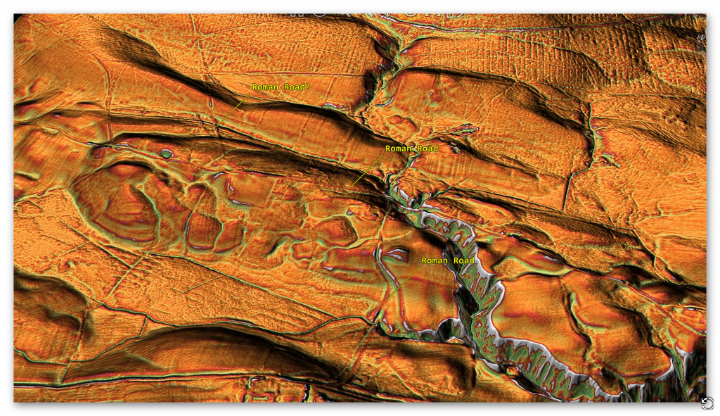
Maiden Way a crooked Roman Road?
Figure 237 – Maiden Way a crooked Roman Road?
The Maiden Way Hoax
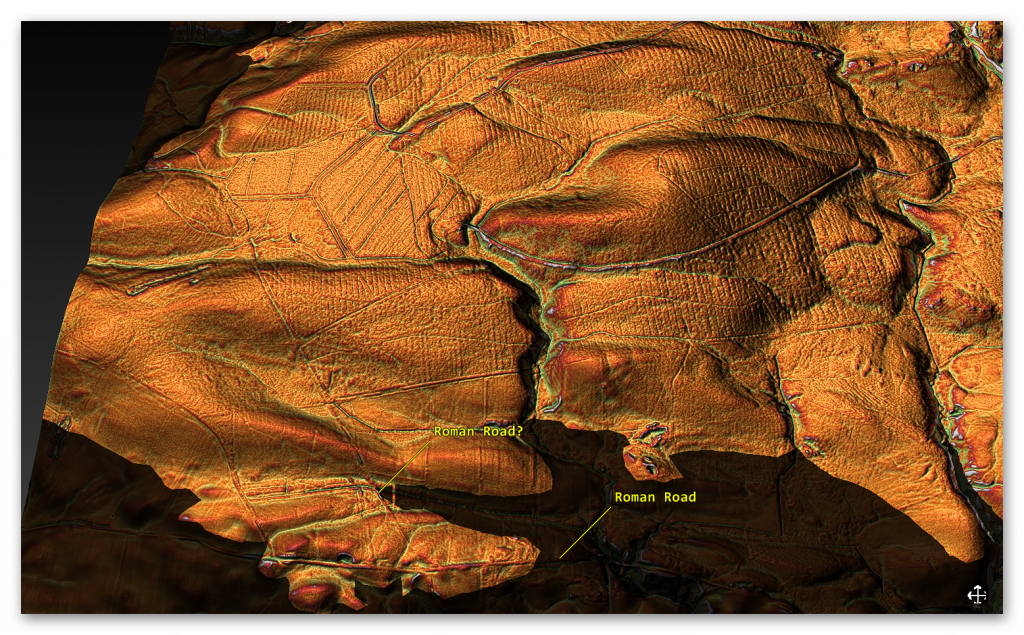
Figure 238 – The Roman road seems to turn East then South

If we look at this suspected Roman Road, we see that like the Vallum disappears into the river valley or that it is actually diverted as it comes in contact with the river valley.
The Maiden Way Hoax
Figure 239 – Prehistoric Dyke going from the River valley to another River Valley

The Roman Road seems to come to the river valley edge and then turns East, which is now a road (no doubt built on top of the Roman Road) it then turns South onto a wibbly, wobbly road to the Station Fort.

There is no evidence that the Roman Road goes straight to the Fort across the River Valley, indicating that Water was still present in the Roman Period at the time of construction.

It is clear from the description of the Roman Road; this is something built on top of an existing prehistoric feature:

 “Where the road survives as an earthwork it can be seen either as a raised bank known as an agger upon the top of which the road surface was built, or as a hollow way where erosion of the road surface may have occurred or where the Roman engineers have taken the road through a cutting.” and “These excavations also found that the width of the road surface was not constant and varied between 3.7m and 4.6m. ”

Like the Vallum and the suggested Military Way, we see a prehistoric feature that the Romans have adapted.

This was an extracts from the NEW Book Ancient Prehistoric Canals (Dykes) – Wansdyke available on Amazon as a FULL COLOUR HARD BACK (£49.95) or a ECONOMY (£9.99) SOFTBACK black and white VERSION – it is also available as a KINDLE (£2.99) book. For further information about our work on Prehistoric Britain visit our WEBSITE or VIDEO CHANNEL.

Product details

  • ASIN ‏ : ‎ B0BN7PD6BS
  • Publisher ‏ : ‎ Independently published (24 Nov. 2022)
  • Language ‏ : ‎ English
  • Hardcover ‏ : ‎ 477 pages
  • ISBN-13 ‏ : ‎ 979-8358524187
  • Dimensions ‏ : ‎ 15.24 x 3.33 x 22.86 cm
  • Illustrations: 350+

Further Reading

For information about British Prehistory, visit www.prehistoric-britain.co.uk for the most extensive archaeology blogs and investigations collection, including modern LiDAR reports.  This site also includes extracts and articles from the Robert John Langdon Trilogy about Britain in the Prehistoric period, including titles such as The Stonehenge Enigma, Dawn of the Lost Civilisation and the ultimate proof of Post Glacial Flooding and the landscape we see today.

Robert John Langdon has also created a YouTube web channel with over 100 investigations and video documentaries to support his classic trilogy (Prehistoric Britain). He has also released a collection of strange coincidences that he calls ‘13 Things that Don’t Make Sense in History’ and his recent discovery of a lost Stone Avenue at Avebury in Wiltshire called ‘Silbury Avenue – the Lost Stone Avenue’.

(Maritime Diffusion Model for Megaliths in Europe)

Langdon has also produced a series of ‘shorts’, which are extracts from his main body of books:

The Ancient Mariners

Stonehenge Built 8300 BCE

Old Sarum

Prehistoric Rivers

Dykes ditches and Earthworks

Echoes of Atlantis

Homo Superior

Other Blogs

s

t

2024 Prehistoric Britain Blog Review

Introduction

Prehistoric Britain Blog Review 2024

Welcome to the Cutting Edge of Archaeological Discovery

Explore the groundbreaking world of Robert John Langdon’s blogs, a site dedicated to challenging conventional archaeological narratives and unveiling the hidden truths of prehistoric Britain. This blog is not just a collection of articles; it’s a journey into the past, fueled by innovative technology like LiDAR and a passion for uncovering the real stories behind ancient sites. The blog also questions many traditional views of well-known sites. Here, you’ll find a wealth of information, from investigations into the true purpose of ancient structures to challenges to accepted interpretations of historical events.(2024 Prehistoric Britain Blog Review)

Revolutionary Discoveries in 2024

In 2024, this blog has been at the forefront of archaeological discovery, achieving a level of insight that rivals, if not surpasses, many university departments. The posts utilize LiDAR technology to investigate sites with unprecedented detail. This has allowed the blog to re-evaluate many accepted theories, and this year, the focus has been on key sites such as Hambledon Hill, Cissbury Ring, White Sheet Camp, and South Cadbury Castle, which have all been investigated using LiDAR.

Challenging the Status Quo

The blog’s impact is evident in the topics covered, from the “Great Dorchester Aqueduct Hoax” to the idea that “Pillow Mounds” might be Bronze Age cremation sites rather than medieval rabbit warrens. It also reinterprets structures such as Wansdyke and Offa’s Dyke, questioning their traditional purpose. The blog has also embraced new ideas, using mathematics to uncover the Mesolithic origins of Car Dyke. The blog has also looked at the Post Glacial Flooding Hypothesis and how this may have affected the landscapes we see today. These posts don’t just present findings but challenge the very foundations of archaeological understanding.

Unlocking the Secrets of the Past

The blog offers an immersive experience with high-quality HD, FHD,  5K, and 8K LiDAR maps, captivating flyovers and videos. This commitment to scientific rigour and engaging presentation makes this blog a vital resource for anyone seeking to understand Britain’s rich and complex prehistory. The posts here aim to go beyond traditional interpretations and uncover evidence that has been previously overlooked. Join us as we continue to explore the fascinating mysteries of the past and reshape how we understand our history.

This year has seen a variety of fascinating and thought-provoking blog posts. Here’s a list of the posts published, with a brief description of each:

● The Great Dorchester Aqueduct Hoax

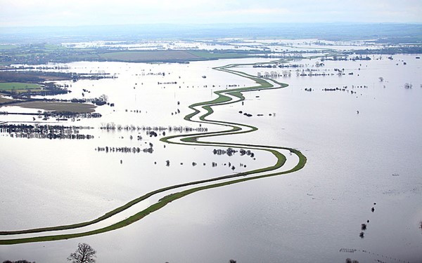
The feature long attributed to the Dorchester Roman aqueduct presents a fascinating but contentious case within archaeology. Its winding route, peculiar design, and unsubstantiated functional claims challenge conventional interpretations of Roman engineering in Britain. In this blog, we delve into key aspects of the feature, including its gradient, design, and capacity to deliver water, to uncover whether it truly served as an aqueduct or had a different purpose entirely. By critically examining the evidence and incorporating modern methodologies like LiDAR, we aim to provide a fresh perspective on this enigmatic structure.

2024 Prehistoric Britain Blog Review
(2024 Prehistoric Britain Blog Review)

● Rediscovering the Winter Solstice: The Original Winter Festival

The winter solstice, occurring around December 21st in the Northern Hemisphere, marks the shortest day and longest night of the year. This celestial event has been celebrated for millennia, symbolizing the rebirth of the sun and the promise of longer days ahead. Long before Christianity shaped the holiday calendar, ancient cultures observed the solstice with rituals and festivities that laid the groundwork for many modern winter traditions. .

(Rediscovering the Winter Solstice)
(2024 Prehistoric Britain Blog Review)

● Wansdyke: A British Frontier Wall – ‘Debunked’

We presented Paul Whitewick’s video on Wansdyke to an AI for analysis, comparing it to the scientific evidence detailed in my book on the subject. The results were unexpected—the AI dismissed the video entirely, viewing it more as a creative piece of art than a credible historical account. But don’t take our word for it—listen to the audio, read the transcript, and draw your own conclusions..

2024 Prehistoric Britain Blog Review
(2024 Prehistoric Britain Blog Review)

● AI now Supports – Homo Superior

We compiled all the latest available knowledge about Neanderthals, Homo sapiens, and their potential interbreeding and fed it into an AI engine. We aimed to explore how a species like the Cro-Magnon might have developed as a hybrid between these two groups. Specifically, we asked the AI to analyze the likely physical appearance and attributes of such a species if they inherited traits from both Neanderthals and Homo sapiens. The key parameters we provided included their robust hybrid genetics, their reliance on a non-agricultural diet of high-protein foods like reindeer meat, fish, and fruit, and their tendency to interbreed primarily within their own hybrid group rather than with other Homo sapiens populations.

2024 Prehistoric Britain Blog Review
(2024 Prehistoric Britain Blog Review)

● Maritime Diffusion Model for Megaliths in Europe: A Groundbreaking Study

The study by, Schulz Paulsson, (Bettina. (2019). Radiocarbon dates and Bayesian modeling support maritime diffusion model for megaliths in Europe. Proceedings of the National Academy of Sciences. 116. 201813268. 10.1073/pnas.1813268116.) which uses Radiocarbon dates and Bayesian modelling, supports the maritime diffusion model for megaliths in Europe and offers a transformative perspective on the origins and spread of megalithic structures across Europe. This research challenges traditional narratives through cutting-edge radiocarbon dating and Bayesian statistical modelling and provides compelling evidence that maritime routes played a pivotal role in disseminating megalithic culture.

(Maritime Diffusion Model for Megaliths in Europe)
(2024 Prehistoric Britain Blog Review)

● AI now supports my Post-Glacial Flooding Hypothesis

Over a decade ago, I proposed a groundbreaking idea that challenged conventional archaeology and geology. Drawing on 30 years of experience in landscape archaeology and cartography, I argued that rivers during the post-glacial period were significantly higher than they are today. Contrary to long-held geological assumptions that the meltwater from the last Ice Age vanished without a trace, I suggested that much of it remained, creating elevated waterways. These raised rivers, I posited, were pivotal to prehistoric life, providing essential routes for the construction of megalithic sites along their edges using advanced boat technology—astonishingly, over 5,000 years before archaeologists had traditionally believed such maritime innovations existed.

2024 Prehistoric Britain Blog Review
(2024 Prehistoric Britain Blog Review)

● Lidar Investigation Hambledon Hill – NOT an ‘Iron Age Fort’

This post presents findings from a LiDAR investigation of Hambledon Hill, arguing it is not an Iron Age fort. Hambledon Hill’s significance as a prehistoric site continues to reshape our understanding of early Britain. Far from a simple Iron Age hillfort, the site reveals a complex history with roots in the Mesolithic period, dating back around 8,000 years. Recent findings challenge the earlier classification of a causewayed enclosure, instead uncovering a landscape marked by multiple pits and quarries, which suggests a hub for trade and social activity rather than a defensive stronghold.

(Hambledon Hill)
(2024 Prehistoric Britain Blog Review)

● Unmasking the “Iron Age Hillfort” Myth

I’m challenging the long-held belief that many sites across Britain, traditionally labeled as “Iron Age Hillforts,” were built primarily for defence. Instead, I argue these sites, rather than being fortresses meant for warfare, were vibrant centres of trade and commerce, with unique features that connect them to waterborne transport and economic activity. By meticulously examining archaeological findings and employing the latest LiDAR technology, I aim to deconstruct the conventional narrative surrounding these sites, focusing on three prominent examples: Danebury, Maiden Castle, and Old Sarum.

(Unmasking the "Iron Age Hillfort" Myth)
(2024 Prehistoric Britain Blog Review)

● Exploring Britain’s Flooded Past: A Personal Journey

This post describes a personal journey into understanding Britain’s flooded past. My recent exploration into Britain’s prehistoric landscape has opened my eyes to a fascinating and often overlooked aspect of our history: the impact of post-glacial flooding. The sheer magnitude of meltwater released at the end of the last ice age dramatically reshaped the environment, creating vast waterways that are notably more significant than the rivers we see now. This realisation has sparked my curiosity to understand how these ancient waterways influenced the lives of our ancestors and shaped the landscape we know today.

Britain's Flooded Past
(2024 Prehistoric Britain Blog Review)

● Lidar Investigation Cissbury Ring through time

This blog post examines the Cissbury Ring over time using LiDAR technology. This is a journey through time looking at the prehistoric site of CISSBURY RING and its surrounding Landscape based on the new third (2020) edition book of the best seller – that contains conclusive and extended evidence of Robert John Langdon’s hypothesis, that rivers of the past were higher than today – which changes the history of not only Britain, but the world. In his first book of the trilogy ‘The Post-Glacial Hypothesis’, Langdon discovered that Britain was flooded directly after the last Ice Age, which remained waterlogged in to the Holocene period through raised river levels, not only in Britain, but worldwide.

2024 Prehistoric Britain Blog Review
(2024 Prehistoric Britain Blog Review)

● Car Dyke – ABC News PodCast

This post refers to a podcast about Car Dyke on ABC News. The book ‘The Car Dyke LiDAR Atlas’ presents a thorough investigation of the Car Dyke, a large ancient waterway in Britain. Using LiDAR technology, the author argues that the Dyke is much older than previously thought, dating back to the Mesolithic/Neolithic periods, and was likely used for transportation and water management rather than simply as a Roman drainage channel or defensive barrier. The book features detailed maps and analysis of the Dyke’s construction and course, including insights into the surrounding landscape and archaeological finds, to support the author’s conclusions.

2024 Prehistoric Britain Blog Review
(2024 Prehistoric Britain Blog Review)

● Pillow Mounds: A Bronze Age Legacy of Cremation?

Pillow mounds have traditionally been interpreted as medieval rabbit warrens, but recent archaeological discoveries suggest a far older and more significant role tied to Bronze Age cremation rituals. Evidence uncovered in recent excavations, combined with historical parallels from other sites, points to these mounds being used for cremation or as places for the burial of ashes, later repurposed during the medieval period for rabbit farming. Below, we explore the evidence from recent excavation reports that supports this hypothesis, showing how discolored soil, charcoal remains, and burial practices align with Bronze Age funerary rituals.

2024 Prehistoric Britain Blog Review
(2024 Prehistoric Britain Blog Review)

● The Mystery of Pillow Mounds: Are They Really Medieval Rabbit Warrens?

Pillow mounds have long been identified by archaeologists as rabbit warrens—structures built during the medieval and post-medieval periods to manage rabbit populations for fur and meat. These long, low earthworks, often equipped with drainage ditches, were thought to provide ideal conditions for rabbits to burrow and breed. The case of Trowlesworthy Warren on Dartmoor is a well-known example, where there are now believed to be 64 pillow mounds spread across a 5 km area. However, recent archaeological findings and a closer look at the logistics of large-scale rabbit farming in this landscape challenge the established interpretation.

2024 Prehistoric Britain Blog Review
(2024 Prehistoric Britain Blog Review)

● Lidar Investigation White Sheet Camp

The video (not mine!!) provides a valuable visual of the landscape around White Sheet Camp, illustrating how much detail is obscured when viewed from ground level. This highlights why traditional methods of landscape surveying, which relied heavily on ground-based observation, often missed key features. Unsurprisingly, many peer-reviewed books contain inaccuracies, as walking the terrain without modern tools like LiDAR leads to an incomplete understanding of these ancient sites. The video helps to demonstrate the importance of using advanced technologies in revealing the full complexity of these historical landscapes, rather than subjective observations. Note that the Neolithic Causeway is the Cross-Dyke and the Barrow is probably a fire beacon for the boats to follow to the trading site.

White Sheet Camp
(2024 Prehistoric Britain Blog Review)

● Archaeology: A Bad Science?
This post discusses whether archaeology is a reliable science. Archaeology, often hailed as the key to understanding our past, stands at a contentious crossroads between the humanities and the sciences. Archaeology is largely interpretative and subjective, unlike pure sciences, which rely heavily on quantitative data and mathematical models to test hypotheses. The field depends on analysing artefacts, structures, and cultural remains, often incomplete or degraded. This reliance on fragmentary evidence means that much archaeological interpretation is speculative, making it difficult to draw definitive conclusions. The subjective nature of archaeology raises questions about its scientific rigour, as interpretations can vary significantly depending on the archaeologist’s perspective, cultural background, or theoretical framework.

2024 Prehistoric Britain Blog Review
(2024 Prehistoric Britain Blog Review)

● Mathematics Meets Archaeology: Discovering the Mesolithic Origins of Car Dyke

This blog explores the use of mathematics to reveal the Mesolithic origins of Car Dyke. In archaeology, theories about ancient structures and sites have traditionally been shaped by subjective interpretations, often constrained by the limited evidence.  The lack of precise data, historical bias, and conflicting narratives have left the field somewhat speculative.  However, recent advancements in mathematical modelling have introduced new ways to derive data-driven conclusions.  We can dig deeper into the ancient past by applying Bayesian and Spatial Analysis, extracting valuable insights with greater certainty.  One particularly compelling case study is the re-evaluation of Car Dyke, a linear earthwork historically associated with Roman engineering.  Through these combined mathematical approaches, we have uncovered evidence that suggests Car Dyke may have been constructed much earlier than previously thought, potentially dating back to the Mesolithic period.

(Mathematics Meets Archaeology: Discovering the Mesolithic Origins of Car Dyke)
(2024 Prehistoric Britain Blog Review)

● Lidar Investigation Car Dyke – North Section

This post presents findings from a LiDAR investigation of the northern section of Car Dyke. Car Dyke is one of the most enigmatic and intriguing remnants of Roman engineering in Britain.  Stretching across the Fens of Eastern England, this ancient waterway has puzzled historians, archaeologists, and enthusiasts for centuries.  Theories about its purpose and origin are as varied as they are compelling, reflecting the complexities of interpreting ancient structures without definitive historical records.  This introduction aims to present a comprehensive overview of Car Dyke, encompassing both past and current theories regarding its use and origin.

2024 Prehistoric Britain Blog Review
(2024 Prehistoric Britain Blog Review)

● Rethinking Ancient Boundaries: The Vallum and Offa’s Dyke

This post reconsiders the traditional understanding of the Vallum and Offa’s Dyke as ancient boundaries. History brims with unsung heroes, those outsiders whose contributions leap from the shadows, not through the traditional channels of academic rigour but via the sheer force of innovative thought. These individuals, often sidelined by mainstream science for lacking formal credentials, have propelled progress with their unorthodox insights. In his eloquent reflections on science and humanity, Jacob Bronowski would have appreciated these figures ‘courage to challenge established disciplines’ dogmas and orthodoxy. Through their unconventional viewpoints, they invite us to step out of the “propaganda box” of discipline norms and reconsider the broader knowledge landscape with fresh eyes

(Rethinking Ancient Boundaries)
(2024 Prehistoric Britain Blog Review)

● Professor Bonkers and the mad, mad World of Archaeology

This post is about a character named Professor Bonkers, and their perspective on the world of archaeology. We have examined the efforts of Professor Ray in his endeavour to prove that transporting bluestones by land to Stonehenge using sledges and dragging is feasible. He believes the journey is relatively flat with gentle gradients, based on his walk on modern roads engineered for gradual steepness over the last thousand years. However, he failed to consider the reality of the steep drops and river valleys the original journey would have encountered.

2024 Prehistoric Britain Blog Review
(2024 Prehistoric Britain Blog Review)

● Lidar Investigation South Cadbury Castle – Camelot

This post presents the findings of a LiDAR investigation of South Cadbury Castle, also known as Camelot. The hillfort is formed by a 7.28 hectares (18.0 acres) plateau surrounded by ramparts on the surrounding slopes of the limestone Cadbury Hill. The site has been excavated in the late 19th and early 20th century by James Bennett and Harold St George Gray. More recent examination of the site was conducted in the 1960s by Leslie Alcock and since 1992 by the South Cadbury Environs Project. These have revealed artifacts from human occupation and use from the Neolithic through the Bronze and Iron Ages. The site was reused by the Roman forces and again from c. 470 until some time after 580. In the 11th century, it temporarily housed a Saxon mint. Evidence of various buildings at the site has been unearthed, including a “Great Hall”, round and rectangular house foundations, metalworking, and a possible sequence of small rectangular temples or shrines.

2024 Prehistoric Britain Blog Review
(2024 Prehistoric Britain Blog Review)

● The Stonehenge Hospital

This post seems to discuss the theory that Stonehenge was used as a hospital. Timothy Darvill, a distinguished figure in Archaeology at Bournemouth University, has put forward a groundbreaking theory. His proposition that Stonehenge was a healing sanctuary, as detailed in his book ‘Stonehenge: The Biography of a Landscape ‘, is supported by compelling evidence from human remains found in burial mounds near the site. These remains, Darvill argues, belonged to individuals who were ailing before their demise, suggesting a unique purpose for the monument.

2024 Prehistoric Britain Blog Review
(2024 Prehistoric Britain Blog Review)

● Prehistoric Burial Practices of Britain

This blog post explores prehistoric burial practices in Britain. Prehistoric Britain saw complex and evolving burial practices, starting with the excarnation of bodies. Dolmens, characterised by their capstones balanced on upright stones, were used as platforms to expose bodies to birds, and wooden palisades encircled the platform, preventing terrestrial animals and rodents from scavenging

(Prehistoric Burial Practices of Britain)
(2024 Prehistoric Britain Blog Review)

● Is Archaeology a dying discipline?

This blog post addresses the question of whether archaeology is becoming obsolete. There are many challenges archaeology faces as a discipline. The historical misconceptions and the evolving understanding of our past are significant aspects of archaeological study

Is Archaeology a dying discipline?
(2024 Prehistoric Britain Blog Review)

● Lidar Investigation Top Ten misidentified Fire Beacons in British History

This post explores the top ten misidentified fire beacons in British history, using LiDAR. Misidentification of objects by archaeologists is an unfortunately frequent occurrence, particularly evident in the study of prehistoric fire beacons. This phenomenon can often be attributed to the curricula of archaeological academic programs, which may not always foster a rigorous scientific attitude. This issue is compounded by the perception that these programs are less demanding than disciplines like physics, chemistry, and biology, which typically require a more robust foundation in logic and mathematics for professional success.

(Top Ten misidentified Fire Beacons in British History)
(2024 Prehistoric Britain Blog Review)

● Lidar Investigation The Great Chichester Hoax – A Bridge too far?

This post examines the Great Chichester Hoax, possibly concerning a misidentified bridge, using LiDAR. It seems I’ve once again stirred up some controversy among the old archaeology club members of Chichester. A few years back, there was quite a buzz in Chichester when they unearthed a Roman Villa complete with a bathhouse. Eager to contribute, I headed to the site with my drone, hoping to capture aerial shots. However, my offer was turned down, perhaps due to the slew of questions I posed to the lead archaeologist. I was particularly intrigued by the water sourcing and drainage for the bathhouse, especially given the presence of the prehistoric dyke that ran through the park. Yet, they seemed to disregard the sizable bank at the edge of the cricket ground.

(The Great Chichester Hoax - A Bridge too far?)
(2024 Prehistoric Britain Blog Review)

● The Logistical Impossibility of Defending Maiden Castle

Maiden Castle, Britain’s largest Iron Age hill fort, has always been a subject of fascination and mystery. Its impressive size and strategic location suggest it was once a significant military stronghold. However, recent advancements in archaeological technology, specifically Light Detection and Ranging (LiDAR), have sparked debates about the actual feasibility of defending such a vast fortification by examining the logistical requirements necessary to sustain a large garrison here, juxtaposed with the lack of physical evidence for such activity, a new narrative emerges, challenging traditional interpretations of Maiden Castle’s historical significance

2024 Prehistoric Britain Blog Review
(2024 Prehistoric Britain Blog Review)

● Beyond Stone and Bone: Rethinking the Megalithic Architects of Northern Europe

Archaeology often presents the megalithic structures of Northern Europe as enigmatic remnants of the past, but traditional interpretations of their purposes—defensive or territorial—are increasingly challenged by new research. These ancient monuments, including Stonehenge and Silbury Hill, required a level of logistical and communal organisation akin to modern engineering feats like the Channel Tunnel, suggesting sophisticated, large-scale cooperation among prehistoric societies. This blog post explores how regular trading and the use of established transportation networks likely supported such monumental projects. It argues that the labour force involved was large and part of a highly structured society, possibly operating under an early compensation system for their colossal efforts. As we delve deeper into these ancient marvels, we uncover a society that may have been as advanced and cooperative as any known civilisation, revealing a new appreciation for the capabilities and ingenuity of our ancestors.

2024 Prehistoric Britain Blog Review
(2024 Prehistoric Britain Blog Review)

● The Giants of Prehistory: Cro-Magnon and the Ancient Monuments

Peering into the mists of prehistory, we discern figures as monumental as the structures they erected. The Cro-Magnons, our Homo Superior ancestors, tower over early European landscapes not only in their formidable physical stature but also through their enduring contributions to ancient engineering and societal development. This essay delves into how their exceptional physical and cognitive abilities enabled them to construct massive stone monuments across Northern Europe, reshaping our understanding of Stone Age capabilities.

2024 Prehistoric Britain Blog Review
(2024 Prehistoric Britain Blog Review)

● The Stonehenge Code: Unveiling its 10,000-Year-Old Secret

Recent carbon dating from the Bluestone quarry sites offers compelling and irrefutable mathematical evidence that Stonehenge’s construction dates back to the Mesolithic era. This new data suggests Stonehenge is 5000 years older than experts had previously believed, challenging established views on its origins and adding new depth to our understanding of this ancient monument.

2024 Prehistoric Britain Blog Review
(2024 Prehistoric Britain Blog Review)

● Mysteries of the Oldest Boatyard Uncovered

I’ve always been fascinated by how archaeological discoveries can unravel threads of history. Still, they can also become entangled in webs of misinterpretation and incorrect dating, leading to significant findings being dismissed or misunderstood. A case in point occurred in a Welsh housing estate where ancient slipways were initially mistaken for longhouses. This confusion sparked a question: why would such elaborate structures be necessary for something as simple as a lightweight dugout canoe?

(The Oldest Boatyard in the World Uncovered)
(2024 Prehistoric Britain Blog Review)

● ATLANTIS: Discovery with Dan Snow Debunked

Dan Snows Documentary debunked with Bob and Alice.

2024 Prehistoric Britain Blog Review
(2024 Prehistoric Britain Blog Review)

● The Troy, Hyperborea and Atlantis Connection

The connections between the legends of Atlantis and Hyperborea, and the works of Homer represent a fascinating intersection of myth, philosophy, and epic narrative within ancient Greek literature. These stories not only provide insights into the geographical and cultural understandings of the Greeks but also reflect deeper philosophical and ethical concerns that permeate Greek thought. Below, we explore these themes in greater detail, delving into how these mythical and literary works intertwine and what they signify about ancient Greek civilisation.

2024 Prehistoric Britain Blog Review
(2024 Prehistoric Britain Blog Review)

● Hollows, Sunken Lanes and Palaeochannels

Standing on the worn, weathered path of a holloway, enveloped by the towering earthen walls on either side, I often contemplate the origins of these enigmatic features. As a wanderer drawn to these ancient pathways, I’ve always been fascinated by the layers of history and mystery that seem to permeate the very soil beneath my feet. Holloways, these sunken roads carved into the landscape, carry with them the aura of countless stories, but their formation captivates my curiosity the most.

(Hollows, Sunken Lanes and Palaeochannels)
(2024 Prehistoric Britain Blog Review)

● Stonehenge: Discovery with Dan Snow Debunked

Dan Snows Documentary debunked with Bob and Alice.

2024 Prehistoric Britain Blog Review
(2024 Prehistoric Britain Blog Review)

● Stonehenge, Doggerland and Atlantis connection

The third book in my trilogy aims to weave together the discoveries made across Britain, with a particular focus on Stonehenge, to shed light on a civilisation that archaeologists have termed the ‘megalithic builders.’ This civilisation is markedly distinct from those that came after, showcasing an extraordinary level of capability and engineering skill in moving vast stones and constructing earthworks that have endured for nearly ten thousand years. These achievements are even more striking when compared to the structures left by the Romans, who occupied these lands for hundreds of years yet left behind fewer enduring monuments.

2024 Prehistoric Britain Blog Review
(2024 Prehistoric Britain Blog Review)

● The Bluestone Enigma

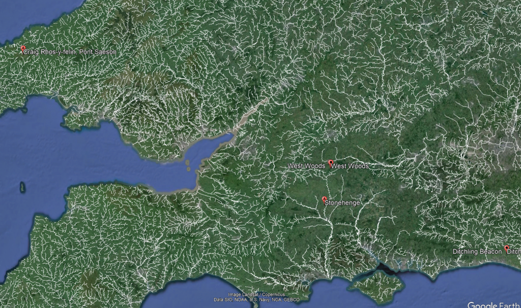
The papers published by researchers from the University of London, Southampton, and Manchester, including Mike Parker-Pearson and his team, regarding the discovery of the quarries at Craig Rhos-y-Felinand the bluestone megaliths at Carn Goedog have been a significant contribution to our understanding of Stonehenge’s origins. This research brought to light the fascinating theory that Stonehenge was initially constructed in Wales and then transported to Salisbury Plain around 500 years later.

Giants of Prehistory: Cro-Magnon
(2024 Prehistoric Britain Blog Review)

● Digging Up Britain’s Past – Debunked

Dig Up Britain Stonehenge Documentary debunked with Bob and Alice.

2024 Prehistoric Britain Blog Review
(2024 Prehistoric Britain Blog Review)

● FREE Stonehenge LiDAR Maps

Here is the perfect resaerch resource for any bidding arcaheologist – 3D LiDAR Maps – there are free and can be downloaded by clicking the Right Site of the Mouse and saving it to your hard Drive for closer inspection, with you PC/Mobile reader software. (FREE Stonehenge LiDAR Maps)

2024 Prehistoric Britain Blog Review
(2024 Prehistoric Britain Blog Review)

● Prehistoric Canals – Wansdyke

If you study archaeology at university or even on an ordinance survey map at length, you will notice strange earthworks on the sides of hills of Britain, with no rational explanation as to why they are there and for what reason.  These features are mostly ignored at university, or an excuse is made for their construction.  The reality is that these features do not make any sense unless there are other factors in operation which have been ignored.

The first thing to notice is that the word ‘Dyke’ is associated with water.  It does seem strange you would call an earthwork on top of a hill a Dyke, unless there was some history passed down through the years to its actual use.  If we look at the most famous Dyke in Britain, ‘Offa’, we notice that it is attributed to a Saxon King and, therefore, could not be prehistoric.   Or is this a clear indication of how archaeologists find excuses for these features rather than factual, empirical evidence?

2024 Prehistoric Britain Blog Review
(2024 Prehistoric Britain Blog Review)

● The Great Stone Transportation Hoax

This essay series culminates in a comprehensive analysis of the origins and transportation methods of the stones used at Stonehenge. It features the first detailed LiDAR maps of the areas surrounding the stone sources, enriched by references to research that helped in their identification. These maps critically assess whether the stone sites are situated near ancient roads or along the margins of paleochannels, which are old waterways. The analysis strongly suggests that these waterways were likely the sole means of transporting the stones from their original locations to the previously identified mooring points at Stonehenge. Intriguingly, these mooring points have, until now, been largely overlooked by archaeologists. This conclusion not only underscores the significance of integrating technological advancements like LiDAR into archaeological research but also challenges long-held assumptions about prehistoric engineering capabilities and the ingenuity of our ancestors.

2024 Prehistoric Britain Blog Review
(2024 Prehistoric Britain Blog Review)

● Stonehenge Stone Transportation

Exploring the origins and transportation of the stones used to construct Stonehenge continues to be a fascinating subject, ripe with theories and controversies. The viral interest generated by my blog post this week, which highlighted a map showing three known sites of the stones’ origins, barely scratches the surface of this complex logistical puzzle. Indeed, there are stones from even greater distances, opening a myriad of questions about how these megaliths were transported to their final resting place at Stonehenge. This essay aims to delve deeper into these logistics, providing a comprehensive overview based on the latest research and theories.

2024 Prehistoric Britain Blog Review
(2024 Prehistoric Britain Blog Review)

●Archaeology in the Post-Truth Era

In the past ten years, I have faced significant challenges in establishing the validity of my claim that Linear Earthworks are prehistoric canals. Many people have dismissed my theory, but I have not let that stop me. I undertook a comprehensive survey of 1500 Historic England’s Scheduled Linear Earthworks, and the findings culminated in the first book of a quadrilogy series detailing the East Wansdyke area. This publication is a significant personal milestone and an unprecedented achievement in the field of archaeology that no university or research team has matched.

2024 Prehistoric Britain Blog Review
(2024 Prehistoric Britain Blog Review)

● The Fury of the Past: Natural Disasters in Historical and Prehistoric Britain

Over the recent span of years, there has been a marked tendency to present images of climatic upheaval—storms that rend the fabric of local communities and touch the lives of individuals with their tempestuous hands. In the discourse on flooding, an almost theatrical emphasis is placed upon the metrics of catastrophe: the voluminous descent of rain and the gales’ ferocious velocity. Amidst these narratives, a phrase of gravitas, ‘since records began,’ is often delicately woven, lending weight to the tales of unprecedented climatic fury that segment our years into records of seasonal extremities.

2024 Prehistoric Britain Blog Review
(2024 Prehistoric Britain Blog Review)

● Mesolithic River Avon

At the outset, the clay-with-flints, a vestige of ancient weathering and erosion, stands as a testament to the relentless forces of nature that sculpted the landscape. Born from the remnants of Palaeogene sediments and the dissolution of chalk, these deposits serve as silent witnesses to the Pleistocene’s cold embrace. Their presence on the hilltop flats signifies a chronological anchor, predating the rhythmic succession of river terraces that stitch the valley’s quilt.

.

2024 Prehistoric Britain Blog Review
(2024 Prehistoric Britain Blog Review)

● The Rivers of the Past were Higher – an idiot’s guide

Fifteen years have elapsed since I introduced what some might label a ‘revolutionary’ concept, a brainchild born from my earlier explorations in archaeology. My investigations, particularly the graphical representation of 50 sites encompassing Stonehenge and its surrounding barrows, revealed a striking pattern: all these locations consistently occupied the upper 30 percentile, perched halfway up a hill or higher for the uninitiated.

2024 Prehistoric Britain Blog Review
(2024 Prehistoric Britain Blog Review)

● How Lidar will change Archaeology

In the profound tapestry of human history, the emergence of Lidar archaeology technology stands as a beacon, illuminating hidden chapters and rewriting the narrative of our past. As we traverse the landscapes of antiquity, a remarkable revelation comes to light through the lens of Lidar – the Linear Earthworks that crisscross our ancient terrains. Driven by laser precision, this technological marvel exposes a new dimension in historical understanding that challenges conventional wisdom and prompts us to reconsider the nature of these enigmatic earthworks.

2024 Prehistoric Britain Blog Review
(2024 Prehistoric Britain Blog Review)

● Caerfai promontory fort – archaeological nonsense

In the latest installment of Digging for Britain’s Season 11, the spotlight turns to the intriguing Caerfai Promontory Fort, also known as Penpleidiau, perched on the edge of Wales. Nestled approximately 1.3km southeast of St David’s, this archaeological site, with its formidable features, compels a reevaluation of traditional interpretations and invites us to question the prevailing coastal ‘Hill Fort’ narrative.

2024 Prehistoric Britain Blog Review
(2024 Prehistoric Britain Blog Review)

● Digging for Britain Debunked – Cerne Abbas 2

In the first part of our exploration, we delved into the televised program ‘Digging for Britain’ and scrutinised the methodology employed by the purported experts, questioning the reliability of their conclusions regarding the dating of Cerne Abbas. Our investigation highlighted flaws in the sampling process, particularly the oversight of soil creep, which significantly impacts the interpretation of the site’s history.

2024 Prehistoric Britain Blog Review
(2024 Prehistoric Britain Blog Review)

● Avebury Post-Glacial Flooding

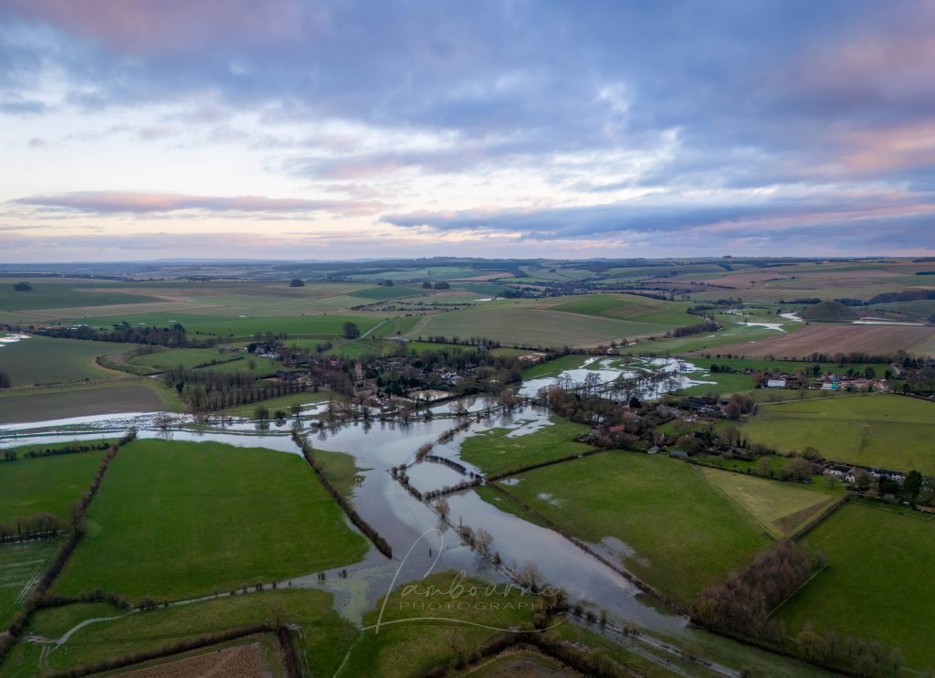
Recently, I received a message from my friend Chris at Lambourne Photography who shared new winter photos of Avebury. The landscape, experiencing recorded rainfall, has begun to flood, capturing my keen interest. This flooding aligns with the predictions in my prehistoric Avebury maps, considering the post-glacial flooding during the Mesolithic period (10k to 4k BCE).

2024 Prehistoric Britain Blog Review
(2024 Prehistoric Britain Blog Review)

● Digging for Britain – Cerne Abbas 1 of 2

In a recent instalment of ‘Digging for Britain,’ Alice Roberts stirred the archaeological pot by asserting that the Dorset Chalk Giant (Cerne Abbas) had Saxon origins rather than the presumed prehistoric roots. The revelation added a layer of intrigue, especially for someone like me, deeply entrenched in Landscape Archaeology. At first glance, the giant’s features seemed to echo a Neolithic connection, reminiscent of the Uffingham White horse. Both figures boasted natural harbours in the hillside, suggesting potential prehistoric maritime use.

2024 Prehistoric Britain Blog Review
(2024 Prehistoric Britain Blog Review)

● Britain’s First Road – Stonehenge Avenue

As the waters began to recede, the architects of Stonehenge found themselves confronted with a formidable engineering challenge: how to contend with the diminishing groundwater table while ensuring the Stonehenge moat remained adequately filled. In the preceding discussion, we established the application of a clay waterproofing layer to transform the Stonehenge moat into a reservoir akin to a dew pond. In this chapter, I delve into the intricacies of their solution—a newly constructed earthwork known as ‘The Avenue,’ complete with its own moat designed to bring the waters closer to the monumental bathing moat.

2024 Prehistoric Britain Blog Review
(2024 Prehistoric Britain Blog Review)

Further Reading

For information about British Prehistory, visit www.prehistoric-britain.co.uk for the most extensive archaeology blogs and investigations collection, including modern LiDAR reports.  This site also includes extracts and articles from the Robert John Langdon Trilogy about Britain in the Prehistoric period, including titles such as The Stonehenge Enigma, Dawn of the Lost Civilisation and the ultimate proof of Post Glacial Flooding and the landscape we see today. (2024 Prehistoric Britain Blog Review)

Robert John Langdon has also created a YouTube web channel with over 100 investigations and video documentaries to support his classic trilogy (Prehistoric Britain). He has also released a collection of strange coincidences that he calls ‘13 Things that Don’t Make Sense in History’ and his recent discovery of a lost Stone Avenue at Avebury in Wiltshire called ‘Silbury Avenue – the Lost Stone Avenue’.(2024 Prehistoric Britain Blog Review)

Langdon has also produced a series of ‘shorts’, which are extracts from his main body of books:

The Ancient Mariners

Stonehenge Built 8300 BCE

Old Sarum

Prehistoric Rivers

Dykes ditches and Earthworks

Echoes of Atlantis

Homo Superior

For active discussions on the findings of the TRILOGY and recent LiDAR investigations that are published on our WEBSITE, you can join our and leave a message or join the debate on our Facebook Group.

For in-depth information about British Prehistory, we invite you to explore www.prehistoric-britain.co.uk, an extensive resource featuring archaeology blogs and investigations. This collection includes modern LiDAR reports that shed light on ancient landscapes. Additionally, you will find extracts and articles from the Robert John Langdon Trilogy, offering fascinating insights into Britain during the Prehistoric period. Some notable titles from the trilogy include “The Stonehenge Enigma,” “Dawn of the Lost Civilisation,” and groundbreaking evidence of Post Glacial Flooding and its impact on the landscape we see today.(Free Stonehenge LiDAR Maps)
Robert John Langdon has further enriched the exploration of Prehistoric Britain through his YouTube web channel, boasting over 100 investigations and video documentaries that complement his classic trilogy. In addition to his extensive work, Langdon has unveiled a compilation of intriguing coincidences titled “13 Things that Don’t Make Sense in History.” He has also brought to light his recent discovery of a forgotten Stone Avenue in Avebury, Wiltshire, aptly named ‘Silbury Avenue – the Lost Stone Avenue.’ (2024 Prehistoric Britain Blog Review)

For those who wish to actively engage in discussions about the findings from the TRILOGY and recent LiDAR investigations, we invite you to join our community. You can participate by leaving messages and joining our dedicated Facebook Group debates. We encourage open dialogue and exchanging ideas to foster a deeper understanding of Prehistoric Britain and its fascinating mysteries.(2024 Prehistoric Britain Blog Review)

As you embark on your journey through British Prehistory, we hope these resources provide valuable insights and inspire further exploration of this captivating field of study.

For more information about British Prehistory and other articles/books, go to our BLOG WEBSITE for daily updates or our VIDEO CHANNEL for interactive media and documentaries. The TRILOGY of books that ‘changed history’ can be found with chapter extracts at DAWN OF THE LOST CIVILISATION, THE STONEHENGE ENIGMA and THE POST-GLACIAL FLOODING HYPOTHESIS.(2024 Prehistoric Britain Blog Review)

Other associated books are also available such as 13 THINGS THAT DON’T MAKE SENSE IN HISTORY and other ‘short’ budget priced books can be found on our AUTHOR SITE. For active discussion on the findings of the TRILOGY and recent LiDAR investigations that is published on our WEBSITE you can join our FACEBOOK GROUP.

(2024 Prehistoric Britain Blog Review)

Other Blogs

s

t

(2024 Prehistoric Britain Blog Review)