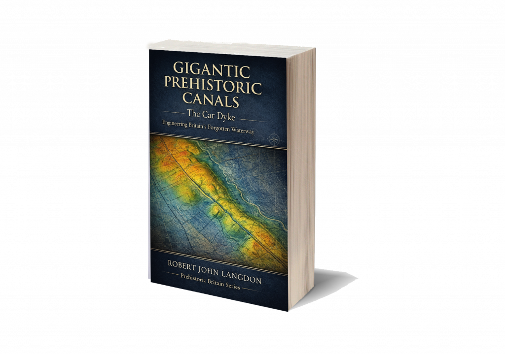
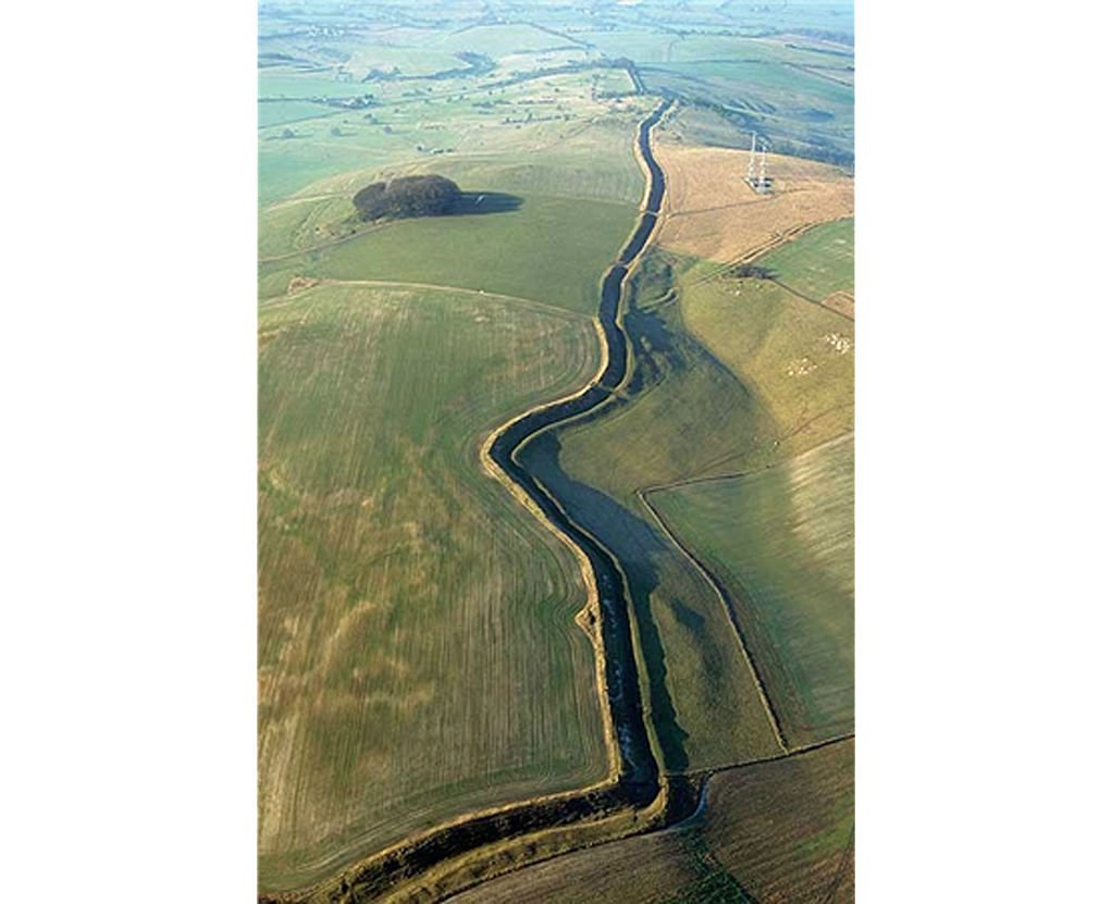
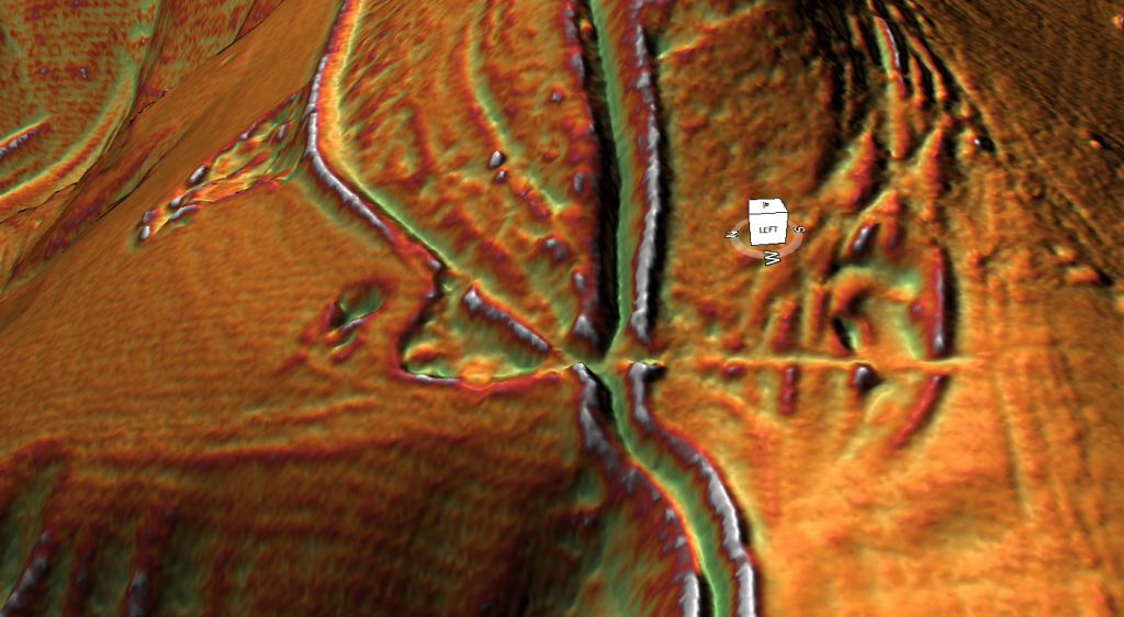
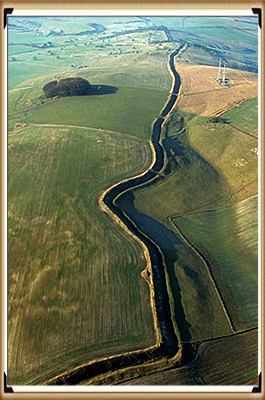
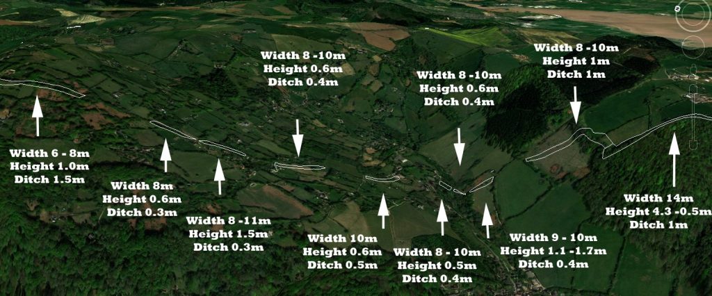
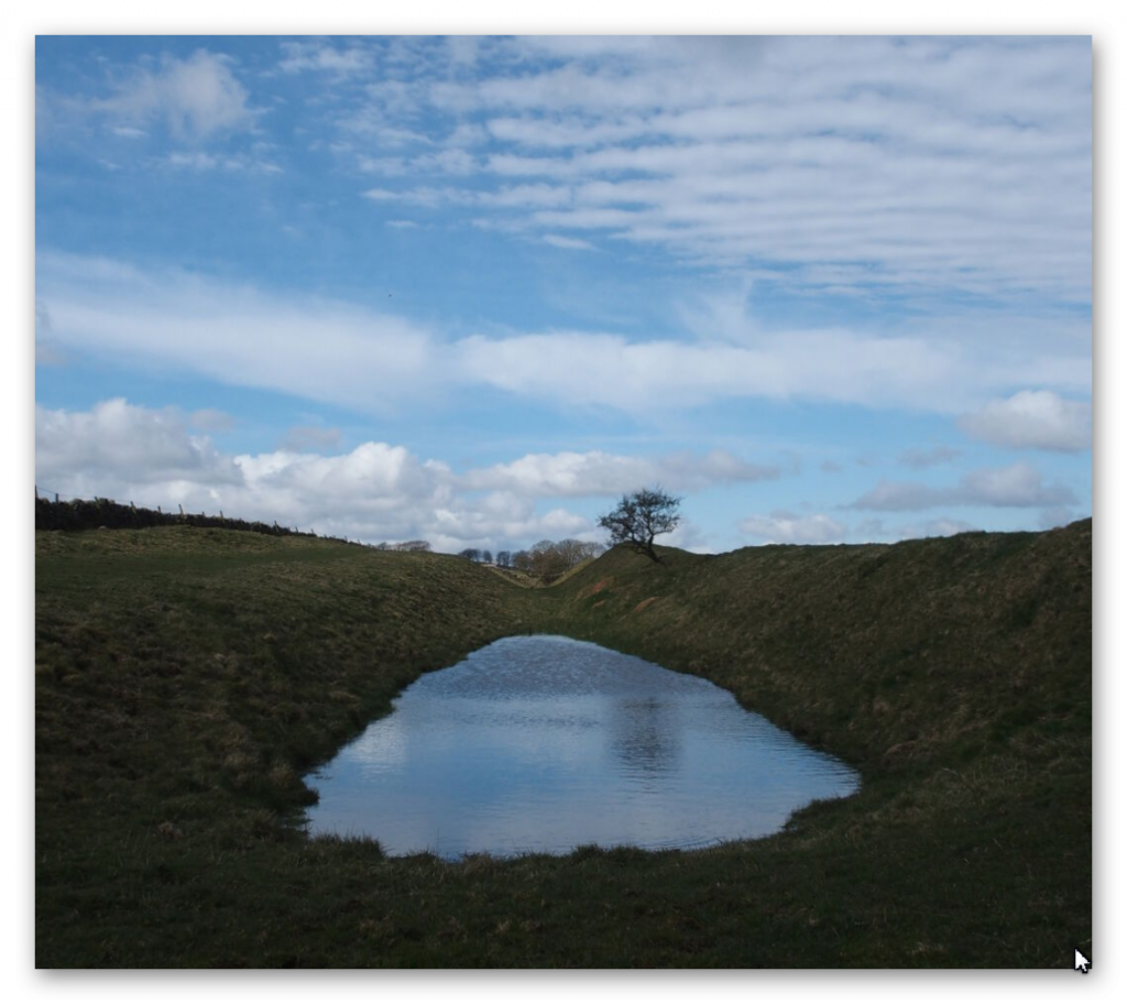
For centuries, Car Dyke was regarded as a relic of Roman engineering—a mere canal or drainage system that facilitated military logistics and agricultural management. However, our first-ever comprehensive LiDAR investigation has completely rewritten that narrative. By employing state-of-the-art laser scanning, we have penetrated the dense vegetation and hidden soil layers to reveal a much more complex story. The data, bolstered by advanced mathematical dating methods and AI-assisted analysis, demonstrate that Car Dyke is not Roman but prehistoric in origin, with roots dating to the Mesolithic and Neolithic periods.
Inside the Investigation
LiDAR Mapping: Our high-resolution scans provide unprecedented detail, capturing the full 103-mile span of Car Dyke. The imagery reveals intricate construction details and natural variations that traditional methods have overlooked.
Mathematical Dating: Utilising a novel approach that integrates archaeological finds with advanced algorithms, our team has applied mathematical theorems to establish a definitive timeline. This breakthrough challenges centuries of conventional wisdom and suggests a multi-phased construction history long before the Roman era.
Archaeological Integration: The Atlas includes comprehensive data from archaeological excavations—pottery shards, tools, and other artefacts—that further support the prehistoric origin of the Dyke.
LiDAR mapping reveals Car Dyke’s hidden prehistoric layers, challenging the Roman narrative
The Car Dyke Atlas: A Deep Dive into History
Car Dyke Atlas is not merely a book—it is a complete digital and print repository of our groundbreaking research. With over 140 meticulously crafted illustrations, 58 audio files, 22 360° interactive maps, and 120 flyover video clips, the Atlas offers a multidimensional view of this ancient earthwork.
Key Sections of the Atlas
Preamble & Introduction: Sets the stage by summarising decades of archaeological debate and introducing our revolutionary LiDAR findings.
Methodology: Explains the innovative techniques, including advanced AI and mathematical models, that enabled us to accurately map and date Car Dyke.
Detailed Mapping & Analysis: Interactive maps and flyover videos allow readers to explore Car Dyke in minute detail—from its northern, central, and southern sections to the subtle variations in its elevation and course.
Comparative Archaeology: Chapters that juxtapose traditional interpretations with our new findings, offering a compelling case for re-evaluating Britain’s ancient landscape.
Multimedia Content: Beyond static images, the Atlas integrates audio narrations, expert discussions, and interactive elements that provide context and bring the research to life.
The Car Dyke Atlas offers a panoramic view of history—where detailed maps meet immersive multimedia.
FusionBook 360: A New Paradigm in Storytelling
In today’s fast-paced digital age, traditional books are evolving. FusionBook 360 represents the future of reading—a concept that reimagines the boundaries between print and digital media. This revolutionary format brings historical scholarship into the 21st century by seamlessly integrating interactive and multimedia elements into the reading experience.
What Makes FusionBook 360 Unique?
Dual Format Availability: Choose between a digital edition loaded with interactive features and a beautifully designed printed edition enhanced with QR codes that unlock a wealth of supplementary content.
Realistic Page-Turning Effects: Experience the nostalgic feel of flipping pages, complete with authentic sound effects, yet enjoy the benefits of digital enhancements.
Embedded Interactive Content: Access video introductions, expert panels, detailed audio narrations, and 360° maps—all within the book’s pages. Each chapter invites readers to engage more deeply with the content.
Cloud-Based Updates: Stay current with ongoing research. As new discoveries emerge, the book updates automatically, ensuring that your copy remains at the cutting edge of historical scholarship.
Smart Chatbot Integration: Have a question while reading? Our integrated chatbot provides instant answers and additional context, making your exploration seamless and interactive.
FusionBook 360 transforms your reading experience, merging the tactile pleasure of print with the limitless possibilities of digital interactivity.”
Bridging the Past and Future: The Impact of Our Research
The implications of our findings extend far beyond Car Dyke itself. By challenging the long-held view of Car Dyke as a Roman construct, we open up new avenues of research into prehistoric engineering and land management. Our work sets a new standard for historical inquiry, combining rigorous scientific analysis with the creative potential of modern multimedia technology.
Why This Matters
Rewriting History: Our research forces historians, archaeologists, and the public to reconsider the origins of Car Dyke and, by extension, the broader narrative of Britain’s ancient past.
Innovative Methodologies: The integration of LiDAR technology, AI, and mathematical analysis provides a blueprint for future studies in archaeology.
Enhanced Engagement: FusionBook 360 invites a wider audience—from academic experts to curious enthusiasts—to engage with history in a more dynamic, interactive way.
Where ancient mysteries meet modern innovation—redefining our understanding of the past.
Join Us on This Journey
Be part of a transformative moment in historical research and digital publishing. Whether you are a scholar, a technology enthusiast, or simply passionate about uncovering the secrets of our past, the Car Dyke Atlas and FusionBook 360 offer an unparalleled journey into history.
By merging rigorous scientific inquiry with immersive multimedia technology, we’re not just telling history—we’re experiencing it. Step into a world where every page turns into a window to the past, and where the future of historical research is unfolding right before your eyes.
For more exclusive content, behind-the-scenes insights, and regular updates, visit our website and follow us on social media.
Car Dyke – ABC News Podcast
Summary
The book ‘The Car Dyke LiDAR Atlas’ presents a thorough investigation of the Car Dyke, a large ancient waterway in Britain. Using LiDAR technology, the author argues that the Dyke is much older than previously thought, dating back to the Mesolithic/Neolithic periods, and was likely used for transportation and water management rather than simply as a Roman drainage channel or defensive barrier. The book features detailed maps and analysis of the Dyke’s construction and course, including insights into the surrounding landscape and archaeological finds, to support the author’s conclusions.
Car Dyke Audio Book
Britain’s first-ever LiDAR investigation and mapping project of Car Dyke.
Unveiling the Truth: The Real History of Britain’s Dykes
For over a century, conventional archaeology has promoted the idea that Britain’s great Dykes—such as Offa’s Dyke and Wansdyke—were built by the Saxons as defensive barriers. These theories, based on limited fieldwalking evidence and subjective interpretation, have gone largely unchallenged. But what if this widely accepted narrative is completely wrong?
Car Dyke: The Key to a Forgotten Past
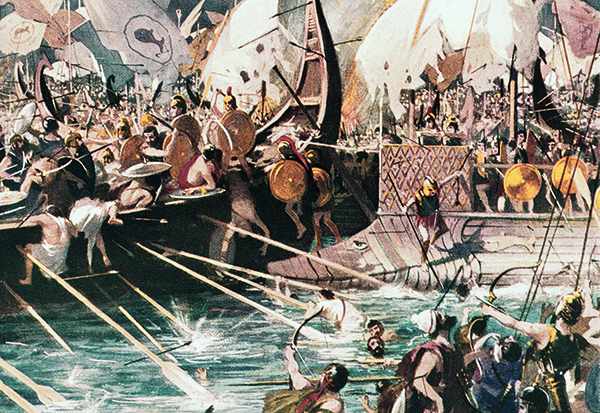
Car Dyke has long stood apart, defying the traditional explanations of Saxon territorial defence. When a boat laden with goods was discovered at the bottom of Car Dyke—dating back hundreds of years before the Saxons arrived in Britain—it should have rewritten history. Yet, mainstream archaeology dismissed this evidence, continuing to support outdated theories.
Revolutionary New Findings with LiDAR Technology
Using cutting-edge LiDAR mapping, our research has uncovered undeniable proof that Car Dyke and similar Dykes are not Saxon or even Roman constructions. Instead, they are intricately linked to ancient paleochannels, suggesting an advanced transportation and water management system that predates recorded history. Our new maps have corrected the estimated length of Car Dyke from 85 miles to 103 miles, aligning with the theories proposed by William Stukeley nearly 300 years ago. His claim that the Dyke supported the Roman occupation of Lincolnshire by facilitating troop and resource movements has now been scientifically validated.
Redefining Britain’s Longest Dyke
This research now positions Car Dyke as Britain’s longest Dyke, surpassing Offa’s Dyke, previously believed to be 177 miles long. Our survey reveals that Offa’s Dyke is, in fact, a series of smaller Dykes, totalling just 59.2 miles. Like Car Dyke, these ancient waterways were repurposed by the Romans for transportation and resource extraction, fundamentally shifting our understanding of Britain’s infrastructure.
A Groundbreaking Discovery: The Mesolithic and Neolithic Origins of the Dykes
Our mathematical analysis reveals that Car Dyke, Offa’s Dyke, and Wansdyke predate both the Romans and Saxons, tracing their origins back to the Mesolithic and Neolithic periods. This breakthrough challenges the established archaeological timeline and presents a compelling case for an advanced prehistoric civilisation. Could these ancient canals have been used to transport the massive stones of Britain’s megalithic structures? Our findings suggest they very well could have.
Rewriting the History of Britain’s Past. This book uncovers the real purpose and origins of Britain’s enigmatic Dykes, using cutting-edge technology and rigorous analysis to challenge centuries of academic assumptions. If you’re ready to explore the truth behind Britain’s forgotten past, this book will change everything you thought you knew about history.
Softback B/W Edition for Amazon – with QR codes to the interactive website links
The Car Dyke Atlas
Softback Colour Edition for Amazon – with QR codes to the interactive website links
The Car Dyke Atlas
Further Reading
For those interested in British Prehistory, visit www.prehistoric-britain.co.uk, a comprehensive resource featuring an extensive collection of archaeology articles, modern LiDAR investigations, and groundbreaking research. The site also includes insights and extracts from the acclaimed Robert John Langdon Trilogy, a series of books exploring Britain during the Prehistoric period. Titles in the trilogy include The Stonehenge Enigma, Dawn of the Lost Civilisation, and The Post Glacial Flooding Hypothesis, offering compelling evidence about ancient landscapes shaped by post-glacial flooding.
To further explore these topics, Robert John Langdon has developed a dedicated YouTube channel featuring over 100 video documentaries and investigations that complement the trilogy. Notable discoveries and studies showcased on the channel include 13 Things that Don’t Make Sense in History and the revelation of Silbury Avenue – The Lost Stone Avenue, a rediscovered prehistoric feature at Avebury, Wiltshire. (The Great Farming Hoax – Einkorn Wheat)
In addition to his main works, Langdon has released a series of shorter, accessible publications, ideal for readers delving into specific topics. These include:
For active discussions and updates on the trilogy’s findings and recent LiDAR investigations, join our vibrant community on Facebook. Engage with like-minded enthusiasts by leaving a message or contributing to debates in our Facebook Group.
Whether through the books, the website, or interactive videos, we aim to provide a deeper understanding of Britain’s fascinating prehistoric past. We encourage you to explore these resources and uncover the mysteries of ancient landscapes through the lens of modern archaeology.
For more information, including chapter extracts and related publications, visit the Robert John Langdon Author Page. Dive into works such as The Stonehenge Enigma or Dawn of the Lost Civilisation, and explore cutting-edge theories that challenge traditional historical narratives. (The Great Farming Hoax – Einkorn Wheat)
Recent carbon dating from the Bluestone quarry sites offers compelling and irrefutable mathematical evidence that Stonehenge’s construction dates back to the Mesolithic era. This new data suggests Stonehenge is 5000 years older than experts had previously believed, challenging established views on its origins and adding new depth to our understanding of this ancient monument (The Stonehenge Code).
Papers by researchers from the University of London, Southampton, and Manchester, including Mike Parker-Pearson and his team, have significantly advanced our understanding of Stonehenge’s origins. The discoveries at the Craig Rhos-y-Felin quarries and the bluestone megaliths at Carn Goedog, which reveal that Stonehenge may have been initially built in Wales and then transported to Salisbury Plain 500 years later, are no longer credible.
This groundbreaking revelation has captivated archaeologists worldwide and challenged previous beliefs about the construction of Stonehenge. The idea that these bluestones were quarried, shaped, and then moved to Salisbury Plain offers a deeper understanding of prehistoric people’s capabilities and social organisation.
The transport of these massive stones over such a distance, centuries after their initial quarrying, suggests remarkable dedication and coordination. It highlights the profound significance these stones—and the monument they form—held for ancient communities.
As an enthusiast of ancient civilisations, I find this research thrilling. It deepens our appreciation for the ingenuity and spiritual dedication of our ancestors, opening new avenues for exploring cultural and religious connections across prehistoric Britain. (The Stonehenge Code)
Prescilli Mountains in Wales – (The Stonehenge Code)
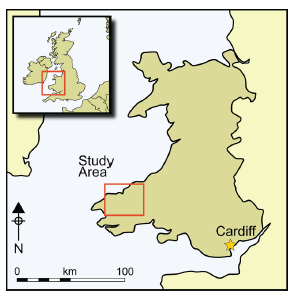
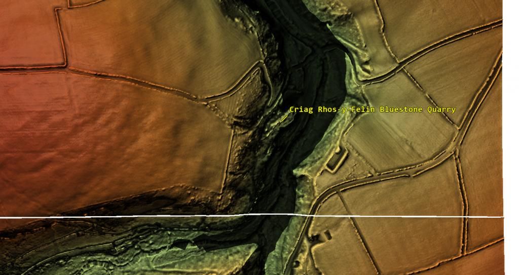
Craig Rhos-Y-Felin
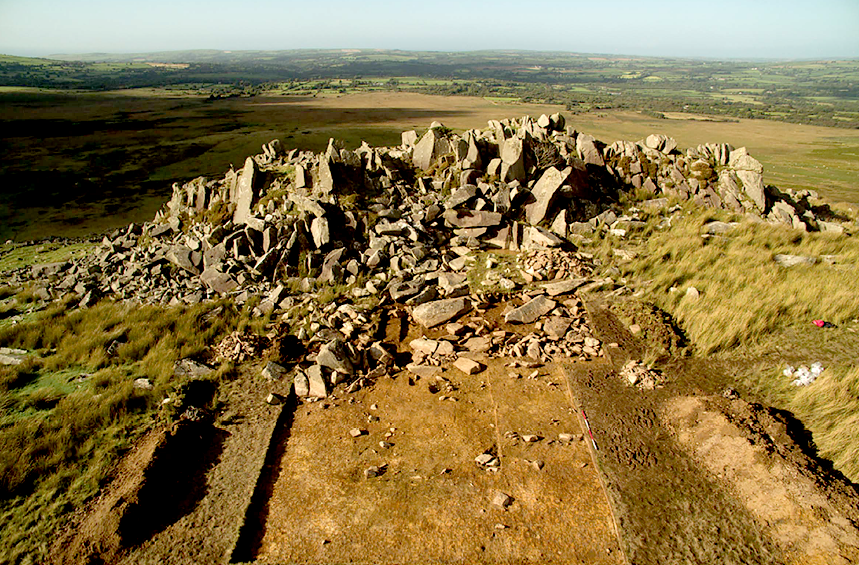
The December 2016 edition of Antiquity Magazine featured a report titled “Craig Rhos-y-Felin: a Welsh bluestone megalith quarry for Stonehenge,” unveiling intriguing insights into the origins of Stonehenge’s bluestones. The study identified a 4m long monolith at Craig Rhos-y-Felin as microscopically identical to Stonehenge’s bluestones ignited substantial debate and speculation in the archaeological world.
However, the report’s emphasis on two radiocarbon dates, which aligns with the authors’ hypothesis on Stonehenge’s construction, has raised concerns about the completeness of its narrative. This led to speculation that Stonehenge was originally built in Wales and then moved to Salisbury Plain centuries later, highlighting the complexities of interpreting archaeological data and the temptation to fit new findings into pre-existing narratives.
A deeper analysis of the report reveals a trove of Mesolithic carbon dates from human-made hearths, suggesting a much earlier period of human activity at the site than the highlighted Neolithic dates. These Mesolithic dates, which predate Stonehenge’s construction as currently understood, were largely overlooked in the public dissemination of the study’s findings. (The Stonehenge Code)
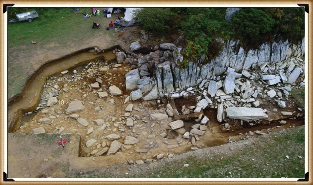
Quarry Site at Craig Rhos-Y-Felin – (The Stonehenge Code)
This oversight brings to light crucial questions about the narrative surrounding Stonehenge’s origins and the methodologies employed in archaeological dating. The presence of Mesolithic hearths at Craig Rhos-y-Felin indicates the site’s significance to human communities millennia before the Neolithic era. This evidence challenges Stonehenge’s conventional timeline and suggests a more complex history of human interaction with the landscape and its bluestones.
Moreover, the report underscores the ongoing debate within archaeology about how to interpret and present findings to the public. The focus on headline-grabbing narratives, such as Stonehenge’s relocation from Wales, can sometimes eclipse equally significant but less sensational discoveries, such as Mesolithic activity at the quarry site. (The Stonehenge Code)
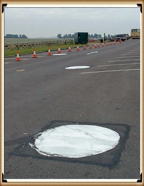
Stonehenge Old Car Park
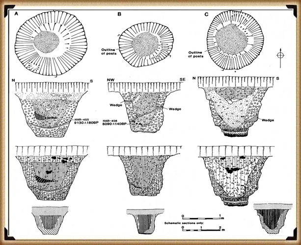
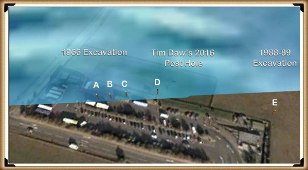
Mesolithic Post Holes at the Old Car Park at Stonehenge – (The Stonehenge Code)
The 1966 excavation and subsequent discoveries surrounding Stonehenge offer a fascinating and somewhat contentious insight into the challenges of accurately dating ancient sites. Initial observations by Lance and Faith Vatcher revealed three holes near Stonehenge with a Neolithic character, though no datable pottery was found. Yet, the characteristics of the holes suggested a Neolithic origin. This assumption was later challenged when a PhD student discovered that the charcoal deposits from these holes, composed primarily of pine, could not be Neolithic, as pine was believed to be ‘extinct’ in the area by Stonehenge’s supposed construction, based on pollen analysis.
This revelation was startling, particularly to officials from the Historic Buildings and Monuments Commission, now known as English Heritage. Carbon dating placed these pine samples in the Mesolithic era, specifically between 8860 and 6590 BCE, challenging Stonehenge’s previously accepted timeline. Furthermore, pine samples from Woodhenge, if also Mesolithic, would significantly alter our understanding of that site’s age. (The Stonehenge Code)
Mesolithic Post Holes in Old Car Park – (The Stonehenge Code)
Rather than seizing the opportunity to explore these findings further, a narrative emerged dismissing these posts as totem poles from unrelated, wandering hunter-gatherers. This decision to sideline potentially groundbreaking evidence underscores a reluctance within some segments of the archaeological community to reconsider established narratives, even when faced with new data.
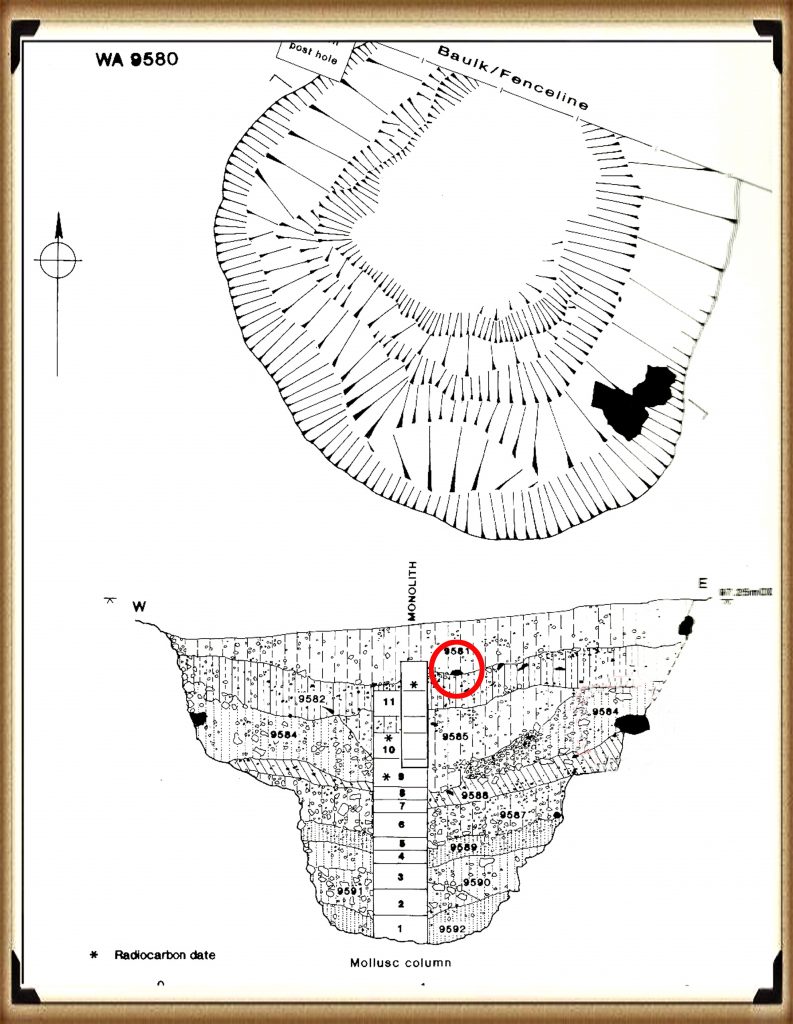
The 1988-89 discovery by Wessex Archaeology of another Mesolithic post hole, along with a piece of rhyolite dated to 7737 – 7454 BCE, further complicates the timeline of Stonehenge and its surrounding area. This finding should have prompted a reevaluation of the site’s dating, yet efforts to fit it into the existing narrative highlight the challenges and controversies of archaeological interpretation.
These instances emphasise the need for openness, curiosity, and a readiness to revise our understanding of history as new evidence emerges. They remind us that the story of human history is complex and evolving, necessitating that our interpretations adapt as we learn more about our past. (The Stonehenge Code)
Stone Hole WA9580 shows a piece of Bluestone 5,000 years before they arrived. – (The Stonehenge Code)
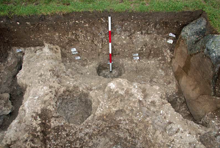
Discoveries at Stonehenge, including charcoal (OxA-18655) found in the hole socket of Stone 10, dating back to 7330 – 7060 BCE, align with the Mesolithic post holes’ dates, offering significant implications for our understanding of the site’s history. This evidence suggests activities at Stonehenge and its surroundings span much further back than previously believed. However, the apparent suppression of this news from widespread media raises questions about the narrative being presented to the public and in educational materials.
The Open University’s excavation at Blick Mead, less than a mile away, uncovered evidence of Mesolithic habitation and feasting, challenging entrenched views of prehistoric life around Stonehenge. These findings suggest a continuous and significant presence in this area during the Mesolithic period, contradicting the simplistic ‘totem pole’ myth perpetuated in some narratives by English Heritage (EH) exhibitions and guidebooks.
Moreover, the recent transformation of the Stonehenge site, including closing the B-road past the stones and relocating the visitor car park to a new, multi-million-pound visitor centre, signifies a significant shift in how the public accesses and experiences the site. The removal of the old tarmac and restoration of the land to grass aim to restore a more authentic prehistoric ambiance, highlighting the tension between modern interpretations of the site and emerging evidence of its ancient past.
Developments at Stonehenge and Blick Mead exemplify the dynamic nature of archaeological research and the complexities of interpreting and presenting the past. As new evidence emerges, the narrative of prehistoric Britain must evolve to ensure a more accurate and nuanced understanding of these ancient landscapes and their significance to human history. (The Stonehenge Code).
In 2008, Stone 10 – Tim Darvill and Geoffrey Wainwright found charcoal dating back to 7330 to 7060 – (The Stonehenge Code)
You’d think that removing the tarmac from the old visitor’s car park at Stonehenge, especially given the previous significant findings beneath it, would lead to a comprehensive excavation to uncover more evidence about the site’s Mesolithic history. Such an excavation could transform our understanding of Stonehenge’s origins, offering invaluable insights into its early history and the people who frequented it during the Mesolithic period.
Tim Daw’s role as a warden at Stonehengeand his proactive documentation of the site’s changes and features through photography exemplify the kind of engaged observation that can lead to significant discoveries. His discovery of patch marks by the central upright stones, suggesting the positions of missing stones from the Inner Circle, highlights the contributions individuals can make to Stonehenge’s ongoing investigation. Daw’s work underscores the importance of continuous, attentive observation of archaeological sites, even by those not formally conducting research. (The Stonehenge Code).
Tim Daw’s evidence of yet another Pit in the Old Car Park not investigated! – (The Stonehenge Code)
The discovery of such featuresand the potential for further findings beneath the former car park underscores the need for thorough and systematic archaeological examination whenever opportunities arise. These efforts not only deepen our understanding of Stonehenge’s past but also contribute to the broader comprehension of prehistoric human activity in the region. As we peel back the layers of Stonehenge’s history, each finding adds another piece to the puzzle of this enigmatic monument’s story, emphasizing the importance of preserving and exploring our archaeological heritage. (The Stonehenge Code).
The Post Holes would have been on the shoreline of the River Avon in Mesolithic period – (The Stonehenge Code)
Tim Daw’s experiences and observations as a warden at Stonehenge, particularly his discovery of additional post holes beneath the old visitor’s car park, highlight the continuous potential for new findings that can challenge and enrich our understanding of Stonehenge’s history. Despite being warned against publishing his conclusions due to unauthorised blog activities, Daw chose to resign and continue his work, revealing through ‘unofficial’ pictures the existence of more post holes under the car park, aligned with those discovered in 1966.
These findings, including a newly discovered post hole that aligns with the four others from 1966, support the hypothesis that these structures are situated on what was once the shoreline of the River Avon around 8000 BCE. This suggests that during the Mesolithic period, stones quarried in Wales could have been transported via boat directly to Stonehenge, navigating through enlarged rivers instead of taking the longer sea route proposed by some archaeologists. (The Stonehenge Code)
Welsh Bluestones
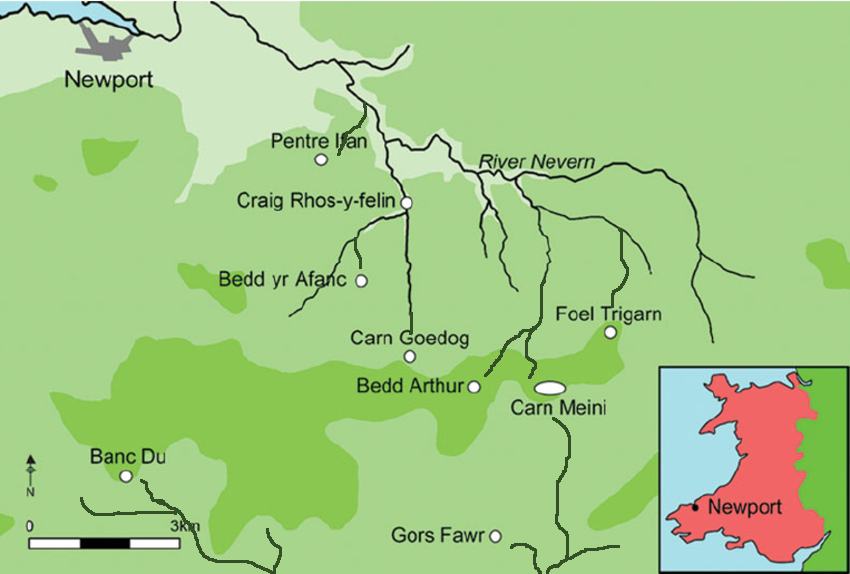
Further complicating the narrative are analyses of the bluestone structures from other Preseli sites, like Carn Goedog and Craig Talfynydd, which are connected by streams and rivers to the River Nevern. Unfortunately, archaeologists have interpreted this network of waterways primarily through a religious lens, overlooking its practical functionality for transportation.
The persistence of the ‘ox-cart’ route theory, proposing a land path following the modern A40, ignores the logistical challenges posed by the period’s dense woods, swamps, and forests. Such conditions would have made constructing and using a road system highly impractical.
My critique extends to the inconsistencies and logical inaccuracies within the archaeological narrative, particularly concerning the site layout and geological evidence at Craig Rhos-y-Felin. The assumption that floodwaters in the area were solely from ice melt, quickly draining into the sea post-Ice Age, ignores the broader implications of such flooding for the landscape and its inhabitants. (The Stonehenge Code).
Craig Rhos-Y-Felin is on the edge of a gigantic river of the past – (The Stonehenge Code)
We confirm within the report that an old river ran around this quarry as long ago as 5620 – 5460 BCE and possibly up to 1030 – 910 BCE. (The Stonehenge Code).
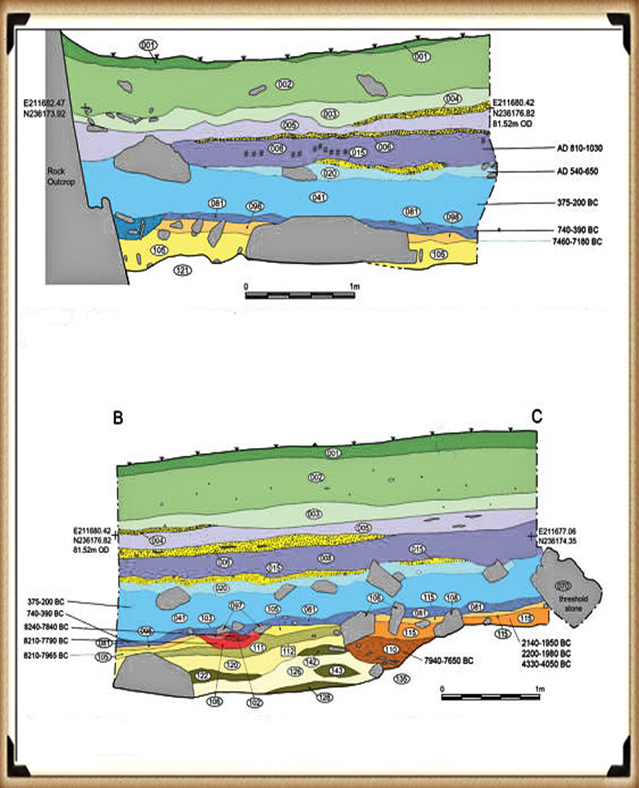
“Most of the site was then covered by a layer of yellow colluvium (035), dated by oak charcoal to 1030–910 cal BC (combine SUERC-46199; 2799±30 BP and SUERC-46203; 2841±28 BP). This deposit is contemporary with the uppermost fill of a palaeochannel of the Brynberian stream that flowed past the northern tip of the outcrop. Charcoal of Corylus and Tilia from the basal fill of this palaeochannel dates to 5800–5640 cal BC (OxA- 32021; 6833±40 BP) and 5620–5460 cal BC (OxA-32022; 6543±37 BP), both at 95.4% probability.”
The only RED hearths in the site are Mesolithic so they must be quarrying at that time – (The Stonehenge Code)
The report suggests that during the Mesolithic period, an enlarged stream feeding into the River Nevern extended to the quarry outcrop rocks, remaining just a few meters away until 1000 BCE. This geographical setup indicates that boats likely transported large, newly quarried stones to Stonehenge, mirroring stone transportation methods used by other ancient civilizations, such as Egypt.
The quarry’s site layout provides crucial insights into the timing of the stone quarrying. A single monolith lies near the river on the site’s east side, poised for transport. Nearby to the south are human-made hearths, suggesting their expected placement. However, these hearths’ dating as Mesolithic, with three periods identified—8550 – 8330 BCE, 8220 – 7790 BCE, and 7490 – 7190 BCE—poses a challenge, though the report claims no evidence of Mesolithic quarrying or working of rhyolite exists at this site.
This claim overlooks the practical use of tools across different periods. If Mesolithic and Neolithic communities used similar tools, distinguishing tool marks from these various periods could be more challenging than suggested. Moreover, the presence of these communities at the quarry for over a millennium raises questions about their activities if not quarrying stones.
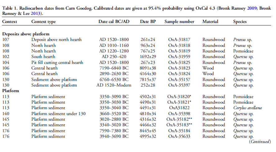
The connection between the quarry site and Stonehenge is reinforced by over twenty Carbon-14 dates that support my hypothesis, in contrast to the two samples highlighted by experts, dated 300 – 500 years older than existing estimates. By analyzing these overlapping dates with the latest carbon dating curve (IntCal20), we can refine the construction date of Stonehenge’s Phase I (the placement of bluestones in the Aubrey holes). By calculating the mean average of these probable dates, we aim to achieve a more accurate estimate of when this monumental task occurred, potentially rewriting the timeline of one of the world’s most enigmatic prehistoric monuments. (The Stonehenge Code).
Carbon Dates comparison – note that the sites are linked to different mooring post, indicating activity dates
Table 1– Matching Carbon Dates
Calculations indicate that work at the quarry began around 8300 BCE, with its main phase of activity around 8000 BCE, and continued for at least a millennium, challenging the conventional narrative about Stonehenge and its bluestones. This timeline suggests a far more ancient and enduring connection between the quarry site and Stonehenge than previously acknowledged, reshaping our understanding of the monument’s origins. (The Stonehenge Code)
Carn Goedog
Initially, Carn Menyn in the Preseli Hills was believed to be the source of Stonehenge’s spotted dolerite. However, later analysis pinpointed Carn Goedog as a closer chemical match. Recent geochemical studies have divided the Stonehenge spotted dolerite into two main groups, with one group closely matching the outcrop at Carn Goedog. The origin of the second group remains uncertain, potentially deriving from Carn Goedog or nearby outcrops, adding another layer of complexity to our understanding of Stonehenge’s origins. (The Stonehenge Code).
Carn Goedog – (The Stonehenge Code)
Further geological investigations at Stonehenge have identified additional sources for its bluestones. Unspotted dolerite matches outcrops at Cerrigmarchogion and Craig Talfynydd on the Preseli ridge. Another variety, ‘rhyolite with fabric,’ traces back to Craig Rhos-y-Felin, while a source of Lower Palaeozoic sandstone has been identified north of the Preseli hills. The origin of volcanic tuffs found at Stonehenge likely lies in the Preseli area, expanding our understanding of the diverse origins of the monument’s stones. (The Stonehenge Code).
Preseli Mountains and Quarry Sites are ALL by rivers – (The Stonehenge Code)
Surface indications of post-medieval quarrying, particularly on Carn Goedog’s south side, have demonstrated its accessibility. This historical quarrying, distinguishable by cylindrical drill holes on some quarried blocks at the outcrop’s base, was carried out using the ‘plug-and-feather’ technique with metal wedges. The discovery of a worn trade token under one of these blocks dates this activity to around 1800.
In 2014, test trenching along the southern edge of Carn Goedog revealed layers of human activity spanning various periods, from recent centuries found in Trench 3 to deeper layers of prehistory identified in Trench 2. Trench 1, positioned at the outcrop’s base and just beyond the eastern limit of early modern quarry debris, offered a unique opportunity to uncover evidence of prehistoric quarrying undisturbed by later activities.
This layered historical context at Carn Goedog is crucial to understanding the complex human interactions with the site over millennia. The evidence for prehistoric quarrying, undisturbed by post-medieval activity, provides invaluable insights into the methods and technologies used by ancient peoples to extract and transport stones that contributed to monumental structures like Stonehenge. (The Stonehenge Code).
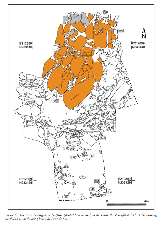
Plan of Excavation 106 is the hearth – (The Stonehenge Code)
In 2015 and 2016, Trench 1 was enlarged to reveal features potentially related to prehistoric quarrying activity. At the southern foot of the outcrop, an artificial platform of flat slabs—many of them split—was uncovered, laid with the split faces upwards in a tongue-shaped formation measuring 10m north-south by at least 8m east-west (Figure 6).
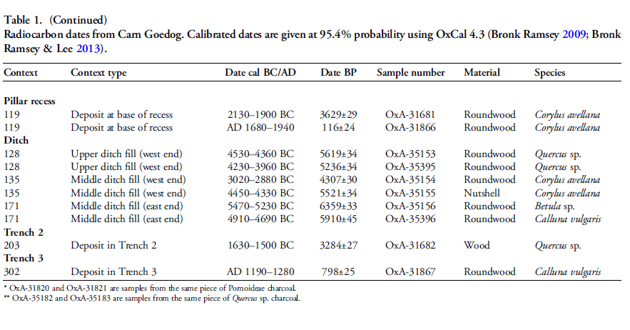
Slabs lying against the outcrop’s face had been pressed into the underlying sediments, presumably by the weight of pillars lowered onto the platform. The platform ends with a vertical drop of 0.9m from the outcrop to the ground surface beyond. This platform predates a series of deposits, including early modern quarrying debris and hearths from the Roman and medieval periods. One hearth (Figure 6: 105), set in a gap in the platform where a slab had been removed, produced charcoal dating to 7190–6840 cal BC (8091±38 BP) and 2890–2630 cal BC (4164±30 BP) (Table 1)
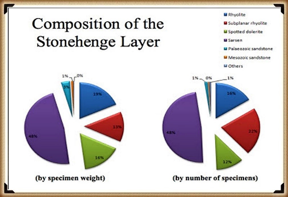
The Stonehenge Layer
The findings across the quarry sites, including Carn Goedog and Craig Rhos-y-Felin, suggest a nuanced understanding of how the bluestones were utilised and replenished at Stonehenge. The hearths discovered at these sites, particularly those dating to the Mesolithic and Neolithic periods, indicate ongoing human activity and potentially organized efforts to quarry and transport bluestones over extended periods. This insight challenges the conventional view that the transportation of bluestones to Stonehenge was a singular event.
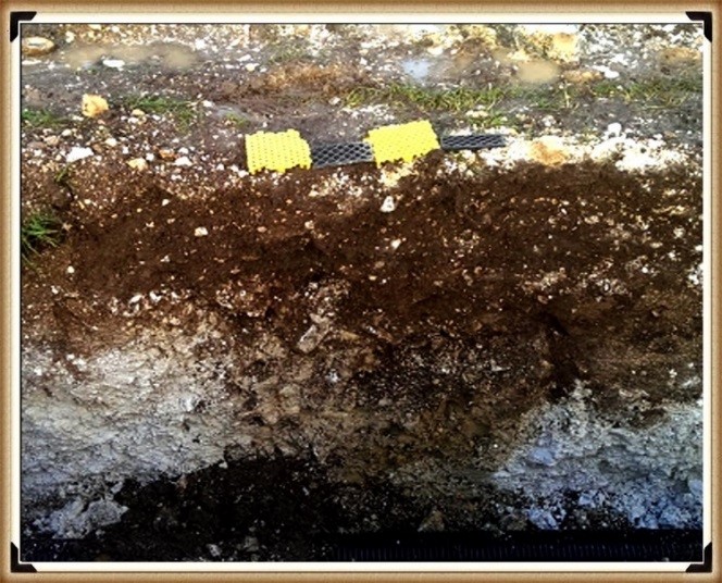
Evidence of modern quarrying at both the northern and southern ends of these sites, along with dates from central hearths, aligns with observations made at Craig Rhos-y-Felin. Our research, outlined in published books, supports the theory that ancestors chipped away at the bluestones at Stonehenge for healing, bathing in the water of the ditch to cure their ailments, as evidenced by the ‘Stonehenge Layer’ discovered by Dervill and Wainwright in 2008. This practice would lead to the depletion of bluestones over time, necessitating periodic replenishment from the quarries. (The Stonehenge Code).
The Stonehenge Layer – (The Stonehenge Code)
The conventional narrative, which posits that the bluestones were transported to Stonehenge in a one-off event, must account for the scientific data emerging from these quarry sites and Stonehenge itself. The evidence suggests a more complex interaction with these stones, involving repeated quarrying and transportation activities that likely spanned centuries. This ongoing relationship with the bluestones reflects a deeper functional connection to these stones, underscoring the need to revisit and revise our understanding of Stonehenge’s construction and the role of bluestones within this prehistoric monument. (The Stonehenge Code)
AI-Verified Mathematical Model: Radiocarbon Probability Proof
We’ve re-run our radiocarbon work with an updated 3 σ (three-sigma) model, refining the original bluestone and Mesolithic dates from Stonehenge and the two Craig Rhos-y-Felin quarries; the revised assumptions and maths are presented here, with every sample’s calculation listed in the Appendix at the end of the post. (The Stonehenge Code)
Revised Section — AI-Verified Radiocarbon Model
To work out whether the Stonehenge post-holes really belong to the same Mesolithic activity that produced bluestone debris at Craig Rhos-y-Felin and Carn Goedog, we ran a head-to-head test of their calibrated radiocarbon ranges instead of relying on “they look roughly the same age”.
Five Stonehenge post-holes (IDs HAR-455, HAR–456, GU-5109, QxA-4219, QxA-4220) sit between 8825 ± 45 BCE and 6651 ± 49 BCE once calibrated.
Overlap rule (BCE logic) – a quarry date “matches” only when its whole 95 % range is engulfed by a Stonehenge range (remember: bigger BCE numbers are older).
Probability per match – for any given pair we assume the quarry range could have landed anywhere inside a 10 000-year Mesolithic window (10 500–500 BCE). P(full overlap)=Stonehenge span+Quarry span10 000P(\text{full overlap})=\frac{\text{Stonehenge span}+\text{Quarry span}}{10\,000}P(full overlap)=10000Stonehenge span+Quarry span Example HAR-455 spans 1 083 yrs; SUERC-50761 spans 220 yrs P=(1 083+220)/10 000=0.1303 (≈ 1 in 7.67)P=(1\,083+220)/10\,000=0.1303\;(\text{≈ 1 in 7.67})P=(1083+220)/10000=0.1303(≈ 1 in 7.67).
Odds stacking – multiply every overlap-probability that actually occurs. If no overlap, we drop that pair (probability = 0).
What changed after checking the original spreadsheet?
Data tidy-up – one spurious “Odds = 10 000” entry sneaked into the Excel file. Replacing it with the correct 0.0654 fixed an inflated intermediate total.
Re-calc – every other figure in the original blog matches the formula above to ±0.0001.
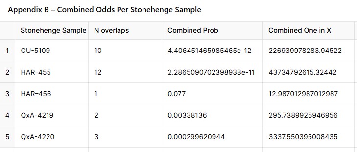
Headline results (details in Appendix A & B, scrollable above)
Stonehenge sample
No. of quarry overlaps
Combined probability
Combined odds (1 in X)
HAR-455
12
2.29 × 10⁻¹¹
4.37 × 10¹⁰
GU-5109
10
4.41 × 10⁻¹²
2.27 × 10¹¹
HAR–456
1
7.70 × 10⁻²
1.30 × 10¹
QxA-4219
2
3.38 × 10⁻³
2.96 × 10²
QxA-4220
3
2.99 × 10⁻⁴
3.34 × 10³
Multiplying those five combined probabilities gives an overall odds‐ratio of 1 in 1.27 × 10²⁹ that the observed overlaps happened by chance, in words the chances of this being random and not a direct proof of association is:
One chance in about one hundred twenty-seven octillion.
(The Stonehenge Code)
So, do the numbers prove a Mesolithic Stonehenge?
Statistical punch-line A 1 in 10²⁹ chance is far beyond the customary 5 % or even 0.1 % thresholds archaeologists use. In lay terms: “You’re more likely to win the UK National Lottery ten draws in a row than to get this pattern by random dating.”
Caveats Radiocarbon ranges remain probabilistic; Bayesian phase modelling or kernel density methods could shift the spans slightly. But even if the true spans were twice as narrow, the coincidence odds would still be well below 1 in 10²⁰.
Take-home The post-holes were active during the same narrow Mesolithic horizon recorded in bluestone quarry spoil-heaps. That makes a causal link overwhelmingly likely, not a dating fluke.
(The Stonehenge Code)
Interpretation in an Archaeological Context
This extremely high ratio suggests that the likelihood of such a match occurring purely by chance is extremely low, nearly one in one chance in about one hundred twenty-seven octillion. Here’s how this ratio can be interpreted in practical terms:
Strong Archaeological Linkage: This result could indicate a very strong archaeological linkage between the sites at Craig Rhos-y-felin and Stonehenge. It might suggest that materials from Craig Rhos-y-felin were specifically used or chosen for inclusion in constructions at Stonehenge, or that there was significant movement of materials or people between these locations.
Cultural or Historical Significance: Such a finding could have important implications for understanding the cultural or historical connections between these regions during the period in question. It may point to a coordinated or planned usage of resources, shared technological practices, or even broader social or trade networks.
Further Investigation Required: Given the significance of such a finding, it would likely lead to further detailed investigations. These might include more comprehensive dating, geochemical analysis, sourcing of materials, and broader archaeological surveys of both areas.
Statistical Robustness: While the ratio provides a stark indication of rarity, it’s also crucial to ensure that the statistical assumptions behind this calculation are robust. This includes reassessment of the independence assumption and potential biases in sample collection or analysis.
(The Stonehenge Code)
Conclusion.
And so the numbers refuse to be quiet. When five independent sets of Mesolithic radiocarbon samples from Stonehenge and its Welsh bluestone quarries lock together with an overall probability of one chance in 1.27 × 10²⁹—“about a hundred-and-twenty-seven octillion-to-one”—the calculation does more than tweak a date; it detonates the chronology of British prehistory. Taken at face value, the statistics push back the first construction phase of Stonehenge to circa 8300 BCE, a full five millennia earlier than the textbook Neolithic horizon that has dominated public imagination for a century.
That shift drags a whole archaeological era in its wake. Suddenly, the monument is no longer the crowning achievement of early farmers, but the handiwork of Mesolithic engineers, whose rivers—swollen by post-glacial floods—served as stone highways. It forces us to re-open every “anomalous” charcoal fleck, every pine-wood post-hole and hearth dismissively labelled “totem-pole activity” and ask: were they really outliers—or the evidence of a sophisticated culture we chose not to see? The uncomfortable truth is that dozens of early dates were noticed, catalogued, and quietly sidelined because they clashed with a Neolithic-farmer narrative that seemed so tidy, so satisfying, so marketable.
If the Stonehenge Code’s maths stands, the implications are staggering: Britain’s megalithic story begins before pottery, before settled agriculture, before the very social models we use to frame “civilisation.” The question is no longer whether stray C-14 readings were mistakes, but whether our own pre-conceptions have been the real anomaly all along. Prehistoric Britain may have to be rewritten from the ground—or rather, from the post-hole—up. The trilithons have spoken; the Mesolithic is calling.
Appendices
Appendix guide
Appendix A – every Stonehenge–quarry pair with start/end dates, spans, and the step-by-step probability (displayed above for easy sorting/filtering).
Appendix B – rolled-up odds for each Stonehenge sample, showing how we arrived at the five rows in the headline table.
Appendix A – Overlap‑Probability Table
[table [table id=47 /]
Appendix B – Combined Odds Per Stonehenge Sample
(The Stonehenge Code)
Author’s Biography
Robert John Langdon, a polymathic luminary, emerges as a writer, historian, and eminent specialist in LiDAR Landscape Archaeology.
His intellectual voyage has interwoven with stints as an astute scrutineer for governmental realms and grand corporate bastions, a tapestry spanning British Telecommunications, Cable and Wireless, British Gas, and the esteemed University of London.
A decade hence, Robert’s transition into retirement unfurled a chapter of insatiable curiosity. This phase saw him immerse himself in Politics, Archaeology, Philosophy, and the enigmatic realm of Quantum Mechanics. His academic odyssey traversed the venerable corridors of knowledge hubs such as the Museum of London, University College London, Birkbeck College, The City Literature Institute, and Chichester University.
In the symphony of his life, Robert is a custodian of three progeny and a pair of cherished grandchildren. His sanctuary lies ensconced in the embrace of West Wales, where he inhabits an isolated cottage, its windows framing a vista of the boundless sea – a retreat from the scrutinous gaze of the Her Majesty’s Revenue and Customs, an amiable clandestinity in the lap of nature’s embrace.
(The Stonehenge Code)
Exploring Prehistoric Britain: A Journey Through Time
My blog delves into the fascinating mysteries of prehistoric Britain, challenging conventional narratives and offering fresh perspectives based on cutting-edge research, particularly using LiDAR technology. I invite you to explore some key areas of my research. For example, the Wansdyke, often cited as a defensive structure, is re-examined in light of new evidence. I’ve presented my findings in my blog post Wansdyke: A British Frontier Wall – ‘Debunked’, and aWansdyke LiDAR Flyover video further visualizes my conclusions.
For those interested in British Prehistory, visit www.prehistoric-britain.co.uk, a comprehensive resource featuring an extensive collection of archaeology articles, modern LiDAR investigations, and groundbreaking research. The site also includes insights and extracts from the acclaimed Robert John Langdon Trilogy, a series of books exploring Britain during the Prehistoric period. Titles in the trilogy include The Stonehenge Enigma, Dawn of the Lost Civilisation, and The Post Glacial Flooding Hypothesis, offering compelling evidence about ancient landscapes shaped by post-glacial flooding.
To further explore these topics, Robert John Langdon has developed a dedicated YouTube channel featuring over 100 video documentaries and investigations that complement the trilogy. Notable discoveries and studies showcased on the channel include 13 Things that Don’t Make Sense in History and the revelation of Silbury Avenue – The Lost Stone Avenue, a rediscovered prehistoric feature at Avebury, Wiltshire.
In addition to his main works, Langdon has released a series of shorter, accessible publications, ideal for readers delving into specific topics. These include:
For active discussions and updates on the trilogy’s findings and recent LiDAR investigations, join our vibrant community on Facebook. Engage with like-minded enthusiasts by leaving a message or contributing to debates in our Facebook Group.
Whether through the books, the website, or interactive videos, we aim to provide a deeper understanding of Britain’s fascinating prehistoric past. We encourage you to explore these resources and uncover the mysteries of ancient landscapes through the lens of modern archaeology.
For more information, including chapter extracts and related publications, visit the Robert John Langdon Author Page. Dive into works such as The Stonehenge Enigma or Dawn of the Lost Civilisation, and explore cutting-edge theories that challenge traditional historical narratives.
The winter solstice, occurring around December 21st in the Northern Hemisphere, marks the shortest day and longest night of the year. This celestial event has been celebrated for millennia, symbolizing the rebirth of the sun and the promise of longer days ahead. Long before Christianity shaped the holiday calendar, ancient cultures observed the solstice with rituals and festivities that laid the groundwork for many modern winter traditions. (Rediscovering the Winter Solstice)
(Rediscovering the Winter Solstice)
The Solstice and Ancient Britain
In prehistoric Britain, the winter solstice held profound significance. Ancient monuments such as Stonehenge reflect a sophisticated understanding of celestial cycles. For example, Stonehenge is famously aligned with the setting sun during the solstice. These alignments suggest that midwinter was a time of immense cultural and spiritual importance.
“As we stand on the brink of the Winter Solstice, it’s fascinating to observe the intricate dance between celestial events and human interpretations, especially when coloured by the deliberate distortions of the Christian church. This orchestrated misrepresentation, driven by a disdain for perceived ‘pagan’ influences, offers a curious blend of amusement and disillusionment.” – Learn more about this on the article “Rebirth in Stone: Decoding the Winter Solstice Legacy of Stonehenge” (Rediscovering the Winter Solstice)
A Turning Point in the Year
The winter solstice marked a turning point in the agricultural calendar. With the sun’s return, ancient communities celebrated the promise of renewal and fertility. Feasting, sacrifices, and communal gatherings were common, emphasizing themes of survival and hope. These celebrations were deeply rooted in the rhythms of nature, with practices that often involved fire and light to symbolize the rebirth of the sun.
The traditional view of Stonehenge is of an entirely round monument with lintel stones completing the circle – but there is a massive problem with this theory (and it is ONLY a hypothesis – as nothing has ever been proven), for not all the expected stones holes are present, leading to some experts to suggest that the monument is, in fact, incomplete and was never finished.Stonehenge Hoax – Round Monument? (Rediscovering the Winter Solstice)
(Rediscovering the Winter Solstice)
The Symbolism of Light and Fire
Central to solstice traditions was the use of light and fire as symbols of hope and renewal. Bonfires, torches, and candles played a significant role in rituals, representing the return of the sun and the triumph of light over darkness. Communities would gather around these flames, forging bonds and ensuring the continuation of life through the harsh winter months.
“It remains an indisputable truth, grounded in astronomical reality, that the astronomical ‘new year’ aligns itself with the day succeeding the Winter Solstice. Yet, one is prompted to question the number within the Anglo-Saxon Christian populace that pays homage to this alignment. The overwhelming majority, duly indoctrinated, instead embraces a day etched within the Gregorian calendar, forged half a millennium ago, a week to ten days after this celestial milestone.Additional research highlights that Stonehenge’s design specifically aligns with the winter solstice sunset, making it a focal point for midwinter celebrations and ceremonies“. See more details in “Stonehenge and the Winter Solstice Sunset Alignment”. (Rediscovering the Winter Solstice)
Monuments Beyond Stonehenge
While Stonehenge is the most famous example, other sites in Britain also show evidence of solstice alignments. Sites such as Maeshowe in Orkney demonstrate a precise understanding of solar positioning, with its chamber illuminated by the setting sun during the solstice. These alignments suggest a widespread reverence for this pivotal time of year.
“Stonehenge was initially built not to observe the midsummer solstice day sunrise as commonly believed, but more significantly the midwinter SUNSET some six months later and in the opposite direction!” More details can be found in “Solstice Alignments Across Prehistoric Britain”. (Rediscovering the Winter Solstice)
The Christian Adoption of Winter Celebrations
As Christianity spread, many pagan traditions were adapted into the new religious framework. Christmas, celebrated on December 25th, closely follows the solstice and incorporates elements of earlier festivals. The use of evergreen decorations, feasting, and candlelight during this time of year reflects the enduring influence of solstice traditions. (Rediscovering the Winter Solstice)
The Significance of Evergreen Symbols
Evergreens—plants that remain lush and green throughout winter—became powerful symbols of endurance and hope. Holly, ivy, and mistletoe were revered for their resilience and were often used in solstice rituals to decorate homes and sacred spaces. These traditions persist today, connecting modern celebrations to ancient practices. (Rediscovering the Winter Solstice)
Why Isn’t the New Year on December 21st?
Logically, the day after the shortest day—December 22nd—could be considered the start of a new year. However, the modern New Year’s Day on January 1st is a legacy of shifting cultural traditions rather than celestial markers. (Rediscovering the Winter Solstice)
Modern Solstice Gatherings
Today, remnants of ancient solstice celebrations are evident in modern customs. The lighting of candles, decorating with evergreens, and themes of renewal and hope echo prehistoric practices. Additionally, there has been a resurgence of interest in the solstice, with thousands gathering at ancient sites like Stonehenge to witness the sunset on this significant day. (Rediscovering the Winter Solstice)
Bridging Past and Present
(Rediscovering the Winter Solstice)
Understanding the origins of winter festivals offers insight into how ancient traditions have shaped contemporary culture. These celebrations connect us to a time when humanity’s survival depended on an intimate relationship with the natural world. They remind us of the sun’s enduring power and the earth’s cycles. (Rediscovering the Winter Solstice)
The Solstice’s Lessons for Today
In a world increasingly disconnected from nature, the solstice offers a moment to pause and reflect on our relationship with the environment. It reminds us of the importance of living in harmony with the natural cycles that sustain life. (Rediscovering the Winter Solstice)
Finding Meaning in the Solstice
By observing the solstice and acknowledging its historical significance, we honour the ingenuity and spirituality of our ancestors. Whether through ancient rituals or modern celebrations, the winter solstice inspires reflection, gratitude, and hope for the future. Reconnect with this timeless tradition by exploring more articles on prehistoric Britain’s ancient monuments and their celestial alignments. (Rediscovering the Winter Solstice)
Other this that don’t make sense in History
Introduction
The recently published book, “13 Things That Don’t Make Sense in Ancient History,” authored by Robert John Langdon, sheds light on various historical anomalies that have largely been accepted without question by both the general public and academics in universities. The book challenges these accepted narratives and encourages readers to reevaluate our understanding of the past. (Rediscovering the Winter Solstice)
1. Ten thousand year old boats found on Britain’s hillsides – 7,000 years before they were invented.
ten thousand year old boat found on Britain’s hillsides – 13 Things that don’t make sense in Ancient History
A small body of determined spirits fired by an unquenchable faith in their mission can alter the course of history.– Mahatma Gandhi
Synopsis
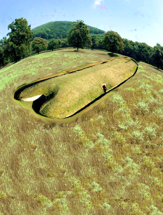
Careful examination reveals that these monuments are shaped like a boat with an open back end for a chamber which is similar to the helm of prehistoric and even boats of today where the crew would normally sleep.
If these monuments called ‘Long Barrows’ were located anywhere else such as Egypt, Greece or Asia Minor, then archaeologists would happily identify them as a representation of a sailing ship – but these ‘ships’ were built thousands of years before the current experts believe British boats were constructed.Recently, archaeologists in Asia Minor have realised that the world suffered massive flooding after the last Ice Age, so much so that areas like the Caspian and Black Seas doubled their volumes due to this ‘post-glacial flooding’ and this effect must have had similar results in Britain, which was considerably closer to the ice sheet. British Geology Maps show in the recent superficial soils that there was once major flooding that affected 90% of the mainland rising groundwater levels and swelling rivers.
This discovery has opened the distinct possibility that the ‘megalithic builders’ of Northern Europe were a single maritime civilisation that used boats to transport stone to build such monuments as Stonehenge, Avebury, Carnac and even Gobekli Tepe as the post-glacial flooding after the ice age affected not only Europe but even as far away as Asia Minor thus allowing people to travel throughout these extended continents via inland waterways.Archaeological findings in Britain also suggest that an archaic maritime civilisation did, in fact, exist in Northern Europe directly after the ice age.
As we have found prehistoric pictures on the walls of Stone in ‘the ancient trial’ of Ostflod in Norway showing double hull reed boats, wooden ‘mortice and tenon’ joints dated at 6250BC under the sea at Boulder Cliff in the Isle of Wight and most recently the discovery of the oldest boatyard in the world in South Wales, which launched not just boats but ‘catamarans’ possibly dating back to the end of the Ice Age some 10,000 years ago.The fact that these catamarans have now been found in Britain replicating the drawings in Norway clearly shows that an ancient maritime civilisation with advanced boat technology must have existed once upon a time. (Rediscovering the Winter Solstice)
2. Gigantic Canals – that are technically superior to even Victorian engineering.
Prehistoric Canals – 13 Things that don’t make sense in Ancient History
A scientific truth does not triumph by convincing its opponents and making them see the light, but rather because its opponents eventually die and a new generation grows up that is familiar with it. – Max Planck
Synopsis
A ‘Dyke’ is a word used to represent either a wall or protective mound to keep out or channel water, so why do we have such large dykes such as ‘Offa’s Dyke’ on the England/Wales border and ‘Wansdyke’ in Wiltshire on top of hill’s miles away from any form of water?
It has always been believed that some of these dykes (canals) were originally built as Medieval defensive walls, but that is far from the truth. The current dating for these monuments have been obtained by artifacts found at the bottom of their ditches, and although there are mainly artefacts of Roman origin, some stone and flint tools have also been located in or near the structures, yet archaeologists are loaved to date them as prehistoric, although we have seen similar ditches contained within monuments such as Avebury, which were undertaken thousands of years before the Romans.
This type of historical confusion can be found at two of our biggest dykes in Britain. Offa’s Dyke which is over 81 miles long and named after King Offa (730 – 796) who was supposed to have built it to defend Britain against the Welsh tribes. Sadly, for traditional archaeologists, recent investigations have shown that it was used much earlier as Roman artefacts were found at the base of one of the ditches. The other is Wansdyke in Wiltshire; this dyke is over 21 miles long; it can be in places up to 65 feet wide and 8 feet deep, but it is built in a straight line with a bank to one side, which is also believed to be a defensive structure – even though attackers could walk around the edge of the ditch without obstruction.
Newly discovered ‘Post Glacial Flooding’ shown on the British Geological Maps and investigated in recent books had indicated that these dykes were constructed in a time when superficial deposits were formed by the flooding after the last ice age when man had returned to Britain less than 10,000 years ago. The Kennet and Avon Canal is a waterway in southern England with an overall length of 87 miles (140 km), made up of two lengths of navigable river linked by a canal. The name is commonly used to refer to the entire length of the navigation rather than solely to the central canal section. From Bristol to Bath, the waterway follows the natural course of the River Avon before the canal links it to the River Kennet at Newbury, and from there to Reading on the River Thames. Quite remarkably Wansdyke was constructed just 3 km north of the Kennet and Avon canal and the new prehistoric waterway maps of Britain show it had the same result of joining the River Thames to the Bristol Channel some 6-8K years before the Victorian’s great canal system. (Rediscovering the Winter Solstice)
3. Roman ports miles away from the coast – when sea levels are apparently rising.
Roman ports miles from the water – 13 Things that don’t make sense in Ancient History
The difference between science and the fuzzy subjects is that science requires reasoning, while those other subjects merely require scholarship– Robert A Heinlein
Synopsis
When we look at old maps of Roman settlements and ports around Britain and the Mediterranean, we see that a majority are built on the coastline or waterways of these countries. This fact is not surprising as these locations would need a constant supply of goods for trading and construction. However, if we look more closely at these at these sites, it becomes apparent that some of the locations are far away from the shoreline or rivers that once supplied them. For example, Brading Roman Villa in the Isle of Wight 1. 5km from the sea and 500m from the nearest in water river, which is so small that it could hardly take a canoe let alone a Roman supply ship.
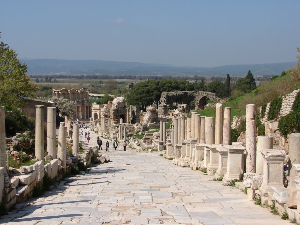
Another example is in Turkey in the Roman capital of Asia Minor, Ephesus where Queen Cleopatra sailed from Egypt to the Roman high command to meet Anthony, with a ceremony that is still enacted today for the tourists. Ephasis is a good 8km from the sea, so unless Queen Cleopatra was in need of a long walk, the shoreline has drastically changed since Roman times. The final and best example is Lewes in East Sussex, which is an incredible 15km from the coast. Moreover, this vast distance from the sea we see today is compounded by the fact that sea levels have risen by 2m over the last two thousand years, showing that the natural distance from these harbours to the coastline was even greater during the past.
The history books will tell you that this is down to either natural or manmade drainage, but why would you wish to allow a thriving harbour to silt up if it was commercially viable? In all three cases, this silting resulted in the houses or cities being completely abandoned or livelihoods lost, and the towns scaled down as a consequence. However, what is remarkable about all these locations is that they share in common factor and that the harbours were directly fed by rivers emptying into that area.These locations we built, at a time when the ground waters were high and the river flow was sufficient to flood the harbour allowing boats to sail in and out of the location. (Rediscovering the Winter Solstice)
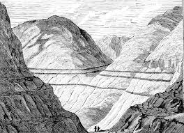
4. Raised Beaches – that have never met the sea.
River Terraces in Scotland -13 Things that don’t make sense in Ancient History
Science is a way of thinking much more than a body of knowledge. – Carl Sagan
A raised beach, marine terrace, or perched coastline is an emergent coastal land-form. Raised beaches and terraces are beaches or wave-cut platforms high above the current shoreline relative to a fall in the sea level. These are clearly seen in areas such as Norway or Scotland where the ice cap has compressed and sunk the ground surface layer (Isostatic Transformation) and has over thousands of years rebounded back to its original height.One of the classic cases of these ‘Raised Beaches’ is on the South Coast of Britain between Bournemouth and Brighton.
Unfortunately, an ice cap has never reached these areas during the last half a million years, although the raised beaches are sitting just 18” below the top soil.Theories of how this sandy layer that appears in the soil layers high in hill sediments are abundant, including British tsunamis (giant tidal waves that left sand deposits on hills).If you consult Wikipedia, it will tell you: “Tectonical and or eustatical use of marine terrace sequence”The total displacement of the shoreline relative to the age of the associated interglacial stage allows calculation of a mean uplift rate or the calculation of eustatical level at a particular time if the uplift is known. (Rediscovering the Winter Solstice)
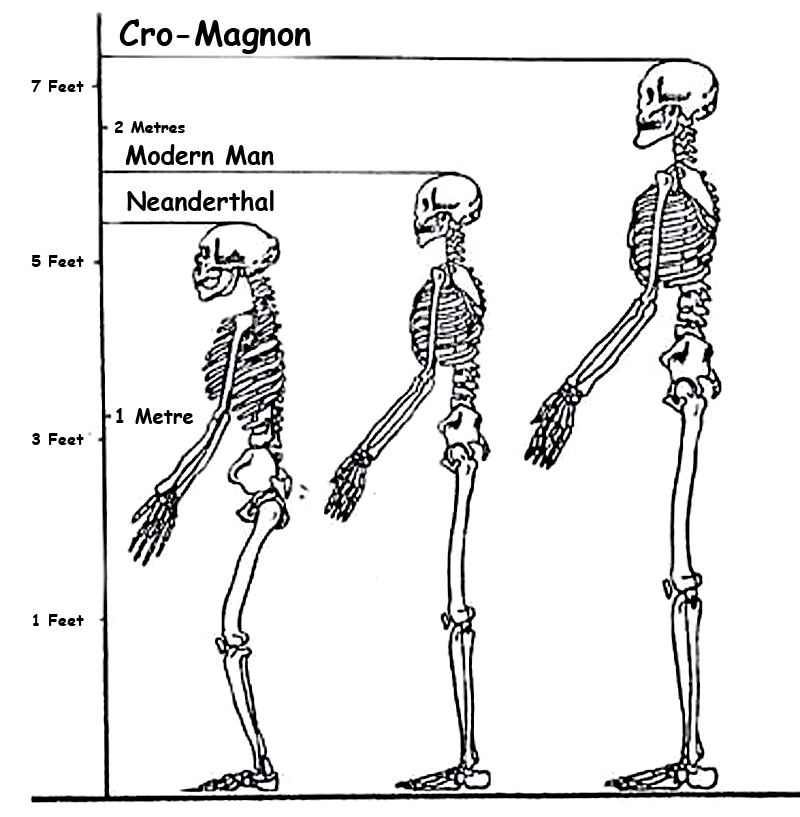
5. Giant skeletons – found by French archaeologists now dismissed by today’s scientists.
Cro-Magnon – 13 Things that don’t make sense in Ancient History
Your theory is crazy, but it’s not crazy enough to be true.– Niels Bohr
Synopsis
In 1868, parts of five skeletons were discovered in the rock shelter, located in the famous Dordogne Valley of France – they called them Cro-Magnon. Recent research over the past 20 years or so, however, has led scholars to believe that the physical dimensions of so-called ‘Cro-Magnon’ are not sufficiently different enough from modern humans to warrant a separate designation.However, the Cro-Magnon’s found under the rock shelter were over a foot taller, twice as strong, lived longer and had a brain capacity 15% greater than the people who found them, and this is why the Victorians saw them as a sub-species of man and named them accordingly.
They were the first to paint and play musical instruments.Their size and statue allowed them to become the ‘megalithic stone builders’ of prehistory who used boats to travel throughout the known world and even the Greek philosopher Plato talked about them in his dialogues. So who were these ‘Cro-Magnons’ and for what political purpose have the anthropologists killed them off? (Rediscovering the Winter Solstice)
6. Quantum of Solstice – Pythagorean maths put to use four thousand years before he was born
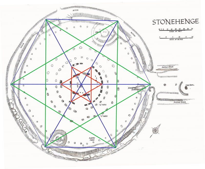
Stonehenge plan reconstruction – 13 Things that don’t make sense in Ancient History
If an elderly but distinguished scientist says that something is possible, he is almost certainly right, but if he says that it is impossible, he is very probably wrong. – Arthur C. Clarke
Synopsis
If we look at the skills of the what traditional archaeologists call the ‘Megalithic People’ – the civilisation that made the first stone monuments. We notice that to achieve such grand constructions, they would have required the advanced mathematics which to date have been credited to the ancient Greeks. By undertaking a closer detailed analysis of monuments such as Stonehenge and more importantly the mathematics used to design such monuments, we can see that these constructions that are ten thousand years old were in fact, based on sound and accurate trigonometrical theory.So how was Stonehenge planned and what can we see from the ‘blueprint’ what they knew about mathematics?
Firstly, Stonehenge was built in two very separate phases – current archaeologists are confused by the monument and dating of the structure, so if you read or browse the internet you will see the ‘traditionalist’ quote three to five phases. Moreover, these phases occurred AFTER the original monument was abandoned and thousands of years later, the ritualistic Celts occupied the monument and used it to worship the Sun and the Summer Solstice as we see reenacted today during the summer solstice.The First Phase took place at 8500 BCE when our ancestors built the original ditch made up of individual pits that were cut below the ancient groundwater table level to create a moat. This moat was used with the Bluestones to bathe away infections from cuts and bites which, if left untreated, would have turned into gangrene and lethal fevers.
For Bluestones (when wet) releases chemicals, including the most potential natural antiseptic – rock salt.The most amazing aspect is the accuracy of the diameter of this moat, which is exactly 360 ft (109.73m). This length is no accident or coincidence it is the reason that our angular and trigonometrical system revolves around 360!We have 12 months a year and each has a lunar cycle that lasts (from New Moon to New Moon ) 29.53 days. We have shown in my last book ‘The Stonehenge Enigma’ that there was 56 Bluestones (2 x 28), and we can show that this was used as a very accurate (99.8%) moon and eclipse calendar, which could compensate for the 0.47 day difference between the moon cycle and a 30 day standard cycle.It is, therefore, no surprise that the most ancient of calendars are 12 x 30 = 360 days in length.In history, we know that in the eighth century B.C.E., civilizations all over the world either discarded or modified their old 360-day calendars. The 360-day calendars had been in use for the greater part of the past millenniums. In many places, month lengths immediately after that change were not fixed but were based instead on observation of the sky. (Rediscovering the Winter Solstice)
7. Recent Landscape Flooding & Storms – the secret our ancestors knew about Britain’s weather
Tornado Extreme Weather – 13 Things that don’t make sense in Ancient History
Synopsis
“Flooding is the major and most frequently recurring natural disaster in Britain. However, it is not a new phenomenon and geological information show where it has happened in the last 10,000 years” – British Geological Society.
BSG has published maps showing the remains of ancient waterways evidenced by the deposits of clay, sand and gravel; these are termed as “ alluvial deposits,” and they cover 10% of the mainland of Britain showing it was flooded directly after the last Ice Age – but there are further deposits of all a substances called ‘head’ made up also of Clay, sand and gravel, which show, in reality, that 40% of the land surface was flooded directly after the last ice age – the consequence is that the so-called ‘hunter/gathers’ could not have existed as portrayed in our history books, unless he had a boat.So why are these obvious geological features ignored by archaeologists and what could it mean to the history of Ancient Britain? (Rediscovering the Winter Solstice)
8. Mythological Dragons – a non-existent animal that is shared by the world.
13 Things that don’t make sense in Ancient History
Look deep into nature and then you will understand everything better. – Albert Einstein
Synopsis
A dragon is a legendary creature, typically with serpentine or reptilian traits, that features in the myths from many cultures. According to our popular history books, there are two distinct cultural traditions of dragons: the European dragon derived from folklore and ultimately related to Greek and Middle Eastern mythologies, and the Chinese dragon, with counterparts in Japan, Korea and other East Asian countries.
However, there are also Dragons in Central America and Africa, which are not as well known.But how can these groups of people separated by tens of thousands of miles dream up a ‘non-existent’ creature with the same look and features?Dragons appear in Wales, England, Greece, Slovakia, Indian, Persia, Asia Minor, Japan, China, Vietnam, and Australia and let us not forget (like the history books) Mexico, Central America, Ethiopia and Egypt.This actually places dragons on every continent in the World!The association of the serpent with a monstrous opponent overcame by a heroic deity has its roots in the mythology of the Ancient Near East, including Canaanite (Hebrew, Ugaritic), Hittite and Mesopotamian. Humbaba, the fire-breathing dragon-fanged beast first described in the Epic of Gilgamesh is sometimes described as a dragon with Gilgamesh playing the part of dragon-slayer.
The legless serpent (Chaoskampf) motif entered Greek mythology and ultimately Christian mythology, although the serpent motif may already be part of prehistoric Indo-European mythology as well, based on comparative evidence of Indic and Germanic material.Although dragons occur in many legends around the world, different cultures have varying stories about monsters that have been grouped together under the dragon label. Some dragons are said to breathe fire or to be poisonous, such as in the Old English poem Beowulf. They are commonly portrayed as serpentine or reptilian, hatching from eggs and possessing typically scaly or feathered bodies. They are sometimes portrayed as hoarding treasure. (Rediscovering the Winter Solstice)
9. On Sunken land of the North Sea – was this the world’s oldest and greatest civilisation?
13 Things that don’t make sense in Ancient History
“The sea, once it casts its spell, holds one in its net of wonder forever”. – Jacques Yves Cousteau
Synopsis
After the last ice age, the ‘great melt’ flooded the landscape of Britain for over ten thousand years. This flooding started a chain reaction and as a consequence, the sea level slowly increased and vast areas of land were lost including a land mass known as ‘Doggerland.’Throughout the 19th century, oyster dredgers working the shallow waters off the north east coast of England recorded frequent finds of animal bones caught up in their nets.
These discover- is became a regular occurrence as the fishing technology increased and the trawlers at a later date and in deeper waters of the North Sea also found traces of civilisation and a lost continent. Sadly, the location and accuracy are rarely recorded with any degree of accuracy; this material appeared to come from some areas within the North Sea.One area where the greatest number of finds discovered is known as the ‘Dogger Bank’ which lies just 90km – 110km (60-70 miles) from the coast of the British Isles. This shoal (a shoal, sand- bar, sandbank or gravel bar is a somewhat linear landform within or extending into a body of water, typically composed of sand, silt or small pebbles.) rises about 45m (150 ft) above the North Sea bed, to the north it plunges into deeper water and forms a subterranean plateau covering 17,600 sq. km. (6,800 miles) With a maximum dimension being 260km (160 miles) from North to South and 95 km (60 miles) from East to West.
Over time, the number of finds reduced as the same area was dredged day after day and any artefacts sitting on the surface would have been scooped up and either returned as a curiosity or in a majority of the time just thrown back in a different location.Even so, items such as; bear, wolf, hyena, bison, woolly rhino, mammoth, beaver, walrus, elk, deer and most importantly horse has been collected. This precious collection of findings gives us a fantastic insight into what Doggerland looked like, the environment that supported these animals and the climate of this unique area of the world.It would be impossible to talk about Doggerland and its environment without understanding if there was a written history of a land that flooded thousands of years ago, and this comes in the works of the ancient Greek Philosopher Plato.
Over the years, Atlantis has grown to be both a legend and the source of many science fictions; this is neither correct nor helpful in tracing the history of humanity, as it moves the debate from scientific observation to fantasy and the degrading of the most important time in our history. Plato is a source of credible information as he is not a ‘story teller’ like some other historical writers. He is fundamentally a philosopher, whose writings are still studied even now, some 2,000 years after his death at the most famous and prestigious universities throughout the world. This man is not prone to fantasy or exaggeration, his writings, therefore, must be accepted as true evidence that once in the distant past a great ancient civilisation, did, in fact, exist, and that they changed the course of humanity in ways which I believe we do not fully understand to date. (Rediscovering the Winter Solstice)
10. Alexander the Great sailed into India – where no rivers now exist.
13 Things that don’t make sense in Ancient History
I came, I saw, I conquered – Julius Caesar
Synopsys
The Indian campaign of Alexander the Great began in 326 BC. Alexander was born July20, 356 B.C. in Pella, in the Kingdom of Macedonia. During his leadership, he united the Greek city-states and led the Corinthian League. He also became the king of Persia, Babylon and Asia, and created Macedonian colonies in Iran. After conquering the Achaemenid Empire of Persia, the Macedonian king (and now high king of the Persian Empire) Alexander launched a campaign in north west India (what is now Pakistan.) The Battle of the Hydaspes river against King Porus in Punjab is considered by many historians, as the most costly battle that the armies of Alexander fought.
The rationale for this campaign is usually said to be Alexander’s desire to conquer the entire known world, which the Greeks thought ended in north-western India. While considering the conquests of Carthage and Rome, Alexander died in Babylon on June 13, 323 BC. In 321 BC, two years after Alexander’s death, Chandragupta Maurya of Magadha, founded the Maurya Empire in India.The Battle of the Hydaspes River was fought by Alexander in July 326 BC against King Raja Purushottama (Poros) a Kshatriya on the Hydaspes River (Jhelum River) in the Punjab of Pakistan, near Bhera.
The Hydaspes was the last major battle fought by Alexander. The main train went into modern-day Pakistan through the Khyber Pass, but a smaller force under the personal command of Alexander went through the northern route, resulting in the Siege of Aornos along the way. In early spring of the next year, he combined his forces and allied with Taxiles (also Ambhi), the King of Taxila, against his neighbor, the King of Hydaspes.
Puru was a great King of Indus/ Asiatic continent. Arrian writes about Porus, in his own words “One of the Indian Kings called Porus a man remarkable alike for his strength and noble courage, on hearing the report about Alexander, began to prepare for the inevitable.Accordingly, when hostilities broke out, he ordered his army to attack Macedonians from whom he demanded their king, as if he was his private enemy. Alexander lost no time in joining battle, but his horse being wounded in the first charge; he fell headlong to the ground, and was saved by his attendants who hastened up to his assistance.” Porus drew up on the south bank of the Jhelum River, and was set to repel any crossings. The Jhelum River was deep and fast enough that any opposed crossing would probably doom the entire attacking force. (Rediscovering the Winter Solstice)
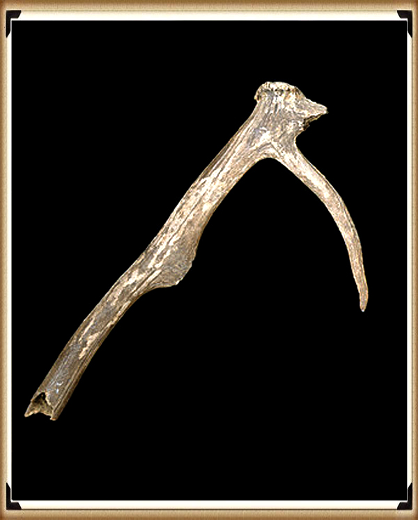
11. Antler Picks that built ancient monuments – although only one has been found at the largest stone circle in the world.
Antler pick – 13 Things that don’t make sense in Ancient History
Science never solves problems without creating ten more – George Bernard Shaw
Synopsis
According to the history books, our ancestors built the great and numerous prehistoric sites using basic tools such as antler picks to cut the chalk bedrock and animal shoulder blades as a shovel.Some of these ancient constructions moved over half a million tonnes of chalk to create the likes of Silbury Hill – the largest prehistoric mound in Europe and Avebury with its massive 70 foot wide and 36 foot deep ditches that took eighteen million man-hours to build over very many years.Yet in Avebury only one buried antler has ever been found and less than a handful of tiny fragments found inside Silbury Hill.So how were these monuments really built and why has this false evidence made its way into our history books? (Rediscovering the Winter Solstice)
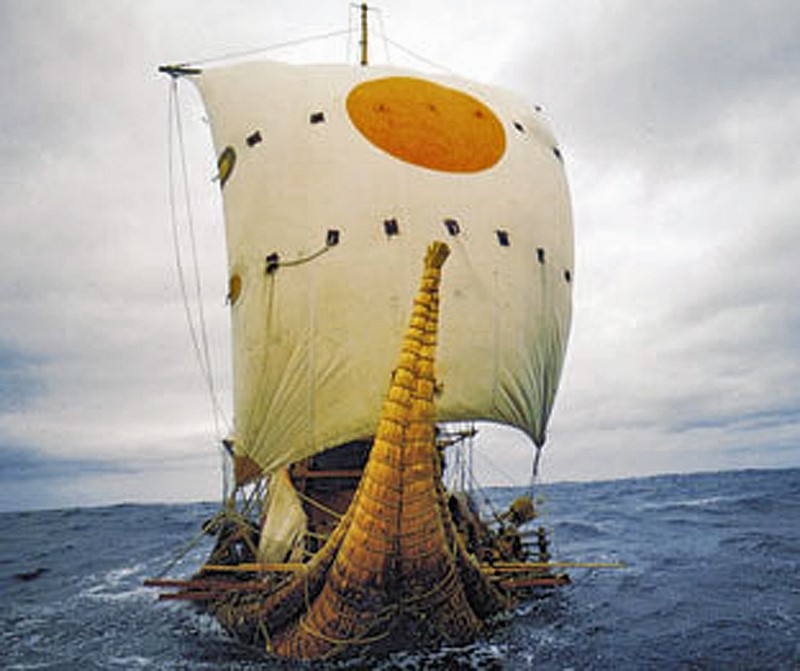
12. Columbus was the first Western Man to reach America – Yet bones and tools suggest that Europeans sail there ten thousand years earlier.
RA Reed Boat – – 13 Things that don’t make sense in Ancient History
“We would like to live as we once lived, but history will not permit it”– John F. Kennedy
Synopsys
A blood type (also called a blood group) is a classification of blood-based on the presence or absence of inherited antigenic substances on the surface of red blood cells (RBCs). These antigens may be proteins, carbohydrates, glycoproteins, or glycolipids, depending on the blood group system. Some of these antigens are also present on the surface of other types of cells of various tissues. Several of these red blood cell surface antigens can stem from one allele (or very closely linked genes) and collectively form a blood group system. Blood types are inherited and represent contributions from both parents. A total of 32 human blood group systems is now recognized by the International Society of Blood Transfusion (ISBT).
The two most important ones are ABO and the RhD antigen; they determine someone’s blood type (A, B, AB and O, with + and – denoting RhD status).Many pregnant women carry a fetus with a blood type different from their own, and the mother can form antibodies against fetal RBCs. Sometimes these maternal antibodies are IgG, a small immunoglobulin, which can cross the placenta and cause hemolysis of fetal RBCs, which in turn can lead to hemolytic disease of the newborn called erythroblastosis fetalis; an illness of low fetal blood counts that ranges from mild to severe.
Sometimes this is lethal for the fetus; in these cases, it is called hydrops fetalis.One of the Greatest Mysteries in Anthropology is how the A Rh neg blood groups originated in North America.Blood groups are a good method to detect population migration in conjunction with modern DNA Haplogroups, as the former has been identified for over 100 years, unlike the modern method.An individual either has or does not have, the “Rhesus factor” on the surface of their red blood cells. This term refers only to the most immunogenic D antigen of the Rh blood group system, or the Rh- blood group system. The status is usually indicated by Rh positive (Rh+ does have the D antigen), or Rh negative (Rh- does not have the D antigen) suffix to the ABO blood type. (Rediscovering the Winter Solstice)
13. Was Troy really located in Turkey – if so why did it take Odysseus ten years to travel 200 miles get home to Greece.
Tro Debunked – 13 Things that don’t make sense in Ancient History
The very ink with which history is written is merely fluid prejudice.– Mark Twain
Synopsys
Where Troy Once Stood is a book by Iman Wilkens, that argues that the city of Troy was located in England and the Trojan War was fought between groups of Celts.The standard view is that Troy is located near the Dardanelles in Turkey. Wilkens claims that Homer’s Iliad and Odyssey, though products of ancient Greek culture, is originally orally transmitted epic poems from Western Europe. Wilkens disagrees with conventional ideas about the historicity of the Iliad and the location and participants of the Trojan War.Copies of his book ranked high on Bookfinder’s list of most-wanted out of print books until 2005, when the latest revised edition was published. His work has had little impact on professional scholars.
Anthony Snodgrass, Emeritus Professor of Classical Archaeology at Cambridge University, has named Wilkens as an example of an “infinitely less-serious” writer.So what evidence does Wilkens use to prove that Troy was in Northern Europe?Wilkens argues that Troy was located in England on the Gog Magog Downs in Cambridgeshire. He believes that Celts living there were attacked around 1200 BC by fellow Celts from the continent to battle over access to the tin mines in Cornwall as tin was a very important component for the production of bronze.Wilkens writes that there are similarities between the river names in the Iliad and present-day England: “Homer names no less than fourteen rivers in the region of Troy.” The rivers Thames, Cam, Great Ouse and Little Ouse, to name a few, can respectively be identified as Temese, Scamander, Simois and Satniois, according to Wilkens.
The revised edition of 2005 contains a “reconstruction” of the Trojan battlefield in Cambridgeshire.13 ancient things that don’t make sense in History – TroyAccording to Wilkens, St Michael’s Mount is the site of Scylla and CharybdisWilkens further hypothesises that the Sea Peoples found in the Late Bronze Age Mediterranean were Celts, who settled in Greece and the Aegean Islands as the Achaeans and Pelasgians. They named new cities after the places they had come from, (similar to the migration of many place names to North America), and brought the oral poems that formed the basis of the Iliad and the Odyssey with them from Western Europe. Wilkens writes that, after being orally transmitted for about four centuries, the poems were translated and written down in Greek around 750 BC.
The Greeks, who had forgotten about the origins of the poems, located the stories in the Mediterranean, where many Homeric place names could be found, but the poems’ descriptions of towns, islands, sailing directions and distances were not altered to fit the reality of the Greek setting. He also writes that “It also appears that Homer’s Greek contains a large number of loan words from western European languages, more often from Dutch rather than English, (Rediscovering the Winter Solstice)
Robert John Langdon has also created a YouTube web channel with over 100 investigations and video documentaries to support his classic trilogy (Prehistoric Britain). He has also released a collection of strange coincidences that he calls ‘13 Things that Don’t Make Sense in History’ and his recent discovery of a lost Stone Avenue at Avebury in Wiltshire called ‘Silbury Avenue – the Lost Stone Avenue’. (Rediscovering the Winter Solstice)
Langdon has also produced a series of ‘shorts’, which are extracts from his main body of books:
For active discussions on the findings of the TRILOGY and recent LiDAR investigations that are published on our WEBSITE, you can join our and leave a message or join the debate on our Facebook Group.
We presented Paul Whitewick’s video on Wansdyke to an AI for analysis, comparing it to the scientific evidence detailed in my book on the subject. The results were unexpected—the AI dismissed the video entirely, viewing it more as a creative piece of art than a credible historical account. But don’t take our word for it—listen to the audio, read the transcript, and draw your own conclusions.
Bob: All right, so are you ready for a deep dive today?
Alice: Always.
Bob: We’re going to be looking at this YouTube video about Wansdyke.
Alice: Okay.
Bob: You know, Wansdyke is one of those earthworks that people have been scratching their heads over for centuries, assuming it was defensive. But we’re going to be bringing in the research of Robert John Langdon, who uses LIDAR data, and he’s really kind of turning the tables on what we thought we knew about these earthworks.
Alice: Right.
Bob: So we’ve got his blogs, we’ve got his book, and we’re going to be putting this YouTube video up against those sources.
Alice: Sounds fascinating.
Bob: Yeah. So I guess we can jump right into it, right?
Alice: Let’s do it.
Bob: The video starts off by saying Wansdyke can’t be older than 903 CE because it was built by the Saxons.
Alice: Right.
Bob: But Langdon’s research, using LIDAR to look beneath the surface, is showing evidence that kind of blows that theory out of the water. He’s found features indicating that these dikes could date back to the Mesolithic or even the Neolithic periods.
LiDAR section of Morgan’s Hill showing Roman Road cutting the Dyke (so must pre-date) – Wansdyke: A British Frontier Wall – ‘Debunked’
Alice: Wow, that’s a huge difference.
Bob: Yeah. We’re talking thousands of years older.
Alice: Right.
Bob: It’s fascinating because the video relies on these early historians, like William Stukeley or Richard Colt Hoare, who just looked at Wansdyke and said, “Well, it looks like an Iron Age hill fort, so it must be from that period.”
Alice: Just based on appearances.
Bob: But Langdon’s work shows that looks can be deceiving.
Alice: Absolutely. Especially when you’ve got LIDAR revealing what’s hidden underground.
Bob: It’s like those crime shows where they use luminol to find bloodstains you can’t see with the naked eye. Suddenly, the whole story changes.
Alice: Precisely. And speaking of changing stories, the video does mention Augustus Pitt Rivers.
Bob: Okay.
Alice: He was the one who figured out that Wansdyke predates Roman roads because of how they intersect. Langdon agrees with that, but he takes it a step further, arguing that the Romans were actually quite clever.
Bob: Right.
Alice: They saw this existing network of canals, these impressive ditches already dug, and they thought, “Well, hey, we can use this.”
Bob: So not just lazy Romans, but opportunistic Romans.
Alice: Yeah, that’s a great way to put it.
Bob: The video throws out a bunch of theories about Wansdyke’s purpose—defense, boundary marker, symbol of authority. All plausible, I guess, but kind of vague.
Alice: Right.
Bob: Then they show this section of Wansdyke with a sharp, 90-degree bend in it.
Unnatural Bends show that it was never a Boundary or Defensive Wall in origin – Wansdyke: A British Frontier Wall – ‘Debunked’
Alice: Okay.
Bob: And I’m thinking, who builds a defensive wall with a sharp turn like that?
Alice: That’s where Langdon’s LIDAR analysis really comes in handy.
Bob: Okay.
Alice: He points out that this bend makes perfect sense if you consider that water levels have changed dramatically over time. What might have been a straight canal thousands of years ago would have needed adjustments as the water receded, creating these seemingly illogical features that have puzzled archaeologists for centuries.
Bob: So the landscape itself is like a witness to history, and LIDAR is finally letting us hear its testimony.
Alice: That’s a really poetic way to put it. I like that.
Bob: What’s even more compelling is that Langdon’s research isn’t limited to just interpreting the shape of these earthworks. He’s combined LIDAR data with archaeological evidence and analysis of peat distribution, which, by the way, the video barely mentions.
Alice: Right. I was wondering about that.
Bob: They talked about optically stimulated luminescence dating, suggesting Wansdyke might be from the 5th century CE. But Langdon’s timeline, based on changing water levels and the formation of peat bogs, points to a much earlier origin.
Alice: That’s crucial because peat only forms in very specific waterlogged environments.
Bob: Right.
Alice: So if you find peat near Wansdyke, it suggests that the area was once much wetter than it is today, which supports Langdon’s idea of a prehistoric canal system.
Bob: Hold on. Can we back up for a second? I realize I might be a bit behind here. What exactly is this LIDAR technology, and why is it so revolutionary for understanding these ancient structures?
Alice: That’s a great question. Imagine a super-detailed 3D map of the ground, revealing everything hidden beneath the surface.
Bob: Okay.
Alice: That’s essentially what LIDAR does. It uses lasers to measure distances and create these incredibly precise maps. Those maps can show us features that are completely invisible to the naked eye.
LiDAR can show more details of Ditches and Construction techniques for Moats – Wansdyke: A British Frontier Wall – ‘Debunked
Bob: Wow.
Alice: Things like buried ditches, ancient settlements, even faint traces of pathways. It’s like having X-ray vision for archaeology.
Bob: So it’s not just looking at the earthworks themselves. It’s about understanding the entire landscape in which they were built.
Alice: Precisely. And that’s where Langdon’s work becomes so compelling. He’s not just reinterpreting existing structures; he’s using LIDAR to build a whole new model for understanding prehistory—a model that takes into account changing environmental conditions and the incredible ingenuity of those who came before us.
Bob: Okay, now that is mind-blowing. This is starting to feel less like a history lesson and more like an episode of Indiana Jones.
Alice: Haha, I can see why you’d say that. And we’re just getting started. Wait till you hear about Langdon’s findings on Wansdyke East and his analysis of Hadrian’s Wall. Buckle up—this deep dive is about to get even deeper.
Bob: Let’s go!
(Wansdyke: A British Frontier Wall – ‘Debunked’)
Bob: So, what’s the deal with Wansdyke East? You said the video loses its footing there.
Alice: Yeah, exactly. They zoom in on these flint pits near the dike and kind of brush them off, you know? But Langdon, using LIDAR, actually mapped the density of these pits and found a consistent pattern along the dike that’s hard to ignore.
Bob: Oh wow. And he even did calculations on how long it would’ve taken to create those pits?
Alice: Exactly. And those calculations raise some serious questions about the traditional timelines presented in the video. It’s another example of how technology forces us to reexamine what we thought we knew.
Bob: Like we can no longer just look at something and make assumptions based on its appearance. We need to dig deeper—literally. And LIDAR is the shovel.
Alice: I love that analogy. Speaking of digging deeper, the video quotes an archaeologist, P.J. Fowler, who claimed that the East Dike could have been built in just 30 days.
Bob: Thirty days? With a massive workforce?
Alice: Exactly. Langdon, being the meticulous researcher he is, actually crunched the numbers and called Fowler out on this.
Bob: Wait, hold on. Thirty days to build a structure that stretches for miles? Even for the ancient world, that seems a bit far-fetched.
Alice: It really does. Langdon points out the logistical nightmare of feeding, housing, and managing such a massive workforce for a month-long construction project. His own calculations, based on a more reasonable work rate and team size, suggest that building Wansdyke East would have taken years, possibly even decades.
Bob: That makes way more sense. And I’m guessing this ties into Langdon’s theory that these dikes weren’t built all at once?
Alice: Exactly. He argues that Wansdyke, and potentially many other dikes, were constructed in sections over time, possibly by different groups of people. This reflects changes in population, technology, and even the landscape itself.
Dykes have shown that they are made in separate sections at different times – Wansdyke: A British Frontier Wall – ‘Debunked’
Bob: Okay, so now I’m really starting to see the limitations of this YouTube video. They’re presenting this very static, one-dimensional view of Wansdyke, like it just popped up out of nowhere, fully formed.
Alice: Right. But Langdon’s work shows that it was a much more dynamic and evolving structure, shaped by the needs and capabilities of the people who built and used it over centuries—maybe even millennia.
Bob: It’s like the difference between looking at a single snapshot and watching a time-lapse video. You get a much richer and more nuanced understanding of how things change and develop over time.
Alice: Exactly. And remember that 90-degree bend we talked about earlier?
Bob: Oh yeah, yeah.
Alice: The video tries to explain it away as some kind of defensive feature, but it just doesn’t hold up to scrutiny. Through Langdon’s LIDAR lens, that bend becomes a key piece of evidence supporting his theory.
(Wansdyke: A British Frontier Wall – ‘Debunked’)
Bob: What’s his take on it?
Alice: He argues that the bend is a result of changing water levels over time. As the water receded, the canal would have needed adjustments to remain functional, resulting in these seemingly inexplicable turns and deviations.
Bob: It’s like those ancient riverbeds you see in the desert. They were once flowing with water, but now they’re just these dry, winding channels etched into the landscape.
Alice: Exactly. Except in this case, the river is a man-made canal, and the evidence is hidden beneath the surface, waiting to be uncovered by LIDAR.
Bob: That’s incredible. And it highlights how the landscape itself is constantly changing, which in turn influences how humans interact with it and adapt their structures and technologies over time.
Car Dyke shown to have been made at the edge of the ancient Neolithic shoreline – Wansdyke: A British Frontier Wall – ‘Debunked’
Alice: That concept of adaptation is central to Langdon’s argument. He believes that these prehistoric canals weren’t just abandoned as the water receded—they were repurposed and modified to serve new functions, reflecting the evolving needs of the communities that relied on them.
Bob: So it’s not just about the canals themselves. It’s about understanding how they fit into the larger environmental and social landscape.
Alice: Precisely. Langdon even points to examples of how the Romans later repurposed these prehistoric canals for their own needs. For instance, he suggests that the vallum, the ditch running parallel to Hadrian’s Wall, might have been a preexisting dike that the Romans simply adapted for their defensive purposes.
Bob: That’s incredible. So these canals had a lasting impact on the landscape, influencing how later civilizations interacted with and shaped the land.
Alice: Exactly. It’s like a ripple effect through time, where the actions of one generation have unintended consequences for those who come after them.
Bob: And that brings us to the most controversial aspect of Langdon’s research, doesn’t it?
Alice: Yes. His argument that these dikes represent a level of sophistication and interconnectedness that we haven’t previously attributed to prehistoric British societies. He suggests these weren’t just simple ditches dug for local drainage or irrigation—they were part of a planned and engineered network of waterways that facilitated trade, transportation, and communication across the entire island.
Bob: That’s groundbreaking. And it’s so different from the simplistic narrative of isolated settlements and limited technological capabilities that we’ve been taught.
Alice: It is. But Langdon’s work challenges those outdated ideas, showing us a prehistoric world that’s far more complex, dynamic, and interconnected than we ever imagined.
Bob: So, if Langdon’s right and these dikes were part of a vast prehistoric canal network, what does that tell us about those ancient societies? What can we learn from them?
Alice: It tells us that they were far more advanced and interconnected than we’ve given them credit for. They had a deep understanding of their environment, were skilled engineers, and were capable of undertaking massive construction projects that spanned generations.
(Wansdyke: A British Frontier Wall – ‘Debunked’)
Bob: That’s incredible. These weren’t just isolated tribes—they were pioneers of their time, pushing the boundaries of what was possible.
Alice: Exactly. And they left behind a legacy that’s still visible in the landscape today, even if we’re only now beginning to recognize it for what it was.
Bob: It’s a powerful reminder that the past is full of surprises and that we should never underestimate the ingenuity of those who came before us.
Alice: Absolutely. And it’s also a call to action. For anyone interested in history and archaeology, Langdon’s work is a reminder to keep exploring, keep questioning, and push the boundaries of what we think we know.
Bob: And to embrace new technologies like LIDAR, which are giving us tools to uncover hidden stories.
Alice: Exactly. LIDAR allows us to see the landscape with fresh eyes, revealing features and connections that were invisible before. It’s like having a time machine—not to travel physically, but to see the past in unprecedented detail.
Bob: That’s such a powerful image. And it makes me wonder—if Langdon’s findings are correct, how many other sites around the world might have hidden histories just waiting to be uncovered?
Alice: That’s the exciting part. Langdon’s work doesn’t just change how we see Wansdyke or Hadrian’s Wall. It opens up the possibility that other ancient structures, even ones we think we understand, might have far more complex stories to tell.
Hadrian’s Wall Vallum was once a Dyke of water that moved the stones for the Wall – Wansdyke: A British Frontier Wall – ‘Debunked
Bob: And that’s what makes this research so groundbreaking. It’s not just about rewriting the history of one site—it’s about reimagining the past on a much larger scale.
Alice: Right. Langdon’s work shows us that prehistoric Britain wasn’t just a series of isolated settlements. It was a vibrant, interconnected network of communities, trading goods, sharing ideas, and shaping their world in ways we’re only beginning to understand.
Bob: It’s like discovering an entirely new chapter of history—one that forces us to rethink everything we thought we knew.
Alice: Exactly. And it’s a testament to the power of questioning conventional wisdom and looking at the evidence with fresh eyes.
Bob: So, where do we go from here? What’s the next step in this journey of discovery?
Alice: I think the next step is to take Langdon’s findings and build on them. If he’s right about these dikes being part of a canal network, we need to start reexamining other ancient sites in Britain—and beyond—with this new perspective.
Bob: That’s true. And we need to start asking bigger questions, like how these networks influenced trade, migration, and even cultural exchange across prehistoric Europe.
Alice: Exactly. It’s about connecting the dots and understanding how these structures fit into a larger picture of human ingenuity and resilience.
Bob: And it’s also about using new technologies, like LIDAR, to uncover the hidden stories that still lie beneath our feet.
Alice: Absolutely. The more we uncover, the more we realize just how much we still have to learn about the past—and how it can shape our understanding of the present.
Bob: Well, this has been an eye-opening conversation. Thanks for taking the time to explore this with me.
Alice: Anytime. It’s always a pleasure diving into history and discovering the stories that have been waiting to be told.
Bob: Until next time, let’s keep questioning, keep exploring, and never stop digging for the truth.
Alice: Agreed. Here’s to the next chapter in uncovering the mysteries of our past!
Bob: So, before we wrap up completely, I keep coming back to one thing—this idea of interconnectedness. If Langdon’s theory about the canal system is correct, how does that reshape our understanding of prehistoric societies, not just in Britain but globally?
Alice: That’s a fascinating question. If we accept that prehistoric Britons built an interconnected canal network, it challenges the long-held notion that advanced engineering and large-scale infrastructure only emerged in more “modern” civilizations like the Romans or Egyptians.
Bob: It kind of flips the narrative, doesn’t it? Instead of viewing these societies as primitive or isolated, we start seeing them as highly innovative and adaptive, capable of solving complex problems.
(Wansdyke: A British Frontier Wall – ‘Debunked’)
Alice: Exactly. And it suggests they weren’t just thinking locally—they were thinking regionally or even globally. If these canals were facilitating trade and transportation, it means they were engaging with wider networks of exchange, sharing goods, ideas, and technologies.
Bob: That’s incredible. It makes me wonder how much of that interconnectedness influenced later societies, like the Romans. Could they have learned from these prehistoric systems?
Wansdyke was once a Canal like Car Dyke and Prehistoric in Origin – Wansdyke: A British Frontier Wall – ‘Debunked’
Alice: It’s very possible. The Romans were exceptional at adopting and adapting existing technologies. If Langdon’s theory is correct, they might have recognized the value of these prehistoric canals and incorporated them into their own infrastructure. It’s not just about influence, though—it’s about continuity. These systems didn’t just disappear; they evolved.
Bob: That’s such a powerful way to think about history—not as a series of isolated events, but as a continuous thread where each generation builds on the work of those before them.
Alice: Exactly. And it highlights something else that’s often overlooked: the relationship between humans and their environment. These canals weren’t just engineering feats; they were a response to the challenges and opportunities presented by the landscape.
Bob: So, in a way, they were shaping the land just as much as the land was shaping them.
Alice: Precisely. It’s a dynamic relationship, and it’s one of the reasons Langdon’s research is so compelling. He’s not just looking at the structures themselves; he’s considering the entire ecosystem—the geology, the hydrology, even the social and cultural factors that influenced their construction.
Bob: It’s such a holistic approach. And it makes me think about how we study history today. Maybe we need to break out of our silos and start looking at the bigger picture, connecting disciplines like archaeology, geology, and even technology.
Alice: Absolutely. The past isn’t just a collection of isolated facts—it’s a complex, interconnected web. And to truly understand it, we need to approach it from multiple angles.
Bob: So, what’s the takeaway here? What can we learn from Langdon’s work and apply to how we think about history—and the present?
Alice: I think the biggest lesson is to remain curious and open-minded. History isn’t set in stone—literally. New evidence, new technologies, and new perspectives can completely reshape our understanding of the past.
Bob: And that understanding can help us navigate the present. If prehistoric societies were able to adapt and innovate in the face of changing environments, maybe there’s a lesson there for us as we face our own challenges.
Alice: That’s such a great point. The ingenuity and resilience of those early societies are a reminder that humans have always found ways to overcome obstacles. And with the tools we have today, there’s no limit to what we can discover—or achieve.
Bob: Well, this has been an incredible journey. Thanks for sharing your insights, Alice.
Alice: Thank you, Bob. It’s always a pleasure exploring these ideas with you.
Bob: Here’s to more deep dives in the future. Until next time, let’s keep questioning, keep exploring, and keep uncovering the stories that connect us to our past.
Alice: Couldn’t have said it better myself. Here’s to the next adventure!
We compiled all the latest available knowledge about Neanderthals, Homo sapiens, and their potential interbreeding and fed it into an AI engine. We aimed to explore how a species like the Cro-Magnon might have developed as a hybrid between these two groups. Specifically, we asked the AI to analyze the likely physical appearance and attributes of such a species if they inherited traits from both Neanderthals and Homo sapiens. The key parameters we provided included their robust hybrid genetics, their reliance on a non-agricultural diet of high-protein foods like reindeer meat, fish, and fruit, and their tendency to interbreed primarily within their own hybrid group rather than with other Homo sapiens populations. (AI now Supports – Homo Superior)
The AI-generated a detailed profile of what this hybrid species might have looked like and how they would have functioned physically and socially. It revealed a population that was significantly taller and stronger than their Homo sapiens contemporaries, with an average male height of 6’0″ to 6’9″ and women reaching 5’8″ to 6’4″. This species would have had an imposing physical presence, combining the muscular density and resilience of Neanderthals with the longer limbs and endurance of Homo sapiens. Their diet, rich in protein and omega-3 fatty acids, would have further amplified their physical growth and cognitive development, potentially increasing their overall body size and brain function by up to 10% compared to typical Homo sapiens.
The AI also suggested that the hybrids’ selective interbreeding within their group could have amplified certain traits, including their striking physical features. Fair or red hair, light eyes (blue or green), and lighter skin tones, often associated with Neanderthal genetics, would have been more prominent in this population. These traits, combined with their impressive stature and strength, likely made them appear extraordinary to other groups, contributing to myths and legends of “giants” that persist in cultural memory.
Another critical aspect was their physiological superiority. The hybrid species would have benefited from larger lung capacities and enhanced endurance, making them adept at both short sprints and long-distance pursuits. Their dense bones and strong immune systems, inherited from Neanderthals, would have made them highly resilient to physical injury and disease, particularly in harsh climates. (AI now Supports – Homo Superior)
Socially and cognitively, the AI revealed a fascinating picture. This hybrid species would have excelled in innovation, tool-making, and symbolic communication, blending the Neanderthals’ spatial and practical intelligence with sapiens’ abstract reasoning and social organization. Their diet, free from the nutritional deficiencies common in agricultural societies, would have sustained their superior physical and cognitive capabilities over generations.
What stands out is how closely this AI-generated profile aligns with archaeological evidence of Cro-Magnons and other prehistoric populations. These hybrids, through their unique blend of traits, could very well have formed the basis of what I call the Lost Civilization. They were not just robust survivors but likely dominant figures in their time—towering, physically impressive, and culturally advanced. Their reliance on high-quality diets and intra-group interbreeding would have preserved and even enhanced their defining characteristics, making them a remarkable branch of human evolution.
This exercise highlights how advanced tools like AI can help us reimagine the past and uncover forgotten truths about our ancestors. It presents a compelling case for the existence of a distinct group of humans, hybrids of Neanderthals and sapiens, who stood out not only in physical stature but also in their abilities, potentially giving rise to legends of giants and mysterious ancient civilizations. (AI now Supports – Homo Superior).
Introduction
Throughout human history, myths and legends have spoken of giants—beings of great stature, strength, and striking appearance. Could these stories have been rooted in reality? Recent studies and logic suggest that Cro-Magnons, early Homo sapiens with Neanderthal ancestry, might have been the inspiration for these legends. Their physical characteristics, selective interbreeding, and unique adaptations may have made them “giants” in comparison to their contemporaries, especially as their lineage diverged and flourished before the agricultural revolution. (AI now Supports – Homo Superior).
1. Cro-Magnons: The Hybrid Giants
Cro-Magnons were the early anatomically modern humans who lived in Europe approximately 40,000 to 10,000 years ago. Unlike modern Homo sapiens, they coexisted and interbred with Neanderthals. This interbreeding may have given them unique physical traits that set them apart. As hybrids, Cro-Magnons inherited both the robust strength of Neanderthals and the tall stature and lean frame of Homo sapiens, creating individuals who were taller, stronger, and more physically capable than their contemporaries. (AI now Supports – Homo Superior)
Homo Superior – (AI now Supports – Homo Superior)
2. Height and Strength: A Physical Advantage
Evidence suggests that the average height of Cro-Magnon men ranged from 6’0” to 6’9”, towering over other Homo sapiens, whose average height ranged between 5’5″ and 5’8″. Their hybrid ancestry amplified their physicality: Neanderthal muscle density combined with the longer limbs of sapiens made them incredibly strong and athletic. These towering figures, clad in fur and wielding advanced tools, might have seemed almost superhuman to smaller, less robust populations.
3. The Role of Selective Interbreeding
Over time, Cro-Magnons may have developed a tendency to selectively interbreed within their hybrid lineage. Historical and genetic evidence points to the natural attraction of individuals with certain features, such as light hair, blue or green eyes, and fair skin. These traits, linked to genetic markers associated with Neanderthal and early European Homo sapiens, may have been amplified through interbreeding. The result was a distinct population with striking features and greater physical capabilities.
4. The Impact of a High-Protein Diet
A significant factor in Cro-Magnon’s development was their high-protein diet, rich in reindeer meat, fish, and other game. This diet supported their exceptional growth and physical strength, contributing to their towering height. Unlike early agricultural societies, which relied on nutrient-deficient grains, Cro-Magnons thrived on a diet that maximized their genetic potential. This dietary advantage not only enhanced their size but also bolstered their overall health and longevity.
5. Blond and Red Hair: A Marker of Hybridity
Blond and Red Hair – (AI now Supports – Homo Superior)
Historical accounts and genetic studies indicate that Cro-Magnons may have had blond or red hair, a trait less common in darker-skinned populations migrating out of Africa. These hair colours, along with blue and green eyes, are strongly associated with Neanderthal ancestry and would have been relatively unique in prehistoric populations. This distinct appearance might have given rise to myths of “fair-haired giants” that persisted in folklore for millennia.
6. The Cultural Memory of Giants
Many ancient cultures reference giants in their oral histories and written texts. From the Norse Jotunn to the Biblical Nephilim, these tales often describe beings of extraordinary height and strength, with fair or red hair. Given the prominence of Cro-Magnons in early European and Middle Eastern history, it is plausible that their unique physical traits inspired these legends. Their presence, especially during the Mesolithic and early Neolithic periods, would have left a lasting impression on smaller, agricultural communities.
7. The Decline of the Giants: The Agricultural Revolution
The rise of agriculture around 10,000 BCE marked a turning point in human history—and the decline of the towering Cro-Magnons. As societies shifted from hunting and gathering to farming, the nutritional quality of diets declined. Populations relying on cereal-based diets experienced reduced stature due to malnutrition. In contrast, Cro-Magnons, reliant on high-protein diets, maintained their size and health longer, but their dominance faded as farming populations expanded and overtook hunter-gatherers.
8. The Shrinking of the Human Population
Between 5000 BCE and 3000 BCE, as agricultural societies became more widespread, the average height of humans declined significantly. Cro-Magnons, who retained their tall and robust frames, began to fade into history, blending with farming populations. The loss of their unique hybrid genetic advantage contributed to the decline of their distinguishing traits, including their exceptional height and strength.
9. The Legacy of Fair Features
Blue and Green Eyed – (AI now Supports – Homo Superior)
Interestingly, the fair-haired, light-eyed traits associated with Cro-Magnons persisted. These features, amplified by selective interbreeding in the hybrid population, remain prominent in Northern European populations today. The attraction to individuals with these features may have been a subconscious preference, perpetuating their genetic legacy even as their giant-like stature diminished.
10. Reinterpreting Historical Giants
When we reexamine ancient accounts of giants, they align remarkably well with what we know about Cro-Magnons. Their tall stature, robust build, and striking appearance would have made them stand out in early human societies. To smaller agricultural populations, encountering such individuals could easily have inspired awe and fear, giving rise to myths of giants that persisted in folklore.
11. The Scientific Basis for Myths
While myths of giants are often dismissed as fiction, modern anthropology suggests they could have a basis in reality. The genetic and dietary advantages of Cro-Magnons, combined with selective interbreeding, created a unique population of early humans who truly embodied “giant-like” qualities. The interaction between these hybrids and smaller populations in the Neolithic period likely cemented their place in cultural memory.
12. Giants of Prehistory: A New Perspective
Cro-Magnons, the hybrid descendants of Homo sapiens and Neanderthals, were likely the real-life basis for legends of giants. Their tall stature, striking appearance, and physical dominance set them apart in prehistoric times. As selective interbreeding amplified their traits, they formed a unique tribe that stood out in both size and presence. Though they faded into history with the rise of agriculture, their legacy endures—in myths, genetics, and the enduring fascination with the giants of the past. (AI now Supports – Homo Superior).
Summary – (AI Calculations)
If hybrids with optimal diets of meat (e.g., reindeer) and fish interbred exclusively over generations, the resulting unique tribe of humans would refine and amplify their physical, cognitive, and physiological traits. This process would select for the most advantageous characteristics of both Homo sapiens and Neanderthals, further influenced by their nutrient-rich diet. Here’s what we might expect:
Height
The tribe would stabilize at the upper limit of human height due to a consistent intake of high-protein and high-fat foods, which promote growth:
Men: ~6’4″ to 6’9″ (193–205 cm).
Women: ~5’10” to 6’4″ (178–193 cm).
The height would combine the tall, lean sapiens proportions with a Neanderthal’s robust frame, resulting in tall yet powerfully built individuals.
Muscle Mass and Strength
Muscular Strength:
Exceptional muscle density due to inherited Neanderthal traits, optimized by their protein-rich diet.
Grip strength and upper-body power would be 70–80% stronger than modern humans.
Athletic Build:
Lean yet muscular, with ideal body fat percentages (~10–15% for men, ~15–20% for women) for peak performance.
Explosive Power:
Capable of short, powerful bursts of activity, combined with greater endurance for prolonged exertion.
Bone Density and Skeletal Structure
Bone Density:
Extremely dense bones, reducing the risk of fractures.
Bones would be optimized for a balance of durability and agility, lighter than pure Neanderthals but stronger than modern humans.
Joint Efficiency:
Larger, well-formed joints would allow for greater flexibility and range of motion, reducing wear and tear over time.
Posture:
A more upright, sapiens-like posture combined with the robust skeletal structure of Neanderthals.
Lung Capacity and Cardiovascular Efficiency
Enhanced Thoracic Cavity:
A large thoracic cavity would support 30–40% greater lung capacity than modern humans.
High Oxygen Efficiency:
Increased hemoglobin levels and superior oxygen utilization would allow for prolonged physical activity.
Endurance:
Capable of both endurance running and intense anaerobic activities, making them highly versatile.
Metabolism and Diet Utilization
Dietary Adaptations:
Highly efficient at metabolizing proteins and fats from meat and fish, with a balanced ability to store and utilize energy.
Cold Resistance:
Subcutaneous fat layers inherited from Neanderthals, combined with sapiens-like metabolic flexibility, would provide excellent insulation and energy reserves for cold climates.
Muscle Recovery:
Omega-3 fatty acids from fish would enhance recovery from physical exertion, allowing for frequent, high-intensity activity.
Cognitive and Brain Enhancements
Brain Size:
Stabilized at 1,600–1,700 cm³, surpassing modern humans in overall volume.
Cognitive Abilities:
Enhanced problem-solving skills, long-term planning, and abstract thinking from sapiens.
Superior spatial awareness and sensory-motor control from Neanderthals.
Neural Efficiency:
Omega-3 fatty acids would support optimized neural connectivity, leading to faster processing speeds and heightened emotional intelligence.
Physical Performance
Strength:
Able to lift and carry weights 80–100% heavier than modern humans.
Exceptional grip strength and upper-body power for tool use, combat, and construction.
Long-distance endurance running, rivaling or surpassing early Homo sapiens’ persistence hunting abilities.
Resilience:
Extremely durable and resistant to injury due to robust skeletal and muscular systems.
Immune System and Resilience
Disease Resistance:
Combined immunity from Neanderthals and sapiens would create a robust defense against pathogens.
Adaptability to diverse climates and environments, from Arctic tundras to temperate forests.
Longevity:
With improved diets and physical resilience, lifespan could exceed 80–100 years, provided environmental conditions remain stable.
Unique Physical Features
Heightened Physical Presence:
A tall, imposing stature with muscular definition and robust skeletal features.
Distinct Facial Features:
Larger brow ridges and prominent noses (from Neanderthals), balanced by the finer, symmetrical features of sapiens.
Eye and Vision Adaptations:
Neanderthal-like adaptations for low-light vision, with larger eye sockets and sharper visual acuity.
Tribal Specialization
The tribe would likely develop a unique cultural identity around their physical and cognitive strengths, excelling in activities requiring:
Hunting and resource gathering.
Toolmaking and innovation.
Complex social organization and territorial management.
This tribe would embody the pinnacle of human physical and cognitive evolution, shaped by selective hybridization and a nutrient-rich diet, making them a unique and dominant human subspecies.
The book ‘The Car Dyke LiDAR Atlas’ presents a thorough investigation of the Car Dyke, a large ancient waterway in Britain. Using LiDAR technology, the author argues that the Dyke is much older than previously thought, dating back to the Mesolithic/Neolithic periods, and was likely used for transportation and water management rather than simply as a Roman drainage channel or defensive barrier. The book features detailed maps and analysis of the Dyke’s construction and course, including insights into the surrounding landscape and archaeological finds, to support the author’s conclusions.
Car Dyke Transcript
Welcome in deep divers ready to get our hands dirty.
Always up for a challenge, especially if it involves rewriting history.
Today we’re diving headfirst into the heart of eastern England.
Sounds intriguing. What’s on the agenda? Roman ruins, hidden treasure.
Even better, we’re tackling a seemingly unassuming ditch known as Car Dyke
A ditch. You’ve piqued my curiosity. There’s got to be more to it than meets the eye.
Oh, absolutely. This isn’t just any ditch car. Dyke has been hiding in plain sight for centuries, mislabeled as just another Roman canal.
I’m sensing a butt coming,
But thanks to some seriously cool tech. Lidar, our car dyke secrets are finally coming to light
Lidar for our listeners who aren’t familiar, it’s like giving archaeologist X-ray vision, right? Seeing beneath the surface without even lifting a shovel.
You got it. And that’s where Robert John Langdon’s work comes in his Car Dyke Atlas uses lidar to paint a whole new picture of this ancient waterway.
Okay. I’m hooked. We’ve got cutting edge technology and a fresh perspective on what we thought we knew. Let’s dive in.
Let’s start with the biggest bombshell car Dyke’s actual length. We used to think it was around 85 miles long. Not too shabby, right?
Impressive for sure.
Hold on to your hats, because LiDAR revealed it’s actually a whopping 103 miles long.
Well, that’s longer than any other known dyke in Britain. Talk about a game changer.
Yeah,
Suddenly we’re not talking about a local project. This suggests a level of planning and coordination that makes you rethink everything.
And that’s just the beginning. Remember those assumptions about car dyke being Roman? Well, LiDAR revealed something interesting. Instead of those ruler straight lines. The Romans loved some sections. Let’s just say they get a little. Wiggly. Not exactly the precision engineering we associate with Rome.
So not just longer, but potentially much older. This is where things get really interesting.
These wiggly sections, what makes them so special?
They often line up perfectly with ancient shorelines and natural springs. Features you wouldn’t know about without Lidar’s ability to see underground. It suggests construction happened when the Fens were a much wetter, wilder place.
So instead of battling the landscape like the Romans might have, these early builders worked with nature using their knowledge of water flow and natural springs to their advantage. Talk about ingenuity. It really highlights their adaptability and deep understanding of the environment.
It’s like comparing two completely different engineering philosophies, reflecting not just changing needs, but how technology evolved over thousands of years.
Absolutely. And that contrast is crystal clear when you look at Langdon’s maps, the early sections hugging the high ground, ensuring that natural flow from the springs,
And then the later Roman sections just slicing straight through.
It’s like they said, we’re the Romans, we build in straight lines.
But what’s amazing is how those early sections might have worked, just like modern canals, but without using locks, they relied on those natural gradients and carefully chosen routes to manage the flow of water.
Now that’s some clever engineering. Speaking of which, how did LiDAR help uncover these subtle differences in construction?
Imagine looking at an aerial photo of a dense forest. You see trees, right? But not what’s below. LiDAR strips away that canopy. It revealed subtle changes in elevation and vegetation that hinted at these different construction phases.
So it’s like they left us a hidden message written in the very landscape itself, and we finally have the tools to decipher it.
We’ve got this massive waterway, potentially pre-Roman, showing a deep understanding of water management. This can’t just be about irrigation, right? What was its purpose?
That’s the million dollar question. And it forces us to rethink our assumptions about life in prehistoric Britain. If these early sections of Car Dyke really do predate the Romans,
Which the lidar suggests they do.
Exactly. Then we’re talking about a society far more advanced and interconnected than we ever imagined.
This wasn’t just a weekend project. It was a mammoth undertaking requiring incredible coordination and collaboration, and that just wasn’t thought possible for people of that era.
It really flips the script on how we view them, doesn’t it? They weren’t just surviving, they were thriving. And Car Dyke, that just might be the key to understanding how.
We’re back. Deep divers. Did you catch your breath yet? After that last revelation?
Honestly, I’m still wrapping my head around it. It really makes you wonder what else we’ve missed when it comes to our ancient ancestors.
Right? And get this, the plot thickens. It turns out Car Dyke might challenge one of our biggest assumptions about ancient dykes in general.
Okay. I’m listening. What assumption are we shattering today?
Well, we usually think of these huge ditches as, you know, defensive barriers. Like drawing a line in the sand. You stay over there. We’ll stay over here.
Yeah, like a giant keep out sign. But Car Dyke doesn’t quite fit that mould, does it?
Not one bit. This network, especially with those older sections connecting to lost shorelines. And get this paleo channels, they’re basically ancient dried up riverbeds. Points to something way more interesting.
So instead of walls, we’re talking about prehistoric highways. Like a way to actually connect with other settlements.
Bingo. Think about it. Moving goods, sharing ideas, all made possible by an intricate network of waterways. Long before the Romans ever marched in with their straight roads, the Britons were cruising along these waterways. And speaking of moving things,
You’re thinking about Stonehenge, aren’t you?
Busted. But seriously, those massive stones, Avebury, all of that moving them has always been a logistical head scratcher. Could Car Dyke hold the answer?
It’s a mind blowing thought, isn’t it? Imagine, instead of back breakingly dragging those stones over land, they were floating them along this intricate waterway system. So much more efficient and less disruptive. Picture a flotilla of prehistoric boats navigating these channels, those iconic stones on board not just cargo, but symbols of shared beliefs, maybe even religious ideas. It’s a completely different picture of prehistoric Britain, isn’t it?
Completely. It makes you realise how much we may have underestimated them. But okay, before we get too carried away, let’s bring it back to the data. Langdon doesn’t just stop it, at Lidar. He goes full on detective, analysing the objects found along car dyke. What he find.
This is where the statistical analysis comes in. Langdon looked at how likely it was to find such a large cluster of artefacts from specific eras. The Mesolithic, Neolithic and Bronze Age all along the Dyke.
Don’t keep us in suspense.
Let’s just say the results were, statistically speaking, through the roof. Way too many artifacts to be some happy coincidence.
So not just a few random things people dropped, but evidence of something much bigger going on.
Precisely. It strongly indicates that stretches of car dyke were hives of activity long before the Romans showed up.
Okay, so now we have this picture. A huge ancient network of waterways possibly used for trade transportation. Who knows what else. Then enter the Romans, Masters of engineering and straight lines. What did they make of this already existing infrastructure?
That’s the fascinating part. As ingenious as the Romans were, they were also incredibly practical. They saw the brilliance in those wiggly, meandering waterways, how they follow the natural lay of the land. And they rolled with it.
So a bit of where the Romans, we do things our way, but also a touch of, hmm, these prehistoric folks were on to something.
Exactly. They incorporated the preexisting knowledge into their own plans. You can actually see this in Car Dyke today. Some sections are those laser street Roman roads bear hair waterways, while others wiggle and wind following those ancient, more organic roots.
Talk about a fusion of styles. It speaks to Roman ingenuity, but also a respect for the people who came before. But this begs the question why were the Romans so drawn to Car Dyke in the first place? Was it just strategic, or was there more to it? Langdon suggests this waterway may have been a key factor in the economy back then. Could we go as far as to call it a prehistoric economic engine?
So we’re back. Last we left off, we were trying to wrap our heads around car dyke being this, well, prehistoric economic powerhouse, a bit of a bold statement that you think maybe, but think about it. What are the key ingredients for a thriving economy? You need resources, sure, but also the means to move them around, to connect, to exchange. Not just goods, but ideas. And that’s where car dyke comes in.
So it wasn’t just about moving stuff from point A to point B, but actually creating a system for growth and innovation.
Exactly. Car Dyke wasn’t just a ditch. It was an artery, a network of waterways breathing life into these settlements that might have otherwise been isolated. Imagine the possibilities. Suddenly you have specialized skills. Trade routes, a breeding ground for new ideas. All thanks to this intricate water system.
Okay, I’m starting to see the bigger picture, but what evidence did Langdon find that really supports this prehistoric Silicon Valley theory?
Well, he points to the clusters of specific artifacts found along car dyke tools, pottery, remnants of early metalworking, all concentrated in ways that suggest something beyond just your average everyday life.
More like specialized workshops, right? Taking advantage of the waterway, both to get their raw materials and then ship out whatever they created.
Precisely. And it makes you look at those wiggly sections, those seemingly less efficient paths in a whole new light.
They weren’t just following the terrain, they were strategically connecting these hubs of activity.
Exactly. Plus, we can’t forget the sheer scale of this thing. Building and maintaining 103 mile waterway, even with prehistoric tools, would have taken massive coordination and organization.
We’re talking next level project management, leadership, planning, resource allocation. It boggles the mind, not to mention the exchange of knowledge that must have happened along the way.
Right? Think about all those different groups coming together, each with their own skills and knowledge. That kind of collaboration, that cross-pollination of ideas, it’s the perfect recipe for innovation.
So not just an economic engine, but a melting pot of ideas and innovation. It’s amazing to think that this simple ditch might hold the key to understanding how complex societies developed in prehistoric Britain.
It really makes you wonder what else is still out there, hidden just beneath the surface, waiting for us to uncover it,
And to think all it took was a fresh perspective, a healthy dose of curiosity, and of course, the magic of Lidar.
Who knows what other mysteries are waiting to be revealed
To all you deep divers tuning in. If this exploration of Car Dyke has taught us anything, it’s that history is full of surprises. So keep questioning, keep exploring. And who knows, maybe you’ll make the next big discovery. Until next time, happy digging.
The video (not mine!!) provides a valuable visual of the landscape around White Sheet Camp, illustrating how much detail is obscured when viewed from ground level. This highlights why traditional methods of landscape surveying, which relied heavily on ground-based observation, often missed key features. Unsurprisingly, many peer-reviewed books contain inaccuracies, as walking the terrain without modern tools like LiDAR leads to an incomplete understanding of these ancient sites. The video helps to demonstrate the importance of using advanced technologies in revealing the full complexity of these historical landscapes, rather than subjective observations. Note that the Neolithic Causeway is the Cross-Dyke and the Barrow is probably a fire beacon for the boats to follow to the trading site.
According to Wikipedia
White Sheet Hill, also known as Whitesheet Hill, is a hill in the English county of Wiltshire. As one of the most westerly areas of downland in Britain the area is noted for its chalky farmland which contains a rich variety of rare and protected fauna and flora. The hill is also the site of a neolithiccauseway camp and barrows; and an Iron Agehill fort. The Roman road which runs along the hill was at one time the main route through the Selwood Forest. The hill is part of the Stourhead estate and has been in the ownership of the National Trust since 1946.
Immediately on ascending the hill called Whitesheet, we find ourselves surrounded by British antiquities. The road intersects an ancient earthen work, of a circular form, and which, from the slightness of its vallum, appears to have been of high antiquity. Adjoining it is a large barrow, which we opened in October 1807, and found it had contained a skeleton, and had been investigated before.
On a point of land near this barrow are three others, all of which, by the defaced appearance of their summits, seemed to have attracted the notice of former antiquaries. No 1, the nearest to the edge of the hill, had certainly been opened, and appears to have contained a double interment. The primary one was an interment of burned bones deposited within a shallow cist, in an urn rudely formed, and badly baked. Above it was a skeleton with its head laid towards the south, and which from its position and perfect preservation appears not to have been disturbed. Its mouth was wide open, and it “grinn’d horribly a ghastly smile,” a singularity we have never before met with.
Location
White Sheet Hill is divided between the civil parishes of Kilmington, Mere , and Stourton, along with Gasper. It is situated within the Cranborne Chase and West Wiltshire Downs Area of Outstanding Natural Beauty and has extensive views over Somerset, Dorset and Wiltshire. It is home to White Sheet Radio Flying Club, which uses it as a slope-soaring site for fun and competition flying.
Excavations/History
This monument includes a large multivallate hillfort with two bowl barrows and a beacon situated on the summit of a prominent south facing spur of White Sheet Hill at the top of a very steep scarp slope overlooking a dry valley. The hillfort survives as roughly oval enclosure defined by three widely spaced ramparts with ditches to the north and east and by a single ditch and slight rampart to the west and south where the steep natural scarps are augmented. The inner enclosure is approximately 2ha, the medial enclosed area 0.6ha and the outer 0.9ha and all three areas contain large quantities of circular platforms measuring up to 12m in diameter which indicate a proliferation of dense settlement throughout the entire interior.
The hillfort is thought to be multi-phased, to have started as a single univallate enclosure and to have expanded and become more complex through time. There is a complex entrance which has double portals. The ramparts appear to have been constructed as a series of shorter lengths of bank and ditch which were eventually amalgamated. There is also strong evidence of internal quarry scoops surrounding the interior side of the defences. To the south west two bowl barrows were incorporated into the defences and these survive as circular mounds of 10m and 12.5m in diameter, standing from 0.8m up to 1m high, surrounded by visible quarry ditches from which the construction material was derived of up to 3.5m wide and 0.6m deep.
One barrow mound has a central hollow. Almost central to the inner enclosure is a circular feature that survives as a ring bank measuring 15m in diameter, 4m wide, and 0.5m high, surrounded by an outer ditch of 2m wide and 0.4m deep. These surround a slightly dished interior with a small central mound of 6m in diameter and 0.2m high with a central hollow. A beacon is shown at this position on Saxton’s map of 1576. Although this feature has been interpreted as a disc barrow, possible pond barrow, tree ring or a beacon’s exact date and function is unknown. Still, the beacon appears very likely, given the prominent location and early map depiction. Other features investigated by Colt Hoare as potential barrows were found not to be sepulchral but formed part of the hillfort defences. Iron Age pottery and animal bone have also been recovered within the hillfort as stray surface finds.
Maps
1800s OS Map
White Sheet Camp – click on map for larger version
GE Satellite Map
White Sheet Camp – GE Map
LiDAR Map
South Cadbury Castle – LiDAR Map
Investigation
Site Flyaround
White Sheet Camp Look around
Site Flyover
Flyover showing that it was once a landing site for boats as the surrounding area was flooded in Prehistory (Blue)
The SE section of White Sheet Camp shows that a cut was made in the bank so that boats could be placed inside the camp in the moats for loading. Notice also the shape of the moat – is u-shaped and a shallow 3m deep and 18m wide, again no remotely the the classic V-shaped 2m deep 2m wide Roman ankle breaker defense.
The Closed Dyke that goes NE to SW has no defensive bank (clearly with the spoil on both sides of the Ditch, which is 1m deep and 11m wide – allowing boats to be dragged across the hill from one paleochannel to the other.
The NE side of this same Dyke shows (unlike on OS Maps) that the ditch goes all the way down to the bottom of the Paleochannel (natural harbour), suggesting that the boats were hauled up using the bank (with men or animals) as a ‘towpath’ as we see in later Victorian Canals.
White Sheet Camp – So-Called Neolithic Causewayed Camp
Causewayed Enclosure
Historic England Summary
An Early Neolithic causewayed enclosure on Whitesheet Hill. It lies on the western edge of the Wessex downland overlooking the Vale of Wardour. The Neolithic enclosure has one probable entrance, and consists of a single ovoid circuit enclosing 2.3 hectares. It may form part of a larger complex of Neolithic earthworks, comparable to that on Hambledon Hill, although they may also relate to an Iron Age hillfort 350 metres to the south. These include traces of what may be an earlier ditch circuit beneath the hillfort itself and a univallate ovoid enclosure 300 metres to the north-east. Beyond this is an undated cross-ridge dyke which cuts off another spur. Leslie Grinsell identified the site as a causewayed enclosure and Stuart Piggott later carried out limited excavations in 1951. Earthwork survey further excavation took place in 1989-90. Artefacts included pottery, animal bone, and struck flint. Recent research into the dating of causewayed enclosures has indicated that the enclosure was probably built in 3595-3550 cal BC. The circuit seems to have been used for a relatively brief period, probably for up to 55 years. The main phase of activity may have only lasted for a few generations or less.
Commentfrom RJL
It is truly astonishing that archaeologists continue to label Dykes as Saxon boundary markers, giving them names like Offa’s Dyke and Wansdyke. This stance persists despite evidence that Cross-Dykes are prehistoric. If Dykes were constructed over 4,000 years before the Saxons, it raises the question: was this an engineering skill lost and then reinvented, or is the dating simply incorrect?
My research on Offa’s Dyke and Wansdyke (detailed in my books and blogs) suggests they were built during the Mesolithic/Neolithic periods and later reused by the Romans. This theory is now substantiated by my latest investigation into Car Dyke, which, through Bayesian and spatial (Monte Carlo) mathematics, has been confirmed as the longest dyke in Britain and dates back to the Mesolithic/Bronze Age. Despite this, some archaeologists still label Car Dyke as Roman due to the discovery of a boat laden with goods at its bottom, indicating later usage rather than original construction.
Car Dyke looking similar with high river levels to the East – dated as Mesolithic
The approach to White Sheet Camp by some archaeologists shows a surprising lack of connected thinking. Classified as a “causewayed enclosure,” which usually involves more than one ring and features causeways between the rings, White Sheet Camp only has a single ring. LiDAR analysis and excavation reports reveal that this ring consists of pits joined together, a construction method similar to Stonehenge Phase I, which our mathematical dating places at 8300 BCE. This aligns with the high river levels of that period, suggesting that the ditches could have been viable for boat use.
More information : (ST 802352) Camp (GT).- From Historic England
Whitesheet Hill: Neolithic causeway camp. Identified by Grinsell in 1950. Trial trenches by Stuart Piggott in 1951 revealed Windmill Hill potsherds and an ox-skull in the ditch silting. A probably EBA barrow (ST 83 NW 49) overlies bank and ditch on the SE. See illustration card. Finds in Devizes Museum, Acc No 10/52/39-54. (2-3)
ST 80173519. A well defined ‘egg shaped’ causewayed camp measuring approximately 200 x 140 metres. The bank, ditch and causeways are clearly visible. Surveyed at 1:2500. (4)Visible on air photographs. (7-8). This Neolithic causewayed camp lies on the edge of a plateau on Whitesheet Hill, at 235m above OD above steep chalk scarps to the south and west and approached by level ridges from the north east and south east. The irregularly interrupted ditch measures 5.0m wide, and 0.4m deep, and has causeways approximately 4m wide. The inner bank is 6.0m wide; it stands up to 1.5m above the ditch bottom and is 0.4m above the interior. The level interior measures 185m north east to south west by 140m transversely, enclosing approximately 2.0 ha. A hollow-way, and a modern road have cut through the camp, but it is otherwise in good condition.
Whitesheet Hill causewayed enclosure has been surveyed by staff of RCHME Salisbury as part of a project focussing on the earthworks of South Wiltshire. The following is abstracted from the archive report:
White Sheet Camp – Causewayed Enclosure is showing long trenches and not a circular ditch.
This oval enclosure is defined by an internal bank and external ditch. Both circuits are interrupted and there are in excess of 23 individual segments of ditch. The enclosure is best defined to the NE of the existing trackway which crosses the site. Here the ditch is identifiable as a series of elongated hollows up to 0.5m in depth, max 0.4m wide and 4-5m long. Within some ditch segments are smaller ’causeways’. The internal bank is correspondingly well-preserved in this area, surviving to a height of c0.7m above the ground surface. It is generally continuous, although there are occasional isolated segments. Although not all discontinuities in the line of the rampart are mirrored in the ditch, these dumps of material relate directly to the excavated ditch sections. Slightly off-set alignments between ditch and rampart causeways are also evident. The enclosure SW of the modern track is less substantial, damage reducing the bank to a series of mound-like dumps. These too tend to occur opposite ditch segments, which in this area are noticeably more irregular and slighter constructions.
Recent quarrying has damaged the NW quadrant of the enclosure. Here, a stone extraction pit c60m in length, 10m wide and 2-4m deep, running parallel to the enclosure has encroached upon c40m of the latter’s ditch.
Roman Road placed on top of the Dyke Ditch
One potential entrance was located 35m to the W of the round barrow (ST 83 NW 49) which impinges upon the enclosure. The approach to the entrance itself is defined by a double lynchet trackway c10m wide, traceable to the SE for c45m. The entrance itself consisted of a simple gap in the defences c10m wide. Two noticeable misalignments occur in the course of the enclosure boundary. The first of these consists of a misclosure 8m in length between two sections of bank and ditch. The second is a staggered gap of 2-5m. This apparent misplacement of c170m of enclosure circuit (one-third of the entire circuit) suggests non-contemporaneity with the remaining two-thirds.
Comment from RJL
First of all, the ‘hollow way’ is a Dyke that connects to the road and goes down to the bottom of the Paleochannel – the Dyke was replaced by the road when the water table fell, and the shoreline fell down the hill until it reached the present ground level – Probably in the Bronze Age. This means that the Romans also quarried here, as we can see when they cut a path to the Roman Road that replaced the Dyke going down from the site to the paleochannel shoreline.
Is It a Fire Beacon or a Round Barrow
The so-called Causewayed Enclosure is of great interest as it is near to three other barrows (to the top Right) but is much bigger (the video has the chap climbing it to find a flat top and a crater) – is it a Fire Beacon to attract ships to the Cross-Dyke – there seems to be a part in that direction that stops. The beacon seems to have a moat surrounding it, built on the direct line of one of these 10m long ditches. The other three barrows (HE:1005674) have never been excavated, so dates are speculative, but it doesn’t seem logical to build three round barrows of a size and the one seven times larger unless it had a different purpose.
This would suggest that the ditches were part of the manufacturing process for the site and the likelihood it was to obtain groundwater as the ditches are very narrow and shallow (The irregularly interrupted ditch measures 5.0m wide and 0.4m deep, and has causeways approximately 4m wide) and this water level and alignment would have filled the ditch of the fire beacon also.
If it is similar to the Stonehenge ditch/individual pits, then it could be for the same function—bathing pools. Were the minerals from the quarries (like the bluestones) extracted for health reasons? Archaeologists and geologists alike have never looked at the minerals ancient quarries extracted, and so, sadly, we have a massive hole in our history due to dumb, subjective guesswork and bad science.
Neolithic Camp
No information is available on the Neolithic Camp at any of the official archaeology sites (Earthworks on White Sheet Downs 800yds S of Coombe Barn—1003006), as no excavations have been undertaken, and so the classification is just a guesstimate from the past.
Neolithic camp? – White Sheet CampEven under extreme enhancement it shows very little – White Sheet Camp
It offer very little in detail in comparison to the other ‘Causedwayed Enclosure’ and so looks like an earlier site abandoned when the waters of the prehistory fell – as the enhancement shows the natural harbour and possibly some path lines to the camp – excavation is required to furrther our understanding of the site (but don’t hold your breath!).
Dykes
The entire site is surrounded by Dykes (as seen on the LiDAR Maps by depressions that are green in colour and red/white banks).
Dykes – White Sheet Camp
The two main Dykes are NE and NW of the main site (White Sheet Camp). These are classified as ‘Cross-Dykes’ by archaeologists, who now accept that they are Bronze Age in origin (still not correct – but better than the Saxon boundaries of 50 years ago). As we have already shown above, the Dyke to the NW (in green at the start of the blog) dips down into the valley that is dry today but was a river in the Mesolithic period. This LiDAR map below shows how all of the Dykes would have connected to the shorelines of the Mesolithic and hence the reason for their construction.
Dykes connecting to the Paleochannel of the Mesolithic – White Sheet CampDyke to the NE of the Camp – White Sheet Camp
LiDAR analysis of these Dykes quickly dispels the notion that they were either defensive or markers at any time, as they are only 1m deep. The ditch spill is evenly distributed with slightly more to the right-hand bank (the wrong one if it’s defensive!!) but perfect if you are dragging across a boat full of goods as you have a towpath for yourself or animals to pull the boats across from the natural harbour to the open river.
White Sheet Camp
Accodring to English Hertitage
This monument includes a large multivallate hillfort with two bowl barrowsand a beacon situated on the summit of a prominent south facing spur of White Sheet Hill at the top of a very steep scarp slope overlooking a dry valley.
The hillfort survives as roughly oval enclosure defined by three widely spaced ramparts with ditches to the north and east and by a single ditch and slight rampart to the west and south where the steep natural scarps are augmented. The inner enclosure is approximately 2ha, the medial enclosed area 0.6ha and the outer 0.9ha and all three areas contain large quantities of circular platforms measuring up to 12m in diameter which indicate a proliferation of dense settlement throughout the entire interior.
The hillfort is thought to be multi-phased, to have started as a single univallate enclosure and to have expanded and become more complex through time. There is a complex entrance which has double portals. The ramparts appear to have been constructed as a series of shorter lengths of bank and ditch which were eventually amalgamated. There is also strong evidence of internal quarry scoops surrounding the interior side of the defences.
White Sheet Camp showing the Ditch Layout
To the south west two bowl barrows were incorporated into the defences and these survive as circular mounds of 10m and 12.5m in diameter, standing from 0.8m up to 1m high, surrounded by visible quarry ditches from which the construction material was derived of up to 3.5m wide and 0.6m deep. One barrow mound has a central hollow.
Almost central to the inner enclosure is a circular feature which survives as a ring bank measuring 15m in diameter, 4m wide and 0.5m high surrounded by an outer ditchof 2m wide and 0.4m deep these surround a slightly dished interior with a small central mound of 6m in diameter and 0.2m high which has a central hollow.
A beacon is shown at this position on Saxton’s map of 1576. Although this feature has been interpreted as a disc barrow, possible pond barrow, tree ring or a beacon its exact date and function is not known but the beacon appears very likely given the prominent location and early map depiction. Other features investigated by Colt Hoare as potential barrows were found not to be sepulchral but formed part of the hillfort defences. Iron Age pottery and animal bone have also been recovered within the hillfort as stray surface finds.
Comment from RJL
The central ‘circular feature with moat is the exact same size as the one found to the NW of the Site at the edge of the so-called ‘Causewayed Enclosure’ except it is not as high – probably as it was reused as a beacon later in history and hence it’s been hollowed out. But the function did not cahnge in over 5,000 years as it was a fire beacon to attact boats to the new harbour to the SE of the site and hence the enhanced Dyke features.
There is no evidence that it was occupied, and the likelihood is that it was a trading centre and processing site for the raw minerals excavated by the causewayed enclosure. The LiDAR map confirms that this was made in stages, with the middle ditch first and complete, then the Inner Ditch NW side – with the rest added in patches at a later date again. The outer bank is of great interest (and missed by archaeologists, as it does not have an associated ditch and the spoil has come from both sides of the bank – this looks like a Roman Feature and no doubt will be revealed if an excavation is done as I suspect a palisade will be found on top of the bank.
Natural Harbour to the SE of the Camp with lots of Dykes – some scheduled, some unidentified until nowWhite Sheet Camp third bank – Roman with palisade?White Sheet Camp – Prehistoric Bank and Ditch of 3m deep
Lastly, let’s look at this area in the Mesolithic before the natural harbours were formed in the Late Mesolithic/early Neolithic. We see that this was an isolated island in the landscape. Moreover, we find within this island a Dyke going through the centre and, on the Eastern side, hundreds of small 4m – 8m quarry pits as we have seen with all our investigations of Dykes in Prehistory – this Dyke cuts through both ‘Cross-Dykes’ and terminates at the ‘Causewayed Enclosure. It should be noted that all the Dykes have associated prehistoric Barrows by the side of the cuttings, which confirms the early Neolithic Dates of these features.
Mesolithic Landscape showing an island with Dykes cutting accross the paleochannels (and later Dykes as waters dropped to maintain the sites use
Defence Strategy 101
Roman Defense System
Roman defences (of the same period as the ‘Iron Age’ ), we notice the ditches were relatively small and narrow. These ditches were called ‘Ankle Breaker’ as the purpose was for the assailant to fall into the ditch (usually containing pointed wooden stakes to either injure or kill the assailant) or to at least break their ankle from the fall, making them immobile. These ditches would be 3 to 4 m wide and about 2m deep and could be dug quickly.
Roman Ankle Breaker
The spoil from the ditch would be placed on the defended side of the ditch to give the defendants higher ground and be able to look and fight down against their assailants. Finally, as standing on higher ground without any other defence would make you a clear target, they constructed a fortification of either wood stakes or, later on, if the defence was to be more permanent and substantial of stone so that you could hide looking down above the conflict giving you the needed cover from spears, arrows or stones. This is a basic 1-1 defence that has not changed in thousands of early years as we saw a thousand years onwards with the Normans who had Castles with moats who wanted to slow down assailants so they could use their cross-bows if they attempted to sail across the wide moats as it was too deep to wade across.
Classic Roman Fort With Ditch and Palisade
Lidar Maps Showing No Defences – South Cadbury Castle Illustration
Ditches
Ditch is banked on the wrong side
The LiDAR Maps also show that the ditch of the ditches indicate that they were built for water, as shown by the blue on these images – this then allows us to look at the design of the earthwork in detail, which shows that the banks have been cut by not roads but other ditches. These ditches that cut across the circumference moats cut into them that, suggest that if water had been contained in these ditches, then the vertical dykes could have been used to gaol boats up from the bottom of the dyke ditch to one of these upper moat levels. These same LiDAR maps also show how the soil was distributed to the outside of the moats to enhance and make the feature deeper.
Water Table
This hypothesis of using these ditches can only be proven if we find the natural springs that could have fed these earthworks in the past. We know from our work in studying Rivers such as The Thames and Avon that they were both much higher and of greater volume in the past and at their highest directly after the last ice age and continued to be much higher than today for ten thousand years. This greater height in Rivers is reflected and caused by a higher water table. Within these water tables, natural springs are formed, and water leaks into the land, creating rivers and streams. Although we do not have geological information that allows us to trace past springs, we do find existing springs in this location (still active today at a time of Britain’s lowest water levels ), which suggests our hypothesis is correct.
South Cadbury Castle showing Springs still in existence
Dykes
As we have already suggested, other undocumented features show that this is far from being defensive and used as a trading site. We have noticed that this trading was achieved by creating other earthworks called Linear Earthworks (also known as Dykes). Dykes were introduced when the waters of the Prehistoric fell, and they wanted to continue to use the trading sites, and also they used the Dykes to transport minerals extracted from the many quarries that uncommonly surround these Dykes. Here in South Cadbury Castle, we see not only Dykes feeding the local quarry sites but also placed on the side of the Trading side to allow boats to be parked/moored on the moats of the site ready for unloading/loading.
Slipway built to feed the moats in the upper levels with trading boatsTwo Possible Slipways – one connecting directly to a Dyke
The second old earthwork identified via LiDAR technology is a secondary slipway, distinguishable from the initial structure by its lack of connection to a dyke or river. This slipway appears to traverse from the lowest moat up to the top of the site. While photographs may provide a visual reference, the full extent and significance of this feature are best understood through LiDAR models, which enhance the landscape to reveal these historical elements with greater clarity.
The Dykes seen on the LiDAR map are concentrated on the quarry in the East of the Site
Archaeology, often hailed as the key to understanding our past, stands at a contentious crossroads between the humanities and the sciences. Archaeology is largely interpretative and subjective, unlike pure sciences, which rely heavily on quantitative data and mathematical models to test hypotheses. The field depends on analysing artefacts, structures, and cultural remains, often incomplete or degraded. This reliance on fragmentary evidence means that much archaeological interpretation is speculative, making it difficult to draw definitive conclusions. The subjective nature of archaeology raises questions about its scientific rigour, as interpretations can vary significantly depending on the archaeologist’s perspective, cultural background, or theoretical framework.
In contrast, pure sciences like physics, chemistry, and biology adhere to strict methodologies that prioritise empirical data and mathematical precision. These disciplines employ controlled experiments, reproducible results, and quantitative analysis to validate theories and build on existing knowledge. Hypotheses in pure sciences are rigorously tested, often through repeated experiments, to prove or disprove them. The mathematical models in these fields are designed to predict outcomes with high accuracy, leaving little room for personal bias or interpretive flexibility. This reliance on complex data and reproducibility sets pure sciences apart from more interpretative disciplines like archaeology, where conclusions are often inferred from indirect evidence and subject to ongoing debate.
Archaeology: A Bad Science?
While archaeology provides invaluable insights into human history and culture, its status as a “science” is frequently challenged due to its inherent subjectivity. The field’s heavy dependence on interpretation rather than objective data can lead to multiple, often conflicting, narratives about the past. Archaeology usually deals with probabilities and possibilities rather than certainties, unlike pure sciences, where theories can be definitively proven or disproven. This makes archaeology a unique and valuable discipline. Still, one that straddles the line between science and the humanities, leading some to argue that it is more of a social science than an actual, data-driven science. As a result, the conclusions drawn in archaeology should be viewed critically, understanding that they are often shaped as much by the archaeologist’s perspective as by the evidence itself.
In the competitive world of academia, the struggle for funding is fierce, particularly in fields like archaeology, where financial resources are often scarce. Universities and research institutions face significant pressure to secure grants and sponsorships, which are essential for conducting fieldwork, preserving artefacts, and supporting academic staff. Given the limited budget allocated to archaeology, institutions are often forced to prioritise projects that promise high visibility and public interest, sometimes at the expense of rigorous scientific inquiry. This competition can lead to a climate where sensationalism takes precedence over careful, evidence-based research, with archaeologists making bold claims to capture the media’s and potential funders’ attention.
Archaeology: A Bad Science?
The egos of leading professors and researchers further complicate this landscape. In their quest for prestige and recognition, some academics may undermine their peers to secure funding and enhance their credibility. This can create a toxic environment where collaboration and peer review are replaced by rivalry and one-upmanship. The need to stand out and secure funding can lead to premature announcements of discoveries or theories that have yet to be fully vetted or substantiated. These announcements often make headlines and capture the public imagination. Still, they also contribute to a growing perception that archaeology is a field rife with contentious guesses rather than solid, verifiable knowledge.
As a result, the discipline of archaeology risks becoming a series of unproven hypotheses, each vying for attention but needing more robust evidence to withstand critical scrutiny. This trend diminishes the field’s credibility as the public becomes increasingly sceptical of claims that are later debunked or revised. The focus on media appeal and public interest, driven by the need for funding, can overshadow the meticulous and often slow scientific validation process essential to any credible discipline. In the long run, this erodes trust in archaeology and undermines its potential to contribute meaningful insights into our understanding of the past.
The misinterpretations surrounding Stonehenge, Iron Age hill forts, and linear earthworks like dykes stem from a failure to fully integrate emerging technologies and scientific methods into archaeological research. For instance, Stonehenge is often dated to the Neolithic period, around 3000 to 2000 BCE. However, as discussed in the blog “The Stonehenge Code”, significant evidence, including Mesolithic carbon dates from quarry sites associated with Stonehenge, was largely ignored. The Mesolithic carbon dates suggest activity at these quarries—and potentially the beginnings of Stonehenge itself—could have occurred much earlier, possibly as far back as 8500 BCE.
Archaeology: A Bad Science?
This oversight exemplifies how the subjective nature of archaeology can lead to selective interpretation of data. Suppose a more scientific approach incorporating probability and statistical analysis had been employed. In that case, it might have revealed that the likelihood of these earlier dates being relevant to Stonehenge’s construction was much higher. Instead of discarding the Mesolithic evidence, a rigorous application of mathematical models could have provided a more nuanced understanding of the site’s history, possibly redefining the origins of one of Britain’s most iconic monuments. This tendency to favour prevailing theories over emerging evidence highlights the risk of allowing unproven hypotheses to dominate the discourse.
Similarly, classifying over 3,300 sites across Britain as “Iron Age hill forts” reveals another instance of entrenched archaeological assumptions. As discussed in the blog on Iron Age hill forts, many of these earthworks have no concrete evidence that they were constructed during the Iron Age or served as fortifications. The absence of mass graves or signs of warfare at these sites challenges the accuracy of their classification as “forts.” This misclassification has stifled further research, as archaeologists may need to pay more attention to evidence suggesting alternative uses or periods.
The issue extends to linear earthworks or dykes, traditionally attributed to the Saxon period due to their names. However, LiDAR technology has revealed these structures to be much older and likely filled with water, suggesting they served as transport hubs rather than defensive boundaries. Discoveries such as the Roman barge at Car Dyke indicate that these features predate the Saxon era, further supported by recent scientific analyses pointing to a Mesolithic origin. This evidence fundamentally changes our understanding of these dykes, emphasising the need to integrate new findings into the archaeological narrative.
The failures to interpret these sites accurately often stem from a broader oversight in archaeological analysis: the post-glacial flooding that reshaped Britain’s landscape. According to research on post-glacial flooding, large portions of Britain were submerged underwater for thousands of years after the last Ice Age. This created waterways essential for transportation, trade, and monumental construction, allowing a megalithic civilisation to thrive. Many archaeologists, lacking training in hydrology, have not fully grasped the significance of this waterlogged environment, leading to misinterpretations about the origins and functions of these prehistoric sites.
This dysfunction has contributed to a discipline of arguably 70% suggestive fiction and only 30% scientific fact, where speculative interpretations often overshadow hard evidence. By failing to consider the dynamic nature of ancient landscapes and the significance of waterways, archaeology risks misrepresenting the true complexity of Britain’s prehistoric past. A more interdisciplinary approach, incorporating hydrology, geology, and climate science, is crucial to reconstructing these environments accurately and moving beyond preconceived notions.
In conclusion, while archaeology employs various scientific techniques, it is not immune to human biases and the influence of external pressures. The reliance on subjective interpretation over empirical data, the competition for funding, and a tendency to favour popular narratives have contributed to a discipline that often straddles the line between science and speculative storytelling. By embracing a more evidence-based, interdisciplinary approach, archaeology can enhance its credibility and offer a more accurate exploration of our past, reducing the current imbalance between fiction and fact in the field.
This is a primary report of the first LiDAR mapping of Car Dyke in Lincolnshire
Introduction
Car Dyke is one of the most enigmatic and intriguing remnants of Roman engineering in Britain. Stretching across the Fens of Eastern England, this ancient waterway has puzzled historians, archaeologists, and enthusiasts for centuries. Theories about its purpose and origin are as varied as they are compelling, reflecting the complexities of interpreting ancient structures without definitive historical records. This introduction aims to present a comprehensive overview of Car Dyke, encompassing both past and current theories regarding its use and origin.
Car Dyke: A Brief Description
Car Dyke runs for approximately 85 miles (137 kilometres) from Waterbeach in Cambridgeshire to the River Witham near Lincoln. Its construction is attributed to the Roman period, specifically around the 1st or 2nd century AD. The Dyke consists of a broad, shallow ditch with accompanying banks, a typical feature of Roman civil engineering, yet its exact function remains a matter of debate.
Early Theories: Navigational and Defensive Purposes
The earliest theories about Car Dyke’s purpose centred around its potential use as a navigational canal. Some scholars suggested that the Romans constructed it to facilitate the movement of goods and troops across the Fenlands, which were notoriously difficult to traverse due to their marshy nature. This theory aligns with the Romans’ known prowess in building canals and other hydraulic structures throughout their empire.
Another prevalent early theory posited that Car Dyke served a defensive purpose. Given the strategic importance of controlling the Fenlands, it was speculated that the Dyke might have been part of a broader military defence network. The presence of Roman forts and settlements along its route lends some credence to this idea, suggesting that the Dyke could have been a boundary or a means to control movement through the region.
Our Research
We have now sucessfully mapped the northern section of Car Dyke and located all the findings from periods from Mesolithic Period to modern times. Our objective is to discover or confirm the construction date of the Dyke and its function.
Fens
The first aspect of the maps show that Car Dyke ‘hugs’ the raised shorelines of the Fen Area. This is in contrast to the modern and some Roman drainage ditches.
Car Dyke – Profile
Locks and Water Management
One of the most striking anomalies observed in the Car Dyke is the varying elevation profile along its course. Contrary to what might be expected from a Roman engineering project, the dyke does not maintain a flat or consistent gradient. In fact, in some sections, the elevation fluctuates by as much as 4 meters (14 feet) without the apparent use of locks to regulate water flow.
This irregularity raises intriguing questions about the design and function of the Car Dyke. Historically, Greek engineers were pioneers in using canal locks, employing them to manage water levels in the Ancient Suez Canal as early as the 3rd century BC. Similarly, under Emperor Trajan, the Romans utilised sluice gates to control water flow at the entrance to the Red Sea, extending the canal south to what is now Cairo to improve water inflow.
The possibility that the Romans might have used ancient pound locks to manage height differences in canals has been proposed by several scholars. These locks would have allowed for regulating water levels and bridging elevation gaps, much like modern lock systems. However, the absence of clear archaeological evidence for such structures in the Car Dyke—or elsewhere in Roman Britain—leaves this hypothesis unresolved.
Given the significant elevation changes along the Car Dyke, the lack of any visible lock mechanisms suggests alternative explanations must be considered. It’s possible that natural springs or other water sources were strategically utilised to maintain water levels or that the dyke served a different purpose altogether, one that did not require precise water level management.
The question of whether ancient pound locks were used in the Car Dyke remains one of the many mysteries surrounding this ancient structure. Without concrete archaeological evidence, the debate is likely to continue. However, the abnormal elevation profile is a critical factor that must be addressed in any comprehensive analysis of the Car Dyke’s construction and function. As we delve deeper into the investigation, understanding how these variations in height were managed will be crucial to unravelling the true nature of this enigmatic alleged Roman legacy.
Wibbly-Wobbly pathway is not of Roman design
Dyke Design
In examining the northern section of the Car Dyke, we observe two markedly different design patterns, each suggesting a distinct approach to engineering. The first pattern, characterised by a “wibbly-wobbly” alignment, closely follows the contours of higher land formations and hugs the shoreline. In contrast, the second design, which traverses the low-lying marshlands (indicated in blue), features the straight, linear precision typically associated with Roman engineering.
This stark contrast in design raises the possibility of looking at two different techniques, potentially indicative of two separate historical periods and civilisations at work. The “wibbly-wobbly” design, with its organic, meandering course, suggests a construction that prioritised the natural landscape, possibly indicating a pre-Roman origin. This approach aligns with a more ancient engineering practice, where the path of the dyke would have been dictated by the topography and the need to follow natural water sources or higher ground to avoid flooding.
The more uniform and linear sections of the dyke, on the other hand, are characteristic of Roman engineering. The Romans emphasised straight lines and efficient, purposeful design, often cutting across landscapes with little regard for natural obstacles. This technique is evident in their roads, aqueducts, and canals, where functionality and directness were paramount.
Given these observations, it is logical to hypothesise that the Car Dyke in its “wibbly-wobbly” form may have been an earlier construction, later adapted or reused by the Romans. This scenario suggests a continuum of engineering efforts, where the Romans recognised the utility of an existing structure and modified or extended it according to their own methods and needs.
Car Dyke and Roman Roads that are Straight
This theory of two distinct periods of construction is supported by the duality in the dyke’s design: the original, meandering path possibly built by an earlier civilisation and the later, more systematic Roman modifications. The reuse of earlier infrastructure by the Romans was not uncommon; they often incorporated and improved upon existing works, blending local traditions with their engineering principles.
While this hypothesis offers a compelling narrative, it remains speculative without further archaeological evidence. The precise dating of the different sections and the identification of specific construction techniques and materials will be crucial in confirming whether the “wibbly-wobbly” sections indeed predate the Roman modifications.
If this interpretation holds, it would provide valuable insights into the history of the region, illustrating a timeline where the Car Dyke evolved from a local engineering solution to a component of the expansive Roman infrastructure network. This layered history would highlight the Romans’ pragmatic approach to utilising existing resources and underscore the continuity and adaptation of engineering practices across different civilisations in Britain.
In conclusion, the northern section of the Car Dyke, with its dual design characteristics, likely reflects two distinct historical phases. The “wibbly-wobbly” sections suggest an earlier, possibly pre-Roman origin, later integrated into the Roman landscape through their characteristic straight-line construction. This scenario offers a fascinating glimpse into the interaction between different cultures and the evolution of engineering practices over time. Further research and excavation will be essential to validate this theory and fully understand the complex history of the Car Dyke.
The Maths and Proof of Concept
End of The Northern Section
This is the end of the Northern section and the Lincolnshire database. It allows us to examine the number of artefacts found and the probability that they were in use during this period. This probability is calculated by understanding the frequency of finds on Average over the entire county. Consequently, this is the collective number of artefacts found in Lincolnshire:
To calculate the prior probabilities for each period based on the total number of finds in Lincoln, we first calculate the total number of finds across all periods:
Neolithic/Mesolithic: The higher frequency of finds in this period significantly increases its posterior probability to approximately 30.69%, which is quite substantial.
Roman: Despite having fewer finds in this area, the Roman period still has a high posterior probability due to its higher prior, but it is now only about 60.74%.
Bronze Age: The probability for the Bronze Age period remains lower at approximately 8.55%.
Conclusion:
The calculated probabilities show a more balanced view, with the Roman period still favoured but with a much stronger case for the Mesolithic/Neolithic period. This suggests that while Roman use of the Dyke is still likely, the Mesolithic/Neolithic period also holds significant importance, potentially indicating earlier use or occupation before the Romans.
Langdon Mathematics
While Bayesian theory often yields definitive results, its accuracy can be compromised due to its dependence on subjective prior assumptions, which may only sometimes reflect reality. If these priors are not well-chosen or are based on incomplete or biased information, the resulting analysis might be misleading.
Therefore, relying solely on Bayesian methods without considering the variability and complexity of archaeological data could lead to conclusions that only partially capture the nuances of the actual distribution of artefacts. My method, which focuses on spatial analysis and empirical data, addresses these limitations.
My approach to calculating finds would differ significantly. First, I would define the area where artefacts could be discovered—using Lincolnshire as a reference due to its comprehensive archaeological data. By doing so, we can estimate the expected number of artefacts per square meter of Lincolnshire land, offering a more objective and spatially grounded method for understanding artefact distribution.
As IA reports:
To calculate the percentage likelihood of finding an artefact from each period in a single square meter of Lincolnshire, we can follow these steps:
Step 1: Determine the Area of Lincolnshire
Area of Lincolnshire: Approximately 6,959 square kilometres (6,959,000,000 square meters).
Step 2: Calculate the Find Density
For each period, calculate the density of finds per square meter by dividing the total number of finds by the area of Lincolnshire.
Step 3: Calculate the Likelihood for Each Period
Roman:
Likelihood: 0.000156%
Neolithic:
Likelihood: 0.000011%
Mesolithic:
Likelihood: 0.000004%
Bronze Age:
Likelihood: 0.000003%
Summary of Likelihoods in order of expectation:
Roman: 0.000156%
Medieval: 0.000129%
Post Medieval: 0.000081%
Early Medieval: 0.000024%
Iron Age: 0.000021%
Neolithic: 0.000011%
Mesolithic: 0.000004%
Bronze Age: 0.000003%
These percentages represent the likelihood of finding an artefact from each period in a square meter of Lincolnshire. Given the extensive activity during that time, the highest is for the Roman period, just marginally ahead of the Medieval period.
We now need to look at the search area (63 miles of the Northern End of Car Dyke) as listing on the LiDAR maps in the previous section of the book. We must first calculate the total search area in square metres, count the number of finding within this area, and then compare against the expected number.
Summary of Expected Finds:
Roman: 15.83 artefacts
Medieval: 13.07 artefacts
Post Medieval: 8.19 artefacts
Early Medieval: 2.44 artefacts
Iron Age: 2.17 artefacts
Neolithic: 1.07 artefacts
Unknown: 0.59 artefacts
Modern: 0.50 artefacts
Mesolithic: 0.36 artefacts
Bronze Age: 0.34 artefacts
Summary of Items Found:
Mesolithic/Neolithic: 61 finds
Bronze Age: 47 finds
Roman: 24 finds
Calculate the Odds of This Kind of Find
For each period, the odds ratio of finding this many artefacts compared to the expected finds:
Step 4: Interpret the Results
Mesolithic/Neolithic: A massive 5589.72% increase and an odds ratio of 57.01 suggest significant activity during this period, far beyond what was expected.
Bronze Age: An even higher increase of 13723.53% and an odds ratio of 138.24 indicate the area was very important during the Bronze Age.
Roman: A modest 51.60% increase with an odds ratio of 1.52 suggests Roman activity, but not as dominant as the earlier periods.
Conclusion
The very high percentage increases and odds ratios for the Mesolithic/Neolithic and Bronze Age periods strongly suggest that the Car Dyke area was occupied and actively used during these times, with significant archaeological activity that exceeds what would be expected based on general Lincolnshire data. While still represented, the Roman period is less prominent in this area compared to the earlier periods.
This confirms other Dyke surveys such as Offa’s and Wansdyke that also show design (wibbly-wobbly) in construction attributed to the builders seeking natural springs rather than a direct line of route to maintain water levels which were achieved at a later date in history by locks.
The Prehistoric Health Spa – A Perspective by Timothy Darvill and Robert John Langdon (The Stonehenge Hospital)
Traditional Roman Spa
Introduction
Timothy Darvill, a distinguished figure in Archaeology at Bournemouth University, has put forward a groundbreaking theory. His proposition that Stonehenge was a healing sanctuary, as detailed in his book ‘Stonehenge: The Biography of a Landscape ‘, is supported by compelling evidence from human remains found in burial mounds near the site. These remains, Darvill argues, belonged to individuals who were ailing before their demise, suggesting a unique purpose for the monument.
Darvill’s theory also carries an international dimension. He suggests that the remains found near Stonehenge, including those of the Amesbury Archer from what is now Switzerland, point to a diverse population that visited the site. He further proposes that Stonehenge’s primary function was during the winter solstice, a time when it was believed to be under the influence of Apollo, the Greek and Roman god of healing. (The Stonehenge Hospital)
Amesbury Archer with bad leg from the Alps
Adding to Darvill’s hypothesis, Robert John Langdon’s revelations in his book, The Stonehenge Enigma, suggest that the ditch surrounding Stonehenge was not merely a ditch but a series of post holes and chalk seats. These were likely used for people to sit and bathe in the waters of the moat. British Geological Survey (BGS) superficial deposits and carbon-dated excavations in the old Stonehenge car park indicate that these water-filled ditches were active during the Mesolithic period. This suggests a higher water table at that time, allowing the Stonehenge ditch to fill with water.
Langdon emphasises that the old car park, now recognised for its historical significance, reveals evidence of three giant circles (similar to mini roundabouts) where post holes were discovered during its construction. These post holes, each at least 1 meter in diameter, contained pieces of bone and charcoal dated to be 10,000 years old, over twice the age of any other structure at Stonehenge. Traditional archaeology describes these posts as ‘totem poles,’ but Langdon argues that they were more likely functional mooring posts for boats. These posts could have supported a lifting device using simple mortise and tenon joints, allowing stones to be raised from boats during high tide and transported to Stonehenge. (The Stonehenge Hospital)
The Ditch is really a series of pits with seats and stone holes – (The Stonehenge Hospital)
Langdon’s theory aligns with the idea that Bluestone chippings were used as ‘bath salts.’ When placed in the water-filled moat, these chippings would enhance the healing properties of the baths. Although unremarkable igneous rocks like Dolerite and Rhyolite take on a bluish hue when wet and have been attributed with mystical properties over centuries.
The 13th-century British poet Layamon, inspired by Geoffrey of Monmouth’s folklore, wrote:
The stones are great
And magic power they have
Men who are sick
Fare to that stone
And they wash that stone
And with that water bathe away their sickness
This poem indicates that the sick would bathe away their ailments using water that had encountered the stones. Surprisingly, Darvill did not link this poem to his hypothesis. However, recent findings by Professor Mike Parker Pearson of Sheffield University reveal a smaller version of Stonehenge, aptly named ‘Bluehenge,’ made of 27 Welsh stones and linked to the River Avon, reinforcing the connection between Bluestones and water. (The Stonehenge Hospital)
Excavations have uncovered numerous stone holes at the bottom of the moat surrounding Stonehenge, suggesting they once housed Bluestones. These stones, smaller than the more prominent Sarsen Stones, have been overlooked by archaeologists but played a crucial role in the site’s healing practices. Archaeologists have found 3,600 Bluestone chippings scattered around Stonehenge, suggesting they were deliberately broken up to enhance their healing properties when placed in water. (The Stonehenge Hospital)
Stonehenge was an excarnation site – (The Stonehenge Hospital)
Contrary to the belief that these chippings were merely remnants of reshaping efforts, the high number of Bluestone fragments compared to the fewer Sarsen Stone pieces found suggests a deliberate practice. The discrepancy indicates that the Bluestones were intentionally fragmented for use in healing rituals, possibly to be placed in the moat where people bathed.
Tim Darvill and Geoffrey Wainwright’s excavations in 2008 support this theory, revealing that Bluestones began to be chipped away almost immediately after being set up in successive arrangements. The notion of prehistoric man using water to heal may seem far-fetched, but such practices have deep roots in human history, evidenced by the widespread use of spas in Roman Britain. (The Stonehenge Hospital)
The Ditches were used as a spa to bathe away illness – (The Stonehenge Hospital)
Langdon’s theory also posits that Stonehenge had a ‘lost’ processional walkway on the northwest side of the monument, leading towards the ancient shoreline and mooring station. This area, aligned with the midsummer moonset, highlights the site’s connection to the moon rather than the sun. The lack of human remains from the Mesolithic and Neolithic periods has led to theories of ‘excarnation,’ where bodies were left to decompose naturally. The Q and R holes at Stonehenge, arranged in a crescent moon shape, suggest a space designed for laying out the dead, aligned with the setting moon.
Further supporting Langdon’s hypothesis is the Palisade Ditch, a lesser-known feature running in a southwest-to-northeast direction between Stonehenge and the visitor’s car park. This ditch likely served as a barrier or entrance, creating a secluded sacred space. The Palisade would have kept the monument hidden from outsiders and protected the corpses laid out on slabs from wild animals.
As the Bronze Age progressed and the moat at Stonehenge dried up, these smaller Bluestones were abandoned and scattered throughout the site. Larger Bluestones where moved to the inner stone circle, accounting for today’s varied bluestone shapes and sizes. This perspective reimagines Stonehenge as a prehistoric health spa and highlights the enduring human quest for healing and wellness through natural elements. (The Stonehenge Hospital)