Avebury Ditch – Avebury Phase 2

Transcript from the Video Langdon – investigates Avebury Ditch Phase Two

My name is Robert John Langdon and you’re watching my video channel this video cast is one of my 10 minute shorts which looks at sites around Britain using LiDAR in a strange sense this is my version of landscape archaeology for the 21st century I hope you enjoy. Last week we looked at phase one of the Avebury site site which was windmill Hill which we discovered was a island in the Mesolithic. This week we’ll look at the main site Avebury to see how that developed and why.
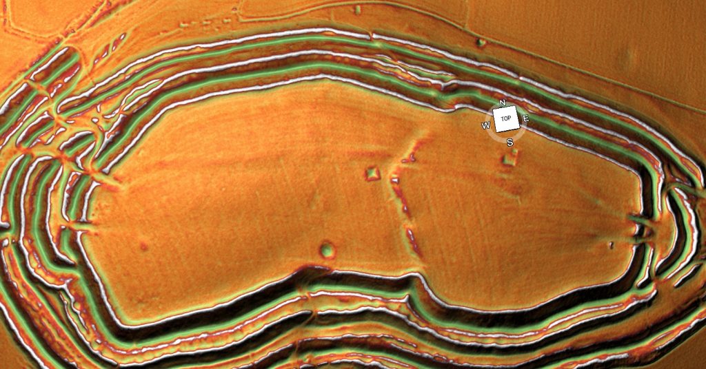
Windmill Hill - Avebury Ditch
Windmill Hill – Avebury Ditch

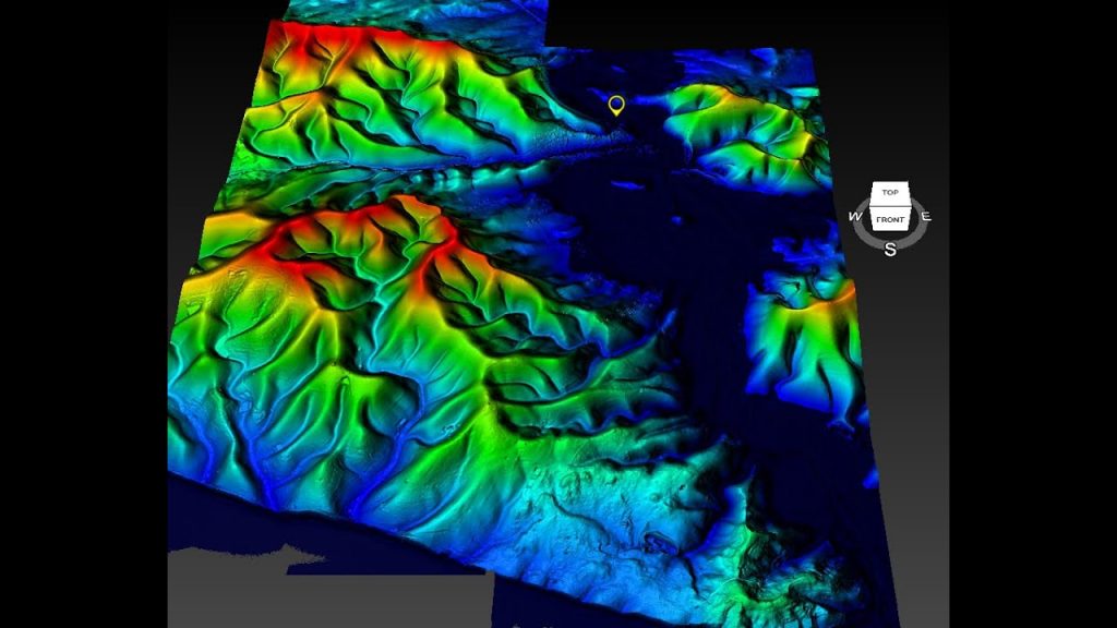
First thing we need to do is have a look at how Avebury looked in the Mesolithic and here we are back again with the Mesolithic high waters this is the Kennet this is Windmill Hill and as you we saw last week Windmill Hill are causewayed enclosure or what I call concentric Circle site which is much more accurate which is actually orientated towards the water so boats will come in and come more around the edge

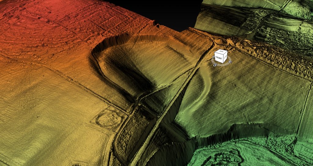
Now as the Mesolithic continued in the rivers fell in high what would have happened this site would become more and more inaccessible so much so that at some point they would have to actually have a new site and this is where Avebury will phase two as I call it was built if we zoom in a bit into Avebury you can see it’s quite unique with its large ditches and the River Kennet actually flowing but this is the river Kennet here today very small obviously much larger in the past.
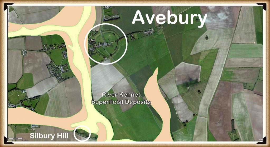
BGS Map of river alluvium - Avebury Ditch
BGS Map of river alluvium – Avebury Ditch

When it was that size and that large and I’ll show you a picture of the tick off the of the alluvium from the British Geological Society with their fanned around here it shows that once upon a time the Kennet was this size and would have touched the edge of the Avebury site which gives you a bit of a clue of what they were doing with it because the boats will now be able to come in and more inside Avebury in these gigantic ditches which I would imagine actually would joined we now got roads there this was just been one large ditch

I think it actually was there would have been a gap here because we’ve got the stone Avenues coming out this side but I would imagine the ditches would have continued here and were continued on that side as well and it’s only recently since the roads have been put in that these ditches have been filled in for obvious reasons.
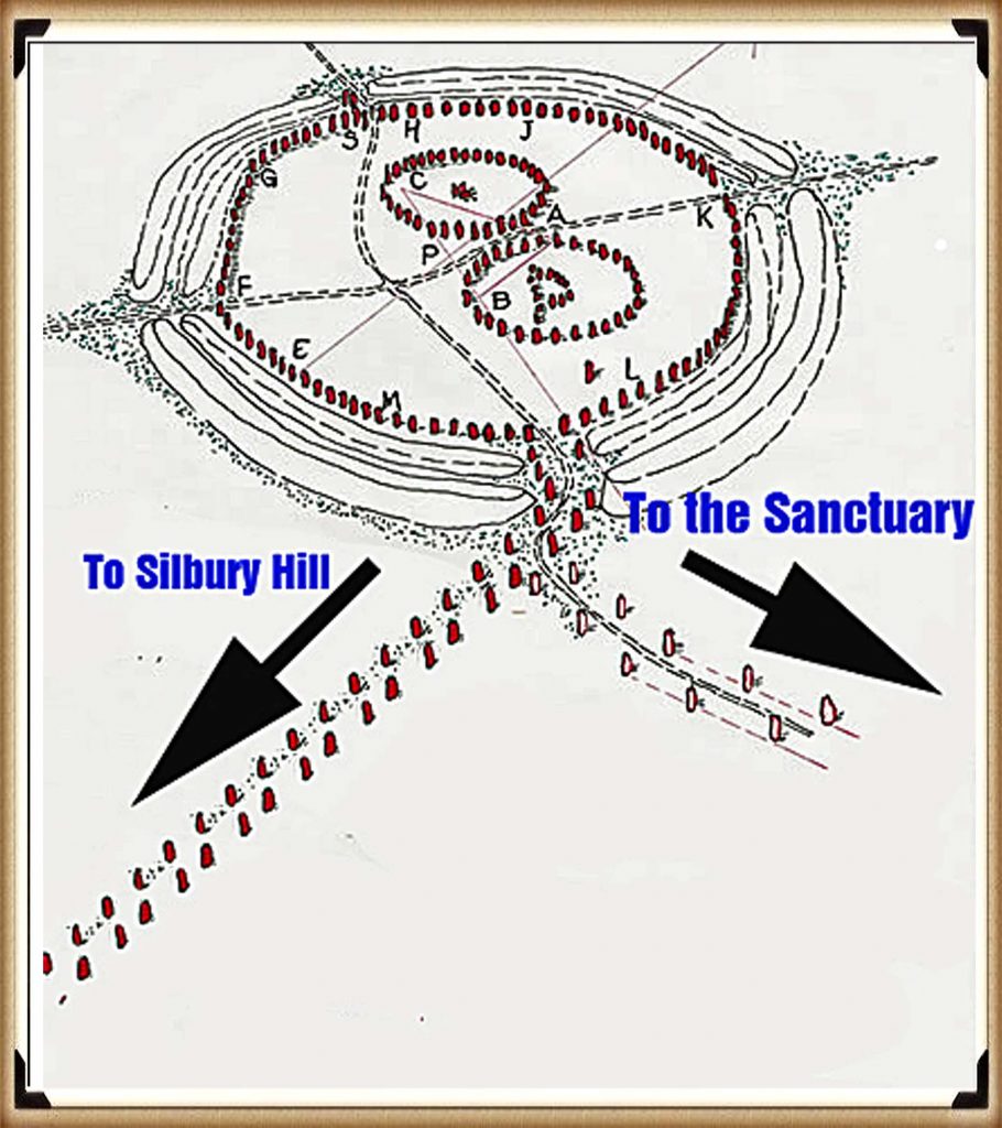
Stone Avenues spreading from the Southern Entrance - Avebury Ditch
Stone Avenues spreading from the Southern Entrance – Avebury Ditch

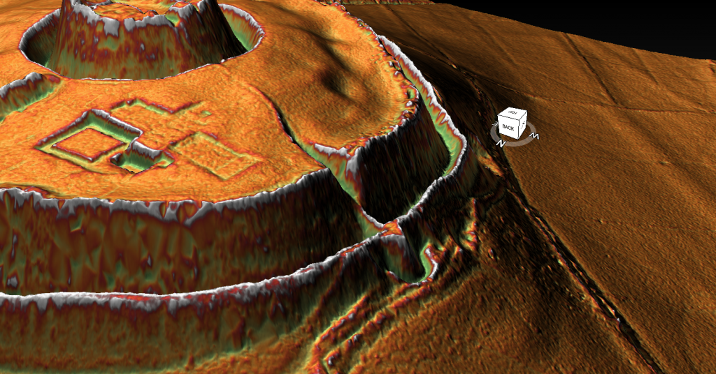
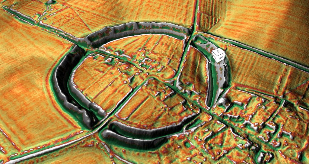
Now what’s interesting if we can pan in and tilt this just a little bit is having a look at the west side which has been lowered for the Kennet. Now archaeologists have seemed to miss this completely for some reason.

As we can see there very clearly and what I’ll do I’ll take the water off because it’s a bit distracting that’s better well you can see here very clearly is that this bank has been tapered it’s been rounded here and tapered there now that and obviously on this side has been tapered here there is no logical reason that it’s been should have been tapered and if you look at some of the if you look at some of the icon drawings they will show you it has been completely round at some point which is a nonsense it was never that way these tapered edges have always been there and as we have a closer look we could go around the back and have a look
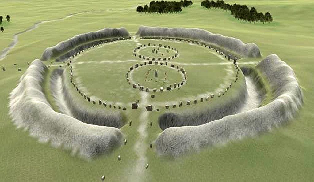
Archaeologists view of the Avebury - Avebury Ditch
Archaeologists view of the Avebury – Avebury Ditch

We can show you that basic there you go can’t get more clear there this was this was made to be tapered this was not natural there is nothing here… most people think that it was tapered or cut down because it’s in a way off part of the tap well there’s no town there and as you see from the LiDAR there’s never been we can see we see walls and buildings and bits here and here and here here nothing so why would you take down this gigantic bank if you have no reason to it’s a bit of a nonsense really.

So this tapered effect of the bank has never been explained by archaeologists unfortunately but it is a main key feature and if we put the water back in again it becomes painfully obvious and that’s a bit too high and we it will drop a bit here we go painfully obvious that this is where the water were coming to fill the ditches of Avebury – archaeological conundrum 101 Avebury resolved

Okay for we go and take a look at the number bank here we also see that that’s been this rounded obviously it’s not squared it’s been tapered as well and that’s because it was never meant to be there and I imagine once upon a time that the river probably came in here and would have come in here it’d be very hard to see this now because this is now raised ground due to the fact that you’ve got a cricket ground and you’ve got buildings and you can see this is this is natural ground – this has been built upon in recent years with bits and pieces which have changed the level and therefore we don’t see as we see on this side it’s nice clear aspect of where the River would have come in in the past .

We see here very clear River would have been here boats would have come here and trading would have been on here very much like Windmill Hill in the past so a very clear indication of Avebury phase two the other aspect which archaeologists sadly don’t really go into much detail about is why did they dig the ditches are so deep. They don’t need to be 12 meters deep do they?
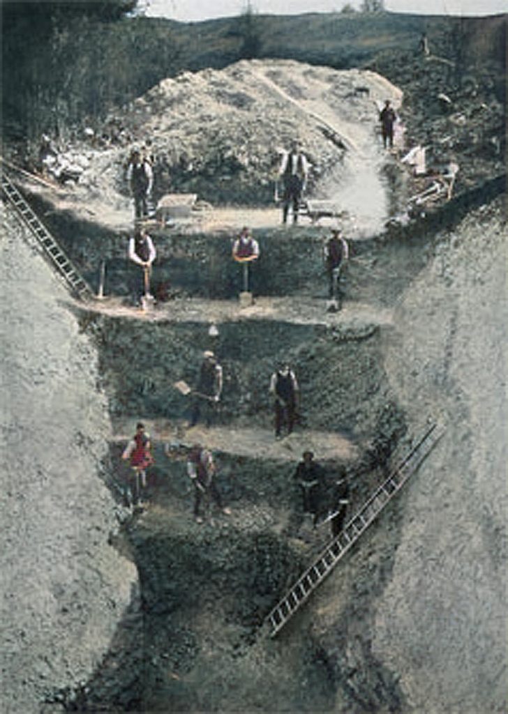
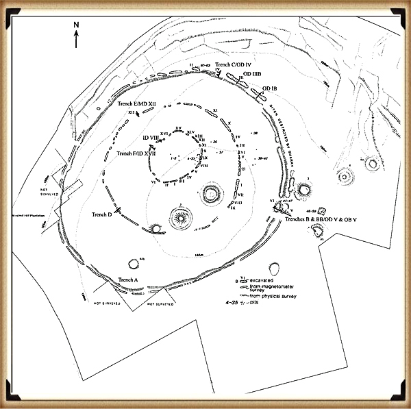
Avebury Excavation of 1914 - Avebury Ditch
Avebury Excavation of 1914 – Avebury Ditch

Unless there this is a really good reason now sadly I watched Carenza on Time Team once and she told me on the television that these ditches were so deep it was to keep out evil spirits…wow!

How can I question that that is such a scientific proof with such great evidence who wanted to question that logical scientific conclusion to why these ditches are 12 meters deep unless of course it’s wrong what we have found is that as the river and let’s see if I can illustrate this by showing the River as as the river went further and further away the water table would have got lower and lower as you see here it’s dropped another three meters if it drops another three meters here and not touching to keep this has water and I would imagine again because we can’t see there might be still a connection roughly here to here because again you’ve got buildings here it’s referring the landscape so it’s almost impossible to tell surfaced original surface area was it’s all been built up since then.

But clearly from this illustration here we can see there is there is a a hint that the river continued to touch the edge of the the site here and it’s dropped from one five seven to one five four so that’s three metres now if it’s dropped three metres in water level these would have to be three metres deep deeper to contain water that’s the logical aspect of the water table.

So let’s say it started up as a two metre ditch which is what we see in Stonehenge and other rare and other sites start up as a two metre ditch with water as you start to dry up they would have to then dig so it would on this hand this occasion they’re out of it a number three metres to it so that’s a minimum of five metres which is a very very big ditch.
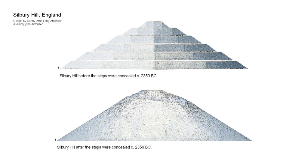
Silbury Hill built in Phases - Avebury Ditch
Silbury Hill built in Phases – Avebury Ditch

So what we see here is that Avebury was actually built in stages and then we see this later on in phase three when we start looking at Silbury Hill and the fire Beacon there and how that was built we see it started low and it built up high over hundreds of years very good reason for that is for visibility on this occasion with a brief phase two is because the groundwater dropped and they tried to keep up with the drop of the groundwater by digging the ditch deeper until it got to 12 metres and if I can just lob in a picture here when we done an excavation or when archaeologists done the excavation in 1922 (2014) when it got when they got to the bottom of this ditch which was at the same height as the eight of the same height as the cross so you can see the picture we’ve been at the same height of as the Kennet which is this river here they actually had to stop because it failed full of water one we might have to say a bit of a clue what it was when it filled full of water but clearly archaeologists don’t want to know the truth because they’ll have to rewrite the books.
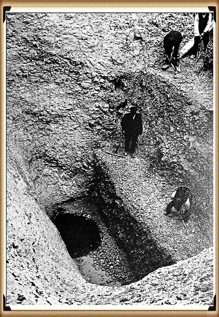
1914 Avebury Excavation had to stop as it hit the water table - Avebury Ditch
1914 Avebury Excavation had to stop as it hit the water table – Avebury Ditch

Anyway that is Avebury phase two next week we’ll look at Avebury phase three which we’ll be looking at the very famous Silbury Hill and where that was built and again it’s to do with water levels

Well that’s all we’ve got time for this week tune in next week for another edition of Langdon investigates where we look at another ancient site until then subscribe below to make sure you’re informed when new videos come on the video channel until then thank you for watching.

For more information about British Prehistory and other articles/books, go to our BLOG WEBSITE for daily updates or our VIDEO CHANNEL for interactive media and documentaries. The TRILOGY of books that ‘changed history’ can be found with chapter extracts at DAWN OF THE LOST CIVILISATION, THE STONEHENGE ENIGMA and THE POST-GLACIAL FLOODING HYPOTHESIS. Other associated books are also available such as 13 THINGS THAT DON’T MAKE SENSE IN HISTORY and other ‘short’ budget priced books can be found on our AUTHOR SITE. For active discussion on the findings of the TRILOGY and recent LiDAR investigations that is published on our WEBSITE you can join our FACEBOOK GROUP.

Windmill Hill – Avebury Phase 1

Langdon Investigates Short Videocast – Transcript (Windmill Hill)

Hello my name is Robert John Langdon and you’re watching my video channel this video cast is one of my 10 minute shorts which looks at sites around Britain using LIDAR in a strange sense this is my version of landscape archaeology for the 21st century i hope you enjoy

This week we look at Avebury Stone Circle a little bit like Stonehenge the way to examine this site is to look at the surrounding areas and the landscape what i have done is split this into three sections and this is phase one which will concentrate at windmill hill now windmill hill is a very interesting sight because it’s somewhat northwest of the main site of Avebury but if we can if we see it’s actually on the highest aspect of the landscape now if we put in the Neolithic water levels at the time we see it’s become an island which is makes it even more interesting we if we now zoom in to the site we’re gonna give it a bit of a tilt to make it much more interesting to look at and then we’re going to give it a bit of a look around so we’re going to look around why explain windmill hill and what the archaeologists make of it.

After the great melt of the last ice age this area would have been almost flooded at the start the Mesolithic period about 10 000 bce the only part of Avebury above this initial water level would have been windmill hill this site shows evidence of occupation this is what archaeologists call a caused way enclosure as they incorrectly imagine that the moats that built to accommodate ships and boats were in fact dry ditches to contain cattle -would you believe

Windmill Hill Avebury

So let’s have a closer look at Windmill Hill – now the first thing you should observe its location if you’re going to build a site surely you would build it in the middle of the island and archaeologists don’t believe it was island this is if it was a hillside then you would have built it on top of the hill rather than on one h which doesn’t make any sense as we spin around you see this more clearly

Now the fascinating aspect of this is that one of these ditches dips into what would have been the River Kennet in the Mesolithic period when we’ve looked at other sites such as the volcano we actually found that there are very very clear dykes that go from the inner ring to the outer ring but what you do see very clearly is where they’ve actually positioned this caused weighing closure as they could this gives you a better idea of the original depth of the dishes this is all being ploughed down left so we only got a ghost of the image as it was but clearly this is a lot different to what the archaeologists imagine is something for cattle

Causewayed Enclosure - Windmill Hill
Causewayed Enclosure – Windmill Hill

The construction is kind of site used for cattle to be honest is complete nonsense if you think about it as the time the effort the organisation and the workforce required to dig this these dishes for some cows is I find totally bizarre you know at the end of the day wood was free build a fence it’s far far quick this is 30 times more work than building a fence and at the end of the day why would you want you know three rings if it’s to corrode some cows that’s great put it that way and you know fits it off in the middle it’s much why would you do a concentric circle site for some cows – and sadly this is archaeology today it’s nonsense it doesn’t make

Whitehawk Causewayed Enclosure - Windmill Hill
Whitehawk Causewayed Enclosure – Windmill Hill

Any sense any rational person would look at this and go obviously there must have been method in their matters look if you’ve spent you know thousands of man hours building something and you’re going to put some cows in it you know if a ditch was an effective way of keeping cows in you would have farmers with their jcbs which is somewhat quicker than digging it by hand knocking out ditches all right their farms rather than building fences which is you know it’s just a nonsense but that’s archaeology today you know what do i know i’m an idiot according to them

Construction of Causewayed Enclosures - Windmill Hill
Construction of Causewayed Enclosures – Windmill Hill

So this was phase one back to reality rather than the archaeological bubble this was phase one it’s um it’s a causeway include and you know the the most fascinating aspect i don’t call them complaint closures because it’s a nonsense yeah i call concentric circle sites and i do that because they’re we the one of the earliest writers in history talk about them would you believe you know someone from 300 bce talk about concentric circle science and that guy was Plato.

Plato described a a a city with concentric circles it’s amazing that you’ve got someone in history who actually writes about concentric circle sites now it’s you know this is over two and a half thousand years ago much closer to the time where obviously these these sites existed so one would imagine that the the they had a better idea of why they were constructed today

Plato - Windmill Hill
Plato – Windmill Hill

But the most amazing aspect of you know Plato’s work and contra concentric circle sites is that he dates them as nine thousand years before the present he’s present so then ninety thousand bce we’re talking about now no one in the past ever imagined that these sites could exist but they have existed and they’re here now they’re in Britain they’re in the northern hemisphere they’re probably under Doggerland where they these people actually who originated these sites came from and and an amazing aspect of Plato’s work is that he talks about a civilisation who drowned under you know the first of climate change I suppose the ladies put it by rising sea levels and that was 9 000 years ago that’s when it started at least and this these signs are dated back to them

Now the archaeologists would tell you oh no no no no they’re only 3 000 bce not no they’re only 5 000 years old not not 10 000 years old and that’s because at the end of the day they date and if we put this on holding it they go and date these sites by what they find in this ditch now to be honest that’s probably what i would call bad science and they’re bad science because at the end of the day you can’t date you cannot take that site but what’s in that ditch

Causewayed Enclosure Distribution - Windmill Hill
Causewayed Enclosure Distribution – Windmill Hill

So back to our little display we have windmill it’s it’s made to touch the River Kennet because you would sell your boat to this river in you go on on the inner circle you can park it there i would imagine that something like here you can then take your boat to the inner circle perhaps you know yeah that’s i see it more like I don’t know a um a car park everybody goes to Sunday markets don’t they think think of it more your boat is your your modern day car you take it along the river which is the highway and you want to sell your goods at the back of yours in your Sunday market so you park your car in a car park as close close to the centre as possible you know if you got there late you have to come to the end if you got there early you get in the centre wherever you’ve got the bigger footfall so you go there you park your car you open your boot and you sell your goods do you think people in the past didn’t do something similar they didn’t have a car clearly but they had a boat you take your boat full of your goods you come into this site you take your bring your boat in from the river if you’re late you have to park around the end if you’re early you can go to the the inner one of the inner circles if you’re really really early and you’ve got lots of things to to sell but perhaps you’re selling food.

You know we know that we know that food was brought from as far as Scotland into uh big meat we know that it’s a fact you know it’s something archaeologists don’t like to admit but they’re mystified how the hell do you get a cow from Scotland to pick mead if you don’t have a boat it’s you know the the idea they bring this by car is absolute nonsense you wouldn’t even know what big media is from Scotland you know if we got the if they got GPS or the greatest signposts in the world – I don’t think so

Mesolithic Site Animal DNA distribution - Windmill Hill
Mesolithic Site Animal DNA distribution – Windmill Hill

But you can follow a river and rivers usually lead down to to places like this and we’ll have a look with phase two how they got to places like this in the most obvious way so you bring your boat in if you’re if you’re early you get into the centre if you’re selling food particularly you get into the centre you go you park your boat on the banks and people will come in perhaps perhaps uh the the people with their wares take this inner circle and they say out the circle and people are visiting use the out circle you know at the end of the day if you bring it back you can always park it on the edge and walk up yeah and you can beat it on these beaches and just walk across you know to you know if we’ve got a footpath that may be tens of thousands of years old you know we could park beaches there walk up do some trading go back to your boat go back home phase one of uh windmill hill piece of cake if you’ve got half

Well that’s all we’ve got time for this week tune in next week for another edition of Langdon investigates where we look at another ancient site until then subscribe below to make sure you’re informed when new videos come on the video channel until then thank you for watching.

For more information about British Prehistory and other articles/books, go to our BLOG WEBSITE for daily updates or our VIDEO CHANNEL for interactive media and documentaries. The TRILOGY of books that ‘changed history’ can be found with chapter extracts at DAWN OF THE LOST CIVILISATION, THE STONEHENGE ENIGMA and THE POST-GLACIAL FLOODING HYPOTHESIS. Other associated books are also available such as 13 THINGS THAT DON’T MAKE SENSE IN HISTORY and other ‘short’ budget priced books can be found on our AUTHOR SITE. For active discussion on the findings of the TRILOGY and recent LiDAR investigations that is published on our WEBSITE you can join our FACEBOOK GROUP.
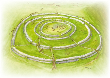
The Old Sarum Hoax

This week we that a look at The Old Sarum Hoax

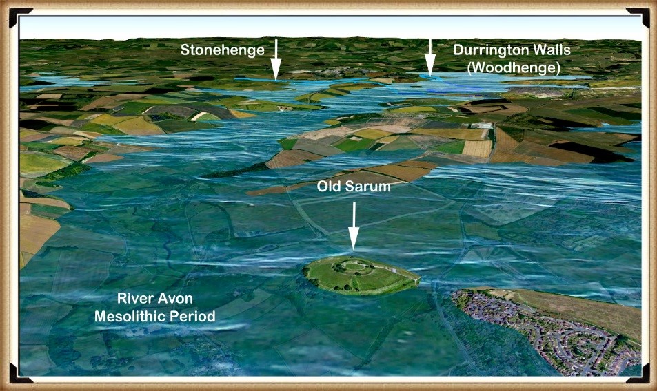
If we use the Southern Station Stone as a direction marker from Stonehenge, it points South by South East.  If we then follow the line on a map of our Mesolithic landscape, showing the raised river levels of the past, we find that it points to a fantastic site just 10 km away from Stonehenge: an island in the middle of an extensive waterway called Old Sarum. (The Old Sarum Hoax).

 The Old Sarum Hoax
The Island of Old Sarum in the Mesolithic Period – The Old Sarum Hoax

The positioning of this site is most interesting, as it lies very close to the English Channel, which would have enabled boats to reach the continent.  It is quite possible that this was Britain’s first seaport, as it appears to be the last known Mesolithic-era island to be occupied.  If so, it would have been one of the most critical sites in Britain and Europe, as it would have been involved in nearly all Mesolithic imports and exports to and from France, Spain and the Mediterranean countries.

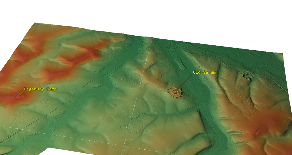
The area surrounding Old Sarum is also of great interest, as it has two sites on the same raised river, the Avon, in the past.  One of these sites, called Figsbury Ring, is even older than Old Sarum.  The Old Sarum area is very similar to the Avebury Area, as it has an ancient site older than the central Avebury Stone circle called Windmill Hill. 

River Avon and sites on the route

Both Windmill Hill and Figsbury are what archaeologists call ’causewayed enclosures’ – this is sadly and not uncommonly incorrect labelling of these sites by academics, as we also see from their term ‘Iron Age Forts’ that are neither Iron Age nor fortifications.

Causewayed enclosures are labelled as enclosures for cattle, with paths across the ditches (causeways) for access by the livestock – this is complete nonsense.

A more historically accurate definition for these monuments would be ‘concentric circle sites’ – the term was created by none other than Plato, who referred to them back in 300 BCE when relating to the story of Atlantis and its central city’s description, which I cover in great depth in my books.

This ancient reference to such sites clearly dates both Windmill Hill and Figsbury to the very early Neolithic, when the Avon and Kennet waters were at their highest, directly after the last Ice Age, 12k years ago.

These monuments were constructed for boats to moor with their circular ditches to trade, and it was only when the waters fell towards the end of the Mesolithic and early Neolithic that both Old Sarum and Avebury were constructed to replace their predecessors.

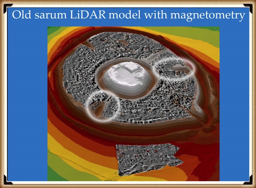
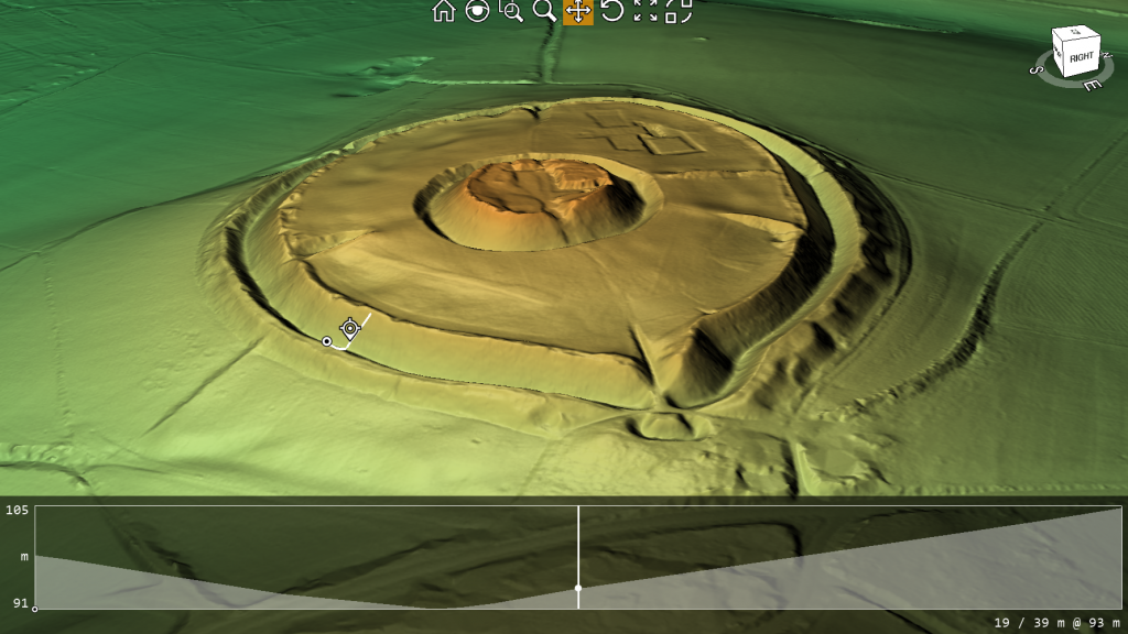
The island of Sarum would have been a magnificent sight, sitting in a vast river as wide as the eye could see.  When we look at the LiDAR survey of the site, we notice that two deep ditches lead from the outer to the inner ditch, both of which have been partially filled.  During the Mesolithic, the groundwater would have flooded both the outer and inner channels via the Dykes (canal) cut in between the two ditches.

Current theories on this site speculate that the central moat was dug for the motte-and-bailey Norman castle that stands there today.  Still, without firm evidence, this is just speculation – although as the centre of the site is now raised, it would be probable that both the Romans and then the Normans, cleaned out the prehistoric ditch and then extended further down to the new water table, to keep the inner ditch as a defensive moat, placing the excess spoil in the inner area of the site.

Lidar Magnetometry Survey showing two Dykes

The site at Old Sarum is much bigger than Stonehenge and is similar to Avebury.  One can only guess what would have been in the centre of the Mesolithic island.  From the amount of reused Sarsen stone found in the remains of the Norman castle, the original cathedral, and the Roman Fort, we can infer that a megalithic structure such as Stonehenge or Avebury stood at Sarum in prehistoric times.  Because if you extend a line from the centre of the motte-and-bailey at Old Sarum through the centre of the church (the original Salisbury Cathedral), it points to Stonehenge.

Churches built on prehistoric sites are not uncommon.  In addition, there are many instances of pagan religions being crushed by Christianity, taking over their sacred sites and using the stone circles as a building material for their churches.  So, we believe that in prehistory, three stone circles existed at Sarum: one large outer circle and two smaller inner circles, indicating the way to Stonehenge.  Later, as the groundwater fell, our ancestors built Sarum’s outer banks to keep their sacred site an island.  At Avebury, a similar configuration is evident, with two smaller stone rings within the large ring bordering the outer moat.

In the Neolithic Period, the groundwater table dropped by about 10 m, and the island of Sarum was joined to the mainland by a peninsula.  Our ancestors, therefore, built giant ditches 12 m deep to keep the site surrounded by groundwater.  The Southern and Northern mooring points could no longer be used, as the groundwater had receded too far, so the Neolithic people created a new landing point to the West.  They left a gap in the large ditch, so that people and goods could enter the island; this would have looked like a bridge across the water.

Neolithic Loading position with a pathway cut over the outer moat to the interior

At the end of this footpath, they built another mooring station that protruded from the edge of the moat, like a peninsula, so that boats could be moored safely around the feature.  (Silbaby)

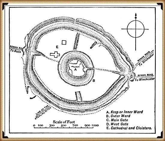
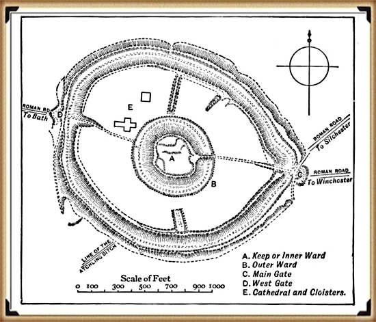
For some bizarre reason known only to early archaeologists, the platform is shown on some maps as a Roman road which connected to a road some 200 metres away on the island’s West side. But, unfortunately, that theory would take a leap of faith and nature. The landing platform, shown as a lumpy protrusion on maps, has a 1:2 slope and a vertical drop of over 30 metres.  I would suggest that a Roman horse and cart would not be an advisable means of transport for this terrain unless they were equipped with ABS brakes and a parachute.

Plan of Old Sarum - with 'impossible' Roman road to Bath with a 1:2 vertical drop
Plan of Old Sarum – with ‘impossible’ Roman road to Bath with a 1:2 vertical drop

The historical record gives us some clues to Old Sarum’s deeper past and how the groundwater surrounding the island dictated its history.  The original Salisbury Cathedral was built here, only to be moved down to the valley a few hundred years later.  Can you guess the reason for the move?  That’s right, the lack of water!  It seems that even over the Cathedral’s brief history at Old Sarum, the groundwater continued to subside.  As this story is well known, why did no one wonder how deep the rivers might have been thousands of years ago?

The Maths

Currently, the groundwater table around Old Sarum is 56.5 m above sea level.  The well in the Norman fort is 70 m deep from an altitude of 130 m, which shows that the groundwater is today 3.5 m below the Norman well.  Therefore, the groundwater table in 1000 AD – when the well was first constructed – must have been at least 60 m, so in 1,000 years the groundwater has fallen 3.5 m.  If we multiply this thousand-year drop in the groundwater table by 9, then add 56.5 m to account for the existing groundwater table, we can estimate the groundwater table 9,000 years ago, i.e. in 7000 BC.  That would make the groundwater table (9 x 3.5 m) + 56.5 m = 88 m.

I, the outer banks of Old Sarum, are 89 m above sea level – close enough to prove my point, methinks?

New information 2024

According to English Heritage, which owns the site, Old Sarum is an ‘Iron Age hillfort’, which may have been established here about 400 BC. It was then occupied shortly after the Roman conquest of Britain (AD 43), when it became known as Sorviodunum.

The Great Iron Age Hill Fort Hoax
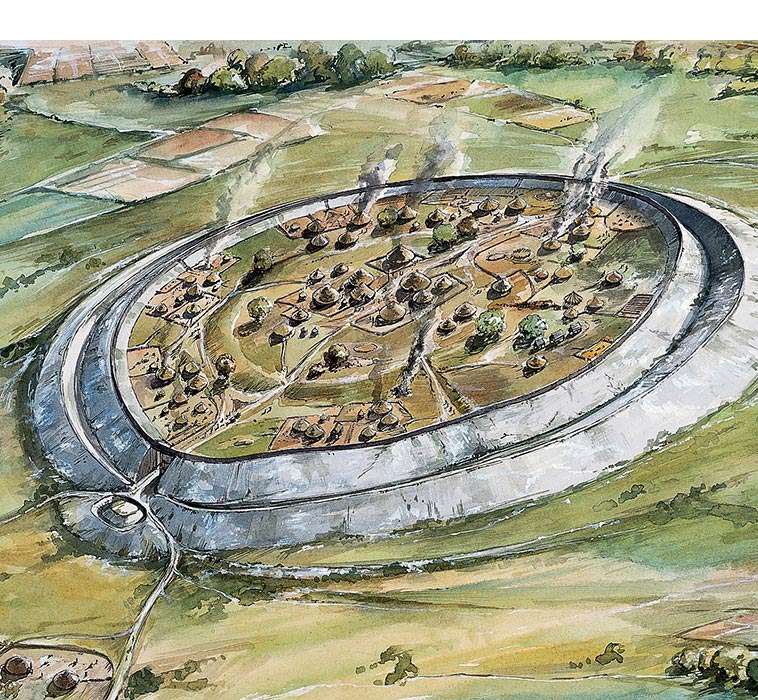
EH: A reconstruction showing how the Iron Age hillfort at Old Sarum may have appeared in about 100 BC

Three Roman roads from the north and east converged outside the east gate of the hillfort, and two sizeable Romano-British settlements were also established outside the ramparts. Little is known of this period, though it has been suggested that in the early Roman period a military fort was set up within the earthworks, with a civilian settlement outside. The civilian settlement formed the nucleus of one, or both, of the extra-mural Roman settlements. As the need for a fort dwindled, meanwhile, the area within the ramparts was converted to become the precinct for a Romano-British temple.

We have no evidence of the fate of Sorviodunum at the end of the Roman period, and the Anglo-Saxon period as a whole is poorly recorded. In 1003, however, a mint was sited within the old hillfort; and archaeological finds suggest there was late Anglo-Saxon settlement outside the ramparts. So there is evidence of life in and around Old Sarum before the Conquest.

Old Sarum with supposed Roman roads


In my view, oversimplified interpretations of the past, lacking excavation work to substantiate theories, pose significant challenges. Close examination often reveals fundamental flaws, such as the assumption that Roman roads converge and pass through a particular site. This type of desk-based archaeology, relying solely on OS maps and rulers, can lead to subjective conclusions.

The reality, as demonstrated by my own LiDAR investigation, contradicts these assumptions. The supposed road leading through the site to Bath is absent from both LiDAR maps and satellite photographs. Furthermore, considering the topography, it would be implausible for such a road to exist unless it were the largest land bridge in British Roman history.

It’s crucial to approach archaeological interpretations with a critical eye and to rely on comprehensive research methods to uncover the true complexities of the past. My LiDAR investigation highlights the importance of utilising advanced technologies and conducting thorough fieldwork to refine our understanding of historical landscapes.

Is it a defensive structure?

In archaeology, I believe honesty is paramount. Categorising sites under broad labels like “Iron Age Forts” oversimplifies their complexities. Take Old Sarum, for instance—it’s situated in a floodplain on an island, not on a hill as commonly assumed. This challenges our traditional understanding of fortifications and prompts us to reconsider our interpretations.

The Great Iron Age Hill Fort Hoax
Hills are in red, flood plain is in green – Old Sarum is an island in a floodplain on a hillock

The proximity of these supposed defensive forts raises another intriguing question. Why would communities invest considerable time and effort in building multiple forts close to each other? Considering the logistical challenges and the likely limited population of prehistoric Britain, it’s logical to question the necessity of such clustering.

Assuming that manpower was an unlimited and cost-free resource in ancient times is overly simplistic. It overlooks the practical considerations that would have influenced decision-making. By challenging these assumptions, we can gain a deeper understanding of prehistoric society. I believe it’s essential to critically examine these aspects of the past rather than accepting naive interpretations. Let’s strive for a more nuanced understanding that acknowledges the complexities of ancient societies and avoids oversimplification.

Was the Outer Moat constructed to keep water in as a moat?

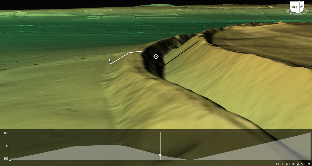
When we examine the site’s profile using lidar, two major findings become apparent. Firstly, the spoil from the ditch was placed on the outside rather than the inside (as expected if it was defensive), and the base of the spoil was not part of the natural rise of the floodplain, indicating that the outer part of the ditch is actually a bank.

The Great Iron Age Hill Fort Hoax
The Ditch Spoil is on the outside not inside as a defensive structure would expect
The Great Iron Age Hill Fort Hoax
The profile shows that the base is not part of the natural hillock and is in fact a false bank

Water Table

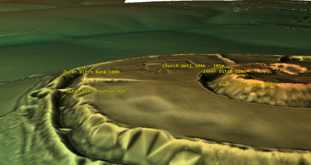
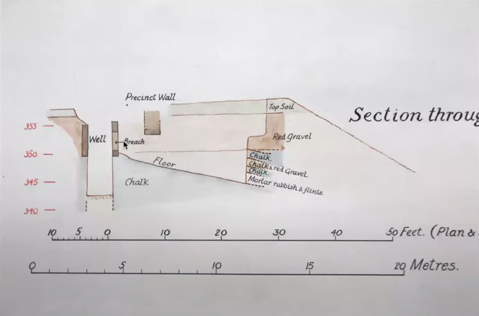
Based on the site’s historical records, we understand that one motive for relocating the church was its water shortage, which led it to tap into the garrison’s deep well. This knowledge allows us to assess the state of the moats and comprehend why the inner moat was excavated to a depth of 7 meters. By examining the well discovered during excavation, we ascertain that it was abandoned at a depth of 104m to 105m (OD), suggesting that any ditch below this level would have become waterlogged.

The Great Iron Age Hill Fort Hoax
The sites feature with their height over OD specified

The initial depth of the inner ditch was 110 meters (OD), but today it measures 103 meters (OD), which is below the bottom of the Church well. Based on this data, we can hypothesise that during Norman times, the inner ditch was dug deeper to reach the water table. It’s also possible that, as the water supply for the moat decreased over the church’s lifetime, the moat was excavated unusually deep to access the diminishing water levels.

The Great Iron Age Hill Fort Hoax
Church well going form 108M (OD) to 104m (OD)

This new understanding of the water table also opens up the possibility that the outer ditch was also moated up to the Norman conquest, and moreover, during the Roman period – this is something that needs urgent explanation and further study.

For more information about British Prehistory and other articles/books, go to our BLOG WEBSITE for daily updates or our VIDEO CHANNEL for interactive media and documentaries. The TRILOGY of books that ‘changed history’ can be found with chapter extracts at DAWN OF THE LOST CIVILISATION, THE STONEHENGE ENIGMA and THE POST-GLACIAL FLOODING HYPOTHESIS. Other associated books are also available such as 13 THINGS THAT DON’T MAKE SENSE IN HISTORY and other ‘short’ budget priced books can be found on our AUTHOR SITE. For active discussion on the findings of the TRILOGY and recent LiDAR investigations that is published on our WEBSITE you can join our FACEBOOK GROUP.

The Woodhenge Hoax

In our last video, we looked at Durrington Walls in Wiltshire to find that it was not a traditional henge but a harbour for boats, with natural springs and ditches cut into the site to allow boats to moor in the prehistoric past – (Woodhenge Hoax). Today we will look at an associated structure next to the prehistoric harbour – Woodhenge, to see if we can find what association this has with Durrington Walls.

This monument has a series of ‘massive’ wooden post holes – at this point, I need to explain that archaeologists don’t seem to understand the difference between a ‘Post Hole’ and a ‘Stake Hole’. You use stake holes for posts such as fences as they can be quickly buried in the ground as they have a sharp point – this point naturally compresses the surroundings (due to the shape and hammering from above), so they don’t move or wobble!

A ‘Post Hole’ is different as it has a flat bottom and needs rubble to stop it from rocking from side to side. Stake holes are easy as they are ‘self-burying’ while post holes are more work as you need to dig a hole for it. The only reason you would do all the extra work of digging a flat-bottomed hole (especially in chalk) is if the wooden pole is to take some kind of weight from above, for a stake hole is useless for this type of structure as it would sink (overtime) under the weight pushing down on the point and probably fall over.

Therefore, if you have a round wooden single-storey building (which was the original theory by archaeologists that excavated Woodhenge) with a simple roof, the use of massive posts is simple ‘over-engineering’ and time-consuming – especially with simple tools.

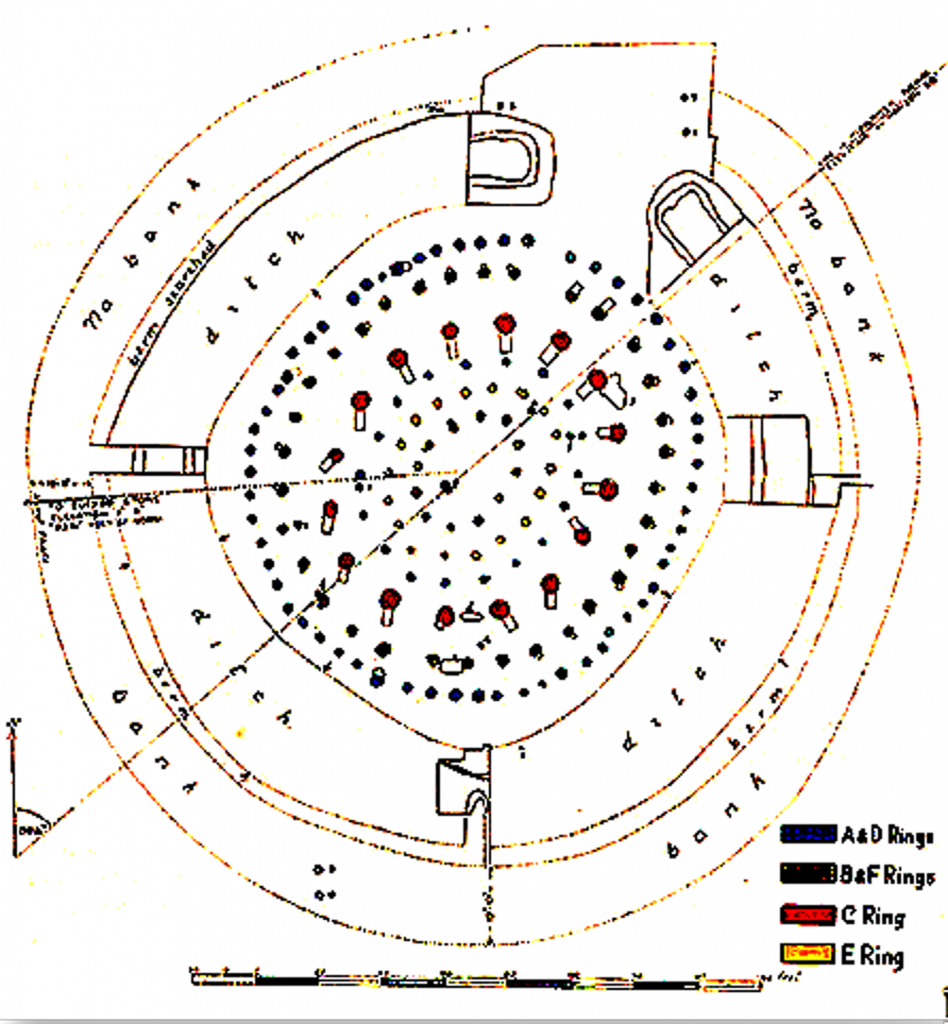
Cunnington excavations at Woodhenge in 1929 suggested that some posts are up to 60 inches in diameter: Cummington reports that:

“clear evidence was obtained in excavation that the six centric rings of holes once held posts or tree trunks varying from 1ft to 3ft in diameter according to the size of the hole…… the size and depth and distance varies in each circle…. In the outer circle holes are 6ft apart from centre to centre, from 1 1/2 ft to 2ft in depth and from 2ft to 3ft in diameter. In the second circle the holes are larger and further apart, averaging about 4ft in depth and 3 ½ to 4ft in diameter. The largest of all were those were those of the third circle, being about 6ft deep with a diameter at the top from 4ft to 5ft“

Sadly, Woodhenge shows us yet another illustration of flawed science in archaeology. Even with a ‘second rate’ excavation report from the 1920’s the conclusion of modern archaeologists is that this structure was a single-story house – a slightly grander feature to the traditional ‘iron age’ house. This is simply nonsense. If we look closely at the evidence presented here, we obtain a totally different and more accurate conclusion to the nature of this structure.

Cunnington Excavation plan 1929 - (Woodhenge Hoax).
Cunnington Excavation plan 1929 – (Woodhenge Hoax).

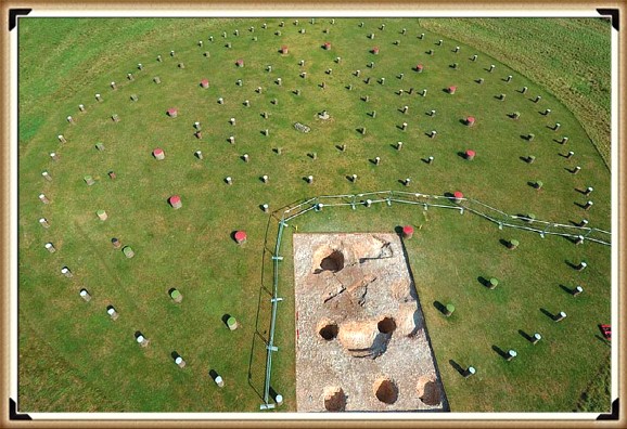
Firstly, if we look at the layout of the site (which lacks much detail), we can see from these original excavation plans the scale of this understatement, as the existing ‘concrete’ posts on the site, are far too small. The most recent photo was from the excavation by Pollard in 2007, indicates that these posts are at least five times larger than the current representations – although he is happy with the concrete post representations – which suggests either he was towing the traditional archaeological view or he should have gone to Specsavers?

The next fact that goes unanswered by archaeologists is the reason for the large post-hole ramps. You don’t take time to put 32 ramps into the soil unless it is essential, as you just added at least another month to the building work for the site and 500 working hours. What archaeologists have missed (or failed to mention) is in which direction these ramps were cut – as it tells us more than the entire excavation report by Cunnington.

The massive 4 – 5 ft pine posts of the 16 post-holes (known as the C Ring) would weigh 214kg per foot of length. Therefore, a sizeable healthy person (we will go into detail about who these megalithic people in my book – ‘Dawn of the Lost Civilisation’) could pick up one foot of pine and place it in a hole without assistance or a need for a ramp. 

Woodhenge post holes much larger than the concrete posts on the site! - (Woodhenge Hoax).
Woodhenge post holes much larger than the concrete posts on the site! – (Woodhenge Hoax).

Consequently, an eight-foot pine tree trunk could easily be placed on the shoulders of 8 people and put straight into the hole, which is the current estimation by archaeologists for a single-storey structure.

Therefore, the empirical evidence suggests they are wrong, and the pole was much more significant.

We have seen similar ramps at Stonehenge, not for the 4-tonne bluestones but by the Sarsen stones that weighed an average of 25 tonnes (the trilithons are 35 tonnes) but half the size of these ramps.

A 25-tonne pine post of width between 4 – 5 ft would be 39m long or 128ft, and a 35-tonne pine tree is some 177ft long. But do Pine trees grow that tall? Longleat Forest is just down the road from Durrington Walls; within this forest there are pine trees that grow to nearly 200ft tall.

Moreover, the site plan also gives us another clue to the length of these poles. If to look carefully at the angle of the ramps into the giant post holes, you will notice that they are not all facing the same direction. The only logical reason for that is if you erect the pine poles in a set order so that they would not hit or interfere with each other when attempting to erect the posts.

This allows us to come to some remarkable conclusions about the construction and the process of how it was built:

  1. Holes were filled in an anti-clockwise direction starting at hole 1 (at four o’clock to the site)
  2. Poles must have been more than 100’ long; otherwise, you could erect them in any order and direction.
  3. The current ditch at the site was added later, as you would need to bring the poles through the ditch and in some cases be in the ditch to erect it.
  4. The 4 to 5ft diameter posts all entered the site from the south, as it has the minimal distance to travel – as these poles were either rolled or dragged on a sledge and therefore probably the direction of where the pine trees have initially been growing or unloaded, after being floated down the river.

Now the slopes for ‘Ring C’ (the largest posts) are 5 to 8ft long, which are even longer than the Stone ramps (3 to 4ft) at Stonehenge (Fig.58). This probably shows the large (Sarsens are only 13ft tall) leverage factor required to be pulled upright with an A-frame, which then allows the posts to slide into position and then into the hole.

Ring B – the 3.5 to 4ft diameter trees also have ramps, but much smaller (3 to 4ft), indicating less leverage and therefore half the weight/height. Moreover, they were placed into position after the C Ring, as their ramps point away from the centre with no common direction.

Broch which was a later version of Woodhenge - made of Stone - (Woodhenge Hoax).
Broch which was a later version of Woodhenge – made of Stone – (Woodhenge Hoax).

The last row of post-holes (A), 1 to 3ft in diameter, do not have ramps and are sporadic in nature and size – which leads me to believe they have no structural significance and were probably more like a palisade covering, to either enclose the structure or allow mud or reed covering (wattle & daub) and protection from the elements.

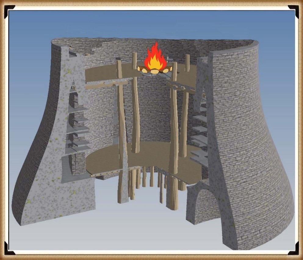
The internal posts (D to F) are superficial and probably were there to support the first-floor structure, as we see in their successors in British history the ‘broch’ – a stone version-built thousands of years later for the same purpose.

But my money would be on the tower being of a lower ratio of 1 to 1, with the base making it 135ft high and the same height as Silbury Hill, a little further up the river Avon.

Therefore, what would you build next to a harbour to attract and direct boats – obvious, isn’t it, a fire beacon (with a stone base) as we know from written history and the Pharos of Alexandria (280 – 247 BCE).

What Woodhenge probably looked like during phase I of its construction – with a spiral staircase - (Woodhenge Hoax).
What Woodhenge probably looked like during phase I of its construction – with a spiral staircase – (Woodhenge Hoax).

Furthermore, this link with the harbour is illustrated by the Moat, Bank and then a Dyke construction. As we have suggested, the Woodhenge ditch would not have existed at the original time (Phase I) of the construction of the C and then the B rings. It seems that it was added at the end of Phase I when the structure was complete and before Ring A was established, as it points to the shoreline of the Neolithic Avon River. This alignment disproves the current ‘expert’ theory about being an astronomical alignment with the Solstice Sunrise. 

Evidence for the construction of the post holes (with gaps in the circle which were later filled with smaller posts) indicates that the ditch had filled from age or by design. The main opening (in the A circle) to the northeast is not in line with the gap in the ditch, and the two other spaces in the circle, would track across the ditch in the southeast and northwest.

As for the dating of Woodhenge (and Durrington Walls), like Stonehenge, unrelated antler and bone fragments have dated it to about 2400 BCE, which is very convenient. The problem is that most of the post hole samples at Woodhenge were either lost or have been stored away and not tested since the excavations between 1926 to 29, for reasons known best to the experts.

Moreover, like the samples taken from the old car park in 1966, pine charcoal was reported to be found “similar to the charcoal found at Woodhenge” was the quote from the labs at the time, who failed to carbon date the samples as the experts had declared them Neolithic, supporting the antler pick dates. Although now, once this gross error was exposed, we know these pine charcoal wood dates to be in fact, Mesolithic 8100 BCE – which ‘begs-the-question’ so are the pine charcoal dates found at Woodhenge also Mesolithic?

Less than a mile down the river is ‘Blick mead’, (Vespasian’s Camp), which has also been found in dates ranging from 7900 BCE, (remember our bluestone estimation for Stonehenge is 8000 BCE), to 4050 BCE, with multiple RC dates from the 8th to the 5th BCE. Sadly, until someone finds these samples and carbon tests them to get an accurate date for Woodhenge and Durrington Walls, this unscientific archaeological ad hoc dating methodology will continue.

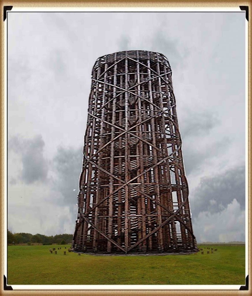
Furthermore, the engineering structure created by this civilisation – like the design at Stonehenge, has been overlooked by archaeologists looking for a more simplistic ‘hunter-gatherer’ solution for this superstructure, which has ended up with a single-storey roof, that is clearly well over-engineered for that purpose. We can see at Woodhenge (and also at The Sanctuary at Avebury) the ‘triangulation’ of wood joints using the mortice and tenon techniques we have seen on the Sarsen stones at Stonehenge. This structural technique (which are incorporated in modern towers today) allows to the construction of extremely high wooden towers, which is what we see at Woodhenge.

Woodhenge Unique construction technique for building towers – still used today – (Woodhenge Hoax).

For more information about British Prehistory and other articles/books, go to our BLOG WEBSITE for daily updates or our VIDEO CHANNEL for interactive media and documentaries. The TRILOGY of books that ‘changed history’ can be found with chapter extracts at DAWN OF THE LOST CIVILISATION, THE STONEHENGE ENIGMA and THE POST-GLACIAL FLOODING HYPOTHESIS. Other associated books are also available such as 13 THINGS THAT DON’T MAKE SENSE IN HISTORY and other ‘short’ budget priced books can be found on our AUTHOR SITE. For active discussion on the findings of the TRILOGY and recent LiDAR investigations that is published on our WEBSITE you can join our FACEBOOK GROUP.

The Durrington Walls Hoax – it’s not a henge?

If we look at Durrington Walls (hoax) from top down it looks like a traditional round site which archaeologists call a henge.
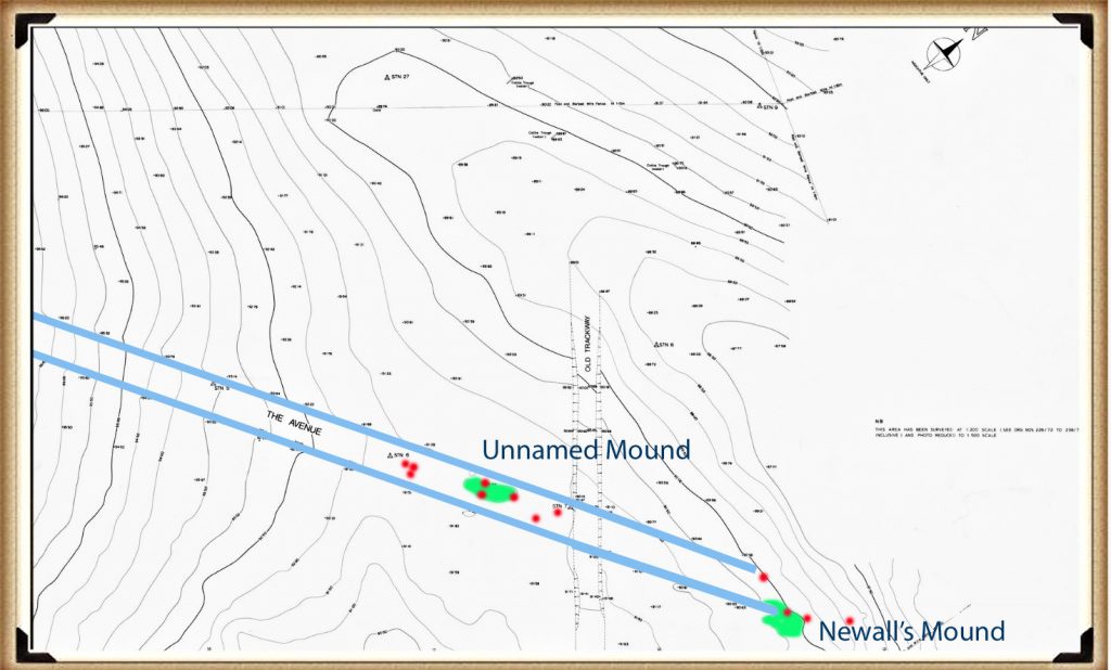
Durrington Walls
Durrington Walls

But it’s NOT!!

A henge is an earthwork that is created by ditches being cut to produce a corresponding bank – the classic case is Avebury with its massive 12m deep ditches and consequently 12m banks.

Avebury showing the banks  - Durrington walls hoax
Avebury showing the banks – Durrington walls hoax

But looking at Durrington Walls from the centre like it has a bank but no visible ditch.  Archaeologists suggest that the ditch is under the surface and is not visible although the bank looks massive and one would wonder if you have dug a hole that produces that amount of soil bank then some kind of indentation should be visible – but is not?

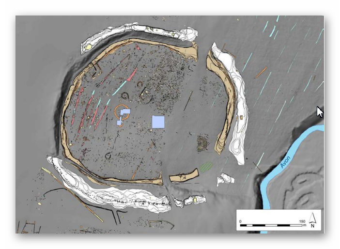
The mystery deepens when you look at Durrington with Lidar which turns it into a 3D model – suddenly this changes its perspective and the round site now transforms into a round hole in the ground with steep walls just like a quarry.

Durrington Walls LiDAR map  - Durrington walls hoax
Durrington Walls LiDAR map – Durrington walls hoax

If we look very closely at the outside or back end of the bank looking towards the centre – we find there is no substantial bank… so small it not worth considering as a real bank as the land surround in the site is at the same level.

So why have the archaeologists miss this obvious design flaw and called Durrington Walls a Henge?

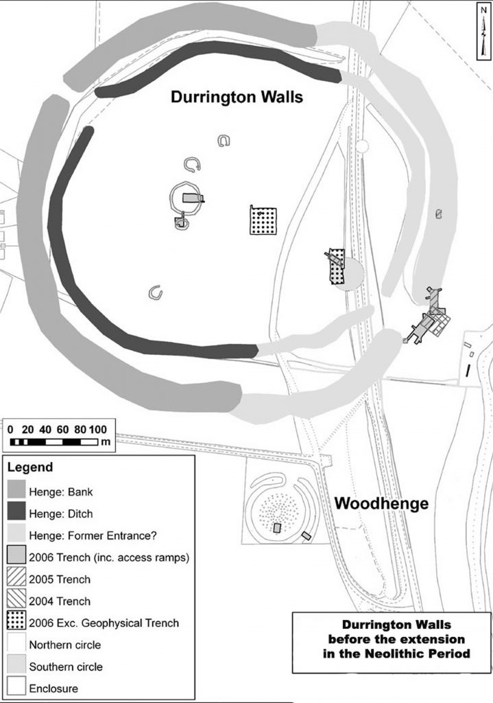
If we look at some of their diagrams of the site we find that not only are the ditches hidden from view but also it seems the banks which have been marked on the site maps but are invisible from view.

Durrington Missing Banks and ditches?  - Durrington walls hoax
Durrington Missing Banks and ditches? – Durrington walls hoax

So are the archaeologists relying on detailed excavation evidence then of these ditches and banks – well no, all they have is geophysics guestimations and very limited small excavation results which show that there ‘maybe’ ditches and banks under the ground of unknown proportions.

Durrington Walls - Geophysical Results
Durrington Walls – Geophysical Results

Back to our Lidar map – we can see that this massive carved hole in the landscape is at a strange angle – in fact it tilts towards the River Avon and would have flooded in the past at the start of the Mesolithic when the River Avon was at its highest.

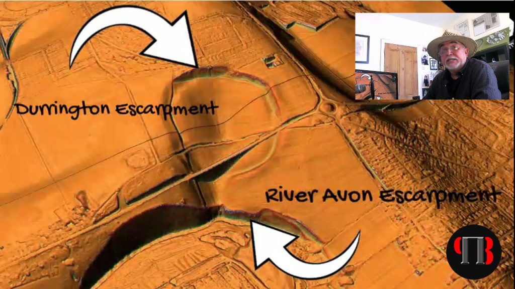
Moreover, if we use LiDAR we can see this strange earthwork is duplicated towards the River Avon – the same kind of steep walls have been cut from the waters of the river.  This is were LiDAR is an exceptional tool for landscape archaeology and has not been fully utilised to its full potential when investigation Durrington Walls. 

They are Escarpments – NOT banks

Examining the river-cut cliff face, we notice the extreme height the river had to be in the past, to remove the chalk bedrock.  This is another clear indication and proof of the Post-Glacial Flooding that existed after the last ice age and during the Mesolithic period, obviously eroding these cliffs for thousands of years because of the raised river Avon level.

If we know raise the level of the River Avon we see that this feature floods to create a perfect harbour, which would suggest it was natural to start and was tinkered with at a later date as the river levels dropped.

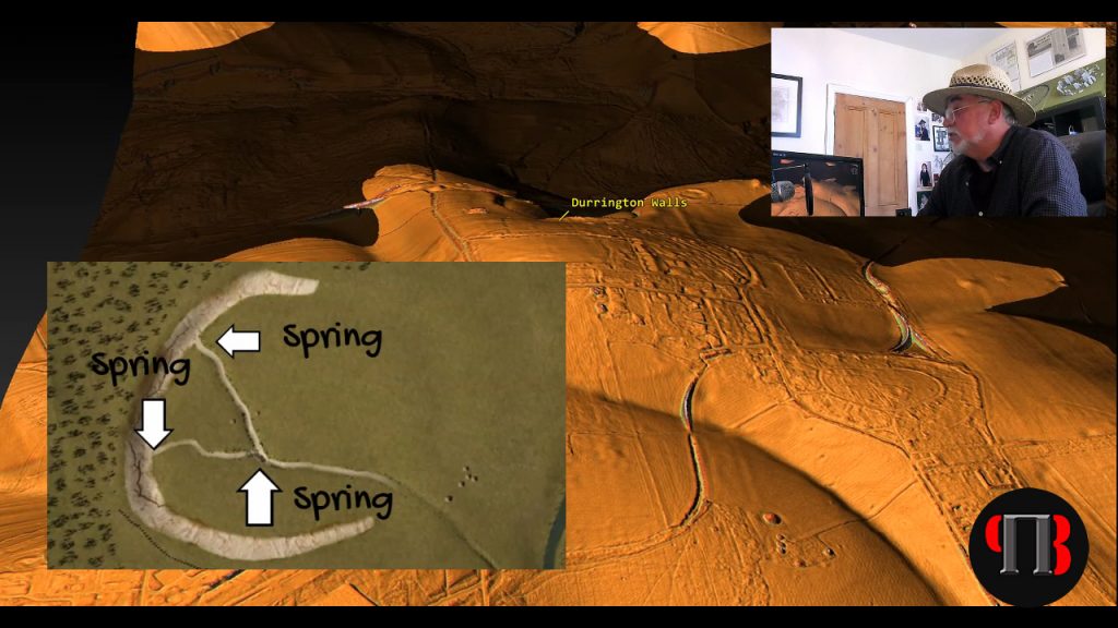
Archaeologists have found ‘natural springs’ withing the site at the north end of the henge which would suggest that it would have flooded with up to 2800 litres of water per second per spring directly at the start of the Mesolithic gradually decreasing the flow over the following millenniums.

Springs inside Durrington Walls  - Durrington walls hoax
Springs inside Durrington Walls – Durrington walls hoax

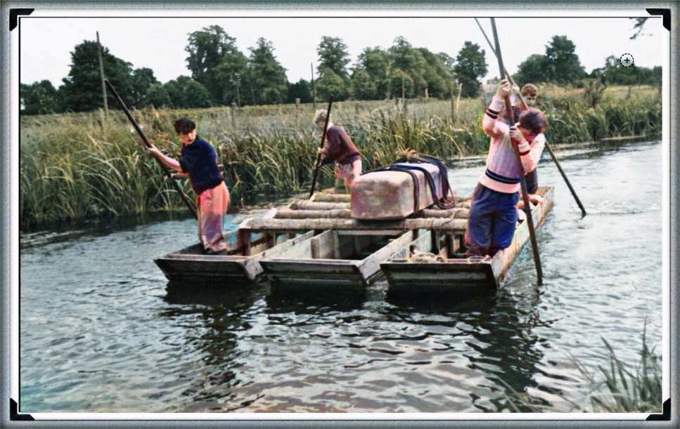
This may explain the shallow ditch found by archaeologists at the northern end which may have been built to allow boats from the river to be ‘beached’ on the shoreline at low tide – and yes the Avon is tidal and even more so in the past as water levels were higher and so the current two metre variation would have been even greater.

Before I continue I feel that I must point out that the current archaeologist believe that Durrington was a settlement for the builders of Stonehenge as they have found post holes in a round patterns within the site.  But just looking at the profile of the site clearly shows that to build houses at ground level on this site would be complete ‘bonkers’ – the gradient of the site would flood any house every time it rained and why build a house in a ditch when surround this site is normal flat ground – it’s a sad nonsense.

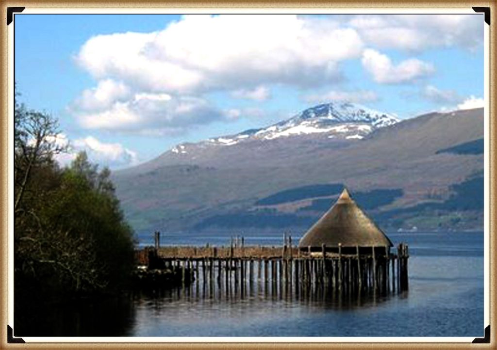
The holes they found were for another kind a building we see in other parts of Britain – a crannog.  Crannogs are houses build in the air on stilts in flooded areas as they are perfect mooring sites for boats.

Crannogs  - Durrington walls hoax
Crannogs – Durrington walls hoax

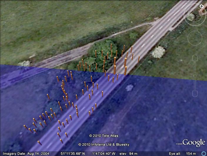
This marine use of this site is further found towards the Eastern side towards the river were we find mooring post similar to what we have seen on the Stonehenge avenue, placed their during the Neolithic period as the water levels fell, with the addition of larger crannogs which archaeologist have misidentified as smaller wooden ceremonial circles.

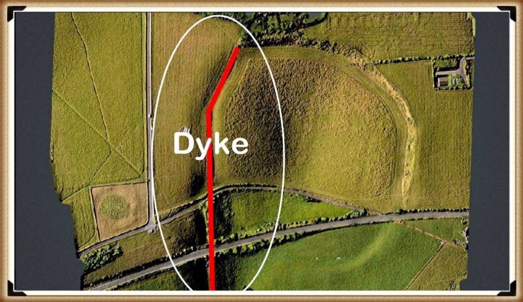
Other additions to the site can be found on the western side of the henge with another feature that has foxed archaeologists and has been misidentified as a lynchet (a farming feature) – this earthwork is a ‘Dyke’ also known as a linear earthwork. It is a ditch and a bank and LiDAR clearly shows it starting from the River Avon. 

Post Holes found on the Durrington Shoreline – Durrington walls hoax

Sadly, again archaeologists are unaware of why these Dykes were built in the past (which is strange) as there are over 1500+ known scheduled monuments listed as ‘linear Earthworks’ and therefore the most frequent prehistoric feature in the landscape?

My other site investigations have found that Dykes are late Mesolithic and early Neolithic (about 5000 BCE) and so would have been added to the site as an access point once the rive Avon had dropped below the natural harbour entrance to allow boats to access the site up to the ditches in the north of the site we saw earlier.

Durrington Walls Dyke -Durrington walls hoax

This is when the Eastern Banks and ditch must have been added to the site – which are clearly shown as very different to the other features on the site.  Again it may have been another attempt to prolong the sites usefulness by adding additional landing points as the river shrunk in size.

The biggest question for me is what was this site used for?

In the next video we will look at the famous site connected with Durrington – Woodhenge and why it was constructed and the reason it reinforces the hypothesis that it was a harbour for boats – but where were they going?

A tantalising clue maybe found if we go back to the Dyke that crosses the site going north.  If we look closely at lidar we find it actually goes beyond the edge of the site and connects to an existing road at a very odd angle – in fact to road is a dead end going south and so has no reason to kink like it does.

We have found that some B-roads were initially formed from the banks of Dykes and so logically this road could be the direction of the Dyke’s bank that takes us into the middle of the Army camp – which may have been something once but not anymore – sadly we may never know consequently?

Further Reading

For information about British Prehistory, visit www.prehistoric-britain.co.uk for the most extensive archaeology blogs and investigations collection, including modern LiDAR reports.  This site also includes extracts and articles from the Robert John Langdon Trilogy about Britain in the Prehistoric period, including titles such as The Stonehenge Enigma, Dawn of the Lost Civilisation and the ultimate proof of Post Glacial Flooding and the landscape we see today.

Robert John Langdon has also created a YouTube web channel with over 100 investigations and video documentaries to support his classic trilogy (Prehistoric Britain). He has also released a collection of strange coincidences that he calls ‘13 Things that Don’t Make Sense in History’ and his recent discovery of a lost Stone Avenue at Avebury in Wiltshire called ‘Silbury Avenue – the Lost Stone Avenue’.

Langdon has also produced a series of ‘shorts’, which are extracts from his main body of books:

The Ancient Mariners

Stonehenge Built 8300 BCE

Old Sarum

Prehistoric Rivers

Dykes ditches and Earthworks

Echoes of Atlantis

Homo Superior

For active discussions on the findings of the TRILOGY and recent LiDAR investigations that are published on our WEBSITE, you can join our and leave a message or join the debate on our Facebook Group.

The Stonehenge Avenue

The Stonehenge Avenue investigation transcript.

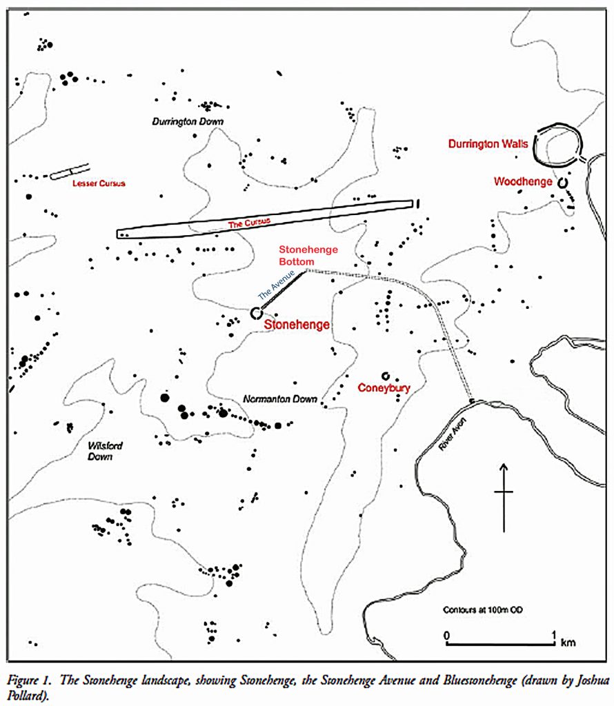
In our last video we looked at Stonehenge during the Mesolithic period and showed that the Dry River Valley (that surrounds the site) is called ‘Stonehenge Bottom’ and was full of water during this period, as the many natural springs in Stonehenge Bottom would have flooded the area, up to the Old Car Park. We believe this was the landing site where the four-tonne Bluestones that travelled by boat from their quarry site in Wales.

Bluestone boat to Stonehenge - Stonehenge Avenue
Bluestone boat to Stonehenge – Stonehenge Avenue

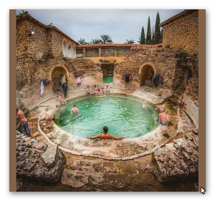
This was the start of Stonehenge (Phase I), which was a ditch surrounding the site, with 56 Bluestone chalk pits known as Aubrey Holes. This construction was used as a bathing place as the excavation is unique as it is not a traditional ditch, but a series of individual 2m deep chalk holes with walls and seats. This facility was used with the Bluestone chippings to heal ailments and diseases, as we see later in history with Roman baths.

This structure lasted for thousands of years and was replenished periodically with more Bluestones as they were chipped away from the large stone blocks until the Neolithic period when the site changed its function. This change was necessary as the water table in the area had dropped (and consequently, the shoreline of the River Avon within the Stonehenge Bottom). This drop in the water table dried up the ditch, and so it could no longer function as a bathing pool.

Roman Health Spa - Stonehenge avenue
Roman Health Spa – Stonehenge avenue

At this stage, a new monument was created to celebrate the Motherland of these ‘Megalithic Builders’ who originally came from Doggerland in the North Sea, which had surrendered to the rising sea levels (the original) global warming event. So, they decided to build a stone structure in remembrance, as we continue to do today for monumental occasions.

Moreover, the River Avon was now much lower than in the Mesolithic and to bringing the Bluestones to Stonehenge (from the quarry) became more difficult and so, to meet the retreating water, a new ‘pathway’ was constructed with mooring points throughout its length – this is called The Avenue.

Stonehenge Avenue
Stonehenge Avenue

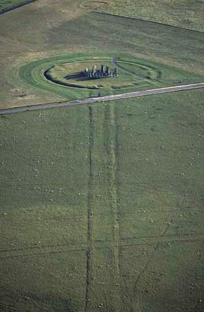
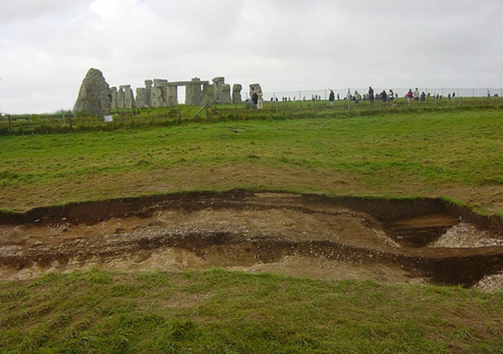
Traditional archaeologists believe that the Avenue existed before the start of Stonehenge as a natural feature – excavations have revealed ‘preglacial stripes’ which they believe was the reason Stonehenge was placed in this low location. These Stripes (they imagine) were created through tundra thawing and freezing during the last ice age.

The problem with this idea is that these stripes were only found within this 20 ft wide narrow path going to the site and not over the general area as would be expected as the geology within this area of the Avenue is pretty universal (chalk bedrock) and not unique, so this idea can easily be dismissed.

Preglacial stripes - Stonehenge Avenue
Preglacial stripes – Stonehenge Avenue

From the LiDAR scan, it is obvious (and we will change the colour to see the detail better), that it is a roadway with ditches on the edge. Inside it the excavations shows track marks of past visitors who used the Avenue as a natural road for their transportation, as seen in Stukeley 18th century drawings – we have found evidence from latter cart tracks in excavations, and these are pretty shallow as the carriages are only about 1500lbs to 1800lbs in weight (0.8 tonnes), but the deeper cuts are clearly from overly heavy wheeled vehicles used to ship the massive 25-tonne sarsen stones to the site during the Neolithic and hence their misidentification.

These archaeologists also support that the Avenue takes a ‘long walk’ down to the existing River Avon past a series of borrows on the opposite hill (called The Kings Barrows). This may be the case today, with a light path that some wander down as it appears on their OS maps, but the reality is that it didn’t exist in the past or on the first series of OS maps.

The Avenue today - Stonehenge Avenue
The Avenue today – Stonehenge Avenue

If we look at the End of the Avenue, we see that the river valley looks like it splits as we see in Stukeley’s 18th-century drawing – but compared to the deep cuttings of the original Avenue, they are not worth considering as original.

The larger Sarsen stones would have been transported from the bottom of the Avenue (as shown on the LiDAR Map) as this feature’s final function. Prior to that occasion, the Avenue would have been used over a couple of thousand years to bring the Bluestone in the Late Mesolithic and Early Neolithic, from their quarry site which can be seen from the post holes in the Avenue (which could not have any other useful function) these are at an angle to the shoreline, as we saw in the Old Car Park at Stonehenge.

The Avenue with Post Holes and mounds - Stonehenge Avenue
The Avenue with Post Holes and mounds – Stonehenge Avenue

We also see two artificial flint mounds within the Avenue (pic). One has been identified as Newmans Mound, and the other remains unidentified. These features have no other rational explanation other than unloading platforms for boats on the River Avon in the Neolithic.

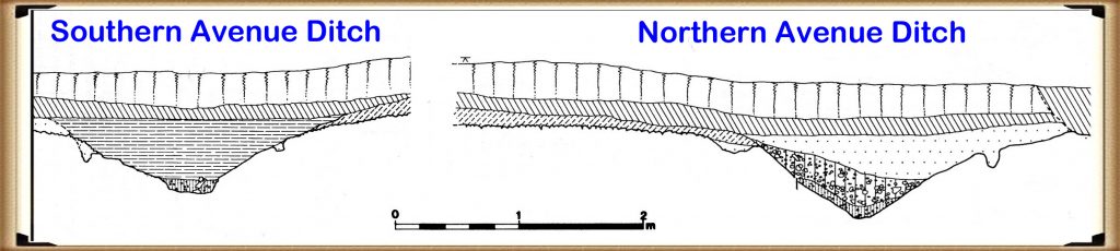
Moreover, the physical construction of the Avenue earthwork shows the incorporation of water features, supporting the higher water table theory. For example, the Southern ditch is much shallower than the Northern ditch of the Avenue. This is because the river lies on the Southern side of the Avenue and does not need extra depth to fill the Southern ditch evenly, while the Northern ditch is further away from the river.  

The Avenue Ditches - Stonehenge Avenue
The Avenue Ditches – Stonehenge Avenue

Furthermore, this extra depth to one side of the monument can also be seen in the main ditch of Stonehenge as the north western side also 10% deeper, reflecting the water table at that time.

Further Reading

For information about British Prehistory, visit www.prehistoric-britain.co.uk for the most extensive archaeology blogs and investigations collection, including modern LiDAR reports.  This site also includes extracts and articles from the Robert John Langdon Trilogy about Britain in the Prehistoric period, including titles such as The Stonehenge Enigma, Dawn of the Lost Civilisation and the ultimate proof of Post Glacial Flooding and the landscape we see today.

Robert John Langdon has also created a YouTube web channel with over 100 investigations and video documentaries to support his classic trilogy (Prehistoric Britain). He has also released a collection of strange coincidences that he calls ‘13 Things that Don’t Make Sense in History’ and his recent discovery of a lost Stone Avenue at Avebury in Wiltshire called ‘Silbury Avenue – the Lost Stone Avenue’.

Langdon has also produced a series of ‘shorts’, which are extracts from his main body of books:

The Ancient Mariners

Stonehenge Built 8300 BCE

Old Sarum

Prehistoric Rivers

Dykes ditches and Earthworks

Echoes of Atlantis

Homo Superior

For active discussions on the findings of the TRILOGY and recent LiDAR investigations that are published on our WEBSITE, you can join our and leave a message or join the debate on our Facebook Group.

The Henge and River Relationship

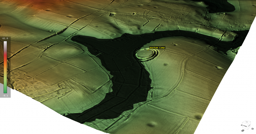
Recently I have been in conversation with FB members who have identified a little known henge (to me at least!) in Norfolk. The discussion was around if the locals had rerouted the local stream (River Stiffkey) towards the ancient henge (Warham Camp) and consequently , by design, removed the huge chalk banks to accommodate this redesign – this was a flood prevention scheme of the past according to local records. Moreover, there was a suggestion that the river had originally lay on the opposite side of the henge, on top of the hill? – (Henge and River Relationship)

When I looked at the site via Google Earth, there was a sudden realisation that most of this story was just misplaced and confused fantasy and nonsense. The site had been built at a direct angle on the edge of a hill (plenty of flat places to built the henge elsewhere) were this strange angle and dip into the local river would have not occured – so clearly it was purpose built.

The LiDAR maps show that this henge ‘dips’ into an ancient river channel of the past and as the animation shows when this river is replaced by the larger ancient water levels the design and location of the henge finally makes sense as it is a harbour to the river and the ditches would have been used for boats as a mooring canal. Furthermore, if we look at the road that goes over the hill on the opposite side River – it’s strangely ‘wibbly wobbly’ and not straight – this would suggest that it was once a manmade ‘Dyke’ a short-cut that went over the hill from river to river, which (like some dykes) the bank was used at a later date to build a road (and explain the local mythology?).

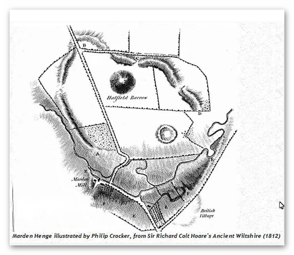
However, this is not the only Henge that is closely linked to Rivers and their use as trading posts with canal facilities for boats. The most famous recently found henge henge that also has half of the henge walls missing in relation to the local river is ‘Marden Henge’ near Stonehenge and down river from Avebury.

Warham Camp/Henge - Henge and River Relationship
Warham Camp/Henge – Henge and River Relationship

Interestingly the archaeologists of this site (you would imagine) would have analyses why this henge was placed so close to the River Avon – but as you see from the book extracts below…. it’s not even mentioned?

What was originally commented upon was In the 1810 publication Ancient Wiltshire, where Colt Hoare describes it as a ‘deep and wide ditch. . . which in winter is nearly full of water, although the soil consists of a greenish sand.’ Soil of a sandy composition should allow decent drainage – the fact that the ditch (though it’s tempting to use the word moat) remained full of water throughout the winter months is a probable indication of the water table being swollen by winter rain rather than being filled by it from above. The English Heritage geophysical survey shows the ditch in great clarity – their estimate of its size is 25 m across, and 105 m in diameter, with the remains of the barrow showing as a comparatively small island in the centre.

Henge with moated ditches…. my oh my…. are we seeing an archaeologist supporting my Post-Glacial Hypothesis..LOL!! – well I’m sure the academic world will attempt to qualify it as ‘the only one’…… but its not!!

Marden Henge - built to meet the River Avon so the ditches will become canals for boats - Henge and River Relationship
Marden Henge – built to meet the River Avon so the ditches will become canals for boats – Henge and River Relationship

You would expect modern archaeologist to have read up on Sir Richard Colt Hoare’s investigation and the obvious link to a river in their papers and books….. yet sadly they seem to ignore the obvious for the more obtrusive aspects of the site?

AUBREY BURL
“Earthworks like those at Waulud’s Bank, Durrington Walls, Marden, Mount Pleasant, all in southern England, seem to have been put up on the sites of earlier unenclosed settlements of the middle Neolithic once occupied by the users of Windmill Hill pottery. Forest clearance and crop growing had been followed by a long cessation of cultivation before the earthworks were thrown up as many as five centuries later. In every one of these enclosures Grooved Ware has been found.”

Burl, A (2002). Prehistoric Avebury. Yale. P125

“At the earthwork of Marden, the Grooved Ware settlement only a few miles south of Avebury in the marshy vale of Pewsey, the body of a young woman who seemed to have suffered from malnutrition in her childhood was put in the ditch alongside the north entrance. Again, this could have been an ordinary burial but, if so, it is remarkable that the body of yet another young woman should have been found at Avebury’s south entrance, buried there like the skeleton at Marden some time after the ditch was dug.”

Burl, A (2002). Prehistoric Avebury. Yale. P248

JAN HARDING
“Excavations at a number of the henge monuments located across the chalklands of Wiltshire and Dorset have produced large quantities of Grooved Ware pottery, and this has lead some to consider both monument and pottery as closely linked phenomena, even as components of a single socio-religious complex of artefacts, practices and beliefs.”

Harding, J (2003). Henge Monuments of the British Isles. Tempus. P12

“At a number of excavated sites, the ditch is certainly wider and deeper on either side of the causeway: at the ‘henge enclosure’ of Marden, in Wiltshire, it expanded to 59ft (18m) wide and about 10ft (3m) deep instead of the more normal 52.5 (16m) and 6.5 (2m) respectively (Wainright 1972, 185-7), whilst two of the three excavated terminals at the double entrance site of Arbor Low were deeper than elsewhere around its circuit (Gray 1903).”

Harding, J (2003). Henge Monuments of the British Isles. Tempus. P66

JOSH POLLARD
“Other large mounds of similar date are known closer to Avebury, including those at Marden in the Vale of Pewsey (Wainright 1971) and Mount Pleasant, Dorset (1979). Both are associated with henge enclosures. These are not on the same scale as the final phase of Silbury, though close in size to Silbury I and II (Thomas 1999, 216). The massive mound in the grounds of Marlborough College might be another, while the curiously large mound and wide ditches that form the Beckhampton long barrow (adjacent to the ditched enclosure) provide a tantalising possibility that this monument was enlarged and elaborated during the late Neolithic.”

Pollard J & Reynolds, A (2002). Avebury, The Biography of a Landscape. Tempus. P121

“The postholes of large timber circles, originally comprising multiple concentric rings of posts of telegraph-pole size, were discovered within the interiors of Durrington Walls and Mount Pleasant; another may exist within Avebury; and a smaller example was discovered just inside the northern entrance at Marden.”

Pollard, J (1997). Neolithic Britain. Shire. P43

MARTIN GREEN
“Due east of the centre circle, covered in trees, is the great mound still surviving to a height of 6.5m. Two concentric ditches surround it, one within 5m of the mound and the outer, segmented ditch, set some 30m distant from it. It is possible that this outer ditch, over 10m in diameter, is in fact a fifth henge which enclosed the likely earlier mound. Supporting this hypothesis are some aerial photographs that clearly reveal traces of an external bank. A rescue excavation in 1958 (Field 1962), following a pipe trench which cut the ditch, uncovered a profile apparently less than 2m deep which is admittedly rather un-henge like.

However, bearing in mind the causewayed nature of the ditch, the profile could vary significantly around its circuit. Nothing is known of this mound but similar combinations of henges and large mounds are known in other parts of the country — notably at Arbor Low in Derbyshire, Marden in Wiltshire and the most extreme example of all Silbury Hill and the Avebury complex. The large Neolithic round mound Duggleby Howe on the Yorkshire Wolds is now known to lie at the centre of a surrounding causewayed enclosure (Selkirk 1980). Silbury Hill is known to date from 3000 BC and it is likely that the other mounds are of broadly similar date.”

Green, M (2000). A Landscape Revealed – 10,000 years on a Chalkland Farm. Tempus. P90

ALEX GIBSON
“A more common ceramic association with timber circles is Grooved Ware. This sometimes plain but often highly decorated flat-based ceramic occurs at 16 (timber circle) sites and most notably at large, elaborate, complex circles. These are the large Wessex sites of Durrington Walls, Mount Pleasant, and Marden.”

Gibson, Alex (2005) Stonehenge and Timber Circles. Tempus. P66

“Beaker [pottery] was unusually found at Durrington Walls North Circle (Phase II) and South Circle (Phase II) and at the Sanctuary (though largely from the later stone holes). The Durrington contexts suggest that the Beaker represents a secondary activity at the site and that the sherds were recovered from the upper fills of pits or settling cones in the tops of the dismantled post rings. Like the other sites, therefore, the Beaker at Durrington represents a terminus ante quem for the circles. At Mount Pleasant and Marden the Beaker sherds were likewise not in primary contexts.”

Gibson, Alex (2005) Stonehenge and Timber Circles. Tempus. P68

“Most notably at the large Wessex henges, where chalky soil is conducive to the survival of faunal remains, there appears to be evidence for feasting. This would appear to have taken place at Durrington Walls, Mount Pleasant, Marden and Woodhenge, and is represented by the large quantities of bones of immature or young adult pig and other domesticated animals recovered from the excavations at these sites.”

Gibson, Alex (2005) Stonehenge and Timber Circles. Tempus. P105

MIKE PARKER PEARSON
“The huge grey sarsen uprights that can be seen today at Stonehenge were put up around 2400 BC (Phase 3ii). No one knows precisely where they came from but their most likely source is thought to be the Marlborough Downs about 20km (12 miles) to the north. However, reports of large buried sarsens near the henge enclosure at Marden, 15 km (9 miles) to the north, hint at a less distant origin.”

Parker Pearson, M (2005). Bronze Age Britain. Batsford. P65

JULIAN THOMAS
“When completed, Silbury would have had an imposing appearance, with stepped concentric revetment walls of chalk blocks, infilled with rubble (Whittle 1997a, 25). The connotations of this architecture are arguable. It may be that the various remodellings were attempts to draw upon quite different traditions derived from different places. In this way the earlier mounds find parallels in the Hatfield Barrow inside the Marden henge, the nearby Marlborough Mound (if indeed it is Neolithic in date: Whittle 1997a, 169–70), the Conquer Barrow in southern Dorset, and the large round mounds of Yorkshire. The final phase, by contrast, may be modelled on the passage tombs of the Boyne Valley and Brittany, traditions whose use had long lapsed by the time that Silbury was completed. Whittle (1997a, 147–9) suggests even more far-flung prototypes for the great mound.”

Thomas, J (2002). Understanding the Neolithic. Routledge. P217

TIMOTHY DARVILL
“Like causewayed camps before them, henges in southern England may have performed a variety of functions and most probably changed their role over the course of time. The majority were probably somehow utilized as ritual monuments, but three large sites in Wessex—Mount Pleasant, Dorset, Marden, Wiltshire and Durrington Walls, Wiltshire—stand apart from the others in having abundant evidence for occupation within them, including timber buildings, middens and large amounts of occupation debris. Indeed, Mount Pleasant contains within its bounds a conventional henge, and Durrington Walls has a similar structure just outside its perimeter at Woodhenge. The site at Waulud’s Bank, Luton, Bedfordshire, may also belong to this group of henge enclosures.”

Darvill, T (1987) Prehistoric Britain. Routledge. P82

BARBARA BENDER
“At Avebury there is also a dramatic link-up between the Avebury circle, the Avenue and Sanctuary, and the great stepped white mound of Silbury. From the Sanctuary the ‘hill’ takes up the low ground, and picks up the sky-line between two long hill ranges (Jarman, pers. comm.). Moving either down or up the Avenue the hill comes in and out of sight, and it can again be seen from the great encircling bank (perhaps a viewing platform) at Avebury. There are, or were, other artificial white hills, one to the east of Avebury in the grounds of what is now Marlborough College, another southward at Marden on the route between Avebury and Stonehenge, and perhaps yet another at Silk Hill, 5 km northeast of Stonehenge.”

Bender, B (1992). Theorising Landscapes, and the Prehistoric Landscapes of Stonehenge. Royal Anthropological Institute of Great Britain and Ireland. P 784.

JSTOR Stable URL – http://www.jstor.org/stable/2804172?origin=JSTOR-pdf

MIKE PITTS
“At Durrington Walls, the size and positioning of his trenches were determined by the roadworks. At Marden, Wainright could choose where he wanted to dig. Tony Clarke’s geophysical survey was no help, as the wet sandy subsoil yielded no clues, So Wainright decided to dig at the one entrance that was accessible, that to the north. At the Walls, the large southern circles were close to the southern entrance, and the end of the ditch there had been particularly rich in pottery and other finds. And, lo and behold, in their relatively small trench just inside the entrance they found the post holes of a simple, circular structure, and in the ditch a human skeleton, red deer antlers and quantities of Grooved Ware exactly like that found at Durrington Walls.”

Pitts, M (2000). Hengeworld.  Arrow. P64

The latest of the investigations is been by Jim Leary, of Reading university – the conclusion of his work in 2010 – is best summed up in this video.

Typical modern archaeologists failing to understand the significance of the site and why they were created taking hundreds of working hours. This video sadly shows the state of current archaeology, with more questions than answers and the solutions they do suggest are based on very unscientific evidence as ‘ceremonial’ and ‘religious’ concepts which quite frankly is just ‘bad science’. But at least Jim actually mentioned the River Avon – even if he failed to understand the true relationship and why the gigantic moats were once full of water!!

Oh by the way…. the gigantic mount (like Silbury Hill) was empty of bodies (like Marlborough Mound) due to the fact these are fire beacons to attract ships and boats to the camp…. history can be painfully obvious..to some?

Let’s look at the LiDAR map video of Marden Henge that shows the size and function within in the landscape.

Finally, the most famous Henge that meet a major river is Durrington Walls – the LiDAR map clearly shows (like the previous examples) the site was built tilted to the enlarge river of the past and hence it does not have banks or ditches in this section. Durrington is slightly different as it looks like when the River retreated as the river levels shrank, the builders attempted to prolong the use of the site by adding ditches which were much smaller and shallower than the original sites feature showing it was adapted much later in history. This adaption included a ‘dyke’ cut from the lower river shoreline to the original banks in the west of the site.

Further Reading

For information about British Prehistory, visit www.prehistoric-britain.co.uk for the most extensive archaeology blogs and investigations collection, including modern LiDAR reports.  This site also includes extracts and articles from the Robert John Langdon Trilogy about Britain in the Prehistoric period, including titles such as The Stonehenge Enigma, Dawn of the Lost Civilisation and the ultimate proof of Post Glacial Flooding and the landscape we see today.

Robert John Langdon has also created a YouTube web channel with over 100 investigations and video documentaries to support his classic trilogy (Prehistoric Britain). He has also released a collection of strange coincidences that he calls ‘13 Things that Don’t Make Sense in History’ and his recent discovery of a lost Stone Avenue at Avebury in Wiltshire called ‘Silbury Avenue – the Lost Stone Avenue’.

Langdon has also produced a series of ‘shorts’, which are extracts from his main body of books:

The Ancient Mariners

Stonehenge Built 8300 BCE

Old Sarum

Prehistoric Rivers

Dykes ditches and Earthworks

Echoes of Atlantis

Homo Superior

For active discussions on the findings of the TRILOGY and recent LiDAR investigations that are published on our WEBSITE, you can join our and leave a message or join the debate on our Facebook Group.

To understand why rivers were larger in the past we have video with all the relevant information.

Three Dykes – Kidland Forest

This is a journey through time looking at the prehistoric site of Three Dykes – Northumberland (Kidland Forest) and its surrounding Landscape based on the new third (2020) edition book of the best seller – that contains conclusive and extended evidence of Robert John Langdon’s hypothesis, that rivers of the past were higher than today – which changes the history of not only Britain, but the world. In his first book of the trilogy ‘The Post-Glacial Hypothesis’, Langdon discovered that Britain was flooded directly after the last Ice Age, which remained waterlogged in to the Holocene period through raised river levels, not only in Britain, but worldwide.

In this second book of the series ‘The Stonehenge Enigma’, he also shows that a new civilisation known to archaeologists as the ‘megalithic builders’ adapted to this landscape, to build sites like Stonehenge, Avebury, Woodhenge and Old Sarum, where carbon dating has now shown that these sites were constructed about five thousand years earlier than previously believed. Within the trilogy ‘Prehistoric Britain’, Langdon looks at the anthropology, archaeology and landscape of Britain and the attributes and engineering skills of the builders of these megalithic structures.

Including finding and dating the original bluestones of Stonehenge Phase I from the quarry of Craig-Rhos-Y-Felin in Wales, five thousand year earlier than current archaeological theory and how this civilisation used the sites surrounding Stonehenge at a time of these raised river levels. This unique insight into how the prehistoric world looked in the ‘Mesolithic Period’ allows Langdon to explain archaeological mysteries that have confused archaeologist since the beginning of the science and allows us to make sense of these sites, allowing us to understand their function for this society for the first time.

Three Dykes - Kidland Forest
Three Dykes – Kidland Forest

With over thirty ‘proofs’ of his hypothesis and one hundred and twenty-five peer-reviewed references – Langdon uses existing excavation findings and carbon dating to forward a new understanding of the environment and our ancient society, which consequently rewrites our history books and allows us to find more conclusive and persuasive evidence which is currently trapped in our landscape, ready to be discovered by future students of archaeology. Articles on this Trilogy and an Active FaceBook Group where you can leave comments and get feedback can be found at:

Further Reading

For information about British Prehistory, visit www.prehistoric-britain.co.uk for the most extensive archaeology blogs and investigations collection, including modern LiDAR reports.  This site also includes extracts and articles from the Robert John Langdon Trilogy about Britain in the Prehistoric period, including titles such as The Stonehenge Enigma, Dawn of the Lost Civilisation and the ultimate proof of Post Glacial Flooding and the landscape we see today.

Robert John Langdon has also created a YouTube web channel with over 100 investigations and video documentaries to support his classic trilogy (Prehistoric Britain). He has also released a collection of strange coincidences that he calls ‘13 Things that Don’t Make Sense in History’ and his recent discovery of a lost Stone Avenue at Avebury in Wiltshire called ‘Silbury Avenue – the Lost Stone Avenue’.

Langdon has also produced a series of ‘shorts’, which are extracts from his main body of books:

The Ancient Mariners

Stonehenge Built 8300 BCE

Old Sarum

Prehistoric Rivers

Dykes ditches and Earthworks

Echoes of Atlantis

Homo Superior

For active discussions on the findings of the TRILOGY and recent LiDAR investigations that are published on our WEBSITE, you can join our and leave a message or join the debate on our Facebook Group.

Unlocking the Mysteries of British Prehistory

Delve into the depths of time, as we embark on a captivating voyage into the enigmatic world of British prehistory. www.prehistoric-britain.co.uk is your portal to a treasure trove of archaeological wonders, modern LiDAR reports, and fascinating insights from the Robert John Langdon Trilogy. This immersive digital hub is your key to unlocking the secrets of Britain’s ancient past.

A Glimpse into the Robert John Langdon Trilogy

Step into the shoes of Robert John Langdon, a dedicated explorer of Britain’s prehistoric mysteries. His trilogy, comprising “The Stonehenge Enigma,” “Dawn of the Lost Civilization,” and “The Post-Glacial Flooding Hypothesis,” is a literary marvel that unravels the untold tales of our ancestors. These books take you on an exhilarating journey through time, meticulously researched and backed by over 125 references from esteemed scientists, archaeological experts, and geological researchers.

Dive into the World of LiDAR

At www.prehistoric-britain.co.uk, we harness the power of LiDAR technology to unearth hidden landscapes and archaeological marvels. Our LiDAR reports offer a modern lens through which you can peer into ancient history. Explore the effects of flooding on the British environment after the great ice age melt, a phenomenon that has shaped the landscape we see today. Join us in decoding the mysteries of our past using cutting-edge technology.

A Multimedia Experience

Our commitment to storytelling extends beyond the written word. Robert John Langdon has curated a rich multimedia experience, including a YouTube web channel featuring over 100 investigations and video documentaries. These visual journeys complement his classic trilogy, providing a multi-dimensional understanding of prehistoric Britain. From Stonehenge’s construction in 8300 BCE to the lost Stone Avenue at Avebury in Wiltshire known as ‘Silbury Avenue,’ these documentaries offer an immersive experience that brings history to life.

Explore the ’13 Things that Don’t Make Sense in Ancient History’

History is replete with anomalies and enigmas that defy explanation. Robert John Langdon has curated a collection of such historical curiosities in ’13 Things that Don’t Make Sense in History.’ These peculiar occurrences and unanswered questions will leave you pondering the mysteries of the past, inviting you to join the debate on their possible interpretations.

Three Dykes – Kidland Forest

Maiden Castle through time

This is a journey through time looking at the prehistoric Maiden Castle Landscape based on the new third (2020) edition book of the best seller – that contains conclusive and extended evidence of Robert John Langdon’s hypothesis, that rivers of the past were higher than today – which changes the history of not only Britain, but the world. In his first book of the trilogy ‘The Post-Glacial Hypothesis’, Langdon discovered that Britain was flooded directly after the last Ice Age, which remained waterlogged in to the Holocene period through raised river levels, not only in Britain, but worldwide. (Maiden Castle through time)

Maiden Castle through time

In this second book of the series ‘The Stonehenge Enigma’, he also shows that a new civilisation known to archaeologists as the ‘megalithic builders’ adapted to this landscape, to build sites like Stonehenge, Avebury, Woodhenge and Old Sarum, where carbon dating has now shown that these sites were constructed about five thousand years earlier than previously believed. Within the trilogy ‘Prehistoric Britain’, Langdon looks at the anthropology, archaeology and landscape of Britain and the attributes and engineering skills of the builders of these megalithic structures.

Including finding and dating the original bluestones of Stonehenge Phase I from the quarry of Craig-Rhos-Y-Felin in Wales, five thousand year earlier than current archaeological theory and how this civilisation used the sites surrounding Stonehenge at a time of these raised river levels. This unique insight into how the prehistoric world looked in the ‘Mesolithic Period’ allows Langdon to explain archaeological mysteries that have confused archaeologist since the beginning of the science and allows us to make sense of these sites, allowing us to understand their function for this society for the first time.

With over thirty ‘proofs’ of his hypothesis and one hundred and twenty-five peer-reviewed references – Langdon uses existing excavation findings and carbon dating to forward a new understanding of the environment and our ancient society, which consequently rewrites our history books and allows us to find more conclusive and persuasive evidence which is currently trapped in our landscape, ready to be discovered by future students of archaeology. Articles on this Trilogy and an Active FaceBook Group where you can leave comments and get feedback can be found at:

Maiden Castle through time

Further Reading

For information about British Prehistory, visit www.prehistoric-britain.co.uk for the most extensive archaeology blogs and investigations collection, including modern LiDAR reports.  This site also includes extracts and articles from the Robert John Langdon Trilogy about Britain in the Prehistoric period, including titles such as The Stonehenge Enigma, Dawn of the Lost Civilisation and the ultimate proof of Post Glacial Flooding and the landscape we see today.

Robert John Langdon has also created a YouTube web channel with over 100 investigations and video documentaries to support his classic trilogy (Prehistoric Britain). He has also released a collection of strange coincidences that he calls ‘13 Things that Don’t Make Sense in History’ and his recent discovery of a lost Stone Avenue at Avebury in Wiltshire called ‘Silbury Avenue – the Lost Stone Avenue’.

Langdon has also produced a series of ‘shorts’, which are extracts from his main body of books:

The Ancient Mariners

Stonehenge Built 8300 BCE

Old Sarum

Prehistoric Rivers

Dykes ditches and Earthworks

Echoes of Atlantis

Homo Superior

For active discussions on the findings of the TRILOGY and recent LiDAR investigations that are published on our WEBSITE, you can join our and leave a message or join the debate on our Facebook Group.

Unlocking the Mysteries of British Prehistory

Delve into the depths of time, as we embark on a captivating voyage into the enigmatic world of British prehistory. www.prehistoric-britain.co.uk is your portal to a treasure trove of archaeological wonders, modern LiDAR reports, and fascinating insights from the Robert John Langdon Trilogy. This immersive digital hub is your key to unlocking the secrets of Britain’s ancient past.

A Glimpse into the Robert John Langdon Trilogy

Step into the shoes of Robert John Langdon, a dedicated explorer of Britain’s prehistoric mysteries. His trilogy, comprising “The Stonehenge Enigma,” “Dawn of the Lost Civilization,” and “The Post-Glacial Flooding Hypothesis,” is a literary marvel that unravels the untold tales of our ancestors. These books take you on an exhilarating journey through time, meticulously researched and backed by over 125 references from esteemed scientists, archaeological experts, and geological researchers.

Dive into the World of LiDAR

At www.prehistoric-britain.co.uk, we harness the power of LiDAR technology to unearth hidden landscapes and archaeological marvels. Our LiDAR reports offer a modern lens through which you can peer into ancient history. Explore the effects of flooding on the British environment after the great ice age melt, a phenomenon that has shaped the landscape we see today. Join us in decoding the mysteries of our past using cutting-edge technology.

A Multimedia Experience

Our commitment to storytelling extends beyond the written word. Robert John Langdon has curated a rich multimedia experience, including a YouTube web channel featuring over 100 investigations and video documentaries. These visual journeys complement his classic trilogy, providing a multi-dimensional understanding of prehistoric Britain. From Stonehenge’s construction in 8300 BCE to the lost Stone Avenue at Avebury in Wiltshire known as ‘Silbury Avenue,’ these documentaries offer an immersive experience that brings history to life.

Explore the ’13 Things that Don’t Make Sense in Ancient History’

History is replete with anomalies and enigmas that defy explanation. Robert John Langdon has curated a collection of such historical curiosities in ’13 Things that Don’t Make Sense in History.’ These peculiar occurrences and unanswered questions will leave you pondering the mysteries of the past, inviting you to join the debate on their possible interpretations.

Mount Caburn through time

Introduction

This is a journey through time (Mount Caburn through time) looking at the prehistoric Landscape of Lewes in East Sussex based on the new third (2020) edition book of the best seller – that contains conclusive and extended evidence of Robert John Langdon’s hypothesis, that rivers of the past were higher than today – which changes the history of not only Britain, but the world. In his first book of the trilogy ‘The Post-Glacial Hypothesis’, Langdon discovered that Britain was flooded directly after the last Ice Age, which remained waterlogged in to the Holocene period through raised river levels, not only in Britain, but worldwide. (Mount Caburn through time).

Video

Mount Caburn through time

The Stonehenge Enigma

In this second book of the series ‘The Stonehenge Enigma’, he also shows that a new civilisation known to archaeologists as the ‘megalithic builders’ adapted to this landscape, to build sites like Stonehenge, Avebury, Woodhenge and Old Sarum, where carbon dating has now shown that these sites were constructed about five thousand years earlier than previously believed. Within the trilogy ‘Prehistoric Britain’, Langdon looks at the anthropology, archaeology and landscape of Britain and the attributes and engineering skills of the builders of these megalithic structures. (Mount Caburn through time).

Including finding and dating the original bluestones of Stonehenge Phase I from the quarry of Craig-Rhos-Y-Felin in Wales, five thousand year earlier than current archaeological theory and how this civilisation used the sites surrounding Stonehenge at a time of these raised river levels. This unique insight into how the prehistoric world looked in the ‘Mesolithic Period’ allows Langdon to explain archaeological mysteries that have confused archaeologist since the beginning of the science and allows us to make sense of these sites, allowing us to understand their function for this society for the first time.

With over thirty ‘proofs’ of his hypothesis and one hundred and twenty-five peer-reviewed references – Langdon uses existing excavation findings and carbon dating to forward a new understanding of the environment and our ancient society, which consequently rewrites our history books and allows us to find more conclusive and persuasive evidence which is currently trapped in our landscape, ready to be discovered by future students of archaeology. (Mount Caburn through time).

Mount Caburn through time

(Mount Caburn through time).

Further Reading

For information about British Prehistory, visit www.prehistoric-britain.co.uk for the most extensive archaeology blogs and investigations collection, including modern LiDAR reports.  This site also includes extracts and articles from the Robert John Langdon Trilogy about Britain in the Prehistoric period, including titles such as The Stonehenge Enigma, Dawn of the Lost Civilisation and the ultimate proof of Post Glacial Flooding and the landscape we see today.

Robert John Langdon has also created a YouTube web channel with over 100 investigations and video documentaries to support his classic trilogy (Prehistoric Britain). He has also released a collection of strange coincidences that he calls ‘13 Things that Don’t Make Sense in History’ and his recent discovery of a lost Stone Avenue at Avebury in Wiltshire called ‘Silbury Avenue – the Lost Stone Avenue’. (Mount Caburn through time).

Langdon has also produced a series of ‘shorts’, which are extracts from his main body of books:

The Ancient Mariners

Stonehenge Built 8300 BCE

Old Sarum

Prehistoric Rivers

Dykes ditches and Earthworks

Echoes of Atlantis

Homo Superior

For active discussions on the findings of the TRILOGY and recent LiDAR investigations that are published on our WEBSITE, you can join our and leave a message or join the debate on our Facebook Group.

Unlocking the Mysteries of British Prehistory

Delve into the depths of time, as we embark on a captivating voyage into the enigmatic world of British prehistory. www.prehistoric-britain.co.uk is your portal to a treasure trove of archaeological wonders, modern LiDAR reports, and fascinating insights from the Robert John Langdon Trilogy. This immersive digital hub is your key to unlocking the secrets of Britain’s ancient past.

A Glimpse into the Robert John Langdon Trilogy

Step into the shoes of Robert John Langdon, a dedicated explorer of Britain’s prehistoric mysteries. His trilogy, comprising “The Stonehenge Enigma,” “Dawn of the Lost Civilization,” and “The Post-Glacial Flooding Hypothesis,” is a literary marvel that unravels the untold tales of our ancestors. These books take you on an exhilarating journey through time, meticulously researched and backed by over 125 references from esteemed scientists, archaeological experts, and geological researchers.

Dive into the World of LiDAR

At www.prehistoric-britain.co.uk, we harness the power of LiDAR technology to unearth hidden landscapes and archaeological marvels. Our LiDAR reports offer a modern lens through which you can peer into ancient history. Explore the effects of flooding on the British environment after the great ice age melt, a phenomenon that has shaped the landscape we see today. Join us in decoding the mysteries of our past using cutting-edge technology.

A Multimedia Experience

Our commitment to storytelling extends beyond the written word. Robert John Langdon has curated a rich multimedia experience, including a YouTube web channel featuring over 100 investigations and video documentaries. These visual journeys complement his classic trilogy, providing a multi-dimensional understanding of prehistoric Britain. From Stonehenge’s construction in 8300 BCE to the lost Stone Avenue at Avebury in Wiltshire known as ‘Silbury Avenue,’ these documentaries offer an immersive experience that brings history to life.

Explore the ’13 Things that Don’t Make Sense in Ancient History’

History is replete with anomalies and enigmas that defy explanation. Robert John Langdon has curated a collection of such historical curiosities in ’13 Things that Don’t Make Sense in History.’ These peculiar occurrences and unanswered questions will leave you pondering the mysteries of the past, inviting you to join the debate on their possible interpretations.

(Mount Caburn through time).

Other Blogs

s

t