This is not another theory. This is not speculation. And it is not a reinterpretation of the same old narrative.
👉 This is the point where the old narrative breaks.
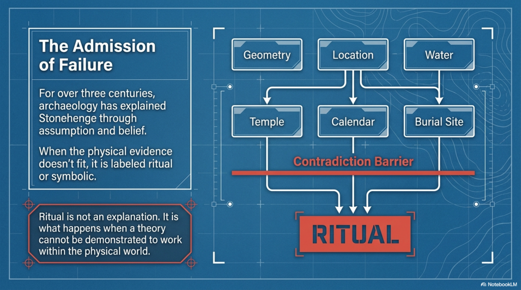
For over three centuries, archaeology has explained Stonehenge—and prehistory as a whole—through assumption, analogy, and belief. When the evidence didn’t fit, it was labelled “ritual,” “symbolic,” or simply ignored.
That approach ends here.
The Stonehenge Enigma V4.0
The First Scientific Reconstruction of Prehistory
The Prehistoric Britain trilogy is the first body of work to rebuild prehistoric Britain using:
Measurable scientific evidence
Mathematics and statistical validation
Engineering logic and system analysis
Environmental and hydrological constraints
Not interpretation. Not tradition.
👉 Proof.
At its core is a simple principle:
If a theory cannot be demonstrated to work within the physical world, it is not science.
The Stonehenge Enigma V4.0
Why the Old Narrative Is Dead
The traditional model of Stonehenge—and of prehistoric Britain—fails one basic test:
👉 It does not function.
It cannot explain:
Why the geometry exists
Why the site is positioned where it is
Why water is fundamental to its construction
Or how the system operates as a whole
Instead, it relies on disconnected explanations that never resolve into a working model.
This trilogy replaces that failure with something archaeology has never delivered:
👉 A complete, testable system that works.
The Stonehenge Enigma V4.0
The Consequence
Once the system is understood, the implications are unavoidable:
Stonehenge is not symbolic—it is functional
Its builders were not primitive—they were engineers
And prehistoric Britain was not dry land—it was a water-dominated environment shaping everything that followed
This is not a minor correction.
👉 It is the collapse of the existing framework.
The Stonehenge Enigma V4.0
What You Are About to Read
This book does not ask you to accept a new belief.
It does something far more direct:
👉 It shows you how the system works.
And once you see that…
👉 The old explanations don’t just look weak.
👉 They become impossible to defend.
The Stonehenge Enigma V4.0
A Scientific Rebuild of Prehistoric Britain
What if Stonehenge isn’t a monument… but a machine?
For over 300 years, Stonehenge has been described as a temple, a calendar, a burial site, or a place of ritual.
There’s just one problem:
👉 None of those explanations actually work.
They explain fragments. They ignore contradictions. And when the evidence doesn’t fit—they fall back on one word:
👉 “Ritual.”
That’s not an explanation. That’s an admission of failure.
The Stonehenge Enigma V4.0
A Different Approach
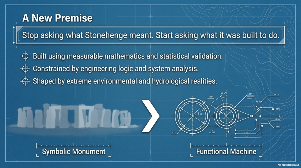
The Stonehenge Enigma v4.0 starts from a simple premise:
👉 Stop asking what Stonehenge meant 👉 Start asking what it was built to do
This isn’t theory layered on top of assumption.
It’s a rebuild from the ground up using:
Geometry
Hydrology
Construction logic
Environmental constraints
No speculation. No inherited narratives.
👉 Only what can be demonstrated.
The Key Breakthrough
The mistake has always been the same:
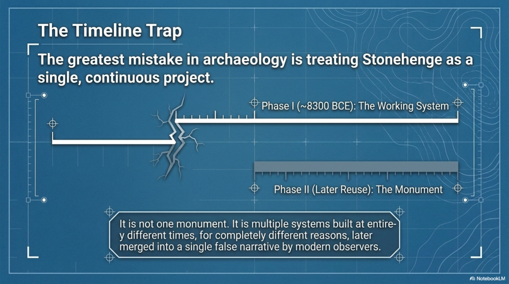
👉 Treating Stonehenge as one monument
It isn’t.
It’s multiple systems built at different times, then merged into a single story.
This book separates them properly:
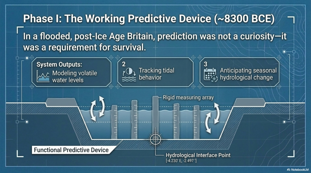
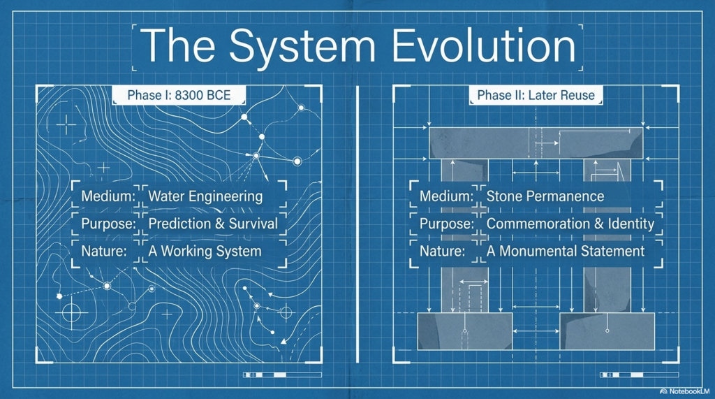
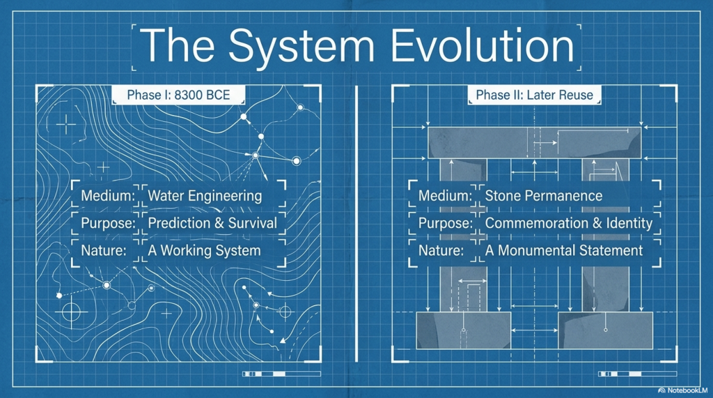
Phase I (~8300 BCE)
A functional, water-based system built within a flooded landscape
Phase II (Later Reuse)
A completely different structure—misinterpreted as the original purpose
Once separated, everything changes.
The Stonehenge Enigma V4.0
What Stonehenge Actually Was
When analysed as a system—not a symbol—the evidence leads to one unavoidable conclusion:
👉 Stonehenge was a working predictive device
Not abstract astronomy. Not ceremonial alignment.
👉 A practical system used to model natural cycles:
Water levels
Tidal behaviour
Seasonal change
Because in a flooded, post-Ice Age Britain…
👉 Prediction wasn’t curiosity—it was survival.
The Stonehenge Enigma V4.0
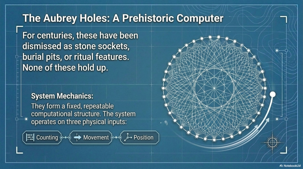
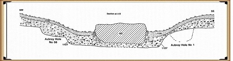
The Aubrey Holes – Finally Explained
For centuries, the Aubrey Holes have been treated as:
Stone sockets
Burial pits
Ritual features
None of these explanations hold up.
Instead, they form:
👉 A fixed, repeatable computational structure
A system based on:
Counting
Movement
Position
In simple terms:
👉 A prehistoric “computer”
The Stonehenge Enigma V4.0
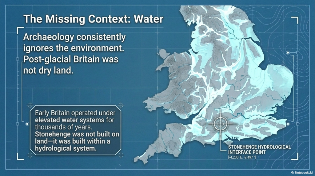
The Missing Piece: Water
Archaeology has consistently ignored the most obvious constraint:
👉 The environment
Post-glacial Britain wasn’t dry land.
It was:
Flooded valleys
Raised groundwater
Expanding rivers
Wetland basins
As shown in the wider Post-Glacial Flooding Hypothesis, early Britain operated under elevated water systems for thousands of years
That changes everything.
Stonehenge wasn’t built on land.
👉 It was built within a hydrological system
The Stonehenge Enigma V4.0
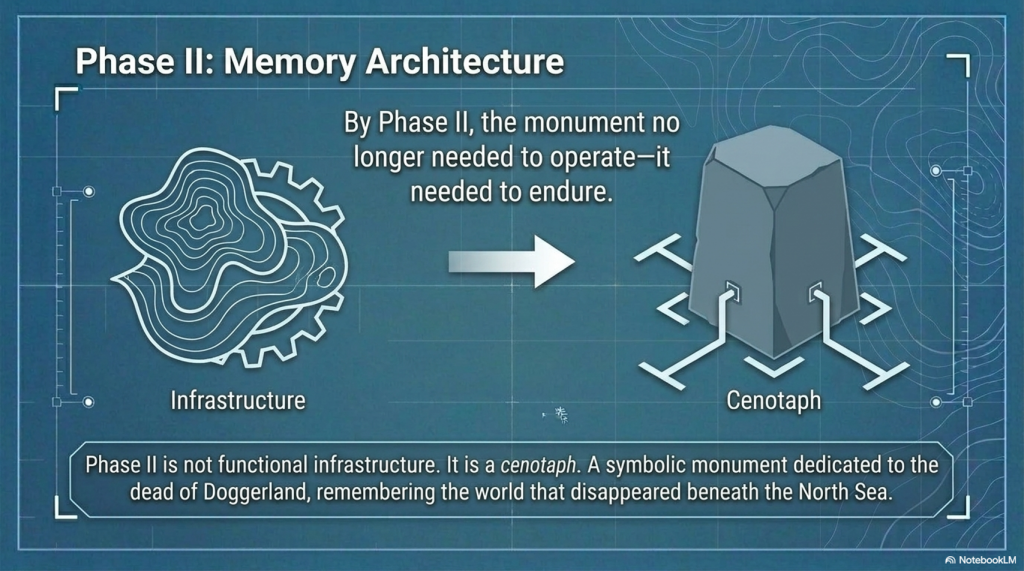
Phase II – A Monument to the Dead of Doggerland
Once Phase I is understood as a functional, water-based system, Phase II stops being a continuation—and starts to look like something very different.
It becomes a response.
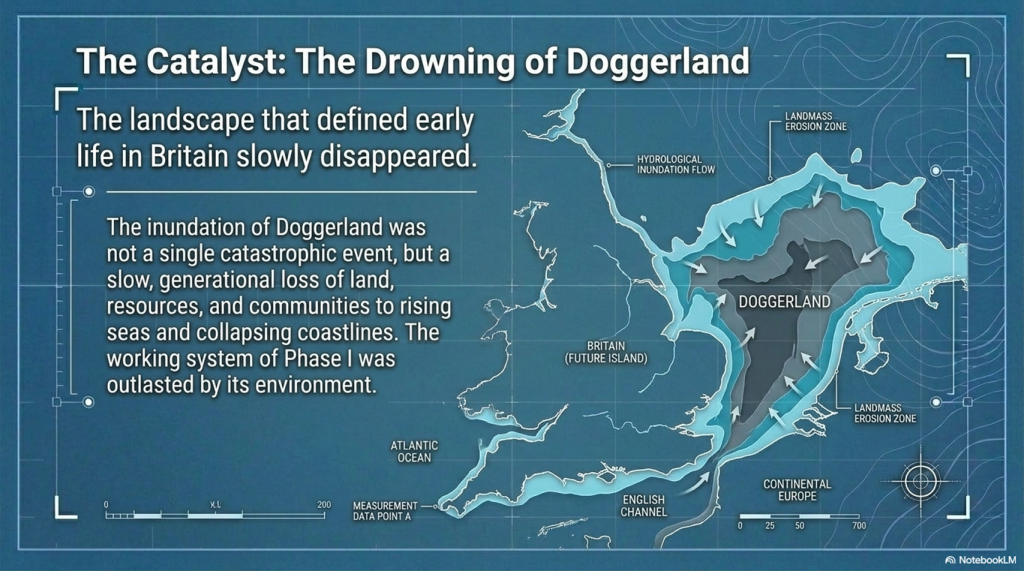
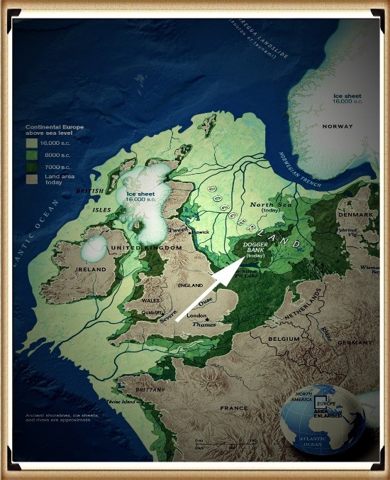
By the time Phase II was constructed, the landscape that defined earlier life in Britain had changed dramatically. The great lowland plains of Doggerland—once a vast, habitable region connecting Britain to mainland Europe—had been progressively inundated by rising seas and collapsing coastlines.
This was not a single event. It was a slow, generational loss of land, resources, and communities.
Within this context, Phase II takes on a new and coherent meaning:
👉 It is not functional infrastructure. 👉 It is memory architecture.
The shift is clear:
From water engineering → to stone permanence
From prediction and survival → to commemoration and identity
From a working system → to a monumental statement
The geometry, scale, and orientation of Phase II reflect this transition. The monument no longer needs to operate—it needs to endure.
In this interpretation:
👉 Stonehenge Phase II becomes a cenotaph 👉 A symbolic structure representing a lost homeland 👉 A monument to the people and world that disappeared beneath the North Sea
This is why the site changes so fundamentally.
It is no longer solving a problem.
👉 It is remembering one.
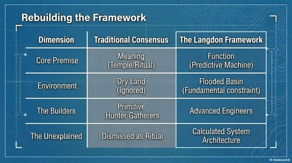
The Stonehenge Enigma V4.0
Why Every Traditional Explanation Fails
Because they all start with meaning—not function.
Temple → ignores engineering
Observatory → ignores water
Burial site → ignores process
Ritual → explains nothing
👉 They don’t fail individually.
👉 They fail because they are asking the wrong question.
The Stonehenge Enigma V4.0
A Simple Test
If a theory is correct, it must:
✔ Explain all features ✔ Work as a system ✔ Match the environment ✔ Provide practical value
So ask yourself:
👉 What use is a monument that only “works” once every 18 years? 👉 Why build precision geometry with no functional output? 👉 Why ignore water in a saturated landscape?
The Stonehenge Enigma V4.0
The Conclusion
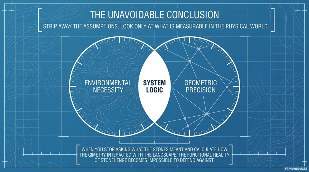
Strip away the assumptions.
Look only at what’s measurable.
And the answer becomes obvious:
Why This Matters
If this model is correct, then:
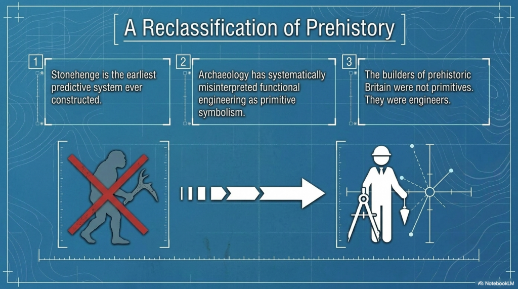
Stonehenge is the earliest predictive system ever built
Prehistoric societies were engineers—not primitives
And archaeology has been interpreting function as symbolism
The Stonehenge Enigma V4.0
The Final Point
Stonehenge has never lacked explanations.
👉 It has lacked one that works.
The Stonehenge Enigma V4.0
Now Available
The Stonehenge Enigma v4.0 A Scientific Rebuild of Prehistoric Britain
Paperback Version – £9.95Hardback COLOUR Version – £29.95
PODCAST
The Videos
More Book information
Technical White Paper: The Post-Glacial Flooding Hypothesis (PGFH) and British Hydrological Evolution
1. Theoretical Framework: The Post-Glacial Flooding Hypothesis
The Post-Glacial Flooding Hypothesis (PGFH) establishes a necessary paradigm shift in paleohydrological modeling, moving away from the simplistic “episodic flood event” narrative toward a rigorous model of sustained hydrological disequilibrium. This framework asserts that the early Holocene landscape was not shaped by modern-style meteorological cycles but by a state of delayed continental drainage. This disequilibrium was the inevitable consequence of ice-sheet-induced crustal compression and the massive overcharging of continental aquifers.
The core premise of the PGFH is that prehistoric river levels were governed by hydraulic boundary conditions rather than modern precipitation patterns, which are largely irrelevant to early Holocene reconstructions. We must recognize the lithosphere’s failure to rebound instantaneously; this “isostatic lag” created physical obstructions that prevented efficient drainage. Consequently, Britain operated under a hydraulic regime where river stages were maintained at elevations significantly higher than today. This theoretical shift necessitates a rigorous re-examination of global sea-level data to resolve volumetric discrepancies that cannot be explained by surface meltwater alone.
2. Proof 1: Sea-Level Mass Balance and Volumetric Discrepancy
Between 19,000 and 7,000 years BP, the global deglacial sequence resulted in a 120m rise in mean sea level, representing an influx of approximately 4.5 × 10⁸ km³ of water into the ocean basins. However, a mass balance analysis reveals a profound “volumetric discrepancy.” Traditional models struggle to account for the continued rise in sea level during the Holocene, particularly as the British-Irish Ice Sheet (BIIS) had largely vanished.
While thermal expansion and residual ice loss from the Laurentide and Antarctic sheets contributed, they are insufficient to explain the total observed ocean loading. The PGFH identifies pressurized continental aquifers as the primary engine for this continued discharge. This “asynchronous decay”—where continental aquifers acted as secondary, delayed reservoirs—sustained sea-level rise long after the primary meltwater pulses (MWP-1A and 1B).
The Deglacial Sequence identified in the PGFH:
Stable Minimum (26–19 ka BP): Sea levels remained constant near -130m; global ice volume was at its maximum.
Deglacial Rise (19–7 ka BP): Global mean sea level increased by 120m at an average rate of 1.2 cm/year.
Holocene Highstand (After 7 ka BP): Relative stability within ±3m, characterized by regional divergence driven by glacio-isostatic adjustment (GIA).
If the global oceans were receiving this sustained continental discharge, the regional geomorphic response must be visible in the elevation and architecture of river terraces.
3. Proof 2: Ice-Volume Scaling and the Terrace Elevation Rule
Fluvial terrace formation is a direct function of base-level thresholds and hydraulic energy. The PGFH utilizes Langdon Mathematics to establish the “90% Terrace Rule” and the “Terrace Elevation Scaling Principle.” The significance of the 90% benchmark lies in the fact that the Last Glacial Maximum (LGM) reached approximately 90% of the maximum possible Pleistocene ice extent, creating a specific “hydrological energy” baseline. This mathematical benchmark allows for the precise prediction of early Holocene river heights based on ice-volume percentages.
Assumes modern drainage baselines were reached rapidly.
Predicts elevated river stages based on 90% ice-volume scaling.
Mechanism
Focused on surface runoff and precipitation.
Driven by hydraulic head and multi-millennial aquifer discharge.
By applying Langdon Mathematics, we treat river terraces as time-calibrated gauges. When ice volume approached 90% of its maximum, the resulting groundwater pressure and river energy placed floodplains at elevations that modern hydrology cannot replicate.
4. Proof 3: Statistical Validation via Subsurface Matrix Analysis
The borehole data from Stonehenge Bottom provides the localized empirical rejection of traditional models. The “random chalk deposition model,” which dismisses subsurface variability as geological noise, is statistically untenable. By normalizing data by elevation (Ordnance Datum) rather than depth, we identify a rigorous clustering of water-related deposits at discrete heights.
The analysis identifies a 92.6 m OD envelope where water-related deposits cluster with a 170:1 probability against chance. This statistical rejection is the “nail in the coffin” for traditional theories; it confirms that the water table was sustained at this elevation for millennia.
The Four Phases of Subsurface Matrix Analysis:
Height-Frequency Analysis: Identifying the vertical distribution of sedimentary units.
Matrix Concurrence: Comparing deposit types across independent boreholes at identical elevations.
Discrete Elevation Zones: Defining the specific “water-envelopes” where saturation occurred.
Statistical Rejection: Disproving the randomness of deposition in favor of a sustained hydrological control.
5. Case Study: Volumetric Scaling in the Thames Valley Basin
As a principal Quaternary gauge, the Thames Valley demonstrates a massive mismatch between modern hydrology and Holocene geomorphology. The modern mean discharge of 65.8 m³/s is incapable of creating the 3,723% average volumetric expansion observed in the mapped Holocene alluvium.
Cross-Sectional Analysis (Sections A–G):
Cross-Section
Current Width (m)
Holocene Width (m)
Volume Increase %
A
400
4,425
8,866%
B
650
7,725
3,590%
C
731
8,450
4,292%
D
965
7,644
1,151%
E
1,207
11,265
7,367%
F
1,125
5,230
390%
G
1,448
7,242
408%
AVERAGE
932
7,426
3,723%
The derived discharge for this system is approximately 2,450 m³/s. Critically, the sediment competence argument confirms this; the modern Thames flow cannot move the coarse gravel sheets found in the basin’s stratigraphic record. Only the high-energy discharge predicted by the PGFH explains the presence and transport of these massive gravel units.
6. Hydraulic Mechanisms: Aquifer Pressure and the “Age of Water”
Using Darcy’s Law, we can model the elevated hydraulic head in British chalk systems. During the glacial period, aquifers were subjected to immense subglacial recharge and lithospheric pressure. This “ancient pressure” sustained high river baseflow for thousands of years after the ice retreated from the surface.
Unlike “rain-fed” modern rivers, these spring-fed, high-stage rivers were consistent systems seeking hydraulic equilibrium. The PGFH clarifies that these were not short-lived runoff events but a multi-millennial release of stored glacial water.
Isotopic analysis identifies a 12,000-year gap between the melting of surface ice and the eventual rainwater replenishment of the aquifers. This gap provides definitive proof that early Holocene rivers were powered by “ancient” meltwater under pressure, not recent precipitation.
7. Chronological Constraints: Peat as a National Hydrological Clock
Peat serves as the ultimate geomorphological “clock” for the PGFH. The “Delayed Peat Peak Paradox”—the fact that British peat expansion reached its maximum well into the early Holocene (c. 9–8.5 ka BP)—is only resolvable if we accept the PGFH. Peat only forms in anaerobic, saturated conditions; its expansion proves that the landscape remained saturated long after traditional models suggest it should have been “dry land.”
Buried peat beds in the Somerset Levels, Fenland, and the Thames Valley (c. 9–8.5 ka BP) are physical records of “delayed drainage.” They mark the period of maximum groundwater overcharge and provide the chronological proof of a landscape in slow, hydraulic transition.
8. Synthesis: The Deglacial Hydraulic Law and Engineering Implications
The convergence of Sea-Level Mass Balance, Ice-Volume Scaling, and Subsurface Matrix Analysis defines the Deglacial Hydraulic Law. This law dictates that the early Holocene landscape was governed by the predictable relationship between ice-mass loss, crustal rebound, and aquifer discharge duration.
Strategic Framework for Geomorphologists:
Redefine Hydrological Baselines: Acknowledge that early Holocene baseflow was an order of magnitude higher than modern levels.
Apply Volumetric Scaling: Use the 3,723% benchmark from the Thames as a baseline for other British catchment reconstructions.
Reject Random Deposition Models: Replace Bayesian “noise” models with elevation-normalized matrix analysis.
Model Sediment Competence: Account for the high-energy flow (e.g., 2,450 m³/s) required to transport Holocene gravel sheets.
Utilize Peat Chronology: Interpret peat initiation as a record of peak groundwater saturation rather than simple climate shifts.
Ancient Britain was never a static, dry island; it was a dynamic system of “living water” undergoing a measurable, mathematically predictable, and multi-millennial transformation.
Robert John Langdon, a polymathic luminary, emerges as a writer, historian, and eminent specialist in LiDAR Landscape Archaeology.
His intellectual voyage has been interwoven with stints as an astute scrutineer in government and grand corporate bastions, a tapestry spanning British Telecommunications, Cable and Wireless, British Gas, and the esteemed University of London.
A decade hence, Robert’s transition into retirement unfurled a chapter of insatiable curiosity. This phase saw him immerse himself in Politics, Archaeology, Philosophy, and the enigmatic realm of Quantum Mechanics. His academic odyssey traversed the venerable corridors of knowledge hubs such as the Museum of London, University College London, Birkbeck College, The City Literature Institute, and Chichester University.
In the symphony of his life, Robert is a custodian of three progeny and a pair of cherished grandchildren. His sanctuary lies ensconced in the embrace of West Wales, where he inhabits an isolated cottage, its windows framing a vista of the boundless sea – a retreat from the scrutinising gaze of Her Majesty’s Revenue and Customs, an amiable clandestinity in the lap of nature.
Exploring Prehistoric Britain: A Journey Through Time
My blog delves into the fascinating mysteries of prehistoric Britain, challenging conventional narratives and offering fresh perspectives grounded in cutting-edge research, particularly LiDAR technology. I invite you to explore some key areas of my research. For example, the Wansdyke, often cited as a defensive structure, is re-examined in light of new evidence. I’ve presented my findings in my blog post Wansdyke: A British Frontier Wall – ‘Debunked’, and a Wansdyke LiDAR Flyover video further visualises my conclusions.
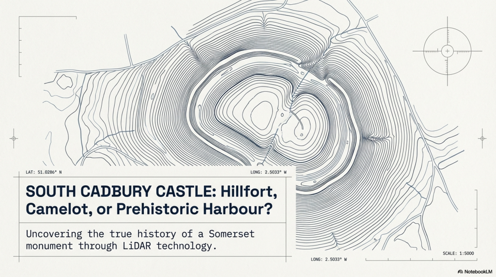
My work also often challenges established archaeological dogma. I argue that many sites, such as Hambledon Hill, commonly identified as Iron Age hillforts, are not what they seem. My posts Lidar Investigation Hambledon Hill – NOT an ‘Iron Age Fort’ and Unmasking the “Iron Age Hillfort” Myth explore these ideas in detail and offer an alternative view. Similarly, sites like Cissbury Ring and White Sheet Camp receive re-evaluations based on LiDAR analysis in my posts “Lidar Investigation Cissbury Ring through time”and “Lidar Investigation White Sheet Camp,“ revealing fascinating insights into their true purpose. I have also examined South Cadbury Castle, often linked to the mythical Camelot56.
My research also extends to ancient water management, including the role of canals and other linear earthworks. I have discussed the true origins of Car Dyke in multiple posts, including Car Dyke – ABC News Podcast and Lidar Investigation Car Dyke – North Section, which suggest a Mesolithic origin 2357. I also explore the misidentification of Roman aqueducts, as seen in my posts on the Great Chesters (Roman) Aqueduct. My research has also been greatly informed by my post-glacial flooding hypothesis, which has helped explain landscape transformations over time. I have discussed this hypothesis in several posts, including AI now supports my Post-Glacial Flooding Hypothesis and Exploring Britain’s Flooded Past: A Personal Journey
For those interested in British Prehistory, visit www.prehistoric-britain.co.uk, a comprehensive resource featuring an extensive collection of archaeology articles, modern LiDAR investigations, and groundbreaking research. The site also includes insights and excerpts from the acclaimed Robert John Langdon Trilogy, a series of books that explore Britain during the Prehistoric period. Titles in the trilogy include The Stonehenge Enigma, Dawn of the Lost Civilisation, and The Post-Glacial Flooding Hypothesis, which offer compelling evidence of ancient landscapes shaped by post-glacial flooding.
To further explore these topics, Robert John Langdon has developed a dedicated YouTube channel featuring over 100 video documentaries and investigations that complement the trilogy. Notable discoveries and studies showcased on the channel include 13 Things that Don’t Make Sense in History and the revelation of Silbury Avenue – The Lost Stone Avenue, a rediscovered prehistoric feature at Avebury, Wiltshire.
In addition to his main works, Langdon has released a series of shorter, accessible publications, ideal for readers delving into specific topics. These include:
For active discussions and updates on the trilogy’s findings and recent LiDAR investigations, join our vibrant community on Facebook. Engage with like-minded enthusiasts by leaving a message or contributing to debates in our Facebook Group.
Whether through the books, the website, or interactive videos, we aim to provide a deeper understanding of Britain’s fascinating prehistoric past. We encourage you to explore these resources and uncover the mysteries of ancient landscapes through the lens of modern archaeology.
For more information, including chapter extracts and related publications, visit the Robert John Langdon Author Page. Dive into works such as The Stonehenge Enigma or Dawn of the Lost Civilisation, and explore cutting-edge theories that challenge traditional historical narratives.
Exploring the origins and transport of the stones used to construct Stonehenge remains a fascinating subject, rife with theories and controversies. The viral interest generated by my blog post this week, which highlighted a map showing three known sites of the stones’ origins, barely scratches the surface of this complex logistical puzzle. Indeed, there are stones from even greater distances, raising myriad questions about how these megaliths were transported to their final resting place at Stonehenge. This essay aims to delve into these logistics, providing a comprehensive overview grounded in the latest research and theories. (The Stonehenge Transportation Mystery)
The Stonehenge Transportation Mystery
The Bluestones
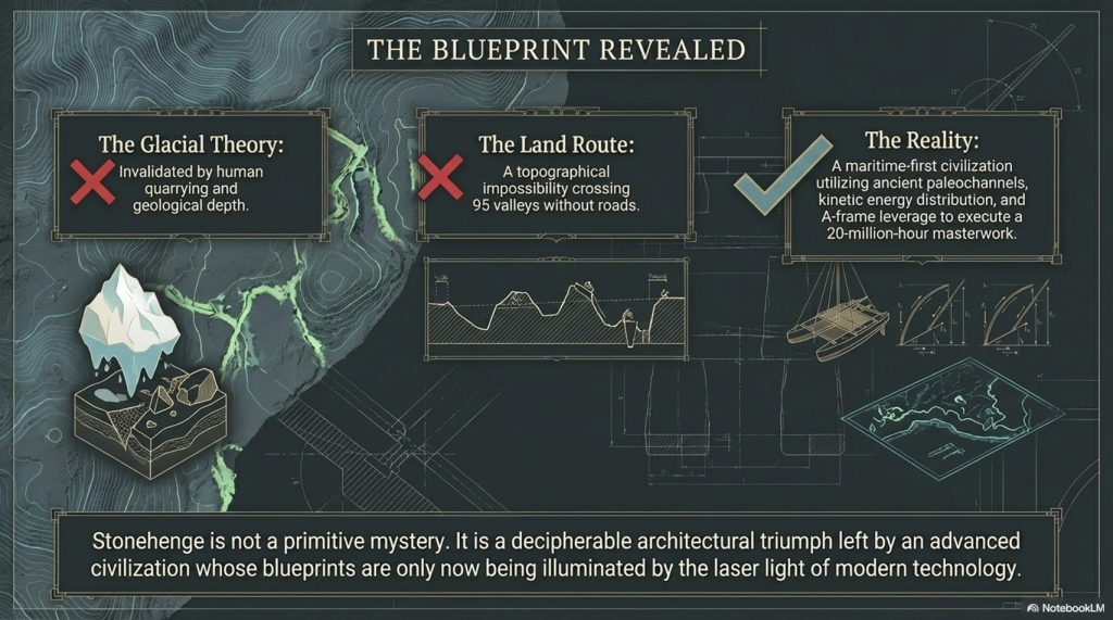
Recent advancements in micro-spectrum analysis have significantly contributed to our understanding of the origins of bluestones. However, this is not an exact science, as the movement of rocks due to glacial activity and post-ice age water flows complicates their traceability. Some academics have proposed that the bluestones found at Stonehenge were not quarried and transported from Wales but deposited nearby by glacial action. This theory, however, conflicts with geological evidence indicating that the last ice age glaciers did not reach as far as Stonehenge, stopping instead at the Bristol Channel. This discrepancy casts doubt on the glacier transport theory, suggesting the need to consider earlier ice ages, such as the Anglian, which occurred over 500,000 years ago. Yet the immense timescale involved means that any stones moved by such glaciers would be deeply buried beneath millennia of soil, making their discovery improbable.
The Stonehenge Transportation Mystery
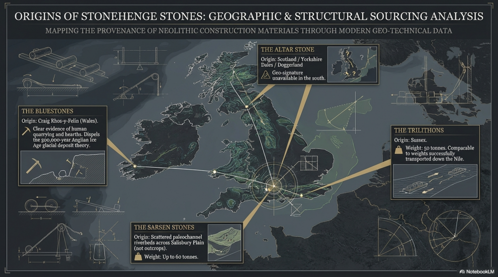
Furthermore, the lack of bluestone erratics in the vicinity of Stonehenge further challenges the idea of glacial transport. The site at Craig Rhos-Y-Felin, identified as a source of the bluestones, shows clear evidence of human quarrying activity, contradicting the theory that these stones were randomly picked up from glacial deposits. The discovery of human hearths and quarrying tools at Craig Rhos-Y-Felin, along with a partially quarried bluestone, strongly suggests that these stones were intentionally selected and transported for use at Stonehenge.
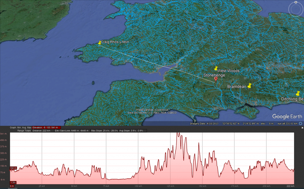
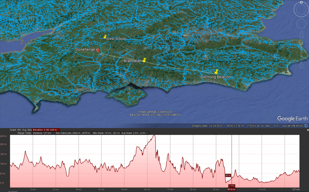
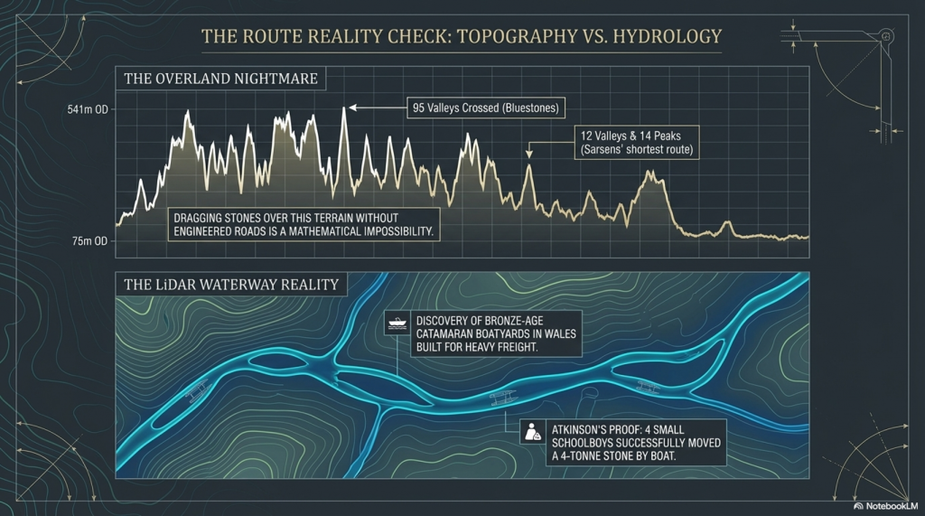
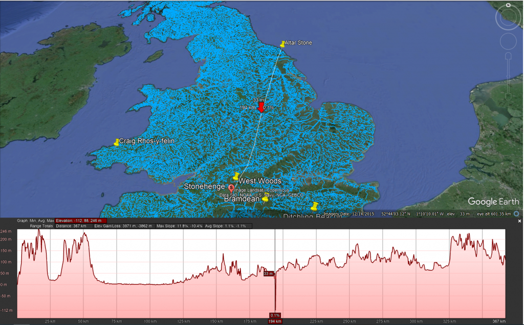
The overland path from Craig Rhos-y-felin to Stonehenge is insane. It goes from 75m OD to 541 OD and crosses 95 valleys – the idea that you can either roll, drag or ox-cart such a route without a road is bonkers!!
The Sarsen Stones
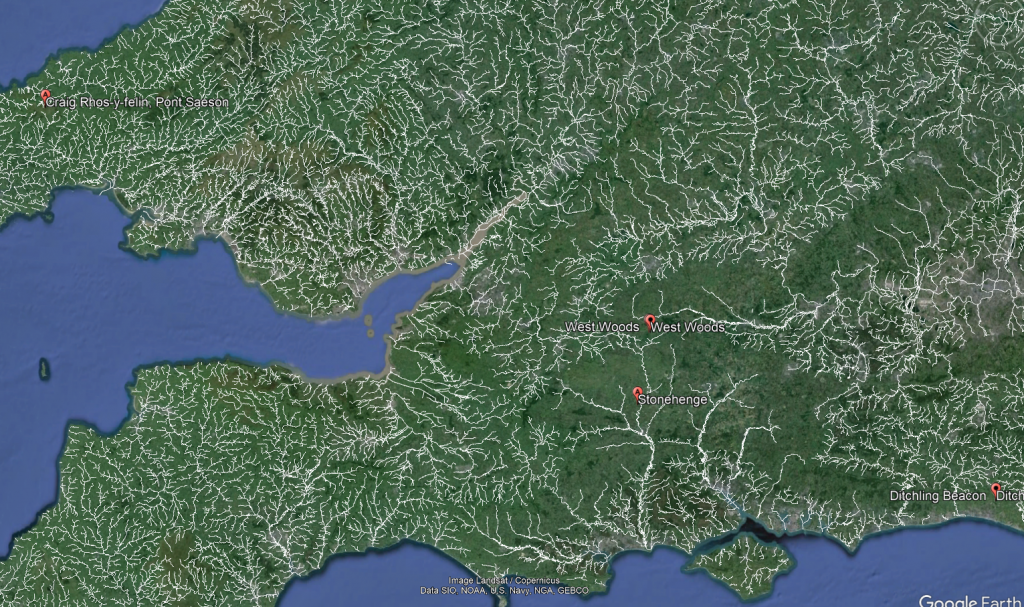
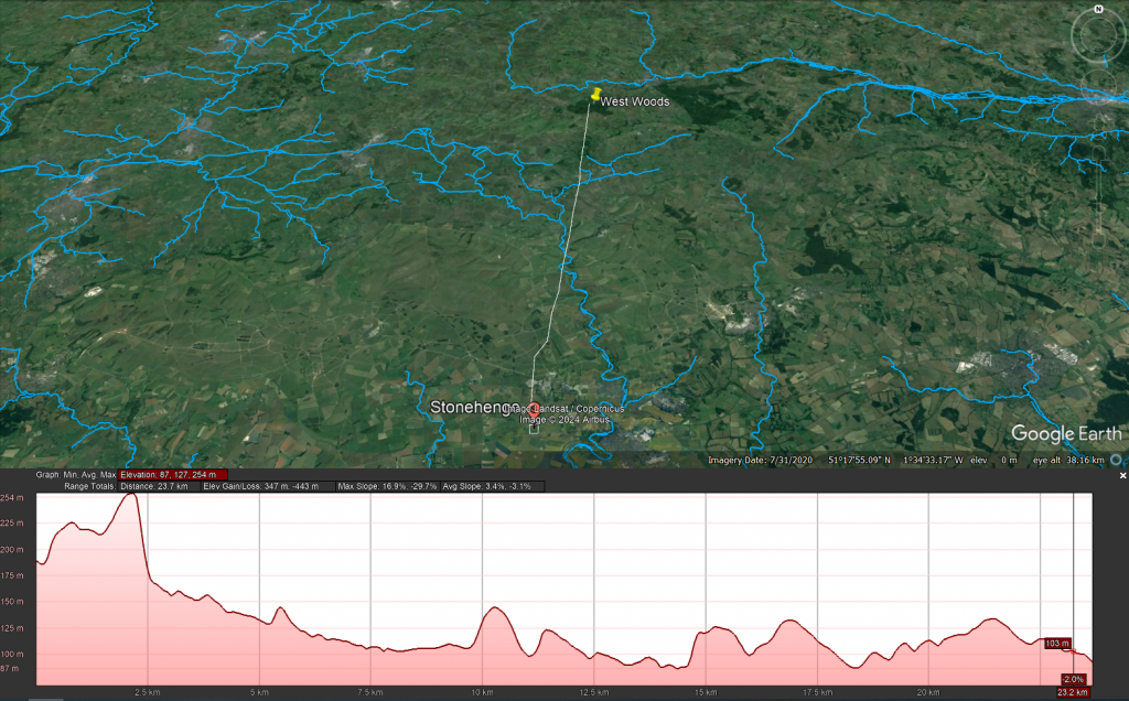
The origin and transportation of the sarsen stones present a different set of challenges. These stones are found scattered across the Salisbury Plain and further afield, in areas never reached by the ice sheets that covered Britain during the last ice age. The popular theory that the sarsen stones came from West Woods near Avebury suggests that they could have been dragged to their current location. However, recent observations indicate that many of these stones are in paleochannel riverbeds rather than rock outcrops. This suggests that they were transported by ice-age floodwaters rather than being quarried from nearby outcrops.
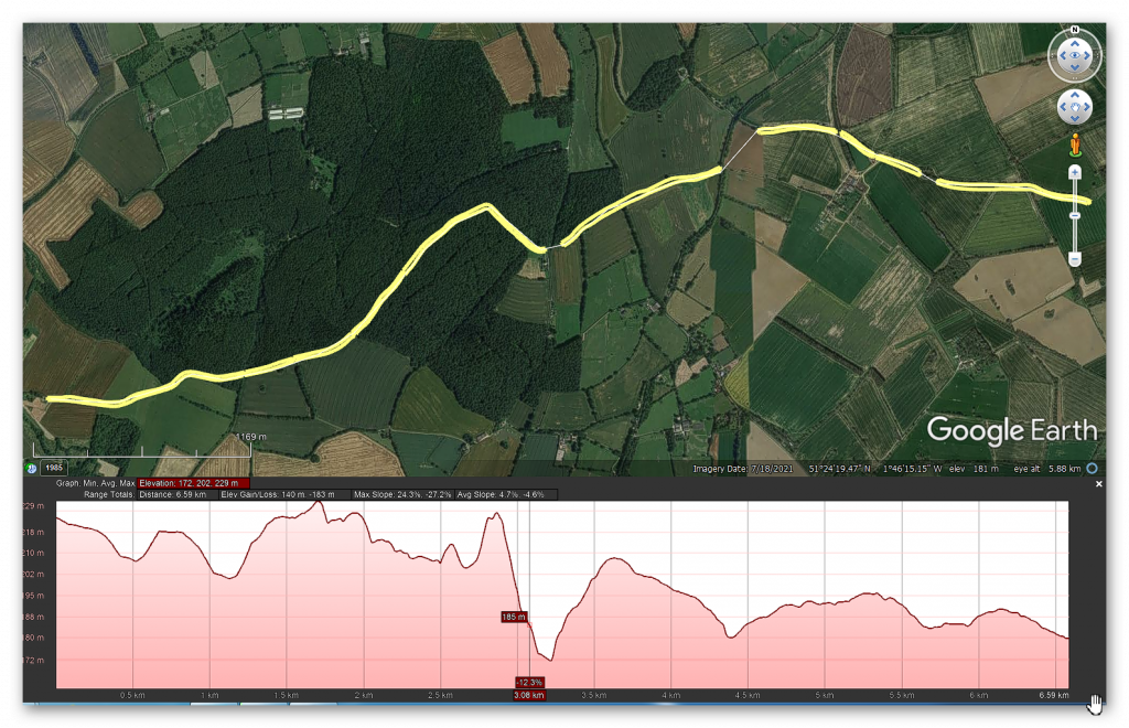
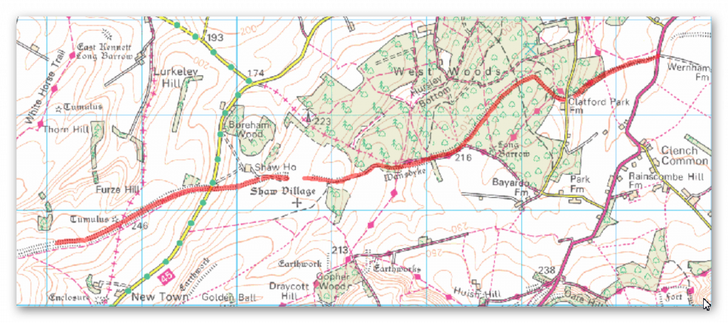
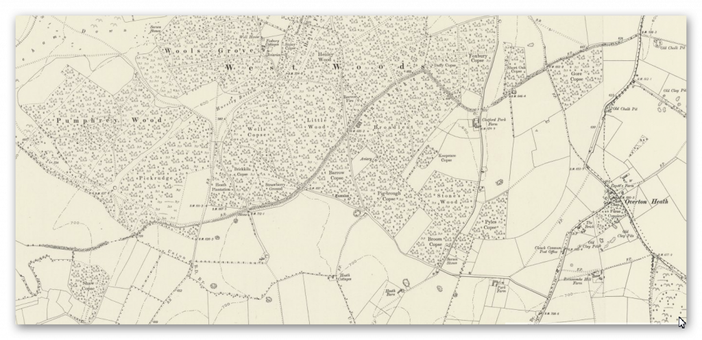
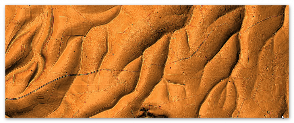
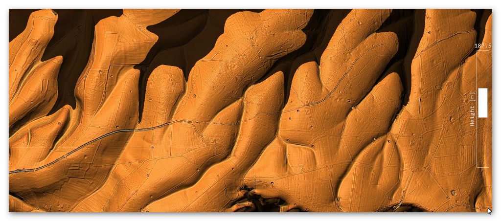
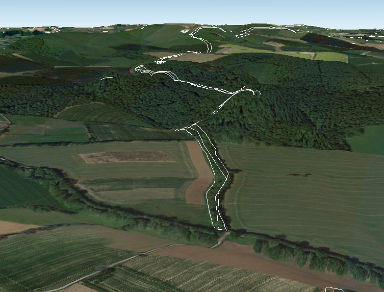
Even the shortest route known to transport these stones is difficult to follow, as the 12 valleys and 14 peaks shown on this map testify.
Theories of Transportation
The theory that the stones could have been moved over frozen rivers during the ice age is intriguing but fraught with logistical issues. The absence of a significant human population capable of organising such an endeavour, coupled with the challenges of moving heavy stones over potentially thin ice, makes this theory less plausible. Additionally, the radiocarbon dating of Stonehenge would be significantly off if the stones had been transported at the end of the ice age.
The Stonehenge Transportation Mystery
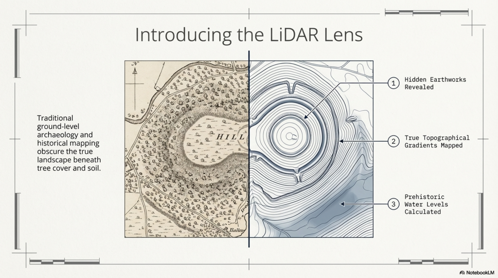
LiDAR, or Light Detection and Ranging, is a remote sensing technology that uses laser light to densely sample the earth’s surface, creating highly accurate topographic maps. It has revolutionised archaeological surveys by uncovering features difficult or impossible to see from the ground or through traditional surveying methods. Regarding Stonehenge and the transportation of the stones used in its construction, LiDAR technology offers invaluable insights into the landscape and potential transport routes used by ancient peoples.
The trilithon stones, weighing around 50 tonnes, reportedly come from Sussex. Such weights were successfully transported down the Nile on boats.
LiDAR Evidence and Stonehenge
LiDAR has been instrumental in mapping the landscape around Stonehenge, revealing details that have remained hidden for millennia under vegetation or soil. This technology has the potential to identify old riverbeds, trackways, and other features that could suggest routes for transporting the massive sarsen stones and bluestones used in the monument’s construction. However, despite its capabilities, LiDAR has not yet provided definitive evidence of prehistoric roads or paths leading directly from the quarries to Stonehenge.
The Stonehenge Transportation Mystery
Key Findings from LiDAR Surveys
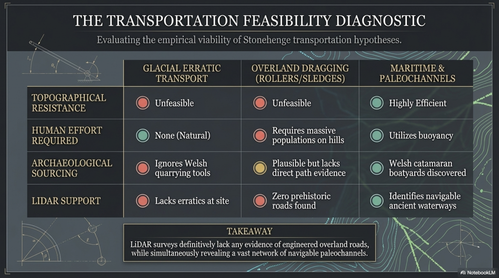
No Prehistoric Roads from Quarries: LiDAR surveys have not found any evidence of engineered roads or paths originating from the bluestone quarries in Wales or from locations where sarsen stones are found. This absence challenges theories that rely on overland transport of the stones using rollers, sledges, or ox-carts over vast distances and rugged terrain.
Ancient Waterways and Paleochannels: One significant contribution of LiDAR is the identification of ancient waterways and paleochannels. These features are crucial for understanding the prehistoric landscape, suggesting that rivers and watercourses may have played a significant role in transporting the stones. The larger rivers identified by LiDAR, which were navigable in the past, support the theory that water transport was a feasible and preferred method for moving the stones.
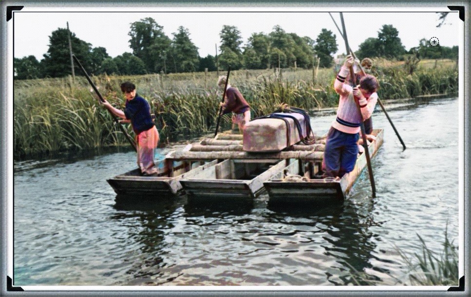
Atkinson proved with just four small schoolboys that a 4-tonne stone can easily be moved by boat down to the River Avon
Landscape Features: LiDAR has revealed the complexity of the landscape through which any transportation route would have had to navigate, including valleys, dense forests, and waterlogged areas. This detailed mapping underscores the logistical challenges faced by ancient builders, further calling into question the practicality of relying solely on land-based transport methods.
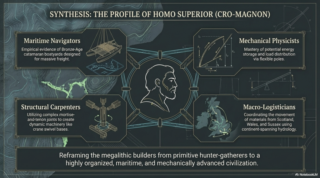
We have now found empirical evidence of boat yards in which catamaran design is made to carry large weights in Wales, dating back to the Bronze Age and beyond
Implications of LiDAR Evidence
The evidence from LiDAR surveys, particularly the absence of prehistoric roads and the emphasis on natural watercourses, suggests a reevaluation of how the stones were transported to Stonehenge. The lack of direct routes from quarries to the site and the identification of navigable ancient rivers and paleochannels lend weight to theories prioritising water transport. This perspective aligns with the understanding that ancient peoples were highly adept at utilising their natural environment to achieve monumental feats of construction.
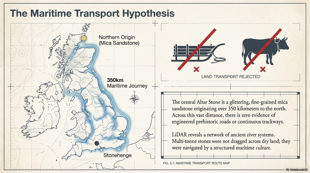
The Altar Stone is now suspected of coming from as far as Scotland, as its Geo signature is not available down south (I would guess Doggerland for obvious reasons), but even if it just came from the Yorkshire Dales, the idea of l, and transportation is pure nonsense
Short Transportation systems from the boatharbours to the Monument
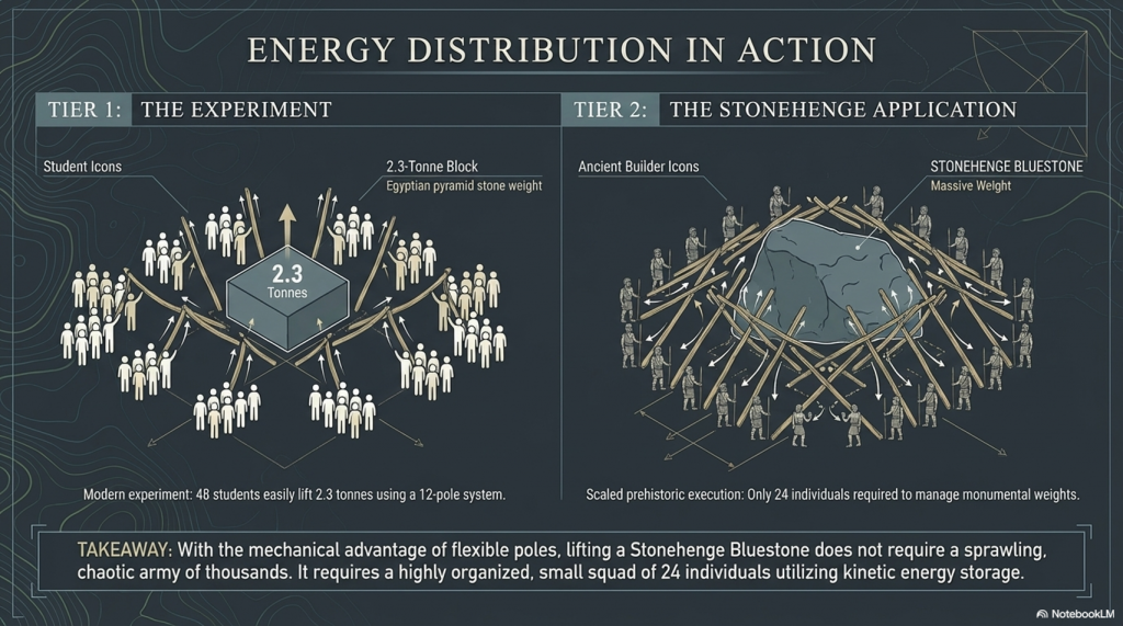
Mechanical Advantage of Poles (from the book – Dawn of the Lost Civilisation)
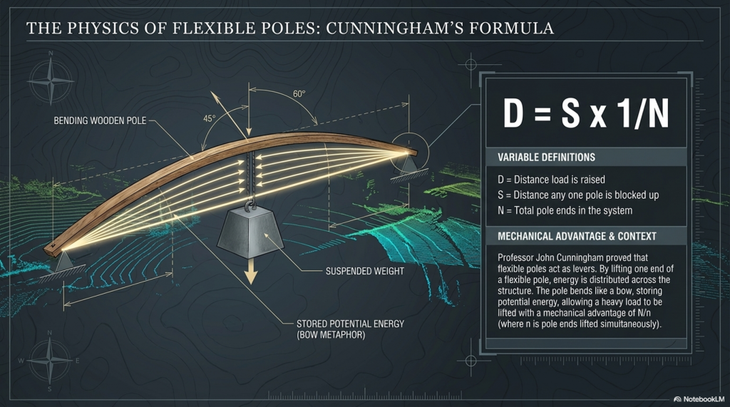
The principle of leverage, applied through poles, provides a mechanical advantage when handling heavy weights. Professor John Cunningham, an art professor at Skidmore College, has introduced a novel concept, creating a new class of simple machines based on flexible rods. Unlike traditional machines, Cunningham’s design not only multiplies force but also distributes it and stores mechanical energy.
The Stonehenge Transportation Mystery
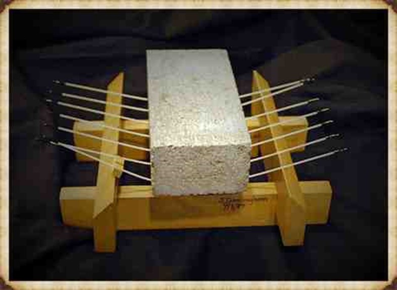
Consider a scenario with a 20,000-pound stone. If you attempt to support it on two rigid beams, each will bear half the weight (10,000 pounds), posing a risk of fracture. Now, imagine spreading the load across 20 solid, parallel beams, each supporting only a fraction of the total weight, making the burden manageable. Cunningham’s innovation takes this idea further by replacing solid beams with flexible poles.
The Bluestones were carried, not dragged, to Stonehenge
In the flexible pole structure, each pole can be raised independently without affecting the others. By lifting one end of a pole, a small amount of extra energy is imparted to that pole, and the energy is distributed across the structure. The weight rises by a fraction of the raised end, divided by the number of pole ends. If one end is lifted by a foot, the weight on each of the other pole ends diminishes by a corresponding fraction. Using this method, heavy loads can be lifted with significantly fewer people, as each person is only moving a fraction of the weight at a time.
This innovative approach enables efficient handling of substantial weights, offering a unique perspective on the use of mechanical advantage in lifting and distributing loads. (Stone transportation and censorship)
The Stonehenge Transportation Mystery
Cunningham has distilled the concept to a formula: D = S x 1/N
Where D is the distance, the load is raised, s is the distance any one pole is blocked up, and N is the total number of pole ends in the system. Given n is the number of pole ends lifted simultaneously, the mechanical advantage for any symmetrical pole configuration will be N/n.
The Stonehenge Transportation Mystery
So, the fact that a pole bends like a bow, storing energy, makes it easier to carry. So easy in fact, that it acts as a lever and gives you a mechanical advantage. This principle would be well known as it is the same principle as how a bow works as it is a store of potential energy, you can’t throw an arrow 100 metres, but the bowing of the wood channelled through a small area (the string) give you the potential energy.
Walk like an Egyptian
The experiment showed that 48 students ( four x 12 poles) could lift 2.3 tonnes, which was the weight of one of the pyramid’s building stones. The larger the stone, the more poles and men you need, but it was quite easy even for wimpish students. In prehistoric Days with Cro-Magnon works you would need only 24 people to move a Pyramid stone or a Bluestone at Stonehenge without the rest blocks the video has included in their H & S safety assessment….LOL!!
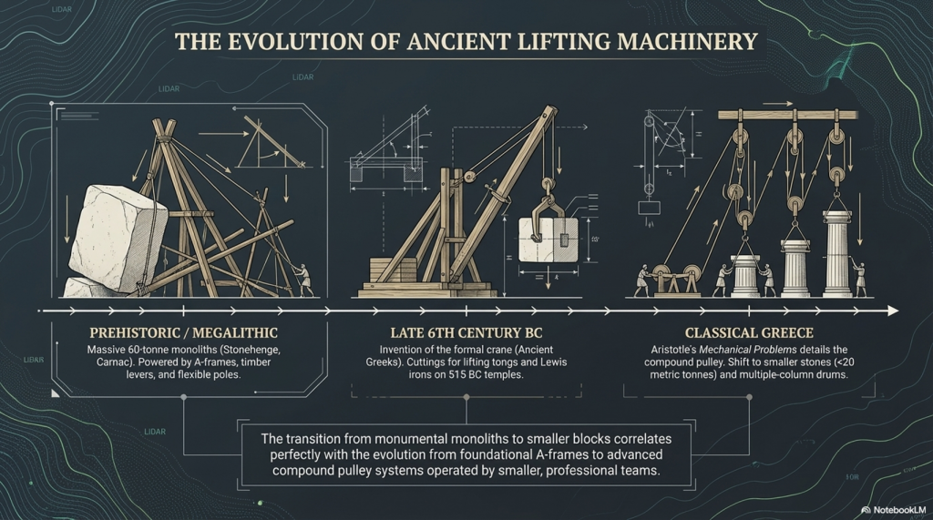
A-Frames and Cranes
The advancement of technology and the movement of massive stones, such as the Sarsen stones at Stonehenge, Avebury, and Carnac, demand a closer examination of the engineering and logistical challenges faced by the ancient civilisation of Homo Superior, also known as Cro-Magnons. The Sarsen stones, weighing up to 60 tonnes, were not merely transported but meticulously erected, presenting a feat that even modern attempts struggle to replicate.
In our exploration of ancient technology, we encounter the question of how to transport and handle colossal loads. The Sarsen stones serve as an illustrative example due to their significant size, and it is perplexing that historians and archaeologists often overlook the intricacies of moving and placing these stones. This oversight persists even though, even with today’s technology, replicating the achievements of Homo Superior at Stonehenge remains a daunting challenge.
The Stonehenge Transportation Mystery
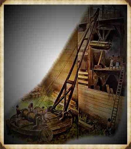
The crane, a machine designed to lift and move heavy materials, is pivotal in the transport and construction industries. Equipped with a hoist, wire ropes or chains, and sheaves, a crane utilises mechanical advantages to lift and lower materials beyond the capacity of human effort. Historically, the invention of the crane is attributed to the Ancient Greeks in the late 6th century BC, as evidenced by cuttings for lifting tongs and Lewis irons on stone blocks of Greek temples dating to around 515 BC.
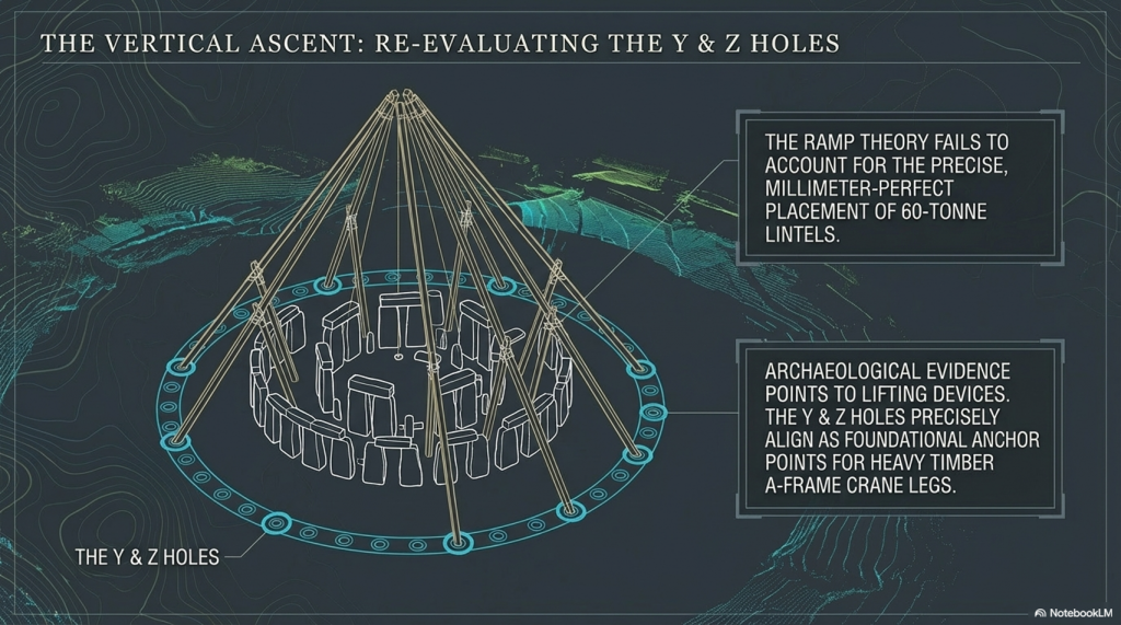
However, when scrutinising Stonehenge, we encounter a fascinating divergence. In contrast, archaeological evidence points to the use of lifting devices, particularly with cuttings indicating the application of cranes, the peculiarities of Stonehenge’s construction challenge conventional narratives. Notably, the placement of lintels on Sarsen uprights and the presence of holes like Y & Z, potentially serving as foundations for A-frame crane legs, hint at a more sophisticated lifting apparatus.
The Stonehenge Transportation Mystery
The reluctance of some scholars to acknowledge advanced lifting devices in the historical context of Homo Superior may stem from the challenge they pose to established historical frameworks. Nevertheless, the investigation into the engineering marvels of Stonehenge encourages us to reassess the capabilities of this ancient civilisation, prompting a deeper understanding of their technological prowess and organisational acumen.
The Stonehenge Transportation Mystery
The transition from ramps to the more sophisticated winch-and-pulley hoist marked a significant shift in ancient construction technology. The emergence of the compound pulley system, attributed to Aristotle in the Mechanical Problems, coincided with a notable decrease in the weights of stones handled on Greek building sites. This transformative period saw the prevalence of smaller stones, weighing less than 15–20 metric tonnes, in contrast to the archaic era’s trend of using larger blocks.
The adoption of the crane, facilitated by the compound pulley system, introduced a more efficient and practical method of vertical motion. Grecian temples of the classical age, exemplified by the Parthenon, favoured using several smaller stones rather than fewer larger ones. Monolithic columns, a prominent feature in earlier constructions, were gradually replaced by multiple-column drums.
The Stonehenge Transportation Mystery
The reasons behind this technological evolution are not entirely clear. It raises intriguing questions about whether the shift from larger to smaller stones was due to the loss of past techniques, improved quarrying methods that enabled faster cutting of shorter blocks, or other factors influencing construction practices. The shift in societal dynamics, with smaller, professional construction teams being favoured over larger bodies of unskilled labour, is proposed as a potential contributing factor. The crane, with its efficiency in handling smaller stones, became preferable in the more volatile social and political conditions of ancient Greece.
While the exact circumstances of this transition remain uncertain, the historical record indicates that the compound pulley system and the crane became integral to Greek construction sites. The literary evidence from Aristotle’s Mechanical Problems and the resurgence of larger block sizes at Greek temples suggests a correlation between the adoption of the compound pulley and advancements in construction techniques. The earliest construction cranes, likely powered by humans or beasts of burden like donkeys, marked a transformative period in ancient construction methods.
The Stonehenge Transportation Mystery
The evolution of cranes played a crucial role in the construction of tall buildings, enabling the lifting of heavier loads. In the High Middle Ages, harbour cranes emerged to facilitate ship loading and unloading, often integrated into stone towers for enhanced strength and stability. The earliest cranes were crafted from wood, but with the advent of the Industrial Revolution, materials like cast iron and steel became predominant.
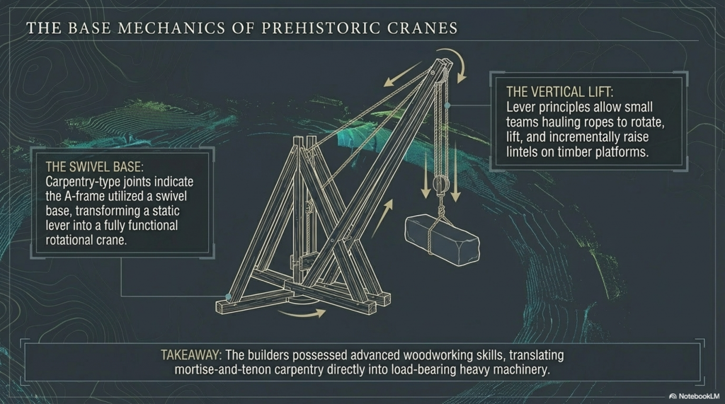
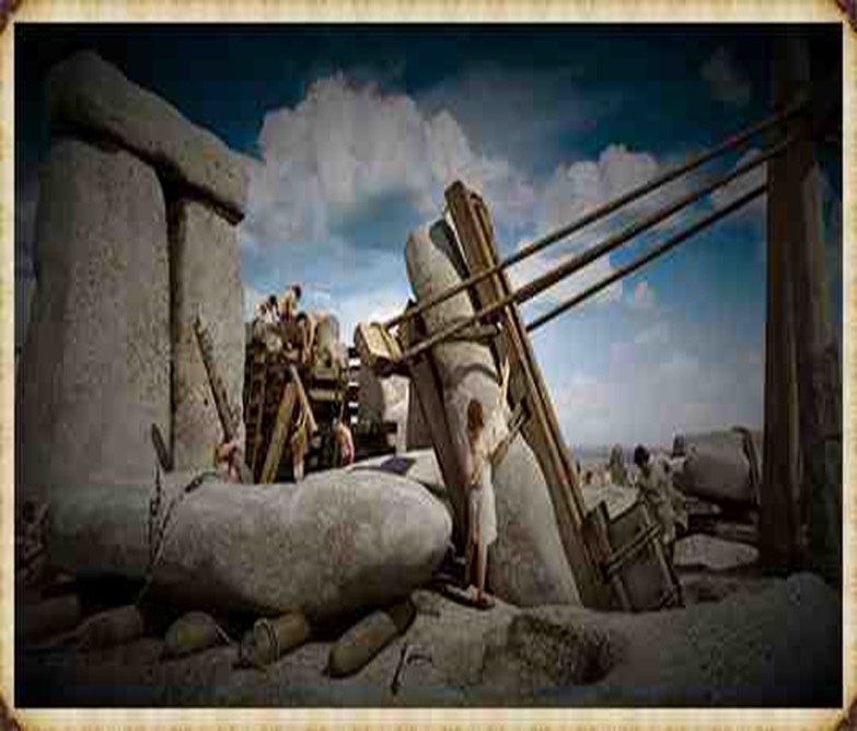
At Stonehenge, the construction methods are a subject of speculation, with suggestions that timber A-frames were employed to raise the stones. Teams of individuals may have hauled the stones upright using ropes, and the topmost stones (lintels) could have been incrementally raised on timber platforms and slid or pushed into place. Carpentry-type joints on the stones indicate a high level of woodworking skill among the builders.
The Stonehenge Transportation Mystery
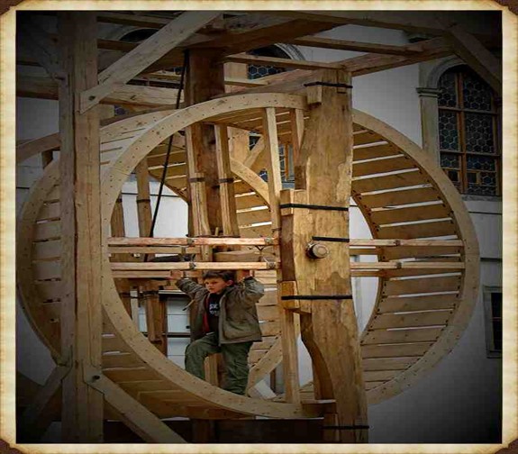
The idea of A-frames finds support in demonstrations by individuals such as Wally Wallington, a retired construction worker, who showcased techniques based on lever principles for rotating, lifting, and positioning heavy monoliths. An A-frame, essentially a basic crane without a pulley or winch, operates on similar principles to facilitate vertical movement. Adding a swivel base could transform it into a fully functional crane, a concept compatible with the mortise-and-tenon joints observed at Stonehenge.
The Stonehenge Transportation Mystery
Estimates of the manpower required for Stonehenge’s construction suggest a substantial effort, with millions of hours of work. The various phases of Stonehenge’s construction, from the initial to the third phase, may have required extensive human labour, amounting to up to 20 million hours spent working the stones. The primitive tools available at the time necessitated considerable effort, highlighting the strong will and advanced social organisation required to build and maintain such a monumental site. Stonehenge stands as a testament to the ingenuity and determination of its ancient builders. (Stone transportation and censorship)
The Stonehenge Transportation Mystery
PodCast
Author’s Biography
Robert John Langdon, a polymathic luminary, emerges as a writer, historian, and eminent specialist in LiDAR Landscape Archaeology.
His intellectual voyage has been interwoven with stints as an astute scrutineer in government and grand corporate bastions, a tapestry spanning British Telecommunications, Cable and Wireless, British Gas, and the esteemed University of London.
A decade hence, Robert’s transition into retirement unfurled a chapter of insatiable curiosity. This phase saw him immerse himself in Politics, Archaeology, Philosophy, and the enigmatic realm of Quantum Mechanics. His academic odyssey traversed the venerable corridors of knowledge hubs such as the Museum of London, University College London, Birkbeck College, The City Literature Institute, and Chichester University.
In the symphony of his life, Robert is a custodian of three progeny and a pair of cherished grandchildren. His sanctuary lies ensconced in the embrace of West Wales, where he inhabits an isolated cottage, its windows framing a vista of the boundless sea – a retreat from the scrutinising gaze of Her Majesty’s Revenue and Customs, an amiable clandestinity in the lap of nature.
Exploring Prehistoric Britain: A Journey Through Time
My blog delves into the fascinating mysteries of prehistoric Britain, challenging conventional narratives and offering fresh perspectives grounded in cutting-edge research, particularly LiDAR technology. I invite you to explore some key areas of my research. For example, the Wansdyke, often cited as a defensive structure, is re-examined in light of new evidence. I’ve presented my findings in my blog post Wansdyke: A British Frontier Wall – ‘Debunked’, and a Wansdyke LiDAR Flyover video further visualises my conclusions.
My work also often challenges established archaeological dogma. I argue that many sites, such as Hambledon Hill, commonly identified as Iron Age hillforts, are not what they seem. My posts Lidar Investigation Hambledon Hill – NOT an ‘Iron Age Fort’ and Unmasking the “Iron Age Hillfort” Myth explore these ideas in detail and offer an alternative view. Similarly, sites like Cissbury Ring and White Sheet Camp receive re-evaluations based on LiDAR analysis in my posts “Lidar Investigation Cissbury Ring through time”and “Lidar Investigation White Sheet Camp,“ revealing fascinating insights into their true purpose. I have also examined South Cadbury Castle, often linked to the mythical Camelot56.
My research also extends to ancient water management, including the role of canals and other linear earthworks. I have discussed the true origins of Car Dyke in multiple posts, including Car Dyke – ABC News Podcast and Lidar Investigation Car Dyke – North Section, which suggest a Mesolithic origin 2357. I also explore the misidentification of Roman aqueducts, as seen in my posts on the Great Chesters (Roman) Aqueduct. My research has also been greatly informed by my post-glacial flooding hypothesis, which has helped explain landscape transformations over time. I have discussed this hypothesis in several posts, including AI now supports my Post-Glacial Flooding Hypothesis and Exploring Britain’s Flooded Past: A Personal Journey
For those interested in British Prehistory, visit www.prehistoric-britain.co.uk, a comprehensive resource featuring an extensive collection of archaeology articles, modern LiDAR investigations, and groundbreaking research. The site also includes insights and excerpts from the acclaimed Robert John Langdon Trilogy, a series of books that explore Britain during the Prehistoric period. Titles in the trilogy include The Stonehenge Enigma, Dawn of the Lost Civilisation, and The Post-Glacial Flooding Hypothesis, which offer compelling evidence of ancient landscapes shaped by post-glacial flooding.
To further explore these topics, Robert John Langdon has developed a dedicated YouTube channel featuring over 100 video documentaries and investigations that complement the trilogy. Notable discoveries and studies showcased on the channel include 13 Things that Don’t Make Sense in History and the revelation of Silbury Avenue – The Lost Stone Avenue, a rediscovered prehistoric feature at Avebury, Wiltshire.
In addition to his main works, Langdon has released a series of shorter, accessible publications, ideal for readers delving into specific topics. These include:
For active discussions and updates on the trilogy’s findings and recent LiDAR investigations, join our vibrant community on Facebook. Engage with like-minded enthusiasts by leaving a message or contributing to debates in our Facebook Group.
Whether through the books, the website, or interactive videos, we aim to provide a deeper understanding of Britain’s fascinating prehistoric past. We encourage you to explore these resources and uncover the mysteries of ancient landscapes through the lens of modern archaeology.
For more information, including chapter extracts and related publications, visit the Robert John Langdon Author Page. Dive into works such as The Stonehenge Enigma or Dawn of the Lost Civilisation, and explore cutting-edge theories that challenge traditional historical narratives.
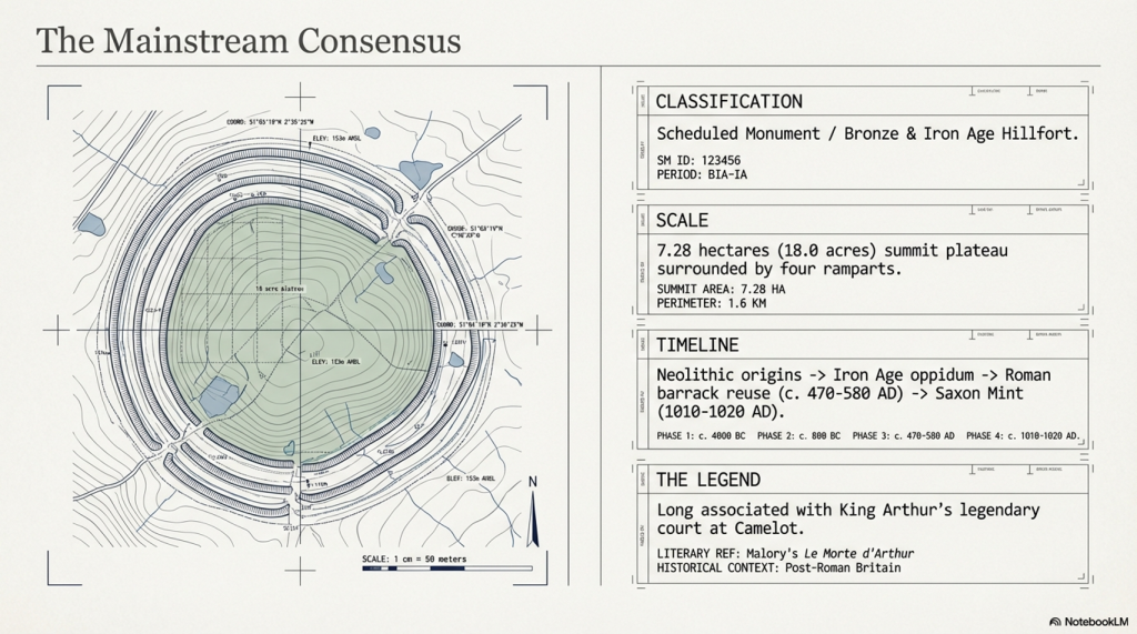
In the traditional archaeological interpretation, Cadbury Castle represents a long-lived settlement that developed gradually over several millennia. The earliest evidence of activity dates to the Neolithic period, where pits and postholes associated with pottery and flint finds suggest a small, unenclosed agricultural community. Radiocarbon dating places this early occupation around 3500–3300 BC, indicating that the hill was already being utilised long before the construction of its later defences.(South Cadbury Castle – Camelot)
The site continued to be occupied into the Bronze Age, where evidence of ovens and metalworking activity points to an increasingly organised settlement. By the Iron Age, Cadbury Castle had developed into a substantial fortified enclosure. Around 300 BC, a stone-built enclosure with timber reinforcements was constructed, later expanded into a complex hillfort with multiple ramparts and elaborate defensive systems. Excavations have revealed both roundhouses and rectangular structures, alongside evidence of industrial activity and possible ritual features, suggesting a permanent and socially complex community—often described as “oppidum-like” in character.
South Cadbury Castle – Camelot
During the 1st century BC and into the early Roman period, the defences were further strengthened. Archaeological evidence indicates that the site may have been violently attacked during the Roman conquest of Britain, around AD 43, with signs of burning and destruction uncovered at key प्रवेश points. Following this, the Romans appear to have reused the hilltop, possibly establishing a military presence and later constructing a temple during the 3rd or 4th century AD.
After the end of Roman administration, Cadbury Castle was reoccupied in the post-Roman period, between approximately AD 470 and 580. Excavations led by Leslie Alcock revealed a large timber “Great Hall,” interpreted within the traditional framework as the residence of a high-status Brittonic ruler. The discovery of imported Mediterranean pottery from this phase suggests long-distance trade connections and reinforces the idea of the site as a regional power centre. It is this phase of occupation that has led to long-standing associations with the legendary Camelot of King Arthur.
South Cadbury Castle – Camelot
The site saw later reuse in the early medieval period, including the establishment of a temporary Saxon mint in the 11th century. Across its long history, Cadbury Castle is therefore understood, in conventional terms, as a multi-period fortified settlement—evolving from a Neolithic farming site into a major Iron Age stronghold, later adapted by Roman and post-Roman communities, and ultimately woven into both historical and legendary narratives.
The Problem with the Traditional Interpretation
The conventional explanation of Cadbury Castle presents a familiar story: a hilltop settlement that gradually evolves from a Neolithic farm into a Bronze Age community, then into an Iron Age hillfort, later reused by Romans and post-Roman elites.
It sounds neat. It reads well. But when examined critically, it raises more problems than it solves.
South Cadbury Castle – Camelot
The core issue is methodological.
The site is treated as a continuous “occupation sequence,” yet the evidence presented is not continuous—it is fragmentary, intermittent, and separated by significant spans of time. A pit here, a posthole there, a later rampart above it—all are grouped together and interpreted as a single evolving settlement. In reality, what is being described is not continuity, but repeated reuse of a prominent landscape feature over thousands of years.
This is a fundamental distinction.
Finding Neolithic pits does not prove a Neolithic settlement in the sense implied. It proves activity. The same applies to Bronze Age ovens, Iron Age ramparts, or post-Roman halls. Each represents a moment in time, not necessarily a continuous tradition of occupation.
Archaeology, however, routinely compresses these separate events into a single narrative—effectively averaging the past into a story that feels coherent but is not supported as a continuous process.
South Cadbury Castle – Camelot
Elevation and Function — The Missing Variable
What is consistently overlooked in the traditional model is the most obvious physical characteristic of Cadbury Castle:
Its elevation.
At approximately 153 metres above sea level, the site sits well above the surrounding lowlands, particularly the Somerset Levels to the north. In the conventional interpretation, this is explained purely in terms of defence—height equals visibility, therefore height equals protection.
But this assumption is never tested.
It is simply inherited.
If we step back and apply a physical framework rather than a cultural one, a different question emerges:
Why are the earliest activities consistently located on elevated ground?
This is not unique to Cadbury. Across Britain, early prehistoric activity frequently appears at higher elevations, with later activity progressively occupying lower ground. This pattern is measurable, repeatable, and not dependent on interpretation.
South Cadbury Castle – Camelot
The simplest explanation is not a defence.
It is an environment.
As demonstrated in the broader hydrological model of post-glacial Britain, early Holocene landscapes were characterised by significantly higher groundwater levels and expanded river systems. In such a system, low-lying areas—such as the Somerset Levels—would not have been stable, dry land in the way they are today. They would have been wetlands, floodplains, or standing water environments for extended periods.
Under these conditions, elevated sites like Cadbury Hill are not “defensive choices.”
They are the only viable ground.
South Cadbury Castle – Camelot
Reframing the “Hillfort”
Once elevation is understood as an environmental constraint rather than a defensive preference, the entire interpretation of the site shifts.
The term “hillfort” becomes problematic.
It assumes:
conflict
territorial defence
permanent settlement
Yet none of these are directly proven by the physical evidence alone.
The ramparts, for example, are interpreted as defensive structures—but this is an assumption based on form, not function. Earthworks can serve multiple purposes: hydraulic control, stock management, boundary demarcation, or even phased landscape modification.
At Cadbury, the presence of multiple ramparts is often cited as evidence of increasing conflict. But an alternative explanation is equally plausible: staged construction responding to changing environmental conditions, particularly shifting water levels and drainage patterns.
South Cadbury Castle – Camelot
The traditional model selects one interpretation—warfare—without excluding others.
The Illusion of Continuity
Perhaps the most significant issue is the illusion of continuity created by archaeological phasing.
Cadbury Castle is presented as:
Neolithic → Bronze Age → Iron Age → Roman → Post-Roman → Saxon
But this is not a continuous timeline of occupation.
It is a list of disconnected events.
Between these phases lie gaps—sometimes centuries, sometimes longer—where no evidence of sustained activity exists. These gaps are rarely emphasised, because they disrupt the narrative of an “important settlement.”
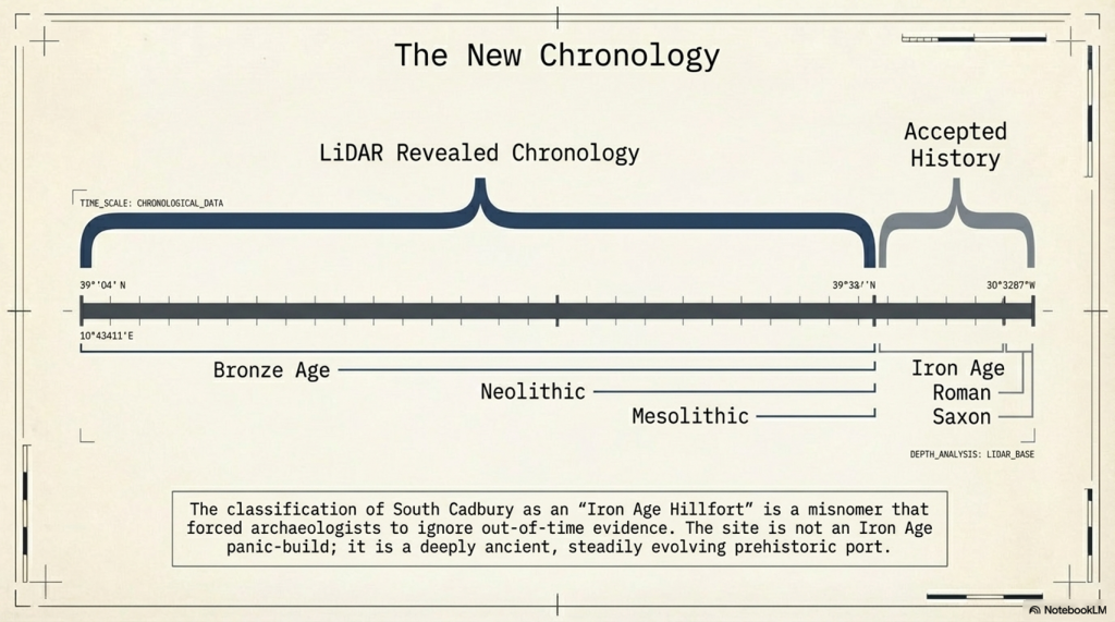
Instead, the site is framed as persistently occupied, when the evidence more accurately supports periodic reuse of a prominent, strategically located landscape feature.
In other words, the hill is important.
Not necessarily the settlement.
South Cadbury Castle – Camelot
A Simpler Model
If we remove the assumption and focus only on physical constraints, a more economical explanation emerges:
Early activity occurs on high ground because low ground is unstable or flooded
Sites are reused over time because elevated locations remain reliable as conditions change
Earthworks reflect adaptation to landscape conditions, not necessarily warfare
Later cultures reinterpret and reuse earlier features without preserving the original function
This model requires fewer assumptions and aligns with measurable environmental behaviour.
It also explains why sites like Cadbury Castle appear repeatedly in the archaeological record across different periods without requiring continuous occupation.
South Cadbury Castle – Camelot
Maps
1800s OS Map
South Cadbury Castle – 1800s OS Map
GE Satellite Map
South Cadbury GE Map
LiDAR Map
South Cadbury Castle – LiDAR Map
Investigation
Site Flyaround
South Cadbury Castle Flyaround
Site Flyover
South Cadbury Castle Fly Over
Lidar Map showing Bronze Age
South Cadbury Castle – with Bronze Age Water Levels
LiDAR Map showing Mesolithic Period
South Cadbury Castle with Mesloithic Water levels
Defence Strategy 101
Roman Defence System
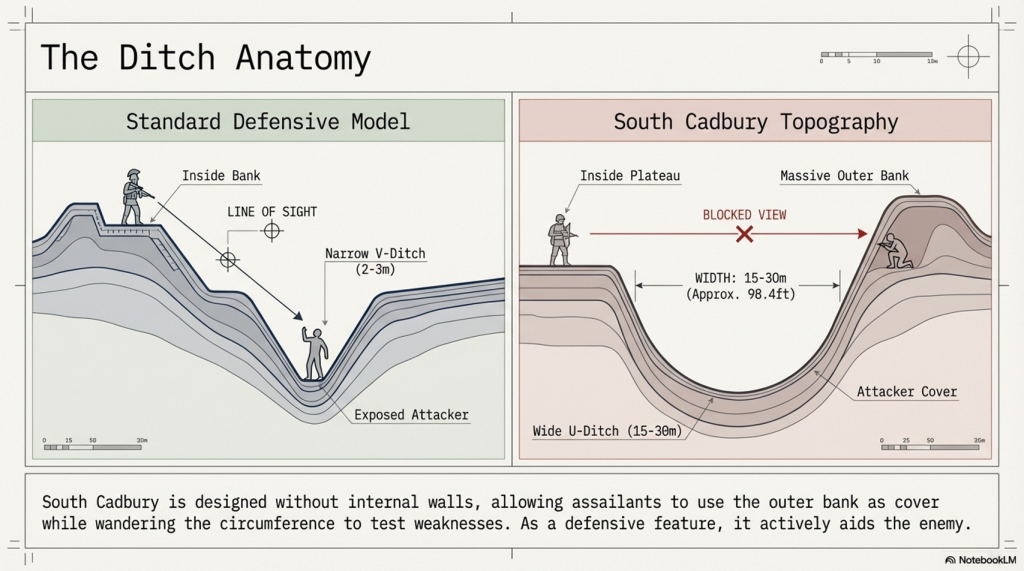
Roman defences (of the same period as the ‘Iron Age’ ), we notice the ditches were relatively small and narrow. These ditches were called ‘Ankle Breaker’ as the purpose was for the assailant to fall into the ditch (usually containing pointed wooden stakes to either injure or kill the assailant) or to at least break their ankle from the fall, making them immobile. These ditches would be 3 to 4 m wide and about 2m deep and could be dug quickly.
Roman Ankle Breaker
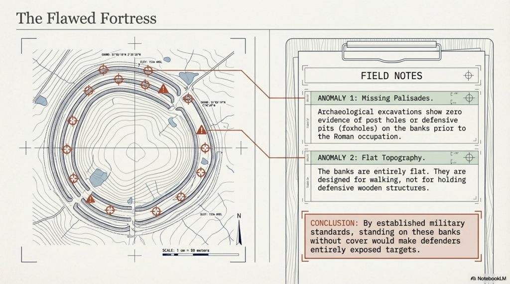
The soil excavated from the ditch would be placed on the defensive side to elevate the defenders, allowing them to look down and fight their attackers from a higher position. Simply standing on elevated ground without a barrier would make defenders easy targets. Therefore, they built fortifications using wooden stakes or stone for more permanent and substantial defences. These fortifications provided cover from spears, arrows, or stones while looking down into the conflict zone. This basic defensive strategy has remained unchanged for thousands of years, as seen with the Normans, who used castles and moats. The moats slowed down assailants, allowing defenders to use crossbows effectively against anyone attempting to cross the deep waters.
Classic Roman Fort With Ditch and Palisade
Lidar Maps of Sth Cadbury Castle Show No Defences
Banks
The banks at South Cadbury Castle show no signs of palisades on top of the bank at any stage before the Roman occupation, which brought stone to the very top of the site. The other four banks appear to be quite flat, as if they have been used for walking upon rather than holding any defensive wooden structures or ‘foxholes.’
Importance and Use of Foxholes in Defense
Concealment and Protection: Foxholes are small, dug-out trenches or pits used by soldiers to provide cover and concealment. They protect defenders from enemy fire and other dangers. By being below ground level, soldiers can remain hidden and minimize their exposure to enemy attacks.
Historical Use: Throughout history, foxholes have been a crucial part of defensive strategies in various military contexts: While the term “foxhole” is modern, the concept of digging protective pits or trenches has been used in various forms throughout history. In ancient battles, soldiers would dig pits to defend against archers and other ranged weapons.
Advantages of Foxholes
Reduced Visibility: Soldiers in foxholes are less visible to the enemy, making it harder for attackers to target them.
Protection from Spears, Rocks and Arrows: Being below ground level the size of the target is greatly reduced.
Stability for Firing: Foxholes provide a stable firing position, allowing soldiers to fire and use their weapons more accurately.
South Cadbury Castle Context
The absence of evidence for palisades or foxholes at South Cadbury Castle before the Roman occupation suggests a different use or purpose for the banks. Instead of being purely defensive, the flat banks must have served other functions.
Ditches
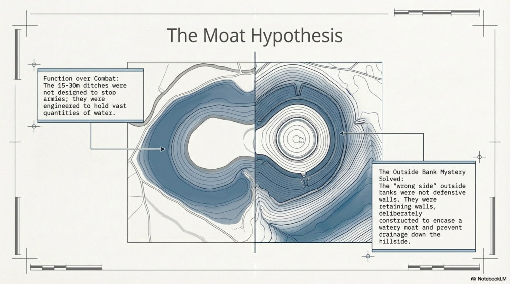
Looking at the construction of the ditches at South Cadbury Castle, we notice that it has no defensive features as expected from a so-called ‘Iron Age Fort’. The ditches are far too broad to be defensive (15m to 30m wide) compared to Roman ‘Ankle Breaker’ of 2m to 3m. The maps show no sign of a wooden or stone barrier, and archaeological excavations have found no evidence of post holes or defensive pits on the banks. Moreover, the Ditch is banked on the wrong side to be defensive, as if it has been built to encase a watery moat. This outside bank would protect any assailants attacking, giving them ample bank coverage. The internal aspect of the Ditch shows no sign of any wooden defensive poles or post holes as seen in Roman Ditches and is designed without internal walls allowing assailants from using the Ditch as cover and the facility to wander around the circumference undercover, testing the weaknesses in the defence. Therefore, as a defensive feature, these types of ditches on so-called ‘Iron Age Forts’ are fundamentally flawed and commonplace.
Ditch is banked on the wrong side
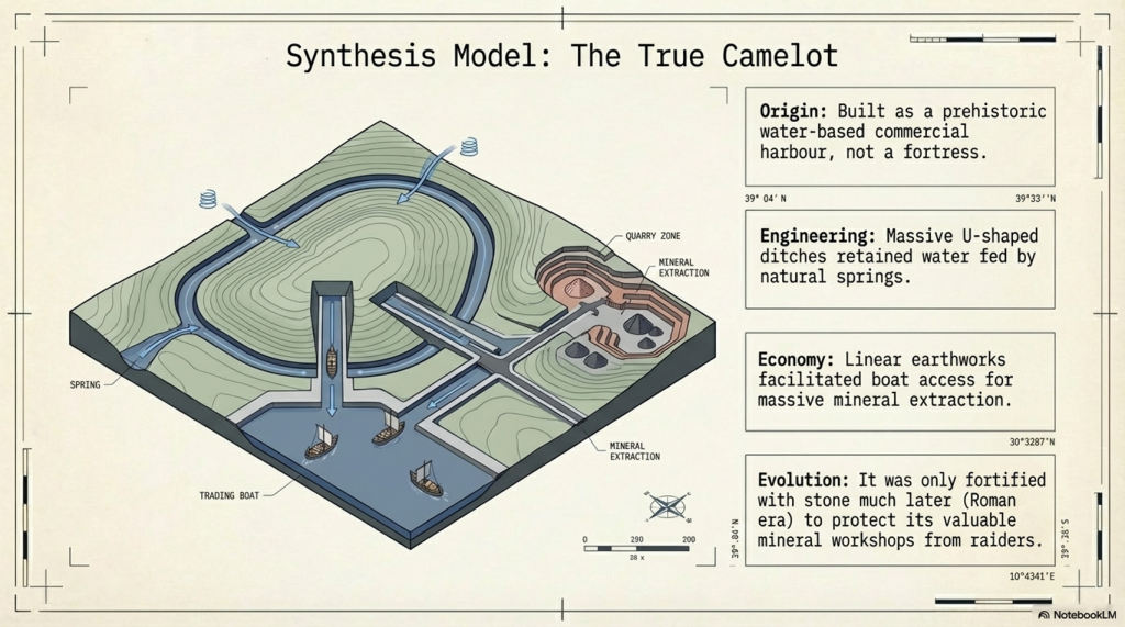
The LiDAR Maps also show that the ditch of the ditches indicate that they were built for water, as shown by the blue on these images – this then allows us to look at the design of the earthwork in detail, which shows that the banks have been cut by not roads but other ditches. These ditches that cut across the circumference moats cut into them that, suggest that if water had been contained in these ditches, then the vertical dykes could have been used to gaol boats up from the bottom of the dyke ditch to one of these upper moat levels. These same LiDAR maps also show how the soil was distributed to the outside of the moats to enhance and make the feature deeper.
South Cadbury Castle – Banks on the outside to keep in the Water
Water Table
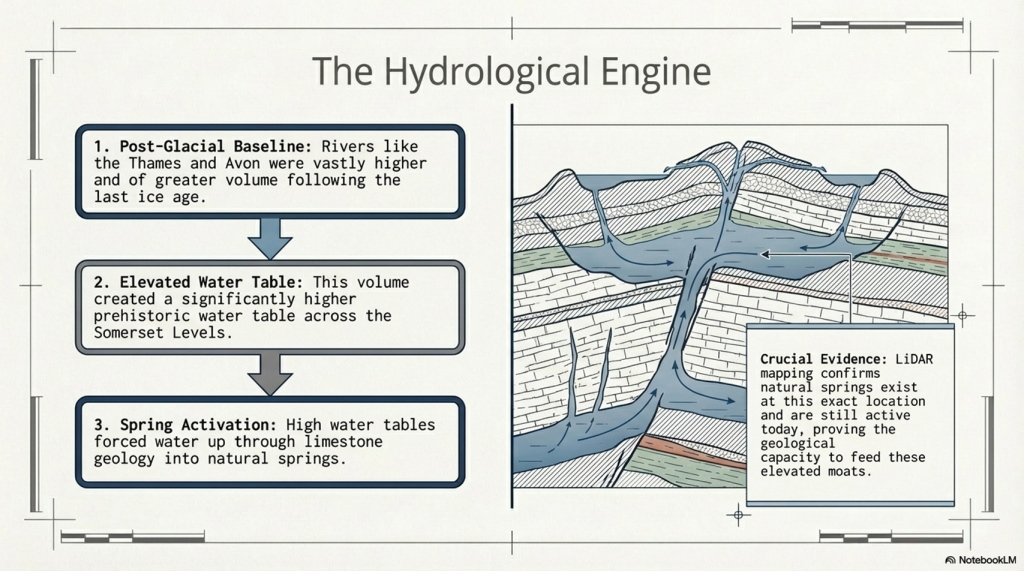
This hypothesis of using these ditches as moats can only be proven if we find the natural springs that could have fed these earthworks in the past. We know from our studies into rivers, such as The Thames and Avon, that they were both much higher and of greater volume in the past, and this height was retained for thousands of years after the last ice age. This enhanced height and volume is reflected and caused by a higher water table. Within these water tables, natural springs are formed, and water leaks into the land, creating rivers and streams. Although we do not have geological information that allows us to trace past springs, we find existing springs in this location (still active today), which suggests our hypothesis is correct.
South Cadbury Castle showing Springs still in existence
Dykes
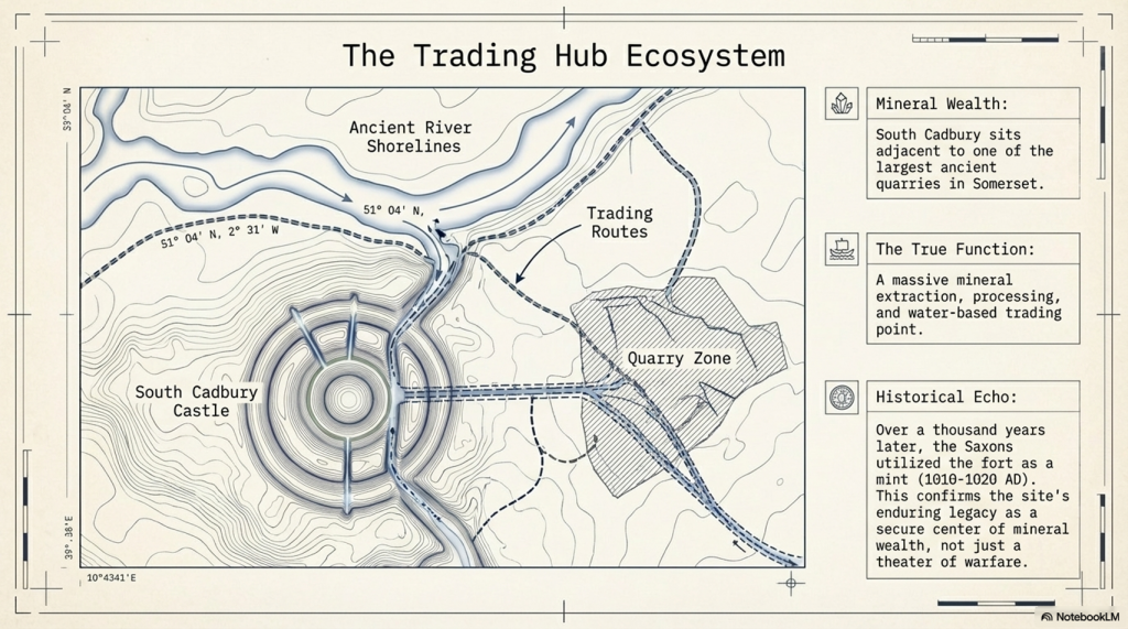
As we have already suggested, the lack of defensive features shows that this is far from being a fortification; instead, it was used as a trading site with moats to facilitate the mooring of boats. The transportation to these moats was achieved by other earthworks called Linear Earthworks (also known as Dykes). Dykes were introduced when the river shorelines of the Prehistoric fell with the water table, and they wanted to continue to use these established trading sites rather than having to build new sites at a lower level. So, Dykes were built (like roads) to transport goods to market and also minerals extracted from the many quarries which uncommonly surround these Dykes. Here in South Cadbury Castle, we see not only Dykes feeding the local quarry sites but also placed on the side of this Trading site to allow access to the moats for the boats coming off the rivers, ready for unloading/loading.
Slipway built to feed the moats in the upper levels with trading boatsTwo Possible Slipways – one connecting directly to a Dyke
To reinforce the use of this site as a trading The site as a trading place has a second vertical earthwork identified through LiDAR technology. This secondary slipway is distinguishable from the initial structure by its lack of connection to a dyke or river. The slipway appears to traverse from the lowest moat up to the top of the site. While photographs may provide a visual reference, the full extent and significance of this feature are best understood through LiDAR models, which enhance the landscape to reveal these historical elements with greater clarity.place, a second verticle earthwork has been identified via LiDAR technology is a secondary slipway, distinguishable from the initial structure by its lack of connection to a dyke or river. This slipway appears to traverse from the lowest moat up to the top of the site. While photographs may provide a visual reference, the full extent and significance of this feature are best understood through LiDAR models, which enhance the landscape to reveal these historical elements with greater clarity.
The Dykes seen on the LiDAR map are concentrated on the quarry in the East of the Site
Dating the Site
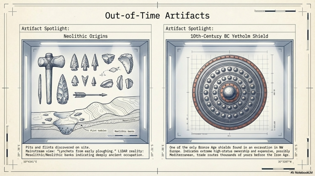
Archaeologists are puzzled by the unexpected dates of this site at South Cadbury Castle, the site that was originally thought to be Iron Age from its classification. Therefore, the discovery of Neolithic pits at the site challenges their previously held beliefs about its functions. However, instead of reconsidering their perceptions, they instead provided speculative explanations for these out-of-time artifacts and features. For example, they have described a bank beneath the Iron Age defenses as a “lynchet or terrace derived from early ploughing,” even though there is no carbon dating evidence to support this claim. In reality, this site is likely to be Neolithic, and the ‘lynchets’ could be Mesolithic banks, indicating its true age.
The discovery of the Bronze Age shield is also an indication of the status of the site and its trading routes – as only one has been found, this would indicate that it was part of the trading or personal ownership of someone in the 10th Century BC at this site. This suggests that this was trading could have been at a much earlier date than current archaeologists suggest, which could too have been with the Mediterranean and a possible source of this unusual artefact, as indicated by the other finds from the late saxon period.
Function of the site
The fact that in the East of this site is one of the largest quarries in Somerset and that the Saxons used the fort as a mint just over a thousand years ago proves that the site’s function was a mineral extraction and trading point. This extraction goes back to the Mesolithic period shown on LiDAR maps with a natural harbour by the Quarries and then Dykes to the Trading site as the prehistoric waters fell. No doubt (as the banks are found not to be defensive), the fort was fortified later during the Roman period with Stone as it was to keep the valuable minerals safe but not as a defensive barrier of warfare as suggested. This would explain the minor disturbances and deaths at a single gate as raiders would have attempted to steal the valuable minerals it contained in its workshops, as described by archaeologists.
PodCast
Author’s Biography
Robert John Langdon, a polymathic luminary, emerges as a writer, historian, and eminent specialist in LiDAR Landscape Archaeology.
His intellectual voyage has been interwoven with stints as an astute scrutineer in government and grand corporate bastions, a tapestry spanning British Telecommunications, Cable and Wireless, British Gas, and the esteemed University of London.
A decade hence, Robert’s transition into retirement unfurled a chapter of insatiable curiosity. This phase saw him immerse himself in Politics, Archaeology, Philosophy, and the enigmatic realm of Quantum Mechanics. His academic odyssey traversed the venerable corridors of knowledge hubs such as the Museum of London, University College London, Birkbeck College, The City Literature Institute, and Chichester University.
In the symphony of his life, Robert is a custodian of three progeny and a pair of cherished grandchildren. His sanctuary lies ensconced in the embrace of West Wales, where he inhabits an isolated cottage, its windows framing a vista of the boundless sea – a retreat from the scrutinising gaze of Her Majesty’s Revenue and Customs, an amiable clandestinity in the lap of nature.
Exploring Prehistoric Britain: A Journey Through Time
My blog delves into the fascinating mysteries of prehistoric Britain, challenging conventional narratives and offering fresh perspectives grounded in cutting-edge research, particularly LiDAR technology. I invite you to explore some key areas of my research. For example, the Wansdyke, often cited as a defensive structure, is re-examined in light of new evidence. I’ve presented my findings in my blog post Wansdyke: A British Frontier Wall – ‘Debunked’, and a Wansdyke LiDAR Flyover video further visualises my conclusions.
My work also often challenges established archaeological dogma. I argue that many sites, such as Hambledon Hill, commonly identified as Iron Age hillforts, are not what they seem. My posts Lidar Investigation Hambledon Hill – NOT an ‘Iron Age Fort’ and Unmasking the “Iron Age Hillfort” Myth explore these ideas in detail and offer an alternative view. Similarly, sites like Cissbury Ring and White Sheet Camp receive re-evaluations based on LiDAR analysis in my posts “Lidar Investigation Cissbury Ring through time”and “Lidar Investigation White Sheet Camp,“ revealing fascinating insights into their true purpose. I have also examined South Cadbury Castle, often linked to the mythical Camelot56.
My research also extends to ancient water management, including the role of canals and other linear earthworks. I have discussed the true origins of Car Dyke in multiple posts, including Car Dyke – ABC News Podcast and Lidar Investigation Car Dyke – North Section, which suggest a Mesolithic origin 2357. I also explore the misidentification of Roman aqueducts, as seen in my posts on the Great Chesters (Roman) Aqueduct. My research has also been greatly informed by my post-glacial flooding hypothesis, which has helped explain landscape transformations over time. I have discussed this hypothesis in several posts, including AI now supports my Post-Glacial Flooding Hypothesis and Exploring Britain’s Flooded Past: A Personal Journey
For those interested in British Prehistory, visit www.prehistoric-britain.co.uk, a comprehensive resource featuring an extensive collection of archaeology articles, modern LiDAR investigations, and groundbreaking research. The site also includes insights and excerpts from the acclaimed Robert John Langdon Trilogy, a series of books that explore Britain during the Prehistoric period. Titles in the trilogy include The Stonehenge Enigma, Dawn of the Lost Civilisation, and The Post-Glacial Flooding Hypothesis, which offer compelling evidence of ancient landscapes shaped by post-glacial flooding.
To further explore these topics, Robert John Langdon has developed a dedicated YouTube channel featuring over 100 video documentaries and investigations that complement the trilogy. Notable discoveries and studies showcased on the channel include 13 Things that Don’t Make Sense in History and the revelation of Silbury Avenue – The Lost Stone Avenue, a rediscovered prehistoric feature at Avebury, Wiltshire.
In addition to his main works, Langdon has released a series of shorter, accessible publications, ideal for readers delving into specific topics. These include:
For active discussions and updates on the trilogy’s findings and recent LiDAR investigations, join our vibrant community on Facebook. Engage with like-minded enthusiasts by leaving a message or contributing to debates in our Facebook Group.
Whether through the books, the website, or interactive videos, we aim to provide a deeper understanding of Britain’s fascinating prehistoric past. We encourage you to explore these resources and uncover the mysteries of ancient landscapes through the lens of modern archaeology.
For more information, including chapter extracts and related publications, visit the Robert John Langdon Author Page. Dive into works such as The Stonehenge Enigma or Dawn of the Lost Civilisation, and explore cutting-edge theories that challenge traditional historical narratives.
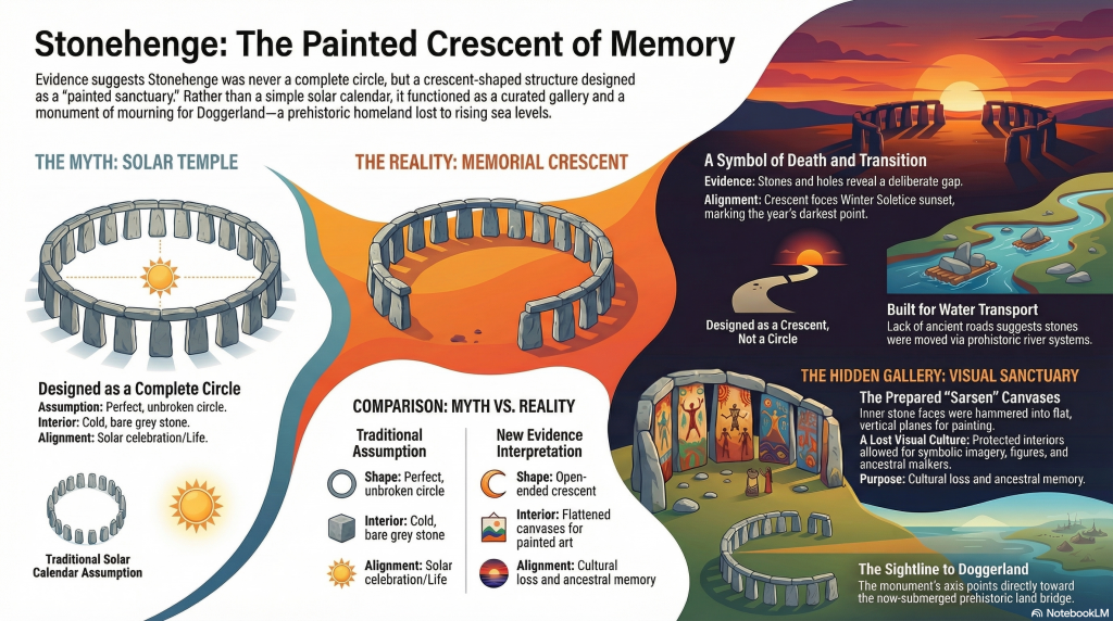
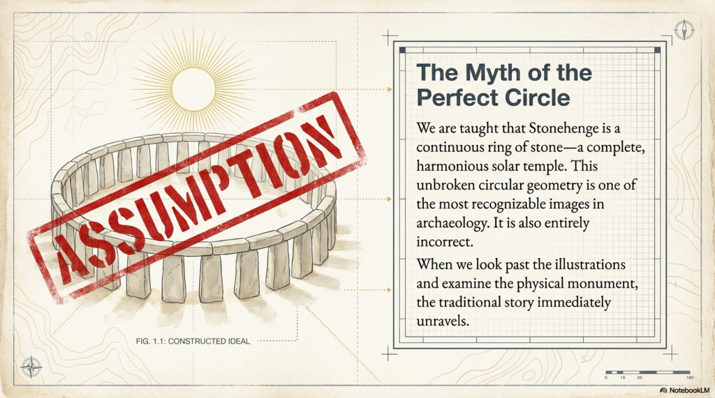
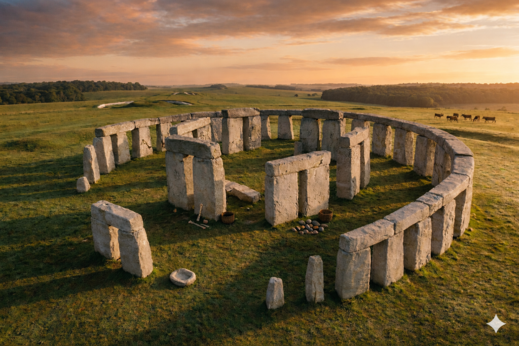
One of the most recognisable images in archaeology is that of a perfect circular Stonehenge — a continuous ring of upright stones capped with lintels. (The Stonehenge Crescent: A Monument to a Lost World)
You’ve seen it everywhere:
Textbooks
Reconstructions
Documentaries
It has become the accepted version of the monument.
There is just one problem.
Stonehenge was never built that way.
(The Stonehenge Crescent: A Monument to a Lost World)
The Myth of the Perfect Circle
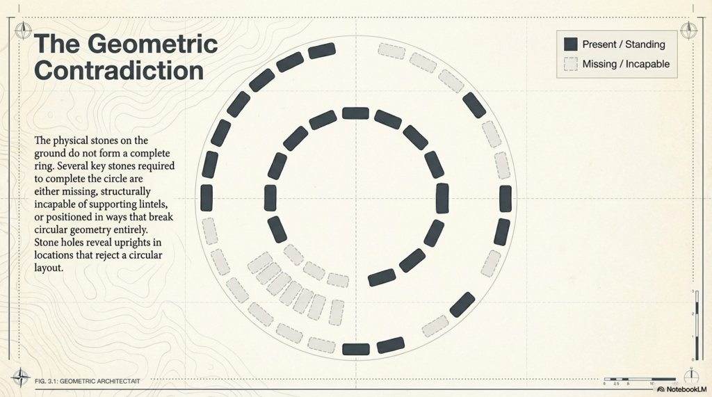
The circular Stonehenge exists more in illustration than in reality.
When we examine the monument itself, the physical evidence tells a very different story:
Several stones required to complete the circle are missing
Others are too small to support lintels
Some are incorrectly positioned for a continuous ring
Stone holes reveal uprights that do not conform to a circular design
This creates a fundamental contradiction.
If Stonehenge was intended to be a perfect solar temple, then:
It was never completed
Or it was deliberately dismantled
Both explanations are unsatisfactory.
There is a far simpler solution.
It was never meant to be a complete circle.
(The Stonehenge Crescent: A Monument to a Lost World)
Structural Proof: Stone 11 Breaks the Model
This conclusion is not just interpretive — it is structural.
One stone alone exposes the flaw in the circular theory.
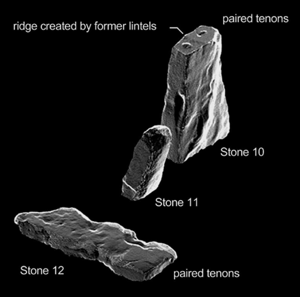
Stone 11.
This stone is:
Smaller than its neighbours
Structurally inadequate
Incapable of supporting a lintel
This is critical.
A continuous lintel ring requires every upright to meet a basic engineering condition:
It must support load.
Stone 11 cannot.
This is not a minor anomaly. It is a mechanical failure within the supposed design.
There are only two possible explanations:
The builders made a fundamental structural mistake
The circle was never intended to be continuous
Given the precision elsewhere in the monument, the first option is highly unlikely.
Which leaves only one conclusion:
Stone 11 is not an error — it is evidence.
It proves that the monument was never designed as a complete ring.
(The Stonehenge Crescent: A Monument to a Lost World)
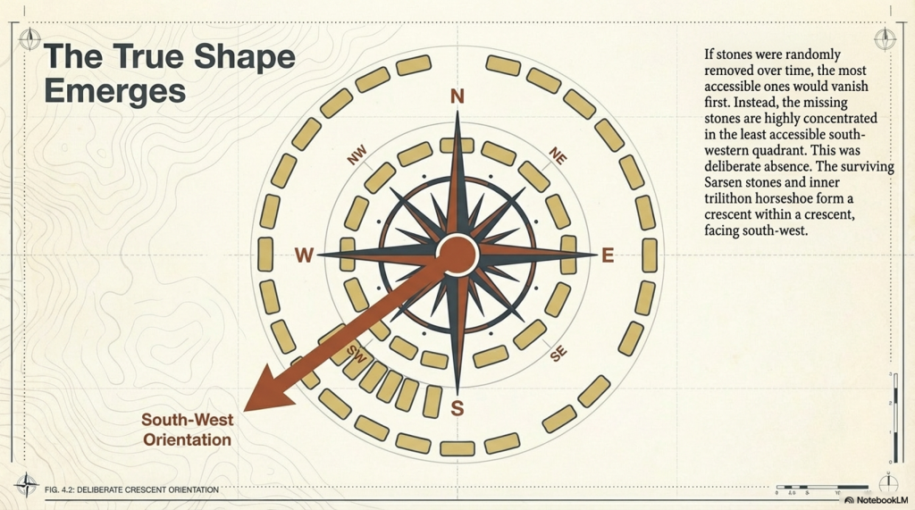
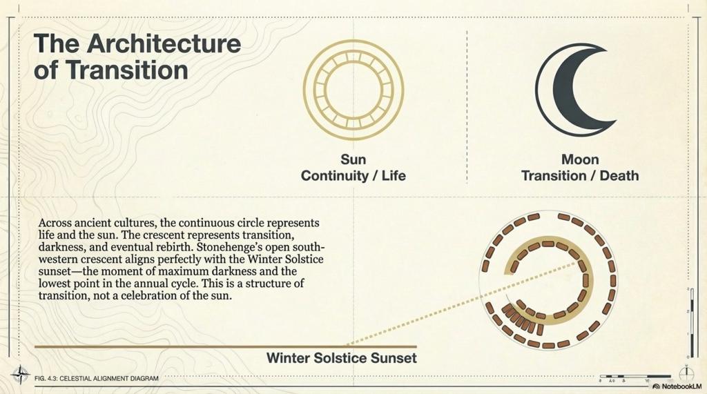
A Different Shape Emerges
When we examine all surviving stones and stone holes together, a new pattern appears.
Not a circle.
A crescent.
The Sarsen arrangement — particularly the inner trilithon horseshoe — reinforces this, forming a crescent within a crescent.
This is deliberate.
And its orientation matters.
(The Stonehenge Crescent: A Monument to a Lost World)
Death, Not the Sun
Across ancient cultures:
The sun represents life and continuity
The circle reflects that — endless and complete
But death is different.
Death is transition.
And that transition is often symbolised by the crescent moon — a passage between darkness and renewal.
Stonehenge aligns with this symbolism precisely.
The structure faces the Winter Solstice sunset:
The lowest point of the sun
The moment of greatest darkness
The turning point before light returns
This is not a monument to life.
It is a monument to transition.
(The Stonehenge Crescent: A Monument to a Lost World)
The Missing Stones Tell the Story
The pattern of missing stones strengthens this interpretation.
If stones had been removed later, we would expect:
Random distribution
Removal from accessible locations
But instead:
The majority of missing stones occur in the south-western quadrant
This is the least accessible area
This is not random.
It is intentional.
The monument was designed to be open in this direction — forming a crescent aligned with the Winter Solstice sunset.
(The Stonehenge Crescent: A Monument to a Lost World)
The Altar Stone and the Slaughter Stone
At the centre of the monument lies the Altar Stone:
Fine-grained sandstone
Rich in mica
Distinct from all other stones
It is also placed flat.
This is unusual — but not unique.
Near the entrance lies the Slaughter Stone, also recumbent.
Excavations in the 1920s showed:
The chalk beneath it was deliberately levelled
It was always intended to lie flat
Even more importantly:
It sits in a shallow depression
Connected to the ditch system
Likely water-filled under higher groundwater conditions
This would have made the stone appear as a small island in water.
(The Stonehenge Crescent: A Monument to a Lost World)
A Monument Built in Water
This aligns directly with the hydrological model of early Holocene Britain.
Evidence shows that:
Water tables were significantly higher
River systems were larger
Floodplains dominated the landscape
Stonehenge was not a dry site.
It existed within a water-controlled environment
(The Stonehenge Crescent: A Monument to a Lost World)
The Altar Stone: A Geological Clue
The Altar Stone introduces another layer of evidence.
It is widely accepted that:
It originates from outside the local region
It travelled over long distances
Traditional explanations suggest land transport.
But there is a problem.
Across hundreds of kilometres:
No prehistoric roads
No engineered trackways
No infrastructure for overland movement
What we do find is:
Extensive river systems
Floodplains
Palaeochannels
The conclusion is straightforward:
The stones were transported by water.
(The Stonehenge Crescent: A Monument to a Lost World)
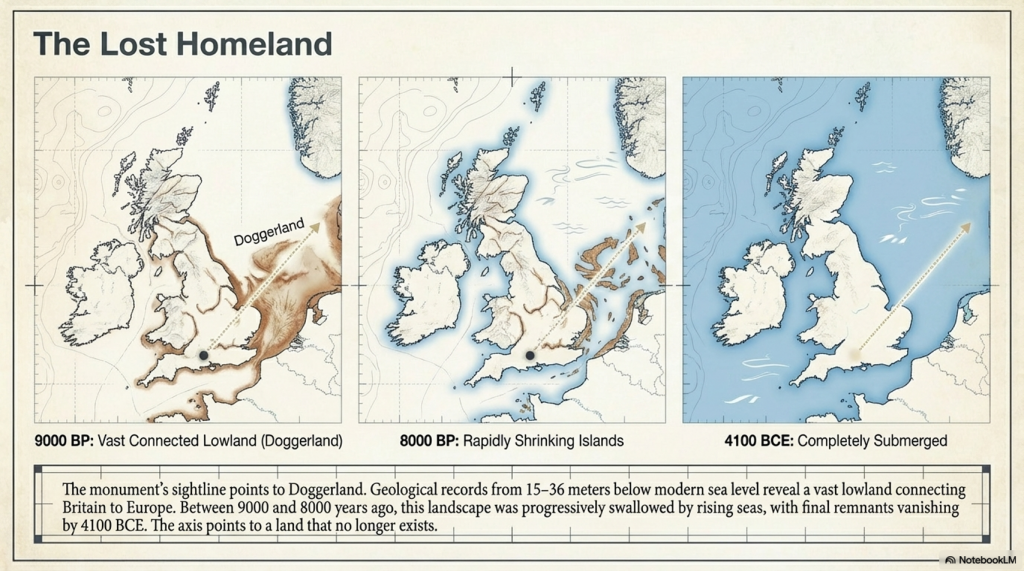
The Doggerland Origin Hypothesis
There is an additional, often overlooked possibility.
The geological composition of the Altar Stone matches:
Bedrock found in northern Britain
And bedrock mapped beneath the North Sea
This is critical.
Because during the early Holocene:
The North Sea was not fully submerged
It was a vast landmass
Doggerland.
If the Altar Stone originated from this region, then:
It was not just transported across distance
It was brought from a landscape that no longer exists
(The Stonehenge Crescent: A Monument to a Lost World)
A Lost Source Beneath the Sea
Geological evidence shows that Doggerland:
Contained exposed bedrock
Shared lithological characteristics with the Altar Stone
Was progressively flooded between ~9000 and 8000 years ago
This reframes the stone completely.
It is no longer just imported material.
It becomes:
a fragment of a lost homeland.
(The Stonehenge Crescent: A Monument to a Lost World)
A Deliberate Sightline
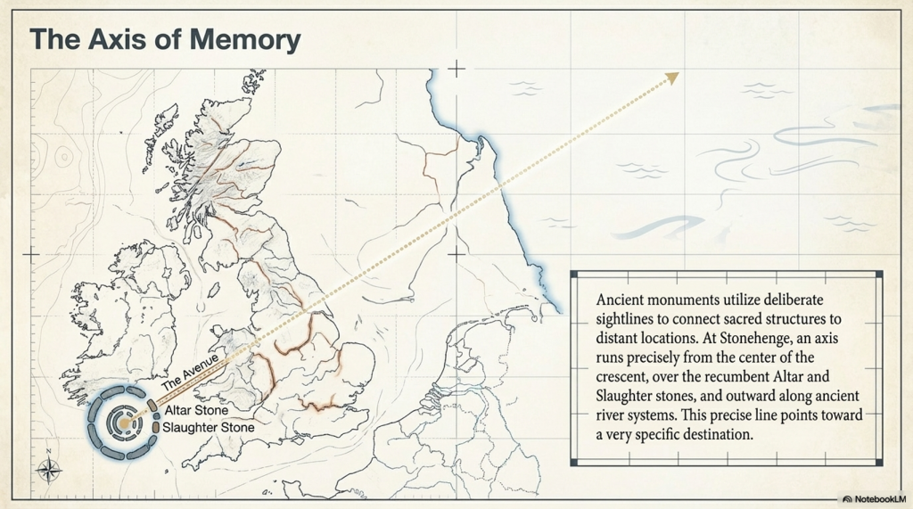
The Altar Stone and Slaughter Stone form a direct alignment:
From the centre
Through the entrance
Along the Avenue
Toward the ancient river system
When extended beyond the monument, this line points toward:
Doggerland.
This is not coincidence.
Ancient monuments frequently connect:
Structure
Landscape
Memory
Stonehenge does all three.
(The Stonehenge Crescent: A Monument to a Lost World)
A Monument Built from Memory
When combined:
Crescent design
Solstice alignment
Directional sightline
Geological connection
The interpretation becomes clear.
Stonehenge is not simply pointing toward a lost world.
It may contain material from it.
(The Stonehenge Crescent: A Monument to a Lost World)
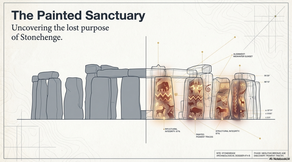
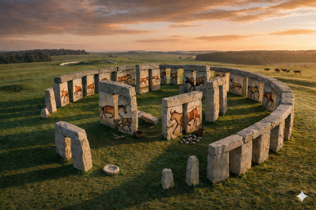
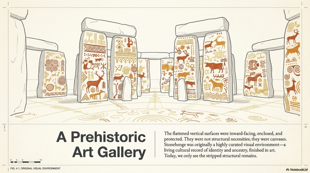
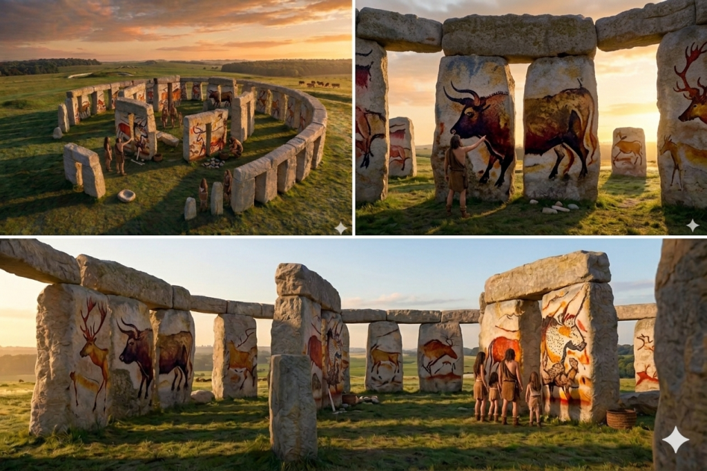
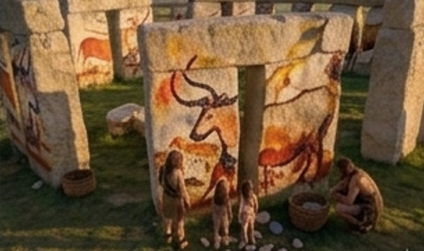
The Hidden Interior: Stonehenge as a Painted Space
There is another overlooked feature.
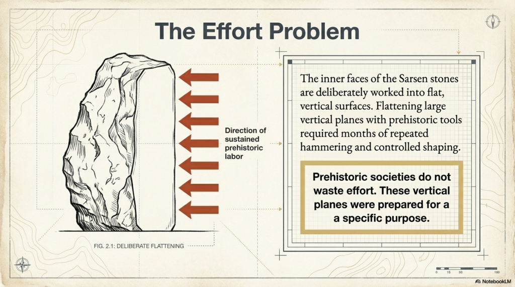
The inner faces of the Sarsen stones are flattened.
This required:
Significant labour
Controlled shaping
Time investment across multiple stones
This was not done casually.
It was done for a reason.
(The Stonehenge Crescent: A Monument to a Lost World)
The Effort Behind the Surfaces
Flattening stone with prehistoric tools would have taken:
Weeks per stone
Possibly months across the structure
Prehistoric societies do not waste effort.
Every action has purpose.
These surfaces were prepared for something important.
(The Stonehenge Crescent: A Monument to a Lost World)
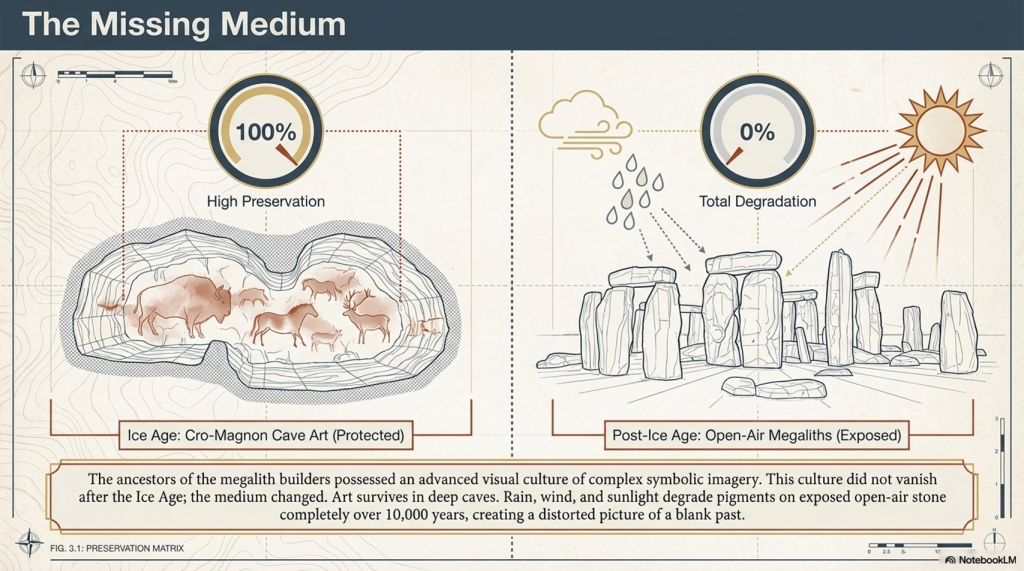
A Cultural Memory Lost
Before the Ice Age, the ancestors of these builders created:
Complex cave art
Symbolic imagery
Advanced visual culture
After this period, the art seems to disappear.
But it didn’t.
The medium changed
(The Stonehenge Crescent: A Monument to a Lost World)
The Missing Medium
We know:
Pigments were used
Bodies were painted
Symbolism was central
But open-air artwork does not survive:
Rain erodes it
Sunlight fades it
Time destroys it
Over 10,000 years, it vanishes.
(The Stonehenge Crescent: A Monument to a Lost World)
Stonehenge as an Art Space
Now reconsider the monument:
Flattened inner stone surfaces
Enclosed space
Controlled environment
These are perfect conditions for:
painting
(The Stonehenge Crescent: A Monument to a Lost World)
A Prehistoric Gallery
Instead of bare stone, imagine:
Painted surfaces
Symbolic imagery
Cultural storytelling
Ancestral representation
Stonehenge becomes:
a sacred visual environment
From Cold Stone to Living Culture
What we see today:
Weathered stone
Empty surfaces
Structural remains
What once existed:
Colour
Meaning
Cultural expression
Not a ruin.
But a gallery of memory and identity.
(The Stonehenge Crescent: A Monument to a Lost World)
A Memorial to a Lost World
When all evidence is combined:
The crescent form reflects death
The solstice alignment marks transition
The sightline points toward Doggerland
The Altar Stone may originate from that drowned land
The interior may have been painted with cultural memory
The meaning becomes clear.
Stonehenge is not a solar temple.
It is a memorial.
(The Stonehenge Crescent: A Monument to a Lost World)
Final Conclusion
Stonehenge was not built to mark the movement of the sun.
It was built to remember.
To record a moment in human history when:
A landscape was lost
A homeland disappeared
A civilisation adapted
The stones do not just stand.
They point.
They align.
They remember.
And once you remove the myth of the circle, the monument finally makes sense.
Stonehenge was never a circle. It was a message.
(The Stonehenge Crescent: A Monument to a Lost World)
PodCast
Author’s Biography
Robert John Langdon, a polymathic luminary, emerges as a writer, historian, and eminent specialist in LiDAR Landscape Archaeology.
His intellectual voyage has been interwoven with stints as an astute scrutineer in government and grand corporate bastions, a tapestry spanning British Telecommunications, Cable and Wireless, British Gas, and the esteemed University of London.
A decade hence, Robert’s transition into retirement unfurled a chapter of insatiable curiosity. This phase saw him immerse himself in Politics, Archaeology, Philosophy, and the enigmatic realm of Quantum Mechanics. His academic odyssey traversed the venerable corridors of knowledge hubs such as the Museum of London, University College London, Birkbeck College, The City Literature Institute, and Chichester University.
In the symphony of his life, Robert is a custodian of three progeny and a pair of cherished grandchildren. His sanctuary lies ensconced in the embrace of West Wales, where he inhabits an isolated cottage, its windows framing a vista of the boundless sea – a retreat from the scrutinising gaze of Her Majesty’s Revenue and Customs, an amiable clandestinity in the lap of nature.
Exploring Prehistoric Britain: A Journey Through Time
My blog delves into the fascinating mysteries of prehistoric Britain, challenging conventional narratives and offering fresh perspectives grounded in cutting-edge research, particularly LiDAR technology. I invite you to explore some key areas of my research. For example, the Wansdyke, often cited as a defensive structure, is re-examined in light of new evidence. I’ve presented my findings in my blog post Wansdyke: A British Frontier Wall – ‘Debunked’, and a Wansdyke LiDAR Flyover video further visualises my conclusions.
My work also often challenges established archaeological dogma. I argue that many sites, such as Hambledon Hill, commonly identified as Iron Age hillforts, are not what they seem. My posts Lidar Investigation Hambledon Hill – NOT an ‘Iron Age Fort’ and Unmasking the “Iron Age Hillfort” Myth explore these ideas in detail and offer an alternative view. Similarly, sites like Cissbury Ring and White Sheet Camp receive re-evaluations based on LiDAR analysis in my posts “Lidar Investigation Cissbury Ring through time”and “Lidar Investigation White Sheet Camp,“ revealing fascinating insights into their true purpose. I have also examined South Cadbury Castle, often linked to the mythical Camelot56.
My research also extends to ancient water management, including the role of canals and other linear earthworks. I have discussed the true origins of Car Dyke in multiple posts, including Car Dyke – ABC News Podcast and Lidar Investigation Car Dyke – North Section, which suggest a Mesolithic origin 2357. I also explore the misidentification of Roman aqueducts, as seen in my posts on the Great Chesters (Roman) Aqueduct. My research has also been greatly informed by my post-glacial flooding hypothesis, which has helped explain landscape transformations over time. I have discussed this hypothesis in several posts, including AI now supports my Post-Glacial Flooding Hypothesis and Exploring Britain’s Flooded Past: A Personal Journey
For those interested in British Prehistory, visit www.prehistoric-britain.co.uk, a comprehensive resource featuring an extensive collection of archaeology articles, modern LiDAR investigations, and groundbreaking research. The site also includes insights and excerpts from the acclaimed Robert John Langdon Trilogy, a series of books that explore Britain during the Prehistoric period. Titles in the trilogy include The Stonehenge Enigma, Dawn of the Lost Civilisation, and The Post-Glacial Flooding Hypothesis, which offer compelling evidence of ancient landscapes shaped by post-glacial flooding.
To further explore these topics, Robert John Langdon has developed a dedicated YouTube channel featuring over 100 video documentaries and investigations that complement the trilogy. Notable discoveries and studies showcased on the channel include 13 Things that Don’t Make Sense in History and the revelation of Silbury Avenue – The Lost Stone Avenue, a rediscovered prehistoric feature at Avebury, Wiltshire.
In addition to his main works, Langdon has released a series of shorter, accessible publications, ideal for readers delving into specific topics. These include:
For active discussions and updates on the trilogy’s findings and recent LiDAR investigations, join our vibrant community on Facebook. Engage with like-minded enthusiasts by leaving a message or contributing to debates in our Facebook Group.
Whether through the books, the website, or interactive videos, we aim to provide a deeper understanding of Britain’s fascinating prehistoric past. We encourage you to explore these resources and uncover the mysteries of ancient landscapes through the lens of modern archaeology.
For more information, including chapter extracts and related publications, visit the Robert John Langdon Author Page. Dive into works such as The Stonehenge Enigma or Dawn of the Lost Civilisation, and explore cutting-edge theories that challenge traditional historical narratives.
Stonehenge: Discovery with Dan Snow Debunked (Transcript)
Hello, this is my co-presenter Alice, and this is my co-presenter Robert John Langton this is Bob and Alex debunks another Stonehenge video
Deep in the English Countryside lies one of the most famous ancient monuments Stonehenge. Stonehenge is totally unique; there’s nothing like this ring of colossal Stone arches anywhere else in the world; it’s as old as the pyramids; it’s one of the world’s greatest archaeological sites, but who built it and why how did ancient Builders construct this extraordinary Stone Circle for centuries there’ve been so many unanswered questions about these Stones
Well that all looks very professional do you think that they will give us some answers at last well who knows Alice all we can do is watch the program and we’ll come back if there’s a clear error and point out to our viewers the correct information
In this program, I’m joining the investigations that are still unlocking the mysteries of Stonehenge I’ll be following the most recent hunt for where the biggest Stones came from there’s some big ones up ahead; oh yeah fantastic, and exploring how they were moved well done, everyone some a round of applause I’ll come face to face with the ancient people of Stonehenge and their beautiful Treasures – look at that’s fabulous and reveal the unbelievable sophistication of Stonehenge’s Builders – they knew their map they knew their astronomy that’s why stone is unique and will never find anything like this is the story of Stonehenge.
One of the things I love about Stonehenge is that one minute you’re just driving through typical English Countryside with its Hills and its valleys and its Fields, and the next minute, without warning, boom first Stonehenge right there, one of the world’s greatest prehistoric sites.
Built 2 and 1/ half thousand years before Britain’s first ever town towns or cities even existed. Stonehenge sits in the heart of the Wiltshire landscape on Salsbury Plane – 3 miles from the town of Amesbury, and once you’re Offroad, it still feels as wild as ever; when I was a kid visiting Stonehenge, he used to drive your car right up and park next to it and then clamber all over the stones and thankfully that’s changed now it’s much more special much better for the local environment you park some distance away, and then you walk across these beautiful downlands past these ancient mysterious humps and bumps in the landscape evidence of a rich prehistoric past building your anticipation that you’re about to reach somewhere very special and then you arrive and see this.
Wow you just don’t get a sense of the scale of this place until you walk inside these Stones you don’t get a feel for its power its intensity until you’re standing in here right up next them and they dwarf you look at them seven metres high each one of those weighs 20 tons it just feels so ancient and there’s just nowhere else in the world like this literally there is nowhere else where we have stone circles with these big Stones placed on top these lentils forming arches it’s Unique These giant stones are just part of this or inspiring Monument within this incredible ring of huge stones called Sarsons there are smaller stones and these are known as the blue stones and every one of the stones big and small have been carefully placed in position and the entire stone circle is then surrounded by a huge bank and outer ditch but unlike other great ancient discoveries Stonehenge is different because it was never lost for thousands of years it stood here but people forgot what it was built for and it became a magnificent mystery.
The whole place is phenomenal and you find yourself thinking, who built it why did they build it when did they build it but above all, you think, how did they build it with the technology had available how did they transport these enormous Stones Some distance to this place how did they turn them on their ends sink them in the ground anchor them it’s just mind-blowing and all this happened thousands of years ago before the wheel had even been introduced to Britain so 900 years ago when people first began to speculate about how Stonehenge was created they simply could not believe that the giant Stones could have been put here by Ordinary People.
Wow that was a spectacular start to the program by Dan so why have we paused here I just want to stop you there to look at this picture at 11:00 you got a couple of parallel lines now they’ve been cut into the grass to represent a ditch now they’re not ditches these are cut marks in the grass why they couldn’t cut the grass to show you the ditch is another matter but there’s a degree of dishonesty here especially when you put the Hillstone in the middle of the Avenue because the Hillstone is not in the middle of the Avenue and it makes me very suspicious of what he’s going to tell you is not 100% accurate.
With a pretty wacky Theory, this is an illustration of one particular popular account of just how Stonehenge came to be, and this account is literally magical you can see the stones being laid here into the Stone Circle by a giant and it’s not being built right here it’s being built in Ireland before being magicked here by the wizard Merlin this Fantastical tale may sound ludicrous today, but it shows how people have been grappling for Centuries with the puzzle of how the stones got here, and it’s still a hot topic of research today.
I’m heading to the ancient Technology Centre in Dorset where they’re testing out a possible Theory the weather is grim today but that wouldn’t have stopped our Stone Age ancestors that’s a pretty big chunk of rock isn’t it is yeah it’s about a ton and a half ton and a half okay Anthony Whitlock is an experimental archaeologist at the centre it’s sort of equivalent to some of the smaller blue stones that we find at Stonehenge scary to think this would be one of the smaller Stones today at Stone Henge that’s amazing what is it a sort of sledge is is this the latest thinking on how they were moved yeah absolutely yes so it’s based on Stone carving some Assyria and ancient Egypt which are showing big statues being moved on sort of skis on Runners like we’ve got on the on the ground the old Theory which goes back to the 1500s was Stone Age people prehistoric people moved stones on rollers and that it works on flat level ground but experiments since the 1950s have proven that big lumps of rock if they’re being attempted to move sort of uphill or downhill on rollers you lose control very easily yeah Does that mean they have now proven that using rollers to move the stones is no longer feasible? Mr Langdon, yes, it’s a bit obvious that you could not roll large Stones across Open Fields, Woods, Hills and forests. The question is, can you Sledge these Stones across the exact same environment?
Once on the move a sledge proved easier to control than rollers although a little bit more difficult to get moving in the first place so you need a lot of force you need a lot of force more than just be snow can provide unfortunately yes we’re going to need a little help Mighty as you are luckily we got an army of 50 volunteers on hand to flex their muscles grab a bit of rope let’s divide in half hope you’re feeling strong you can imagine the whole Stone AG Community coming together a bit like this to help move the rocks to an important place like Stonehenge with someone taking charge of the stone shifting today that’s me every I’m feeling good here we go ready 3 2 1 go
Let’s do it again; ready, okay? We’re going to try for another one here, ready? Okay, everyone, 3 2 1 go, oh, look at that. It’s moving; the wet, muddy ground certainly helps the sledges slip along fairly easily, and Stone Age people might well have used the weather to their advantage in just the same way. Okay, stop. Brilliance let her strong well-done everyone give yourself a round of applause look at that well that was a really interesting experiment; it shows that it is possible to move a big Stone over some distance using this setup, provided you have a lot of people to help with 50 people we moved our Stone a few meters quite easily and archaeologists are now pretty certain that this is how Stonehenge’s ancient Builders moved the stones 4 and half thousand years ago.
That’s brilliant. We now know for sure how they got the stones to Stonehenge at last, don’t we, Bob?
Sadly not Alice, you just looked at 50 people dragging a 1.5-ton Stone just 20 yards. The stones of Stonehenge can weigh up to 25 tons when it comes to the larger trilithons in the centre, so in this experiment, you would actually need 830 people dragging the stone, and that is over a flat wet ground you would need double that number for a small hill and as you can see from this profile map of the journey from Wales to Stonehenge you have about 90 Hills to cross and therefore it’s not impossible it’s totally futile to even try or imagine a little bit like rolling the stones eventually archaeologists will come to the conclusion that it went via boat.
400 years ago when the first person to really scrutinise the stones arrived on the scene, he was certainly impressed by Inigo Jones the most famous architect of the time and a man who knew all about putting up Stones Jones was enthralled he was convinced this site had been put together by very skilled Master Craftsman he noticed that some of the stones had large chunks gouged out of them this is realised fit neatly snugly on top of those knobs on the uprights someone had skilfully put these arches together like a huge ancient Lego model there’s only one people in his mind who it could be the Romans
Jones came up with a theory about what on Earth Stonehenge was that it was a Roman Temple built around 2,000 years ago; he began to measure and survey every single Stone to produce a plan to prove his theory; he knew that Romans built with a Keen Eye for Symmetry and proportion and this is the plan of the monument that he came up with just look at it here it’s very intricate and it’s perfect a little bit too perfect look he’s turned Stonehenge into an absolute Circle all the stones smooth exactly the same size almost interchangeable and as you can see the reality is a little bit more messy in fact if you overlay his plan over the Stone Circle it’s clear that Jones ignored the actual position of any standing stone that didn’t fit the Symmetry essentially Jones’s Roman Theory only worked he well made it up.
So Bob Stonehenge has a history of people making up stories of who and why the monument was built and its original design yes Alice they made it up in the past and they have continued to make it up even today and that is why this program has made it up again but about it being round as you can see from this aerial shot of stone h the monument is not complete and now our Stones missing from one quadrant of the circle
Well is that because people stole the stones to make buildings nearby
No it’s not Alice but that’s what they would like you to believe
So how do you know that is not true
Look at the picture again and note the position of the road if you wanted to steal the stones would you not move the ones closest to the road rather than the ones furthest away and harder to get to moreover you would need to break them up in the first place before putting them onto your cart now we’ seen this at Avery where the stones were stolen by carts but what they did beforehand was to burn the stones to break them up make them brittle we see no signs of that at all at Stonehenge we see no debris we see no fires what we do have is some of the stones being relics of the original size because in the Victorian days they gave them hammers to take pieces off and what they would have done is look for something on the floor which has fallen down nice and simple take a piece off and over a period of time what would happen that larger Stone will be smaller stones and this is what we see we see a scattering a smaller rounder stones from both wearing and chipping away from souvenir Hunters
So was Stonehenge not finished did they just run out of suitable Stone
Not at all Alice even this program has realised that this is a moon Temple to the dead hence the bodies Cremations therefore the temple would be Moon shaped and not a solar Temple this is shown in the illustration here showing that it was actually made for the mid winter Sunset to commemorate the dead.
Anybody who is anybody now came to look at these stones that included the world famous architect so Christopher Ren and look he left his Mark here that is graffiti of his name a cross for Christopher and then Ren here in this Mighty Stone as more and more people came to Stonehenge more theories were put forward about its Origins it was a Royal Viking camp or perhaps a temple built by an ancient British priesthood The Druids no one could agree and no one could find any proof to unlock the truth but that was about to change 300 years ago the discovery of a buried clue would finally reveal the true purpose of these ancient stones.
In the summer of 1721, one man began to explore the floor beyond the stones in the land around the monument; his name was William Stukeley he started to roam the surrounding landscape, eyes to the ground, searching for something, anything to help him understand Stonehenge’s ancient past as he was exploring this field Stukeley stumbled across something that felt familiar there was a depression almost like a dick in the landscape very difficult to see but with his practised eye it was clear and there was some Higher Ground here on the other side it reminded him of the ditch and bank that circled Stonehenge itself but the difference was this wasn’t circular this was straight it didn’t make much sense but then he noticed something even more intriguing.
He walked across this field for another 30 m until he found another ditch another bank you can see the line of it here and this one seemed to be parallel to the one he just discovered could it be that they were marking out some kind of route through this landscape and excitingly that route seemed to be leading up to Stonehenge intrigued Stukeley followed the course of the path he was determined to find out how it was connected to Stonehenge Stukeley quickly realised that the the path was leading him up to this big prominent Stone here and as he reached this Stone continued on the same line he realised that it was drawing him through that Arch there right into the centre of Stonehenge Stukeley was ecstatic that couldn’t have been an accident whoever laid out this route wanted people to move right up into the heart of the Monument Stukeley was fascinated and he had a convincing Theory
So why did you stop the program here Bob.
I’ve stopped here Alice’ because this bit is actually the most interesting part of the entire program you see obviously Stonehenge in its Glory at the top of the Avenue but what you also see and is not even mentioned in the program is the recumbent Stone in front of Dan snow which is known as the Slaughter Stone now the slaughter stone is probably the second most important Stone in the entire site because that stone and the stone in the middle known as the Altar Stone lines up in a direct path to a place called Doggerland – Doggerland is interesting because that is the birthplace of the Stonehenge Builders we call them the Megalithic Builders but that is their birthplace and one will imagine that as this is a temple to the dead and Doggerland sunk under the sea at basically the same time phase two of Stonehenge was built – I.E the large s of stones is it possible is it just remotely possible that they built this Temple for the dead to commemorate their island of Doggerland that was sunk into the sea just an idea.
He believed that he had found a sacred Avenue leading right into Stone Henge but what were those ancient people doing when they reached their destination inside the stone He was now obsessed and spent days and nights in and around the stones was then as he watched the sun rise and fall through its arches, he unlocked one of Stonehenge’s most incredible Secrets.
Stukeley noticed something spectacular on the summer solstice the longest day of the air and the Sun is highest in the sky the sun rose right above that stone there along the line of the Avenue and right through the middle of Stonehenge this couldn’t be an accident it had to be deliberate and that meant Stonehenge was designed around the movements of the sun today Skyscape archaeologist Fabio Sila is mapping the skies that our ancestors would have seen at Stonehenge to find out the precise astronomical alignments okay so Fabio what is a Skyscape archaeologist it sounds like the coolest job in the world it is a little bit we can use equipment like this to come here and take the measurements ourself put them on the computer open up a planetarium software that shows us what the sky looked like 5,000 years ago and put the sounds against that Sky the alignment of the Stars relative to the Earth has shifted slightly over the Millennia since Stone henge was first built Fabio’s finding out what the stone age Sky looked like right here back then so you can actually see the stars as they would have seen them that’s right yeah we can we can as close to what as they would have seen it as we as we can today yeah so stookie first chest’s place is solar aligned he he was right was he yeah absolutely was right so he mentioned the midsummer Sunrise alignment which is where the Avenue joins up with the Hench right where the Hillstone is cut Stonehenge in half two exactly equal parts and this line exactly matches the midsummer sunrise on one end and the midwinter sunset on the other these were Master Builders they knew their Ms they knew their astronomy they encoded everything they knew into this one place that’s why Stone age is unique and will never find anything like this all of this was over 4,000 years ago that’s just incredible to think about well it’s a bit cloudy but it is winter solers today so to prove just how skilled those ancient Stonehenge Builders were as we approach a gloomy Sunset Fabio has asked me to help him take some measurements
Hey Fabio what have we got hey let ass me their results let’s look at this O So what you’re seeing is is winter solstice around 2,500 BC that’s fantastic just as people would have seen it that is cool so this is 4 and a half thousand years ago this line here is the sun is it yes that’s the that’s the line the sun does on the day of the solers so we can see where it rises and then it’s going to set right in the middle of that window in the middle of stonehenge so cool you can well
Well Bob it looks like modern efficient technology has given us a precise date of the construction of Stonehenge which archaeologists call Phase 2 with the larger sarson Stones
Well it looks that way doesn’t it Alice but if you actually look very closely the sun’s actually not setting on the floor of this alignment in fact if you look closely it actually will set just behind the stone to the right and there’s a bit of a gap at the bot and you say well it’s not much of a gap but the Gap tells us a lot about the date of Stonehenge’s construction now the first thing to realize is that the sun moves about one degree every 5,000 years now half a degree is the diameter of the Sun so we can see there Gap is quite a substantial date change so the fact it actually doesn’t actually line correctly is interesting which would suggest that the date they’re going to promote is wrong
The second thing you should notice is where the alignment lines up with now at the moment we are just to the right of the slaughter stones though the slaughter stone you see in front of you on the left now the centre of the Avenue isn’t the slaughter Stone as we pointed out as you saw it’s actually a couple of feet to the right – now we’re not a couple of feet to the right we’re just by the side of the slaughter Stone otherwise if it was a couple of feet to the right of the sold Stone wouldn’t be in view so they’re cheating on the date.
Which is no surprise because we actually got the correct date which is 4,180 BCE and we know that because one of the stones has got an antler pick wedged against the side of the hole now archaeologists have tried to make excuses and this the antler is dated 4,300 BC they’re saying ah what happened they found a bit of old antler a thousand years old which was in really good condition – it’s like that when you leave a piece of antler around for a thousand years and they wedged it in by accident this can be easily confirmed by actually drawing a straight line down the middle of the Avenue and lining up to see where the sun sets and in what year.TV programs rather have professional looking with funny names running around with alignment scopes looking at sunsets from peculiar angles because it’s good television but very bad science.
Thousand years ago, people coming out this this processional room here and it would have just been in perfect alignment yeah that’s right it’s just the most extraordinary Monument is it the sophistication of that visitor experience marching up here on the shortest day of the year and seeing that alignment absolutely it’s Unique there’s nothing like this in the world 300 years ago Stonehenge’s solar alignment captivated people’s imagination. As more and more visitors came and inspected the site there was a real hope that more of Stonehenge’s ancient Secrets would be unlocked but there was a problem with its popularity tourists were now beginning to put the stones themselves in danger they were coming here and clambering on them they were digging little holes around the place they were even shipping little pieces of the stones off and taking them home as souvenirs. Then on the 3rd of January 1797, disaster struck; a group of Travelers was camping among the stones for some reason they dug a big hole at the base of one of them was already looking a bit precarious as the sun came up it and the ground soil became moist and with a great crash one of the stones fell over Bringing Down the Ring of stones like dominoes luckily, many of the stones remained standing but people worried the collapse of some of the Stone Circle might be the beginning of the end many feared that just as the secrets of Stonehenge were finally being rediscovered the ancient Monument was in danger of total collapse, the future looked Bleak
When you visit Stonehenge you realise that the Stone Circle itself is actually just a small part of a much larger ancient, more mysterious landscape dotted all around the hills that surround Stonehenge are mounds like these ones you can see three and there’s many more on the hills around me these are all a little bit different in shape and size but they all the same purpose they’re all burial mounds.
They’re called barrows these had been found right across the British Isles and treasure Hunters had been looting them for centuries so it was well known that they were used for barriers but nowhere had as many barrows as Stonehenge, and so Colt thought that if some of these barriers were undisturbed, he could excavate them and learn from the skeletons and the goods within them more about Stonehenge and unlock its
Secrets wasting no time the team began their archaeological assault on Stonehenge’s barrows their investigation was carried out with the speed and efficiency of a military operation; sometimes they would power through a whole Barrow in a single day after 5 years of slightly disappointing results they turned their attention to this spot just half a mile away overlooking the Magnificent Stone Circle.
Today it’s private land but I’ve been given special access still feel so magic so full of possibilities and it was in this mound here right on top of the hill that they would make the most extraordinary discoveries they called it Bush Baron thanks to a small tree on its side but there was nothing else particularly remarkable about this mound I imagine they approached it with trepidation with excitement as they always did when they started Excavating a new burial mound but they couldn’t have had High Hopes given their previous experience how wrong they would be with hundreds of excavated barrows under their belts the team tore through the soil after days of solid digging they reached the bottom and then at that moment they made the discovery of their lives at the base of this burial mound, they found an undisturbed human grave a tall Stout man laid out north to south, and the team gasped because around him was the most remarkable array of artefacts they had ever discovered Finally they had struck gold .
Today the Bush Barrow skeleton and his magnificent Treasures are held at the Wilshire Museum in devises so this gives you an impression of what they found yeah this is a reconstruction of his burial David Dawson has spent years unlocking the secrets of this incredible burial you can see he’s laid out in a Crouch position he’s got everything he needs everything that shows how important he is so clearly someone of great wealth and probably of prestige and power absolutely and what do we know about him I mean was he was he a tall man do we know how he died all we know is what the excavator said that he’s a stout and tall man and he also gives the length of his FEMA so he knows he’s a six-footer he’s a big chap.
Wow so the skeleton was 6t tall isn’t that unusually high for people of that period in Britain
Indeed Alice 6 feet is exceptionally high for the Bronze Age but not for the previous periods of the Neolithic and Mesolithic – because these people were exceptionally tall they were more 6′ six to 7 foot tall consequently looking at his height this may be a distant relative of the ancient ones and therefore his status was as a Chieftain of the tribe.
Now if we go back to the start of the video you saw the story of Stonehenge being built by Giants the question is when myth and reality mix you need to take a part of the myth because it’s real what we know is that the megalithic builders were very tall and very strong and we call them Cro-Magnons now these Cro-Magnons were seen as a separate species by the Victorians because like later immigrants to Britain they were somewhat smaller than the Cho-magnon and the average Victorian and bronze age person was about 5’6 we know that we got shorter as time went past because the average Roman was only 5’4 so when they looked at Cro-Magnons who was 6’9 they would ultimately call them Giants which is quite interesting because as you say Stonehenge myth is that they were built by Giants and Stonehenge was originally called the Giants Dance interestingly enough recent discoveries show that the blue stones don’t come from Ireland but come from Wows which is an amazing coincidence in a sense that is far to the west of Stonehenge almost on the other side of the water from Ireland.
He a six-footer he’s a big chap he’s tall the body is laid out with replicas of his personal items exactly as it was found 200 years ago and those treasured Goods reveal a person of incredible wealth and power and the Crown Jewel in this collection is this extraordinary piece of gold this decorative diamond shape that would probably have been worn on a cloak it’s not just beautifully crafted archaeologists have discovered something remarkable about it They’ve worked out that the angles of the diamond inscribed on the surface precisely match the angle of the movements of the Sun at the summer and winter solers they discovered that if you place the diamond in the centre of Stonehenge at the winter solers you can use it like a compass if you align one side with the Setting Sun you can work out where the sun would set during the summer solers it’s 81° wow so and shows an understanding of astronomy and then you see the zigzag lines around the outside those are laid out to an accuracy of less than half a millimetre what that means is they understood geometry and Mathematics accurate measurement to be able to construct that they had to understand those 4,000 years ago that is astonishing isn’t it for the first time they were uncovering things which showed the sophistication of people at the time
With the discovery of the Bush Barrow burial we now had a glimpse of someone who’d actually known Stonehenge his golden Jewel suggests he was a sun worshipper maybe even the person who oversaw Stonehenge’s Solstice celebrations this man lived 4,000 years ago at the same time as the pharaohs ruled Egypt and he was more magnificent more wealthy and more sophisticated than anyone had ever imagined ancient Britain’s could be.
With such remarkable finds Stonehenge became more and more famous throughout the 19th century and so too did the visitors from Queen Victoria to Charles Dickens Arthur Conan Doyle to Charles Darwin but then disaster struck once again in in 1900 another of the giant Stones fell during a violent storm enough was enough Stonehenge might be privately owned but it was a National Treasure it needed to be protected and that meant putting up the stones that had fallen down and protecting those that remained standing they poured concrete around the bases they kept the lentils those horizontal arches fixed on top of the uprights using lead taken from the roof of Hampton Court Palace.
But the repairs gave archaeologists the chance to move in too they were determined to extract every piece of evidence they could by digging in and around the holes that have been left at the base of the stones that had fallen over they were going to sift through the soil layer by layer methodically and they didn’t find treasure at least not gold or other precious metals but they did find antlers charred wood and stone tools
The archaeologists concluded these were the ancient tools used to dig the ditch and shape the stones but there was a much bigger Revelation although metal had been found in the burials around Stonehenge there was no evidence of any metal tools buried in the monument Stonehenge had to have been built in the Stone Age it was an incredible breakthrough and the first step in solving the great mystery of when Stonehenge was built now 100 years later we can chart every phase of its construction from beginning to end.
So this is the I guess the first stone if you like what this this is 5,000 years ago yes absolutely what it’s showing us is the first things that happened in the space Heather sair is the head curator at Stonehenge they dug out a ditch and throw up a bank with the contents of the ditch slightly higher on the inside and lower on the outside so associated with the bank and ditch around the same period are 56 pits and we know they hold cremation burials but as well as that the the tops of the cremation burials were quite compressed so we’re fairly sure they held posts of some sort a lot of the academics who’ve done Recent research really do think they were probably blue stones so these could be the famous blue stones that are still on the site today absolutely.
So, the blue stones came from Wales and were used like gravestones for cremations is that right Bob
Well yes or no Alice, yes the blue stones definitely come from Wales and we’ve found their quarries, two quarries’ and we’ve carbon dated the quarries and they Mesolithic in date not Neolithic and it’s probably why they don’t talk about it on this program, one would imagine the quarry site is synonymous with Stonehenge and we should talk about that and it states but clearly this program doesn’t discuss the matter.
As for using them as gravestones absolutely and completely wrong what they found is cremations in the old holes which used to hold the blue stones and they’ come to this bizarre conclusion even though the evidence shows that not every hole has a cremation in fact there’s less than a dozen holes that have cremations within them and most those holes have had recesses cut into them for the cremations so the idea that they were made for Creations is a nonsense otherwise you won’t be carving holes in the side of the pits for the ashes it clearly something that’s happened after the stones have been removed which then asks the very interesting question well how long were the stones in the holes before they were removed now we know that these cremations in the blue stone holes have been carbon dated to 3,300 BCE the oldest dates on the site according to archaeologists now question is how long were these blue stones in the holes before they were chipped away or removed it could have been thousands of years gives credibility to the idea that basically this site is actually 5,000 years older than they’re telling you on this program.
So more STS come in but they’re much bigger this time that quite the chain so yes absolutely and what they did was they erected five in a horseshoe shape then they form a circle a Circle enclosing that horseshoe shape so it really is a feet of engineering so all of these stones or posts around the edge have gone haven’t they yes they have do you think they’ve taken the circle of blue stones and put them inside there is that I’m sure they would have used the same Stones so it now feels it’s all very much orientated towards the sunrise yes very much
So it’s been a bit remodelled I can see that these blue stones have been moved around a bit so the blue stones get put into a circle and really an oval there’s not major reconstruction at this time nothing has changed that will actually interfere with the source’s access so we’re fairly sure that that’s still very important so it’s 4, 200 years ago and how the Avenues here is this has this just been put in now yes indeed so really this Avenue you know if you imagine a processional away like the mile you know going up to Buckingham Palace it’s connected Stonehenge with the river so all the different elements seem to come together you’ve got the big Stones being built you’ve got the solar alignment you got the Avenue joining it to other things this feels like it’s Peak yes it is.
Bob the ditch that Dan just put his thumb around doesn’t look right as it is very bumpy why is it not perfect.
Well spotted Alice you’re quite right it’s very imperfect in fact the ditch isn’t a ditch most archaeologists don’t talk about the ditch and TV programs ignore it completely at least on the model they show there’s something underneath but it won’t tell you what because it then throws a light of confusion on what Stonehenge really was when it was first constructed the ditch is not a ditch it’s a series of pit holes here’s an illustration of what it looked like when it was excavated it’s still the greatest mystery of Stonehenge and it’s very rarely talked about.
It’s actually a series of holes with seats and there Stone holes at the bottom of the ditch why in Earth would that happen there’s only one single possibility which most archaeologists would like to avoid and TV programs again do not talk about it’s because once upon a time it was full of water because in the mesolithic the water table was much much higher and if you dug down a meter or two at Stonehenge it would immediately fill up with water, now this again allows us to date the site which shows it was 5,000 years older than that’s saying on this program and which most archaeologists believe.
And people used to bathe in the water and in the water is where they put the blue stone chips a little bit like bath Salts some of the holes have got large holes at the bomb so obviously large pieces of blue stone were placed at the bottom of the hole like a giant Barth salt now why they don’t want to talk about this is another matter we can go down this line of they put the temple together to worship the Sun but yet at the same time they were bathing and they were bathing their illnesses away because that’s what prehistoric people did and that’s what they carried on doing in throughout the Roman period and we know that because anybody goes down to Bath the reason the baths were there was for the same reason to bathe illness away and we even do it today in our own private little bath where we lay in the bath and throw some bath salts to make us feel good.
This precise dating of each phase from a simple bank and ditch to the big Stones arriving and then the construction of the Avenue has only been possible to work out recently because science back at the beginning of the 20th-century investigators were still beginning to feel more positive than ever about solving Stonehenge’s Mysteries until sudden 100 years ago Stonehenge’s future was suddenly thrown into doubt once again as it came into the firing line of the most devastating War the world had ever seen Stonehenge had a turbulent time, but after the war investigations picked up like never before now, archaeologists and Military Pilots began to work together, taking and sharing aerial photographs of this landscape in the hunt to understand Stonehenge and in 1926 that would result in an incredible
Discovery near to the monument look here just in this field here you can see this circular shape with lots of black dots there was something hidden buried in the ground analysing the photo in the 1920s the archaeologists were astonished the circle was almost exactly the same size as Stonehenge and the dots seemed to be symmetrically placed just like the stones at the monument just imagine how excited the archaeologist must have been when they entered this field were they about to discover the foundations of another Stonehenge just beneath their feet they started digging outside the main Circle soon became clear the dark circular impression was the remains of a ditch like the one at Stonehenge and next to it was a circular Bank I’m standing on it now this was almost exactly the same size as the one at Stonehenge 360 ft in diameter but it was when they started to dig inside the circle that they found something even more
intriguing fairly soon they found a pit which was exciting because they knew from Stonehenge the stones didn’t just sit on top of the ground they were sunk into them in p to make them far more solid so a pit here suggested a similar structure but this pit was smaller and there were residues of wood in it so archaeologists assumed that unlike Stonehenge this was made out of wood huge wooden posts stretching up out of the ground perhaps 20 metres High twice as high as the biggest stones in Stonehenge today this marks the sight of a pit but I should say pits because after finding that first one they went on to find pit after pit after pit until they realized that this was a whole landscape covered in 168 tall wooden columns soaring up to the sky visible for miles around and when the archaeologists looked at the layout of the monument they noticed something very familiar The Columns were aligned with the movements of the Sun so how was this Woodhenge connected to Stonehenge was it an early wooden prototype.
For 80 years no one had the answer until in 2004 a new investigation Finally Revealed the truth and it would revolutionise our understanding of Stonehenge a team from Sheffield University set up base here by Woodhenge and began to dig as they dug they revealed that there was a physical link between here and Stonehenge The Avenue at Stonehenge was connected to the river as it passed near Woodhenge the Avenue then picked up again this was clearly a route between the two monuments Stonehenge and Woodhenge was linked in the Stone Age but this amazing Discovery was just the start of their breakthroughs what they found next in the area by Woodhenge called Durrington walls was totally unexpected, and it was the real game changer as they dug their trenches right across this site they found layers of clay and on them burn marks it looked like people have been gathering around fires to the trained eye of archaeologist it seemed likely that these were hearths and that they had found Stone Age houses.
But as they realized the extent of the finds it became clear that this was a whole Stone Age Village to see how our ancient ancestors lived a replica of one corner of this rare Discovery has been recreated near Stonehenge look I love how picturesque and cosy the little Hamlet feels very different to the Stark Stone of stone Heng well these are your classic Watt and dorb houses this is the way that most people in Britain lived up until about 500 years ago Mike Parker Pearson led the team who discovered the houses.
What you what we’ve got it’s very simple construction that you have a screen of wood and then plaster against it WT and orb and then you have reads to build the roof that’s amazing they’re all different aren’t they they’re not all built to one particular why that what was really interesting is that they actually form a module a group although each of them was a habitation with beds they had slightly different purposes that’s the main house the storehouse around the corner we’re standing just behind the Cook House okay and that’s the workshop so uh they’re all working together as a single unit Mike believes that each cluster of buildings was probably home to 15 to 20 people all working together possibly extended families he believes that the whole Stone Age site would have been densely packed with groups like this we have maybe a thousand houses yes so this would have been perhaps the biggest settlement in the whole of Britain.
Wow and that do you think that’s because of Stonehenge undoubtedly the date for the occupation of this great settlement is the same as the second stage of Stonehenge when the really big sass went up so my guess is that this would have been where the building crew were actually living that’s almost a stone age city as a result of the excavations Mike has come up with an exciting new Theory the houses were found next to Woodhenge could that mean that together they were a place for the living and Stonehenge was a ceremonial sight for the dead it all seems to fit together quite nicely Stonehenge was the place where the people living down at Woodhenge could come and commemorate their ancestors at the summer and winter solers people would begin to gather at the Durrington walls town next the wood henge before making their way up the sacred Avenue to Stone hedge where they would celebrate their ancestors at special times in the year isn’t that incredible
Bob, we have found a whole new prehistoric City with thousands of houses just down the road from Stonehenge, which must be where the builders lived when constructing the site incredible
Yes but I would probably pull it down to be more delusional the 1,000 houses that the experts are quoting in come from just five houses found in an excavation outside Durrington walls at the entrance which should ask you a question if the houses are in a city surely the houses should be inside the city rather than on the walkway leaving the city but this sort of exaggeration is Common Place sadly nowadays in archaeology headlines of the fashion if they find five houses which to be honest is no big deal – it suddenly becomes a thousand house City because it gets better publicity than we just found five houses this is in fact very poor science what we found is five houses only two we know that are inhabited by someone the others have just halves on the floor so it could be anything the interesting aspect of it is that the shape of the house has changed they’ve told us in the past that everybody lived in round houses these are not round these are square with round corners so it’s very new and it just illustrates that archaeologists are just guessing when it comes to discoveries they haven’t really got a grip with our true history and at the moment they’re taking pot shots of ideas hoping that some of them will stick and that some of them will find other evidence in the future.
What we see in front of us at Durrington Walls is actually not a 1000 house site it’s actually a harbour in fact Durrington Walls isn’t a henge as it’s categorised because it doesn’t have a ditch and bank which is the normal criteria for a henge it’s actually a natural harbour made by the water as we can see very clearly on this liar map sadly archaeologists don’t use liar it’s the most advanced tool in archaeology why archaeologists don’t use this most sophisticated of tools on a day-to-day basis I just don’t understand this tool allows us to look at the landscape in great detail which is much much better than field walking because you have a different perspective from the sky and even Satellite photographs which to be honest is no good because it’s covered in foliage so you cannot see the detail as you see from this illustration the site is carved into the side of the landscape and that was due to the Waters of the mesic when the river Avon which is Tiny in comparison there was large and extensive and would have cut the chalk away from the side of the Durrington wall site carving out a natural harbour which people would have used with their boats.
But then the surprise discovery of an ancient skeleton would reveal an even bigger story, putting Stonehenge at the centre of the ancient world and when the homes of Stonehenge’s ancient inhabitants were discovered in 2004 archaeologists found evidence of scraps of food perfect for scientific analysis and it revealed something incredible there were traces of hazelnuts fruit honey even a sort of ancient cheese is a bit like mozzarella but there was one thing that dominated the menu there are tens of thousands of pig bones from the site about 90% of all the bones that were found there are from pigs so they really like their pork archaeologist Richard matwick analysed the food and was fascinated by the amount of pig being consumed in his experience this didn’t look like an everyday menu these were huge feasting events in my opinion not only because of the volume of material but also because of the volume of pigs because pigs are good feasting animals you can kill large numbers without harming what we call a secondary product economy.
So if you rely on milk if you rely on wool you don’t want to kill large quantities of cattle and and sheep in one go because you’ll have nothing to live on afterwards but pigs don’t don’t have those products and therefore they’re very well suited to feasting well so we can imagine that people at dint WS they’re there for a party and there’s just a huge pig base like the end of an asterisk book yeah I think you can think of it a bit like that Richard now began analysing chemicals in the pig bones called Isotopes these would help him work out where the pigs had come from so if we’re prepared to sacrifice a tiny fragment of a pig tooth 20 Mig of an can you see that cut there to that in half yeah exactly uh that is an archive of lots of important information about where the animal came from what its diet was like and how it lived.
So every time we consume food and drink and animals consume food and drink chemical signals from those products enter the body and ultimately and thankfully for archaeologists end up in our bones and teeth so what so you can kind of identify where these animals are from to some degree we can so if I can show you a graph so we can see this Square down here is the chalkland and the green s of of Wessex around the area of Durrington walls and these blue diamond’s here are the Durrington walls pigs so lots of them are coming from Fairly nearby lots of them are coming from Fairly nearby these that are below the 709 line and just above the 709 line they’re consistent with being local but the science also shows that pigs were being brought here from further away but you can see we have got large numbers that are higher much higher up in the map 710 711 all the way up to 717 now these are really high values and it it clearly points to the animals having come from a wide range of different locations different geological zones certainly Wales certainly Southwest England and certainly the Eastern Seaboard as well so people are coming from a long long way and they’re bringing their pigs with them wow the pig bones revealed that Stonehenge was not only celebrated with a massive communal feast but was the heart of a vast prehistoric Network drawing crowds from right across the land but what about the origins of the actual people who were coming here at that time 3 and a half thousand years ago.
In 2002 a chance Discovery was about to reveal an extraordinary clue just three miles from Stonehenge lies the town of Amesbury 20 years ago a brand new school was being built here but just as construction started work was suddenly halted anytime that anyone tries to build something new around here they have to be very careful indeed because we’re so close to Stonehenge that there is very likely to be precious archaeology just beneath the surface off so when they were building this school 20 years ago archaeologists were on hand for every single moment and it’s lucky they were because just over there where that playing field now is they discovered one of the most important one of the richest burials ever found in Britain the Amesbury Archer.
I’ve come to Salsbury where the skeleton and his extraordinary great Brave goods are on display this is one of the most significant prehistoric finds ever made in Europe it’s an adult male around 35 to 45 he was 5′ 8 tall missing a KNEe cap so he’d have walked with a limp he’s buried with his beakers there he might have drunk beer out of and an extraordinary Rich array of other objects laid out around him he’s got arrow heads and he’s got a wrist protector just here so that the string from the bow doesn’t graze him as he releases it and he’s been named as the Amesbury Archer as a result but the Archer had something else buried alongside him and it’s what makes this individual truly exciting alongside the archery equipment very unusually is this might not look like much but it is a portable Anvil a stone which he would have used to shape metal you can see examples of the sort of work he might have done just here these golden ornaments possibly used in hair to tie up braids and also you’ve got copper knives these gold and bronze objects are the oldest ever found in Britain which means the Asbury Archer could be one of our first metal workers other finds in the grave are equally intriguing lying around him were five Pottery cups called Bell beakers because of their bell-like shape this style wasn’t local it came from the continent archaeologists were very keen to find out where this trailblazing individual might have come from and luckily they now had the scientific tools to do just that.
I’m heading to the Natural History Museum in London where scientists have been analysing the Asbury archer in extraordinary detail so Selena you’ve got this mysterious character he’s absolutely dripping with all the new technology and Cool Stuff who is he what have you boffin’s been able to unlock about him so yeah we actually know quite a lot about this individual he’s a really interesting chat Selena brace is an expert in discovering the secrets of our ancient ancestors from minute information stored in their bones and teeth the Amesbury Archer is full of a wealth of data about where he came from well there’s lots of different lines of evidence U that we can use to uh explain more about who the Asbury Archer was one of the lines of evidence that we look at is isotope analyses so they looked at the Isotopes in his teeth it’s the same science that showed us earlier that the slaughtered pigs came from all over Britain by looking at chemicals in human teeth you can also find out where someone grew up so what’s all that telling us so what this actually tells us is that his the signature that we see in his teeth is not what you would expect from Britain oh so where’s he from well it looks like sort of Central Europe Germany Hungary Austria but he probably grew up in the Alps so he’s migrated from the Alps to be buried in Amesbury
Wow much nicer climate I don’t blame him well we think that he must have just migrated here probably with the community uh a whole group of people because this is a Time point when we see a lot of migration happening in Europe and a lot of people migrating into Britain at this time wow so even we think the modern world were all travelling around lots of migration going on but actually this was people moving across Europe even thousands of years ago yeah I mean this was what so he died 3,200 BC so and yeah there’s a huge sways of people moving around Europe bringing different cultures exchanging ideas yeah it’s a pretty active time point with the discovery of the Archer’s Continental Origins his extraordinary burial goods made much more sense metal working developed in Europe before arriving in Britain those jars called Bell beakers were also a continental Style the idea of traveling many hundreds of miles to come here it’s just remarkable and if people were making that big trick it implies that news of Stone Hedge must have spread far and wide
So we have stones from Wales pigs from East Anglia and now archers from the Alps so how did they get to Stonehenge and how did they know Stonehenge actually existed in the first place?
That indeed is a great question Alice how on Earth did people in the Alps knew there was a place called Stonehenge and why would you even attempt to undertake that Journey unless there’s some very very good reason now one thing the prob never mentioned is the fact that the AMC Archer had a kneecap missing and had a waivered leg this person doesn’t travel easy this person travels very badly this person would have to can’t walk obviously to St inch even if he knew where it was he would have to go by cart there’s no carts in those days there’s no roads in those days there’s no signposts in those days there’s no friendly villagers to say oh do you know where Stonehenge is particularly when you get halfway through France it’s a nonsense of history that people would know where Stonehenge was and where it was located the only way you can actually achieve a knowledge of where something was if there’s somebody on a regular basis traveling to your village or traveling to your town who tells you stories of where they’ve been in the past now that won’t be through walking and this won’t be through migration as the archaeologists and history books would tell you we’ve seen this in the past and this sort of communication on a constant basis happens when people trade when people in the past have traded via ships we’ve gone off to far distant Islands picked up and traded with far distant people come back tell stories of potatoes and tobacco and gone back again to trade with them and people have gone with those Traders because of the stories to say oh that sounds great i’ like to go and see those wonderful sites you tell stories for I’ll come with you
This is our natural way of communication this is how cultures intermingle this is how trading happens and it’s people going on trade routes so if people have come to Stonehenge it’s because it’s on a trading route and this very crucial piece of information has always been missed in our history and Stonehenge is classic case of someone coming to Stonehenge probably to B if we saw before because he’s ill and he hasn’t got a kneecap and he’s got a waivered leg he’s come to try and cure himself from a far distant country because he’s heard of this from the trading route and what we also know is that we traded in the Alps for other things such as Jade – Jade axes found a thousand years before the Amesbury Archer has been coming from the Alps so we’ve had regular contact on these trading routes sadly this information which is crucial for the understanding of Stonehenge and its history is missing from this program.
Modern science has transformed our understanding of Britain’s most iconic Monument but until very recently, there was still one very big question that had never been answered where did the biggest Stones themselves come from in 2017 that mystery was finally about to be solved but one of the greatest Mysteries still remain where did the biggest Stones the sarsens that that form these iconic arches actually come from investigators had never got close to revealing the truth until now when a lost piece of evidence emerged archaeologist Sue greeney was part of the team given this incredible opportunity to identify the exact spot where stonehenge’s largest sarson Stones came from.
So how how on Earth do you work out where a stone is from well actually sarson are really really tricky to tell where they’re from suris because if you look at sarson inside it’s just like sand it just looks like solidified sand okay that’s because it’s more than 99% silica so um actually you have to use geochemistry you have to take a sample and you have to look at the trace elements everything that’s not silica in order to be able to match it it’s sort like a fingerprint or a signature so you’re just looking at the chemical composition of the stone using very wizzy technology by matching the chemical signature of these Mammoth stones with the identical Fingerprints of ones found naturally in the landscape scientists hoped they could work out where these Stones originally came from before they were set up at Stonehenge but they had a big problem they really needed a stone sample and that would mean hacking out a piece and destroying a bit of this precious Monument the destroyed bit I can imagine is tricky with Stonehenge yes we don’t want to be drilling into the stones here at Stonehenge.
But back in the 1950s Engineers had done exactly that to stop this Stone from cracking they drilled a hole and pinned it together the core they removed was taken away to the United States by one of the team and forgotten until 2017 when it was returned out of the blue
oh wow look at this and here wow in this perspect tube is the core so it’s about a meter long section complete cross-section through the stone and if you look at it you can see it’s kind of like layers of sand it’s a bit like one of those things you buy as a souvenir on the beach on the beach yeah that’s perfect isn’t it uh and this bit here is where a little piece of it was sent away for destructive analysis so that we could look at the chemistry of this particular Stone in detail and you don’t feel like you’re desecrating ancient site do you ex it’s already been taken out finally Sue and the team had something they’d only ever dreamed of a sample it could send to the lab and analyse its chemical signature but now came the difficult part they were going to have to scour the countryside to find a match they started searching within a 10m radius of stone henge Susan is taking me on a trip through Wilshire to retrace their steps it’s soon clear why this was such a mammoth task the area is littered with natural Sasson Stones so these are Stones they the S Stones R to Sea they’re not this is a natural sarson spread sometimes called an assassin River and this is exactly what how it occurs here they’re quite small um but this would have been a common sight across lots of bits of of this part of Wilshire but when these Stones were sampled their chemical signatures didn’t quite match Stone henges precisely enough the hunt was still on for a better match wow right let’s keep going this up here up to the right here the investigation now took the archaeologist deep into West Woods 8 mil from Stonehenge this is where they’d make their breakthrough so I’m starting to see Stones poking up through the surface yeah we’ve got just a few of them here there’s a few aren’t there there’s some big ones up ahead
oh yeah fantastic that’s good some good size I mean that one you could almost make a lentil out of couldn’t you these stones were around the right size to be candidates for the ones chosen for Stonehenge the archaeologists began to analyse them could this be the exact spot where Stone’s Mighty Stones originally came from around 4 and a half thousand years ago the archaeologist carried out preliminary field tests this is a machine that scans beneath the surface to identify the chemical composition of any material metal wood or stone it basically is an x-ray machine we just turn it on and we place it near to the surface that we want to analyse and fire it away and then we just place it against The Rock and we just take the reading and it’s done and we can look at that back in the lab and download the data and yeah you can just see here a little graph of the reading we’ve just taken and so we’ve got that graph for the stones at Stonehenge yes and if it’s the same graph then the stones are from the same place yes when the archaeologists first analysed everything in the lab the results were remarkable so the sample that was taken from West woods which is where we are was the closest match to that signature that wiggle matching of all the chemical composition of the SARS and stones at Stonehenge and so the scientist were happy that the sassin from Stonehenge came from here it’s an amazing Discovery proving that 4 and a/ half thousand years ago the Builders of Stonehenge came right here to this exact spot in Westwood to choose the biggest and best stones for their great creation Sue’s team could now work out the route they travelled to Stonehenge these 20 ton stones were dragged from Westwood over 8 mil of rough terrain out of this wood downhills alongside the river then uphill to their final destination on Salsbury plane the scale of the operation was incredible.
I have this strangest feeling you’re going to tell me this is also not true
Well Alice once again yes and no yes the big S Stones did come from West woods or around West woods but no not all of the stones come from West woods and the fact that some of the very largest Stones the trilithon stones which are 25 tons came from much further field from both Hampshire and Sussex that tells us a little bit more about Stonehenge and this idea of dragging Stones across land which there still trying to push upon the viewer we even look at the 8 Mile very simple Crossing between West woods and Stonehenge as shown on this profile map you see it’s not as clear as Dan would suspect up a hill and down a hill dragging the stone no indeed you’ve got to go past what’s known as two very large rivers best will in the world you cannot drag a stone through a river and one of the rivers is the Avon and that will be at least 18 to 20 metres wide the chances are that you would probably drown if you try to do so all the stone will be swept away Downstream you’ll have to build a boat to take it across these rivers and if you’ve got a boat for the stone why would you want to drag it you could floated it down from where they found it because there’s Rivers by westwards there’s also a manmade structure a linear earthwork known as Wansdyke now people don’t understand what was Wansdyke and the age of on stake but strangely enough it connects to Two Rivers from one end to the other and it goes through West woods what’s the chances that someone built it to take the stone from Westwood all the way down to Stonehenge but that’s another story which sadly this documentary will not cover they just want you to believe people drag Stones across land.
Looking at the profiles of the Hampshire and Sussex maps showing the path of these gigantic Stones it is clear that you need a boat to take it and what you have seen over the last hour is the theme of boats people coming from Abroad in boats Stones being taken to sites by boats animals coming for Slaughter and feasting by boats are Central to the understanding of Stonehenge but it’s not Central to the understanding of archaeology today currently
It’s just extraordinary to think that over 4 and a half thousand years ago our Stone Age ancestors were foraging in some Woodland when they came across these Mighty Stones they decided to shape them and dig them up and transport them here and then erect them into this huge monument and then for centuries afterwards people from across Britain that as far fielders in Europe perhaps came here to visit and even now then yet later it’s drawing bigger crowds than ever Stonehenge’s discoveries are remarkable they’ve revealed when it was built 4 and a half thousand years ago they’ve revealed the extraordinary story of how it was built dragging those Mighty Stones here carefully shaping and erecting them to align precisely with the movements of the sun then creating that Avenue linking it to Woodhenge and that vast Stone Age village and discovering what it was used for thousands came here to celebrate the summer and winter solstice for over a thousand years journeying across the seas and the country burying their dead around it’s taken three centuries armies of archaeologists investigations from the high and looking under the ground it’s taken the latest scientific techniques and yet now finally it feels like we’ve unlocked some of Stonehenge’s most important Secrets it’s still one of the greatest one of the most magical archaeological sites on Earth there is no longer quite as much of a mystery well that’s all we got time for you today.
I hope you enjoyed the video and a little chat about archaeology come to our website where you can find essays and liar investigations or come and visit us on YouTube where we have a video channel where we have more videos for you to browse so it’s goodbye from me and it’s goodbye from Alice
Author’s Biography
Robert John Langdon, a polymathic luminary, emerges as a writer, historian, and eminent specialist in LiDAR Landscape Archaeology.
His intellectual voyage has been interwoven with stints as an astute scrutineer for governmental realms and grand corporate bastions, a tapestry spanning British Telecommunications, Cable and Wireless, British Gas, and the esteemed University of London.
A decade hence, Robert’s transition into retirement unfurled a chapter of insatiable curiosity. This phase saw him immerse himself in Politics, Archaeology, Philosophy, and the enigmatic realm of Quantum Mechanics. His academic odyssey traversed the venerable corridors of knowledge hubs such as the Museum of London, University College London, Birkbeck College, The City Literature Institute, and Chichester University.
In the symphony of his life, Robert is a custodian of three progeny and a pair of cherished grandchildren. His sanctuary lies ensconced in the embrace of West Wales, where he inhabits an isolated cottage, its windows framing a vista of the boundless sea – a retreat from the scrutinous gaze of Her Majesty’s Revenue and Customs, an amiable clandestinity in the lap of nature’s embrace.
Exploring Prehistoric Britain: A Journey Through Time
My blog delves into the fascinating mysteries of prehistoric Britain, challenging conventional narratives and offering fresh perspectives grounded in cutting-edge research, particularly LiDAR technology. I invite you to explore some key areas of my research. For example, the Wansdyke, often cited as a defensive structure, is re-examined in light of new evidence. I’ve presented my findings in my blog post Wansdyke: A British Frontier Wall – ‘Debunked’, and aWansdyke LiDAR Flyover video further visualises my conclusions.
My work also often challenges established archaeological dogma. I argue that many sites, such as Hambledon Hill, commonly identified as Iron Age hillforts, are not what they seem. My posts Lidar Investigation Hambledon Hill – NOT an ‘Iron Age Fort’ and Unmasking the “Iron Age Hillfort” Myth explore these ideas in detail and offer an alternative view. Similarly, sites like Cissbury Ring and White Sheet Camp also receive a re-evaluation based on LiDAR analysis in my posts “Lidar Investigation Cissbury Ring through time”and “Lidar Investigation White Sheet Camp,“ revealing fascinating insights into their true purpose. I have also examined South Cadbury Castle, often linked to the mythical Camelot56.
My research also extends to ancient water management, including the role of canals and other linear earthworks. I have discussed the true origins of Car Dyke in multiple posts, including Car Dyke – ABC News Podcast and Lidar Investigation Car Dyke – North Section, which suggest a Mesolithic origin 2357. I also explore the misidentification of Roman aqueducts, as seen in my posts on the Great Chesters (Roman) Aqueduct. My research has also been greatly informed by my post-glacial flooding hypothesis, which has helped explain landscape transformations over time. I have discussed this hypothesis in several posts, including AI now supports my Post-Glacial Flooding Hypothesis and Exploring Britain’s Flooded Past: A Personal Journey
For those interested in British Prehistory, visit www.prehistoric-britain.co.uk, a comprehensive resource featuring an extensive collection of archaeology articles, modern LiDAR investigations, and groundbreaking research. The site also includes insights and excerpts from the acclaimed Robert John Langdon Trilogy, a series of books that explore Britain during the Prehistoric period. Titles in the trilogy include The Stonehenge Enigma, Dawn of the Lost Civilisation, and The Post-Glacial Flooding Hypothesis, which offer compelling evidence of ancient landscapes shaped by post-glacial flooding.
To further explore these topics, Robert John Langdon has developed a dedicated YouTube channel featuring over 100 video documentaries and investigations that complement the trilogy. Notable discoveries and studies showcased on the channel include 13 Things that Don’t Make Sense in History and the revelation of Silbury Avenue – The Lost Stone Avenue, a rediscovered prehistoric feature at Avebury, Wiltshire.
In addition to his main works, Langdon has released a series of shorter, accessible publications, ideal for readers delving into specific topics. These include:
For active discussions and updates on the trilogy’s findings and recent LiDAR investigations, join our vibrant community on Facebook. Engage with like-minded enthusiasts by leaving a message or contributing to debates in our Facebook Group.
Whether through the books, the website, or interactive videos, we aim to provide a deeper understanding of Britain’s fascinating prehistoric past. We encourage you to explore these resources and uncover the mysteries of ancient landscapes through the lens of modern archaeology.
For more information, including chapter extracts and related publications, visit the Robert John Langdon Author Page. Dive into works such as The Stonehenge Enigma or Dawn of the Lost Civilisation, and explore cutting-edge theories that challenge traditional historical narratives.
Wansdyke has always captured the imagination of the general public as it is a substantial prominent structure in the Wiltshire landscape relatively close to another famous ancient site Avebury, which also has massive ditches like Wansdyke and therefore, one might suggest there is a direct relationship between the two.
This apparent connection has not occurred to past or present archaeologists who sought to find a simple meaning for this unique ‘linear structure’ and hence the conclusion that it was built to defend warlike invaders of the past and hence a ‘Saxon’ name was adopted as historians of the past believed that these ‘tribes’ had large armed forces that could cope with such grand engineering undertakings as it was to defend their land.
Over the last few decades, this ‘fact’ (which was also shared by an even more immense ‘Dyke’ also named after a Saxon ‘Offa’) has been revisited and found that this continuous defence ditch is far less continuous than previously believed and a new theory developed for these earthworks as ‘Boarder Markers’ in the landscape – as they have never been a single body found with battle wounds in all 22 miles of Wansdyke or the 177 mile Offa’s Dyke which would support the defence hypothesis.
Sadly, even with this new ‘reassuring’ suggestion for these extensive sites, archaeologists have failed to address the facts that Dykes are incomplete and not continuous (Offa has 40% missing and Wansdyke has 20% missing) and there beginning and end points just ‘appear’ without reason in the landscape ‘like magic’ with no one able to tell you why.
Moreover, if these ‘Boundary Markers’ taking years if not decades to build were demarcation points for land ownership, then why do some Dykes (like Offa) track much larger separation points like major rivers that would have been a far more apparent marker than a 4m ditch and a known and well used territorial boundary marker still used today.
Furthermore, archaeologists have ignored that there are over 1500+ scheduled Dykes in Britain (including Ireland), of which 90% could not be used for this function as some of these ‘boundary markers’ are found on uninhabited islands dotted around the entire circumference of Britain.
Robert John Langdon (2022)
Section 2 – HE:1004719 Wansdyke: Section from S of Furze Hill to Marlborough-Pewsey Road 4.3km (4,300m = 12,900 working days – 20 men taking 649 days (1.78 years).
P.J.Fowler (2001) used 0.1423 metres per hour and claimed 1,000 men built the ENTIRE East Dyke in 30 days working 10-hours a day six days a week??
This ridiculous claim even with modern tools, it would be too demanding, and the logistics of feeding, mending tools and housing 1,000 men were not taken into account.
If we take the East Wansdyke into account – which is a total of 25,408 – we then get a calculation of 84,693 days. That is 11.6 years for the same 200 man tean (20 digging) – which indicates that this Dyke was built in small sections and then joined at a later date?
Twisty Route
What is clear from the route of this section of Wansdyke is that it is not straight at all; it works against the topology to bend at 90 degrees in some places and dip down unnecessarily into a valley rather than taking the high ground.
The line of Wansdyke is not remotely straight – Wansdyke East – Prehistoric Canals
But these wild undulations into valleys also cause problems for my hypothesis as a canal. For example, how could a canal move up and down significant gradients without locks?
Well, the answer is that they can’t – but the solution to this problem is in detail, for if you look again at this part of Wansdyke going into an old dry river valley, you see something archaeologists miss – it stops!!
We also saw this from the transition from Section 1 to Section 2 of Wansdyke. The second was a gap, which looked like a piece filled in by farming; there were two other gaps; the first was a later road cutting through and then a railway doing the same.
Gap number Two in Wansdyke – Wansdyke East – Prehistoric CanalsMesolithic Water Levels again fills the gap – Wansdyke East – Prehistoric Canals
The Dry River Valley aspect of this part of the canal comes with a massive gradient – if it went to the valley’s bottom, it would make moving a boat very difficult. But we see on LiDAR evidence of the Dyke stopping before reaching the bottom. This is because, at some point in the past, this dry river valley in prehistoric times would not be ‘dry’ but full of water, as shown in the illustration (Fig.49)
This would make sense to the termination on the right as it would initially end at the river’s shoreline. If this was the case, the simple answer to the problem is that at that point, you took the boat across the river, so the gradients of the Dyke in the Mesolithic were small.
But why is there a continuation (bank) of the Dyke down the valley?
This can best be answered by understanding what happened to this earthwork once the waters started to fall in the Neolithic Period.
Logically, as the waters fell, the ditch would have been extended to meet the lower water level until the slope was too extreme to continue and was abandoned. Later once the river had completely dried up (and consequently the rest of the Dyke as the water table would have universally fallen), the natural road (the bank of the Dyke) would be used as a road.
Excavations of similar aspects of Dykes have shown that the bank reduced in height and became flattered like a road and hence more comprehensive. To use this road permanently, the builders adapted the dry river valley element (which would still be boggy for many centuries after the river disappeared) by adding to the bank by removing soil from the ground – but on both sides, making the ditch element smaller and more shallow than the rest of the Dyke and to both sides.
The result of this work looks like a loss of the deep ditch but is more likely a change in its structure – which is seen clearly on parts excavated in other Dykes but impossible to see here without excavation.
Long Barrow
An interesting associated feature can be found just 200m south of Wansdyke Section 2 – A Long Barrow.
“The monument includes a long barrow set above the floor of a dry valley in an area of gently undulating chalk downland. The barrow mound is ovate and orientated east-west. It is 40m long, 27m wide and stands to a maximum height of 3.5m. Flanking the barrow mound to the north and south are ditches from which the material used to form the mound was quarried during the construction of the monument. These survive as earthworks 8m wide and 1m deep” – Historic England
What should be noted is it’s ON THE SHORELINE of the ‘Dry River Valley’ as shown from the suggested water level in our illustration. This is reflected by the ‘track’ (dyke) that connects the shoreline to the main Wansdyke Canal. So are we seeing the Dyke being used at a later date to take the bones of the dead from a reincarnation site to the Long Barrow?
This confirms the river levels at the time of construction and the previously speculated gap in Wansdyke by the river valley top.
Flint Pits
Again, as shown in the previous section (1), another interesting feature near the Dyke is the ‘Old Flint Pits’ as a feature on the 1886 edition of the OS map but not recorded by the Historic Monuments Dept.
90-degree bend
Another strange and bewildering feature in this section is the 90-degree bend on the Dyke.
This ‘kink’ confirms that Wansdyke was never built as either a Defensive wall or Boundary marker. As if it was a defensive feature, it would not have a ‘gently rounded ditch – it would be square like a castle. If it were just a marker, it would cut across the flat landscape – as it is more work to create such a turning for no reason.
The only logical reason for such an engineering feature is that it was added later when the Water Levels dropped in the Neolithic to follow the landscape topology.
Epilogue
Unveiling the True Purpose of Britain’s Largest Linear Earthworks
The recent publication of three Lidar investigations into Offa’s Dyke, Wansdyke, and The Vallum at Hadrian’s Wall has revealed that these structures were built in areas affluent in quarrying and mineral extraction. Archaeologists have overlooked mainly this critical aspect until now.
The likelihood that these earthworks were used to transport materials to rivers for trading is compelling. Moreover, the possibility that they were initially constructed as transport routes for boats during the Mesolithic period, with quarries developing around this infrastructure later, is an intriguing hypothesis that deserves attention.
As we continue to study these ancient linear earthworks with advanced landscape tools like Lidar, we can expect this timeline to become more apparent. What is undeniable is that the old myths of these structures being solely fortifications or boundary markers are complete fiction. While they may have been used as such after their original construction, their primary purpose was much more complex and integral to early trade and transportation networks.
This new understanding challenges long-held beliefs and opens exciting avenues for future research into these remarkable earthworks’ true history and function.
Results from the LiDAR investigations
Wansdyke
With meticulous precision, our investigations have set out to unravel the intricacies enshrouding Wansdyke, delving boldly into the heart of its historical narrative. In so doing, it dares to challenge the archaic views, which have rendered Wansdyke a mere defensive ditch or a boundary marker of the Saxon age. However, a discerning eye reveals that these notions lack the bedrock of objective evidence, for they rely merely on a handful of carbon dates, a commonplace in the annals of sites from that period.
Yet, the gaps within this enigmatic earthwork beckon us to embark on an exploratory journey that hints at the presence of something else entirely – the possibility of water coursing through these river valleys. We dare to propose that these ditches were not mere boundaries but ingeniously designed moated canals, where boats once plied as a means of transport, an ideal mode of travel within a water-rich landscape.
Though our current knowledge may fall short of unearthing all the answers, the profound excavations led by Pitt Rivers present a tantalising glimpse, revealing that water once flowed through these ditches. And the Romans themselves, much later, saw fit to repurpose these canals, affirming their practicality and utility in the annals of history.
The advent of LiDAR has unfurled before us an unprecedented vista, affording a sweeping survey of over 1500 Scheduled Dykes throughout Britain. In the luminous wake of this technology, a compelling story unfolds, hinting at Wansdyke’s Mesolithic origins, challenging established beliefs, and unveiling its construction during a period of abundant river levels, a time far more distant than previously perceived.
With their customary flair for adaptation, the Romans likely reworked sections of Wansdyke, leaving behind a more cohesive structure than its counterparts. The Vallum by Hadrian’s Wall and Offa’s Dyke bear the indelible marks of their prehistoric origins, standing as testaments to the Romans’ quarrying and stone-delivery endeavours.
Yet, we venture further into the mists of history, exploring prehistoric mining, the significance of quarried materials, and their vital role in facilitating trade – not just within Britain’s borders but beyond, crisscrossing the conflation of Europe. This revelation dispels earlier scepticism and shines a light on the sophisticated network of international trade that flowed with the currents of time, enriching Wansdyke’s profound legacy as a conduit of a vibrant and interconnected ancient civilisation.
The veil of uncertainty still shrouds the origins of West Wansdyke in a cloak of ambiguity. While the passage of time has not yet delivered a definitive date, the prevailing narrative, tethered to a carbon dating of 1500 BCE, finds itself juxtaposed against emerging evidence. This evidence, born of meticulous inquiry, casts shadows of doubt upon the established chronology and beckons us to reevaluate our understanding.
In the chronicles of academia, where scepticism is both a guardian of rigour and a hurdle to innovation, the seeds of inquiry were sown some fifteen years ago. The publication that dared to challenge convention and present a different perspective on West Wansdyke stirred a tempest within the academic community. Accusations of ‘pseudoscience’ echoed like distant thunder, casting a shadow over the revelations that dared to dissent.
Yet, the march of progress is often fueled by the fervour of inquiry and the evolution of knowledge. Archaeologists, driven by a relentless pursuit of truth, have not shied away from the fray. In an embrace of scientific discovery, new dating evidence has emerged—a beacon of revelation that punctures the shroud of scepticism that once enshrouded the discourse.
Carbon dating, that time-traveller’s tool that peers into the past through the lens of isotopes, has yielded results that lend credence to the suspicions germinating in the fertile soil of curiosity. LiDAR, with its laser-guided gaze, has unveiled hidden landscapes and confirmed the prehistoric existence of canals—ancient pathways etched into the earth by the hands of civilisations long past.
As we stand at this juncture, it is not merely the story of West Wansdyke that unfolds before us; it is a testament to the evolution of thought and the malleability of understanding. The ‘pseudoscience’ that once raised eyebrows now stands vindicated—a reminder that the boundaries of knowledge are ever-shifting, ever-expanding, yielding to the tenacity of those who dare to question.
In the grand theatre of history, where narratives are woven from threads of evidence and conjecture, the tale of West Wansdyke takes centre stage. It serves as a reminder that even the most firmly established edifices of understanding can be reshaped by the currents of new insight. The academic stir that was ignited by dissenting revelations has matured into a symphony of acceptance—a harmonious acknowledgement that the pursuit of knowledge, however tumultuous, is the essence of scholarly endeavour.
As we navigate the twists and turns of this historical journey, we honour the legacy of those who dared to defy convention, the archaeologists who continued to dig beneath the surface, and the spirit of inquiry that animates the quest for truth. In this narrative, West Wansdyke emerges not just as a physical structure of the past, but as a symbol of the human spirit’s unyielding march toward comprehension—a testament that even in the face of scepticism, the pursuit of understanding remains an unwavering beacon of progress.
Consequently, in the HE publication ‘Prehistoric Linear Boundary Earthworks: Introductions to Heritage Assets. Swindon. Historic England 2018’.
The archaeologists confess that “Some of the earliest (Dykes) seem to date to the later Neolithic period: on Ebberston Common, the latest sequence of at least six pit alignments appears to predate the construction of a round barrow which would typically date to the earlier Bronze Age, around 2000 BC. “(see Page Fig.87. Page 151 for full quotation).
And as a consequence of their endeavours now are happy to plush a timeline of Dyke construction, vindicating my original work and allowing us to date West Wansdyke from my research on water levels in the prehistoric from the middle Mesolithic to the Bronze Age.
Hadrian’s Wall – The Vallum
Our Findings
Before we reflect on our findings Section by Section, It may be beneficial to look at the total statistics for some aspects of Hadrian’s Wall, as such details have not been found in our research on this subject.
Vallum
Total length found: 73,812m (45.86 miles) – 62% of the entire wall length
Total length missing: 40,075m (24.90 miles) – 35% of the Vallum length
The total length of Vellum 113,887m (70.77 miles)
In comparison, Hadrian’s Wall is reported as 80 Roman miles or 73 standard miles in length.
Within the 70.77 miles of the Vallum, we have identified – within 200m of the construction:
46 Springs (as specified by the 1800 OS maps series)
54 Quarries
14 Prehistoric Ancient sites
To judge if the frequency of these objects are standard or an anomaly of the Vallum – we have measured two roughly parallel lines to the Vallum, one 5 miles to the north and the other to the south, so still conforming to a similar environment and then counted the frequency of these objects that are also within 200m of the experimental map lines:
Northern Test line
12 Springs
25 Quarries
1 Ancient site
Southern Test Line
10 Springs
30 Quarries
3 Ancient Sites
Consequently, we can now judge the Vallum path against our map test lines:
10 v 46 Springs – Vallum has 460% more Springs
30 v 54 Quarries – Vallum has 180% more Quarries
14 v 2 Ancient Sites – Vallum has 700% more sites
With these fantastic statistics in mind, we can now take a detailed look at the LiDAR investigations, starting with Section A, where we find that the Vallum ends some distance before the end of the Wall on the Bowness-on-Solway coast.
This terminus seems to be at a point of a Paleochannel/Dyke that turns and heads south overland, which has no connection to the Wall. This Section shows that the Wall was built at an inappropriate distance from the current river to be defensive – as attackers would be free to land and muster.
The LiDAR map shows the likelihood that the river was higher in the Roman period and that the Wall was built on its shoreline, making it a much more secure feature. This raised water level would suggest that the Paleochannel was full of water and was used to link into the Vallum as a canal feature.
Section B, shows that the Vallum was in this area (sections A & B) as short-run (2.6 miles) and not continuous. The terminal point to the east of this run again is in a river valley, which was again higher than today at the time of Roman occupation, allowing boats to enter and exit from the river Esk to supply or deliver Stone to the Wall as there is an absence of the suggested ‘Military Way’ that was supposed to be constructed for this purpose.
We will not see any signs of the Military Way (see case study) for the next 24.2km, indicating that the Vallum was the primary source of supply and communication.
Section C, demonstrates that the Vallum disappears for 2.6 miles on the LiDAR map. No excavation evidence shows it was below the surface; we can only conclude that it did not exist in this Section. This questions the old theory about the Vallum being constructed as a defence structure either before the Wall was built or after to defend the south flank – as attackers could just walk around it?
This Section also offers further support to the higher water table at the time of the Wall’s construction as it seems to bend around the shorelines of these higher river levels, which otherwise make no engineering or defensive sense?
Sections D and E, illustrate the raised water levels of prehistory and, consequently, the path of the Wall and Vallum, which in places (such as in the River Eden) disappears, indicating that the Vallum was probably constructed on an existing ‘Dyke’ and enlarged for their purposes?
Sections F, G and H show the first signs of the Roman Road called Stanegate (see case study). The Vallum again is broken in its course by the river valleys in this area, eradicating any evidence of its existence. It also shows that the Vallum headed towards river valleys rather than avoiding them, which again would suggest these were earlier prehistoric features that were reused.
Vallum – was once a series of prehistoric dykes which were recut and extended to deliver supplies and stone to the Wall.
Stanegate – does not exist as a road but has a river connection to the first five sites.
Military Way – Does not exist as an independent road(way) but is observable in areas not covered by the Vallum.
The Antonine Wall – was once a series of Dykes that was reconnect together and recut.
Offa’s Dyke
The Total length of Offa’s Dyke (including gaps and missing sections) 279,745m (173.8 miles)
Total length Found (by LiDAR): 95,044m (59.2 miles) – 34% of the entire length
Total length Missing (by LiDAR): 185,476m (114.6 miles) – 66% of the entire length
Total number of Gaps in the Offa’s Dyke – 70
Total number of Scheduled Monuments in Listing: 237
Features
Within the 59.2 miles of Offa’s Dyke, we have identified – within 200m of the construction:
118 (33 Natural Springs)/Wells/Ponds (as specified by the 1800 OS maps series – Wells and Ponds included to show high water table)
303 Quarries/Bell Pits (Bell Pits Ancient Quarry Holes) ave of 5 Quarries per mile of Dyke
12 Prehistoric Ancient Sites
4 Barrows
7 Roman Sites
52% of Sections are linked to each other
20% of Sections are connected to existing rivers
28% of Sections join Paleochannels
Summary
Section A – Total 20,201m. 14 Gaps – 6,758m missing (34%)
Section B – Total 110,545m. 10 Gaps – 106,768 missing (97%)
Section C – Total 55,905m. 17 Gaps – 7,990 missing (14%)
Section D – Total 56,369m. 22 Gaps – 29,848 missing (53%)
Section E – Total 36,725m. 7 Gaps – 33,101 missing (90%)
Our findings concluded that these landscape features are much more exciting and complex than the archaeologists currently imagine, as each Section has its interest that finally gives us a solution to the construction and functionality of the Dyke.
Section A – Runs around the hills surrounding Chepstow and the River Wye. This Dyke is no boundary or marker as the river would be a better solution to both causes. But what it does show is the connection to Quarries and Roman Roads that would have probably linked to the canal system it inherited from the ancient Dyke builders. These ‘linear earthworks’ were created to assist in trade during both prehistory and later Roman era until the canals dried up when the roads built upon the banks of these Dykes replaced the method of transport.
Section B – Shows why the Dyke is not interconnected, as 97% of it is missing, and there is not functionality or design that links together the small portions of Dyke that is in this Section.
Section C – Has the least missing sections, yet it still has 14% missing with 17 gaps, indicating that these Dykes are a series of individual trading canals and not a single entity. This trading can be seen in the extensive quarries in this area, which have been mined for their mineral wealth for thousands of years.
Each hill has a different design from the last regarding width and Depth of the Ditch. What we are seeing is a degree of uniformity in access to quarries and water sources, and natural springs along the Dyke.
Section D – This is a 50/50 series of Dyke to gap ratio, again showing that it is connected to Quarries and Mining, particularly Coal Mining, which the Romans widely used. These are some of the largest coal mines in Britain. The Dyke does not just come close – it in some cases the alignment goes through the middle of these quarries, with on average four quarries per Section which makes any suggestion that these Dykes were not used in conjunction with the minerals being extracted (as we see also in The Vallum at Hadrian’s Wall) and were constructed for another purpose as completely absurd.
Section E – Even archaeologists (including Fox) now admit that this is a different series of Dykes (Whitford Dyke) and not part of Offa’s Dyke as it’s too dysfunctional.
So, our conclusion about Offa’s Dyke is that we are looking at a series of working Dykes – initially built in prehistoric times and then utilised (as again we found in The Vallum) by the Romans to service the same Quarries for trading purposes.
In particular, we see this Roman influence in Section D as these are Coal minerals, which we know they used to heat the hypocaust underfloor furnaces of their Bath and home houses, which to date, archaeologists have failed to investigate the sources of this coal and how it was transported.
– Wansdyke East – Prehistoric Canals
This was an extracts from the NEW Book Ancient Prehistoric Canals (Dykes) – Wansdyke available on Amazon as a FULL COLOUR HARD BACK (£19.95) or a ECONOMY (£4.99) SOFTBACK black and white VERSION – it is also available as a KINDLE (£1.99) book. For further information about our work on Prehistoric Britain visit our WEBSITE or VIDEO CHANNEL.
Book details
ASIN : B0BF31GQKC
Publisher : Independently published (18 Sept. 2022)
Robert John Langdon, a polymathic luminary, emerges as a writer, historian, and eminent specialist in LiDAR Landscape Archaeology.
His intellectual voyage has interwoven with stints as an astute scrutineer for governmental realms and grand corporate bastions, a tapestry spanning British Telecommunications, Cable and Wireless, British Gas, and the esteemed University of London.
A decade hence, Robert’s transition into retirement unfurled a chapter of insatiable curiosity. This phase saw him immerse himself in Politics, Archaeology, Philosophy, and the enigmatic realm of Quantum Mechanics. His academic odyssey traversed the venerable corridors of knowledge hubs such as the Museum of London, University College London, Birkbeck College, The City Literature Institute, and Chichester University.
In the symphony of his life, Robert is a custodian of three progeny and a pair of cherished grandchildren. His sanctuary lies ensconced in the embrace of West Wales, where he inhabits an isolated cottage, its windows framing a vista of the boundless sea – a retreat from the scrutinous gaze of the Her Majesty’s Revenue and Customs, an amiable clandestinity in the lap of nature’s embrace.
Exploring Prehistoric Britain: A Journey Through Time
My blog delves into the fascinating mysteries of prehistoric Britain, challenging conventional narratives and offering fresh perspectives based on cutting-edge research, particularly using LiDAR technology. I invite you to explore some key areas of my research. For example, the Wansdyke, often cited as a defensive structure, is re-examined in light of new evidence. I’ve presented my findings in my blog post Wansdyke: A British Frontier Wall – ‘Debunked’, and aWansdyke LiDAR Flyover video further visualizes my conclusions.
For those interested in British Prehistory, visit www.prehistoric-britain.co.uk, a comprehensive resource featuring an extensive collection of archaeology articles, modern LiDAR investigations, and groundbreaking research. The site also includes insights and extracts from the acclaimed Robert John Langdon Trilogy, a series of books exploring Britain during the Prehistoric period. Titles in the trilogy include The Stonehenge Enigma, Dawn of the Lost Civilisation, and The Post Glacial Flooding Hypothesis, offering compelling evidence about ancient landscapes shaped by post-glacial flooding.
To further explore these topics, Robert John Langdon has developed a dedicated YouTube channel featuring over 100 video documentaries and investigations that complement the trilogy. Notable discoveries and studies showcased on the channel include 13 Things that Don’t Make Sense in History and the revelation of Silbury Avenue – The Lost Stone Avenue, a rediscovered prehistoric feature at Avebury, Wiltshire.
In addition to his main works, Langdon has released a series of shorter, accessible publications, ideal for readers delving into specific topics. These include:
For active discussions and updates on the trilogy’s findings and recent LiDAR investigations, join our vibrant community on Facebook. Engage with like-minded enthusiasts by leaving a message or contributing to debates in our Facebook Group.
Whether through the books, the website, or interactive videos, we aim to provide a deeper understanding of Britain’s fascinating prehistoric past. We encourage you to explore these resources and uncover the mysteries of ancient landscapes through the lens of modern archaeology.
For more information, including chapter extracts and related publications, visit the Robert John Langdon Author Page. Dive into works such as The Stonehenge Enigma or Dawn of the Lost Civilisation, and explore cutting-edge theories that challenge traditional historical narratives.
Take a moment to picture the average Mesolithic person. What do you see? A ragged figure chasing deer with a spear? A nomad trudging through the forest with a handful of berries? If so, you’ve been sold a myth—a neatly packaged academic fiction known as the “hunter-gatherer.” (The “Hunter-Gatherer” Myth)
It’s time we dismantled it.
The “Hunter-Gatherer” Myth
🔍 Where Did the Term Even Come From?
The label “hunter-gatherer” was coined during the golden age of Victorian anthropology—a time when white men in waistcoats sat in armchairs and categorised human beings into “stages of civilisation.” Their goal? To show how clever and advanced they were by comparison.
They invented a ladder: • Savagery → Barbarism → Civilisation
And guess who got shoved on the bottom rung? That’s right—any group that didn’t build cities, write in Latin, or farm wheat in rows. The phrase “hunter-gatherer” was born not out of evidence, but out of elitist ideology. It was never meant to explain—it was meant to dismiss.
The “Hunter-Gatherer” Myth
🧱 The House of Cards Begins to Wobble
For decades, the term held firm. Archaeologists casually applied it to all Mesolithic peoples—especially in Britain. They painted a picture of small, mobile bands who survived hand-to-mouth in a wild, untouched land.
But bit by bit, the evidence started punching holes in the story.
• Timber homes and platforms built along rivers and wetlands show long-term habitation and planning. • Langdale axe-stone was being quarried, shaped, and traded across Britain. • Obsidian, jet, shells, and ochre were transported over continental distances. • And most damning of all: boats—used to travel, trade, and connect.
As for the old narratives? They fall apart under scrutiny. Take the supposed “ritual deer masks” of Star Carr—likely just toys or ornaments, given their small size and awkward construction. But rather than rethink their assumptions, many archaeologists default to religious fantasy or shamanic mysticism to avoid confronting a more practical, intelligent society.
The “Hunter-Gatherer” Myth
⛵ Mesolithic Britain Was a Trading Superhighway
Let’s be blunt: you don’t trade obsidian across the Alps or Langdale axes across Britain by wandering aimlessly through the woods. You need: • Logistics • Navigation • Shipbuilding • And a network
The North Sea and the Channel were not barriers—they were highways. The Mesolithic was maritime. Fisherfolk became traders. River systems became arterial routes. Trade wasn’t just present—it was foundational.
Yet archaeologists kept repeating “hunter-gatherer” as if these people were somehow less than.
The “Hunter-Gatherer” Myth
❌ Why the Term No Longer Works (and Never Really Did)
Let’s break down why “hunter-gatherer” is not just inaccurate—it’s insulting.
What It Implies
What the Evidence Shows
They wandered aimlessly
They returned seasonally to established settlements
They lived hand-to-mouth
They had surplus and storage systems
They were isolated
They traded across hundreds of miles
They lived in temporary shelters
They built homes, platforms, even causeways
They were simple and passive
They were engineers, navigators, and diplomats and built megalithic structures
In recent decades, the problem has only worsened. Instead of retiring the term, archaeologists have stretched it—shoehorning in entirely different societies to keep the “hunter-gatherer” model alive. When the evidence for permanent homes, complex structures, or monumental building surfaces (as with the megalithic builders), the explanation is now: “seasonal use.” That term has become a get-out clause—used to explain away the absence of houses while clinging to the myth of nomadism.
What we’re left with is a linguistic mess. “Hunter-gatherer” now means everything and nothing. It includes boatbuilders, ritual architects, and regional traders, but still implies simplicity and mobility. It’s a label too blunt for the evidence we have—and too convenient for the questions archaeologists aren’t willing to ask.
The most striking irony? The term is supposedly abandoned the moment “farmers” arrive in Britain around 4000 BCE. As if a new population suddenly appears and rewrites the story overnight. But the data doesn’t support that. The continuity of settlement, culture, and trade points not to a replacement—but an evolution. Which means the old label was never fit for purpose in the first place.
The “Hunter-Gatherer” Myth
🗣️ What Should We Say Instead?
We need new language. Not just a new box—but no box at all. Context is key.
A few alternatives: • Maritime Mesolithic communities • Pre-agrarian traders • Aquatic resource managers • Coastal navigators of post-glacial Europe
Better still? Just name the culture or region and describe their actual behaviour. “The people of the Severn Estuary were expert canoe traders who built seasonal fish traps and settled floodplain islands.” Simple. Honest. Accurate.
The “Hunter-Gatherer” Myth
🧠 The Real Damage of Lazy Labels
Words shape thought. If you call someone a “hunter-gatherer,” you’re not just describing their diet—you’re defining their worth, their place in history, and how much respect they get from future generations.
And this term? It’s robbed Mesolithic people of the credit they deserve.
• They weren’t dumb. • They weren’t backward. • And they weren’t primitive.
They were adaptable, intelligent, and strategic—surviving and thriving in a flooded, shifting landscape using boats, trade, and ingenuity.
The “Hunter-Gatherer” Myth
🚫 Let’s Retire the Term—For Good
It’s time to stop repeating outdated myths. The archaeological record is clear: Britain’s Mesolithic people were not passive foragers—they were active architects of their world, navigating a post-glacial continent using waterways, knowledge, and exchange.
So next time someone says “hunter-gatherers,” ask them this: Do you mean the boatbuilders? The traders? The engineers? Or are you still living in 1877?
PodCast
Author’s Biography
Robert John Langdon, a polymathic luminary, emerges as a writer, historian, and eminent specialist in LiDAR Landscape Archaeology.
His intellectual voyage has interwoven with stints as an astute scrutineer for governmental realms and grand corporate bastions, a tapestry spanning British Telecommunications, Cable and Wireless, British Gas, and the esteemed University of London.
A decade hence, Robert’s transition into retirement unfurled a chapter of insatiable curiosity. This phase saw him immerse himself in Politics, Archaeology, Philosophy, and the enigmatic realm of Quantum Mechanics. His academic odyssey traversed the venerable corridors of knowledge hubs such as the Museum of London, University College London, Birkbeck College, The City Literature Institute, and Chichester University.
In the symphony of his life, Robert is a custodian of three progeny and a pair of cherished grandchildren. His sanctuary lies ensconced in the embrace of West Wales, where he inhabits an isolated cottage, its windows framing a vista of the boundless sea – a retreat from the scrutinous gaze of the Her Majesty’s Revenue and Customs, an amiable clandestinity in the lap of nature’s embrace.
(The Stonehenge Code)
Exploring Prehistoric Britain: A Journey Through Time
My blog delves into the fascinating mysteries of prehistoric Britain, challenging conventional narratives and offering fresh perspectives based on cutting-edge research, particularly using LiDAR technology. I invite you to explore some key areas of my research. For example, the Wansdyke, often cited as a defensive structure, is re-examined in light of new evidence. I’ve presented my findings in my blog post Wansdyke: A British Frontier Wall – ‘Debunked’, and aWansdyke LiDAR Flyover video further visualizes my conclusions.
For those interested in British Prehistory, visit www.prehistoric-britain.co.uk, a comprehensive resource featuring an extensive collection of archaeology articles, modern LiDAR investigations, and groundbreaking research. The site also includes insights and extracts from the acclaimed Robert John Langdon Trilogy, a series of books exploring Britain during the Prehistoric period. Titles in the trilogy include The Stonehenge Enigma, Dawn of the Lost Civilisation, and The Post Glacial Flooding Hypothesis, offering compelling evidence about ancient landscapes shaped by post-glacial flooding.
To further explore these topics, Robert John Langdon has developed a dedicated YouTube channel featuring over 100 video documentaries and investigations that complement the trilogy. Notable discoveries and studies showcased on the channel include 13 Things that Don’t Make Sense in History and the revelation of Silbury Avenue – The Lost Stone Avenue, a rediscovered prehistoric feature at Avebury, Wiltshire.
In addition to his main works, Langdon has released a series of shorter, accessible publications, ideal for readers delving into specific topics. These include:
For active discussions and updates on the trilogy’s findings and recent LiDAR investigations, join our vibrant community on Facebook. Engage with like-minded enthusiasts by leaving a message or contributing to debates in our Facebook Group.
Whether through the books, the website, or interactive videos, we aim to provide a deeper understanding of Britain’s fascinating prehistoric past. We encourage you to explore these resources and uncover the mysteries of ancient landscapes through the lens of modern archaeology.
For more information, including chapter extracts and related publications, visit the Robert John Langdon Author Page. Dive into works such as The Stonehenge Enigma or Dawn of the Lost Civilisation, and explore cutting-edge theories that challenge traditional historical narratives.
For over a century, British archaeology has repeated the same tale: Offa’s Dyke and Wat’s Dyke were built by Saxon kings to define borders and display royal power. But each time we peel back another layer—literally and figuratively—the data tells a radically different story. This is no longer about interpretation or fringe theory. The scientific evidence, especially from radiocarbon dating, blows the Saxon myth apart.(Twigs, Charcoal, and the Death of the Saxon Dyke Myth)
1. The Mesolithic Nuts Beneath the Bank
At Gobowen, Shropshire, archaeologists uncovered pits beneath Wat’s Dyke filled with charred hazelnut shells and twigs. Radiocarbon dating placed these at 5210–4840 BC—deep into the Mesolithic. This is not “background noise.” It proves the site was in use—and likely managed—thousands of years before any so-called Saxon activity. (Twigs, Charcoal, and the Death of the Saxon Dyke Myth)
Gobowen Side where they found the Mesolithic Hearths – (Twigs, Charcoal, and the Death of the Saxon Dyke Myth)
2. The “Twigs” and the Bronze Age Pattern
Here’s where things get explosive. Two different digs—at Gobowen and Maes-y-Clawdd—each pulled a charred twig from the primary fill of the dyke’s ditch. Both were sent to modern AMS labs for dating. These were sent to independent AMS labs for testing:
Gobowen: 2825 ± 40 BP, calibrated to 1120–890 BC
Maes-y-Clawdd: 2855 ± 40 BP, calibrated to 1120–890 BC
Different labs, different sites, nearly identical dates: Late Bronze Age. Some might claim “residuality” or accident, but when the same date keeps showing up in primary contexts at different sites, the odds of pure coincidence plummet.(Twigs, Charcoal, and the Death of the Saxon Dyke Myth)
Maes-Y-Clawdd site (Twigs, Charcoal, and the Death of the Saxon Dyke Myth)
3. Erddig and Chirk: More Prehistoric Dates
The new gold standard in the debate is the peer-reviewed Archaeologia Cambrensis study (Malim et al. 2021), which returned:
Erddig: Alder charcoal under the bank, 1414–1258 BC (Bronze Age)
Chirk: Charcoal at base of bank, 776–543 BC (Iron Age)
These aren’t rogue samples. They are part of a systematic pattern. (Twigs, Charcoal, and the Death of the Saxon Dyke Myth)
Wats Dyke Excavation – (Twigs, Charcoal, and the Death of the Saxon Dyke Myth)
4. The Car Dyke and Wansdyke Parallels
Our recent research on Car Dyke—summarised in my book, Car Dyke: The Lost Waterways of Prehistoric Britain—shows exactly the same pattern. LiDAR analysis, gradient modeling, and dated artefacts reveal this “Roman” canal sits atop a much older, prehistoric water-management system, later adapted by the Romans. The same sequence—prehistoric construction, Roman enhancement, and later reuse—emerges at other great linear earthworks.
Wansdyke: More than Just a Saxon Bank and Ditch
Roman Water System at the Summit: Topographic and archaeological evidence shows that a Roman water-management system, likely an aqueduct or channel, was constructed along sections of Wansdyke near Cliffe Pypard and Cherhill. The Roman works appear to incorporate the line and gradient of the existing dyke, indicating that the dyke was already present and subsequently adapted for Roman infrastructure needs. This reuse implies that the dyke is pre-Roman in origin, forming part of an older, possibly prehistoric, water-management landscape. Rather than constructing a new route, the Romans modified what was already there—strong evidence that Wansdyke was not their creation, but an earlier engineering feature they found valuable enough to repurpose.
Roman Road Laid On the Dyke: To the north of Morgan’s Hill, a documented Roman road is physically laid on top of the Wansdyke bank. The logical sequence? The dyke had to exist before the road. (For detail and field evidence, see: prehistoric-britain.co.uk/prehistoric-canals-dykes-wansdyke4)
The Implication: These features make it impossible to honestly claim that Wansdyke is purely a Saxon or sub-Roman structure. Instead, we’re seeing a prehistoric engineering work—possibly a canal or water-management feature—repurposed by the Romans, and then again in later centuries.
(Twigs, Charcoal, and the Death of the Saxon Dyke Myth)
Car Dyke Parrellels – (Twigs, Charcoal, and the Death of the Saxon Dyke Myth)
A Consistent Prehistoric Pattern
The parallels between Car Dyke, Wansdyke, Offa’s Dyke, and Wat’s Dyke are now undeniable:
All show prehistoric (Mesolithic, Bronze Age, or Iron Age) dates or structural evidence in primary contexts.
All were reused, enlarged, or recut by later societies—be it the Romans, Saxons, or Medievals.
All have been misunderstood because traditional narratives refuse to follow the evidence.
Roman Canal Boat as found at Car Dyke – (Twigs, Charcoal, and the Death of the Saxon Dyke Myth)
(Twigs, Charcoal, and the Death of the Saxon Dyke Myth)
5. Why the Saxon Narrative No Longer Holds
Traditional archaeology claims these dykes were built in the Dark Ages because it’s “what’s always been said” and because a handful of OSL dates cluster in the early medieval period. But with so many radiocarbon dates from secure, primary contexts returning Bronze Age and Iron Age results, the only scientific response is to question the narrative—not the data.
This shift isn’t limited to a few isolated studies. In 2019, Historic England (formerly English Heritage) published a national overview of linear earthworks, concluding that most of the dykes they had investigated dated to the prehistoric period, not the early medieval one. Their guidance document, Prehistoric Linear Boundary Earthworks, situates these features firmly in the Late Neolithic through to the Iron Age, aligning with the growing body of radiocarbon evidence and undermining the traditional Dark Age attribution.
Rather than reinforcing the Saxon story, modern research now supports a much older, more complex landscape—one that was later reused and reinterpreted by the Romans and Saxons alike.
From the Book by HE – (Twigs, Charcoal, and the Death of the Saxon Dyke Myth)
(Twigs, Charcoal, and the Death of the Saxon Dyke Myth)
6. AI and Modern Method: The Death of Peer-Reviewed Dogma
For years, peer review has failed to challenge inherited assumptions. “Authority” was all that mattered—a single, dramatic radiocarbon date (like the infamous 6.25 kg of charcoal at Maes-y-Clawdd) could define an entire monument’s chronology, regardless of context or contradictory data from other sites.
But now? AI is revolutionising how we check and interpret archaeological evidence.
Take our recent FB post, where we used AI to reassess the Maes-y-Clawdd excavation:
Myth: The excavation report’s headline date (c. 400 AD) from the charcoal was endlessly repeated as proof of a “Roman” or “sub-Roman” dyke.
AI’s Role:
Pulled together site photos, original reports, ditch profiles, and stratigraphy from multiple digs.
Flagged the ditch’s V-shape (classic recut) and the heavy truncation of the bank (over half missing)—which undermined the idea that the charcoal was securely “sealed” and contemporary with construction.
Cross-referenced other sites (Gobowen, Erddig, Chirk), showing that Bronze Age and Iron Age dates in similar primary contexts kept reappearing—not as random “residuals,” but as a systematic pattern.
Outcome:
Instead of blindly accepting published “facts,” AI let us validate or reject past interpretations using all the available primary evidence.
The “Roman” story now stands exposed as an artefact of interpretation, not of data.
This is not “pseudoscience”—it’s the very definition of the scientific method:
Gather all the evidence.
Challenge every conclusion.
Rebuild the narrative when the facts demand it.
Just as AI is transforming genetics, climate science, and engineering, it’s now arming archaeology with the ability to see through myths, correct errors, and put our past on a solid, evidence-based footing. If you want real history, let the data—and AI—lead the way. (Twigs, Charcoal, and the Death of the Saxon Dyke Myth)
Twigs, Charcoal, and the Death of the Saxon Dyke Myth
Conclusion: Follow the Data, Not the Doctrine
The parallels between Offa’s Dyke, Wat’s Dyke, Car Dyke, and Wansdyke are now undeniable:
All show prehistoric (Mesolithic, Bronze Age, or Iron Age) evidence in primary contexts
All were reused, recut, or adapted by Romans, Saxons, and Medieval societies
All have been misunderstood because inherited narratives resisted revision
The story we’ve been told—that Saxon kings built these monuments as borders—is no longer sustainable.
The data demands a paradigm shift. (Twigs, Charcoal, and the Death of the Saxon Dyke Myth)
References
Hannaford, H.R. (1997), SCCAS Report no. 111, An Interim Report on Archaeological Excavations on Wat’s Dyke at Maes-y-Clawdd, Oswestry.
Malim, T. & Hayes, L. (2008), The Date and Nature of Wat’s Dyke: a reassessment in the light of recent investigations at Gobowen, Shropshire, ASSAH 15.
Malim, T., Hoggard, C., et al. (2021). “Offa’s Dyke and Wat’s Dyke: Scientific Dating at Chirk and Erddig, North Wales.” Archaeologia Cambrensis, 170, pp. 93–117.
Langdon, R.J. (2024), Car Dyke: The Lost Waterways of Prehistoric Britain.
In this deep-dive case study, we explore the so-called Maiden Way—a Roman road stretching 6.58 km from the B6318 to the moorlands near High House, featuring not just a road but also a Roman signal station and a post-medieval settlement. Officially recognized as monument HE:1018242, this route is traditionally believed to have linked the Hadrian’s Wall fort at Birdoswald to the more remote outpost of Bewcastle.
The road winds over Waterhead Common and Gillalees Beacon, where a signal station known as Robin Hood’s Butt perches with a clear line of sight to Birdoswald, hinting at a rapid communication system used in the Roman period. But the picture gets muddier as we examine the path’s quirks and oddities—such as its abrupt changes in direction, inconsistencies in width, and curious detours around natural features like river valleys.
What’s especially compelling is the suggestion that the Maiden Way might not be entirely Roman at all. Archaeological evidence describes the road being built on top of earlier earthworks—raised banks known as aggers, hollow ways, and terraced slopes. Such features are commonly associated with prehistoric dykes, raising the tantalizing possibility that Roman engineers simply repurposed a much older network.
The signal station and adjacent Beacon Pasture settlement reveal layered usage through time. From turf-covered stone platforms to lazy-bed agriculture, we see a landscape that evolved, was reused, and finally abandoned by the mid-19th century. Yet the road’s twisty turn—particularly its eastward and then southward veer near the river valley—suggests Roman pragmatism encountering ancient geography and adapting rather than conquering.
So, was the Maiden Way a Roman masterpiece of engineering… or just a makeover of a prehistoric thoroughfare?
As with other “Roman” features like the Vallum and Military Way, the truth might be a lot more ancient—and a lot more complicated—than it first appears.
Hadrians Wall
Traditional archaeologists and archaeological establishments like English Heritage suggest that:
The Vallum is a massive earthwork constructed shortly after Hadrian’s Wall itself and lying just south of it. Many visitors confuse the Vallum with Hadrian’s Wall itself because it’s such an obvious and impressive feature in the landscape.
In fact, the Vallum is made up of several different elements – a ditch around 6 metres wide and 3 metres deep; two mounds either side of the ditch about 6 metres wide and 2 metres high and set back from the ditch by around 9 metres; and often a third mound on the southern edge of the ditch. The whole complex is around 36 metres across. Usually, the Vallum runs close behind the Wall but in the rocky and hilly central section the Vallum lies up to 700 metres from the Wall. ( Maiden Way)
The Vallum
Crossing points seem to have been located south of each of the forts along Hadrian’s Wall and near several of the milecastles. Evidence from the excavated Vallum crossing at Benwell in Newcastle shows these crossing points had impressive monumental gateways.
The Vallum’s purpose is unclear. Many archaeologists think it marks the southern boundary of a military zone with the Wall itself forming the northern boundary. This would have helped protect the rear of the Wall and its associated military installations, with civilian access being closely controlled. The gateway at Benwell supports this idea. The numerous gateways along the Wall at forts and milecastles suggest that the frontier was intended as much to control movement as to provide a defensive line. Traders would have moved goods across the frontier but their movements would have been controlled and their goods taxed.
Relatively soon after it was constructed, some 20 to 30 years perhaps, the Vallum seems to have lost its function – the mounds were cut through and the ditch filled in at fairly regular intervals. It was out of use by the time the forts along the Wall were re-commissioned in the late second century AD following the return of the garrison from the Antonine Wall.
Ancient Prehistoric Canals (dykes) – The Vallum
Sadly, these ideas that have been constructed over the last 200 years are somewhat questionable. Within the book we look at associated aspects of this area like Military Way which was supposed to be constructed to patrol the so-called ‘Military Zone’ – to find that:
That over 50% of Military Way does not exist as a separate road, as described by archaeologists. Instead, the perceived road is fragmented and only becomes ‘alive’ as an independent road when the Vallum separates from the wall at any distance.
This might give us a clue to the function of this rough and wonky road, as the stone for the wall would have needed to be delivered by cart if the Vallum canal was not available.
Stanegate as portrayed by archaeologists –The Antonine Wall
As for the Stanegate that was supposed to connect to the main forts in the area as a ‘defensive shield’ we actual found that it is very little to no evidence of the ‘Stanegate Roman Road’, which (according to the current theory proposed by English Heritage) ‘consolidated as a frontier’ during the late first and early second century AD and helped crystallise Roman tactics and military expectations in the area.
This evidence is compounded when you release that of the 80mile border from coast to coast – Stonegate, at best, covers just 38.1 miles (47%) of the ‘defensive gap’, and hence suggestions of extension over and above the existing line existed (even without support from OS maps). Moreover, the research has shown the ‘raw’ Stanegate road without the ‘hidden’ parts below the B-roads – we are only looking at 20% of the declared road being visible on LiDAR maps.
Stanegate Road (when not part of an existing B-road system) is inconsistent in width and structure -moving from bank track to road with two ditches on each side to a ditch with two banks far from straight and usually starts and ends in ravens.
Most Forts and the Stanegate are not found to connect (with intersecting sub-roads) on only two occasions, and the rest show no connection. Moreover, later ‘temporary’ camps also did not connect with the road – which questions whether (a defence line) was its purpose.
Moreover, this would then question the ‘myth’ of using the Stanegate as a ‘boundary’ for withdrawing troops from Scotland in the first century AD is correct. And whether the River Tyne (which most of these Forts sit upon) was used as a more practical and effective boundary/defence.
This ‘myth buster’ will not surprise many in academia as it has been ‘hinted’ at for some time (but not acted upon it by updating the literature), as we see from Symonds et al.
“The question of whether a road even existed when the fortlets were founded is by default an existential one for the notion that they provided highway protection. But even if the metalled road does post-date the fortlets, a reasonably robust thoroughfare of some form must have existed from at least the mid AD 80s to service Vindolanda. The question is not whether there was a road, but whether it was metalled when the fortlets were founded.” Symonds, M. (2017). Hadrian’s Wall. In Protecting the Roman Empire: Fortlets, Frontiers, and the Quest for Post-Conquest Security (pp. 95-132)
Moreover, even if Stanegate was not built as suggested, it exists in parts, and it looks prehistoric (by design) as it relies heavily on ravens that start and end sections of the Stanegate sections; its sunken structure in parts is unfamiliar to traditional Roman Road design.
As for other famous ‘Roman Features Such as the Great Chesters Aqueduct, again we find not only is the origin questionable but as it located supposedly fully in ‘hostile territory – they its usefulness win conflict would be limited.
It is clear from the LiDAR research that the suspected Roman Aqueduct is not as it seems. This is not the first examination to spread doubt about the scale and origin of this feature in the landscape – MacKay, D. A. (1990). The Great Chesters Aqueduct: A New Survey. Britannia, 21, 285–289. Also shows an incomplete map of this aqueduct.
Great Chesters by Mackey
Mackey failed to find in their survey that the Aqueduct changed size, and the path suggested had no identifiable remains of the bridges required to make this Aqueduct work.
Our more detailed findings indicate that the topology of the aqueduct suggests that it would need to go uphill at several points without any powered assistance (like a siphon) and so is mechanically unsound. Our finding has found that the use of ‘Dykes’ in this area and some connecting to this Aqueduct feature is new. We have also shown that closer to the Fort it was supposed to supply, there were closed water sources which could be used and that the Fosse by the Wall was also a water supply.
We conclude that we found a prehistoric watercourse linked to their sophisticated ‘Dyke’ system. I would be bold to suggest that this was used for either agricultural purposes or maybe industrial, seeing the multiple sites of quarries associated and in the region of this feature.
Case Study – Maiden Way
Name: Maiden Way Roman road from B6318 to 450m SW of High House, Gillalees Beacon signal station and Beacon Pasture early post-medieval dispersed settlement List UID: 1018242
Figure 236 – HE:1018242
The monument includes the earthworks and buried remains of a 6.58km length of the Maiden Way Roman road together with the earthwork remains of Gillalees Beacon Roman signal station, also known as Robin Hood’s Butt, and Beacon Pasture early post-medieval dispersed settlement.
The Maiden Way connected the Hadrian’s Wall fort at Birdoswald with the fort at Bewcastle 9.6km to the north.
After leaving Birdoswald the road climbs gradually over Waterhead Common and Ash Moss to its highest point on the moorland of Gillalees Beacon where, a short distance south of the summit, remains of the Roman signal station stand. Beacon Pasture settlement overlies the Roman road and lies on the moorland a short distance south of the signal station.
Construction of Birdoswald and Bewcastle forts commenced during the early 120s AD and the road connecting the two forts must also have been built at this time.
Where the road survives as an earthwork it can be seen either as a raised bank known as an agger upon the top of which the road surface was built, or as a hollow way where erosion of the road surface may have occurred or where the Roman engineers have taken the road through a cutting.
It is also visible as a terrace running diagonally down the steepest hillslope in order to ease the gradient. Flanking ditches for drainage purposes ran either side of the road; where not infilled by natural processes these ditches survive as earthworks.
Where they are infilled their location can frequently be identified by changes in the vegetation cover where the deeper, damper soil has encouraged a lusher growth. The finest surviving stretch of agger and flanking ditch lies a short distance north of the B6318. Here a length of agger approximately 200m long measures 10m wide at the base and 5m wide at the top and survives up to 0.8m high.
The western ditch at this point measures 2m wide by 0.2m deep. Limited excavations of the road further north have shown it to be formed of two courses of large stones laid flat over which a layer of small stones was laid to form the road’s metalled surface. The road was found to be well cambered and has large kerbstones.
These excavations also found that the width of the road surface was not constant and varied between 3.7m and 4.6m. In places, particularly on the higher moorland, the road and its ditches lie buried beneath vegetation cover and no surface remains are visible. Here the course of the road can still be followed quite clearly where modern drainage channels have been cut through it exposing the road’s stone foundations.
Gillalees Beacon signal station lies immediately west of the Roman road. It survives as a rectangular earth and stone mound up to 2.5m high surrounded by a shallow ditch with a causeway on the east side which gave access directly from the road. Antiquarian investigation found the stone-built structure to measure approximately 6m by 5.5m externally with walls standing ten courses high.
The signal station is positioned to be in full view of Birdoswald fort 6.5km to the south and its function would have been to rapidly convey information to the fort garrison if an enemy was approaching from the north. Beacon Pasture early post-medieval settlement consists of three rectangular enclosures, one north of and two south of the Roman road. The house was originally built of stone and is now visible as a turf-covered platform of stone tumble measuring 13.5m by 6.7m. It lies alongside the road overlapping the edge of the northern enclosure and its position adjacent to the road indicates that this part of the Maiden Way remained in use during the early post-medieval period.
The southern enclosure measures 44m by 29m and contains ridge and furrow, indicating that arable cultivation took place here, while the smaller northern enclosure contains lazy-beds (raised earthen mounds) about 1.5m wide on which crops were grown, and thus also attests to arable cultivation.
The central enclosure measures 34m by 32m and is interpreted as a stockpen. The settlement had been abandoned by 1854.
Between NY60286811 – NY59886877 the protection follows the actual line of the road and not that suggested by the Ordnance Survey.
The road is visible as an earthwork between NY60286811 – NY60136831 and between NY59906865 – NY59886877.
Between NY60136831 and Slittery Ford at NY59896862 the road is interpreted as surviving as a buried feature.
Figure 237 – Maiden Way a crooked Roman Road?Figure 238 – The Roman road seems to turn East then South
If we look at this suspected Roman Road, we see that like the Vallum disappears into the river valley or that it is actually diverted as it comes in contact with the river valley.
Figure 239 – Prehistoric Dyke going from the River valley to another River Valley
The Roman Road seems to come to the river valley edge and then turns East, which is now a road (no doubt built on top of the Roman Road) it then turns South onto a wibbly, wobbly road to the Station Fort.
There is no evidence that the Roman Road goes straight to the Fort across the River Valley, indicating that Water was still present in the Roman Period at the time of construction.
It is clear from the description of the Roman Road; this is something built on top of an existing prehistoric feature:
“Where the road survives as an earthwork it can be seen either as a raised bank known as an agger upon the top of which the road surface was built, or as a hollow way where erosion of the road surface may have occurred or where the Roman engineers have taken the road through a cutting.” and “These excavations also found that the width of the road surface was not constant and varied between 3.7m and 4.6m. ”
Like the Vallum and the suggested Military Way, we see a prehistoric feature that the Romans have adapted.
This was an extracts from the NEW Book Ancient Prehistoric Canals (Dykes) – Wansdyke available on Amazon as a FULL COLOUR HARD BACK (£49.95) or a ECONOMY (£9.99) SOFTBACK black and white VERSION– it is also available as aKINDLE (£2.99) book. For further information about our work on Prehistoric Britain visit our WEBSITE or VIDEO CHANNEL.
Product details
ASIN : B0BN7PD6BS
Publisher : Independently published (24 Nov. 2022)