Long barrows, long skulls; round barrows, round skulls—and a biological division archaeology has known about for more than 150 years
1. The evidence was never lost—it was simply left behind
More than 150 years ago, Dr John Thurnam assembled an extraordinary body of physical evidence from Britain’s prehistoric burial monuments. He did not study a single unusual skeleton and construct a theory around it. He compared large groups of human skulls recovered from two archaeologically distinct types of monument: the earlier long barrows and the later round barrows.
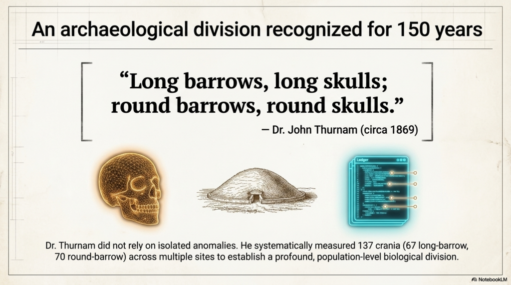
His conclusion became one of the most memorable statements in British archaeology:
“Long barrows, long skulls; round barrows, round skulls.”
The saying survives, but the scale of the evidence behind it has largely disappeared from public discussion.
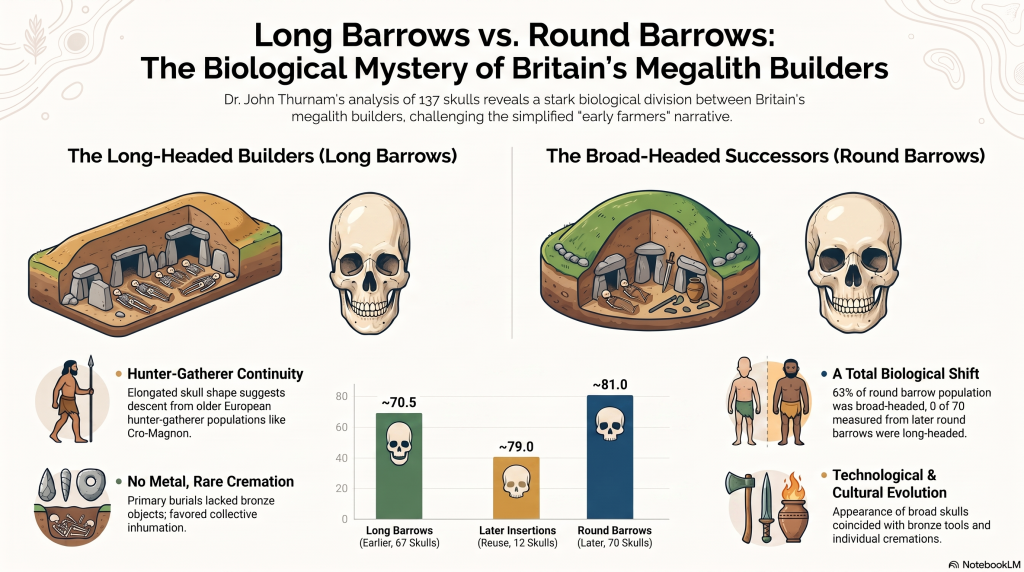
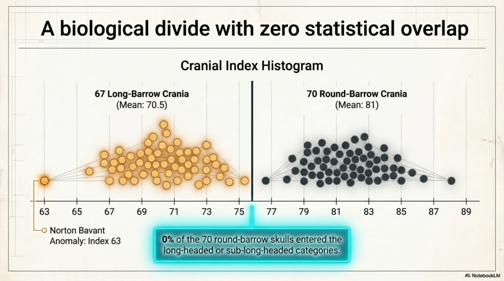
Thurnam’s two studies contain measurements from 67 long-barrow crania and 70 round-barrow crania—a combined sample of 137 prehistoric skulls. The long-barrow series had a combined average cranial index of approximately 70.5. The round-barrow series averaged approximately 81.
A cranial index is calculated by dividing the maximum breadth of a skull by its maximum length and multiplying by 100. A low index indicates a relatively long, narrow skull. A higher index indicates a shorter, broader skull.
This does not mean that one skull was literally twice the length of another. It describes the proportional relationship between length and breadth. Nevertheless, a difference between population averages of 70.5 and 81 is substantial.
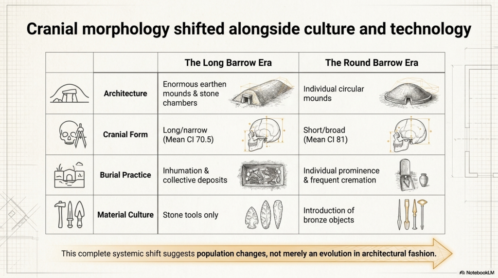
More importantly, the skull measurements did not exist in isolation. They followed changes in monument form, burial practice and associated material culture.
Thurnam classified the long barrows as the earlier monuments. Their primary deposits usually contained whole or disarticulated skeletons, often gathered together at the broad end of the mound. Metal objects were absent from the original burials, and cremation was rare and incomplete.
The round barrows belonged to a later archaeological tradition. Cremation was far more common, bronze objects appeared, and individual burials became increasingly prominent. Thurnam regarded the contrast as evidence of two different populations or chronological communities rather than a mere change in architectural fashion.
Victorian researchers surrounded these measurements with racial labels and social interpretations that cannot simply be carried into modern science. Thurnam’s ideas about chiefs, slaves, sacrifice and cannibalism must be treated as historical hypotheses, not proven explanations.
But rejecting his Victorian terminology does not make his measurements disappear.
A skull measured at a cranial index of 68 remains proportionally long, whether it was measured in 1869 or yesterday. The correct response is to remeasure the surviving specimens, establish their precise archaeological contexts, radiocarbon-date them and obtain ancient DNA.
Instead, modern accounts commonly reduce the question of Britain’s megalithic builders to a simple label: early farmers.
That label may describe an economy, but it does not identify biological ancestry, monument designers, engineers or the social group whose dead were selected for burial inside the monuments.
Farming can be adopted. Domestic animals can be traded. Cultivation can spread between neighbouring populations. Finding agricultural practices in a landscape does not automatically prove that every monument in that landscape was conceived and built by a newly arrived population.
Thurnam’s evidence therefore raises a question that archaeology has never adequately resolved:
Why did the people buried in long barrows possess a consistently elongated cranial form, while the people buried in later round barrows possessed much broader skulls?
That is not a Victorian curiosity. It is a modern research question waiting to be reopened.
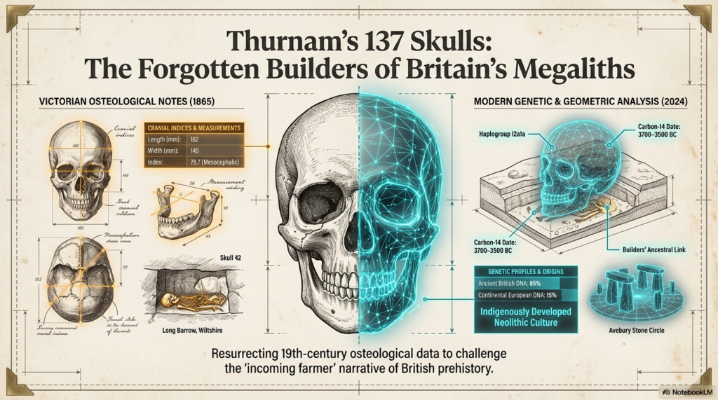
2. The 67 long-barrow skulls: what Thurnam actually measured
Thurnam separated long barrows into two principal forms: unchambered long barrows and chambered long barrows.
The unchambered monuments were generally enormous earthen mounds with lateral ditches and primary burials concentrated beneath the broader and higher end. The chambered monuments incorporated stone-built compartments containing multiple human remains.
From ten unchambered long barrows, Thurnam obtained 27 measurable crania. Their indices ranged from 63 to 75, with an overall average of only 69. He described them as remarkably long and narrow.
The lowest value, 63, came from the nine-skull series at Norton Bavant. This was an exceptionally elongated skull even by the standards of the wider long-barrow sample.
Unchambered long-barrow crania
| Site | Measured skulls | Index range | Mean index |
|---|---|---|---|
| Winterbourne Stoke | 1 | 75 | 75 |
| Tilshead East | 5 | 68–74 | 71.5 |
| Bowl’s Barrow, Heytesbury | 4 | 65–70 | 67 |
| Fyfield, Giant’s Grave | 1 | 69 | 69 |
| Tilshead Lodge | 2 | 66–68 | 67 |
| Figheldean | 1 | 67 | 67 |
| Netheravon | 1 | 69 | 69 |
| Tilshead Old Ditch | 1 | 68 | 68 |
| Stonehenge Long Barrow 165 | 2 | 70.5–71 | 71 |
| Norton Bavant | 9 | 63–73 | 68.5 |
| Total | 27 | 63–75 | 69 |
The table is striking because the pattern is not confined to one cemetery. It appears across multiple Wiltshire long barrows excavated at different times.
The four skulls from Bowl’s Barrow averaged 67. The two from Tilshead Lodge averaged 67. The single measurable examples from Figheldean, Netheravon and Tilshead Old Ditch produced indices of 67, 69 and 68 respectively.
Thurnam’s 27-skull unchambered series included 21 skulls he regarded as male and six as female. Although Victorian sex assessments require modern checking, this indicates that the result was not created by measuring only one sex.
The chambered long barrows produced another 40 measurable crania from seven sites.
Chambered long-barrow crania
| Site | Measured skulls | Index range | Mean index |
|---|---|---|---|
| Uley | 2 | 71–74 | 72.5 |
| Littleton Drew | 7 | 68–74 | 71 |
| West Kennet | 4 | 67–73 | 70 |
| Nympsfield | 2 | 74–75 | 74 |
| Rodmarton | 5 | 71–74 | 73 |
| Charlton Abbot’s | 17 | 68–77 | 71 |
| Oldbury | 3 | 68–74 | 71 |
| Total | 40 | 67–77 | 71.5 |
The chambered sample is slightly broader on average than the unchambered series, but it remains predominantly elongated.
West Kennet produced four skulls ranging from 67 to 73, averaging 70. Littleton Drew produced seven skulls averaging 71. Charlton Abbot’s supplied the largest chambered sample, with 17 skulls and a mean of 71.
We must not claim that every one of these 67 people was strictly dolichocephalic. Thurnam’s published tables provide site ranges and averages rather than all 67 individual measurements. At sites such as Charlton Abbot’s, where the range reaches 77, some individuals were evidently broader-headed.
What can be stated securely is that:
- the combined long-barrow population averaged approximately 70.5;
- every site series had a long-headed, sub-long-headed or predominantly long-headed average;
- the strongest unchambered series were extraordinarily elongated;
- the pattern occurred across both earthen and chambered long-barrow traditions.
This is not the result of selecting two spectacular museum skulls. It is a regional population pattern involving 67 measured crania from 17 monumental burial sites.
3. The 70 round-barrow skulls: the population changes
The round-barrow evidence is even more dramatic because Thurnam published a categorical distribution for the complete sample.
He assembled 70 skulls from later round-barrow burials. Their cranial indices ranged from 74 to 89, with an average close to 81.
Among those 70 skulls, Thurnam found:
- no dolichocephalic examples;
- no sub-dolichocephalic examples;
- 12 intermediate skulls with indices of 74–76;
- 14 broader skulls with indices of 77–79;
- 44 brachycephalic skulls with indices of 80–89.
Distribution of the 70 round-barrow skulls
| Cranial category | Index range | Number | Proportion |
|---|---|---|---|
| Dolichocephalic | 70 or below | 0 | 0% |
| Sub-dolichocephalic | 71–73 | 0 | 0% |
| Orthocephalic | 74–76 | 12 | 17% |
| Sub-brachycephalic | 77–79 | 14 | 20% |
| Brachycephalic | 80–89 | 44 | 63% |
| Total | 74–89 | 70 | 100% |
The significance is not that every round-barrow person had an almost spherical skull. The majority were broad-headed, while a minority occupied an intermediate range.
The critical result is that not one of the 70 entered Thurnam’s long-headed or sub-long-headed classes.
The complete contrast
| Burial population | Measured crania | Approximate mean index | Long/sub-long skulls |
|---|---|---|---|
| Long barrows | 67 | 70.5 | Predominant, but exact individual total unavailable |
| Round barrows | 70 | 81 | 0 of 70 |
| Later secondary burials inside long barrows | 12 | about 79 | Predominantly broader-headed |
The third row is particularly important.
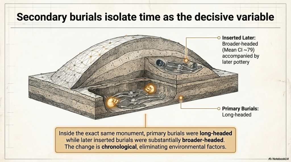
Long barrows were sometimes reopened and reused by later people. Thurnam examined 12 skulls from secondary burials inserted into Wiltshire long barrows. Their average index was approximately 79.
Some were accompanied by later pottery, including decorated drinking cups. These were not part of the original long-barrow burial population.
This produces a remarkably controlled comparison.
Inside the same monument:
- the primary burials were long-headed;
- the later inserted burials were substantially broader-headed.
Therefore, the difference cannot easily be dismissed as the effect of soil, regional geography, monument location or measurement technique. The cranial form changes with the archaeological phase.
The same point is illustrated by individual named round-barrow skulls.
Ten named Wiltshire round-barrow examples
| Site | Cranial index |
|---|---|
| Kennet Hill | 74 |
| Morgan’s Hill | 75 |
| Stonehenge, Barrow 150 | 78 |
| Stonehenge, Collection 266 | 79 |
| Wilsford | 80 |
| Winterbourne Stoke | 81 |
| Roundway | 83 |
| Codford | 83 |
| Stonehenge, Barrow 150 | 84 |
| Stonehenge, Collection 265 | 84 |
These ten had an average index of approximately 80.1.
The burial evidence changes as well. Thurnam’s long barrows were dominated by inhumation and collective deposits. Cremation occurred only exceptionally. In the later circular barrows, cremation was far more common and bronze artefacts became part of the archaeological record.
The evidence therefore points to more than architectural development.
We see simultaneous changes in:
- skull proportions;
- treatment of the dead;
- collective versus individual burial;
- cremation frequency;
- monument design;
- associated technology.
Whether this represents migration, population mixing, social selection or long-term biological change remains open to investigation.
What is not scientifically reasonable is to pretend that no physical distinction existed.
4. From Cro-Magnon to the long-barrow population
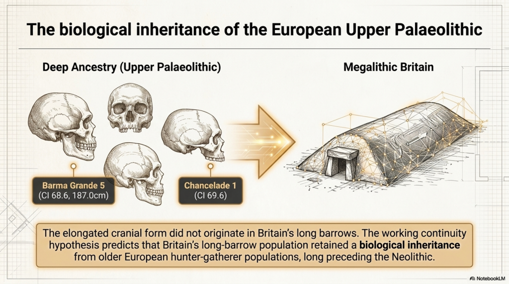
The elongated cranial form did not originate in Britain’s long barrows.
Long, narrow skulls are present much earlier in the European Upper Palaeolithic record. Specimens traditionally associated with Cro-Magnon, Barma Grande, Grotte des Enfants, Chancelade, Předmostí and other Upper Palaeolithic sites frequently possess substantial front-to-back cranial length.
“Cro-Magnon” is a historical label for early European Homo sapiens, which was once seen as a separate modern species. Nevertheless, the term remains useful when discussing a recognisable Upper Palaeolithic pattern of tall, robust bodies and large, often elongated crania.
The 2025 European cranial study by Pavel Grasgruber provides modern measurements for many of these specimens. It identifies considerable variation rather than a single universal Cro-Magnon type, but it also confirms that several Upper Palaeolithic individuals possessed conspicuously tall or narrow cranial forms.
Barma Grande 5 and Chancelade 1 stand out as tall, narrow cranial outliers. Early western European specimens including Cro-Magnon 1 and Grotte des Enfants 4 show differences from some central and eastern European Upper Palaeolithic skulls, although the study stresses that limited sample size prevents a simple biological classification.
Our own matched body-and-cranium database includes several relevant individuals:
| Upper Palaeolithic/Mesolithic specimen | Reconstructed stature | Cranial index |
|---|---|---|
| Barma Grande 5 | 187.0 cm | 68.6 |
| Grotte des Enfants 4 | 185.7 cm | 76.8 |
| Předmostí 3 | 183.0 cm | 71.8 |
| Sungir 1 | 183.2 cm | 76.6 |
| Oberkassel 1 | 175.1 cm | 72.7 |
| Romito 4 | 173.2 cm | 74.9 |
| Bichon 1 | 169.9 cm | 75.8 |
| Chancelade 1 | 165.7 cm | 69.6 |
Note: Villabruna 1 and M50 provide two complementary pieces of evidence. Villabruna 1 directly connects early R1b1 with a non-round-headed cranium, having a cranial index of 75.97. M50 directly connects basal R1b with exceptional stature, having a published estimate of 181.63 centimetres. The complete combination of early R1b, exceptional stature and strongly long-headed cranial morphology has not yet been demonstrated in one securely documented individual, but both components of the working hypothesis are now represented within the early R1b record.
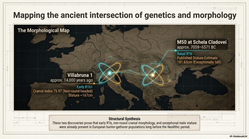
This demonstrates two important points.
First, an elongated skull does not automatically indicate exceptional stature. Chancelade 1 was strongly long-headed but comparatively short, while Grotte des Enfants 4 was very tall despite having a broader cranial index than Barma Grande 5.
Second, the combined pattern of tall stature, robust anatomy and elongated cranial form unquestionably existed among some Upper Palaeolithic European populations.
The central question is whether Britain’s long-barrow population represents biological continuity from these older European hunter-gatherers.
Cranial morphology is substantially inherited and has long been used to investigate biological affinity, population continuity and descent. Individual skulls may be affected by development, nutrition, cultural practices or burial pressure, but these factors cannot reasonably explain away a repeated population-level pattern involving 67 measured crania from 17 long-barrow monuments.
The evidence becomes still stronger because the cranial form changes with the archaeological phase. The primary long-barrow burials were predominantly long-headed, while the later secondary burials inserted into the same monuments were substantially broader-headed. The later round-barrow population was broader-headed again.
This is not a random collection of unusual skulls. It is a structured biological pattern associated with different burial populations and different archaeological periods.
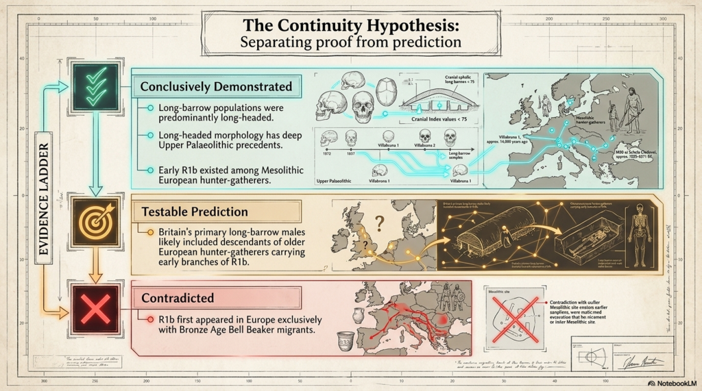
The working continuity hypothesis is therefore:
Britain’s long-barrow population retained a substantial biological inheritance from older European hunter-gatherer populations, including the elongated cranial form visible among parts of the Upper Palaeolithic population traditionally described as Cro-Magnon.
This does not require every long-barrow individual to have been identical to every Upper Palaeolithic specimen. Ancient populations contained variation, just as modern populations do. The argument concerns biological continuity across populations, not the claim that one unchanging physical type survived for tens of thousands of years.
The conventional narrative proposes that Anatolian-derived farming populations migrated progressively across Europe and eventually reached Britain. However, genetic resemblance alone does not establish that migration route, and our analysis of more than 14,000 calibrated radiocarbon records has not identified the archaeological trail that such a mass population movement should have produced.
There is no coherent sequence of increasingly later settlement sites running from Anatolia through southeastern Europe, central Europe, France and finally Britain. Nor is there the expected concentration of early sites along the proposed migration corridor. Instead, the radiocarbon evidence shows extensive activity already present in northwestern Europe during the period in which the supposed farmer migration is claimed to have occurred.
Genetic components described as Anatolian-related may reflect shared ancestry, contact, intermarriage or limited gene flow. They do not automatically prove that a large farming population crossed Europe, replaced indigenous communities or constructed Britain’s monumental landscape.
It is therefore entirely possible that people later classified archaeologically as “farmers” were substantially descended from older European hunter-gatherer populations who adopted cultivation, livestock and new material practices without being biologically replaced.
The important distinction is this:
Agriculture describes what people did. Cranial morphology helps establish who they descended from, while radiocarbon evidence tests whether the claimed migration actually occurred.
The long-barrow measurements therefore support biological continuity with Europe’s older inhabitants, while the radiocarbon record provides no corresponding settlement trail for the conventional Anatolian farmer migration narrative
5. The R1b question: what the archaeological record permits us to predict
R1b is not a blood group. It is a Y-chromosome haplogroup passed primarily through the paternal line.
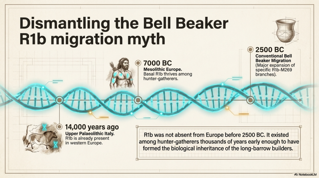
The traditional popular narrative often associates the major expansion of R1b in western Europe with Bronze Age Steppe-related or Bell Beaker populations after approximately 2500 BC.
That explanation may describe a major later expansion of particular R1b branches, especially those descending from R1b-M269.
It cannot mean that R1b itself was absent from Europe before the Bell Beaker period.
Ancient DNA has now identified R1b among European hunter-gatherers thousands of years before the proposed Bell Beaker migration.
Villabruna 1: R1b in Upper Palaeolithic Italy
The earliest confirmed R1b individual currently known is Villabruna 1, discovered at Riparo Villabruna in northern Italy.
Villabruna 1:
- was an adult male;
- belonged to the Late Upper Palaeolithic Epigravettian population;
- was directly dated to approximately 14,000 years ago;
- carried the early paternal lineage R1b1, or R-L754;
- had estimated stature results ranging from approximately 167.2 to 169.1 centimetres.
The average stature reported for European Late Upper Palaeolithic males was approximately 165.6 centimetres. Villabruna 1 therefore fell within the taller part of the known male range for his period.
Villabruna 1 places R1b in western Europe around nine thousand years before the conventional Bell Beaker horizon.
His discovery separates two questions that are too often confused.
The first is when R1b originally appeared in Europe.
The second is when particular later branches of R1b expanded and became dominant.
The expansion of some R1b branches during the Bronze Age cannot be presented as the first appearance of the wider R1b lineage in Europe.
M50: a tall Mesolithic R1b hunter-gatherer
The strongest direct body-and-DNA crossover currently in our database is I4655, also recorded as SCCL_50 and M50, from Schela Cladovei on the Romanian bank of the Danube.
This individual:
- belonged to basal R-L754/R1b;
- dates to approximately 7059–6571 calibrated BC;
- had a right tibia measuring 412 millimetres;
- received a published stature estimate of 181.63 centimetres.
This is direct evidence that an exceptionally tall Mesolithic European man carried basal R1b roughly four thousand years before the conventional Bell Beaker horizon.
M50 is particularly important to our investigation because his stature fits the physical pattern being examined.
The evidence already shows that some Upper Palaeolithic European populations possessed tall stature, robust skeletal proportions and elongated cranial forms.
M50 now demonstrates that exceptional stature was also present in at least one securely identified early R1b hunter-gatherer.
It does not prove that M50 possessed an elongated skull, because his individual cranium has not yet been securely matched to published cranial measurements.
Nor does it prove that Britain’s long-barrow population was predominantly R1b.
What it proves is that R1b existed among European hunter-gatherers early enough to have formed part of the biological inheritance from which later long-barrow populations could have developed.
Villabruna 1 establishes the presence of R1b in Upper Palaeolithic western Europe.
M50 demonstrates the continued presence of basal R1b among Mesolithic hunter-gatherers and provides a direct association with exceptional male stature.
The responsible hypothesis is therefore:
Early R1b paternal lineages were present among European hunter-gatherers long before the Bell Beaker period, and Britain’s long-headed long-barrow population may have included descendants carrying those lineages.
That is a prediction capable of being tested.
It is not yet a universal conclusion.
The evidence ladder
| Statement | Present status |
|---|---|
| R1b existed in Upper Palaeolithic western Europe | Directly demonstrated by Villabruna 1 approximately 14,000 years ago |
| Villabruna 1 was relatively tall for his period | Supported by published stature estimates of approximately 167.2–169.1 centimetres |
| Basal R1b existed among Mesolithic European hunter-gatherers | Directly demonstrated |
| Some early R1b individuals were exceptionally tall | Directly demonstrated by I4655/M50, estimated at 181.63 centimetres |
| Long-headed European populations existed before the Neolithic | Directly demonstrated by Upper Palaeolithic and Mesolithic cranial measurements |
| Britain’s primary long-barrow burials were predominantly long-headed | Strongly demonstrated by Thurnam’s series of 67 crania |
| Britain’s long-barrow population included males carrying R1b | Plausible and directly testable, but not yet demonstrated across the population |
| All long-headed prehistoric people carried R1b | Not demonstrated |
| All early R1b individuals were tall or long-headed | Not demonstrated |
| R1b first appeared in Europe with Bell Beaker migrants | Contradicted if interpreted as the first European appearance of the wider R1b lineage |
| Particular later R1b branches expanded during the Bronze Age | Possible, but separate from the earlier presence of basal R1b |
The absence of a securely identified round-headed early R1b individual in our present register strengthens the working association between early R1b, greater stature and elongated cranial form.
However, the absence of contradictory evidence is not the same as proof.
The archaeological record currently presents two independently demonstrated patterns.
The first is the presence of R1b paternal lineages among Upper Palaeolithic and Mesolithic European hunter-gatherers.
The second is the persistence of elongated cranial morphology from older European populations into Britain’s primary long-barrow burial population.
The working hypothesis is that these two patterns may intersect.
Britain’s long-headed long-barrow population may have included descendants of older European hunter-gatherers carrying early branches of R1b.
This is not an attempt to project the later Bell Beaker model backwards into an earlier period.
It is a testable prediction based on:
- the confirmed presence of R1b in Upper Palaeolithic Italy;
- the confirmed presence of basal R1b among Mesolithic Danube hunter-gatherers;
- the exceptional stature of M50;
- the existence of elongated cranial forms among older European populations;
- the predominantly long-headed character of Britain’s primary long-barrow burials.
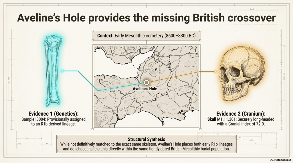
Aveline’s Hole: the missing British crossover
A third and potentially critical connection comes from Aveline’s Hole in Somerset, Britain’s largest known Early Mesolithic cemetery.
The male genetic sample I3004, also recorded as SB 337B3, came from a human tibia directly dated to approximately 8600–8300 BC.
The current genetic annotation assigns this individual to an R1b-derived paternal lineage. This would place R1b in Britain more than five thousand years before the conventional Bell Beaker horizon.
Aveline’s Hole also produced directly measured long-headed crania.
The reconstructed skull M1.11.301 had a maximum cranial length of 186 millimetres and a maximum breadth of 134 millimetres. Its cranial index was 72.0, placing it securely within the dolichocephalic, or long-headed, category.
The surviving evidence does not presently demonstrate that the R1b tibia and the long-headed skull belonged to the same person. They must therefore not be combined as though they represent a single securely reconstructed individual.
Nevertheless, their occurrence within the same tightly dated Early Mesolithic burial population is highly significant.
Aveline’s Hole provides the missing geographical and chronological bridge between the other two early R1b findings.
Villabruna 1 demonstrates that R1b1 was present in Upper Palaeolithic Italy approximately fourteen thousand years ago and was carried by an individual with a non-round-headed cranium.
M50 at Schela Cladovei demonstrates that basal R1b was carried by an exceptionally tall Mesolithic man whose published stature estimate was 181.63 centimetres.
Aveline’s Hole places an R1b-derived paternal lineage within a British Early Mesolithic cemetery where securely long-headed individuals were also buried.
These are three complementary observations:
| Individual or site | Genetic evidence | Physical evidence | Present status |
|---|---|---|---|
| Villabruna 1, Italy | Early R1b1/R-L754 | Cranial index 75.97; non-round-headed | Individual genetic and cranial crossover |
| Aveline’s Hole, Britain | I3004 provisionally assigned to an R1b-derived lineage | At least one cemetery cranium had an index of 72.0 | Site-level crossover; genetic call requires confirmation |
| M50, Schela Cladovei | Basal R-L754/R1b | Published stature estimate of 181.63 cm | Individual genetic and stature crossover |
The three findings cannot yet be merged into a claim that one securely identified person possessed R1b, exceptional stature and an extremely long skull.
They do, however, substantially strengthen the prediction that these characteristics intersected within the older European population.
The evidence now shows:
- early R1b associated with a non-round-headed individual in Upper Palaeolithic Italy;
- a provisional R1b male within a British Mesolithic cemetery containing long-headed crania;
- and basal R1b associated with exceptional stature in Mesolithic southeastern Europe.
The Aveline’s Hole result is particularly important because it places the proposed association directly within Britain thousands of years before the construction of the long barrows.
Its current Y-chromosome assignment carries a technical quality warning and must therefore remain provisional. However, it is no longer an isolated result without archaeological context. It occurs within a burial population whose surviving cranial evidence independently includes the long-headed form predicted by the hypothesis.
Revised evidence ladder
| Statement | Present status |
|---|---|
| R1b existed in Upper Palaeolithic western Europe | Directly demonstrated by Villabruna 1 |
| An early R1b1 individual possessed a non-round-headed cranium | Directly demonstrated by Villabruna 1 |
| Basal R1b existed among Mesolithic European populations | Directly demonstrated by M50 and other early samples |
| Some early R1b individuals were exceptionally tall | Directly demonstrated by M50 |
| Long-headed people were buried at Aveline’s Hole | Directly demonstrated by cranial measurements, including an index of 72.0 |
| An R1b-derived male was buried at Aveline’s Hole | Provisionally supported by I3004, but the contamination-flagged genetic call requires confirmation |
| The Aveline R1b male was the measured long-headed individual | Not demonstrated; the DNA sample came from a tibia that has not been matched to the measured cranium |
| Early R1b and long-headed morphology occurred within the same British Mesolithic cemetery | Supported at site-population level |
| Britain’s long-barrow males carried R1b | Strengthened as a testable prediction, but not yet directly demonstrated |
| R1b first appeared in Europe with Bell Beaker migrants | Contradicted if interpreted as the first European appearance of R1b |
The next scientific step
The surviving long-barrow skulls identified by Thurnam should be relocated in museums and archaeological collections.
Their original labels, monument locations, chamber positions, burial phases and excavation histories should be reconciled with modern catalogues.
Where preservation allows, the research programme should include:
- direct radiocarbon dating;
- renewed cranial measurement;
- three-dimensional scanning;
- ancient-DNA sampling;
- Y-chromosome identification;
- mitochondrial identification;
- isotope testing;
- comparison with the known prehistoric body-size records.
The results should then be compared by individual.
Cranial form, stature, skeletal proportions, genetic lineage, burial position and archaeological date should no longer be studied as separate categories of evidence.
A confirmed group of primary long-barrow males possessing elongated skulls, exceptional stature and early R1b paternal lineages would provide the missing biological connection between Upper Palaeolithic populations, Mesolithic hunter-gatherers and Britain’s megalithic communities.
Until that work is carried out, the R1b connection remains a strong research hypothesis—not a licence to replace one simplistic migration narrative with another.
What can already be stated with certainty is that R1b did not first appear in Europe with the Bell Beaker phenomenon.
It was present in Upper Palaeolithic Italy approximately fourteen thousand years ago.
It survived among Mesolithic European hunter-gatherers.
And at least one of those securely identified Mesolithic R1b men stood approximately 181.63 centimetres tall.
6. Our new method: estimating a person’s height from the skull
Long-barrow excavations often preserved skulls while postcranial bones were lost, mixed, damaged or separated from their original individuals.
That creates an obvious problem. Traditional stature reconstruction depends primarily on complete long bones such as the femur and tibia. Without those bones, the person’s height is usually left unknown.
Our project has therefore begun testing whether external cranial dimensions can provide a preliminary stature range.
The method is based on adult male prehistoric individuals for whom both cranial measurements and independently reconstructed body heights survive.
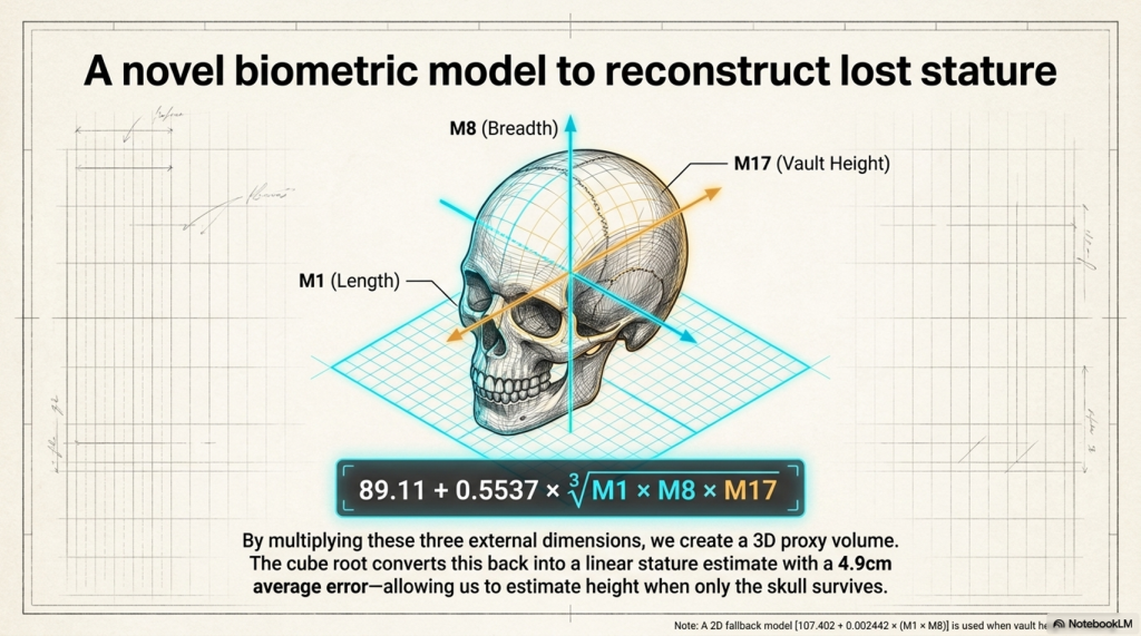
The three principal skull measurements are:
- M1: maximum cranial length;
- M8: maximum cranial breadth;
- M17: cranial vault height.
These three dimensions are multiplied to produce an external cranial-size proxy. The cube root then converts that volume-like product back into a linear measurement.
Current three-dimensional model
Estimated stature in centimetres:
89.11 + 0.5537 × ∛(M1 × M8 × M17)
This is not a measurement of actual brain volume. It is an external three-dimensional cranial-size proxy.
The current calibration sample contains 14 securely or probably matched adult males.
| Specimen | Known stature | M1 | M8 | M17 |
|---|---|---|---|---|
| Barma Grande 5 | 187.0 | 204 | 140 | 153 |
| Grotte des Enfants 4 | 185.7 | 198 | 152 | 131 |
| Sungir 1 | 183.2 | 188 | 144 | 130 |
| Předmostí 3 | 183.0 | 202 | 145 | 133 |
| Oberkassel 1 | 175.1 | 194 | 141 | 137 |
| Předmostí 9 | 173.3 | 196 | 145 | 134 |
| Romito 4 | 173.2 | 195 | 146 | 132 |
| Villabruna 1 | 172.9 | 181 | 137.5 | 133.5 |
| Rochereil 1 | 172.6 | 190 | 138 | 138 |
| Le Peyrat 5 | 171.5 | 194 | 144 | 126 |
| Bichon 1 | 169.9 | 190 | 144 | 122 |
| Arene Candide 3 | 169.3 | 185 | 144 | 126 |
| Arene Candide 5 | 167.1 | 203 | 142 | 146 |
| Chancelade 1 | 165.7 | 194 | 135 | 149 |
The present model has an average in-sample error of approximately 4.9 cm. That is useful for broad categories—short, medium, tall or very tall—but it is not accurate enough to claim an exact stature.
A simpler two-dimensional fallback is available when M17 is missing:
Estimated stature = 107.402 + 0.002442 × (M1 × M8)
In leave-one-out testing, this model produced an average error of approximately 5.9 cm:
| Validation result | Performance |
|---|---|
| Within ±5 cm | 57.1% |
| Within ±7 cm | 71.4% |
| Within ±10 cm | 78.6% |
| Mean absolute error | 5.9 cm |
This level of error is why our database reports a range rather than presenting a cranial estimate as a direct measurement.
Historical records demonstrate the problem.
| Historical case | Body-based stature | 2D skull estimate | Difference |
|---|---|---|---|
| Coldrum male composite | 164.5 cm | 172.5 cm | +8.0 cm |
| Halling Man | 166.5 cm from femur | 172.3 cm | +5.8 cm |
| Ipswich Man | 180.0 cm | 174.9 cm | −5.1 cm |
The Coldrum result is also a group composite rather than one individual. None of these historical cases has been used to alter the model.
For most of Thurnam’s 67 long-barrow skulls, only cranial indices, ranges and site averages are currently published in the material we have extracted. A cranial index alone cannot produce a height because it gives a proportion rather than the skull’s absolute dimensions.
We therefore need the original M1, M8 and M17 measurements from Crania Britannica, museum catalogues or surviving skulls.
Once recovered, those dimensions could provide the first systematic stature estimates for many of Britain’s long-headed long-barrow occupants.
Applying the method to skulls without surviving body measurements
The most important purpose of the model is not to recalculate the heights of individuals whose skeletons already provide stature estimates.
Its real value lies in the cranial-only discoveries for which the skull survives, but the associated long bones are missing or cannot be securely identified.
Our present register contains several such cases.
Where maximum cranial length, maximum cranial breadth and cranial vault height survive, the preferred three-dimensional model can be used.
Where only maximum length and breadth are available, the less precise two-dimensional fallback model must be used.
The following results are therefore predictions rather than known statures.
| Skull or site | M1 length | M8 breadth | M17 height | Cranial index | Model used | Estimated stature | Approximate height |
|---|---|---|---|---|---|---|---|
| Aveline’s Hole skull M1.11.301 | 186 mm | 134 mm | Not available | 72.0 | Two-dimensional | 168.3 cm | 5 ft 6 in |
| Carnon calvaria | 184 mm | 137 mm | Not available | 74.46 | Two-dimensional | 169.0 cm | 5 ft 6½ in |
| Langwith Man | 192 mm | 135 mm | 127 mm | 70.31 | Three-dimensional | 171.5 cm | 5 ft 7½ in |
| Engis skull | 198 mm | 140 mm | Not available | 70.71 | Two-dimensional | 175.1 cm | 5 ft 9 in |
| Dartford cranium | 207 mm | 150 mm | Not available | 72.46 | Two-dimensional | 183.2 cm | approximately 6 ft |
These estimates reveal a considerable range of possible body sizes among the surviving long-headed skulls.
The relatively small Aveline’s Hole and Carnon crania produce estimates of approximately 168 to 169 centimetres.
Langwith Man produces an estimate of approximately 171.5 centimetres.
The larger Engis skull produces an estimate of approximately 175 centimetres.
The exceptionally large Dartford cranium produces an estimated stature of approximately 183 centimetres, or around six feet.
These figures must not be treated as direct measurements.
The two-dimensional model has a mean leave-one-out error of approximately 5.9 centimetres. A practical working range of roughly six centimetres on either side of each estimate is therefore more responsible than presenting a single exact height.
The estimates could consequently be expressed approximately as:
- Aveline’s Hole: 162 to 174 centimetres;
- Carnon: 163 to 175 centimetres;
- Langwith: 165 to 177 centimetres;
- Engis: 169 to 181 centimetres;
- Dartford: 177 to 189 centimetres.
These are working archaeological ranges, not formal statistical confidence intervals.
The importance of Aveline’s Hole
The Aveline’s Hole calculation requires particular care.
The measured skull had a cranial index of 72.0 and produces a two-dimensional stature estimate of approximately 168.3 centimetres.
However, this skull has not been securely matched to the male tibia from which the provisional R1b genetic result was obtained.
We cannot therefore claim that the R1b male himself stood 168 centimetres tall.
What can be stated is that the Aveline’s Hole cemetery contained:
- a provisionally identified R1b-derived male;
- at least one securely long-headed skull;
- and a measured cranium whose dimensions suggest an individual of approximately medium stature.
The genetic, cranial and stature evidence remains associated at the cemetery-population level rather than the securely identified individual level.
What the estimates suggest
The cranial-only results do not indicate that all long-headed individuals were exceptionally tall.
Instead, they suggest that long-headed prehistoric populations included individuals ranging from approximately average stature to potentially more than six feet tall.
This is an important distinction.
Cranial shape and cranial size are not the same measurement.
A person may possess a strongly elongated skull without possessing an exceptionally large skull or exceptional body height.
The Dartford cranium combines an elongated form with unusually large absolute dimensions and consequently produces the tallest prediction.
Aveline’s Hole possesses a similarly long-headed form but smaller absolute dimensions and therefore produces a much lower stature estimate.
This is precisely why cranial index alone cannot estimate height.
The index reveals the proportion of the skull.
The complete measurements reveal its physical size.
Present conclusion
The model now provides provisional stature estimates for five cranial discoveries where a secure body-based comparison is unavailable.
The results range from approximately 168 centimetres to approximately 183 centimetres.
They demonstrate that Britain and western Europe’s surviving long-headed crania did not represent one uniform body size.
Some appear to have belonged to individuals of ordinary or medium stature.
Others, particularly the Dartford individual, may have belonged to exceptionally tall people.
Further recovery of the original cranial measurements from long-barrow collections could extend this analysis from five isolated examples to a much larger prehistoric population.
7. Who built Britain’s megaliths—and what must happen next?
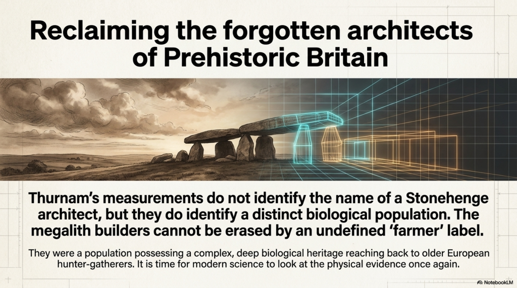
Thurnam’s measurements do not identify the name of a Stonehenge architect.
They do something more fundamental: they identify a distinctive biological population occupying Britain’s early monumental burial tradition.
The 67 long-barrow crania were predominantly long-headed. The 70 later round-barrow skulls contained no dolichocephalic or sub-dolichocephalic individuals in Thurnam’s classification. Later burials inserted into long barrows were broader-headed and averaged approximately 79.
The change in human morphology follows the change in monument and burial practice.
This creates a serious problem for the simplified story that “incoming farmers built Britain’s megaliths.”
Modern genetics supports substantial migration into Britain during the Neolithic. It does not automatically prove that every long barrow, causewayed enclosure, stone setting and later phase of Stonehenge was conceived by one biologically uniform immigrant population.
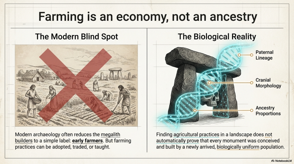
The word farmer identifies subsistence practice.
It does not identify:
- paternal lineage;
- cranial morphology;
- ancestry proportions;
- social leadership;
- specialist engineering knowledge;
- the population selected for monumental burial.
People can adopt agriculture without losing their ancestry. Incoming farmers can mix with indigenous hunter-gatherers. Different groups can cooperate, exchange partners and technologies, or occupy different positions within the same society.
The traditional construct therefore contains a hidden logical jump:
Farming appears in the archaeological record; therefore incoming farmers designed and built the monumental landscape.
That conclusion must be demonstrated, not assumed.
What the evidence currently permits us to say
| Finding | Assessment |
|---|---|
| Long-barrow and round-barrow skull populations were markedly different | Strongly demonstrated |
| The original long-barrow population was predominantly long-headed | Strongly demonstrated |
| Later secondary burials inside long barrows were broader-headed | Strongly demonstrated |
| Long-headed morphology has Upper Palaeolithic European precedents | Demonstrated |
| Early R1b existed among Mesolithic European hunter-gatherers | Demonstrated |
| Long-barrow people descended partly from older hunter-gatherers | Strong continuity hypothesis |
| Long-barrow males probably included early R1b lineages | Testable hypothesis |
| Long-barrow people alone built every British megalith | Not demonstrated |
| Incoming farmers alone built every British megalith | Not demonstrated |
This is the crucial distinction.
The evidence does not justify declaring that every long-headed person was a monument builder or that one paternal lineage created an entire civilisation.
But it equally does not justify removing the long-headed burial population from the discussion and replacing them with an undefined category called “farmers.”
The surviving human remains offer a direct route to resolving the question.
A serious research project should:
- locate all surviving skulls from Thurnam’s 17 long-barrow series;
- identify individual museum and excavation numbers;
- separate primary deposits from later intrusions;
- rescan and remeasure the crania;
- recover M1, M8 and M17 for stature modelling;
- radiocarbon-date the individuals directly;
- sequence their DNA;
- compare their ancestry with Mesolithic, Early Neolithic and Bronze Age populations;
- test whether R1b occurs among the long-headed males;
- compare their reconstructed statures with our 429-person prehistoric body-size database.
This investigation could confirm, modify or reject the Cro-Magnon–Mesolithic–long-barrow continuity hypothesis.
That is how science should work.
The measurements have existed since the nineteenth century. Modern radiocarbon dating, 3D imaging and ancient DNA now allow us to test what Thurnam could only observe.
“Long barrows, long skulls; round barrows, round skulls” was not merely a Victorian slogan.
It was a concise description of a measurable change in Britain’s prehistoric population.
The physical evidence has waited more than 150 years for archaeology to finish the investigation.
PODCAST

Author’s Biography

Robert John Langdon, a polymathic luminary, emerges as a writer, historian, and eminent specialist in LiDAR Landscape Archaeology.
His intellectual voyage has been interwoven with stints as an astute scrutineer in government and grand corporate bastions, a tapestry spanning British Telecommunications, Cable and Wireless, British Gas, and the esteemed University of London.
A decade hence, Robert’s transition into retirement unfurled a chapter of insatiable curiosity. This phase saw him immerse himself in Politics, Archaeology, Philosophy, and the enigmatic realm of Quantum Mechanics. His academic odyssey traversed the venerable corridors of knowledge hubs such as the Museum of London, University College London, Birkbeck College, The City Literature Institute, and Chichester University.
In the symphony of his life, Robert is a custodian of three progeny and a pair of cherished grandchildren. His sanctuary lies ensconced in the embrace of West Wales, where he inhabits an isolated cottage, its windows framing a vista of the boundless sea – a retreat from the scrutinising gaze of Her Majesty’s Revenue and Customs, an amiable clandestinity in the lap of nature.
Exploring Prehistoric Britain: A Journey Through Time
My blog delves into the fascinating mysteries of prehistoric Britain, challenging conventional narratives and offering fresh perspectives grounded in cutting-edge research, particularly LiDAR technology. I invite you to explore some key areas of my research. For example, the Wansdyke, often cited as a defensive structure, is re-examined in light of new evidence. I’ve presented my findings in my blog post Wansdyke: A British Frontier Wall – ‘Debunked’, and a Wansdyke LiDAR Flyover video further visualises my conclusions.
My work also often challenges established archaeological dogma. I argue that many sites, such as Hambledon Hill, commonly identified as Iron Age hillforts, are not what they seem. My posts Lidar Investigation Hambledon Hill – NOT an ‘Iron Age Fort’ and Unmasking the “Iron Age Hillfort” Myth explore these ideas in detail and offer an alternative view. Similarly, sites like Cissbury Ring and White Sheet Camp receive re-evaluations based on LiDAR analysis in my posts “Lidar Investigation Cissbury Ring through time” and “Lidar Investigation White Sheet Camp,“ revealing fascinating insights into their true purpose. I have also examined South Cadbury Castle, often linked to the mythical Camelot56.
My research also extends to ancient water management, including the role of canals and other linear earthworks. I have discussed the true origins of Car Dyke in multiple posts, including Car Dyke – ABC News Podcast and Lidar Investigation Car Dyke – North Section, which suggest a Mesolithic origin 2357. I also explore the misidentification of Roman aqueducts, as seen in my posts on the Great Chesters (Roman) Aqueduct. My research has also been greatly informed by my post-glacial flooding hypothesis, which has helped explain landscape transformations over time. I have discussed this hypothesis in several posts, including AI now supports my Post-Glacial Flooding Hypothesis and Exploring Britain’s Flooded Past: A Personal Journey
Finally, my blog also investigates prehistoric burial practices, as seen in Prehistoric Burial Practices of Britain and explores the mystery of Pillow Mounds, often mistaken for medieval rabbit warrens, but with a potential link to Bronze Age cremation in my posts: Pillow Mounds: A Bronze Age Legacy of Cremation? and The Mystery of Pillow Mounds: Are They Really Medieval Rabbit Warrens?. My research also includes astronomical insights into ancient sites, for example, in Rediscovering the Winter Solstice: The Original Winter Festival. I also review new information about the construction of Stonehenge in The Stonehenge Enigma.
Further Reading
For those interested in British Prehistory, visit www.prehistoric-britain.co.uk, a comprehensive resource featuring an extensive collection of archaeology articles, modern LiDAR investigations, and groundbreaking research. The site also includes insights and excerpts from the acclaimed Robert John Langdon Trilogy, a series of books that explore Britain during the Prehistoric period. Titles in the trilogy include The Stonehenge Enigma, Dawn of the Lost Civilisation, and The Post-Glacial Flooding Hypothesis, which offer compelling evidence of ancient landscapes shaped by post-glacial flooding.
To further explore these topics, Robert John Langdon has developed a dedicated YouTube channel featuring over 100 video documentaries and investigations that complement the trilogy. Notable discoveries and studies showcased on the channel include 13 Things that Don’t Make Sense in History and the revelation of Silbury Avenue – The Lost Stone Avenue, a rediscovered prehistoric feature at Avebury, Wiltshire.
In addition to his main works, Langdon has released a series of shorter, accessible publications, ideal for readers delving into specific topics. These include:
- The Ancient Mariners
- Stonehenge Built 8300 BCE
- Old Sarum
- Prehistoric Rivers
- Dykes, Ditches, and Earthworks
- Echoes of Atlantis
- Homo Superior
- 13 Things that Don’t Make Sense in History
- Silbury Avenue – The Lost Stone Avenue
- Offa’s Dyke
- The Stonehenge Enigma
- The Post-Glacial Flooding Hypothesis
- The Stonehenge Hoax
- Dawn of the Lost Civilisation
- Darwin’s Children
- Great Chester’s Roman Aqueduct
- Wansdyke
For active discussions and updates on the trilogy’s findings and recent LiDAR investigations, join our vibrant community on Facebook. Engage with like-minded enthusiasts by leaving a message or contributing to debates in our Facebook Group.
Whether through the books, the website, or interactive videos, we aim to provide a deeper understanding of Britain’s fascinating prehistoric past. We encourage you to explore these resources and uncover the mysteries of ancient landscapes through the lens of modern archaeology.
For more information, including chapter extracts and related publications, visit the Robert John Langdon Author Page. Dive into works such as The Stonehenge Enigma or Dawn of the Lost Civilisation, and explore cutting-edge theories that challenge traditional historical narratives.
Other Blogs
1
a
- AI now Supports – Homo Superior
- AI now supports my Post-Glacial Flooding Hypothesis
- Alexander the Great sailed into India – where no rivers exist today
- Ancient Secrets of Althorp – debunked
- Antler Picks built Ancient Monuments – yet there is no real evidence
- Antonine Wall – Prehistoric Canals (Dykes)
- Archaeological ‘pulp fiction’ – has archaeology turned from science?
- Archaeological Pseudoscience
- Archaeology in the Post-Truth Era
- Archaeology: A Bad Science?
- Archaeology: A Harbour for Fantasists?
- Archaeology: Fact or Fiction?
- Archaeology: The Flaws of Peer Review
- Archaeology’s Bayesian Mistake: Stop Averaging the Past
- Are Raised Beaches Archaeological Pseudoscience?
- Atlantis Found: The Mathematical Proof That Plato’s Lost City Was Doggerland
- ATLANTIS: Discovery with Dan Snow Debunked
- Avebury Ditch – Avebury Phase 2
- Avebury through time
- Avebury’s great mystery revealed
- Avebury’s Lost Stone Avenue – FREE Flipbook
b
- Battlesbury Hill – Wiltshire
- Beyond Stone and Bone: Rethinking the Megalithic Architects of Northern Europe
- BGS Prehistoric River Map
- Blackhenge: Debunking the Media misinterpretation of the Stonehenge Builders
- Brain capacity (Cro-Magnon Man)
- Britain’s First Road – Stonehenge Avenue
- Britain’s Giant Prehistoric Waterways
- British Roman Ports miles away from the coast
c
- Caerfai Promontory Fort – Archaeological Nonsense
- Car Dyke – ABC News PodCast
- Car Dyke – North Section
- Car Dyke Atlas – Prehistoric Canals – FREE Flipbook
- CASE STUDY – An Inconvenient TRUTH (Craig Rhos Y Felin)
- Case Study – River Avon
- Case Study – Woodhenge Reconstruction
- Chapter 2 – Craig Rhos-Y-Felin Debunked
- Chapter 2 – Stonehenge Phase I
- Chapter 2 – Variation of the Species
- Chapter 3 – Post Glacial Sea Levels
- Chapter 3 – Stonehenge Phase II
- Chapter 7 – Britain’s Post-Glacial Flooding
- Cissbury Ring through time
- Clement Reid, Doggerland, and the Archaeological Establishment
- Cro-Magnon Brain Capacity
- Cro-Magnon Megalithic Builders: Measurement, Biology, and the DNA
- Cro-Magnons – An Explainer
d
- Darwin’s Children – Flipbook
- Darwin’s Children – The Cro-Magnons
- Dawn of the Lost Civilisation – FREE Flipbook
- Dawn of the Lost Civilisation – Introduction
- Digging for Britain – Cerne Abbas
- Digging for Britain Debunked – Cerne Abbas 2
- Digging Up Britain’s Past – Debunked
- DLC Chapter 1 – The Ascent of Man
- Durrington Walls – Woodhenge through time
- Durrington Walls Revisited: Platforms, Fish Traps, and a Managed Mesolithic Landscape
- Dyke Construction – Hydrology 101
- Dykes Ditches and Earthworks
- DYKES of Britain
e
f
g
h
- Hadrian’s Wall – Military Way Hoax
- Hadrian’s Wall – the Stanegate Hoax
- Hadrian’s Wall LiDAR investigation
- Hambledon Hill – NOT an ‘Iron Age Fort’
- Hayling Island Lidar Maps
- Hidden Sources of Ancient Dykes: Tracing Underground Groundwater Fractals
- Historic River Avon
- Hollingsbury Camp Brighton – A Hillfort… or a Forgotten Harbour?
- Hollows, Sunken Lanes and Palaeochannels
- Homo Superior – Flipbook
- Homo Superior – History’s Giants
- How Lidar will change Archaeology
- Hydrology 101 Simplified: Why Britain’s Dykes Worked Without Rivers
i
l
m
- Maiden Castle through time
- Mathematics Meets Archaeology: Discovering the Mesolithic Origins of Car Dyke
- Mesolithic River Avon
- Mesolithic Stonehenge
- Minerals found in Prehistoric and Roman Quarries
- Mining in the Prehistoric to Roman Period
- Mount Caburn through time
- Mysteries of the Oldest Boatyard Uncovered
- Mythological Dragons – a non-existent animal that is shared by the World.
o
- Offa’s Dyke – FREE Flipbook
- Old Sarum Lidar Map
- Old Sarum Through Time…………….
- On Sunken Lands of the North Sea – Lived the World’s Greatest Civilisation.
- OSL Chronicles: Questioning Time in the Geological Tale of the Avon Valley
- Oswestry LiDAR Survey
- Oswestry through time
- Oysters in Archaeology: Nature’s Ancient Water Filters?
p
- Pillow Mounds: A Bronze Age Legacy of Cremation?
- Pinkery Canal
- Plato Was Right: The Archaeological Evidence the Academics Never Expected
- Post Glacial Flooding – Flipbook
- Prehistoric Burial Practices of Britain
- Prehistoric Canals – Wansdyke
- Prehistoric Canals – Wansdyke
- Prehistoric Canals (Dykes) – Great Chesters Aqueduct (The Vallum Pt. 4)
- Prehistoric Canals (Dykes) – Hadrian’s Wall Vallum (pt 1)
- Prehistoric Canals (Dykes) – Offa’s Dyke (Chepstow)
- Prehistoric Canals (Dykes) – Offa’s Dyke (LiDAR Survey)
- Prehistoric Canals (Dykes) – Offa’s Dyke Survey (End of Section A)
- Prehistoric Canals (Dykes) – Wansdyke (4)
- Prehistoric Canals Wansdyke 2
- Professor Bonkers and the mad, mad World of Archaeology
r
- Real-World Confirmation of Post-Glacial Flooding
- Rebirth in Stone: Decrypting the Winter Solstice Legacy of Stonehenge
- Rediscovering the Winter Solstice: The Original Winter Festival
- Rethinking Ancient Boundaries: The Vallum and Offa’s Dyke”
- Rethinking Ogham: Could Ireland’s Oldest Script Have Begun as a Tally System?
- Rethinking The Past: Mathematical Proof of Langdon’s Post-Glacial Flooding Hypothesis
- Rising Evidence, Falling Rivers: The Real Story of Europe’s First Farmers
- Rivers of the Past Were Higher: A Fresh Perspective on Prehistoric Hydrology
s
- Sea Level Changes
- Section A – NY26SW
- Section B – NY25NE & NY26SE
- Section C – NY35NW
- Section D – NY35NE
- Section E – NY46SW & NY45NW
- Section F – NY46SE & NY45NE
- Section G – NY56SW
- Section H – NY56NE & NY56SE
- Section I – NY66NW
- Section J – NY66NE
- Section K – NY76NW
- Section L – NY76NE
- Section M – NY87SW & NY86NW
- Section N – NY87SE
- Section O – NY97SW & NY96NW
- Section P – NY96NE
- Section Q – NZ06NW
- Section R – NZ06NE
- Section S – NZ16NW
- Section T – NZ16NE
- Section U – NZ26NW & NZ26SW
- Section V – NZ26NE & NZ26SE
- Silbury Avenue – Avebury’s First Stone Avenue
- Silbury Hill
- Silbury Hill / Sanctuary – Avebury Phase 3
- Sky Maps of Prehistoric Britain
- Somerset Plain – Signs of Post-Glacial Flooding
- South Cadbury Castle – Camelot
- Statonbury Camp near Bath – an example of West Wansdyke
- Stone me – the druids are looking the wrong way on Solstice day
- Stone Transportation and Dumb Censorship
- Stonehenge – Monument to the Dead
- Stonehenge Hoax – Dating the Monument
- Stonehenge Hoax – Round Monument?
- Stonehenge Hoax – Summer Solstice
- Stonehenge LiDAR tour
- Stonehenge Phase 1 – 8300 BCE Documentary
- Stonehenge Phase 1 — Britain’s First Monument
- Stonehenge Phase I (The Stonehenge Landscape)
- Stonehenge Solved – Pythagorean maths put to use 4,000 years before he was born
- Stonehenge Through Time
- Stonehenge, Doggerland and Atlantis connection
- Stonehenge: Borehole Evidence of Post-Glacial Flooding
- Stonehenge: Discovery with Dan Snow Debunked
- Stonehenge: The World’s First Computer – FREE Flipbook
- Stonehenge: The Worlds First Computer
- Stonehenge’s The Lost Circle Revealed – DEBUNKED
t
- Ten Reasons Why Car Dyke Blows Britain’s Earthwork Myths Out of the Water
- Ten Things You Didn’t Know About Britain’s Prehistoric Flooded Past
- Ten thousand year old boats found on Northern Europe’s Hillsides
- Ten thousand-year-old boats found on Northern Europe’s Hillsides
- Testing Plato’s Atlantis Against Reality
- The “Hunter-Gatherer” Myth: Why It’s Time to Bury This Outdated Term
- The Ancient Mariners – Flipbook
- The Ancient Mariners – Prehistoric seafarers of the Mesolithic
- The Ascent of Man — From Survival to Systems
- The Beringian Migration Myth: Why the Peopling of the Americas by Foot is Mathematically and Logistically Impossible
- The Bluestone Enigma
- The Bulford Hoax: The “Simpler, Older Stonehenge” That Wasn’t
- The Cheddar Man Hoax
- The Cro-Magnon Cover-Up: How DNA and PR Labels Erased Our Real Ancestry
- The Dolmen and Long Barrow Connection
- The Durrington Mega-Monument Hoax: What Lies Beneath? – Debunked
- The Durrington Walls Hoax – it’s not a henge?
- The Dyke Myth Collapses: Excavation and Dating Prove Britain’s Great Dykes Are Prehistoric Canals
- The First European Smelted Bronzes
- The Fury of the Past: Natural Disasters in Historical and Prehistoric Britain
- The Giant’s Graves of Cumbria
- The Giants of Prehistory: Cro-Magnon and the Ancient Monuments
- The Great Ancient DNA Illusion: How Statistical Models Became Archaeological “Facts”
- The Great Antler Pick Hoax
- The Great Bell Beaker Migration Myth
- The Great Chichester Hoax – A Bridge too far?
- The Great Dorchester Aqueduct Hoax
- The Great Farming Hoax – (Einkorn Wheat)
- The Great Farming Migration Hoax
- The Great Hadrian’s Wall Hoax
- The Great Iron Age Hill Fort Hoax
- The Great Offa’s Dyke Hoax
- The Great Prehistoric Migration Hoax
- The Great Stone Transportation Hoax
- The Great Stonehenge Hoax
- The Great Wansdyke Hoax
- The Henge and River Relationship
- The Logistical Impossibility of Defending Maiden Castle
- The Long Barrow and Dolmen Enigma
- The Long Barrow Mystery
- The Long Barrow Mystery: Unravelling Ancient Connections
- The Lost Island of Avalon – revealed
- The Maiden Way Hoax – A Closer Look at an Ancient Road’s Hidden History
- The Maths – LGM total ice volume
- The Mystery of Pillow Mounds: Are They Really Medieval Rabbit Warrens?
- THE ODYSSEY PROBLEM: WHY DID A WEEK-LONG VOYAGE BECOME A TEN-YEAR EPIC?
- The Old Sarum Hoax
- The Oldest Boat Yard in the World found in Wales
- The Perils of Paradigm Shifts: Why Unconventional Hypotheses Get Branded as Pseudoscience
- The Post-Glacial Flooding Hypothesis – 1/11
- The Post-Glacial Flooding Hypothesis – FREE Flipbook
- The Post-Glacial Flooding Theory
- The Problem with Hadrian’s Vallum
- The Rise of the Cro-Magnon (Homo Superior)
- The Roman Military Way Hoax
- The Silbury Hill Lighthouse?
- The Stone Money – Credit System
- The Stonehenge Avenue
- The Stonehenge Avenue
- The Stonehenge Code: Unveiling its 10,000-Year-Old Secret
- The Stonehenge Crescent: A Monument to a Lost World
- The Stonehenge Enigma – FREE Flipbook
- The Stonehenge Enigma: Part 1/6
- The Stonehenge Hoax – Bluestone Quarry Site
- The Stonehenge Hoax – FREE Flipbook
- The Stonehenge Hoax – FREE Flipbook
- The Stonehenge Hoax – Moving the Bluestones
- The Stonehenge Hoax – Periglacial Stripes
- The Stonehenge Hoax – Station Stones
- The Stonehenge Hoax – Stonehenge’s Location
- The Stonehenge Hoax – The Ditch
- The Stonehenge Hoax – The Slaughter Stone
- The Stonehenge Hoax – The Stonehenge Layer
- The Stonehenge Hoax – Totem Poles
- The Stonehenge Hoax – Woodhenge
- The Stonehenge Hospital
- The Stonehenge Transportation Mystery
- The Subtropical Britain Hoax
- The Troy, Hyperborea and Atlantis Connection
- The Vallum @ Hadrian’s Wall – it’s Prehistoric!
- The Vallum at Hadrian’s Wall Atlas – FREE Flipbook
- The Woodhenge Hoax
- Three Dykes – Kidland Forest
- Thurnam’s 137 Skulls: The Forgotten People Behind Britain’s Megaliths.
- Top Ten Misidentified Fire Beacons in British History
- Troy Debunked – Troy did not exist in Asia Minor, but in fact, the North Sea island of Doggerland
- TSE – DVD Barrows
- TSE DVD – An Inconvenient Truth
- TSE DVD – Antler Picks
- TSE DVD – Avebury
- TSE DVD – Durrington Walls & Woodhenge
- TSE DVD – Dykes
- TSE DVD – Epilogue
- TSE DVD – Stonehenge Phase I
- TSE DVD – Stonehenge Phase II
- TSE DVD – The Post-Glacial Hypothesis
- TSE DVD Introduction
- TSE DVD Old Sarum
- Twigs, Charcoal, and the Death of the Saxon Dyke Myth
w
- Wansdyke – Short Film
- Wansdyke Atlas – FREE Flipbook
- Wansdyke East – Prehistoric Canals
- Wansdyke LiDAR Flyover
- Wansdyke: A British Frontier Wall – ‘Debunked’
- Was Columbus the first European to reach America?
- What Archaeology Missed Beneath Stonehenge
- White Sheet Camp
- Why a Simple Fence Beats a Massive Dyke (and What That Means for History)
- Windmill Hill – Avebury Phase 1
- Winter Solstice – Science, Propaganda and Indoctrination
- Woodhenge – the World’s First Lighthouse?