Conundrum 12 – The Slaughter Stone……………………… Book Extract (The Great Stonehenge Hoax)
“The Killing of great numbers of human beings”
The Problem
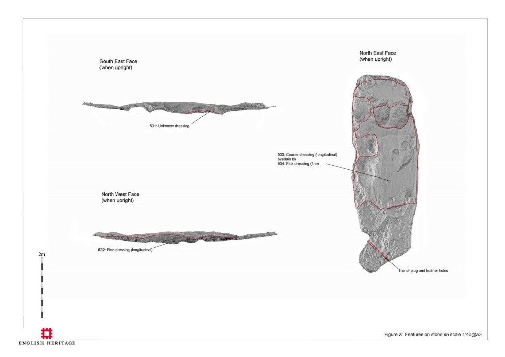
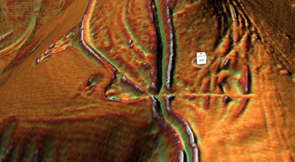
The slaughter stone has always been associated with mythology and speculation. Some say it was where Druids sacrificed bodies to their gods (hence the name); others suggested that it is merely a fallen Sarsen stone that once stood upright as the entrance to the monument. But recent scanning has shown that it was once sculpted to look ’lumpy and ‘rolling’,’ but why?
The Solution
In the centre of the Sarsen circle lies an extraordinary stone – the Altar stone; the reason it’s unique is two-fold. Firstly, it’s made of mica, unlike the other Sarsen standing stones. ‘Hawkins notes that while all the other stones were either bluestone or Sarsen, the so-called altar-stone is ‘of fine-grained pale green sandstone, containing so many flakes of mica that its surface, wherever, wherever it is freshly exposed, shows the typical mica glitter’. The second reason is that it was positioned to be ‘flat’ with the landscape; the only other stone designed in that fashion is the Slaughter Stone.
Unpublished EH scan of the Slaughter Stone – (The Stonehenge Hoax – The Slaughter Stone)
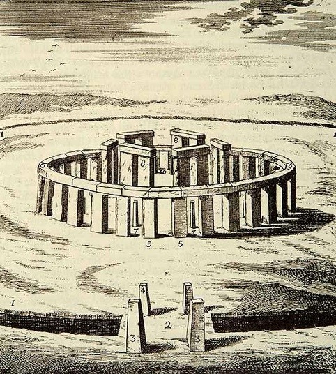
Most archaeologists believe that the Slaughter Stone was once a standing stone at the monument’s entrance; this is a flawed theory resulting from a hypothetical drawing by Inigo Jones in 1655. This drawing shows Stonehenge as a perfect circle (Roman Solar Temple), with a hexagon-shaped trilithon and three entrances into the site, with six upright standing stones serving as access points, one of which was the slaughter stone. This idea was incorporated into John Aubrey’s drawing in 1666, which was more accurate but again tended to place all the fallen stones upright.
This false assumption was further compounded by William Cunning in 1880, when (it was reported) that he suggested his grandfather “saw” the upright slaughter stone in the 17th Century. This mistake was later corrected, yet the myths among archaeologists persist (Stones of Slaughter, E. Herbert Stone, 1924, p. 120). (The Stonehenge Hoax – The Slaughter Stone)
Hypothetical drawing by Inigo Jones in 1655 – (The Stonehenge Hoax – The Slaughter Stone)
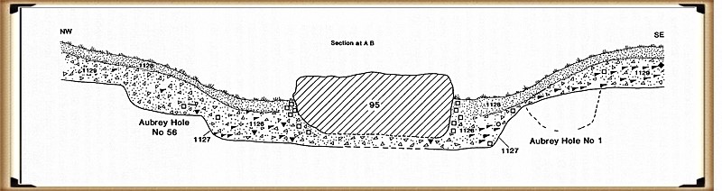
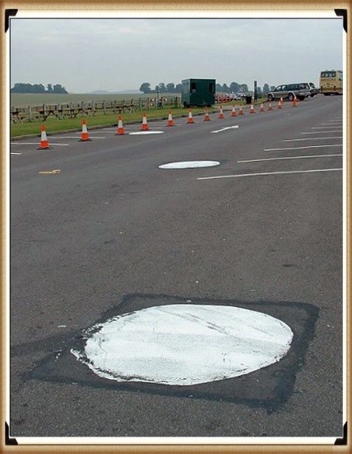
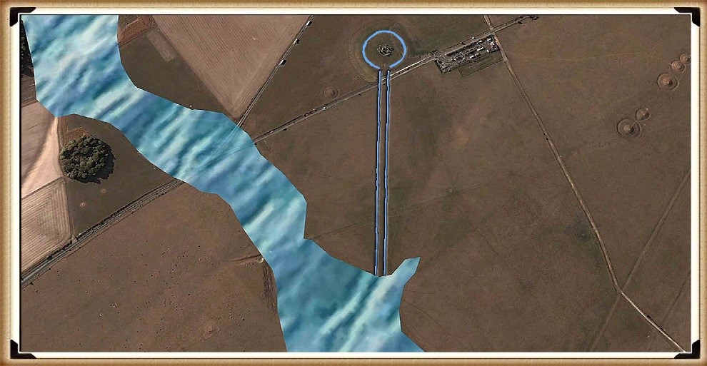
The reality is that the Slaughter Stone was always (like the Altar Stone) a deliberate recumbent, as the excavations of this stone by Hawley and Newall in the 1920s clearly show, as the chalk subsoil was also deliberately flattened before it was placed in its current position. Hawley presumed that the Slaughter Stone was once ‘buried’; this idea is understandable as the stone does lie below the ground level, but what Hawley never understood is that the reason the stone was in this position was for the same reason the ditch was built around Stonehenge, as it was made to be full of water.
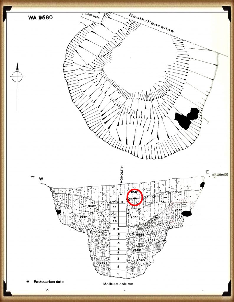
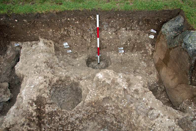
This can be observed by the size of the stone hole called ‘E’ (WA1165), which lies two metres North West of the Slaughter stone but still within the ‘hollow’ that contains the stone. Most stone holes at Stonehenge are relatively shallow – less than a metre in-depth, but stone hole ‘E’ is twice as deep, over 2m. So if the Slaughter stone were placed in it (as the experts have suggested), it would be only 3m high at the surface, compared to 4.57m for the Heel Stone a few yards away.
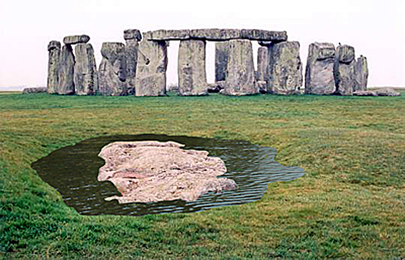
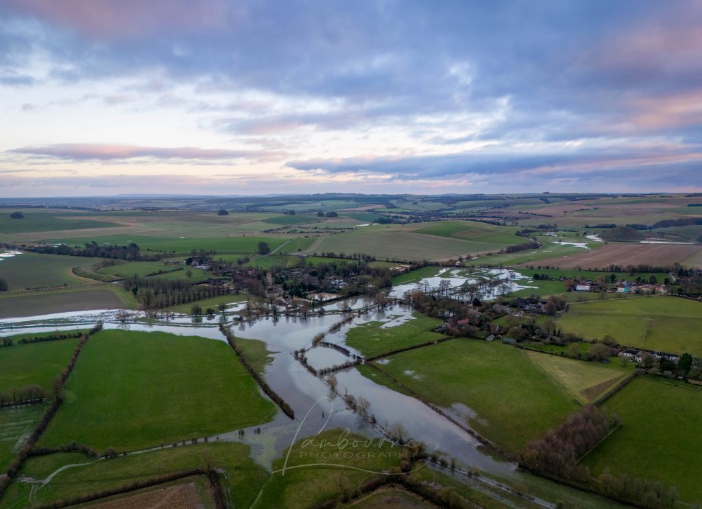
The only other place in Stonehenge with these more massive pits is within the Ditch section surrounding the site, which is the same depth, allowing access to the groundwater levels. In the past, when the Slaughter stone was placed in this ditch, as in the moat, water would have surrounded the stone, making it appear like an island.
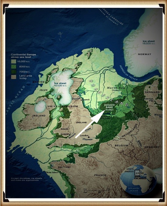
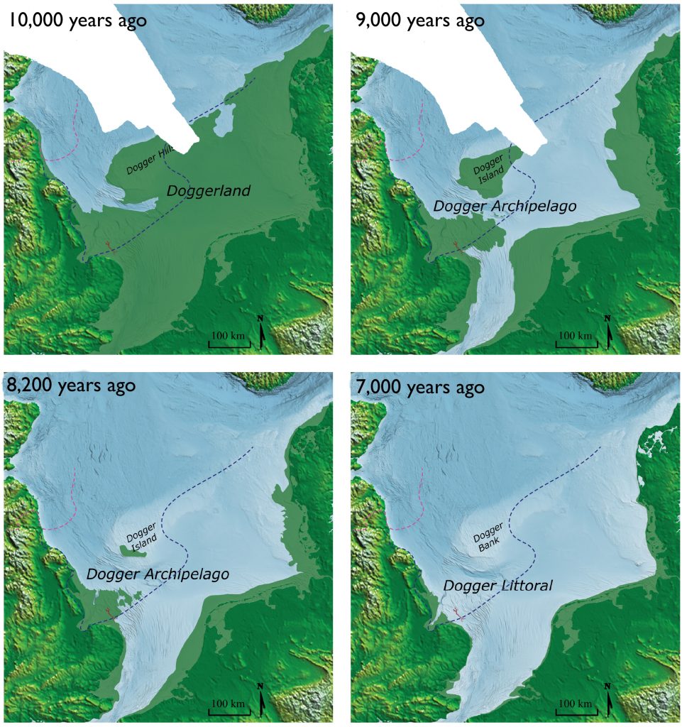
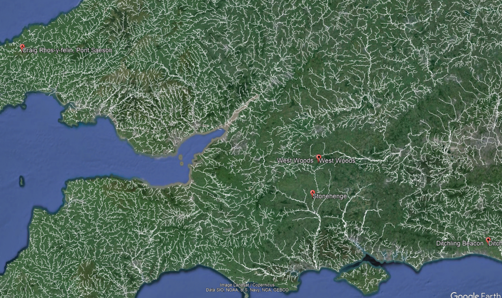
Therefore, what we see today at Stonehenge is a 6,000-year-old relief map of the land the megalithic builders originated from – Doggerland, which now lies below the North Sea.
They created a relief Map of their Island – (The Stonehenge Hoax – The Slaughter Stone)
Not only did they place a 6ft piece of Sarsen stone, flat in a watery ditch, but they also carved out the island’s contours, showing high and low ground, like a contour relief map. Archaeologists have always believed these features were ‘weather-worn’ by age (although the other recumbent stones have not been weathered in the same fashion), but recent laser technology has confirmed our belief that this stone was carved, as the tool marks are still visible at the microscopic level.
Moreover, and more importantly, the stone has been placed in a bizarre position, almost in the way of The Avenue. This shows that this stone and the Avenue have a connection; this type of relationship is seen in association with Egyptian Pyramids, where ‘sight lines’ are cut into the sides of the burial chambers toward important star constellations to show their associations with the Gods.
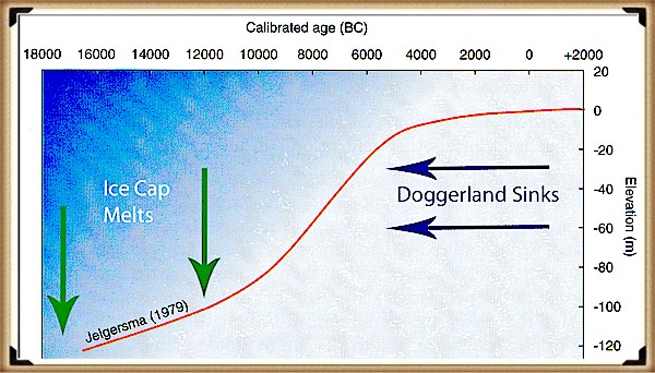
At Stonehenge, the Slaughter Stone and the Avenue are important as they link death with rebirth for this Megalithic Civilisation, for if we look from the Altar stone and follow a line past the Slaughter stone, they make a sight-line, which quite remarkably points directly to their homeland, Doggerland. This was only a small island at the time of the Avenues’ construction in 4100 BCE, but it was constantly shrinking as sea levels (as now) continued to rise. Geologists currently estimate the sinking of Doggerland to have occurred 2,000 years earlier, at 6200 BCE, after finding a Tsunami that would have hit the island at that time.
Moreover, as we have seen in the Indian ocean and Japan – when tsunami’s hit, they do NOT sink the region, sadly, this is just another example of ‘bad science’ within archaeology. We can confirm that Doggerland did not disappear at this stage of history with a bit of simple maths. We know that the island is between 15m and 36m (average 25m) (Wikipedia) under the sea as a sandbank (and hence covered in modern-day wind farms). And we know (from satellites) that the sea rises 3.6mm per annum – consequently, by 4100 BCE it was still 6m above sea level, but probably so small it was uninhabitable.
The Slaughter Stone Points to Doggerland – Enigma V2.0 (2015) page 95 – (The Stonehenge Hoax – The Slaughter Stone)
2026 Update
When I first published The Stonehenge Enigma almost twenty years ago, one of the most controversial suggestions was that the accepted story of Stonehenge’s stones was incomplete. At the time, archaeologists largely confined their search for sources to Wales and southern Britain, while suggestions of much longer-distance transport were routinely dismissed.
Today, the debate looks very different.
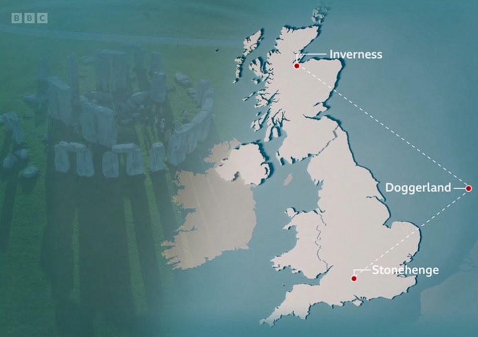
Researchers have now concluded that Stonehenge’s six-tonne Altar Stone most likely originated in north-east Scotland, approximately 700 kilometres from Salisbury Plain. More significantly, the latest peer-reviewed study has examined how such a journey may have been achieved.
According to Dr Anthony Clarke of Curtin University:
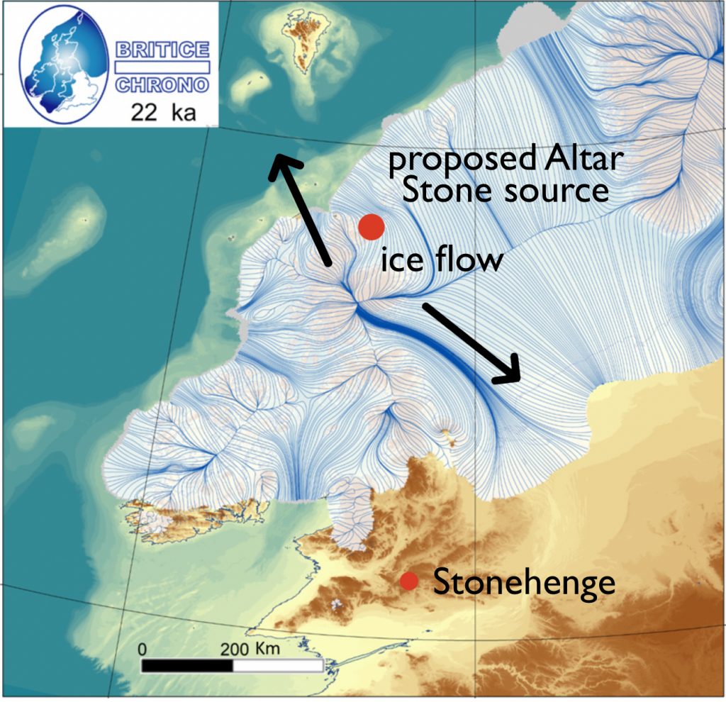
“Our modelling shows glaciers may have transported rocks part of the way during the last Ice Age — potentially as far as Dogger Bank in the North Sea — but not into southern England, meaning the stone would still have needed to be moved hundreds of kilometres by people.”
That statement is remarkable.
For decades, the standard objection to long-distance transport was that prehistoric people simply could not move such massive stones across Britain. The new research reaches the opposite conclusion. Not only was human transport required, but the journey appears to have involved multiple stages, combining overland movement with river and coastal transport.
The paper concludes there were no viable glacial pathways connecting the source region directly to Stonehenge. Human organisation, planning and transport networks were therefore essential.
What makes this particularly interesting is the appearance of Dogger Bank within the discussion.
Dogger Bank occupies the heart of the drowned North Sea landscape known as Doggerland. For years, Doggerland has often been portrayed as little more than a submerged hunting ground. Yet the new study identifies the region as a potential staging point within the wider movement of material from Scotland towards southern Britain.
The Stonehenge Hoax – The Slaughter Stone
In other words, the researchers are now discussing precisely the kind of interconnected landscape that I have been putting forward for nearly twenty years.
The significance of the paper is therefore not simply that the Altar Stone came from Scotland.
The significance is that a peer-reviewed transport model now places Dogger Bank directly into the discussion and confirms that prehistoric communities were capable of moving multi-tonne stones across hundreds of kilometres using a combination of routes and technologies.
Twenty years ago, such ideas were considered pseudoscience or conspiracy theory.
Today, they appear in the scientific literature.
The lesson is simple.
Never underestimate prehistoric people.
The real mystery is not how they moved the stone.
The real mystery is why it took archaeology so long to accept that they could.
The Stonehenge Hoax – The Slaughter Stone
Fast forward to today, and the story has taken a remarkable turn. Advances in geochemical analysis and improved scientific methods have provided new insights into the origin of Stonehenge’s stones, particularly the Altar Stone. Researchers have determined that this unique stone, composed of fine-grained pale green sandstone with a high mica content, does not match the geology of Wales or Cornwall, as once thought. Instead, studies now strongly suggest that it originated in Scotland, a revelation that challenges long-held assumptions and lends credibility to my earlier hypothesis.
The Altar Stone has always been an outlier in terms of its composition. Unlike the bluestones of Preseli or the massive Sarsens from the Marlborough Downs, its distinctive mica-rich material immediately set it apart. Early examinations by archaeologists such as Richard Atkinson noted these differences but lacked the tools to trace their exact origins. It wasn’t until recent years that advanced geochemical fingerprinting techniques were applied, allowing scientists to identify its likely provenance with greater accuracy.
One pivotal breakthrough came in 2016 when researchers conducted isotopic analysis on fragments of the Altar Stone. These tests revealed a chemical composition that closely matched sandstone formations found in southern Scotland. This discovery was groundbreaking, as it opened the door to a broader understanding of how far people in the Neolithic were willing to travel—or trade—to obtain materials for their monumental constructions.
The Stonehenge Hoax – The Slaughter Stone)
In 2020, further studies refined this analysis, narrowing the possible source to the southern uplands of Scotland. However, the exact quarry site remains unknown. This uncertainty stems from a lack of comprehensive geological mapping of underwater sandstone formations along Scotland’s eastern coast. Some experts have speculated that the stone may have been transported via waterways, possibly from a submerged quarry site now lying beneath the North Sea.
This raises intriguing questions about the logistical capabilities of Neolithic societies. How did they transport such a massive stone across hundreds of miles? Did they rely on an extensive network of waterways and seafaring routes, or were the stones traded overland in a series of exchanges between communities? These questions remain unanswered, but they highlight the sophistication of the builders’ organisational and engineering skills.
The story of the Altar Stone also underscores the slow pace of archaeological research. Despite the clear potential for groundbreaking discoveries, investigations into the stone’s origins have been limited by funding constraints and the challenges of underwater archaeology. The sandstone formations off the east coast of Scotland, which could provide definitive answers, have yet to be explored in detail. Without such investigations, the hypothesis that the Altar Stone came from this region remains partially validated but not fully proven.
Interestingly, the Altar Stone’s unique material properties may have held symbolic significance for the builders of Stonehenge. The shimmering mica within the sandstone gives it a luminous quality when freshly exposed, which may have been interpreted as spiritually or ritually important. Its placement at the centre of the Sarsen circle, lying flat rather than upright like the surrounding stones, further suggests it played a central role in the monument’s purpose.
The debate over the Altar Stone’s origin is part of a broader reevaluation of Stonehenge’s construction and function. The monument was interpreted primarily as a solar temple or astronomical observatory for centuries. However, newer theories emphasise its role as a site of cultural and ritual significance, with connections to far-flung regions of the Neolithic world. The diversity of the stones’ origins supports the idea that Stonehenge was not just a local project but a monument with broader regional and possibly even international connections.
The Stonehenge Hoax – The Slaughter Stone)
This evolving understanding of the Altar Stone exemplifies the dynamic nature of archaeology. What was once dismissed as pseudoscience is now recognised as a plausible, even likely, explanation. It also highlights the importance of revisiting old assumptions with new tools and technologies. Had geochemical fingerprinting not been applied, the Altar Stone’s Scottish origin might still be unknown.
The following steps in this journey will likely involve underwater archaeology, a field that has only recently begun to gain traction. As technology improves and funding becomes available, it is hoped that investigations into the submerged sandstone formations along Scotland’s coast will uncover the exact source of the Altar Stone. Such a discovery would not only validate this hypothesis but also shed light on the broader network of trade and communication that existed in Neolithic Britain.
Until then, the story of the Altar Stone remains a testament to the resilience of ideas and science’s slow but steady progress. It serves as a reminder that archaeology, while painstakingly slow, has the power to rewrite our understanding of history. My initial hypothesis, once dismissed, has found a place in the growing body of evidence that challenges traditional narratives about Stonehenge and its builders.
Unearth the Astonishing Secrets of Stonehenge (The Stonehenge Hoax)
Introduction
Video
Synopsys
Stonehenge, a timeless enigma etched in stone and earth, has stood as a formidable puzzle challenging the intellects of archaeologists and historians alike. Despite the myriad attempts, including books, TV programs, and academic conferences, the secrets of these ancient stones and their encircling ditches have proven elusive. Against this backdrop, we scrutinise the existing thirteen hypotheses, each presenting its narrative but collectively lacking a coherent thread.
In adopting the deductive reasoning akin to Sherlock Holmes, we endeavour to weave these disparate threads into a unified tapestry that not only unravels the mystery of Stonehenge but also shakes the foundations of established academic narratives. This intellectual journey may induce some discomfort as we challenge conventional perceptions and invite a reevaluation of our understanding of the past. Apologies are extended in advance for any cognitive dissonance, but the pursuit of truth and reason mandates an unfiltered presentation of the facts.
So, fasten your seatbelts for an expedition into the archaeological unknown.
As we navigate this intellectual rollercoaster, be prepared for a revelation that might reshape our understanding of Stonehenge and question the foundations of our historical narratives. The dawn of a new archaeological era awaits promising insights that could leave even the most curious minds astonished. As we delve into this intellectual rabbit hole, be ready for a revelation that could astonish Alice.
Robert John Langdon (2023) – (The Stonehenge Hoax)
Author’s Biography
Robert John Langdon, a polymathic luminary, emerges as a writer, historian, and eminent specialist in LiDAR Landscape Archaeology.
His intellectual voyage has been interwoven with stints as an astute scrutineer in government and grand corporate bastions, a tapestry spanning British Telecommunications, Cable and Wireless, British Gas, and the esteemed University of London.
A decade hence, Robert’s transition into retirement unfurled a chapter of insatiable curiosity. This phase saw him immerse himself in Politics, Archaeology, Philosophy, and the enigmatic realm of Quantum Mechanics. His academic odyssey traversed the venerable corridors of knowledge hubs such as the Museum of London, University College London, Birkbeck College, The City Literature Institute, and Chichester University.
In the symphony of his life, Robert is a custodian of three progeny and a pair of cherished grandchildren. His sanctuary lies ensconced in the embrace of West Wales, where he inhabits an isolated cottage, its windows framing a vista of the boundless sea – a retreat from the scrutinising gaze of Her Majesty’s Revenue and Customs, an amiable clandestinity in the lap of nature.
Exploring Prehistoric Britain: A Journey Through Time
My blog delves into the fascinating mysteries of prehistoric Britain, challenging conventional narratives and offering fresh perspectives grounded in cutting-edge research, particularly LiDAR technology. I invite you to explore some key areas of my research. For example, the Wansdyke, often cited as a defensive structure, is re-examined in light of new evidence. I’ve presented my findings in my blog post Wansdyke: A British Frontier Wall – ‘Debunked’, and a Wansdyke LiDAR Flyover video further visualises my conclusions.
My work also often challenges established archaeological dogma. I argue that many sites, such as Hambledon Hill, commonly identified as Iron Age hillforts, are not what they seem. My posts Lidar Investigation Hambledon Hill – NOT an ‘Iron Age Fort’ and Unmasking the “Iron Age Hillfort” Myth explore these ideas in detail and offer an alternative view. Similarly, sites like Cissbury Ring and White Sheet Camp receive re-evaluations based on LiDAR analysis in my posts “Lidar Investigation Cissbury Ring through time”and “Lidar Investigation White Sheet Camp,“ revealing fascinating insights into their true purpose. I have also examined South Cadbury Castle, often linked to the mythical Camelot56.
My research also extends to ancient water management, including the role of canals and other linear earthworks. I have discussed the true origins of Car Dyke in multiple posts, including Car Dyke – ABC News Podcast and Lidar Investigation Car Dyke – North Section, which suggest a Mesolithic origin 2357. I also explore the misidentification of Roman aqueducts, as seen in my posts on the Great Chesters (Roman) Aqueduct. My research has also been greatly informed by my post-glacial flooding hypothesis, which has helped explain landscape transformations over time. I have discussed this hypothesis in several posts, including AI now supports my Post-Glacial Flooding Hypothesis and Exploring Britain’s Flooded Past: A Personal Journey
For those interested in British Prehistory, visit www.prehistoric-britain.co.uk, a comprehensive resource featuring an extensive collection of archaeology articles, modern LiDAR investigations, and groundbreaking research. The site also includes insights and excerpts from the acclaimed Robert John Langdon Trilogy, a series of books that explore Britain during the Prehistoric period. Titles in the trilogy include The Stonehenge Enigma, Dawn of the Lost Civilisation, and The Post-Glacial Flooding Hypothesis, which offer compelling evidence of ancient landscapes shaped by post-glacial flooding.
To further explore these topics, Robert John Langdon has developed a dedicated YouTube channel featuring over 100 video documentaries and investigations that complement the trilogy. Notable discoveries and studies showcased on the channel include 13 Things that Don’t Make Sense in History and the revelation of Silbury Avenue – The Lost Stone Avenue, a rediscovered prehistoric feature at Avebury, Wiltshire.
In addition to his main works, Langdon has released a series of shorter, accessible publications, ideal for readers delving into specific topics. These include:
For active discussions and updates on the trilogy’s findings and recent LiDAR investigations, join our vibrant community on Facebook. Engage with like-minded enthusiasts by leaving a message or contributing to debates in our Facebook Group.
Whether through the books, the website, or interactive videos, we aim to provide a deeper understanding of Britain’s fascinating prehistoric past. We encourage you to explore these resources and uncover the mysteries of ancient landscapes through the lens of modern archaeology.
For more information, including chapter extracts and related publications, visit the Robert John Langdon Author Page. Dive into works such as The Stonehenge Enigma or Dawn of the Lost Civilisation, and explore cutting-edge theories that challenge traditional historical narratives.
Were the Constellations Originally a Navigational System?
A Long-Term Research Project for 2026/7
Introduction
For thousands of years, humanity has looked upward and seen stories written in the stars.
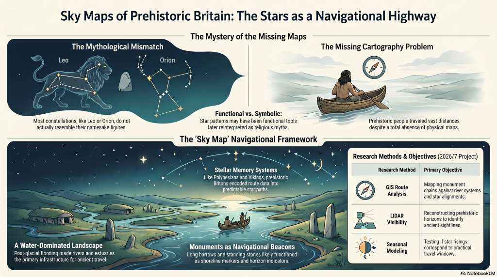
Ancient cultures named constellations after animals, heroes, gods, monsters, hunters and mythical creatures. Archaeologists and historians generally assume these star patterns were primarily symbolic, religious, or mythological in nature. (Sky Maps of Prehistoric Britain)
But there is a major problem.
Most constellations do not actually resemble the creatures they supposedly represent.
The Great Bear resembles neither a bear nor a wagon. Orion does not resemble a hunter. Leo looks nothing like a lion. Draco barely resembles a dragon.
In many cases, the supposed shapes appear forced, inconsistent, or entirely dependent on later artistic interpretation.
This raises an important question:
What if the original purpose of many stellar patterns was not mythology at all?
What if they were functional?
More specifically:
What if ancient star systems originally formed part of a navigational framework used by an early maritime civilisation operating across the flooded landscapes of post-glacial Europe?
This article outlines a new long-term research project planned for 2026, investigating whether the stars themselves may once have formed part of an integrated navigational system connected to prehistoric waterways, coastlines, monuments, and seasonal movement.
The purpose of this project is not to make unsupported claims, but to establish whether this idea can be scientifically investigated using measurable evidence.
(Sky Maps of Prehistoric Britain)
The Foundation of the Hypothesis
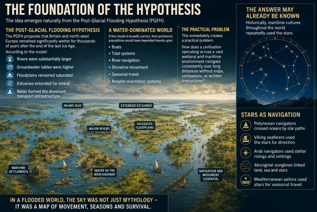
The idea emerges naturally from the Post-Glacial Flooding Hypothesis (PGFH).
The PGFH proposes that Britain and north-west Europe remained significantly wetter for thousands of years after the end of the last Ice Age.
According to the model:
rivers were substantially larger,
groundwater tables were higher,
floodplains remained saturated,
estuaries extended far inland,
and water formed the dominant transport infrastructure.
If this model is broadly correct, then prehistoric populations would have depended heavily upon:
boats,
tidal systems,
river navigation,
shoreline movement,
seasonal travel,
and reliable orientation systems.
This immediately creates a practical problem.
How does a civilisation operating across a vast wetland and maritime environment navigate consistently over long distances without maps, compasses, or written instructions?
The answer may already be known.
Historically, maritime cultures throughout the world repeatedly used the stars.
(Sky Maps of Prehistoric Britain)
The Stars as Navigation
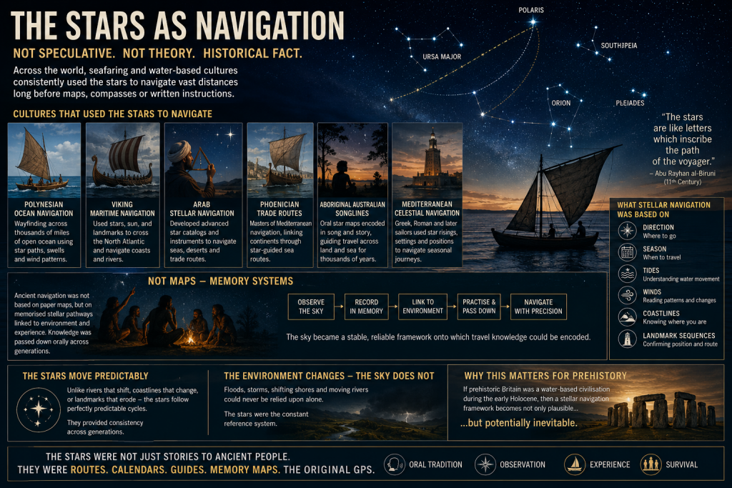
The use of stars for navigation is not speculative. It is a historical fact.
Examples include:
Polynesian ocean navigation
Viking maritime navigation
Arab stellar navigation
Phoenician trade routes
Aboriginal Australian songlines
Mediterranean celestial navigation
In many cases, navigation was not based on maps in the modern sense, but on memorised stellar pathways tied to:
direction,
season,
tides,
winds,
coastlines,
and landmark sequences.
This is critical.
Ancient navigation often functioned as a memory system.
The sky became a stable framework onto which travel knowledge could be encoded.
Unlike coastlines or rivers, the stars moved predictably. They provided consistency across generations.
If prehistoric Britain operated as a water-based civilisation during the early Holocene, then a stellar navigation framework becomes not only plausible, but potentially inevitable.
(Sky Maps of Prehistoric Britain)
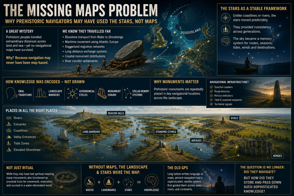
The Missing Maps Problem
One of the great mysteries of prehistoric maritime movement is the apparent absence of navigational maps.
We know prehistoric populations travelled extraordinary distances.
Examples include:
Bluestone transport from Wales to Stonehenge
Maritime movement along Atlantic Europe
Doggerland migration networks
Long-distance exchange systems
Coastal monument distributions
River corridor settlements
Yet no conventional cartographic systems survive.
This may be because navigation itself was never primarily map-based.
Instead, route knowledge may have been embedded within:
oral traditions,
landscape markers,
astronomical cycles,
monument chains,
and stellar memory systems.
This possibility becomes especially interesting when viewed alongside the repeated placement of prehistoric monuments near:
rivers,
estuaries,
coastlines,
valley entrances,
tidal zones,
and elevated shoreline positions.
Long barrows, standing stones, beacon hills, avenues, dykes, and henges may not simply represent ritual locations.
Some may have functioned as navigational infrastructure.
(Sky Maps of Prehistoric Britain)
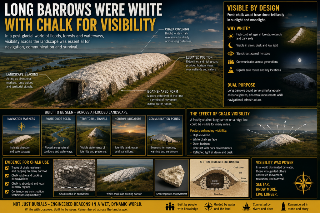
Long Barrows and Landscape Markers
One of the most intriguing aspects of prehistoric Britain is the repeated positioning of monuments along visible movement corridors.
Long barrows in particular often occupy:
ridge lines,
valley edges,
coastal approaches,
elevated viewpoints,
or route intersections.
Traditionally, these sites are interpreted almost exclusively through ritual or funerary frameworks.
But there is another possibility.
In a landscape dominated by wetlands and waterways, elevated monuments would naturally function as:
directional markers,
navigation points,
horizon indicators,
territorial signals,
or route beacons.
This does not exclude symbolic meaning.
The same structure can serve both practical and cultural purposes simultaneously.
Indeed, this dual-function model is common throughout human history.
Church towers, lighthouses, harbour beacons, hill forts, and even modern skyscrapers operate as both symbols and navigational markers.
The same may have applied in prehistory.
(Sky Maps of Prehistoric Britain)
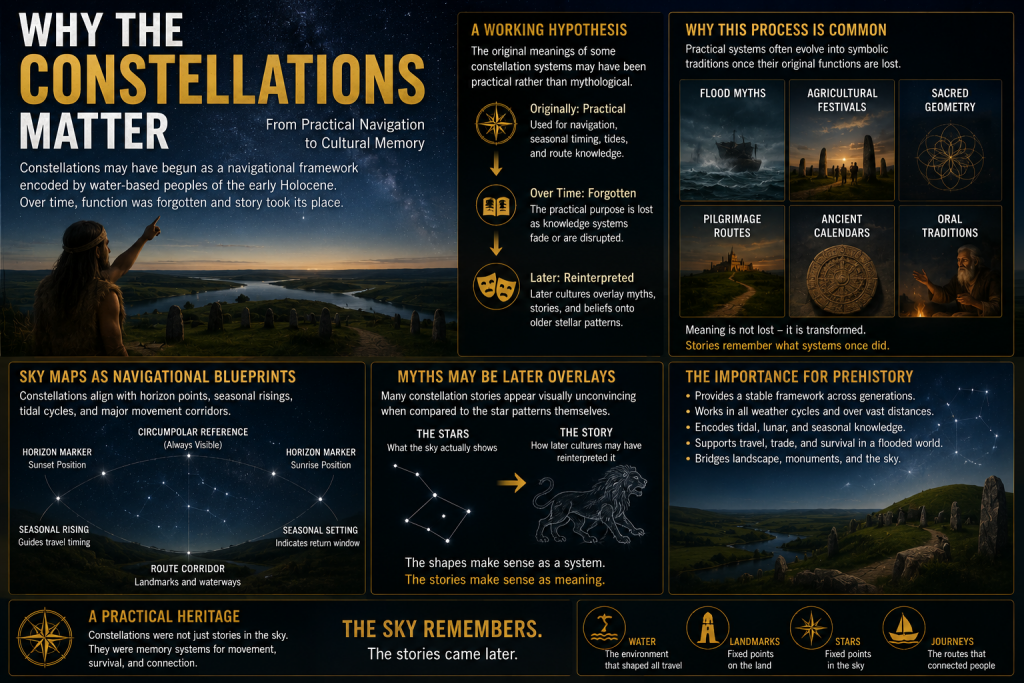
Why the Constellations Matter
The more complex question is whether the constellations themselves formed part of this navigational architecture.
This project proposes a cautious working hypothesis:
The original meanings of some constellation systems may have been practical rather than mythological.
Over time, as the original navigational framework was forgotten, later cultures may have reinterpreted older stellar systems through:
mythology,
religion,
folklore,
and storytelling.
This process is not unusual.
Throughout history, practical systems often evolve into symbolic traditions once their original functions are lost.
Examples include:
flood myths,
agricultural festivals,
sacred geometry,
pilgrimage routes,
and ancient calendrical systems.
The same process may explain why many modern constellation interpretations appear visually unconvincing.
The animals and heroes may represent later narrative overlays applied onto much older orientation frameworks.
(Sky Maps of Prehistoric Britain)
Current Evidence Supporting the Idea
At present, there is no direct proof that constellations encoded prehistoric navigation routes.
However, several independent lines of evidence support the broader possibility.
1. Proven Stellar Navigation in Ancient Cultures
The use of stars for navigation is universally documented.
This establishes that:
stars can encode movement systems,
oral navigation is possible,
and complex route memory can operate without maps.
2. Water-Dominated Early Holocene Landscapes
The PGFH and associated geological evidence suggest:
extensive wetlands,
enlarged river systems,
inland tidal environments,
and maritime dependency.
Such environments strongly favour navigation-based societies.
3. Monument Distribution Along Water Systems
Many prehistoric sites cluster around:
rivers,
floodplains,
estuaries,
coastal corridors,
and elevated shoreline terrain.
This pattern is more consistent with movement infrastructure than isolated ritual placement.
4. Horizon Astronomy in Prehistory
Prehistoric societies demonstrably tracked:
solar cycles,
lunar cycles,
solstices,
equinoxes,
and horizon alignments.
Once astronomical observation is accepted, the application to navigation becomes entirely plausible.
5. Seasonal Movement Systems
Maritime societies depend upon predictable seasonal timing.
Stars naturally provide:
seasonal indicators,
directional consistency,
and long-distance orientation.
6. Ethnographic Parallels
Multiple indigenous cultures linked:
landscape movement,
memory systems,
navigation,
and stars.
This provides real-world functional parallels.
What This Project Will Attempt to Test
The 2026 project will focus on measurable and testable questions rather than speculation.
Key research areas include:
GIS Route Analysis
Testing whether:
monument chains,
river systems,
long barrows,
beacon hills,
and prehistoric movement corridors
show statistically significant astronomical relationships.
Seasonal Navigation Modelling
Investigating whether:
key stars,
heliacal risings,
lunar cycles,
or stellar azimuths
correspond to practical travel windows within prehistoric water systems.
Horizon Visibility Studies
Using LiDAR and digital terrain models to reconstruct:
prehistoric horizons,
sightlines,
beacon visibility,
and navigational marker ranges.
Maritime Route Reconstruction
Reconstructing:
post-glacial coastlines,
flooded valleys,
inland estuaries,
and navigable river systems.
The aim is to determine whether major monuments occupy logical positions within ancient transport networks.
Statistical Testing
This is essential.
Any proposed alignment or pattern must be tested against random distributions.
Without statistical controls, pattern recognition rapidly becomes subjective.
The project, therefore, intends to:
establish falsifiable criteria,
use control datasets,
compare against random models,
and avoid arbitrary alignment selection.
What This Project Is NOT Claiming
This research does not claim:
that every constellation is a map,
that mythology is irrelevant,
or that all prehistoric monuments were navigational.
Nor does it claim direct proof already exists.
Instead, the project asks a more careful scientific question:
Could an aquatic civilisation operating across flooded post-glacial landscapes have encoded navigational knowledge into stable stellar frameworks?
At present, the answer appears plausible.
Whether it is correct remains to be tested.
Why This Matters
If even part of this hypothesis proves correct, the implications would be profound.
It would suggest that:
prehistoric Britain possessed far more advanced navigational systems than traditionally assumed,
monuments may have functioned as infrastructure as well as symbolism,
astronomy was practical rather than purely ceremonial,
and early maritime societies may have operated sophisticated memory-based route systems long before formal cartography.
Most importantly, it would further support the emerging picture of a civilisation shaped not by isolated ritual sites, but by movement, water, navigation, and environmental adaptation.
In short:
The stars may not simply have inspired prehistoric civilisation.
They may have guided it.
Future Research Updates
This article represents the beginning of a long-term research project planned for 2026.
Future work will include:
GIS modelling
Hydrological reconstruction
Stellar simulation analysis
Monument alignment databases
Statistical testing
Maritime route reconstruction
LiDAR visibility studies
Ethnographic comparison
Updates will be published through:
Prehistoric Britain
and associated research publications.
Final Thought
Modern civilisation separates:
astronomy,
geography,
navigation,
religion,
engineering,
and landscape.
Prehistoric societies may not have.
For people living in a flooded world of rivers, marshes, estuaries, tides, and coastlines, the sky itself may have functioned as the oldest navigation system humanity ever created.
And perhaps, hidden within the stars, fragments of those ancient water routes still remain.
PODCAST
Author’s Biography
Robert John Langdon, a polymathic luminary, emerges as a writer, historian, and eminent specialist in LiDAR Landscape Archaeology.
His intellectual voyage has been interwoven with stints as an astute scrutineer in government and grand corporate bastions, a tapestry spanning British Telecommunications, Cable and Wireless, British Gas, and the esteemed University of London.
A decade hence, Robert’s transition into retirement unfurled a chapter of insatiable curiosity. This phase saw him immerse himself in Politics, Archaeology, Philosophy, and the enigmatic realm of Quantum Mechanics. His academic odyssey traversed the venerable corridors of knowledge hubs such as the Museum of London, University College London, Birkbeck College, The City Literature Institute, and Chichester University.
In the symphony of his life, Robert is a custodian of three progeny and a pair of cherished grandchildren. His sanctuary lies ensconced in the embrace of West Wales, where he inhabits an isolated cottage, its windows framing a vista of the boundless sea – a retreat from the scrutinising gaze of Her Majesty’s Revenue and Customs, an amiable clandestinity in the lap of nature.
Exploring Prehistoric Britain: A Journey Through Time
My blog delves into the fascinating mysteries of prehistoric Britain, challenging conventional narratives and offering fresh perspectives grounded in cutting-edge research, particularly LiDAR technology. I invite you to explore some key areas of my research. For example, the Wansdyke, often cited as a defensive structure, is re-examined in light of new evidence. I’ve presented my findings in my blog post Wansdyke: A British Frontier Wall – ‘Debunked’, and a Wansdyke LiDAR Flyover video further visualises my conclusions.
My work also often challenges established archaeological dogma. I argue that many sites, such as Hambledon Hill, commonly identified as Iron Age hillforts, are not what they seem. My posts Lidar Investigation Hambledon Hill – NOT an ‘Iron Age Fort’ and Unmasking the “Iron Age Hillfort” Myth explore these ideas in detail and offer an alternative view. Similarly, sites like Cissbury Ring and White Sheet Camp receive re-evaluations based on LiDAR analysis in my posts “Lidar Investigation Cissbury Ring through time”and “Lidar Investigation White Sheet Camp,“ revealing fascinating insights into their true purpose. I have also examined South Cadbury Castle, often linked to the mythical Camelot56.
My research also extends to ancient water management, including the role of canals and other linear earthworks. I have discussed the true origins of Car Dyke in multiple posts, including Car Dyke – ABC News Podcast and Lidar Investigation Car Dyke – North Section, which suggest a Mesolithic origin 2357. I also explore the misidentification of Roman aqueducts, as seen in my posts on the Great Chesters (Roman) Aqueduct. My research has also been greatly informed by my post-glacial flooding hypothesis, which has helped explain landscape transformations over time. I have discussed this hypothesis in several posts, including AI now supports my Post-Glacial Flooding Hypothesis and Exploring Britain’s Flooded Past: A Personal Journey
For those interested in British Prehistory, visit www.prehistoric-britain.co.uk, a comprehensive resource featuring an extensive collection of archaeology articles, modern LiDAR investigations, and groundbreaking research. The site also includes insights and excerpts from the acclaimed Robert John Langdon Trilogy, a series of books that explore Britain during the Prehistoric period. Titles in the trilogy include The Stonehenge Enigma, Dawn of the Lost Civilisation, and The Post-Glacial Flooding Hypothesis, which offer compelling evidence of ancient landscapes shaped by post-glacial flooding.
To further explore these topics, Robert John Langdon has developed a dedicated YouTube channel featuring over 100 video documentaries and investigations that complement the trilogy. Notable discoveries and studies showcased on the channel include 13 Things that Don’t Make Sense in History and the revelation of Silbury Avenue – The Lost Stone Avenue, a rediscovered prehistoric feature at Avebury, Wiltshire.
In addition to his main works, Langdon has released a series of shorter, accessible publications, ideal for readers delving into specific topics. These include:
For active discussions and updates on the trilogy’s findings and recent LiDAR investigations, join our vibrant community on Facebook. Engage with like-minded enthusiasts by leaving a message or contributing to debates in our Facebook Group.
Whether through the books, the website, or interactive videos, we aim to provide a deeper understanding of Britain’s fascinating prehistoric past. We encourage you to explore these resources and uncover the mysteries of ancient landscapes through the lens of modern archaeology.
For more information, including chapter extracts and related publications, visit the Robert John Langdon Author Page. Dive into works such as The Stonehenge Enigma or Dawn of the Lost Civilisation, and explore cutting-edge theories that challenge traditional historical narratives.
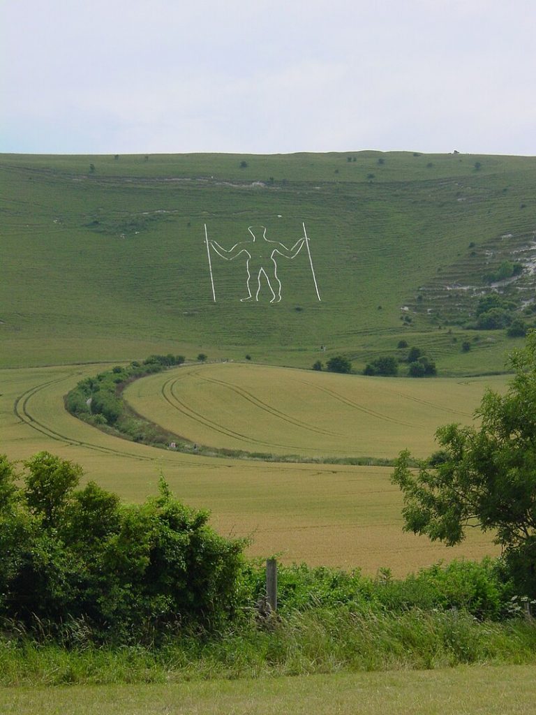
In a recent instalment of Digging for Britain, Alice Roberts stirred the archaeological debate by asserting that the Dorset Chalk Giant at Cerne Abbas had Saxon origins rather than prehistoric roots. This added a layer of intrigue, especially from a landscape archaeology perspective. At first glance, the giant’s features appear to echo a much earlier connection, reminiscent of other chalk figures found elsewhere in Britain, where their placement within the landscape suggests a deeper, functional context.
Curiosity led to a closer look at the methods used to date this iconic figure, and the findings raise several important questions. While the programme presents a clear and confident conclusion, a deeper inspection reveals fundamental issues and omissions that call into question its reliability. This is not just about one site but about broader methodological problems in archaeology, particularly the uncritical acceptance of dating approaches that underpin many historical assumptions.
Small trenches for dating evidence
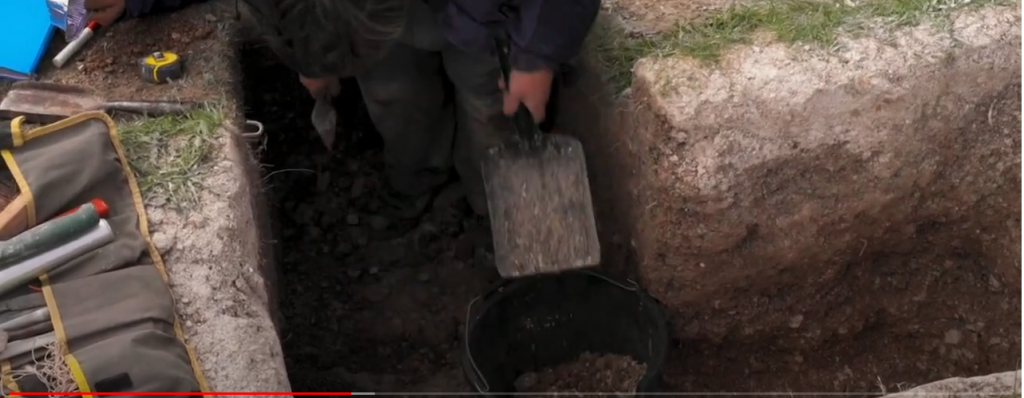
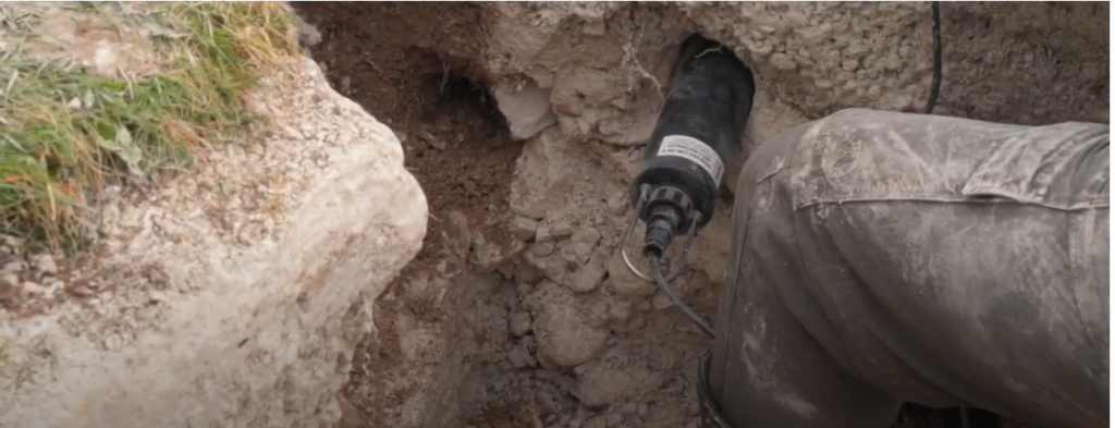
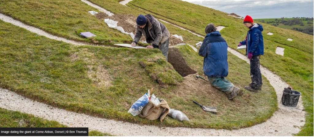
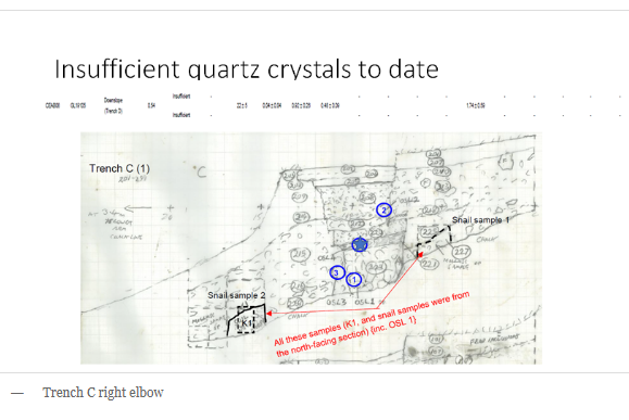
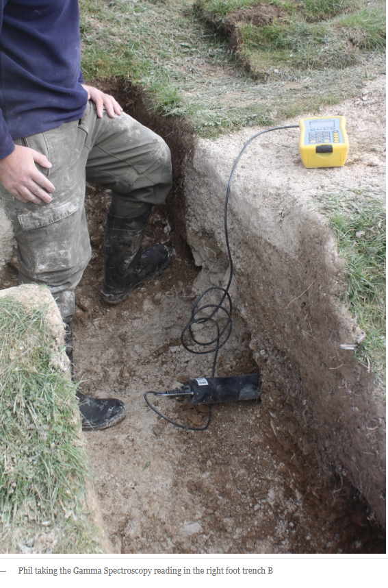
The primary technique involved excavating four small trenches and penetrating approximately 1 m into the topsoil to extract samples. The underlying assumption is that the surface beneath the chalk line represents the original ground level and therefore provides the latest possible date for the figure’s creation. While the theory itself is not unreasonable, the reliance on just four sampling points raises serious concerns about the representativeness of the results.
To fully support such a method, variations across the entire area beneath the figure would need to be taken into account. Limited sampling introduces the risk of missing key variations in the soil and sediment, which could significantly alter the dating outcome. Scientific investigation depends on comprehensive data, and without it, conclusions remain open to question.
Snail used to date the chalk figuare
In addition, the programme does not fully explore alternative interpretations or the potential impact of environmental processes on the site. This becomes particularly important when considering evidence from other studies, in which larger datasets have shown a wide range of dates from similar contexts. In one such case, forty-two samples produced dates ranging from the ninth millennium BCE through to the historic period, yet only a subset was used to support the final interpretation. This raises an obvious question about the selection and exclusion of data.
The reliance on a very small number of samples for OSL dating introduces a substantial margin of uncertainty. Across a large area such as this, variation is expected. With such limited data, the resulting data range cannot be considered definitive. The methodology, including how samples are collected and interpreted, does not meet the level of precision expected in modern scientific analysis.
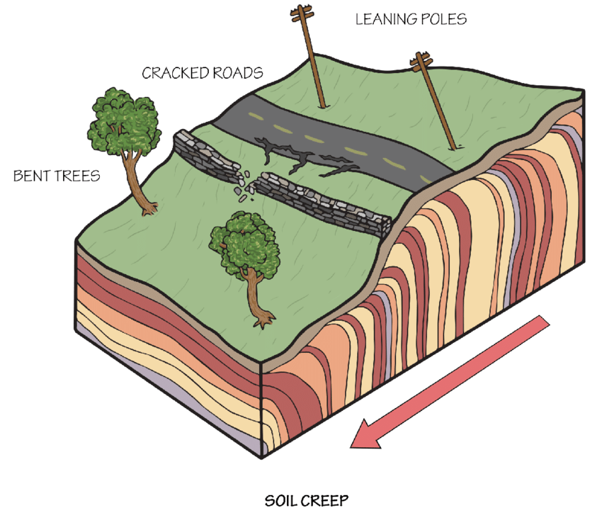
There is also a fundamental geological factor that appears to have been overlooked. The site sits on a steep slope, where soil creep is an ongoing process. Even at a conservative rate, soil can move approximately one metre over a thousand years. This means that materials such as snails and sediments beneath the figure are not necessarily in their original position. Over long periods, they can be displaced downslope, disconnecting them from the original context to which they were dated.
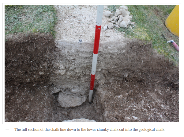
The physical construction of the figure itself also raises questions. The current form sits within topsoil rather than being cut directly into the underlying chalk bedrock. From a practical perspective, a prehistoric construction would be more logically cut into solid chalk to ensure durability and reduce maintenance needs. The fact that the figure requires ongoing upkeep suggests a different history, potentially involving phases of covering and reworking.
Historical accounts suggest that subsequent activity may have altered or preserved the figure, raising the possibility that what is visible today is not the original construction. This opens the question of whether an earlier figure existed beneath the current one, potentially modified or replaced at a later date.
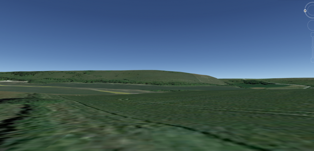
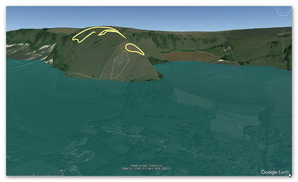
The landscape context adds further complexity. The figure is positioned at the edge of a range of hills rather than at its highest point, and its full form is clearly visible only from elevated viewpoints. This challenges the idea of it functioning as a simple ground-level marker and instead suggests that its placement may relate to a broader landscape system that is no longer immediately visible.
When all of these factors are considered together, the conclusion presented in the programme appears far less certain than initially suggested. The evidence does not point to a simple, single-phase construction, but rather to a more complex history influenced by geological processes, environmental change, and possible later modification.
Archaeological interpretation must remain grounded in robust, testable methods. When conclusions rely on limited data, untested assumptions, or incomplete consideration of environmental factors, they risk presenting certainty where uncertainty remains.
The current Figuare sits on top of the soil with broken chalk that needs constant maintenance
The Dorset Chalk Giant is not a straightforward case. It is a reminder that understanding the past requires not just data, but careful evaluation of how that data is gathered, interpreted, and applied.
The next stage of analysis will examine the wider landscape using LiDAR data, with the aim of reconstructing how this site functioned in a prehistoric environment and what it may originally have represented.
The Giant is to the far right of the Hill Range and near the bottom – why not at the top of the middle if it’s a marker?
Part 2
Now, in this second part, our focus shifts to the professionalism of archaeologists involved in such endeavours and, by extension, the broader state of the archaeological profession in the 21st century. A critical lens is turned towards the National Trust’s excavation efforts, particularly the four trenches dedicated to OSL dating. Despite the extensive timeframe of over two years for this undertaking, the conspicuous absence of an official report raises concerns about transparency and the ability of other knowledgeable individuals to conduct scrutiny. This delay in producing and sharing findings with the wider community calls into question the efficiency and accessibility of archaeological information.
The quality of documentation further comes into question, as hand-drawn cross-sections, seemingly rushed and lacking the meticulous detail expected in rigorous scientific practices, were presented. This not only reveals an apparent ‘back of an envelope’ approach but also underscores a profound oversight by the experts. Despite having two years for scrutiny and examination, critical questions were left unexplored, a shortcoming magnified by the collaboration with the BBC for the televised program.
Digging for Britain Debunked – Cerne Abbas
Cerne Abbas
The absence of a comprehensive and timely report, coupled with the apparent lack of attention to detail in documentation, casts doubt on the thoroughness and professionalism of the archaeological efforts surrounding Cerne Abbas. The urgency to present findings to the media and create a documentary may have compromised the meticulousness required in archaeological endeavours.
This prompts a broader reflection on the state of the archaeological profession itself. The slow pace of report publication, potential gaps in expertise, and a seeming reluctance to subject findings to rigorous scrutiny raise concerns about the discipline’s agility and accountability in contemporary times.
The deficiencies in the excavation process around Cerne Abbas become more apparent when we scrutinise the placement of the trenches and the sampling locations. The hand-drawn illustrations (which I consider ‘outdated’ in an era of affordable, widely available 3D high-definition cameras) indicate that samples were taken from the topsoil just above the chalk bedrock. However, a photograph reveals a more accurate location at the bottom of the topsoil, near the chalk bedrock, leading to the conclusion that it is Saxon.
Poor Conclusions
A critical oversight emerges when we consider the implications of the Saxon date. If accurate, the absence of topsoil dating back thousands of years raises intriguing questions. Three plausible scenarios are explored: the deliberate removal of soil before the construction of Cerne Abbas, the initial absence of soil, or inaccuracies in OSL dating.
Option one, soil removal, implies an intention to obliterate what was originally present, raising logistical questions about the necessity for such an extensive process compared to the simplicity of laying new lines on existing chalk.
Option two speculates on the absence of soil due to something atop the bedrock, a theory we will delve into further.
Option three questions the accuracy of OSL dates, which, if proven, could cast doubt on the entire OSL science.
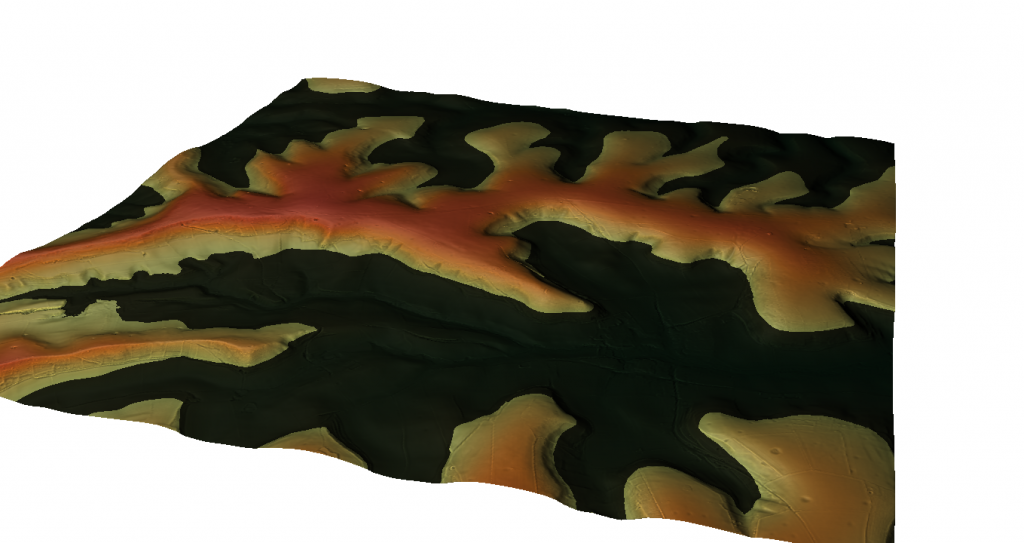
Option two gains credence when exploring the Post-Glacial Hypothesis, which is grounded in the notion of elevated sea levels in prehistoric times. LiDAR imagery of the site reveals a landscape shaped by Mesolithic waters, with identified natural harbours and Neolithic camps indicating the higher historical river levels. Archaeological findings, including tools and earthworks, support the hypothesis that the river running parallel to the figure was significantly higher during the Neolithic period.
Mesolithic Coastline – Digging for Britain Debunked – Cerne Abbas
Prehistoric Landscape
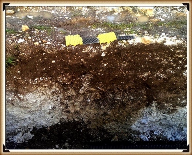
This scenario accounts for approximately 7,000 years with no topsoil in the figure. Examining the bedrock reveals signs of extensive water weathering, consistent with chalk erosion over thousands of years. The excavation report and photographs reveal broken chalk at the base of the topsoil, indicating water-induced erosion and redeposition. The darkened appearance, a result of drying after being broken and re-laid on top, mirrors the common impact of water on solid chalk.
Digging for Britain Debunked – Cerne Abbas
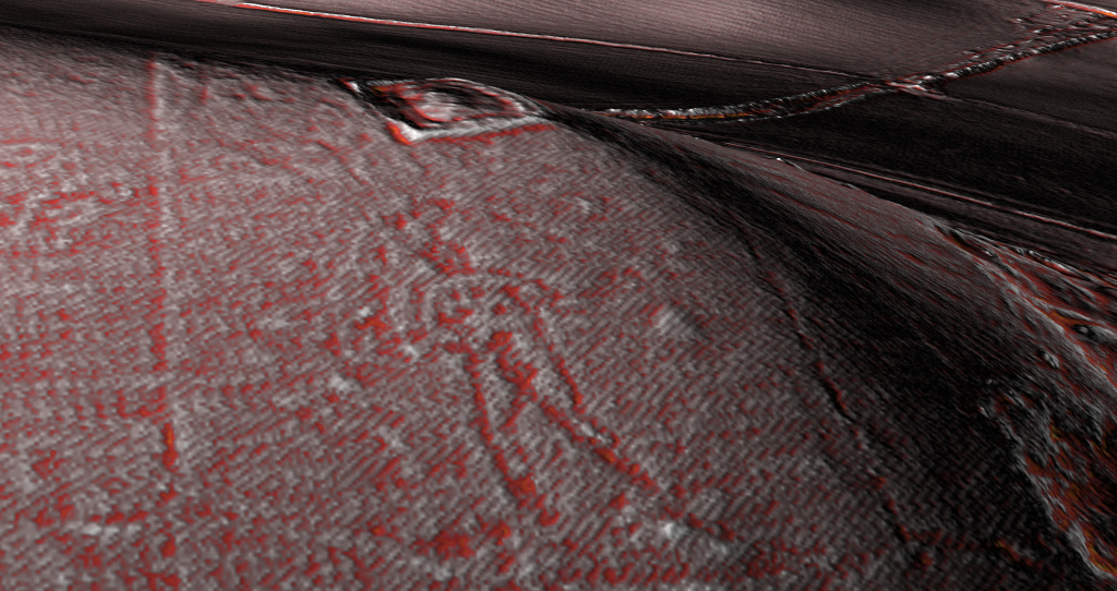
Further evidence points to Post-Glacial Flooding and a Neolithic origin of the figure, which strategically marks the entrance to the harbour. LiDAR maps suggest a man balancing a load on his shoulders or head, potentially representing a trading centre surrounded by quarries and mining pits.
Lidar showing the deep chalk cuttings – Digging for Britain Debunked – Cerne AbbasOriginal Cerne Abbas figure according to AI – Digging for Britain Debunked – Cerne Abbas
The intricacies of Cerne Abbas, when viewed through the lens of geological processes and archaeological evidence, unfold a narrative of ancient landscapes shaped by water, a figure emerging from millennia of erosion, and a Neolithic trading hub leaving its mark on the chalky canvas of history.
Long Man of Wilmington
NB. The findings at The Long Man of Wilmington by Prof. Martin Bell show very similar findings and geology as Cerne Abbas –
“Our method was to machine cut a trench at the base of the slope to look at the sediment sequence, then carefully hand excavate an adjoining strip, recording in three dimensions the positions of all artefacts, no matter how modern, in order to date each layer.
At the base of our trench, there were chalk meltwater muds from a time of rapid physical weathering at the end of the last Ice Age. Above these were bowl-shaped features, perhaps tree-throw pits, because they contained land snails from woodland habitats, indicating that this part of the slope had been wooded earlier in the Postglacial. They also contained some flint flakes, so they could be archaeological features.
Over this was a buried soil. Ed Rhodes, formerly of the Research Laboratory for Archaeology at Oxford, now of the Australian National University, has used OSL to date this soil to the mid-2nd millennium BC. The snails show that by this time, the landscape was open. Later in the Bronze Age, the soil was buried by more soil derived from cultivation at the base of the slope. Snails show that the escarpment above was grassland. Many sites on the South Downs show evidence for quite extensive Bronze Age soil erosion. Bronze Age and Neolithic pottery and flints from the basal soil and the colluvium indicate that a settlement was nearby.”
They called the broken chalk we saw in these excavations ‘chalk meltwater muds’, and he is correct, but this kind of deposit can only be produced by thousands of years of water erosion, not a couple of hundred, and his OSL dates confirm this, as just above this level is an OSL date of 2,000 BCE. We have 8,000 years of topsoil missing as the site, like Carne Abbass, was covered with river water, creating another natural harbour – and would you believe it – it also has a Neolithic.
PODCAST
Author’s Biography
Robert John Langdon, a polymathic luminary, emerges as a writer, historian, and eminent specialist in LiDAR Landscape Archaeology.
His intellectual voyage has been interwoven with stints as an astute scrutineer in government and grand corporate bastions, a tapestry spanning British Telecommunications, Cable and Wireless, British Gas, and the esteemed University of London.
A decade hence, Robert’s transition into retirement unfurled a chapter of insatiable curiosity. This phase saw him immerse himself in Politics, Archaeology, Philosophy, and the enigmatic realm of Quantum Mechanics. His academic odyssey traversed the venerable corridors of knowledge hubs such as the Museum of London, University College London, Birkbeck College, The City Literature Institute, and Chichester University.
In the symphony of his life, Robert is a custodian of three progeny and a pair of cherished grandchildren. His sanctuary lies ensconced in the embrace of West Wales, where he inhabits an isolated cottage, its windows framing a vista of the boundless sea – a retreat from the scrutinising gaze of Her Majesty’s Revenue and Customs, an amiable clandestinity in the lap of nature.
Exploring Prehistoric Britain: A Journey Through Time
My blog delves into the fascinating mysteries of prehistoric Britain, challenging conventional narratives and offering fresh perspectives grounded in cutting-edge research, particularly LiDAR technology. I invite you to explore some key areas of my research. For example, the Wansdyke, often cited as a defensive structure, is re-examined in light of new evidence. I’ve presented my findings in my blog post Wansdyke: A British Frontier Wall – ‘Debunked’, and a Wansdyke LiDAR Flyover video further visualises my conclusions.
My work also often challenges established archaeological dogma. I argue that many sites, such as Hambledon Hill, commonly identified as Iron Age hillforts, are not what they seem. My posts Lidar Investigation Hambledon Hill – NOT an ‘Iron Age Fort’ and Unmasking the “Iron Age Hillfort” Myth explore these ideas in detail and offer an alternative view. Similarly, sites like Cissbury Ring and White Sheet Camp receive re-evaluations based on LiDAR analysis in my posts “Lidar Investigation Cissbury Ring through time”and “Lidar Investigation White Sheet Camp,“ revealing fascinating insights into their true purpose. I have also examined South Cadbury Castle, often linked to the mythical Camelot56.
My research also extends to ancient water management, including the role of canals and other linear earthworks. I have discussed the true origins of Car Dyke in multiple posts, including Car Dyke – ABC News Podcast and Lidar Investigation Car Dyke – North Section, which suggest a Mesolithic origin 2357. I also explore the misidentification of Roman aqueducts, as seen in my posts on the Great Chesters (Roman) Aqueduct. My research has also been greatly informed by my post-glacial flooding hypothesis, which has helped explain landscape transformations over time. I have discussed this hypothesis in several posts, including AI now supports my Post-Glacial Flooding Hypothesis and Exploring Britain’s Flooded Past: A Personal Journey
For those interested in British Prehistory, visit www.prehistoric-britain.co.uk, a comprehensive resource featuring an extensive collection of archaeology articles, modern LiDAR investigations, and groundbreaking research. The site also includes insights and excerpts from the acclaimed Robert John Langdon Trilogy, a series of books that explore Britain during the Prehistoric period. Titles in the trilogy include The Stonehenge Enigma, Dawn of the Lost Civilisation, and The Post-Glacial Flooding Hypothesis, which offer compelling evidence of ancient landscapes shaped by post-glacial flooding.
To further explore these topics, Robert John Langdon has developed a dedicated YouTube channel featuring over 100 video documentaries and investigations that complement the trilogy. Notable discoveries and studies showcased on the channel include 13 Things that Don’t Make Sense in History and the revelation of Silbury Avenue – The Lost Stone Avenue, a rediscovered prehistoric feature at Avebury, Wiltshire.
In addition to his main works, Langdon has released a series of shorter, accessible publications, ideal for readers delving into specific topics. These include:
For active discussions and updates on the trilogy’s findings and recent LiDAR investigations, join our vibrant community on Facebook. Engage with like-minded enthusiasts by leaving a message or contributing to debates in our Facebook Group.
Whether through the books, the website, or interactive videos, we aim to provide a deeper understanding of Britain’s fascinating prehistoric past. We encourage you to explore these resources and uncover the mysteries of ancient landscapes through the lens of modern archaeology.
For more information, including chapter extracts and related publications, visit the Robert John Langdon Author Page. Dive into works such as The Stonehenge Enigma or Dawn of the Lost Civilisation, and explore cutting-edge theories that challenge traditional historical narratives.
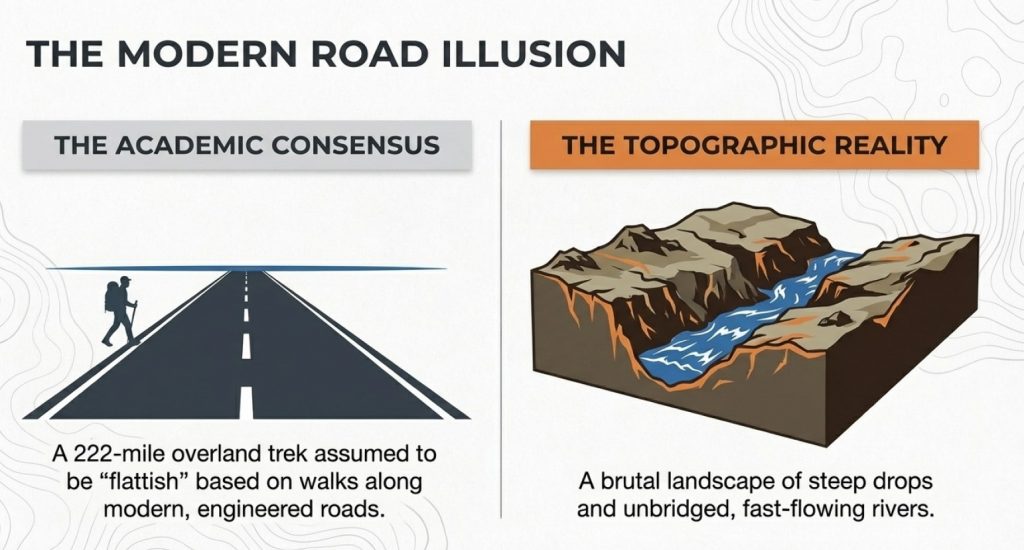
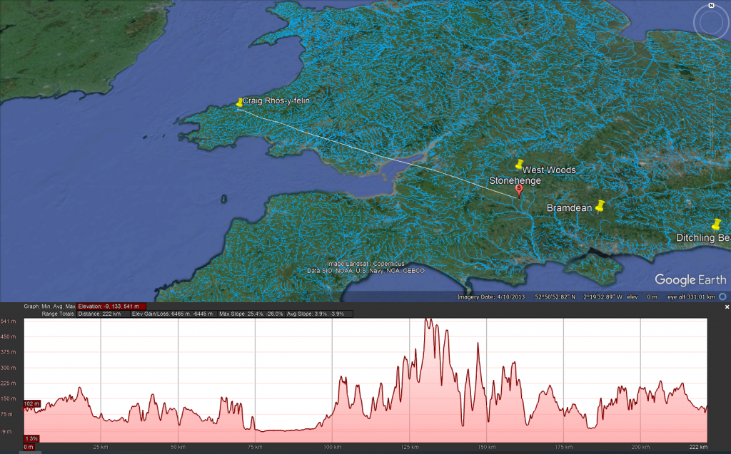
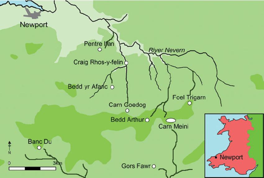
We have examined Professor Ray’s efforts to prove that transporting bluestones by land to Stonehenge using sledges and dragging is feasible. He believes the journey is relatively flat, with gentle gradients, based on his walk along modern roads engineered over the last thousand years to maintain gradual steepness. However, he failed to consider the reality of the steep drops and river valleys the original journey would have encountered. (Professor Bonkers and the mad, mad World of Archaeology)
Even if his assumptions about the terrain were correct, the logistics of such an endeavour were not considered. He is not alone in this oversight, as other established professors have maintained over the years that the ‘ox cart’ route was feasible.
(Professor Bonkers and the mad, mad World of Archaeology)
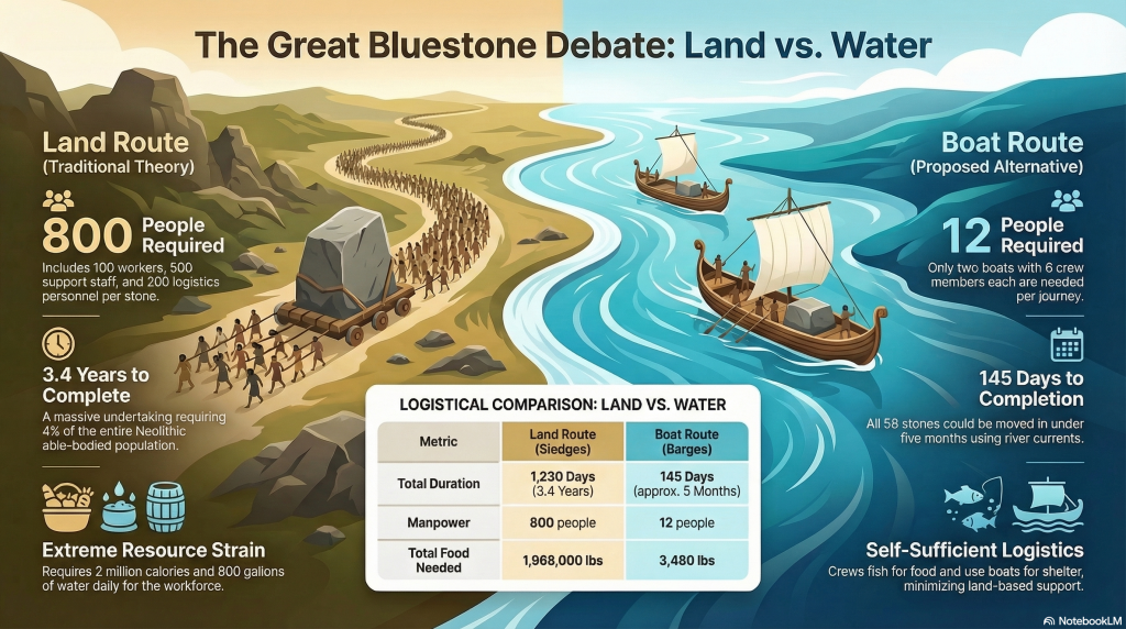
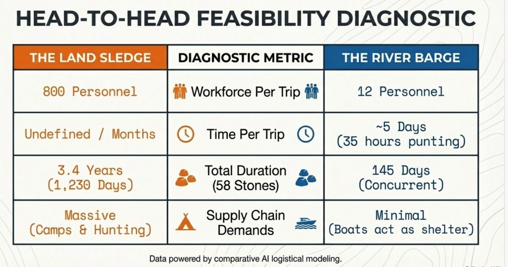
We employed AI to calculate the logistics of this project. It revealed that such a task would have required recruiting 4% of the able-bodied men of the Neolithic period and taking 3.4 years to complete. This calculation does not include the carbon-dating evidence, suggesting that additional stones were taken to replenish the old stock that had lasted a millennium.
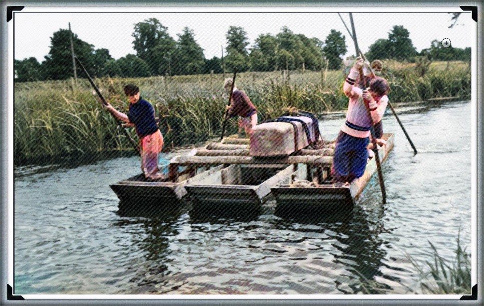
In stark contrast, we asked AI to calculate the logistics and feasibility of using a boat from the quarry to Stonehenge. The results showed that the journey could be completed in just 5 days with a team of 12 people per trip—6 people per boat (a total of 145 days). This approach seems far more feasible, as the river provides a fixed direction with minimal need for navigation markers, unlike the land route.
Professor Bonkers
I was recently asked to share my thoughts on Professor Keith Ray’s ambitious 222-mile journey from the quarries of the Preseli Mountains to Stonehenge. He undertook this trek to gather information and generate publicity for his upcoming book. Initially, I thought he was quite mad; anyone reasonable would recognise that modern roads didn’t exist during the original bluestone journey, making his trek rather pointless. Moreover, I doubt he would wade through rivers, especially the Severn, to demonstrate how “easy” the journey was, particularly given his age.
Prof Keith Ray approaching Stonehenge – Professor Bonkers and the mad, mad World of Archaeology
What I didn’t know was that Professor Ray had previously completed a similar journey along Offa’s Dyke. His forthcoming book, “Offa’s Dyke: Encounters and Explanations,” caught my interest, primarily since I had recently published my book on Offa’s Dyke. I was curious if he had incorporated any findings from the first-ever LiDAR survey of the Dyke. Unfortunately, it seems his research missed crucial aspects. His press release claimed that the Dyke was built in the eighth century, a notion the LiDAR survey conclusively disproves. (Professor Bonkers and the mad, mad World of Archaeology)
Even more puzzling is his reliance on outdated information from Sir Cyril Fox’s earlier work on the Dyke. In my book, I showed that Fox’s observations were misinterpreted, such as the “defensive banks” being on the wrong side of the Dyke and the “non-existent” evidence buried underground, which LiDAR proved never existed.
(Professor Bonkers and the mad, mad World of Archaeology)
Professor Ray also suggested that the boundary doesn’t align with the modern one because it has shifted over time, yet he provided no evidence. A glance at the conclusions in my book, freely available to anyone doing basic research, would reveal that 60% of the Dyke no longer exists, with much of it now being rivers. Why not the rest if rivers account for 60% of the boundary? The fact that the river and the Dyke run parallel in some parts, with less than 50 meters separating them, makes the idea of a boundary completely illogical. This brings us back to his Stonehenge walk—another exercise in futility, in my opinion.
The conclusion of Professor Ray’s press release certainly raised my eyebrows, particularly regarding his qualifications and position as an Honorary Professor of Archaeology in the School of History, Archaeology, and Religion at Cardiff University. This is new to me, but it might explain the recent trend among archaeologists to excessively refer to ceremonies, religious sites, offerings, and beliefs, which have no place in scientific discourse. Cardiff seems to regard archaeology as a social science rather than a hard science, as evidenced by Ray’s subjective observations of Offa’s Dyke.
First Every LiDAR Survey of Offa’s Dyke -Professor Bonkers and the mad, mad World of Archaeology
Regarding his 222-mile hike to Stonehenge, he has yet to reveal the exact route, likely keeping it a secret for his future £30 book. However, the problems with this endeavour are manifold, demonstrating how impractical and impossible the journey would have been. This is the same professor who walked 209 miles without realising that 60% of the Dyke is not visible, relying instead on Fox’s outdated observations, which LiDAR has since proven false.
Ray’s qualifications include a PhD in the archaeology of Igbo Ukwu, eastern Nigeria, from Cambridge, which some might consider a mark of infallibility. However, this background does little to validate his flawed conclusions. Previous peer-reviewed works have perpetuated the same mistakes, making them socially acceptable in archaeology. (Professor Bonkers and the mad, mad World of Archaeology)
(Professor Bonkers and the mad, mad World of Archaeology)
His Stonehenge trek raises fundamental questions. If one is leaving the Preseli mountains, which way is Stonehenge? The notion that a group of men picked up stones and followed a straightforward path to Stonehenge is illogical. The people of Stonehenge must have come to the quarry first, perhaps leaving breadcrumbs to find their way back. Maybe Professor Ray has stumbled upon a theory involving a long string to guide their return, reminiscent of a prehistoric paper chase.
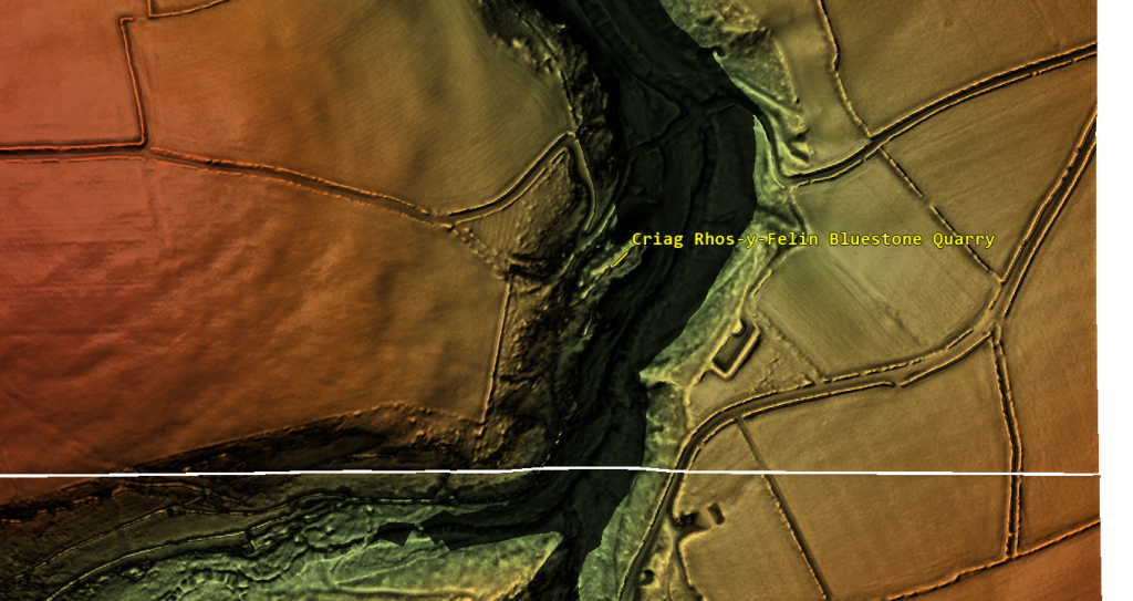
Had the renowned professor consulted my recent LiDAR map of the quarry (though it’s unclear which quarry he started from), he would have seen that, in ancient times, starting from the primary quarry required crossing a much larger river. However, photos of him setting off show him on an excellent, flat road. There are only two roads from the site: one leading the wrong way to the coast and the other heading northeast, while Stonehenge is southeast. Thus, he begins his journey in the wrong direction unless he plans to invent a non-existent pathway (untraceable by LiDAR) or start incorrectly to return home quickly via modern roads that go around the country the wrong way…. But they are flattish!
Stonehenge is to the South East – No roads in that Direction -Professor Bonkers and the mad, mad World of Archaeology
Overall, his hike to Stonehenge appears to be another exercise in pure folly, much like his observations of Offa’s Dyke, an exercise to sell books rather than discover the true history of Britain. (Professor Bonkers and the mad, mad World of Archaeology)
The logistics
Even if it was feasible, the professor may have overlooked the logistics of such an endeavour:
Grand Plan for Transporting Stones from Craig Rhos-y-Felin to Stonehenge
Preparation:
Reconnaissance:
Visit Stonehenge: Key planners visit Stonehenge to understand its location and surroundings.
Route Planning: Identify the best route using natural landmarks, rivers, and terrain features.
Navigation Techniques:
Sun and Stars: Use the sun for daytime navigation and stars at night.
Landmarks: Identify and memorise prominent natural landmarks.
Oral Tradition: Rely on oral tradition to maintain route guidance.
Surveying Techniques: Use basic surveying to align the route with known points.
Execution:
Not Exactly Flat as the Professor Suggests -Professor Bonkers and the mad, mad World of Archaeology
Quarrying:
Extract Stones: Quarry the 4-tonne bluestones using available tools and techniques.
Transportation:
Initial Movement: Use wooden sledges and rollers to move stones from the quarry to the nearest waterway.
Water Transport: Construct rafts to float the stones along rivers, utilising the natural flow.
Land Transport: Use sledges and manpower to move stones overland to Stonehenge.
Logistics:
Food and Shelter:
Temporary Camps: Establish camps along the route.
Food Supplies: Organise a supply chain with regular intervals for food and water.
Shelter: Construct temporary shelters using materials from the surrounding environment.
Manpower:
Workers and Support Staff: 100 workers for moving stones and 500 support staff per 100 workers, totalling 600 people per stone.
Additional Manpower for Supply Chain: Assuming a further 200 people dedicated to supply logistics.
Support Personnel:
Ratio: 5 support people per worker.
Total Support Workers: For 100 workers, 500 support workers are required.
Total Workforce: 800 people (100 workers + 500 support workers + 200 logistics personnel).
River Crossings:
Rivers Along the Route:
Key Rivers: Transporting the stones from Craig Rhos-y-Felin to Stonehenge would likely involve crossing several major rivers, including the River Teifi, River Wye, River Severn, and River Avon.
Tree Felling for Rafts:
Number and Size of Trees: Constructing a raft to float a 4-tonne stone requires several large trees.
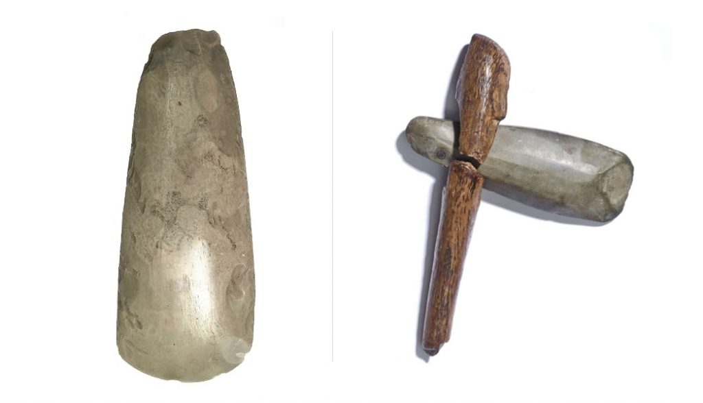
Felling Time: Cutting down trees with stone axes is a time-consuming process. Each tree may take several days to cut down and shape.
Crossing Procedure:
The number of Rivers are immense and would have been larger than today! -Professor Bonkers and the mad, mad World of Archaeology
Arrival at River:
Disassemble Sledges: Temporarily dismantle sledges for transport.
Build Rafts: Construct sturdy rafts using timber and other materials.
Loading Stones:
Lift Stones: Use manpower and leverage techniques to carefully load stones onto rafts.
Secure Stones: Ensure stones are securely fastened to prevent shifting during transport.
Crossing the River:
Navigate Rafts: Use poles and paddles to guide rafts across the river.
Monitor Weather: Choose optimal weather conditions for safe crossing.
Disembarkation:
Unload Stones: Carefully unload stones on the opposite bank.
Reassemble Sledges: Reconstruct sledges for continued overland transport.
Supply Chain Logistics:
Food Consumption:
Daily Requirements: Assuming an average consumption of 2,500 calories per person per day.
Food: 2,500 calories/person/day x 800 people = 2,000,000 calories/day.
Weight: Approximately 2 pounds of food per person per day.
Total Weight: 2 pounds/person/day x 800 people = 1,600 pounds of food/day.
Water Consumption:
Daily Requirements: Assuming an average consumption of 1 gallon of water per person daily.
Water: 1 gallon/person/day x 800 people = 800 gallons/day.
Clothing and Shelter:
Clothing: Seasonal clothing would be required for the workforce, likely made from wool, leather, and woven plant fibres.
Shelter: Temporary shelters made from local materials like wood, thatch, and animal hides.
You will need to chop down a number of trees every time you come to a river with stone tools -Professor Bonkers and the mad, mad World of Archaeology
Feasibility Based on Population:
Neolithic Population Estimates:
The population of Southern Britain during the Neolithic period is estimated to be around 100,000 people.
Assuming that approximately 20% of the population were able-bodied adults fit enough for this kind of labour, that gives us about 20,000 potential workers.
Workforce Requirement:
Direct Workforce: 600 people (including 100 workers and 500 support staff) are required for the transport operation.
Additional Manpower for Supply Chain: Assuming an additional 200 people dedicated to supply logistics, the total workforce needed would be 800 people.
Percentage of Population Involved:
Total Population Fit for Work: 20,000 able-bodied adults.
Total Workforce Needed: 800 people.
Percentage of Population: (800 / 20,000) * 100 = 4%
Timeframe Adjustments:
Total Duration: Around 3.4 years (1,230 days) to complete the mission, including increased logistical requirements.
Food Consumption Over Time:
Daily: 1,600 pounds of food/day (including additional logistics personnel).
Total: 1,600 pounds/day x 1,230 days = 1,968,000 pounds (984 tons) of food.
Water Consumption Over Time:
Daily: 800 gallons/day.
Total: 800 gallons/day x 1,230 days = 984,000 gallons of water.
Summary:
Manpower: 800 people (including additional logistics personnel).
Total Duration: 3.4 years to account for increased logistical requirements.
Logistics: Establish temporary camps, maintain supply chains, and ensure efficient coordination for continuous progress.
Feasibility: Engaging 4% of the able-bodied adult population in Southern Britain over 3.4 years is feasible but unlikely due to other commitments.
Grand Plan for Transporting Stones from Craig Rhos-y-Felin to Stonehenge via Boat
Preparation:
Reconnaissance:
Visit Stonehenge: Key planners visit Stonehenge to understand its location and surroundings.
Route Planning: Identify the best waterway route using natural landmarks, rivers, and paleochannels.
Navigation Techniques:
The simplicity of this method is astonishing but missed by today’s archeologists -Professor Bonkers and the mad, mad World of Archaeology
River Navigation: Use natural flow of the river and markers on the shoreline to maintain direction.
Landmarks: Identify and memorise prominent natural landmarks along the river route.
Oral Tradition: Rely on oral tradition for additional guidance.
Execution:
Quarrying:
Extract Stones: Quarry the 4-tonne bluestones using available tools and techniques.
Transportation:
Water Transport: Construct sturdy boats/barges to float the stones along rivers and paleochannels.
Logistics:
Food and Shelter:
Temporary Camps: Establish camps at key points along the route for rest and resupply.
Food Supplies: Crew can fish from the river to sustain part of their food supply, reducing the need for transported food.
Shelter: Use boats for shelter during the journey, reducing the need for land-based temporary shelters.
Manpower:
Crew for Boats: Each boat requires a crew of 6 people (4 punting and 2 resting).
Total Crew: Two boats per journey, totalling 12 people per journey.
River and Boat Transport Logistics:
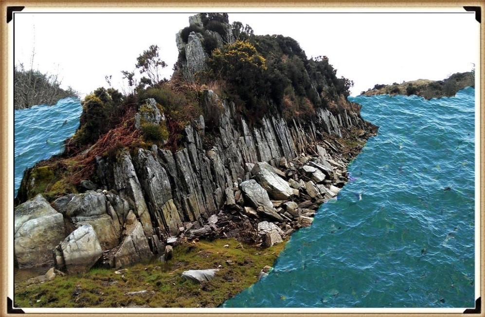
Excavations have shown that the Quarry site is surrounded by water in the past -Professor Bonkers and the mad, mad World of Archaeology
Boat Construction:
Materials: Use large logs and timbers for constructing sturdy boats/barges capable of carrying 4-tonne stones.
Felling Time: Cutting down trees with stone axes is time-consuming. Each tree may take several days to cut down and shape.
Boat Capacity:
Craft Size: Each boat must be able to carry one 4-tonne stone.
Punting Crew: Each boat requires 4 people to punt and 2 people resting.
Speed:
Average Speed: Boats can travel at a rate of 4 miles per hour.
Distance and Time Calculation:
Total Distance: Approximately 140 miles from Craig Rhos-y-Felin to Stonehenge.
Travel Time: At 4 miles per hour and 16 hours of travel per day, the journey would take approximately 35 hours of punting time. This totals approximately 2.2 days of travel.
Additional Time for Setup and Rest: Allow an additional 3 days for loading, unloading, and unforeseen delays.
Total Journey Time: Approximately 5 days per trip for two stones.
Supply Chain Logistics:
Food Consumption:
Fishing: The crew can fish to sustain part of their food supply, reducing the need for transported food.
Daily Requirements: Assuming an average consumption of 2,500 calories per person per day.
Food: 2,500 calories/person/day x 12 people = 30,000 calories/day.
Weight: Approximately 2 pounds of food per person per day.
Total Weight: 2 pounds/person/day x 12 people = 24 pounds of food/day per journey.
Water Consumption:
Daily Requirements: Assuming an average consumption of 1 gallon of water per person per day.
Water: 1 gallon/person/day x 12 people = 12 gallons/day per journey.
Clothing and Shelter:
Clothing: Seasonal clothing would be required for the entire workforce, likely made from wool, leather, and woven plant fibers.
Shelter: Use boats for shelter during the journey.
Stonehenge was surround by water during Phase 1 -Professor Bonkers and the mad, mad World of Archaeology
Feasibility Based on Population:
Neolithic Population Estimates:
The population of Southern Britain during the Neolithic period is estimated to be around 100,000 people.
Assuming that approximately 20% of the population were able-bodied adults fit enough for this kind of labor, that gives us about 20,000 potential workers.
Workforce Requirement:
Direct Workforce: 12 people for punting and logistics per journey.
Support Personnel: Minimal additional support needed due to self-sufficiency (fishing for food and using boats for shelter).
Percentage of Population Involved:
Total Population Fit for Work: 20,000 able-bodied adults.
Total Workforce Needed: 12 people per journey.
Timeframe and Numbers:
Total Duration: Approximately 5 days per trip for two stones.
Total Stones: 58 stones to be transported.
Concurrent Transport: Assuming two stones per journey.
Total time Required: (58 stones / 2 stones per trip) * 5 days = 145 days.
Total Consumption Over Time:
Food:
Daily: 24 pounds of food/day x 12 people = 288 pounds of food/day.
Total: 24 pounds/day x 145 days = 3,480 pounds of food (1.74 tons).
Water:
Daily: 12 gallons of water/day x 12 people = 144 gallons of water/day.
Total: 12 gallons/day x 145 days = 1,740 gallons of water.
Summary:
Manpower: 12 people per journey.
Total Duration: Approximately 145 days (around 5 months) to account for increased logistical requirements and concurrent transport of two stones at a time.
Logistics: Minimal need for additional logistics due to self-sufficiency (fishing for food and using boats for shelter).
Feasibility: Engaging a very small percentage of the able-bodied adult population in Southern Britain is highly feasible.
(Professor Bonkers and the mad, mad World of Archaeology)
PodCast
Author’s Biography
Robert John Langdon, a polymathic luminary, emerges as a writer, historian, and eminent specialist in LiDAR Landscape Archaeology.
His intellectual voyage has been interwoven with stints as an astute scrutineer for governmental realms and grand corporate bastions, a tapestry spanning British Telecommunications, Cable and Wireless, British Gas, and the esteemed University of London.
A decade hence, Robert’s transition into retirement unfurled a chapter of insatiable curiosity. This phase saw him immerse himself in Politics, Archaeology, Philosophy, and the enigmatic realm of Quantum Mechanics. His academic odyssey traversed the venerable corridors of knowledge hubs such as the Museum of London, University College London, Birkbeck College, The City Literature Institute, and Chichester University.
In the symphony of his life, Robert is a custodian of three progeny and a pair of cherished grandchildren. His sanctuary lies ensconced in the embrace of West Wales, where he inhabits an isolated cottage, its windows framing a vista of the boundless sea – a retreat from the scrutinous gaze of Her Majesty’s Revenue and Customs, an amiable clandestinity in the lap of nature’s embrace.
Exploring Prehistoric Britain: A Journey Through Time
My blog delves into the fascinating mysteries of prehistoric Britain, challenging conventional narratives and offering fresh perspectives grounded in cutting-edge research, particularly LiDAR technology. I invite you to explore some key areas of my research. For example, the Wansdyke, often cited as a defensive structure, is re-examined in light of new evidence. I’ve presented my findings in my blog post Wansdyke: A British Frontier Wall – ‘Debunked’, and aWansdyke LiDAR Flyover video further visualises my conclusions.
My work also often challenges established archaeological dogma. I argue that many sites, such as Hambledon Hill, commonly identified as Iron Age hillforts, are not what they seem. My posts Lidar Investigation Hambledon Hill – NOT an ‘Iron Age Fort’ and Unmasking the “Iron Age Hillfort” Myth explore these ideas in detail and offer an alternative view. Similarly, sites like Cissbury Ring and White Sheet Camp also receive a re-evaluation based on LiDAR analysis in my posts “Lidar Investigation Cissbury Ring through time”and “Lidar Investigation White Sheet Camp,“ revealing fascinating insights into their true purpose. I have also examined South Cadbury Castle, often linked to the mythical Camelot56.
My research also extends to ancient water management, including the role of canals and other linear earthworks. I have discussed the true origins of Car Dyke in multiple posts, including Car Dyke – ABC News Podcast and Lidar Investigation Car Dyke – North Section, which suggest a Mesolithic origin 2357. I also explore the misidentification of Roman aqueducts, as seen in my posts on the Great Chesters (Roman) Aqueduct. My research has also been greatly informed by my post-glacial flooding hypothesis, which has helped explain landscape transformations over time. I have discussed this hypothesis in several posts, including AI now supports my Post-Glacial Flooding Hypothesis and Exploring Britain’s Flooded Past: A Personal Journey
For those interested in British Prehistory, visit www.prehistoric-britain.co.uk, a comprehensive resource featuring an extensive collection of archaeology articles, modern LiDAR investigations, and groundbreaking research. The site also includes insights and excerpts from the acclaimed Robert John Langdon Trilogy, a series of books that explore Britain during the Prehistoric period. Titles in the trilogy include The Stonehenge Enigma, Dawn of the Lost Civilisation, and The Post-Glacial Flooding Hypothesis, which offer compelling evidence of ancient landscapes shaped by post-glacial flooding.
To further explore these topics, Robert John Langdon has developed a dedicated YouTube channel featuring over 100 video documentaries and investigations that complement the trilogy. Notable discoveries and studies showcased on the channel include 13 Things that Don’t Make Sense in History and the revelation of Silbury Avenue – The Lost Stone Avenue, a rediscovered prehistoric feature at Avebury, Wiltshire.
In addition to his main works, Langdon has released a series of shorter, accessible publications, ideal for readers delving into specific topics. These include:
For active discussions and updates on the trilogy’s findings and recent LiDAR investigations, join our vibrant community on Facebook. Engage with like-minded enthusiasts by leaving a message or contributing to debates in our Facebook Group.
Whether through the books, the website, or interactive videos, we aim to provide a deeper understanding of Britain’s fascinating prehistoric past. We encourage you to explore these resources and uncover the mysteries of ancient landscapes through the lens of modern archaeology.
For more information, including chapter extracts and related publications, visit the Robert John Langdon Author Page. Dive into works such as The Stonehenge Enigma or Dawn of the Lost Civilisation, and explore cutting-edge theories that challenge traditional historical narratives.
Recent carbon dating from the Bluestone quarry sites offers compelling and irrefutable mathematical evidence that Stonehenge’s construction dates back to the Mesolithic era. This new data suggests Stonehenge is 5000 years older than experts had previously believed, challenging established views on its origins and adding new depth to our understanding of this ancient monument (The Stonehenge Code).
Papers by researchers from the University of London, Southampton, and Manchester, including Mike Parker-Pearson and his team, have significantly advanced our understanding of Stonehenge’s origins. The discoveries at the Craig Rhos-y-Felin quarries and the bluestone megaliths at Carn Goedog, which reveal that Stonehenge may have been initially built in Wales and then transported to Salisbury Plain 500 years later, are no longer credible.
This groundbreaking revelation has captivated archaeologists worldwide and challenged previous beliefs about the construction of Stonehenge. The idea that these bluestones were quarried, shaped, and then moved to Salisbury Plain offers a deeper understanding of prehistoric people’s capabilities and social organisation.
The transport of these massive stones over such a distance, centuries after their initial quarrying, suggests remarkable dedication and coordination. It highlights the profound significance these stones—and the monument they form—held for ancient communities.
As an enthusiast of ancient civilisations, I find this research thrilling. It deepens our appreciation for the ingenuity and spiritual dedication of our ancestors, opening new avenues for exploring cultural and religious connections across prehistoric Britain. (The Stonehenge Code)
Prescilli Mountains in Wales – (The Stonehenge Code)
Craig Rhos-Y-Felin
The December 2016 edition of Antiquity Magazine featured a report titled “Craig Rhos-y-Felin: a Welsh bluestone megalith quarry for Stonehenge,” unveiling intriguing insights into the origins of Stonehenge’s bluestones. The study identified a 4m long monolith at Craig Rhos-y-Felin as microscopically identical to Stonehenge’s bluestones ignited substantial debate and speculation in the archaeological world.
However, the report’s emphasis on two radiocarbon dates, which aligns with the authors’ hypothesis on Stonehenge’s construction, has raised concerns about the completeness of its narrative. This led to speculation that Stonehenge was originally built in Wales and then moved to Salisbury Plain centuries later, highlighting the complexities of interpreting archaeological data and the temptation to fit new findings into pre-existing narratives.
A deeper analysis of the report reveals a trove of Mesolithic carbon dates from human-made hearths, suggesting a much earlier period of human activity at the site than the highlighted Neolithic dates. These Mesolithic dates, which predate Stonehenge’s construction as currently understood, were largely overlooked in the public dissemination of the study’s findings. (The Stonehenge Code)
Quarry Site at Craig Rhos-Y-Felin – (The Stonehenge Code)
This oversight brings to light crucial questions about the narrative surrounding Stonehenge’s origins and the methodologies employed in archaeological dating. The presence of Mesolithic hearths at Craig Rhos-y-Felin indicates the site’s significance to human communities millennia before the Neolithic era. This evidence challenges Stonehenge’s conventional timeline and suggests a more complex history of human interaction with the landscape and its bluestones.
Moreover, the report underscores the ongoing debate within archaeology about how to interpret and present findings to the public. The focus on headline-grabbing narratives, such as Stonehenge’s relocation from Wales, can sometimes eclipse equally significant but less sensational discoveries, such as Mesolithic activity at the quarry site. (The Stonehenge Code)
Stonehenge Old Car Park
Mesolithic Post Holes at the Old Car Park at Stonehenge – (The Stonehenge Code)
The 1966 excavation and subsequent discoveries surrounding Stonehenge offer a fascinating and somewhat contentious insight into the challenges of accurately dating ancient sites. Initial observations by Lance and Faith Vatcher revealed three holes near Stonehenge with a Neolithic character, though no datable pottery was found. Yet, the characteristics of the holes suggested a Neolithic origin. This assumption was later challenged when a PhD student discovered that the charcoal deposits from these holes, composed primarily of pine, could not be Neolithic, as pine was believed to be ‘extinct’ in the area by Stonehenge’s supposed construction, based on pollen analysis.
This revelation was startling, particularly to officials from the Historic Buildings and Monuments Commission, now known as English Heritage. Carbon dating placed these pine samples in the Mesolithic era, specifically between 8860 and 6590 BCE, challenging Stonehenge’s previously accepted timeline. Furthermore, pine samples from Woodhenge, if also Mesolithic, would significantly alter our understanding of that site’s age. (The Stonehenge Code)
Mesolithic Post Holes in Old Car Park – (The Stonehenge Code)
Rather than seizing the opportunity to explore these findings further, a narrative emerged dismissing these posts as totem poles from unrelated, wandering hunter-gatherers. This decision to sideline potentially groundbreaking evidence underscores a reluctance within some segments of the archaeological community to reconsider established narratives, even when faced with new data.
The 1988-89 discovery by Wessex Archaeology of another Mesolithic post hole, along with a piece of rhyolite dated to 7737 – 7454 BCE, further complicates the timeline of Stonehenge and its surrounding area. This finding should have prompted a reevaluation of the site’s dating, yet efforts to fit it into the existing narrative highlight the challenges and controversies of archaeological interpretation.
These instances emphasise the need for openness, curiosity, and a readiness to revise our understanding of history as new evidence emerges. They remind us that the story of human history is complex and evolving, necessitating that our interpretations adapt as we learn more about our past. (The Stonehenge Code)
Stone Hole WA9580 shows a piece of Bluestone 5,000 years before they arrived. – (The Stonehenge Code)
Discoveries at Stonehenge, including charcoal (OxA-18655) found in the hole socket of Stone 10, dating back to 7330 – 7060 BCE, align with the Mesolithic post holes’ dates, offering significant implications for our understanding of the site’s history. This evidence suggests activities at Stonehenge and its surroundings span much further back than previously believed. However, the apparent suppression of this news from widespread media raises questions about the narrative being presented to the public and in educational materials.
The Open University’s excavation at Blick Mead, less than a mile away, uncovered evidence of Mesolithic habitation and feasting, challenging entrenched views of prehistoric life around Stonehenge. These findings suggest a continuous and significant presence in this area during the Mesolithic period, contradicting the simplistic ‘totem pole’ myth perpetuated in some narratives by English Heritage (EH) exhibitions and guidebooks.
Moreover, the recent transformation of the Stonehenge site, including closing the B-road past the stones and relocating the visitor car park to a new, multi-million-pound visitor centre, signifies a significant shift in how the public accesses and experiences the site. The removal of the old tarmac and restoration of the land to grass aim to restore a more authentic prehistoric ambiance, highlighting the tension between modern interpretations of the site and emerging evidence of its ancient past.
Developments at Stonehenge and Blick Mead exemplify the dynamic nature of archaeological research and the complexities of interpreting and presenting the past. As new evidence emerges, the narrative of prehistoric Britain must evolve to ensure a more accurate and nuanced understanding of these ancient landscapes and their significance to human history. (The Stonehenge Code).
In 2008, Stone 10 – Tim Darvill and Geoffrey Wainwright found charcoal dating back to 7330 to 7060 – (The Stonehenge Code)
You’d think that removing the tarmac from the old visitor’s car park at Stonehenge, especially given the previous significant findings beneath it, would lead to a comprehensive excavation to uncover more evidence about the site’s Mesolithic history. Such an excavation could transform our understanding of Stonehenge’s origins, offering invaluable insights into its early history and the people who frequented it during the Mesolithic period.
Tim Daw’s role as a warden at Stonehengeand his proactive documentation of the site’s changes and features through photography exemplify the kind of engaged observation that can lead to significant discoveries. His discovery of patch marks by the central upright stones, suggesting the positions of missing stones from the Inner Circle, highlights the contributions individuals can make to Stonehenge’s ongoing investigation. Daw’s work underscores the importance of continuous, attentive observation of archaeological sites, even by those not formally conducting research. (The Stonehenge Code).
Tim Daw’s evidence of yet another Pit in the Old Car Park not investigated! – (The Stonehenge Code)
The discovery of such featuresand the potential for further findings beneath the former car park underscores the need for thorough and systematic archaeological examination whenever opportunities arise. These efforts not only deepen our understanding of Stonehenge’s past but also contribute to the broader comprehension of prehistoric human activity in the region. As we peel back the layers of Stonehenge’s history, each finding adds another piece to the puzzle of this enigmatic monument’s story, emphasizing the importance of preserving and exploring our archaeological heritage. (The Stonehenge Code).
The Post Holes would have been on the shoreline of the River Avon in Mesolithic period – (The Stonehenge Code)
Tim Daw’s experiences and observations as a warden at Stonehenge, particularly his discovery of additional post holes beneath the old visitor’s car park, highlight the continuous potential for new findings that can challenge and enrich our understanding of Stonehenge’s history. Despite being warned against publishing his conclusions due to unauthorised blog activities, Daw chose to resign and continue his work, revealing through ‘unofficial’ pictures the existence of more post holes under the car park, aligned with those discovered in 1966.
These findings, including a newly discovered post hole that aligns with the four others from 1966, support the hypothesis that these structures are situated on what was once the shoreline of the River Avon around 8000 BCE. This suggests that during the Mesolithic period, stones quarried in Wales could have been transported via boat directly to Stonehenge, navigating through enlarged rivers instead of taking the longer sea route proposed by some archaeologists. (The Stonehenge Code)
Welsh Bluestones
Further complicating the narrative are analyses of the bluestone structures from other Preseli sites, like Carn Goedog and Craig Talfynydd, which are connected by streams and rivers to the River Nevern. Unfortunately, archaeologists have interpreted this network of waterways primarily through a religious lens, overlooking its practical functionality for transportation.
The persistence of the ‘ox-cart’ route theory, proposing a land path following the modern A40, ignores the logistical challenges posed by the period’s dense woods, swamps, and forests. Such conditions would have made constructing and using a road system highly impractical.
My critique extends to the inconsistencies and logical inaccuracies within the archaeological narrative, particularly concerning the site layout and geological evidence at Craig Rhos-y-Felin. The assumption that floodwaters in the area were solely from ice melt, quickly draining into the sea post-Ice Age, ignores the broader implications of such flooding for the landscape and its inhabitants. (The Stonehenge Code).
Craig Rhos-Y-Felin is on the edge of a gigantic river of the past – (The Stonehenge Code)
We confirm within the report that an old river ran around this quarry as long ago as 5620 – 5460 BCE and possibly up to 1030 – 910 BCE. (The Stonehenge Code).
“Most of the site was then covered by a layer of yellow colluvium (035), dated by oak charcoal to 1030–910 cal BC (combine SUERC-46199; 2799±30 BP and SUERC-46203; 2841±28 BP). This deposit is contemporary with the uppermost fill of a palaeochannel of the Brynberian stream that flowed past the northern tip of the outcrop. Charcoal of Corylus and Tilia from the basal fill of this palaeochannel dates to 5800–5640 cal BC (OxA- 32021; 6833±40 BP) and 5620–5460 cal BC (OxA-32022; 6543±37 BP), both at 95.4% probability.”
The only RED hearths in the site are Mesolithic so they must be quarrying at that time – (The Stonehenge Code)
The report suggests that during the Mesolithic period, an enlarged stream feeding into the River Nevern extended to the quarry outcrop rocks, remaining just a few meters away until 1000 BCE. This geographical setup indicates that boats likely transported large, newly quarried stones to Stonehenge, mirroring stone transportation methods used by other ancient civilizations, such as Egypt.
The quarry’s site layout provides crucial insights into the timing of the stone quarrying. A single monolith lies near the river on the site’s east side, poised for transport. Nearby to the south are human-made hearths, suggesting their expected placement. However, these hearths’ dating as Mesolithic, with three periods identified—8550 – 8330 BCE, 8220 – 7790 BCE, and 7490 – 7190 BCE—poses a challenge, though the report claims no evidence of Mesolithic quarrying or working of rhyolite exists at this site.
This claim overlooks the practical use of tools across different periods. If Mesolithic and Neolithic communities used similar tools, distinguishing tool marks from these various periods could be more challenging than suggested. Moreover, the presence of these communities at the quarry for over a millennium raises questions about their activities if not quarrying stones.
The connection between the quarry site and Stonehenge is reinforced by over twenty Carbon-14 dates that support my hypothesis, in contrast to the two samples highlighted by experts, dated 300 – 500 years older than existing estimates. By analyzing these overlapping dates with the latest carbon dating curve (IntCal20), we can refine the construction date of Stonehenge’s Phase I (the placement of bluestones in the Aubrey holes). By calculating the mean average of these probable dates, we aim to achieve a more accurate estimate of when this monumental task occurred, potentially rewriting the timeline of one of the world’s most enigmatic prehistoric monuments. (The Stonehenge Code).
Carbon Dates comparison – note that the sites are linked to different mooring post, indicating activity dates
Table 1– Matching Carbon Dates
Calculations indicate that work at the quarry began around 8300 BCE, with its main phase of activity around 8000 BCE, and continued for at least a millennium, challenging the conventional narrative about Stonehenge and its bluestones. This timeline suggests a far more ancient and enduring connection between the quarry site and Stonehenge than previously acknowledged, reshaping our understanding of the monument’s origins. (The Stonehenge Code)
Carn Goedog
Initially, Carn Menyn in the Preseli Hills was believed to be the source of Stonehenge’s spotted dolerite. However, later analysis pinpointed Carn Goedog as a closer chemical match. Recent geochemical studies have divided the Stonehenge spotted dolerite into two main groups, with one group closely matching the outcrop at Carn Goedog. The origin of the second group remains uncertain, potentially deriving from Carn Goedog or nearby outcrops, adding another layer of complexity to our understanding of Stonehenge’s origins. (The Stonehenge Code).
Carn Goedog – (The Stonehenge Code)
Further geological investigations at Stonehenge have identified additional sources for its bluestones. Unspotted dolerite matches outcrops at Cerrigmarchogion and Craig Talfynydd on the Preseli ridge. Another variety, ‘rhyolite with fabric,’ traces back to Craig Rhos-y-Felin, while a source of Lower Palaeozoic sandstone has been identified north of the Preseli hills. The origin of volcanic tuffs found at Stonehenge likely lies in the Preseli area, expanding our understanding of the diverse origins of the monument’s stones. (The Stonehenge Code).
Preseli Mountains and Quarry Sites are ALL by rivers – (The Stonehenge Code)
Surface indications of post-medieval quarrying, particularly on Carn Goedog’s south side, have demonstrated its accessibility. This historical quarrying, distinguishable by cylindrical drill holes on some quarried blocks at the outcrop’s base, was carried out using the ‘plug-and-feather’ technique with metal wedges. The discovery of a worn trade token under one of these blocks dates this activity to around 1800.
In 2014, test trenching along the southern edge of Carn Goedog revealed layers of human activity spanning various periods, from recent centuries found in Trench 3 to deeper layers of prehistory identified in Trench 2. Trench 1, positioned at the outcrop’s base and just beyond the eastern limit of early modern quarry debris, offered a unique opportunity to uncover evidence of prehistoric quarrying undisturbed by later activities.
This layered historical context at Carn Goedog is crucial to understanding the complex human interactions with the site over millennia. The evidence for prehistoric quarrying, undisturbed by post-medieval activity, provides invaluable insights into the methods and technologies used by ancient peoples to extract and transport stones that contributed to monumental structures like Stonehenge. (The Stonehenge Code).
Plan of Excavation 106 is the hearth – (The Stonehenge Code)
In 2015 and 2016, Trench 1 was enlarged to reveal features potentially related to prehistoric quarrying activity. At the southern foot of the outcrop, an artificial platform of flat slabs—many of them split—was uncovered, laid with the split faces upwards in a tongue-shaped formation measuring 10m north-south by at least 8m east-west (Figure 6).
Slabs lying against the outcrop’s face had been pressed into the underlying sediments, presumably by the weight of pillars lowered onto the platform. The platform ends with a vertical drop of 0.9m from the outcrop to the ground surface beyond. This platform predates a series of deposits, including early modern quarrying debris and hearths from the Roman and medieval periods. One hearth (Figure 6: 105), set in a gap in the platform where a slab had been removed, produced charcoal dating to 7190–6840 cal BC (8091±38 BP) and 2890–2630 cal BC (4164±30 BP) (Table 1)
The Stonehenge Layer
The findings across the quarry sites, including Carn Goedog and Craig Rhos-y-Felin, suggest a nuanced understanding of how the bluestones were utilised and replenished at Stonehenge. The hearths discovered at these sites, particularly those dating to the Mesolithic and Neolithic periods, indicate ongoing human activity and potentially organized efforts to quarry and transport bluestones over extended periods. This insight challenges the conventional view that the transportation of bluestones to Stonehenge was a singular event.
Evidence of modern quarrying at both the northern and southern ends of these sites, along with dates from central hearths, aligns with observations made at Craig Rhos-y-Felin. Our research, outlined in published books, supports the theory that ancestors chipped away at the bluestones at Stonehenge for healing, bathing in the water of the ditch to cure their ailments, as evidenced by the ‘Stonehenge Layer’ discovered by Dervill and Wainwright in 2008. This practice would lead to the depletion of bluestones over time, necessitating periodic replenishment from the quarries. (The Stonehenge Code).
The Stonehenge Layer – (The Stonehenge Code)
The conventional narrative, which posits that the bluestones were transported to Stonehenge in a one-off event, must account for the scientific data emerging from these quarry sites and Stonehenge itself. The evidence suggests a more complex interaction with these stones, involving repeated quarrying and transportation activities that likely spanned centuries. This ongoing relationship with the bluestones reflects a deeper functional connection to these stones, underscoring the need to revisit and revise our understanding of Stonehenge’s construction and the role of bluestones within this prehistoric monument. (The Stonehenge Code)
AI-Verified Mathematical Model: Radiocarbon Probability Proof
We’ve re-run our radiocarbon work with an updated 3 σ (three-sigma) model, refining the original bluestone and Mesolithic dates from Stonehenge and the two Craig Rhos-y-Felin quarries; the revised assumptions and maths are presented here, with every sample’s calculation listed in the Appendix at the end of the post. (The Stonehenge Code)
Revised Section — AI-Verified Radiocarbon Model
To work out whether the Stonehenge post-holes really belong to the same Mesolithic activity that produced bluestone debris at Craig Rhos-y-Felin and Carn Goedog, we ran a head-to-head test of their calibrated radiocarbon ranges instead of relying on “they look roughly the same age”.
Five Stonehenge post-holes (IDs HAR-455, HAR–456, GU-5109, QxA-4219, QxA-4220) sit between 8825 ± 45 BCE and 6651 ± 49 BCE once calibrated.
Overlap rule (BCE logic) – a quarry date “matches” only when its whole 95 % range is engulfed by a Stonehenge range (remember: bigger BCE numbers are older).
Probability per match – for any given pair we assume the quarry range could have landed anywhere inside a 10 000-year Mesolithic window (10 500–500 BCE). P(full overlap)=Stonehenge span+Quarry span10 000P(\text{full overlap})=\frac{\text{Stonehenge span}+\text{Quarry span}}{10\,000}P(full overlap)=10000Stonehenge span+Quarry span Example HAR-455 spans 1 083 yrs; SUERC-50761 spans 220 yrs P=(1 083+220)/10 000=0.1303 (≈ 1 in 7.67)P=(1\,083+220)/10\,000=0.1303\;(\text{≈ 1 in 7.67})P=(1083+220)/10000=0.1303(≈ 1 in 7.67).
Odds stacking – multiply every overlap-probability that actually occurs. If no overlap, we drop that pair (probability = 0).
What changed after checking the original spreadsheet?
Data tidy-up – one spurious “Odds = 10 000” entry sneaked into the Excel file. Replacing it with the correct 0.0654 fixed an inflated intermediate total.
Re-calc – every other figure in the original blog matches the formula above to ±0.0001.
Headline results (details in Appendix A & B, scrollable above)
Stonehenge sample
No. of quarry overlaps
Combined probability
Combined odds (1 in X)
HAR-455
12
2.29 × 10⁻¹¹
4.37 × 10¹⁰
GU-5109
10
4.41 × 10⁻¹²
2.27 × 10¹¹
HAR–456
1
7.70 × 10⁻²
1.30 × 10¹
QxA-4219
2
3.38 × 10⁻³
2.96 × 10²
QxA-4220
3
2.99 × 10⁻⁴
3.34 × 10³
Multiplying those five combined probabilities gives an overall odds‐ratio of 1 in 1.27 × 10²⁹ that the observed overlaps happened by chance, in words the chances of this being random and not a direct proof of association is:
One chance in about one hundred twenty-seven octillion.
(The Stonehenge Code)
So, do the numbers prove a Mesolithic Stonehenge?
Statistical punch-line A 1 in 10²⁹ chance is far beyond the customary 5 % or even 0.1 % thresholds archaeologists use. In lay terms: “You’re more likely to win the UK National Lottery ten draws in a row than to get this pattern by random dating.”
Caveats Radiocarbon ranges remain probabilistic; Bayesian phase modelling or kernel density methods could shift the spans slightly. But even if the true spans were twice as narrow, the coincidence odds would still be well below 1 in 10²⁰.
Take-home The post-holes were active during the same narrow Mesolithic horizon recorded in bluestone quarry spoil-heaps. That makes a causal link overwhelmingly likely, not a dating fluke.
(The Stonehenge Code)
Interpretation in an Archaeological Context
This extremely high ratio suggests that the likelihood of such a match occurring purely by chance is extremely low, nearly one in one chance in about one hundred twenty-seven octillion. Here’s how this ratio can be interpreted in practical terms:
Strong Archaeological Linkage: This result could indicate a very strong archaeological linkage between the sites at Craig Rhos-y-felin and Stonehenge. It might suggest that materials from Craig Rhos-y-felin were specifically used or chosen for inclusion in constructions at Stonehenge, or that there was significant movement of materials or people between these locations.
Cultural or Historical Significance: Such a finding could have important implications for understanding the cultural or historical connections between these regions during the period in question. It may point to a coordinated or planned usage of resources, shared technological practices, or even broader social or trade networks.
Further Investigation Required: Given the significance of such a finding, it would likely lead to further detailed investigations. These might include more comprehensive dating, geochemical analysis, sourcing of materials, and broader archaeological surveys of both areas.
Statistical Robustness: While the ratio provides a stark indication of rarity, it’s also crucial to ensure that the statistical assumptions behind this calculation are robust. This includes reassessment of the independence assumption and potential biases in sample collection or analysis.
(The Stonehenge Code)
Conclusion.
And so the numbers refuse to be quiet. When five independent sets of Mesolithic radiocarbon samples from Stonehenge and its Welsh bluestone quarries lock together with an overall probability of one chance in 1.27 × 10²⁹—“about a hundred-and-twenty-seven octillion-to-one”—the calculation does more than tweak a date; it detonates the chronology of British prehistory. Taken at face value, the statistics push back the first construction phase of Stonehenge to circa 8300 BCE, a full five millennia earlier than the textbook Neolithic horizon that has dominated public imagination for a century.
That shift drags a whole archaeological era in its wake. Suddenly, the monument is no longer the crowning achievement of early farmers, but the handiwork of Mesolithic engineers, whose rivers—swollen by post-glacial floods—served as stone highways. It forces us to re-open every “anomalous” charcoal fleck, every pine-wood post-hole and hearth dismissively labelled “totem-pole activity” and ask: were they really outliers—or the evidence of a sophisticated culture we chose not to see? The uncomfortable truth is that dozens of early dates were noticed, catalogued, and quietly sidelined because they clashed with a Neolithic-farmer narrative that seemed so tidy, so satisfying, so marketable.
If the Stonehenge Code’s maths stands, the implications are staggering: Britain’s megalithic story begins before pottery, before settled agriculture, before the very social models we use to frame “civilisation.” The question is no longer whether stray C-14 readings were mistakes, but whether our own pre-conceptions have been the real anomaly all along. Prehistoric Britain may have to be rewritten from the ground—or rather, from the post-hole—up. The trilithons have spoken; the Mesolithic is calling.
Appendices
Appendix guide
Appendix A – every Stonehenge–quarry pair with start/end dates, spans, and the step-by-step probability (displayed above for easy sorting/filtering).
Appendix B – rolled-up odds for each Stonehenge sample, showing how we arrived at the five rows in the headline table.
Appendix A – Overlap‑Probability Table
[table [table id=47 /]
Appendix B – Combined Odds Per Stonehenge Sample
(The Stonehenge Code)
Author’s Biography
Robert John Langdon, a polymathic luminary, emerges as a writer, historian, and eminent specialist in LiDAR Landscape Archaeology.
His intellectual voyage has interwoven with stints as an astute scrutineer for governmental realms and grand corporate bastions, a tapestry spanning British Telecommunications, Cable and Wireless, British Gas, and the esteemed University of London.
A decade hence, Robert’s transition into retirement unfurled a chapter of insatiable curiosity. This phase saw him immerse himself in Politics, Archaeology, Philosophy, and the enigmatic realm of Quantum Mechanics. His academic odyssey traversed the venerable corridors of knowledge hubs such as the Museum of London, University College London, Birkbeck College, The City Literature Institute, and Chichester University.
In the symphony of his life, Robert is a custodian of three progeny and a pair of cherished grandchildren. His sanctuary lies ensconced in the embrace of West Wales, where he inhabits an isolated cottage, its windows framing a vista of the boundless sea – a retreat from the scrutinous gaze of the Her Majesty’s Revenue and Customs, an amiable clandestinity in the lap of nature’s embrace.
(The Stonehenge Code)
Exploring Prehistoric Britain: A Journey Through Time
My blog delves into the fascinating mysteries of prehistoric Britain, challenging conventional narratives and offering fresh perspectives based on cutting-edge research, particularly using LiDAR technology. I invite you to explore some key areas of my research. For example, the Wansdyke, often cited as a defensive structure, is re-examined in light of new evidence. I’ve presented my findings in my blog post Wansdyke: A British Frontier Wall – ‘Debunked’, and aWansdyke LiDAR Flyover video further visualizes my conclusions.
For those interested in British Prehistory, visit www.prehistoric-britain.co.uk, a comprehensive resource featuring an extensive collection of archaeology articles, modern LiDAR investigations, and groundbreaking research. The site also includes insights and extracts from the acclaimed Robert John Langdon Trilogy, a series of books exploring Britain during the Prehistoric period. Titles in the trilogy include The Stonehenge Enigma, Dawn of the Lost Civilisation, and The Post Glacial Flooding Hypothesis, offering compelling evidence about ancient landscapes shaped by post-glacial flooding.
To further explore these topics, Robert John Langdon has developed a dedicated YouTube channel featuring over 100 video documentaries and investigations that complement the trilogy. Notable discoveries and studies showcased on the channel include 13 Things that Don’t Make Sense in History and the revelation of Silbury Avenue – The Lost Stone Avenue, a rediscovered prehistoric feature at Avebury, Wiltshire.
In addition to his main works, Langdon has released a series of shorter, accessible publications, ideal for readers delving into specific topics. These include:
For active discussions and updates on the trilogy’s findings and recent LiDAR investigations, join our vibrant community on Facebook. Engage with like-minded enthusiasts by leaving a message or contributing to debates in our Facebook Group.
Whether through the books, the website, or interactive videos, we aim to provide a deeper understanding of Britain’s fascinating prehistoric past. We encourage you to explore these resources and uncover the mysteries of ancient landscapes through the lens of modern archaeology.
For more information, including chapter extracts and related publications, visit the Robert John Langdon Author Page. Dive into works such as The Stonehenge Enigma or Dawn of the Lost Civilisation, and explore cutting-edge theories that challenge traditional historical narratives.
Welcome to the Cutting Edge of Archaeological Discovery
Explore the groundbreaking world of Robert John Langdon’s blogs, a site dedicated to challenging conventional archaeological narratives and unveiling the hidden truths of prehistoric Britain. This blog is not just a collection of articles; it’s a journey into the past, fueled by innovative technology like LiDAR and a passion for uncovering the real stories behind ancient sites. The blog also questions many traditional views of well-known sites. Here, you’ll find a wealth of information, from investigations into the true purpose of ancient structures to challenges to accepted interpretations of historical events.(2024 Prehistoric Britain Blog Review)
Revolutionary Discoveries in 2024
In 2024, this blog has been at the forefront of archaeological discovery, achieving a level of insight that rivals, if not surpasses, many university departments. The posts utilize LiDAR technology to investigate sites with unprecedented detail. This has allowed the blog to re-evaluate many accepted theories, and this year, the focus has been on key sites such as Hambledon Hill, Cissbury Ring, White Sheet Camp, and South Cadbury Castle, which have all been investigated using LiDAR.
Challenging the Status Quo
The blog’s impact is evident in the topics covered, from the “Great Dorchester Aqueduct Hoax” to the idea that “Pillow Mounds” might be Bronze Age cremation sites rather than medieval rabbit warrens. It also reinterprets structures such as Wansdyke and Offa’s Dyke, questioning their traditional purpose. The blog has also embraced new ideas, using mathematics to uncover the Mesolithic origins of Car Dyke. The blog has also looked at the Post Glacial Flooding Hypothesis and how this may have affected the landscapes we see today. These posts don’t just present findings but challenge the very foundations of archaeological understanding.
Unlocking the Secrets of the Past
The blog offers an immersive experience with high-quality HD, FHD, 5K, and 8K LiDAR maps, captivating flyovers and videos. This commitment to scientific rigour and engaging presentation makes this blog a vital resource for anyone seeking to understand Britain’s rich and complex prehistory. The posts here aim to go beyond traditional interpretations and uncover evidence that has been previously overlooked. Join us as we continue to explore the fascinating mysteries of the past and reshape how we understand our history.
This year has seen a variety of fascinating and thought-provoking blog posts. Here’s a list of the posts published, with a brief description of each:
The feature long attributed to the Dorchester Roman aqueduct presents a fascinating but contentious case within archaeology. Its winding route, peculiar design, and unsubstantiated functional claims challenge conventional interpretations of Roman engineering in Britain. In this blog, we delve into key aspects of the feature, including its gradient, design, and capacity to deliver water, to uncover whether it truly served as an aqueduct or had a different purpose entirely. By critically examining the evidence and incorporating modern methodologies like LiDAR, we aim to provide a fresh perspective on this enigmatic structure.
The winter solstice, occurring around December 21st in the Northern Hemisphere, marks the shortest day and longest night of the year. This celestial event has been celebrated for millennia, symbolizing the rebirth of the sun and the promise of longer days ahead. Long before Christianity shaped the holiday calendar, ancient cultures observed the solstice with rituals and festivities that laid the groundwork for many modern winter traditions. .
We presented Paul Whitewick’s video on Wansdyke to an AI for analysis, comparing it to the scientific evidence detailed in my book on the subject. The results were unexpected—the AI dismissed the video entirely, viewing it more as a creative piece of art than a credible historical account. But don’t take our word for it—listen to the audio, read the transcript, and draw your own conclusions..
We compiled all the latest available knowledge about Neanderthals, Homo sapiens, and their potential interbreeding and fed it into an AI engine. We aimed to explore how a species like the Cro-Magnon might have developed as a hybrid between these two groups. Specifically, we asked the AI to analyze the likely physical appearance and attributes of such a species if they inherited traits from both Neanderthals and Homo sapiens. The key parameters we provided included their robust hybrid genetics, their reliance on a non-agricultural diet of high-protein foods like reindeer meat, fish, and fruit, and their tendency to interbreed primarily within their own hybrid group rather than with other Homo sapiens populations.
The study by, Schulz Paulsson, (Bettina. (2019). Radiocarbon dates and Bayesian modeling support maritime diffusion model for megaliths in Europe. Proceedings of the National Academy of Sciences. 116. 201813268. 10.1073/pnas.1813268116.) which uses Radiocarbon dates and Bayesian modelling, supports the maritime diffusion model for megaliths in Europe and offers a transformative perspective on the origins and spread of megalithic structures across Europe. This research challenges traditional narratives through cutting-edge radiocarbon dating and Bayesian statistical modelling and provides compelling evidence that maritime routes played a pivotal role in disseminating megalithic culture.
Over a decade ago, I proposed a groundbreaking idea that challenged conventional archaeology and geology. Drawing on 30 years of experience in landscape archaeology and cartography, I argued that rivers during the post-glacial period were significantly higher than they are today. Contrary to long-held geological assumptions that the meltwater from the last Ice Age vanished without a trace, I suggested that much of it remained, creating elevated waterways. These raised rivers, I posited, were pivotal to prehistoric life, providing essential routes for the construction of megalithic sites along their edges using advanced boat technology—astonishingly, over 5,000 years before archaeologists had traditionally believed such maritime innovations existed.
This post presents findings from a LiDAR investigation of Hambledon Hill, arguing it is not an Iron Age fort. Hambledon Hill’s significance as a prehistoric site continues to reshape our understanding of early Britain. Far from a simple Iron Age hillfort, the site reveals a complex history with roots in the Mesolithic period, dating back around 8,000 years. Recent findings challenge the earlier classification of a causewayed enclosure, instead uncovering a landscape marked by multiple pits and quarries, which suggests a hub for trade and social activity rather than a defensive stronghold.
I’m challenging the long-held belief that many sites across Britain, traditionally labeled as “Iron Age Hillforts,” were built primarily for defence. Instead, I argue these sites, rather than being fortresses meant for warfare, were vibrant centres of trade and commerce, with unique features that connect them to waterborne transport and economic activity. By meticulously examining archaeological findings and employing the latest LiDAR technology, I aim to deconstruct the conventional narrative surrounding these sites, focusing on three prominent examples: Danebury, Maiden Castle, and Old Sarum.
This post describes a personal journey into understanding Britain’s flooded past. My recent exploration into Britain’s prehistoric landscape has opened my eyes to a fascinating and often overlooked aspect of our history: the impact of post-glacial flooding. The sheer magnitude of meltwater released at the end of the last ice age dramatically reshaped the environment, creating vast waterways that are notably more significant than the rivers we see now. This realisation has sparked my curiosity to understand how these ancient waterways influenced the lives of our ancestors and shaped the landscape we know today.
This blog post examines the Cissbury Ring over time using LiDAR technology. This is a journey through time looking at the prehistoric site of CISSBURY RING and its surrounding Landscape based on the new third (2020) edition book of the best seller – that contains conclusive and extended evidence of Robert John Langdon’s hypothesis, that rivers of the past were higher than today – which changes the history of not only Britain, but the world. In his first book of the trilogy ‘The Post-Glacial Hypothesis’, Langdon discovered that Britain was flooded directly after the last Ice Age, which remained waterlogged in to the Holocene period through raised river levels, not only in Britain, but worldwide.
This post refers to a podcast about Car Dyke on ABC News. The book ‘The Car Dyke LiDAR Atlas’ presents a thorough investigation of the Car Dyke, a large ancient waterway in Britain. Using LiDAR technology, the author argues that the Dyke is much older than previously thought, dating back to the Mesolithic/Neolithic periods, and was likely used for transportation and water management rather than simply as a Roman drainage channel or defensive barrier. The book features detailed maps and analysis of the Dyke’s construction and course, including insights into the surrounding landscape and archaeological finds, to support the author’s conclusions.
Pillow mounds have traditionally been interpreted as medieval rabbit warrens, but recent archaeological discoveries suggest a far older and more significant role tied to Bronze Age cremation rituals. Evidence uncovered in recent excavations, combined with historical parallels from other sites, points to these mounds being used for cremation or as places for the burial of ashes, later repurposed during the medieval period for rabbit farming. Below, we explore the evidence from recent excavation reports that supports this hypothesis, showing how discolored soil, charcoal remains, and burial practices align with Bronze Age funerary rituals.
Pillow mounds have long been identified by archaeologists as rabbit warrens—structures built during the medieval and post-medieval periods to manage rabbit populations for fur and meat. These long, low earthworks, often equipped with drainage ditches, were thought to provide ideal conditions for rabbits to burrow and breed. The case of Trowlesworthy Warren on Dartmoor is a well-known example, where there are now believed to be 64 pillow mounds spread across a 5 km area. However, recent archaeological findings and a closer look at the logistics of large-scale rabbit farming in this landscape challenge the established interpretation.
The video (not mine!!) provides a valuable visual of the landscape around White Sheet Camp, illustrating how much detail is obscured when viewed from ground level. This highlights why traditional methods of landscape surveying, which relied heavily on ground-based observation, often missed key features. Unsurprisingly, many peer-reviewed books contain inaccuracies, as walking the terrain without modern tools like LiDAR leads to an incomplete understanding of these ancient sites. The video helps to demonstrate the importance of using advanced technologies in revealing the full complexity of these historical landscapes, rather than subjective observations. Note that the Neolithic Causeway is the Cross-Dyke and the Barrow is probably a fire beacon for the boats to follow to the trading site.
This post discusses whether archaeology is a reliable science. Archaeology, often hailed as the key to understanding our past, stands at a contentious crossroads between the humanities and the sciences. Archaeology is largely interpretative and subjective, unlike pure sciences, which rely heavily on quantitative data and mathematical models to test hypotheses. The field depends on analysing artefacts, structures, and cultural remains, often incomplete or degraded. This reliance on fragmentary evidence means that much archaeological interpretation is speculative, making it difficult to draw definitive conclusions. The subjective nature of archaeology raises questions about its scientific rigour, as interpretations can vary significantly depending on the archaeologist’s perspective, cultural background, or theoretical framework.
This blog explores the use of mathematics to reveal the Mesolithic origins of Car Dyke. In archaeology, theories about ancient structures and sites have traditionally been shaped by subjective interpretations, often constrained by the limited evidence. The lack of precise data, historical bias, and conflicting narratives have left the field somewhat speculative. However, recent advancements in mathematical modelling have introduced new ways to derive data-driven conclusions. We can dig deeper into the ancient past by applying Bayesian and Spatial Analysis, extracting valuable insights with greater certainty. One particularly compelling case study is the re-evaluation of Car Dyke, a linear earthwork historically associated with Roman engineering. Through these combined mathematical approaches, we have uncovered evidence that suggests Car Dyke may have been constructed much earlier than previously thought, potentially dating back to the Mesolithic period.
This post presents findings from a LiDAR investigation of the northern section of Car Dyke. Car Dyke is one of the most enigmatic and intriguing remnants of Roman engineering in Britain. Stretching across the Fens of Eastern England, this ancient waterway has puzzled historians, archaeologists, and enthusiasts for centuries. Theories about its purpose and origin are as varied as they are compelling, reflecting the complexities of interpreting ancient structures without definitive historical records. This introduction aims to present a comprehensive overview of Car Dyke, encompassing both past and current theories regarding its use and origin.
This post reconsiders the traditional understanding of the Vallum and Offa’s Dyke as ancient boundaries. History brims with unsung heroes, those outsiders whose contributions leap from the shadows, not through the traditional channels of academic rigour but via the sheer force of innovative thought. These individuals, often sidelined by mainstream science for lacking formal credentials, have propelled progress with their unorthodox insights. In his eloquent reflections on science and humanity, Jacob Bronowski would have appreciated these figures ‘courage to challenge established disciplines’ dogmas and orthodoxy. Through their unconventional viewpoints, they invite us to step out of the “propaganda box” of discipline norms and reconsider the broader knowledge landscape with fresh eyes
This post is about a character named Professor Bonkers, and their perspective on the world of archaeology. We have examined the efforts of Professor Ray in his endeavour to prove that transporting bluestones by land to Stonehenge using sledges and dragging is feasible. He believes the journey is relatively flat with gentle gradients, based on his walk on modern roads engineered for gradual steepness over the last thousand years. However, he failed to consider the reality of the steep drops and river valleys the original journey would have encountered.
This post presents the findings of a LiDAR investigation of South Cadbury Castle, also known as Camelot. The hillfort is formed by a 7.28 hectares (18.0 acres) plateau surrounded by ramparts on the surrounding slopes of the limestone Cadbury Hill. The site has been excavated in the late 19th and early 20th century by James Bennett and Harold St George Gray. More recent examination of the site was conducted in the 1960s by Leslie Alcock and since 1992 by the South Cadbury Environs Project. These have revealed artifacts from human occupation and use from the Neolithic through the Bronze and Iron Ages. The site was reused by the Roman forces and again from c. 470 until some time after 580. In the 11th century, it temporarily housed a Saxon mint. Evidence of various buildings at the site has been unearthed, including a “Great Hall”, round and rectangular house foundations, metalworking, and a possible sequence of small rectangular temples or shrines.
This post seems to discuss the theory that Stonehenge was used as a hospital. Timothy Darvill, a distinguished figure in Archaeology at Bournemouth University, has put forward a groundbreaking theory. His proposition that Stonehenge was a healing sanctuary, as detailed in his book ‘Stonehenge: The Biography of a Landscape ‘, is supported by compelling evidence from human remains found in burial mounds near the site. These remains, Darvill argues, belonged to individuals who were ailing before their demise, suggesting a unique purpose for the monument.
This blog post explores prehistoric burial practices in Britain. Prehistoric Britain saw complex and evolving burial practices, starting with the excarnation of bodies. Dolmens, characterised by their capstones balanced on upright stones, were used as platforms to expose bodies to birds, and wooden palisades encircled the platform, preventing terrestrial animals and rodents from scavenging
This blog post addresses the question of whether archaeology is becoming obsolete. There are many challenges archaeology faces as a discipline. The historical misconceptions and the evolving understanding of our past are significant aspects of archaeological study
This post explores the top ten misidentified fire beacons in British history, using LiDAR. Misidentification of objects by archaeologists is an unfortunately frequent occurrence, particularly evident in the study of prehistoric fire beacons. This phenomenon can often be attributed to the curricula of archaeological academic programs, which may not always foster a rigorous scientific attitude. This issue is compounded by the perception that these programs are less demanding than disciplines like physics, chemistry, and biology, which typically require a more robust foundation in logic and mathematics for professional success.
This post examines the Great Chichester Hoax, possibly concerning a misidentified bridge, using LiDAR. It seems I’ve once again stirred up some controversy among the old archaeology club members of Chichester. A few years back, there was quite a buzz in Chichester when they unearthed a Roman Villa complete with a bathhouse. Eager to contribute, I headed to the site with my drone, hoping to capture aerial shots. However, my offer was turned down, perhaps due to the slew of questions I posed to the lead archaeologist. I was particularly intrigued by the water sourcing and drainage for the bathhouse, especially given the presence of the prehistoric dyke that ran through the park. Yet, they seemed to disregard the sizable bank at the edge of the cricket ground.
Maiden Castle, Britain’s largest Iron Age hill fort, has always been a subject of fascination and mystery. Its impressive size and strategic location suggest it was once a significant military stronghold. However, recent advancements in archaeological technology, specifically Light Detection and Ranging (LiDAR), have sparked debates about the actual feasibility of defending such a vast fortification by examining the logistical requirements necessary to sustain a large garrison here, juxtaposed with the lack of physical evidence for such activity, a new narrative emerges, challenging traditional interpretations of Maiden Castle’s historical significance
Archaeology often presents the megalithic structures of Northern Europe as enigmatic remnants of the past, but traditional interpretations of their purposes—defensive or territorial—are increasingly challenged by new research. These ancient monuments, including Stonehenge and Silbury Hill, required a level of logistical and communal organisation akin to modern engineering feats like the Channel Tunnel, suggesting sophisticated, large-scale cooperation among prehistoric societies. This blog post explores how regular trading and the use of established transportation networks likely supported such monumental projects. It argues that the labour force involved was large and part of a highly structured society, possibly operating under an early compensation system for their colossal efforts. As we delve deeper into these ancient marvels, we uncover a society that may have been as advanced and cooperative as any known civilisation, revealing a new appreciation for the capabilities and ingenuity of our ancestors.
Peering into the mists of prehistory, we discern figures as monumental as the structures they erected. The Cro-Magnons, our Homo Superior ancestors, tower over early European landscapes not only in their formidable physical stature but also through their enduring contributions to ancient engineering and societal development. This essay delves into how their exceptional physical and cognitive abilities enabled them to construct massive stone monuments across Northern Europe, reshaping our understanding of Stone Age capabilities.
Recent carbon dating from the Bluestone quarry sites offers compelling and irrefutable mathematical evidence that Stonehenge’s construction dates back to the Mesolithic era. This new data suggests Stonehenge is 5000 years older than experts had previously believed, challenging established views on its origins and adding new depth to our understanding of this ancient monument.
I’ve always been fascinated by how archaeological discoveries can unravel threads of history. Still, they can also become entangled in webs of misinterpretation and incorrect dating, leading to significant findings being dismissed or misunderstood. A case in point occurred in a Welsh housing estate where ancient slipways were initially mistaken for longhouses. This confusion sparked a question: why would such elaborate structures be necessary for something as simple as a lightweight dugout canoe?
The connections between the legends of Atlantis and Hyperborea, and the works of Homer represent a fascinating intersection of myth, philosophy, and epic narrative within ancient Greek literature. These stories not only provide insights into the geographical and cultural understandings of the Greeks but also reflect deeper philosophical and ethical concerns that permeate Greek thought. Below, we explore these themes in greater detail, delving into how these mythical and literary works intertwine and what they signify about ancient Greek civilisation.
Standing on the worn, weathered path of a holloway, enveloped by the towering earthen walls on either side, I often contemplate the origins of these enigmatic features. As a wanderer drawn to these ancient pathways, I’ve always been fascinated by the layers of history and mystery that seem to permeate the very soil beneath my feet. Holloways, these sunken roads carved into the landscape, carry with them the aura of countless stories, but their formation captivates my curiosity the most.
The third book in my trilogy aims to weave together the discoveries made across Britain, with a particular focus on Stonehenge, to shed light on a civilisation that archaeologists have termed the ‘megalithic builders.’ This civilisation is markedly distinct from those that came after, showcasing an extraordinary level of capability and engineering skill in moving vast stones and constructing earthworks that have endured for nearly ten thousand years. These achievements are even more striking when compared to the structures left by the Romans, who occupied these lands for hundreds of years yet left behind fewer enduring monuments.
The papers published by researchers from the University of London, Southampton, and Manchester, including Mike Parker-Pearson and his team, regarding the discovery of the quarries at Craig Rhos-y-Felinand the bluestone megaliths at Carn Goedog have been a significant contribution to our understanding of Stonehenge’s origins. This research brought to light the fascinating theory that Stonehenge was initially constructed in Wales and then transported to Salisbury Plain around 500 years later.
Here is the perfect resaerch resource for any bidding arcaheologist – 3D LiDAR Maps – there are free and can be downloaded by clicking the Right Site of the Mouse and saving it to your hard Drive for closer inspection, with you PC/Mobile reader software. (FREE Stonehenge LiDAR Maps)
If you study archaeology at university or even on an ordinance survey map at length, you will notice strange earthworks on the sides of hills of Britain, with no rational explanation as to why they are there and for what reason. These features are mostly ignored at university, or an excuse is made for their construction. The reality is that these features do not make any sense unless there are other factors in operation which have been ignored.
The first thing to notice is that the word ‘Dyke’ is associated with water. It does seem strange you would call an earthwork on top of a hill a Dyke, unless there was some history passed down through the years to its actual use. If we look at the most famous Dyke in Britain, ‘Offa’, we notice that it is attributed to a Saxon King and, therefore, could not be prehistoric. Or is this a clear indication of how archaeologists find excuses for these features rather than factual, empirical evidence?
This essay series culminates in a comprehensive analysis of the origins and transportation methods of the stones used at Stonehenge. It features the first detailed LiDAR maps of the areas surrounding the stone sources, enriched by references to research that helped in their identification. These maps critically assess whether the stone sites are situated near ancient roads or along the margins of paleochannels, which are old waterways. The analysis strongly suggests that these waterways were likely the sole means of transporting the stones from their original locations to the previously identified mooring points at Stonehenge. Intriguingly, these mooring points have, until now, been largely overlooked by archaeologists. This conclusion not only underscores the significance of integrating technological advancements like LiDAR into archaeological research but also challenges long-held assumptions about prehistoric engineering capabilities and the ingenuity of our ancestors.
Exploring the origins and transportation of the stones used to construct Stonehenge continues to be a fascinating subject, ripe with theories and controversies. The viral interest generated by my blog post this week, which highlighted a map showing three known sites of the stones’ origins, barely scratches the surface of this complex logistical puzzle. Indeed, there are stones from even greater distances, opening a myriad of questions about how these megaliths were transported to their final resting place at Stonehenge. This essay aims to delve deeper into these logistics, providing a comprehensive overview based on the latest research and theories.
In the past ten years, I have faced significant challenges in establishing the validity of my claim that Linear Earthworks are prehistoric canals. Many people have dismissed my theory, but I have not let that stop me. I undertook a comprehensive survey of 1500 Historic England’s Scheduled Linear Earthworks, and the findings culminated in the first book of a quadrilogy series detailing the East Wansdyke area. This publication is a significant personal milestone and an unprecedented achievement in the field of archaeology that no university or research team has matched.
Over the recent span of years, there has been a marked tendency to present images of climatic upheaval—storms that rend the fabric of local communities and touch the lives of individuals with their tempestuous hands. In the discourse on flooding, an almost theatrical emphasis is placed upon the metrics of catastrophe: the voluminous descent of rain and the gales’ ferocious velocity. Amidst these narratives, a phrase of gravitas, ‘since records began,’ is often delicately woven, lending weight to the tales of unprecedented climatic fury that segment our years into records of seasonal extremities.
At the outset, the clay-with-flints, a vestige of ancient weathering and erosion, stands as a testament to the relentless forces of nature that sculpted the landscape. Born from the remnants of Palaeogene sediments and the dissolution of chalk, these deposits serve as silent witnesses to the Pleistocene’s cold embrace. Their presence on the hilltop flats signifies a chronological anchor, predating the rhythmic succession of river terraces that stitch the valley’s quilt.
Fifteen years have elapsed since I introduced what some might label a ‘revolutionary’ concept, a brainchild born from my earlier explorations in archaeology. My investigations, particularly the graphical representation of 50 sites encompassing Stonehenge and its surrounding barrows, revealed a striking pattern: all these locations consistently occupied the upper 30 percentile, perched halfway up a hill or higher for the uninitiated.
In the profound tapestry of human history, the emergence of Lidar archaeology technology stands as a beacon, illuminating hidden chapters and rewriting the narrative of our past. As we traverse the landscapes of antiquity, a remarkable revelation comes to light through the lens of Lidar – the Linear Earthworks that crisscross our ancient terrains. Driven by laser precision, this technological marvel exposes a new dimension in historical understanding that challenges conventional wisdom and prompts us to reconsider the nature of these enigmatic earthworks.
In the latest installment of Digging for Britain’s Season 11, the spotlight turns to the intriguing Caerfai Promontory Fort, also known as Penpleidiau, perched on the edge of Wales. Nestled approximately 1.3km southeast of St David’s, this archaeological site, with its formidable features, compels a reevaluation of traditional interpretations and invites us to question the prevailing coastal ‘Hill Fort’ narrative.
In the first part of our exploration, we delved into the televised program ‘Digging for Britain’ and scrutinised the methodology employed by the purported experts, questioning the reliability of their conclusions regarding the dating of Cerne Abbas. Our investigation highlighted flaws in the sampling process, particularly the oversight of soil creep, which significantly impacts the interpretation of the site’s history.
Recently, I received a message from my friend Chris at Lambourne Photography who shared new winter photos of Avebury. The landscape, experiencing recorded rainfall, has begun to flood, capturing my keen interest. This flooding aligns with the predictions in my prehistoric Avebury maps, considering the post-glacial flooding during the Mesolithic period (10k to 4k BCE).
In a recent instalment of ‘Digging for Britain,’ Alice Roberts stirred the archaeological pot by asserting that the Dorset Chalk Giant (Cerne Abbas) had Saxon origins rather than the presumed prehistoric roots. The revelation added a layer of intrigue, especially for someone like me, deeply entrenched in Landscape Archaeology. At first glance, the giant’s features seemed to echo a Neolithic connection, reminiscent of the Uffingham White horse. Both figures boasted natural harbours in the hillside, suggesting potential prehistoric maritime use.
As the waters began to recede, the architects of Stonehenge found themselves confronted with a formidable engineering challenge: how to contend with the diminishing groundwater table while ensuring the Stonehenge moat remained adequately filled. In the preceding discussion, we established the application of a clay waterproofing layer to transform the Stonehenge moat into a reservoir akin to a dew pond. In this chapter, I delve into the intricacies of their solution—a newly constructed earthwork known as ‘The Avenue,’ complete with its own moat designed to bring the waters closer to the monumental bathing moat.
Robert John Langdon has also created a YouTube web channel with over 100 investigations and video documentaries to support his classic trilogy (Prehistoric Britain). He has also released a collection of strange coincidences that he calls ‘13 Things that Don’t Make Sense in History’ and his recent discovery of a lost Stone Avenue at Avebury in Wiltshire called ‘Silbury Avenue – the Lost Stone Avenue’.(2024 Prehistoric Britain Blog Review)
Langdon has also produced a series of ‘shorts’, which are extracts from his main body of books:
For active discussions on the findings of the TRILOGY and recent LiDAR investigations that are published on our WEBSITE, you can join our and leave a message or join the debate on our Facebook Group.
For in-depth information about British Prehistory, we invite you to explore www.prehistoric-britain.co.uk, an extensive resource featuring archaeology blogs and investigations. This collection includes modern LiDAR reports that shed light on ancient landscapes. Additionally, you will find extracts and articles from the Robert John Langdon Trilogy, offering fascinating insights into Britain during the Prehistoric period. Some notable titles from the trilogy include “The Stonehenge Enigma,” “Dawn of the Lost Civilisation,” and groundbreaking evidence of Post Glacial Flooding and its impact on the landscape we see today.(Free Stonehenge LiDAR Maps) Robert John Langdon has further enriched the exploration of Prehistoric Britain through his YouTube web channel, boasting over 100 investigations and video documentaries that complement his classic trilogy. In addition to his extensive work, Langdon has unveiled a compilation of intriguing coincidences titled “13 Things that Don’t Make Sense in History.” He has also brought to light his recent discovery of a forgotten Stone Avenue in Avebury, Wiltshire, aptly named ‘Silbury Avenue – the Lost Stone Avenue.’ (2024 Prehistoric Britain Blog Review)
For those who wish to actively engage in discussions about the findings from the TRILOGY and recent LiDAR investigations, we invite you to join our community. You can participate by leaving messages and joining our dedicated Facebook Group debates. We encourage open dialogue and exchanging ideas to foster a deeper understanding of Prehistoric Britain and its fascinating mysteries.(2024 Prehistoric Britain Blog Review)
As you embark on your journey through British Prehistory, we hope these resources provide valuable insights and inspire further exploration of this captivating field of study.
We presented Paul Whitewick’s video on Wansdyke to an AI for analysis, comparing it to the scientific evidence detailed in my book on the subject. The results were unexpected—the AI dismissed the video entirely, viewing it more as a creative piece of art than a credible historical account. But don’t take our word for it—listen to the audio, read the transcript, and draw your own conclusions.
Bob: All right, so are you ready for a deep dive today?
Alice: Always.
Bob: We’re going to be looking at this YouTube video about Wansdyke.
Alice: Okay.
Bob: You know, Wansdyke is one of those earthworks that people have been scratching their heads over for centuries, assuming it was defensive. But we’re going to be bringing in the research of Robert John Langdon, who uses LIDAR data, and he’s really kind of turning the tables on what we thought we knew about these earthworks.
Alice: Right.
Bob: So we’ve got his blogs, we’ve got his book, and we’re going to be putting this YouTube video up against those sources.
Alice: Sounds fascinating.
Bob: Yeah. So I guess we can jump right into it, right?
Alice: Let’s do it.
Bob: The video starts off by saying Wansdyke can’t be older than 903 CE because it was built by the Saxons.
Alice: Right.
Bob: But Langdon’s research, using LIDAR to look beneath the surface, is showing evidence that kind of blows that theory out of the water. He’s found features indicating that these dikes could date back to the Mesolithic or even the Neolithic periods.
LiDAR section of Morgan’s Hill showing Roman Road cutting the Dyke (so must pre-date) – Wansdyke: A British Frontier Wall – ‘Debunked’
Alice: Wow, that’s a huge difference.
Bob: Yeah. We’re talking thousands of years older.
Alice: Right.
Bob: It’s fascinating because the video relies on these early historians, like William Stukeley or Richard Colt Hoare, who just looked at Wansdyke and said, “Well, it looks like an Iron Age hill fort, so it must be from that period.”
Alice: Just based on appearances.
Bob: But Langdon’s work shows that looks can be deceiving.
Alice: Absolutely. Especially when you’ve got LIDAR revealing what’s hidden underground.
Bob: It’s like those crime shows where they use luminol to find bloodstains you can’t see with the naked eye. Suddenly, the whole story changes.
Alice: Precisely. And speaking of changing stories, the video does mention Augustus Pitt Rivers.
Bob: Okay.
Alice: He was the one who figured out that Wansdyke predates Roman roads because of how they intersect. Langdon agrees with that, but he takes it a step further, arguing that the Romans were actually quite clever.
Bob: Right.
Alice: They saw this existing network of canals, these impressive ditches already dug, and they thought, “Well, hey, we can use this.”
Bob: So not just lazy Romans, but opportunistic Romans.
Alice: Yeah, that’s a great way to put it.
Bob: The video throws out a bunch of theories about Wansdyke’s purpose—defense, boundary marker, symbol of authority. All plausible, I guess, but kind of vague.
Alice: Right.
Bob: Then they show this section of Wansdyke with a sharp, 90-degree bend in it.
Unnatural Bends show that it was never a Boundary or Defensive Wall in origin – Wansdyke: A British Frontier Wall – ‘Debunked’
Alice: Okay.
Bob: And I’m thinking, who builds a defensive wall with a sharp turn like that?
Alice: That’s where Langdon’s LIDAR analysis really comes in handy.
Bob: Okay.
Alice: He points out that this bend makes perfect sense if you consider that water levels have changed dramatically over time. What might have been a straight canal thousands of years ago would have needed adjustments as the water receded, creating these seemingly illogical features that have puzzled archaeologists for centuries.
Bob: So the landscape itself is like a witness to history, and LIDAR is finally letting us hear its testimony.
Alice: That’s a really poetic way to put it. I like that.
Bob: What’s even more compelling is that Langdon’s research isn’t limited to just interpreting the shape of these earthworks. He’s combined LIDAR data with archaeological evidence and analysis of peat distribution, which, by the way, the video barely mentions.
Alice: Right. I was wondering about that.
Bob: They talked about optically stimulated luminescence dating, suggesting Wansdyke might be from the 5th century CE. But Langdon’s timeline, based on changing water levels and the formation of peat bogs, points to a much earlier origin.
Alice: That’s crucial because peat only forms in very specific waterlogged environments.
Bob: Right.
Alice: So if you find peat near Wansdyke, it suggests that the area was once much wetter than it is today, which supports Langdon’s idea of a prehistoric canal system.
Bob: Hold on. Can we back up for a second? I realize I might be a bit behind here. What exactly is this LIDAR technology, and why is it so revolutionary for understanding these ancient structures?
Alice: That’s a great question. Imagine a super-detailed 3D map of the ground, revealing everything hidden beneath the surface.
Bob: Okay.
Alice: That’s essentially what LIDAR does. It uses lasers to measure distances and create these incredibly precise maps. Those maps can show us features that are completely invisible to the naked eye.
LiDAR can show more details of Ditches and Construction techniques for Moats – Wansdyke: A British Frontier Wall – ‘Debunked
Bob: Wow.
Alice: Things like buried ditches, ancient settlements, even faint traces of pathways. It’s like having X-ray vision for archaeology.
Bob: So it’s not just looking at the earthworks themselves. It’s about understanding the entire landscape in which they were built.
Alice: Precisely. And that’s where Langdon’s work becomes so compelling. He’s not just reinterpreting existing structures; he’s using LIDAR to build a whole new model for understanding prehistory—a model that takes into account changing environmental conditions and the incredible ingenuity of those who came before us.
Bob: Okay, now that is mind-blowing. This is starting to feel less like a history lesson and more like an episode of Indiana Jones.
Alice: Haha, I can see why you’d say that. And we’re just getting started. Wait till you hear about Langdon’s findings on Wansdyke East and his analysis of Hadrian’s Wall. Buckle up—this deep dive is about to get even deeper.
Bob: Let’s go!
(Wansdyke: A British Frontier Wall – ‘Debunked’)
Bob: So, what’s the deal with Wansdyke East? You said the video loses its footing there.
Alice: Yeah, exactly. They zoom in on these flint pits near the dike and kind of brush them off, you know? But Langdon, using LIDAR, actually mapped the density of these pits and found a consistent pattern along the dike that’s hard to ignore.
Bob: Oh wow. And he even did calculations on how long it would’ve taken to create those pits?
Alice: Exactly. And those calculations raise some serious questions about the traditional timelines presented in the video. It’s another example of how technology forces us to reexamine what we thought we knew.
Bob: Like we can no longer just look at something and make assumptions based on its appearance. We need to dig deeper—literally. And LIDAR is the shovel.
Alice: I love that analogy. Speaking of digging deeper, the video quotes an archaeologist, P.J. Fowler, who claimed that the East Dike could have been built in just 30 days.
Bob: Thirty days? With a massive workforce?
Alice: Exactly. Langdon, being the meticulous researcher he is, actually crunched the numbers and called Fowler out on this.
Bob: Wait, hold on. Thirty days to build a structure that stretches for miles? Even for the ancient world, that seems a bit far-fetched.
Alice: It really does. Langdon points out the logistical nightmare of feeding, housing, and managing such a massive workforce for a month-long construction project. His own calculations, based on a more reasonable work rate and team size, suggest that building Wansdyke East would have taken years, possibly even decades.
Bob: That makes way more sense. And I’m guessing this ties into Langdon’s theory that these dikes weren’t built all at once?
Alice: Exactly. He argues that Wansdyke, and potentially many other dikes, were constructed in sections over time, possibly by different groups of people. This reflects changes in population, technology, and even the landscape itself.
Dykes have shown that they are made in separate sections at different times – Wansdyke: A British Frontier Wall – ‘Debunked’
Bob: Okay, so now I’m really starting to see the limitations of this YouTube video. They’re presenting this very static, one-dimensional view of Wansdyke, like it just popped up out of nowhere, fully formed.
Alice: Right. But Langdon’s work shows that it was a much more dynamic and evolving structure, shaped by the needs and capabilities of the people who built and used it over centuries—maybe even millennia.
Bob: It’s like the difference between looking at a single snapshot and watching a time-lapse video. You get a much richer and more nuanced understanding of how things change and develop over time.
Alice: Exactly. And remember that 90-degree bend we talked about earlier?
Bob: Oh yeah, yeah.
Alice: The video tries to explain it away as some kind of defensive feature, but it just doesn’t hold up to scrutiny. Through Langdon’s LIDAR lens, that bend becomes a key piece of evidence supporting his theory.
(Wansdyke: A British Frontier Wall – ‘Debunked’)
Bob: What’s his take on it?
Alice: He argues that the bend is a result of changing water levels over time. As the water receded, the canal would have needed adjustments to remain functional, resulting in these seemingly inexplicable turns and deviations.
Bob: It’s like those ancient riverbeds you see in the desert. They were once flowing with water, but now they’re just these dry, winding channels etched into the landscape.
Alice: Exactly. Except in this case, the river is a man-made canal, and the evidence is hidden beneath the surface, waiting to be uncovered by LIDAR.
Bob: That’s incredible. And it highlights how the landscape itself is constantly changing, which in turn influences how humans interact with it and adapt their structures and technologies over time.
Car Dyke shown to have been made at the edge of the ancient Neolithic shoreline – Wansdyke: A British Frontier Wall – ‘Debunked’
Alice: That concept of adaptation is central to Langdon’s argument. He believes that these prehistoric canals weren’t just abandoned as the water receded—they were repurposed and modified to serve new functions, reflecting the evolving needs of the communities that relied on them.
Bob: So it’s not just about the canals themselves. It’s about understanding how they fit into the larger environmental and social landscape.
Alice: Precisely. Langdon even points to examples of how the Romans later repurposed these prehistoric canals for their own needs. For instance, he suggests that the vallum, the ditch running parallel to Hadrian’s Wall, might have been a preexisting dike that the Romans simply adapted for their defensive purposes.
Bob: That’s incredible. So these canals had a lasting impact on the landscape, influencing how later civilizations interacted with and shaped the land.
Alice: Exactly. It’s like a ripple effect through time, where the actions of one generation have unintended consequences for those who come after them.
Bob: And that brings us to the most controversial aspect of Langdon’s research, doesn’t it?
Alice: Yes. His argument that these dikes represent a level of sophistication and interconnectedness that we haven’t previously attributed to prehistoric British societies. He suggests these weren’t just simple ditches dug for local drainage or irrigation—they were part of a planned and engineered network of waterways that facilitated trade, transportation, and communication across the entire island.
Bob: That’s groundbreaking. And it’s so different from the simplistic narrative of isolated settlements and limited technological capabilities that we’ve been taught.
Alice: It is. But Langdon’s work challenges those outdated ideas, showing us a prehistoric world that’s far more complex, dynamic, and interconnected than we ever imagined.
Bob: So, if Langdon’s right and these dikes were part of a vast prehistoric canal network, what does that tell us about those ancient societies? What can we learn from them?
Alice: It tells us that they were far more advanced and interconnected than we’ve given them credit for. They had a deep understanding of their environment, were skilled engineers, and were capable of undertaking massive construction projects that spanned generations.
(Wansdyke: A British Frontier Wall – ‘Debunked’)
Bob: That’s incredible. These weren’t just isolated tribes—they were pioneers of their time, pushing the boundaries of what was possible.
Alice: Exactly. And they left behind a legacy that’s still visible in the landscape today, even if we’re only now beginning to recognize it for what it was.
Bob: It’s a powerful reminder that the past is full of surprises and that we should never underestimate the ingenuity of those who came before us.
Alice: Absolutely. And it’s also a call to action. For anyone interested in history and archaeology, Langdon’s work is a reminder to keep exploring, keep questioning, and push the boundaries of what we think we know.
Bob: And to embrace new technologies like LIDAR, which are giving us tools to uncover hidden stories.
Alice: Exactly. LIDAR allows us to see the landscape with fresh eyes, revealing features and connections that were invisible before. It’s like having a time machine—not to travel physically, but to see the past in unprecedented detail.
Bob: That’s such a powerful image. And it makes me wonder—if Langdon’s findings are correct, how many other sites around the world might have hidden histories just waiting to be uncovered?
Alice: That’s the exciting part. Langdon’s work doesn’t just change how we see Wansdyke or Hadrian’s Wall. It opens up the possibility that other ancient structures, even ones we think we understand, might have far more complex stories to tell.
Hadrian’s Wall Vallum was once a Dyke of water that moved the stones for the Wall – Wansdyke: A British Frontier Wall – ‘Debunked
Bob: And that’s what makes this research so groundbreaking. It’s not just about rewriting the history of one site—it’s about reimagining the past on a much larger scale.
Alice: Right. Langdon’s work shows us that prehistoric Britain wasn’t just a series of isolated settlements. It was a vibrant, interconnected network of communities, trading goods, sharing ideas, and shaping their world in ways we’re only beginning to understand.
Bob: It’s like discovering an entirely new chapter of history—one that forces us to rethink everything we thought we knew.
Alice: Exactly. And it’s a testament to the power of questioning conventional wisdom and looking at the evidence with fresh eyes.
Bob: So, where do we go from here? What’s the next step in this journey of discovery?
Alice: I think the next step is to take Langdon’s findings and build on them. If he’s right about these dikes being part of a canal network, we need to start reexamining other ancient sites in Britain—and beyond—with this new perspective.
Bob: That’s true. And we need to start asking bigger questions, like how these networks influenced trade, migration, and even cultural exchange across prehistoric Europe.
Alice: Exactly. It’s about connecting the dots and understanding how these structures fit into a larger picture of human ingenuity and resilience.
Bob: And it’s also about using new technologies, like LIDAR, to uncover the hidden stories that still lie beneath our feet.
Alice: Absolutely. The more we uncover, the more we realize just how much we still have to learn about the past—and how it can shape our understanding of the present.
Bob: Well, this has been an eye-opening conversation. Thanks for taking the time to explore this with me.
Alice: Anytime. It’s always a pleasure diving into history and discovering the stories that have been waiting to be told.
Bob: Until next time, let’s keep questioning, keep exploring, and never stop digging for the truth.
Alice: Agreed. Here’s to the next chapter in uncovering the mysteries of our past!
Bob: So, before we wrap up completely, I keep coming back to one thing—this idea of interconnectedness. If Langdon’s theory about the canal system is correct, how does that reshape our understanding of prehistoric societies, not just in Britain but globally?
Alice: That’s a fascinating question. If we accept that prehistoric Britons built an interconnected canal network, it challenges the long-held notion that advanced engineering and large-scale infrastructure only emerged in more “modern” civilizations like the Romans or Egyptians.
Bob: It kind of flips the narrative, doesn’t it? Instead of viewing these societies as primitive or isolated, we start seeing them as highly innovative and adaptive, capable of solving complex problems.
(Wansdyke: A British Frontier Wall – ‘Debunked’)
Alice: Exactly. And it suggests they weren’t just thinking locally—they were thinking regionally or even globally. If these canals were facilitating trade and transportation, it means they were engaging with wider networks of exchange, sharing goods, ideas, and technologies.
Bob: That’s incredible. It makes me wonder how much of that interconnectedness influenced later societies, like the Romans. Could they have learned from these prehistoric systems?
Wansdyke was once a Canal like Car Dyke and Prehistoric in Origin – Wansdyke: A British Frontier Wall – ‘Debunked’
Alice: It’s very possible. The Romans were exceptional at adopting and adapting existing technologies. If Langdon’s theory is correct, they might have recognized the value of these prehistoric canals and incorporated them into their own infrastructure. It’s not just about influence, though—it’s about continuity. These systems didn’t just disappear; they evolved.
Bob: That’s such a powerful way to think about history—not as a series of isolated events, but as a continuous thread where each generation builds on the work of those before them.
Alice: Exactly. And it highlights something else that’s often overlooked: the relationship between humans and their environment. These canals weren’t just engineering feats; they were a response to the challenges and opportunities presented by the landscape.
Bob: So, in a way, they were shaping the land just as much as the land was shaping them.
Alice: Precisely. It’s a dynamic relationship, and it’s one of the reasons Langdon’s research is so compelling. He’s not just looking at the structures themselves; he’s considering the entire ecosystem—the geology, the hydrology, even the social and cultural factors that influenced their construction.
Bob: It’s such a holistic approach. And it makes me think about how we study history today. Maybe we need to break out of our silos and start looking at the bigger picture, connecting disciplines like archaeology, geology, and even technology.
Alice: Absolutely. The past isn’t just a collection of isolated facts—it’s a complex, interconnected web. And to truly understand it, we need to approach it from multiple angles.
Bob: So, what’s the takeaway here? What can we learn from Langdon’s work and apply to how we think about history—and the present?
Alice: I think the biggest lesson is to remain curious and open-minded. History isn’t set in stone—literally. New evidence, new technologies, and new perspectives can completely reshape our understanding of the past.
Bob: And that understanding can help us navigate the present. If prehistoric societies were able to adapt and innovate in the face of changing environments, maybe there’s a lesson there for us as we face our own challenges.
Alice: That’s such a great point. The ingenuity and resilience of those early societies are a reminder that humans have always found ways to overcome obstacles. And with the tools we have today, there’s no limit to what we can discover—or achieve.
Bob: Well, this has been an incredible journey. Thanks for sharing your insights, Alice.
Alice: Thank you, Bob. It’s always a pleasure exploring these ideas with you.
Bob: Here’s to more deep dives in the future. Until next time, let’s keep questioning, keep exploring, and keep uncovering the stories that connect us to our past.
Alice: Couldn’t have said it better myself. Here’s to the next adventure!
We compiled all the latest available knowledge about Neanderthals, Homo sapiens, and their potential interbreeding and fed it into an AI engine. We aimed to explore how a species like the Cro-Magnon might have developed as a hybrid between these two groups. Specifically, we asked the AI to analyze the likely physical appearance and attributes of such a species if they inherited traits from both Neanderthals and Homo sapiens. The key parameters we provided included their robust hybrid genetics, their reliance on a non-agricultural diet of high-protein foods like reindeer meat, fish, and fruit, and their tendency to interbreed primarily within their own hybrid group rather than with other Homo sapiens populations. (AI now Supports – Homo Superior)
The AI-generated a detailed profile of what this hybrid species might have looked like and how they would have functioned physically and socially. It revealed a population that was significantly taller and stronger than their Homo sapiens contemporaries, with an average male height of 6’0″ to 6’9″ and women reaching 5’8″ to 6’4″. This species would have had an imposing physical presence, combining the muscular density and resilience of Neanderthals with the longer limbs and endurance of Homo sapiens. Their diet, rich in protein and omega-3 fatty acids, would have further amplified their physical growth and cognitive development, potentially increasing their overall body size and brain function by up to 10% compared to typical Homo sapiens.
The AI also suggested that the hybrids’ selective interbreeding within their group could have amplified certain traits, including their striking physical features. Fair or red hair, light eyes (blue or green), and lighter skin tones, often associated with Neanderthal genetics, would have been more prominent in this population. These traits, combined with their impressive stature and strength, likely made them appear extraordinary to other groups, contributing to myths and legends of “giants” that persist in cultural memory.
Another critical aspect was their physiological superiority. The hybrid species would have benefited from larger lung capacities and enhanced endurance, making them adept at both short sprints and long-distance pursuits. Their dense bones and strong immune systems, inherited from Neanderthals, would have made them highly resilient to physical injury and disease, particularly in harsh climates. (AI now Supports – Homo Superior)
Socially and cognitively, the AI revealed a fascinating picture. This hybrid species would have excelled in innovation, tool-making, and symbolic communication, blending the Neanderthals’ spatial and practical intelligence with sapiens’ abstract reasoning and social organization. Their diet, free from the nutritional deficiencies common in agricultural societies, would have sustained their superior physical and cognitive capabilities over generations.
What stands out is how closely this AI-generated profile aligns with archaeological evidence of Cro-Magnons and other prehistoric populations. These hybrids, through their unique blend of traits, could very well have formed the basis of what I call the Lost Civilization. They were not just robust survivors but likely dominant figures in their time—towering, physically impressive, and culturally advanced. Their reliance on high-quality diets and intra-group interbreeding would have preserved and even enhanced their defining characteristics, making them a remarkable branch of human evolution.
This exercise highlights how advanced tools like AI can help us reimagine the past and uncover forgotten truths about our ancestors. It presents a compelling case for the existence of a distinct group of humans, hybrids of Neanderthals and sapiens, who stood out not only in physical stature but also in their abilities, potentially giving rise to legends of giants and mysterious ancient civilizations. (AI now Supports – Homo Superior).
Introduction
Throughout human history, myths and legends have spoken of giants—beings of great stature, strength, and striking appearance. Could these stories have been rooted in reality? Recent studies and logic suggest that Cro-Magnons, early Homo sapiens with Neanderthal ancestry, might have been the inspiration for these legends. Their physical characteristics, selective interbreeding, and unique adaptations may have made them “giants” in comparison to their contemporaries, especially as their lineage diverged and flourished before the agricultural revolution. (AI now Supports – Homo Superior).
1. Cro-Magnons: The Hybrid Giants
Cro-Magnons were the early anatomically modern humans who lived in Europe approximately 40,000 to 10,000 years ago. Unlike modern Homo sapiens, they coexisted and interbred with Neanderthals. This interbreeding may have given them unique physical traits that set them apart. As hybrids, Cro-Magnons inherited both the robust strength of Neanderthals and the tall stature and lean frame of Homo sapiens, creating individuals who were taller, stronger, and more physically capable than their contemporaries. (AI now Supports – Homo Superior)
Homo Superior – (AI now Supports – Homo Superior)
2. Height and Strength: A Physical Advantage
Evidence suggests that the average height of Cro-Magnon men ranged from 6’0” to 6’9”, towering over other Homo sapiens, whose average height ranged between 5’5″ and 5’8″. Their hybrid ancestry amplified their physicality: Neanderthal muscle density combined with the longer limbs of sapiens made them incredibly strong and athletic. These towering figures, clad in fur and wielding advanced tools, might have seemed almost superhuman to smaller, less robust populations.
3. The Role of Selective Interbreeding
Over time, Cro-Magnons may have developed a tendency to selectively interbreed within their hybrid lineage. Historical and genetic evidence points to the natural attraction of individuals with certain features, such as light hair, blue or green eyes, and fair skin. These traits, linked to genetic markers associated with Neanderthal and early European Homo sapiens, may have been amplified through interbreeding. The result was a distinct population with striking features and greater physical capabilities.
4. The Impact of a High-Protein Diet
A significant factor in Cro-Magnon’s development was their high-protein diet, rich in reindeer meat, fish, and other game. This diet supported their exceptional growth and physical strength, contributing to their towering height. Unlike early agricultural societies, which relied on nutrient-deficient grains, Cro-Magnons thrived on a diet that maximized their genetic potential. This dietary advantage not only enhanced their size but also bolstered their overall health and longevity.
5. Blond and Red Hair: A Marker of Hybridity
Blond and Red Hair – (AI now Supports – Homo Superior)
Historical accounts and genetic studies indicate that Cro-Magnons may have had blond or red hair, a trait less common in darker-skinned populations migrating out of Africa. These hair colours, along with blue and green eyes, are strongly associated with Neanderthal ancestry and would have been relatively unique in prehistoric populations. This distinct appearance might have given rise to myths of “fair-haired giants” that persisted in folklore for millennia.
6. The Cultural Memory of Giants
Many ancient cultures reference giants in their oral histories and written texts. From the Norse Jotunn to the Biblical Nephilim, these tales often describe beings of extraordinary height and strength, with fair or red hair. Given the prominence of Cro-Magnons in early European and Middle Eastern history, it is plausible that their unique physical traits inspired these legends. Their presence, especially during the Mesolithic and early Neolithic periods, would have left a lasting impression on smaller, agricultural communities.
7. The Decline of the Giants: The Agricultural Revolution
The rise of agriculture around 10,000 BCE marked a turning point in human history—and the decline of the towering Cro-Magnons. As societies shifted from hunting and gathering to farming, the nutritional quality of diets declined. Populations relying on cereal-based diets experienced reduced stature due to malnutrition. In contrast, Cro-Magnons, reliant on high-protein diets, maintained their size and health longer, but their dominance faded as farming populations expanded and overtook hunter-gatherers.
8. The Shrinking of the Human Population
Between 5000 BCE and 3000 BCE, as agricultural societies became more widespread, the average height of humans declined significantly. Cro-Magnons, who retained their tall and robust frames, began to fade into history, blending with farming populations. The loss of their unique hybrid genetic advantage contributed to the decline of their distinguishing traits, including their exceptional height and strength.
9. The Legacy of Fair Features
Blue and Green Eyed – (AI now Supports – Homo Superior)
Interestingly, the fair-haired, light-eyed traits associated with Cro-Magnons persisted. These features, amplified by selective interbreeding in the hybrid population, remain prominent in Northern European populations today. The attraction to individuals with these features may have been a subconscious preference, perpetuating their genetic legacy even as their giant-like stature diminished.
10. Reinterpreting Historical Giants
When we reexamine ancient accounts of giants, they align remarkably well with what we know about Cro-Magnons. Their tall stature, robust build, and striking appearance would have made them stand out in early human societies. To smaller agricultural populations, encountering such individuals could easily have inspired awe and fear, giving rise to myths of giants that persisted in folklore.
11. The Scientific Basis for Myths
While myths of giants are often dismissed as fiction, modern anthropology suggests they could have a basis in reality. The genetic and dietary advantages of Cro-Magnons, combined with selective interbreeding, created a unique population of early humans who truly embodied “giant-like” qualities. The interaction between these hybrids and smaller populations in the Neolithic period likely cemented their place in cultural memory.
12. Giants of Prehistory: A New Perspective
Cro-Magnons, the hybrid descendants of Homo sapiens and Neanderthals, were likely the real-life basis for legends of giants. Their tall stature, striking appearance, and physical dominance set them apart in prehistoric times. As selective interbreeding amplified their traits, they formed a unique tribe that stood out in both size and presence. Though they faded into history with the rise of agriculture, their legacy endures—in myths, genetics, and the enduring fascination with the giants of the past. (AI now Supports – Homo Superior).
Summary – (AI Calculations)
If hybrids with optimal diets of meat (e.g., reindeer) and fish interbred exclusively over generations, the resulting unique tribe of humans would refine and amplify their physical, cognitive, and physiological traits. This process would select for the most advantageous characteristics of both Homo sapiens and Neanderthals, further influenced by their nutrient-rich diet. Here’s what we might expect:
Height
The tribe would stabilize at the upper limit of human height due to a consistent intake of high-protein and high-fat foods, which promote growth:
Men: ~6’4″ to 6’9″ (193–205 cm).
Women: ~5’10” to 6’4″ (178–193 cm).
The height would combine the tall, lean sapiens proportions with a Neanderthal’s robust frame, resulting in tall yet powerfully built individuals.
Muscle Mass and Strength
Muscular Strength:
Exceptional muscle density due to inherited Neanderthal traits, optimized by their protein-rich diet.
Grip strength and upper-body power would be 70–80% stronger than modern humans.
Athletic Build:
Lean yet muscular, with ideal body fat percentages (~10–15% for men, ~15–20% for women) for peak performance.
Explosive Power:
Capable of short, powerful bursts of activity, combined with greater endurance for prolonged exertion.
Bone Density and Skeletal Structure
Bone Density:
Extremely dense bones, reducing the risk of fractures.
Bones would be optimized for a balance of durability and agility, lighter than pure Neanderthals but stronger than modern humans.
Joint Efficiency:
Larger, well-formed joints would allow for greater flexibility and range of motion, reducing wear and tear over time.
Posture:
A more upright, sapiens-like posture combined with the robust skeletal structure of Neanderthals.
Lung Capacity and Cardiovascular Efficiency
Enhanced Thoracic Cavity:
A large thoracic cavity would support 30–40% greater lung capacity than modern humans.
High Oxygen Efficiency:
Increased hemoglobin levels and superior oxygen utilization would allow for prolonged physical activity.
Endurance:
Capable of both endurance running and intense anaerobic activities, making them highly versatile.
Metabolism and Diet Utilization
Dietary Adaptations:
Highly efficient at metabolizing proteins and fats from meat and fish, with a balanced ability to store and utilize energy.
Cold Resistance:
Subcutaneous fat layers inherited from Neanderthals, combined with sapiens-like metabolic flexibility, would provide excellent insulation and energy reserves for cold climates.
Muscle Recovery:
Omega-3 fatty acids from fish would enhance recovery from physical exertion, allowing for frequent, high-intensity activity.
Cognitive and Brain Enhancements
Brain Size:
Stabilized at 1,600–1,700 cm³, surpassing modern humans in overall volume.
Cognitive Abilities:
Enhanced problem-solving skills, long-term planning, and abstract thinking from sapiens.
Superior spatial awareness and sensory-motor control from Neanderthals.
Neural Efficiency:
Omega-3 fatty acids would support optimized neural connectivity, leading to faster processing speeds and heightened emotional intelligence.
Physical Performance
Strength:
Able to lift and carry weights 80–100% heavier than modern humans.
Exceptional grip strength and upper-body power for tool use, combat, and construction.
Long-distance endurance running, rivaling or surpassing early Homo sapiens’ persistence hunting abilities.
Resilience:
Extremely durable and resistant to injury due to robust skeletal and muscular systems.
Immune System and Resilience
Disease Resistance:
Combined immunity from Neanderthals and sapiens would create a robust defense against pathogens.
Adaptability to diverse climates and environments, from Arctic tundras to temperate forests.
Longevity:
With improved diets and physical resilience, lifespan could exceed 80–100 years, provided environmental conditions remain stable.
Unique Physical Features
Heightened Physical Presence:
A tall, imposing stature with muscular definition and robust skeletal features.
Distinct Facial Features:
Larger brow ridges and prominent noses (from Neanderthals), balanced by the finer, symmetrical features of sapiens.
Eye and Vision Adaptations:
Neanderthal-like adaptations for low-light vision, with larger eye sockets and sharper visual acuity.
Tribal Specialization
The tribe would likely develop a unique cultural identity around their physical and cognitive strengths, excelling in activities requiring:
Hunting and resource gathering.
Toolmaking and innovation.
Complex social organization and territorial management.
This tribe would embody the pinnacle of human physical and cognitive evolution, shaped by selective hybridization and a nutrient-rich diet, making them a unique and dominant human subspecies.
Misidentification of objects by archaeologists is unfortunately frequent, particularly evident in the study of prehistoric fire beacons. This phenomenon can often be attributed to the curricula of archaeological academic programs, which may not always foster a rigorous scientific attitude. This issue is compounded by the perception that these programs are less demanding than disciplines such as physics, chemistry, and biology, which typically require a stronger foundation in logic and mathematics for professional success. (Top Ten misidentified Fire Beacons in British History)
The educational limitations in archaeological curricula are further magnified by a trend to prioritise adherence to established classifications over critical analysis. This approach often leads to misidentifications. For example, when faced with a large earth mound, archaeologists might automatically categorise it as a burial mound or a motte-and-bailey site based solely on standard conclusions drawn from past peer-reviewed publications. This reliance on precedent, often rooted in initial assumptions without comprehensive evidence, perpetuates a cycle of educated guesswork.
Top Ten Misidentified Fire Beacons in British History
As a result, a narrative has evolved over the past seventy years that has become challenging for scientists to penetrate and rectify. These historical misinterpretations include the stereotype of “cavemen” who lived in caves and the notion of hunter-gatherers who roamed all day in furs, hunting live game while women gathered berries and fruit. These ideas later evolved into the image of people living in round mud houses with their animals for warmth. Such portrayals conflict with empirical evidence showing that prehistoric societies constructed more durable and sophisticated structures, such as Stonehenge, numerous hill settlements, stone circles, and linear earthworks, which exhibit a level of architectural longevity surpassing even that of the highly advanced Romans.
The advanced woodworking evident at sites like Star Carr, which dates back ten thousand years, along with the sophisticated mortise-and-tenon joints found in stone structures like Stonehenge, clearly contradicts the traditional ‘hunter-gatherer’ classification. These findings suggest a significant misrepresentation of the technological capabilities and societal structures of prehistoric societies in Britain. Recent advancements in scientific tools, such as LiDAR, have further illuminated these inaccuracies. They reveal that these societies were using boats 8,000 years earlier than previously recognised in conventional archaeological narratives. Moreover, the discovery of over 1,500 linear earthworks across Britain indicates that these prehistoric populations were extensively involved in extracting and trading minerals, revealing a complex, interconnected society far more advanced than the simple hunter-gatherer model suggests.
The evidence of a boat civilisation, which not only engaged in waterborne trade but also likely lived on these boats due to insufficient terrestrial dwellings, draws parallels with contemporary practices observed in many Far Eastern countries today. If educational institutions included these facts in the curriculum for archaeologists, it could lead to a significant shift in how archaeological finds are interpreted. For instance, when encountering an earthwork such as a bank mound, educated archaeologists might take the likelihood that it is a fire beacon more seriously. This consideration is supported by the prevalence of such structures, which outnumber traditional interpretations such as motte-and-bailey castles and burial mounds in Britain today. This shift in perspective could enhance understanding and interpretation of archaeological sites, leading to more accurate reconstructions of historical societies. (Top Ten misidentified Fire Beacons in British History).
1. Silbury Hill– misidentified as a burial mound & 2.Marlborough Mount – Motte and Bailey Castle
According to EH – “The largest artificial mound in Europe, mysterious Silbury Hill compares in height and volume to the roughly contemporary Egyptian pyramids. Probably completed in around 2400 BC, it apparently contains no burial. Though clearly important in itself, its purpose and significance remain unknown.”
The purpose of Silbury Hill remains a mystery today. Originally, it was believed to be a grand burial mound for a mythical King Sil of England and his golden horse. This belief led to the excavation of a large, dangerous shaft in the mound in search of treasure—a decision influenced by flawed educational assumptions. When this initial excavation failed to reveal any treasures, they instead drove another horizontal shaft into the mound rather than reconsidering their hypothesis. This, too, uncovered nothing but chalk. The continued lack of findings underscores a significant disconnect and highlights a substantial gap in understanding the historical context and the civilisation that built Silbury Hill.
Original design of Silbury Hill – NOT what you see today
The initial assumption that Silbury Hill was a burial mound led to multiple excavations that failed to uncover any evidence to support this theory. Meanwhile, empirical evidence suggests a different story: during winter, the surrounding area floods, and historical-geographical maps indicate that the River Kennet, nearby, was much larger in the past. Given these facts, it would be reasonable to hypothesise that Silbury Hill served a practical purpose, such as acting as a fire beacon for the boats of the prehistoric society that constructed the mound.
This perspective aligns with the environmental context and the strategic importance of elevated structures in ancient water-based societies. Yet the reluctance to move away from traditional burial mound theories may reflect a broader hesitation within the archaeological field to embrace new interpretations without definitive evidence, leaving the true purpose of Silbury Hill largely a matter of conjecture among archaeologists.
If you understand how the landscape looked and was used in the past, then such beacons can be easily found all over Britain, even ones built to a similar design to Silbury Hill. To find this unique design, we can look at the most recent re-excavation and detailed examination of Silbury Hill by English Heritage. Only a few years ago, it needed to be ‘shored up’ because of the reckless archaeologists of the past who cut vast tunnels and shafts into the hill in search of tombs and treasure, making it totally unstable. This investigation showed for the first time that the hill was built like the pyramids of Egypt and South America in steps. (Top Ten misidentified Fire Beacons in British History).
This is from The Daily Mail in 2010:
Top Ten Misidentified Fire Beacons in British History
Figure 78 – Silbury Hill made like a ‘layer cake’ – Silbury Hill Lighthouse
Silbury Hill – one of the most mysterious and striking monuments in Britain – was a prehistoric ‘cathedral’, built layer by layer over 100 years, a new study suggests. The 4,000-year-old earth mound, which towers over the Wiltshire countryside, was the tallest human-made structure in Europe until the Middle Ages.
However, despite its size and repeated attempts to tunnel into the heart of the mound, archaeologists have long been puzzled about how and why it was created.
Now, a new book published by English Heritage suggests that the 120-ft-high hill was not built to a grand blueprint but was assembled by at least three generations of Bronze Age Britons between 2400 and 2300 BC. A study of soil, rocks, gravel, and tools inside the hill shows that it underwent 15 distinct stages of development.
Dr Jim Leary, English Heritage archaeologist, said the creators were building the mound as part of a ‘continuous storytelling ritual’ – and that the final shape of the mound may have been unimportant. He argues that the familiar outline of stepped sides and the flat top visible today is primarily the result of Anglo-Saxon activity and subsequent alterations.
“Most interpretations of Silbury Hill have, up to now, concentrated on its monumental size and its final shape,’ he said. ‘It has generally been thought to be a concerted effort of generations of people building something out of a common vision and spiritual zeal akin to that spurred the creation of soaring medieval cathedrals.
‘The flat top, especially, was often seen to be a “platform” deliberately built to bring people closer to the skies. ‘But new evidence is increasingly telling us that our Neolithic ancestors display an almost obsessive desire to constantly change the monument – to rearrange, tweak and adjust it. It’s as if the final form of the Hill did not matter – it was the construction process that was important.”
Silbury Hill lies close to the stone circles of Avebury and a few miles from Stonehenge. Archaeologists estimate that it would have taken 700 men working for ten years to build out of soil and chalk. It started as a low gravel mound before it was transformed into a pile of soil and rock surrounded by a ditch.
Dr Leary added: “The most intriguing discovery is the repeated occurrence of antler picks, gravel, chalk and stones in different kinds of layering, in ways that suggest that these materials and their different combinations had symbolic meanings. We don’t know what myths they were representing but they must have meant something quite compelling and personal.
What we do know is that by the time work on the hill had started in the later Neolithic period, the surrounding area was already saturated with evidence of past use; it was a place heavily inscribed with folk memories recalling ancestors and their origins. What is emerging is a picture of Neolithic people having the same need to anchor and share ideas and stories as we do now, and that built structures like Silbury Hill may not be conceived as grand monuments of worship but intimate gestures of communication.”
The hill was damaged in the 18th century when archaeologists sank a vertical shaft from the top. In the 1840s, a tunnel was dug into the mound from the edge, while in 1968, BBC2 filmed a new attempt to tunnel into the mound’s centre.
After parts of the mound began to sink in 2002, English Heritage reopened the BBC tunnel, took soil and rock samples, filled in the gaps, and sealed the mound for good.
Dr Leary now believes the mound went through 15 stages of construction, and up to 100 different phases within four or five generations. It would make sense that a monument was a round-based hill made in layers (similar to Marlborough Mound – sometimes known as Merlin’s Barrow, also excavated by Dr Leary, hence his idea!). The question not answered by archaeologists is – why build this monument in stages?
Fortunately, the answer is simple – to make it higher, for Silbury was a beacon to attract ships to its harbour. Over time, the height of the mound was raised to increase the beacon’s visibility. (Top Ten misidentified Fire Beacons in British History).
Top Ten misidentified Fire Beacons in British History
Figure 79 – Marlborough Mount – Built like Silbury Hill – Silbury Hill Lighthouse
‘The flat top, especially, was often seen to be a “platform” deliberately built to bring people closer to the skies.
Unfortunately, the article is also full of nonsense like this quotation. So, the ancestors built a hill at the bottom of a valley to get closer to the skies – is it me, or can anyone see the error in this statement? You may therefore respond to my criticism by asking – Wouldn’t a beacon on top of a hill have greater visibility? Yet the reason the beacon is located in the watery harbour and not on top of a hill is that the light shows the exact location of mooring places, in bad weather and at night, when visibility is poor.
This type of device can be seen throughout our recent nautical history, as illustrated at the Spurn Point Lighthouse. The earliest reference to a lighthouse on Spurn Point dates to 1427, when it was a coal-fired lighthouse at ground level. There were several lighthouses of various designs until, in 1767, John Smeaton was commissioned to build a new pair of lighthouses (one a 90ft tower). The 1895 lighthouse is a round brick tower, 128ft tall, painted black and white. It was designed by Thomas Matthews. Its main light had a range of 17 nautical miles.
Silbury Hill also started at ground level and was built up (like Spurn Point) over hundreds of years until it reached the 120ft height seen today. (Top Ten misidentified Fire Beacons in British History).
From the Guardian, 31st May 2011
For generations, it has been scrambled up with pride by students at Marlborough College. But the mysterious, pudding-shaped mound in the grounds of the Wiltshire public school now looks set to gain far wider acclaim as scientists have revealed it is a prehistoric monument of international importance.
After thorough excavations, the Marlborough mound is now thought to be around 4,400 years old, making it roughly contemporary with the nearby, and far more renowned, Silbury Hill.
The new evidence was described by one archaeologist, an expert on ancient ritual sites in the area, as “an astonishing discovery”. Both Neolithic structures are likely to have been constructed over many generations.
The Marlborough mound had been thought to date back to Norman times. It was believed to be the base of a castle built 50 years after the Norman invasion and later landscaped as a 17th-century garden feature. But it has now been dated to around 2400BC from four samples of charcoal taken from the core of the 19-metre-high hill.
The Marlborough mound has been called “Silbury’s little sister”, after the more famous artificial hill on the outskirts of Avebury, which is the largest manmade prehistoric hill in Europe.
Marlborough, at two-thirds the height of Silbury, now becomes the second largest prehistoric mound in Britain; it may yet be confirmed as the second largest in Europe.
Jim Leary, the English Heritage archaeologist who led a recent excavation of Silbury, said: “This is an astonishing discovery. The Marlborough mound has been one of the biggest mysteries in the Wessex landscape. For centuries, people have wondered whether it is Silbury’s little sister, and now we have an answer. This is a very exciting time for British prehistory.”
(Top Ten misidentified Fire Beacons in British History)
Fire Beacon
Marlborough Mound shows that fires were lit on the hill throughout its use, and the same fact can be found at Silbury Hill. Jim Leary’s excavations showed signs of fire and associated dates for these charcoal remains. According to Jim:
Old Land Surface
Sample: OxA-20808
Hazelnut fragments (from the same hazelnut) from [4041] – sample <9821>, sub-sample of <9435>. [4041] is a concentration of charcoal comprising charred hazel nutshell fragments and other charred remains as well as two pig or wild boar teeth. It was recorded within a small, defined area of the upper part of the OLS (4041]) on the north side of the East Lateral in Bay 7, and is thought to indicate the remains of a hearth.
Radiocarbon Date: 4012±29; 2620–2460 cal BC; 2510–2465 cal BC
Sample: SUERC- 24089 Maloideae branchwood (single entity) as OxA-20808
Radiocarbon Date: 4030±35; 2840–2470 cal BC; 2510–2465 cal BC
This presence of charcoal is reinforced by: Canti, Matthew & Campbell, Gill & Robinson, D.. (2004). Site Formation, Preservation and Remedial Measures at Silbury Hill. Who reported that: ” The remaining part of Core 5 consisted of around 29 m of chalk rubble from the rest of the mound, and this was also assessed for the presence of biological remains. Samples were taken at 25 cm intervals respecting interfaces, and floated using a 0.25 mm mesh for the flot and a 0.5 mm mesh for the residue. Tiny fragments of charcoal were present at intervals throughout the depth of the mound.”
This clearly shows that both Fire beacons were used around 2400 – 2500 BCE, when the Neolithic Waters were still high and could carry boats. (Top Ten misidentified Fire Beacons in British History).
3. Brack Mount – missidentified as a Motte and Bailey
In Lewes, a village nestled in the South Downs, stands an intriguing prehistoric structure known as the ‘Brack Mount’. Local historians have traditionally linked this mound to the nearby Norman Castle, presenting it as an additional feature connected by a wall to the main Motte and Bailey structure. This interpretation paints the Brack Mount as an integral part of the medieval landscape, purportedly serving to attract shipping.
However, recent archaeological investigations complicate this picture. A Norman well was discovered at the summit of the Brack Mount. This finding raises significant questions about the dating and function of the mound. The construction of a 50-foot-high earth mound followed by the excavation of a 60-foot-deep well at its peak suggests a sequence of use that might not align with the timeline of Norman castle construction. Why would you attempt to build a well in a mound you have constructed, knowing it will not contain water until it reaches ground level?? This discrepancy suggests that the Brack Mount may predate the Norman structures, possibly having served an entirely different function before being adapted by the Normans.
This mount, existing at an earlier date, has now been accepted by archaeologists, especially as Roman finds have been found in test pits on the mount:
“While the form of the mound which survives to this day is undoubtedly Norman in date, it has recently been suggested that it may have utilised the site of one of a number of pre-existing tumuli or burial mounds of possible Romano-British origin located within the bounds of the later settlement (Bleach 1997). A factor underpinning the site’s potential ritual and later strategic use was its dominant position within the landscape, for it marks the end of a prominent chalk spur commanding excellent views of the Ouse Valley, especially upstream.” Lewes Archaeological Society.
The presence of the well might indicate that the mound was originally built for a different purpose, perhaps even as a beacon or lookout point, which was later repurposed to serve the castle. This theory challenges the traditional interpretation and suggests a more complex historical usage of the landscape in Lewes. If we look at the LiDAR map of Lewes, we can see how the town was not only on a great river but was a harbour for boats from the English Channel. (Top Ten misidentified Fire Beacons in British History).
Fire beacon Built on the shoreline of the prehistoric shoreline – Top Ten misidentified Fire Beacons in British HistoryThe Fire Beacon is 6m lower than the Norman Motte – Top Ten misidentified Fire Beacons in British History
3. The Trump
The Lewes Trump, another significant mound often dismissed by archaeologists as merely a garden feature, raises further questions about Lewes’s historical landscape. Standing 75 feet tall with a circumference of 140 feet, it suggests a purpose far more substantial than ornamental garden decor. Located on the edge of the monastery’s grounds, this mound, originally known as The Mount, is strategically placed on Lewes’s prehistoric shoreline, according to LiDAR maps.
Adjacent to The Trump is an ancient site known as the “dripping pan,” historically used by Cluny Monks for salt production, a process that required constant access to saltwater. This proximity to a salt production site and its strategic positioning on the former shoreline lend credence to the argument that The Trump served a navigational purpose. It likely functioned as a fire beacon, guiding ships—particularly those from France through the English Channel—towards safe harbours and the monastery.
These insights challenge the more straightforward interpretation of The Trump as a garden feature, instead highlighting its role in a complex network of maritime navigation and monastic industry, underscoring the need to reevaluate such historical structures beyond their immediate physical context. (Top Ten misidentified Fire Beacons in British History)
Rather too large to be a ‘garden feature’? – Top Ten misidentified Fire Beacons in British HistoryThe Trump and Dripping Pan made to be by the shoreline of the Harbour – Top Ten misidentified Fire Beacons in British History
4. Cadwgan Hall Mount – Motte and Bailey
Plas Cadwgan mound is a mutilated oval hillock used for livestock in a field next to the farm of the same name. It is immediately next to Offa’s Dyke, and part of it was cut away to create an air raid shelter in the Second World War. There is some debate about whether it was actually a motte or not, but strategically, it matches others of this type next to a crossing point and stream. There is no evidence of a bailey, but there is the suggestion of a ditch, and that it was used as a burial mound in antiquity.
Top Ten Misidentified Fire Beacons in British History
LiDAR clearly shows that this is a mound on a river – that would have been much larger in the past, and it can only be identified as a ‘Fire Beacon’ for boats.
If we add the Mesolithic waters, then we can see it was made on the shoreline of the river, which connected with Offa’s DykeMap showing that even though EH called it a Motte and Bailey, First Edition OS said it was a tumulus -Top Ten misidentified Fire Beacons in British History
(Top Ten misidentified Fire Beacons in British History)
5. Bradfield (Sheffield) – Motte and Bailey
According to HE – “Believed to be a 12th century castle of the de Furnivals, the monument comprises a motte c.18m high whose summit has been disturbed by amateur excavation, leaving it crescent shaped in plan. During excavations in 1720, squared tool-marked stones were found which have been interpreted as the foundations of a tower. A deep, steep-sided ditch c.9m wide circles the motte to the north and extends southward along the east flank of the monument, following the south-westward curve of a substantial 8m wide rampart. At its northern end, the rampart stops just short of the motte. At its southern end, it curves round to meet the edge of the sharp drop down into the valley of Rocher End Brook. (Top Ten misidentified Fire Beacons in British History)This scarp forms a natural western defence to a small semi- circular bailey measuring c.15m x 30m, though it is likely this edge was also palisaded. A low bank running between the scarp and the motte ditch at the northern end of the bailey is all that survives of another section of rampart. A causeway across the motte ditch just south of this was a point of access to the motte from the bailey. Access to the bailey seems to have been from the south-west or, alternatively, from the east across the outer ditch, where a route up from the village and church would have passed through the gap between motte and rampart. A ditch also divides the bailey from the east rampart. Modern walling and fencing is excluded from the scheduling though the ground beneath is included.“
It doesn’t even remotely look like a Motte – Top Ten misidentified Fire Beacons in British History
The case of Bradfield offers an intriguing puzzle in historical interpretation and archaeological classification. According to the Domesday Book, Bradfield didn’t exist during the Norman period, which raises significant questions about the motivations behind constructing an expensive Motte and Bailey there. Without a local population to tax, the financial rationale for maintaining an expensive garrison becomes unclear—especially without the traditional threats from the Welsh or Picts to justify such fortifications.
It’s positioned not even close to a road needed for castle provisions – Top Ten misidentified Fire Beacons in British History
Furthermore, the defensive Bailey at Bradfield is notably small, measuring just 15 meters by 30 meters, which further complicates understanding its purpose. Such a diminutive size seems impractical for significant defensive operations, challenging the notion that it was built with a primary military purpose in mind.
The Dyke connects to the local River in prehistoric times – clearly showing it’s a fire beacon – Top Ten misidentified Fire Beacons in British History
This scenario illustrates a broader issue within archaeology: the tendency to assign a “Motte and Bailey” classification to any unidentifiable mound. This default categorisation can lead to misinterpretations of archaeological sites, as it may oversimplify or entirely overlook the actual historical and functional complexities of these structures. In the case of Bradfield, the lack of contemporaneous settlement and the impractical size of the Bailey suggest that alternative explanations for the mound’s purpose should be explored, rather than settling for a conventional but possibly inaccurate historical narrative. Such instances highlight the need for more nuanced archaeological methods and interpretations that consider all available evidence and context.
The reason for all this prehistoric activity (and probably some Roman – so it could be a Roman Beacon?) is the vast quarry site in this region and the use of the Dyke to send minerals out for processing and trading.
Top Ten Misidentified Fire Beacons in British History
6. Sibbertoft – Motte and Bailey
According to EH – “The motte and bailey castle at Sibbertoft, known as Castle Yard, is situated 800m to the south of Marston Lodge farm and south of the dense woodland of Marston and Sibbertoft woods. Sibbertoft motte and bailey is located on the north spur of a natural hilltop, and the round flat topped mound of the motte stands approximately 3m above this hill. On its southern side the motte is bounded by a ditch 2.5m deep and 6m wide and on the northern side there is narrow ledge with a slight outer bank about 0.25m high. Within the area of the top of the motte slight depressions indicate the location of former buildings. The bailey lies to the south and south east of the motte and covers an area about 100m x 50m. (Top Ten misidentified Fire Beacons in British History) A ditch 1m deep surrounds the bailey on the southern side and there is a slight inner bank 0.5m high on the south, west and east sides of the bailey. This motte and bailey is considered to have been constructed in the late 11th century or early 12th century. Outbuildings on the site are excluded from the scheduling, but the ground beneath is included”.
Motte is covered in trees today, some distance from the town, with no roads nearby for supplies – Top Ten misidentified Fire Beacons in British History
Sibbertoft presents another example in which traditional archaeological classifications may not fully align with historical and geographical realities. The classification of Sibbertoft as a ‘Motte and Bailey’ raises questions due to several unconvincing features of the site. The motte is relatively insubstantial, rising only 2 to 3 meters above the surface, which is unusually low for a structure that was intended to be defensively formidable. Additionally, the associated bailey is characterised by a very shallow outer ditch, merely 1 meter deep, which further diminishes its credibility as an effective defensive structure.
Top Ten Misidentified Fire Beacons in British History
Furthermore, the motte’s strategic positioning does not offer a commanding view over the town, which, according to the Domesday Book, comprised only 18 households during the period in question. This small population base would have made the construction of a traditional Motte and Bailey an economically unjustifiable venture, given the expense of building and maintaining such a fortification without adequate economic returns.
Top Ten Misidentified Fire Beacons in British History
Given these factors, it is plausible to consider that Sibbertoft’s mound may originally have served a different purpose—potentially as a fire beacon. This would align with the use of elevated structures as navigational or signal points. It is conceivable that the site was later repurposed as a defensive position, perhaps in response to changing political or military needs, even if it was not ideally suited for this role. This hypothesis encourages a reevaluation of Sibbertoft and similar sites, suggesting that a flexible understanding of their historical uses may provide a more accurate interpretation of their origins and functions.
7. Castletump– Motte and Bailey
According to HE – “The monument includes a motte and bailey castle situated on high ground, known as Castle Tump. The castle was granted temporarily to William de Braose between 1148 and 1154 by Roger, Earl of Hereford. The motte was considered to be a meeting place for Botloes Hundred. The visible remains include the large mound of the motte, with the flattened area of the bailey surrounding it and extending to the south. The motte stands to about 14m, and has a flattened top about 8m in diameter. There are no signs of any structures on top of the mound, although these will survive as buried features. About 6m from the base of the motte on its north side is a bank generally about 1m high, but rising to 2m high in places, which now forms a field boundary. (Top Ten misidentified Fire Beacons in British History)This was the boundary of the bailey on this side. The bailey follows the field boundary around to the south shelving off sharply beyond this. On the south side the change in levels between the bailey and the land outside is about 2.5m, and the bailey appears to have been terraced. It is reported that a double bank on the line of the bailey was removed in 1946-47. About 5m from the base of the motte on its north west side is a pond 15m long, 3m wide and about 0.7m deep, thought to be spring fed, which may be the remains of the moat which would have encircled the motte. A number of features are excluded from the scheduling; these are post and wire fences, the brick wall bounding the property on the west side and the cement and post and wire fence above it, although the ground beneath all these features is included. The house and extensions known as `Castle Tump’ and its surrounding garden and outbuildings are not included in the scheduling.”
Dymock Castle (Castle Tump) today – Top Ten misidentified Fire Beacons in British History
The frequent misclassification of historical mounds as Motte and Bailey structures highlights a significant oversight in archaeological interpretation. Many of these mounds are located on the edges of prehistoric waterways rather than near towns or roads that would support the typical Norman use of Motte and Baileys as garrison sites. The Norman model required substantial financial investment for construction and maintenance, which was typically recuperated through local taxation. This economic model necessitates a sizable nearby population to sustain the costs.
However, positioning many mounds in less-populated or less economically viable areas contradicts this requirement, suggesting that these mounds may not initially have served as Motte and bailey. Despite this, archaeologists have often defaulted to this classification without considering the economic and strategic feasibility of such an interpretation.
This pattern suggests a need for a more nuanced approach in archaeological classification that considers the broader geographical and economic contexts of these structures. Recognising that not every mound fits the Motte and Bailey category could lead to a more accurate understanding of their historical roles, potentially identifying alternative uses such as lookout points, meeting sites, or fire beacons that align better with their locations and available evidence.
LiDAR Map showing the prehistoric Shoreline of this fire beacon – Top Ten misidentified Fire Beacons in British History
Castle Tump presents yet another instance where traditional archaeological classifications may be misleading. The mound is notably not flat-topped, as would typically be necessary for a Motte, and its width is a mere 8 meters, casting further doubt on its identification as a Motte and Bailey structure—especially given the historical context that suggests no significant population lived here during the Norman period to justify such a defensive construction.
The small size of the outer ditch also implies that the site might have served purposes other than castle defence. This invites speculation about alternative functions for the mound, which might not align with conventional military uses.
Adding to the intrigue is the proximity of a Roman road, suggesting a possible connection to earlier periods. This road is unusual in that it seems to be built on a bank of a linear earthwork or dyke. It is cut into the surface rather than elevated, as is typical in Roman road construction to ensure proper drainage. This anomaly could indicate that the road and possibly the mound predate the Roman occupation and were later adapted to Roman infrastructure needs.
Top Ten Misidentified Fire Beacons in British History
The debate around Castle Tump might indeed be expanded to consider the broader historical landscape, including the age and purpose of adjacent features like the Roman road and the linear earthwork. Such an inquiry could provide deeper insights into the region’s history and the chronological layering of human activity, moving beyond the Motte and Bailey classification’s limited and sometimes inaccurate framework.
8. Bicton – Motte and Bailey
Accrding to HE – “The monument includes the earthwork and buried remains of a motte and bailey castle to the south of the hamlet of Bicton. It has been constructed by adapting a low elongated glacial mound, on the eastern side of the flood plain of the River Unk. It is situated 1.9km upstream of Clun Castle located next to the River Clun, which is the subject of a separate scheduling. The close proximity of these two castles suggest that they acted together during the early Middle Ages to control river crossing points and the movement of people along the valleys. (Top Ten misidentified Fire Beacons in British History)The oval shaped motte appears to have been originally circular, approximately 30m in diameter at its base. It has been modified by later quarrying for gravel and now stands to a height of 2.2m. A dry flat-bottomed ditch surrounds the motte, which is defined by an external bank and a small bailey to the south. The south eastern part of the bank is about 8m wide and also stands about 2.2m high. The rest of the bank is now visible as a slight earthwork, having been reduced in height by later quarrying and the digging of drainage ditches. The southern part of the glacial mound appears to have been deliberately altered to form a small bailey, a level rectangular platform measuring approximately 14m by 25m. A former field boundary has cut into the base of the scarp which defines the western side of this platform.”
Bicton Motte and Bailey is just a mile down the road from Clun Castle – why?? – (Top Ten misidentified Fire Beacons in British History)
The situation at Bicton Motte highlights another instance where conventional archaeological interpretations may be insufficient or misleading. The proximity of Bicton Motte to the enormous Clun Castle—just 1.2 miles away—raises valid questions about the economic and strategic rationale behind constructing two castles so close together, primarily when they differ significantly in design and size.
Top Ten Misidentified Fire Beacons in British History
This scenario suggests a potential oversight in the economic understanding of such constructions by some archaeologists, who may prioritise fitting finds into existing historical narratives at the expense of exploring alternative explanations. The proximity of these two structures might have allowed for cooperative use in later periods, but this does not explain the initial decision to build both. This is especially relevant as the Doomsday book reports that Bicton had just 6 households in the village.
Top Ten Misidentified Fire Beacons in British History
Furthermore, Bicton Motte’s location on the riverbank and the surrounding landscape, notably marked by extensive quarries, suggests a potentially different original purpose. These quarries indicate longstanding human activity predating the Norman invasion, which could suggest that Bicton Motte served as a strategic site for other purposes, such as a fire beacon. This is supported by its geographical position, ideal for signalling and communication and crucial for navigation and trade, especially along waterways.
Bicton Motte is just 66m and does not have a flat top – Top Ten misidentified Fire Beacons in British HistoryClun Castle is 180m with a flat top for the castle – Top Ten misidentified Fire Beacons in British History
The presence of quarries also underscores continuous utilisation of the area, possibly for resource extraction, adding another layer of practical significance to the site beyond mere military use. This context, combined with the historical usage of fire beacons by prehistoric societies and the Romans, could provide a more comprehensive understanding of Bicton Motte’s historical importance, suggesting that its actual function and significance might have been oversimplified or misunderstood in the framework of medieval fortifications.
9. Annesley Castle – Motte and Bailey
According to EH – “The monument includes the motte and two baileys of Annesley motte and bailey castle. The motte is on the south side of the monument and built on the edge of a deep gully so that, although from the north it stands only some 3m high, on the south side it drops sharply to the bottom of the gully c.30m below. It is a roughly circular mound with an average diameter of 42m. A palisade would have enclosed the top and wooden buildings would have occupied the interior. At a number of examples of this class of monument, the palisade was replaced by a stone shell keep in the later Middle Ages, but there is as yet no evidence that this occurred at Annesley. On the south side, the motte relied largely on the steep natural slope for defence and is unusual in that there is no trace of a ditch around it. On the north side it was protected by the bailey which comprises a sub-rectangular area measuring c.120m from east to west by c.150m from north to south. There is no trace of a rampart round the edge of the bailey which is instead demarcated by the natural slope and would also have been enclosed by a palisade. Outside the palisade, the slope has been scarped to create a 10m wide berm or terrace which can be traced most clearly on the south-west side and the north-east corner of the monument. The entire enclosure was divided in two so that there were, in effect, two baileys which would have had different functions and would have contained a variety of ancillary features including domestic and garrison buildings and corrals for stock and horses. (Top Ten misidentified Fire Beacons in British History)The line of this division can be traced from the west side of the monument where a 1.5m high bank extends for c.50m and ends approximately midway across the bailey. It is not yet clear whether the fence or wall that surmounted this bank then continued in a straight line to the east side of the bailey or whether it turned at right-angles towards the motte. The latter is more likely because a second bank, roughly parallel with the first and starting on a line with its east end, can be seen running eastward from near the foot of the motte to join the east side of the bailey. Although much lower than the first, this bank is of a similar width, being c.5m wide, and would also have been surmounted by a wall or palisade. This palisade would have connected the two banks across the gap between them, creating a small highly defensible inner bailey in the south-west quadrant of the monument. It is not known precisely when the castle was built, as a reference to the construction of a house in Sherwood Forest by Regnald de Annesley in 1220 may alternatively refer to the Norman hall half a mile north- west of the castle and incorporated into the present Annesley Hall. That the castle was built to control the forest is almost certain, and it would have commanded any road through the forest on the line of the current Annesley Road. There is also evidence to suggest that it was held by Philip Mark, who is believed to have been the inspiration for the Sheriff of Nottingham of the Robin Hood legends.”
It seems to be in an odd position, in the middle of nowhere – Top Ten misidentified Fire Beacons in British History
The example of this particular Motte illustrates a broader problem in archaeological interpretation and the reliance on established categories without sufficient empirical evidence. The description indicates that the Motte is 3 meters high and lacks stonework. Despite this, archaeologists suggest it fits the traditional Motte and Bailey mould, given its classification. This kind of speculative attribution exemplifies the issue being critiqued—science should be grounded in empirical evidence rather than suppositions or forced into pre-existing categories.
Lots of good flat ground around the road – so why in the hills with a 3m motte? – Top Ten misidentified Fire Beacons in British History
Moreover, the strategic utility of this Motte is further called into question by its location. It is situated 100 meters from the main highway, beyond the effective crossbow range (typically 50 to 60 meters), diminishing its purported defensive capability. If the intent was genuinely defensive, the choice of this site appears illogical, especially given that LiDAR imaging suggests flatter, more strategically advantageous ground is available closer to the highway. This would have been a more influential position for a defensive structure intended to control or monitor the road.
When the prehistoric waters are added, then you see why it’s positioned where it is! – Top Ten misidentified Fire Beacons in British History
The decision to place the Motte out of effective range on the edge of a deep gully suggests either a misinterpretation of the site’s original purpose or a lack of understanding of the tactical demands of medieval fortifications. This scenario underscores the need for a more nuanced and evidence-based approach in archaeological practice, moving away from fitting ambiguous sites into broad, pre-defined categories without adequate justification. It suggests that alternative, non-defensive interpretations should be considered preferable for understanding such structures’ historical and practical context.
Is this really a defensive castle? – Top Ten misidentified Fire Beacons in British History
10. Pilsbury Castle – Motte and Bailey Castle
According to EH – “The monument is a medieval motte and bailey castle whose remains include a conical motte or castle mound, three baileys enclosed by ramparts and ditches, an outwork on the south side and an open area on the north side containing a variety of earthworks interpreted as the remains of pens and structures associated with the castle. The castle is situated on a spur overlooking the River Dove and utilises the steep natural slope on its north-west side as part of its defences. From this side the motte is c.12m high and the ramparts up to 10m high. From inside the castle, the motte is c.5m high and 30m wide across the top. The breadth of the summit indicates that it was the site of a shell keep; a type of castle keep in which timber buildings were arranged round the inside of a circular wall or palisade. Internally, the ramparts vary between 2m and 5m high. Internal ditches flank the ramparts of the central and south-west baileys and vary between 3m and 5m deep and 5m to 10m wide. A 15m wide ditch encloses the foot of the motte on its east and south sides and branches north-eastward along the north-west side of the north bailey where it reaches a width of 10m. The motte ditch also branches to create a 10m wide external ditch round the south side of the north bailey, where it varies between 2m and 3m deep. The north bailey is the largest and most massively defended of the three enclosures. Its ramparts are up to 5m high and a similar width across the top. Projections facing north and eastward were the sites of towers. Blocks of limestone on the surface of these projections are the remains of their foundations or, alternatively, of the curtain wall that formerly enclosed the bailey. Access into the north bailey was via a gateway through the defences on the south-east side. (Top Ten misidentified Fire Beacons in British History)A gate tower would have guarded this entrance and a curving ramp leads down into the interior of the bailey which is roughly square and has an area of 0.25 hectares. The strength of the north bailey indicates that it was the location of the main living accommodation of the lords of Pilsbury Castle, and would have included the lord’s hall and its various service buildings. The smaller central and south-west baileys, with areas of 0.15 hectares and 0.09 hectares respectively, would have contained a variety of workshops, stabling and ancillary buildings, and were most likely enclosed by timber palisades. They are separated from the north bailey by a wide ditch. A drawbridge would have existed to connect the two areas and is believed to have been located at the south-west corner of the north bailey where there is a corresponding earthwork on the opposite side of the ditch. In this way, the highly defensible motte and north bailey could be isolated in the event of attack. The main approach to the castle was via a sunken track that leads from the deserted village of Pilsbury to the south and from Crowdecote to the north. This track passes the entrance into the north bailey and is overlooked by the outwork on the south side of the castle and by the projecting towers in the curtain wall. Traffic wishing to enter the service areas of the castle – that is, the central and south-west baileys – would have circled the castle to the north and approached via a second entrance which lay to the west of the motte. Here a ramp leads from the occupation area north of the castle to a gateway into the south-west bailey. This gate is overlooked by two earthwork mounds interpreted as the sites of towers. The central bailey was then entered by turning east through another gate located at the head of the rampart dividing the two baileys. This rampart would also have carried a palisade. The precise history of the castle is uncertain but, in addition to commanding the Dove Valley between two crossing points, it may, in the last quarter of the thirteenth century, have been the centre of the Hartington estates of Edmund, Earl of Lancaster. No excavation of the site has been carried out but, in c.1880, a number of medieval artefacts were found in a cave below the castle. All modern boundary walls and fencing are excluded from the scheduling though the ground underneath is included.”
Top Ten Misidentified Fire Beacons in British History
Characterising a remote site traditionally labelled as a defensive fortification, particularly one distanced from any substantial population centre, raises significant logistical questions. As noted in the Domesday Book, the nearest town was essentially unpopulated, consisting only of agricultural land and meadows, which raises the question: what exactly was this fortification defending?
A deeper examination of the site’s geography and resources provides a more plausible explanation. The area, known for its limestone reef, is mineral-rich and marked by numerous caves and pits that were historically used for mining. The discovery of a single Norman tile in one of these caves, which helped date the site, may be less indicative of a defensive structure and more of an occasional Norman presence or activity.
Top Ten Misidentified Fire Beacons in British History
Furthermore, the LiDAR mapping of the area reveals the absence of any significant roads leading to or from the so-called castle, suggesting alternative means of access and utility. A once-significant river channel nearby supports the hypothesis that this site was more likely used as a trading post. Boats could have utilised the river for transport, making the site an ideal location for trading activities associated with the mining operations. Rather than serving as a defensive feature, the area designated as a bailey might have functioned as storage for the mined materials awaiting transportation via the river.
This interpretation shifts the narrative from a traditional defensive stronghold to a commercial and industrial hub, highlighting the importance of considering all environmental and archaeological clues when assessing historical sites. Such a perspective aligns better with the geographical and economic realities and enriches our understanding of the diverse functions historical structures could serve.
(Top Ten misidentified Fire Beacons in British History)
Maiden Castle, Britain’s largest Iron Age hill fort, has always been a subject of fascination and mystery. Its impressive size and strategic location suggest it was once a significant military stronghold. However, recent advancements in archaeological technology, specifically Light Detection and Ranging (LiDAR), have sparked debates about the actual feasibility of defending such a vast fortification by examining the logistical requirements necessary to sustain a large garrison here, juxtaposed with the lack of physical evidence for such activity, a new narrative emerges, challenging traditional interpretations of Maiden Castle’s historical significance. (The Logistical Impossibility of Defending Maiden Castle)
The Scale of Maiden Castle
Maiden Castle sprawls across approximately 47 acres, making it one of Europe’s most extensive hill forts. Historically, it’s been portrayed as the last stand of the Britons against the Romans, implying it once hosted a substantial military force. The sheer size of the fortification would require significant human resources to defend and maintain, not to mention the extensive support system needed to sustain such a force over prolonged periods.
Estimating Defence Manpower
Based on the fort’s perimeter, an estimated 155 soldiers per shift would be necessary to effectively guard it, assuming a strategic placement of one soldier every 10 meters. This calculation triples to 465 soldiers when considering three shifts to cover 24-hour defense, without considering the rotation of these soldiers. In comparison, the Roman town of Londinium had 1,000 soldiers to protect it and a supporting population of 30,000 people.
Logistical Support Requirements
Supporting a garrison of this size is no minor feat. Each soldier would require at least 3,000 calories daily, amounting to over 171 million monthly calories for the entire personnel. This would necessitate large-scale food provisions, including grains and meat, which would require extensive storage and preservation facilities.
Phases of Maiden Castle – The Logistical Impossibility of Defending Maiden Castle
Water Supply Challenges
One of the most critical logistical requirements is water. For Maiden Castle’s estimated population of 1910 individuals (including soldiers, support staff, and their families), about 745,950 litres of water would be needed monthly – this equates to at least 15 large deep wells. Historical accounts and archaeological evidence must show substantial water sources, such as wells or water management systems, to support this figure.
The Missing Wells
However, LiDAR scans, which are highly effective at identifying even minute changes in landscape and topography, have not revealed evidence of the necessary 15 wells. The absence of such crucial infrastructure raises significant doubts about the sustained military use of Maiden Castle at the scale often depicted in historical narratives.
Livestock and Food Production
The logistics of feeding a large garrison would also involve livestock management. Approximately 516 animals (2 -3 acres) would be required monthly for the meat supply alone, necessitating extensive grazing areas, enclosures, and management systems, none of which have been identified in the LiDAR data.
Manufacturing Weapons and Armour
A garrison’s effectiveness also depends on its ability to arm itself. Producing weapons and armour would require workshops, forges, and considerable quantities of raw materials, along with skilled craftsmen. The fort’s defence would necessitate a continuous supply of spears, arrows, and protective gear. Yet, there is no archaeological evidence of such industrial activity on a scale that the theoretical number of defenders would demand.
Maiden Castle LiDAR Image -The Logistical Impossibility of Defending Maiden Castle
Lack of Residential Structures
Moreover, the housing needs (min. 250 structures) for a population this large would be substantial. If Maiden Castle were as populated and active as theorised, we would expect to find numerous residential structures. Yet, archaeological digs and surveys, including LiDAR imaging, have only identified a handful of houses to date, casting further doubt on the historical narratives of a densely populated fort.
The Problem of Evidence
The discrepancy between the logistical requirements for sustaining a significant military presence at Maiden Castle and the lack of physical evidence supporting such activities presents a profound challenge to traditional interpretations. The absence of infrastructure necessary for water, food, and weapon production suggests that either Maiden Castle was not primarily a military fort at the scale often imagined or our understanding of its historical role needs significant revision.
Alternative Theories
It’s possible that Maiden Castle served a different function, perhaps more to do with trading and hence the massive ditches that would have been moated in the past rather than a continuously manned military fortress. This would align more closely with the archaeological evidence, or lack thereof, and help explain the absence of extensive military infrastructure.
Conclusion
The enigma of Maiden Castle reflects the complexities of archaeological interpretation and the importance of integrating new technologies like LiDAR with traditional archaeological methods. The emerging picture is that the logistical viability of Maiden Castle as a large-scale military fortress is not supported by the physical evidence currently available. This case serves as a reminder of archaeological research’s dynamic and evolving nature, where new tools can significantly alter our understanding of the past.
Final Thoughts
As we uncover more about ancient sites like Maiden Castle, it is crucial to remain open to new interpretations and theories that might differ significantly from traditional views. The absence of evidence is not evidence of absence. Still, it does require us to question and reassess historical assumptions, ensuring our understanding of the past is as accurate as possible.