Hollingsbury Camp Brighton – A Hillfort… or a Forgotten Harbour?

Introduction

There is a single bank and ditch at Hollingbury, roughly square with rounded corners, enclosing around 9 acres (3.6 ha). The original entrances lie to the east and west, with the western entrance distinctly inturned—classic “defensive” design, we’re told. Pottery recovered during excavation places it neatly in the Iron Age, around 450–250 BC.

And that’s where the story usually stops.

But let’s actually look at the landscape.
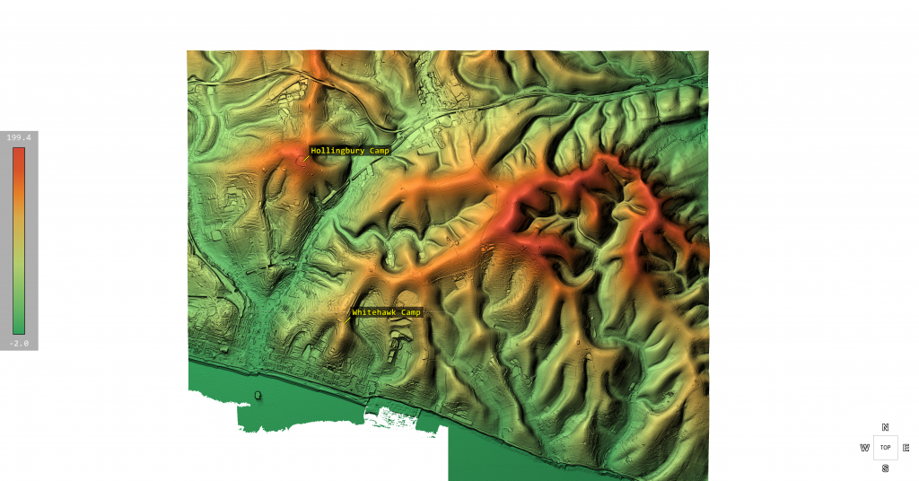
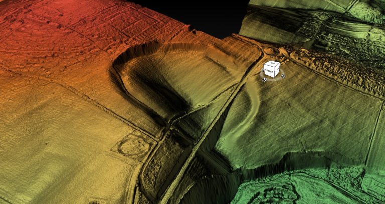
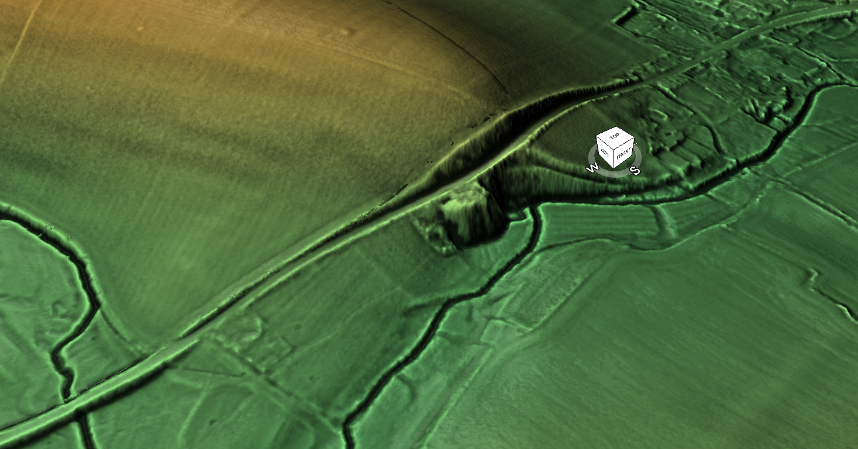
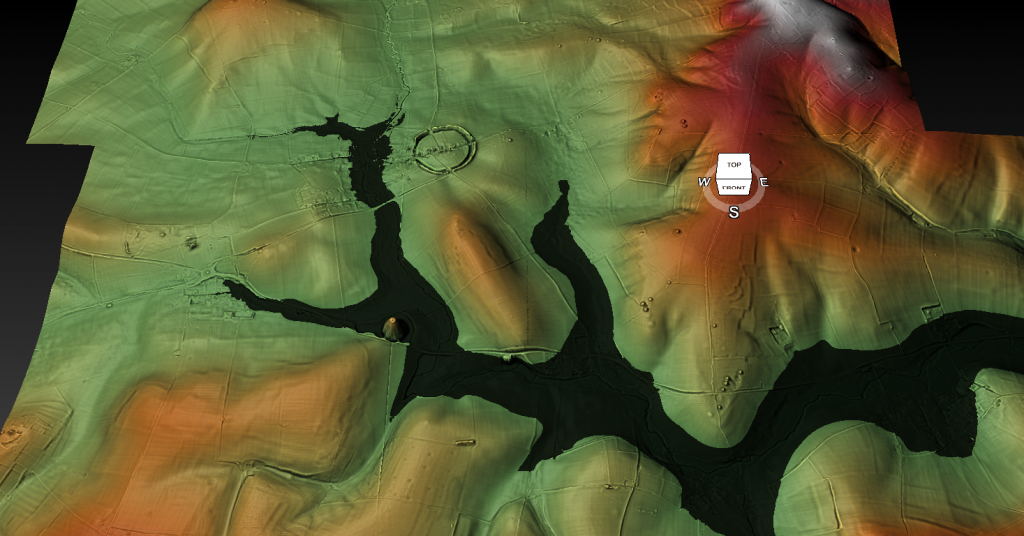
Lidar Map of Brighton - Hollingsbury Camp
Lidar Map of Brighton – Hollingsbury Camp

Inside the enclosure sit three Bronze Age bowl barrows, aligned north–south near the centre. That alone tells us the site had significance long before the so-called Iron Age “fort” was constructed. This isn’t a one-phase monument—it’s a reused landscape.

Now here’s where it gets interesting.

The Harbour That Nobody Talks About
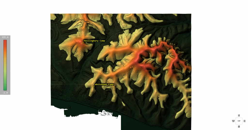
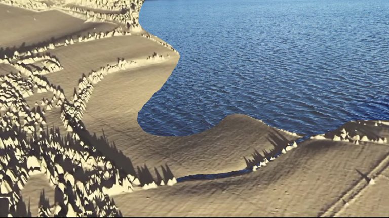
Lidar Map of Mesolithic  Brighton - Hollingsbury Camp
LiDAR Map of Hollingbury Camp in the Mesolithic Period – Hollingbury Camp Brighton

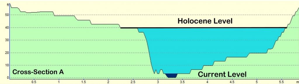
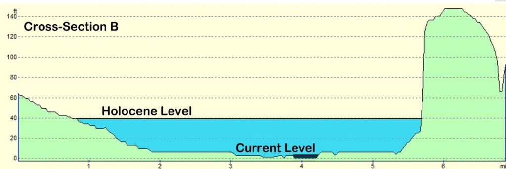
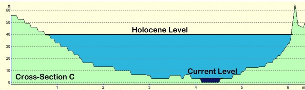
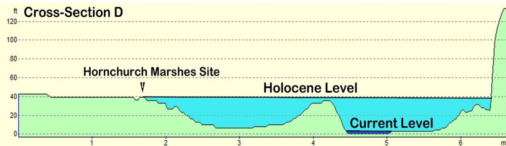
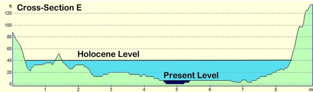
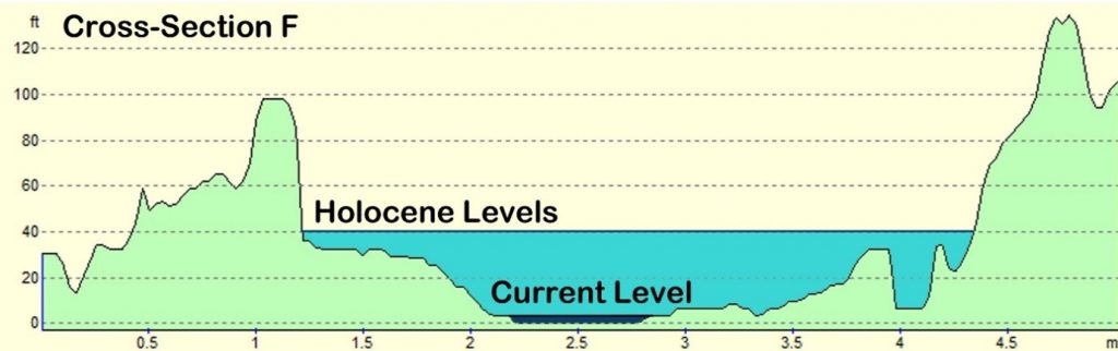
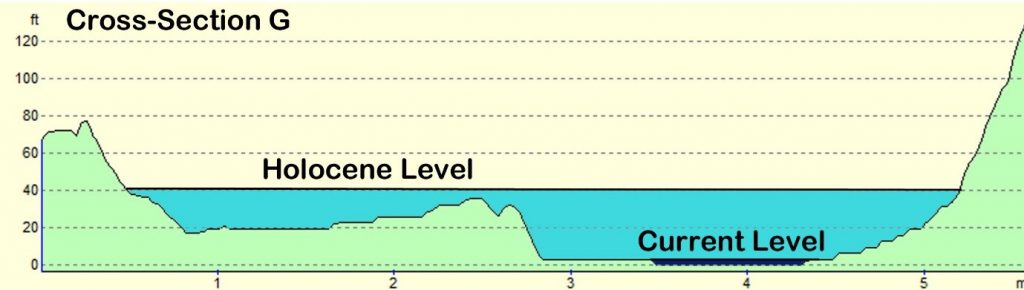
When you strip away the modern assumptions and look at the terrain model, Hollingbury reveals something far more compelling—a natural basin, a sheltered hollow with clear defensive sides.

In other words:

➡️ A harbour.

Not a symbolic one. A functional one.

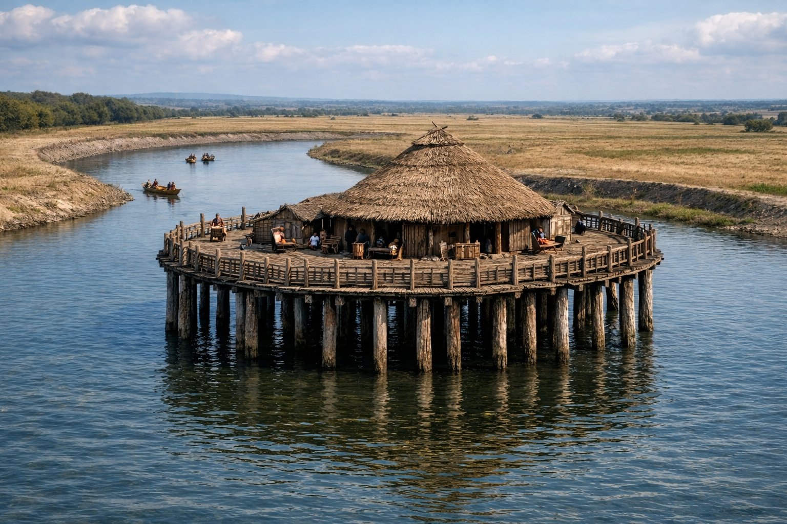
A place where vessels could shelter, protected from prevailing conditions, connected to wider water systems leading toward the Channel.

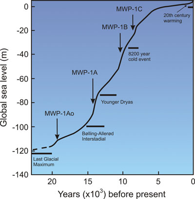
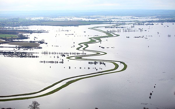
If you accept—based on measurable hydrology—that early Holocene Britain operated under significantly higher water tables and river levels, then sites like Hollingbury stop being “hillforts” and start being coastal or inland port infrastructure.

This is not speculation—it follows directly from the physics of post-glacial drainage and landscape response.


Trade, Not Tribes

Look around the perimeter and you’ll find pits and quarries.

Archaeology calls them “extraction features.”

But ask the obvious question:

➡️ Extraction for what purpose?

The answer is trade.

Minerals, flint, chalk products—materials that had value and were moved. You don’t build infrastructure like this for isolation. You build it for exchange.


The Dating Problem Nobody Wants to Address

The conventional timeline—Iron Age construction—relies heavily on pottery and standard dating frameworks.

But those frameworks have known limitations:

➡️ Reworked material
➡️ Contamination
➡️ Reservoir effects
➡️ Post-depositional movement

All of which can shift dates significantly, especially in water-influenced environments .

So if the landscape itself was water-dominated for thousands of years after the Ice Age…

➡️ Then the context in which those artefacts were deposited is already compromised.

Which raises the uncomfortable possibility:

👉 The site could be far older than the assigned Iron Age label
👉 Potentially Late Mesolithic / Early Neolithic (~6000 years ago)


Midsummer, Memory, and Meaning

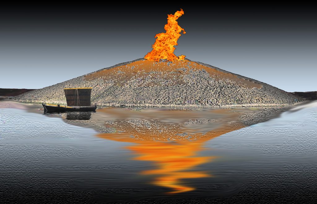
We’re told Hollingbury is a place of ritual—midsummer fires, folklore, Druids, dragons in burial mounds.

And yes, those traditions matter.

But they’re secondary.

They are memory, not origin.

People return to meaningful places. They reuse them. They mythologise them.

But they rarely build them without purpose in the first place.


So What Is Hollingbury?

Not just a hillfort.
Not just a burial ground.
Not just a ritual landscape.

➡️ It is infrastructure.
➡️ It is positioned for water.
➡️ It is aligned with trade.
➡️ It is reused across millennia.

And once you factor in post-glacial hydrology, it makes perfect sense.


The Bigger Picture

Hollingbury isn’t unique.

It’s part of a pattern:

➡️ Elevated sites
➡️ Basin-like interiors
➡️ Resource extraction nearby
➡️ Later “defensive” reinterpretation

What archaeology calls “hillforts” may in many cases be the fossilised remains of a water-based transport and trading network—one that existed in a very different Britain.

A Britain that was still draining from the Ice Age.


The question isn’t whether these sites were reused in the Iron Age.

They clearly were.

The question is:

👉 What were they before that?


The Prehistoric AI Team 🤖
(Still following the water… because the archaeology won’t 😎)

Use mouse and Left hand click (Ctrl) to PAN – Mouse and RIGHT hand Click to move UP and Down – and Wheel to zoom in the 3D Image

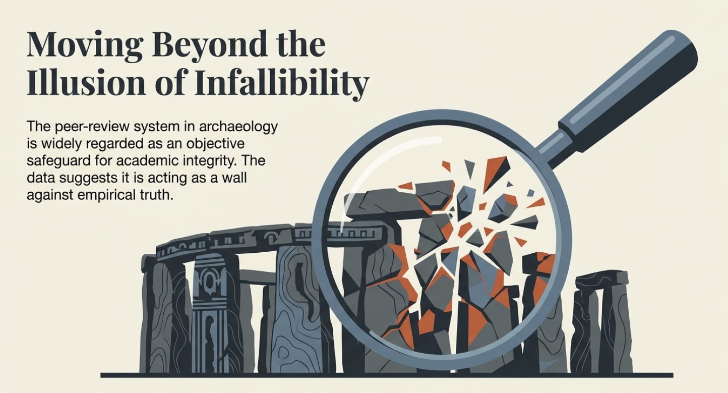
The peer-review system in archaeology is often regarded as a safeguard for academic integrity and quality control.  However, it has become a gatekeeping mechanism that suppresses alternative interpretations and enforces conformity to prevailing theories.  Michael Gordin, a historian of science, has noted that peer review is often mistaken for a flawless vetting system when, in reality, it is prone to bias and conservatism.  He argues that the process tends to favour established paradigms, making it difficult for groundbreaking ideas to gain traction.

Archaeologist E. Thomas Lawson has pointed out that the peer-review system is highly susceptible to institutional biases.  In a study published in Science and Technology Studies, Lawson demonstrated that reviewers often reject submissions that challenge dominant models, not necessarily because they lack weak evidence, but because they disrupt the consensus.  This issue is particularly acute in archaeology, where entrenched narratives about cultural evolution, settlement patterns, and technological development dominate scholarly discourse.  Those who propose alternative chronologies or challenge the attribution of artefacts often find their work dismissed outright, regardless of its empirical rigour.(Archaeology: The Flaws of Peer Review)

Archaeology: The Flaws of Peer Review
Most Peer-reviewed papers are ‘Pulp-fiction’ constructed for publicity and funding – (Archaeology: The Flaws of Peer Review)

A stark example of this suppression can be seen at the Cerutti Mastodon site in California.  When Steven Holen and his team published their findings in Nature in 2017, suggesting that humans may have been in North America over 130,000 years ago, the backlash was immediate.  Critics did not merely question the dating methods; they dismissed the research as implausible, despite the use of multiple independent dating techniques.  This reaction illustrates how peer review often functions not as an objective filter but as a reinforcement of accepted timelines and theories, even when the evidence demands reconsideration.

Further, the peer-review system is primarily controlled by a small number of academic gatekeepers.  A 2020 analysis by J. Scott Turner in The Journal of Scholarly Publishing revealed that many archaeological journals rely on a narrow pool of reviewers, many of whom share institutional affiliations and research backgrounds.  This concentration of influence creates an echo chamber where dissenting voices struggle to be heard.  Turner’s study found that papers proposing unconventional interpretations had a rejection rate nearly three times that of papers aligned with mainstream archaeological views.
(Archaeology: The Flaws of Peer Review)

This lack of openness is compounded by the anonymous nature of peer review, which allows reviewers to dismiss or delay controversial findings without accountability.  In some cases, reviewers have been found to recommend rejection of papers that later, when published through alternative means, proved to be groundbreaking.  For instance, the discovery of pre-Clovis human presence in the Americas faced decades of dismissal until mounting evidence from sites like Monte Verde forced a reassessment of long-held beliefs.  The delay in accepting such evidence highlights how peer review can be a brake on scientific progress rather than a facilitator of truth.

Another fundamental flaw of the peer-review system is its failure to recognise the evolving nature of scientific inquiry.  History has shown that many discoveries initially rejected by the academic establishment later became widely accepted.  The heliocentric model, continental drift, and the role of bacteria in ulcers were all dismissed before overwhelming evidence overturned the consensus.  In archaeology, similar patterns emerge, where findings that contradict prevailing models are routinely discarded until the weight of evidence makes resistance untenable.
(Archaeology: The Flaws of Peer Review)

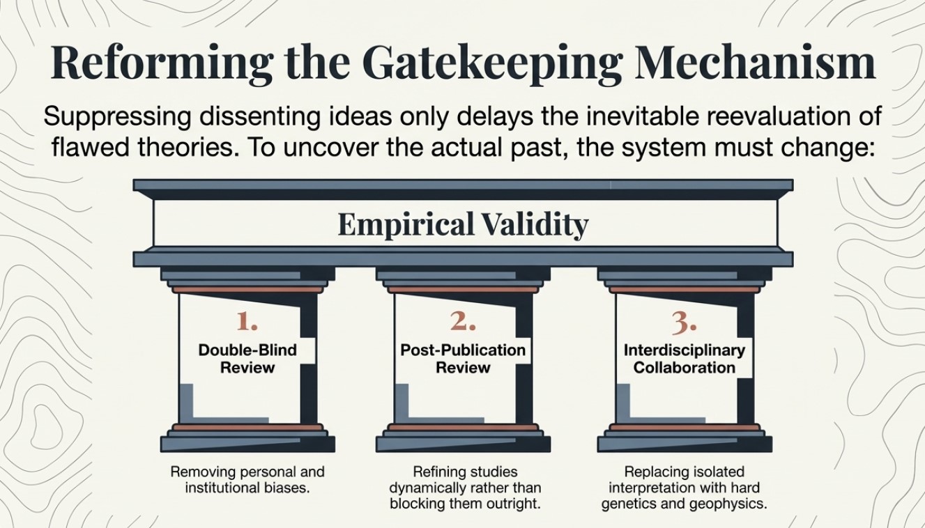
Archaeology must embrace a more open and transparent review process to foster true scientific progress.  Double-blind peer review, in which authors and reviewers remain anonymous, could help mitigate personal and institutional biases.  Additionally, encouraging post-publication peer review—where studies are critiqued and refined after publication rather than being blocked from dissemination—would enable a more dynamic and evidence-driven discourse.  Greater interdisciplinary collaboration, incorporating fields such as genetics, geophysics, and AI-assisted analysis, could also help challenge entrenched assumptions and promote a more balanced evaluation of new findings.

If archaeology aims to uncover the truth about the past, then the discipline must acknowledge and address the limitations of its review system.  Suppressing dissenting ideas only delays the inevitable reevaluation of flawed theories.  By reforming the peer-review process to prioritise empirical validity over academic orthodoxy, archaeology can become a more dynamic and self-correcting field that genuinely pursues knowledge rather than merely defending existing paradigms.

(Archaeology: The Flaws of Peer Review)

Preconceived notions

The peer-review process stands as a cornerstone of modern scientific inquiry, intended to filter research, uphold quality, and ensure the validity of published findings.  It is a system whereby experts in a particular field critically evaluate a submitted manuscript before it is accepted for publication, ideally identifying flaws, inconsistencies, and errors.  While the intention behind peer review is laudable, the assumption that all peer-reviewed papers are inherently accurate and error-free is a dangerous oversimplification.  Particularly within archaeology, where interpretation plays a significant role and definitive proof can be elusive, placing unwavering faith in the peer-review stamp can hinder progress and perpetuate flawed narratives.  The provided sources offer compelling insights into the limitations of peer review in archaeology, highlighting instances where the process has failed to prevent the dissemination of questionable findings, often due to the inherent subjectivity of the field and a tendency to prioritise the reporter’s preconceived notions over objective facts.

The investigations surrounding the dating and origins of Stonehenge, particularly the peer-reviewed publications stemming from Mike Parker-Pearson’s (MPP) work on Bluehenge, the bluestone quarries and Waun Mawn, serve as stark examples of how the peer-review system can be flawed and how its weight of evidence can be unduly influenced by the author’s reputation and desired outcomes.  The case of Bluestonehenge further highlights how prior assumptions can drive research conclusions, even when contradictory data exists.  These cases illustrate a broader issue within archaeology: a tendency to align findings with prevailing theories rather than rigorously testing hypotheses against all available evidence.

The Lost Stone Circle – many made up for good TV

The Subjectivity

Unlike the hard sciences that rely on quantifiable data and reproducible experiments, archaeology frequently deals with fragmented evidence requiring interpretation.  Archaeological findings are often unique to specific sites and cannot be replicated.  This reliance on interpretation opens the door to interpretive bias, in which an archaeologist’s perspective, cultural background, or theoretical framework can influence the narrative constructed from the available evidence.  Consequently, the peer reviewers, who are also subject to their own biases, may inadvertently endorse interpretations that align with prevailing theories or the author’s established viewpoint rather than rigorously scrutinising the factual basis of the claims.

This can lead to “possibilities are often presented as certainties, creating a misleading view of the past.” The “establishment’s over-reliance on ‘peer review’ as a conformity standard of credibility” has been criticised, with Richard Horton, editor of The Lancet, suggesting that peer review is merely a “crude means of discovering the acceptability—not the validity—of a new finding.” This crucial distinction underscores that peer review may often reinforce existing paradigms within the archaeological community, potentially hindering the acceptance of genuinely novel or contradictory evidence.

Ricahrd Horton of the Lancet

The Case of Bluestonehenge: A Shift in Narrative Due to Contradictory Evidence

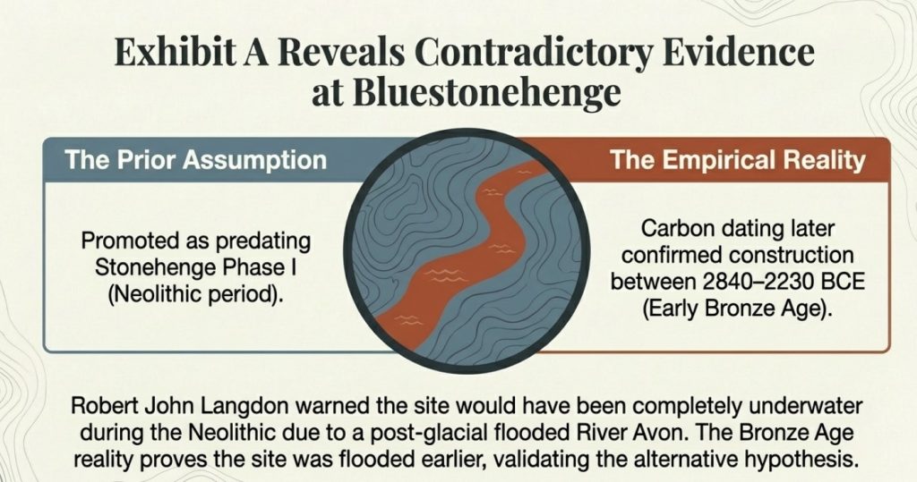
The first site to consider, Bluestonehenge, was under excavation in 2009.  At that time, MPP was preparing to announce it as his bluestone site and believed it predated Stonehenge Phase I.  However, during their meeting, the author of The Stonehenge Enigma (2013) raised concerns about this dating.  Based on his research into the 50 sites surrounding Stonehenge and his post-glacial-flooded-environment hypothesis, they concluded that Bluestonehenge would have been below water during the Neolithic period because the River Avon remained flooded.

MPP dismissed this research and published, but later carbon dating confirmed this point and supported the author’s hypothesis, as it is now accepted that Bluestonehenge was constructed between 2840–2230 BCE, which falls into the Early Bronze Age rather than the Neolithic period as initially proposed by MPP.  This raises significant concerns about the reliability of peer-reviewed interpretations, as the initial dating—endorsed by peer review—was later found to be incorrect.
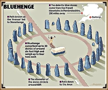
MPP’s first attempt to justify his dates

The Craig Rhos-y-Felin Quarry: Cherry-Picking Evidence to Fit a Hypothesis

The investigations led by MPP into the origins of Stonehenge’s bluestones provide a compelling case study of how the peer-review process can be intertwined with pursuing a specific hypothesis, potentially overlooking contradictory evidence and leading to flawed conclusions.  The initial breakthrough of finding the bluestone quarry at Craig Rhos-y-Felin was significant.  However, the subsequent attempts to date the quarry and link it definitively to a specific construction date for Stonehenge, particularly around 3300 BCE, demonstrate a tendency to “attempt to find a date that would vindicate their Stonehenge dating methods.”
(Archaeology: The Flaws of Peer Review)

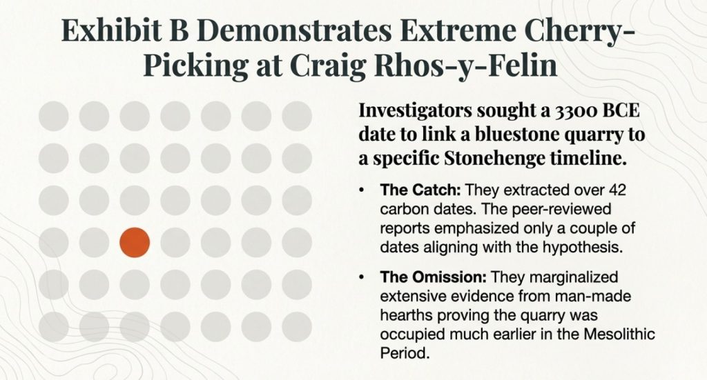
At Craig Rhos-y-Felin, over 42 carbon dates were obtained.  However, the peer-reviewed reports emanating from this investigation were criticised for emphasising only a couple of Neolithic dates that appeared to support the 3300 BCE hypothesis while mainly overlooking the “extensive evidence found in the site’s man-made hearths, which showed that the quarry was first occupied in the Mesolithic Period.” These Mesolithic hearths, dating significantly earlier than the desired Neolithic timeframe, posed a challenge to the pre-existing narrative but were seemingly marginalised in pursuit of a specific conclusion.  This selective presentation of data, which the sources label as “clear ‘cherry-picking’ of the archaeological evidence,” suggests that the weight of the reported evidence was skewed by the author’s desire to validate a prior claim and that the peer-review process in this instance did not sufficiently challenge this biased interpretation.
(Archaeology: The Flaws of Peer Review)
Only accept one of the forty-two carbon dates that were closest to his hypothesis

Waun Mawn: The Search for a Lost Circle and the Limits of Peer Review

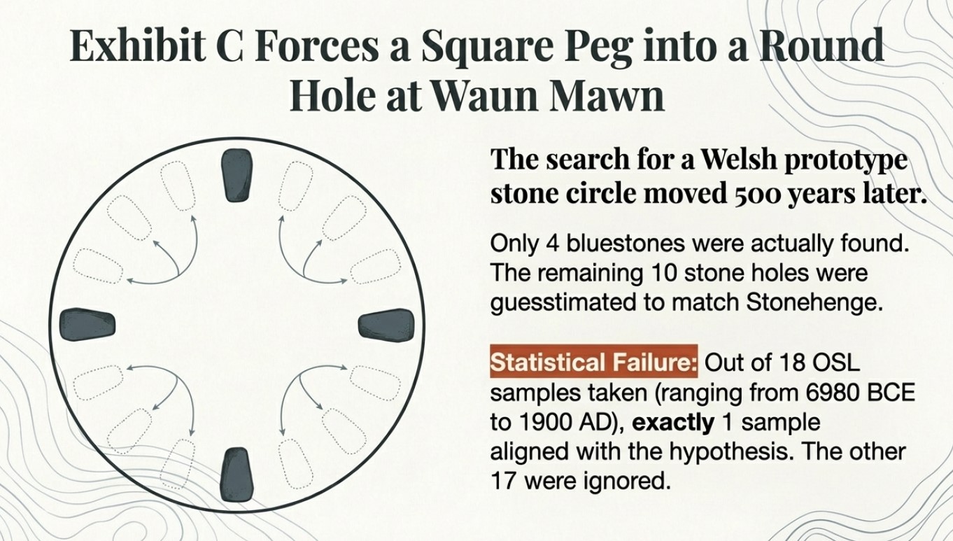
The discrepancy between the desired 3300 BCE date and the slightly earlier dates obtained at the quarry site fueled the hypothesis of a “Welsh prototype stone circle which was moved 500 years later.” This second claim by MPP and subsequent peer-reviewed papers and TV programmes “claimed to find this ‘mysterious site,’ later to discover that it was nonsense raises serious questions about the rigour of the research and the extent to which the peer-review process scrutinised these evolving and ultimately unsubstantiated claims.

At Waun Mawn, only four bluestones were found, leading to a “sad attempt to fit a square peg into a round hole” by identifying ten further stone holes and guesstimating the existence of the remaining stones needed to match Stonehenge.  Furthermore, the dating evidence from Waun Mawn is heavily criticised.  While the program highlighted a single OSL date that appeared to align with the desired timeframe, the sources reveal that “there was not one OSL sample taken but 18, which gave results in the range of 6980+/- 2120 BCE to AD 1900 +/- 20.” The fact that “17 dating samples did not verify MPP’s Hypothesis, ONLY a single one,” strongly suggests a selective emphasis on a single data point to support a pre-existing claim.
(Archaeology: The Flaws of Peer Review)
The dates he found corresponded to other carbon dates at Stonehenge but were ignored

Conclusion: Moving Beyond the Illusion of Infallibility

While the peer-review process remains a vital component of archaeological scholarship, it is crucial to recognise its inherent limitations and avoid believing that all peer-reviewed papers are accurate and error-free.  The case studies surrounding Mike Parker-Pearson’s investigations into the origins of Stonehenge highlight how the subjectivity of archaeological interpretation, the pursuit of pre-existing hypotheses, and the potential influence of the reporter’s authority can lead to flawed findings being published.  The selective use of data, the downplaying of contradictory evidence, and the development of speculative theories underscore the need for a more critical engagement with peer-reviewed publications, prioritising rigorous examination of the factual evidence and methodologies employed rather than relying on perceived authority.

(Archaeology: The Flaws of Peer Review)

Prologue

Archaeological research, while often considered a rigorous discipline, faces challenges concerning the reach and reliability of its published work. Studies have shown that a significant portion of academic papers receive minimal attention post-publication. Approximately 44% of all published manuscripts are never cited, indicating that nearly half of these works remain largely unread or unreferenced within the scholarly community.

lucbeaulieu.com

Furthermore, citation analyses reveal that the average number of citations per paper is below ten. Achieving 10 or more citations places a manuscript in the top 24% of the most-cited works worldwide, underscoring the limited engagement many papers receive.

lucbeaulieu.com

Regarding the accuracy of scientific publications, the rate of retractions has seen a notable increase. Although retracted papers still constitute a small fraction—under 0.1%—of the more than 25 million papers indexed in PubMed since the 1940s, this uptick highlights ongoing concerns about the reliability of published research.

en.wikipedia.org

In archaeology, the prevalence of flawed studies is difficult to quantify precisely due to the field’s interpretive nature and the scarcity of replication studies. However, documented cases, such as the Himalayan fossil hoax involving Vishwa Jit Gupta, illustrate that significant errors and even fraudulent activities can persist undetected for extended periods, thereby influencing subsequent research.

en.wikipedia.org

These insights emphasise the necessity for heightened scrutiny and critical engagement within archaeological scholarship to ensure the integrity and impact of its contributions.

PodCast

Author’s Biography

Robert John Langdon, a polymathic luminary, emerges as a writer, historian, and eminent specialist in LiDAR Landscape Archaeology.

His intellectual voyage has interwoven with stints as an astute scrutineer for governmental realms and grand corporate bastions, a tapestry spanning British Telecommunications, Cable and Wireless, British Gas, and the esteemed University of London.

A decade hence, Robert’s transition into retirement unfurled a chapter of insatiable curiosity. This phase saw him immerse himself in Politics, Archaeology, Philosophy, and the enigmatic realm of Quantum Mechanics. His academic odyssey traversed the venerable corridors of knowledge hubs such as the Museum of London, University College London, Birkbeck College, The City Literature Institute, and Chichester University.

In the symphony of his life, Robert is a custodian of three progeny and a pair of cherished grandchildren. His sanctuary lies ensconced in the embrace of West Wales, where he inhabits an isolated cottage, its windows framing a vista of the boundless sea – a retreat from the scrutinous gaze of the Her Majesty’s Revenue and Customs, an amiable clandestinity in the lap of nature’s embrace.

Exploring Prehistoric Britain: A Journey Through Time

My blog delves into the fascinating mysteries of prehistoric Britain, challenging conventional narratives and offering fresh perspectives based on cutting-edge research, particularly using LiDAR technology. I invite you to explore some key areas of my research. For example, the Wansdyke, often cited as a defensive structure, is re-examined in light of new evidence. I’ve presented my findings in my blog post Wansdyke: A British Frontier Wall – ‘Debunked’, and a Wansdyke LiDAR Flyover video further visualizes my conclusions.

My work also often challenges established archaeological dogma. I argue that many sites, such as Hambledon Hill, commonly identified as Iron Age hillforts are not what they seem. My posts Lidar Investigation Hambledon Hill – NOT an ‘Iron Age Fort’ and Unmasking the “Iron Age Hillfort” Myth explore these ideas in detail and offer an alternative view. Similarly, sites like Cissbury Ring and White Sheet Camp, also receive a re-evaluation based on LiDAR analysis in my posts Lidar Investigation Cissbury Ring through time and Lidar Investigation White Sheet Camp, revealing fascinating insights into their true purpose. I have also examined South Cadbury Castle, often linked to the mythical Camelot56.

My research also extends to the topic of ancient water management, including the role of canals and other linear earthworks. I have discussed the true origins of Car Dyke in multiple posts including Car Dyke – ABC News PodCast and Lidar Investigation Car Dyke – North Section, suggesting a Mesolithic origin2357. I also explore the misidentification of Roman aqueducts, as seen in my posts on the Great Chesters (Roman) Aqueduct. My research has also been greatly informed by my post-glacial flooding hypothesis which has helped to inform the landscape transformations over time. I have discussed this hypothesis in several posts including AI now supports my Post-Glacial Flooding Hypothesis and Exploring Britain’s Flooded Past: A Personal Journey

Finally, my blog also investigates prehistoric burial practices, as seen in Prehistoric Burial Practices of Britain and explores the mystery of Pillow Mounds, often mistaken for medieval rabbit warrens, but with a potential link to Bronze Age cremation in my posts: Pillow Mounds: A Bronze Age Legacy of Cremation? and The Mystery of Pillow Mounds: Are They Really Medieval Rabbit Warrens?. My research also includes the astronomical insights of ancient sites, for example, in Rediscovering the Winter Solstice: The Original Winter Festival. I also review new information about the construction of Stonehenge in The Stonehenge Enigma.

Further Reading

For those interested in British Prehistory, visit www.prehistoric-britain.co.uk, a comprehensive resource featuring an extensive collection of archaeology articles, modern LiDAR investigations, and groundbreaking research. The site also includes insights and extracts from the acclaimed Robert John Langdon Trilogy, a series of books exploring Britain during the Prehistoric period. Titles in the trilogy include The Stonehenge Enigma, Dawn of the Lost Civilisation, and The Post Glacial Flooding Hypothesis, offering compelling evidence about ancient landscapes shaped by post-glacial flooding.

To further explore these topics, Robert John Langdon has developed a dedicated YouTube channel featuring over 100 video documentaries and investigations that complement the trilogy. Notable discoveries and studies showcased on the channel include 13 Things that Don’t Make Sense in History and the revelation of Silbury Avenue – The Lost Stone Avenue, a rediscovered prehistoric feature at Avebury, Wiltshire.

In addition to his main works, Langdon has released a series of shorter, accessible publications, ideal for readers delving into specific topics. These include:

For active discussions and updates on the trilogy’s findings and recent LiDAR investigations, join our vibrant community on Facebook. Engage with like-minded enthusiasts by leaving a message or contributing to debates in our Facebook Group.

Whether through the books, the website, or interactive videos, we aim to provide a deeper understanding of Britain’s fascinating prehistoric past. We encourage you to explore these resources and uncover the mysteries of ancient landscapes through the lens of modern archaeology.

For more information, including chapter extracts and related publications, visit the Robert John Langdon Author Page. Dive into works such as The Stonehenge Enigma or Dawn of the Lost Civilisation, and explore cutting-edge theories that challenge traditional historical narratives.

Other Blogs

s

t

Archaeological ‘pulp fiction’ – has archaeology turned from science?
Introduction

After 40 years of studying archaeological features and reports, I have sadly concluded that archaeologists no longer follow accepted scientific methods and now revert to the simplistic traditional model or political correctness, mixed with the occasional sensationalism, not to progress the discipline but moreover, to find funding and maintain their status in the archaeological community.  This new social media marketing technique has also spread to both the geological and anthropological disciplines closely related to this archaeological ‘pulp fiction’. (Archaeological ‘pulp fiction’ – has archaeology turned from science?)

Science is about questioning what is known, as it is understood from History that current knowledge is not a ‘SCIENTIFIC FACT’ but just a supposition which over time will change and become more accurate through questioning the details of these ideas over time and the inevitable future scientific discoveries – but this is not the case in archaeology. (Archaeological ‘pulp fiction’ – has archaeology turned from science?)

Bronowski - Archaeological 'pulp fiction' - has archaeology turned from science?
Bronowski – Archaeological ‘pulp fiction’ – has archaeology turned from science?
In recent years, the discovery of the Bluestone quarry at Craig Rhos-Y-Felin should have brought a new perspective to the construction date and nature of the civilisation that built Stonehenge – Britain’s most famous prehistoric site.  Instead, the findings and data were manipulated to prove an existing hypothesis while excluding more interesting and revolutionary results.

This dogmatic approach to archaeology is compounded by new theories and even findings being ignored and, in some instances, actively crushed by the archaeological establishment and their disciples in favour of this dated ‘historical narrative’ in this new post-truth era of social media – rather than following the past practices of a scientific methodology of examining the potential and feasibility of these new ideas. 

This censorship is also practised in scientific journals and websites either by blanket failure to publish contrary evidence or by claiming a liberal attitude and then demanding excessive peer-reviewed endorsements before consideration.  In some instances, they encourage the simplistic labelling of these ideas as ‘pseudoscience’ in social media and academic punishment at university for any student that dares suggest such ideas in their assignments. (Archaeological ‘pulp fiction’ – has archaeology turned from science?)

Karl Popper quote - Archaeological 'pulp fiction' - has archaeology turned from science?
Popper -(Archaeological ‘pulp fiction’ – has archaeology turned from science?)

Moreover, these education establishments have failed to teach their students basic scientific principles of ‘critical analysis’ and ‘deductive logic’ when examining primary sources, demanding their students rely on secondary sources (opinions) of an accepted highly vetted reading list – which therefore favours the current simplistic traditional theories.  Consequently, this allows them to concentrate their energies on the establishment’s main concern for ‘bums on seats’ to secure funding for future financial security, rather than the higher principle of progressive education – questioning the validity of the certificates and qualifications awarded.

The establishments over-reliance on ‘peer-review’ as a conformity standard of credibility has not only been recognised by myself within my recent Honours degree in History but by moreover Richard Horton, editor of the British medical journal The Lancet, who said that:

“The mistake, of course, is to have thought that peer review was any more than a crude means of discovering the acceptability—not the validity—of a new finding. Editors and scientists alike insist on the pivotal importance of peer review. We portray peer review to the public as a quasi-sacred process that helps to make science our most objective truth teller.

But we know that the system of peer review is biased, unjust, unaccountable, incomplete, easily fixed, often insulting, usually ignorant, occasionally foolish, and frequently wrong.” (Archaeological ‘pulp fiction’ – has archaeology turned from science?)

peer review is biased, unjust, unaccountable, incomplete, easily fixed, often insulting, usually ignorant, occasionally foolish, and frequently wrong." Archaeological 'pulp fiction' - has archaeology turned from science?
Richard Horton – “unjust, unaccountable, incomplete, easily fixed, often insulting, usually ignorant, occasionally foolish, and frequently wrong.” – archaeological ‘pulp fiction’

So, in what areas do we see this flawed blanket censorship and what are the other possibilities archaeologists have failed to comprehend?

Cheddar Man

A recent discovery in Britain was made by analysing the mtDNA (mitochondrial DNA) from the skeleton of a Mesolithic man, discovered in the Cheddar Gorge, Somerset, England. According to the announcement, what researchers found in their analysis was that this ancient person (dated approximately 9000 years ago) likely had a dark (brown-black) skin colour, dark brown hair, blue eyes, and phenotypical features resemble western Europeans. That’s all well and good, but what’s the problem with that? (Archaeological ‘pulp fiction’ – has archaeology turned from science?)

Without going into too much detail about the genomic research conducted, the issue is with the findings compiled with data collected over twenty years prior when the mtDNA collection first began in 1996. The 1996 study (interestingly was not subjected to any peer-review) it has been stated by subsequent reports referencing these findings, suggested that there was modern DNA contamination at some point in the process of collection. (Archaeological ‘pulp fiction’ – has archaeology turned from science?)

Cheddar Man -Archaeological 'pulp fiction' - has archaeology turned from science?
Cheddar Man -(Archaeological ‘pulp fiction’ – has archaeology turned from science?)

The more recent study was made after a fragment of the skull was analysed in 2018. It was found that Cheddar Man’s remains belonged to the same ancestral family as other Mesolithic European populations. This information does not seem too profound, but what appears to be an issue for some, including myself, is simply the lack of efforts to peer-review the work first conducted to ensure that all the findings are legitimate and then knowing its questionable origins to go on to publish the chromosome details of hair colour, eye colour and skin colour via a model to gain maximum publicity. (Archaeological ‘pulp fiction’ – has archaeology turned from science?)

Even if the DNA was not contaminated initially, the chromosomes required to estimate (as this science is still not proven, just a working hypothesis) were missing.  Of the six types of chromosome needed for the estimation of skin tone, 60% of them were absent, and consequently, at BEST, the assessment had a 60% chance of being incorrect.  Science dictates that unless the probability rate is greater than 50%, then the result should not be even attempted as the likelihood (statistically) is wrong!!

Yet, this announcement has now created ‘scientifically based’ documentaries showing that black Rastafarian men (with dreadlocks), discovered and populated Ireland ten thousand years ago, all based on ‘Bad Science’ that gave the establishment political ‘brownie points’ on social media. Previous studies (Genomic structure in Europeans dating back at least 36,200 years, Science DOI: 10.1126/science.aaa0114) have shown that the first Europeans were Scandinavians, and hence cheddar man’s’ blue eyes’. (Archaeological ‘pulp fiction’ – has archaeology turned from science?)

Craig Rhos-Y-Felin (Stonehenge’s Bluestone Quarry)

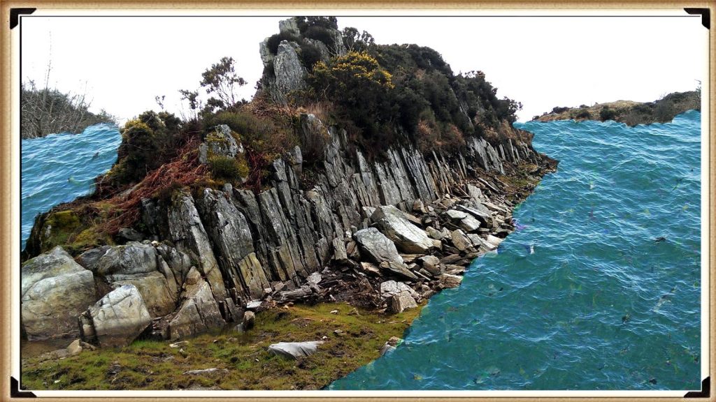
The Craig Rhos-y-Felin report (by Mike Parker-Pearson) is full of inconsistencies and logical inaccuracies as the layout of the site were never taken into consideration.  Firstly is the river that runs next to the quarry – this shows that this river was still at the edge of the site as long ago as 5620 – 5460 BCE and possibly up to 1030 – 910 BCE. (Archaeological ‘pulp fiction’ – has archaeology turned from science?)

Craig Rhos-Y-Felin - Archaeological 'pulp fiction' - has archaeology turned from science?
Craig Rhos-Y-Felin – (Archaeological ‘pulp fiction’ – has archaeology turned from science?)

“Most of the site was then covered by a layer of yellow colluvium (035), dated by oak charcoal to 1030–910 cal BC (combine SUERC-46199; 2799±30 BP and SUERC-46203; 2841±28 BP). This deposit is contemporary with the uppermost fill of a palaeochannel of the Brynberian stream that flowed past the northern tip of the outcrop. Charcoal of Corylus and Tilia from the basal fill of this palaeochannel dates to 5800–5640 cal BC (OxA- 32021; 6833±40 BP) and 5620–5460 cal BC (OxA-32022; 6543±37 BP), both at 95.4% probability.”

Consequently, what the report is trying to tell us, is that an enlarged stream that feeds into the River Nevern was flowing during the Mesolithic Period up to the quarry outcrop rocks, and it remained there just a few metres away, even up to 1000 BCE.  Therefore, the apparent transport system for these large newly quarried stones to their final destination at Stonehenge, as we have seen in other countries with their stone constructions like Egypt – was via a boat. (Archaeological ‘pulp fiction’ – has archaeology turned from science?)

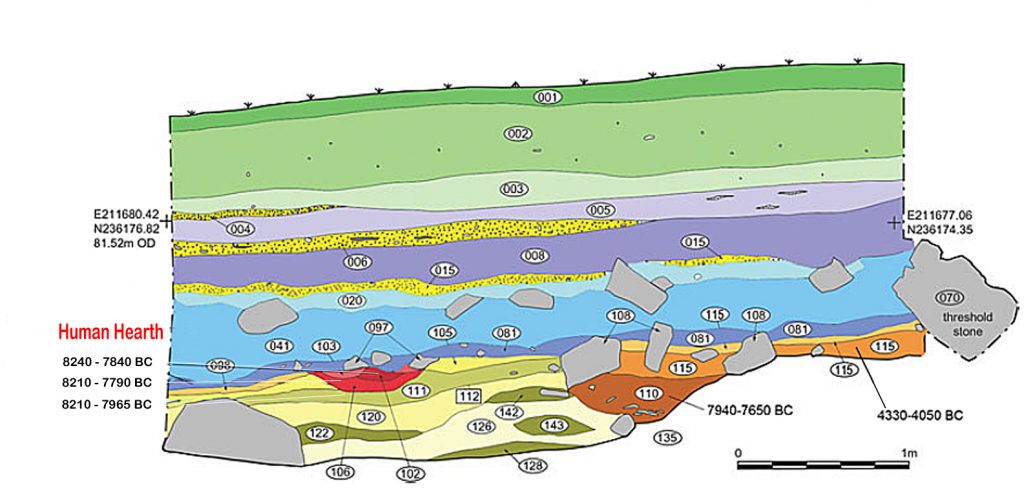
Moreover, the site layout also gives a clear indication of when the stone was genuinely quarried. There is a single monolith ready for transportation by the river on the east side of the site, and the hearths, which are human-made, are a few metres south of this monolith – where you would expect them.  The problem for archaeologists is that these are Mesolithic hearths, and they’re not just one but three hearths dating from 8550 – 8330 BCE; 8220 – 7790 and BCE 7490 – 7190B CE and yet the report quite clearly states:

Rhos-Y-Felin Mesolithic hearths - Archaeological 'pulp fiction' - Archaeological 'pulp fiction' - has archaeology turned from science?
Rhos-Y-Felin Mesolithic hearths – archaeological ‘pulp fiction’

“There is no evidence of any Mesolithic Quarrying or working of Rhyolite from this crop”.

This is an astonishing unscientific claim – for how they would know what tool marks are either Mesolithic or Neolithic (would they not be using the same tools?) And secondly, what do they think they were doing there at the quarry during these 1300 years?

What the establishment would like you to believe is that just TWO of the 42 carbon dates obtained from the site are of importance and the other 40 are irrelevant.  This is ‘bad science’ in pursuit of maintaining the ‘tradition model’ at the expense of real science.

More information can be found about Craig Rhos-Y-Felin can be found on this website and on this video channel. (Archaeological ‘pulp fiction’ – has archaeology turned from science?)

Woodhenge

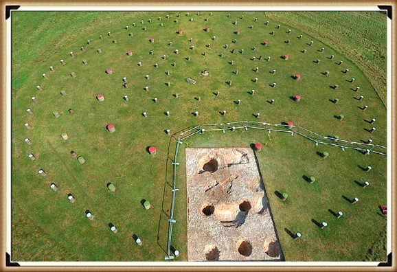
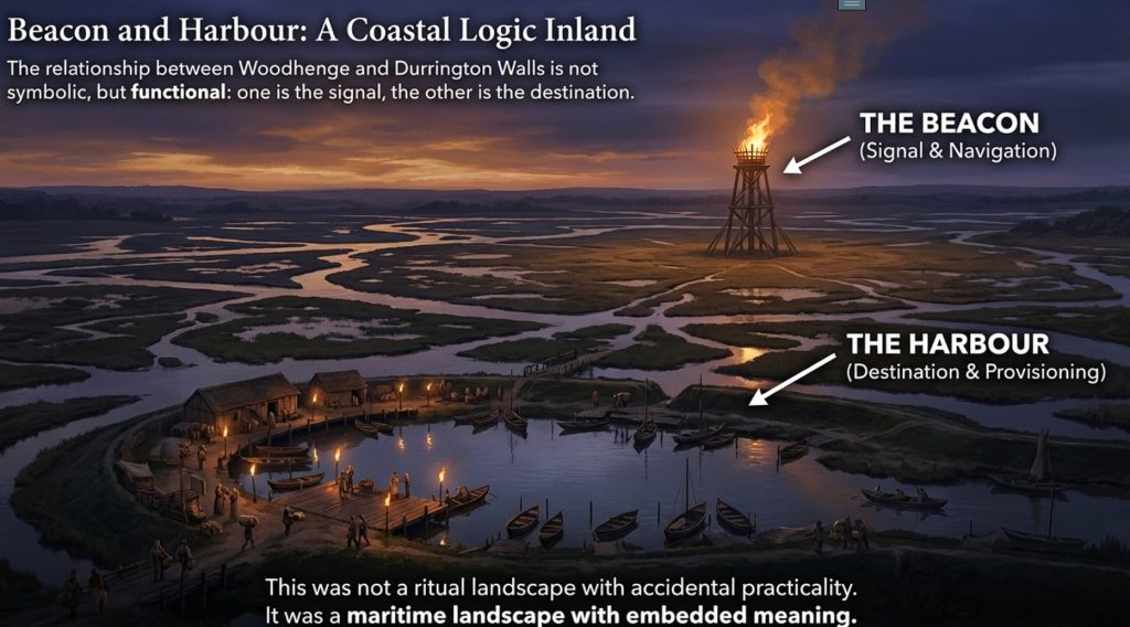
Sadly, Woodhenge’s traditional reconstruction shows us yet another illustration of flawed science in archaeology.  Even with a ‘second rate’ excavation report from the 1920s, the conclusion of modern archaeologists is that this structure was a single-story house – a slightly grander feature to the traditional ‘iron age’ house or an ‘artistic forest’ of tree stumps is simply nonsense. If we look closely at the evidence presented here, we obtain a totally different and more accurate conclusion to the nature of this structure.

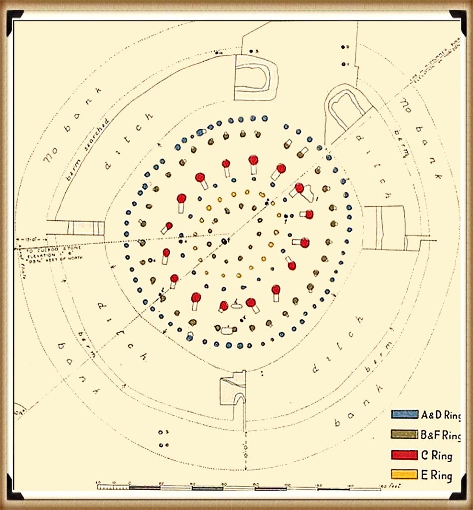
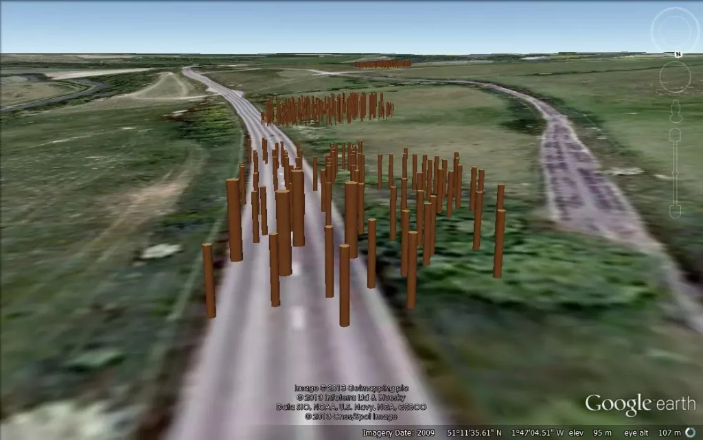
Firstly, if we look at the layout of the site (which lacks much detail), we can see from these original excavation plans the scale of this understatement, as the existing ‘concrete’ posts on the site are far too small.  The most recent photo was from the excavation by Pollard in 2007 indicates that the original post holes are at least five times larger than the current representations. (Archaeological ‘pulp fiction’ – has archaeology turned from science?)

Woodhenge misinterpretation – archaeological ‘pulp fiction’

The following fact that goes unanswered is the reason for the large ramps by the post holes. You don’t take time to put 32 ramps into the soil unless it is essential, as you just added at least another month to the building work for the site and 500 working hours.  What archaeologists have missed (or failed to mention) is in which direction these ramps were cut – as it tells us more than the entire excavation report by Cunnington.

The massive 4 – 5 ft pine posts of the 16 postholes (known as the C Ring) would weigh 214kg per foot of length.  Therefore, several sizeable healthy adults could pick up a single story pole and place it in a hole without assistance or a need for a large ramp.

Moreover, the site plan does also give us another clue to the length of these poles.  If to look carefully at the angle of the ramps into the giant postholes, you will notice that they are not all facing the same direction.  The only logical reason for that to happen is if you erect the pine poles in a set order not to hit or interfere with each other when attempting to erect the posts.  This would prove that the poles at Woodhenge were over 100 ft high (if not taller). (Archaeological ‘pulp fiction’ – has archaeology turned from science?)

Archaeological 'pulp fiction' - has archaeology turned from science?
Giant Posts of Woodhenge – archaeological pulp fiction.

As for the dating of Woodhenge reconstruction (and Durrington Walls), like Stonehenge, unrelated antler and bone fragments have dated it to about 2400 BCE, which is very convenient.  The problem is that most of the post hole samples at Woodhenge were either lost or have been stored away and not tested since the excavations between 1926 to 29, for reasons known best to the experts. (Archaeological ‘pulp fiction’ – has archaeology turned from science?)

Moreover, like the samples taken from the old car park in 1966, pine charcoal was reported to be found “similar to the charcoal found at Woodhenge” was the quote from the labs at the time, who failed to carbon date the samples as the experts had declared them Neolithic, supporting the antler pick dates.  Although now, once this gross error was exposed, we know these pine charcoal wood dates to be in fact Mesolithic 8100 BCE – which ‘begs-the-question’ so are the pine charcoal dates found at Woodhenge also Mesolithic, and why were they not also carbon-dated when the mistake was discovered? – more ‘bad science’ supporting the traditional model.

More information can be found about Woodhenge can be found on this website and on this video channel. (Archaeological ‘pulp fiction’ – has archaeology turned from science?)

Dykes

If you study archaeology at university or even on an ordinance survey map at length, you will notice strange earthworks on the sides of hills of Britain, with no rational explanation as to why they are where they are. At university, these features are mostly ignored, or an excuse is made for their construction. The reality is that these features do not make any sense unless there is another factor in operation.

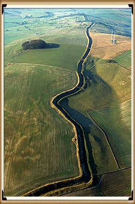
The first thing to notice is that the word ‘Dyke’ is associated with water. It does seem strange you would call an earthwork on top of a hill a Dyke, unless there was some history passed down through the years to its actual use. If we look at the most famous Dyke in Britain: Offa’s Dyke (that tracks the border between England and Wales).

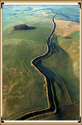
Wansdyke - Archaeological 'pulp fiction' - has archaeology turned from science?
Wansdyke – (Archaeological ‘pulp fiction’ – has archaeology turned from science?)

“Offa’s Dyke (Welsh: Clawdd Offa) is a massive linear earthwork, roughly followed by some of the current borders between England and Wales. In places, it is up to 65 feet (19.8 m) wide (including its flanking ditch) and 8 feet (2.4 m) high. In the 8th century, it formed some delineation between the Anglia kingdom of Mercia and the Welsh kingdom of Powys.” (Archaeological ‘pulp fiction’ – has archaeology turned from science?)

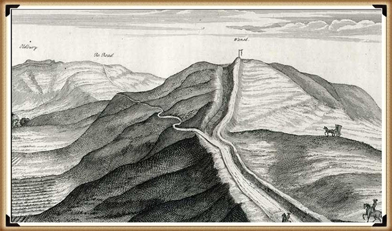
Stukeley's Drawing showing the Roman road ON TOP of the Dyke showing it was pre-Roman - Archaeological 'pulp fiction' - has archaeology turned from science?
Stukeley’s Drawing showing the Roman road ON TOP of the Dyke showing it was pre-Roman – (Archaeological ‘pulp fiction’ – has archaeology turned from science?)

At face value, this seems to answer all the questions about dykes – except the water connection.

The current ‘traditional model’ for these features is split into two very unconvincing and easily disproven theories:

Defensive Feature – According to English Heritage, “Sometime during the 780s, Offa decided on the construction of a great earth wall and ditch, or dyke, running from ‘sea to sea’.  The work required thousands of men, and each section seems to have been built by people from a different district. The fact that this mammoth undertaking was achieved illustrates the cohesion of the kingdom at this time. The dyke was never garrisoned but would have been manned by relatively small local forces. Offa died in 796 in a battle against the Welsh. It is believed that he was trying to establish a final link in the dyke to the Irish Sea in the north.“

The ditch only appears in the north of Wales (with two parallel ditches – not explained by any ‘experts’) and in the South.  There is a massive 30-mile gap in the middle which is denoted by the River Wye.  Consequently. If it was defensive, it had an enormous 30-mile flaw?

Boundary Marker – experts knowing the original ‘defensive identification’ have now fallen  back to support a ‘boundary marker’ theory of the same date – but why build a massive ditch just a few metres from the rest of the river Wye – especially, when you are using over 30% of the same river as the accepted boarder marker?? – it’s completely flawed logic, again to support the irrational traditional model and dating system, especially, when there is a much more rational and simple explanation (a canal)?

More information can be found about Dykes (canals) can be found on this website and on this video channel. (Archaeological ‘pulp fiction’ – has archaeology turned from science?)

The Lost Stone Circle

Following on from the ‘Bad Science’ at Craig Rhos-Y-Felin, Mike Parker-Pearson then went ‘public’ and announced that they found the site of bluestones that supported his hypothesis on Stonehenge being built in 2800 BCE – but there was a problem even with this only two carbon ‘nut case’ date. It was still 500 years too early, and so MPP came up with a ‘credible theory’ about the date differences – A Welsh prototype stone circle that was moved 500 years later.

Consequently, the search started for this mysterious ‘lost’ stone circle in Wales from 2013 (onward) to justify the 500-year gap in his dates. MPP has on several occasions, and he claimed to find this ‘mysterious site’, later to discover that it was nonsense (as he could not find his 3300 BCE date), and then they moved on to find another site.  Needless to say, this is again ‘Bad Science’ as you have prejudiced your methodology, as these other sites may have actually had a more significant impact on the knowledge of Prehistoric Britain and the Stonehenge builders if they were fully excavated and reported upon – rather than just ‘backfilled’ for a later or another excavator in the future, as you are more focused on proving yourself right. (Archaeological ‘pulp fiction’ – has archaeology turned from science?)

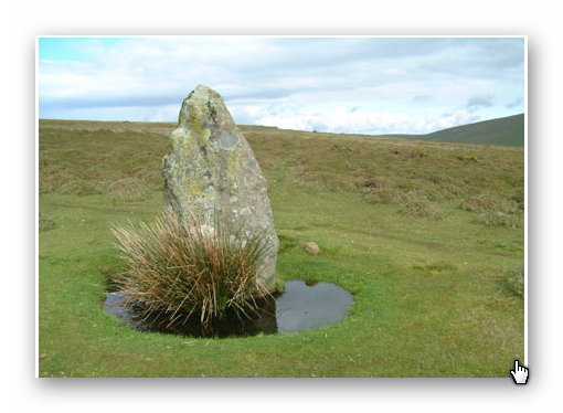
Archaeological 'pulp fiction' - has archaeology turned from science?
Waun Mawn – (Archaeological ‘pulp fiction’ – has archaeology turned from science?)

Therefore, the last hope of MPP’s reputation and his’ 10-year search’ fell upon Waun Mawn, culminating in the BBC documentary: “Stonehenge: The Lost Circle Revealed”, show on the 12th February 2021.  Once again of the 43 carbon dates obtained from this new discovery, only three random samples supports his theory and none of the human-made hearths which are Mesolithic (like Craig Rhos-Y-Felin) or late Neolithic. (Archaeological ‘pulp fiction’ – has archaeology turned from science?)

When they eventually found their target site Waun Mawn (after many claims that other sites were “the one we have been looking for” to eventually find that the carbon dating on these sites did not match the required date), they found just four bluestones, and so went on a stone hunt and found ten further stone HOLES! – This is clearly a sad attempt to fit a square peg into a round hole. The excavation was flawed as it only identified 14 possible stone locations and the remainder of the estimated 15 – 25 stones was a ‘guesstimation’ based on the known 14 holes – two of which had non-bluestone stones in situ.

Sadly, and not reported in the TV program, but within the Waun Mawn excavation report, there were not one OSL samples taken but 18, which gave results in the range of 6980+/- 2120 BCE to AD 1900 +/- 20. So, 17 dating sample did not verify MPP’s Hypothesis ONLY a single one which was dated 3530 +/- 330 (with that date range, the probability its 3300 BCE is slim!!). In fact, the OSL data in the review document suggested “removal of the stones” 2120 +/-520 BCE, long after Stonehenge phase I. (Archaeological ‘pulp fiction’ – has archaeology turned from science?)

The program never went in to any detail of the OTHER carbon dates found at Waun Mawn, which would allow a balanced scientific program enabling the viewer to decide whether MPP’s hypothesis was feasible? It dictated speculation as fact justified by a number of site workers and the presenter agreeing on MPP’s ideas, without question or qualification – this is commonly known as ‘propaganda’ and not scientific methodology.  Moreover, the REAL evidence CAN be found in the report and shows that the carbon dating evidence at Waun Mawn (the OSL data was excluded from the report except a small paragraph without all data!) shows that of the 43 samples taken:

1 – sample were of 9th Millennium BCE

3 – samples were of the 8th Millennium BCE

8 – samples were of the 7th Millennium BCE

4 – samples were of the 6th Millennium BCE

10 – samples were of the 5th Millennium BCE

6 – samples were of the 4th Millennium BCE

11- samples after 4th Millennium BCE up to 17 AD.

It seems that the BBC has produced a nice piece of archaeological propaganda that supports the current false ‘archaeological narrative’ of mythology and speculation, rather than tested and qualified scientific fact. This lack of ‘critical analysis’ is a clear indication of why the ‘science’ of archaeology has not progressed much over the last 50 years, even with modern technology, which it has incorporated to minimal success.

More information can be found about Waun Mawn can be found on this website and on this video channel. (Archaeological ‘pulp fiction’ – has archaeology turned from science?)

Conclusion

We have sadly seen this kind of censorship and banal attitude to knowledge and education before in pre-enlightenment Europe, with the dominance of the Christian church as a fundamental feature of the establishment

It is also a reminder of a world, just 350 years ago, that used ‘suppression’ to control the thoughts of the mass population against any kind of ‘original thought’ or ideas.  Galileo Galilei; (15 February 1564 – 8 January 1642), was an Italian physicist, mathematician, astronomer, and philosopher who played a major role in the Scientific Revolution. His achievements include improvements to the telescope and consequent astronomical observations and support for Copernicanism. Galileo has been called the “father of modern observational astronomy”, the “father of modern physics”, the “father of science”, and “the Father of Modern Science”. (Archaeological ‘pulp fiction’ – has archaeology turned from science?)

Galileo on Trial - Archaeological 'pulp fiction' - has archaeology turned from science?
Galileo on Trial – archaeological ‘pulp fiction’

Three hundred and fifty years ago, he was not a father to anything, and he was a ‘heretic’ as he believed that the earth went around the sun, contrary to the bible (a peer-reviewed book).  Galileo did not have the internet to promote his hypothesis, and the church had a complete monopoly over ideas and the print industry at that time.  Moreover, even after verification of his evidence and the acceptance of his theories, it still took another fifty years for the ‘Inquisition’s ban’ on printing Galileo’s works to be lifted in 1718 – when permission was finally granted to publish an edition of his works (it had to exclude the ‘condemned’ Dialogue’s) – the church finally lifted this partial ban in 1835, just 178 years ago and 193 years after his premature death.

This kind of institutional censorship still survives today but in a different form.  The print industry in the last century, through books, used to (and in some instances still do) publish ideas through ‘accredited’ authors only (Professors and some PhD’s, within the subject matter).  But this is not the censorship of ideology, and it is censorship through publishing editorial ignorance!

I was at a journalist workshop the other day at the Guardian Newspaper (one would imagine a safe liberal-minded audience); the science writer confessed that most of the new books and articles under review were written in such convoluted scientific language that most people, including the editors of scientific journals, had no idea if the content was true of false, so they had to rely on ‘peer review’ for its accuracy.  The problem with this system is that is fraught with significant concerns, as your peer may be either your competitor or rival.  The long-term effect of this ignorance is the stagnation and dismissal of new ideas (even if there is overwhelming evidence), just like we have seen with Galileo’s life. Not because he was wrong, but because if he is right – his (so-called) peers would be shown to be wrong and their credibility questioned. (Archaeological ‘pulp fiction’ – has archaeology turned from science?)

Archaeological 'pulp fiction' - has archaeology turned from science?
Academic Censorship in the 21st century – (Archaeological ‘pulp fiction’ – has archaeology turned from science?)

The church was brought down by science in what is termed the ‘enlightenment period’ where truth overcome ignorance.  Sadly, what we have seen since is the replacement of the church with academia, who use the same propaganda and discrediting tactics to maintain their cultural dominance. 

Science was revolutionary as it questioned authority and demanded qualified answers (speak truth to power) – but that methodology and philosophy is missing from academia today.  Universities do not teach knowledge to their students they instead teach conformity and censorship using exclusion as a weapon of choice. For if you dare questioning the so-called facts at University, you will fail to obtain the grades as punishment and consequently, the chances of any financially successful career in the future, forcing you to live a life of poverty and suppression. (Archaeological ‘pulp fiction’ – has archaeology turned from science?)

PodCast

Author’s Biography

Robert John Langdon, a polymathic luminary, emerges as a writer, historian, and eminent specialist in LiDAR Landscape Archaeology.

His intellectual voyage has interwoven with stints as an astute scrutineer for governmental realms and grand corporate bastions, a tapestry spanning British Telecommunications, Cable and Wireless, British Gas, and the esteemed University of London.

A decade hence, Robert’s transition into retirement unfurled a chapter of insatiable curiosity. This phase saw him immerse himself in Politics, Archaeology, Philosophy, and the enigmatic realm of Quantum Mechanics. His academic odyssey traversed the venerable corridors of knowledge hubs such as the Museum of London, University College London, Birkbeck College, The City Literature Institute, and Chichester University.

In the symphony of his life, Robert is a custodian of three progeny and a pair of cherished grandchildren. His sanctuary lies ensconced in the embrace of West Wales, where he inhabits an isolated cottage, its windows framing a vista of the boundless sea – a retreat from the scrutinous gaze of the Her Majesty’s Revenue and Customs, an amiable clandestinity in the lap of nature’s embrace.

Exploring Prehistoric Britain: A Journey Through Time

My blog delves into the fascinating mysteries of prehistoric Britain, challenging conventional narratives and offering fresh perspectives based on cutting-edge research, particularly using LiDAR technology. I invite you to explore some key areas of my research. For example, the Wansdyke, often cited as a defensive structure, is re-examined in light of new evidence. I’ve presented my findings in my blog post Wansdyke: A British Frontier Wall – ‘Debunked’, and a Wansdyke LiDAR Flyover video further visualizes my conclusions.

My work also often challenges established archaeological dogma. I argue that many sites, such as Hambledon Hill, commonly identified as Iron Age hillforts are not what they seem. My posts Lidar Investigation Hambledon Hill – NOT an ‘Iron Age Fort’ and Unmasking the “Iron Age Hillfort” Myth explore these ideas in detail and offer an alternative view. Similarly, sites like Cissbury Ring and White Sheet Camp, also receive a re-evaluation based on LiDAR analysis in my posts Lidar Investigation Cissbury Ring through time and Lidar Investigation White Sheet Camp, revealing fascinating insights into their true purpose. I have also examined South Cadbury Castle, often linked to the mythical Camelot56.

My research also extends to the topic of ancient water management, including the role of canals and other linear earthworks. I have discussed the true origins of Car Dyke in multiple posts including Car Dyke – ABC News PodCast and Lidar Investigation Car Dyke – North Section, suggesting a Mesolithic origin2357. I also explore the misidentification of Roman aqueducts, as seen in my posts on the Great Chesters (Roman) Aqueduct. My research has also been greatly informed by my post-glacial flooding hypothesis which has helped to inform the landscape transformations over time. I have discussed this hypothesis in several posts including AI now supports my Post-Glacial Flooding Hypothesis and Exploring Britain’s Flooded Past: A Personal Journey

Finally, my blog also investigates prehistoric burial practices, as seen in Prehistoric Burial Practices of Britain and explores the mystery of Pillow Mounds, often mistaken for medieval rabbit warrens, but with a potential link to Bronze Age cremation in my posts: Pillow Mounds: A Bronze Age Legacy of Cremation? and The Mystery of Pillow Mounds: Are They Really Medieval Rabbit Warrens?. My research also includes the astronomical insights of ancient sites, for example, in Rediscovering the Winter Solstice: The Original Winter Festival. I also review new information about the construction of Stonehenge in The Stonehenge Enigma.

Further Reading

For those interested in British Prehistory, visit www.prehistoric-britain.co.uk, a comprehensive resource featuring an extensive collection of archaeology articles, modern LiDAR investigations, and groundbreaking research. The site also includes insights and extracts from the acclaimed Robert John Langdon Trilogy, a series of books exploring Britain during the Prehistoric period. Titles in the trilogy include The Stonehenge Enigma, Dawn of the Lost Civilisation, and The Post Glacial Flooding Hypothesis, offering compelling evidence about ancient landscapes shaped by post-glacial flooding.

To further explore these topics, Robert John Langdon has developed a dedicated YouTube channel featuring over 100 video documentaries and investigations that complement the trilogy. Notable discoveries and studies showcased on the channel include 13 Things that Don’t Make Sense in History and the revelation of Silbury Avenue – The Lost Stone Avenue, a rediscovered prehistoric feature at Avebury, Wiltshire.

In addition to his main works, Langdon has released a series of shorter, accessible publications, ideal for readers delving into specific topics. These include:

For active discussions and updates on the trilogy’s findings and recent LiDAR investigations, join our vibrant community on Facebook. Engage with like-minded enthusiasts by leaving a message or contributing to debates in our Facebook Group.

Whether through the books, the website, or interactive videos, we aim to provide a deeper understanding of Britain’s fascinating prehistoric past. We encourage you to explore these resources and uncover the mysteries of ancient landscapes through the lens of modern archaeology.

For more information, including chapter extracts and related publications, visit the Robert John Langdon Author Page. Dive into works such as The Stonehenge Enigma or Dawn of the Lost Civilisation, and explore cutting-edge theories that challenge traditional historical narratives.

Other Blogs

s

t

Durrington Walls Revisited: Platforms, Fish Traps, and a Managed Mesolithic Landscape

Introduction

Durrington Walls has long been treated as a problem site. Despite decades of excavation, reinterpretation, and popular retelling, it has never settled comfortably into any single explanatory model. It is alternately described as a village, a ritual aggregation centre, a ceremonial counterpart to Stonehenge, or a symbolic landscape without a clear economic function. Each interpretation resolves one difficulty only by creating several others. The result is a site that is endlessly described, but never fully explained.

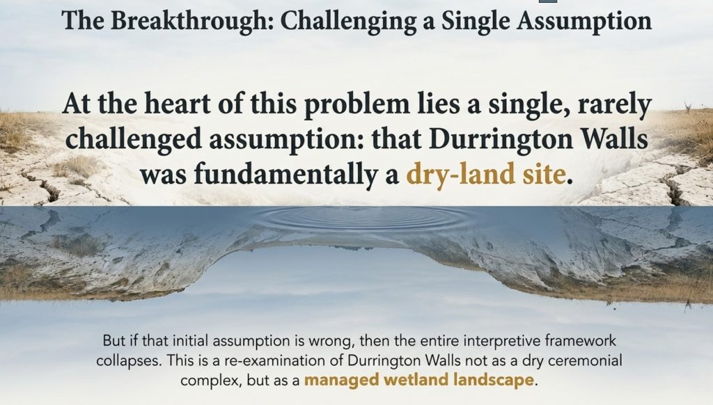
At the heart of this problem lies a single, rarely challenged assumption: that Durrington Walls was fundamentally a dry-land site.

Once this assumption is adopted, everything else follows automatically. Timber circles must be buildings. Ditches must be boundaries. Irregular features must be symbolic, incomplete, or poorly preserved. Water becomes incidental, a backdrop rather than an organising force. The site is then interpreted through analogy with later prehistoric monuments built on stable ground in fundamentally different environmental conditions.

But if that initial assumption is wrong, then the entire interpretive framework collapses.

Durrington Walls Revisited

This essay re-examines Durrington Walls not as a dry ceremonial complex, but as a managed wetland landscape, operating within a Mesolithic or early Neolithic hydrological regime characterised by elevated groundwater, seasonal flooding, and an expanded River Avon system. When water is treated as an active variable rather than an inconvenience, features that once appeared anomalous begin to behave coherently. Structures that resisted architectural explanation begin to make functional sense.

Crucially, this reassessment does not rely on speculation, symbolism, or ethnographic metaphor. It is driven by structure: by the physical geometry of post-holes, the mechanics of timber insertion and removal, the engineering logic of ditches, and the spatial relationships between features. The question throughout is not “what did this mean?” but “what does this do?”

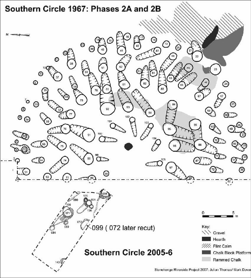
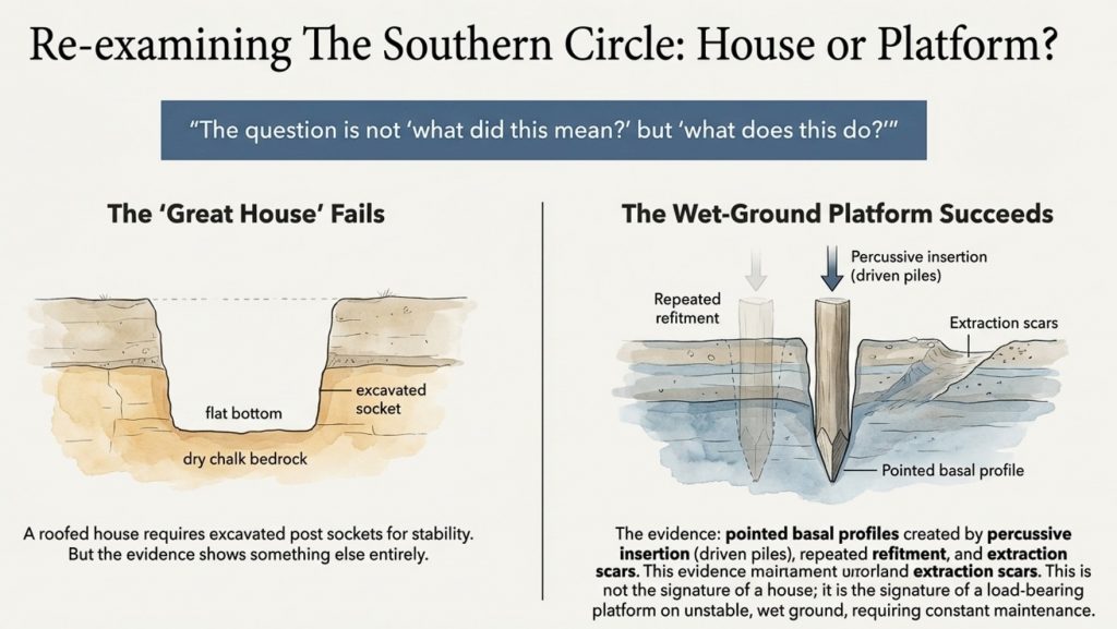
Previous discussions have already demonstrated that the Southern Circle at Durrington Walls does not conform to the construction logic of a domestic “great house.” Its post-holes show evidence of driven piles rather than excavated sockets, repeated refitment, extraction scars, and maintenance over time—behaviour entirely inconsistent with a single-phase roofed structure, but entirely consistent with a load-bearing platform operating in wet or unstable ground. That argument will be summarised here, not repeated in full.

What has received far less attention, however, is the Northern Circle.

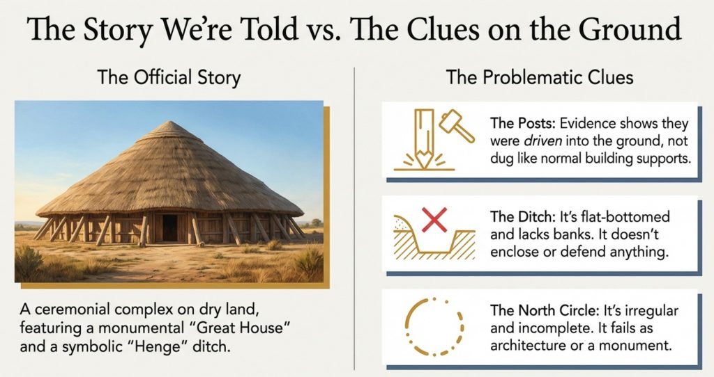
The North Circle has always been awkward for orthodox interpretations. It is irregular, incomplete, and structurally incoherent if treated as architecture. It lacks symmetry, closure, and any plausible roof logic. As a result, it has often been marginalised in discussion, treated as a secondary or failed monument, or folded into vague ceremonial narratives that demand little mechanical explanation.

This essay takes a different approach.

Instead of asking why the North Circle fails to resemble a building, it asks whether it was ever intended to be one.

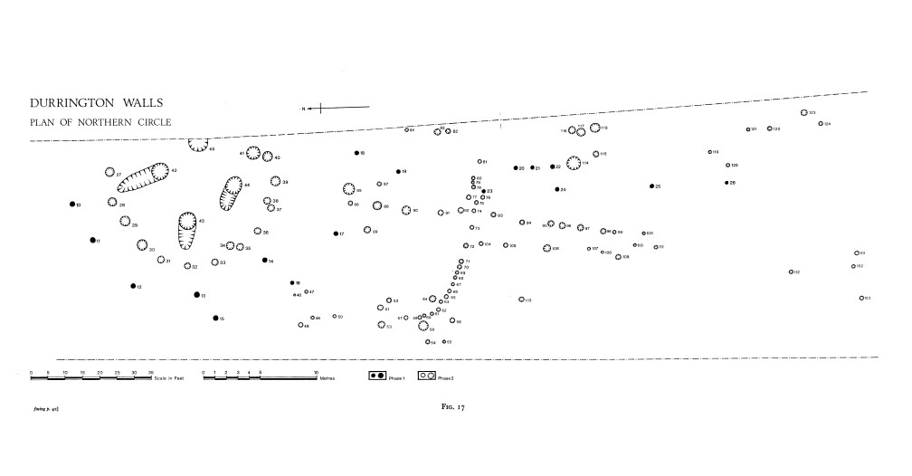
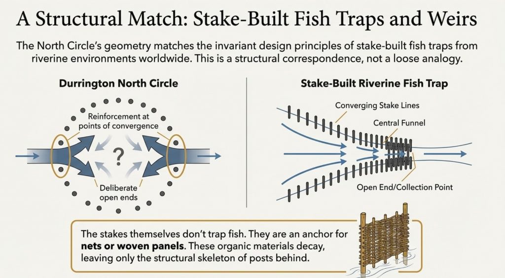
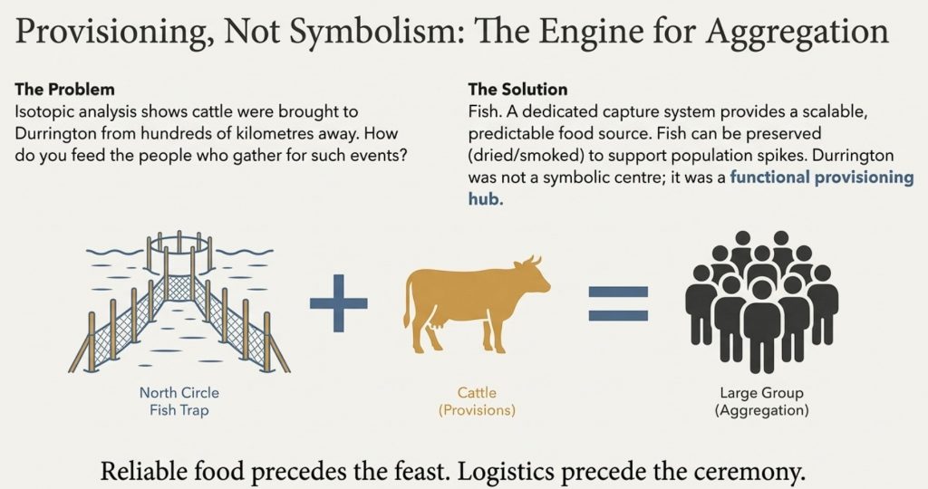
When the North Circle post-hole pattern is examined without architectural preconceptions, a very different structure emerges. The arrangement is directional rather than radial. Post density varies by position rather than by ritual importance. Open-ended alignments replace enclosed rings. Linear elements appear that make no sense as walls, but perfect sense as access routes. In plan, the structure resembles neither a house nor a monument, but a capture and control system.

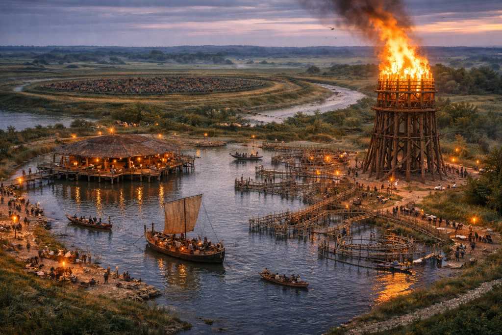
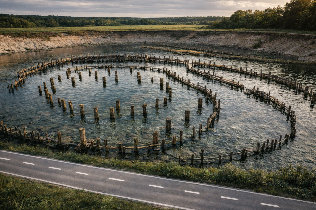
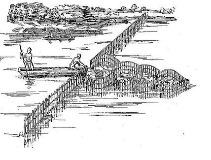
Specifically, it resembles a stake-built fish trap or weir, integrated into a seasonally flooded landscape and connected—directly or indirectly—to the Avon system.

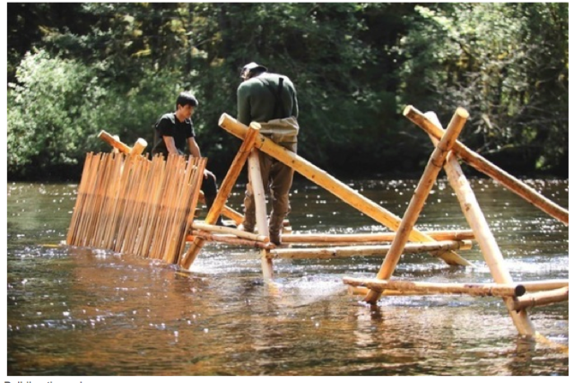
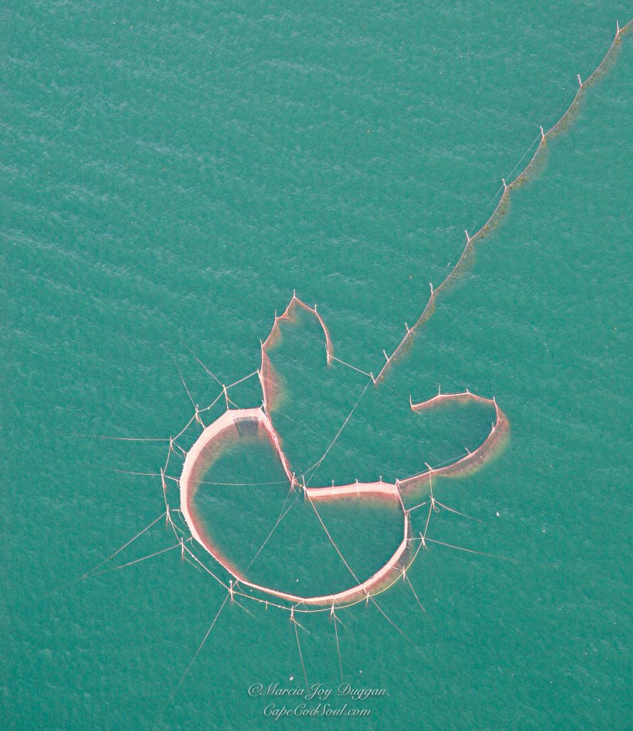
This proposal is not based solely on analogy. Fish traps across riverine and wetland environments worldwide share a remarkably consistent structural logic: converging stake lines, funnel geometries, selective reinforcement, open ends, and maintenance walkways. These traits recur because they work. When these same traits appear at Durrington, they deserve to be evaluated functionally rather than dismissed symbolically.

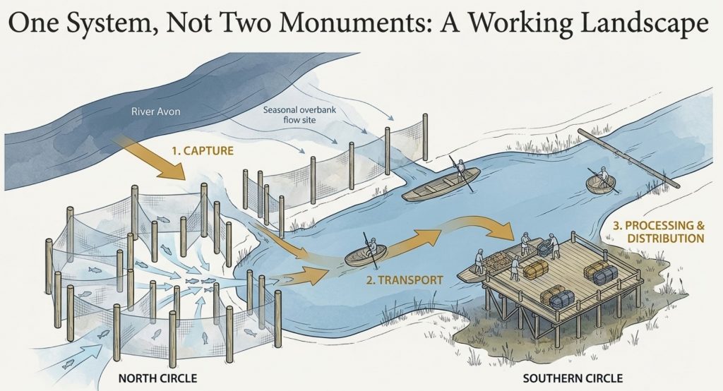
The argument developed in the sections that follow is therefore straightforward, but far-reaching. Durrington Walls was not a village decorated with monuments. It was a working landscape, engineered to manage water, movement, and resources. The Southern Circle and Northern Circle were not paired symbols, but paired components within a single operational system: one concerned with capture and provisioning, the other with unloading, staging, and redistribution.

Once this is recognised, Durrington ceases to be enigmatic.

It becomes intelligible.

Durrington Walls Revisited

The Southern Circle Revisited: Why It Was Never a “Great House”

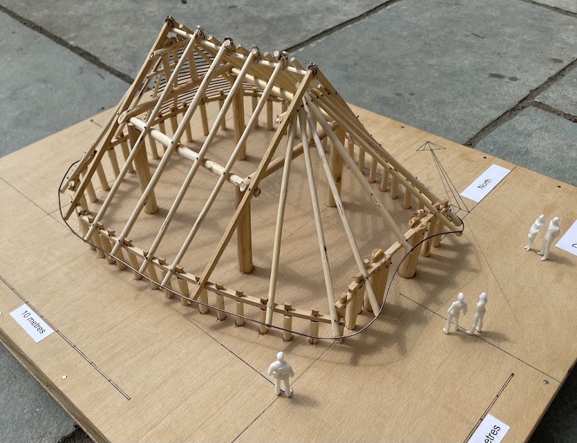
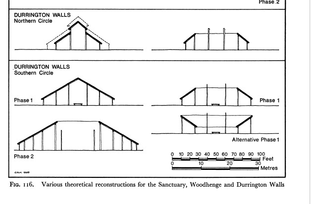
The interpretation of the Southern Circle at Durrington Walls as a monumental timber “great house” has become so familiar that it is rarely interrogated at a mechanical level. The idea is attractive: a vast roofed hall, domestic or ceremonial in nature, forming a symbolic counterpart to Stonehenge. Yet when the excavation evidence is examined in detail—particularly the published section drawings rather than the interpretive summaries—the great house model begins to fail almost immediately.

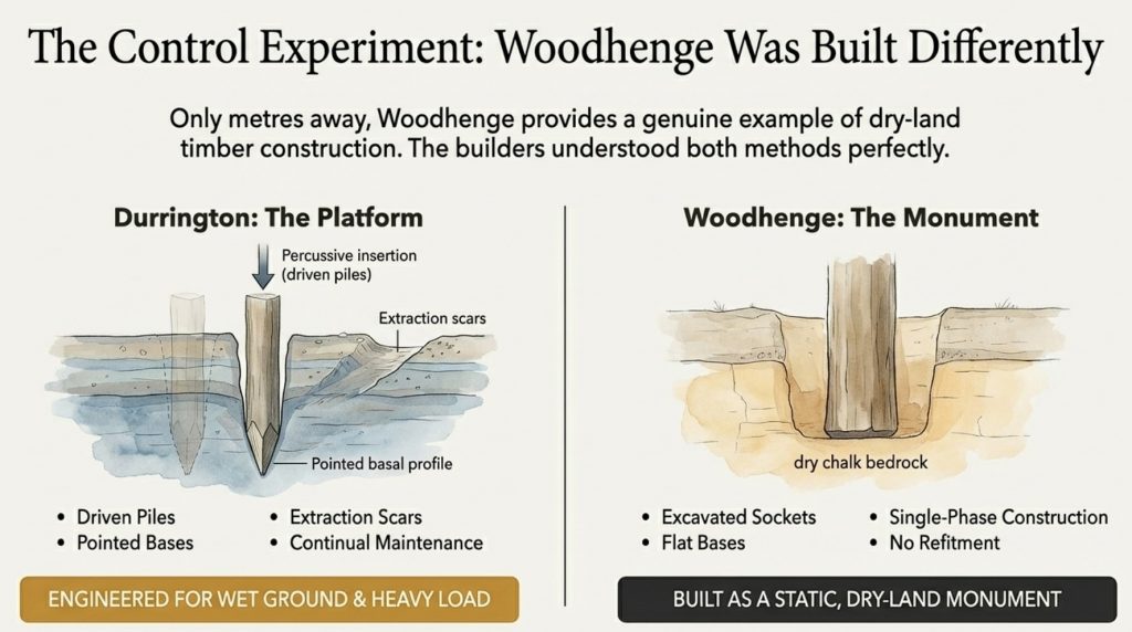
The most revealing comparison lies only a short distance away. Woodhenge provides a genuine example of dry-land timber construction in the same landscape. There, the post-holes behave exactly as expected for excavated sockets: bases are flat or gently scooped, profiles widen with depth, and the construction appears largely single-phase. There is no evidence for repeated refitment, no extraction scars, and no need for structural revision once the building was complete. This is what dry-ground timber architecture looks like.

The Southern Circle shows none of these characteristics.

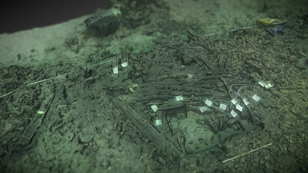
Instead, a significant proportion of its post-holes display pointed or strongly convergent basal profiles. This is not a minor detail. In chalk geology, a pointed base cannot be created—or preserved—by excavation using antler picks or stone tools. Digging necessarily destroys such geometry almost immediately: chalk fractures, loosens, and collapses under levering action. The only reliable way to create and preserve a pointed basal profile in chalk is through percussive insertion—repeatedly driving a sharpened timber pole vertically into the ground.

In other words, these posts were driven, not dug.

This single observation has far-reaching consequences. Driven posts imply a construction method closer to pile-driving than pit excavation. They imply a concern with vertical load transfer rather than lateral stability. And they imply ground conditions in which excavation was either impractical or unnecessary—conditions consistent with saturated or semi-saturated substrates, not dry stable ground.

The Southern Circle also shows extensive evidence of refitment and maintenance. Many post-holes were re-cut, enlarged, or overlapped by later insertions. Some show multiple phases of intervention, with earlier sockets truncated or partially reused. This behaviour is incompatible with a roofed hall. Large timber buildings are constructed once, used for their lifespan, and then abandoned or dismantled. They are not repeatedly re-engineered at the level of individual load-bearing elements.

Durrington Walls Revisited
The Graet House – being constructed at the Stonehenge Visitors site – Durrington Walls Revisited

Platforms, by contrast, are.

A load-bearing platform operating in wet ground is subject to continual stress. Timber piles rot, shift, or fail below the waterline. Loads change seasonally. Maintenance is not optional; it is a structural necessity. The Southern Circle’s pattern of intervention fits this logic precisely. It behaves like a working structure that requires periodic repair, not like a symbolic or domestic building.

The so-called “ramps” associated with many of the Southern Circle post-holes reinforce this conclusion. These features have traditionally been interpreted as construction aids, used to insert large timbers into excavated pits. Mechanically, this interpretation is weak. A pointed timber pile does not require a ramp to be driven vertically. It does, however, require leverage and access when being removed—especially from wet or compacted ground.

The ramps at Durrington are irregular in orientation, inconsistent in form, and closely associated with refitment episodes. They make little sense as planned construction features. They make perfect sense as extraction scars, created when failing piles were levered out at oblique angles prior to replacement.

Water also resolves several subsidiary problems that have long accompanied the Southern Circle. The relative absence of charcoal, often cited as anomalous for a timber structure, is easily explained in wet conditions, where organic debris is floated away, oxidised, or redeposited elsewhere. The preservation of pointed basal profiles becomes more plausible when chalk fines slump and seal around driven posts in saturated ground. Even the subtlety of the ramps themselves is better explained by soft, infilling sediments than by erosion on dry surfaces.

Finally, the location of the Southern Circle is deeply uncomfortable for a “great house” interpretation. It sits at the head of a coombe, above the River Avon, on chalk geology prone to elevated groundwater, and within a broad flat-bottomed ditch. This is a poor location for a monumental roofed building. It is an excellent location for a pile-supported platform designed to interface with water.

When all of these observations are taken together, the conclusion is difficult to avoid. The Southern Circle at Durrington Walls was not constructed like a house, not maintained like one, and not positioned like one. It behaves instead as a load-bearing, wet-ground-adapted platform, built using driven timber piles and maintained through repeated intervention.

This reclassification is not speculative. It follows directly from the published excavation evidence. And once accepted, it provides the foundation for understanding the rest of the site—particularly the Northern Circle—not as isolated monuments, but as components within a single, coherent system.

Durrington Walls Revisited

The Ditch That Isn’t a Henge

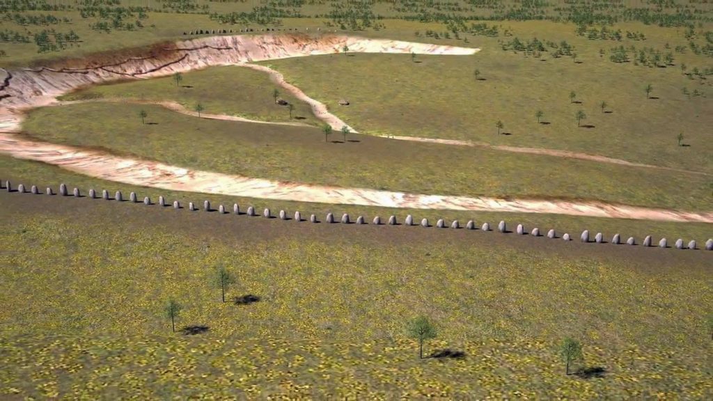
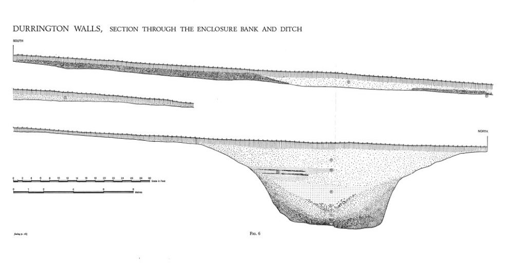
Encircling much of Durrington Walls is a substantial ditch, approximately six metres wide, flat-bottomed, and conspicuously lacking many of the features usually associated with a defensive or symbolic enclosure. For decades, this feature has been described almost reflexively as a “henge ditch.” Yet this label explains little. Instead, it obscures a series of mechanical and spatial problems that have never been satisfactorily resolved.

If the ditch is examined as part of a conventional henge monument, its design is baffling. It has no associated bank, either internal or external. It does not create a visual boundary, nor does it restrict movement in any meaningful way. In places, it terminates abruptly, particularly near the Southern Circle, rather than forming a closed circuit. Its scale is excessive for symbolism alone, yet insufficient for defence. These inconsistencies have been noted repeatedly, but they are usually brushed aside as idiosyncrasies or later disturbances.

The difficulty lies not in the ditch itself, but in the assumption that it must be a boundary.

Boundaries—whether defensive, ritual, or social—require continuity. They are designed to enclose, exclude, or demarcate. They demand banks, palisades, or visual markers that signal a transition from one space to another. The Durrington ditch does none of these things. It is flat-bottomed rather than V-shaped, open rather than enclosed, and discontinuous rather than circuital. As a boundary, it fails on every functional criterion.

As an element of water infrastructure, however, it begins to make sense almost immediately.

Flat-bottomed channels are not arbitrary. They are used where predictable draft matters, where grounding without capsizing is desirable, and where loading and unloading must occur repeatedly. A flat base allows small craft to settle safely as water levels fluctuate. It facilitates the transfer of people, animals, or goods. And crucially, it will enable vessels to wait—either moored or grounded—without blocking movement elsewhere in the system.

Durrington Walls Revisited
Inadequate representation of the ditch – for Propaganda purposes – Durrington Walls Revisited

In such a context, a bank would be a liability rather than an asset. Banks restrict access, create instability through slumping, and impede lateral movement. The absence of a bank at Durrington is not an omission; it is a design choice.

The ditch also stops where it stops being useful. Near the Southern Circle platform, where water-managed access converges, the ditch terminates rather than looping neatly around the structure. This behaviour is inexplicable in symbolic terms, but entirely logical if the ditch functions as an access basin or secondary channel — infrastructure ends where function ends, not where geometry demands closure.

Further reinforcing this interpretation is the presence of smaller, narrow linear ditches within the enclosure. These features cut across activity areas, vary in depth according to slope, do not enclose anything, and extend beyond the immediate vicinity of the Southern Circle. They are often dismissed as later intrusions, drainage attempts, or poorly understood disturbances. Such labels may account for reuse, but they do not explain origin.

 Durrington Walls Revisited
The site drawings are not the same as the excvation Record view of the ditch – Durrington Walls Revisited

In a dry landscape, these features are indeed awkward. They serve no obvious purpose. In a seasonally flooded chalk landscape, however, they behave exactly as secondary redistribution channels. They guide shallow flows, drain saturated areas, and create controlled pathways for water, people, or small craft moving between functional zones.

The critical point is that none of this infrastructure makes sense unless water was a recurring and significant presence. In permanently dry conditions, the ditch is redundant. The platform is unnecessary. The engineering is absurd. In wet conditions—where wheeled transport fails, livestock must be controlled, and movement across saturated ground is hazardous—water becomes the safest and most efficient route. The ditch, the channels, and the platform together form a coherent system.

This reinterpretation also dissolves the artificial separation between the ditch and the Southern Circle. Traditionally, the ditch is treated as a framing device, a symbolic container for the monument within. Under a functional reading, the relationship is reversed. The ditch exists for the platform, not around it. It facilitates access, movement, and staging at the point where loads are transferred between water and land, or vice versa.

Once the ditch is understood as an access basin rather than a boundary, it becomes clear that Durrington Walls was never intended to be enclosed in the conventional sense. It was designed to be entered, exited, and worked within. Control was achieved not through exclusion, but through channelling movement along predictable routes.

This reframing is not radical. It simply requires taking the physical form of the ditch seriously and asking what it is mechanically suited to do. When that question is asked honestly, the answer is no longer “henge,” but hydraulic infrastructure.

And that infrastructure, as the next section will show, connects directly to the site’s most misunderstood element: the Northern Circle.

Durrington Walls Revisited
Durrington is NOT a Henge as it has no banks and it’s a natural water feature – Durrington Walls Revisited

Introducing the North Circle: The Forgotten Half of the System

If the Southern Circle has been misread because it was forced into the category of a “great house,” then the North Circle has been misread because it has never fit comfortably into any category at all. Its awkwardness is not accidental. It is the clearest signal that the interpretive framework applied to Durrington Walls has been wrong from the outset.

The North Circle has typically been described in vague or dismissive terms: an incomplete timber circle, a subsidiary structure, a poorly preserved monument, or a ceremonial feature whose purpose remains unclear. These descriptions all share a common trait—they treat the North Circle as a failed version of something else, rather than asking what it actually is.

When examined on its own terms, the North Circle does not behave like architecture.

Architectural timber circles, whether domestic or ceremonial, tend to display several consistent characteristics. They favour regular spacing, because loads must be distributed predictably. They favour symmetry because roof structures require balanced support. They favour closure, because walls and roofs must enclose space. And they usually exhibit clear entrance logic aligned with internal organisation.

Durrington Walls Revisited

The North Circle exhibits none of these traits.

Instead, its post-holes are irregularly spaced, with zones of dense clustering and zones of relative absence. The arrangement is incomplete rather than closed. There is no coherent radial symmetry, no central focus, and no plausible roof geometry that could span the pattern without extraordinary and unnecessary complexity. Attempts to “complete” the circle or impose a regular geometry on it require heavy interpretive intervention—joining dots that the ground itself does not join.

This failure has often been attributed to truncation, later disturbance, or erosion. Yet this explanation becomes increasingly strained when the pattern is viewed as a whole. The irregularities are not random. They are structured. They display directionality, not decay.

Several alignments within the North Circle converge or taper, forming subtle V- or funnel-like shapes. These are not centred on a focal point, but biased toward particular orientations. Post density increases in some areas precisely where a structural or functional constraint would be expected, and decreases where openness would be advantageous. The plan reads not as a ring, but as a system of guidance and control.

Equally telling is what the North Circle does not attempt to do. It does not demarcate a sacred interior. It does not create an enclosed performance space. It does not separate inside from outside. Instead, it remains porous, open-ended, and accessible. These are not failures of design; they are the opposite. They indicate that containment was never the goal.

The persistent mistake has been to assume that posts must define walls.

Posts can just as easily define routes, channels, funnels, and working edges. In wetland and riverine environments, timber stakes are rarely used to enclose space. They are used to shape the movement of water, animals, and people. When the North Circle is read with this in mind, its structure stops looking defective and starts looking purposeful.

The spatial relationship between the North and South Circles reinforces this interpretation. The two are not redundant repetitions of the same idea. They occupy different positions within the enclosure, relate differently to slope and hydrology, and exhibit radically different construction logic. If they were both ceremonial timber monuments, built by the same community for the same symbolic purpose, this divergence would be inexplicable.

If they are components of a functional system, it is expected.

The Southern Circle, with its deep driven piles and heavy maintenance signature, behaves like a load-bearing interface—a place where weight, stress, and repeated use demanded structural robustness. The North Circle, by contrast, exhibits lighter construction, selective reinforcement, and directional geometry. It appears designed to work with movement rather than resist it.

This distinction has important implications. It suggests that Durrington Walls was not organised around a single focal monument, but around distributed functions. Different tasks required different structures, each optimised for its role within a larger operational landscape. In such a system, symmetry and monumentality are irrelevant. Efficiency and adaptability matter far more.

The North Circle has been forgotten not because it is unimportant, but because it does not conform to expectations. It does not announce itself as a monument. It does not demand reverence. It looks messy, irregular, and practical. In other words, it looks like infrastructure.

Recognising the North Circle as such does more than rehabilitate a neglected feature. It completes the picture begun with the Southern Circle and the ditch. It suggests that Durrington Walls was organised around movement and control, not static display. And it prepares the ground for a closer examination of the North Circle’s post-hole structure—an examination that points, quite consistently, toward a specific functional model.

That model is not architectural.


It is economic.


And it is aquatic

Simplistic Archaeologist’s View of The Southern Circle – Durrington Walls Revisited

Reading the Post-Hole Structure Correctly

The North Circle at Durrington Walls has resisted interpretation primarily because it has been read as architecture. Once that assumption is removed, the post-hole pattern stops appearing chaotic and begins to behave coherently. The key is to read the structure directionally, not radially.

This section does not argue by analogy or symbolism. It reads the geometry as preserved in plan.

Durrington Walls Revisited
A Crannog lives in water and has an evident footprint – Durrington Walls Revisited

5.1 Directionality, Not Radial Design

Architectural timber circles—whether domestic or ceremonial—are organised radially. Posts are arranged around a centre, spacing is broadly consistent, and geometry prioritises balance. The North Circle does none of this.

Instead, the post-holes form directional alignments.

Several lines of posts converge, narrowing toward specific zones rather than orbiting a central point. These alignments do not mirror one another, nor do they divide space evenly. They are biased in orientation, favouring particular directions across the enclosure rather than reinforcing a circular interior.

Most importantly, these converging lines form funnel-like geometries.

Funnels are not architectural devices. They are control devices. They are used to guide movement—of water, animals, or material—toward predictable points. In buildings, funnels are undesirable; they create uneven load and instability. In capture systems, they are essential.

The absence of any true radial symmetry is therefore not a problem to be explained away. It is diagnostic. The structure was never intended to define a central space.

Durrington Walls Revisited
Northern Circle showing a classic Crannog connected walkway- Durrington Walls Revisited

5.2 Variable Density and Open Ends

Equally revealing is the uneven density of post-holes across the structure.

Some zones show closely spaced posts, reinforced and clustered. Other areas are sparse, open, or entirely absent of posts. This pattern is inconsistent with walls or supports, which demand relatively uniform spacing to function structurally.

Instead, the density varies where stress or control would be required.

Reinforced zones occur at points of convergence and directional change. These are precisely the locations where pressure—hydraulic, biological, or mechanical—would be concentrated. Open zones occur where flow must continue unimpeded. This is not accidental variation; it is selective reinforcement.

Just as important is what the structure does not do.

The North Circle does not close.

There is no continuous ring, no sealed boundary, and no attempt to demarcate an “inside” and “outside.” Gaps are not randomly distributed but aligned with the directional geometry of the posts themselves. These open ends allow movement through the structure rather than confinement within it.

Containment is the defining feature of architecture.
Controlled permeability is the defining feature of movement systems.

The North Circle is consistently permeable.


5.3 Structural Implication

Taken together, these characteristics are decisive:

  • Converging lines rather than radial symmetry
  • Funnel-shaped geometries rather than enclosed spaces
  • Biased orientation rather than balanced layout
  • Reinforced zones paired with deliberate openness
  • Absence of closure

This is not architectural geometry.

It is movement-control geometry.

The posts do not define walls. They define paths.
They do not enclose space. They shape flow.

Once read correctly, the North Circle ceases to be an “incomplete monument” and becomes a purpose-built control structure designed to operate within a fluid, changing environment. The geometry is functional, not symbolic, and it does exactly what it needs to do—no more, no less.

The remaining question is therefore not whether this structure controlled movement, but what kind of movement it was designed to control.

The answer to that question lies in a close comparison with known prehistoric and ethnographic examples of stake-built capture systems—specifically, fish traps and weirs.

That comparison is structural, not metaphorical, and it is the subject of the next section.

Durrington Walls Revisited

Fish Traps, Weirs, and Walkways: A Structural Match

Once the North Circle is read as movement-control geometry rather than architecture, the range of plausible functions narrows rapidly. Among known prehistoric structures, one class matches the observed geometry with remarkable consistency: stake-built fish traps and weirs in riverine and wetland environments.

This is not a loose analogy. It is a structural correspondence.

Across Europe and beyond, fish traps built from driven wooden stakes share a small number of invariant design principles. These principles recur because they solve the same physical problems—guiding aquatic movement, managing variable water levels, and allowing human access for maintenance and harvesting. The North Circle conforms to these principles point by point.


6.1 Core Structural Traits of Stake-Built Fish Traps

Fish traps are not enclosures. They are guidance systems.

Their defining features include:

  • Converging stake lines forming V- or funnel-shaped geometries
  • Biased orientation aligned to current, slope, or tidal movement
  • Selective reinforcement at points of pressure or convergence
  • Open ends to prevent blockage and allow controlled release
  • Replaceable driven posts, not permanent load-bearing timbers

These systems are designed to be worked, not admired. Stakes are driven, removed, replaced, and re-set as conditions change. Precision is functional, not geometric. Symmetry is irrelevant.

This description matches the North Circle far more closely than any architectural model ever proposed for it.

Durrington Walls Revisited

6.2 Funnel Geometry and Capture Logic

At the heart of most fish traps lies a simple idea: narrowing space increases predictability.

Fish moving with current, tide, or seasonal flow tend to follow the path of least resistance. Converging stake lines exploit this behaviour, reducing lateral escape while avoiding complete obstruction. The narrowing geometry concentrates fish into a manageable zone where they can be collected, speared, netted, or temporarily held.

The North Circle exhibits precisely this behaviour.

Its post alignments converge rather than encircle. Density increases toward specific zones rather than around a centre. There is no attempt to close the structure, because closure would be counterproductive. A fully enclosed trap risks blockage, damage, and loss of control during high flow.

Instead, permeability is engineered.

Durrington Walls Revisited

6.3 Walkways and Working Edges

A further diagnostic feature of fish traps is the presence of access routes.

Fish traps require continual human intervention:

  • clearing debris
  • repairing or replacing stakes
  • harvesting catch
  • adjusting geometry to seasonal conditions

For this reason, many prehistoric traps incorporate walkways or linear access edges—not formal platforms, but narrow zones where people can move alongside or into the structure without disrupting flow.

The North Circle includes precisely such linear elements.

These alignments do not contribute to enclosure or support. They make no sense as walls or screens. But as working edges, they are entirely intelligible. They allow access to key points within the structure while maintaining the integrity of the funnel geometry.

This feature is difficult to explain symbolically. It is trivial to explain functionally.


6.4 Driven Posts and Maintenance Cycles

Fish traps almost universally employ driven stakes rather than excavated post-holes. Speed of construction, ease of replacement, and adaptability matter more than permanence. Stakes are sharpened, driven into soft or saturated ground, and replaced as needed.

This construction logic mirrors what has already been observed at Durrington, particularly in the Southern Circle, but at a lighter scale appropriate to a capture system rather than a load-bearing platform.

Crucially, fish traps leave minimal artefactual signatures. They are economic infrastructure, not ritual deposition sites. Their primary archaeological trace is geometric: the pattern of post-holes themselves. This explains both the long-standing interpretive discomfort and the lack of “confirmatory” finds.

Durrington Walls Revisited

6.5 Structural Conclusion

The correspondence between the North Circle and known fish-capture systems is not based on superficial resemblance. It is grounded in:

  • Directional funnel geometry
  • Variable post density
  • Open, non-enclosing design
  • Evidence for driven, replaceable posts
  • Presence of access alignments

Taken together, these traits identify the North Circle as a capture and control structure operating in a wetland context. Fish traps are not the only structures that control movement, but they are the only ones that match all of the observed characteristics without forcing the evidence.

The remaining task is to situate this structure within its environmental setting. Geometry alone suggests function; hydrology makes it inevitable.

That context—specifically the relationship between the North Circle, seasonal flooding, and the River Avon—is the focus of the next section.

6.6 Stakes Alone Do Not Capture Fish: The Role of Nets and Panels

Durrington Walls Revisited

It is essential to clarify a common misconception when interpreting prehistoric fish traps. Wooden stakes by themselves do not usually trap fish. Their primary role is to define geometry—to create funnels, guide movement, and provide anchoring points. Actual capture is achieved through flexible barriers fixed between those stakes.

Across ethnographic and archaeological examples, fish traps consistently combine:

  • driven poles or stakes
  • nets, woven reed panels, or wattle screens
  • removable or seasonal barriers

These soft components perform the critical work. Nets stretch between adjacent stakes, forming semi-permeable walls that allow water to pass while restricting fish movement. Wattle panels can be lifted, lowered, or removed entirely, enabling selective harvesting and preventing damage during high flow.

This distinction is crucial for interpreting the North Circle at Durrington Walls.

The post-hole pattern defines where barriers were anchored, not the barriers themselves. The absence of preserved nets or panels is therefore not a problem. Organic woven materials decay rapidly, particularly in fluctuating wet–dry conditions. What survives archaeologically is the system’s structural skeleton: the stake pattern.

This also explains the variable spacing observed in the North Circle. Where fine control was needed—such as at funnel throats or retention zones—posts are closer together, providing frequent anchor points for nets or woven screens. Where guidance alone was sufficient, spacing increases, allowing flow without excessive material resistance.

Importantly, this arrangement allows for adaptive management. Nets can be tightened or slackened. Panels can be reconfigured seasonally. Sections can be opened to release non-target species or to clear debris. The post system remains, while the soft infrastructure changes.

This behaviour aligns precisely with what is seen at Durrington. The North Circle shows:

  • permanent stake positions
  • selective reinforcement
  • no attempt at full enclosure
  • evidence for ongoing maintenance

These traits are incompatible with rigid architectural forms, but entirely consistent with net-assisted capture systems.

The presence of linear access alignments—interpreted in the previous section as walkways or working edges—becomes even more significant in this context. Nets must be set, checked, lifted, repaired, and cleared. This requires controlled human access along the structure. The North Circle provides that access structurally, without interfering with flow or capture zones.

Finally, this model explains why such a system would coexist with the Southern Circle platform rather than replace it. Fish traps capture and concentrate fish; platforms are needed to:

  • process catches
  • distribute food
  • store or dry fish
  • provision larger groups

The two structures are complementary, not redundant.

Durrington Walls Revisited

Hydrology and the Avon Connection

The functional interpretation of the North Circle as a net-assisted fish capture system only becomes fully coherent when placed within its hydrological context. Without water, the structure is inexplicable. With water, it is inevitable. The controlling variable is not symbolism or ritual intent, but the behaviour of the River Avon system during the Mesolithic and early Holocene.

Post-glacial Britain was not a dry, stable landscape punctuated by neatly contained rivers. It was a wet, dynamic environment characterised by elevated groundwater tables, seasonally inundated floodplains, and laterally mobile channels. Chalk landscapes in particular respond to rising water tables by spreading water across broad areas rather than confining it to discrete banks. Springs emerge unpredictably, coombes fill, and low gradients produce slow-moving, shallow flows ideal for fish movement—and capture.

In such conditions, the Avon would not have been the narrow, incised river seen today. It would have occupied a much broader floodplain, with multiple shallow channels, seasonal overbank flow, and temporary wetlands forming and dissipating across the valley floor. This is precisely the kind of environment in which stake-built fish traps are most effective.

Durrington Walls’ location places it at a critical junction within this system. Situated above the Avon, at the head of a coombe, the site occupies a natural transition zone between higher ground and floodplain. This is where water slows, spreads, and becomes manageable. Fish moving upstream or laterally with seasonal flooding are naturally funnelled into such areas. Human intervention needs only enhance an existing pattern.

The North Circle sits downslope from the main enclosure, in a position consistent with intermittent or seasonal water flow rather than permanent submersion. This is important. Fish traps are rarely placed in deep, fast-flowing channels. They are placed where water is shallow enough to control, slow enough to guide, and predictable enough to exploit repeatedly. The North Circle occupies exactly such a zone.

Durrington Walls Revisited

The Southern Circle platform, by contrast, occupies a slightly higher and more stable position. This spatial separation is not accidental. Capture systems are messy, dynamic, and exposed to fluctuating conditions. Processing and redistribution require firmer footing. The two structures are therefore arranged along a hydrological gradient rather than a ceremonial axis.

When the ditch system is reintroduced into this picture, the integration becomes clearer still. The broad flat-bottomed ditch functions as a controlled water body—part basin, part channel—linking capture zones, working areas, and access points. Smaller linear ditches act as secondary channels, draining or redistributing water as conditions change. Together, these features create a managed waterscape rather than a bounded monument.

This model also explains why Durrington Walls does not behave like a settlement. Permanent domestic occupation is poorly suited to fluctuating wet ground. Infrastructure, however, thrives on predictability rather than permanence. Fish runs are seasonal but reliable. Flooding is disruptive but cyclical. A site organised around provisioning and aggregation does not need year-round habitation; it requires timing.

The Avon connection further explains the scale of the system. Fish capture at this level is not a subsistence afterthought. It is provisioning infrastructure capable of supporting large numbers of people over short periods. This aligns neatly with isotopic evidence from nearby sites indicating the movement of cattle over long distances. Aggregation events require reliable food sources. Fish, preserved by drying or smoking, provide exactly that.

Crucially, none of this requires speculative reconstructions of ritual behaviour. It requires only an honest assessment of how water behaves in chalk landscapes and how people respond to it. Once hydrology is treated as an active force rather than a passive backdrop, the site stops fragmenting into unrelated anomalies and starts functioning as a system.

The North Circle does not need to be reimagined as symbolic.
The Southern Circle does not need to be elevated into a hall.
The ditch does not need to enclose anything.

They need only to be wet.

With the hydrological framework in place, the final step is to integrate all components—North Circle, Southern Circle, ditch, and channels—into a single operational model. That integration, and its wider implications for how Durrington Walls is understood, forms the basis of the next section.

Avon in the Mesolithic – Durrington Walls Revisited

One System, Not Two Monuments

Once the North Circle is understood as a net-assisted fish capture structure operating within a flooded landscape, and the Southern Circle as a pile-supported platform adapted to wet ground, the most important interpretive shift becomes unavoidable: these were not two monuments serving parallel symbolic roles. They were two components within a single operational system, each designed for a different task but dependent on the other to function effectively.

Traditional interpretations have treated the two circles as variants of the same idea—timber equivalents of stone monuments, perhaps reflecting social or ritual dualism. This approach struggles to explain why the two structures differ so profoundly in construction logic, geometry, maintenance signature, and placement. If they were built by the same community, at roughly the same time, for the same symbolic purpose, such divergence would be inexplicable.

If they were built for different functions, it is exactly what we should expect.

The North Circle, with its directional geometry, variable post density, open ends, and reliance on nets or panels fixed between stakes, is optimised for capture and control. It operates in shallow, slow-moving water. It is light, adaptable, and continuously reworked. Its success depends on guiding movement rather than resisting it.

The Southern Circle, by contrast, is heavy, vertical, and structurally intensive. Driven piles, pointed bases, extraction scars, and repeated refitment indicate a structure designed to carry load and withstand repeated use. It is not concerned with guiding movement, but with supporting weight—people, animals, goods, or equipment—above unstable ground.

These are not alternative expressions of monumentality. They are complementary solutions to different problems posed by the same environment.

Durrington Walls Revisited

The spatial relationship between the two reinforces this reading. They are positioned along a hydrological gradient rather than a symbolic axis. Capture occurs where water spreads and slows; processing and redistribution occur where footing is more reliable. Movement between the two is short, direct, and controlled, minimising loss and maximising efficiency. This is how working landscapes are organised.

The ditch system binds these elements together. Far from enclosing or separating, it facilitates the circulation of water, people, and resources. The broad flat-bottomed ditch provides a holding basin and access route. Smaller linear ditches redistribute flow internally. Together, they create a managed network rather than a ceremonial boundary.

This integrated system also explains features that have long resisted interpretation. The absence of domestic architecture ceases to be a problem once the site is recognised as seasonal or task-specific rather than permanently inhabited. The lack of ritual deposition around the North Circle becomes irrelevant once its function is understood as economic rather than symbolic. The repeated maintenance of the Southern Circle stops being anomalous and becomes expected.

Importantly, this model does not diminish the social or cultural importance of Durrington Walls. On the contrary, it elevates it. The infrastructure of this scale implies coordination, planning, and shared knowledge. Fish capture systems require an understanding of seasonal cycles, water behaviour, and animal movement. Platforms that support heavy, repeated use demand engineering competence and long-term investment.

What it does reject is the idea that meaning must always precede function.

In many prehistoric contexts, function generates meaning, not the other way around. Aggregation sites become socially significant because they work—because they feed people, enable exchange, and bring groups together at predictable times. Ritualisation follows success; it does not replace it.

Seen in this light, Durrington Walls begins to resemble other large-scale provisioning landscapes known from wetland contexts worldwide. These are places where food is captured, processed, and distributed; where people gather seasonally; where social bonds are renewed around shared labour rather than abstract symbolism.

The persistent attempt to read Durrington as a dry ceremonial complex has obscured this possibility for decades. Once water is reintroduced as the organising force, the site stops fragmenting into unrelated anomalies. The North Circle, Southern Circle, ditch, and channels lock together into a coherent whole.

They were never meant to be read separately.

The next question, then, is not how this system functioned internally—that is now clear—but what it was capable of supporting. The answer lies in the scale of provisioning required to sustain aggregation, movement, and long-distance exchange. That evidence comes from the animals themselves.

Durrington Walls Revisited

Provisioning, Not Symbolism: Fish, Cattle, and Aggregation

The integrated model proposed for Durrington Walls—combining fish capture, water-managed access, and load-bearing platforms—only makes sense if it served a substantial provisioning role. Infrastructure of this scale is not built to support small household groups. It is built to sustain aggregation: the periodic gathering of large numbers of people for social, economic, or logistical purposes. The archaeological evidence strongly supports this interpretation.

One of the most compelling lines of evidence comes from animal remains, particularly cattle. Isotopic analysis of cattle teeth from the Durrington area has demonstrated that animals were brought to the site from hundreds of kilometres away, including regions as distant as northern Britain. This level of movement cannot be explained by casual exchange or local herding. It implies planned transport, coordination across landscapes, and a clear reason for convergence.

Moving cattle over such distances presents a fundamental logistical challenge: feeding people during aggregation events. Large numbers of humans and animals arriving simultaneously create immediate provisioning demands. Terrestrial resources alone are insufficient unless extensive storage or long-term settlement is present. Durrington Walls shows no convincing evidence for either.

Durrington Walls Revisited

Fish solve this problem elegantly.

Riverine and wetland fish resources are highly productive, predictable, and scalable. Seasonal runs concentrate biomass naturally, allowing capture systems to harvest large quantities with relatively low labour input once infrastructure is in place. Fish can be consumed fresh, but more importantly, they can be preserved—dried or smoked—for use over extended periods. This makes them ideal for supporting short-term population spikes.

The presence of a dedicated fish capture system adjacent to a processing and redistribution platform transforms Durrington from a symbolic gathering place into a functional provisioning hub. Fish provide the caloric baseline that allows cattle to be moved and exchanged without exhausting local resources. In this context, cattle become socially and economically meaningful assets rather than primary food sources.

This also clarifies why the North Circle shows no signs of ritual elaboration. Fish traps are invisible when they work well. Their success is measured in output, not display. What mattered was reliability, not monumentality. The South Circle, by contrast, may well have acquired social significance over time—not because it was symbolic in origin, but because it became central to the site’s functioning.

Aggregation sites do not need to be permanently occupied to be socially powerful. In many ethnographic and archaeological examples, the opposite is true. Places that are visited seasonally, but reliably, acquire meaning precisely because they structure time, movement, and interaction. Durrington Walls fits this pattern far better than that of a permanent village.

The combined fish-and-cattle model also resolves the persistent question of scale. Why build such large earthworks and timber structures if they were not continuously inhabited? The answer is that scale reflects capacity, not population. Infrastructure is built to accommodate peak demand, not average use. The apparent over-engineering of the ditch, the maintenance-heavy nature of the Southern Circle, and the extensiveness of the enclosure all make sense once the site is understood as an aggregation and provisioning landscape.

This interpretation further undermines attempts to explain Durrington solely through ritual or cosmology. Ritual does not require such logistical redundancy. Symbolism does not demand maintenance cycles. Meaning does not require fish traps.

Provisioning does.

None of this denies the possibility that social or ceremonial activities occurred at Durrington Walls. On the contrary, they almost certainly did. But those activities were enabled by an infrastructure that worked first. The sequence matters. Food precedes feast; logistics precede ceremony.

By reframing Durrington as a provisioning hub rather than a symbolic centre, long-standing interpretive tensions dissolve. The absence of domestic architecture is no longer a problem. The scale of construction is no longer puzzling. The presence of multiple specialised structures becomes expected rather than anomalous.

The final issue to address is not whether this model fits the evidence—it does—but why it has been so persistently overlooked. That question speaks less to the site itself and more to the habits of the discipline that has studied it.

Durrington Walls Revisited

Woodhenge Reconsidered: Why a Real Timber Monument Was Built

Any serious reinterpretation of Durrington Walls must confront an uncomfortable but decisive fact: Woodhenge exists only metres away, and it behaves entirely differently. This proximity removes any excuse for misinterpretation. If archaeologists wish to argue that the Southern Circle and the North Circle are misunderstood timber monuments, they must also explain why Woodhenge—built in the same landscape, by the same culture, using the same materials—follows a completely different construction logic.

When the excavation evidence is read honestly, Woodhenge is exactly what orthodox archaeology claims it to be: a dry-land timber monument. Its post-holes are excavated, not driven. Bases are flat or scooped. Spacing is regular and concentric. Construction appears largely single-phase. There is no evidence of refitment, no extraction scars, and no requirement for continual maintenance. This is what architecture looks like when it is built on stable ground.

In other words, Woodhenge behaves precisely as a monument should.

This matters because it means cultural incompetence, technological limitations, or preservation bias cannot explain away the anomalous behaviour observed at the Southern Circle. The builders clearly understood how to construct dry-land timber structures when they wanted to. They did so successfully at Woodhenge.

The question, then, is not whether they could build a great house or ceremonial monument at Durrington.

It is why they chose not to – The answer lies in function.

Durrington Walls Revisited

Woodhenge occupies a slightly higher, drier position in the landscape, removed from the most unstable ground and from the immediate water interface. Its geometry is regular, enclosed, and inward-facing. It defines a space rather than guiding movement. Everything about it suggests a static, symbolic structure—a place designed to be stood within, observed, or marked, rather than worked.

By contrast, the Southern Circle is engineered for load, not enclosure. Its driven piles, pointed bases, extraction scars, and repeated refitment demonstrate adaptation to unstable ground and continual stress. It is outward-facing, practical, and structurally redundant. These are not symbolic choices; they are engineering responses.

The North Circle pushes this contrast even further. Where Woodhenge is concentric and enclosed, the North Circle is directional and open. Where Woodhenge emphasises symmetry, the North Circle emphasises flow. Where Woodhenge creates a place, the North Circle creates a process.

Seen together, the three structures form a deliberate functional triad:

  • Woodhenge: a true dry-land timber monument, static and symbolic
  • Southern Circle: a pile-supported working platform, load-bearing and maintained
  • North Circle: a net-assisted capture system, guiding movement in water

This arrangement is not accidental, nor is it contradictory. It reflects task differentiation within a single managed landscape.

Woodhenge demonstrates that symbolism had a place here—but not everywhere. Meaning was spatially segregated from function. Ritual did not need to sit on unstable ground. Infrastructure did not need to be monumental. Each structure was optimised for its role, not forced into a single interpretive category.

This observation alone dismantles the “timber monument everywhere” assumption that has distorted interpretations of Durrington Walls for decades. The presence of Woodhenge proves that the builders were capable of symbolic timber architecture. The absence of similar behaviour at the Southern and North Circles proves that those structures were intended for something else.

Woodhenge is not the key to explaining Durrington by analogy.
It is the key to explaining why analogy fails.

Durrington Walls Revisited

Why the Site Is There: Woodhenge as Beacon, Durrington Walls as Harbour

Once the structures at Durrington Walls are understood functionally—rather than symbolically—the final and most important question can finally be adequately asked: why here? Not why these monuments look the way they do, but why this landscape was chosen in the first place.

The answer lies not in cosmology, ritual abstraction, or seasonal feasting alone, but in navigation, visibility, and access.

The relationship between Woodhenge and Durrington Walls has been consistently mischaracterised as a symbolic pairing. In reality, it is a functional pairing—beacon and harbour, signal and destination.

Woodhenge as a Beacon, Not a Gathering Place

Woodhenge occupies a slightly elevated, dry position in the landscape, visible across the surrounding floodplain. Its regular concentric structure, excavated post-holes, and lack of maintenance scars indicate a static, dry-land monument rather than a working platform. This alone sets it apart from the Southern Circle at Durrington.

But crucially, Woodhenge also occupies the wrong position to be economically useful in provisioning, capture, or water management. It does not sit at a hydrological interface. It does not control movement. It does not support load. It does not guide flow.

What it does do exceptionally well is stand.

When the post heights implied by the excavated sockets are reconstructed, Woodhenge becomes a tall vertical structure in an otherwise low-relief landscape. In a flooded or waterlogged plain, such verticality is not ornamental—it is navigational. A timber ring supporting a raised superstructure, fire platform, or beacon would have been visible from a considerable distance across open water or marsh.

This places Woodhenge firmly within a known class of prehistoric structures: fire beacons and navigation markers, used to attract, guide, and signal to approaching vessels. Such beacons are not inventions of historic or classical societies. They are a logical response wherever waterborne movement dominates, and shorelines are unstable or indistinct.

Woodhenge does not need to be interpreted as exclusively ritual to fulfil this role. A beacon is both practical and symbolic. Fire marks presence. Height marks authority. Visibility marks safety.

Durrington Walls as Harbour and Trading Point

If Woodhenge is the signal, Durrington Walls is the destination.

The scale, layout, and infrastructure of Durrington Walls are entirely consistent with a harbour complex rather than a village. The broad flat-bottomed ditch functions as a controlled basin. The Southern Circle provides a pile-supported platform for unloading, staging, and redistribution. The North Circle captures and concentrates aquatic resources. Linear channels manage movement internally.

This is what harbours look like before stone quays and masonry piers.

In a Mesolithic or early Holocene environment dominated by water transport, harbours do not require monumental stonework. They require predictable access, controlled grounding, and reliable provisioning. Durrington provides all three.

The presence of long-distance cattle movement reinforces this interpretation. Harbours are exchange points. They are where inland routes meet water routes. They are where goods arrive, are processed, redistributed, and moved on. Cattle arriving from hundreds of kilometres away do not converge on ritual centres by accident. They converge on logistical hubs.

Durrington Walls occupies precisely such a node: accessible from the Avon system, provisioned by fish capture, stabilised by platforms, and signalled by a visible beacon.

Dual-Purpose Monuments and Excarnation

This civilisation did not separate function and meaning. It layered them.

The same structures that guided ships and provisioned people could also serve mortuary functions. Elevated timber platforms—especially those associated with fire and visibility—are ideal for excarnation. This practice is well attested ethnographically, including the Silent Towers of India, where bodies are exposed on raised structures for defleshing by birds.

Woodhenge’s elevated, open timber form is well suited to such use. Fire, height, and exposure are not contradictions; they are complementary. A beacon can signal to the living while serving the dead. A harbour can receive goods and bodies alike. In water-based cultures, the boundary between journey, trade, and afterlife is often deliberately thin.

This dual-purpose logic explains why these structures were invested with care but not rebuilt endlessly. Their power lay in continuity, not replacement.

Durrington Walls Revisited

Conclusion: A Coastal Logic Inland

Woodhenge and Durrington Walls together form a system that only looks strange if interpreted through dry-land assumptions.

Seen through the lens of navigation and water management, the logic is simple:

  • Woodhenge marks the place
  • Durrington Walls services the place
  • Water connects the place

This is not a ritual landscape with accidental practicality.
It is a maritime landscape with embedded meaning.

The site exists where it does because it had to.

Podcast

Author’s Biography

Robert John Langdon, a polymathic luminary, emerges as a writer, historian, and eminent specialist in LiDAR Landscape Archaeology.

His intellectual voyage has interwoven with stints as an astute scrutineer for governmental realms and grand corporate bastions, a tapestry spanning British Telecommunications, Cable and Wireless, British Gas, and the esteemed University of London.

A decade hence, Robert’s transition into retirement unfurled a chapter of insatiable curiosity. This phase saw him immerse himself in Politics, Archaeology, Philosophy, and the enigmatic realm of Quantum Mechanics. His academic odyssey traversed the venerable corridors of knowledge hubs such as the Museum of London, University College London, Birkbeck College, The City Literature Institute, and Chichester University.

In the symphony of his life, Robert is a custodian of three progeny and a pair of cherished grandchildren. His sanctuary lies ensconced in the embrace of West Wales, where he inhabits an isolated cottage, its windows framing a vista of the boundless sea – a retreat from the scrutinous gaze of the Her Majesty’s Revenue and Customs, an amiable clandestinity in the lap of nature’s embrace.

Exploring Prehistoric Britain: A Journey Through Time

My blog delves into the fascinating mysteries of prehistoric Britain, challenging conventional narratives and offering fresh perspectives based on cutting-edge research, particularly using LiDAR technology. I invite you to explore some key areas of my research. For example, the Wansdyke, often cited as a defensive structure, is re-examined in light of new evidence. I’ve presented my findings in my blog post Wansdyke: A British Frontier Wall – ‘Debunked’, and a Wansdyke LiDAR Flyover video further visualizes my conclusions.

My work also often challenges established archaeological dogma. I argue that many sites, such as Hambledon Hill, commonly identified as Iron Age hillforts are not what they seem. My posts Lidar Investigation Hambledon Hill – NOT an ‘Iron Age Fort’ and Unmasking the “Iron Age Hillfort” Myth explore these ideas in detail and offer an alternative view. Similarly, sites like Cissbury Ring and White Sheet Camp, also receive a re-evaluation based on LiDAR analysis in my posts Lidar Investigation Cissbury Ring through time and Lidar Investigation White Sheet Camp, revealing fascinating insights into their true purpose. I have also examined South Cadbury Castle, often linked to the mythical Camelot56.

My research also extends to the topic of ancient water management, including the role of canals and other linear earthworks. I have discussed the true origins of Car Dyke in multiple posts including Car Dyke – ABC News PodCast and Lidar Investigation Car Dyke – North Section, suggesting a Mesolithic origin2357. I also explore the misidentification of Roman aqueducts, as seen in my posts on the Great Chesters (Roman) Aqueduct. My research has also been greatly informed by my post-glacial flooding hypothesis which has helped to inform the landscape transformations over time. I have discussed this hypothesis in several posts including AI now supports my Post-Glacial Flooding Hypothesis and Exploring Britain’s Flooded Past: A Personal Journey

Finally, my blog also investigates prehistoric burial practices, as seen in Prehistoric Burial Practices of Britain and explores the mystery of Pillow Mounds, often mistaken for medieval rabbit warrens, but with a potential link to Bronze Age cremation in my posts: Pillow Mounds: A Bronze Age Legacy of Cremation? and The Mystery of Pillow Mounds: Are They Really Medieval Rabbit Warrens?. My research also includes the astronomical insights of ancient sites, for example, in Rediscovering the Winter Solstice: The Original Winter Festival. I also review new information about the construction of Stonehenge in The Stonehenge Enigma.

Further Reading

For those interested in British Prehistory, visit www.prehistoric-britain.co.uk, a comprehensive resource featuring an extensive collection of archaeology articles, modern LiDAR investigations, and groundbreaking research. The site also includes insights and extracts from the acclaimed Robert John Langdon Trilogy, a series of books exploring Britain during the Prehistoric period. Titles in the trilogy include The Stonehenge Enigma, Dawn of the Lost Civilisation, and The Post Glacial Flooding Hypothesis, offering compelling evidence about ancient landscapes shaped by post-glacial flooding.

To further explore these topics, Robert John Langdon has developed a dedicated YouTube channel featuring over 100 video documentaries and investigations that complement the trilogy. Notable discoveries and studies showcased on the channel include 13 Things that Don’t Make Sense in History and the revelation of Silbury Avenue – The Lost Stone Avenue, a rediscovered prehistoric feature at Avebury, Wiltshire.

In addition to his main works, Langdon has released a series of shorter, accessible publications, ideal for readers delving into specific topics. These include:

For active discussions and updates on the trilogy’s findings and recent LiDAR investigations, join our vibrant community on Facebook. Engage with like-minded enthusiasts by leaving a message or contributing to debates in our Facebook Group.

Whether through the books, the website, or interactive videos, we aim to provide a deeper understanding of Britain’s fascinating prehistoric past. We encourage you to explore these resources and uncover the mysteries of ancient landscapes through the lens of modern archaeology.

For more information, including chapter extracts and related publications, visit the Robert John Langdon Author Page. Dive into works such as The Stonehenge Enigma or Dawn of the Lost Civilisation, and explore cutting-edge theories that challenge traditional historical narratives.

Other Blogs

s

t

Silbury Avenue – Avebury’s First Stone Avenue

Introduction

In 2014 a third stone‑lined processional way was recognised within the Avebury UNESCO World Heritage landscape. Archaeologists have long known the West Kennet Avenue and the Beckhampton Avenue, because many of their giant sarsen uprights still punctuate the fields. Nobody had imagined a hidden counterpart until a band of subtle turf marks on Waden Hill was spotted in enhanced air‑photos and ground‑truthed on the slope (see Silbury Avenue – Avebury’s First Stone Avenue). I have provisionally christened the new line “Silbury Avenue,” because it climbs the ridge and then would have descended towards Silbury Hill.

Silbury Avenue - Avebury's First Stone Avenue
Waden Hill showing the patch marks of stone holes under the soil – (Silbury Avenue – Avebury’s First Stone Avenue)

Digital enhancement revealed a ribbon of greener “patches” stretching roughly 470 m up Waden Hill’s north‑west flank; if the sockets continued down to the Kennet flood‑plain the avenue would total about 1.47 km. Counting the colour anomalies indicates at least nineteen stone‑pairs, each ≈ 25 m apart and defining a corridor 15–20 m wide — essentially a match for West Kennet Avenue, whose stones stand 22–24 m apart across a path 15–17 m wide (Stonehenge Stone Transportation Hoax).

Silbury Avenue - Avebury's First Stone Avenue
Waden Hill in contrast with stone markers added – Silbury Avenue – Avebury’s First Stone Avenue

Back in 1936 Keiller & Piggott excavated the northern arm of West Kennet Avenue and discovered it had been set out as ten ruler‑straight segments, not William Stukeley’s elegant serpent (Keiller & Piggott 1936). Their plan shows the line drifting west of Avebury’s south entrance; later pairs kink back in a pronounced zig‑zag. Explanations have varied: a prehistoric surveying blunder (Burl 2002), a drafting error in Keiller’s plan (Gillings & Pollard 2004), or deliberate symbolic geometry (Sims 2009). Silbury Avenue resolves the puzzle: the earliest stones formed a direct line between Avebury and Silbury Hill; when processional emphasis later shifted south‑east toward The Sanctuary, masons grafted a dog‑leg onto that older axis.


Silbury Avenue - Avebury's First Stone Avenue
The ‘Zig Zag’ Avenue currently seen is simply explained – Silbury Avenue – Avebury’s First Stone Avenue

A New Three‑Dimensional Landscape

Silbury Avenue does not take the beeline to Silbury Hill; instead it climbs the ridge crest. There, nine Bronze‑Age round barrows flank — yet never interrupt — the stone‑line, proving the avenue is older than the mounds. A 1913 water‑pipe trench near the crest cut an oval pit filled with Windmill Hill sherds, burnt flint and animal bone, hinting at Mesolithic–Neolithic activity long before the barrows rose (Whitehead & Edmunds 2012).

The ridge offered practical advantages: carts or sledges avoided the steepest gradient and travellers gained a sweeping view of the Kennet valley. That stance is exactly where Silbury Hill’s beacon would first appear to a procession leaving Avebury, tying topography to spectacle.

Silbury Avenue - Avebury's First Stone Avenue
Waden Hill showing the pathway stones and the Round Barrows at the Apex to the left only – Silbury Avenue – Avebury’s First Stone Avenue

Where Silbury Avenue Ends 

After cresting Waden Hill the socket‑line does not run straight to Silbury Hill. Instead it veers down the gentle south‑west slope and stops on the flood‑plain at a low, circular mound long nick‑named “Silbaby” (a.k.a. Waden Mound). Early engravings reproduced by Stukeley mark the same bump beside the mediaeval track, and modern LiDAR shows a raised berm about 20 m west of today’s farm lane — almost certainly the original causeway that carried the avenue to the mound (Silbury Avenue – Avebury’s First Stone Avenue).

Silbury Avenue - Avebury's First Stone Avenue
Modern LiDAR shows a raised berm – Silbury Avenue – Avebury’s First Stone Avenue

Local researcher Pete Glastonbury re‑identified the earthwork in 2011, traced the avenue’s last sockets to it, and commissioned coring. Those cores revealed a chalk‑rich matrix and Neolithic–Early‑Bronze‑Age charcoal, contradicting a later suggestion that the mound was post‑mediaeval spoil (Glastonbury pers. comm.; Mesolithic River Avon Case Study). Because Silbaby sits on an artificial spur that channels Waden Spring into the Kennet, it would have projected into open water for much of the year, giving boats deep enough draught to lie alongside even in flood. LiDAR also shows a hard‑packed apron on the south edge. Taken together, the evidence indicates that Silbaby was intentionally constructed as a riverside loading platform—an embanked spot where sledges coming down Silbury Avenue could transfer stones or other cargo onto boats for onward travel along the Kennet.

Reading the avenue this way clarifies two old puzzles. First, the stones climb the ridge because the south‑west descent offers the shallowest haul to the only reliable harbour. Second, the stone‑pairs stop at Silbaby because onward travel switched from road to river: Silbury Hill itself, surrounded by deep winter pools, was never the quay but the lighthouse marking the approach. Silbaby is therefore the functional full‑stop of Silbury Avenue — the hinge where Avebury’s over‑land processions and its riverine trade converged.

Silbury Avenue - Avebury's First Stone Avenue
Silbaby or Silbury Mount – Silbury Avenue – Avebury’s First Stone Avenue

Implications for Avebury’s Chronology

Recognising Silbaby as the avenue’s terminus shows that West Kennet Avenue’s zig‑zag is not a prehistoric “mistake” but a later splice grafted on when the harbour at Silbury Hill silted up and traffic shifted east to The Sanctuary. John Aubrey’s seventeenth‑century sketch of a matching dog‑leg at the Sanctuary end confirms that both termini are secondary (Stonehenge Stone Transportation Hoax).

Sequence now reads:

  1. Silbury Avenue and Silbaby/Waden Mound laid out first, linking Avebury directly to its beacon‑harbour.
  2. Round barrows added on the ridge, respecting but not intersecting the avenue.
  3. West Kennet Avenue begun as an extension, later kinked south‑east when the Kennet receded and a new unloading ground was needed at The Sanctuary.
  4. Beckhampton Avenue and other monuments accreted as the valley dried further.

Silbury Avenue - Avebury's First Stone Avenue
Proves that Silbury Hill was a firebeacon to attract ships and boats to a harbour – Silbury Avenue – Avebury’s First Stone Avenue

Conclusion

Silbury Avenue transforms our mental map of Avebury. What once looked like an eccentric detour now emerges as a freight road engineered for carts, sledges, ceremony — and crucially — for a river harbour that existed only while Kennet levels were higher. Silbaby, the modest mound on the flood‑plain, turns out to be the key: loading platform where land met water, and symbolism merged with logistics.

Future trenching inside Silbaby, coupled with a full socket survey along the south‑west descent, could lock this model in place or overturn it. Either way, recognising the avenue’s true destination forces us to read Avebury’s stones not just as ritual architecture but as part of a dynamic transport system built for a landscape that is now largely lost beneath the plough.

Avebury's First Stone Avenue
path of Silbury Avenue to the deep water Harbour of Silbury Hill – Avebury’s First Stone Avenue

Key sources

Blog posts: Silbury Avenue – Avebury’s First Stone Avenue; Stonehenge Stone Transportation Hoax; Mesolithic River Avon Case Study; and others listed in the blog index.Introduction

Keiller, A. & Piggott, C. (1936) Excavations at Avebury.

Burl, A. (2002) Prehistoric Avebury.

Gillings, M. & Pollard, J. (2004) Avebury.

Sims, L. (2009) ‘Decoding Avebury’.

Whitehead, P. & Edmunds, M. (2012) ‘Palaeohydrology of the Kennet and the Siting of Silbury Hill’, EH Research Report 12‑2012.

(Silbury Avenue – Avebury’s First Stone Avenue)

Podcast

Silbury Avenue - Avebury's First Stone Avenue

Author’s Biography

Robert John Langdon, a polymathic luminary, emerges as a writer, historian, and eminent specialist in LiDAR Landscape Archaeology.

His intellectual voyage has interwoven with stints as an astute scrutineer for governmental realms and grand corporate bastions, a tapestry spanning British Telecommunications, Cable and Wireless, British Gas, and the esteemed University of London.

A decade hence, Robert’s transition into retirement unfurled a chapter of insatiable curiosity. This phase saw him immerse himself in Politics, Archaeology, Philosophy, and the enigmatic realm of Quantum Mechanics. His academic odyssey traversed the venerable corridors of knowledge hubs such as the Museum of London, University College London, Birkbeck College, The City Literature Institute, and Chichester University.

In the symphony of his life, Robert is a custodian of three progeny and a pair of cherished grandchildren. His sanctuary lies ensconced in the embrace of West Wales, where he inhabits an isolated cottage, its windows framing a vista of the boundless sea – a retreat from the scrutinous gaze of the Her Majesty’s Revenue and Customs, an amiable clandestinity in the lap of nature’s embrace.

(The Stonehenge Code)

Exploring Prehistoric Britain: A Journey Through Time

My blog delves into the fascinating mysteries of prehistoric Britain, challenging conventional narratives and offering fresh perspectives based on cutting-edge research, particularly using LiDAR technology. I invite you to explore some key areas of my research. For example, the Wansdyke, often cited as a defensive structure, is re-examined in light of new evidence. I’ve presented my findings in my blog post Wansdyke: A British Frontier Wall – ‘Debunked’, and a Wansdyke LiDAR Flyover video further visualizes my conclusions.

My work also often challenges established archaeological dogma. I argue that many sites, such as Hambledon Hill, commonly identified as Iron Age hillforts are not what they seem. My posts Lidar Investigation Hambledon Hill – NOT an ‘Iron Age Fort’ and Unmasking the “Iron Age Hillfort” Myth explore these ideas in detail and offer an alternative view. Similarly, sites like Cissbury Ring and White Sheet Camp, also receive a re-evaluation based on LiDAR analysis in my posts Lidar Investigation Cissbury Ring through time and Lidar Investigation White Sheet Camp, revealing fascinating insights into their true purpose. I have also examined South Cadbury Castle, often linked to the mythical Camelot56.

My research also extends to the topic of ancient water management, including the role of canals and other linear earthworks. I have discussed the true origins of Car Dyke in multiple posts including Car Dyke – ABC News PodCast and Lidar Investigation Car Dyke – North Section, suggesting a Mesolithic origin2357. I also explore the misidentification of Roman aqueducts, as seen in my posts on the Great Chesters (Roman) Aqueduct. My research has also been greatly informed by my post-glacial flooding hypothesis which has helped to inform the landscape transformations over time. I have discussed this hypothesis in several posts including AI now supports my Post-Glacial Flooding Hypothesis and Exploring Britain’s Flooded Past: A Personal Journey

Finally, my blog also investigates prehistoric burial practices, as seen in Prehistoric Burial Practices of Britain and explores the mystery of Pillow Mounds, often mistaken for medieval rabbit warrens, but with a potential link to Bronze Age cremation in my posts: Pillow Mounds: A Bronze Age Legacy of Cremation? and The Mystery of Pillow Mounds: Are They Really Medieval Rabbit Warrens?. My research also includes the astronomical insights of ancient sites, for example, in Rediscovering the Winter Solstice: The Original Winter Festival. I also review new information about the construction of Stonehenge in The Stonehenge Enigma.

Further Reading

For those interested in British Prehistory, visit www.prehistoric-britain.co.uk, a comprehensive resource featuring an extensive collection of archaeology articles, modern LiDAR investigations, and groundbreaking research. The site also includes insights and extracts from the acclaimed Robert John Langdon Trilogy, a series of books exploring Britain during the Prehistoric period. Titles in the trilogy include The Stonehenge Enigma, Dawn of the Lost Civilisation, and The Post Glacial Flooding Hypothesis, offering compelling evidence about ancient landscapes shaped by post-glacial flooding.

To further explore these topics, Robert John Langdon has developed a dedicated YouTube channel featuring over 100 video documentaries and investigations that complement the trilogy. Notable discoveries and studies showcased on the channel include 13 Things that Don’t Make Sense in History and the revelation of Silbury Avenue – The Lost Stone Avenue, a rediscovered prehistoric feature at Avebury, Wiltshire.

In addition to his main works, Langdon has released a series of shorter, accessible publications, ideal for readers delving into specific topics. These include:

For active discussions and updates on the trilogy’s findings and recent LiDAR investigations, join our vibrant community on Facebook. Engage with like-minded enthusiasts by leaving a message or contributing to debates in our Facebook Group.

Whether through the books, the website, or interactive videos, we aim to provide a deeper understanding of Britain’s fascinating prehistoric past. We encourage you to explore these resources and uncover the mysteries of ancient landscapes through the lens of modern archaeology.

For more information, including chapter extracts and related publications, visit the Robert John Langdon Author Page. Dive into works such as The Stonehenge Enigma or Dawn of the Lost Civilisation, and explore cutting-edge theories that challenge traditional historical narratives.

Other Blogs

s

t

Rivers of the Past Were Higher: A Fresh Perspective on Prehistoric Hydrology

Introduction

A Revolutionary Perspective on Archaeology and Hydrology

Fifteen years ago, I introduced an idea that some might consider revolutionary—an insight born from my archaeological investigations. A clear pattern emerged through the detailed graphical analysis of 50 sites around Stonehenge and its surrounding barrows: these locations consistently occupied elevated positions within the upper 30th percentile of the landscape. (The Rivers of the Past were Higher)

The Rivers of the Past were Higher – an idiot’s guide
The Raised Waters of the River Avon brought first the Bluestones from Wales to Stonehenge and then the Sarsens from nr Avebury – (The Rivers of the Past were Higher)

This observation was more than coincidental. It pointed to a critical hydrological phenomenon: rivers during the post-glacial period were far more expansive than today. Surprisingly, this idea had not been explored within archaeological circles. I embarked on years of meticulous research to address this gap, culminating in a 50,000-word thesis titled “The Post-Glacial Flooding Hypothesis.” The thesis, supported by 125 peer-reviewed references, explored the interplay between mathematics, hydrology, and archaeology to propose a groundbreaking hypothesis: the elevated placement of ancient sites correlates with the past’s larger, more powerful rivers.

By analyzing major rivers, including the Thames and the Avon, I demonstrated that these waterways were shaped by the glacial meltwaters of the last ice age, and their ongoing diminution reflects millennia of hydrological evolution. This thesis challenged traditional archaeological assumptions about ancient landscapes and human settlement patterns. (The Rivers of the Past were Higher)

Britain's Flooded Past
Stonehenge Bottom was once part of the Avon – (The Rivers of the Past were Higher)

The Challenge of Being Heard

Despite publishing over 250 essays, producing over 100 videos, and fostering discussion among 5,000+ community members, I still encounter the same basic misconceptions and questions. Many of these queries could be answered with a brief engagement with the material—something even a curious six-year-old might accomplish if they took the time to delve beyond the surface.

This blog addresses the ten most common questions sceptics and enthusiasts pose. For those who have already grasped the fundamentals, feel free to move on. But I invite you to engage with the answers below for those who remain perplexed or unconvinced. Let’s unravel the science, revisit the evidence, and explore the transformative role of hydrology in reshaping our understanding of ancient human landscapes. (The Rivers of the Past were Higher)

Empirical Proof of Higher Waters in the Past

The “Post-Glacial Flooding Hypothesis,” proposed by Robert John Langdon, suggests that rivers in Britain and Europe were significantly larger after the last Ice Age due to higher water. This hypothesis posits that the landscape remained flooded for thousands of years after the ice caps melted, with water persisting in enlarged rivers. The sources highlight several lines of empirical evidence that are interpreted to support this assertion, drawing on geological, hydrological, and archaeological data.

One key piece of evidence cited is the steady rise in sea levels over the last ten thousand years, proving that water continued to occupy the land as enlarged rivers after the ice caps melted. Beyond this general trend, studies focusing on river activity provide more direct support. A scientific paper by Lewis & Macklin (2003) indicates that rivers in Britain experienced over 100 flooding events in the last ten thousand years, some of which lasted for hundreds of years. Another review of radiocarbon-dated fluvial deposits in the UK suggests up to twenty flooding episodes in lowland rivers between 11,190 and 390 cal B.P.20. These numerous flood events are presented as evidence of a significantly higher water table in the past.

Britain's Flooded Past
Flloding of sites like Avebury as shown on BGS maps – (The Rivers of the Past were Higher)

Geological formations such as peat deposits are also considered empirical evidence. Peat forms in wet, marshy ground, and its presence and dating are proof of the extent of the Post-Glacial Flooding and the timing of these episodes. Peat growth is shown to have peaked about 4000 years after the Last Glacial Maximum (LGM), which is interpreted as indicating that rivers remained high and flowing until the Neolithic Period. Modern peatlands are even described as old river beds.

 (The Rivers of the Past were Higher)eat coverage due to flooding
The reason we have more Peat than most countries is that we had more bogland in the past due to the raised river levels – (The Rivers of the Past were Higher)

River terraces, remnants of former floodplains, offer further geological insights. The sources note that in the Avon Valley, the terraces between T7 and T10 consist of river silt. Optical Stimulated Luminescence (OSL) dating indicates they are “out of sequence” compared to the traditional geological model. This chronological discrepancy is suspected to result from the numerous flooding events during the Holocene, which would have affected and redeposited sediments on older terraces. Recent OSL dating research in the Avon Valley supports the deposition of T10-7 during or before MIS10/9 (including the LGM).

Avon Terrances
River Avon Flood Terrances accepted by Geologists – (The Rivers of the Past were Higher)

Analysis of the scale of past river systems provides quantitative evidence. Based on sedimentary data and borehole samples, a case study on the Thames River concluded that its current average discharge rate was potentially increased by 3723% during the Mesolithic and Neolithic periods, reaching a peak discharge of 2450 m³/s. This rate was comparable to smaller North American rivers during the same epoch. Similarly, the Mississippi River’s discharge is noted to have increased from its present rate of 16,790 m³/s to a considerable 160,000 m³/s just after the LGM, an 853% rise indicative of significant augmentation in river height and discharge. Globally, river volumes and heights are estimated to have been, on average, around 941% greater towards the end of the last ice age due to extra water washed down existing terrestrial rivers. Evidence from river terraces, sediment deposits, and paleohydrology supports the idea that rivers were more extensive in the post-glacial period, with major rivers like the Thames and Severn having broader and more dynamic channels.

 (The Rivers of the Past were Higher)
Thames is on a flood plain that was active in the Mesolithic period – (The Rivers of the Past were Higher)

Archaeological sites and features are also interpreted as providing empirical evidence for past higher water levels. The strategic positioning of many prehistoric settlements on higher ground is seen as aligning with the edges of floodplains or higher terraces that would have offered safety from the elevated river levels. The history of sites like Old Sarum is presented as evidence of fluctuating water levels, thriving for approximately 5,000 years (or 4,000) and showing the impact of environmental changes, with its initial abundance of water supporting the notion of much higher levels in prehistoric times. The fact that the Norman well at Old Sarum is now dry is proof of changes in groundwater levels over time. Excavations at Old Sarum also revealed a raised platform and pathway through the outer bank, suggesting the site was accessed by boats on a higher water table during the Neolithic period. Further excavation evidence from the Avebury ditch in 1914, which had to be stopped due to groundwater flooding it and turning it into a moat, is considered a “smoking gun” proving that higher river levels indicated in geological maps would have flooded the ditch. Similarly, an excavation at Hornchurch Marsh, on the edge of the British Geological Survey (BGS) superficial Alluvium flood map, revealed radiocarbon-dated evidence of inundation during the early Holocene, supporting the model of past higher river levels and periodic flooding.

Old Saum
The Wells of Old Sarum are below the Ditch level – so they must have been flooded (moat)

Linear earthworks, commonly known as dykes, are another category of archaeological features offering potential evidence. While traditionally interpreted as boundaries or defensive structures, emerging evidence suggests they may have functioned as prehistoric canals designed for water management and transport within a water-rich landscape. Research indicates that these earthworks can significantly hold and manage water, impacting hydrological connectivity and promoting localized water retention.. An analysis using AI is mentioned, concluding that 8 out of the 10 longest dykes in Britain show empirical evidence of water retainment. Specifically, Wansdyke is noted to incorporate earthworks with right-angled ditches that resemble Roman cross-regulators used for water management, seen at sites like Rybury Camp and Tan Hill. The discrepancy in ditch dimensions between East and West Wansdyke suggests sequential construction linked to changing water levels. Gaps in dykes like Wansdyke and Offa’s Dyke are interpreted as points where ancient, higher rivers coursed through, necessitating a break in the earthwork or requiring boat travel. Excavations by Pitt Rivers are said to reveal that water once flowed through the ditches of Wansdyke. Even Roman structures like Hadrian’s Wall and the Vallum are interpreted as providing evidence; their disappearance for stretches where the landscape would have been flooded by rivers 8m higher than today suggests the structures were routed around these bodies of water, indicating a higher water table even during the Roman period. LiDAR analysis is used to show how structures like henges and potential canals align with past river shorelines or paleochannels associated with higher water levels.

(Britain's Giant Prehistoric Waterways)
The Vallum at Hadrian’s Wall still retains its water – (The Rivers of the Past were Higher)

In conclusion, the body of empirical evidence drawn from geological features like peat and river terraces, hydrological data indicating increased river discharge rates, and the characteristics and placement of archaeological sites and linear earthworks (dykes), which are interpreted as supporting the hypothesis of significantly raised river levels in Britain and potentially wider Europe during the Mesolithic and Neolithic periods and extending into later epochs. This perspective challenges traditional archaeological interpretations and suggests a need for re-evaluating ancient landscapes in light of past hydrological conditions. While acknowledging that scientific evidence is always open to reinterpretation, the proponents argue that the collected evidence provides compelling support for this view.

Case Study: Dykes Follow Water: The 68.6% Aquifer Overlap Nobody’s Talking About

Across Britain, prehistoric dykes have long been dismissed as little more than defensive ramparts or mystical boundary markers. But what if we’ve been looking at them through the wrong lens entirely? A new GIS-based study we conducted earlier this year, integrating official British Geological Survey aquifer maps with the known alignments of ancient linear earthworks, reveals something astonishing: 68.6% of dyke segments intersect directly with mapped aquifer zones. That’s not a loose correlation — that’s a direct, measurable pattern that begs for re-evaluation.

Aquafer showing heights of 256m

This level of overlap seriously undermines the tired narratives of ritual and fortification. Instead, it points to a far more practical purpose — one rooted in hydrology, not mysticism. These dykes, including major features like Offa’s Dyke and Wansdyke, may have been strategically aligned along natural underground water fractures or aquifer boundaries. In this light, their purpose shifts dramatically: from symbolic markers to functioning elements of a water-based transport or irrigation system. Seasonal canal usage, trade facilitation, or even simple water management may have played a central role in their placement.

Aquafers showing at a height of 370m

Overlaying hydrogeological data on ancient dyke networks reveals geometric precision that’s impossible to ignore. These earthworks don’t meander aimlessly — they often shadow aquifer flows, spring lines, and fracture zones. Whether this was achieved through environmental observation, empirical trial and error, or even primitive water divining, it’s clear that prehistoric builders had a working knowledge of what lay beneath their feet. The alignment with hydrological structures is too deliberate to be accidental.

Aquafers showing at a height of 490m

It’s time to abandon the chalky clichés of ritualistic ditches and Saxon scare-lines. This isn’t about spiritual symbolism or defensive paranoia — it’s about engineering, observation, and control of a life-sustaining resource: water. The idea that prehistoric Britons built with such hydrological insight isn’t fantastical — it’s the most logical interpretation of the data. If we start following the water, we might finally start understanding what the dykes were really for.

Case Study: Piercebridge Roman Bridge & the Ancient Tees – A Post-Glacial Perspective

Rivers of the past were higher
(The Rivers of the Past were Higher)

Ever wondered why the Roman bridge at Piercebridge is stranded in a field, far from today’s riverbank?

The answer lies in one of the clearest pieces of physical evidence supporting the Post-Glacial Hypothesis — that Britain’s ancient rivers were not briefly swollen by seasonal flooding but remained massively elevated for thousands of years due to glacial melt, lack of drainage, and a saturated prehistoric climate.

🧱 Roman Engineering Reveals Ancient Water Levels

  • Bridge foundations: 58m OD (Ordnance Datum)
  • Original bridge deck: likely 6–10m above this = ~64–68m OD
  • Standard Roman river clearance: 2–3m ➜ River level: ~61–65m OD

Today, the Tees flows at just ~55m OD, meaning a drop of 6–10m since the Roman era.

But that’s just the start.

Rivers of the past were higher
(The Rivers of the Past were Higher)

🕰️ Rolling Back Time to the Mesolithic (~8000–4000 BC)

With:

  • No flood defences
  • Heavy glacial runoff
  • Slow-draining forested valleys

A conservative model of ~5m drop every 2000 years means the Tees in the Mesolithic likely flowed at ~70–75m OD — up to 20m higher than today.

Piercebridge
LiDAR Map of the River and the Position of the Bridge – (The Rivers of the Past were Higher)

💡 What It All Proves

This isn’t just a minor fluctuation.

It’s geological proof that prehistoric rivers were immense — wide, high, and capable of supporting boat-based transport across much of Britain. That changes how we interpret:

  • “Hillforts” (which may have been river-edge settlements)
  • Prehistoric trade and transport networks
  • Sites like Stonehenge, where the River Avon (currently at 68m OD) was likely much higher — supporting the theory of bluestone delivery by boat

Piercebridge is no anomaly — it’s a smoking gun.

Case Study – The Thames

The Lower Thames sequence has been thoroughly studied not only because it is one of the largest river systems in the country but also because of its fortuitous exposure in many of the quarries and recent development programmes in and around London. The Thames was diverted into its current valley during the Anglian period where it proceeded to lay down extensive gravel deposits before reaching the sea. Archaeological interest in the Thames alluvial deposits and the raised beaches of the south-east coast is also due to the presence of significant Lower, and Middle Palaeolithic artefacts and hominin remains within these deposits.

The depositional chronology of the Thames gravel terraces has yet to be universally accepted, and the two significant sequences have been proposed by Gibbard (1985) and Bridgland (1994).  This is because the terraces are dated by the artefacts found within them which are archaeologically dated and not carbon dated.  The problem with this method is that if the area flooded after the original deposits were laid down, the artefacts could have been washed down from upstream and embedded at random.

(The Thames through time)
Traditional View of the Thames River terraces
(The Thames through time)

The modern floodplain of the Lower Thames, downstream of central London, is bounded either by older Pleistocene sands or gravels at the higher levels or by bedrock. The depositional chronology of the Thames gravel terraces has yet to be universally accepted, and the two significant sequences have been proposed by (Gibbard, 1985).

The SBAB model of floodplain evolution proposes that during the early Holocene multi-channel braided systems stabilised with the narrowing and deepening of some channels, and the progressive abandonment of others over the course of the Holocene (Brown et al. 1994).

The Lower Thames saw a rise of about 15m in relative sea level between c. 10,000, and c. 6000 BP (Rackham and Sidell, 2000; Sidell 2003b). This would have had a significant effect upon settlement of the outer and mid estuary floodplain. It has been suggested, for example, that settlement areas along the river margin progressively moved to higher ground as the land below was overtaken by the rising water levels (Rackham and Sidell 2000).

During the early Holocene, the Lower Thames floodplain was a complex environment of peat-forming areas, migrating channels and raised eyots (Sidell 2003a). Often these eyots were the focus of prehistoric occupation, for example, Runnymede (Needham 1991; 1992), Westminster, Southwark (Bowsher 1991; Dillion et al. 1991; Merriman 1992) and Bermondsey (Sidell et al. 2002). These areas tended to lie at the junction between the higher ground on the edge of an island and the adjacent peat and alluvium, which preserved the evidence of human activity that took place when the river levels were lower (Merriman 1992; Sidell et al. 2002).

The investigations carried out for the Jubilee Line extension have suggested that the sand eyots of Westminster and north Southwark did not complete their formation by the early Holocene as initially believed. Still, instead, they formed in the mid-Neolithic (c. 3500 cal B.C.). This could help explain why there is a lack of Early Neolithic occupation in the floodplain (Sidell 2003b).

An extensive number of boreholes (> 1100) have allowed the British Geological Society to map the extent of flooding in the early Holocene period as it left extensive alluvium up to 10m deep in places showing the vast duration of the raised water levels.

(The Thames through time)
BGS Map of London showing in blue the Alluvium deposited at the end of the LGM.  We have sectioned off A- G areas to look at their cross-sections. 
(The Thames through time)

If we section off (A to G) the Thames and look at the volume and width of the Holocene Thames in comparison to today, we can get an estimation of the discharge of water at its peak during this period.

Increased discharge levels during the Holocene

Cross- SectionCurrent WidthHolocene WidthWidth Increase %Volume Increase – (Holo. – Present =) Cu.m3Increase in Volume
A400m4,425m1,10071,724 – 800 = 70,9248,866%
B650m7,725m1,18871,950 – 1950 = 70,0003,590%
C731m8,450m1,156128,430 – 2924 = 125,5064,292%
D965m7,644m79260,348 – 4825 = 55,5231,151%
E1,207m11,265m93390,122 – 7274 = 82,8807,367%
F1,125m5,230m46538,622 – 7875 = 30,747390%
G1,448m7,242m50058,902 – 11584 = 47318408%
Average932m7426m797% 3723%
(The Thames through time)
Thames River Cross-Sections A – G
(The Thames through time)

The current average discharge is 65.8 m³/s and therefore with a 3723% increase in the watershed area we can estimate that at its peak the Thames River discharged 2450 m3/s (0.0025 Gt /s or 1314 Gt per annum). 

About the same rate of one of the smaller rivers ‘Susquehanna/Chesapeake River’ (Table 5) in North America – which is minor, in comparison to the eight North American river discharge ratios, which begs the question as the Thames is the largest river in the country, would it not be affected mostly by the meltwater at the end of the last ice age – so, have the scientists got the extent of the alluvium flooding correct?

To investigate further, we need to look at a detailed excavation undertaken at the edge of the BGS superficial Alluvium flood map to get some real evidence of dates and clues about what sediments are present in comparison to the ages suggested in the past publications.

‘Holocene environmental changes in the Lower Thames Valley’ (Branch et al.,2012) excavated parts of Hornchurch marsh at the edge of the BSG alluvium deposit (Cross-Section D). 

The paper suggests that “Palaeoenvironmental data (publicly or in the form of commercial archaeological reports) on these near-surface sediments indicate that following the end of the last glaciation, the lower reaches of the Thames Valley and its tributaries were inundated by the sea, and marine and estuarine sediments accumulated. Since that time, the evidence suggests that sea level continued to rise at a much slower rate as a response to either glacio-eustatic or sedimentary processes”.  But the idea of any recent “inundation by the sea” can now be easily rebuked.

The reason for this incorrect interpretation of sediments was that past Geologists believed that the LGM was much smaller than previous ice ages – this has now been disproved by new research at sea level data from the Mediterranean (Rohling et al., 2017) as they could only measure by observation the extent of the ice sheets on the surface of the landmass and took for granted the greater the area, the larger the ice mass by estimation.

The conclusion of this study is to show that the last Ice Age was far more significant than previously maximum (PCM) as illustrated below in table 6 and Fig. 30)

Ten  Frequently Asked Questions

1. If the sea level was so high, wouldn’t people in the past have drowned?

This question reflects a misunderstanding of hydrology. The elevation of a river is not directly linked to sea level. Rivers flow primarily from aquifers—water reservoirs embedded within bedrock—not from just rainfall as commonly taught in schools. These aquifers dictate water flow through natural springs, independent of sea level.

Unfortunately, even prominent figures in archaeology have misunderstood this principle. For instance, one well-known archaeologist dismissed my findings by dubbing the book the “Stonehenge on Sea” hypothesis – based solely on the book’s cover. This misinterpretation highlights the importance of engaging with the underlying science rather than relying on superficial impressions. (The Rivers of the Past were Higher)

(The Rivers of the Past were Higher)
Fifteen years on and still people refuse to read the literature and ask foolish questions as a consequence -(The Rivers of the Past were Higher)

2. If sea levels in the past were lower, how could rivers be higher?

During the last ice age, sea levels were approximately 65 meters lower than today. However, the colder climate meant precipitation fell as snow, forming massive glaciers. These glaciers trapped vast amounts of water, preventing it from flowing into rivers.

When the glaciers began to melt, the water released caused rivers to swell dramatically. This wasn’t a quick process. Recent models show that sea levels rose over 7,000 years after the initial melt, transforming landscapes like Doggerland—a land bridge connecting Britain to Europe—into the North Sea. This extended period of flooding explains how rivers could have been significantly larger in the past, despite lower sea levels.

(The Rivers of the Past were Higher)
People don’t understand the difference between sea level and river levels – (The Rivers of the Past were Higher)

3. Why aren’t all rivers and tributaries the same height in this area?

The simplistic notion that water “always seeks a common level” misrepresents the complexities of hydrology. Multiple aquifers at varying elevations feed rivers, and their flow mirrors the contours of the landscape. This intricate system ensures that rivers don’t conform to a uniform height.

For instance, rivers like the Thames have multiple sources that contribute to their flow. Even when rainfall is scarce, aquifers release water at different elevations, sustaining the river. This dynamic interplay explains why rivers don’t follow a universal level and why one river may sit higher than another in the same region.

(The Rivers of the Past were Higher)
It took 15 thousand years for the ice water to melt – where did you think it was before it entered the sea? – (The Rivers of the Past were Higher)

4. Is this hypothesis based on fact or just speculation?

The hypothesis is firmly grounded in decades of research and fieldwork. It builds on three decades of academic study and exploration, culminating in an academic thesis supported by 125 peer-reviewed references.

(The Rivers of the Past were Higher)
The Book – (The Rivers of the Past were Higher)

5. I’ve walked these routes and found no water. How do you explain that?

Landscapes are dynamic, not static. Ten thousand years ago, the Sahara was a lush rainforest filled with elephants and lions. Similarly, Britain’s east coast was once a verdant plain connecting it to Europe. Over millennia, these landscapes changed dramatically due to shifting climates and sea levels.

Rivers that once flowed abundantly have since diminished as aquifers dried up. For example, the North Sea, Irish Sea, and English Channel gradually drained the rivers that fed them, lowering water tables and drying out springs in elevated areas. Today, you see a shadow of the ancient hydrological systems that once defined these regions.

(The Rivers of the Past were Higher)
When it overly rains only the old rivers of the past overflow – guess what happened when the ice melted 10k years ago – (The Rivers of the Past were Higher)

6. Why would people push boats to the top of a hillfort?

The idea that ancient people moved boats uphill reflects a misunderstanding of how rivers once shaped the landscape. According to the hypothesis, ancient rivers like the Thames were vastly larger—potentially 3,000 times their current size. What we perceive as hills today would have appeared as islands within these expansive waterways.

Earthworks along these rivers likely defined the edges of these elevated landforms, making them accessible by boat. This perspective challenges modern assumptions about the topography of the past and highlights the transformative role of ancient hydrological systems.

(The Rivers of the Past were Higher)
Dykes connecting to Hillforts – (The Rivers of the Past were Higher)

7. Where is the evidence for larger rivers in the past?

British Geological Survey maps provide compelling evidence of ancient, larger rivers. These maps detail the extent of superficial deposits that mark the waterways’ historical boundaries. Features like river terraces further support this evidence.

For instance, the River Avon has ten terraces, indicating its past size and elevation. At one time, this river spanned tens of kilometres in width and was over 100 meters above current sea level. These geological features attest to the dynamic nature of rivers throughout history. (The Rivers of the Past were Higher)

(The Rivers of the Past were Higher)
These BGS Maps grossly under estimated deposits as they are based on bore holes that are few and far between – (The Rivers of the Past were Higher)

8. I have a PhD in archaeology—why wasn’t I taught this?

Archaeological education has traditionally focused on specific methodologies while neglecting interdisciplinary approaches. In the 21st century, good archaeology requires integrating hydrology, dating methods, and advanced mapping techniques like LiDAR.

LiDAR, for instance, allows us to reconstruct ancient landscapes with remarkable precision. Yet, many archaeologists lack the training to interpret raw LiDAR data or understand its full potential. The absence of such knowledge limits their ability to engage with complex hypotheses like the one presented here. Archaeology must evolve into a more scientifically robust discipline to address this gap. (The Rivers of the Past were Higher)

(The Rivers of the Past were Higher)
Empirical evidence shows that once the rivers were much higher in the past – the only question is when? – (The Rivers of the Past were Higher)

9. Water can’t flow uphill, for the gradients are too high

This question reflects a common misconception about the nature and purpose of prehistoric linear earthworks, or “dykes,” in a flooded prehistoric landscape. Many people mistakenly interpret these structures through the lens of Victorian canals, imagining them as continuous waterways designed to transport goods over long distances in a single, uninterrupted flow. This comparison oversimplifies the engineering principles and functional realities of prehistoric dykes. (The Rivers of the Past were Higher)

(The Rivers of the Past were Higher)
Today we have the lowest water table in history – hence the dry landsacpe on hills – (The Rivers of the Past were Higher)
(The Rivers of the Past were Higher)
But in prehistory the water table was much higher so flooded often – (The Rivers of the Past were Higher)

In prehistory, river levels were significantly higher than today, which meant that the distances goods needed to travel over land were much shorter. Prehistoric dykes were not designed as continuous waterways; instead, they were engineered to serve as efficient connections between rivers or to transport raw materials from quarries to waterways. These materials could then be transported by boat to trading sites or processing locations.

A key feature of these dykes is their adaptability to the landscape. Unlike Victorian canals, which relied on a continuous channel of water and locks to maintain flow, prehistoric dykes often utilized natural springs at the tops of hills. These springs could provide water that flowed down both sides of a hill, enabling transport without the need to “go over” the hill itself. This ingenious use of natural water sources allowed for movement between points A and B most efficiently, considering the terrain and hydrology of the time. (The Rivers of the Past were Higher)

10. How can you connect to other rivers as you need to go over the hill?

(The Rivers of the Past were Higher)
Prehistoric ‘cross-dykes’ were used to drag boats from once water source to another – (The Rivers of the Past were Higher)

In cases where goods or people needed to traverse a hill with water flowing down both sides, the solution was remarkably straightforward and practical. A boat or barge, naturally floating in the water and much lighter to manage than carrying goods or loads overland, could be dragged uphill using workforce or, more efficiently, animal power. Oxen, for example, would have been ideal for towing boats up gradients along the dyke.

Once the summit was reached, the natural downhill flow of water could take over, allowing the boat to continue its journey easily. Using animal power to drag boats uphill echoes practices seen in early Victorian canal systems. During this period, weirs were often constructed to slow water flow in downhill rivers, facilitating the towing of barges and boats uphill. The principle was straightforward: use animal power for uphill transport and natural flow for downhill movement, ensuring efficiency and minimizing the physical burden on workers.

This method would have effectively transported goods or people over varied terrain in a prehistoric context, leveraging both natural hydrology and available resources like animal labour. The adaptability of this system highlights the innovative and pragmatic approaches of ancient societies to overcome challenges posed by their environment.

By viewing prehistoric dykes through this lens, we can better appreciate their functionality and the ingenuity of those who designed them. Modern assumptions of continuous waterways did not limit these structures but reflected a deep understanding of the landscape and the tools available to navigate it. (The Rivers of the Past were Higher)

Conclusion

The Post-Glacial Flooding Hypothesis challenges conventional wisdom about ancient landscapes and hydrology. It invites us to reconsider the evidence and embrace a more interdisciplinary approach to archaeology. While the journey to broader acceptance has been fraught with resistance and misunderstanding, the evidence speaks for itself.

For those willing to engage deeply, the hypothesis offers a transformative lens to understand the past—a perspective rooted in science, shaped by rigorous research, and open to thoughtful debate.

Scientific progress begins with hypotheses. I welcome questions and challenges, but they must be substantiated with evidence. The burden of proof lies with those who disagree, requiring more than opinion; it demands well-referenced counterarguments. This process of scrutiny and debate is the essence of scientific advancement.

The landscape has changed — but the clues are still there, in stone, in soil, and in elevation maps. It’s time archaeology stopped ignoring the water and started reimagining the prehistoric world from the riverbed up. (The Rivers of the Past were Higher)

(The Rivers of the Past were Higher)
The Hypothesis of 50K words with 125 peer-reviewed references – three times larger that a PhD thesis -(The Rivers of the Past were Higher)

(The Rivers of the Past were Higher)

Exploring Prehistoric Britain: A Journey Through Time

My blog delves into the fascinating mysteries of prehistoric Britain, challenging conventional narratives and offering fresh perspectives based on cutting-edge research, particularly using LiDAR technology. I invite you to explore some key areas of my research. For example, the Wansdyke, often cited as a defensive structure, is re-examined in light of new evidence. I’ve presented my findings in my blog post Wansdyke: A British Frontier Wall – ‘Debunked’, and a Wansdyke LiDAR Flyover video further visualizes my conclusions.

My work also often challenges established archaeological dogma. I argue that many sites, such as Hambledon Hill, commonly identified as Iron Age hillforts are not what they seem. My posts Lidar Investigation Hambledon Hill – NOT an ‘Iron Age Fort’ and Unmasking the “Iron Age Hillfort” Myth explore these ideas in detail and offer an alternative view. Similarly, sites like Cissbury Ring and White Sheet Camp, also receive a re-evaluation based on LiDAR analysis in my posts Lidar Investigation Cissbury Ring through time and Lidar Investigation White Sheet Camp, revealing fascinating insights into their true purpose. I have also examined South Cadbury Castle, often linked to the mythical Camelot56.

My research also extends to the topic of ancient water management, including the role of canals and other linear earthworks. I have discussed the true origins of Car Dyke in multiple posts including Car Dyke – ABC News PodCast and Lidar Investigation Car Dyke – North Section, suggesting a Mesolithic origin2357. I also explore the misidentification of Roman aqueducts, as seen in my posts on the Great Chesters (Roman) Aqueduct. My research has also been greatly informed by my post-glacial flooding hypothesis which has helped to inform the landscape transformations over time. I have discussed this hypothesis in several posts including AI now supports my Post-Glacial Flooding Hypothesis and Exploring Britain’s Flooded Past: A Personal Journey

Finally, my blog also investigates prehistoric burial practices, as seen in Prehistoric Burial Practices of Britain and explores the mystery of Pillow Mounds, often mistaken for medieval rabbit warrens, but with a potential link to Bronze Age cremation in my posts: Pillow Mounds: A Bronze Age Legacy of Cremation? and The Mystery of Pillow Mounds: Are They Really Medieval Rabbit Warrens?. My research also includes the astronomical insights of ancient sites, for example, in Rediscovering the Winter Solstice: The Original Winter Festival. I also review new information about the construction of Stonehenge in The Stonehenge Enigma.

(The Rivers of the Past were Higher)

Further Reading

For those interested in British Prehistory, visit www.prehistoric-britain.co.uk, a comprehensive resource featuring an extensive collection of archaeology articles, modern LiDAR investigations, and groundbreaking research. The site also includes insights and extracts from the acclaimed Robert John Langdon Trilogy, a series of books exploring Britain during the Prehistoric period. Titles in the trilogy include The Stonehenge Enigma, Dawn of the Lost Civilisation, and The Post Glacial Flooding Hypothesis, offering compelling evidence about ancient landscapes shaped by post-glacial flooding.

To further explore these topics, Robert John Langdon has developed a dedicated YouTube channel featuring over 100 video documentaries and investigations that complement the trilogy. Notable discoveries and studies showcased on the channel include 13 Things that Don’t Make Sense in History and the revelation of Silbury Avenue – The Lost Stone Avenue, a rediscovered prehistoric feature at Avebury, Wiltshire.

In addition to his main works, Langdon has released a series of shorter, accessible publications, ideal for readers delving into specific topics. These include:

For active discussions and updates on the trilogy’s findings and recent LiDAR investigations, join our vibrant community on Facebook. Engage with like-minded enthusiasts by leaving a message or contributing to debates in our Facebook Group.

Whether through the books, the website, or interactive videos, we aim to provide a deeper understanding of Britain’s fascinating prehistoric past. We encourage you to explore these resources and uncover the mysteries of ancient landscapes through the lens of modern archaeology.

For more information, including chapter extracts and related publications, visit the Robert John Langdon Author Page. Dive into works such as The Stonehenge Enigma or Dawn of the Lost Civilisation, and explore cutting-edge theories that challenge traditional historical narratives.

(The Rivers of the Past were Higher)

Other Blogs

s

t

(The Rivers of the Past were Higher)

Britain’s Giant Prehistoric Waterways

Introduction

Unmasking the Shared Secrets of Offa’s Dyke, Wansdyke, Car Dyke, and the Vallum

For centuries, the great linear earthworks of Britain – Offa’s Dyke, Wansdyke, Car Dyke, and Hadrian’s Wall’s Vallum – have been shrouded in mystery, often interpreted as defensive barriers or territorial markers. However, groundbreaking research utilizing LiDAR technology and re-evaluating archaeological evidence reveals a fascinating shared secret. These monumental structures bear compelling evidence of a significant relationship with water at various stages of their development, challenging conventional understandings of prehistoric and Roman Britain. (Britain’s Giant Prehistoric Waterways)

Let’s delve into the individual investigations of these four colossal “dykes” to uncover their watery past and shared characteristics:

(Britain's Giant Prehistoric Waterways)
Car Dyke – (Britain’s Giant Prehistoric Waterways)

Car Dyke: The Undeniable Waterway

Car Dyke, stretching across the Fens of Eastern England, has long puzzled historians. Unlike the other three, Car Dyke’s historical narrative has often acknowledged its role as a waterway, albeit primarily attributed to Roman engineering. However, recent investigations, including LiDAR surveys, reveal a more complex and ancient story.

  • Direct Evidence of Water Retention and Navigation: AI analysis even admits that Car Dyke shows empirical evidence of intentional water retention, with ditches designed for drainage and navigation. Our research confirms this, highlighting its function as a transportation hub for boats carrying men and materials.
  • Connection to Rivers and Springs: Car Dyke’s course appears to hug the shoreline, seemingly looking for natural springs to fill the canal. It has direct links to existing or prehistoric rivers created from post-glacial flooding. LiDAR mapping has further revealed its connections to other Roman sites and infrastructure, emphasizing its strategic importance within a network of waterways.
  • Prehistoric Origins and Water Use: Mathematical analysis of artefacts suggests that Car Dyke predates the Roman period, potentially having Mesolithic/Neolithic origins. This aligns with the broader theory that prehistoric societies utilized waterways extensively for transport. The “wobbly” nature of much of the Dyke’s course further hints at an adaptation of earlier natural water features.

(Britain’s Giant Prehistoric Waterways)

(Britain's Giant Prehistoric Waterways)
Offa’s Dyke in the Neolithic (Britain’s Giant Prehistoric Waterways)

Offa’s Dyke: More Canal Than Combat Barrier

Offa’s Dyke, famously dividing England and Wales, has traditionally been seen as a massive defensive earthwork. However, detailed LiDAR studies are dismantling this long-held belief.

  • Discontinuity and “Wrong-Facing” Defences: Our LiDAR surveys reveal that a significant portion of what is thought to be Offa’s Dyke is either missing (66% with over 70 gaps) or linked to natural river formations. Additionally, sections of the ditch face the “wrong way” if its primary purpose was defence.
  • Connection to Quarries and Rivers: A consistent pattern emerges: Offa’s Dyke shows a strong association with numerous quarries (48 identified within 200m in one section) and connections to both existing rivers and prehistoric paleochannels. This strongly suggests its use as a canal system to transport mined minerals.
  • Springs and Water Replenishment: Investigations have identified numerous springs along the alignment of Offa’s Dyke (17 in one section), indicating an intentional placement near water sources. This supports the idea that the “dyke” could trap and replenish water, functioning as a canal. The presence of potential “ponds” and connecting channels further hints at a prehistoric lock system to navigate elevation changes.
  • Adaptation of Prehistoric Waterways: Like Car Dyke, mathematical analysis suggests that parts of Offa’s Dyke are likely of Mesolithic/Neolithic origin, reused and potentially modified by later periods, including the Romans.
(Britain's Giant Prehistoric Waterways)
Wansdyke design shows its not for defence or a land marker – (Britain’s Giant Prehistoric Waterways)

Wansdyke: An Island’s Watery Embrace

Wansdyke, with its two main sections across Wiltshire, has also been conventionally interpreted as a Saxon defensive structure—however, our LiDAR surveys and analysis point towards a more intricate relationship with water.

  • Proximity to Prehistoric Waterways: Wansdyke’s location is significant: East Wansdyke runs between Savernake Forest and Morgan’s Hill, while West Wansdyke extends towards Bristol. Importantly, Wansdyke was potentially an island during the Mesolithic period, surrounded by the waters of the River Kennet.
  • Connection to Springs and Pits: LiDAR surveys reveal a notable number of springs and pits/quarries close to Wansdyke, similar to Offa’s Dyke. The consistent mathematics assigning a mining site to every 7 meters of Dyke suggests an intentional link.
  • Potential for Boat Travel: The western end of Wansdyke, situated within a prehistoric island, intriguingly splits the landmass, raising the possibility of boats sailing from end to end during the Mesolithic era.
  • Roman Adaptation: Evidence suggests that the Romans likely reworked sections of Wansdyke, creating a more cohesive structure. However, its underlying origins appear to be linked to prehistoric water management and transport during higher river levels.

(Britain's Giant Prehistoric Waterways)
Parts of the Vallum still contain water today – (Britain’s Giant Prehistoric Waterways)

The Vallum: Hadrian’s Watery Companion

The Vallum, a significant earthwork associated with Hadrian’s Wall, is often seen as a linear barrier south of the wall. While its Roman origin is widely accepted, its function is debated. Our research suggests that, like the other dykes, the Vallum also has strong connections to water.

  • Water Retention in the Ditch: AI analysis indicates that sections of the Vallum ditch show empirical evidence of water retention.
  • Connection to Springs and Water Sources: LiDAR investigations reveal a significantly higher number of springs (460% more than the norm) and quarries (180% more than the norm) near the Vallum. This mirrors the pattern observed with Offa’s and Wansdyke. The Vallum also connects with the Eden River and Brunstock Beck.
  • Paleochannel Connections and Potential for Canal Use: Paleochannels seem to connect Roman temporary forts near the Vallum, suggesting a potential for waterborne movement. The presence of a bridge and castle named after “Drawsdyke” further points to a historical association with a water-filled ditch. It’s plausible that the Romans, known for their engineering prowess, utilized a pre-existing prehistoric dyke for water management and the transport of materials for Hadrian’s Wall, similar to their adaptation of other British Dykes.

(Britain's Giant Prehistoric Waterways)

Shared Features and a New Perspective

Examining these four major linear earthworks collectively reveals compelling shared features indicative of a significant relationship with water:

  • Proximity to Water Sources: All four “dykes” exhibit a notable association with springs, existing rivers, and prehistoric paleochannels.
  • Links to Quarries: A strong connection exists between these earthworks and numerous quarries, suggesting a function in transporting quarried materials.
  • Evidence Against Solely Defensive Purposes: Discontinuities, “wrong-facing” ditches, and locations that would be illogical for defence suggest alternative primary functions.
  • Potential for Water Retention and Navigation: Evidence of ditch design and historical accounts (especially for Car Dyke) indicate the capacity for water retention and boat transport.
  • Likely Prehistoric Origins: Mathematical analysis and the “wobbly” nature of some sections suggest that these “Roman” or “Saxon” structures often have much earlier, possibly Mesolithic/Neolithic, origins linked to a landscape with significantly higher river levels due to post-glacial flooding.Introduction

Arles Rhône 3,

In 2004, archaeologists working near Arles in southern France discovered a remarkable Roman barge buried in the silt of the Rhône River. Named the Arles Rhône 3, this 1st-century AD vessel is a masterpiece of Roman-era inland water transport. But beyond its craftsmanship lies a deeper story—one that could reshape how we view Britain’s ancient linear earthworks.

Was this boat design truly Roman? Or did it originate earlier, as part of a pan-European river and canal culture? And if so, could Britain’s dykes and waterways—like the Car Dyke, Wansdyke, and the Vallum—have used similar vessels? Let’s dive in. (Rhône to Wansdyke).

From the Rhône to Wansdyke
Arles Rhône 3– From the Rhône to Wansdyke

The Arles Rhône 3: A Flat-Bottomed Marvel

The Arles Rhône 3 is about 31 meters long and 3 meters wide, with a flat-bottomed hull, shallow draft, and a side rudder for steering. These traits make it ideal for shallow rivers and canals—not the open sea. It was built with robust oak planks using mortise-and-tenon joinery, a technique consistent with Roman construction standards, though not unique to them.

This barge wasn’t designed for speed or waves. It was built to carry cargo—up to 30 tonnes—downriver efficiently, and then be towed back upstream by oxen, slaves, or ropes along towpaths. This was standard practice across the empire.

But here’s the crucial detail: this design predates Roman occupation. Flat-bottomed boats were used by Gauls and other European cultures for centuries before the Romans arrived. The Romans didn’t invent the design—they simply adopted and refined it. (Rhône to Wansdyke).

From the Rhône to Wansdyke
Arles Rhône 3– From the Rhône to Wansdyke

Roman Shipbuilding: The Great Inheritor

The Romans were not seafaring pioneers. Their naval tradition was built by copying and improving on the technologies of others—Carthaginians, Greeks, Celts, and Phoenicians. Even the famed Roman quinqueremes were based on captured Carthaginian ships.

What the Romans excelled at was standardisation and replication. Once they saw something that worked—be it a road, aqueduct, or barge—they duplicated it across the empire. The Arles Rhône 3 represents not an isolated invention, but a functional watercraft refined for mass deployment across inland Europe. (Rhône to Wansdyke).

From the Rhône to Wansdyke
Arles Rhône 3– From the Rhône to Wansdyke

Britain’s Dykes and Waterways: Built for Boats?

One of the strongest pieces of evidence supporting the canal hypothesis lies in the geography of Britain itself. Much of the island’s landscape is hilly and fed by abundant natural springs, particularly at higher elevations. These springs would have provided a consistent water source at altitude, ideal for feeding manmade waterways through gravity alone.

Now consider this: many quarries and prehistoric stone sources are found at the tops of hills. Flat-bottomed barges like the Arles Rhône 3, when used in this context, make perfect engineering sense. They could be dragged uphill while empty—a task made easier by constructing a large earthen bank or causeway—and then floated downhill fully loaded, using gravity and spring-fed water flow to move cargo efficiently.

This system would eliminate the need for locks or complex water-lifting infrastructure. The consistent gradient and the known spring-fed terrain match perfectly with this form of gravity-assisted water transport. It fits so well with the physical structure of earthworks like Wansdyke and the Vallum that it goes a long way to support the idea that these were never just boundaries or defensive moats—they were engineered canals, tailored for one-way barge traffic designed for the landscape.

Now let’s look at Britain. The Car Dyke, Wansdyke, and Vallum are long, linear earthworks that resemble canals more than fortifications. They run through low-lying, sloping terrain, have consistent gradients, and in many cases, align with rivers and spring sources. (Rhône to Wansdyke).

These are precisely the conditions that suit flat-bottomed barges like the Arles Rhône 3:

  • Shallow water: ✔️
  • Gentle gradients: ✔️
  • Cargo transport potential: ✔️
  • Limited need for locks: ✔️

If the Romans were using this design in Gaul and the Rhine, why wouldn’t they use the same boats in Britain’s engineered water routes?

Even more compelling—what if these British earthworks predate Roman occupation, and the Romans simply inherited them, just as they did the boat design?

From the Rhône to Wansdyke
Arles Rhône 3– From the Rhône to Wansdyke

The Logic of a Pan-European Canal Culture

Flat-bottomed barges are functionally inevitable in any society using water transport through shallow inland terrain. If Gauls had them before the Romans, and Romans used them everywhere from the Rhône to the Po, there’s every reason to think that prehistoric Britons used them too.

Perhaps the real question isn’t whether Roman barges came to Britain—but whether Britain’s prehistoric canal system inspired the very model the Romans used elsewhere. (Rhône to Wansdyke).


Arles Rhône 3: Evidence of One-Way Flow Design

🔻 1. Hull Design: One-Way Flow Bias
The flat-bottomed hull is ideal for shallow, slow-moving water.

But crucially: this shape is not suited to sailing upstream—especially in rivers with even modest currents.

The boat’s structure lacks features (like a deep keel or robust rigging) needed to tack against the flow—meaning it could go downstream easily, but upstream only with assistance.

🐂 2. Towpaths and Towing Evidence
Roman documents (like those by Pliny the Elder) describe towpaths along rivers and canals.

In many parts of the empire (e.g. the Moselle, Po, Tiber, Rhône), goods were floated downstream, and barges were then dragged back by animals or slaves.

Archaeological traces of towpaths—flattened, eroded soil tracks along riverbanks—appear alongside known Roman transport routes.

🔄 3. Wear Patterns and Construction
The wear on the hull of Arles Rhône 3 is consistent with slow, controlled navigation, not being battered by surf or fast-moving water.

Its broad beam and robust timber joinery would have made it sturdy under lateral stress—ideal for being dragged when empty.

📦 4. Transport Economics: Gravity Efficiency
Roman freight economics favoured downhill bulk movement (grains, wine, amphorae) from inland settlements toward ports like Arles, where goods could be offloaded to sea vessels.

It was far more efficient to send heavy goods downstream and then haul the empty barge back uphill.

Example: A full barge might carry 15–30 tonnes of goods downstream, but return empty or lightly loaded—making overland or riverbank hauling feasible.

🧾 5. Roman Textual Support
The Codex Theodosianus and other Roman records refer to barge haulers (tractores or halatores) as part of commercial operations.

Writings from the late Empire reference teams of oxen or slaves towing barges upstream, including detailed provisions for how and when they were paid or taxed.

🏞️ 6. Rhône Geography
The Rhône is a strongly flowing river—even today.

Before modern locks and dams, upstream sailing was nearly impossible for heavy vessels.

Barges like Arles Rhône 3 were almost certainly floated downstream from Roman workshops or upriver loading points, then dragged back to repeat the cycle.

🧠 Conclusion:
They put the pieces together logically:

  • The design says “downstream floater.”
  • The Roman transport economy says “drag it back up.”
  • The archaeological context shows towpath-compatible riverbanks.
  • The written sources say “yes, we hauled stuff.”

So the idea that Arles Rhône 3 and its ilk were floated with gravity and hauled by muscle is not just theory—it’s a conclusion based on design pragmatism, textual evidence, and site context. (Rhône to Wansdyke).


Reclaiming the Narrative

The Arles Rhône 3 doesn’t just tell us about Roman logistics. It gives us a template for understanding the practicality of prehistoric British water transport.

Roman or not, the boat’s design proves one thing: if you have a canal, you need a barge like this. And if Britain has thousands of kilometres of mysterious linear earthworks designed for water—then we know exactly what kind of boat would have sailed through them.

It’s time to stop calling them ditches and start recognising them for what they may truly be: the ancient motorways of a forgotten seafaring civilisation. (Rhône to Wansdyke).

Conclusion: Britain’s Ancient Canal Network

The investigations into Offa’s Dyke, Wansdyke, Car Dyke, and the Vallum strongly suggest that these monumental earthworks were not simply defensive barriers or boundary markers. Instead, the evidence points towards a more sophisticated understanding of their purpose: they were integral components of a vast prehistoric (and later Roman-utilized) network of canals designed for water management and the efficient transportation of goods, particularly quarried materials, across a landscape significantly shaped by higher post-glacial river levels.

By embracing modern technologies like LiDAR and shedding outdated assumptions, we are beginning to unravel the true nature of these enigmatic structures, revealing a prehistoric Britain far more interconnected and technologically capable than previously imagined. The story of these giant waterways is still unfolding, promising further groundbreaking discoveries that will continue to reshape our understanding of Britain’s ancient past.

(Britain's Giant Prehistoric Waterways)
Car Dyke at the edge of the prehistoric flood plain – (Britain’s Giant Prehistoric Waterways)

Timeline of Main Events:

  • Prehistoric Era (before written records):
  • Palaeolithic and Mesolithic Periods: Evidence of human activity and settlements. (Hosfield et al., 2008; various mentions in “DAWN of the LOST CIVILISATION”, “Echoes of Atlantis”)
  • Last Eurasian Ice Sheets: Recession of ice sheets occurred within the last 20,000 years, a relatively recent period geologically. (Hughes et al., 2016)
  • Doggerland: Existence of a landmass connecting the British Isles to mainland Europe in the North Sea. (III, V, 99, various mentions in “DAWN of the LOST CIVILISATION”)
  • Neolithic Period: Construction of ditches and dykes. (Figure 57 in “Enigma”)
  • Construction of Ancient Monuments: Building of Long Barrows, Durrington Walls, Stonehenge, Silbury Hill, Windmill Hill, and other prehistoric sites. Dating evidence suggests activity in the millennia BCE. (Various mentions in “DAWN of the LOST CIVILISATION”, “Enigma”, “The Stonehenge Hoax”)
  • Early Use of Dykes/Canals: Evidence suggesting prehistoric dykes were utilized as waterways or for water management. (Various mentions in “Prehistoric Dykes (Canals) – Offa’s Dyke”, “Prehistoric Dykes (Canals) – Wansdyke”)
  • Bronze Age: Mention of a Bronze Age civilization that sailed the planet, possibly referencing Doggerland. (Jul 17, 2022 Facebook Text)
  • Development of the Word “Dyke”: Evolved from Proto-Indo-European roots to Proto-Germanic (c. 1500–500 BCE) with the dual meaning of “ditch” and “embankment.” (Facebook Texts)
  • Roman Period (c. 43 AD – 410 AD):
  • Roman Chronicler Tacitus (c. 56 AD – c. 120 AD): Mentions the Batavi piercing dikes to flood their land in AD 70. (“Dykes Ditches and Earthwortks”)
  • Roman Activity in Britain: Reworking of prehistoric structures like Wansdyke. (“Prehistoric Dykes (Canals) – Wansdyke”)
  • Construction of Roman Roads: Mention of a possibly “impossible” Roman road to Bath at Old Sarum. (Figure 66 in “Enigma”)
  • Great Chesters Roman Aqueduct: Construction and later questioning of its true nature and connection to local dykes. (“Great Chesters Roman Aqueduct”)
  • Hadrian’s Wall and Vallum: Construction and later re-evaluation of the Vallum’s purpose, suggesting it might have functioned as a water-filled ditch (moat) connected to existing dykes. (“The Hadrian’s Wall Hoax”)
  • Use of Jet: Evidence of Roman mining and manufacturing of Jet in Whitby. (“Prehistoric Dykes (Canals) – Wansdyke”)
  • Post-Roman Period:
  • Old English and Old Norse (c. 500 – 1100 CE): The word “dic” (Old English) and “dík” (Old Norse) were in use, meaning both trench and earthwork. (Facebook Texts)
  • Offa’s Dyke (generally attributed to the 8th century AD): Construction of a significant linear earthwork, potentially utilizing earlier prehistoric structures. (Various mentions in “Prehistoric Dykes (Canals) – Offa’s Dyke”, Robert John Langdon’s quote in “Great Chesters Roman Aqueduct”)
  • Medieval Period:
  • Dikes in the Netherlands (from 12th century onwards): Well-attested construction of dikes, with the Westfriese Omringdijk completed by 1250. (“Dykes Ditches and Earthwortks”)
  • Later Periods:
  • Antiquarian Studies: Individuals like Cunnington and Stukeley map and excavate ancient sites, including dykes. (Figure 59 and 98 in “Enigma”)
  • Modern Archaeological and Geological Research: Utilizing LiDAR and other technologies to re-examine the purpose and origins of ancient earthworks. (Various mentions across sources)

Cast of Characters:

  • Robert John Langdon: A modern-day individual living in West Wales and author of books in the trilogy “Prehistoric Britain,” including “The Post-Glacial Flooding Hypothesis.” He appears to be independently researching and writing about prehistoric Britain.
  • Tacitus: A Roman historian (c. 56 AD – c. 120 AD) who chronicled events in the Roman Empire, including mentioning the Batavi piercing dikes.
  • Offa: An 8th-century King of Mercia, generally credited with the construction of Offa’s Dyke, though the sources suggest possible prehistoric origins or influence.
  • Cunnington: Likely refers to William Cunnington (1754–1810) or his descendants (like Maud Cunnington), early antiquarians who conducted excavations at sites like Woodhenge and Avebury. His excavation plan is mentioned.
  • Stukeley: Likely refers to William Stukeley (1687–1765), an English antiquarian who made detailed surveys and drawings of Stonehenge and other ancient monuments, including Roman roads. His map is mentioned.
  • Pitt-Rivers: Likely refers to Augustus Pitt Rivers (1827–1900), an English archaeologist and ethnologist known for his meticulous excavations, including work on Wansdyke. His cross-section of Wansdyke is mentioned.
  • Harold St. George Grey: An archaeologist who conducted excavations at Avebury and other sites. His sketch of an excavation is mentioned.
  • Hawley: Likely refers to Robert Sibbald Hawley (1850–1932), an archaeologist who conducted significant early excavations at Stonehenge. His discovery of an antler pick is mentioned.
  • Fox: Likely refers to Cyril Fred Fox (1882–1967), a prominent archaeologist who extensively studied Offa’s Dyke. His interpretations of the dyke’s changes in direction are mentioned.
  • Erskine: An archaeologist involved in studying Wansdyke in the 1990s, mentioned in the context of excavation findings.
  • Green: An archaeologist involved in studying Wansdyke in 1966, mentioned in the context of excavation findings.
  • Sheppard: An individual associated with a location on Wansdyke where Pitt Rivers excavated.
  • Isaac Newton: A famous physicist mentioned in the context of individuals whose ideas changed the world, although not directly related to the prehistoric or Roman periods discussed in detail regarding dykes and earthworks.
  • Wilkinson, I. P., Brayson, J., Evans D.J.; Hosfield, Rob & Straker, V. & Gardiner, P. & Brown, Tony & Davies, P. & Fyfe, Ralph & Jones, J. & Tinsley, H.; Hughes, A. L. C., Gyllencreutz, R., Lohne, Ø. S., Mangerud, J., Svendsen, J. I.: Authors of the academic papers cited regarding geological and archaeological contexts.
  • Robert John Langdon: A modern author (2023) who has questioned the conventional understanding of Offa’s Dyke and other earthworks.

This timeline and cast provide a structured overview of the information presented in the provided sources. The sources heavily focus on the origins, purpose, and reinterpretation of ancient earthworks, particularly dykes, in the British Isles, spanning from prehistoric times through the Roman period and up to modern archaeological investigations.

Further Reading

For those interested in British Prehistory, visit www.prehistoric-britain.co.uk, a comprehensive resource featuring an extensive collection of archaeology articles, modern LiDAR investigations, and groundbreaking research. The site also includes insights and extracts from the acclaimed Robert John Langdon Trilogy, a series of books exploring Britain during the Prehistoric period. Titles in the trilogy include The Stonehenge Enigma, Dawn of the Lost Civilisation, and The Post Glacial Flooding Hypothesis, offering compelling evidence about ancient landscapes shaped by post-glacial flooding.

To further explore these topics, Robert John Langdon has developed a dedicated YouTube channel featuring over 100 video documentaries and investigations that complement the trilogy. Notable discoveries and studies showcased on the channel include 13 Things that Don’t Make Sense in History and the revelation of Silbury Avenue – The Lost Stone Avenue, a rediscovered prehistoric feature at Avebury, Wiltshire.

In addition to his main works, Langdon has released a series of shorter, accessible publications, ideal for readers delving into specific topics. These include:

For active discussions and updates on the trilogy’s findings and recent LiDAR investigations, join our vibrant community on Facebook. Engage with like-minded enthusiasts by leaving a message or contributing to debates in our Facebook Group.

Whether through the books, the website, or interactive videos, we aim to provide a deeper understanding of Britain’s fascinating prehistoric past. We encourage you to explore these resources and uncover the mysteries of ancient landscapes through the lens of modern archaeology.

For more information, including chapter extracts and related publications, visit the Robert John Langdon Author Page. Dive into works such as The Stonehenge Enigma or Dawn of the Lost Civilisation, and explore cutting-edge theories that challenge traditional historical narratives.(Blackhenge: Debunking the Media misinterpretation of the Stonehenge Builders)


Other Blogs

s

t

Blackhenge: Debunking the Media misinterpretation of the Stonehenge Builders

Introduction

The recent report on ancient DNA and human pigmentation has sparked controversy, particularly in how social and commercial media have misrepresented its findings. The study suggests that early inhabitants of Britain, including those who may have built Stonehenge, had abundant melanin in their skin—but this does not equate to them being “Black” in the modern racial sense. Instead, the study’s broad terminology, particularly its classification of “dark-skinned” individuals, has led to widespread misunderstandings. (Blackhenge: Debunking the Media misinterpretation of the Stonehenge Builders)

One of the key failings in how the media reported the findings is the assumption that “dark skin” in ancient populations is equivalent to the complex racial identities we use today. Instead of a nuanced look at genetic pigmentation, some outlets have claimed outright that “Black people built Stonehenge,” which is a significant misinterpretation. The builders could have had a range of pigmentation types, including those commonly associated with modern Europeans, such as pale, freckled skin and red or blonde hair.

(Blackhenge: Debunking the Media misinterpretation of the Stonehenge Builders)
Although this maybe an effort to balance our biased history – the claims about Stonehenge are not true (Blackhenge: Debunking the Media misinterpretation of the Stonehenge Builders)

The Issue with Broad Terminology

One of the key issues in the report is the lack of precision in skin tone classification. The study divides ancient populations into three general categories: “dark,” “intermediate,” and “light.” However, this system lumps olive-skinned, freckled individuals together with people with deep brown skin, which can be misleading when applied to historical narratives. (Blackhenge: Debunking the Media misinterpretation of the Stonehenge Builders)

CLICK TO OPEN TABLE
Period% Very Light (Pale, Fair, Type I-II)% Light (Beige, Olive, Type III-IV)% Medium Brown (Tan, Type V)% Dark Brown (Type VI)% Deep Black (Type VI+)Key Observations
Paleolithic (45,000 – 13,000 BP)0%8%17%75%0%Early humans in Europe had mostly dark skin. One Russian sample (Kostenki 14) had intermediate skin
Mesolithic (14,000 – 4,000 BP)6%13%21%60%0%First signs of lighter skin in Sweden and France, but dark skin still dominant
Neolithic (10,000 – 4,000 BP)15%27%23%35%0%Lighter skin spread, but most Neolithic farmers still had medium to dark skin
Copper Age (6,000 – 3,500 BP)20%30%24%26%0%Lighter skin increases, especially in Central Europe and Britain
Bronze Age (7,000 – 3,000 BP)28%35%20%17%0%Rapid spread of lighter skin, but still mixed pigmentation in Europe and Asia
Iron Age (3,000 – 1,700 BP)50%30%12%8%0%By the Iron Age, light and medium skin tones were dominant, but some dark-skinned individuals still existed in Southern Europe and Asia

The Freckled Redhead Problem: Misclassified as “Dark”

Freckled individuals present an interesting challenge. Freckles are a sign of melanin but in an uneven distribution rather than high overall melanin levels. Red-haired, blue-eyed individuals with freckles—such as those associated with ancient Irish populations, including some early Britons—would have been technically classified as “dark-skinned” under the report’s broad terminology【source】. This is misleading for several reasons:

  1. Freckled individuals tend to have pale skin (Type I-II), not deep brown skin (Type VI).
  2. The classification method used in the report fails to differentiate between high eumelanin (deep brown skin) and localized pheomelanin (freckles).
  3. This means that Stonehenge could have been built by individuals with red or blonde hair, blue or green eyes, and freckles—who are now mistakenly included in “dark-skinned” categories.

This is not just an academic issue; it has real-world implications. By misrepresenting the pigmentation of ancient populations, the media reinforces misleading narratives about identity, race, and migration in prehistory. (Blackhenge: Debunking the Media misinterpretation of the Stonehenge Builders)

Media need clickbait to sell stories these days – (Blackhenge: Debunking the Media misinterpretation of the Stonehenge Builders)

Key Genetic Findings from the Report

The study also reveals how genetic markers for pigmentation changed over time:

  • The first instances of lighter skin (SLC24A5 gene mutation) appeared in Mesolithic Northern Europe (Sweden and France).
  • The presence of blue eyes peaked during the Mesolithic period before decreasing in the Neolithic period and rising again in the Bronze Age.
  • Hair colour remained mostly dark until the Bronze Age when more variation emerged due to gene flow from Anatolia and the Pontic Steppe – but without full MC1R sequencing, early red-haired individuals in Britain may have been misclassified as “dark-haired”.

Additionally, the study supports the idea that pigmentation evolved gradually over thousands of years, influenced by migration, diet, and environmental adaptation. (Blackhenge: Debunking the Media misinterpretation of the Stonehenge Builders)

How the Media Got It Wrong

Because the report states that melanin was more abundant in early Britons, some media outlets jumped to the conclusion that the builders of Stonehenge were “Black” in the modern racial sense. The genetic evidence does not support this. Instead, the report tells us that lighter skin only became common in Britain during the later Bronze and Iron Ages.

This misunderstanding can be traced back to:

  • Overgeneralised classifications in the report (grouping olive, tanned, and freckled individuals into “dark-skinned”).
  • Sensationalised media headlines that equate high melanin levels with modern Black African ancestry.
  • The failure to consider how genetic traits like freckles and red hair interact with skin tone.

Conclusion: A Call for More Precision in Pigmentation Studies

The study on ancient DNA and human pigmentation is valuable. Still, its broad terminology has led to confusion. Instead of claiming that the builders of Stonehenge were “Black,” a more accurate interpretation would be:

  • The early Britons had higher melanin levels than today, but this included a wide range of skin tones, including freckled individuals with red hair.
  • The idea that Stonehenge was built by “Black people” as understood in modern racial terms, is a media exaggeration.
  • More precise genetic research and classification systems are needed to avoid these misinterpretations in future studies.

If we want to understand our past accurately, we need more precise language in scientific studies and more responsible reporting from the media. Stonehenge’s builders were likely diverse in their pigmentation, but calling them “Black” is an oversimplification that does not align with the actual genetic findings.

By recognizing the complexity of ancient human pigmentation, we can ensure that historical narratives remain rooted in evidence rather than modern identity politics.

Source

Inference of human pigmentation from ancient DNA by genotype likelihood, Silvia Perretti, et. Al. bioRxiv 2025.01.29.635495; doi: https://doi.org/10.1101/2025.01.29.635495

(Blackhenge: Debunking the Media misinterpretation of the Stonehenge Builders)
The Builders were Cro-Magnons with Red hair, Green eyes and freakles – hence the confusion (Blackhenge: Debunking the Media misinterpretation of the Stonehenge Builders)

Cheddar Man

A recent discovery in Britain was made by analysing the mtDNA (mitochondrial DNA) from the skeleton of a Mesolithic man, discovered in the Cheddar Gorge, Somerset, England. According to the announcement, what researchers found in their analysis was that this ancient person (dated approximately 9000 years ago) likely had a dark (brown-black) skin colour, dark brown hair, blue eyes, and phenotypical features resemble western Europeans. That’s all well and good, but what’s the problem with that?

Without going into too much detail about the genomic research conducted, the issue is with the findings compiled with data collected over twenty years prior when the mtDNA collection first began in 1996. The 1996 study (interestingly was not subjected to any peer-review) it has been stated by subsequent reports referencing these findings, suggested that there was modern DNA contamination at some point in the process of collection.

Cheddar Man -(Blackhenge: Debunking the Media misinterpretation of the Stonehenge Builders)
Cheddar Man – as portrayed by the Media and Museums (Blackhenge: Debunking the Media misinterpretation of the Stonehenge Builders)

The more recent study was made after a fragment of the skull was analysed in 2018. It was found that Cheddar Man’s remains belonged to the same ancestral family as other Mesolithic European populations. This information does not seem too profound, but what appears to be an issue for some, including myself, is simply the lack of efforts to peer-review the work first conducted to ensure that all the findings are legitimate and then knowing its questionable origins to go on to publish the chromosome details of hair colour, eye colour and skin colour via a model to gain maximum publicity.

Even if the DNA was not contaminated initially, the chromosomes required to estimate (as this science is still not proven, just a working hypothesis) were missing.  Of the six types of chromosome needed for the estimation of skin tone, 60% of them were absent, and consequently, at BEST, the assessment had a 60% chance of being incorrect.  Science dictates that unless the probability rate is greater than 50%, then the result should not be even attempted as the likelihood (statistically) is wrong!!

Yet, this announcement has now created ‘scientifically based’ documentaries showing that black Rastafarian men (with dreadlocks), discovered and populated Ireland ten thousand years ago, all based on ‘Bad Science’ that gave the establishment.

ABC News PodCast – Click Below to play (Blackhenge: Debunking the Media misinterpretation of the Stonehenge Builders)

Executive Summary

A recent study (Perretti et al.) using ancient DNA to infer pigmentation traits in past Eurasian populations has been widely misinterpreted by media outlets and the public. The core issue lies in the oversimplified categorization of skin tones (“dark,” “intermediate,” “light”), leading to inaccurate claims about the racial identity of ancient peoples, particularly concerning the builders of Stonehenge. These misinterpretations stem from a failure to consider the complexities of pigmentation, the limitations of ancient DNA analysis, and the dangers of equating ancient phenotypes with modern racial concepts. The “Cheddar Man” study is also criticized for its questionable origins and the lack of peer-review.

Main Themes and Key Ideas:

The Perretti et al. Study: Pigmentation Shifts in Eurasia

  • Methodology: The study uses a probabilistic method to infer skin, eye, and hair color from ancient DNA, addressing the challenges of low-coverage ancient genomes. They use a probabilistic approach to phenotypic inference, useful when a direct genotype calling would not be accurate. They tested this framework by estimating phenotypes considering for each sample 1,000 combinations of genotypes at the 41 HIrisPlex-S positions, reflecting their likelihoods.
  • Findings: The study traces the evolution of pigmentation in Eurasia over 45,000 years, finding a gradual shift towards lighter pigmentation. “The shift towards lighter pigmentations turned out to be all but linear in time and place, and slower than expected, with half of the individuals showing dark or intermediate skin colors well into the Copper and Iron ages.”
  • They observed a peak of light eye pigmentation in Mesolithic times, and an accelerated change during the spread of Neolithic farmers over Western Eurasia.
  • Early Europeans often had darker skin than modern populations. “During much of prehistory, most Europeans were dark-skinned.”
  • Gene flow was a major factor causing shifts of pigmentation traits.

Media Misrepresentation and Oversimplification:

  • The “Black Stonehenge” Narrative: The media has jumped to the conclusion that early Britons, including Stonehenge builders, were “Black” in the modern racial sense based on the presence of “dark skin” alleles. This is a significant oversimplification. “Instead of a nuanced look at genetic pigmentation, some outlets have claimed outright that ‘Black people built Stonehenge,’ which is a significant misinterpretation.”
  • Broad Terminology: The study’s use of broad categories (“dark,” “intermediate,” “light”) is problematic because it lumps together a range of skin tones, including those with freckles or olive complexions. “One of the key issues in the report is the lack of precision in skin tone classification.”
  • Freckled Redheads: Individuals with freckles, red hair, and blue eyes, common in ancient British populations, would likely have been classified as “dark-skinned” under the study’s system, which is misleading.
  • Importance of Gradual Change: The media often fails to account for the gradual nature of pigmentation changes and the diverse range of phenotypes that likely existed in ancient populations.

Genetic Markers and Their Evolution:

  • The presence of blue eyes peaked during the Mesolithic period before decreasing in the Neolithic period and rising again in the Bronze Age.
  • Hair colour remained mostly dark until the Bronze Age when more variation emerged due to gene flow from Anatolia and the Pontic Steppe.
  • The first instances of lighter skin (SLC24A5 gene mutation) appeared in Mesolithic Northern Europe (Sweden and France).
  • The shift to food production by early Neolithic farmers had two evolutionary advantages, increase in available food and skin phenotype fit for the lower levels of UV radiation.

Critique of the “Cheddar Man” Study:

  • The source criticizes the “Cheddar Man” study, arguing that the findings were compiled with data collected over twenty years prior when the mtDNA collection first began in 1996.
  • The 1996 study suggested that there was modern DNA contamination at some point in the process of collection, and it was not subjected to any peer-review.
  • Even if the DNA was not contaminated initially, the chromosomes required to estimate skin tone were missing.

Quotes from Sources:

  • (Perretti et al.): “The shift towards lighter pigmentations turned out to be all but linear in time and place, and slower than expected, with half of the individuals showing dark or intermediate skin colors well into the Copper and Iron ages.”
  • (“black stonehenge builders.pdf”): “Instead of a nuanced look at genetic pigmentation, some outlets have claimed outright that ‘Black people built Stonehenge,’ which is a significant misinterpretation.”
  • (“black stonehenge builders.pdf”): “One of the key issues in the report is the lack of precision in skin tone classification.”
  • (“blackhenge.pdf”): “Without going into too much detail about the genomic research conducted, the issue is with the findings compiled with data collected over twenty years prior when the mtDNA collection first began in 1996.”

Recommendations:

  • More Precise Language: Scientific studies should use more precise and nuanced terminology when describing pigmentation traits.
  • Responsible Reporting: Media outlets should avoid sensationalizing findings and should provide context about the complexities of pigmentation genetics.
  • Focus on Diversity: Acknowledge the diverse range of phenotypes that likely existed in ancient populations, rather than attempting to assign simplistic racial labels.
  • More precise genetic research and classification systems are needed to avoid these misinterpretations in future studies.

Conclusion:

The study of ancient DNA and pigmentation offers valuable insights into human history, but it is crucial to avoid oversimplification and misinterpretation. By using more precise language, responsible reporting, and a focus on diversity, we can ensure that our understanding of the past remains rooted in evidence rather than modern-day identity politics.

(Blackhenge: Debunking the Media misinterpretation of the Stonehenge Builders)

Further Reading

For those interested in British Prehistory, visit www.prehistoric-britain.co.uk, a comprehensive resource featuring an extensive collection of archaeology articles, modern LiDAR investigations, and groundbreaking research. The site also includes insights and extracts from the acclaimed Robert John Langdon Trilogy, a series of books exploring Britain during the Prehistoric period. Titles in the trilogy include The Stonehenge Enigma, Dawn of the Lost Civilisation, and The Post Glacial Flooding Hypothesis, offering compelling evidence about ancient landscapes shaped by post-glacial flooding.

To further explore these topics, Robert John Langdon has developed a dedicated YouTube channel featuring over 100 video documentaries and investigations that complement the trilogy. Notable discoveries and studies showcased on the channel include 13 Things that Don’t Make Sense in History and the revelation of Silbury Avenue – The Lost Stone Avenue, a rediscovered prehistoric feature at Avebury, Wiltshire. (The Great Farming Hoax – Einkorn Wheat)

In addition to his main works, Langdon has released a series of shorter, accessible publications, ideal for readers delving into specific topics. These include:

For active discussions and updates on the trilogy’s findings and recent LiDAR investigations, join our vibrant community on Facebook. Engage with like-minded enthusiasts by leaving a message or contributing to debates in our Facebook Group.

Whether through the books, the website, or interactive videos, we aim to provide a deeper understanding of Britain’s fascinating prehistoric past. We encourage you to explore these resources and uncover the mysteries of ancient landscapes through the lens of modern archaeology.

For more information, including chapter extracts and related publications, visit the Robert John Langdon Author Page. Dive into works such as The Stonehenge Enigma or Dawn of the Lost Civilisation, and explore cutting-edge theories that challenge traditional historical narratives.(Blackhenge: Debunking the Media misinterpretation of the Stonehenge Builders)


Other Blogs

s

t

(Blackhenge: Debunking the Media misinterpretation of the Stonehenge Builders)

The Great Farming Hoax – (Einkorn Wheat)

Introduction

Challenging the Migration Myth: Einkorn Wheat, Ancient Mariners, and the True Timeline of Megalithic Europe

For decades, the “migration model” has dominated the narrative of early farming in Europe, portraying agriculture as spreading westward through the gradual movement of farming communities from the Middle East. However, recent discoveries, including findings at Bouldnor Cliff, evidence of the world’s oldest boatyard in Wales, and new analyses of radiocarbon dates, are reshaping this long-held theory. These groundbreaking insights reveal a far more intricate picture of prehistoric Europe, characterized by advanced maritime trade networks and megalithic monuments built millennia earlier than previously believed. (The Great Farming Hoax – Einkorn Wheat)


The Einkorn Wheat Discovery at Bouldnor Cliff

(Six years ago archaeology made an astonishing discovery (Einkorn Wheat))
Bouldnor Cliff – Einkorn wheat

Over a decade ago, archaeologists uncovered traces of domesticated einkorn wheat at Bouldnor Cliff, a submerged Mesolithic site off the British coast. Radiocarbon dating confirmed that this discovery dates back over 8,000 years, predating the arrival of farming in Britain by 2,000 years. This challenges the idea of agriculture’s slow and linear spread and suggests that Mesolithic hunter-gatherers in Britain accessed agricultural products through complex trade networks extending to the Middle East.

The presence of einkorn wheat, a domesticated crop with origins in the Middle East, implies that prehistoric societies had advanced seafaring capabilities. Evidence of planked wooden boats at the site contradicts the traditional view of Mesolithic communities as primitive hunter-gatherers using rudimentary dugout canoes. Instead, these boats could navigate long distances and enabled sophisticated trade networks. (The Great Farming Hoax – Einkorn Wheat)


The Oldest Boatyard: Catamarans and Maritime Innovation

Wales oldest Boat Yard
Wales oldest Boat Yard – (The Great Farming Hoax – Einkorn Wheat)

Supporting this narrative is the discovery of what has been called the “oldest boatyard in the world,” located in Wales. Initially thought to be channels for dugout canoes, a reevaluation using LiDAR mapping revealed that these were slipways for catamarans—a remarkable technological advancement not recognized in Europe until thousands of years later.

These catamarans, equipped with outriggers, could transport heavy materials over water. This innovation aligns with the movement of large stones, such as those transported from the Preseli Hills to Stonehenge. The revised dating of this boatyard to around 8,000 BCE supports the theory that maritime trade and technological sophistication existed far earlier than previously believed. (The Great Farming Hoax – Einkorn Wheat)


Radiocarbon Dating and the Revised Timeline of Megalithic Europe

(Maritime Diffusion Model for Megaliths in Europe)
2.400 radio carbon dates showing the earliest use of sites – (The Great Farming Hoax – Einkorn Wheat)

The timeline of megalithic construction in Europe is also being reexamined. A comprehensive study of over 2,400 radiocarbon dates suggests that megalithic construction originated in northwestern France around 4500 BCE and spread via coastal and maritime networks. However, a closer analysis of early contexts points to an even earlier timeline, with sites like Carnac and Stonehenge showing evidence of activity as far back as 8300 BCE.

These findings challenge the traditional narrative, which dates megalithic monuments to 5000 years later. Mesolithic hearths, tools, and other features suggest that these sites were part of a widespread maritime culture, further emphasizing the advanced capabilities of these prehistoric societies. (The Great Farming Hoax – Einkorn Wheat)


Implications for Prehistoric Migration and Trade

ten years ago archaeology made an astonishing discovery (Einkorn Wheat))
Divers locating the Einkorn wheat – (The Great Farming Hoax – Einkorn Wheat)

The implications of these discoveries are profound and dismantle the outdated “migration model” as the sole explanation for the spread of agriculture and culture. The evidence suggests:

  • Sophisticated Maritime Trade: Prehistoric societies were interconnected through vast trade networks, enabling the exchange of goods, ideas, and technologies.
  • Advanced Seafaring Technology: Using planked boats and catamarans demonstrates significant maritime innovation, facilitating long-distance travel and trade.
  • Pre-Agricultural Networks: Long-distance trade routes likely predated the adoption of farming, serving as conduits for agricultural products and cultural exchanges.
  • Mesolithic Origins of Megaliths: Monumental structures such as Stonehenge and Carnac were built much earlier than previously believed during the Mesolithic period.

These findings reveal a more nuanced view of prehistoric societies, characterized by ingenuity and technological sophistication rather than the simplistic hunter-gatherer versus farmer dichotomy. (The Great Farming Hoax – Einkorn Wheat)


Rethinking the Past

(Six years ago archaeology made an astonishing discovery (Einkorn Wheat))
Location of the Einkorn wheat by the Boat remains

Despite the mounting evidence, some academic communities have resisted reevaluating entrenched narratives. Discoveries at sites like Craig Rhos-y-Felin, where Mesolithic carbon dates suggest an early quarrying activity, have been dismissed in favour of later Neolithic timelines. Similarly, Mesolithic post holes at Stonehenge have been downplayed as unrelated artefacts rather than being recognized as evidence of early monumental construction. (The Great Farming Hoax – Einkorn Wheat)

This reluctance highlights the need for a paradigm shift in archaeological thought. By embracing new perspectives, we can:

  • Recognize the complexity and interconnectedness of prehistoric societies.
  • Acknowledge the central role of maritime activity in shaping early European cultures.
  • Employ more accurate dating methods, moving beyond relying solely on Bayesian statistical modeling.
  • Encourage open-mindedness in interpreting data, ensuring discoveries are not dismissed for contradicting established theories.

The Call for a New Paradigm

The einkorn wheat discovery, the world’s oldest boatyard, and revised megalithic timelines collectively demand reevaluating our understanding of prehistoric Europe. These findings reveal a world where maritime trade, advanced engineering, and cultural innovation flourished long before the arrival of farming communities. They challenge the outdated “migration model” and call for a broader, more inclusive framework that better reflects the ingenuity of our ancestors.

By shifting our perspective, we can uncover a richer, more accurate account of prehistoric Europe—one that honours the achievements of early seafarers and their contributions to the development of human civilization. (The Great Farming Hoax – Einkorn Wheat)

To deny the truth creates a fiction known as archeology today
To deny the truth creates a fiction known as archeology today – (The Great Farming Hoax – Einkorn Wheat)

References


By Michael BalterFeb. 26, 2015 , Science Magazine.

Hunter-gatherers may have brought agricultural products to the British Isles by trading wheat and other grains with early farmers from the European mainland. That’s the intriguing conclusion of a new study of ancient DNA from a now submerged hunter-gatherer camp off the British coast. If true, the find suggests that wheat made its way to the far edge of Western Europe 2000 years before farming was thought to have taken hold in Britain.

Ten years ago archaeology made an astonishing discovery (Einkorn Wheat))
Wooden remains – (The Great Farming Hoax – Einkorn Wheat)

The work confronts archaeologists “with the challenge of fitting this into our worldview,” says Dorian Fuller, an archaeobotanist at University College London who was not involved in the work.

For decades, archaeologists had thought that incoming farmers from the Middle East moved into Europe beginning about 10,500 years ago and replaced or transformed hunter-gatherer populations as they moved west, not reaching Britain until about 6000 years ago. But that worldview had already undergone some modifications. Recent discoveries, for example, have shown some incoming farmers coexisted with the hunter-gatherers already living in Europe rather than quickly replacing them. In 2013, researchers reported that, beginning about 6000 years ago, farmers and hunter-gatherers had both buried their dead in the same cave in Germany and continued to do so for 800 years, suggesting that the two groups were in close contact. More controversially, researchers claimed that about 6500 years ago hunter-gatherers in Germany and Scandinavia may have acquired domesticated pigs from nearby farmers. (The Great Farming Hoax – Einkorn Wheat)

The new findings promise to further upset the scenario that farming steadily marched from east to west. A team led by Robin Allaby, a plant geneticist at the University of Warwick in the United Kingdom, was looking for the earliest evidence of domesticated plants in the British Isles. The researchers decided to take a gander at an underwater site called Bouldnor Cliff, 250 meters offshore from the hamlet of Bouldnor in the northwest corner of the Isle of Wight. (The island is in the English Channel just off Britain’s southern coast.)

Bouldnor Cliff, located 11 meters below the water’s surface, was discovered in 1999, when, as the United Kingdom’s Maritime Archaeology Trust puts it on its website, “a lobster was seen throwing Stone Age worked flints from its burrow.” Archaeologists have been working there ever since. The site was clearly occupied by hunter-gatherers, who may have built wooden boats. Allaby’s team took four core samples of sediments from a section of the site littered with burnt hazelnut shells apparently left by the hunter-gatherers and subjected the samples to both radiocarbon dating and ancient DNA analysis. The samples’ wood and plants were dated to between 8020 and 7980 years ago, after which the site was inundated by the rising seas that created the English Channel and separated Britain from France.

For the ancient DNA analysis, the team used methods pioneered by paleogeneticist Eske Willerslev of the University of Copenhagen to recover and sequence genetic material left behind in sediments even after the plants that originally contained it have disintegrated. As might be expected, Allaby and his colleagues found DNA from a wide variety of trees and plants known to have populated southern Britain 8000 years ago, including oak, poplar, and beech, along with various grasses and herbs. But the team also got a big surprise: Among the DNA samples were two types of domesticated wheat that originated in the Middle East and that have no wild ancestors in northern Europe. That meant they must have been associated with the original spread of farming from the Middle East, beginning about 10,500 years ago, rather than domesticated locally. Yet many archaeologists assume that by 8000 years ago farming was no further west than the Balkans region and modern Hungary. (The Great Farming Hoax – Einkorn Wheat)

The researchers performed a number of tests to eliminate the possibility of contamination from modern wheat, including trying to sequence DNA from the chemical solutions it used in the experiments, but no plant sequences were detected. The only possible conclusion was that the domesticated wheat had actually come from the hunter-gatherer site at Bouldnor Cliff, the team reports online today in Science.

“The paper is methodologically impressive,” Fuller says. Willerslev agrees: “The study is quite convincing,” he says, adding that loose DNA from sediments will provide “some of the earliest detectable evidence for farming” because cereal grains themselves are less likely to be preserved. (The Great Farming Hoax – Einkorn Wheat)

So how did domesticated wheat get to Britain 2000 years before people began to farm there? Allaby’s team does not think the hunter-gatherers cultivated wheat themselves, because no wheat pollen was found in the samples—as should have been expected if the cereal had been allowed to go through its entire life cycle, including flowering.

The team proposes that farming might have spread to western France earlier than had been thought, up to 7600 years ago, and thus only a 400-year gap would have to be explained. But Peter Rowley-Conwy, an archaeologist at the Durham University in the United Kingdom, rejects that suggestion. “The authors do not do justice to the chronology of the spread of agriculture,” he complains, noting that “thousands of directly radiocarbon-dated cereal grains” argue against farming in Western Europe that early. “One DNA study of this kind is just not enough to overturn all this.”

Another possibility, Allaby says, is that the nomadic hunter-gatherers of southern Britain roamed much farther into the European mainland than previously realized, picked up wheat or wheat products from farmers to the east, and brought them back to Britain. He also suggests that the conventional dating of the spread of agriculture, based on clearly detectable cereal grains, might be missing earlier samples.

Allaby may well be right, says Greger Larson, an evolutionary biologist at the University of Oxford in the United Kingdom. “Are we underestimating the degree to which there were exchange networks between farmers and hunter-gatherers which extended far across time and space? Maybe the only way to pick them up is from DNA signatures.”

Yet Fuller says that the new finds do not necessarily indicate that the spread of farming needs to be radically redated. Rather, he suggests, small-scale pioneers of both farmers and hunter-gatherers may have been “operating beyond the frontier of farming” as it spread west in a wave of advance. The wheat might have been part of trade or cultural exchanges between them. Just as rare spices from the east are regarded as valuable commodities today, Fuller says, the wheat at Bouldnor Cliff might have been symbolically charged and seen as “rare, exotic, and valuable,” rather than something to be eaten daily. (The Great Farming Hoax – Einkorn Wheat)

https://www.sciencemag.org/news/2015/02/dna-recovered-underwater-british-site-may-rewrite-history-farming-europe

Clearly, the traditional migration model is, quite frankly – DEAD!

Timeline of Main Events (BCE)

Note that many of these events are based on radiocarbon dating and are subject to interpretation and potential revisions. The sources provided offer a specific perspective that questions some established archeological timelines. (The Great Farming Hoax – Einkorn Wheat)

  • 8800 BCE: Likely date of construction of Saint Michel site (France), marking the earliest megalithic construction mentioned. The “Maritime Diffusion Model” suggests seafaring people were building megaliths this early.
  • 8750 BCE: Likely date of construction of Orquinha dos Juncais site (Portugal), another early megalithic site.
  • 8560 BCE: Likely date of construction of Curacchiaghiu site (Corsica), one of the earliest megalithic constructions according to the maritime diffusion model.
  • 8328 BCE: Likely date of construction of the Flintbek site (Germany).
  • 8300 BCE: Proposed date for the construction of Stonehenge by the author, predating other accepted timelines. This is based on the author’s idea of a maritime diffusion.
  • 8080 BCE: Likely date of construction of Casinha Derribada site (Portugal), another early megalithic site
  • 8000 BCE: Likely date of construction of Madorras I site (Portugal), suggesting a concentration of early megalithic construction in this area
  • 7985 BCE: Likely date of construction of Le Souc´h site (France)
  • 7960 BCE: Likely date of construction of Tremedal site (Portugal)
  • 7740 BCE: Likely date of construction of Orca de Merouços site (Portugal)
  • 7670 BCE: Likely date of construction of Sarceaux site (France)
  • 7660 BCE: Likely date of construction of Cabeçuda site (Portugal)
  • 7615 BCE: Likely date of construction of the Gökhem 94:1 site (Sweden), the earliest Megalithic site in Scandinavia by far.
  • 7580 BCE: Likely date of construction of Barkaer site (Denmark)
  • 7550 BCE: Likely date of construction of Cabeço da Arruda (Muge), Ribatejo site (Portugal)
  • 7500 BCE: Sketewan site (Scotland), showing evidence for an early phase of megalithic activity in the region
  • 7440 BCE: Likely date of construction of Cuevo de los Murciélagos site (Spain)
  • 7300 BCE: Likely date of construction of Cabeço da Amoreira (Muge), Ribatejo site (Portugal)
  • 7240 BCE: Likely date of construction of Moita do Sebastião (Muge), Ribatejo site (Portugal)
  • 7230 BCE: Likely date of construction of Cabeço das Amoreiras, Alentejo site (Portugal), the first of multiple sites in this area.
  • 7200 BCE: Likely date of construction of Arapouco site (Portugal)
  • 7165 BCE: Likely date of construction of Hoëdic site (France)
  • 7140 BCE: Likely date of construction of Cova da Onça (Magos), Ribatejo site (Portugal), indicating that the maritime diffusion model covered many areas of Portugal at this time.
  • 7060 BCE: Likely date of construction of L’Ubac site (France)
  • 7030 BCE: Likely date of construction of Châ de Carvahal 1 site (Portugal)
  • 6990 BCE: Likely date of construction of Quélarn site (France)
  • 6925 BCE: Likely date of construction of Ballymcdermot (Ireland), the earliest Megalithic site in Ireland by far.
  • 6910 BCE: Likely date of construction of Châ da Parada 3 site (Portugal)
  • 6835 BCE: Likely date of construction of Knowth 1 site (Ireland)
  • 6760 BCE: Likely date of construction of Cabeço do Pez, Alentejo (Portugal)
  • 6740 BCE: Likely date of construction of Téviec site (France)
  • 6730 BCE: Likely date of construction of Carvahal site (Portugal)
  • 6670 BCE: Likely date of construction of Balnuaran of Clava (Scotland).
  • 6575 BCE: Likely date of construction of Chan de Prado 6 site (Spain)
  • 6570 BCE: Likely date of construction of Cabras site (Spain)
  • 6565 BCE: Likely date of construction of Valdemuriel 2 site (Spain)
  • 6500 BCE: Likely date of construction of Carrowmore site (Ireland).
  • 6420 BCE: Likely date of construction of Grotte de Puechmargues site (France).
  • 6370 BCE: Likely date of construction of Samouqueira 1 site (Portugal).
  • 6360 BCE: Likely date of construction of Castelhanas site (Portugal).
  • 6330 BCE: Likely date of construction of Correio-Mór site (Portugal)
  • 6310 BCE: Likely date of construction of Outeiro de Ante 1 site (Portugal)
  • 6305 BCE: Likely date of construction of Er Grah site (France)
  • 6300 BCE: Likely date of construction of Biggar Common site (Scotland)
  • 6250 BCE: Likely date of construction of Dissignac site (France).
  • 6210 BCE: Likely date of construction of Table des Marchands (France), along with Tertre de Lomer and Figueira Branca and numerous other Megalithic sites.
  • 6200 BCE: Likely date of construction of Vallon Carbonel site (France)
  • 6190 BCE: Likely date of construction of Font de la Vena and La Chaise sites (France).
  • 6180 BCE: Likely date of construction of Ascott-under-Wychwood (England) based on the Maritime Diffusion Model, being the earliest Megalithic site in the UK.
  • 6140 BCE: Likely date of construction of Skorba (Maltese Archipelago)
  • 6100 BCE: Likely date of construction of Cabritos 3 site (Spain)
  • 6090 BCE: Likely date of construction of Passy Sablonnière site (France).
  • 6060 BCE: Likely date of construction of Lupawa (Poland)
  • 6050 BCE: Likely date of construction of Coto dos Mouros (Portugal)
  • 6030 BCE: Likely date of construction of Alto da Barreira (Portugal)
  • 6022 BCE: Likely date of construction of Menhir de Meada (Portugal).
  • 6006 BCE: Likely date of construction of Boghead site (Scotland).
  • 5995 BCE: Likely date of construction of Haut Mée site (France).
  • 5970 BCE: Likely date of construction of Areita 1 site (Spain).
  • 5960 BCE: Likely date of construction of Passy Richebourg site (France)
  • 5940 BCE: Likely date of construction of Goumoizère site (Switzerland)
  • 5920 BCE: Likely date of construction of Cerro Virtud (Spain), Cova de I´Avellaner (Spain) and Outeiro de Ante 2 site (Portugal).
  • 5890 BCE: Likely date of construction of Chan da Cruz 1 site (Portugal).
  • 5870 BCE: Likely date of construction of El Padró II site (Spain) and Kilpatrick site (Scotland).
  • 5860 BCE: Likely date of construction of Bougon/Chirons site (France)
  • 5840 BCE: Likely date of construction of Kercado site (France)
  • 5835 BCE: Likely date of construction of Lannec er Gadouer site (France)
  • 5820 BCE: Likely date of construction of Monte Areo VI site (Spain)
  • 5810 BCE: Likely date of construction of Alcalar 7 site (Portugal), Larrarte and Larratbi sites (Spain).
  • 5805 BCE: Likely date of construction of Monte Maninho site (Portugal)
  • 5800 BCE: Likely date of construction of Île Guennoc III and Îlot de Roc´h Avel sites (France)
  • 5780 BCE: Likely date of construction of Outeiro de Ante 3 site (Portugal).
  • 5750 BCE: Likely date of construction of Barnenez site (France)
  • 5750 BCE: Likely date of construction of Azutan site (Spain)
  • 5730 BCE: Likely date of construction of Hazleton North (England).
  • 5720 BCE: Likely date of construction of Castelo Belinho (Portugal).
  • 5710 BCE: Likely date of construction of Castillejo site (Spain).
  • 5690 BCE: Likely date of construction of Vierville/La Butte á Luzerne site (France)
  • 5680 BCE: Likely date of construction of Catasol 2 site (Spain).
  • 5670 BCE: Likely date of construction of Valdemuriel 1 site (Spain).
  • 5660 BCE: Likely date of construction of Le Grée de Cojoux site (France) and Sandun site (Spain).
  • 5650 BCE: Likely date of construction of Petit Mont site (France) and Campo del Hockey site (Spain)
  • 5640 BCE: Likely date of construction of Caune de Belesta site (France)
  • 5630 BCE: Likely date of construction of Monte da Olheira site (Portugal).
  • 5615 BCE: Likely date of construction of Balloy, Les Réaudins site (France).
  • 5590 BCE: Likely date of construction of Les Fouaillages site (France).
  • 5580 BCE: Likely date of construction of Les Erves and Ty Floc´h, St. Thois sites (France).
  • 5570 BCE: Likely date of construction of Sarnowo site (Poland)
  • 5560 BCE: Likely date of construction of La Hoguette site (France) and Gruta dos Escoral (Portugal).
  • 5550 BCE: Likely date of construction of Cleaven Dyke (Scotland) and Mestreville (France).
  • 5545 BCE: Likely date of construction of Lyse 7 site (Sweden).
  • 5540 BCE: Likely date of construction of Bòbila Madurell site (Spain), Chenon and Mámoa do Monte: dos Marxos sites (Portugal).
  • 5530 BCE: Likely date of construction of Châ da Parada 4 site (Portugal).
  • 5500 BCE: Likely date of construction of Outeiro de Gregos 2 site (Portugal), Boeriza 2 and Péré, tumulus C sites (France).
  • 5490 BCE: Likely date of construction of Larcuste II and Beg-an-Dorchem sites (France) and Monte Revincu, Dolmen de Casa di l´Urca and Hayas I sites (Corsica)
  • 5470 BCE: Likely date of construction of Changé, (Saint Piat) site (France) and Monte Areo V site (Spain)
  • 5450 BCE: Likely date of construction of Chã de Carvahal 1 site (Portugal)
  • 5440 BCE: Likely date of construction of Portela do Pau 1 site (Portugal)
  • 5435 BCE: Likely date of construction of Portela do Pau 2 site (Portugal).
  • 5423 BCE: Likely date of construction of Contraguda site (Italy).
  • 5410 BCE: Likely date of construction of La Hogue Bie (England), Monte Revincu, Dolmen de Cellucia (Corsica).
  • 5405 BCE: Likely date of construction of Monte Revincu, Casa di L´Urcu, La Cabana 2, Monte Revincu, secteur de la Cima de Suarella sites (Corsica).
  • 5404 BCE: Likely date of construction of Monte Areo XII site (Spain)
  • 5400 BCE: Likely date of construction of Joaninha (Portugal) and Dolmen d`Arreganyats sites (Spain)
  • 5390 BCE: Likely date of construction of Île Carn site (France)
  • 5380 BCE: Likely date of construction of Brochtorff Circle (Maltese Archipelago).
  • 5375 BCE: Likely date of construction of Fuentepecina site (Spain).
  • 5365 BCE: Likely date of construction of Champ Châlon, Monument B1 site (France) and Lambourne Ground (England).
  • 5360 BCE: Likely date of construction of Lameira de Cima 2 site (Portugal).
  • 5355 BCE: Likely date of construction of Camp del Ginébre site (Spain) and Monte Revincu (Corsica).
  • 5354 BCE: Likely date of construction of Najac site (France).
  • 5340 BCE: Likely date of construction of Els Vilars and La Motte des Justices sites (France).
  • 5330 BCE: Likely date of construction of Antelas (Portugal) and Mámoa do Monte: dos Marxos, Cova del Lladres and Prajou Menhir sites (Spain).
  • 5329 BCE: Likely date of construction of Cotogrande 1 site (Spain)
  • 5320 BCE: Likely date of construction of Alberite site (Spain) and Ventin 4 site (France).
  • 5305 BCE: Likely date of construction of Rebolledo site (Spain)
  • 5300 BCE: Likely date of construction of Trikuaizti I and Camp de la Vergentière sites (France).
  • 5290 BCE: Likely date of construction of Ciella site (Spain)
  • 5270 BCE: Likely date of construction of Furnas 1 and 2 and Igartza W sites (Spain).
  • 5263 BCE: Likely date of construction of Le Déhus site (England).
  • 5260 BCE: Likely date of construction of Meninas do Crastro 2 (Portugal)
  • 5250 BCE: Likely date of construction of Neuvy-en-Dunois site (France) and Velilla 2 site (Spain).
  • 5240 BCE: Likely date of construction of La Cabaña site (Spain)
  • 5235 BCE: Likely date of construction of La Pierre Tourneresse site (France).
  • 5230 BCE: Likely date of construction of Outeiro de Gregos 3 site (Portugal), Primrose Grange (Ireland) and Sierra Plana de la Borbolla 24 sites (Spain).
  • 5220 BCE: Likely date of construction of Uglhöj and Jättegraven sites (Sweden).
  • 5215 BCE: Likely date of construction of Slieve Gullion site (Ireland)
  • 5200 BCE: Likely date of construction of Beckhampton Road site (England) Grotte des Cranes (France) and Velilla 3 sites (Spain).
  • 5195 BCE: Likely date of construction of L´île Bono and Pena Ovieda I sites (Spain).
  • 5190 BCE: Likely date of construction of Los Llanos 1 site (Spain), Dalladies (Scotland), and Horslip (England)
  • 5175 BCE: Likely date of construction of La Llaguna A site (Spain)
  • 5170 BCE: Likely date of construction of Wietrzychowice site (Poland)
  • 5160 BCE: Likely date of construction of Picoto da Vasco (Portugal) and Cave de Cadaval sites (Portugal).
  • 5155 BCE: Likely date of construction of El Miradero site (Spain)
  • 5150 BCE: Likely date of construction of Dooey´s Cairn (Ireland), Borgstedt LA 22 (Germany), Morceo (Spain), Colombiers-sur-Seulles (France), and As Rozas 1 site (Spain).
  • 5140 BCE: Likely date of construction of Krusza Zamkova site (Poland) and Liscuis I (France).
  • 5135 BCE: Likely date of construction of La Llaguna D site (Spain).
  • 5130 BCE: Likely date of construction of Senhora do Monte 3 (Portugal), Mina do Simão (Portugal), and Castello d’Araggio, C-Ar-4 sites (Corsica).
  • 5125 BCE: Likely date of construction of Carapito 1 site (Portugal).
  • 5115 BCE: Likely date of construction of Odarslöv site (Sweden)
  • 5112 BCE: Likely date of construction of Mamoa do Castelo 1 site (Portugal)
  • 5110 BCE: Likely date of construction of Monamore site (Ireland), Albersdorf: LA 56: Bredenhoop site (Germany).
  • 5101 BCE: Likely date of construction of Coldrum site (England).
  • 5100 BCE: Likely date of construction of Poulnabrone (Ireland), La Mina, Els garrofers del torrent de Sta. Maria sites (Spain).
  • 5095 BCE: Likely date of construction of Montou site (France) and Örnakulla site (Sweden).
  • 5090 BCE: Likely date of construction of Maes Howe (Scotland) and Sa ´Ucca de su Tintirriolu (Corsica) Dolmen de Tires Llargues, Champ Châlon, Monument B2 sites (France).
  • 5080 BCE: Likely date of construction of Mosegården site (Sweden) and La Xorenga (Spain)
  • 5078 BCE: Likely date of construction of San Benedetto site (Italy).
  • 5070 BCE: Likely date of construction of Street House (England), Port Blanc (France) and Lochhill site (Scotland).
  • 5060 BCE: Likely date of construction of Orca das Castenairas site (Portugal).
  • 5055 BCE: Likely date of construction of Monte da Romea site (Portugal).
  • 5050 BCE: Likely date of construction of Trefignath (Wales), Bjørnsholm (Denmark) and Gwernvale sites (Wales).
  • 5045 BCE: Likely date of construction of Orca de Seixas (Portugal) and Ballybriest (Ireland)
  • 5040 BCE: Likely date of construction of Monte Areo XV site (Spain)
  • 5030 BCE: Likely date of construction of Champ Châlon, Monument C site (France) and Seamer Moor site (England).
  • 5029 BCE: Likely date of construction of Broadsands site (England)
  • 5025 BCE: Likely date of construction of Le Castellic site (France).
  • 5020 BCE: Likely date of construction of Ponte da Pedra (Portugal).
  • 5010 BCE: Likely date of construction of Châ da Parada 1 (Portugal) and Lindebjerg and Pedra Cuberta sites (Spain).
  • 5005 BCE: Likely date of construction of Gökhem 17 site (Sweden) and Acon site (France).
  • 4996 BCE: Likely date of construction of Vale de Rodrigo 3 site (Portugal).
  • 4990 BCE: Likely date of construction of Orca da Penela 1 site (Portugal), Châ de Santinhos 2 site (Portugal) and Lameira de Cima 1, Algarão da Goldra sites (Portugal).
  • 4980 BCE: Likely date of construction of Châ de Santinhos 1 and Pedra Moura sites (Portugal).
  • 4970 BCE: Likely date of construction of Rustrup I site (Denmark) and Pen-y-Wyrlod site (Wales).
  • 4969 BCE: Likely date of construction of Su Stampu e Giovnnicu Meli site (Corsica)
  • 4965 BCE: Likely date of construction of Tulloch of Assery B (Scotland)
  • 4960 BCE: Likely date of construction of Tully (Ireland) Willerby Wold site (England), Gladsax (Sweden) Meninas do Crastro 3 sites (Portugal), Cotobasero 2 and Orca dos Padrões sites (Portugal).
  • 4955 BCE: Likely date of construction of Hirumugarrieta 2 site (Spain).
  • 4950 BCE: Likely date of construction of West Kennet Long Barrow site (England), Dombate (Spain), Chamster Long (England), Costa dels Garrics de Caballol I Pinell and Grotta Filiestru sites (Spain).
  • 4935 BCE: Likely date of construction of Dolmen de Menga site (Spain).
  • 4930 BCE: Likely date of construction of Shanballeyedmond no 3 (Ireland), El Palomar, and Feixa del Moro sites (Spain).
  • 4920 BCE: Likely date of construction of Monte d´Accodi (Italy), Rustrup II (Denmark) and Forno dos Mouros site (Portugal).
  • 4910 BCE: Likely date of construction of Rude (Denmark)
  • 4905 BCE: Likely date of construction of Vale de Rodrigo 2 (Portugal).
  • 4900 BCE: Likely date of construction of Mound of the Hostages (Ireland) Millbarrow site (England), Grotta del Guano (Italy) Anta de Serramo, Collado Palomero 2 sites (Spain).
  • 4897 BCE: Likely date of construction of West Tump site (England)
  • 4890 BCE: Likely date of construction of Valtorp 2 site (Sweden)
  • 4880 BCE: Likely date of construction of Ernes site (Scotland).
  • 4875 BCE: Likely date of construction of Cotogrande 2 site (Spain)
  • 4873 BCE: Likely date of construction of Knowth 17 (Ireland)
  • 4870 BCE: Likely date of construction of Oldendorf IV and Champ Châlon, Monument A sites (Germany) , Pierre Virante II (France) and Bagnos site (France).
  • 4860 BCE: Likely date of construction of Glenvoideau and Kleinenkneten 2 sites (Germany)
  • 4852 BCE: Likely date of construction of Knowth site (Ireland).
  • 4850 BCE: Likely date of construction of Bissee (Germany) , As Pereiras and Konens Høj sites (Denmark).
  • 4840 BCE: Likely date of construction of La Vega 1 (Spain).
  • 4830 BCE: Likely date of construction of Carreg Coetan (Wales), Montiou site (France), Kilham site (England).
  • 4825 BCE: Likely date of construction of Kerléven (France), Storegard IV (Sweden) and Creggandevesky site (Ireland)
  • 4820 BCE: Likely date of construction of Pena Ovieda and Dorna sites (Spain)
  • 4817 BCE: Likely date of construction of Wayland´s Smithy site (England)
  • 4810 BCE: Likely date of construction of South Stanwick (England) and Velilla 1 site (Spain).
  • 4800 BCE: Likely date of construction of Tulloch of Assery A site (Scotland), Heberg (Sweden) and Ballintruer More site (Ireland)
  • 4795 BCE: Likely date of construction of Grundoldendorf I site (Germany) and Lüdelsen 6 (Germany)
  • 4785 BCE: Likely date of construction of Parknabinnia site (Ireland).
  • 4780 BCE: Likely date of construction of Outeiro de Gregos 5 (Portugal) and Cabeceira 4 site (Portugal).
  • 4770 BCE: Likely date of construction of Jerpoint West (Ireland), Carascal (Spain) and Sobreira 1 site (Portugal).
  • 4765 BCE: Likely date of construction of Ashley Park site (England).
  • 4760 BCE: Likely date of construction of South Street site (England).
  • 4755 BCE: Likely date of construction of Rastorf site (Germany) and Drottning Hackas grav (Sweden), La Hameliniere site (France).
  • 4750 BCE: Likely date of construction of Großenrode II site (Germany) and Peña Guerra 2 site (Spain).
  • 4740 BCE: Likely date of construction of Rokaer and Bygholm Nørremark sites (Denmark) Casota do Páramo (Portugal) and Cova del Toixò site (Spain).
  • 4735 BCE: Likely date of construction of Baunogenasraid site (Ireland).
  • 4730 BCE: Likely date of construction of Easton Down, Bisshop´s Canning site (England), Collado Palomero 1 (Spain) and Kjeldbækgård site (Denmark).
  • 4720 BCE: Likely date of construction of Arnillas and Torshøj sites (Spain), Moinhos de Vento site (Portugal) and Zberzyn site (Poland).
  • 4717 BCE: Likely date of construction of San Bieito 2 site (Portugal)
  • 4710 BCE: Likely date of construction of Port Charlotte site (Scotland) and Ølstykke site (Denmark)
  • 4708 BCE: Likely date of construction of Canelles site (Spain).
  • 4700 BCE: Likely date of construction of El Collado de Mallo (Spain), Cabeço de Arruda 2 (Portugal), Tustrup (Denmark) Fuente Morena and Le Stade sites (Spain).
  • 4690 BCE: Likely date of construction of La Bruyere du Hamel and La Butte Saint Cyr (France) and Pujolet de Moja site (Spain).
  • 4685 BCE: Likely date of construction of Mysinge 2 (Sweden) and Tulach an T`Sionnaich (Scotland).
  • 4680 BCE: Likely date of construction of Point of Cott site (Scotland) and La Ciste de Cous site (France).
  • 4680 BCE: Likely date of construction of Townleyhall II site (Ireland).
  • 4675 BCE: Likely date of construction of Ardcrony (Ireland)
  • 4671 BCE: Likely date of construction of Nutbane site (Ireland).
  • 4670 BCE: Likely date of construction of Sobreira de Cima 3 site (Portugal).
  • 4665 BCE: Likely date of construction of The Ord North site (Scotland).
  • 4660 BCE: Likely date of construction of Vroue Hede and Holtenes III sites (Denmark).
  • 4653 BCE: Likely date of construction of Warburg III site (Germany).
  • 4650 BCE: Likely date of construction of North Mains site (Scotland), Huerta Montero (Spain), Phoenix Park (Ireland), Bagnolet (France), Cabeço da Areira, Cova de la Font del Molinot and Rabuje 5 sites (Spain).
  • 4649 BCE: Likely date of construction of Stoneyfield, Raigmore site (Scotland)
  • 4640 BCE: Likely date of construction of Tofta 14/Ansarve Hage (Sweden), Pena Guerra II (Spain), Hejring site (Denmark) and Ansião and Ta´Hagrat sites (Portugal).
  • 4630 BCE: Likely date of construction of Odoorn site (Netherlands)
  • 4620 BCE: Likely date of construction of Château Blanc site (France) and Giants Hills site (England).
  • 4620 BCE: Likely date of construction of Hvalshøje site (Denmark)
  • 4610 BCE: Likely date of construction of Quanterness site (Scotland) and L´Hotel de Dieu (France).
  • 4605 BCE: Likely date of construction of Calden site (Germany).
  • 4600 BCE: Likely date of construction of Warburg V site (Germany).
  • 4590 BCE: Likely date of construction of Pedras Grandes and Snibhøj sites (Denmark) and Abogalheira 1 and Odoorn D32 sites (Netherlands)
  • 4585 BCE: Likely date of construction of Lisduggan North (Ireland) and Mané Kernaplaye site (France).
  • 4580 BCE: Likely date of construction of Fjälkinge 9 site (Sweden).
  • 4570 BCE: Likely date of construction of Warburg IV site (Germany), Kinneved 21/Slutarp (Sweden) and Ditfurt, Vroue Hede Ia sites (Germany).
  • 4560 BCE: Likely date of construction of Vroue Hede III (Denmark) and Falköpings västra 7 site (Sweden) Skjeberg (Norway).
  • 4550 BCE: Likely date of construction of Dolmen de Viera site (Spain), Klokkehøj site (Denmark), Poulawack site (Ireland), Großeibstadt I, La Pierre Godon, Beaulieu and Odoorn D32a sites (Germany)
  • 4545 BCE: Likely date of construction of Dötlingen site (Germany).
  • 4540 BCE: Likely date of construction of La Chaussée Tirancourt (France), Odagsen and Ramshög sites (Germany) and Raevehøj (Denmark).
  • 4535 BCE: Likely date of construction of Newgrange (Ireland) and La Grosse Motte (France).
  • 4530 BCE: Likely date of construction of Sobreira de Cima 1 (Portugal).
  • 4525 BCE: Likely date of construction of Castro Marim (Portugal).
  • 4520 BCE: Likely date of construction of Rego da Murta 1 (Portugal), Nordhausen 2 and Dolmen de Mailleton sites (France), Sobreira de Cima 4 (Portugal).
  • 4515 BCE: Likely date of construction of Karleby 59 site (Sweden).
  • 4510 BCE: Likely date of construction of Hunnebostrand site (Sweden).
  • 4505 BCE: Likely date of construction of Les Varennes (France) and Falköpings stad 3 site (Sweden).
  • 4500 BCE: Likely date of construction of Noisy-sur-Ecole (France) and Tossen-Keler, Altendorf, Jörlanda 120, and Trekoner and Aguels sites (Spain).
  • 4496 BCE: Likely date of construction of S. Caterina di Pittinuri site (Italy).
  • 4490 BCE: Likely date of construction of Jordehøj (Denmark), Maison Rouge site (France) and Alvastra and Kellerød sites (Sweden).
  • 4485 BCE: Likely date of construction of Tarxien site (Maltese Archipelago)
  • 4485 BCE: Likely date of construction of Großenrode I site (Germany).
  • 4480 BCE: Likely date of construction of Isbister (Scotland) and Cova de las Encantades de Martis (Spain) and Loon D15 and Horta (Netherlands).
  • 4476 BCE: Likely date of construction of Cannas di Sotto site (Italy)
  • 4475 BCE: Likely date of construction of Schönstedt site (Germany) and Ubby Dysselod (Denmark).
  • 4470 BCE: Likely date of construction of Valle de las Higueras (Spain) and Gavrinis site (France).
  • 4460 BCE: Likely date of construction of Berry-au-Bac and Niederbösa sites (Germany).
  • 4450 BCE: Likely date of construction of Liscuis II site (France), Atteln (Germany), and Trigache 4, Cuesta de los Almendrillos and Cova del Frare sites (Spain).
  • 4445 BCE: Likely date of construction of Kurtzebide site (Spain) and Schönstedt site (Germany).
  • 4440 BCE: Likely date of construction of Maglehøj site (Denmark)
  • 4435 BCE: Likely date of construction of Portejoie/sepulture 1 (France) and Kruckow (Germany)
  • 4430 BCE: Likely date of construction of Goërem (France), Holm of Papa Westray North (Scotland) and Gökhem 78 and Valtorp 1 sites (Sweden)
  • 4428 BCE: Likely date of construction of Falk stad 3 (Sweden).
  • 4425 BCE: Likely date of construction of Stones of Steness (Scotland) and Ȧ Djèyî (France).
  • 4420 BCE: Likely date of construction of Los Millares (Spain), Aldersro (Denmark), Monte Canelas 1 (Portugal), Saint-Gervais (France), Can Pey site (Spain), Øm site (Denmark), and Knowth 9 site (Ireland)
  • 4410 BCE: Likely date of construction of Praia das Maças (Portugal), Santa Margarida 2 (Portugal), Casullo (Italy), Lairg, Achany Glen (Scotland), Arruda (Portugal).
  • 4405 BCE: Likely date of construction of Buchow-Karpzow site (Germany).
  • 4399 BCE: Likely date of construction of Knowth 16 site (Ireland)
  • 4395 BCE: Likely date of construction of Annaghmare site (Ireland)
  • 4390 BCE: Likely date of construction of Petit-Chasseur I (Switzerland) and Kermené (France).
  • 4390 BCE: Likely date of construction of Cotogrande 5 site (Spain) and Falköpings stad 28 (Sweden).
  • 4389 BCE: Likely date of construction of Lohra site (Germany).
  • 4376 BCE: Likely date of construction of Warburg I site (Germany).
  • 4375 BCE: Likely date of construction of Megalithe du Chateau site (France).
  • 4370 BCE: Likely date of construction of Gökhem 31 (Sweden) and Hotié de Viviane site (France).
  • 4360 BCE: Likely date of construction of Bola da Cera site (Portugal).
  • 4340 BCE: Likely date of construction of Em

(The Great Farming Hoax – Einkorn Wheat)

Challenging the Migration Myth: Einkorn Wheat, Ancient Mariners, and the True Timeline of Megalithic Europe

For decades, the narrative of early farming in Europe has been dominated by the “migration model,” which suggests that agriculture spread westward through the gradual movement of farming communities from the Middle East. However, groundbreaking discoveries, including those at Bouldnor Cliff, the world’s oldest boatyard in Wales, and a comprehensive analysis of radiocarbon dates, are forcing a reevaluation of this long-held theory . These findings reveal a far more complex picture of prehistoric Europe, where sophisticated maritime trade networks predated and possibly facilitated the spread of agriculture, and where megalithic monuments were built millennia earlier than previously believed. (The Great Farming Hoax – Einkorn Wheat)

The Einkorn Wheat Revelation at Bouldnor Cliff

Over a decade ago, archaeologists unearthed traces of domesticated einkorn wheat at an underwater site off the British coast at Bouldnor Cliff [1]. This discovery, dating back over 8,000 years, is significant because it predates the accepted timeline of farming in Britain by 2,000 years . The presence of einkorn wheat, a crop originating in the Middle East, challenges the notion that agriculture spread slowly and linearly across Europe through migration . Instead, it indicates that Mesolithic hunter-gatherers in Britain had access to agricultural products through complex trade networks stretching as far as the Middle East. (The Great Farming Hoax – Einkorn Wheat)

This discovery implies that prehistoric societies possessed advanced seafaring capabilities, enabling long-distance exchanges thousands of years earlier than previously thought. The site at Bouldnor Cliff also yielded remnants of planked wooden boats, contradicting the traditional portrayal of these societies as primitive hunter-gatherers using only dugout canoes. These boats were capable of long voyages, facilitating trade routes that spanned vast distances . This evidence suggests a need to reconsider the conventional view of “hunter-gatherer” societies, acknowledging their skills as both traders and innovators in maritime engineering. (The Great Farming Hoax – Einkorn Wheat)

The Oldest Boatyard: Catamarans and Maritime Mastery

Further bolstering the argument for advanced prehistoric maritime capabilities is the discovery of what has been called the “Oldest Boat Yard in the World” in Wales. Initially, archaeologists interpreted channels at the site as evidence of dugout canoe construction dating back 4,000 years. However, a more critical analysis, aided by LiDAR mapping and BGS data, revealed that these channels were part of a slipway for catamarans, not canoes. This is a crucial distinction, as the use of catamarans with outriggers is a remarkable engineering feat not recognized in the Western world until the 16th century. (The Great Farming Hoax – Einkorn Wheat)

The boatyard’s slipway is associated with the transport of large stones. This suggests that these vessels were designed for moving heavy materials over water. The site’s dating has been revised to the Mesolithic period, around 8,000 BCE when it is believed that bluestones were transported to Stonehenge Phase 1. This dating aligns with the presence of Mesolithic tools found at the site. (The Great Farming Hoax – Einkorn Wheat)

These findings at the boatyard further demonstrate the technological sophistication of prehistoric societies. Instead of simple dugout canoes, they were using complex vessels designed for long-distance travel and the transport of heavy loads . This undermines the idea of a slow and linear progression of technology and civilization, suggesting instead a more nuanced path with peaks and troughs of invention. (The Great Farming Hoax – Einkorn Wheat)

Radiocarbon Dating and the True Timeline of Megaliths

The traditional narrative of megalithic construction in Europe is also under scrutiny thanks to a comprehensive study that analyzed over 2,410 radiocarbon dates. This study, which employed Bayesian statistical modeling, concluded that megalithic construction originated in northwestern France around 4500 BCE and spread primarily through maritime networks. The study emphasizes the importance of coastal communities as key nodes in this cultural transmission, highlighting the advanced navigational and organizational skills of prehistoric Europeans. (The Great Farming Hoax – Einkorn Wheat)

However, the study’s reliance on Bayesian analysis has faced critique for its inability to accurately identify original construction dates . Bayesian mathematics tends to average dates, which can skew results toward the midpoint and obscure the actual timeline of a site’s origin, particularly when dates span millennia. Reconstructing the radiocarbon data to focus on the earliest securely dated contexts, reveals that Carnac in France, not Stonehenge, is the oldest megalithic complex, dating to approximately 4500 BCE . (The Great Farming Hoax – Einkorn Wheat)

This revised data indicates that Stonehenge and other similar structures formed part of a network of early monuments reflecting regional variations and migrations of prehistoric cultures. This revised dating places construction thousands of years earlier than what has been previously presented. Mesolithic hearths at the bluestone quarries, Stonehenge’s old car park, and even beneath Stone 10 in the center circle consistently point to an 8300 BCE construction date. This challenges the traditional narrative that dates megalithic monuments to 5000 years later. The statistical probability of these dates aligning with Mesolithic features by chance is exceedingly low, supporting the idea of a Mesolithic origin for Stonehenge .

Implications for Prehistoric Migration and Trade

The implications of these findings are profound. The einkorn wheat discovery, the oldest boatyard, and the revised dating of megalithic sites collectively dismantle the “migration model” as the sole explanation for the spread of agriculture and culture in prehistoric Europe. Instead, the evidence suggests:

  • Sophisticated Maritime Trade: Prehistoric societies were not isolated, but rather engaged in extensive maritime trade networks that facilitated the exchange of goods, ideas, and technologies across vast distances.
  • Advanced Seafaring Capabilities: The use of planked boats and catamarans demonstrates a high level of maritime skill and technology, enabling long voyages.
  • Pre-Agricultural Networks: Trade routes likely predated the spread of farming, with the movement of people emerging as a byproduct of established trading activities.
  • Mesolithic Origins of Megaliths: Megalithic monuments such as Stonehenge and Carnac were built thousands of years earlier than previously believed during the Mesolithic period’

These findings also challenge the notion of a linear progression of culture and technology. The existence of catamarans and complex trade networks in the Mesolithic period shows that societies were capable of advanced innovation and development much earlier than previously thought. (The Great Farming Hoax – Einkorn Wheat)

Reevaluating the Narrative

The persistent adherence to the outdated “migration model” has led to the misinterpretation and dismissal of crucial evidence . For example, discoveries at the Craig Rhos-y-Felin quarries, where bluestones for Stonehenge were sourced, reveal Mesolithic carbon dates that suggest a much earlier period of human activity than the Neolithic dates that were emphasized in reports Similarly, Mesolithic post holes discovered at the old car park at Stonehenge were dismissed as totem poles from unrelated hunter-gatherers, rather than being recognized as potential evidence of early activity at the site.

These examples underscore a reluctance within some archaeological circles to reconsider established narratives, even when faced with contradictory data. This highlights the need for more open and unbiased research approaches that prioritize the accurate interpretation of our past . As more evidence emerges, it becomes clear that the traditional academic framework for understanding early farming and trade in Europe is inadequate. (The Great Farming Hoax – Einkorn Wheat)

The Need for a Paradigm Shift

The einkorn wheat discovery at Bouldnor Cliff, the oldest boatyard in Wales, the revised dating of megalithic sites, and the evidence of sophisticated maritime trade collectively call for a paradigm shift in archaeological thought . It’s time to move beyond the simplistic “migration model” and embrace a more nuanced understanding of prehistoric societies that recognizes their ingenuity, interconnectedness, and advanced technological capabilities. (The Great Farming Hoax – Einkorn Wheat)

By embracing these new perspectives, we can:

  • Acknowledge the complexity of prehistoric societies: Recognize that societies were not solely defined by their subsistence strategies (hunter-gatherer vs. farmer), but were capable of innovation and complex social and economic interactions.
  • Reconsider the role of maritime activity: Acknowledge the crucial role of seafaring in the transmission of goods, ideas, and technologies throughout prehistoric Europe.
  • Embrace new dating methods: Be cautious about relying on Bayesian statistical modeling, and incorporate alternative methods for determining construction dates and timelines.
  • Promote open-mindedness in archaeological research: Encourage a more thorough and unbiased approach to data interpretation, where findings are not dismissed simply because they contradict established narratives.

In conclusion, the discoveries at Bouldnor Cliff, the oldest boatyard, and the radiocarbon dating of megaliths are not isolated anomalies. Instead, they form part of a larger pattern of evidence that challenges our understanding of prehistoric Europe and the “migration model” that has been used to explain the diffusion of agriculture and cultural practices’ This new evidence reveals sophisticated maritime trade networks, advanced seafaring capabilities, and the Mesolithic origins of monumental architecture, demonstrating the need for a more nuanced and accurate understanding of our shared history.

The evidence provided strongly supports the hypothesis that the site at Stonehenge was constructed at the same time as Carnac in France in the 9th millennium BCE. This places the construction of these sites thousands of years before the arrival of farming communities in Britain, demonstrating a more complex history and interconnectedness of European sites, and reinforces the evidence that the current hypothesis on migrations is wrong. This also strongly supports the idea that these sites were built by seafarers rather than farmers who moved across Europe. (The Great Farming Hoax – Einkorn Wheat)

Exploring Prehistoric Britain: A Journey Through Time

My blog delves into the fascinating mysteries of prehistoric Britain, challenging conventional narratives and offering fresh perspectives based on cutting-edge research, particularly using LiDAR technology. I invite you to explore some key areas of my research. For example, the Wansdyke, often cited as a defensive structure, is re-examined in light of new evidence. I’ve presented my findings in my blog post Wansdyke: A British Frontier Wall – ‘Debunked’, and a Wansdyke LiDAR Flyover video further visualizes my conclusions. (The Great Farming Hoax – Einkorn Wheat)

My work also often challenges established archaeological dogma. I argue that many sites, such as Hambledon Hill, commonly identified as Iron Age hillforts are not what they seem. My posts Lidar Investigation Hambledon Hill – NOT an ‘Iron Age Fort’ and Unmasking the “Iron Age Hillfort” Myth explore these ideas in detail and offer an alternative view. Similarly, sites like Cissbury Ring and White Sheet Camp, also receive a re-evaluation based on LiDAR analysis in my posts Lidar Investigation Cissbury Ring through time and Lidar Investigation White Sheet Camp, revealing fascinating insights into their true purpose. I have also examined South Cadbury Castle, often linked to the mythical Camelot. (The Great Farming Hoax – Einkorn Wheat)

My research also extends to the topic of ancient water management, including the role of canals and other linear earthworks. I have discussed the true origins of Car Dyke in multiple posts including Car Dyke – ABC News PodCast and Lidar Investigation Car Dyke – North Section, suggesting a Mesolithic origin2357. I also explore the misidentification of Roman aqueducts, as seen in my posts on the Great Chesters (Roman) Aqueduct. My research has also been greatly informed by my post-glacial flooding hypothesis which has helped to inform the landscape transformations over time. I have discussed this hypothesis in several posts including AI now supports my Post-Glacial Flooding Hypothesis and Exploring Britain’s Flooded Past: A Personal Journey. (The Great Farming Hoax – Einkorn Wheat)

Finally, my blog also investigates prehistoric burial practices, as seen in Prehistoric Burial Practices of Britain and explores the mystery of Pillow Mounds, often mistaken for medieval rabbit warrens, but with a potential link to Bronze Age cremation in my posts: Pillow Mounds: A Bronze Age Legacy of Cremation? and The Mystery of Pillow Mounds: Are They Really Medieval Rabbit Warrens?. My research also includes the astronomical insights of ancient sites, for example, in Rediscovering the Winter Solstice: The Original Winter Festival. I also review new information about the construction of Stonehenge in The Stonehenge Enigma.

(The Great Farming Hoax – Einkorn Wheat)

Further Reading

For those interested in British Prehistory, visit www.prehistoric-britain.co.uk, a comprehensive resource featuring an extensive collection of archaeology articles, modern LiDAR investigations, and groundbreaking research. The site also includes insights and extracts from the acclaimed Robert John Langdon Trilogy, a series of books exploring Britain during the Prehistoric period. Titles in the trilogy include The Stonehenge Enigma, Dawn of the Lost Civilisation, and The Post Glacial Flooding Hypothesis, offering compelling evidence about ancient landscapes shaped by post-glacial flooding.

To further explore these topics, Robert John Langdon has developed a dedicated YouTube channel featuring over 100 video documentaries and investigations that complement the trilogy. Notable discoveries and studies showcased on the channel include 13 Things that Don’t Make Sense in History and the revelation of Silbury Avenue – The Lost Stone Avenue, a rediscovered prehistoric feature at Avebury, Wiltshire. (The Great Farming Hoax – Einkorn Wheat)

In addition to his main works, Langdon has released a series of shorter, accessible publications, ideal for readers delving into specific topics. These include:

For active discussions and updates on the trilogy’s findings and recent LiDAR investigations, join our vibrant community on Facebook. Engage with like-minded enthusiasts by leaving a message or contributing to debates in our Facebook Group.

Whether through the books, the website, or interactive videos, we aim to provide a deeper understanding of Britain’s fascinating prehistoric past. We encourage you to explore these resources and uncover the mysteries of ancient landscapes through the lens of modern archaeology.

For more information, including chapter extracts and related publications, visit the Robert John Langdon Author Page. Dive into works such as The Stonehenge Enigma or Dawn of the Lost Civilisation, and explore cutting-edge theories that challenge traditional historical narratives. (The Great Farming Hoax – Einkorn Wheat)

Other Blogs

s

t

(The Great Farming Hoax – Einkorn Wheat)

Archaeology: Fact or Fiction?

Introduction

The Crisis in Archaeology: Why a Once-Respected Discipline is Losing Its Way

Archaeology, the study of human history and prehistory through excavation and analysis, is facing a credibility crisis. Once a vital link to the past, the discipline is increasingly met with scepticism, with its findings often dismissed as speculative or even fictional. This erosion of trust and academic relevance arises from flawed methodologies, resistance to new technologies, and a culture prioritising sensationalism over rigorous scientific inquiry. This article examines the core issues contributing to archaeology’s challenges and explores potential solutions to restore its integrity. (Archaeology: fact or fiction? )

Subjectivity vs. Scientific Rigour

Why Archaeology is a dying discipline? Archaeology: Fact or Fiction?
(Archaeology: fact or fiction? )

One major criticism of archaeology is its inherent subjectivity. Unlike pure sciences that rely on quantitative data and mathematical models, archaeology often interprets incomplete and degraded evidence, such as artefacts and structures. This reliance on fragmentary data makes definitive conclusions difficult and opens the discipline to claims of speculation. (Archaeology: fact or fiction? )

Interpretative Bias

Archaeological findings are frequently influenced by the archaeologist’s perspective, leading to multiple, sometimes conflicting narratives. These narratives can vary based on cultural background, theoretical framework, or even personal bias. The result is that possibilities are often presented as certainties, creating a misleading view of the past. (Archaeology: Fact or Fiction? )

Lack of Reproducibility

In scientific disciplines, reproducibility is a cornerstone of credibility. However, archaeological findings are often unique to specific sites and cannot be replicated. For example, interpreting an artefact’s purpose or an ancient structure’s use often relies on context that cannot be recreated, making it difficult to validate conclusions through independent studies. (Archaeology: fact or fiction? )

Emphasis on Probability

Archaeology operates in probabilities, where conclusions are based on the most likely scenarios rather than certainties. While this approach is a pragmatic necessity given the fragmentary nature of evidence, it contrasts sharply with the definitive proof or disproof found in pure sciences. This can make archaeology appear less rigorous and more speculative. (Archaeology: fact or fiction? )

Resistance to New Technologies

(Archaeology: fact or fiction? )

The reluctance of some archaeologists to adopt new technologies is a significant factor in the discipline’s struggles. While methods like GIS, LiDAR, stable isotope analysis, and Optically Stimulated Luminescence (OSL) dating have revolutionised the field, resistance to integrating these into traditional studies persists. This often stems from an overreliance on older methodologies or scepticism about newer techniques. (Archaeology: fact or fiction? )

LiDAR Technology

LiDAR (Light Detection and Ranging) provides unparalleled accuracy in studying landscapes by using laser technology to create detailed topographical maps. For instance, a comprehensive LiDAR survey of Offa’s Dyke revealed new insights into its construction and purpose. Despite these advancements, some archaeologists continue to rely on outdated observational methods, ignoring the transformative potential of LiDAR. (Archaeology: fact or fiction? )

OSL Dating

OSL dating offers critical information about the last exposure of sediments to sunlight, providing insights into site usage and artefact burial timelines. Despite its potential to reshape our understanding of archaeological sites, there are instances where OSL findings are dismissed or underutilised. This is often due to a preference for traditional carbon dating methods or a reluctance to challenge established narratives.(Archaeology: fact or fiction? )

Integration Challenges

Part of the resistance to new technologies lies in integrating them into existing curricula and research frameworks. Many archaeologists are trained in traditional methodologies and lack exposure to advanced techniques during their education. Bridging this gap requires significant investment in training and resources, which some institutions are hesitant to provide.(Archaeology: fact or fiction? )

Funding, Egos, and Sensationalism

(Archaeology: fact or fiction? )

The competitive nature of academia exacerbates the challenges facing archaeology. With limited funding opportunities, researchers often prioritise sensationalism to attract grants and media attention. This focus on bold claims over meticulous research undermines the discipline’s credibility.(Archaeology: fact or fiction? )

Ego-Driven Research

The egos of prominent archaeologists can create a toxic environment where rivalry replaces collaboration. In some cases, this leads to premature announcements of discoveries that have not been thoroughly investigated. The rush to claim credit for significant findings can result in flawed interpretations and missed opportunities for peer review. (Archaeology: fact or fiction? )

Sensationalised Interpretations

Archaeologists sometimes present sensationalised interpretations of findings to secure funding or public interest. For example, media coverage of Cheddar Man’s DNA analysis led to exaggerated and often inaccurate reconstructions of his appearance. These narratives, while engaging, usually lack the scientific rigour necessary for credibility. (Archaeology: fact or fiction? )

Ignoring Contradictory Evidence

In some instances, evidence that challenges established theories is disregarded to preserve favoured interpretations. For example, carbon dates from Stonehenge’s quarries suggest activity as early as 8500 BCE, far earlier than traditional timelines. Rather than re-evaluating these findings, they are often dismissed or overlooked. (Archaeology: fact or fiction? )


Misinterpretations of Key Sites

(Archaeology: fact or fiction? )

The reluctance to embrace new methods and the tendency to prioritise established narratives have led to significant misinterpretations of key archaeological sites. These errors hinder our understanding of history and contribute to the discipline’s credibility crisis. (Archaeology: fact or fiction? )

Stonehenge

Stonehenge is traditionally dated to the Neolithic period, approximately 3000-2000 BCE. However, earlier carbon dating evidence suggests the site’s construction may have begun as far back as 8500 BCE. Additionally, the widely accepted theory that the stones were dragged over land ignores the challenges posed by the landscape’s steep drops and river valleys. Alternative explanations, such as the use of waterways, remain underexplored. (Archaeology: fact or fiction? )

Iron Age Hill Forts

Over 3,300 sites in Britain are classified as “Iron Age hill forts,” despite limited evidence to support this designation. Many of these sites lack indications of fortification, such as mass graves or signs of warfare. This misclassification stifles further research into their true purpose and period. (Archaeology: fact or fiction? )

Linear Earthworks

Features like dykes are often attributed to the Saxon period based on their names. However, LiDAR studies suggest these structures are much older and likely served as transport routes rather than defensive boundaries. Discoveries such as a Roman barge at Car Dyke support the theory that these earthworks were prehistoric canals rather than fortifications. (Archaeology: fact or fiction? )

Woodhenge

The traditional interpretation of Woodhenge as a single-story house or an arrangement of tree stumps fails to account for the size of the postholes. Recent excavations indicate that the original posts were far larger, suggesting a more imposing structure. Furthermore, the dating of Woodhenge is based on unrelated antler and bone fragments, with many posthole samples untested or lost. (Archaeology: fact or fiction? )

The Impact of Post-Glacial Flooding

BGS Flood Map (Archaeology: fact or fiction? )
BGS Flood Map – (Archaeology: fact or fiction? )

Post-glacial flooding, which submerged large parts of Britain after the last Ice Age, has been overlooked in many archaeological analyses. These waterways were essential for transportation and construction, yet their significance is often underestimated. For instance, linear earthworks like Wansdyke may have functioned as prehistoric canals rather than defensive structures. A better understanding of hydrology is needed to interpret these features accurately. (Archaeology: fact or fiction? )

The Peer-Review Process

While essential for maintaining scientific rigour, the peer-review process can also hinder progress in archaeology. Slow review times and resistance to new ideas often delay the dissemination of groundbreaking research. Critics argue that the discipline’s adherence to outdated methodologies and theories creates an environment hostile to innovation. This resistance to change has been likened to ideological dogmatism, where new evidence is met with outright denial rather than critical evaluation. (Archaeology: fact or fiction? )

Accessibility and Public Engagement

The language used in academic journals is often dense and inaccessible to the general public. This disconnect limits public understanding and engagement with archaeology. Efforts to bridge this gap through public education initiatives and accessible publications are crucial for fostering a broader appreciation of the discipline. (Archaeology: fact or fiction? )

Specific Examples of Flawed Practices

archaeological pulp fiction (Archaeology: fact or fiction? )
(Archaeology: fact or fiction? )

Craig Rhos-y-Felin

Reports on this site have been criticised for inconsistencies and selective use of data. For example, carbon dates suggesting activity as far back as 5620 BCE were largely ignored, and tool marks indistinguishable between Mesolithic and Neolithic periods were overlooked. These omissions undermine the credibility of interpretations. (Archaeology: fact or fiction? )

Waun Mawn

A BBC documentary linking Waun Mawn to Stonehenge relied on flawed methods, such as photogrammetry requiring impractical vertical stone movements. Additionally, OSL samples were collected without ensuring uncontaminated conditions, further compromising the findings. (Archaeology: fact or fiction? )

Professor Ray’s Journey

Attempts to recreate the transport of Stonehenge’s bluestones by foot failed to account for the region’s geographical challenges. The reliance on modern roads and disregard for natural obstacles rendered the experiment unrealistic and uninformative.

The Path Forward

The issues facing archaeology are complex but not insurmountable. By adopting an evidence-based, interdisciplinary approach, the discipline can restore its credibility and continue to illuminate humanity’s shared history.

Embrace New Technologies

Integrating advanced techniques like LiDAR, OSL, and GIS into research and education is essential for improving accuracy and efficiency.

Promote Interdisciplinary Collaboration

Collaboration with hydrology, geology, and climate science fields can provide a more comprehensive understanding of ancient environments and landscapes.

Strengthen Scientific Rigour

Archaeology must prioritise empirical data and mathematical models over subjective interpretation. This includes using statistical analysis to validate hypotheses and revisiting established theories in light of new evidence.

Encourage Critical Analysis

The peer-review process should welcome new ideas and foster critical debate rather than suppress dissenting views. Openness to challenging established narratives is vital for progress.

Enhance Public Engagement

Making research more accessible through public education, open discussions, and simplified publications can bridge the gap between archaeologists and the wider community.

Reduce Sensationalism

Resisting the temptation to prioritise media appeal over scientific validation is crucial for rebuilding trust in the discipline. Findings should be thoroughly vetted before being presented to the public.

Conclusion

Archaeology stands at a crossroads. Its credibility has been undermined by resistance to new methods, subjective interpretation, sensationalism, and external pressures. However, by addressing these challenges, the discipline can regain trust and respect, ensuring its continued relevance in uncovering and understanding our shared human past.

Briefing Document: Re-evaluating Prehistoric Britain

Introduction

This document summarises key themes and arguments presented in a series of blog posts and a PDF document, all focusing on Prehistoric Britain. The sources challenge mainstream archaeological interpretations, proposing alternative explanations for various historical phenomena and highlighting the limitations of current research methodologies. A central figure throughout these documents is Robert John Langdon” who presents many of the alternative theories and claims to be challenging mainstream, accepted archaeology with these claims.

Key Themes and Ideas:

Prehistoric Canals and Linear Earthworks (Dykes):

  • Main Argument: Linear earthworks, traditionally considered defensive boundaries or political markers (like Offa’s Dyke and Wansdyke), were primarily prehistoric canals used for transportation and trade.
  • Evidence:LiDAR analysis revealing the scale and engineering of these earthworks, suggesting their suitability for water conveyance.
  • The discovery of a canal ditch in the Wansdyke earthwork that is “twice as big as the Victorian canal,” suggesting sophisticated hydrological knowledge and engineering.
  • The existence of Roman barges at Car Dyke indicates that many of the dykes are pre-Saxon.
  • The East Wansdyke being far more substantial, with deeper ditches and wider banks, further supports its use as a waterway, as West Wansdyke appears to be a later, possibly Roman, road extension. As the source material states, “Excavations conclusively show that the Ditches on the East side of Wansdyke are much more profound and twice as broad. In contrast, the Banks on the East Side are much wider.“
  • The connection between these ‘canal’ earthworks and barrows and flint pits, which is seen in the East but not the West, further supports the theory that the East portion is older.
  • Challenged Ideas: Refutes the traditional narrative that these dykes were defensive structures. “Many people have dismissed my theory, but I have not let that stop me.“

Mesolithic Seafaring and Early Boats:

  • Main Argument: Evidence suggests boats were in use much earlier than conventionally believed, possibly as far back as 10,000 years ago.
  • Evidence:Discovery of 10,000-year-old boats on British hillsides challenges traditional dating of boat construction.
  • Discussion of coracles and their capacity for sea travel, posing the question of early sea exploration. “Furthermore, radiocarbon dating evidence suggests that sea travel may have been invented much earlier than previously thought.“

The Problem of “Iron Age Forts”:

  • Main Argument: Many structures labeled “Iron Age hill forts” are misclassified. These sites lack clear evidence of defense, such as mass graves, implying they served other purposes. As the source material notes, “All sites that sit on top of hills and have ditches are called Iron Age Forts – sadly I have yet to find a single location that is either ‘Iron Age’ or a ‘Fortification’ as not a single dead body from slaying has ever been found and all the so called defensive ditches EVER!!“
  • Evidence:The lack of defensive remains at these sites.
  • The classification stifles further research into the true purpose of these structures.
  • Challenged Ideas: The widely accepted idea that many hilltop sites in Britain were military defenses in the Iron Age.

Roman Ports and Shifting Coastlines:

  • Main Argument: Roman ports located far inland indicate significant sea-level changes or different hydrological conditions, possibly fed by freshwater rivers rather than the sea.
  • Evidence:Examples of Roman ports like Brading and Lewes, now inland, due to what is assumed to be rising sea levels.
  • The silting of harbours like Ephesus.
  • Questions whether the Lewes harbour was once fed by freshwater rather than seawater.

Raised Beaches and Post-Glacial Activity:

  • Main Argument: Raised beaches are better explained by falling sea levels or past tsunami events, rather than solely by isostatic rebound.
  • Evidence:Alternative explanations for raised beach formation, including tsunami theory and falling sea levels. “Geologists have come up with a complex explanation for raised beaches, but a more straightforward reason is that they form when sea levels fall, leaving beaches exposed and stranded above the new sea level.“
  • Discussion of the Storegga slide and its potential impact.
  • Rejection of the idea that deposits are due to post-glacial flooding.

Giant Skeletons and Early Human Populations:

  • Main Argument: Claims that giant skeletons were dismissed by modern science. This suggests that prior human species existed that were larger than humans as they exist now.
  • Evidence:The dismissing of giant skeleton findings found by French Archaeologists

Ancient Knowledge and Weather Patterns:

  • Main Argument: Prehistoric people in Britain had knowledge of severe weather patterns (including tornadoes) and constructed underground shelters in response.
  • Evidence:The existence of “souterrains” and fogous.
  • Historical records of severe storms such as the “Grote Mandrenke” in 1362 and a tornado in 1091.

Mythological Dragons as Reality:

  • Main Argument: The global presence of dragon mythology across diverse cultures suggests a possible shared experience with a real, now-extinct animal or some other ‘real’ experience.
  • Evidence:The presence of dragon mythologies across different cultures.

Doggerland/Atlantis and a Lost Civilization:

  • Main Argument: The sunken land of Doggerland in the North Sea may be linked to Plato’s account of Atlantis. This suggests a potential “world’s oldest and greatest civilisation” existed in the area.
  • Evidence:Plato’s account of Atlantis is debated due to its potential connection to the flooded land of Doggerland

Alexander the Great and Ancient Waterways:

  • Main Argument: Alexander’s campaign into India was facilitated by waterways that no longer exist, rather than solely over land.
  • Evidence:The proposal that Alexander used waterways that were larger in the past, leading to India. “Traditionally, Alexander’s route was seen as a march over barren land, but a photojournalist suggests he used waterways that were larger in the past.“

Challenging Mainstream Archaeology:

  • Main Argument: Mainstream archaeology is flawed, often biased by preconceived notions and hampered by a resistance to alternative interpretations, often referred to as “bad science.”
  • Evidence:The classification of many sites as “Iron Age hill forts” despite a lack of evidence.
  • The misinterpretations and censorship of archaeological findings.
  • The slow adoption of new technology, such as LiDAR, and new perspectives.
  • The continued misinterpretations of ancient measurements.
  • Specific criticism of academics who use peer review to validate and propogate errors. As the source material notes “Previous peer-reviewed works have perpetuated the same mistakes, making them socially acceptable in archaeology.“

Stonehenge Transportation:

  • Main Argument: The stones used in Stonehenge were likely transported primarily via waterways, rather than overland, as mainstream archaeology suggests.
  • Evidence: The difficulty in transporting the stones overland, given the landscape.
  • Logistical assessments of stone transportation, indicating that overland movement is unlikely, and that using water is far more feasible. As the source material states, “The number of Rivers are immense and would have been larger than today!“
  • Calculations of workforce, materials and time needed for moving bluestones with boats as opposed to overland transportation.
  • Challenged Ideas: The prevailing idea that stones were hauled by sledges over land, ignoring the difficulties posed by terrain.
  • The Use of LiDAR TechnologyMain Argument: LiDAR technology has revolutionised and will continue to transform our understanding of Prehistoric Britain.
  • Evidence: The consistent referral to the use of LiDAR technology in various claims throughout the source material.

Contradictions and Questions:

  • The sources present a clear bias against mainstream archaeology, often framing it as deliberately flawed or resistant to new evidence.
  • Some of the arguments are speculative and may rely on interpretations of the evidence and logic more than concrete proof.
  • The sources often conflate multiple lines of evidence to support a singular conclusion, which might make it difficult to verify.

Concluding Thoughts:

These sources provide an interesting challenge to conventional historical accounts of Prehistoric Britain. They raise valid concerns about the limitations of current archaeological practices and push for re-evaluation using new technologies and interdisciplinary approaches. However, it’s important to approach these alternative interpretations with a critical eye and note that they are often based on a revisionist point of view. Further research and scrutiny will be needed to validate the claims made. The use of LiDAR and other advanced technologies to gather new evidence should also be given further scrutiny.

Exploring Prehistoric Britain: A Journey Through Time

My blog delves into the fascinating mysteries of prehistoric Britain, challenging conventional narratives and offering fresh perspectives based on cutting-edge research, particularly using LiDAR technology. I invite you to explore some key areas of my research. For example, the Wansdyke, often cited as a defensive structure, is re-examined in light of new evidence. I’ve presented my findings in my blog post Wansdyke: A British Frontier Wall – ‘Debunked’, and a Wansdyke LiDAR Flyover video further visualizes my conclusions. (The Great Antler Pick Hoax).

My work also often challenges established archaeological dogma. I argue that many sites, such as Hambledon Hill, commonly identified as Iron Age hillforts are not what they seem. My posts Lidar Investigation Hambledon Hill – NOT an ‘Iron Age Fort’ and Unmasking the “Iron Age Hillfort” Myth explore these ideas in detail and offer an alternative view. Similarly, sites like Cissbury Ring and White Sheet Camp, also receive a re-evaluation based on LiDAR analysis in my posts Lidar Investigation Cissbury Ring through time and Lidar Investigation White Sheet Camp, revealing fascinating insights into their true purpose. I have also examined South Cadbury Castle, often linked to the mythical Camelot. (The Great Antler Pick Hoax).

My research also extends to the topic of ancient water management, including the role of canals and other linear earthworks. I have discussed the true origins of Car Dyke in multiple posts including Car Dyke – ABC News PodCast and Lidar Investigation Car Dyke – North Section, suggesting a Mesolithic origin2357. I also explore the misidentification of Roman aqueducts, as seen in my posts on the Great Chesters (Roman) Aqueduct. My research has also been greatly informed by my post-glacial flooding hypothesis which has helped to inform the landscape transformations over time. I have discussed this hypothesis in several posts including AI now supports my Post-Glacial Flooding Hypothesis and Exploring Britain’s Flooded Past: A Personal Journey. (The Great Antler Pick Hoax).

Finally, my blog also investigates prehistoric burial practices, as seen in Prehistoric Burial Practices of Britain and explores the mystery of Pillow Mounds, often mistaken for medieval rabbit warrens, but with a potential link to Bronze Age cremation in my posts: Pillow Mounds: A Bronze Age Legacy of Cremation? and The Mystery of Pillow Mounds: Are They Really Medieval Rabbit Warrens?. My research also includes the astronomical insights of ancient sites, for example, in Rediscovering the Winter Solstice: The Original Winter Festival. I also review new information about the construction of Stonehenge in The Stonehenge Enigma. (The Great Antler Pick Hoax).

(The Great Antler Pick Hoax).

Further Reading

For those interested in British Prehistory, visit www.prehistoric-britain.co.uk, a comprehensive resource featuring an extensive collection of archaeology articles, modern LiDAR investigations, and groundbreaking research. The site also includes insights and extracts from the acclaimed Robert John Langdon Trilogy, a series of books exploring Britain during the Prehistoric period. Titles in the trilogy include The Stonehenge Enigma, Dawn of the Lost Civilisation, and The Post Glacial Flooding Hypothesis, offering compelling evidence about ancient landscapes shaped by post-glacial flooding.

To further explore these topics, Robert John Langdon has developed a dedicated YouTube channel featuring over 100 video documentaries and investigations that complement the trilogy. Notable discoveries and studies showcased on the channel include 13 Things that Don’t Make Sense in History and the revelation of Silbury Avenue – The Lost Stone Avenue, a rediscovered prehistoric feature at Avebury, Wiltshire. (The Great Antler Pick Hoax).

In addition to his main works, Langdon has released a series of shorter, accessible publications, ideal for readers delving into specific topics. These include:

For active discussions and updates on the trilogy’s findings and recent LiDAR investigations, join our vibrant community on Facebook. Engage with like-minded enthusiasts by leaving a message or contributing to debates in our Facebook Group.

Whether through the books, the website, or interactive videos, we aim to provide a deeper understanding of Britain’s fascinating prehistoric past. We encourage you to explore these resources and uncover the mysteries of ancient landscapes through the lens of modern archaeology.

For more information, including chapter extracts and related publications, visit the Robert John Langdon Author Page. Dive into works such as The Stonehenge Enigma or Dawn of the Lost Civilisation, and explore cutting-edge theories that challenge traditional historical narratives. (The Great Antler Pick Hoax).

Other Blogs

s

t