I’ve always been fascinated by how archaeological discoveries can unravel threads of history. Still, they can also become entangled in webs of misinterpretation and incorrect dating, leading to significant findings being dismissed or misunderstood. A case in point occurred in a Welsh housing estate where ancient slipways were initially mistaken for longhouses. This confusion sparked a question: why would such elaborate structures be necessary for something as simple as a lightweight dugout canoe? (Mysteries of the Oldest Boatyard Uncovered)
This kind of oversight distorts our understanding and suggests that the site might harbour deeper, unexplored layers of history, possibly concealing more about our past than we currently understand. These errors serve as stark reminders of the necessity to maintain a critical perspective in archaeology. It underscores the importance of constantly questioning and reevaluating our findings with new information and methodologies. History isn’t just about discovering artifacts; it’s equally about interpreting them correctly and openly, and crucially, acknowledging when our initial theories might need revision. This constant potential for new discoveries should keep us all intrigued and engaged in the field of archaeology.
Three Channels of a Catamaran
A prime example is the site dubbed ‘The Oldest Boat Yard in the World’ in Wales. Archaeologists believed they had uncovered a boatyard dating back nearly 4,000 years, considered the world’s first prehistoric boat-building site. The discovery halted construction for six months as archaeologists unearthed what appeared to be channels shaped like the bottom of wooden canoes, interpreted as evidence that boats were built on the site. This interpretation, however, soon came under scrutiny.(Mysteries of the Oldest Boatyard Uncovered)
How the Catamarn would look
The dating of this boatyard presents a paradox. The original report suggested it was adjacent to an ‘ice glacier lake’—a theory based on the contours of local OS maps. Unfortunately, this scenario is flawed, as neither LiDAR maps, which show the landscape in more detailed relief, nor BGS maps, which display the area’s superficial gravel, supported this. These professional mapping resources confirm that it was not a lake but a river that the slipway linked into. If the BGS map was observed then the fact it had alluvium as a superfical soil whould prove that it was river not a lake as suggested.
This suggests (considering the rivers of the past were more extensive than today’s) that the slipway was much older than the original carbon dates suggested, likely dating back to the Mesolithic period around 8,000 BCE when the bluestones were transported to Stonehenge Phase 1. This makes more sense of the craft’s design, further illustrating that the ‘Oldest Boat Yard’ was making not just boats but catamarans, a significant engineering feat not recognised in the Western world until the 16th century. Yet, here it was, millennia before and miles from where similar technology was known to exist. (Mysteries of the Oldest Boatyard Uncovered)
Wood found in the ‘lake’ was from a crannog
These historical inaccuracies and the rush to conclusions that can bury the truth under layers of misinterpretation underline the necessity for a more thorough, unbiased research approach. It’s about accurately preserving and understanding our history, not just unearthing it. This scenario emphasises the ongoing struggle within archaeology to balance development, conservation, and the accurate interpretation of our past.
It shows that our true history might be lying underneath, waiting to be correctly interpreted and understood. We must approach archaeological findings with open-minded curiosity and rigour, ensuring that our interpretations do justice to the actual significance of these discoveries. Archaeologists and academics are often fixated on creating a narrative of linear progression, attempting to date artefacts by technology. This system fails, as shown by the ‘Oldest Boat Yard in the World,’ having a slipway for a catamaran which, according to this linear theory, should not have existed for another 6,000 years. This highlights that our understanding of history should be reconsidered and that evolution runs less in linear paths but more as a sine wave with peaks and troughs of invention and civilisation. This emphasis on questioning established narratives should empower and encourage us to challenge the status quo in our understanding of history. (Mysteries of the Oldest Boatyard Uncovered)
The site is on the edge of a large Mesolithic Waterway
An analogy can be drawn with other inventions, such as housing throughout history. According to academics, we first lived in caves, a claim that is quite impossible given the insufficient number of known cave dwellings compared to the estimated population in Stone Age Britain. Then, we supposedly all lived in round mud huts, like some African tribal dwellings. This, too, is highly questionable, as insufficient huts have been found, and evidence suggests these might have been animal pens since only a tiny number have hearths. These may also be misidentifications of other features, such as crannogs, which would have the same footprint but are made for a wet, flooded environment. Additionally, excavations at Star Carr, dated 12,000 years ago, show that woodworking skills to plank wood and use mortice and tenon joints (as seen at Stonehenge) were available. This begs the question of whether skilled workmen would live in mud huts with soiled flooring rather than using their skills to create wooden houses for greater comfort and lifestyle. This suggests a need to reevaluate how we interpret such findings, as our ancestors might have been more technologically advanced and lived differently than traditionally portrayed.
This critique calls for a rethinking of specific archaeological missteps and urges a broader reconsideration of how we understand the progression of human technology and society across history. The truth of our past is a complex tapestry that deserves our most diligent and unbiased efforts to be fully understood. As I delve deeper into these historical mysteries, I am continually reminded of the importance of viewing our discoveries through a lens of scepticism and a willingness to challenge established narratives, fostering a more accurate and comprehensive understanding of our shared heritage. This comprehensive understanding should make us all feel more connected and responsible for preserving and interpreting our history accurately. (Mysteries of the Oldest Boatyard Uncovered)
Promotional Video– Digging Up Britain’s Past – Debunked
Transcript
3 0:00:00 Stonehenge, ancient object of wonder and mystery. It’s the world’s most famous prehistoric monument and one of Britain’s most instantly recognizable landmarks.
4 0:00:20 Although they appeared in this landscape thousands of years ago, these stones still have the power to bewitch and baffle us.
3 0:00:28 Maybe that’s because we don’t really know who put them there, how they did it, or why
6 0:00:33 they did it.
1 0:00:35 That’s not for want of trying. Archaeologists have been searching for answers to these questions for hundreds of years. Back in the 17th century, some people were convinced the monument was a Roman temple. Fast forward 400 years and our understanding of Stonehenge has changed dramatically. We now know that it was in place long before the Roman Empire ever existed, and that it dates back to the Neolithic period, the so-called New Stone Age.
All right, let’s pause the video at this juncture. I am Robert John Langdon, stepping in to offer some clarity as you engage in this content. It is important to recognize that many television programs featuring highly polished presenters often convey information as if it was factual and verified. However, the reality is that much is merely theoretical or hypothetical and not always accurate. Over a period of time, the persistent questioning has revealed a lack of definitive answers. My aim here is to navigate you through these inquiries as they arise throughout the program. Now to address the point made by Alex regarding Stonehenge being Neolithic. This is not entirely accurate. In fact Stonehenge is much older, belonging to the Mesolithic period. This assertion is backed by the discovery of four, actually five holes in the area that was once used as a car park. These holes, after being subjected to carbon dating, a process that took 12 years to initiate, revealed to be significantly older than first thought. They date back to the Mesolithic era and not the Neolithic period of 3000 BC as commonly cited, but at a time roughly 5000 years earlier. So let’s delve further into this narrative.
Old Stonehenge Car Park Mesolithic Post Holes – Digging Up Britain’s Past – DebunkedMesolithic Post Holes in Old Car Park – Digging Up Britain’s Past – DebunkedPiece of Bluestone in a hole 5,000 before the stones are supposed to have been transported? Digging Up Britain’s Past – Debunked
3 0:02:41 Yeah that’s good and well but why is it here? What is it meant to symbolise? These questions have continued to stump the world’s leading experts. But there’s another mystery the team at this dig are trying to crack. What was here before the stones arrived? And was it considered a sacred site even then?
5 0:03:00 You’re breaking new ground because we’ve never seen these types of features in this landscape. You have got yourself a huge challenge.
13 0:03:06 We’ll be with them every step of the way
3 0:03:09 as they unearth the concealed clues and the ancient evidence.
6 0:03:15 The dig is taking place in the shadow of this. The henge itself is actually the circular ditch
4 0:03:21 and bank surrounding the stones.
6 0:03:23 These earthwork enclosures would have been common features
1 0:03:26 in the Neolithic landscape, but the architectural grandeur of the Stonehenge monument is unique. Sadly that’s another incorrect assumption. Yes the Stonehenge structure is unique and we’ll come on to that a little bit later but the bit they skimped over as most archaeologists skimp over is the moat. The moat is actually the most important aspect of the site and it’s the only thing that gives you a clue to its function. The reason that no one knows how, why Stonehenge was built for what it was built for is because
1 0:04:16 everybody’s overlooked the moat and I don’t understand why. Just a small investigation into the moat shows you it is actually not a moat. It is actually a series of small pits. Now, are we suggesting that the great architects of Stonehenge can’t dig a ditch successfully? Or did they dig the moated area in a particular way for a good reason? Not only is the ditch pit a major mystery, but also what they’d done with the soil. Stonehenge doesn’t have a bank and to be honest if it doesn’t have a bank and it doesn’t have a ditch it shouldn’t be called Stonehenge. It just shows you to what degree the archaeologists are confused. It’s not a proper hinge. The sole has been stretched on both sides very evenly. The ditch is not a ditch, it’s a series of pits, and inside the pits there’s a series of seats where you can sit on.
1 0:05:52 Now, that is a revelation in itself. Completely overlooked by archaeologists and obviously these TV documentaries.
4 0:06:05 These small stones standing within the circle are a different type of rock. They’re called blue stones. It’s humbling to think that some genius architect conceived of all of this 4,500 years ago and that it’s still here for us to marvel at today. But not everyone has time to marvel. The archaeologists on site are getting down to business. Henry
3 0:06:24 Chapman is one of the 35 strong team. On a warm but windy Salisbury Plain, Henry, what do you think it is that brings so many people year after year? I mean, we can see them queuing around the stones. What brings people here? Oh, it’s so much mystery, and that’s what brings people here. So as an archaeologist, how special is it to dig here? It’s such an exciting landscape to work in and there’s so much interest. It’s just iconic, so it ticks all the boxes. There have been digs here for hundreds of years. Shouldn’t you have found everything by now? Well, you’d think so. It’s the most intensively
2 0:07:08 studied landscape in the world for archaeologists, but they’ve only ever looked at the bits which are really obvious. Stonehenge isn’t just about the stones, it’s about the whole landscape. When you look at the earliest activity at Stonehenge and start relating that to what was already in this landscape, that’s when we start making sense of it.
1 0:07:23 Henry Chapman’s absolutely right. Stonehenge can only be seen for what it is through the landscape. Now this program is of an excellent production but at no point has it shown you any LiDAR maps. Now LiDAR is the greatest landscaping tool archaeologists have and never use. Why they don’t not use it and why is it never shown in any detail on these TV programs I will never know. It shows you and the filming gives you some point of reference on the landscape to show you that Stonehenge isn’t at the top of a hill. Now if it was some sort of astronomical observation point which a lot of people believe, you would put it on top of a hill and by a dry river valley. There’s a reason for that, but again, the program doesn’t look at the landscape in proper detail and therefore that’s another key point of why Stonehenge is placed where it is placed is overlooked.
3 0:08:48 So whatever fell into the ground here has probably got a good story to tell Henry set himself the mammoth task of uncovering the story of this entire landscape With a few shovels and trowels, but then this is the 21st century. So there’s a bit of high-tech weaponry involved, too The team have done a geophysical survey of the entire area. The images from the sensors provide them with a picture of what may lie beneath the surface. You can see that even TV documentaries about Stonehenge find it quite farcical that archaeologists
1 0:09:26 use the most absurd heaps of robs and devices for surveying an area, particularly as you see here when you have LIDAR maps which are much much more effective than the piece of paper that Henry will be showing the presenter and trying to explain the landscape from. Also with LIDAR maps we have the facility to flood areas and this flooding is essential to actually understand the landscape as it studied is essential to understand the landscape as it was in the soil.
2 0:10:28 Anything which is very dark is more magnetic in this case.
3 0:10:32 So what does it mean if it’s more magnetic?
2 0:10:34 It normally means there’s some sort of human activity. This particular area is unusual insofar as there’s some very strange archaeological shapes, if you like, in the detail. There are thousands of these little dots everywhere, these blobs across the whole of the Stonehenge landscape. We don’t really know what they are. And nobody’s really looked at them.
3 0:10:51 So this pit that you’re digging is one of these dark blobs.
10 0:10:54 Yeah.
3 0:10:55 So this could be an area that people have thrown things into the ground, buried them or dropped them or whatever.
2 0:11:00 Yeah, yeah. And the chances are, I mean, if there’s a big pit, it’s gonna be quite deliberate because it’s just so hard to cut into the chalk.
3 0:11:06 So do you want me to keep asking you loads of questions, Henry, so you don’t have to get back to the pit
12 0:11:10 and start digging?
11 0:11:11 Yeah.
8 0:11:11 So you can pull rags.
1 0:11:13 I need to see straight through me!
3 0:11:16 As this project gets underway, the results of earlier digs continue to be analysed.
1 0:11:22 Okay, these pits are fascinating. As you saw there with Henry’s, there’s loads of them on the Stonehenge landscape. We haven’t got a clue what they are. Now, if you actually look at this photograph, you can see that it’s not just a pit as in a hole where someone’s going to bury their rubbish. These are three to four metres wide. There has been some obscure ideas that these are boulder markers. I don’t understand some of the archaeologists’ rational thinking about holes in the ground, but they don’t seem to know why people put holes in the ground so they come up with this idea that it’s ceremonial. These people are a very practical civilization if they’re going to spend time digging a hole, and we shall see later on someone trying to dig a hole with an atlantic. There’s a good really good reason. My studies have shown that most of these are dug because of minerals. There are some 20 odd minerals prehistoric people have used and
1 0:12:33 traded for in the past. We’ve got evidence for that. These pits are normally associated with quarrying and I’ve done several books about sites including just down the road Monsdyke, which is surrounded by 200 of these pits, which unfortunately archaeologists have yet to pick up on.
3 0:12:58 Hello! Sorry to interrupt. It’s a hive of activity quite literally, isn’t it?
2 0:13:05 It is, it is.
3 0:13:06 I can see a circle. I mean, that hasn’t been created by you guys, has it?
2 0:13:10 No, no. So we’ve seen it with the geophysics, as this circular feature. What we expect this to be is quite a deep pit, and that would have filled in gradually. So what they’re doing right now is just digging the most recent deposit.
3 0:13:23 It’s quite brutal work, isn’t it?
10 0:13:24 I mean, you’re not in there with two brushes.
2 0:13:26 No, no, absolutely. I mean, it’s heavy work. But as we dig down, we’re going back in time, effectively. So as we get to the most exciting bit is the bottom. Potentially, this might be earlier than Stonehenge, might be the same dates. We don’t know yet until we get to the bottom and find out what’s in there.
2 0:13:40 The more we can add piece of evidence about the early landscape, the more we have the chance of actually understanding Stonehenge as it is.
3 0:13:47 Wow. Are you excited every day you come here and think, what are we gonna find today?
9 0:13:51 Yeah.
3 0:13:51 Even after all these years?
2 0:13:53 Yeah, it’s always new, isn’t it? That’s the great thing with archeology is it’s always something new.
3 0:13:59 Well, I don’t wanna be bossy, Henry, but get digging.
8 0:14:01 I wonder what’s in there?
6 0:14:03 While many of this site’s secrets are buried beneath us,
4 0:14:06 the stones that stand above ground also have a story to tell. Although the giant arch-like sarsen stones are the most famous and recognisable,
7 0:14:15 it was actually the smaller ones,
4 0:14:17 the so-called blue stones, that arrived on Salisbury Plain first. They made their first appearance around 3000 BC, and they’d had a fair old journey to get there. Experts have identified where the Blue Stones originated, 140 miles away.
6 0:14:40 Hello, Delyn.
4 0:14:41 Hello. Nice to meet you.
1 0:14:42 Nice to meet you. The source is in the beautiful, but sometimes wet and windy, Priscilly Hills of West Wales. Priscilly Hills of West Wales. I can imagine it is a stunning landscape when you can see it.
Robert John Langdon has also created a YouTube web channel with over 100 investigations and video documentaries to support his classic trilogy (Prehistoric Britain). He has also released a collection of strange coincidences that he calls ‘13 Things that Don’t Make Sense in History’ and his recent discovery of a lost Stone Avenue at Avebury in Wiltshire called ‘Silbury Avenue – the Lost Stone Avenue’. (Digging Up Britain’s Past – Debunked)
Langdon has also produced a series of ‘shorts’, which are extracts from his main body of books:
For active discussions on the findings of the TRILOGY and recent LiDAR investigations that are published on our WEBSITE, you can join our and leave a message or join the debate on our Facebook Group.
For in-depth information about British Prehistory, we invite you to explore www.prehistoric-britain.co.uk, an extensive resource featuring archaeology blogs and investigations. This collection includes modern LiDAR reports that shed light on ancient landscapes. Additionally, you will find extracts and articles from the Robert John Langdon Trilogy, offering fascinating insights into Britain during the Prehistoric period. Some notable titles from the trilogy include “The Stonehenge Enigma,” “Dawn of the Lost Civilisation,” and groundbreaking evidence of Post Glacial Flooding and its impact on the landscape we see today.(Digging Up Britain’s Past – Debunked)
Robert John Langdon has further enriched the exploration of Prehistoric Britain through his YouTube web channel, boasting over 100 investigations and video documentaries that complement his classic trilogy. In addition to his extensive work, Langdon has unveiled a compilation of intriguing coincidences titled “13 Things that Don’t Make Sense in History.” He has also brought to light his recent discovery of a forgotten Stone Avenue in Avebury, Wiltshire, aptly named ‘Silbury Avenue – the Lost Stone Avenue.’ (Digging Up Britain’s Past – Debunked)
For those who wish to actively engage in discussions about the findings from the TRILOGY and recent LiDAR investigations, we invite you to join our community. You can participate by leaving messages and joining debates on our dedicated Facebook Group. We encourage open dialogue and the exchange of ideas to foster a deeper understanding of Prehistoric Britain and its fascinating mysteries.(Digging Up Britain’s Past – Debunked)
As you embark on your journey through British Prehistory, we hope these resources provide valuable insights and inspire further exploration of this captivating field of study.
Here is the perfect resaerch resource for any bidding arcaheologist – 3D LiDAR Maps – there are free and can be downloaded by clicking the Right Site of the Mouse and saving it to your hard Drive for closer inspection, with you PC/Mobile reader software. (FREE Stonehenge LiDAR Maps)
Robert John Langdon has also created a YouTube web channel with over 100 investigations and video documentaries to support his classic trilogy (Prehistoric Britain). He has also released a collection of strange coincidences that he calls ‘13 Things that Don’t Make Sense in History’ and his recent discovery of a lost Stone Avenue at Avebury in Wiltshire called ‘Silbury Avenue – the Lost Stone Avenue’. (Free Stonehenge LiDAR Maps)
Langdon has also produced a series of ‘shorts’, which are extracts from his main body of books:
For active discussions on the findings of the TRILOGY and recent LiDAR investigations that are published on our WEBSITE, you can join our and leave a message or join the debate on our Facebook Group.
For in-depth information about British Prehistory, we invite you to explore www.prehistoric-britain.co.uk, an extensive resource featuring archaeology blogs and investigations. This collection includes modern LiDAR reports that shed light on ancient landscapes. Additionally, you will find extracts and articles from the Robert John Langdon Trilogy, offering fascinating insights into Britain during the Prehistoric period. Some notable titles from the trilogy include “The Stonehenge Enigma,” “Dawn of the Lost Civilisation,” and groundbreaking evidence of Post Glacial Flooding and its impact on the landscape we see today.(Free Stonehenge LiDAR Maps)
Robert John Langdon has further enriched the exploration of Prehistoric Britain through his YouTube web channel, boasting over 100 investigations and video documentaries that complement his classic trilogy. In addition to his extensive work, Langdon has unveiled a compilation of intriguing coincidences titled “13 Things that Don’t Make Sense in History.” He has also brought to light his recent discovery of a forgotten Stone Avenue in Avebury, Wiltshire, aptly named ‘Silbury Avenue – the Lost Stone Avenue.’ (Free Stonehenge LiDAR Maps)
For those who wish to actively engage in discussions about the findings from the TRILOGY and recent LiDAR investigations, we invite you to join our community. You can participate by leaving messages and joining debates on our dedicated Facebook Group. We encourage open dialogue and the exchange of ideas to foster a deeper understanding of Prehistoric Britain and its fascinating mysteries.(Free Stonehenge LiDAR Maps)
As you embark on your journey through British Prehistory, we hope these resources provide valuable insights and inspire further exploration of this captivating field of study.
At the outset, the clay-with-flints, a vestige of ancient weathering and erosion, stands as a testament to the relentless forces of nature that sculpted the landscape. Born from the remnants of Palaeogene sediments and the dissolution of chalk, these deposits serve as silent witnesses to the Pleistocene’s cold embrace. Their presence on the hilltop flats signifies a chronological anchor, predating the rhythmic succession of river terraces that stitch the valley’s quilt. (The Mesolithic River Avon)
As one descends the slopes, a mosaic of older head deposits unfolds, their genesis tied to the ancient processes of solifluction and solution. These sediments, bound to the clay-with-flint, narrate a tale of gradual descent and transformation, shaping the valley’s upper reaches with a subtle, yet profound, hand.
Further down the valley, the narrative evolves with the introduction of head gravel, gravelly head, and head deposits. These characters in the valley’s story are borne of fluvial transport, hill wash, hill creep, and solifluction—agents of change that have, over millennia, contributed to the valley’s sculptural form. The river terraces, numbering fourteen, ascend like steps from the valley floor, each a plateau from which to view the passage of time. The highest terraces, perched up to 100 meters above the valley, offer a broad vista extending 12 kilometers across, while the lower terraces, more intimate in their proximity to the present-day river, mark the recent chapters of geological history.
The consistency of thickness across these terraces speaks to a dynamic equilibrium of erosion and deposition, influenced by sediment overloading and tributary contributions. This interplay suggests a complex narrative of landscape evolution, one not solely dictated by the simplistic rhythm of Marine Isotope Stage cycles but enriched by a multifaceted process of lateral erosion and sediment redeposition.
Amidst this discussion of terraces and quaternary deposits, the narrative briefly diverges to contemplate the pre-Quaternary geology, where terraces from the River Avon linger in the Hampshire basin, their ages enshrouded in mystery. The challenges of dating these terraces, and by extension, understanding the full scope of the valley’s geological history, are underscored by recent findings that question traditional dating methods. Such inquiries not only deepen the mystery but also invite a reevaluation of our understanding of the Earth’s past.
Thus, we are reminded that the study of the Avon valley’s quaternary deposits is not merely an academic exercise but a profound exploration of the human quest for knowledge and understanding. It is a journey that connects us to the very essence of the natural world, revealing the intricate interplay of forces that have shaped not only the valley but also the broader tapestry of Earth’s geological history. (The Mesolithic River Avon)
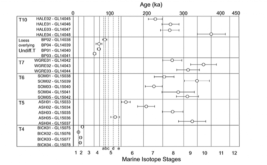
The intriguing findings presented in the diagrams regarding Optically Stimulated Luminescence (OSL) dating within the Avon valley unearth a complex narrative of sediment deposition and geological processes that challenges traditional understandings. The OSL results, as depicted in Figure 5, illuminate the temporal relationship between terrace formations and Marine Isotope Stages (MIS), while Figure 6, based on a three-dimensional model constructed from borehole data, offers a visual cross-section of the valley’s superficial geology.
The OSL ages for terraces T10 through T7, indicating deposition during or before MIS10/9, including the Last Glacial Maximum (LGM), suggest a timeline that not only aligns with but also refines previously established chronological frameworks. This refinement has significant implications for interpreting the archaeological record associated with Terrace T7 and recalibrating regional uplift and incision rates, which are crucial for understanding landscape evolution over geological timescales.
However, the apparent inconsistencies in the OSL dating results, particularly the dating of Terrace T7 before Terrace T10 and the identification of a Loess Terrace laid during the LGM, introduce a paradox into the sedimentary record. These anomalies challenge the linear progression implied by the terrace hypothesis that has guided interpretations of the valley’s geological history.
The highest terrace, T10, positioned at 102 meters above ordnance datum (OD) as illustrated in Figure 6, spans an unexpectedly broad temporal range of over 200,000 years, according to OSL dating. This finding disrupts the presumed chronological order, especially when juxtaposed with the dating of Terrace T7 at 58 meters OD, which, perplexingly, predates T10. Additionally, the Loess Terrace, situated at 77 meters OD and undifferentiated in the terrace sequence, laid down during the LGM, along with Terrace T4, which harbors the youngest dates, further complicates the scenario.
These results hint at a more intricate story of terrace formation and sediment deposition than previously thought. The seeming randomness and inconsistencies in the dating challenge the traditional terrace hypothesis and suggest that other factors, perhaps related to climatic variations, tectonic activities, or both, played significant roles in shaping the valley’s geomorphology.
The evidence points to a dynamic and possibly non-linear process of terrace formation, where episodes of sediment deposition were influenced by a combination of environmental conditions, rather than a simple chronological succession. This complexity underscores the need for a reassessment of the methods and models used to date and interpret terrace formations, advocating for a more nuanced understanding of the interplay between geological processes and climate change over the Pleistocene.
Thus, while the OSL dating provides valuable insights into the timing of terrace deposition, it also raises critical questions about the reliability of traditional chronological frameworks and the factors driving landscape evolution in the Avon valley. These findings invite further investigation and a reevaluation of existing hypotheses, highlighting the ongoing dialogue between past and present in the quest to decipher Earth’s geological history.
The authors’ observations highlight significant discrepancies and anomalies in the OSL dates that raise questions about the method’s reliability in certain contexts, particularly when compared to other dating methods like radiocarbon dating. These discrepancies are not merely academic curiosities; they fundamentally challenge our understanding of the temporal and environmental context in which these sediment layers were deposited.
The attempt to explain the notable discrepancy in the age estimates of Terrace T4 across different locations within the Avon valley suggests that sediment reworking due to recent fluvial processes or the presence of compound terraces exhibiting different depositional behaviors might be responsible. This acknowledgment of variability within the depositional environment underscores the dynamic nature of fluvial landscapes and the complexity of accurately dating such contexts.
The variability in OSL dates for samples taken at the same soil level (e.g., GL14039, GL14041, GL14038, GL14040) further complicates the narrative. The presence of nearly contemporaneous dates within error limits, juxtaposed with the significantly different sedimentation rates observed just below the topsoil, suggests that the depositional history of the Avon valley is more nuanced than previously understood. These findings indicate that relying solely on visual stratigraphy for dating purposes can lead to inaccuracies, reinforcing the need for a multi-methodological approach to construct a reliable chronological framework.
The comparison between OSL and radiocarbon dating, as discussed in the Gaigalas (2000) study, exemplifies the potential for significant age discrepancies between different dating methods. The observation that OSL dates can be substantially older than their radiocarbon counterparts highlights the need for caution and cross-validation when interpreting chronological data, especially in contexts where sediment exposure and reworking may have occurred.
The discussion of Holocene river flooding and its impact on the dating of river terraces introduces an additional layer of complexity. Flooding events can lead to the deposition of silt and other materials that obscure the original depositional sequence, potentially leading to out-of-sequence terrace dates. This phenomenon complicates attempts to use uplift modeling or the Palaeolithic record as reliable chronological markers, as evidenced by the discrepancies in age estimates for Terrace T7.
The passage concludes by emphasizing the potential of terrace deposits to provide a valuable chronological framework, albeit one that must be approached with caution. By integrating chronometric age control with detailed modeling of deposit height and thickness, researchers can gain a more nuanced understanding of the Avon valley’s landscape evolution. This approach not only enhances our interpretations of past hominin landscape use but also improves the predictive modeling of Palaeolithic sites. The challenges and discrepancies encountered in OSL dating underscore the importance of adopting a holistic and critically engaged approach to understanding the geological past, one that acknowledges the inherent complexities and uncertainties of dating dynamic fluvial landscapes.
Macklin, as we have now seen in this section has identified over one hundred Holocene river floods, twelve of which lasted hundreds of years, that would have contributed to this lack of alluvium or colluvium at Stonehenge Bottom. Moreover, the sources of the rivers that lay this sediment over the centuries of water flow, rely on massive precipitation entering the rivers, cutting through rocks and valleys making them flow at extreme levels which create this erosion and consequential sediment. However, the source of Palaeochannel water are natural springs found locally underground and therefore would not contain the same alluvium levels as active flowing rivers – resolving this dilemma.
Model of the number of flooded rivers in Britain – River Avon
UPDATE
More Empirical Evidence of Post-Glacial Flooding and a Flooded Stonehenge
Prehistoric Levels and Widths for the River Avon
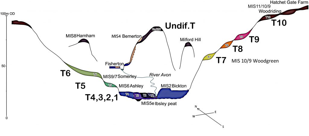
Take a close look at this illustration. It is not speculation, it is empirical science — mapped and measured river terraces from the Avon Valley, published in Egberts (2016), Pleistocene terrace formation and the Quaternary evolution of the Hampshire Basin, Bournemouth University.
What are we looking at?
These are the terrace steps cut by the River Avon over multiple glacial–interglacial cycles.
Each “T-level” marks a former stable floodplain where the river held its height for centuries, often millennia.
The heights are measured in metres OD (Ordnance Datum) and tied to known quarry and pit sites (e.g. Hatchet Gate Farm, Woodgreen, Somerley, Ashley).
How much bigger was the Avon?
Today, the river meanders with a width of just ~50 m near Salisbury.
At its maximum (T11), the Avon floodplain stretched ~12 km across.
That is ~240 times wider than the river today.
What does this mean for Stonehenge?
Phase 1 of Stonehenge (Car Park Postholes) sits on T9 (~90 m OD).
Phase 2 (ditch, Aubrey Holes, bluestones) cuts into T8 (~75 m OD).
The terraces show that the palaeochannel not only flooded up to the old car park, but at times overtopped the entire Stonehenge site.
Why this matters:
Terraces are not theory — they are empirical geomorphological evidence.
They prove that the Avon has flooded to multiple levels, sometimes far higher than the monument itself.
This is not about “if” water could reach those heights — the terraces prove it already has, repeatedly, over many Ice Age cycles.
So when critics dismiss the role of high water tables or argue “the site couldn’t have been wet,” they are ignoring the most basic geological record in front of us. The terraces are the diary of the river — written in gravel, chalk, and silt — showing that water rose and fell, over and over again.
The real question is not if Stonehenge was surrounded by water. It is when, and how many times it happened during its long prehistory.
For active discussions on the findings of the TRILOGY and recent LiDAR investigations that are published on our WEBSITE, you can join our and leave a message or join the debate on our Facebook Group.
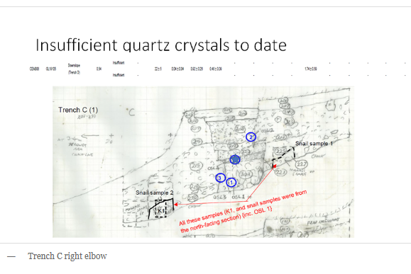
In the first part of our exploration, we delved into the televised program ‘Digging for Britain’ and scrutinised the methodology employed by the purported experts, questioning the reliability of their conclusions regarding the dating of Cerne Abbas. Our investigation highlighted flaws in the sampling process, particularly the oversight of soil creep, which significantly impacts the interpretation of the site’s history. (Digging for Britain Debunked)
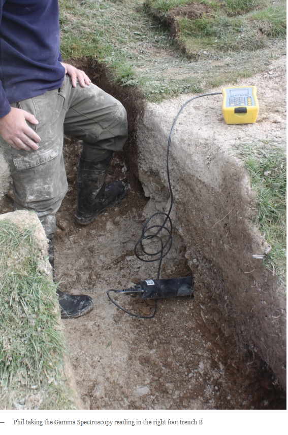
Now, in this second part, our focus shifts to the professionalism of archaeologists involved in such endeavours and, by extension, the broader state of the archaeological profession in the 21st century. A critical lens is turned towards the National Trust’s excavation efforts, particularly the four trenches dedicated to OSL dating. Despite the extensive timeframe of over two years for this undertaking, a conspicuous absence of an official report raises concerns about transparency and the ability for scrutiny by other knowledgeable individuals. This delay in producing and sharing findings with the wider community questions the efficiency and accessibility of archaeological information.
The quality of documentation further comes into question, as hand-drawn cross-sections, seemingly rushed and lacking the meticulous detail expected in rigorous scientific practices, were presented. This not only reveals an apparent ‘back of an envelope’ approach but also underscores a profound oversight by the experts. Despite having two years for scrutiny and examination, critical questions were left unexplored, a shortcoming magnified by the collaboration with the BBC for the televised program.
Digging for Britain Debunked – Cerne Abbas
Cerne Abbas
The absence of a comprehensive and timely report, coupled with the apparent lack of attention to detail in documentation, casts doubt on the thoroughness and professionalism of the archaeological efforts surrounding Cerne Abbas. The urgency to present findings to the media and create a documentary may have compromised the meticulousness required in archaeological endeavours.
This prompts a broader reflection on the state of the archaeological profession itself. The slow pace of report publication, potential gaps in expertise, and a seeming reluctance to subject findings to robust scrutiny raise concerns about the agility and accountability of the discipline in contemporary times.
The deficiencies in the excavation process around Cerne Abbas become more apparent when we scrutinise the placement of the trenches and the sampling locations. The hand-drawn illustrations (which I consider ‘outdated’ in an era of affordable and prevalent 3D high-definition cameras) indicate that samples were taken from the topsoil just above the chalk bedrock. However, a photograph reveals a more accurate location at the bottom of the topsoil near the bedrock chalk, leading to the Saxon date conclusion.
Poor Conclusions
A critical oversight emerges when we consider the implications of the Saxon date. If accurate, the absence of topsoil dating back thousands of years raises intriguing questions. Three plausible scenarios are explored: deliberate removal of soil before Cerne Abbas construction, the absence of soil initially, or inaccuracies in OSL dating.
Option one, soil removal, implies an intention to obliterate what was originally present, raising logistical questions about the necessity for such an extensive process compared to the simplicity of laying new lines on existing chalk.
Option two speculates on the absence of soil due to something atop the bedrock, a theory we will delve into further.
Option three questions the accuracy of OSL dates, which, if proven, could cast doubt on the entire OSL science.
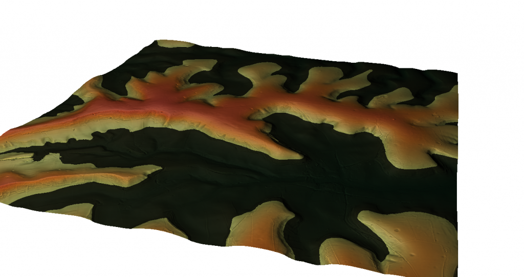
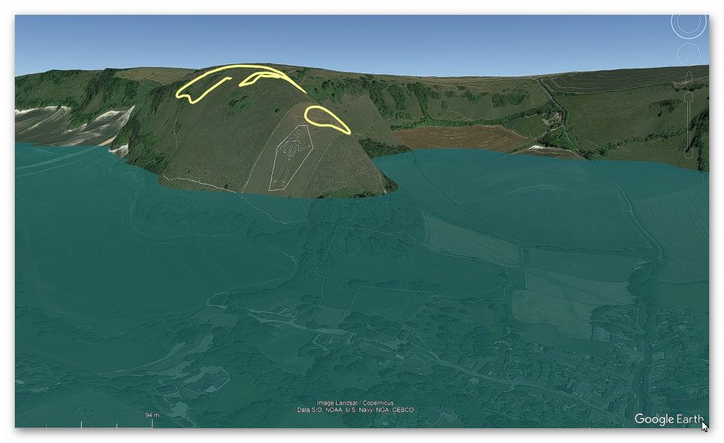
Option two gains credence when exploring the Post-Glacial Hypothesis, grounded in the notion of elevated water levels in prehistoric times. LiDAR imagery of the site reveals a landscape shaped by Mesolithic waters, with identified natural harbours and Neolithic camps indicating the higher historical river levels. Archaeological findings, including tools and earthworks, support the hypothesis of the river running parallel to the figure being significantly higher during the Neolithic period.
Mesolithic Coastline – Digging for Britain Debunked – Cerne Abbas
Prehistoric Landscape
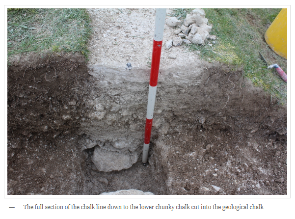
This scenario accounts for approximately seven thousand years with no topsoil on the figure. Examining the bedrock reveals signs of extensive water weathering, consistent with chalk erosion over thousands of years. The excavation report and photographs uncover broken chalk at the bottom of the topsoil, demonstrating water-induced erosion and redeposition. The darkened appearance, a result of drying after being broken and re-laid on top, mirrors the common impact of water on solid chalk.
Digging for Britain Debunked – Cerne Abbas
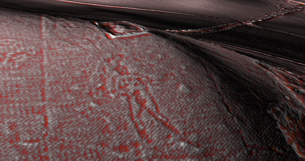
Further evidence points to Post-Glacial Flooding and a Neolithic origin for the figure, strategically marking the entrance to the harbour. LiDAR maps hint at a man with a balance on his shoulders or head, potentially representing a trading centre surrounded by quarries and mining pits.
Lidar showing the deep chalk cuttings – Digging for Britain Debunked – Cerne AbbasOringinal Cerne Abbas figure accoding to AI – Digging for Britain Debunked – Cerne Abbas
The intricacies of Cerne Abbas, when viewed through the lens of geological processes and archaeological evidence, unfold a narrative of ancient landscapes shaped by water, a figure emerging from millennia of erosion, and a Neolithic trading hub leaving its mark on the chalky canvas of history.
Long Man of Wilmington
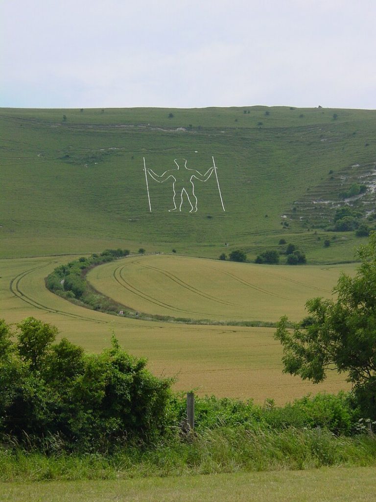
NB. The findings at the The Long Man of Wilmington by Prof. Martin Bell shows very similar findings and geology as Cerne Abbas –
“Our method was to machine cut a trench at the base of the slope to look at the sediment sequence, then carefully hand excavate an adjoining strip, recording in three dimensions the positions of all artefacts, no matter how modern, in order to date each layer.
At the base of our trench there were chalk meltwater muds from a time of rapid physical weathering at the end of the last Ice Age. Above these were bowl-shaped features, perhaps tree-throw pits because they contained land snails of woodland habitats, showing this part of the slope had been wooded earlier in the Postglacial. They also contained some flint flakes, so they could be archaeological features.
Over these was a buried soil. Ed Rhodes, formerly of the Research Laboratory for Archaeology at Oxford, now of the Australian National University, has used OSL to date this soil to the mid-2nd millennium BC. The snails show that by this time the landscape was open. Later in the Bronze Age the soil was buried by more soil derived from cultivation at the base of the slope. Snails show the escarpment above was grassland. Many sites on the South Downs show evidence for quite extensive Bronze Age soil erosion. Bronze Age and Neolithic pottery and flints from the basal soil and the colluvium indicate that a settlement was nearby.”
They called the broken chalk we saw in these excavations ‘chalk meltwater muds’ and he is correct but this kind of deposit can only be produced by thousands of years of water erosion not a couple of hundred and his OSL dates confirm this – as just above this level is a OSL date of 2,000 BCE. We have 8,000 years of top soil missing as the site like Carne Abbass as it was covered with river water creating another natural harbour – and would you believe it – it also has a Neolthic Settlement (trading post above it on the top of the hill) indicating these figures were once used as boat markers/sign posts on the raised rivers of the past, before being change in the saxon period and beyond.
For active discussions on the findings of the TRILOGY and recent LiDAR investigations that are published on our WEBSITE, you can join our and leave a message or join the debate on our Facebook Group.
When we explore the Quaternary deposits of the Avon Valley, a complex geological story begins to emerge. This story challenges traditional interpretations and demands a more careful understanding of the landscape.
Across the valley, we find many different deposits. These include clay with flints, head deposits, gravelly head, river terrace gravels, brickearth, and occasional peat.
One deposit stands out in particular. Clay with flints.
This material is a residual deposit. It formed through the breakdown of older Palaeogene sediments and the gradual dissolution of the chalk beneath them.
The precise age of these deposits remains uncertain. However, many geologists believe that clay-with-flint deposits in southwest England date to the Pleistocene period.
These deposits sit on hilltop flats. They are often found alongside older head deposits. Those head deposits formed through processes such as solifluction and the slow movement of material downslope.
Together, these features show us a landscape shaped by long-term natural processes. They offer a glimpse into deep geological time.
As we move down into the valley itself, we encounter new deposits. These include head gravel, gravelly head, and head.
These layers are the result of water movement and slope processes. They reflect fluvial transport, hill wash, hill creep, and solifluction.
Each layer records how water once moved across the landscape. They show how the river interacted with its surrounding terrain.
One of the most striking features of the Avon Valley is its river terraces. There are fourteen distinct terraces.
These terraces are wide and elevated above the modern valley floor. They suggest that sediments were laid down broadly across the landscape, rather than cut into narrow channels.
The terraces maintain a consistent thickness along the valley. This points to a system overloaded with sediment.
That sediment came from upstream sources and from tributary rivers. Lateral erosion and repeated redeposition played a major role in shaping these features.
This behaviour does not fit neatly with simple explanations tied only to Milankovitch climate cycles. Instead, it suggests a more complex interaction between river dynamics and landscape change.
When we look deeper into the geological history, the picture becomes even more complex. In the Hampshire Basin, older terraces are labelled T5 through T10.
River Avon River Terraces showing the size of the River in the Past
Many of these terraces remain poorly studied. Their ages are often uncertain due to a lack of detailed investigation.
Organic remains found within some terrace deposits have been linked to different interglacial periods. These remains provide clues about past climates and environments.
However, recent research has introduced new questions. Optically Stimulated Luminescence dating — known as OSL — has been applied to the Avon Valley sediments.
The results challenge earlier interpretations. OSL dates from different terraces often appear inconsistent or even random.
OSL Dating of the Sediments on the River Avon
This raises important concerns about accuracy. The situation is similar to early debates surrounding radiocarbon dating.
Further complications arise when OSL dates do not match carbon-14 results. These discrepancies suggest unresolved problems within current dating frameworks.
Differences between upper and lower catchments add yet another layer of uncertainty. Together, these issues show that terrace dating is far from straightforward.
Macklin’s Model of the extsent of the River Flooding in the Past
In conclusion, the Quaternary deposits of the Avon Valley reveal a highly dynamic landscape. They challenge simplified geological narratives.
From clay-with-flint deposits on hilltops, to complex river terrace systems in the valley, every layer tells part of the story.
The uncertainties exposed by OSL dating highlight the need for continued scrutiny and refinement of dating methods.
The Avon Valley remains an open geological record. One that invites us to look again, question assumptions, and read between the lines of deep time.
And there is one conclusion that now seems unavoidable.
The river terraces of the Avon were flooded in relatively recent times. This would have had a profound effect on the people living in this region.
It also offers an important clue. Many ancient sites appear to have been built along the shorelines of these raised rivers.
UPDATE
More Empirical Evidence of Post-Glacial Flooding and a Flooded Stonehenge
Prehistoric Levels and Widths for the River Avon
Take a close look at this illustration. It is not speculation, it is empirical science — mapped and measured river terraces from the Avon Valley, published in Egberts (2016), Pleistocene terrace formation and the Quaternary evolution of the Hampshire Basin, Bournemouth University.
What are we looking at?
These are the terrace steps cut by the River Avon over multiple glacial–interglacial cycles.
Each “T-level” marks a former stable floodplain where the river held its height for centuries, often millennia.
The heights are measured in metres OD (Ordnance Datum) and tied to known quarry and pit sites (e.g. Hatchet Gate Farm, Woodgreen, Somerley, Ashley).
How much bigger was the Avon?
Today, the river meanders with a width of just ~50 m near Salisbury.
At its maximum (T11), the Avon floodplain stretched ~12 km across.
That is ~240 times wider than the river today.
What does this mean for Stonehenge?
Phase 1 of Stonehenge (Car Park Postholes) sits on T9 (~90 m OD).
Phase 2 (ditch, Aubrey Holes, bluestones) cuts into T8 (~75 m OD).
The terraces show that the palaeochannel not only flooded up to the old car park, but at times overtopped the entire Stonehenge site.
Why this matters:
Terraces are not theory — they are empirical geomorphological evidence.
They prove that the Avon has flooded to multiple levels, sometimes far higher than the monument itself.
This is not about “if” water could reach those heights — the terraces prove it already has, repeatedly, over many Ice Age cycles.
So when critics dismiss the role of high water tables or argue “the site couldn’t have been wet,” they are ignoring the most basic geological record in front of us. The terraces are the diary of the river — written in gravel, chalk, and silt — showing that water rose and fell, over and over again.
The real question is not if Stonehenge was surrounded by water. It is when, and how many times it happened during its long prehistory.
For active discussions on the findings of the TRILOGY and recent LiDAR investigations that are published on our WEBSITE, you can join our and leave a message or join the debate on our Facebook Group.
(OSL Chronicles: Questioning Time in the Geological Tale of the Avon Valley)
As we stand on the brink of the Winter Solstice, it’s fascinating to observe the intricate dance between celestial events and human interpretations, especially when coloured by the deliberate distortions of the Christian church. This orchestrated misrepresentation, driven by a disdain for perceived ‘pagan’ influences, offers a curious blend of amusement and disillusionment.
The celestial ballet that designates the astronomical ‘new year’ in the wake of the Winter Solstice is a fact grounded in the cosmic order. Yet, one can’t help but ponder the awareness within the Anglo-Saxon Christian populace regarding this celestial alignment. Instead of acknowledging this cosmic rhythm, the majority adheres to a day within the Gregorian calendar, a construct fashioned half a millennium ago, positioned a week to ten days after this celestial spectacle.
This phenomenon serves as a poignant reminder of the influence wielded by propaganda over scientific realities, leaving us to grapple with a societal landscape that often prioritises pursuits like sports, gambling, and self-indulgence over rational contemplation.
Delving into history, the Winter Solstice emerges as a profound symbol, transcending its astronomical significance. It signifies the juncture where ‘darkness’, emblematic of death and decay, capitulates to ‘light’, ushering in the renewal and vibrancy of life after the rigors of winter. This observance extends far beyond the relatively brief Christian interpretation, as evidenced by the ancient marvel of Stonehenge, standing for over six millennia, crafted to pay homage to this cosmic event.
In the face of deliberate misinterpretations, let the musings of Druids, even in their misconstruing of Stonehenge’s purpose, serve as a testament. As the solstice unfolds, let us not only marvel at the cosmic spectacle but also draw strength from the echoes of traditions, resilient against distortions seeking to challenge the authenticity of our shared history.
The Avenue at Stonehenge – Winter Solstice – Rebirth in Stone
Not A Solar Temple
In contrast to popular belief, Stonehenge was not designed as an observatory for the midsummer solstice sunrise but rather as a tribute to a deeper phenomenon—the midwinter sunset, occurring six months later in the opposite direction. The conventional image of Stonehenge, characterised by its circularity and encompassing lintel stones, is not devoid of complexities. Yet, the monument’s inherent purpose and construction techniques shed light on its true essence.
To grasp the core of Stonehenge’s intent, one must deviate from the idea of it being a solar temple. Aligning it with the Summer Solstice Sunrise lacks significance for a memorial structure dedicated to the departed. Instead, a monument honoring those who ventured beyond life’s horizon gains poignancy by facing the moon’s farthest descent, the nocturnal northwest, or embracing the Winter Solstice Sunset—a representation of the eternal cycle where light ultimately triumphs over darkness, symbolising rebirth.
Furthermore, in this interpretative journey, the archetype of the Sun as a symbol of life and vitality emerges. Ancient civilizations in the Middle East and South and Central America support this imagery, associating monuments to the departed with the crescent moon, a symbol of continuity through time.
Stonehenge’s design was meticulously crafted to mirror a crescent, intertwined with the axis of the Winter Solstice Sunset, notably embodied by a standing trilithon in the southwest quadrant. A lone sentinel of this archetype stands upright, a testament to its purpose. However, history reveals the Druids’ intervention during the Iron Age, reshaping the monument’s symbolism. The displacement of the Heel Stone altered the alignment, connecting it to the Summer Solstice sunrise, while the southwest quadrant’s trilithon met a less glorious fate.
Cresent Moon Temple
The ‘crescent within the crescent,’ the more extensive horseshoe trilithon array, heralds the Summer Solstice sunrise, carrying a significant message across epochs. This symbolism encapsulates the idea of renewal, rebirth, and reincarnation—a testament to the lineage that persevered despite the downfall of their homeland. It echoes through time, illustrating the resilience of a civilization’s descendants, ready to embark anew on the journey of existence.
Stonehenge a ‘Crescent Moon’ Monument – Solstice day
Archaeological evidence lends weight to the hypothesis, unveiling intriguing facets that challenge conventional perceptions. The absence of stones, seemingly ‘missing’ from Stonehenge’s architectural scheme, emerges as a conundrum, a puzzle of significance. The prevailing quandary dissipates if one entertains the notion of an incomplete monument. The curious fact where these ‘missing’ stones cluster within the southwest quadrant offers another layer of intrigue – a testament to their deliberate placement.
A question naturally emerges: if stones were to be transported away, wouldn’t logic dictate that those nearest a road should be the first to go? Yet, the stones of the southwest quadrant, far from the roads, stand as sentinels of purpose, embodying a silent narrative that resonates across the ages.
The argument against Stonehenge’s role as a solar temple deepens by examining the stones themselves. Unaltered by time’s passage, some of these stones stand as witnesses to the challenges faced by a solar temple interpretation. These stones, too small to support the weight of horizontal lintels, cast doubt on this hypothesis. Stone 11, with its inherent dimensions, paints a vivid picture, and in this enigma, the crescent moon’s symbolism gains resonance.
Indeed, the design’s logic unveils a captivating portrait. Strings converging on the centre, the moat manifesting a hexagram – a geometric form replete with significance that resonates through the tapestry of history. As explored in the trilogy’s final tome, ‘Dawn of the Lost Civilisation,’ this geometry speaks to a sophisticated intention that transcends mere architectural endeavour.
Geometrical Construction
In this realm of interpretation, the enigma of Stonehenge takes on dimensions that extend beyond the physical. The stones that stand and those that seemingly ‘disappear’ weave a narrative that goes beyond the mundane, entwining with the geometry of the universe itself. Such is the allure of history – a canvas where stones and geometry converge, inviting us to decipher their secrets, the language of a civilization long past.
The recent incidents of censorship on Facebook, particularly concerning AI-generated images, have raised concerns about the platform’s understanding of reality and the extent of censorship. The fact-checking process, which questioned the authenticity of images supposedly dating back 5,000 years, reflects either a misunderstanding of basic historical knowledge or an Orwellian level of censorship. (Stone transportation and censorship)
It’s noteworthy that the warning about the age of the pictures, considering the invention of cameras only 200 years ago, seems to underestimate the public’s intelligence and awareness of historical facts. Your attempt to share these images served as an opportunity to highlight the limitations and flaws in current archaeological theories, especially those related to stone transportation methods in prehistoric times.
The application of Occam’s razor, favouring the simplest explanation, leads to the logical conclusion that our ancestors likely carried the stones rather than employing more complex methods such as sliding, rolling, or sledging. This perspective challenges prevailing archaeological assumptions and emphasizes the importance of questioning established theories based on practicality and simplicity. (Stone transportation and censorship)
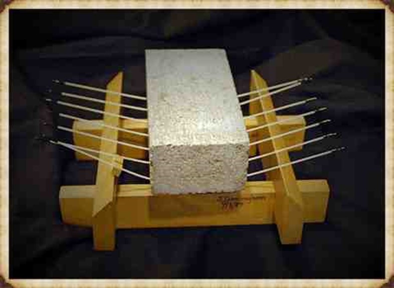
Mechanical Advantage of Poles
The principle of leveraging, applied through poles, serves as a mechanical advantage in handling heavy weights. Professor John Cunningham, an art professor at Skidmore College, has introduced a novel concept, creating a new class of simple machines based on flexible rods. Unlike traditional machines, Cunningham’s design not only multiplies force but also distributes it and stores mechanical energy.
Consider a scenario with a 20,000-pound stone. If you attempt to support it on two rigid beams, each will bear half the weight (10,000 pounds), posing a risk of fracture. Now, imagine spreading the load across 20 solid parallel beams, and each only has to support a fraction of the total weight, making the burden manageable. Cunningham’s innovation takes this idea further by replacing solid beams with flexible poles.
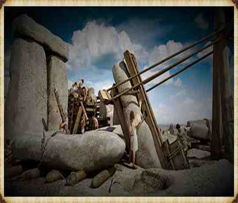
The Bluestones were carried not dragged to Stonehenge
In the flexible pole structure, each pole can be raised independently without affecting the others, thanks to their flexibility. By lifting one end of a pole, a small amount of extra energy is imparted to that pole, and the energy is distributed across the structure. The weight rises by a fraction of the raised end, divided by the number of poles ends. If one end is lifted by a foot, the weight on each of the other pole ends diminishes by a corresponding fraction. Using this method, heavy loads can be lifted with significantly fewer people, as each person is only moving a fraction of the weight at a time.
This innovative approach allows for the efficient handling of substantial weights, introducing a unique perspective on the application of mechanical advantage in lifting and distributing loads. (Stone transportation and censorship)
Cunningham has distilled the concept to a formula: D = S x 1/N
Where D is the distance, the load is raised, s is the distance any one pole is blocked up, and N is the total number of pole ends in the system. Given n is the number of pole ends lifted simultaneously, the mechanical advantage for any symmetrical pole configurations will be N/n. So, the fact that a pole bends like a bow storing energy makes it easier to carry. So easy in fact, that it acts as a lever and gives you a mechanical advantage. This principle would be well known as it is the same principle as how a bow works as it is a store of potential energy, you can’t throw an arrow 100 metres, but the bowing of the wood channelled through a small area (the string) give you the potential energy.
Walk like an Egyptian
The experiment showed that 48 students ( four x 12 poles) could lift 2.3 tonnes – which was the weight of one of the pyramids building stones – the larger the stone the more poles and men you need but quite easy even for wimpish students. In prehistoric Days with Cro-Magnon works you would need only 24 people to move a Pyramid stone or a Bluestone at Stonehenge without the rest blocks the video has included in their H & S safety assessment….LOL!!
A-Frames and Cranes
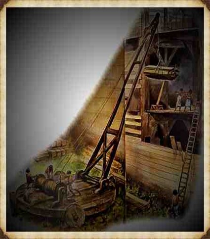
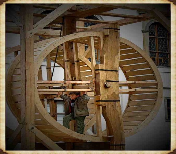
The advancement of technology and the movement of massive stones, such as the Sarsen stones at Stonehenge, Avebury, and Carnac, demand a closer examination of the engineering and logistical challenges faced by the ancient civilization of Homo Superior, also known as Cro-Magnons. The Sarsen stones, weighing up to 60 tonnes, were not merely transported but meticulously erected, presenting a feat that even modern attempts struggle to replicate. In our exploration of ancient technology, we encounter the question of transportation and the handling of colossal loads. The Sarsen stones serve as an illustrative example due to their significant size, and it is perplexing that historians and archaeologists often overlook the intricacies of moving and placing these stones. This oversight persists even though, even with today’s technology, replicating the achievements of Homo Superior at Stonehenge remains a daunting challenge. The crane, a machine designed for lifting and moving heavy materials, is pivotal in the transport and construction industries. Equipped with a hoist, wire ropes or chains, and sheaves, a crane utilizes mechanical advantages to lift and lower materials beyond the capacity of human effort. Historically, the invention of the crane is attributed to the Ancient Greeks in the late 6th century BC, evidenced by cuttings for lifting tongs and Lewis irons on stone blocks of Greek temples around 515 BC.
However, when scrutinizing Stonehenge, we encounter a fascinating divergence. In contrast, archaeological evidence points to the use of lifting devices, particularly with cuttings indicating the application of cranes, the peculiarities of Stonehenge’s construction challenge conventional narratives. Notably, the placement of lintels on Sarsen uprights and the presence of holes like Y & Z, potentially serving as foundations for A-frame crane legs, hint at a more sophisticated lifting apparatus.
The reluctance of some scholars to acknowledge advanced lifting devices within the historical context of Homo Superior may stem from the challenge it poses to established historical frameworks. Nevertheless, the investigation into the engineering marvels of Stonehenge encourages us to reassess the capabilities of this ancient civilization, prompting a deeper understanding of their technological prowess and organisational acumen.
The transition from ramps to the more sophisticated winch and pulley hoist marked a significant shift in construction technology during ancient times. The emergence of the compound pulley system, attributed to Aristotle in the Mechanical Problems, coincided with a notable decrease in the weights of stones handled on Grecian building sites. This transformative period saw the prevalence of smaller stones, weighing less than 15–20 metric tonnes, in contrast to the archaic era’s trend of using larger blocks.
The adoption of the crane, facilitated by the compound pulley system, introduced a more efficient and practical method of vertical motion. Grecian temples of the classical age, exemplified by the Parthenon, favoured the use of several smaller stones over fewer larger ones. Monolithic columns, a prominent feature in earlier constructions, were gradually replaced using multiple-column drums.
The reasons behind this technological evolution are not entirely clear. It raises intriguing questions about whether the shift from larger to smaller stones was due to a loss of past techniques, improved quarrying methods enabling faster cutting of shorter blocks, or other factors influencing construction practices. The shift in societal dynamics, with smaller, professional construction teams being favoured over larger bodies of unskilled labour, is proposed as a potential contributing factor. The crane, with its efficiency in handling smaller stones, became preferable in the more volatile social and political conditions of ancient Greece.
While the exact circumstances of this transition remain uncertain, the historical record indicates that the compound pulley system and the crane became integral to Grecian construction sites. The literary evidence from Aristotle’s Mechanical Problems and the resurgence of larger block sizes at Grecian temples suggest a correlation between the adoption of the compound pulley and advancements in construction techniques. The earliest construction cranes, likely powered by humans or beasts of burden like donkeys, marked a transformative period in ancient construction methods.
Cranes
The evolution of cranes played a crucial role in the construction of tall buildings, and their development over time enabled the lifting of heavier weights. In the High Middle Ages, harbour cranes emerged to facilitate ship loading and unloading, often integrated into stone towers for enhanced strength and stability. The earliest cranes were crafted from wood, but with the advent of the Industrial Revolution, materials like cast iron and steel became predominant.
At Stonehenge, the construction methods are a subject of speculation, with suggestions that timber A-frames were employed to raise the stones. Teams of individuals may have hauled the stones upright using ropes, and the topmost stones (lintels) could have been incrementally raised on timber platforms and slid or pushed into place. Carpentry-type joints on the stones indicate a high level of woodworking skill among the builders.
The idea of A-frames finds support in demonstrations by individuals like Wally Wallington, a retired construction worker, who showcased techniques based on lever principles to rotate, lift, and position heavy monoliths. An A-frame, essentially a basic crane without a pulley or winch, operates on similar principles, facilitating vertical movement. Adding a swivel base could transform it into a fully functional crane, a concept compatible with the mortise and tenon joints observed at Stonehenge.
Estimates of the manpower required for Stonehenge construction suggest a substantial effort, with millions of hours of work involved. The various phases of Stonehenge’s construction, from the initial to the third phase, may have required extensive human labour, reaching up to 20 million hours for working the stones. The primitive tools available at the time necessitated considerable effort, highlighting the strong will and advanced social organization required to build and maintain such a monumental site. Stonehenge stands as a testament to the ingenuity and determination of its ancient builders. (Stone transportation and censorship)
For active discussions on the findings of the TRILOGY and recent LiDAR investigations that are published on our WEBSITE, you can join our and leave a message or join the debate on our Facebook Group.
The Long Barrow Mystery: Unravelling Ancient Connections (essay)
Shared Cultural Practices:
Long barrows, with their elongated shapes and burial chambers, represent a shared cultural practice across Northern Europe. The construction and use of these monuments suggest a common understanding of burial rituals, reflecting the cultural fabric that tied ancient societies together.
Distribution Challenges:
The geographical distribution of long barrows challenges traditional notions of isolated or unconnected societies. The prevalence of similar structures across diverse regions prompts a reevaluation of ancient interactions, migrations, and the potential existence of a network that facilitated the exchange of cultural practices.
Chronological Significance:
As some of the oldest monuments in Northern Europe, long barrows hold chronological significance. Their construction dates provide a timeline for the evolution of burial practices and societal developments, offering valuable insights into the cultural dynamics of ancient communities.
Reassessing Isolationist Narratives:
The existence of long barrows prompts a reassessment of isolationist narratives. Instead of envisioning isolated societies, the shared tradition of constructing long barrows implies a level of communication, interaction, or cultural exchange among different regions, challenging previous assumptions about ancient communities.
Symbolism and Function:
Exploring the symbolism and function of long barrows adds depth to the mystery. These structures served as burial sites, but their specific design, orientation, and incorporation of symbolic elements may carry additional layers of meaning related to shared beliefs, cosmologies, or social structures.
Architectural Diversity:
While long barrows share common characteristics, their architectural diversity across regions raises intriguing questions. Variations in construction methods, materials, or chamber designs may signify regional nuances or adaptations, adding complexity to the narrative of shared practices.
Integration of Archaeological Data:
Integrating archaeological data from various long barrow sites allows researchers to paint a more comprehensive picture of the cultural landscape. Comparative analyses of artifacts, burial practices, and architectural features contribute to understanding the connections and distinctions among different ancient societies.
Interdisciplinary Approaches:
Employing interdisciplinary approaches, such as archaeology, anthropology, and genetics, helps unravel the mysteries surrounding long barrows. Genetic studies, in particular, can provide insights into population movements, relationships, and potential connections among ancient communities.
Cultural Networks and Trade Routes:
The possibility of long barrows being nodes in larger cultural networks or connected by ancient trade routes adds another layer to the mystery. Investigating the movement of people, goods, and ideas along these routes may unveil the intricate web of interactions that shaped the ancient world.
Continued Exploration and Discovery:
The long barrow mystery encourages continued exploration and discovery. New archaeological findings, advanced technologies, and collaborative research efforts offer opportunities to unravel more facets of this ancient enigma, shedding light on the interconnected histories of Northern European societies.
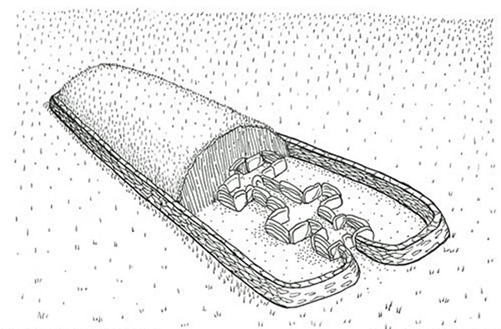
Layout
In unraveling the long barrow mystery, researchers navigate a complex tapestry of shared traditions, regional distinctions, and potential networks that linked ancient communities. As our understanding deepens, these enigmatic structures continue to inspire curiosity and reshape the narratives of the past.
Typical Layout
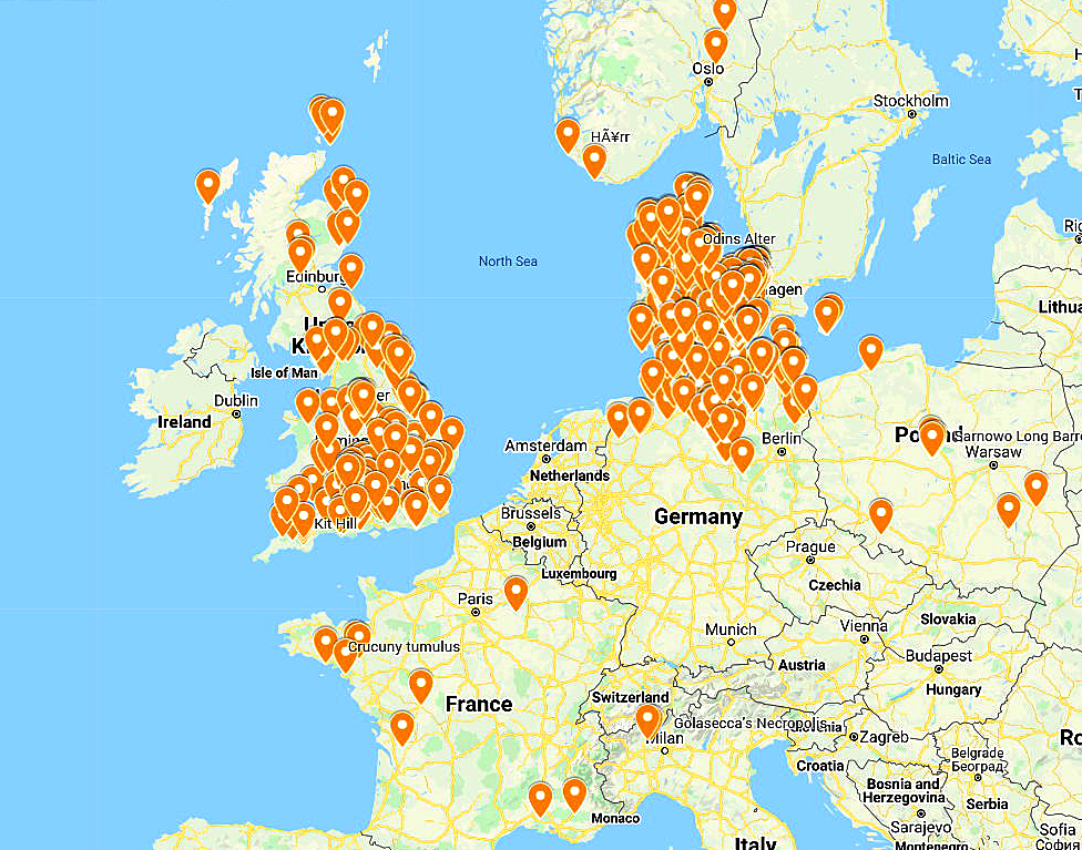
Full Screen map of Long Barrows in Europe – was Doggerland around at the time of Long Barrow construction across Northern Europe?
NB. Active Map has limited sites because of size restrictions
Delving into the mysteries of long barrows in Northern Europe has been a journey filled with fascination and revelation for me. These ancient structures, characterized by their elongated shape and burial chambers, offer a glimpse into the distant past and the rich tapestry of traditions that once thrived in the region. As I navigate through the enigma of long barrows, I find myself questioning established narratives of isolated societies, reconsidering the connections that may have existed among these ancient cultures.
One intriguing perspective that captures my imagination suggests that long barrows might represent more than burial sites—they could be symbolic representations of ships or boats, signaling a journey to the afterlife. The thought that the design of long barrows might mirror contemporary ship designs adds a layer of symbolism and interconnectedness between cultures, transcending geographical and temporal boundaries. This interpretation opens up a world of possibilities, challenging traditional views of migration routes and cultural interactions.
The distribution map of long barrows, a visual representation of their prevalence across Northern Europe, adds complexity to the narrative. The striking scarcity of these structures in Northern France prompts me to reconsider assumptions about the movement of people and ideas in the ancient world. Were there barriers or cultural distinctions that hindered the spread of the long barrow tradition to this region? The map becomes a visual puzzle, inviting me to explore the intricacies of cultural dynamics and exchanges.
The submerged landscape of Doggerland, where the central cluster of long barrows now lies beneath the North Sea, introduces a dynamic element to the mystery. Imagining the Mesolithic Period when Doggerland was above sea level, I contemplate the interconnected routes and interactions it would have facilitated. The submersion of this central cluster reshapes the dating of long barrows and prompts me to consider the impact of environmental changes on ancient landscapes, migration patterns, and cultural developments.
In conclusion, the “Long Barrow Mystery” is not just a historical puzzle but a captivating exploration of ancient cultures and their intricate connections. As I journey through this mystery, I am reminded that history is ever-evolving, and our understanding of the past is a continuous process of discovery and reassessment. The enigma of long barrows challenges me to embrace the surprises it unveils, encouraging a more nuanced and interconnected view of Northern European prehistory.
For active discussions on the findings of the TRILOGY and recent LiDAR investigations that are published on our WEBSITE, you can join our and leave a message or join the debate on our Facebook Group.
Indeed, the modern term “dyke” or “dijk” can be traced back to its Dutch origins. As early as the 12th century, the construction of Dykes in the Netherlands was a well-established practice. One remarkable example of their ingenuity is the Westfriese Omringdijk, stretching an impressive 126 kilometres (78 miles), completed by 1250. This Dyke was formed by connecting existing older ‘dykes’, showcasing the Dutch mastery in managing their aquatic landscape. (Dykes Ditches and Earthworks)
The Roman chronicler Tacitus even provides an intriguing historical account of the Batavi, a rebellious people who employed a unique defence strategy during the year AD 70. They punctured the Dykes daringly, deliberately flooding their land to thwart their enemies and secure their retreat. This historical incident highlights the vital role Dykes played in the region’s warfare and water management.
Originally, the word “dijk” encompassed both the trench and the bank, signifying a comprehensive understanding of the Dyke’s dual nature – as both a protective barrier and a channel for water control. This multifaceted concept reflects the profound connection between the Dutch people and their battle against the ever-shifting waters that sought to reclaim their land.
The term “dyke” evolved as time passed, and its usage spread beyond the Dutch borders. Today, it represents not only a symbol of the Netherlands’ engineering prowess but also a universal symbol of human determination in the face of the relentless forces of nature. The legacy of these ancient Dykes lives on, a testament to the resilience and innovation of those who shaped the landscape to withstand the unyielding currents of time.
Upon studying archaeology, whether at university or examining detailed ordinance survey maps, one cannot help but encounter peculiar earthworks scattered across the British hillsides. Astonishingly, these enigmatic features often lack a rational explanation for their presence and purpose. Strangely enough, these features are frequently disregarded in academic circles, brushed aside, or provided with flimsy excuses for their existence. The truth is, these earthworks defy comprehension unless we consider overlooked factors at play.
One curious observation revolves around the term “Dyke,” inherently linked to water. It seems rather peculiar to apply such a word to an earthwork atop a hill unless an ancestral history has imparted its actual function through the ages. Let us consider the celebrated “Offa’s Dyke,” renowned for its massive linear structure, meandering along some of the present boundaries between England and Wales. This impressive feat stands as a testament to the past, seemingly demarcating the realms of the Anglian kingdom of Mercia and the Welsh kingdom of Powys during the 8th century.
However, delving further into the evidence and historical accounts challenges this seemingly straightforward explanation. Roman historian Eutropius, in his work “Historiae Romanae Breviarium”, penned around 369 AD, mentions a grand undertaking by Septimius Severus, the Roman Emperor, from 193 AD to 211 AD. In his pursuit of fortifying the conquered British provinces, Severus constructed a formidable wall stretching 133 miles from coast to coast.
Yet, intriguingly, none of the known Roman defences match this precise length. Hadrian’s Wall, renowned for its defensive prowess, spans a mere 70 miles. Could Eutropius have referred to Offa’s Dyke, which bears remarkable similarity to the Roman practice of initially erecting banks and ditches for defence?
Figure 1- Offa’s Dyke (Red) – note that it is only complete if you connect the existing rivers to the ditches (Dykes Ditches and Earthworks)
The enigma persists, leaving us to ponder whether Offa’s Dyke, with its impressive extent, holds an ancient Roman legacy or represents a separate and awe-inspiring creation. As we navigate the depths of history, it becomes increasingly apparent that these earthworks hold hidden stories waiting to be revealed, revealing the multifaceted montage of Britain’s past and the extraordinary engineering feats that have shaped its landscape through the ages.
Indeed, history is a complex tapestry woven with a multitude of threads, and the interpretation of archaeological evidence often shapes our understanding of the past. Throughout history, conquerors and civilisations have repurposed existing features, such as ditches, augmenting them with defensive banks and walls to suit their strategic needs. The Romans and the Normans, among others, have demonstrated this practice.
In the case of Offa’s Dyke, the enigma deepens if we consider the possibility that the Romans were the architects behind its creation. Such a scenario challenges the conventional attribution of the Dyke to King Offa and raises questions about the true origins and purpose of this massive linear earthwork. Archaeological realities, or perhaps misinterpretations, can indeed hold the key to unveiling hidden facets of our history.
It is essential to approach historical accounts and archaeological evidence with a critical eye and an openness to multiple interpretations. The past often leaves tantalising clues that may require careful examination and reevaluation. By embracing the complexities and uncertainties of history, we can better appreciate the intricacies of human civilisation and the varied influences that have shaped it over the ages.
In pursuing truth, historians and archaeologists must remain receptive to new insights, allowing the evidence to guide their conclusions, even if it means challenging established narratives. By unravelling these historical puzzles, we can better understand our collective heritage, appreciating the rich combination of human experiences and the myriad forces that have moulded history.
Cross-Dykes
The peculiar earthworks etched upon the British landscape have not eluded the discerning eyes of archaeologists and cartographers alike. These enigmatic features, often defying conventional explanations, have intrigued the curious minds of scholars and historians. A new designation, “Cross-Dykes,” has partially acknowledged their distinctiveness and unusual placement.
Cross-Dykes, substantial linear earthworks, grace the upland terrain, their lengths varying between 0.2km and 1km. Besides one or more banks, they bear ditches, running parallel in an enigmatic dance upon ridges and spurs. Historical excavations and analogies with related monuments paint a broader picture, extending back to the millennia of the Middle Bronze Age. Their purpose, though elusive, leans towards territorial boundaries, delineating parcels of land within ancient communities. But beyond such boundaries, they may have served as tracks or routes for cattle or even as defensive structures.
A pivotal element to grasp lies in the acknowledgement that Cross-Dykes have, at their core, a prehistoric origin. No longer shackled to erroneous notions of Saxon or medieval connections, these ancient features warrant a fresh lens to illuminate their true significance. The names of notable earthworks, like Wansdyke and Offa’s Dyke, may well bear a more profound revision in light of this newfound understanding.
Yet, we must not overlook the Historic England claim that only “very few” of these earthworks remain. The broader landscape contradicts this assertion, teeming with over 1500 scheduled ‘Linear Earthworks,’ showcasing the scope and magnitude of these intriguing remnants. Moreover, advancements in the art of surveying, as heralded by LiDAR, have revealed hidden troves of earthworks, once lost to the unyielding grasp of time and misinterpretation.
To critique archaeological theories with acuity, one must first comprehend their tenets. The evolving narrative seeks to unravel the enigma shrouding these linear earthworks, breathing life into ancient histories etched in the soil. Embracing a spirit of inquiry and remaining receptive to novel discoveries, we embark on a quest of unravelling the untold stories lingering within the terrain. With each revelation, the layers of history peel back, revealing a canvas of human ingenuity, perseverance, and the grandeur of the past, etched forever in the folds of Britain’s landscape. Archaeologists have (partially) recognised that these many earthworks are placed in strange areas for conventional explanations. Consequently, they have attempted to split a section away from the global term earthworks and called them ‘Cross-Dykes’.
Boundary Markers
With their reliance on earthworks as territorial markers, the historical hypothesis surrounding land boundaries emerges as a thought-provoking inquiry. Yet, as we delve deeper into the evidence, a poignant need for more compelling proof becomes evident. Throughout history, societies have indeed relied on markers to delineate their domains, be they natural features like rivers or human-made constructs like hedgerows. The practicality and economy of such choices are undeniable, especially when contrasted with the labour-intensive and costly endeavour of constructing extensive ditches and banks.
In the case of the renowned Offa’s Dyke, a perplexing puzzle emerges. The border, at times, gracefully follows the course of a river, a logical and sensible demarcation. However, the sudden shift to an earthwork set behind the same river defies easy explanation. Such inconsistency leaves us questioning the premise of these earthworks as unequivocal markers. The presence of inexplicable gaps in the land border only deepens the enigma, raising further doubt about the validity of the hypothesis.
We must seek coherence and reason within any historical proposition. The current hypothesis falls short in offering a convincing rationale for this transition from river to earthwork, and it fails to address the glaring accessibility of the river as a natural and readily available boundary marker.
Figure 2 – Path of Offa’s Dyke – showing its not remotely straight
As we navigate the terrain of ancient earthworks, a commitment to rigorous scrutiny is paramount. Only by subjecting our hypotheses to relentless examination can we hope to uncover the authentic truths that lie obscured beneath the layers of time. In embracing a spirit of inquiry and humility, we may yet unlock the profound secrets of these age-old earthworks, shedding light on the intricate relationships between humanity and the landscapes they once inhabited. The pursuit of understanding is a journey marked by discovery and wonder, and in this voyage, we honour the legacy of those who once shaped the contours of history upon British soil.
Defensive Features
According to the pronouncements of esteemed Historical England, discerning the precise function of ancient boundaries proves to be an intricate endeavour. Whether they were intended for defence, stock-herding, or carrying symbolic significance remains elusive. In truth, most boundaries likely fulfilled a mosaic of roles, their purpose evolving and adapting over time. To presume that significant boundaries were solely for defence and smaller ones merely for livestock control would be an oversimplification of the intricate tapestry of history.
These artificial boundaries’ form, extent, and very existence offer vital clues, providing glimpses into their intended purposes. Additionally, their construction’s social and political context can provide insightful context. Yet, as we probe deeper into the historical narrative, it is evident that the written accounts primarily speak of Roman and Norman defence systems. With their ingenuity, the Romans devised the “ankle breaker” ditch – a V-shaped trench with a heightened counterscape masterfully designed to ensnare attackers or thwart mounted assailants.
These ingenious Roman ditches, predominantly surface near Roman sites, are conspicuously absent from 90% of excavations across Linear Earthworks. This absence challenges the prevailing hypothesis and prompts a reevaluation of past assumptions. In particular, investigations into Dykes such as Offa’s have uncovered an unsettling revelation – the defensive banks, in over 10% of the alignment, face the “wrong way.” This finding raises questions about the potential bias that may have influenced the support for this theory in the past.
As the archaeological landscape evolves, a shift is subtly underway, with many archaeologists quietly distancing themselves from this 20th-century hypothesis. The quest for truth demands unyielding inquiry, and as more mysteries come to light, the intricacies of ancient earthworks unfurl before our eyes. In the spirit of intellectual progress, we must approach each enigma with an open mind, ever eager to shed the limitations of preconceived notions and embrace the unfolding revelations of history.
2025 Update
Historic England Confirms the Prehistoric Origins of Britain’s Linear Earthworks
Why Offa’s and Wansdyke Are Not Saxon Ditches
By The Prehistoric AI Team
For over a century, archaeologists have confidently told the public that Britain’s great linear earthworks—Offa’s Dyke, Wansdyke, and their lesser-known cousins—were “Saxon defensive boundaries.” Yet even the government’s own heritage body now quietly admits otherwise.
In its official publication HEAG 219: Prehistoric Linear Boundary Earthworks (Historic England, 2018), the evidence is laid out in black and white: these monumental ditches and banks are not the product of medieval kingdoms but of prehistoric engineering, reaching back thousands of years before Offa or Rome.
1. Historic England’s Own Words
“From the Neolithic period onwards in the British Isles, natural boundaries such as watercourses and escarpments have been supplemented by artificial boundaries, often formed by a ditch and bank.” (HEAG 219, p.2)
That sentence alone demolishes the Saxon myth. These “artificial boundaries” appear from around 3600 BCE, the same period as Britain’s causewayed enclosures and early field systems.
“The earliest conventional linear earthwork so far confirmed, dating to around 3600 BC, follows the crest of the western escarpment of Hambleton Hill, Dorset, for perhaps as much as 3 km.” (HEAG 219, p.7)
In other words, the engineering tradition behind Offa’s and Wansdyke was already flourishing five thousand years earlier than the supposed Saxon period.
2. Confusion by Reuse
“Some of these early boundaries… continued to structure the social and economic landscape through the Iron Age and into the Roman period. Indeed, some have seen continuous use, or repeated re-use, from prehistory to the present day.” (HEAG 219, p.7)
This statement is key. What later archaeologists labelled as “Roman” or “Saxon” were often prehistoric earthworks re-used by later peoples. Defensive adaptations may have been made, but the physical structures already existed—centuries or millennia earlier.
Langdon’s LiDAR analysis of Wansdyke and Offa’s Dyke shows this perfectly: continuous, water-connected segments, truncated by rivers and palaeochannels, betray origins in a hydrological engineering system, not a medieval frontier.
3. Historic England Admits Mis-Dating Risks
“Prehistoric examples can be confused with medieval or later ones… Their form is not often diagnostic.” (HEAG 219, p.7)
This rare confession from within Historic England supports Langdon’s long-standing criticism of archaeological dating methods. When earthworks lack carbonised deposits, dating often depends on surface finds—antler picks, pottery sherds, or even stray Roman coins—leading to circular logic.
As Prehistoric Dykes (Canals) argued, this flawed reasoning has turned prehistoric infrastructure into “Saxon defences” by default.
4. Functional Variety, Not Fortification
“It is often difficult to determine whether a particular boundary was used for defence, for stock-herding, or purely as a symbol; in truth, most boundaries probably served all of these functions to varying degrees.” (HEAG 219, p.2)
The report concedes that no single explanation fits. The traditional defensive model collapses under scrutiny: there are no battle remains, no arrowheads, and no consistent rampart orientations.
This aligns with Langdon’s hydrological interpretation—seeing these earthworks as water management and navigation canals formed when Britain’s post-glacial landscape still retained a higher water table. Their engineering precision makes sense when viewed as prehistoric canalisation, not Saxon militarism.
5. The Official Timeline
Historic England’s own chart places linear boundaries firmly in the Neolithic and Bronze Age, with only reuse continuing into later eras:
Linear Boundaries Timeline (HEAG 219, p. 4000 BC – Neolithic beginnings 1500 BC – Bronze Age expansion 0 AD – Roman reuse
The Saxon period doesn’t even feature.
6. What This Means
The implications are profound. Historic England has, perhaps unintentionally, validated the central premise of the Prehistoric Dyke Hypothesis:
Britain’s linear earthworks are prehistoric hydraulic and boundary systems, later adopted but not created by historical kingdoms.
The narrative of “Saxon kings digging 100-mile ditches by hand” finally collapses under the weight of its own impossibility—and the evidence from both LiDAR and the nation’s own heritage authority.
7. A New Understanding
The HEAG 219 publication is cautious in tone, but its data speaks volumes. The earliest linear boundaries coincide with the rise of complex water management systems, just as Langdon’s LiDAR work shows canal-like forms and river terminations.
It is time to update the textbooks: Wansdyke, Offa’s Dyke, Car Dyke and their lesser cousins are prehistoric canals—part of a sophisticated hydrological network that once crisscrossed a flooded Britain.
Conclusion
Even Historic England now concedes that Britain’s linear earthworks belong to prehistory, not the Dark Ages.
By accepting this evidence, we move beyond folklore and into a genuinely scientific framework—one where landscape engineering, water management, and maritime trade define our ancestors’ genius.
Sources:
Historic England (2018) Prehistoric Linear Boundary Earthworks: Introductions to Heritage Assets (HEAG 219).
Langdon, R.J. (2024) Twigs, Charcoal, and the Death of the Saxon Dyke Myth.
Author’s Biography
Robert John Langdon, a polymathic luminary, emerges as a writer, historian, and eminent specialist in LiDAR Landscape Archaeology.
His intellectual voyage has interwoven with stints as an astute scrutineer for governmental realms and grand corporate bastions, a tapestry spanning British Telecommunications, Cable and Wireless, British Gas, and the esteemed University of London.
A decade hence, Robert’s transition into retirement unfurled a chapter of insatiable curiosity. This phase saw him immerse himself in Politics, Archaeology, Philosophy, and the enigmatic realm of Quantum Mechanics. His academic odyssey traversed the venerable corridors of knowledge hubs such as the Museum of London, University College London, Birkbeck College, The City Literature Institute, and Chichester University.
In the symphony of his life, Robert is a custodian of three progeny and a pair of cherished grandchildren. His sanctuary lies ensconced in the embrace of West Wales, where he inhabits an isolated cottage, its windows framing a vista of the boundless sea – a retreat from the scrutinous gaze of the Her Majesty’s Revenue and Customs, an amiable clandestinity in the lap of nature’s embrace.
Exploring Prehistoric Britain: A Journey Through Time
My blog delves into the fascinating mysteries of prehistoric Britain, challenging conventional narratives and offering fresh perspectives based on cutting-edge research, particularly using LiDAR technology. I invite you to explore some key areas of my research. For example, the Wansdyke, often cited as a defensive structure, is re-examined in light of new evidence. I’ve presented my findings in my blog post Wansdyke: A British Frontier Wall – ‘Debunked’, and aWansdyke LiDAR Flyover video further visualizes my conclusions.
For those interested in British Prehistory, visit www.prehistoric-britain.co.uk, a comprehensive resource featuring an extensive collection of archaeology articles, modern LiDAR investigations, and groundbreaking research. The site also includes insights and extracts from the acclaimed Robert John Langdon Trilogy, a series of books exploring Britain during the Prehistoric period. Titles in the trilogy include The Stonehenge Enigma, Dawn of the Lost Civilisation, and The Post Glacial Flooding Hypothesis, offering compelling evidence about ancient landscapes shaped by post-glacial flooding.
To further explore these topics, Robert John Langdon has developed a dedicated YouTube channel featuring over 100 video documentaries and investigations that complement the trilogy. Notable discoveries and studies showcased on the channel include 13 Things that Don’t Make Sense in History and the revelation of Silbury Avenue – The Lost Stone Avenue, a rediscovered prehistoric feature at Avebury, Wiltshire.
In addition to his main works, Langdon has released a series of shorter, accessible publications, ideal for readers delving into specific topics. These include:
For active discussions and updates on the trilogy’s findings and recent LiDAR investigations, join our vibrant community on Facebook. Engage with like-minded enthusiasts by leaving a message or contributing to debates in our Facebook Group.
Whether through the books, the website, or interactive videos, we aim to provide a deeper understanding of Britain’s fascinating prehistoric past. We encourage you to explore these resources and uncover the mysteries of ancient landscapes through the lens of modern archaeology.
For more information, including chapter extracts and related publications, visit the Robert John Langdon Author Page. Dive into works such as The Stonehenge Enigma or Dawn of the Lost Civilisation, and explore cutting-edge theories that challenge traditional historical narratives.


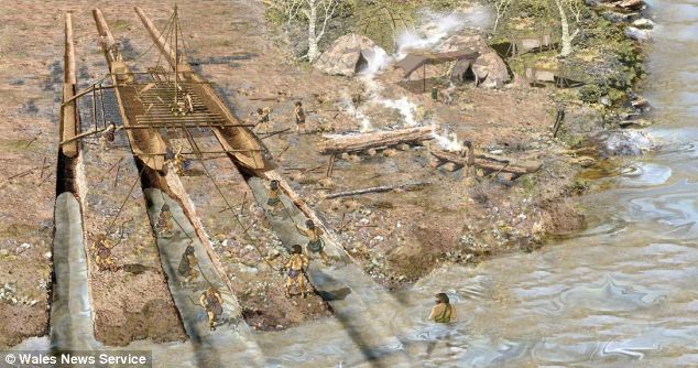
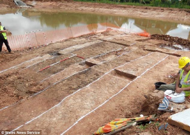
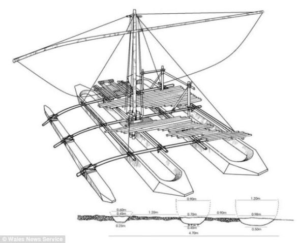
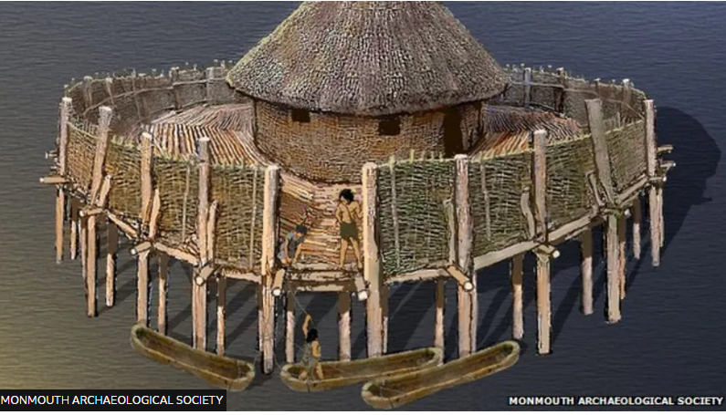
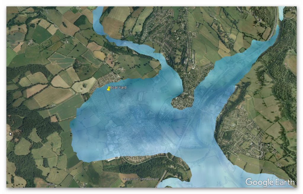


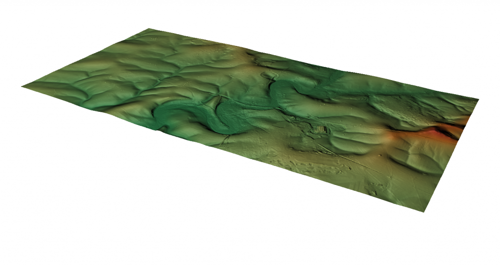
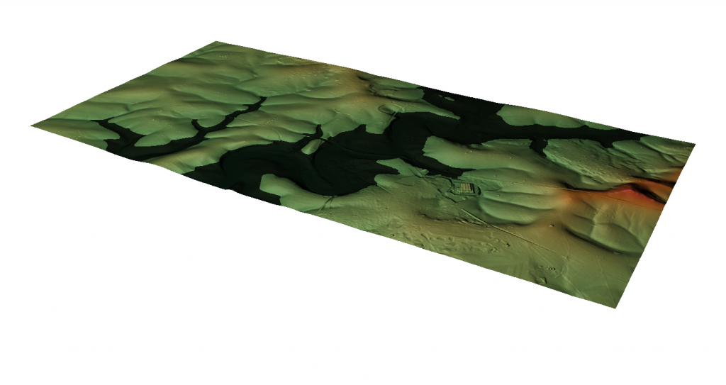
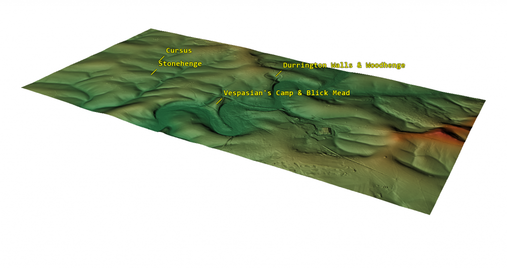

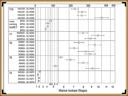
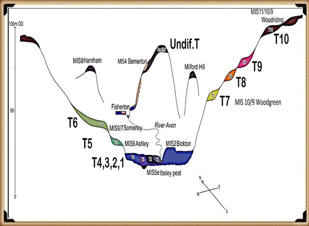
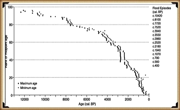
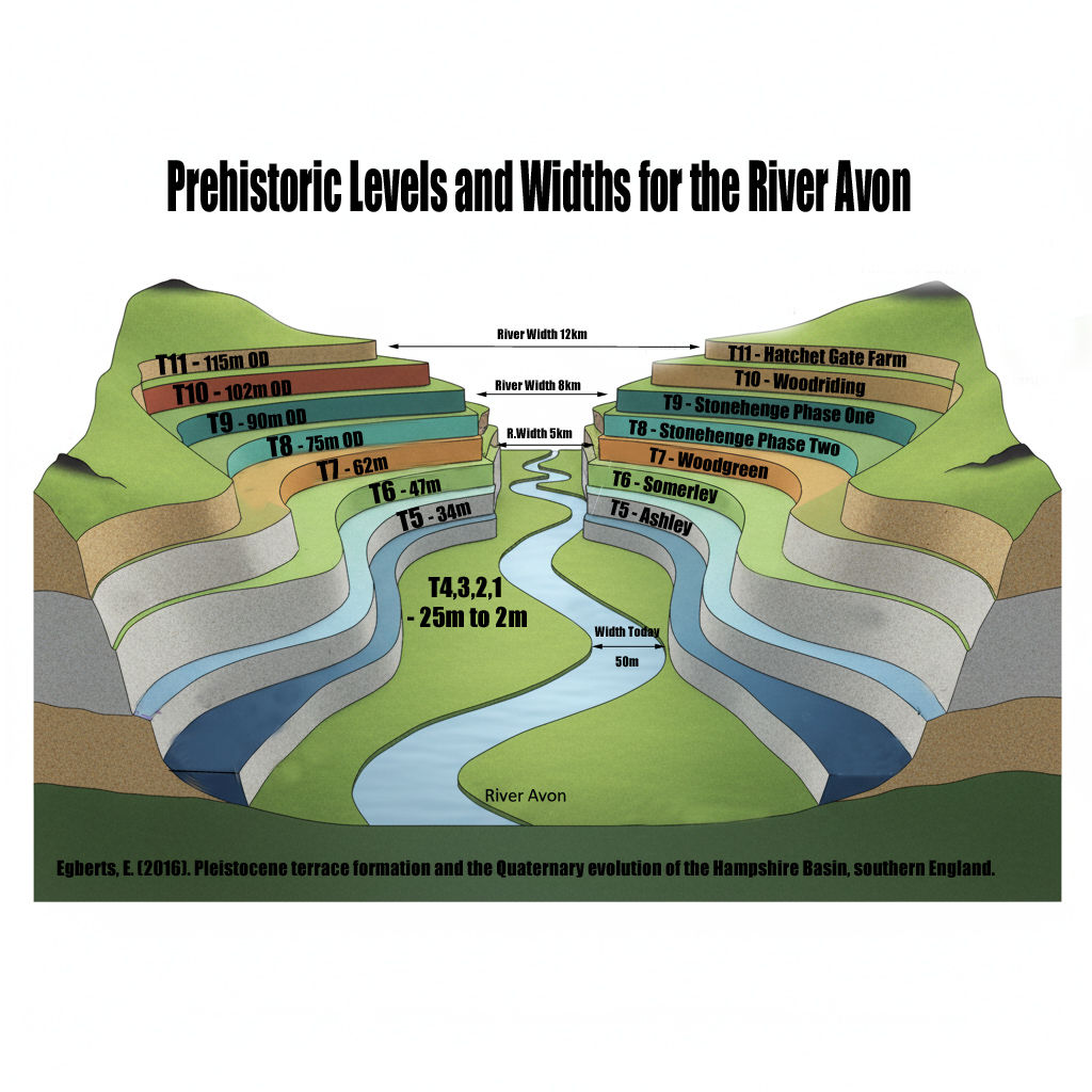
 How much bigger was the Avon?
 What does this mean for Stonehenge?
 Why this matters:
 The real question is not if Stonehenge was surrounded by water. It is when, and how many times it happened during its long prehistory.