Conundrum 11 – Periglacial Stripes…………………………. Book Extract (The Great Stonehenge Hoax)
When was the wheel invented?
The Problem
Deep chalk cuts lines found under the surface of the Avenue, which lead from the Stonehenge monument site to ‘Stonehenge Bottom’ a valley in the NE of the landscape, had always created speculation, especially today as the ‘experts’ came up with a ludicrous argument that had caught the mainstream archaeologists imagination when they suggested that these were Periglacial Stripes from the last ice age, and this was the reason for our ancestors built Stonehenge at this place. These lines are just a foot or so below the topsoil on a known roadway that dates back older than the B-road that passed the stones that have now been removed.
The Solution
This is probably the most provocative subject in history – who invented the wheel and when? What should be remembered when considering this as a key ‘landmark’ invention in the progress of humanity is that the wheel is useless without a road. The current belief is that the wheel was invented in Mesopotamia in about the 4th millennium BCE. This, however, is archaeological gobbledygook as the concept of moving items around on top of a round surface, like a tree trunk, goes back to the Neanderthals, I would imagine, if not before.
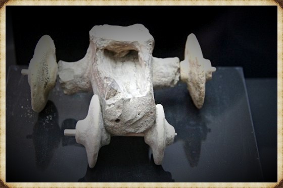
Archaeologists and historians would argue that the concept of the ‘axle’ connected to two free-running discs constitutes an actual wheel technology. However, in 2012, a Museum in Turkey found a ‘toy car’ made of stone with wheels in the northern Kurdish town of Qoser (Kızıltepe), pushing back the accepted date of wheel technology to the 6th millennium (5500BCE). The interesting aspect of this discovery was that it was a toy and not the real thing. This may be because the wood would not last this long, and even the toy car’s timber axle had to be replaced by a modern stick by the museum because it had rotted. But it should be kept in mind that this may represent an accurate record of a wagon or cart with wheels, but without a flat surface, it would be useless. (The Stonehenge Hoax – Periglacial Stripes)
We have seen these kinds of ‘revolutionary inventions’ many times in history and the two most famous ‘useless’ inventions that spring to my mind are the ‘Steam Engine’, and the ‘Windmill’ – both inventions were available to the Romans in 2000 years ago, the original steam engine was a toy that spun around when a candle was placed under the brass ball with pipe outlets. Diagrams of this unique invention are shown in Hero of Alexandria’s epic work on pneumatics, which offers many other unused (or currently undiscovered) hydraulic devices. The windmill, again another mechanism well known to the Romans, was also made as a toy for children, for those who need to construct a full life-size version, at a considerable cost, which can only be used when the wind blows – in comparison to a treadmill that can work 24/7 when you have slaves?
As an example of this limited efficiency of the wheel, the American Indians also had knowledge and access to ‘real wheels’ before they were placed on their reservations, but they continued their nomadic lifestyle with horses that pulled sleighs as the distribution of weight on unmade roads made it less likely for the sleigh to get stuck and bogged down – unlike the wagon trains that could only be used seasonally as the roads were unsuitable for winter weather. Moreover, wagons suited the lifestyle of the white pioneers as not everyone could or wanted to get to their destination quickly, unlike the indigenous populations that survived on the movement of herds.
Where and when did our ancestors invent the wheel or cart, and for what purpose?
To answer this question, we need to find some kind of ‘road’ or a natural clearing that could be used as a road. If we could find such an area, we might be able to spot the telltale signs of these wheeled carts and, if we are fortunate, the cart itself. (The Stonehenge Hoax – Periglacial Stripes)
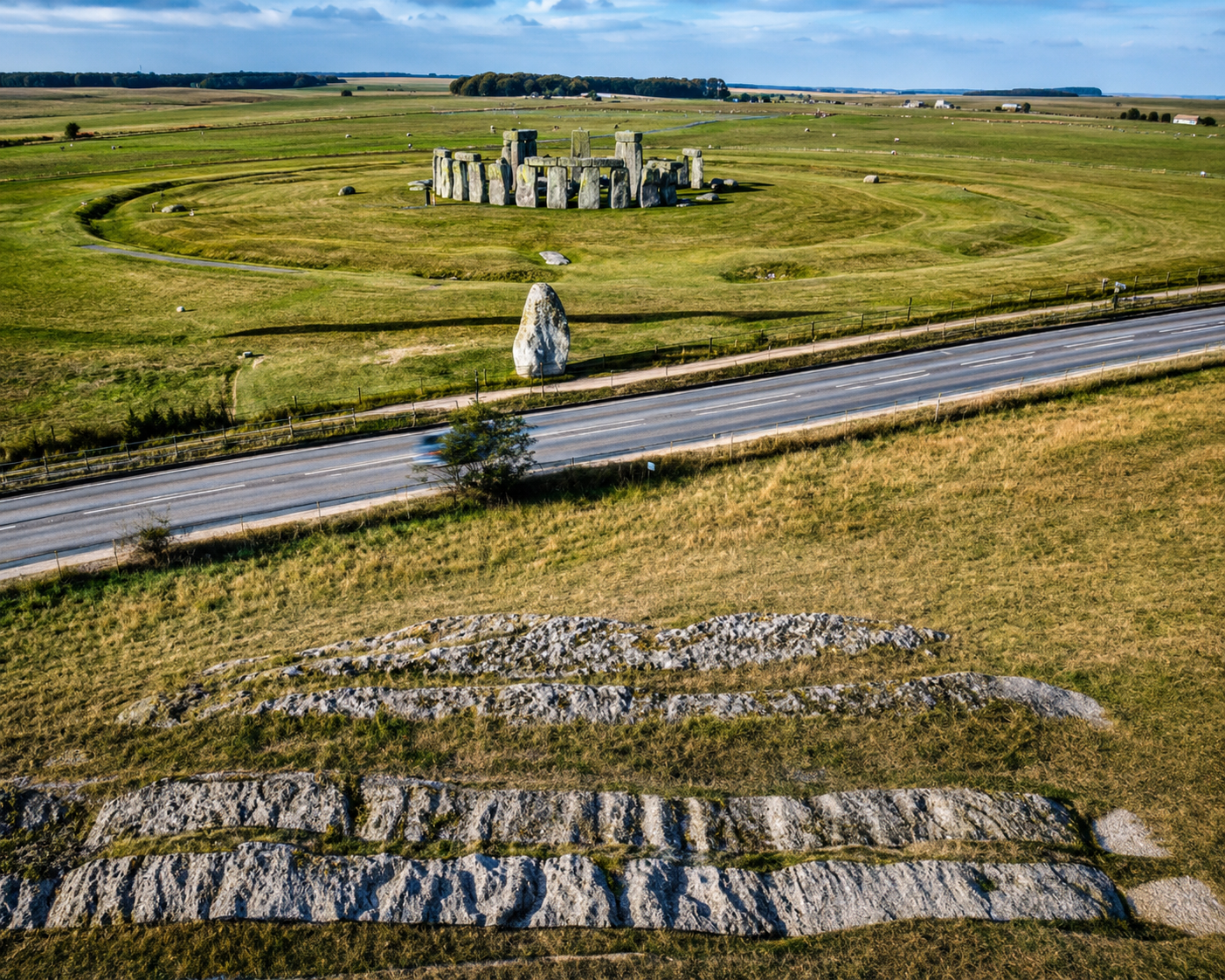
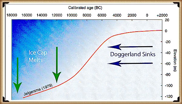
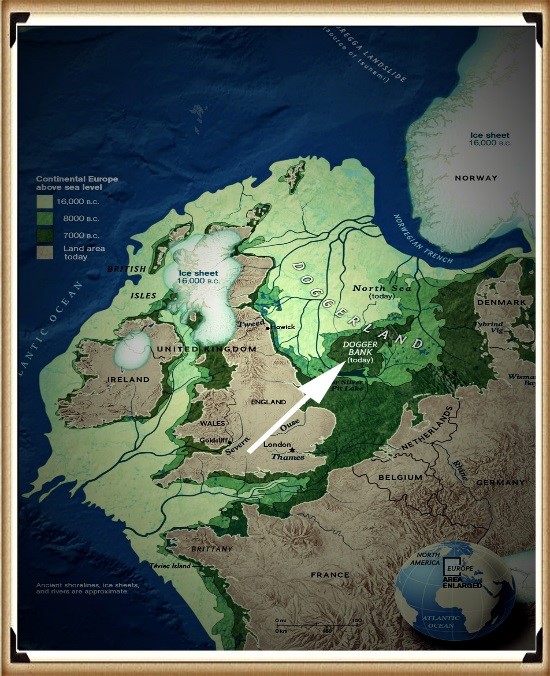
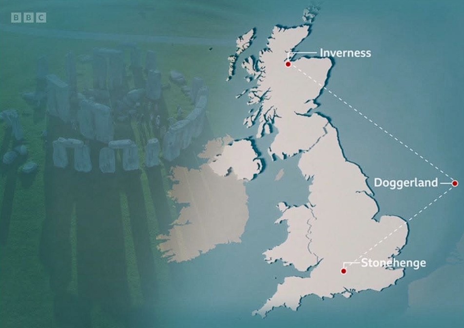
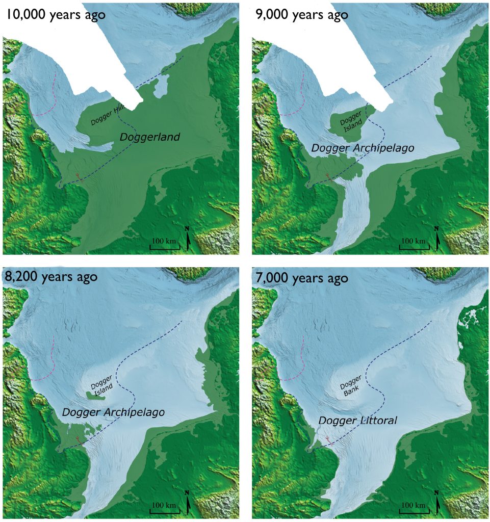
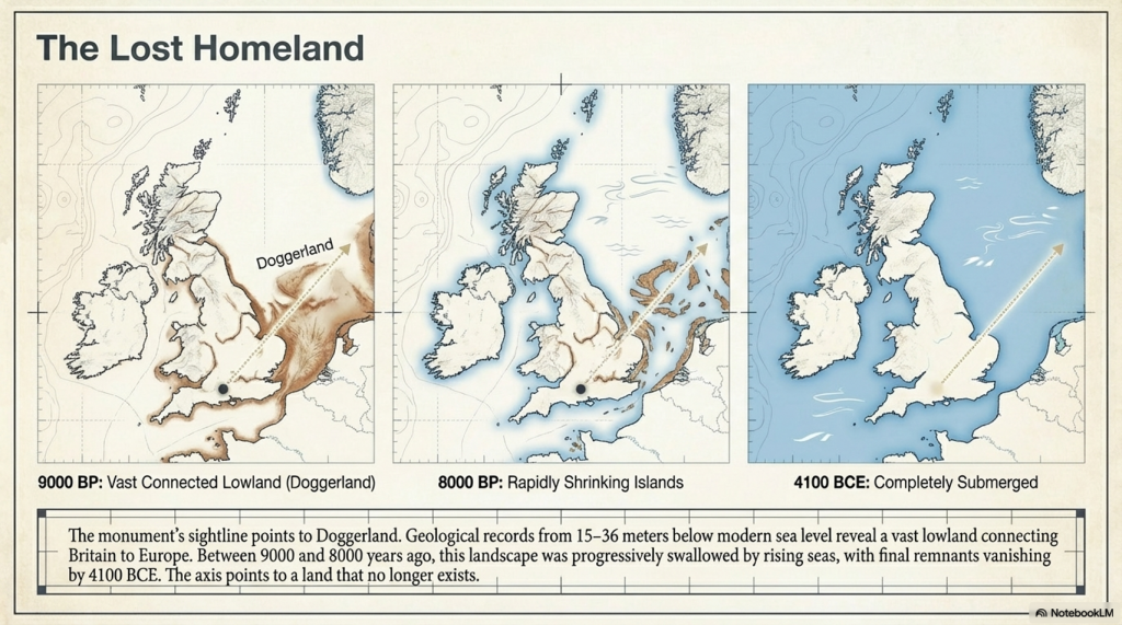
When Doggerland had finally sunk into the North Sea, The Megalithic Builders built Stonehenge, and around 4300BCE, they changed the site to incorporate a new mooring place from the original car park in the North West (which pointed towards the Preseli Mountains where they obtained their sacred healing Bluestones), to a new mooring place in the North-East towards the Solstice midsummer sunrise and their old homeland Atlantis/Doggerland.
The New Shoreline was about a kilometre from the Stonehenge site, so they built what we call ‘The Avenue’, a long straight road about 30 metres wide, too wide for a walkway (which we have seen in places like Avebury is much narrower) but large enough to get two carts going either way with ease. Sadly, for archaeologists, a long ‘road-like’ prehistoric trackway will not persuade them that it was constructed as a road for carts, even if it is concave in shape and has water drainage gullies on both sides – like a Roman road. (The Stonehenge Hoax – Periglacial Stripes)
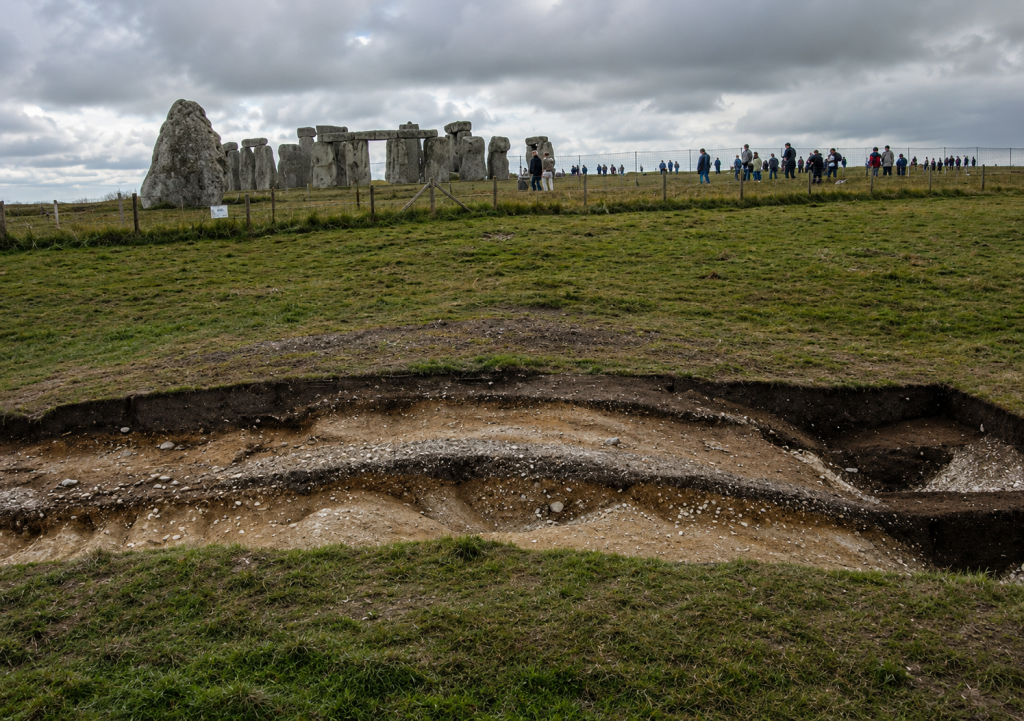
William Hawley in 1922, Atkinson in the 1950s and Mike Parker-Pearson in 2009 found what they believed to be periglacial stripes – they thought that these stripes were the product of rocks being dragged along the floor by ice glaciers or the constant freezing and thawing of the soil known as tundra.
Why am I mentioning such an essential natural feature seen throughout the world?
Well, the great surprise is that they are not natural. These features are found only on the Avenue, not outside the 30m width of the Avenue. Moreover, none are found in the excavated old car park some 50m away, or even inside the Stonehenge enclosure. If they were natural, they should be found either side of the Avenue or past the ‘Heel Stone’ – but mysteriously, they are not. Archaeologists would have you believe that this strange ‘narrow passage’ event happened naturally during the last ice age, which supposedly explains why they built Stonehenge where it is. (The Stonehenge Hoax – Periglacial Stripes)
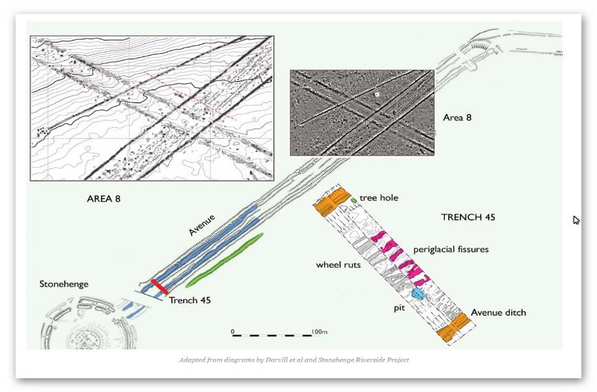
However, the most apparent error by these archaeologists in their assumptions is that we know that the Avenue was built AFTER the Phase I of the site construction (including the ditches) as the ends of the Avenue ditches do not line up and stop short of the Stonehenge Ditches, which would not be the case if periglacial stripes were there first?
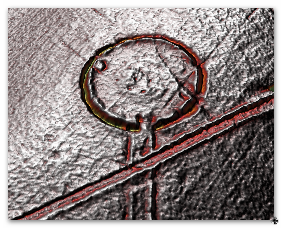
Perhaps this strange event brought the stones to Stonehenge?
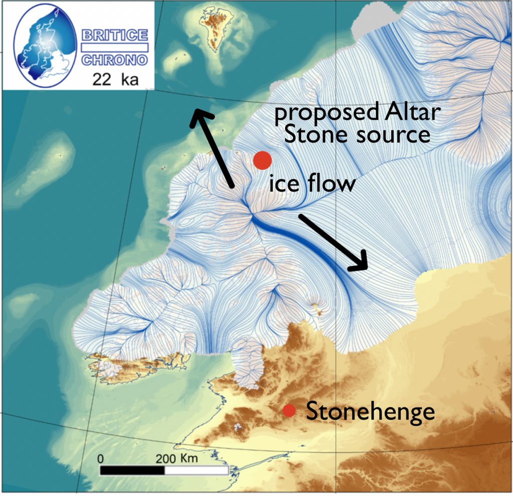
Well, could we not argue that it is possible the Bluestones of Phase I mentioned earlier were delivered via this route on a glacier? This is a nice theory, but sadly, the glacier would be travelling the wrong way. We now know that the Bluestones came from Wales and the Preseli mountains, which are northwest of the site (Solstice midsummer sunset), not the northeast, and the last ice sheet stopped at the Bristol Channel 200km away and travelled in a southeast direction.
So, it is only in previous ice ages that an ice sheet could have reached Stonehenge, which was about 400,000 years ago, and could have come from the northeast. However, would this leave stripes only 30 metres wide? The other problem with these ‘natural features’ is the depth at which they were found, and supposedly half a million years old, yet just under the surface. (The Stonehenge Hoax – Periglacial Stripes)
If it’s not a glacier, what could have made these tracks?
Similar ruts have been found elsewhere in the world, and particularly in Europe. However, the most famous tracks can still be seen today in Malta, which played a crucial role in another of Humanity’s trade routes. Misrah Ghar il-Kbir (informally known as Clapham Junction) is a prehistoric site in Malta near the Dingli Cliffs. It is best known for its “cart ruts” – a complex network of tracks gouged in the rock. However, the age and purpose of the tracks are still a mystery in Maltese history. (The Stonehenge Hoax – Periglacial Stripes)
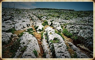
In general, most archaeologists presume that the site was established around 2000 BCE, when new settlers arrived from Sicily to begin the Bronze Age in Malta. It is reported that the “Clapham Junction” nickname was given by an Englishman, who later wrote that it reminded him of the busy railway station Clapham Junction in London. The tracks (known and signposted in Malta as Cart Ruts) can be found at several sites in Malta and Gozo. Busewdien in St Paul’s Bay, Naxxar, San Gwann, and Bidnija are good examples of cart tracks on the island of Malta. Gozo’s best cart ruts are on the Ta’ Cenc plateau, Sannat. The Misraћ Gћar il-Kbir site near the Dingli Cliffs in the south of the island is probably the most impressive – they form a real “traffic jam” here. Also called cart ruts, they are up to 60 cm deep and have an average spacing of 110 to 140 cm. Some cross while others form junctions. This creates the illusion of a great railway station switching yard.
Is this what William Hawley found originally in 1922?
He believed so and immediately called them ‘cart tracks’ because he lived in a time when horse-drawn carriages were common, and their tracks were easily identified. The cart ruts in Malta are not the only reports of earlier wheel use for transportation. In Portugal, in a mountain called Vale d’egua, cart tracks have been found cut into the rock (which by its very nature is undatable) but are located at an altitude of 800m, and they appear ‘out of nowhere’, but it is possible to follow them quite a distance. We can solve this mystery quite simply, as these carts would be used to move goods to and from boats, and at the time of these ruts, the groundwater level would, like we have found throughout Britain, be much higher than today – hence the height and apparent disappearance of the cart tracks.
Why build a road?
The second phase of Stonehenge (the Sarsen Stones) was much heavier than the Bluestones (twelve tonnes versus four tonnes), so the Bluestones could effortlessly be dragged or even carried by the Megalithic Builders as they were tall and heavy, weighing in at about 150kg, so as little as ten fit men would easily lift a stone weighing four tonnes on a ‘stretcher’ type stone carrier. In contrast, the larger Sarsens would need sledges or wheeled transportation. As we have seen previously, such technology has existed since the 6th Millennium BCE, in the form of ‘toy cars’ in Black Sea ports on the trading routes of Doggerland. Therefore, Stonehenge Avenue was Britain’s first ‘road’, and a wheeled cart was first used to move the immense Sarsen Stones from the boats moored at Stonehenge Bottom at the end of 4300BCE. (The Stonehenge Hoax – Periglacial Stripes)
Yes. The strongest 2026 update is no longer the T9 model. The strongest update is that the Stonehenge Bottom borehole dataset has now been completed, and it independently confirms the hydrological interpretation.
Here’s the direction I’d take:
2026 Update: The Stonehenge Bottom Borehole Data Have Now Settled the Question
When this article was updated in 2025, the argument against the so-called “periglacial stripes” relied primarily on the T9 hydrological model. The conclusion was simple: the Avenue corridor was underwater when archaeologists claim these stripes were visible and used to align the monument.
Since then, the investigation has moved beyond modelling.
The complete Stonehenge Bottom borehole dataset has now been analysed.
The results provide direct physical evidence from beneath the landscape itself.
The Fundamental Problem
The periglacial-stripe hypothesis requires archaeologists to believe four things:
- The stripes were visible on the ground surface.
- The landscape was dry enough for them to be observed.
- The Avenue was laid out using these surface features.
- The features survived from the last Ice Age until the Neolithic.
The borehole evidence now challenges every one of these assumptions.
What the Boreholes Reveal
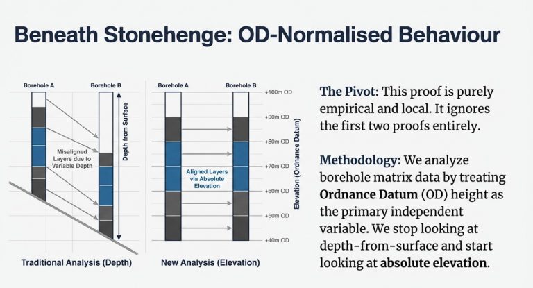
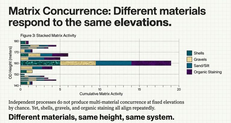
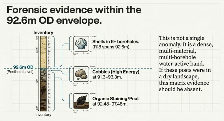
The Stonehenge Bottom boreholes show a concentration of water-related deposits at consistent elevations across multiple independent boreholes.
This is precisely what would be expected if the valley functioned as a long-term watercourse or flooded basin.
It is not what would be expected in a dry landscape dominated by preserved surface frost features.
The remarkable aspect of the dataset is that the deposits cluster by elevation rather than depth.
When analysed against the Ordnance Datum height, the water-related horizons consistently occur at the same levels across the valley, indicating that they were controlled by a common water surface rather than by random geological processes.
The landscape was responding to hydrology.
Not periglacial stripes.
Why This Matters
Periglacial stripes are fragile surface features.
They are not engineered structures.
They cannot remain visible and intact within an active hydrological system subjected to:
- Groundwater fluctuations
- Seasonal flooding
- Sediment deposition
- Erosion
- Channel migration
Yet the borehole evidence demonstrates that Stonehenge Bottom was precisely such a hydrological environment.
The valley was not a dry chalk corridor waiting for Neolithic surveyors.
It was part of a dynamic water system.
The Fatal Contradiction
The archaeological explanation now faces a simple problem.
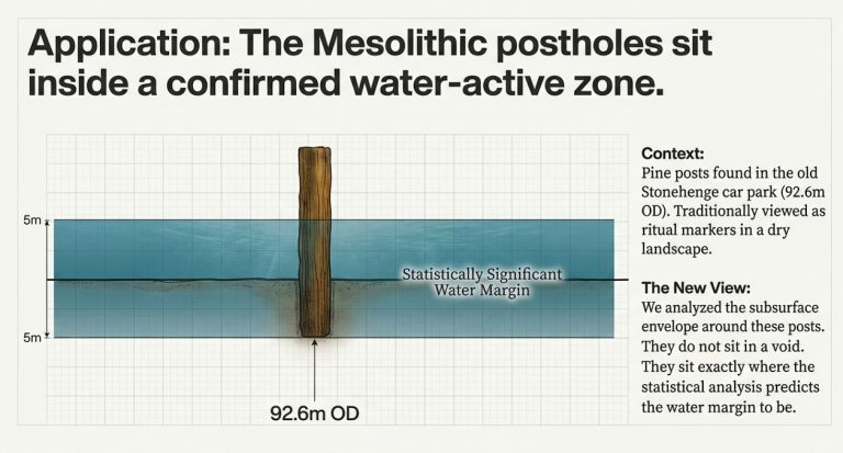
If the boreholes are correct, the landscape was water-dominated.
If the landscape were water-dominated, the stripes could not have functioned as visible alignment markers.
If the stripes could not serve as alignment markers, the entire explanation of the Avenue’s alignment would collapse.
The theory depends upon a dry landscape.
The boreholes demonstrate a wet one.
Both cannot be true.
The Simpler Explanation
The Avenue follows the same route because it follows the hydrology.
The so-called stripes are not the reason the Avenue exists.
They are simply geological features that happened to occupy the same corridor later used by water and subsequently by people.
Archaeologists have reversed cause and effect.
The Avenue was not built because of the stripes.
Both the Avenue and the stripes follow the same route because it was controlled by the underlying landscape and its water system.

Conclusion
The 2025 T9 model suggested that the periglacial-stripe theory was environmentally impossible.
The 2026 Stonehenge Bottom borehole analysis now provides direct subsurface evidence supporting that conclusion.
What began as a mathematical challenge has become a geological one.
The landscape beneath Stonehenge does not support the traditional explanation.
The more evidence we recover from the ground itself, the harder it becomes to argue that the Avenue was aligned using visible Ice Age stripes.
The evidence increasingly points in a different direction:
Stonehenge was designed around water.
Not frost.
🔵 2025 Update: The T9 River-Height Proof Completely Invalidates the Periglacial Stripe Theory
Since this article was first published, we have completed the T9 River-Height Mathematical Model, which reconstructs the groundwater and river levels around Stonehenge across the early Holocene.
The findings are so clear-cut that they require a public correction to the archaeological narrative.
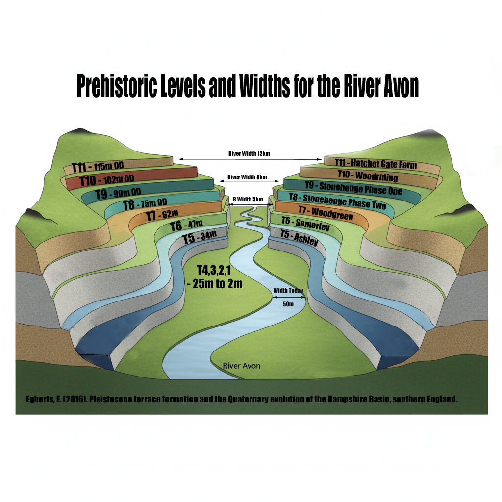
The T9 model shows that at the time the Avenue was supposedly aligned using “periglacial stripes,” the entire Avenue route was underwater.
Not partially wet.
Not marshy.
Submerged. Long-term.
This single fact collapses the entire periglacial-alignment hypothesis.
🔵 Why This Matters: Periglacial Features Cannot Survive Underwater
Archaeologists have claimed that “periglacial stripes” or “meltwater channels” formed during the last glaciation and just happened to align with solstice sunrise — and that Neolithic builders chose Stonehenge’s location because these markings were visible on the ground.
The T9 hydrological reconstruction proves this is impossible:
If the Avenue corridor were underwater, those delicate surface features would have been erased by:
- Hydraulic scouring
- Sediment redistribution
- Bank collapse
- Sheet wash and over-topping
- Reworking of the chalk by sustained flow
Periglacial stripes are shallow, fragile polygonal cracks.
They cannot survive decades — let alone centuries — of fluvial action.
You do not get crisp “visible surface stripes” in an active river channel.
You get reworked chalk, mud deposition, and smoothing — the exact opposite of what MPP’s team claimed to see.
🔵 Archaeologists’ Core Assumption Was Environmentally Impossible
The periglacial hypothesis depends on two assumptions:
- The stripes were visible on dry ground.
- The ground was dry when Neolithic people built the Avenue.
The T9 model completely destroys assumption #2.
If the ground was underwater, then:
- The stripes could not have been visible.
- The stripes could not have survived.
- The Avenue could not have been laid out on foot.
- The “alignment-by-glacial-chance” story collapses.
A submerged landscape cannot guide architectural decisions based on surface marks.
🔵 Correct Interpretation: The Avenue Was a Watercourse, Not a Footpath
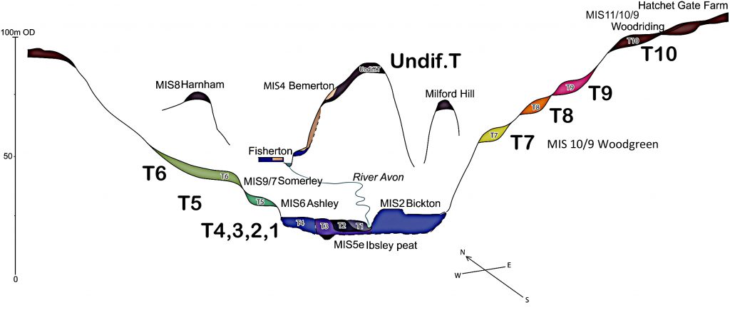
The T9 river height data reinforces everything established in The Post-Glacial Flooding Hypothesis:
- Stonehenge Phase 1 was built on a peninsula surrounded by water.
- The Avenue followed a natural waterway, not a land track.
- The solstice line makes hydrological sense, not glacial sense.
- The site is maritime, not terrestrial, in origin.
Once the Avenue is restored to its true environmental context — a post-glacial river channel, not dry land — the archaeology suddenly stops contradicting itself.
🔵 Conclusion: The “Periglacial Stripe” Theory Is Not Just Weak — It Is Geologically Impossible
The new T9 mathematical proof forces a decisive correction:
❌ The Avenue was not laid out on glacial stripes.
❌ The ground was not dry when the stripes were supposedly “used.”
❌ The stripes could not have survived prolonged inundation.
✅ The Avenue corridor was underwater.
✅ The landscape was shaped by hydrology, not ice.
✅ The entire periglacial-alignment hypothesis must be abandoned.
Unearth the Astonishing Secrets of Stonehenge (The Stonehenge Hoax)
Introduction
Video
Synopsys
Stonehenge, a timeless enigma etched in stone and earth, has stood as a formidable puzzle challenging the intellects of archaeologists and historians alike. Despite the myriad attempts, including books, TV programs, and academic conferences, the secrets of these ancient stones and their encircling ditches have proven elusive. Against this backdrop, we scrutinise the existing thirteen hypotheses, each presenting its narrative but collectively lacking a coherent thread.
In adopting the deductive reasoning akin to Sherlock Holmes, we endeavour to weave these disparate threads into a unified tapestry that not only unravels the mystery of Stonehenge but also shakes the foundations of established academic narratives. This intellectual journey may induce some discomfort as we challenge conventional perceptions and invite a reevaluation of our understanding of the past. Apologies are extended in advance for any cognitive dissonance, but the pursuit of truth and reason mandates an unfiltered presentation of the facts.
So, fasten your seatbelts for an expedition into the archaeological unknown.
As we navigate this intellectual rollercoaster, be prepared for a revelation that might reshape our understanding of Stonehenge and question the foundations of our historical narratives. The dawn of a new archaeological era awaits promising insights that could leave even the most curious minds astonished. As we delve into this intellectual rabbit hole, be ready for a revelation that could astonish Alice. (The Stonehenge Hoax)
Robert John Langdon (2023) – (The Stonehenge Hoax)
The Journey
Langdon’s journey was marked by meticulous mapping and years of research, culminating in a hypothesis that would reshape our understanding of prehistoric Britain. He proposed that much of the British Isles had once been submerged in the aftermath of the last ice age, with these ancient sites strategically positioned along the ancient shorelines. His groundbreaking maps offered a fresh perspective, suggesting that Avebury had functioned as a bustling trading hub for our ancient ancestors. This audacious theory challenged the prevailing notion that prehistoric societies were isolated and disconnected, instead highlighting their sophistication in trade and commerce.
In the realm of historical discovery, the audacious thinkers, the mavericks who dare to question established narratives, propel our understanding forward. Robert John Langdon is undeniably one of these thinkers. With a deep passion for history and an unyielding commitment to his research, he has unearthed a hidden chapter in the story of Avebury that transcends the boundaries of time and offers fresh insights into our shared human history.
As Langdon’s trilogy, ‘The Stonehenge Enigma,’ continues to explore these groundbreaking theories, it beckons us to embark on a journey of discovery, to challenge our assumptions, and to embrace the possibility that the past is far more complex and interconnected than we ever imagined. With its ancient stones and enigmatic avenues, Avebury continues to whisper its secrets to those who dare to listen, inviting us to see history through a new lens—one illuminated by the audacious vision of Robert John Langdon.
(The Stonehenge Hoax – Periglacial Stripes)
The Book
Biography

Robert John Langdon, a polymathic luminary, emerges as a writer, historian, and eminent specialist in LiDAR Landscape Archaeology.
His intellectual voyage has been interwoven with stints as an astute scrutineer in government and grand corporate bastions, a tapestry spanning British Telecommunications, Cable and Wireless, British Gas, and the esteemed University of London.
A decade hence, Robert’s transition into retirement unfurled a chapter of insatiable curiosity. This phase saw him immerse himself in Politics, Archaeology, Philosophy, and the enigmatic realm of Quantum Mechanics. His academic odyssey traversed the venerable corridors of knowledge hubs such as the Museum of London, University College London, Birkbeck College, The City Literature Institute, and Chichester University.
In the symphony of his life, Robert is a custodian of three progeny and a pair of cherished grandchildren. His sanctuary lies ensconced in the embrace of West Wales, where he inhabits an isolated cottage, its windows framing a vista of the boundless sea – a retreat from the scrutinising gaze of Her Majesty’s Revenue and Customs, an amiable clandestinity in the lap of nature.
Exploring Prehistoric Britain: A Journey Through Time
My blog delves into the fascinating mysteries of prehistoric Britain, challenging conventional narratives and offering fresh perspectives grounded in cutting-edge research, particularly LiDAR technology. I invite you to explore some key areas of my research. For example, the Wansdyke, often cited as a defensive structure, is re-examined in light of new evidence. I’ve presented my findings in my blog post Wansdyke: A British Frontier Wall – ‘Debunked’, and a Wansdyke LiDAR Flyover video further visualises my conclusions.
My work also often challenges established archaeological dogma. I argue that many sites, such as Hambledon Hill, commonly identified as Iron Age hillforts, are not what they seem. My posts Lidar Investigation Hambledon Hill – NOT an ‘Iron Age Fort’ and Unmasking the “Iron Age Hillfort” Myth explore these ideas in detail and offer an alternative view. Similarly, sites like Cissbury Ring and White Sheet Camp receive re-evaluations based on LiDAR analysis in my posts “Lidar Investigation Cissbury Ring through time” and “Lidar Investigation White Sheet Camp,“ revealing fascinating insights into their true purpose. I have also examined South Cadbury Castle, often linked to the mythical Camelot56.
My research also extends to ancient water management, including the role of canals and other linear earthworks. I have discussed the true origins of Car Dyke in multiple posts, including Car Dyke – ABC News Podcast and Lidar Investigation Car Dyke – North Section, which suggest a Mesolithic origin 2357. I also explore the misidentification of Roman aqueducts, as seen in my posts on the Great Chesters (Roman) Aqueduct. My research has also been greatly informed by my post-glacial flooding hypothesis, which has helped explain landscape transformations over time. I have discussed this hypothesis in several posts, including AI now supports my Post-Glacial Flooding Hypothesis and Exploring Britain’s Flooded Past: A Personal Journey
Finally, my blog also investigates prehistoric burial practices, as seen in Prehistoric Burial Practices of Britain and explores the mystery of Pillow Mounds, often mistaken for medieval rabbit warrens, but with a potential link to Bronze Age cremation in my posts: Pillow Mounds: A Bronze Age Legacy of Cremation? and The Mystery of Pillow Mounds: Are They Really Medieval Rabbit Warrens?. My research also includes astronomical insights into ancient sites, for example, in Rediscovering the Winter Solstice: The Original Winter Festival. I also review new information about the construction of Stonehenge in The Stonehenge Enigma.
Further Reading
For those interested in British Prehistory, visit www.prehistoric-britain.co.uk, a comprehensive resource featuring an extensive collection of archaeology articles, modern LiDAR investigations, and groundbreaking research. The site also includes insights and excerpts from the acclaimed Robert John Langdon Trilogy, a series of books that explore Britain during the Prehistoric period. Titles in the trilogy include The Stonehenge Enigma, Dawn of the Lost Civilisation, and The Post-Glacial Flooding Hypothesis, which offer compelling evidence of ancient landscapes shaped by post-glacial flooding.
To further explore these topics, Robert John Langdon has developed a dedicated YouTube channel featuring over 100 video documentaries and investigations that complement the trilogy. Notable discoveries and studies showcased on the channel include 13 Things that Don’t Make Sense in History and the revelation of Silbury Avenue – The Lost Stone Avenue, a rediscovered prehistoric feature at Avebury, Wiltshire.
In addition to his main works, Langdon has released a series of shorter, accessible publications, ideal for readers delving into specific topics. These include:
- The Ancient Mariners
- Stonehenge Built 8300 BCE
- Old Sarum
- Prehistoric Rivers
- Dykes, Ditches, and Earthworks
- Echoes of Atlantis
- Homo Superior
- 13 Things that Don’t Make Sense in History
- Silbury Avenue – The Lost Stone Avenue
- Offa’s Dyke
- The Stonehenge Enigma
- The Post-Glacial Flooding Hypothesis
- The Stonehenge Hoax
- Dawn of the Lost Civilisation
- Darwin’s Children
- Great Chester’s Roman Aqueduct
- Wansdyke
For active discussions and updates on the trilogy’s findings and recent LiDAR investigations, join our vibrant community on Facebook. Engage with like-minded enthusiasts by leaving a message or contributing to debates in our Facebook Group.
Whether through the books, the website, or interactive videos, we aim to provide a deeper understanding of Britain’s fascinating prehistoric past. We encourage you to explore these resources and uncover the mysteries of ancient landscapes through the lens of modern archaeology.
For more information, including chapter extracts and related publications, visit the Robert John Langdon Author Page. Dive into works such as The Stonehenge Enigma or Dawn of the Lost Civilisation, and explore cutting-edge theories that challenge traditional historical narratives.
Other Blogs
1
a
- AI now Supports – Homo Superior
- AI now supports my Post-Glacial Flooding Hypothesis
- Alexander the Great sailed into India – where no rivers exist today
- Ancient Secrets of Althorp – debunked
- Antler Picks built Ancient Monuments – yet there is no real evidence
- Antonine Wall – Prehistoric Canals (Dykes)
- Archaeological ‘pulp fiction’ – has archaeology turned from science?
- Archaeological Pseudoscience
- Archaeology in the Post-Truth Era
- Archaeology: A Bad Science?
- Archaeology: A Harbour for Fantasists?
- Archaeology: Fact or Fiction?
- Archaeology: The Flaws of Peer Review
- Archaeology’s Bayesian Mistake: Stop Averaging the Past
- Are Raised Beaches Archaeological Pseudoscience?
- Atlantis Found: The Mathematical Proof That Plato’s Lost City Was Doggerland
- ATLANTIS: Discovery with Dan Snow Debunked
- Avebury Ditch – Avebury Phase 2
- Avebury through time
- Avebury’s great mystery revealed
- Avebury’s Lost Stone Avenue – FREE Flipbook
b
- Battlesbury Hill – Wiltshire
- Beyond Stone and Bone: Rethinking the Megalithic Architects of Northern Europe
- BGS Prehistoric River Map
- Blackhenge: Debunking the Media misinterpretation of the Stonehenge Builders
- Brain capacity (Cro-Magnon Man)
- Britain’s First Road – Stonehenge Avenue
- Britain’s Giant Prehistoric Waterways
- British Roman Ports miles away from the coast
c
- Caerfai Promontory Fort – Archaeological Nonsense
- Car Dyke – ABC News PodCast
- Car Dyke – North Section
- Car Dyke Atlas – Prehistoric Canals – FREE Flipbook
- CASE STUDY – An Inconvenient TRUTH (Craig Rhos Y Felin)
- Case Study – River Avon
- Case Study – Woodhenge Reconstruction
- Chapter 2 – Craig Rhos-Y-Felin Debunked
- Chapter 2 – Stonehenge Phase I
- Chapter 2 – Variation of the Species
- Chapter 3 – Post Glacial Sea Levels
- Chapter 3 – Stonehenge Phase II
- Chapter 7 – Britain’s Post-Glacial Flooding
- Cissbury Ring through time
- Clement Reid, Doggerland, and the Archaeological Establishment
- Cro-Magnon Brain Capacity
- Cro-Magnon Megalithic Builders: Measurement, Biology, and the DNA
- Cro-Magnons – An Explainer
d
- Darwin’s Children – Flipbook
- Darwin’s Children – The Cro-Magnons
- Dawn of the Lost Civilisation – FREE Flipbook
- Dawn of the Lost Civilisation – Introduction
- Digging for Britain – Cerne Abbas
- Digging for Britain Debunked – Cerne Abbas 2
- Digging Up Britain’s Past – Debunked
- DLC Chapter 1 – The Ascent of Man
- Durrington Walls – Woodhenge through time
- Durrington Walls Revisited: Platforms, Fish Traps, and a Managed Mesolithic Landscape
- Dyke Construction – Hydrology 101
- Dykes Ditches and Earthworks
- DYKES of Britain
e
f
g
h
- Hadrian’s Wall – Military Way Hoax
- Hadrian’s Wall – the Stanegate Hoax
- Hadrian’s Wall LiDAR investigation
- Hambledon Hill – NOT an ‘Iron Age Fort’
- Hayling Island Lidar Maps
- Hidden Sources of Ancient Dykes: Tracing Underground Groundwater Fractals
- Historic River Avon
- Hollingsbury Camp Brighton – A Hillfort… or a Forgotten Harbour?
- Hollows, Sunken Lanes and Palaeochannels
- Homo Superior – Flipbook
- Homo Superior – History’s Giants
- How Lidar will change Archaeology
- Hydrology 101 Simplified: Why Britain’s Dykes Worked Without Rivers
i
l
m
- Maiden Castle through time
- Mathematics Meets Archaeology: Discovering the Mesolithic Origins of Car Dyke
- Mesolithic River Avon
- Mesolithic Stonehenge
- Minerals found in Prehistoric and Roman Quarries
- Mining in the Prehistoric to Roman Period
- Mount Caburn through time
- Mysteries of the Oldest Boatyard Uncovered
- Mythological Dragons – a non-existent animal that is shared by the World.
o
- Offa’s Dyke – FREE Flipbook
- Old Sarum Lidar Map
- Old Sarum Through Time…………….
- On Sunken Lands of the North Sea – Lived the World’s Greatest Civilisation.
- OSL Chronicles: Questioning Time in the Geological Tale of the Avon Valley
- Oswestry LiDAR Survey
- Oswestry through time
- Oysters in Archaeology: Nature’s Ancient Water Filters?
p
- Pillow Mounds: A Bronze Age Legacy of Cremation?
- Pinkery Canal
- Plato Was Right: The Archaeological Evidence the Academics Never Expected
- Post Glacial Flooding – Flipbook
- Prehistoric Burial Practices of Britain
- Prehistoric Canals – Wansdyke
- Prehistoric Canals – Wansdyke
- Prehistoric Canals (Dykes) – Great Chesters Aqueduct (The Vallum Pt. 4)
- Prehistoric Canals (Dykes) – Hadrian’s Wall Vallum (pt 1)
- Prehistoric Canals (Dykes) – Offa’s Dyke (Chepstow)
- Prehistoric Canals (Dykes) – Offa’s Dyke (LiDAR Survey)
- Prehistoric Canals (Dykes) – Offa’s Dyke Survey (End of Section A)
- Prehistoric Canals (Dykes) – Wansdyke (4)
- Prehistoric Canals Wansdyke 2
- Professor Bonkers and the mad, mad World of Archaeology
r
- Real-World Confirmation of Post-Glacial Flooding
- Rebirth in Stone: Decrypting the Winter Solstice Legacy of Stonehenge
- Rediscovering the Winter Solstice: The Original Winter Festival
- Rethinking Ancient Boundaries: The Vallum and Offa’s Dyke”
- Rethinking Ogham: Could Ireland’s Oldest Script Have Begun as a Tally System?
- Rethinking The Past: Mathematical Proof of Langdon’s Post-Glacial Flooding Hypothesis
- Rising Evidence, Falling Rivers: The Real Story of Europe’s First Farmers
- Rivers of the Past Were Higher: A Fresh Perspective on Prehistoric Hydrology
s
- Sea Level Changes
- Section A – NY26SW
- Section B – NY25NE & NY26SE
- Section C – NY35NW
- Section D – NY35NE
- Section E – NY46SW & NY45NW
- Section F – NY46SE & NY45NE
- Section G – NY56SW
- Section H – NY56NE & NY56SE
- Section I – NY66NW
- Section J – NY66NE
- Section K – NY76NW
- Section L – NY76NE
- Section M – NY87SW & NY86NW
- Section N – NY87SE
- Section O – NY97SW & NY96NW
- Section P – NY96NE
- Section Q – NZ06NW
- Section R – NZ06NE
- Section S – NZ16NW
- Section T – NZ16NE
- Section U – NZ26NW & NZ26SW
- Section V – NZ26NE & NZ26SE
- Silbury Avenue – Avebury’s First Stone Avenue
- Silbury Hill
- Silbury Hill / Sanctuary – Avebury Phase 3
- Sky Maps of Prehistoric Britain
- Somerset Plain – Signs of Post-Glacial Flooding
- South Cadbury Castle – Camelot
- Statonbury Camp near Bath – an example of West Wansdyke
- Stone me – the druids are looking the wrong way on Solstice day
- Stone Transportation and Dumb Censorship
- Stonehenge – Monument to the Dead
- Stonehenge Hoax – Dating the Monument
- Stonehenge Hoax – Round Monument?
- Stonehenge Hoax – Summer Solstice
- Stonehenge LiDAR tour
- Stonehenge Phase 1 – 8300 BCE Documentary
- Stonehenge Phase 1 — Britain’s First Monument
- Stonehenge Phase I (The Stonehenge Landscape)
- Stonehenge Solved – Pythagorean maths put to use 4,000 years before he was born
- Stonehenge Through Time
- Stonehenge, Doggerland and Atlantis connection
- Stonehenge: Borehole Evidence of Post-Glacial Flooding
- Stonehenge: Discovery with Dan Snow Debunked
- Stonehenge: The World’s First Computer – FREE Flipbook
- Stonehenge: The Worlds First Computer
- Stonehenge’s The Lost Circle Revealed – DEBUNKED
t
- Ten Reasons Why Car Dyke Blows Britain’s Earthwork Myths Out of the Water
- Ten Things You Didn’t Know About Britain’s Prehistoric Flooded Past
- Ten thousand year old boats found on Northern Europe’s Hillsides
- Ten thousand-year-old boats found on Northern Europe’s Hillsides
- Testing Plato’s Atlantis Against Reality
- The “Hunter-Gatherer” Myth: Why It’s Time to Bury This Outdated Term
- The Ancient Mariners – Flipbook
- The Ancient Mariners – Prehistoric seafarers of the Mesolithic
- The Ascent of Man — From Survival to Systems
- The Beringian Migration Myth: Why the Peopling of the Americas by Foot is Mathematically and Logistically Impossible
- The Bluestone Enigma
- The Bulford Hoax: The “Simpler, Older Stonehenge” That Wasn’t
- The Cheddar Man Hoax
- The Cro-Magnon Cover-Up: How DNA and PR Labels Erased Our Real Ancestry
- The Dolmen and Long Barrow Connection
- The Durrington Mega-Monument Hoax: What Lies Beneath? – Debunked
- The Durrington Walls Hoax – it’s not a henge?
- The Dyke Myth Collapses: Excavation and Dating Prove Britain’s Great Dykes Are Prehistoric Canals
- The First European Smelted Bronzes
- The Fury of the Past: Natural Disasters in Historical and Prehistoric Britain
- The Giant’s Graves of Cumbria
- The Giants of Prehistory: Cro-Magnon and the Ancient Monuments
- The Great Ancient DNA Illusion: How Statistical Models Became Archaeological “Facts”
- The Great Antler Pick Hoax
- The Great Bell Beaker Migration Myth
- The Great Chichester Hoax – A Bridge too far?
- The Great Dorchester Aqueduct Hoax
- The Great Farming Hoax – (Einkorn Wheat)
- The Great Farming Migration Hoax
- The Great Hadrian’s Wall Hoax
- The Great Iron Age Hill Fort Hoax
- The Great Offa’s Dyke Hoax
- The Great Prehistoric Migration Hoax
- The Great Stone Transportation Hoax
- The Great Stonehenge Hoax
- The Great Wansdyke Hoax
- The Henge and River Relationship
- The Logistical Impossibility of Defending Maiden Castle
- The Long Barrow and Dolmen Enigma
- The Long Barrow Mystery
- The Long Barrow Mystery: Unravelling Ancient Connections
- The Lost Island of Avalon – revealed
- The Maiden Way Hoax – A Closer Look at an Ancient Road’s Hidden History
- The Maths – LGM total ice volume
- The Mystery of Pillow Mounds: Are They Really Medieval Rabbit Warrens?
- THE ODYSSEY PROBLEM: WHY DID A WEEK-LONG VOYAGE BECOME A TEN-YEAR EPIC?
- The Old Sarum Hoax
- The Oldest Boat Yard in the World found in Wales
- The Perils of Paradigm Shifts: Why Unconventional Hypotheses Get Branded as Pseudoscience
- The Post-Glacial Flooding Hypothesis – 1/11
- The Post-Glacial Flooding Hypothesis – FREE Flipbook
- The Post-Glacial Flooding Theory
- The Problem with Hadrian’s Vallum
- The Rise of the Cro-Magnon (Homo Superior)
- The Roman Military Way Hoax
- The Silbury Hill Lighthouse?
- The Stone Money – Credit System
- The Stonehenge Avenue
- The Stonehenge Avenue
- The Stonehenge Code: Unveiling its 10,000-Year-Old Secret
- The Stonehenge Crescent: A Monument to a Lost World
- The Stonehenge Enigma – FREE Flipbook
- The Stonehenge Enigma: Part 1/6
- The Stonehenge Hoax – Bluestone Quarry Site
- The Stonehenge Hoax – FREE Flipbook
- The Stonehenge Hoax – FREE Flipbook
- The Stonehenge Hoax – Moving the Bluestones
- The Stonehenge Hoax – Periglacial Stripes
- The Stonehenge Hoax – Station Stones
- The Stonehenge Hoax – Stonehenge’s Location
- The Stonehenge Hoax – The Ditch
- The Stonehenge Hoax – The Slaughter Stone
- The Stonehenge Hoax – The Stonehenge Layer
- The Stonehenge Hoax – Totem Poles
- The Stonehenge Hoax – Woodhenge
- The Stonehenge Hospital
- The Stonehenge Transportation Mystery
- The Subtropical Britain Hoax
- The Troy, Hyperborea and Atlantis Connection
- The Vallum @ Hadrian’s Wall – it’s Prehistoric!
- The Vallum at Hadrian’s Wall Atlas – FREE Flipbook
- The Woodhenge Hoax
- Three Dykes – Kidland Forest
- Thurnam’s 137 Skulls: The Forgotten People Behind Britain’s Megaliths.
- Top Ten Misidentified Fire Beacons in British History
- Troy Debunked – Troy did not exist in Asia Minor, but in fact, the North Sea island of Doggerland
- TSE – DVD Barrows
- TSE DVD – An Inconvenient Truth
- TSE DVD – Antler Picks
- TSE DVD – Avebury
- TSE DVD – Durrington Walls & Woodhenge
- TSE DVD – Dykes
- TSE DVD – Epilogue
- TSE DVD – Stonehenge Phase I
- TSE DVD – Stonehenge Phase II
- TSE DVD – The Post-Glacial Hypothesis
- TSE DVD Introduction
- TSE DVD Old Sarum
- Twigs, Charcoal, and the Death of the Saxon Dyke Myth
w
- Wansdyke – Short Film
- Wansdyke Atlas – FREE Flipbook
- Wansdyke East – Prehistoric Canals
- Wansdyke LiDAR Flyover
- Wansdyke: A British Frontier Wall – ‘Debunked’
- Was Columbus the first European to reach America?
- What Archaeology Missed Beneath Stonehenge
- White Sheet Camp
- Why a Simple Fence Beats a Massive Dyke (and What That Means for History)
- Windmill Hill – Avebury Phase 1
- Winter Solstice – Science, Propaganda and Indoctrination
- Woodhenge – the World’s First Lighthouse?