Mesolithic Stonehenge

Introduction

Mesolithic Stonehenge

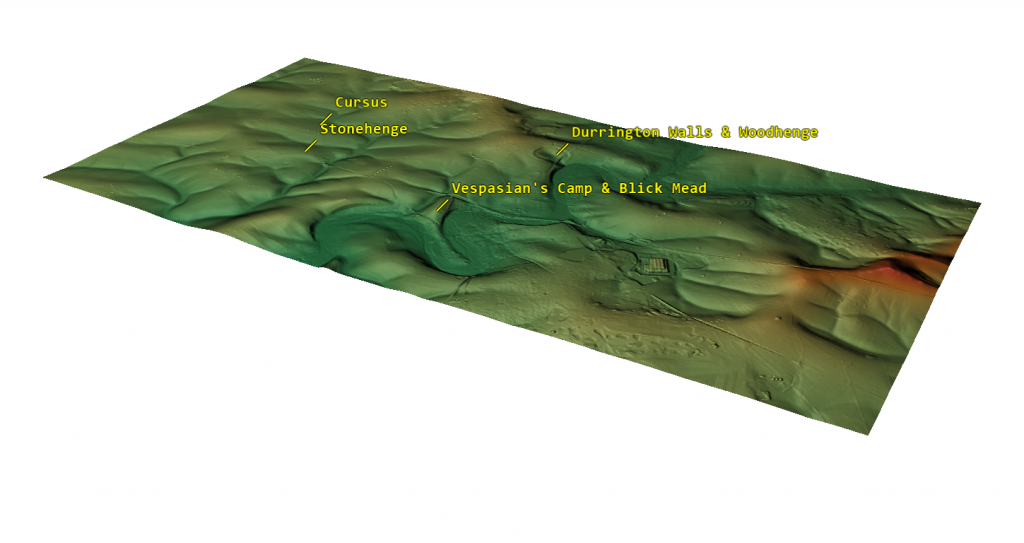
Using LiDAR to examine Stonehenge reveals a surprising detail: the monument isn’t situated at the highest point in the landscape. Instead, it lies midway down a slope, despite nearby elevated sites like Vespasian Camp, near Blick Mead, where the Open University uncovered Mesolithic fire pits with evidence of cooked meat. This raises an intriguing question: why was Stonehenge built in this seemingly less advantageous location?

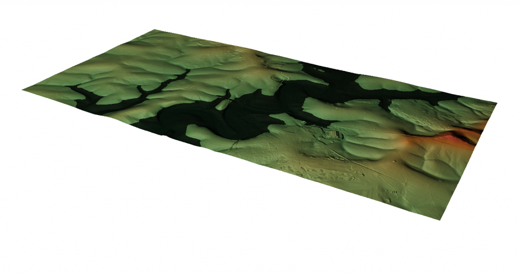
LiDAR technology offers a compelling way to answer this. By creating a detailed 3D landscape model, LiDAR highlights terrain features far more effectively than traditional OS maps or on-site surveys, where important details can easily be overlooked. From a virtual vantage point approximately 100 feet above the ground, facing south, it becomes clear that Stonehenge is perched on the edge of what is now a dry valley. However, during the Mesolithic period, this valley was far from dry; it was an active waterway fed by natural springs, which flowed southward into the River Avon. (Mesolithic Stonehenge)
Blick Mead - Mesolithic Stonehenge
Blick Mead – Mesolithic Stonehenge

These springs were fueled by a high groundwater table, a feature characteristic of post-Ice Age conditions when meltwater replenished underground aquifers. Springs are categorized by their flow rate, with the most productive reaching up to 2,800 litres per second. Evidence suggests that during the Mesolithic, the “Stonehenge Bottom” valley was home to multiple springs, collectively discharging a significant volume of water into the River Avon. Modern core samples taken while surveying the proposed Stonehenge tunnel have confirmed this. The core data revealed that the water table in this area was significantly higher than previously estimated, forcing the tunnel design to be revised and deepened—at a cost of millions. This finding directly challenges the long-held views of archaeologists who have advised on Stonehenge’s historical groundwater levels, casting doubt on their previous peer-reviewed conclusions. (Mesolithic Stonehenge)
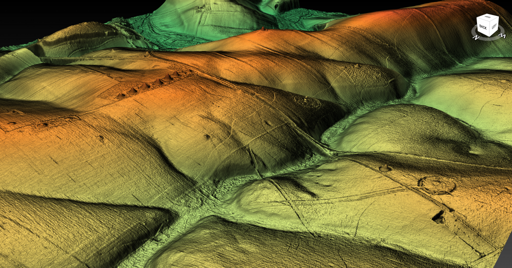
Stonehenge Bottom - Mesolithic Stonehenge
Stonehenge Bottom – Mesolithic Stonehenge

Using LiDAR simulations, we can reconstruct how this water would have shaped the landscape. Archaeological evidence indicates that the water table—and thus the river’s shoreline—was approximately 30 meters higher than today, flooding the valley up to the old Stonehenge car park at 97 meters above sea level. This hypothesis is supported by discoveries made during the construction of the old car park in 1966, where three large post holes were uncovered. These holes cut into the chalk bedrock around 9,000–10,000 years ago and contained silt and sand indicative of a shoreline environment. (Mesolithic Stonehenge)
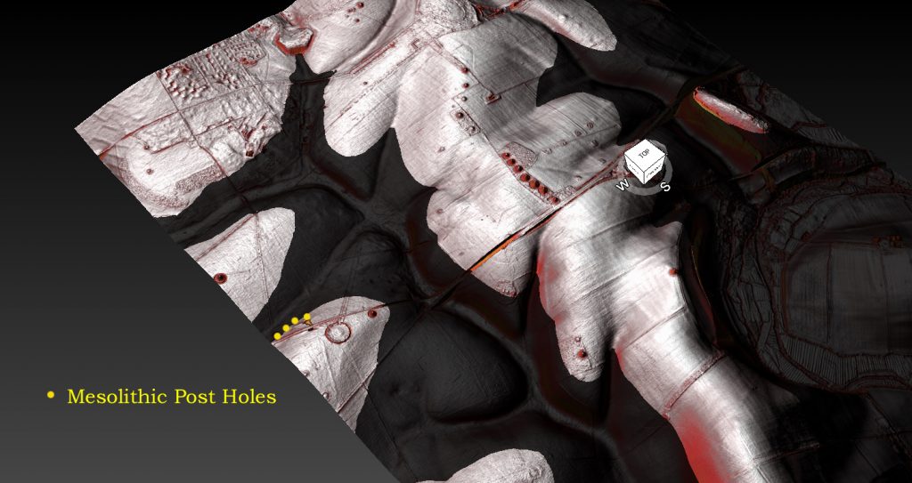
Stonehenge Bottom in the Mesolithic - Mesolithic Stonehenge
Stonehenge Bottom in the Mesolithic – Mesolithic Stonehenge

Radiocarbon dating of pine charcoal from the base of these post holes dates their use to approximately 8,300 BCE. Additionally, more post holes have been discovered in the same area, forming a peculiar alignment. Five such holes have been identified, all dating to the same early Mesolithic period. Intriguingly, these dates align with hearths found at Craig Rhos-y-Felin, the quarry believed to be the source of Stonehenge’s Bluestones. Further supporting this connection is the discovery of hearths at another Bluestone quarry, Carn Goedog, also carbon-dated to approximately 8,400 BCE. These findings strengthen the case for a sophisticated network of activity linking Stonehenge to its quarry sites in Wales. (Mesolithic Stonehenge)
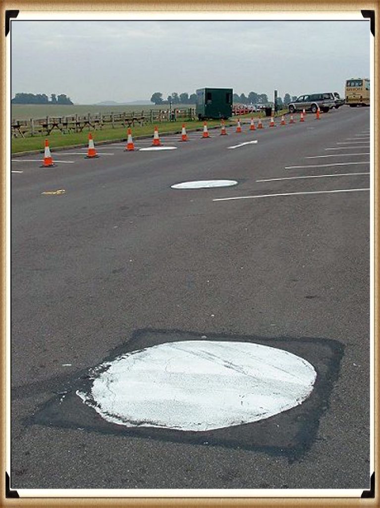
Stonehenge Old Car Park - Mesolithic Stonehenge
Stonehenge Old Car Park – Mesolithic Stonehenge

The old car park is located 10 meters lower than Stonehenge, and further dating evidence from charcoal within the Sarsen circle (confirmed by Darvill and Wainwright in 2008) suggests the site was in use as early as 7,200 BCE. This strongly connects the Mesolithic post holes, possibly used as mooring points for boats, to the later development of Stonehenge. The post holes may have supported cross-beams, functioning as primitive yet effective lifting mechanisms. Boats tied to these beams could utilize the natural rise and fall of the river’s tides to lift heavy stones effortlessly. This would mark an early use of hydraulic lifting principles, demonstrating the ingenuity of Mesolithic communities. (Mesolithic Stonehenge)
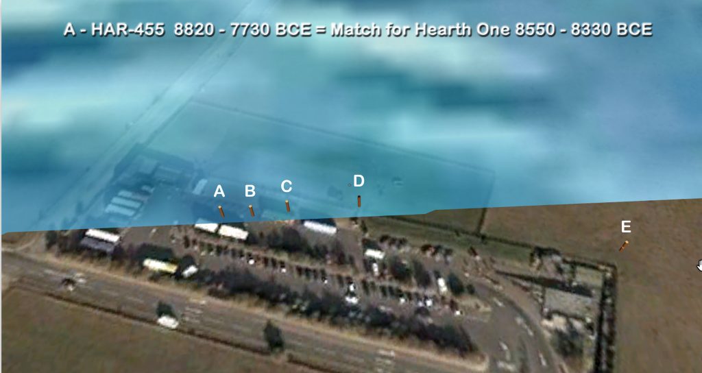
Post Hole A Matches Quarry Hearth Date - Mesolithic Stonehenge
Post Hole A Matches Quarry Hearth Date – Mesolithic Stonehenge

Despite this compelling evidence, mainstream archaeologists often dismiss the idea of a higher River Avon during the Mesolithic. Instead, they suggest these post holes housed “ceremonial totem poles” erected by random hunter-gatherers. However, this explanation is riddled with logical flaws. The post holes are over a meter wide, implying the use of enormous pine trees, which would have required significant effort to fell with stone tools—an unlikely endeavour for mere ceremonial markers. Furthermore, the poles were periodically replaced over more than a thousand years, suggesting a practical rather than symbolic, purpose. (Mesolithic Stonehenge)
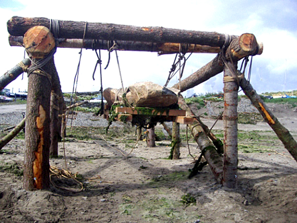
Bluestone lifting device - Mesolithic Stonehenge
Bluestone lifting device – Mesolithic Stonehenge

The discovery of modern core samples in the Stonehenge Bottom Valley only adds to the scepticism regarding traditional archaeological interpretations. For decades, experts advising on Mesolithic groundwater levels have underestimated the height of the water table in the region. The recent core sample findings confirm my hypothesis of a higher water table and highlight the limitations of earlier studies. These experts, whose opinions were once considered definitive, now find their conclusions undermined by hard data—data that has already necessitated expensive revisions to modern engineering projects. (Mesolithic Stonehenge)
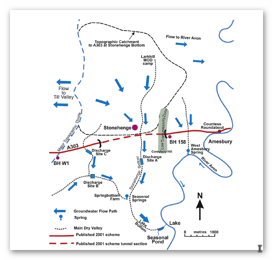
Modern Core Samples show Ground Water in the Area – Mesolithic Stonehenge

LiDAR and archaeological evidence together paint a picture of Stonehenge as part of a peninsula surrounded by water in its early days. This watery context may hold the key to understanding why this iconic monument was built where it stands today. The valley would have provided a natural harbour, making it an ideal location for landing heavy stones transported by boat. The site’s proximity to abundant water resources also suggests that it may have held significant practical and symbolic value for the people who built it.

It’s time to reconsider long-held assumptions about Stonehenge. The combination of LiDAR, modern core samples, and radiocarbon dating has provided a richer, more nuanced understanding of its landscape and early history. These findings challenge traditional narratives and open the door to exciting new interpretations about how and why this monumental site was created. (Mesolithic Stonehenge)

The Stonehenge Book

Video

(Mesolithic Stonehenge)

Synopsys

Stonehenge, a timeless enigma etched in stone and earth, has stood as a formidable puzzle challenging the intellects of archaeologists and historians alike. Despite the myriad attempts, including books, TV programs, and academic conferences, the secrets of these ancient stones and their encircling ditches have proven elusive. Against this backdrop, we scrutinise the existing thirteen hypotheses, each presenting its narrative but collectively lacking a coherent thread.

In adopting the deductive reasoning akin to Sherlock Holmes, we endeavour to weave these disparate threads into a unified tapestry that not only unravels the mystery of Stonehenge but also shakes the foundations of established academic narratives. This intellectual journey may induce some discomfort as we challenge conventional perceptions and invite a reevaluation of our understanding of the past. Apologies are extended in advance for any cognitive dissonance, but the pursuit of truth and reason mandates an unfiltered presentation of the facts.So, fasten your seatbelts for an expedition into the archaeological unknown.

As we navigate this intellectual rollercoaster, be prepared for a revelation that might reshape our understanding of Stonehenge and question the foundations of our historical narratives. The dawn of a new archaeological era awaits promising insights that could leave even the most curious minds astonished. As we delve into this intellectual rabbit hole, be ready for a revelation that could make Alice astonished.(Mesolithic Stonehenge)

Robert John Langdon (2023) – (The Stonehenge Hoax)
The Stonehenge Hoax
The Great Stonehenge Hoax

FREE LiDAR Maps

Here is the perfect resaerch resource for any bidding arcaheologist – 3D LiDAR Maps – there are free and can be downloaded by clicking the Right Site of the Mouse and saving it to your hard Drive for closer inspection, with you PC/Mobile reader software. (Mesolithic Stonehenge)

FREE Stonehenge LiDAR 8K Map
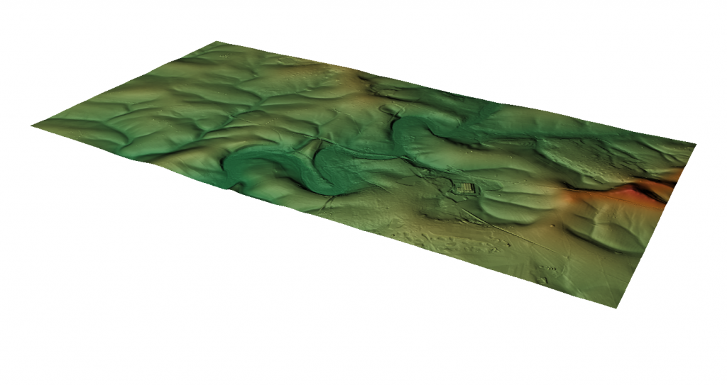
FREE Stonehenge LiDAR Maps

FREE Stonehenge LiDAR water Map

FREE Stonehenge LiDAR Maps

FREE Stonehenge LiDAR 3D Map

(FREE Stonehenge LiDAR Maps)

Exploring Prehistoric Britain: A Journey Through Time

My blog delves into the fascinating mysteries of prehistoric Britain, challenging conventional narratives and offering fresh perspectives based on cutting-edge research, particularly using LiDAR technology. I invite you to explore some key areas of my research. For example, the Wansdyke, often cited as a defensive structure, is re-examined in light of new evidence. I’ve presented my findings in my blog post Wansdyke: A British Frontier Wall – ‘Debunked’, and a Wansdyke LiDAR Flyover video further visualizes my conclusions.

My work also often challenges established archaeological dogma. I argue that many sites, such as Hambledon Hill, commonly identified as Iron Age hillforts are not what they seem. My posts Lidar Investigation Hambledon Hill – NOT an ‘Iron Age Fort’ and Unmasking the “Iron Age Hillfort” Myth explore these ideas in detail and offer an alternative view. Similarly, sites like Cissbury Ring and White Sheet Camp, also receive a re-evaluation based on LiDAR analysis in my posts Lidar Investigation Cissbury Ring through time and Lidar Investigation White Sheet Camp, revealing fascinating insights into their true purpose. I have also examined South Cadbury Castle, often linked to the mythical Camelot56.

My research also extends to the topic of ancient water management, including the role of canals and other linear earthworks. I have discussed the true origins of Car Dyke in multiple posts including Car Dyke – ABC News PodCast and Lidar Investigation Car Dyke – North Section, suggesting a Mesolithic origin2357. I also explore the misidentification of Roman aqueducts, as seen in my posts on the Great Chesters (Roman) Aqueduct. My research has also been greatly informed by my post-glacial flooding hypothesis which has helped to inform the landscape transformations over time. I have discussed this hypothesis in several posts including AI now supports my Post-Glacial Flooding Hypothesis and Exploring Britain’s Flooded Past: A Personal Journey

Finally, my blog also investigates prehistoric burial practices, as seen in Prehistoric Burial Practices of Britain and explores the mystery of Pillow Mounds, often mistaken for medieval rabbit warrens, but with a potential link to Bronze Age cremation in my posts: Pillow Mounds: A Bronze Age Legacy of Cremation? and The Mystery of Pillow Mounds: Are They Really Medieval Rabbit Warrens?. My research also includes the astronomical insights of ancient sites, for example, in Rediscovering the Winter Solstice: The Original Winter Festival. I also review new information about the construction of Stonehenge in The Stonehenge Enigma.

(Mesolithic Stonehenge)
Further Reading

For those interested in British Prehistory, visit www.prehistoric-britain.co.uk, a comprehensive resource featuring an extensive collection of archaeology articles, modern LiDAR investigations, and groundbreaking research. The site also includes insights and extracts from the acclaimed Robert John Langdon Trilogy, a series of books exploring Britain during the Prehistoric period. Titles in the trilogy include The Stonehenge Enigma, Dawn of the Lost Civilisation, and The Post Glacial Flooding Hypothesis, offering compelling evidence about ancient landscapes shaped by post-glacial flooding.

To further explore these topics, Robert John Langdon has developed a dedicated YouTube channel featuring over 100 video documentaries and investigations that complement the trilogy. Notable discoveries and studies showcased on the channel include 13 Things that Don’t Make Sense in History and the revelation of Silbury Avenue – The Lost Stone Avenue, a rediscovered prehistoric feature at Avebury, Wiltshire.

In addition to his main works, Langdon has released a series of shorter, accessible publications, ideal for readers delving into specific topics. These include:

For active discussions and updates on the trilogy’s findings and recent LiDAR investigations, join our vibrant community on Facebook. Engage with like-minded enthusiasts by leaving a message or contributing to debates in our Facebook Group.

Whether through the books, the website, or interactive videos, we aim to provide a deeper understanding of Britain’s fascinating prehistoric past. We encourage you to explore these resources and uncover the mysteries of ancient landscapes through the lens of modern archaeology.

For more information, including chapter extracts and related publications, visit the Robert John Langdon Author Page. Dive into works such as The Stonehenge Enigma or Dawn of the Lost Civilisation, and explore cutting-edge theories that challenge traditional historical narratives.

(Mesolithic Stonehenge)
Other Blogs

s

t

(Mesolithic Stonehenge)
Antonine Wall – Prehistoric Canals (Dykes)

Introduction

Antonine Wall
Antonine Wall

Linear earthworks such as dykes, Hadrian’s Wall (including the Vallum), and the Antonine Wall have long been interpreted as defensive structures or boundary markers by archaeologists. However, emerging evidence challenges these traditional views, suggesting these features may have functioned as prehistoric canals. By examining construction techniques, alignments, and environmental contexts, this groundbreaking research presents a compelling argument that these structures were engineered for water management and transport, reflecting sophisticated societal planning in ancient Britain.


A key focus is the East Wansdyke, which has been traditionally described as a defensive dyke. Comprehensive surveys reveal that its engineering—such as level gradients, excavation methods, and proximity to water sources—aligns more closely with canal systems than with military purposes. Using features like natural valleys and watercourses further strengthens the hypothesis that this and similar earthworks served as functional waterways, enabling efficient transport and trade across regions.

Antonine Wall
Antonine Wall


This re-evaluation extends to iconic features like Hadrian’s Wall and its associated Vallum. Traditionally misinterpreted as solely defensive, the Vallum is revealed through this research as a singular, cohesive structure, potentially integral to a water-based transport network rather than a mere boundary marker. Considering these features’ environmental context and engineering specifics, the research provides a unified interpretation of their original purpose, suggesting a sophisticated system for managing resources and enabling connectivity across ancient Britain.


The implications of this research are profound, not only for redefining the purpose of linear earthworks but also for understanding the societal and technological capabilities of ancient Britons. This work invites further debate and investigation by proposing a cohesive and evidence-backed theory, aiming to bridge gaps between traditional archaeology and scientific methodologies. It also highlights the need for a fresh approach to interpreting Britain’s prehistoric landscape—one grounded in innovation and a willingness to question long-held assumptions

Case Study – The Antonine Wall

It would be amiss if we did not look at the ‘other’ Roman wall in some detail as it is part of the great ‘enigma’. (Antonine Wall)

Antonine Wall
Antonine Wall

Wikipedia

The Antonine Wall, known to the Romans as Vallum Antonini, was a turf fortification on stone foundations built by the Romans across what is now the Central Belt of Scotland, between the Firth of Forth and the Firth of Clyde. Built some twenty years after Hadrian’s Wall to the south and intended to supersede it, while it was garrisoned, it was the northernmost frontier barrier of the Roman Empire. It spanned approximately 63 kilometres (39 miles) and was about 3 metres (10 feet) high and 5 metres (16 feet) wide. Lidar scans have been carried out to establish the length of the wall and the Roman distance units used.

 Security was bolstered by a deep ditch on the northern side. It is thought that there was a wooden palisade on top of the turf. The barrier was the second of two “great walls” created by the Romans in Great Britain in the second century AD. Its ruins are less evident than those of the better-known and longer Hadrian’s Wall to the south, primarily because the turf and wood wall has largely weathered away, unlike its stone-built southern predecessor.

Construction began in 142 AD at the order of Roman Emperor Antoninus Pius, and took about 12 years to complete. Antoninus Pius never visited Britain, whereas his predecessor Hadrian had done so. Pressure from the Caledonians may have led Antoninus to send the empire’s troops further north. The Antonine Wall was protected by 16 forts with small fortlets between them; troop movement was facilitated by a road linking all the sites known as the Military Way.

The soldiers who built the wall commemorated the construction and their struggles with the Caledonians with decorative slabs, twenty of which survive. The wall was abandoned only eight years after completion, and the garrisons relocated rearward to Hadrian’s Wall. Most of the wall and its associated fortifications have been destroyed over time, but some remains are visible. Many of these have come under the care of Historic Environment Scotland and the UNESCO World Heritage Committee.

Grim’s Dyke

Wikipedia

In medieval histories, such as the chronicles of John of Fordun, the wall is called Gryme’s dyke. Fordun says that the name came from the grandfather of the imaginary king Eugenius son of Farquahar. This evolved over time into Graham’s dyke – a name still found in Bo’ness at the wall’s eastern end – and then linked with Clan Graham. Of note is that Graeme in some parts of Scotland is a nickname for the devil, and Gryme’s Dyke would thus be the Devil’s Dyke, mirroring the name of the Roman limes in Southern Germany often called ‘Teufelsmauer’. Grímr and Grim are bynames for Odin or Wodan, who might be credited with the wish to build earthworks in unreasonably short periods of time. This name is the same one found as Grim’s Ditch several times in England in connection with early ramparts: for example, near Wallingford, Oxfordshire or between Berkhamsted (Herts) and Bradenham (Bucks). Other names used by antiquarians include the Wall of Pius and the Antonine Vallum, after Antoninus Pius.

Grimes Dyke – Antonine Wall

Our Research and LiDAR Investigation

The reality is that the exact dates and the reason for its construction are just as confused as Hadrian’s Wall, although (as shown) various theories offer explanations for the construction.

For the purpose of this book, we are only concerned with the construction process behind the Antonine Wall to see if it gives us clues to the structure of the Vallum, which seems to be of similar size and design, but looks as if it has been ‘reused’ in a lesser form and therefore giving us clues to how the original Vallum may have looked before it massively revamped?

We could (and might at a later date) look at the entire length of the Antoine Wall to obtain a more comprehensive analysis of the construction, but for this Case Study exercise, we will look at just one section, including a fortification.

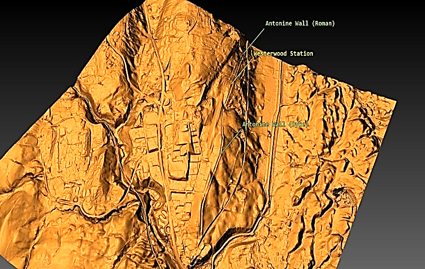
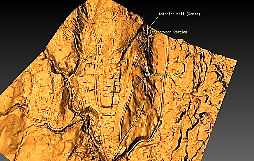
Castlecary Fort Section (Antonine Wall)

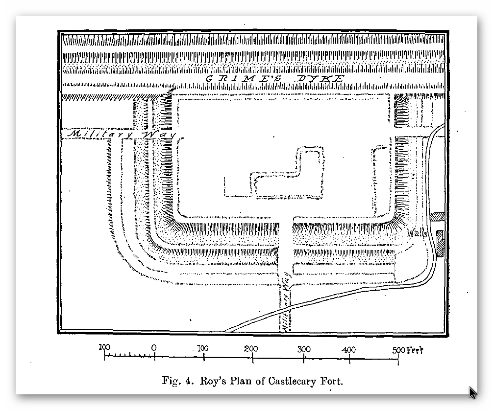
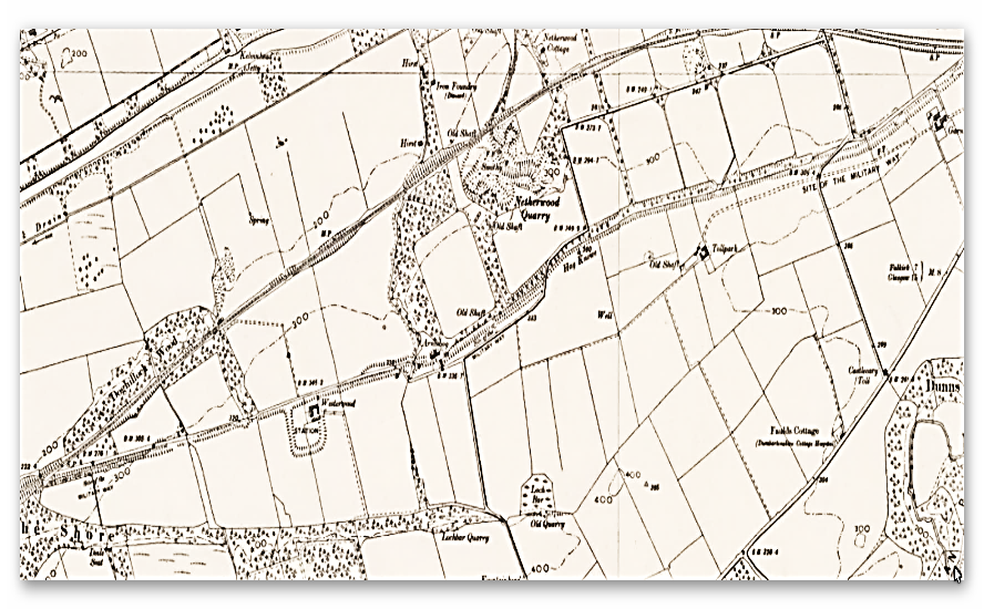
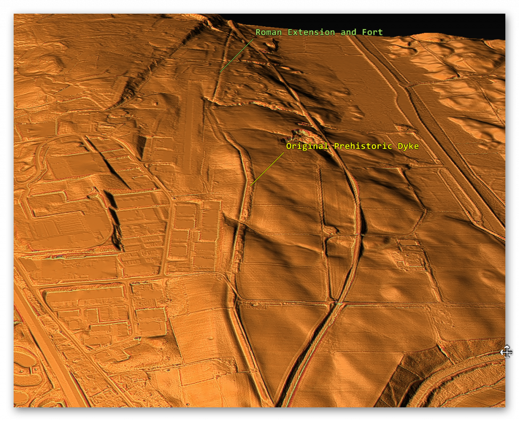
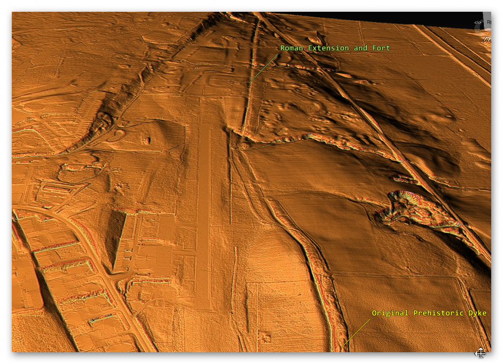
The first thing to notice is that the ‘original’ prehistoric Dyke was there BEFORE the Roman ‘extension’ and connection with the fort.  We know it was a prehistoric Dyke as its path is far from ‘Straight’, unlike the Roman extension.

Castlecary Fort - Antonine Wall
Castlecary Fort – Antonine Wall
Castlecary Fort (LiDAR) - Antonine Wall
Castlecary Fort (LiDAR) – Antonine Wall
Antonine Wall
Figure 102 – Prehistoric Dyke (Antonine Wall)
Antonine Wall
Figure 103 – Roman Extension to Old Dyke (Antonine Wall)


This connection between the Antonine Wall and prehistoric Dykes is connected not only by the LiDAR maps but also by the historical names used for the Wall within the entire length of the Antonine Wall.

Antonine Wall
Castlecary (Antonine Wall)

(Antonine Wall)

Conclusion

The reinterpretation of linear earthworks, such as Hadrian’s Wall and its Vallum, alongside structures like the East Wansdyke, challenges traditional archaeological assumptions and offers a fresh perspective on prehistoric Britain. By viewing these features as potential prehistoric canals rather than purely defensive structures or boundary markers, this research highlights the advanced engineering capabilities and societal organisation of ancient Britons. These findings not only reshape our understanding of these iconic monuments but also call for a broader application of scientific methodologies in archaeology to uncover the true purpose of such structures.

For those interested in exploring this groundbreaking research further, more dykes and linear earthworks are investigated on my website, where detailed surveys and analyses continue to challenge outdated narratives. See below for links to additional blogs that delve into the engineering, societal context, and potential functionality of these fascinating prehistoric features. Together, let’s rethink the history of Britain’s landscape through evidence-based investigation and open dialogue.

Promotional Video – Ancient Prehistoric Canals (Dykes) – The Vallum (The Antonine Wall)

Antonine Wall
Castlecary Fort – Antonine Wall

The Book

Antonine Wall
Ancient Prehistoric Canals (Dykes) Book – Antonine Wall

This was an extracts from the NEW Book Ancient Prehistoric Canals (Dykes) – Wansdyke available on Amazon as a FULL COLOUR HARD BACK (£49.95) or a ECONOMY (£9.99) SOFTBACK black and white VERSION – it is also available as a KINDLE (£2.99) book. For further information about our work on Prehistoric Britain visit our WEBSITE or VIDEO CHANNEL.

Product details

  • ASIN ‏ : ‎ B0BN7PD6BS
  • Publisher ‏ : ‎ Independently published (24 Nov. 2022)
  • Language ‏ : ‎ English
  • Hardcover ‏ : ‎ 477 pages
  • ISBN-13 ‏ : ‎ 979-8358524187
  • Dimensions ‏ : ‎ 15.24 x 3.33 x 22.86 cm
  • Illustrations: 350+

Exploring Prehistoric Britain: A Journey Through Time

My blog delves into the fascinating mysteries of prehistoric Britain, challenging conventional narratives and offering fresh perspectives based on cutting-edge research, particularly using LiDAR technology. I invite you to explore some key areas of my research. For example, the Wansdyke, often cited as a defensive structure, is re-examined in light of new evidence. I’ve presented my findings in my blog post Wansdyke: A British Frontier Wall – ‘Debunked’, and a Wansdyke LiDAR Flyover video further visualizes my conclusions.

My work also often challenges established archaeological dogma. I argue that many sites, such as Hambledon Hill, commonly identified as Iron Age hillforts are not what they seem. My posts Lidar Investigation Hambledon Hill – NOT an ‘Iron Age Fort’ and Unmasking the “Iron Age Hillfort” Myth explore these ideas in detail and offer an alternative view. Similarly, sites like Cissbury Ring and White Sheet Camp, also receive a re-evaluation based on LiDAR analysis in my posts Lidar Investigation Cissbury Ring through time and Lidar Investigation White Sheet Camp, revealing fascinating insights into their true purpose. I have also examined South Cadbury Castle, often linked to the mythical Camelot56.

My research also extends to the topic of ancient water management, including the role of canals and other linear earthworks. I have discussed the true origins of Car Dyke in multiple posts including Car Dyke – ABC News PodCast and Lidar Investigation Car Dyke – North Section, suggesting a Mesolithic origin2357. I also explore the misidentification of Roman aqueducts, as seen in my posts on the Great Chesters (Roman) Aqueduct. My research has also been greatly informed by my post-glacial flooding hypothesis which has helped to inform the landscape transformations over time. I have discussed this hypothesis in several posts including AI now supports my Post-Glacial Flooding Hypothesis and Exploring Britain’s Flooded Past: A Personal Journey

Finally, my blog also investigates prehistoric burial practices, as seen in Prehistoric Burial Practices of Britain and explores the mystery of Pillow Mounds, often mistaken for medieval rabbit warrens, but with a potential link to Bronze Age cremation in my posts: Pillow Mounds: A Bronze Age Legacy of Cremation? and The Mystery of Pillow Mounds: Are They Really Medieval Rabbit Warrens?. My research also includes the astronomical insights of ancient sites, for example, in Rediscovering the Winter Solstice: The Original Winter Festival. I also review new information about the construction of Stonehenge in The Stonehenge Enigma

Further Reading

For those interested in British Prehistory, visit www.prehistoric-britain.co.uk, a comprehensive resource featuring an extensive collection of archaeology articles, modern LiDAR investigations, and groundbreaking research. The site also includes insights and extracts from the acclaimed Robert John Langdon Trilogy, a series of books exploring Britain during the Prehistoric period. Titles in the trilogy include The Stonehenge Enigma, Dawn of the Lost Civilisation, and The Post Glacial Flooding Hypothesis, offering compelling evidence about ancient landscapes shaped by post-glacial flooding.

To further explore these topics, Robert John Langdon has developed a dedicated YouTube channel featuring over 100 video documentaries and investigations that complement the trilogy. Notable discoveries and studies showcased on the channel include 13 Things that Don’t Make Sense in History and the revelation of Silbury Avenue – The Lost Stone Avenue, a rediscovered prehistoric feature at Avebury, Wiltshire.

In addition to his main works, Langdon has released a series of shorter, accessible publications, ideal for readers delving into specific topics. These include:

For active discussions and updates on the trilogy’s findings and recent LiDAR investigations, join our vibrant community on Facebook. Engage with like-minded enthusiasts by leaving a message or contributing to debates in our Facebook Group.

Whether through the books, the website, or interactive videos, we aim to provide a deeper understanding of Britain’s fascinating prehistoric past. We encourage you to explore these resources and uncover the mysteries of ancient landscapes through the lens of modern archaeology.

For more information, including chapter extracts and related publications, visit the Robert John Langdon Author Page. Dive into works such as The Stonehenge Enigma or Dawn of the Lost Civilisation, and explore cutting-edge theories that challenge traditional historical narratives.

Other Blogs

s

t

Statonbury Camp near Bath – an example of West Wansdyke

Challenging Conventional Views: Linear Earthworks as Prehistoric Canals – Statonbury Camp near Bath

Over the past decade, I have faced significant opposition to my theory that Linear Earthworks were originally prehistoric canals. In response, I conducted comprehensive surveys of all 1,500 Historic England Scheduled Linear Earthworks, widely recognised by archaeologists. This extensive research culminated in the publication of the first volume in a quadrilogy, focusing on a section of dykes known as the East Wansdyke. This book supports my theory within the context of a Post-Truth Era.

This publication represents a groundbreaking achievement in archaeology—the first to meticulously survey and document the entire East Wansdyke in unprecedented detail. To date, no university or research team has matched this accomplishment. Furthermore, the book provides robust scientific evidence to demonstrate that prevailing archaeological theories about Wansdyke and Linear Earthworks are fundamentally flawed. (Statonbury Camp near Bath).

(Statonbury Camp near Bath).

The Post-Truth Challenge

One might expect that such a significant contribution, introducing previously undiscovered insights, would spark widespread discussions and rigorous debate. Instead, the book has been dismissed by some as a “conspiracy theory,” despite being grounded in cutting-edge research. The analysis leverages 21st-century LIDAR (Light Detection and Ranging) data sourced from the UK government’s DEFRA (Department for Environment, Food & Rural Affairs), an innovation still underutilised in archaeology, which often relies on outdated satellite imagery and crop mark analysis.

The professional response has been hesitant at best. Meanwhile, criticism on social media often manifests as dogmatic resistance from individuals unwilling to reconsider entrenched beliefs. Many cling to outdated theories simply because they were “peer-reviewed” in the past, treating them as infallible truths rather than hypotheses open to challenge and revision.(Statonbury Camp near Bath).

Resistance and Fundamentalism

(Statonbury Camp near Bath).
Fundamentalist – (Statonbury Camp near Bath).

This unyielding adherence to outdated ideas mirrors the mentality of religious fundamentalists, who interpret texts as immutable doctrine. In my experience, this mindset is evident in attempts to invalidate substantial theories by nitpicking minor details—a tactic reminiscent of the “intelligent design” argument against evolution, where opponents demand exhaustive explanations for every aspect before acknowledging scientific evidence.

For instance, one detractor attempted to undermine my hypothesis by highlighting a site outside the East Wansdyke, claiming it to be a “late Iron Age” fortification, thereby suggesting a Saxon origin. This site, however, pertains to the West Wansdyke, an area I addressed separately in my book. My research concluded that the West Wansdyke likely represents a later addition to the prehistoric canal system, potentially constructed by the Romans. Its sporadic, incomplete nature and distinct specifications set it apart from the East Wansdyke.(Statonbury Camp near Bath).

Conclusions and Moving Forward

I have clearly explained in my book why the West Wansdyke is irrelevant to my analysis of the East Wansdyke. The evidence I present in the book, which surveys every metre of the East Wansdyke, overwhelmingly refutes traditional interpretations of these earthworks as defensive walls or boundary markers. However, challenging deeply ingrained beliefs often meets resistance, even when the evidence is incontrovertible.(Statonbury Camp near Bath).

The reason I have dismissed West Wansdyke


West Wansdyke


We have a problem with West Wansdyke – it’s not part of East Wansdyke. This has always been a historical debate over the last 100 years. If we look at the limited archaeological evidence, we find that although it may have been a much later Canal/Dyke it is not contemporary with the East Wansdyke canal and was not built at the same time.

Excavations conclusively show that the Ditches on the East side of Wansdyke are much more profound and twice as broad. In contrast, the Banks on the East Side are much wider. We see that East Dyke was built first, as our River height model shows that most of West Wansdyke would have been flooded or marshland at the time of use.

LocationWansdyke
BankDitchExcavator notes
MaterialsWidthHeightBermWidthDepthCounterscarp 
EAST        
Red ShoreClay/Flints9.52N103.9YGreen 1966
Sheppard’s shore 102.3N103.9YPitt Rivers 1888
Brown’s Barn 92.3N103.9YPitt Rivers 1891
WEST        
Binces Lane WestStoney12.5????3.51.7YErskine 1990s
Binces Lane EastStoney?5?N62.4?Erskine 1990s
Compton GreenClay marl130.8Y5.82.8YErskine 1990s
Blackrock LaneSilty Clay12.51.7Y4.82.7?Erskine 1990s
Park farmStones100.4Y5.52.4YErskine 1990s
Fairy Hill 13?Y6.5? Erskine 1990s
West Wansdyke Excavation

When the waters receded (possibly Early Iron Age period), it is possible that the Dyke was extended, or the more probable event of East Wansdyke after it dried up was turned into a roadway and what we see in West Wansdyke is the extension of the road, and hence it is wider than in the East.

Archaeology in the Post-Truth Era
East Wansdyke – Earlier Canal System -(Statonbury Camp near Bath).

We also see more shallow ditches as they were not used for water but to obtain soil for the walkway and become drainage ditches.

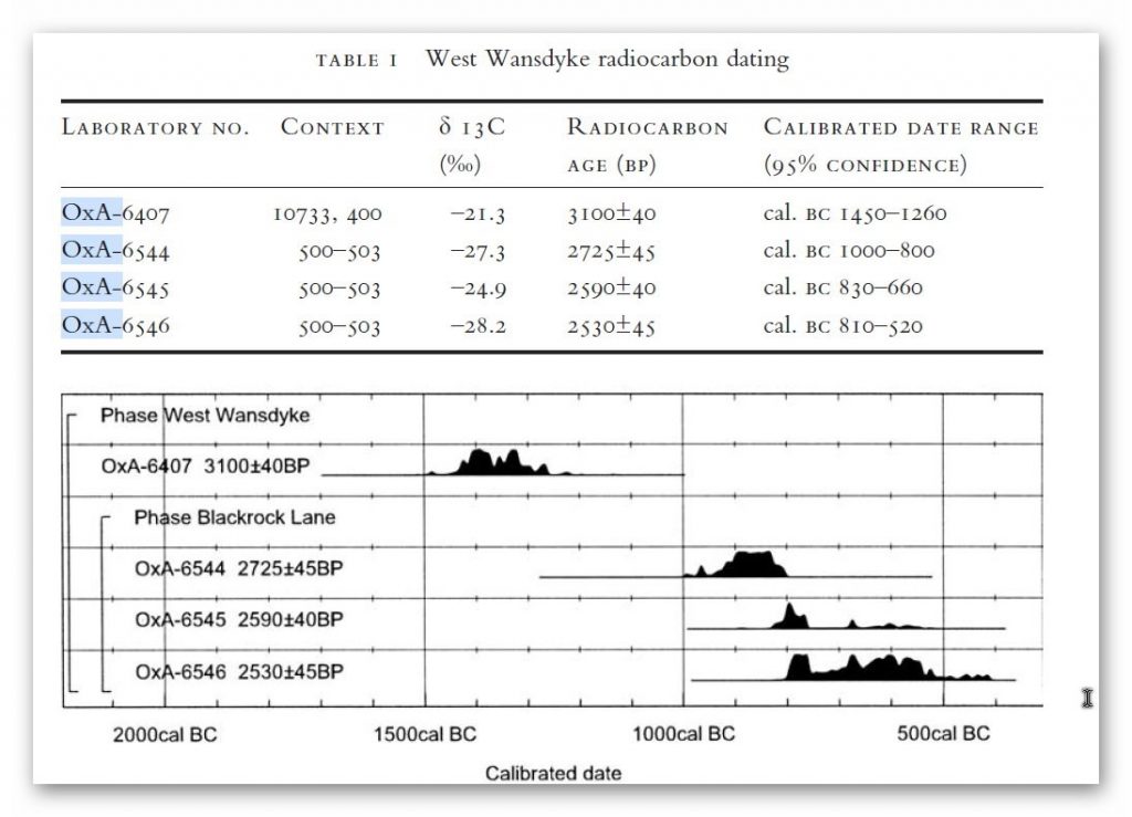
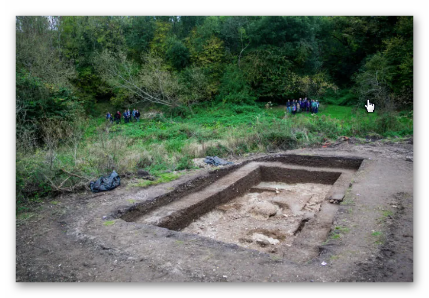
Indeed, we know the Romans used this as a road and always had drainage ditches, usually on both sides. This is supported by carbon dating at Erskine’s excavation at Blackrock Lane, where the section appeared to have been sealed by the primary bank material. One of these layers contained significant concentrations of woody oak charcoal.

Samples of this material were submitted to the Ancient Monuments Laboratory for radiocarbon dating to provide a possible construction of the bank. Unfortunately, as shown in the table below – sadly, as standard when scientific evidence disproves the current archaeological narrative – it is ignored and classified as an error.

(Statonbury Camp near Bath)

Table 1. Erskine, Jonathan. (2007). The West Wansdyke: an appraisal of the dating, dimensions and construction techniques in the light of excavated evidence. Archaeological Journal. 164. 80-108.


The other missing aspect shown in East Wansdyke and not West Wansdyke was the massive connection to Barrows and Flint Pits. Again, this connection is not seen on West Wansdyke, which may help date this monument as the barrows were of the Bronze Age or earlier and as we have seen from the carbon dating evidence at Blackrock Lane much earlier than its 1500 BCE date.(Statonbury Camp near Bath)

Statonbury Camp near Bath – an example of West Wansdyke

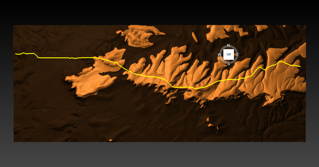
If we look at the Scheduled parts of the Wansdyke – we see that the East is very much intact, but the West is sporadic at best, and it’s hard to find a logical link to all the Dykes that seem to only appear over hills and not in the valley’s – which in my view would have been flooded in the Mesolithic and hence the west sections addition after East Wansdyke’s construction – probably by the roman’s who may have utilised the Dyke system for their own transportation reasons.

But for the sake of scientific curiosity, let’s take a detailed look at Stantonbury Hill site, which is classified as an Iron Age Camp, with Wansdyke making up one of the defensive banks – but before we delve deeper into the field archaeology of the site – I feel I must clarify the use of the classification of ‘Iron Age Fort’ by archaeologists.

All sites that sit on top of hills and have ditches are called Iron Age Forts – sadly I have yet to find a single location that is either ‘Iron Age’ or a ‘Fortification’ as not a single dead body from slaying has ever been found and all the so called defensive ditches EVER!! Yet the archaeology world continues to use this misleading classification that confuses the public as if it has been qualified and proven. So, back to Statonbury camp.


The only investigation of this site was made by Fox and Fox in 1956 as part of their survey of Wansdyke in the publication ‘Wansdyke reconsidered.’ It should be noted that Historic England does not have an account with their scheduling as no excavation work has ever been undertaken, and so only field walking has been undertaken, and so the results are subjective to the field walker.


In Fox’s publication they also question this linkage of East and West Wansdyke through other even older publications and field surveys that resulted in questioning the logic of dating this linear earthwork.


That great antiquary, Sir Richard Colt Hoare, had his doubts about the identification, which he endeavoured to suppress in his account of the earthwork in Ancient Wiltshire,


‘ Hitherto we have been enabled to trace the course of Wansdyke with certainty and success through Somersetshire, but on approaching the neighbouring county of Wiltshire we enter upon a new and doubtful field of inquiry respecting the direction as well as the formation of this celebrated rampart.’


His own observations in the field had shown him that in this central sector ‘ it bears the decided appearance of a Roman causeway, not of a Belgic or Saxon boundary and yet he felt obliged to support the current view that road and dyke were identical because he was convinced that the Wansdyke was continuous and he could find no alternative course for it in the area.

Sir R. C. Hoare also observes, the camps appear to have been added to the Dyke, not the Dyke formed to connect the camps ; which may be noticed especially at Stantonbury Camp, the second on the line of the course of Wansdyke through Somersetshire.(Statonbury Camp near Bath)


They continue


General Pitt-Rivers, also had misgivings,


‘ the Dyke he comments, in the Heddington region,’ is of very low relief everywhere on this line and it has often been questioned whether it is a dyke or a road’, and his suspicions were again aroused at a point west of Morgan’s Hill and on Bowden Hill near Lacock’.

Stanton Camp - Not Defensive
Stanton Camp – Not Defensive -(Statonbury Camp near Bath)


On Statonbury Camp there are not very helpful and report that:


Stantonbury is a univallate Iron Age hill-fort enclosing some 30 acres on the crest of the hill : until very recently it was waste ground going back to thorn scrub and islanded in dense woodland, as can be seen on the air-photo (Pl. VIIIB). The hill top (580 ft.) commands a wide view : from here the whole of the countryside traversed by West Wansdyke can be seen, Maes Knoll to the west. Odd Down to the east, as well as an uninterrupted stretch northwards to the Avon valley and the Cotswolds beyond. From here, the major alignment was probably planned (fig. 19 and p. 37).


In 1956-7 the hill top has been ploughed again, and the much reduced Iron Age defences are visible on the edge of the cultivation. It appears to us that Wansdyke was not constructed along the north-facing hill slope, and that as at Old Oswestry hill-fort, on Wat’s Dyke in Montgomery, the Iron Age defences were deemed sufficient. There is, however, as General Pitt-River’s level section shows, a steep scarp below the traces of the ploughed-in Iron Age ditch, which may be artificial and post-date the hill-fort, but this is uncertain.


East of the fort, in field 20, which is now occupied by a plantation and a pheasantry, the Dyke continues as a scarp for as far as we were able to trace it through the nettles and undergrowth. Below the 500 ft. contour, the large bank and ditch reappear in the dense woodland, and emerge beside the lane leading to the road to Stanton Prior, where the earthwork measures 75 ft. overall.


So according to Fox and Fox Wansdyke stops short and accepts the North Face is the Iron Age Site – therefore if the Wansdyke had been cut to the north of the site – the Iron Age fort replaced it – which is not as the Jihad had claimed?


So where did he get this ‘ground-breaking’ revelation? For this we must go not a peer reviewed book but a web site ‘wansdyke21.org.uk’ by Robert Vermaat


He suggests that:


It has been suggested by Fox & Fox that Wansdyke did not actually use Stantonbury Camp, the ditch stopping short of the Iron Age defences by several metres. However, Burrow showed in 1982 that this was incorrect.


Although the western slope is much disturbed by quarrying and the lower slopes by cultivation, Wansdyke can still be traced quite well at several points on the hill.
As with Maes Knoll, the northern defences are more prominent than those on the south side.


As Wansdyke joins the defences here, it can be argued that, as was the case at Maes Knoll, the northern defences were refurbished when Wansdyke was constructed, neglecting the south side which was without use for the builders of Wansdyke.


If only we had £64 to see this so called evidence from Field walking by burrows (as we know it was not excavated and LiDAR was not in use)!!


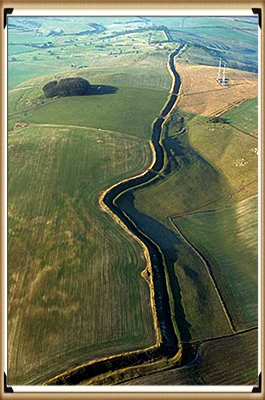
Fortunately, we have now obtained high resolution LiDAR images of Statonbury Camp and we can see that Wansdyke goes over the hill in a strange ‘wibbly wobbly’ way rather than a straight line – which we see either side of the hill from much shallower ditches. This suggests that this area was not built completely at the same time and the Hill Dyke is older than the flat ground levels that surround the hill.

My estimation from the evidence found in the smaller ditches is that they are Roman (and hence straight) in origin that connected to the earlier prehistoric Dyke over Statonbury Hill the archaeologists call West Wansdyke (part of). The path over the hill indicates that the builders were attempting to locate natural springs as they built the Dyke to supply it with water and hence the strange pathway.

Closer inspection of the Dyke as it approaches the ‘Iron Age Site’ suggest that it splits and moves the bank from north facing to south facing which Fox had seen as a terminus of the Dyke for it reached the Fort. LiDAR clearly shows that the ditch moves to the south side of the bank and continues to create the East side of the fort finally terminating in the South.

Also the shape of the fort is not consistent as it has rounded edges in the SE and SW regions but flat T-Junctions in the NE and NW where it meets Wansdyke – indicating it was added to the existing Wansdyke canal either at the time of construction or a later date.

Exploring Prehistoric Britain: A Journey Through Time

My blog delves into the fascinating mysteries of prehistoric Britain, challenging conventional narratives and offering fresh perspectives based on cutting-edge research, particularly using LiDAR technology. I invite you to explore some key areas of my research. For example, the Wansdyke, often cited as a defensive structure, is re-examined in light of new evidence. I’ve presented my findings in my blog post Wansdyke: A British Frontier Wall – ‘Debunked’, and a Wansdyke LiDAR Flyover video further visualizes my conclusions.

My work also often challenges established archaeological dogma. I argue that many sites, such as Hambledon Hill, commonly identified as Iron Age hillforts are not what they seem. My posts Lidar Investigation Hambledon Hill – NOT an ‘Iron Age Fort’ and Unmasking the “Iron Age Hillfort” Myth explore these ideas in detail and offer an alternative view. Similarly, sites like Cissbury Ring and White Sheet Camp, also receive a re-evaluation based on LiDAR analysis in my posts Lidar Investigation Cissbury Ring through time and Lidar Investigation White Sheet Camp, revealing fascinating insights into their true purpose. I have also examined South Cadbury Castle, often linked to the mythical Camelot56.

My research also extends to the topic of ancient water management, including the role of canals and other linear earthworks. I have discussed the true origins of Car Dyke in multiple posts including Car Dyke – ABC News PodCast and Lidar Investigation Car Dyke – North Section, suggesting a Mesolithic origin2357. I also explore the misidentification of Roman aqueducts, as seen in my posts on the Great Chesters (Roman) Aqueduct. My research has also been greatly informed by my post-glacial flooding hypothesis which has helped to inform the landscape transformations over time. I have discussed this hypothesis in several posts including AI now supports my Post-Glacial Flooding Hypothesis and Exploring Britain’s Flooded Past: A Personal Journey

Finally, my blog also investigates prehistoric burial practices, as seen in Prehistoric Burial Practices of Britain and explores the mystery of Pillow Mounds, often mistaken for medieval rabbit warrens, but with a potential link to Bronze Age cremation in my posts: Pillow Mounds: A Bronze Age Legacy of Cremation? and The Mystery of Pillow Mounds: Are They Really Medieval Rabbit Warrens?. My research also includes the astronomical insights of ancient sites, for example, in Rediscovering the Winter Solstice: The Original Winter Festival. I also review new information about the construction of Stonehenge in The Stonehenge Enigma

Further Reading

For those interested in British Prehistory, visit www.prehistoric-britain.co.uk, a comprehensive resource featuring an extensive collection of archaeology articles, modern LiDAR investigations, and groundbreaking research. The site also includes insights and extracts from the acclaimed Robert John Langdon Trilogy, a series of books exploring Britain during the Prehistoric period. Titles in the trilogy include The Stonehenge Enigma, Dawn of the Lost Civilisation, and The Post Glacial Flooding Hypothesis, offering compelling evidence about ancient landscapes shaped by post-glacial flooding.

To further explore these topics, Robert John Langdon has developed a dedicated YouTube channel featuring over 100 video documentaries and investigations that complement the trilogy. Notable discoveries and studies showcased on the channel include 13 Things that Don’t Make Sense in History and the revelation of Silbury Avenue – The Lost Stone Avenue, a rediscovered prehistoric feature at Avebury, Wiltshire.

In addition to his main works, Langdon has released a series of shorter, accessible publications, ideal for readers delving into specific topics. These include:

For active discussions and updates on the trilogy’s findings and recent LiDAR investigations, join our vibrant community on Facebook. Engage with like-minded enthusiasts by leaving a message or contributing to debates in our Facebook Group.

Whether through the books, the website, or interactive videos, we aim to provide a deeper understanding of Britain’s fascinating prehistoric past. We encourage you to explore these resources and uncover the mysteries of ancient landscapes through the lens of modern archaeology.

For more information, including chapter extracts and related publications, visit the Robert John Langdon Author Page. Dive into works such as The Stonehenge Enigma or Dawn of the Lost Civilisation, and explore cutting-edge theories that challenge traditional historical narratives.

Other Blogs

s

t

Wansdyke LiDAR Flyover

Promotional video for the book transcript………………………….. Ancient prehistoric Canals (Dykes) – Wansdyke

Introduction

Wansdyke

Archaeologists and historians have proposed numerous theories regarding dykes such as Wansdyke. Initially, they believed it served as a defensive structure to protect territories from hostile tribes. However, more recent theories, influenced by the absence of evidence such as human remains from excavations, suggest it functioned as a border marker. This border hypothesis, however, can be challenged by examining the easternmost section of Wansdyke.

The Eastern Start of Wansdyke

Start of the Wansdyke in the East

To understand Wansdyke’s purpose, we must first consider how it might have appeared in prehistory when river levels were significantly higher than today. Research involving over 1,500 dykes in England suggests that fluctuating groundwater levels during the Mesolithic and Neolithic periods (5,000–10,000 years ago) drastically altered the landscape. This environmental context sheds light on the mysterious beginning of Wansdyke, which lies in an unassuming field.

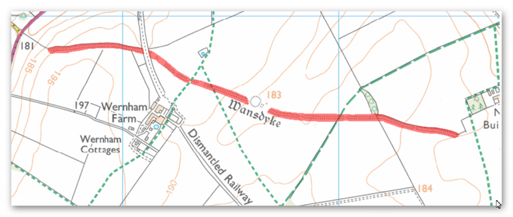
This starting point poses a conundrum. If Wansdyke were a defensive structure, invaders could simply bypass it. Similarly, as a border marker, it appears illogical, given the seemingly arbitrary placement in what would have been “no man’s land” to the east. However, when we consider the Mesolithic water levels, this puzzle begins to make sense. At that time, the eastern end of Wansdyke likely met the shoreline of the River Kennet, acting as an artificial canal that extended across a water-covered landscape.

The Role of LiDAR in Revealing Wansdyke’s History

East Wansdyke - In the middle of nowhere
East Wansdyke – In the middle of nowhere

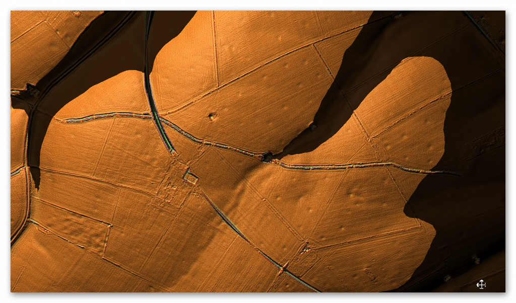
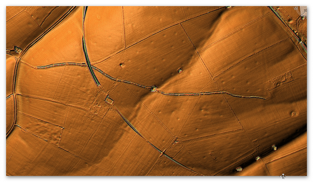
Using LiDAR technology, we can explore Wansdyke’s alignment with ancient water levels and examine its potential origins. Early in this examination, we observe a cluster of pits and quarries surrounding the dyke. These features suggest that the initial purpose of Wansdyke might have been related to resource extraction. Unfortunately, these pits remain largely unexcavated, leaving their significance and contents a mystery.

One particularly large quarry lies directly within Wansdyke itself. This raises questions: was it used for material extraction, or was it later adapted to access lower water levels, possibly during the Roman period when Wansdyke may have been repurposed?

Gaps and Deviations in Wansdyke’s Structure

Wansdyke start meets the Mesolithic waterline

Several gaps in Wansdyke also align with prehistoric waterlines. For example, LiDAR reveals the trace of a palaeochannel (a remnant of an ancient river) that aligns with one such gap. These interruptions suggest that Wansdyke may have originally followed natural watercourses, with later modifications to connect separate segments.

Another perplexing feature is a 90-degree bend in the dyke’s course. This sharp turn would have required substantial extra labour and makes little sense for a defensive structure or border marker. However, if we consider the Mesolithic landscape, this bend corresponds to a shoreline, indicating that Wansdyke likely extended across the river, aligning with natural contours of the water.

Connections to Other Features

Wansdyke Pits
Wansdyke pits shows why the Dykes were Built

Throughout Wansdyke, we see evidence of connections to other prehistoric features. A nearby long barrow, for instance, appears to have been positioned along the edge of a palaeochannel, hinting at the relationship between these earthworks and ancient water levels. Other cross-dykes, tumuli, and barrows scattered along Wansdyke further suggest a complex, evolving use of the landscape over time.

Interestingly, LiDAR reveals a potential square building over Wansdyke that does not appear on modern maps. Its characteristics suggest Roman origins, further evidence that the Romans adapted Wansdyke for their purposes.

Later Modifications and Roman Influence

Roman Road cuts through the Dyke showing it was Pre-Roamn
Roman Road cuts through the Dyke showing it was Pre-Roman date

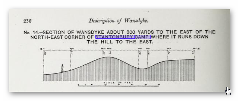
In some sections, Wansdyke appears as a straight line, which contrasts with its otherwise irregular path. This straight alignment may reflect Roman engineering, as it parallels their known preference for direct routes. For instance, one stretch aligns with a Roman road, and closer inspection reveals that the road was constructed within the existing dyke’s ditch. This configuration strongly implies that Wansdyke predated the Roman road.

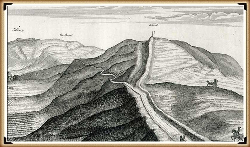
Historical sketches by William Stukeley in 1724 provide additional evidence, showing the Roman road cutting through Wansdyke’s embankment. This supports the argument that Wansdyke originated in prehistoric times when higher river levels would have rendered it part of a broader canal network.

Wansdyke as a Window Into Prehistoric Innovation

How Wansdyke may have looked in the Mesolithic Period

The idea of Wansdyke as a canal rather than a defensive or territorial feature raises intriguing questions about the ingenuity of prehistoric communities. The ability to manipulate natural waterways and integrate them with constructed earthworks demonstrates a sophisticated understanding of engineering and environmental management. Such systems would have been vital for trade, resource transportation, and sustaining settlements in an era defined by dynamic landscapes.

If Wansdyke truly functioned as part of a prehistoric canal system, it challenges traditional narratives that often downplay the complexity of Mesolithic and Neolithic societies. This perspective not only underscores the advanced capabilities of these ancient communities but also invites a re-evaluation of similar features across Britain and beyond. How many other “defensive dykes” might share this hidden history?

Implications for Archaeological Methods

Wansdyke was one surrounded by water and built overland for mining purposes

The case of Wansdyke highlights the limitations of conventional archaeological approaches. Current reliance on surface-level excavations and isolated carbon dating often fails to capture the broader environmental and historical context of such structures. As demonstrated here, integrating technologies like LiDAR with hydrological and geological studies can provide transformative insights. It also emphasises the need for a multidisciplinary approach to interpreting ancient landscapes.

The neglect of quarry features around Wansdyke, for example, represents a missed opportunity to understand the resources and techniques available to its builders. Future investigations that incorporate more detailed excavation and modern technologies could yield a wealth of data to refine our understanding of Britain’s prehistoric engineering marvels.

A Legacy of Adaptation and Innovation

Romans reused and recut the dyke
Massive Engineering Project as Romans reused and recut the dyke

Wansdyke’s story is one of adaptation. From its hypothesised origins as a Mesolithic canal to later modifications by Roman and possibly Saxon cultures, the dyke exemplifies how ancient peoples repurposed and transformed existing structures to meet evolving needs. Whether as a waterway, resource hub, or trade route, Wansdyke stands as a testament to humanity’s ability to innovate and endure across millennia.

By situating Wansdyke within the broader prehistoric context, we move closer to understanding its original purpose and the sophisticated societies that shaped Britain’s ancient landscapes. Its winding paths, mysterious interruptions, and enduring presence remind us that history is not static but a tapestry woven from the ingenuity and adaptability of countless generations.

Exploring Prehistoric Britain: A Journey Through Time

My blog delves into the fascinating mysteries of prehistoric Britain, challenging conventional narratives and offering fresh perspectives based on cutting-edge research, particularly using LiDAR technology. I invite you to explore some key areas of my research. For example, the Wansdyke, often cited as a defensive structure, is re-examined in light of new evidence. I’ve presented my findings in my blog post Wansdyke: A British Frontier Wall – ‘Debunked’, and a Wansdyke LiDAR Flyover video further visualizes my conclusions.

My work also often challenges established archaeological dogma. I argue that many sites, such as Hambledon Hill, commonly identified as Iron Age hillforts are not what they seem. My posts Lidar Investigation Hambledon Hill – NOT an ‘Iron Age Fort’ and Unmasking the “Iron Age Hillfort” Myth explore these ideas in detail and offer an alternative view. Similarly, sites like Cissbury Ring and White Sheet Camp, also receive a re-evaluation based on LiDAR analysis in my posts Lidar Investigation Cissbury Ring through time and Lidar Investigation White Sheet Camp, revealing fascinating insights into their true purpose. I have also examined South Cadbury Castle, often linked to the mythical Camelot56.

My research also extends to the topic of ancient water management, including the role of canals and other linear earthworks. I have discussed the true origins of Car Dyke in multiple posts including Car Dyke – ABC News PodCast and Lidar Investigation Car Dyke – North Section, suggesting a Mesolithic origin2357. I also explore the misidentification of Roman aqueducts, as seen in my posts on the Great Chesters (Roman) Aqueduct. My research has also been greatly informed by my post-glacial flooding hypothesis which has helped to inform the landscape transformations over time. I have discussed this hypothesis in several posts including AI now supports my Post-Glacial Flooding Hypothesis and Exploring Britain’s Flooded Past: A Personal Journey

Finally, my blog also investigates prehistoric burial practices, as seen in Prehistoric Burial Practices of Britain and explores the mystery of Pillow Mounds, often mistaken for medieval rabbit warrens, but with a potential link to Bronze Age cremation in my posts: Pillow Mounds: A Bronze Age Legacy of Cremation? and The Mystery of Pillow Mounds: Are They Really Medieval Rabbit Warrens?. My research also includes the astronomical insights of ancient sites, for example, in Rediscovering the Winter Solstice: The Original Winter Festival. I also review new information about the construction of Stonehenge in The Stonehenge Enigma

Further Reading

For those interested in British Prehistory, visit www.prehistoric-britain.co.uk, a comprehensive resource featuring an extensive collection of archaeology articles, modern LiDAR investigations, and groundbreaking research. The site also includes insights and extracts from the acclaimed Robert John Langdon Trilogy, a series of books exploring Britain during the Prehistoric period. Titles in the trilogy include The Stonehenge Enigma, Dawn of the Lost Civilisation, and The Post Glacial Flooding Hypothesis, offering compelling evidence about ancient landscapes shaped by post-glacial flooding.

To further explore these topics, Robert John Langdon has developed a dedicated YouTube channel featuring over 100 video documentaries and investigations that complement the trilogy. Notable discoveries and studies showcased on the channel include 13 Things that Don’t Make Sense in History and the revelation of Silbury Avenue – The Lost Stone Avenue, a rediscovered prehistoric feature at Avebury, Wiltshire.

In addition to his main works, Langdon has released a series of shorter, accessible publications, ideal for readers delving into specific topics. These include:

For active discussions and updates on the trilogy’s findings and recent LiDAR investigations, join our vibrant community on Facebook. Engage with like-minded enthusiasts by leaving a message or contributing to debates in our Facebook Group.

Whether through the books, the website, or interactive videos, we aim to provide a deeper understanding of Britain’s fascinating prehistoric past. We encourage you to explore these resources and uncover the mysteries of ancient landscapes through the lens of modern archaeology.

For more information, including chapter extracts and related publications, visit the Robert John Langdon Author Page. Dive into works such as The Stonehenge Enigma or Dawn of the Lost Civilisation, and explore cutting-edge theories that challenge traditional historical narratives.

Other Blogs

s

t