The Rise of the Cro-Magnon (Homo Superior)

Cro-Magnon is the name of a rock shelter in the Dordogne region of France. Here three prehistoric skeletons were found in 1868; these humanoid remains are about 28,000 years old. These remains showed the same forehead, upright posture and slender skeletons as modern humans. Necklaces were found buried with their bodies, suggesting the first forms of humanoid burial rights. These bodies showed signs of illness and injury; some had fused vertebrae in their necks, and others had skull fractures and signs of healing, indicating that they had been cared for and lived beyond their injuries.

To place an exact date on when this interbreeding began or when the first Cro-Magnon were born is impossible to suggest, but another cave discovery of a Cro-Magnon skeleton near the Iron Gates in Romania may be a closer indication of the first interbreeding. It is situated in the Danubian corridor, which may be the entry point of the Cro-Magnons into Europe from their Asian base. ‘Pestera cu Oase’ (cave with bones) ‘Oase 1’ has a thick jawbone similar to a Neanderthal together with other minor Sapien features; he has been dated 35,000 years ago
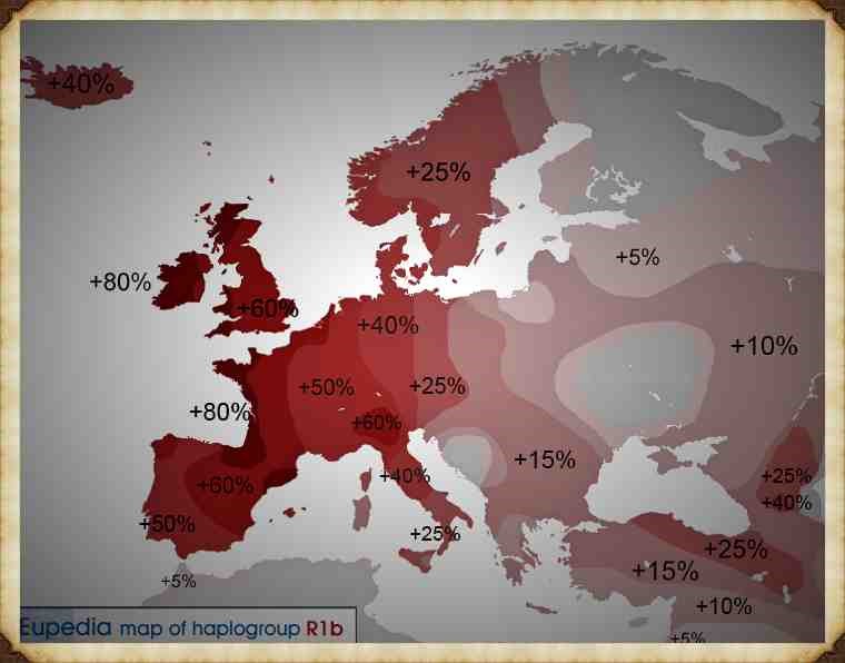
Cro-Magnon Haplogroup showing there spread in History

Why are Cro-Magnons not seen as a separate species anymore?

Before we try to answer this question, we attempt to understand why archaeologists in the first instance believed this discovery in the Dordogne area was a sub-species of humanity and hence the introduction of the anthropological name ‘Homo Cro-Magnon’ giving to the remains rather than Homo Sapien or ‘modern man’ as we would describe it today.

Cro-Magnon’s skulls are longheaded; the forehead is straight, the brow ridges only slightly projecting; the cranial vault is noticeably flattened and the occipital bone (at the back of the head) projects backwards. The cranial capacity (brain) is large, about 1600cc. Although the skull is relatively long and narrow, the face appears quite short and wide. The forward projection of the upper jaw is also distinctive; the eye sockets are low-set and somewhat square, and the nasal aperture of the skull is narrow and powerfully projecting.
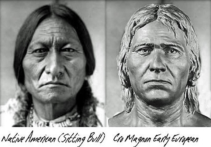
Did Cro-Magnons reach America in prehistory long before the Vikings?

 The mandible is robust, with massive ascending ramus (the upward projection of the jaw, where it attaches to the skull), has strongly developed points of muscular attachment and quite a prominent chin. The stature of Cro-Magnon is lofty, on average over six feet tall. Although in some places even taller and their longevity was exceptional for a prehistoric society as some skeletons are found to be over 50 years old, which may not sound very old today, but this should be viewed in the context to other prehistoric groups – such as Neolithic farmers whose average age was just 25 and even a Roman citizen who was lucky to survive until 35 – although some pampered Senators occasionally reach their 50’s.

Therefore, as you can see the Victorians with an average height of 5’ 2” and an average age of death at 34 (44 for the academic classes and 25 the working class) saw the Cro-Magnon as a sub-species as far apart from themselves as the Neanderthal – as they were taller, faster, stronger, more intelligent and lived longer than the average Victorian.
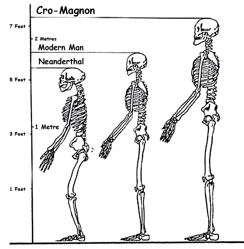
Cro-magnon is the largest of the Homo Species

An interesting fact is that there are notable differences between eastern and western types of Cro-Magnons. As we have shown, humanoids genetically mutated to create M173 and M343 haplogroups, some moved east the others moved west. Archaeologists have given these individual groups to the east, titles to show this variation such as Brunn Man, Predmost or Combe Capelle; these groups are generally shorter, more gracile (thinner) and smaller brained than our western variations of Cro-Magnons, which in my mind shows them to be a separate mutated species – as a Corgi is clearly different in size, shape and attitude to an Irish wolfhound, yet they are both technically canines.

Moreover, M173, M207 and M343 come from the parent Haplogroup R1 – so we now know the genetic signature of the Cro-Magnons, which will allow us to trace them in future chapters, even with these slight genetic deviations.

However, current anthropologists now place them all under the same banner of ‘modern man’ (Homo Sapien Sapien), which can confuse the issue and lead to false generalisations that Cro-Magnon was not as tall or larger brained as first reported. This satisfies the need to be ‘politically correct’ with human evolution to not upset either the ‘creationists’ or racial lobbies, particularly in the Americas, where most genetic research funding is found.

As an example, the Combe Capelle Man is only 5’ 4” rather than the six-foot-three statue of the Cro-Magnon found in western Europe, and hence some reference books classify ‘incorrectly’ Cro-Magnons had an average height of as 5’ 6” – 5’ 7” – successfully reducing their uniqueness and so avoiding obvious awkward questions on the differences between Western, African and Far East cultures, statute and colouration.

The second example of the difference between east and west Cro-Magnons is the tool kit; the eastern tools are just a slight extension of the Neanderthal toolkit from the past 80,000 years, whereas the western toolkit shows signs of high craftsmanship. Nevertheless, the most evident sign of the difference between the east and west Cro-Magnons and all other members of the human tree is that Cro-Magnons brought art and music to our civilisation. The paintings found ‘throughout’ the Pyrenees and Cantabrian mountains in France, which have become famous throughout the world, show these artists’ high degree of skill and coordination, which is missing from all these eastern groups.

Sapien v Neanderthal

Anthropologists generally agree that the eastern Cro-Magnons were nomads whose numbers are fragile and scattered in occupational sites. While the western Cro-Magnon numbers are usually thick (meaning a long and settled occupation in a single place) and are clustered towards the rivers of the European continent, which could explain the sources of their food and the differences in their physical appearance consequently, their intelligence. These occupational sites also contain the first evidence of houses proving that this society was not the stereotypical ‘cave men’ or ‘hunter-gatherers’ archaeologists still use to describe prehistoric Europeans. 

The rise of Homo Superior

I fundamentally believe that Cro-Magnons (Homo Superior) resulted from interbreeding between migrating Sapiens and Neanderthals, and this kind of cross-breeding took place on many occasions and locations before their travels into Europe from Asia. However, this was not the only ‘interbreeding’ that led to human mutations in our history, for weird variations of humanoids are being found in fossil records all over the world, some of which are quite peculiar and short-lived, such as the ‘hobbit’ in the far east (Homo Floresiensis). These are remains of an individual who would have stood about 3.5 feet (1.1 m) in height and were discovered in 2003 on the island of Flores in Indonesia.

These mutations could be from Erectus and Neanderthals or Erectus and Sapiens or even Erectus and Homo Superior. The combinations of these matting patterns are almost endless variations of the original Wolf, now run around our houses in various coats and sizes – which show no clear comparison to the original. So it is not surprising that humans also have such vast physical and aspheric differences. 
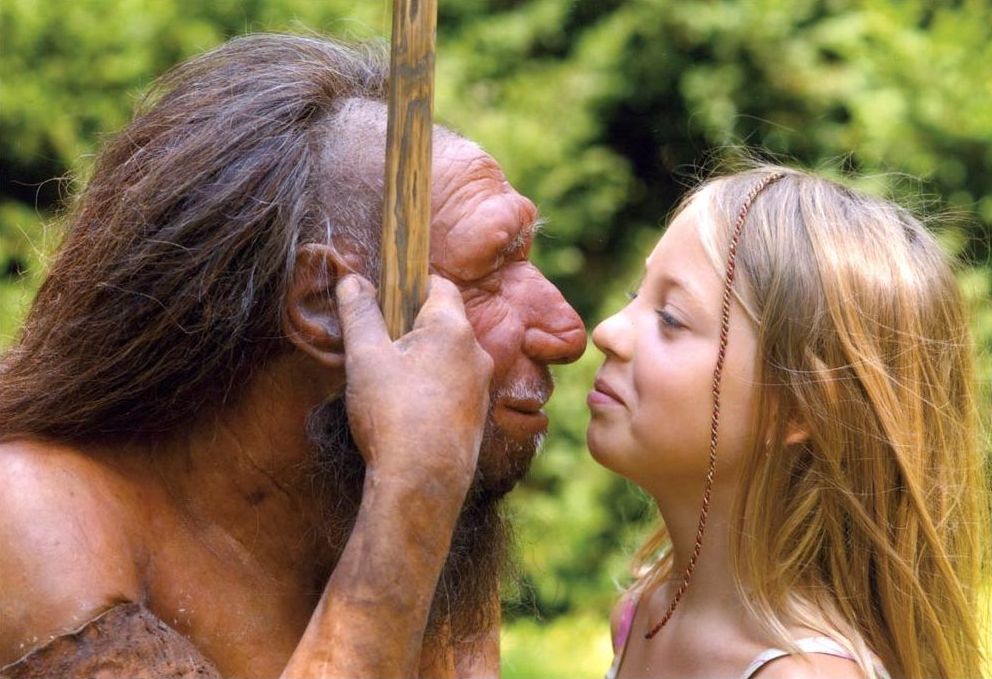
Cross-breeding with Neanderthals

The development of Homo Superior and how its family structure was managed is significant if we are to understand the kind of interbreeding that was going on and why it was so successful, mainly as most other humanoid mutations failed to succeed the test of time and are just fossil records now, unlike Homo Superior. It is more likely that the Neanderthal females mated with Sapien males for their communities were ‘matriarchic’ (female based) in structure, which is reflected in their burial practices. The evidence shows that the Neanderthals buried their dead with possessions and flowers thousands of years before similar Sapiens burial customs were established. 

It should be remembered that matriarchy is a social, organisational form in which the mother or oldest female heads the family. Descent and relationships are determined through the female line and governed or ruled by a woman or women.

Most anthropologists believe that there are no known societies that are unambiguously matriarchal today, but some authors believe exceptions are possible. Nevertheless, the loss of such communities gives us a valuable clue to what customs and practices are ‘prehistoric’ and even ‘Homo Superior’ by nature when we look at our ancient history. 

       It should also be recognised that notwithstanding in today’s societies, in the third world, infanticide would be commonplace as strong independent boys are desired as they can work more hours and support the family better than girls who can be classed as liabilities. African hunter-gather Sapien groups would need to travel long distances foraging for food, so men would be preferred within the social group which lived on a ‘survival of the fittest’ ideology.

Consequently, society would be male-dominated. These groups would leave the dying, weak and sick (including children and girls) behind on their treks across the open Savannah or over hills and mountains. However, because of this limitation, they could only be successful in mild and plentiful climates.

Interbreeding

On the other hand, a matriarchy society like the Neanderthals utilised had successfully survived outside of Africa for over 100,000 years within a fluctuating climate without extinction – but then disappeared almost overnight without reason or archaeological evidence. The causation of this extinction could be relatively simple – the female to male ratio being too great/small or quite possibly reintroducing a Sapien disease, which was deadly to the Neanderthals. This effect has been seen throughout time, for example, in the smallpox plagues that infested Central America after the arrival of the Spanish.  To gain some scale level, the Aztec war killed little compared to the Smallpox that spread North and South. Smallpox killed a total of 90% of the population, who had no immunity. During the harsh winters of the last ice age, such a disease would undoubtedly end the Neanderthal species and is further evidence of interbreeding between Sapiens and Neanderthals.

So why was there interbreeding?

There are two main possibilities for interbreeding. Firstly, males of any species tend to mate at random to seek self-fulfilment, often without emotional or familial connection. In the case of a male Sapien mating with a female Neanderthal, the pairing would leave a

Neanderthal single mother, as the male would leave due to lack of emotional connection, and a Homo Superior child who shared the positive aspects of both species.  This mating occurrence could be caused by the female’s desire to mate with the alternative species. Alternatively, if the Neanderthal species was disappearing due to the lack of males or a selective disease, Neanderthals may have had no other option but to pair with Sapiens purely for survival.

What are the positive attributes of this cross-breeding of the Species?

Darwin's Children
Darwin’s Children

Neanderthals used simple stones for tools. They constructed and made essentially the same stone tools over and over again for perhaps 200,000 years, all serving a single purpose, until around 35,000 years ago, with slight variation or consideration of alternatives. This suggests that they greatly lacked creativity, initiative or imagination. 

As neatly summed up by an ardent defender of Neanderthal cognitive capabilities (Hayden, 1993, p. 139) 
“as a rule, there is no evidence of private ownership or food storage, no evidence for the use of economic resources for status or political competition, no elaborate burials, no ornaments or other status display items, no skin garments requiring intensive labour to produce, no tools requiring high-energy investments, no intensive regional exchange for rare items like sea shells or Amber, no competition for labour to produce economic surpluses and no corporate art or labour intensive rituals in deep cave recesses to impress onlookers and help attract labour.” 

Neanderthals tended to live in the ‘here and now,’ with limited ability to think about or consider the distant future, with one notable exception – the forthcoming life after death. This noteworthy exception is a function of the differential evolution of the frontal versus the temporal lobes. The frontal lobes are the ‘organisational and management’ centres of the brain and are responsible for the initiative, goal formation, long-term planning, generating multiple alternatives, and considering multiple alternative consequences. The frontal lobes are the source of creativity and imagination, whereas the temporal lobes are the brain’s ‘speech and vision’ centre. The temporal lobes were majorly developed in Neanderthals, whereas the frontal lobe would increase in size by a third in the transition from Sapiens to Homo Superior.
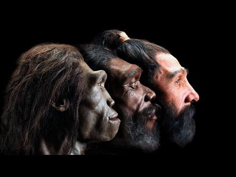
The Ascent of Cro-Magnon Mankind

Based on a gross analysis of the skull and casts made of the inner surface of the skull, it is apparent that Neanderthal men and women possessed a well-developed inferior temporal lobe, whereas the frontal lobe is sloped and stunted. The temporal lobes and the limbic structures buried within are directly implicated in the generation of personal, emotional, and religious experience, including the ability to form long term emotional attachments and feel intense love. This fierce love plays an essential role in the nurturing power of the less mobile Neanderthal groups and makes it less probable for them to abandon their ‘interbred’ babies in comparison to the more mobile ‘nomad’ Sapien groups.

Neanderthals provided loving care for friends and family who had been injured or maimed, enabling them to prolong their lives despite their grievous injuries. For example, the skeleton of one Neanderthal male, approximately aged 45 when he died, had been cared for over several years following profoundly crippling injuries. His right arm had wasted away through disease or injury, and his lower arm and hand had been ripped or bitten off. His left eye socket, right shoulder, collarbone, and both legs were also severely injured. Despite these injuries, findings suggested that someone loved and tenderly cared for this man. He was no doubt a father, a husband, a brother, and a son, and someone in his family not only provided long term loving care to make him comfortable in this life but prepared him for the next life as well.

Further information on Homo Superior and his work can be found: https://youtu.be/B0lWziOvgTk

Articles: http://prehistoric-britain.co.uk/

Facebook Group: https://www.facebook.com/groups/prehistoricbritain
#prehistoricbritain

#stonehenge

#woodhenge

#oldsarum

#avebury

#durringtonwalls&woodhenge

#thethames

13 things that don’t make sense about Waun Mawn – Stonehenge

According to the BBC documentary: Stonehenge: The Lost Circle Revealed (Waun Mawn; stonehenge) – when Mike Parker-Pearson’s (MPP) team found the Bluestone quarry at Craig-Rhos-Y-Felin, it was a significant breakthrough in the story of Stonehenge, as we now know that these precious ‘Bluestones’ were transported from Wales to Salisbury Plain, for reasons unknown to the current batch of English Heritage archaeologists.

The problems then started to materialise when MPP attempted to FIND dates from this quarry, rather than do what Scientists should, and examine the site without prejudice, to see if the quarry’s findings meet the same conclusions at their excavations at Stonehenge. Instead, they attempted to find a date that would vindicate their Stonehenge dating methods.  This is ‘Bad Science’ and consequently naturally leads to corrupting of any findings as they would overlook other possibilities in the pursuit of a narrow band of desired dates.

For example, at Craig Rhos-Y-Felin, MPP overlooked the extensive evidence found in the sites man-made hearths which showed that the quarry was actually first occupied in the Mesolithic Period, rather than the limited Neolithic dates MPP was hoping for. This resulted in the team coming back for a second season and looking further afield from the main occupation area, until a couple of random ‘nut cases’ 😉 were found to have a “close date” to the 2800 BCE Mike required.

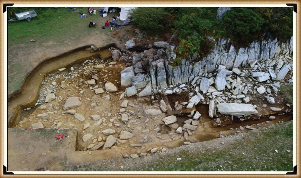
Craig Rhos-Y-Felin from Stonehenge: The Lost Circle Revealed
Craig Rhos-Y-Felin: Stonehenge: The Lost Circle Revealed

MPP then went ‘public’ and announced that they found the site of bluestones that supported his hypothesis on Stonehenge being built in 2800 BCE – but there was a problem even with this ‘nut case’ date. It was still 500 years too early, and so MPP came up with a ‘credible theory’ about the date differences – A Welsh prototype stone circle which was moved 500 years later.

Consequently, the search started for this mysterious ‘lost’ stone circle in Wales from 2013 (onward) to justify the 500-year gap in his dates. The BBC program highlighted that on several occasions; he claimed to find this ‘mysterious site’, later to discover, that it was nonsense (as he could not find his 3300 BCE date) and then they moved on to find another site.  Needless to say, this is again ‘Bad Science’ as you have prejudiced your methodology, as these other sites may have actually had a more significant impact on the knowledge of Prehistoric Britain and the Stonehenge builders if they were fully excavated and reported upon – rather than just ‘backfilled’ for a later or another excavator in the future, as you are more focused on proving yourself right.

Therefore, the last hope of MPP’s reputation and his ’10-year search’ fell upon Waun Mawn, which culminated in the BBC documentary: “Stonehenge: The Lost Circle Revealed”, show on the 12th February 2021. In it, he claimed many so-called ‘facts’ which I shall now highlight as ‘not making sense’, with the reasons why?

1. At (13:20) MPP shows signs of human-made quarrying and splitting of Bluestones at Carn Goedog in Wales – unfortunately, there are no extensive excavation reports on this site just a publish review showing that of the 31 carbon dates only three random samples supports his theory and none of the man-made hearths which are Mesolithic (like Craig Rhos-Y-Felin) or late Neolithic.

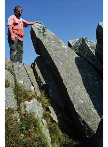
2. The program showed the suggested quarried stones at Carn Goedog which are over 12 feet long and 5-foot-wide, weighing therefore around 20+ tonnes – The Stonehenge bluestones are on average less than six feet high and about 18 – 24 inches wide weighing 1 to 3 tonnes. The review on the site offered no evidence that the stones were cut down and reshaped for the journey to Stonehenge or elsewhere.

Carn Goedog from Stonehenge: The Lost Circle Revealed
Carn Goedog – Stonehenge: The Lost Circle Revealed

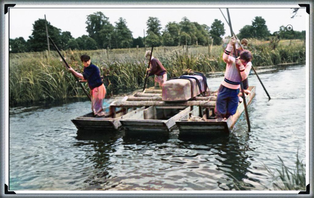
3. MPP claims that the boat transport method (14.50) was infeasible as they did not have sturdy enough boats to carry the stones on such a journey – Sadly, you do not need a ‘boat’ to transport stones in a river as shown by Atkinson in the 1960’s who employed just four school kids to punt a raft with a 3 tonne stone attached down the Avon. Moreover, he has failed to recognise that the oldest boatyard in the world located in the Solent (at the end of the Avon) has found with planked wood (and associated wheat grain from Turkey) indicating that substantial seafaring boats were available by the 7th Millennium BCE.

Punting Bluestone down the Avon from Stonehenge: The Lost Circle Revealed
Clearly MPP was too young to see this punt down the Avon?

4. Mike Parker-Pearson also suggested that an ‘ox-cart’ route that followed the current A40 was the most feasible way of transporting these stones to Stonehenge. He believed that they dragged these stones over 200 km on wooden sledges – unfortunately, the example shown on the program shows schoolboys dragging a small stone over flat grassland, which would not available for another 4000+ years and after Stonehenge’s initial construction. At the time of Phase I construction the environment (shown by pollen analysis) indicates that 70% of the terrain was woodland and forest and the remaining 30% was mostly made up of rivers and swampland, making such an endeavour impossible.

5. The Discovery (21:15) of ‘random’ hazel nuts at Craig Rhos-Y-Felin provides MPP’s required date for Stonehenge of 3300 BCE (which is still 500 years before MPP’s supposed construction date) – This clear ‘cherry picking’ of the archaeological evidence is ‘Bad Science’. To take just two carbon dates from over 40 at the Craig-Rhos-Y-Felin site and ignoring the more solid man-made hearth dates, that are Mesolithic and moreover, compatible with 26 carbon dates found at Stonehenge is plainly a falsehood.

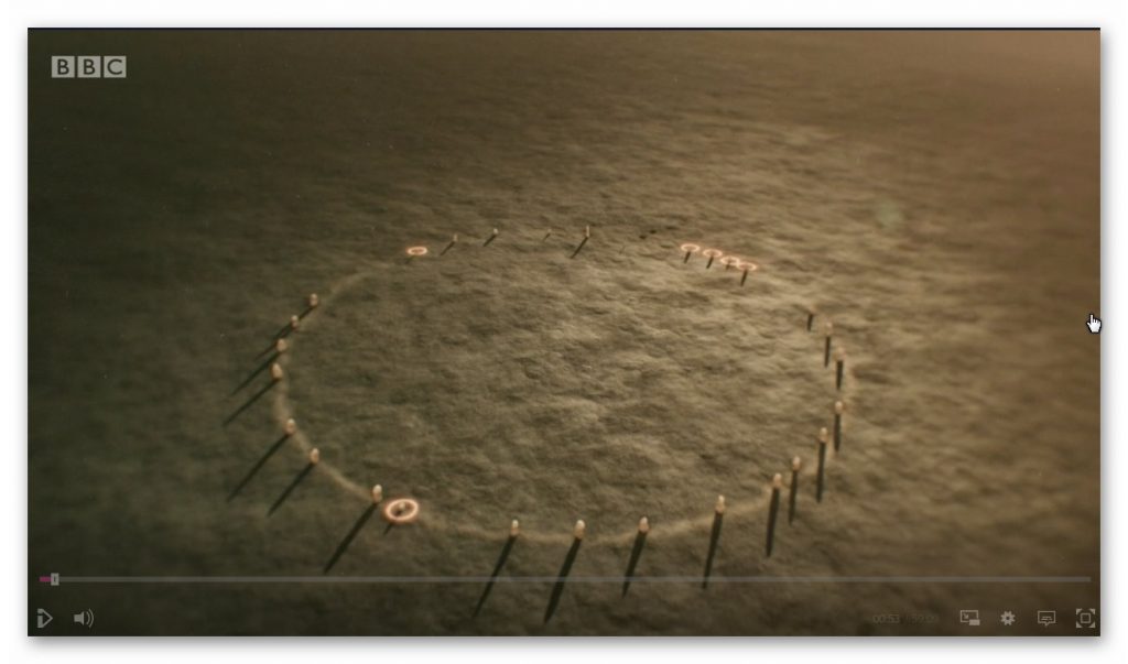
6. When they eventually found their target site (36:15) Waun Mawn (after many claims that other sites were “the one we have been looking for” to eventually find that the carbon dating on these sites did not match the required date), they found just four bluestones, and so went on a stone hunt and found 10 further stone HOLES! – This is clearly a sad attempt to fit a square peg into a round hole. The excavation was flawed as it only identified 14 possible stone locations and the remainder of the estimated 15 – 25 stones was a ‘guesstimation’ based on the known 14 holes – two of which had non-bluestone stones in situ.

Waun Maun from Stonehenge: The Lost Circle Revealed
No where near the 56 stones needed to create Stonehenge Phase I

7. The BBC reconstruction shows just 28 stones (38:05) of the 56 Bluestones required for the Aubrey holes to be filled at Stonehenge, and MPP goes on to suggest, that the stone circle is of equal size and dimensions as Stonehenge, quote “the chances of the two sites having the EXACT dimensions are very slim”- This sadly, is another falsehood, the Moat/Ditch at Stonehenge is approximately 110 metres in diameter, NOT the Aubrey holes which are 90 metres in diameter. Moreover, Stonehenge has a ditch/moat surrounding the stones (for a good reason) Waun Mawn does not!!

8. MPP’s then used a new unused tool in archaeology to prove his hypothesis ‘photogrammetry’ and suggested that Stone 62 at Stonehenge fitted the stone hole 91 at Waun Mawn – The reason this method is not used is somewhat obvious to even non-academics. You would need a crane to move the stone vertically up and out of the hole to get an exact imprint. If you are taking out a stone by hand and or with levers you will rock it from side to side destroying the stone hole impression as we have seen from post holes in numerous excavations.

9. The program fails to report that the 40 carbon dates from wood found on the site did not come up with MPP’s magic date, and so he employed another form of Dating OSL (40:17) to find this single piece of evidence he desperately required. – Sadly, watching Dr Kim Kinnaird efforts to get a light uncontaminated sample from over a fallen Stone, summed up the state of archaeology as a science for me? Armed with black weed blocker and a bicycle light on his head he set forth to get a sample to prove MPP’s hypothesis. Anyone who considers this an effective way of obtaining an OSL sample is beyond scientific redemption, as logic would suggest, doing it at night would perhaps be more suitable? This was finally compounded when we saw him transporting the sample in his hand into the detector in daylight, which was pure icing on that flawed cake.

10. Roberts indicated (quite rightly) that ALL the dates were “way out” and all hopes were put on this one sample, MPP then claimed (42:20) “we had dated the thing, and it just before Stonehenge’s construction” (3300 BCE) – Sadly, and not report in the program, but within the Waun Mawn excavation report, there was not one OSL samples taken but 18, which gave results in the range of 6980+/- 2120 BCE to AD 1900 +/- 20. So 17 dating sample did not verify MPP’s Hypothesis ONLY a single one which was dated 3530 +/- 330 (with that date range the probability its 3300 BCE is slim!!) . In fact the OSL data in the review document suggested “removal of the stones” 2120 +/-520 BCE, long after Stonehenge phase I.

11. The program then went onto a flight of fantasy for 15 minutes (25% OF AIR TIME) with unscientific mythology and astroarchaeology (which proved MORE that astroarchaeology doesn’t have any significance as the ‘expert’ suggested that the stones were ‘in the general direction’ of an alignment  – which by the very nature of a stone circle of 360 degrees – every stone circle in the world is in the general direction of all astrological alignments!! Even more ludicrous came an idea that the Welsh culturally invaded England in 3300 BCE and took the stones of Waun Mawn with them – Sadly, at no point did the experts attempt to justify why Stonehenge had 56 Bluestones and the site at Waun Mawn had less than 30 at the most. Even if this idea was remotely true, why would you leave four stones behind when you are already going to be 30 stones short and need to go back and get some more from the quarry site?

12. The program never went to any detail of the OTHER carbon dates found at Waun Mawn, which would allowed a balanced scientific program allowing the viewer to decide whether MPP’s hypothesis was actually feasible? It dictated speculation as fact justified by a number of site workers and the presenter agreeing on MPP’s ideas, without question or qualification – this is commonly known as ‘propaganda’ and not scientific methodology.  Moreover, the REAL evidence CAN found in the report and shows that of the carbon dating evidence at Waun Mawn (the OSL data was excluded from the report accept a small paragraph without all data!) shows that of the 42 samples taken:

  • 1 – sample were of 9th Millennium BCE
  • 3 – samples were of the 8th Millennium BCE
  • 8 – samples were of the 7th Millennium BCE
  • 4 – samples were of the 6th Millennium BCE
  • 10 – samples were of the 5th Millennium BCE
  • 6 – samples were of the 4th Millennium BCE
  • 11- samples after 4th Millenium BCE upto 17 AD.

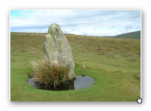
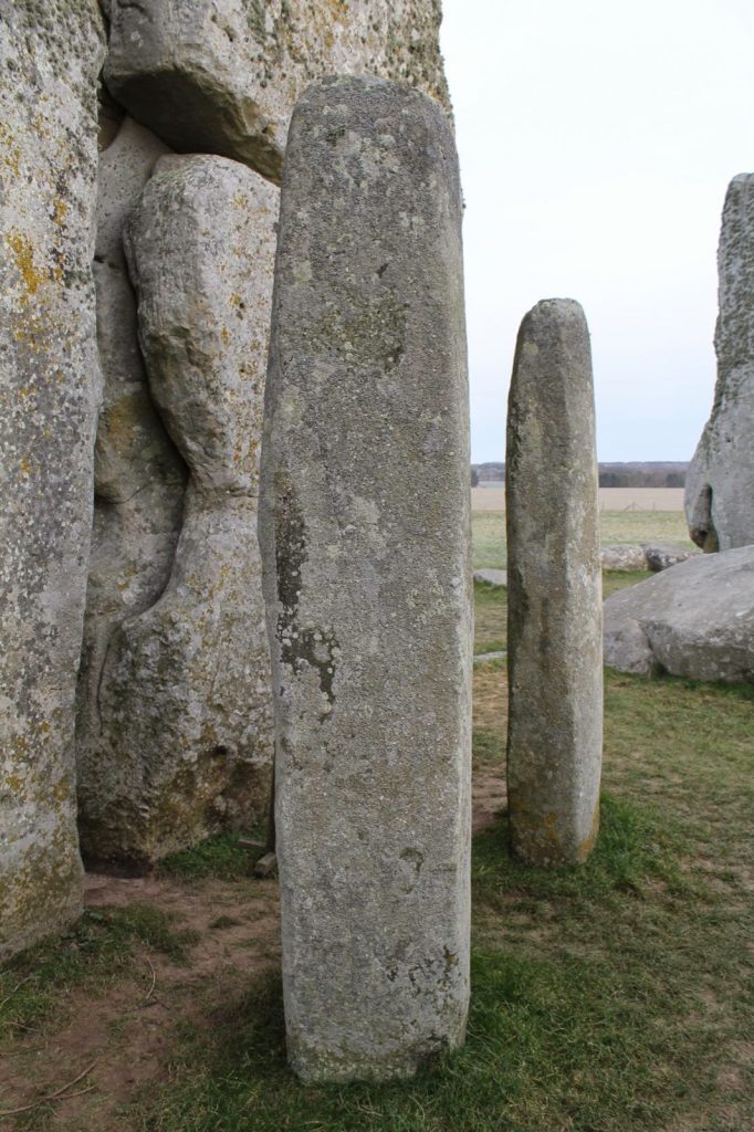
13. The report on Waun Mawn contains other questionable evidence, which was excluded from the program, this includes the fact that the Aubrey holes are ALL two to three times deeper at Stonehenge than Waun Mawn.  This indicates that Stonehenge Bluestones were made form larger bluestones than Waun Mawn (Stonehenge Bluestone hole 69 is over 1.5m deep as it is long and thin). It looks as if the original stone circle at Waun Mawn was made up of similar shaped stones to the existing recumbent stone 13 which is 6 – 7-foot-tall and surrounded by a moat. The shape of recumbent 13 indicates that rather than the long thin bluestones as at Stonehenge, Waun Mawn had ‘fat bottomed’ domed ends and hence the need for only shallow ditches.

Recumbent Stone 13 Waun Mawn from Stonehenge: The Lost Circle Revealed
recumbent stone 13; Stonehenge: The Lost Circle Revealed
Stonehenge Bluestone 69 from Stonehenge: The Lost Circle Revealed
Stonehenge Bluestone 69 – a third is underground. Stonehenge: The Lost Circle Revealed

In conclusion, it seems that the BBC has produced a nice piece of archaeological propaganda that supports the current false ‘archaeological narrative’ of mythology and speculation, rather than tested and qualified scientific fact. This lack of ‘critical analysis’ is a clear indication of why the ‘science’ of archaeology has not progress much over the last 50 years, even with modern technology which it has incorporated to very limited success.

More scientific and Analytical archaeological evidence and investigations relating to Stonehenge: The Lost Circle Revealed can be found on my website. www.prehistoric-britain.co.uk or my Video channel www.prehistoric-britain.online

Addendum – I first meet MPP on his excavation dig on the Avon in 2009, where he was in preparation to announce his bluestone site ‘Bluestonehenge’. At the time we had a discussion about the date of the site, as he was convinced that (at that time) he believed it predated Stonehenge Phase I (we now know this was the first of many claims of a predated Stonehenge bluestone circle). I did point out that at the meeting that I thought this date would be incorrect as according to my research (of the surrounding 50 sites around Stonehenge) which was included in my published book and post-glacial flooded environment hypothesis ‘The Stonehenge Enigma’ in 2013 – that this site would have been below water as the River Avon would remain flooded throughout the Neolithic period. At this point he ended the meeting and disappeared at such rapid speed – it look as if he thought I was clearly mad?

The later carbon dating proved my point and supported my hypothesis as it is now accepted that Bluehenge was constructed between 2840 – 2230 BCE Early Bronze Age.

Further Reading

For information about British Prehistory, visit www.prehistoric-britain.co.uk for the most extensive archaeology blogs and investigations collection, including modern LiDAR reports.  This site also includes extracts and articles from the Robert John Langdon Trilogy about Britain in the Prehistoric period, including titles such as The Stonehenge Enigma, Dawn of the Lost Civilisation and the ultimate proof of Post Glacial Flooding and the landscape we see today.

Robert John Langdon has also created a YouTube web channel with over 100 investigations and video documentaries to support his classic trilogy (Prehistoric Britain). He has also released a collection of strange coincidences that he calls ‘13 Things that Don’t Make Sense in History’ and his recent discovery of a lost Stone Avenue at Avebury in Wiltshire called ‘Silbury Avenue – the Lost Stone Avenue’.

Langdon has also produced a series of ‘shorts’, which are extracts from his main body of books:

The Ancient Mariners

Stonehenge Built 8300 BCE

Old Sarum

Prehistoric Rivers

Dykes ditches and Earthworks

Echoes of Atlantis

Homo Superior

For active discussions on the findings of the TRILOGY and recent LiDAR investigations that are published on our WEBSITE, you can join our and leave a message or join the debate on our Facebook Group.

Avebury’s great mystery revealed

Avebury's great mystery revealed
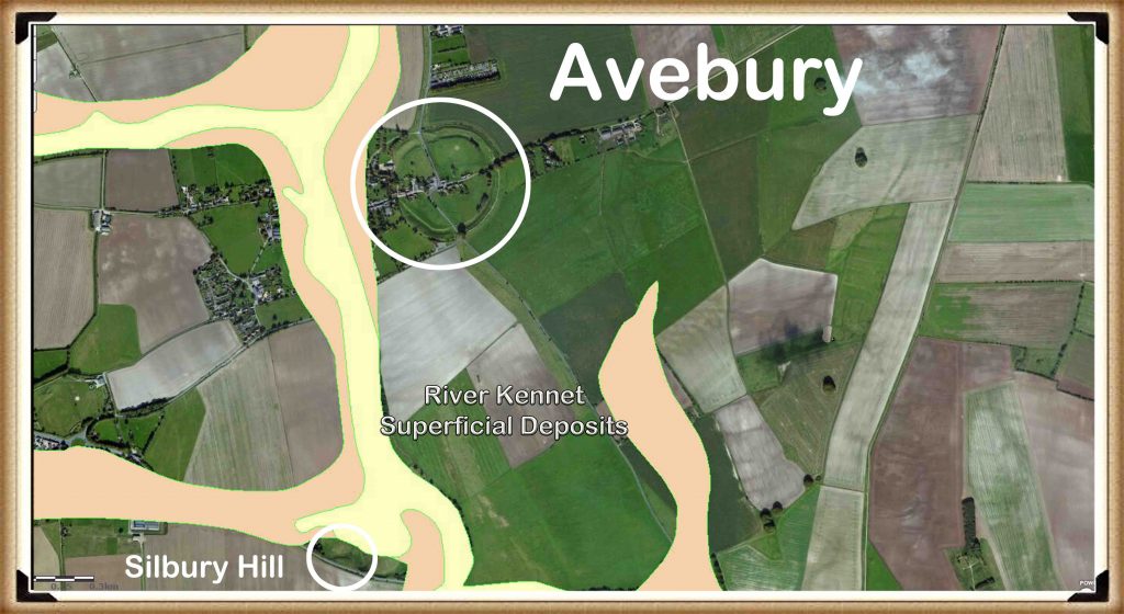
BGS Map of Avebury showing ‘Superficial Deposits’ left by the remains of the River Kennet in the Mesolithic Period – Avebury’s great mystery revealed

Now everyone knows that Stonehenge, Avebury and Old Sarum were cut out of the hard chalk with antler picks – or do we?  For if the archaeologists are right, the entire site must be littered with the broken remains of these objects – but there not! Half of Stonehenge has been fully excavated and found just 82 pieces probably from about 50 full antlers. (Avebury’s great mystery revealed).

At Avebury even less have been found – either antlers are the most formidable natural tools in the world or what we see are the remnants of tools used after the construction for alterations or to clean out (not cut) the ditches. Mike Parker-Pearson found strange cut marks in the bottom of a ditch at Durrington in 2008.  These cut marks were so thin that they could only be made by a metal blade, like a bronze or copper axe. The only problem is that according to traditional archaeology – Bronze technology is not available during this period history – unless, of course, the accepted Victorian dating periods are fundamentally wrong, and metals were used long ago.

More recent discoveries now indicate that the peoples of Europe had Bronze as early as 4600 BCE in Bulgaria found in a Gold and Bronze grave – so there is no good reason to believe that the builders of Stonehenge did not have Bronze or copper axes to cut the chalk, towards the end of the Mesolithic period as they would be trading with these places in Europe using their boats.

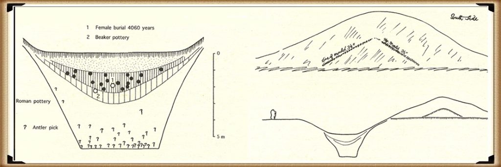
Moreover, the cross-section drawing of Avebury drawn in 1914 by St George Grey shows that our ancestors took great care to make sure the bottom was flat – the question is why?

If it’s a ceremonial ditch (as some archaeologists suggest) why flat and so deep, indeed would not  a small easy to cut v- ditch would suffice and be less time-consuming?

Avebury's great mystery revealed
Figure 70- Harold St. George Grey, with his sketch of the excavation showing the large flat bottom and his evidence on the bank that it was built in stages (Avebury’s great mystery revealed)

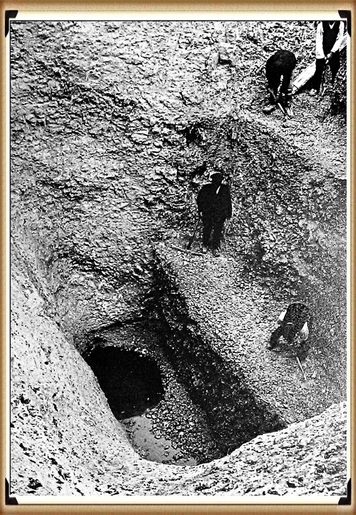
Moreover, the excavation serves us with the ‘smoking gun’ of evidence we have been seeking. Because as St. George Grey’s men dug, following the ancient ditches cut deep in the soil they had to stop working, as the workman had hit the water table level and the ditch started to flood.

Avebury's great mystery revealed
Figure 71- The ‘Smoking gun’ water found at the bottom of the ditch – even today (Avebury’s great mystery revealed)

Now, this is in Summer 1914, and they have reached the water table level.  We know in winter the water table would be higher and more importantly, we have shown in previous chapters that the water tables were higher in the past than today. This proves that when this ditch was originally dug, it filled with water turning it into a moat.

Furthermore, the question that needs to be answered is ‘why a flat bottom moat’ as you are not going to see it when it is full of water. The simple answer is the same reason that we today dredge rivers and boat canals – to remove the silting.

Natural silting over time will create a round bottom to the moat. If you make the bottom flat, it will take longer to silt up than if it was round, prolonging its use or for the need to remove the silt.  Is this what we are finding in the ‘fill’ of these ditches, and the tools used to keep the moat clean and free from weeds, would be the Antler picks and cow shoulder blades found in excavations in small quantities.

Eventually, when Avebury lost all of its groundwater, our ancestors built Silbury Hill as the new landing site to the complex. Silbury Hill is the largest human-made island in Europe and was set at the end of the Neolithic waterway.  Composed mainly of chalk and clay excavated from the surrounding area, the mound stands 40 metres (130 ft) high and covers about 5 acres. As we have already seen, it would have taken 18 million-man hours to deposit and shape this vast pile of chalk and earth on top of the natural hill that forms Silbury’s foundation. The base of the hill is circular, 167 metres (548 ft) in diameter. The summit is most importantly, flat-topped and 30m (98ft) in diameter.

(Avebury’s great mystery revealed)

Articles on this Trilogy and an Active FaceBook Group where you can leave comments and get feedback can be found at:

Articles: http://prehistoric-britain.co.uk/

FaceBook Group: https://www.facebook.com/groups/prehistoricbritain
#prehistoricbritain
#stonehenge

#woodhenge

#oldsarum

#avebury

#durringtonwalls&woodhenge

Further Reading

For information about British Prehistory, visit www.prehistoric-britain.co.uk for the most extensive archaeology blogs and investigations collection, including modern LiDAR reports.  This site also includes extracts and articles from the Robert John Langdon Trilogy about Britain in the Prehistoric period, including titles such as The Stonehenge Enigma, Dawn of the Lost Civilisation and the ultimate proof of Post Glacial Flooding and the landscape we see today.
Robert John Langdon has also created a YouTube web channel with over 100 investigations and video documentaries to support his classic trilogy (Prehistoric Britain). He has also released a collection of strange coincidences that he calls ‘13 Things that Don’t Make Sense in History’ and his recent discovery of a lost Stone Avenue at Avebury in Wiltshire called ‘Silbury Avenue – the Lost Stone Avenue’.

Langdon has also produced a series of ‘shorts’, which are extracts from his main body of books:

The Ancient Mariners

Stonehenge Built 8300 BCE

Old Sarum

Prehistoric Rivers

Dykes ditches and Earthworks

Echoes of Atlantis

Homo Superior

For active discussions on the findings of the TRILOGY and recent LiDAR investigations that are published on our WEBSITE, you can join our and leave a message or join the debate on our Facebook Group.

Great Chesters (Roman) Aqueduct (Part Two)

This is PART TWO of Great Chesters (Roman) Aqueduct LiDAR survey – Part One is available HERE. NB. the flick book version has enhanced colour hi-res zoom illustrations for studying purposes.

Section 6
Section 6 – Great Chesters (Roman) Aqueduct

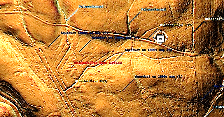
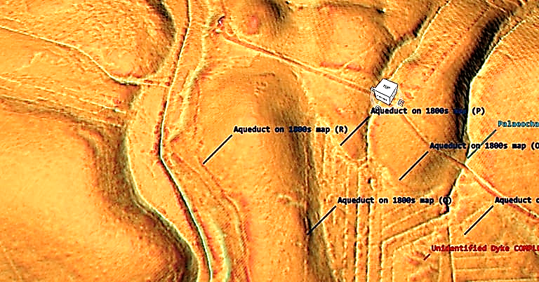
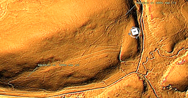
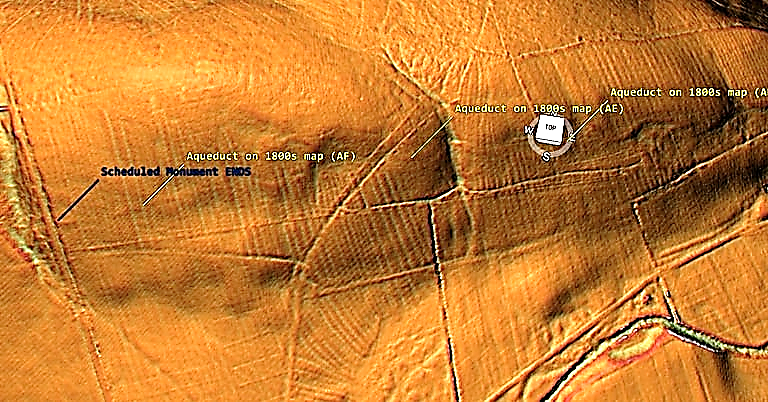
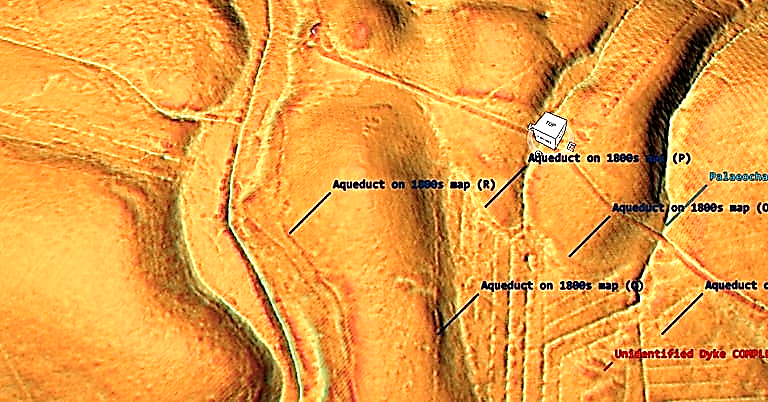
On section 6 the aqueduct can be better seen but of limited size in width (one metre) – what we do see in Section 6 is a water complex of unknown date but clearly linking into other linear earthworks (Dykes) not recognised or scheduled currently. This ‘diamond complex maybe the first signs of agriculture in the area using the existing Dyke canals as a water source for farming crops. Each of these section are 11m (33ft) wide and would have access to water 365 days a year.

We are now left with two tantalising possibilities as this complex cuts through the aqueduct. If the aqueduct is ROMAN then the complex is later in history (selion is a medieval open strip of land or a small field used for growing crops, usually owned by or rented to peasants. A selion of land was typically one furlong (660 ft) long and one chain (66 ft) wide, so one acre in area?) – which means that water levels (as the palaeochannels needed to be full of water to work) were much higher in the past (Roman Period) than currently accepted?

OR the aqueduct is much older than the experts suggest by thousands of years?

Section 7 from SE view
Section 7 from SE view – Great Chesters (Roman) Aqueduct
Section 7 - NW view
Section 7 – NW view – Great Chesters (Roman) Aqueduct

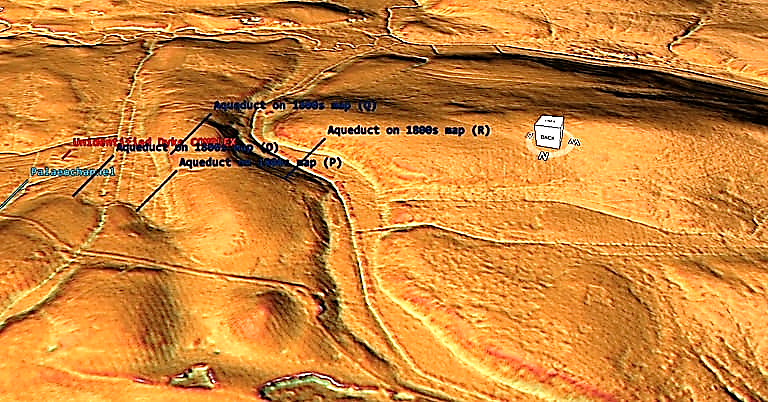
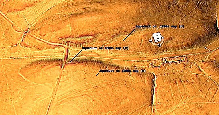
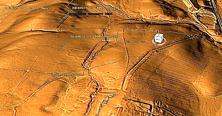
The aqueduct in section seven (for a second time) takes a detour South then north around a shallow mound. The NW view shows that this path could have been halved by going around the north section of the mound – so why the extra work? Moreover, although the OS maps (and Historic England Scheduled Maps) show that the aqueduct crosses the river (authors suggesting a wooden bridge at this point) but unlike previous bridge section showing two pits either side of the river, LiDAR shows no structure and no continuation on the opposite bank – so was this the end?

Great Chesters (Roman) Aqueduct
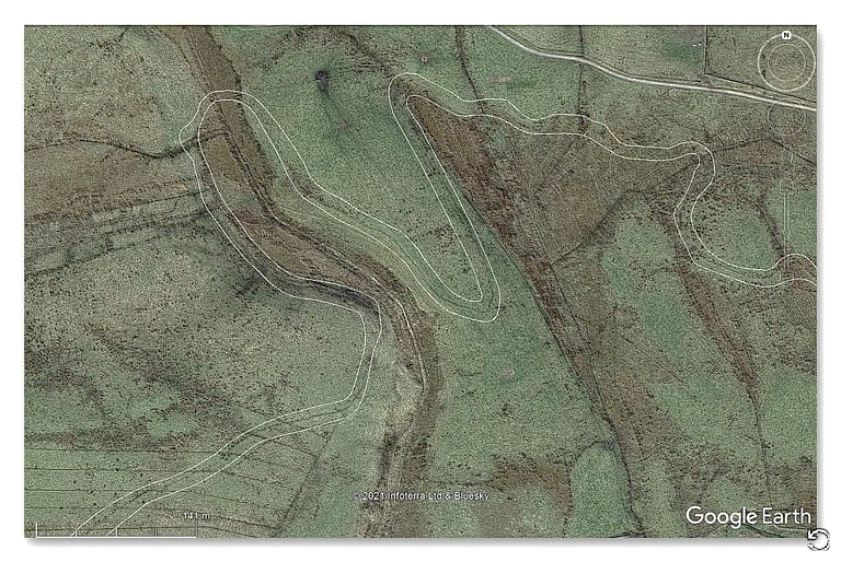
Section 6 and 7 – Historic England’s path of the Aqueduct

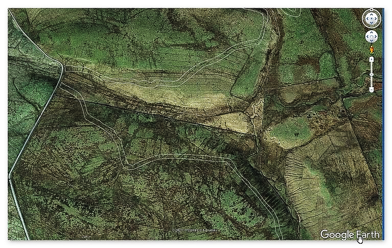
This missing section and bridge is compounded when you look at the GE satellite map as you wounder if you wanted to cross the river, why go so far north when you could have crossed in the south saving time and labour?

Great Chesters (Roman) Aqueduct
Section 8 – Great Chesters (Roman) Aqueduct

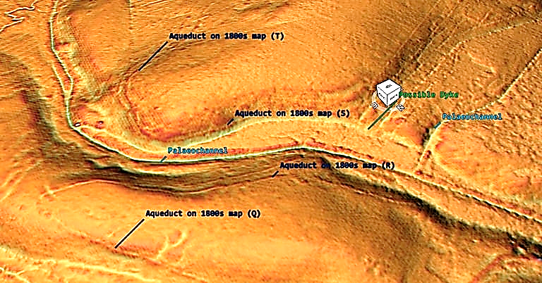
Section 8 shows that the aqueduct seems to come out of a possible Dyke – if the OS maps are correct and the dyke is part of the aqueduct then hows does a 4m wide ditch reduce to a metre. Moreover, why does the Dyke continue and connects to a palaeochannel later down stream whilst the aqueduct turns (as if it draws water from the Dyke) and continues in a very different direction?

It should also be noted that the palaeochannels in this section (right) seem to have banks which would suggest they were used as Dykes?

Great Chesters (Roman) Aqueduct
Section 9 – Two aqueducts??

Section 9 is very interesting as it turns from one Aqueduct into two (again which has not been recognise by the archaeologists.

The question is “why two”?

Was there so much water that one channel could not cope – if so why not just widen the ditch as we have seen in other sections? Did one of the ditches dry up and so another was dug – if so then the groundwater more than the waterflow has been underestimated by the experts? What is sure is that both ditches end entering a depression in the landscape (quarry?) by ‘Benks Bridge’ and there is no sign of it crossing the bridge.

Great Chesters (Roman) Aqueduct
Section 10 – Great Chesters (Roman) Aqueduct

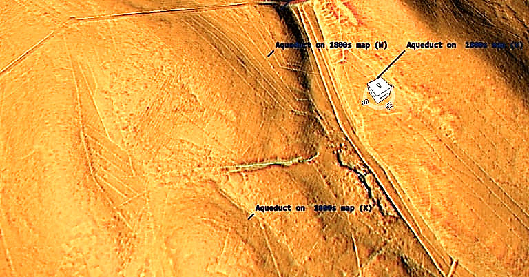
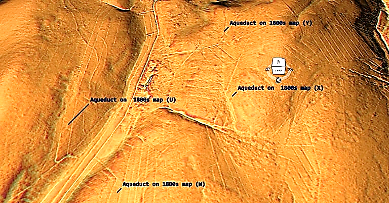
Section 10 shows a much shallower ditch than seen in the north heading from the bridge (W) towards a palaeochannel, where is turns south then north to avoid the gradient (X).

Great Chesters (Roman) Aqueduct
Section 11- Great Chesters (Roman) Aqueduct
Great Chesters (Roman) Aqueduct
Sections 7 – 11 on GE
Great Chesters (Roman) Aqueduct
Section 12 – Great Chesters (Roman) Aqueduct

The ditch now moves east and become s more obvious (Y).

Great Chesters (Roman) Aqueduct
Section 13 – Great Chesters (Roman) Aqueduct

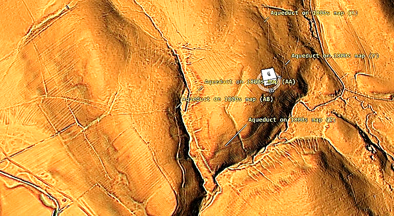
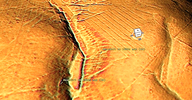
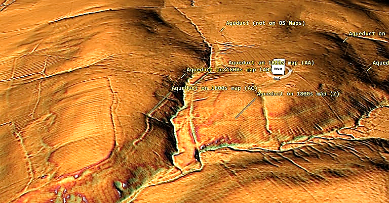
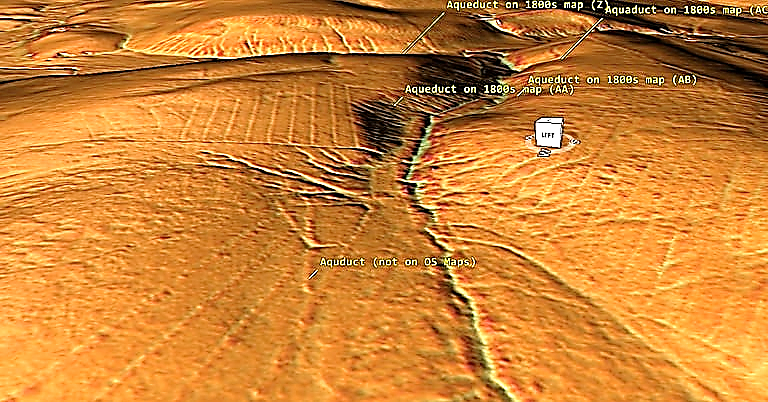
The Aqueduct (Z) to (AA) now follows the contours of the landscape around a dry river valley (Palaeochannel) before coming back on itself again, where archaeologists suspect it cross the valley via an unidentified bridge.

The LiDAR map suggest it disappears into the river valley and the opposite route of the Aqueduct originates at a different location.

Great Chesters (Roman) Aqueduct
Section 13 – showing Aqueduct starting and ending at different points?
Great Chesters (Roman) Aqueduct
Section 14 – shows the Aqueduct goes past the Palaeochannel – which has been missed on the OS maps

Moreover, on the southern side of the Palaeochannel the size of the Aqueduct increases significantly. On the northern side it is 1 – 2m in width and on the Southern side it is now 12m with a 6m ditch and bank.

Great Chesters (Roman) Aqueduct
Section 15 – the Aqueduct has no relation in size to the previous sections.

What we care seeing is an independant Dyke which goes from Palaeochannel to Palaeochannel and has been misidentified by archaeologists attempting to rationalise this strange ditch/aqueduct.

Great Chesters (Roman) Aqueduct
Section 16 – the Aqueduct returns to a very shallow 1m ditch

The last leg of this Aqueduct returns again to a shallow 1m width channel that apparently joins the larger 12m ditch system on the bend of the landscape – which we have found no clear evidence for such an assumption. At this point the Scheduling for the monument ends entering another Palaeochannel.

Great Chesters (Roman) Aqueduct
Section 17 – the aqueduct continues but doesn’t reach the fort

The last leg of the Aquaduct (according to the 1800s OS maps) takes the aqueduct to the Great Chesters Fort (Aesica) – but the LiDAR map shows that the ditch falls short (300m) and disappears in a river north of the fort.

Conclusion

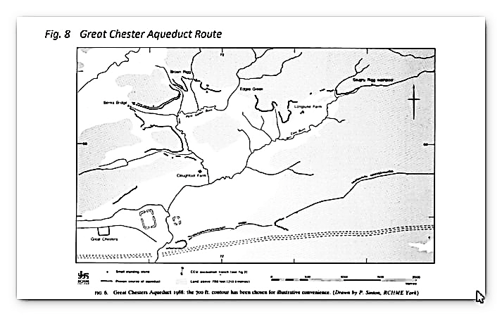
It is clear that from the LiDAR research that the suspected Roman Aqueduct is not as it seems. This is not the first examination to spread doubt about the scale and origin of this feature in the landscape – MacKay, D. A. (1990). The Great Chesters Aqueduct: A New Survey. Britannia, 21, 285–289. Also shows an incomplete map of this aqueduct.

Mackay 1990 - Great Chesters (Roman) Aqueduct
Mackay 1990 – Great Chesters (Roman) Aqueduct

What Mackey failed to find in their survey is that the Aqueduct changes size and the path suggested had no identifiable remains of the bridges required to make this Aqueduct work.

Our more detailed findings indicate that the topology of the aqueduct (Fig.1) indicates that it would need to go up hill at several points without any powered assistance (like a siphon) and so is mechanically unsound. What our finding have found that is new is the use of ‘Dykes’ in this area and some connecting to this Aqueduct feature. We have also shown that closer to the Fort it was supposed to supply there was closure water sources which could be used and that the Fosse by the Wall was also a water supply. Moreover, the easiest supply of water which was available and has been completely ignored by historians and Archaeologists is a WELL!! Wells were used all over Roman Britain and it is clear from the Palaeochannels in this area that a well of just 30 – 40 would have tapped sufficient water fro both the Fort and baths?
Our conclusion is that this what we have found is a prehistoric watercourse that was linked to their very sophisticated ‘Dyke’ system. I would be bold to suggest that this was used for either agricultural purposes or mybe industrial seeing the multiple sites of quarries associated and in the region of this feature.

For more information about Linear Earthworks (Dykes) see our other BLOG POSTS or our LiDAR Investigations on our YOUTUBE channel – Great Chesters (Roman) Aqueduct.

Further Reading

For information about British Prehistory, visit www.prehistoric-britain.co.uk for the most extensive archaeology blogs and investigations collection, including modern LiDAR reports.  This site also includes extracts and articles from the Robert John Langdon Trilogy about Britain in the Prehistoric period, including titles such as The Stonehenge Enigma, Dawn of the Lost Civilisation and the ultimate proof of Post Glacial Flooding and the landscape we see today.
Robert John Langdon has also created a YouTube web channel with over 100 investigations and video documentaries to support his classic trilogy (Prehistoric Britain). He has also released a collection of strange coincidences that he calls ‘13 Things that Don’t Make Sense in History’ and his recent discovery of a lost Stone Avenue at Avebury in Wiltshire called ‘Silbury Avenue – the Lost Stone Avenue’.

Langdon has also produced a series of ‘shorts’, which are extracts from his main body of books:
The Ancient Mariners

Stonehenge Built 8300 BCE

Old Sarum

Prehistoric Rivers

Dykes ditches and Earthworks

Echoes of Atlantis

Homo Superior

For active discussions on the findings of the TRILOGY and recent LiDAR investigations that are published on our WEBSITE, you can join our and leave a message or join the debate on our Facebook Group.
Great Chesters Roman Aqueduct – Debunked (Part One)

NB. for more detailed LiDAR maps in hi-resolution with zoom facility see the corresponding ‘flip book’ in our online library (Great Chesters Roman Aqueduct – Debunked (Part One))

An aqueduct is an artificial channel used to carry water. All known Roman aqueducts functioned on a gravity flow principle, whereby a water source was impounded at a higher level than the place to be supplied, and was then made to flow to it under the influence of gravity. Water was needed for domestic purposes including bathing and drainage, and also for some industrial processes.

Three main types were built; pipeline aqueducts carried water through enclosed pipework which was normally ceramic, lead or wooden. Channel aqueducts carried water in U-shaped channels, normally a wooden or stone duct, which was either open or covered by stone flags. Leats were the simplest form of aqueduct, and carried water in an open channel dug into the ground and generally lined with clay. They often extended for several kilometres following contour levels. Bridges or other forms of support were used to carry the aqueduct over ravines and uneven terrain such as streams or rivers. The earliest aqueducts date from the period immediately following the Roman Conquest of Britain.

These early examples are associated almost exclusively with military activity and provided water to forts. By the end of the 2nd century, most forts and also public towns had been provided with aqueducts, the need for water being driven particularly by the construction of elaborate bath houses, and the developing fashion of bathing as a social activity amongst both the military and civilian populations. Aqueducts were used throughout the Roman period, and some were still functioning into the 5th century AD. They were found throughout Roman Britain with particular concentrations along Hadrian’s Wall. Only 60 have now been identified to survive. As a rare monument type which provides an important insight into Roman engineering skills and both military and civilian life, all surviving examples are identified to be nationally important.

The Great Chesters Aqueduct

According to Historic Britain’s scheduling details: “The monument includes the remains of an aqueduct of Roman date, which carried water from Caw Burn westwards to Great Chesters Roman fort. The aqueduct adopts a circuitous route closely following the topography of the landscape. The protected portions of the monument are contained within five separate areas of protection, which stretch over approximately 8.68km of the aqueduct’s length. The aqueduct is preserved as a partial earthwork and in other locations as a cropmark.” – doesn’t tell us much really?

Sadly It’s all very loose with no excavations just a few field walkers to verify the aqueduct – if it is a aqueduct that is?

Great Chesters Roman Aqueduct (NY741688 to NY703668) – according to the book NORTH-EAST HISTORY TOUR

“One of the neatest feats of Roman engineering in the region is one of the least known. It is the 9.5km line of the Roman aqueduct leading into the old fort of Great Chesters from the NE, a little to the north of Haltwhistle.

Only very faint traces of it remain today, but the logistics of the little water supply project are impressive. Basically, when Great Chesters fort was built on the Wall it didn’t have a nearby water supply, so it had to be piped in from the Caw Burn, about 4km to the NE (more specifically, Saughy Rigg Washpool near Fond Tom’s Pool). However, as the engineers had to rely purely on gravity, the path of the aqueduct took a long and curling route through a 9km+ course to pick up every tiny inch of downhill along the way.

The result was a remarkable bendy, twisting affair taking the channel on a constantly downward trajectory at the almost unbelievably gentle gradient of about 1m drop for every 1,000m travelled. And, once more, the flow of water was eased along a simple, unlined water-course about ½ m wide by ¼ m deep, with the occasional small wooden bridge inserted to take it over minor valleys and streams.

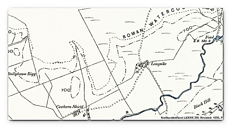
The course of the aqueduct is clearly shown on modern-day OS maps (there’s a decent representation here – and scroll down a bit), though it is not so easy to pick out on the ground. Partial earthworks survive, and in other places crop marks provide the circumstantial evidence.“

Sadly, this perception of History is typical due to the misunderstanding of the Landscape in the past and the misconception of ‘Linear History’ – technology growth and sophistication from one century to the next – which strangely the Roman empire clearly disproves (ask anyone in the Dark Ages who needed to live in Mud Huts with contaminated food and water supplies?

If we now look at modern methods to look at this feature we see quite clearly the problem with the assumption that this is a Roman Aqueduct.

Great Chesters Roman Aqueduct - Debunked
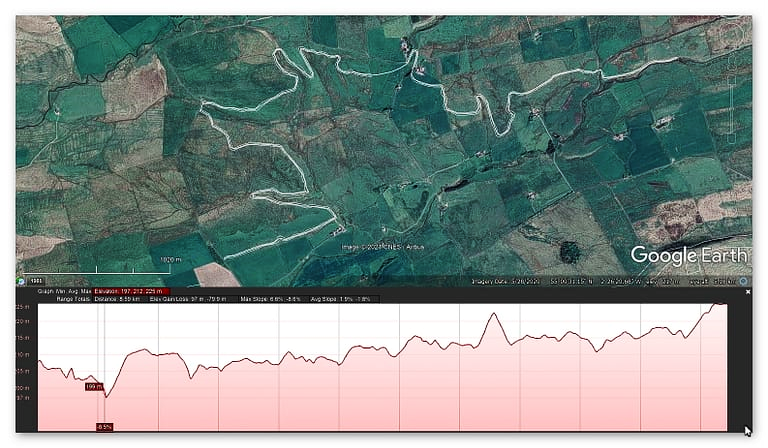
Fig. 1 – GE trace of the ‘Aqueduct’ using the English scheduled monuments feature plan – Great Chesters Roman Aqueduct – Debunked

The profile of the alleged aqueduct is not this ” gentle gradient of about 1m drop for every 1,000m travelled ” but a very haphazard path which would need the aqueduct to defy the laws of gravity in many areas. Within this path there are connections to river valleys no less than six times. It has been suggested that ‘wooden’ (as no stone has ever been found was used to bridge the gaps!! What has not been explained is the last leg of this epic journey where the aqueduct goes up hill by 10m over the last 800m of the journey??

Moreover, the Fort has a much closer source of water – in fact several sources of water which makes such an aqueduct irrelevant?

If we ‘reverse engineer’ the water sources of the fort Aesica we can reveal something quite misunderstood.

Aesica – Wikipedia

Aesica (with the modern name of Great Chesters) was a Roman fort, one and a half miles north of the small town of Haltwhistle in Northumberland, England. It was the ninth fort on Hadrian’s Wall, between Vercovicium (Housesteads) to the east and Magnis (Carvoran) to the west. Its purpose was to guard the Caw Gap, where the Haltwhistle Burn crosses the Wall.

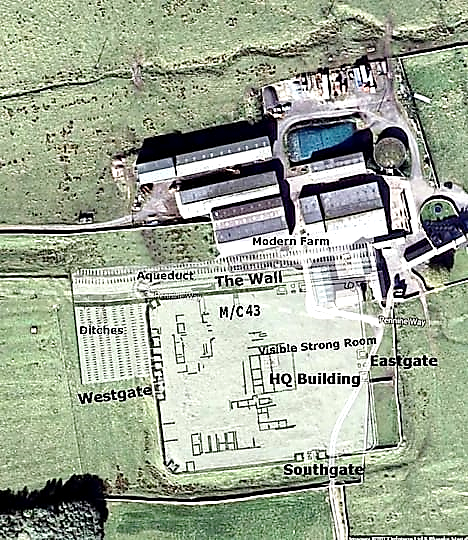
It is believed that the fort was completed in the year 128 AD. Unlike other wall forts that project beyond the Wall, all of Aesica is south of the Wall. The Wall at this point is narrow gauge, but stands next to foundations that were prepared for the broad wall. There was speculation as to why the foundations for the broad wall had not been used to support the wall at this point. In 1939 it was found that Milecastle 43 had already been built in preparation for the broad wall, and it is thought that it was the presence of this milecastle that prevented the north wall of the fort being built on the original foundations. It appears that the milecastle was demolished once the fort had been completed. The east gate and east wall cannot now be traced.

The fort was an oblong, measuring 355 feet (108 m) north to south by 419 feet (128 m) east to west, occupying a comparatively small area of 3 acres (12,000 m2). The north-east corner of the fort is now occupied by farm buildings, built over the route of the Wall.

The fort had only three main gates; south, east and west, with double portals with towers. At some time the west gate was completely blocked up. There were towers at each corner of the fort. The Military Way entered by the east gate and left by the west gate. A branch road from the Stanegate entered by the south gate.

The Vallum passed some short distance south of the fort, and was crossed by a road leading from the south gate to the Stanegate. A vicus lay to the south and east of the fort, and several tombstones have been found there.

The fort was supplied by water from an aqueduct, which wound six miles (10 km) from the head of the Haltwhistle Burn, north of the Wall.

So the Great Chesters Aqueduct fed not only the fort but also the Bath House as it was the only source of water in the area?

Great Chesters Roman Aqueduct - Debunked
1800s OS map

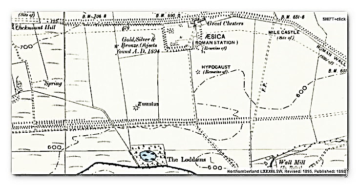
This 1800s map shows the Great Chesters Fort (Aesica) and the bath house south of the Fort – it also indicates a path for an Aqueduct going south to the Vallum and then to the river. This shows the water travelling down hill from 208m high at the Fort to 180m at the river – this is clearly the OUTLET of the water.

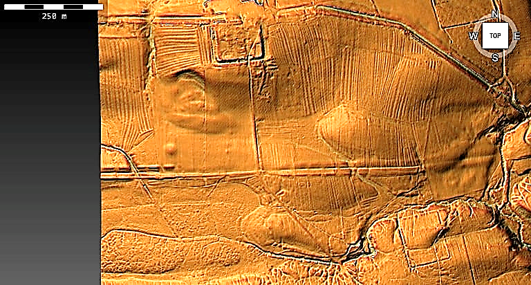
The Lidar map shows this much better but moreover, it also shows that the outlet is NOT the river but the Vallum.

Great Chesters Roman Aqueduct - Debunked
The outlet goes to the Vallum – but only a small (overflow?) ditch goes to the river!

So is the Great Chesters Aqueduct (all 9km) connected to this point in the Fort?

Great Chesters Roman Aqueduct - Debunked
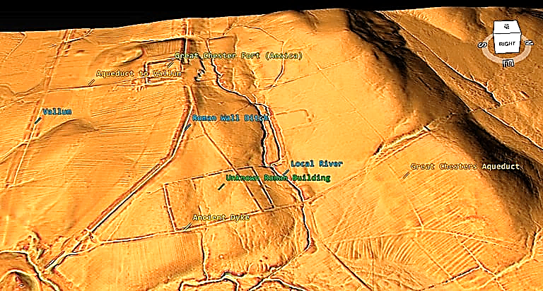
The Roman Wall is connect to a local river and a Palaeochannel (still with water during Roman times?)

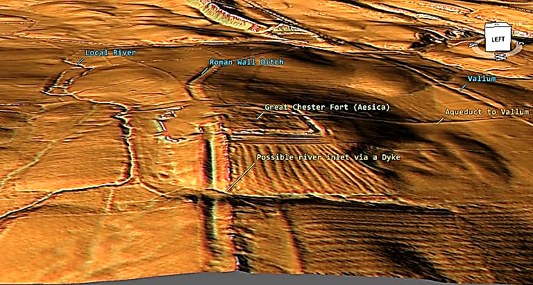
The Great Chesters Aqueduct is too far from the fort to connect and there is not sign of anything on Lidar? What LiDAR suggests is that a Dyke connects the local river to the Wall Ditch and that the Wall ditch is so deep it also was below the water table making it a moat.

Looking at the other side of this ditch/moat – we see that there is a break in the wall that may have allowed water to feed the moat/ditch via another ancient dyke?

Why such an exaggerated ditch at this point not seen generally on the fosse?

This connection seems to be in agreement with excavations of Aesica which shows the ‘aqueduct’ going through the centre of the fort.

Great Chesters Roman Aqueduct - Debunked
Tynedale Hadrian’s Wall Group

So if the Great Chesters Aqueduct is not a 9km Roman piece of engineering – what are we seeing in the Landscape?

LiDAR Investigation starting North East of the Fort – Section One

We will look at each section in turn to see if it actually existed and whether it would flow as expected or that it has another more feasible explanation. The start of the Aqueduct we will call section 1 it is by the River Caw Burn (which flows from Right to Left) and flows the river for a while (Fig. 1 – top right corner) without reason or any ditch found on LiDAR.

Great Chesters Roman Aqueduct - Debunked
Section 1

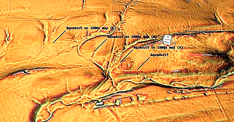
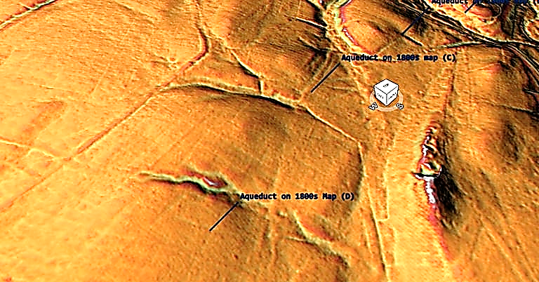
To connect to the river before (C) in the suggested route would not make much sense as the river runs along side and it would need to fight against gravity (as section C is two metres higher than A) it could connect up better to section (A) via the stream running past section (A) to the right much more effectively (unless it was dry during this period). What is more interesting and missed by the archaeologists is the man-made Dyke that cuts North – South between Section B and C connecting the stream to the river with banks on both sides – the southern half is now dry and used as a footpath, but LiDAR clearly shows at one time it went directly from the prehistoric stream.

Section 2

Section two shows that the Aqueduct goes from 4m wide in (C) to 1m wide in (D) over a very small length? Moreover, again LiDAR suggests that at (C) this 4m ditch connects to another Palaeochannel (that would have held water in prehistory) and then seems to head South of (D) to get another palaeochannel keeping the 4m width.

Section 3 goes on a ‘merry dance’ around the landscape without good evidence or reason. The OS map suggests that the route south then north is not required as you could just continue on the same line, which is confirmed on the LiDAR map.

Great Chesters Roman Aqueduct - Debunked
Section 3 – showing the ‘merry dance’
Great Chesters Roman Aqueduct - Debunked
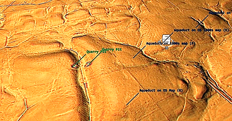
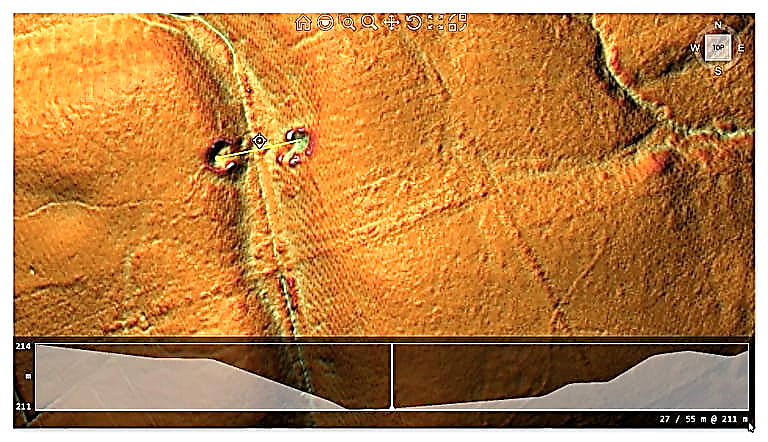
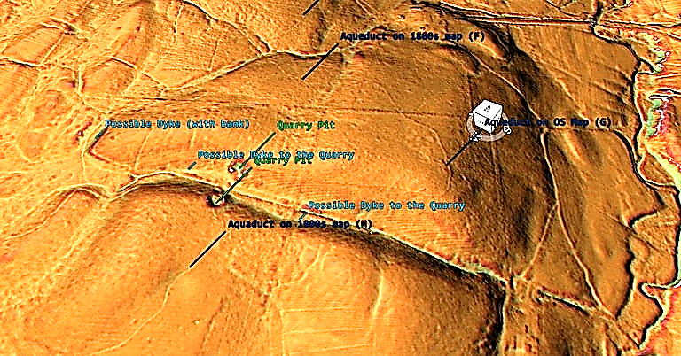
Section 3 LiDAR map shown that this strange route terminates in an ancient quarry

Closure inspection would suggest that (E) terminates in the Palaeochannel and (F) is a linear feature that continues past the palaeochannel and does not connect to the suggested aqueduct.

Great Chesters Roman Aqueduct - Debunked
Section 3 facing east

Section 4 shows that the aqueduct stops at the quarry and starts again on the quarry opposite and does not go around or through the valley as suggested on the OS maps – but what it does open up is the possibility that a stonebridge once connected the aqueduct which has been robbed out?? as it is 50m wide and of the same altitude with a slight slope right to left.

Bridge over to Section 4?
Great Chesters Roman Aqueduct - Debunked
Section 4

If the quarry pits are not the foundations of a stone bridge – then these quarry pits do seems to have Dykes connecting them the the palaeochannel. What there clearly is not is a continuation of the Aquaduct north of each pit. The ditch on section (H) is again quite pronounced at 2m in width – which is more than adequate for ample water is somewhat overkill as some regions is only 1m wide and so is wasted over engineering?.

Section 5

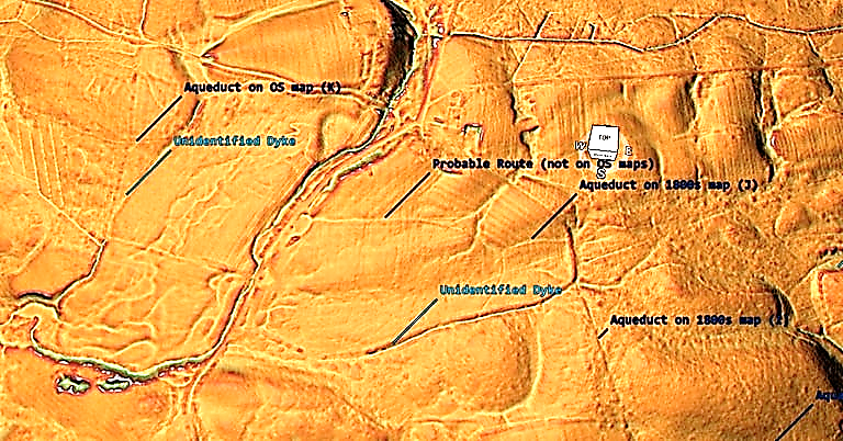
The aqueduct in area (J) seems to connect to another unidentified Dyke of much larger specification (8m wide with Bank) before turning West and on the OS map moving north to the settlement of Edges Green and crossing the river (via a bridge??) but LiDAR sees no evidence of this suggested route. What we do see (but missed by archaeologists) that the route goes west to the palaeochannel, only to reappear out of another Palaeochannel to the West (K).

Moreover, the LiDAR map shows two more possible Dykes – the one on the East side 8m width with 4m ditch and bank and the one on the East 10m wide with a 5m bank and ditch.

End of Part One – Part Two to be published next week.

For more information about Linear Earthworks (Dykes) see our other BLOG POSTS or our LiDAR Investigations on our YOUTUBE channel.

Further Reading

For information about British Prehistory, visit www.prehistoric-britain.co.uk for the most extensive archaeology blogs and investigations collection, including modern LiDAR reports.  This site also includes extracts and articles from the Robert John Langdon Trilogy about Britain in the Prehistoric period, including titles such as The Stonehenge Enigma, Dawn of the Lost Civilisation and the ultimate proof of Post Glacial Flooding and the landscape we see today.

Robert John Langdon has also created a YouTube web channel with over 100 investigations and video documentaries to support his classic trilogy (Prehistoric Britain). He has also released a collection of strange coincidences that he calls ‘13 Things that Don’t Make Sense in History’ and his recent discovery of a lost Stone Avenue at Avebury in Wiltshire called ‘Silbury Avenue – the Lost Stone Avenue’.

Langdon has also produced a series of ‘shorts’, which are extracts from his main body of books:

The Ancient Mariners

Stonehenge Built 8300 BCE

Old Sarum

Prehistoric Rivers

Dykes ditches and Earthworks

Echoes of Atlantis

Homo Superior

For active discussions on the findings of the TRILOGY and recent LiDAR investigations that are published on our WEBSITE, you can join our and leave a message or join the debate on our Facebook Group.

The Giant’s Graves of Cumbria

During my current research into the Dykes (linear earthworks) of Britain using LiDAR, I have come across many strange and wonderful features (Giant’s Graves) lost to the archaeological world – either through uninterest or the lack of scientific investigation to understand the actual and historical meaning of these features – The Giant’s Graves of Cumbria.

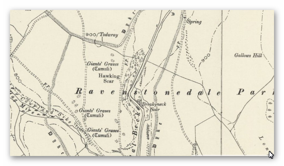
One of these areas is the ‘Ravenstonedale’ area of Cumbria, where over twenty of these unusual tumuli’s are present on the old 1800s OS maps and now can be investigated by LiDAR in detail.

The Giant's Graves of Cumbria
The Giant’s Graves of Cumbria

The dates of these graves are unknown as little to no excavation work has been scheduled, and so only scant accounts are available from historical books of little scientific discipline.

CROSBY GARROT, WESTMORLAND. [1793, Part I., pp. 116, 117]

However rude the monuments of our ancestors may appear to the eyes of a more civilised race, I doubt not but the humble tumulus will convey to posterity as deep an impression of the brace actions performed by its now mouldering contents as the magnificent and gorgeous marbles that decorate out noblest edifices; and that long after those are defaced by the unerring hand of Time, the green turfed mound and grey mossy stone, without the aid of sculpture, will say. “Here sleeps, on his humble bed, a warrior.” At what period one of the following description (lately discovered and opend by the Lord of the Manor of Crosby Garrot, in the county of Westmoreland has been raised, I know not; some of your correspondents more critically acquainted with such antiquities, may probably be able from the following account, to say what era produced it.

Six bodies were cased in stone coffins made of the slates common in that country. The bottom of each consisted of two or three stones well joined; every side had from two to four, which were rather obliquely placed, over which were laid stones, similar to the sides, all the length; there had not been any cement used, but each edge lay about an inch over the other. Over these six earth and stones had been throw about 6 inches higher than the coffins, and then four others exactly like the former (all due north and south) upon them, which were all covered about 2 feet; there appeared not to have been any distinction to any particular body, as in that opened at Halford Bridge. Around the whole (which was about 10 yards in circumference) a circle of flat stones was placed edgeway, with their tops but just appearing above the ground.

The bones of those that were opened were not much decayed; one skull had apparently been cloven half down by a sharp instrument, and other bones mutilated; the teeth in most of them were perfect. No armour or clothing appeared to have been inhumed with the bodies. The whole lay open a few days, and then was restored as nearly to its former state as could be. It is situated in a common pasture, called Bullflat, under a hill, around which the remains of a fosse are still in many places to be traced. At the top of the hill are two more mounds, like the other (though not so large) which have never been opened, and which I doubt not, are similar tumuli.

Yours, etc T.C. (3)

If we look at the GE map of these ‘tumuli’, we see that they are on the side of the hill pointing up (ESE) as strikingly rectangular. They are 60ft x 12ft (18.7m x 4.2m) with a 6ft moat/ditch (1.8m).

The Giant's Graves of Cumbria
The Giant’s Graves of Cumbria

The measurements suggest that this civilisation is associated with the maths of ‘base 6’, which we have shown in previous blogs and books are directly connected to the measuring system of the megalithic builders (Stonehenge). So we would expect to find that these skeletons would be overly large in height and have ‘long skulls’ like the bones found in Long Barrows, which these look like later ‘single‘ version of replica boats – but on a single scale-like Viking burial.

Another way of identifying the date of these objects is the Dykes that interconnect the entire region. These graves make more sense when we add the waters of the Mesolithic as they then appear on the shorelines of the enlarged rivers, and Dykes (currently unscheduled) appear on the LiDAR map next to the Graves.

The Giant's Graves of Cumbria
The Giant’s Graves of Cumbria

Finally, this site allows us to compare prehistoric Dykes against later Iron Age and Saxon boundary markers that archaeologists get somewhat confused.  There is a substantial site in two parts with field boundary markers sub-dividing the land – these markers are tiny compared to the Dykes we observe now through LiDAR and are not ditched unless for drainage, and if so, again are small in size.

The Giant’s Graves of Cumbria

This can best be seen on the scheduled Dykes  in this area which Historic England suggest are ’deer parks boundaries’.  Sadly, they are not straight, they are inconsistent in design (the ditch is on one side then the other), and there are significant gaps or its incomplete, which is convenient but highly flawed scientific logic for clearly canals that once serviced the dead and their path to the afterlife.

For further information about Dykes see our website ot video channel.

Further Reading

For information about British Prehistory, visit www.prehistoric-britain.co.uk for the most extensive archaeology blogs and investigations collection, including modern LiDAR reports.  This site also includes extracts and articles from the Robert John Langdon Trilogy about Britain in the Prehistoric period, including titles such as The Stonehenge Enigma, Dawn of the Lost Civilisation and the ultimate proof of Post Glacial Flooding and the landscape we see today.

Robert John Langdon has also created a YouTube web channel with over 100 investigations and video documentaries to support his classic trilogy (Prehistoric Britain). He has also released a collection of strange coincidences that he calls ‘13 Things that Don’t Make Sense in History’ and his recent discovery of a lost Stone Avenue at Avebury in Wiltshire called ‘Silbury Avenue – the Lost Stone Avenue’.

Langdon has also produced a series of ‘shorts’, which are extracts from his main body of books:

The Ancient Mariners

Stonehenge Built 8300 BCE

Old Sarum

Prehistoric Rivers

Dykes ditches and Earthworks

Echoes of Atlantis

Homo Superior

For active discussions on the findings of the TRILOGY and recent LiDAR investigations that are published on our WEBSITE, you can join our and leave a message or join the debate on our Facebook Group.

Homo Superior – History’s Giants

The Mind of Homo Superior

Homo Superior (History’s Giants) was a product of genetic mutation and is part of the evolutionary process of which we are all a part. This mutation created a Homo species that stood tall and was massively strong, but more importantly, our evolutionary process had a larger brain than any Homo in history. However, this massively intelligent brain was different from the Homo Sapien Sapien brains that we are blessed with today.

If we venture into the mental differences of Homo Superior (History’s Giants) and compare them to our cognitive abilities and processes, we just might catch a glimpse of how this ancestor of ours not only thought but moreover acted in the past. The first and most crucial brain mutation of Homo Superior was the language; it is only speculation to find if both Neanderthal and Sapiens had the ability 50,000 years ago to speak. But one thing is proven – Homo Superior could ‘talk’, and that being the case, it would be interesting to ask what language would he have spoken and whether we would recognise it today.

From the archaeological and genetic evidence, we have seen that Homo Superior (History’s Giants) originated in the Caucasus on the border of Europe & Asia in the previous chapters. The final piece of the evolutionary trail is to find where the language developed in the exact location, allowing us to find out what language the Atlanteans spoke.

The Indo-European Language

In the 16th century, European visitors to the Indian subcontinent suggested similarities between Indo-Aryan, Iranian, and European languages. In 1583, an English Jesuit missionary in Goa called Thomas Stephens wrote to his brother noting similarities between Indian languages, specifically Sanskrit, and Greek and Latin. This letter remained unpublished until the 20th century.

Indo-European Language - Homo Superior - History’s Giants
Indo-European Language – Homo Superior – History’s Giants

Another account mentioned in the ancient language Sanskrit came from Filippo Sassetti (born in Florence in 1540), a merchant who travelled to the Indian subcontinent. Writing in 1585, he noted some word similarities between Sanskrit and Italian (these included devaḥ/dio “God”, sarpaḥ/serpe “serpent”, sapta/sette “seven”, aṣṭa/otto “eight”, nava/nove “nine”). However, neither Stephens’s nor Sassetti’s observations led to further scholarly inquiry.

In 1647, Dutch linguist and scholar Marcus Zuerius van Boxhorn noted the similarity among Indo-European languages and supposed that they derived from a primitive common language he called Scythian. He included Dutch, Albanian, Greek, Latin, Persian, and German in his hypothesis, later adding Slavic, Celtic, and Baltic languages. However, Van Boxhorn’s suggestions did not become widely known and did not stimulate further research.

The Ottoman Turkish traveller Evliya Çelebi, who visited Vienna in 1665–1666 as part of a diplomatic mission, noted a few similarities between words in German and Persian. Gaston Coeurdoux and others made observations of the same type. Coeurdoux thoroughly compared Sanskrit, Latin and Greek conjugations in the late 1760s to suggest a relationship between them. Similarly, Mikhail Lomonosov compared different language groups of the world, including Slavic, Baltic (“Kurlandic”), Iranian (“Medic”), Finnish, Chinese, “Hottentot”, and others. He emphatically expressed the antiquity of the linguistic stages accessible to the comparative method in the draughts for his Russian Grammar (published 1755).

The hypothesis reappeared in 1786 when Sir William Jones first lectured on the striking similarities between three of the oldest languages known in his time: Latin, Greek, and Sanskrit, to which he tentatively added Gothic, Celtic, and Persian, though his classification contained some inaccuracies and omissions.

It was Thomas Young who in 1813 first used the term Indo-European, which became the standard scientific term through the work of Franz Bopp, whose systematic comparison of these and other old languages supported the hypothesis. A synonym for “Indo-European” is Indo-Germanic (Idg. or IdG.), which defines the family by indicating its southeastern most and northwestern most branches.

In most languages, this term is dated or less common, whereas in German it is still the standard scientific term. Advocates of Indo-Germanic often claim that “Indo-European” is misleading because many historic and several living European languages (the unrelated Uralic languages, as well as several others, are also spoken in Europe) do not belong to this family. Advocates of Indo-European counter that Indo-Germanic is misleading because many of the European languages included are not in fact Germanic.

Franz Bopp’s Comparative Grammar, which appeared between 1833 and 1852, is the beginning of Indo-European studies as an academic discipline. The classical phase of Indo-European comparative linguistics leads from this work to August Schleicher’s 1861 Compendium and up to Karl Brugmann’s Grundriss, published in the 1880s. Brugmann’s junggrammatische re-evaluation of the field and Ferdinand de Saussure’s development of the laryngeal theory may be considered the beginning of “modern” Indo-European studies. The generation of Indo-Europeanists active in the last third of the 20th century (such as Calvert Watkins, Jochem Schindler and Helmut Rix) developed a better understanding of morphology and the wake of Kuryłowicz’s 1956 Apophonie, knowledge of the ablaut. 

Language mutation over time
Language mutation over time – Homo Superior – History’s Giants

In recent times, a new paper has been produced whose authors are very confident to suggest it proves that the first ‘Proto-Indo-European’ languages originated in the Caucasus. “Archaeological evidence and linguistic evidence converge in support of an origin of Indo-European languages on the Pontic-Caspian steppes around 4,000 years BCE. The evidence is so strong that arguments in support of other hypotheses should be re-examined” The Indo-European Homeland from Linguistic and Archaeological Perspectives, David W. Anthony and Don Ringe, Anthropology Department, Hartwick College, Oneonta, New York.

Within the report, they state: “Readers might reasonably ask whether a reconstructed prehistoric language such as Proto-Indo-European (PIE) is “real enough” to be linked to the archaeological record. Most historical linguists would say yes—with qualifications.

It is true that we can recover only part of any prehistoric language: a larger or smaller portion of its lexicon and a larger or smaller fragment of its grammar, depending on how the attested daughter languages preserve much-inherited material. As a result, some details may remain unrecoverable, and our reconstructions are sometimes temporally “out of focus,” including slightly older and slightly less old information in the same reconstruction.”

However, as there is a lack of written records to compare the language of the spoken word, they use to look at comments from newly discovered artefacts which can be dated to indicate when the language evolved – so long as the dates of the artefacts are accurate.  Here is an example:

The late PIE word for ‘axle’ is unproblematically reconstructible as *h2eḱs-  (e.g., Mallory & Adams 2006, p. 248). All its descendants, called cognates, retained the meaning ‘axle’ in Indo-Iranian, Balto-Slavic, Germanic, Celtic, Italic, and Greek. Some cognates are attested very early (e.g., in Latin, Ancient Greek, and Sanskrit). This is a protolexeme with an established meaning (as defined by Clackson 2007, pp. 186–89). It is difficult to explain the shared meaning except by inheritance from late PIE; so also the shared sequence of sounds, which can be shown to have evolved into the attested cognates from an ancestral form *h2eḱs-  by regular rules of sound change for each language. Axles cannot exist apart from wheeled vehicles, so a word meaning ‘axle’ in late PIE is evidence that wheeled vehicles existed during the period when late PIE was spoken. The invention of the wheel-and-axle principle, which first made waggons and carts possible, is solidly dated by radiocarbon after 4000–3500 BCE, a very well studied external fact (Bakker et al. 1999, Fansa & Burmeister 2004, Anthony 2007). This external fact ties late PIE to a real-world date after wheeled vehicles were invented, that is, after 4000–3500 BCE..

First Known Wheeled cart - Homo Superior - History’s Giants
First Known Wheeled cart

As we have seen earlier in the book, the wheel was invented at least two thousand years before the date on which they base their findings, and if we accept the cart tracks at Stonehenge’s Avenue, we are looking at four thousand years. As the Atlanteans were the discoverers of the wheel and the word axle, we can confidently establish their language was ‘Proto-Indo-European’, which we also know was invented at their birth place the Caucasus region.

Oral traditions

So we now know the language they spoke, and the reason it took so long to find this ancient language is that this civilisation did not write their language down. The most intriguing aspect of written language is that anthropologists see it as an ‘indication’ of a great culture – but are we biased?  Remember, this Civilisation lived far longer than our current society and were taller, stronger, and by cranial skull comparison, more intelligent than us – yet they did not write. 

So, does history show us that perhaps our definition and understanding of ‘intelligence’ and ‘civilisation’ has been misinterpreted?

The oldest and some would say the greatest orator in history would be Socrates. Dr Raphael Woolf, Kings College London, has analysed Socrates’ objections to writing. He (Socrates) worried that reliance on writing would erode memory (it has!), but also, maybe more importantly, that reading would mislead students to think that they knew when they only had data. In the dialogue titled Phaedrus, Socrates tells the story of the ancient Egyptian god Theuth, inventor of letters, and what the god and king Ammon (Thamus in Greek) said to Theuth about his invention:

“…this discovery of yours will create forgetfulness in the learners’ souls, because they will not use their memories; they will trust to the external written characters and not remember of themselves. The specific which you have discovered is an aid not to memory, but to reminiscence, and you give your disciples not truth, but only the semblance of truth; they will be hearers of many things and will have learned nothing; they will appear to be omniscient and will generally know nothing; they will be tiresome company, having the show of wisdom without the reality.

Plato - History's Giants
Plato – History’s Giants

…writing is unfortunately like painting; for the creations of the painter have the attitude of life, and yet if you ask them a question they preserve a solemn silence. And the same may be said of speeches. You would imagine that they had intelligence, but if you want to know anything and put a question to one of them the speakers always gives one unvarying answer. And when they have been once written down they are tumbled about anywhere among those who may or may not understand them, and know not to whom they should reply, to whom not: and if they are maltreated or abused they have no parent to protect them; and they cannot protect or defend themselves.”

Socrates leads his friend Phaedrus to see the “…living word of knowledge which has a soul and of which the written word is properly no more than an image…” Socrates asks, “if a farmer would not sow his good seeds in the summer heat and expect to reap in eight days, but knows he must sow in proper time and good soil, and wait eight months to reap, then would not a teacher of truth know as much about proper planting and care of the words he teaches by?

Then he will not seriously incline to ‘write’ his thoughts ‘in water’ with pen and ink, sowing words which can neither speak for themselves not teach the truth adequately to others? … No, that is not likely–in the garden of letters he will sow and plant, but only for the sake of recreation and amusement; he will write them down as memorials to be treasured against the forgetfulness of old age, by himself, or by any other old man who is treading the same path”

Socrates sees writing as an imperfect tool to impart information or experience – do we in the 21st Century agree?  Our libraries are closing, and book sales are falling – so why is this if it is ‘a perfect form of communication’?  The truth is that we also believe writing is imperfect, so we have invented video, TV and the radio, as we all now agree with Socrates and see writing as an inferior and flawed communication system. 

But was Socrates the only critic of writing against oral tradition?

The ancient Greek Assembly and the Roman Senate frowned upon their leaders who required notes when speaking – promoting the old custom and leadership and speaking from memory. And any oral discussion would not be complete without reference to both Jesus and Mohammad, who were what we call today ‘illiterate’, yet their abilities aside from writing should indicate that the academic suggestion that writing was a sign of civilisation is fundamentally flawed.

Further Reading

For information about British Prehistory, visit www.prehistoric-britain.co.uk for the most extensive archaeology blogs and investigations collection, including modern LiDAR reports.  This site also includes extracts and articles from the Robert John Langdon Trilogy about Britain in the Prehistoric period, including titles such as The Stonehenge Enigma, Dawn of the Lost Civilisation and the ultimate proof of Post Glacial Flooding and the landscape we see today.

Robert John Langdon has also created a YouTube web channel with over 100 investigations and video documentaries to support his classic trilogy (Prehistoric Britain). He has also released a collection of strange coincidences that he calls ‘13 Things that Don’t Make Sense in History’ and his recent discovery of a lost Stone Avenue at Avebury in Wiltshire called ‘Silbury Avenue – the Lost Stone Avenue’.

Langdon has also produced a series of ‘shorts’, which are extracts from his main body of books:

The Ancient Mariners

Stonehenge Built 8300 BCE

Old Sarum

Prehistoric Rivers

Dykes ditches and Earthworks

Echoes of Atlantis

Homo Superior

For active discussions on the findings of the TRILOGY and recent LiDAR investigations that are published on our WEBSITE, you can join our and leave a message or join the debate on our Facebook Group.

Darwin’s Children – The Cro-Magnons

The Ascent of the Cro-Magnons (Darwin’s Children)

Out of Africa

Long, long ago, man (Homo Sapiens) walked out of Africa into the middle east on a journey that would eventually take them to the moon. However, this ‘voyage’ is not as straightforward as the anthropologists and archaeologists would have you believe. On this incredible journey, not all of mankind would walk the same path to the industrialisation and technology that we would consider natural evolution today. On this journey to humanity’s destiny, there were casualties within societies that fell behind, as they failed to adapt to the rigours of the changes that created our modern society. (The Cro-Magnons)

Initially, anthropologists believed that our ancestral journey started 100,000 years ago when Homo Sapiens (Mankind) ventured ‘Out of Africa’ to eventually inhabit the entire earth’s surface through ‘natural migration’. However, the dates of these migrations have altered drastically in recent years with the introduction of ‘archaeogenetics’. This science was introduced in the 1990s and allowed us to look deep into our DNA to find genealogical connections and linkages, which can be joined together with Palaeolithic archaeological findings that indicate that this single migration theory is now incorrect or misunderstood.

Our Ancestry - Darwin’s Children - The Cro-Magnons
Our Ancestry – The Cro-Magnons (Darwin’s Children)

We currently believe that there were as many as three migrations of ‘Humanoids’ – from the ‘Homo’ family, who left Africa, which is commonly termed as the ‘cradle of humanity’. The first migration was about 1.75 million years ago, when Homo Erectus left East Africa, spread wide for over a million years, and found as far away as China and South America. Homo Erectus was primitive in many aspects compared to the later migration species such as Homo Sapiens, but it represented a benchmark of change to a recognisable humanoid from his extraordinary ape origins. Erectus brain size was much larger, with a face including projecting nasal bones, small teeth, a human-like posture for the skull and a body frame of human proportions. Unfortunately, Erectus disappeared at the time of second migration; whether this disappearance is a connection or a coincidence is unclear at present (as the fossil record is scant). Still, as we will see, this may not be the only time that a humanoid species disappears quite mysteriously after an African migration.

The Second migration happened at a somewhat closer date of around 500,000 years ago when Homo Neanderthal left Africa and moved north into Western Asia. Neanderthals had an elongated superior pubic and rounder femora and ramus bones (in the Pelvic region) like Erectus. A larger brain volume like ours; a high and arched temporal bone (in the skull); reduced interorbital breadth (distance between the eyes); reduced total facial projection (front profile); a lightly built tympanic (middle ear bone) and in many Neanderthals, simplification and shrinkage of tooth crowns like ourselves and weak or absent iliac pillar (in the hip).

There were more distinctive features than Erectus such as body shape, rib cage and limb proportions, but the clearest difference was in the skull; double-arched but small occipital torus with centre pit (the suprainiac fossa at the back of the skull); a spherical vault shape in rear view; distinctive shape of the semi-circular canals of the inner ear; strong mid-facial projection and cheekbones that are inflated and retreat at the sides; a high, wide and projecting nose, large and near circular orbits; a high but relatively narrow face and enlarged front teeth (incisors), which are hollow in the inside surfaces of the upper centrals, but most distinctive than all was the strong brow ridge.

 Interbreeding - Darwin’s Children - The Cro-Magnons
Interbreeding – Darwin’s Children – The Cro-Magnons

Neanderthals were separated as a species for 700,000 years from Sapiens and a million years from Erectus. Similarly, Coyotes and Wolves have been isolated for about 1 million years and far more generations. Interestingly, they can still produce fertile offspring by ‘interbreeding’; similar findings existed between lions and tigers that can interbreed even after 5 million years of separation. These examples clearly show that Sapiens and Neanderthals and even Erectus were capable of interbreeding when given the right circumstances.

I have mentioned interbreeding because any discussion of our evolution has to explain how these humanoid cousins come into being. Most people have heard of Darwin and his famous book ‘On the Origins of Species’ – but few have gone on to understand what he was trying to tell us within this famous book. Most online encyclopaedias will tell you that: “Darwin’s book introduced the scientific theory that populations evolve throughout generations through a process of natural selection. It presented a body of evidence that the diversity of life arose by common descent through a branching pattern of evolution. Darwin included evidence that he had gathered on the Beagle expedition in the 1830s and his subsequent findings from research, correspondence, and experimentation.” All very nice but missing the main point of Evolution.

So what is ‘natural selection’ or, as some put it ‘survival of the fittest’?

Quite simply, it’s the ‘mutation’ of the species. The classic case is a giraffe’s neck, which started history as being no bigger than a horse’s neck.  The giraffe’s neck does not get longer over time; it’s fixed in length, but an off-spring that has genetically mutated may have a neck an inch or two longer than one of their siblings. Therefore, this sibling will be able to feed more successfully as they will have access to the higher food sources – and this is what is meant by the term ‘survival of the fittest’. Consequently, when this sibling mates, the genetic probability is that at least one if not more of its children will have the same neck size and so through inbreeding (with giraffes with this larger neck size over the course of time) the longer necked giraffe will now become the norm for this genetic branch of the giraffe’s family tree and will be better adapted to surviving in times of shortage. This mutational process continues for hundreds of generations until the giraffe’s neck is the size we see today.

The Homo Tree  - Darwin’s Children - The Cro-Magnons
The Homo Tree – Darwin’s Children – The Cro-Magnons

It is thought that six million years ago, this kind of mutation created the first humanoid (Homo) as a branch of the primate tree. Moreover, we need to understand that this mutation of the species is ‘ongoing’ and from this humanoid genetic tree created Homo Erectus, Homo Neanderthal and us Homo Sapiens. This is not an exclusive club as there will be many ‘sub-species’ of humanoids as these cousins can effectively interbreed, producing other kinds of humanoids currently being found in the fossil records, confusing Anthropologists because of their diversity.

When Sapiens left Africa, they had two distinctive routes they could have taken. The best and fastest route would have been over the Red Sea to the Middle East, yet the archaeological evidence shows that they took the ‘foot route’ through present Egypt into Palestine. This was the same route taken by the two former Homo migrations by Erectus and Neanderthal, as both species have now been found in this area through the archaeological record, which leads us to conclude that these first two humanoid species were unwilling or unable to swim and so were utterly land-based. 

It is an interesting and relevant fact that most native Africans are poor swimmers, which is surprising for people who are surrounded by lakes and rivers. A little-known fact is that non-Africans have an extra layer of fat in their skin, known as ‘subcutaneous tissue’, as do most aquatic mammals – this difference in the body type can best be seen in the death rates from drowning, where African people are twice as likely to drown than white people, even in swimming modern pools.

Where did Homo Sapiens get the ability to swim and use boats in our evolutionary history?

Darwin’s Children - The Cro-Magnons
Out of Africa – Darwin’s Children – The Cro-Magnons

Geneticists have concluded that Sapiens final journey, ‘Out of Africa’ was about 50,000 years ago. However, over the past decade, a significant debate has ensued over whether humanity evolved and then moved on this last migration from Africa to conquer the World. During this migration, humanity accidentally interbred with their ‘archaic’ cousins (Neanderthals), who eventually died out. As a consequence of this lack of agreement of these two scientific theories, a ‘multi-regional model’ has been put forward to explain the discrepancy within our human evolution. This claim suggests that when the first humanoids (Erectus and Neanderthal) left Africa in the first and second waves, the third wave (Sapiens) interbred with BOTH Neanderthals and Erectus; therefore, independent pockets of humanoids evolved in Africa, Europe and Asia. While traditionalists still suggest that there was no interbreeding and that superiorly adapted, Sapiens just replaced the archaic ancestors as they could gain access to the available food stocks more quickly as they were more adaptable and intelligent. 

Generic Ancestry

There is a general agreement that Erectus evolved in Africa and gradually expanded to Eurasia, beginning about 1.75 million years ago. Then, about 500,000 years ago, several species of hominids populated the earth. The primary linkage in our family tree was Sapiens in Africa, Erectus in Southeast Asia and China and Neanderthals in Central Europe. But for reasons unknown, by around 30,000 years ago, the only surviving hominids were Sapiens.

Darwin’s Children - The Cro-Magnons
Haplogroup R1b – Darwin’s Children – The Cro-Magnons

Further Reading

For information about British Prehistory, visit www.prehistoric-britain.co.uk for the most extensive archaeology blogs and investigations collection, including modern LiDAR reports.  This site also includes extracts and articles from the Robert John Langdon Trilogy about Britain in the Prehistoric period, including titles such as The Stonehenge Enigma, Dawn of the Lost Civilisation and the ultimate proof of Post Glacial Flooding and the landscape we see today.

Robert John Langdon has also created a YouTube web channel with over 100 investigations and video documentaries to support his classic trilogy (Prehistoric Britain).  He has also released a collection of strange coincidences that he calls ‘13 Things that Don’t Make Sense in History’ and his recent discovery of a lost Stone Avenue at Avebury in Wiltshire called ‘Silbury Avenue – the Lost Stone Avenue’.

Langdon has also produced a series of ‘shorts’, which are extracts from his main body of books:

The Ancient Mariners

Stonehenge Built 8300 BCE

Old Sarum

Prehistoric Rivers

Dykes ditches and Earthworks

Echoes of Atlantis

Homo Superior

For active discussions on the findings of the TRILOGY and recent LiDAR investigations that are published on our WEBSITE, you can join us and leave a message or join the debate on our Facebook Group.

Ancient Secrets of Althorp – debunked

Last night I experienced yet another painful TV viewing of archaeology in the 21st Century (Ancient Secrets of Althorp) about Charles Spencer’s attempt to find a Medieval Village in his grounds at Althorp House in Northamptonshire. (Ancient Secrets of Althorp – debunked).

Well, in a ‘nut shell’, they didn’t find it – but they think they did find a ’round house’ but only uncovered a quarter of the structure and a linear earthwork dated as Neolithic. What I found most ‘disturbing’ was the conclusion by ex-time team member and professor of Archaeology Mark Horton, who concluded that is a feature not only went on for “kilometres” (but found only 150m) that it also “enclosed” the hill it went over, as it was a massive “Neolithic Monument.”

So the 150m linear earthwork with ditch and bank went on for miles, but at the same time was part of a massive monument – well, that is clear as mud then?

Sadly, this was not the end of this fabrication of evidence found as the programme suggested that the ditch (which we were not given full details of size, volume or working hours needed to complete) was only partially excavated – yet from the structure they concluded it was a ceremonial ditch (whatever that is??) was dug to keep in ‘livestock’ – but no animal bones found in the ditch to support this weird hypothesis?

Clearly, the 3,000 working hours needed to make this ditch (my estimation of a 150m x 2m deep by 3m wide ditch) was dug in preference to a ‘wooden fence’ which would have taken less than 200 hours of work and is the prefered method of farmers since the Romans, was prefered as digging ditches was the needed ‘ceremonial’ construction of “an elaborate ritual monument”. This surely pleased Earl Spenser as he had to pay himself for the excavation and flogged this nonsense to channel 4 as a documentary to recoup the cash!!

What they really found

LiDAR Map of the Landscape - Ancient Secrets of Althorp
LiDAR Map of the Landscape – Ancient Secrets of Althorp

LiDAR map of the area shows a series of Quarries on top of the hilly regions. The programme dated their ‘linear ditch’ as Neolithic, which is of interest as the shorelines of the Neolithic Period would have filled the natural dry river valley which Althorp is sited currently. LiDAR shows by the ditch found by the programme are massive ‘other’ trenches going uphill to a quarry, which this smaller ditch seems to branch off this more prominent feature.

So far from being a ‘ritual monument,’ it was a ‘Dyke’ cut from the valley’s shoreline up to a quarry – an efficient use and would warrant the 3,000 working hours needed to cut it. Moreover, this can be seen on the other river valley site to a second quarry – what a coincidence?

Sadly, all this programme shows is the complete and utter nonsense current archaeology has become, with these delusional ideas of ‘ritual’ and ‘ceremonial’ practices used to identify practical engineering projects used for trade, as such basic practical ideas of the past have been lost by so-called experts who look for mythological excuses rather than a scientific methodology for answers – it’s all part of the post-truth era we currently reside?

For more information on Prehistoric Britain and its true history see our website or Video Channel.

Further Reading

For information about British Prehistory, visit www.prehistoric-britain.co.uk for the most extensive archaeology blogs and investigations collection, including modern LiDAR reports.  This site also includes extracts and articles from the Robert John Langdon Trilogy about Britain in the Prehistoric period, including titles such as The Stonehenge Enigma, Dawn of the Lost Civilisation and the ultimate proof of Post Glacial Flooding and the landscape we see today.

Robert John Langdon has also created a YouTube web channel with over 100 investigations and video documentaries to support his classic trilogy (Prehistoric Britain). He has also released a collection of strange coincidences that he calls ‘13 Things that Don’t Make Sense in History’ and his recent discovery of a lost Stone Avenue at Avebury in Wiltshire called ‘Silbury Avenue – the Lost Stone Avenue’.

Langdon has also produced a series of ‘shorts’, which are extracts from his main body of books:

The Ancient Mariners

Stonehenge Built 8300 BCE

Old Sarum

Prehistoric Rivers

Dykes ditches and Earthworks

Echoes of Atlantis

Homo Superior

For active discussions on the findings of the TRILOGY and recent LiDAR investigations that are published on our WEBSITE, you can join our and leave a message or join the debate on our Facebook Group.

Three Dykes – Kidland Forest

This is a journey through time looking at the prehistoric site of Three Dykes – Northumberland (Kidland Forest) and its surrounding Landscape based on the new third (2020) edition book of the best seller – that contains conclusive and extended evidence of Robert John Langdon’s hypothesis, that rivers of the past were higher than today – which changes the history of not only Britain, but the world. In his first book of the trilogy ‘The Post-Glacial Hypothesis’, Langdon discovered that Britain was flooded directly after the last Ice Age, which remained waterlogged in to the Holocene period through raised river levels, not only in Britain, but worldwide.

In this second book of the series ‘The Stonehenge Enigma’, he also shows that a new civilisation known to archaeologists as the ‘megalithic builders’ adapted to this landscape, to build sites like Stonehenge, Avebury, Woodhenge and Old Sarum, where carbon dating has now shown that these sites were constructed about five thousand years earlier than previously believed. Within the trilogy ‘Prehistoric Britain’, Langdon looks at the anthropology, archaeology and landscape of Britain and the attributes and engineering skills of the builders of these megalithic structures.

Including finding and dating the original bluestones of Stonehenge Phase I from the quarry of Craig-Rhos-Y-Felin in Wales, five thousand year earlier than current archaeological theory and how this civilisation used the sites surrounding Stonehenge at a time of these raised river levels. This unique insight into how the prehistoric world looked in the ‘Mesolithic Period’ allows Langdon to explain archaeological mysteries that have confused archaeologist since the beginning of the science and allows us to make sense of these sites, allowing us to understand their function for this society for the first time.

Three Dykes - Kidland Forest
Three Dykes – Kidland Forest

With over thirty ‘proofs’ of his hypothesis and one hundred and twenty-five peer-reviewed references – Langdon uses existing excavation findings and carbon dating to forward a new understanding of the environment and our ancient society, which consequently rewrites our history books and allows us to find more conclusive and persuasive evidence which is currently trapped in our landscape, ready to be discovered by future students of archaeology. Articles on this Trilogy and an Active FaceBook Group where you can leave comments and get feedback can be found at:

Further Reading

For information about British Prehistory, visit www.prehistoric-britain.co.uk for the most extensive archaeology blogs and investigations collection, including modern LiDAR reports.  This site also includes extracts and articles from the Robert John Langdon Trilogy about Britain in the Prehistoric period, including titles such as The Stonehenge Enigma, Dawn of the Lost Civilisation and the ultimate proof of Post Glacial Flooding and the landscape we see today.

Robert John Langdon has also created a YouTube web channel with over 100 investigations and video documentaries to support his classic trilogy (Prehistoric Britain). He has also released a collection of strange coincidences that he calls ‘13 Things that Don’t Make Sense in History’ and his recent discovery of a lost Stone Avenue at Avebury in Wiltshire called ‘Silbury Avenue – the Lost Stone Avenue’.

Langdon has also produced a series of ‘shorts’, which are extracts from his main body of books:

The Ancient Mariners

Stonehenge Built 8300 BCE

Old Sarum

Prehistoric Rivers

Dykes ditches and Earthworks

Echoes of Atlantis

Homo Superior

For active discussions on the findings of the TRILOGY and recent LiDAR investigations that are published on our WEBSITE, you can join our and leave a message or join the debate on our Facebook Group.

Unlocking the Mysteries of British Prehistory

Delve into the depths of time, as we embark on a captivating voyage into the enigmatic world of British prehistory. www.prehistoric-britain.co.uk is your portal to a treasure trove of archaeological wonders, modern LiDAR reports, and fascinating insights from the Robert John Langdon Trilogy. This immersive digital hub is your key to unlocking the secrets of Britain’s ancient past.

A Glimpse into the Robert John Langdon Trilogy

Step into the shoes of Robert John Langdon, a dedicated explorer of Britain’s prehistoric mysteries. His trilogy, comprising “The Stonehenge Enigma,” “Dawn of the Lost Civilization,” and “The Post-Glacial Flooding Hypothesis,” is a literary marvel that unravels the untold tales of our ancestors. These books take you on an exhilarating journey through time, meticulously researched and backed by over 125 references from esteemed scientists, archaeological experts, and geological researchers.

Dive into the World of LiDAR

At www.prehistoric-britain.co.uk, we harness the power of LiDAR technology to unearth hidden landscapes and archaeological marvels. Our LiDAR reports offer a modern lens through which you can peer into ancient history. Explore the effects of flooding on the British environment after the great ice age melt, a phenomenon that has shaped the landscape we see today. Join us in decoding the mysteries of our past using cutting-edge technology.

A Multimedia Experience

Our commitment to storytelling extends beyond the written word. Robert John Langdon has curated a rich multimedia experience, including a YouTube web channel featuring over 100 investigations and video documentaries. These visual journeys complement his classic trilogy, providing a multi-dimensional understanding of prehistoric Britain. From Stonehenge’s construction in 8300 BCE to the lost Stone Avenue at Avebury in Wiltshire known as ‘Silbury Avenue,’ these documentaries offer an immersive experience that brings history to life.

Explore the ’13 Things that Don’t Make Sense in Ancient History’

History is replete with anomalies and enigmas that defy explanation. Robert John Langdon has curated a collection of such historical curiosities in ’13 Things that Don’t Make Sense in History.’ These peculiar occurrences and unanswered questions will leave you pondering the mysteries of the past, inviting you to join the debate on their possible interpretations.

Three Dykes – Kidland Forest