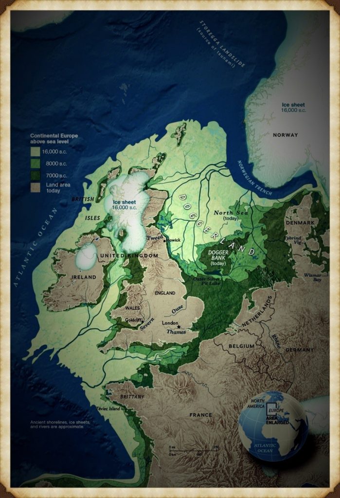
This is a journey through time looking at the prehistoric Maiden Castle Landscape based on the new third (2020) edition book of the best seller – that contains conclusive and extended evidence of Robert John Langdon’s hypothesis, that rivers of the past were higher than today – which changes the history of not only Britain, but the world. In his first book of the trilogy ‘The Post-Glacial Hypothesis’, Langdon discovered that Britain was flooded directly after the last Ice Age, which remained waterlogged in to the Holocene period through raised river levels, not only in Britain, but worldwide. (Maiden Castle through time)
Maiden Castle through time
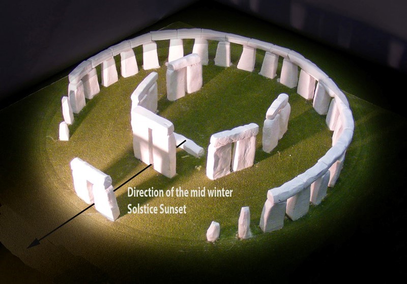
In this second book of the series ‘The Stonehenge Enigma’, he also shows that a new civilisation known to archaeologists as the ‘megalithic builders’ adapted to this landscape, to build sites like Stonehenge, Avebury, Woodhenge and Old Sarum, where carbon dating has now shown that these sites were constructed about five thousand years earlier than previously believed. Within the trilogy ‘Prehistoric Britain’, Langdon looks at the anthropology, archaeology and landscape of Britain and the attributes and engineering skills of the builders of these megalithic structures.
Including finding and dating the original bluestones of Stonehenge Phase I from the quarry of Craig-Rhos-Y-Felin in Wales, five thousand year earlier than current archaeological theory and how this civilisation used the sites surrounding Stonehenge at a time of these raised river levels. This unique insight into how the prehistoric world looked in the ‘Mesolithic Period’ allows Langdon to explain archaeological mysteries that have confused archaeologist since the beginning of the science and allows us to make sense of these sites, allowing us to understand their function for this society for the first time.
With over thirty ‘proofs’ of his hypothesis and one hundred and twenty-five peer-reviewed references – Langdon uses existing excavation findings and carbon dating to forward a new understanding of the environment and our ancient society, which consequently rewrites our history books and allows us to find more conclusive and persuasive evidence which is currently trapped in our landscape, ready to be discovered by future students of archaeology. Articles on this Trilogy and an Active FaceBook Group where you can leave comments and get feedback can be found at:
For active discussions on the findings of the TRILOGY and recent LiDAR investigations that are published on our WEBSITE, you can join our and leave a message or join the debate on our Facebook Group.
Unlocking the Mysteries of British Prehistory
Delve into the depths of time, as we embark on a captivating voyage into the enigmatic world of British prehistory. www.prehistoric-britain.co.uk is your portal to a treasure trove of archaeological wonders, modern LiDAR reports, and fascinating insights from the Robert John Langdon Trilogy. This immersive digital hub is your key to unlocking the secrets of Britain’s ancient past.
A Glimpse into the Robert John Langdon Trilogy
Step into the shoes of Robert John Langdon, a dedicated explorer of Britain’s prehistoric mysteries. His trilogy, comprising “The Stonehenge Enigma,” “Dawn of the Lost Civilization,” and “The Post-Glacial Flooding Hypothesis,” is a literary marvel that unravels the untold tales of our ancestors. These books take you on an exhilarating journey through time, meticulously researched and backed by over 125 references from esteemed scientists, archaeological experts, and geological researchers.
Dive into the World of LiDAR
At www.prehistoric-britain.co.uk, we harness the power of LiDAR technology to unearth hidden landscapes and archaeological marvels. Our LiDAR reports offer a modern lens through which you can peer into ancient history. Explore the effects of flooding on the British environment after the great ice age melt, a phenomenon that has shaped the landscape we see today. Join us in decoding the mysteries of our past using cutting-edge technology.
A Multimedia Experience
Our commitment to storytelling extends beyond the written word. Robert John Langdon has curated a rich multimedia experience, including a YouTube web channel featuring over 100 investigations and video documentaries. These visual journeys complement his classic trilogy, providing a multi-dimensional understanding of prehistoric Britain. From Stonehenge’s construction in 8300 BCE to the lost Stone Avenue at Avebury in Wiltshire known as ‘Silbury Avenue,’ these documentaries offer an immersive experience that brings history to life.
Explore the ’13 Things that Don’t Make Sense in Ancient History’
History is replete with anomalies and enigmas that defy explanation. Robert John Langdon has curated a collection of such historical curiosities in ’13 Things that Don’t Make Sense in History.’ These peculiar occurrences and unanswered questions will leave you pondering the mysteries of the past, inviting you to join the debate on their possible interpretations.
This is a journey through time (Mount Caburn through time) looking at the prehistoric Landscape of Lewes in East Sussex based on the new third (2020) edition book of the best seller – that contains conclusive and extended evidence of Robert John Langdon’s hypothesis, that rivers of the past were higher than today – which changes the history of not only Britain, but the world. In his first book of the trilogy ‘The Post-Glacial Hypothesis’, Langdon discovered that Britain was flooded directly after the last Ice Age, which remained waterlogged in to the Holocene period through raised river levels, not only in Britain, but worldwide. (Mount Caburn through time).
Video
Mount Caburn through time
The Stonehenge Enigma
In this second book of the series ‘The Stonehenge Enigma’, he also shows that a new civilisation known to archaeologists as the ‘megalithic builders’ adapted to this landscape, to build sites like Stonehenge, Avebury, Woodhenge and Old Sarum, where carbon dating has now shown that these sites were constructed about five thousand years earlier than previously believed. Within the trilogy ‘Prehistoric Britain’, Langdon looks at the anthropology, archaeology and landscape of Britain and the attributes and engineering skills of the builders of these megalithic structures. (Mount Caburn through time).
Including finding and dating the original bluestones of Stonehenge Phase I from the quarry of Craig-Rhos-Y-Felin in Wales, five thousand year earlier than current archaeological theory and how this civilisation used the sites surrounding Stonehenge at a time of these raised river levels. This unique insight into how the prehistoric world looked in the ‘Mesolithic Period’ allows Langdon to explain archaeological mysteries that have confused archaeologist since the beginning of the science and allows us to make sense of these sites, allowing us to understand their function for this society for the first time.
With over thirty ‘proofs’ of his hypothesis and one hundred and twenty-five peer-reviewed references – Langdon uses existing excavation findings and carbon dating to forward a new understanding of the environment and our ancient society, which consequently rewrites our history books and allows us to find more conclusive and persuasive evidence which is currently trapped in our landscape, ready to be discovered by future students of archaeology. (Mount Caburn through time).
Robert John Langdon has also created a YouTube web channel with over 100 investigations and video documentaries to support his classic trilogy (Prehistoric Britain). He has also released a collection of strange coincidences that he calls ‘13 Things that Don’t Make Sense in History’ and his recent discovery of a lost Stone Avenue at Avebury in Wiltshire called ‘Silbury Avenue – the Lost Stone Avenue’. (Mount Caburn through time).
Langdon has also produced a series of ‘shorts’, which are extracts from his main body of books:
For active discussions on the findings of the TRILOGY and recent LiDAR investigations that are published on our WEBSITE, you can join our and leave a message or join the debate on our Facebook Group.
Unlocking the Mysteries of British Prehistory
Delve into the depths of time, as we embark on a captivating voyage into the enigmatic world of British prehistory. www.prehistoric-britain.co.uk is your portal to a treasure trove of archaeological wonders, modern LiDAR reports, and fascinating insights from the Robert John Langdon Trilogy. This immersive digital hub is your key to unlocking the secrets of Britain’s ancient past.
A Glimpse into the Robert John Langdon Trilogy
Step into the shoes of Robert John Langdon, a dedicated explorer of Britain’s prehistoric mysteries. His trilogy, comprising “The Stonehenge Enigma,” “Dawn of the Lost Civilization,” and “The Post-Glacial Flooding Hypothesis,” is a literary marvel that unravels the untold tales of our ancestors. These books take you on an exhilarating journey through time, meticulously researched and backed by over 125 references from esteemed scientists, archaeological experts, and geological researchers.
Dive into the World of LiDAR
At www.prehistoric-britain.co.uk, we harness the power of LiDAR technology to unearth hidden landscapes and archaeological marvels. Our LiDAR reports offer a modern lens through which you can peer into ancient history. Explore the effects of flooding on the British environment after the great ice age melt, a phenomenon that has shaped the landscape we see today. Join us in decoding the mysteries of our past using cutting-edge technology.
A Multimedia Experience
Our commitment to storytelling extends beyond the written word. Robert John Langdon has curated a rich multimedia experience, including a YouTube web channel featuring over 100 investigations and video documentaries. These visual journeys complement his classic trilogy, providing a multi-dimensional understanding of prehistoric Britain. From Stonehenge’s construction in 8300 BCE to the lost Stone Avenue at Avebury in Wiltshire known as ‘Silbury Avenue,’ these documentaries offer an immersive experience that brings history to life.
Explore the ’13 Things that Don’t Make Sense in Ancient History’
History is replete with anomalies and enigmas that defy explanation. Robert John Langdon has curated a collection of such historical curiosities in ’13 Things that Don’t Make Sense in History.’ These peculiar occurrences and unanswered questions will leave you pondering the mysteries of the past, inviting you to join the debate on their possible interpretations.
The most extensive study of the ‘Dykes of Britain’ in historical field and modern day LiDAR investigation has been completed on Offa’s Dyke and has found ‘extensive and conclusive’ evidence that Offa’s Dyke was not constructed for ‘Defensive’ or as a medieval ‘Boundary Marker’. Moreover, the results have found that it was not built at the time of the Saxon’s and Offa – but thousands of years earlier. Below is an extract of the dvd video that accompanies the Trilogy of books on ‘Prehistoric Earthworks’ that will be published in the Autumn of 2021.
This new TRILOGY will include case studies of both Offa and Wansdyke – here is an extract from the Wansdyke Case Study
According to Wikipedia, “Wansdyke consists of two sections of 14 and 19 kilometres (9 and 12 mi) long with some gaps in between. East Wansdyke is an impressive linear earthwork, consisting of a ditch and bank running approximately east-west, between Savernake Forest and Morgan’s Hill. West Wansdyke is also a linear earthwork, running from Monkton Combe south of Bath to Maes Knoll south of Bristol, but less impressive than its eastern counterpart. The middle section, 22 kilometres (14 mi) long, is sometimes referred to as ‘Mid Wansdyke’ but is formed by the remains of the London to Bath Roman road. It used to be thought that these sections were all part of one continuous undertaking, especially during the Middle Ages when the pagan name Wansdyke was applied to all three parts.
East Wansdyke in Wiltshire, on the south of the Marlborough Downs, has been less disturbed by later agriculture and building and remains more clearly traceable on the ground than the western part. Here the bank is up to 4 m (13 ft) high with a ditch up to 2.5 m (8.2 ft) deep. Wansdyke’s origins are unclear, but archaeological data shows that the eastern part was probably built during the 5th or 6th century. That is after the withdrawal of the Romans and before the takeover by Anglo-Saxons. The ditch is on the north side, so presumably it was used by the British as a defence against West Saxons encroaching from the upper Thames Valley westward into what is now the West Country.
West Wansdyke, although the antiquarians like John Collinson considered West Wansdyke to stretch from south East of Bath to the west of Maes Knoll, a review in 1960 considered that there was no evidence of its existence to the west of Maes Knoll. Keith Gardner refuted this with newly discovered documentary evidence. In 2007 a series of sections were dug across the earthwork which showed that it had existed where there are no longer visible surface remains.
It was shown that the earthwork had a consistent design, with stone or timber revetment. There was little dating evidence, but it was consistent with either a late Roman or post-Roman date. A paper in “The Last of the Britons” conference in 2007 suggests that the West Wansdyke continues from Maes Knoll to the hill forts above the Avon Gorge and controls the crossings of the river at Saltford and Bristol as well as at Bath.
As there is little archaeological evidence to date the western Wansdyke, it may have marked a division between British Celtic kingdoms or have been a boundary with the Saxons. The evidence for its western extension is earthworks along the north side of Dundry Hill, its mention in a charter and a road name.
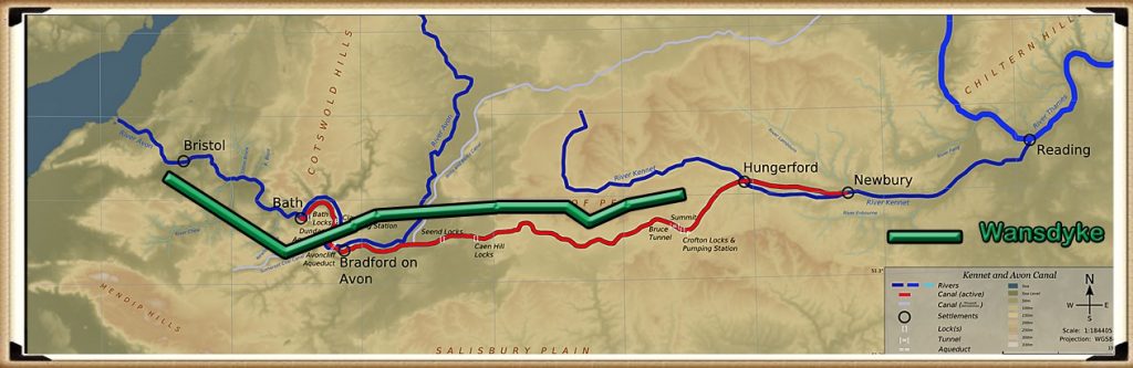
The location of Wansdyke in prehistoric times – in comparison to the Victorian canal – DYKES of Britain
Figure 10- Map comparing Wansdyke (green) to the Kennet and Avon canal
The area of the western Wansdyke became the border between the Romano-British Celts and the West Saxons following the Battle of Deorham in 577 AD. According to the Anglo-Saxon Chronicle, the ‘Saxon’ Cenwalh achieved a breakthrough against the British Celtic tribes, with victories at Bradford on Avon (in the Avon Gap in the Wansdyke) in 652 AD, and further south at the Battle of Peonnum (at Penselwood) in 658 AD, followed by an advance west through the Polden Hills to the River Parrett. It is, however significant to note that the names of the early Wessex kings appear to have a Brythonic (British) rather than Germanic (Saxon) etymology”.
Later scholars have often questioned the accuracy of the descriptions given by these antiquaries such as assertions that Wansdyke reached the Bristol Channel (Fox and Fox 1958) and even Asser’s statement that Offa’s Dyke ran from sea to sea (Hill and Worthington 2003 106). While some antiquarians were probably exaggerating the size of earthworks, we must be cautious of dismissing descriptions of the dykes from before they suffered the ravages of the Agricultural Revolution.
Some scholars went beyond merely describing the dykes and tried, often erroneously (with hindsight), to link them with known historical events like the Belgic invasions mentioned by Caesar or Caesar’s own invasion (Warne 1872 4-10; Guest 1883; Handford 1951 119-40). Among these early, rather speculative descriptions, the work of the Wiltshire historian Sir Richard Colt Hoare (1758-1838) stands out, not only in terms of the quality of his survey work but also his ability to differentiate between features of different dates, for example by realising that the central section of Wansdyke was actually a Roman road (Hoare 1812; Hoare 1821).1
Boundary Markers & Defensive Structures
The archaeologist Mortimer Wheeler produced an analysis of the dykes of southeast England and, like Fox, suggested that they were not primarily military structures but political boundary markers facing post-Roman Britons centred on London (Wheeler 1934 261).
Osbert Crawford’s 1953 book on Wansdyke analysis of the dykes as either military-political (with no clarification of what that meant in practice) or in respect of the coastal dykes (like Dane’s Dyke at Flamborough Head or the Cornish dykes) calling them beach-heads He also made no attempt to group what he termed defensive linear earthworks by period; in his list of them given as an appendix to his field archaeology guide, he includes prehistoric and Anglo-Saxon dykes together with undated earthworks (Crawford 1936 240-53). These shortcomings are easy to criticise now, though, at the time, Crawford’s work was exceptional.
The problem with Crawford’s work is that Wansdyke has a gap in the middle of the defence/boundary and no explanation for the lack of Dyke?
The ‘so called’ warring tribes of the Medieval period – DYKES of Britain
Figure 11 – Crawford Political Boundaries
One of the fundamental weaknesses of this earthwork as a defensive structure is the fact it just stops in a middle of a field on the Eastern side of the Dyke.
A series of excavations carried out by H. Stephen Green on Wansdyke in the late 1960s provided the first opportunity to apply both snail and pollen analysis to dyke studies (Green 1971). While the evidence for snails was largely inconclusive, the pollen samples (analysed by GW Dimbleby) suggested that central parts of the eastern half of Wansdyke passed through a pasture. The pollen evidence from the eastern end of Wansdyke suggested the presence of nearby woodland (Savernake Forest), though it did not prove or disprove the hypothesis that it was an impassable barrier that protected the eastern flank of the dyke, as Fox had postulated (Fox and Fox 1958).
There have sadly been very few excavations or thorough investigations of these dykes (remembering there are over 1000 dykes in Britain), one of the earliest excavations was overseen by Lieutenant-General Pitt Rivers, who excavated Wansdyke at Shepherd’s Shore, Devizes.
Although most of the findings and accounts lack scientific accuracy, we find some aspects that support the dating of dykes earlier than the current ‘expert’ theories of Saxon Britain. In one of his cuttings through the ditch and bank he noted that “At Wand’s house, there is a break in the line of the Dyke, which is occupied by the site of the Roman station of Verlucio, where quantities of Roman pottery are scattered on the soil”.
Pitt-Rivers also found vast amounts of pottery and iron nails in the bank of Wansdyke further down the earthwork. Isn’t it more likely, that the Romans placed their settlement actually on the Dyke as it may have still held water two thousand years ago and, looking at the positions of the findings, actually cleaned it out, which would allow them to take and receive supplies by boat to and from the river Kennet? Moreover, he noticed that at Sandy Lane and the Roman settlement in Spye Park – the river was still running inside the Dyke!
Stukeley’s map of Morgans Hill – DYKES of Britain
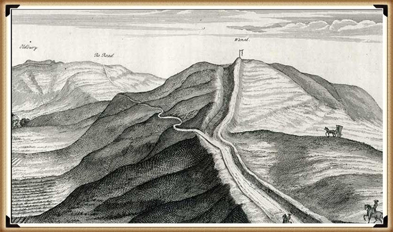
Figure 12- Stukeley’s Map of 1724 showing the Roman road ‘sitting on top’ of the Wansdyke ditch
In fact, within his excavation of the dyke we noted that:
“Very little ‘silting’ had accumulated on the escarp, but in the ditch, it had collected to a depth of about 3 feet in the centre” – showing that the main purpose for the dyke was to take water like a canal.
The final proof of the fact that the Dykes predate the Roman invasion can be found strangely with empirical evidence from a drawing produced by the first British archaeologist William Stukeley in 1724. The Roman road is clearly made on and above the Wansdyke ditch and then cutting through the Dyke’s bank – this is impossible to do if the bank and ditch were built AFTER the road (archaeologist and historians, please take note!!).
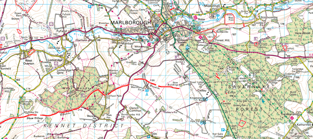
If we look at Wansdyke on an OS map, to the East, the ditch ends in the middle of nowhere, just before the forest of Savernlake. The question that archaeologists fail to answer is ‘why stop there’?
If you continued another 6km, you would have reached water – a natural boundary (remembering you have already cut 19km), or just turn south, and that’s a mere 3km. To the west, it’s even worse, you could go south again and connect to the river, using that as a natural defensive boundary, but no – it just stops dead.
If you were to attack the ditch, you would be mad – as you just walk around it as the German’s did on the Siegfried line at the outbreak of World War II.
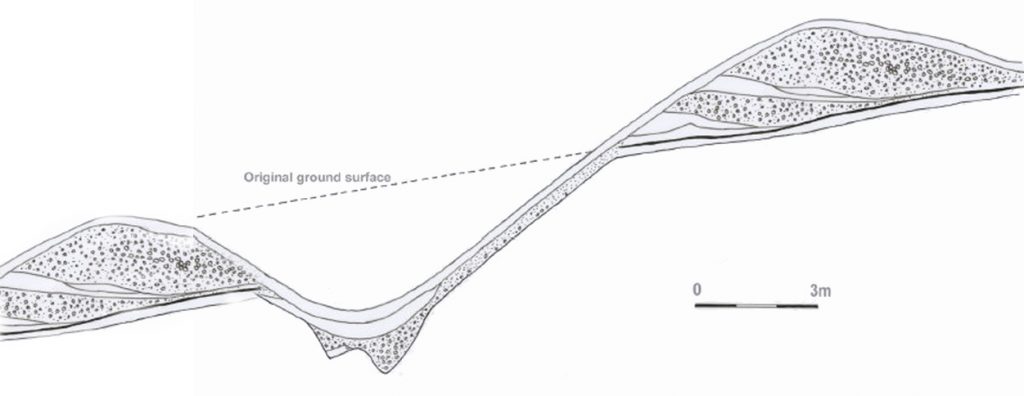
The final proof of that the ditch is not defensive can be found in its method of construction. Going back to the work of Pitt-Rivers, he produced a series of detailed cross-sectional drawings to support his investigation. These drawings showed two significant findings: firstly, the ditches fill was spread over both sides of the ditch (one side slightly more than the other) – you would not do this if it’s a defensive feature as you would want all the ‘high ground’ on your side to help defend. This kind of slightly even distribution we see on Iron Hill ditches and other featured sites such as Durrington, Stonehenge, and particularly Old Sarum. In fact, the only site we don’t see this happen is at Avebury.
Savernake Forest – DYKES of Britain
Figure 13 – Wansdyke East section just stops – the forest would not have been there during Roman times and hence the roman road going through the centre
Secondly, and most importantly, the bottom of the ditch is flat, again just like Stonehenge, Avebury and Durrington – it could also be Old Sarum, but sadly nobody has done an excavation of the ditches to date.
Pitt-Rivers cross section -DYKES of Britain
Figure 14- Pitt-Rivers cross section shows ditch fill spread on BOTH sides – so not defensive
You do not make the bottom of a ditch flat if used as a defensive ditch or a land marker (you’re doubling the time it takes to make a ditch). On Pitt-River’s excavation plan, the flat bottom is a third of the width of the ditch.
The Kennet and Avon Canal (Fig. 93) is a waterway in southern England with an overall length of 87 miles (140 km), made up of two lengths of navigable river linked by a canal. The name is commonly used to refer to the entire length of the navigation rather than solely to the central canal section. From Bristol to Bath, the waterway follows the natural course of the River Avon before the canal links it to the River Kennet at Newbury, and from there to Reading on the River Thames. Quite remarkably, Wansdyke was constructed just 3 km north of the Kennet and Avon canal. If it was a prehistoric waterway, it would have achieved the same purpose of joining the River Thames to the Bristol Channel but some 6-8K years before the Victorian’s great canal system.
Now let us consider the human resources it needed to create such a structure. At 33 km in length (33,000m), its volume can be calculated as about 618,750 cubic metres of chalk (if it is 2.5m deep and 7.5m wide as an average). This is the approximate volume of material removed from the ditch. This is five times more than what was excavated at Avebury and two and a half times larger than Silbury hill. So, according to Atkinson’s calculations at Silbury Hill, we are looking at 45 million working hours, which equates to 100 people working for 12-hours every day 365 days a year for 102 years.
It took the Victorians one hundred years to build the Avon & Kennet Canal using metal tools and steam engines. Moreover, the Victorian canal was only 1.3m deep and 6m wide – the ancient canal ditch is in places twice as big as the Victorian counterparts. So, whoever built it must have spent many years completing this task – which suggested it was essential at the time of construction.
If you study a geological map of this area, you will be struck by the endless twisting rivers that once flowed on and around the Wansdyke earthwork. These are called ‘superficial deposits’ and consist of sand, silt and pebbles. This is evidence that ‘once upon a time’ rivers formerly flowed in these what we call today’ dry valleys’ (Palaeochannels), and the clue just like the name for these earthworks (Dykes) is in the title.
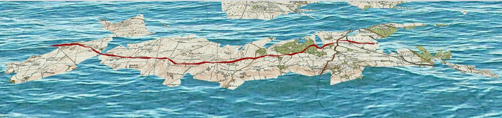
If we add the known prehistoric groundwater rivers (based on our hypothesis) to the map of this great ditch, we find that springs would feed the ditch naturally, flooding it – and there you have yourself a canal. This 21-mile canal links (just like the Avon & Kennet) the river Thames to the Bristol Channel. And there can be only one reason for this massive undertaking (boat travel for the purpose of trade) just like the Victorian ancestors would achieve some six to eight thousand years later.
However, the most miraculous revelation about these Dykes is the fact that the builders had a greater knowledge of hydrology than even today’s engineers and geologists, for the weakness and final demise of the canal system in Britain was the fact they were very slow (the Victorians had to build at least one lock per mile of the canal to keep in the water high) the Kennet and Avon have over 100 locks. The original prehistoric channel had none as it relied on the natural groundwater table levels to fill the canal. Therefore, it was straighter and shorter in length than the Avon & Kennet, which would have allowed them to travel from the Thames to the Bristol Channel almost a hundred times faster than the Victorian barges.
Moreover, if you find this difficult to believe, you should bear in mind that there are over 1,000 dykes in Britain; a majority, 90%, are straight and less than 1km in length. To date, every single dyke we have investigated has underground links to these prehistoric rivers created from the ‘post-glacial flooding’ after the last ice age.
Furthermore, some of these Dykes are linked to ancient sites directly, as shown in this case study confirming the age of these earthworks. For if we add the known prehistoric groundwater rivers, we find out why this remarkable canal has two dead ends. For West side of the dyke is in the middle of a prehistoric island, which perfectly cuts the island into two and would allow boats to sail from one end of the island to the other in the Mesolithic. At a later date, an extension was added (as the water table levels dropped) to keep it connected to the Bristol Channel in the Central and West Section.
This explains why the Central section is different and straighter than the Eastern section of Wansdyke and is often referred to as a ‘Roman Road’ on OS maps. Moreover, it proves beyond doubt that it was not built as a boundary marker of a defensive ditch as it would have had a 6-mile gap in the middle of the earthwork.
This Dyke was built over hundreds if not thousands of years, which reflects not only the engineering and organisational skills of this advanced civilisation but, moreover, the sophistication and complexity of this trading society.
Figure 15 – East Wansdyke was an island in the Prehistoric Period with section analysis to follow – DYKES of Britain
East Wansdyke Maps in Detail (from East to West)
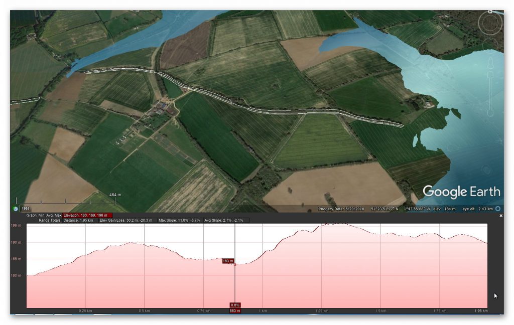
Section 1 – North Savernake to Gore Copse– 1,995 metres long (6,650 working days – 20 men, 333 days).
East Wansdyke (section 1) with Cross Section -DYKES of Britain
Figure 16 – Wansdyke NW of Wernham – with Mesolithic Water Levels
No information is available from Historic Monuments England – no survey or excavation has been undertaken.
East Wansdyke OS series – DYKES of Britain
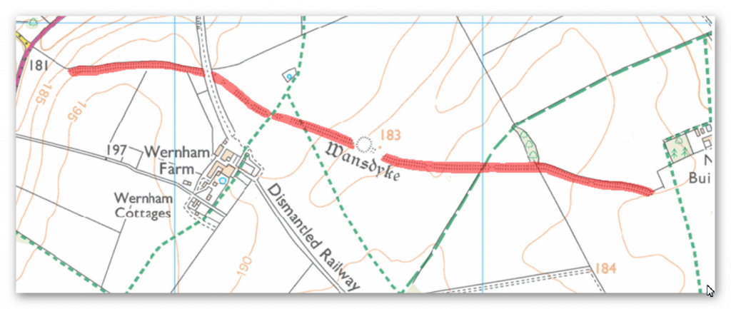
Figure 17 – Current OS Map
East Wansdyke 1800 map series – DYKES of Britain
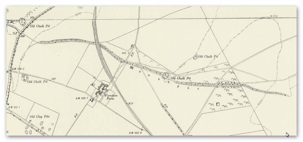
Figure 18 – 1800 map
BGS Geological Map – DYKES of Britain
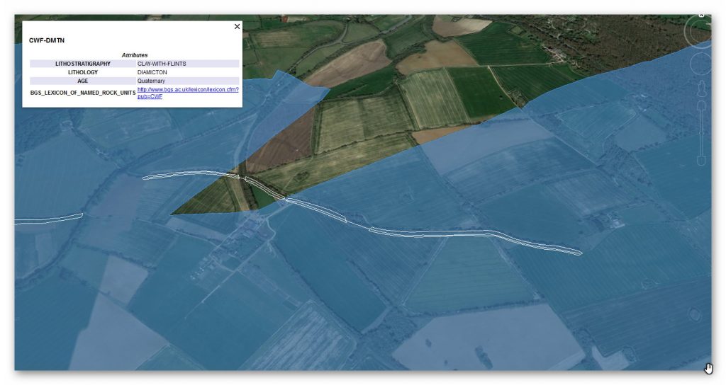
Figure 19 – Geological Map showing ‘Clay with Flints’
The maps tell us very little, sadly, except that the subsoil of clay with flints is ideal for canals and water retention – so even if the water table fell, the clay would and could be used like a dew pond as a liner for rainwater retention. We estimate at a rate of 0.3m per day this section of the Dyke would have taken 6,650 working hours to construct or 20 men working 333 days – this is based on one man cutting 0.3m per day (Ditch down to 2m and bank) although Fowler used 0.1423 metres per hour and claimed 1,000 men built the ENTIRE East Dyke in 30 days working 10-hours a day 6 days a week??
This ridiculous claim I have discounted as even with modern tools, it would be too demanding, and the logistics of feeding, mending tools and housing 1,000 men was not taken into account. Therefore, we have used a more reasonable number of men (20) ‘digging’ as you would probably need double that number to feed and maintain and clear (it was mostly woods and forests in the past) in front of the diggers.
Quarry Pit
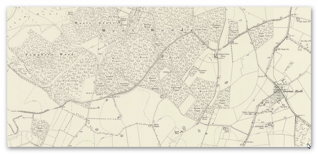
On fig 18. A feature called ‘firs’ is a gap on the OS Map – there is a strange quarry pit (no relevant substances under the surface to quarry?) – this pit, as shown in Fig. 16, is two metres deep and probably built at a later date to the original ditch. Are we looking for a hole to find the groundwater to keep the canal working with fresh water? As we will discover, this is not the first pit cut deep on the line of Wansdyke.
Figure 20 – Water at the top of one of the highest places of Wansdyke – and yet defying public opinion it doesn’t run down the hill to the valley?
Section 2 – Gore Copse to Shaw Farm, 4,325 metres long (14,416 working days – 20 men, just under two years).
Wansdyke section 2 with cross-section – DYKES of Britain
Figure 21 – S of Furze Hill to Marlborough – Pewsey Roads
Figure 25 – View of Wansdyke kinking at right angles for no apparent reason
No information is available from Historic Monuments England – no survey or excavation has been undertaken.
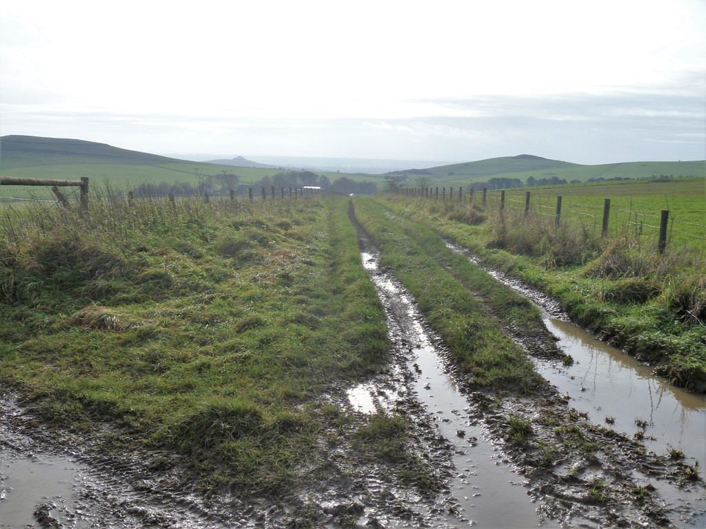
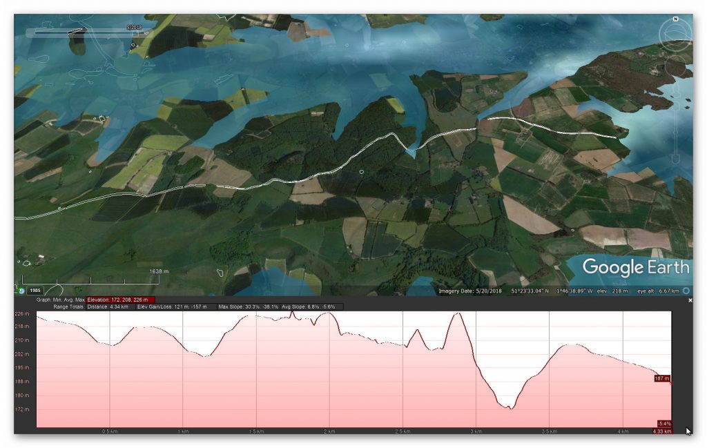
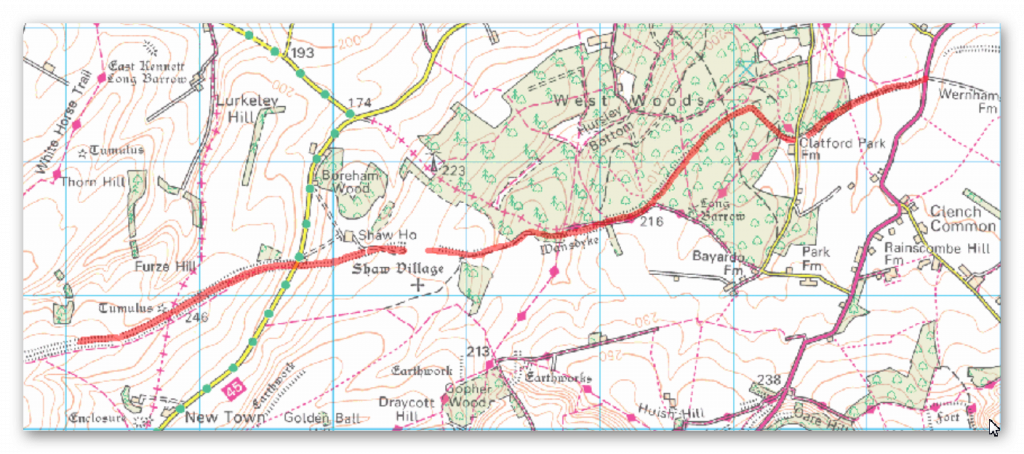
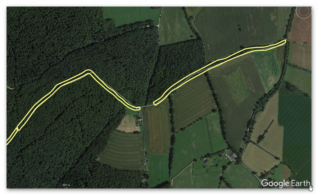
What is clear from the route of this section of Wansdyke is not straight at all – in fact, it works against the topology to bend at 90 degrees in some place and dip down unnecessarily into a valley rather than taking the high ground. Moreover, it heads into a forest that would be impossible to see as a marker, and as a defensive earthwork would be negated by the overhanging trees?
Google Earth Map of Section 2 – DYKES of Britain
Figure 26 – The line of Wansdyke is not remotely straight
But this wild undulations into valleys also causes problems for my hypothesis as a canal. How could a canal move up and down significant gradients without locks?
Well, the answer obviously is that they can’t – but the answer to this problem is in the detail, for if you look again at this part of Wansdyke going into an old dry river valley, you see something archaeologists miss – it stops!!
We saw from the transition from the first part of Wansdyke to the second a gap, which looks like a piece filled in by farming; there were two other gaps the first was a later road cutting through and then a railway doing the same.
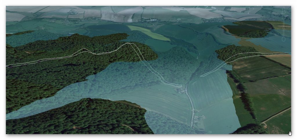
Figure 27 – Dry River valley would have been flooded – so boats went across not down
On the Dry river valley aspect of this part of the canal has a massive gradient if it went to the bottom and would make moving a boat very difficult. But what we do see is evidence of the dyke stopping before reaching the bottom. This also discounts both this earthwork as a marker and especially as a defensive feature.
The termination of this feature and at what point is at best a guestimation as no excavation work has been undertaken on this part of the Dyke. Moreover, this dry river valley in prehistoric times would not be ‘dry’ but full of water as shown in the illustration (Fig.25).
This would make sense to the termination on the right as it would initially end at the shoreline of the river. If this was the case, the simple answer to the problem is that at that point, you took the boat across the river, so the gradients are small to non-existent.
But why is there a continuation of the Dyke down the valley?
This can best be answered by understanding what happened to this earthwork once the waters started to fall in the Neolithic Period.
Logically, as the waters fell, the ditch would have been extended to meet the lower water level until the slope was too extreme to continue and was abandoned. Later once the river had completely dried up (and consequently the rest of the Dyke as the water table would have universally fallen), the natural road (the bank of the Dyke) would be used as a road.
Excavations of similar features (also contained in this book) have shown that the bank reduced in height and become flattered like a road and hence wider. To use this road on a permanent basis, the builders adapted the dry river valley element (which would still be boggy for many centuries after the river disappeared) by adding to the bank by removing soil from the ground – but on both sides, making the ditch element smaller and more shallow than the rest of the Dyke and to both sides.
The result of this work looks like a loss of the deep ditch but is more likely a change in its structure – which again is seen clearly on parts excavated in other Areas and dykes but impossible to see her without excavation.
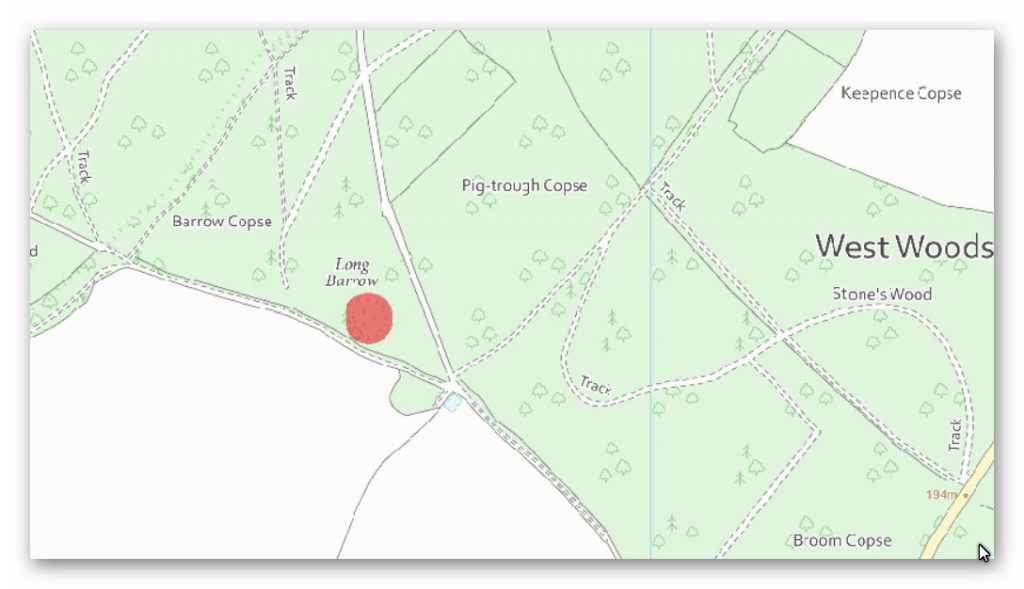
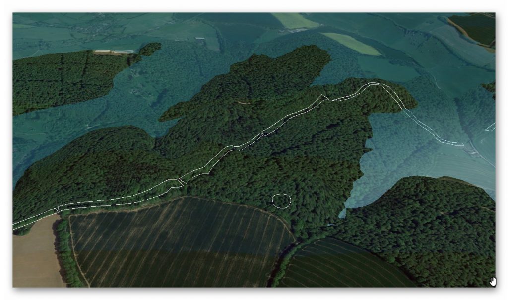
Long Barrow
GE view of Section 2, Long Barrow – DYKES of BritainOS Map of Section 2, Long Barrow – DYKES of Britain
Figure 28- Wansdyke section 2 Long Barrow
An interesting associated feature can be found just 200m south of Wansdyke section 2, a Long Barrow.
“The monument includes a long barrow set above the floor of a dry valley in an area of gently undulating chalk downland. The barrow mound is ovate and orientated east-west. It is 40m long, 27m wide and stands to a maximum height of 3.5m. Flanking the barrow mound to the north and south are ditches from which the material used to form the mound was quarried during the construction of the monument. These survive as earthworks 8m wide and 1m deep” – Historic England
What should be noted is it’s ON THE SHORELINE of the ‘Dry Valley’ as shown from the suggested water level on our illustration. This is reflected by the ‘track’ that mimics the shoreline from the water. We can also see that at a later date, the Dyke was used for the same purpose of bringing the bones of the dead from a reincarnation site to the Long Barrow.
This confirms the river levels at the time of construction and the previously speculated gap in Wansdyke by the river valley top.
Flint Pits
Another interesting feature near the Dyke is the ‘Old Flint Pits’ as a feature on the 1886 edition of the OS map but not recorded by Historic Monuments Dept.
OS 1800s Flint mines – DYKES of Britain
Figure 29 – Old Flint Works in red
As this location is over 3-miles from Marlborough with plenty of open space closer to the town to obtain flint for the Middle Ages – I would expect these relative close works and activities to relate to the time of Wansdyke.
Section 3 – Shaw Farm to Milk Hill (North), 3,821 metres (12,737 working days – 20 men, 1.74 years)
GE Section 3 Map with Profile – DYKES of Britain
Round Barrows
OS 1800s Round Barrows – DYKES of Britain
Figure 30 – Wansdyke section 3 – Round Barrows
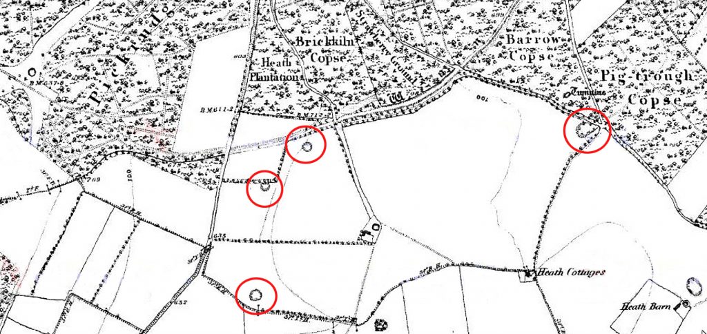
Amazingly, along a strip between New Shaw Farm and Red Shore we find a series of barrows of which only one still exists.
The monument includes a bell barrow set below the crest of a steep north-east facing slope in an area of undulating chalk downland. The barrow mound stands to a height of 0.5m and is 20m in diameter. The surface of the mound comprises large flint nodules, and some worked flint. Surrounding the mound is a ditch from which the mound material was quarried. Although this has been infilled over the years and is no longer visible on the ground, it survives as a buried feature c.3m wide. Partial excavation of the barrow mound in 1970 produced cereal pollen grains suggesting early cultivation of the area. – Historic England
The OS map of the 1800s show this bell barrow as the last of the four nearest the Farm – the other three have clearly been ploughed out over time. What is of significant importance is the fact that Wansdyke and the barrows follow the same path, which gives us a chicken and egg scenario – what came first?
According to the ‘experts’ as these barrows are prehistoric in date, did the builders of the Dyke decide to cut this ditch by their side for reasons unknown? Or is it more likely that the ditch existed first and the barrows were constructed after the completion of the works?
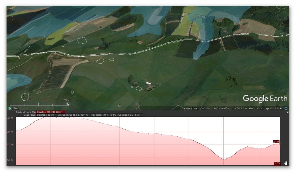
If we look at the satellite map – during the dry season do, we get a glimpse of these features still on the ground? (Fig.31)
GE Section 3 Round Barrows – DYKES of Britain
Figure 31 – Satellite view of the Round Barrow and possible map locations
What is even more interesting are the locations of these Round Barrows to the ancient shorelines of the dry river valley showing this to be a site of prehistoric interest as to the south of the 1800 OS map (fig. 29) is a line of large stones – were these standing stones?
What is quite clear the builders either twisted their Dyke around these features or the most likely possibility – they were built after the Dyke was constructed as it was the natural transport to these places when the waters receded in the Neolithic Period.
GE Section 3, unknown earthworks – DYKES of Britain
Figure 33 – Three Unknown Earthworks and Two Bronze Age Barrows
Further down this stretch of Wansdyke we find two further Round Barrows.
The (northern) monument includes a pair of bowl barrows aligned north east to south west and situated 150m north of the Wansdyke on All Cannings Down. They were originally part of a small group of three barrows situated close together. The exact location of the third barrow is not known. The barrow mounds have been reduced by cultivation and now form a single spread of material c.16m east-west and 14m north-south standing up to 0.2m high.
However, it is known from aerial photographs that both barrows originally had mounds measuring c.12m in diameter. These were surrounded by quarry ditches from which material was obtained during their construction. These merged together between the two mounds and will survive as buried features c.2m wide. In the late 19th century two sherds of Beaker pottery and nine sherds of Bronze Age pottery were found on the site of the barrows. These are now in the Devizes Museum. Excluded from the scheduling is the post and wire fence which runs north-south across the eastern edge of the monument, although the ground beneath is included. – Historic Britain
This (southern)monument includes a disc barrow situated on the upper north facing slopes of a prominent, wide, plateau-like ridge and immediately south of part of the Wansdyke. The barrow survives as a central circular mound of 10m in diameter and 1m high, surrounded by a 6m wide berm, with a 4.2m wide and 0.3m deep ditch and an outer bank of up to 4.5m wide and 0.7m high which is preserved differentially. To the south the ditch and outer bank are preserved as buried features, and to the north the ditch and bank have been cut by a track (not Wansdyke ditch), whilst all the remaining features are clear and intact earthworks.
Again, we see that Wansdyke kinks to either meet the Disc Barrow or that the barrows was built after its construction – proving that it was constructed by the Bronze.
Section 4 – Milk Hill (north) – Sheppard’s Shore, 3,460 metres (11,533 working days – 20 men, 1.58 years)
GE Section 4 Cross Section – DYKES of Britain
According to Historic England, this section – includes a Neolithic long barrow, five other linear earthwork sections crossed by or abutting the dyke and 11 Bronze Age bowl barrows adjoining Wansdyke or partially overlain by it.
The dyke includes a substantial earthwork bank that measures up to 30m wide and stands from 1m to 3m high. For the majority of its length, the bank lies south and west of a substantial open ditch. This also varies in width but measures up to 36m wide and remains open to a depth of 2m in places. The majority of the bank and ditch sections in this area together measure from 30m to 40m across.
There are six further bowl barrows along the length of Wansdyke from East of The Firs to the eastern side of Tan Hill, which are partially overlain by the dyke. These barrows vary from 10m to 20m in diameter and stand up to 3m high. Several barrows near Old Shepherds’ Shore were partially excavated in the 1850s, and finds included burnt animal and human bone and fragments of Bronze Age pottery.
As we go further down this road, more feature answers some of our questions.
GE Map of Section 3 split earthworks – DYKES of Britain
Figure 34 – Wansdyke splits to meet paleochannels and gains a facility?
Fig.34 resolves most of the conjecture on what Dykes are for and why they were constructed. The Dyke now splits north and south – but why?
If it was a boundary marker, what is it marking out? If it is defensive, why stop just a few metres heading BOTH ways – what are you defending??
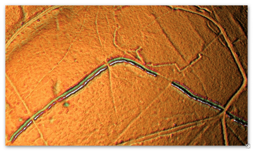
The picture shows a satellite picture during a dry period in this area – consequently, the paleochannels (ancient water channels that are normally unseen in the ground are very visible. Remarkably what we see is that the ditches of Wansdyke meet up with these channels and shows Wansdyke had a junction where boats could leave and join.
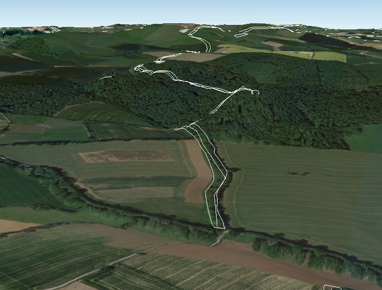
The deep cuts to the south (not considered to be part of Wansdyke are ancient and are currently used as footpaths. Moreover, another large ditch (not on the Historic England schedule) disappears into the old Paleochannel river (Fig. 35)
OS Map of northern connecting dyke – DYKES of Britain
Figure 35 – Map showing the deep ditches now paths and a massive ditch going from Wansdyke
GE Map of Northern connecting dyke (looking south – reverse view) – DYKES of Britain
Figure 36 – Ditch on OS Map (fig.35) heading for the paleochannel – reverse view
Moreover, this ditch enters not only a watery Paleochannel but also a source of massive Sarsens Stones (Fig.37). The old OS maps show that once these stone was abundant in the local Paleochannels from the last Ice Age – the easiest way to transport them would be by boat via Wansdyke?
Figure 37 – 1800 map showing Sarsen Stones in the dry river valley next to the ditch connecting it to Wansdyke
A small dyke appears strange coming off Wansdyke a couple of hundred metres later.
OS Map of small off-dyke – DYKES of BritainGE Map of small dyke – but much larger than the OS map – DYKES of Britain
Figure 38 – Small dyke off Wansdyke – which is far more complex than the OS map or Historic Monuments have to date discovered .
Another ditch feature that joins Wansdyke at Tanhill.
OS Map of Tanhill fair – DYKES of Britain
Figure 39 – Tanhill Fair – complex earthworks
What we see here a very complex series of ditches that join Wansdyke and go down into the Dry River Valley. This looks like a major terminal for Wansdyke and a possible trading site with Ditches allowing boats to moor.
Moreover, historically (Aubrey recorded that in the 17th century, the fair was held “within an old camp”), this has been a trading side since Medieval times and had its own white horse.
Tanhill Fair showing the canal network in the snow – DYKES of Britain
Figure 40 – Tanhill Fair showing a supplementary ditch that connects to Wansdyke in two places and goes down into the river valley
This picture shows the extent of the ditch works at Tanhill Fair; not only does it go much further in both directions than the Historic Monument scheduled monument register suggests, but it connects in two places to Wansdyke and a further cut to the top of the old Tanhill Fair site.
Again, this shows that Wansdyke was not defensive or a marker in the landscape as this feature (which as it connects to the main dyke) not recognised as part of Wansdyke, but clearly is contemporary and can only be for the transportation of boats via a canal.
Section 5 – Sheppard’s Shore – Morgan’s Hill, 5,290 metres (17,633 working days – 20 men, 2.41 years)
GE Map section 5 with Profile – DYKES of Britain
Figure 41 – Section 4 profile
Morgan Hill Kink
GE Map – Morgan Hill ‘Kink’ – DYKES of Britain
Figure 42 – Morgan Hill East ‘kink’
To the East of Morgan Hill is found a bizarre Kink in Wansdyke. This is best seen on an OS map which shows not only this strange direction but the obstacles it avoided.
OS Map Morgan Hill East with Barrows – DYKES of Britain
Figure 43 – Morgan Hill East – Kink
From the topology of the hill – there is no reason to ‘Kink’ to the right, then take a tight 90-degree turn to the left – then left again (rather than continuing), then right turn to get back in line again?
This discounts the fortification idea as it goes downhill, making it lower from its height advantage and then takes two turnings (and a hell more work) to get back online – almost 100% more time and effort. This obvious also excludes it as a marker for the same construction time and resource reasons.
Moreover, again it does help us date this feature as Round barrows are surrounding this kink on both sides. So, are we saying that the builders (if it younger than the Bronze Age) went around the Barrows rather than over them?
Or is it now clear that the Barrows we created at a later date to match the contours of the Dyke?
Branch off Wansdyke
Missing off all OS maps at the top of Morgan Hill is a branch going North and down to the Mesolithic Rivers of prehistory. This feature is captured by Historic England: Cross ridge dyke on Morgan’s Hill –
The monument includes a 560m long section of a cross ridge dyke situated on Morgan’s Hill. The dyke runs from NNW to SSE across the east-west aligned ridge, dividing Morgan’s Hill into two parts. The dyke has a bank c.8m wide and up to 1.5m high. To the East of the bank lies an 8m wide ditch which provided material for its construction and enhanced the effectiveness of the boundary.
This has been partly infilled by cultivation but is open to a depth of 0.3m in places, and is visible on aerial photographs. The bank and ditch are interrupted by a number of openings through which animals and people could pass. It is not clear how many of these are original.
A further section of the dyke, situated to the south is crossed by the Wansdyke which is later in date. This further section is the subject of a separate scheduling. Excluded from the scheduling are the post and wire fences which cross it and run along its length, although the ground beneath is included.
GE map of Morgan’s hill with branch (white) down hill – DYKES of Britain
Figure 44 – Branch off Wansdyke
OS Map of morgan’s Hill West showing more branches – DYKES of Britain
Figure 45 – Morgan’s Hill West with another Branch and where stukeleys drawing was taken (Fig. 12)
Both have a bank and ditch and meet on top of Morgan’s Hill – they are one of the same but probably made at a different date. Interestingly, a paleochannel cuts through the Dyke, and that part is missing showing that this section of the Dyke is ancient (Early Mesolithic?)
East Wansdyke was built across chalk, yet excavations suggest that the builders kept the turf taken during the digging of the ditch to one side and used it to cover the bank; this stabilised the bank but also meant that it did not stand out as a white line across the green downland (Green 1971 87 32-33) and yet more reasons for this not to be either a boundary marker or defensive ditch.
If we look north from Morgan’s Hill (Fig. 45), we can see in the landscape features from satellites that Wansdyke turned north and followed the Roman Road and was met by another ditch from the main Wansdyke canal. This confirmed by the presence of Round Barrows to the right and by the raised river shorelines (top of picture), which the Roman used as an existing platform bank for their road so time later.
Figure 46 – Two more junctions off Wansdyke heading north past round barrows
West Wansdyke
We have a problem with West Wansdyke – it’s not part of East Wansdyke. This has always been a historical debate over the last 100 years. If we look at the limited archaeological evidence, then we find that although it may have been a much later canal/Dyke it is not contemporary with the East Wansdyke canal and was not built at the same time.
Figure 47 – Dyke Feature as shown in Table
Excavations conclusively show that the Ditches on the East side of Wansdyke are much deeper and twice as wide. In contrast, the Banks on the East Side are much wider. What I think we see here is that East Dyke was clearly built first, as our River Height model shows that most of West Wansdyke would have been flooded or marshland at the time of use.
When the waters receded, it is possible that the Dyke was extended or the more probable event of East Wansdyke after it dried up was turned into a roadway and what we see in West Wansdyke is the extension of the roadway, and hence it is wider than in the East.
We also see more shallow ditches as they were not used for water but to obtain soil for the walkway and become a drainage ditch.
Certainly, we know this was used by the Romans as a road, and they always had drainage ditches, usually on both sides. This is support by carbon dating at Erskine’s excavation at Blackrock Lane, where the section appeared to have been sealed by the primary bank material. One of these layers contained significant concentrations of woody oak charcoal.
Samples of this material were submitted to the Ancient Monuments Laboratory for radiocarbon dating in order to provide a possible construction of the bank. As shown in the table below – sadly as normal when scientific evidence disproves the current archaeological narrative – it is ignored and classified as an error.
Figure 48 – Wansdyke West – showing it to be Prehistoric
The other missing aspects are shown in East Wansdyke and not West Wansdyke was the massive connection to Barrows and Flint Pits. This connection is not seen on West Wansdyke, which again may help date this monument as the barrows were of Bronze age or earlier and as we have seen from the carbon dating evidence at Blackrock Lane much earlier than its 1500 BCE date.
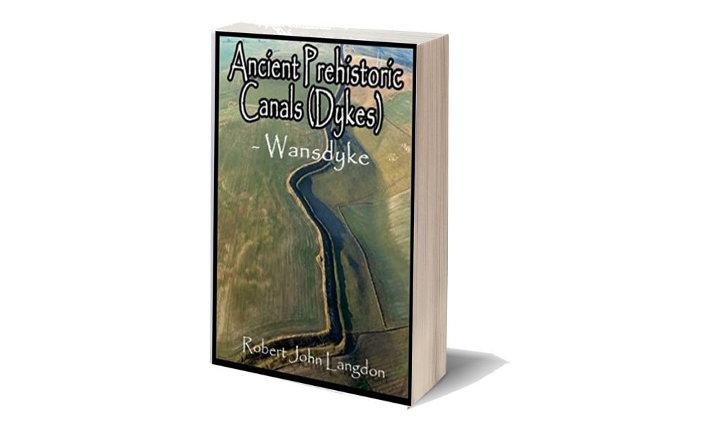
This was an extracts from the NEW Book Ancient Prehistoric Canals (Dykes) – Wansdyke available on Amazon as a FULL COLOUR HARD BACK (£19.95) or a ECONOMY (£4.99) SOFTBACK black and white VERSION – it is also available as a KINDLE (£1.99) book. For further information about our work on Prehistoric Britain visit our WEBSITE or VIDEO CHANNEL.
Product details
ASIN : B0BF31GQKC
Publisher : Independently published (18 Sept. 2022)
The exact time and circumstances of when our Ancient Mariners took to the waters of Northern Europe is unclear to both Archaeologists and Historians alike, although they are aware that the materials used to build the earliest boats, such as wood and reed, have been about since the dawn of time. However, until the experts dig up physical proof in the form of a complete ship, they will resist the temptation to accept that ten-thousand-year-old boats existed and accept an earlier date than the oldest partially constructed boat, dated 4,000 years old, found along the banks of the Humber at Ferriby near Hull in 1937. (The Ancient Mariners).
In recent years, some more enlightened archaeologists have started to accept earlier dates for boat construction, as they recognise that the ‘dating’ for ancient sites in Ireland and the Scottish Isles are far older than the remains found in Hull, and therefore, some boat must have existed at an earlier time with the remains having yet to be discovered. If the radiocarbon dating evidence used in Ireland is correct, it will show conclusively that sea travel must have been invented a further four thousand years earlier than the Ferriby discovery in a period called the Mesolithic dated around 6,000 BCE if not before.
As a compromise, historians now imagine that these earliest boats were probably not constructed of wood or reed but a design consisting of an oval shape similar to half a walnut shell, with the structure made of a framework of split and interwoven willow rods tied with willow bark. The outer layer was originally an animal skin such as horse or bullock hides with a thin layer of tar to be thoroughly waterproof. This type of boat is called a ‘Coracle’ and is still used in parts of Ireland and Wales to travel over small rivers and placid lakes.
Coracle would not get across the Irish Sea – The Ancient Mariners
The problem with this mad idea is that no respectable seafarer would attempt to paddle’ across such harsh waterways such as the Irish Sea with twenty-foot waves (on a good day) in such a flimsy craft unless they were either insane or had decided to set sail on their final voyage!
Another oversight by archaeologists is that the first mariners did not have maps or any idea of anything that existed over the horizon, especially when you realise that Dublin (the nearest point to Anglesey from Wales) is 55 nautical miles away way beyond ‘naked eye’ visibility. The only other route to Ireland would be to ‘hop scotch’ 85 miles along with the Scottish Islands on the West Coast, which will still leave you with a 12-mile paddle across the Irish Sea. The other dilemma for historians and archaeologists is that most prehistoric remains in Ireland are not where you would expect them in the North East or East – the closest shoreline to Scotland and Wales. But in the SW region, over 250 miles further away from where the first Irish settlers are supposed to have landed, with little to no sites showing historical movement in-between. (The Ancient Mariners).
You’re seriously going to sail that across the Irish Sea?? – The Ancient Mariners
But most importantly, what was the motivation to set sail to an unknown point over the horizon in the first place?
Anthropologists estimate that in 6 000 BCE Britain was occupied by bands of simple ‚hunter gatherers’ armed with spears chasing wild pigs and picking berries. This population was estimated to be a mere 50,000 people on an island of 120,000 sq. miles – giving every man, woman and child on average the freedom to roam 2.5 sq. miles each to hunt and pick fruit and roots their heart’s content. Remembering everything in those days was free, and land ownership was another four thousand years time.
So why risk your life to travel to another place when you have no idea if it even exists or is habitable?
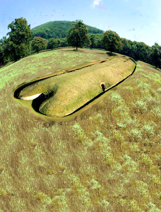
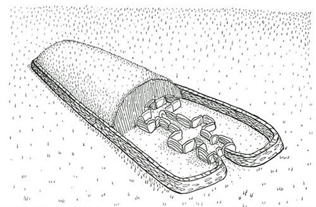
The reality is that the first mariners were exploring our seas and shorelines in a more substantial and suitably designed craft, long before historians are leading us to believe. Any mariner’ worth his salt’ can see this reflected in the hills of Britain with ancient monuments called a ‘Long Barrow’ if he knows what to look for – they are over 100m long, 20m wide and had a chamber covered with chalk or soil, so it sat some 4m – 5m high. It has two moats on either side of a ‘wedge shaped’ sloping mound, with the larger end to the rear and the chamber entrance. Long Barrows has always been the archaeologist’s greatest mystery and appear in abundance on most ordinance survey maps, denoted by a small oval black star. The first thing we should note about these Long Barrows is that they are unique and only built-in in Northern Europe, unlike Round Barrows, which are found worldwide. (The Ancient Mariners).
West Kennet Long Barrow – original construction – The Ancient Mariners
Archaeologists all agree that the Long Barrows are the oldest monuments to exist in our landscape.
This belief originates from the fact that the structure is elaborate and includes huge ‘megalithic’ stones in their construction, as seen in the best-preserved Long Barrows at Avebury called West Kennet and Belas Knap Gloucestershire, which was found with human bone remains inside its stone chambers. It is believed that these remains have been collected rather than buried (as only the larger bones have been found), probably from a process called ‚excarnation’ where the bodies of the dead are laid out to rot naturally, and the bones are then collected for burial inside the tomb. This process is very different from the individual graves and cremations that are seen at a later date in history.
These objects are connected to boats and a marine society because of their size and shape. For example, the Long Barrows mound originally had two deep ditches built on either side of the exterior; this ditch would have flooded with water giving the impression that the bank was surrounded by water. We know that these ditches would have become moats is because, at the time of construction, the waterways of Britain and Northern Europe were much higher than today; this rise in ‘groundwater’ levels was due to ‘post-glacial flooding’, a by-product of the process our last ice cap undertook when it melted on the landscape some fifteen thousand years earlier. (The Ancient Mariners).
Ten thousand year old boat found on Northern Europe’s hillsides – The Ancient Mariners
Furthermore, the shapes of these mounds are not square, round or oblong – they are boat-shaped!
If these Long Barrows existed in Egypt, archaeologists would have no problem in identifying what these objects were or represented, as they look like the giant boats used by the Egyptians and are depicted on their temple walls. Moreover, the act of placing bones inside the Long Barrows would then make perfect sense as it was recreating the person’s last voyage to the afterlife. Consequently, Long Barrows prove a marine society (a civilisation that lives and trades upon water) in existence directly after the last ice age in Northern Europe, who lived in boats and later chose to be buried within a ship. Even today, there still is an old Celtic custom of placing money over a dead person’s eyes to ‘pay the ferryman’, and we lay out our loved ones in strange, unnecessary eight-sided coffin ns tapered at the shoulders that look remarkably like boats – to take them on their last voyage to the afterlife.
But it also gives us a fantastic insight into the design of the boats used in this period of ancient history, which has not survived the ravages of time.
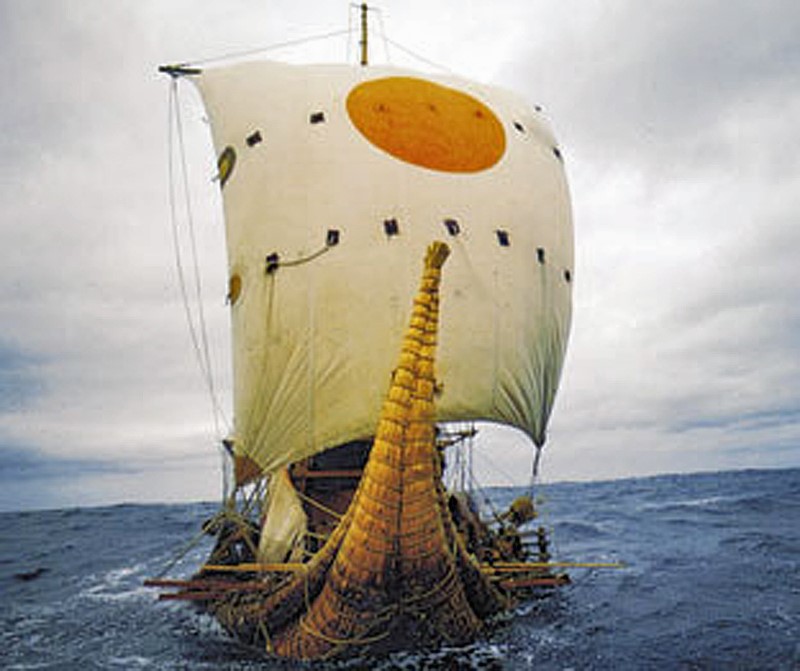
Long Barrows look more like barges than canoes, with the stern (back end) being where the boat was steered and the cabin was placed. The particular size and shape of Long Barrows (similar to Thor Heyerdahl’s reed boat ‘Ra’ that successfully sailed across the Atlantic in 1970) indicates that these vessels had sails and were not rowed or paddled. Moreover, a sailed boat would have a greater range than a canoe as the boat’s front is round, like an archer’s bow – hence the name? Not flat or wedged, this is a design constructed for manoeuvrability, speed and distance, clearly indicating these ancient mariners’ knowledge of advanced boat design. (The Ancient Mariners).
Design of a Long Barrow is the same as a Barge Boat – The Ancient Mariners
The other noteworthy aspect of Long Barrows is the size and construction of the monument. At West Kennet and other Long Barrows, giant megaliths were used to highlight the entrance of the chamber; these boulders are over 15 tonnes in weight and four to five metres in height. They are an unnecessary addition to the construction, but they are visible even a couple of miles away on a clear day. Long Barrows, when first constructed, would have been covered not with grass as today, but with the sub-soil that came from the ditches they dug that surrounded the monument; in the case of West Kennet, it would be bright white chalk. The massive size of these monuments must also be taken into consideration as they are over 100m in length – five times longer than the chambers they hide within them, and they are tapered from the helm 4m high to the bow, just 1m tall. Thus, making them (from a distance on the waters) look like a gigantic direction indicator. (The Ancient Mariners).
The appearance of the bright white Long Barrow would act as a directing indicator from a great distance against a green grass background.
Long Barrows were built halfway up a hill to show direction – The Ancient Mariners
Another remarkable aspect of Long Barrows is its location and position on the landscape. If we look at the extensive river ways after the last ice age, we notice that these monuments are built parallel to significant rivers and appear at junctions where rivers converge. Moreover, they don’t occur on the top of the hills surrounding the rivers but appear just over halfway up – so that they cannot be seen over the top of the hill on the opposite side. Because of their size and construction materials, these ‘markers’ are visible for miles like white pointers in daylight, but because they are pure white, they can also be seen at night with ‘moonshine’.
However, these objects are not in Egypt; they are in Northern Europe, and within the Mesolithic period, our ancestors are supposed to have been primitive‚ hunter gathers’ that lived in temporary shelters. The concept of boats (according to the experts) would not become common for another four thousand years.
If this was a marine civilisation that lived so long ago, who were they, and why have we not found any evidence of them?
Astonishingly, we have, and it’s in the form of myths, wooden planking and wall paintings. As we have already shown, the voyage to the afterlife is a well-known myth and practised belief. Even today, yet another tale connecting us to our marine ancestry and ritual of death is moonlight as well as headstones and raising spirits. Stonehenge is a ‘world heritage site’ made of stone, and when it was first constructed, our ancestors surrounded it with a circle of 58 (four tonnes) ‘Bluestones’ dug into round chalk holes (called Aubrey Holes, named after their discoverer). You can flawlessly track the moon’s seasons (like a calendar), connecting a link between the Stones and the moon. (The Ancient Mariners).
Voyage to the afterlife as seen by the Egyptians – The Ancient Mariners
voyage to the afterlife as seen by the Egyptians – Ten thousand-year-old boats
But where did the body lay before the bones were collected?
Archaeologists have found that initially, in the centre of Stonehenge lay two rows of stone holes (Q & R) two metres apart in a crescent shape open to the NW segment of the monument. These holes held stone slabs for the dead, on which they laid in a ceremony known as an ‘Excarnation’, where the dead are left to rot naturally. Stonehenge is surrounded by no less than ten Long Barrows, which would have taken the dead bodies over two thousand years. Each of the Long Barrows were built on the shorelines of the Mesolithic waterways (which were 30m higher than today), and at least two barrows have had ‘canals’ created from the shorelines to the entrance of the barrow.
These constructions show that the ceremony of taking the bones by boat from Stonehenge to the Long Barrows for final burial probably undertaken at sunset or in the dead of night under a full moon, where the bones and spirit of the departed rise for the last time and go on their final voyage?
More information on Prehistoric Britain can be found on our WEBSITE or VIDEO CHANNEL.
Robert John Langdon has also created a YouTube web channel with over 100 investigations and video documentaries to support his classic trilogy (Prehistoric Britain). He has also released a collection of strange coincidences that he calls ‘13 Things that Don’t Make Sense in History’ and his recent discovery of a lost Stone Avenue at Avebury in Wiltshire called ‘Silbury Avenue – the Lost Stone Avenue’. (The Ancient Mariners).
Langdon has also produced a series of ‘shorts’, which are extracts from his main body of books:
For active discussions on the findings of the TRILOGY and recent LiDAR investigations that are published on our WEBSITE, you can join our and leave a message or join the debate on our Facebook Group.
Unlocking the Mysteries of British Prehistory
Delve into the depths of time, as we embark on a captivating voyage into the enigmatic world of British prehistory. www.prehistoric-britain.co.uk is your portal to a treasure trove of archaeological wonders, modern LiDAR reports, and fascinating insights from the Robert John Langdon Trilogy. This immersive digital hub is your key to unlocking the secrets of Britain’s ancient past.
A Glimpse into the Robert John Langdon Trilogy
Step into the shoes of Robert John Langdon, a dedicated explorer of Britain’s prehistoric mysteries. His trilogy, comprising “The Stonehenge Enigma,” “Dawn of the Lost Civilization,” and “The Post-Glacial Flooding Hypothesis,” is a literary marvel that unravels the untold tales of our ancestors. These books take you on an exhilarating journey through time, meticulously researched and backed by over 125 references from esteemed scientists, archaeological experts, and geological researchers.
Dive into the World of LiDAR
At www.prehistoric-britain.co.uk, we harness the power of LiDAR technology to unearth hidden landscapes and archaeological marvels. Our LiDAR reports offer a modern lens through which you can peer into ancient history. Explore the effects of flooding on the British environment after the great ice age melt, a phenomenon that has shaped the landscape we see today. Join us in decoding the mysteries of our past using cutting-edge technology. (The Ancient Mariners).
A Multimedia Experience
Our commitment to storytelling extends beyond the written word. Robert John Langdon has curated a rich multimedia experience, including a YouTube web channel featuring over 100 investigations and video documentaries. These visual journeys complement his classic trilogy, providing a multi-dimensional understanding of prehistoric Britain. From Stonehenge’s construction in 8300 BCE to the lost Stone Avenue at Avebury in Wiltshire known as ‘Silbury Avenue,’ these documentaries offer an immersive experience that brings history to life.
Explore the ’13 Things that Don’t Make Sense in Ancient History’
History is replete with anomalies and enigmas that defy explanation. Robert John Langdon has curated a collection of such historical curiosities in ’13 Things that Don’t Make Sense in History.’ These peculiar occurrences and unanswered questions will leave you pondering the mysteries of the past, inviting you to join the debate on their possible interpretations.
A blood type (also called a blood group) is a classification of blood-based on the presence or absence of inherited antigenic substances on the surface of red blood cells (RBCs). These antigens may be proteins, carbohydrates, glycoproteins, or glycolipids, depending on the blood group system. Some of these antigens are also present on the surface of other types of cells of various tissues. Several red blood cell surface antigens can stem from one allele (or very closely linked genes) and collectively form a blood group system. Blood types are inherited and represent contributions from both parents. A total of 32 human blood group systems are now recognised by the International Society of Blood Transfusion (ISBT). The two most important ones are ABO and the RhD antigen; they determine someone’s blood type (A, B, AB and O, with + and – denoting RhD status) – so what has this to to with the first European to reach America?
Many pregnant women carry a fetus with a blood type different from their own, and the mother can form antibodies against fetal RBCs. Sometimes these maternal antibodies are IgG, a small immunoglobulin, which can cross the placenta and cause haemolysis of fetal RBCs, leading to haemolytic disease of the newborn called erythroblastosis fetalis; an illness of low fetal blood counts that ranges from mild to severe. Sometimes this is lethal for the fetus; in these cases, it is called hydrops fetalis.
One of the Greatest Mysteries in Anthropology is how the A Rh neg blood groups originated in North America.
Blood Group map – First European to reach America
Blood groups are an excellent method to detect population migration in conjunction with modern DNA Haplogroups, as the former has been identified for over 100 years, unlike the contemporary techniques.
An individual either has or does not have the ‘Rhesus factor’ on the surface of their red blood cells. This term strictly refers only to the most immunogenic D antigen of the Rh blood group system or the Rh- blood group system. Rh-positive usually indicates the status (Rh+ does have the D antigen) or Rh negative (Rh- does not have the D antigen) suffix to the ABO blood type.
Our History books tell us…
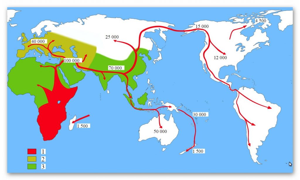
According to the New World migration model, a migration of humans from Eurasia to the Americas took place via Beringia, a land bridge that connected the two continents across what is now the Bering Strait. However, the most recent point at which this migration could have taken place, where the first Americans set foot on Alaska, is 40,000 – 12,000 years ago, a hotly disputed topic.
Traditional distribution of ‘Walking’ humans in time
The early ‘stone age’ Paleo-Indians spread throughout the Americas, diversifying into many hundreds of culturally distinct nations and tribes. According to the oral histories of many of the indigenous peoples of the Americas, they have been living there since their genesis, described by a wide range of traditional creation accounts.
Migration map – First European to reach America
While some indigenous peoples of the Americas were historically hunter-gatherers, many practised aquaculture and agriculture. The impact of their agricultural endowment to the world is a testament to their time and work in reshaping and cultivating the flora indigenous to the Americas. Some societies depended heavily on agriculture, while others practised a mix of farming, hunting, and gathering. In some regions, the indigenous peoples created monumental architecture, large-scale organised cities, chiefdoms, states, and empires.
Indigenous Americans still populate many parts of the Americas; some countries have sizeable populations, especially Bolivia, Peru, Mexico, Guatemala, Colombia, and Ecuador. At least a thousand different indigenous languages are spoken in the Americas. Some, such as Quechua languages, Aymara, Guaraní, Mayan languages, and Nahuatl, count their speakers in millions. Many also maintain indigenous cultural practices to varying degrees, including religion, social organisation and subsistence practices. Nevertheless, some indigenous peoples still lived in relative isolation from Western society, and a few are still unconnected peoples.
So, according to wiki:
About 40,000 years ago, Homo Sapiens walked across the land bridge of Alaska and entered America, finally going south to they reached South America all sharing the same blood type ‘O’, but then a second wave came across in 12,000 BP (Before present) and brought the Blood type A, B and AB with them and settled only in North America.
But there is a massive problem with this theory – apart from who in their right mind would walk across a footbridge for over a thousand years to a cold and inhospitable place (Alaska)?
The Na-Dené, Inuit and Indigenous Alaskan populations exhibit haplogroup Q (Y-DNA); however, they are distinct from other indigenous Amerindians with various mtDNA and atDNA mutations. This suggests that the peoples who first settled the northern extremes of North America and Greenland derived from later migrant populations than those who penetrated further south in the Americas. Linguists and biologists have reached a similar conclusion based on analysis of Amerindian language groups and ABO blood group system distributions.
On the East Coast of Asia (at the start of the footbridge), there is less than 4% Rh Neg blood, 90% of the Blood is ‘O’ type Rh-positive – 6% A,B or AB Rh-positive. So, if travellers who took the ‘land bridge across’ their descendants disappeared into extinction of never leave a trace of interbreeding with the local peoples, even though they walked this pathway for thousands of years – not one stopped to settle or cohabited with the local population.
However, the Haplogroup Q (Y-DNA) shows apparent migration from America to Asia and not vice-versa.
Moreover, the indigenous American Blackfoot Indians of North America are 82% A blood group RH Negative- the other 18% are probably an example of interbreeding since modern Europeans conquered them and their footprint stretches from the lakes of the east coast but falls short of the American West Coast or Alaska.
So, where did the ‘indigenous’ people come from?
If we look at a map of the northern hemisphere, we will see a high frequency of the Rh neg bloodline is in Spain, Ireland, Scotland, Faroe Islands, Iceland, Greenland and Eastern Canada moving West down the East Coast of North America to Central America. This is because in 10 000 BCE, the sea levels were much lower and The Northern Atlantic looked a lot different than today, as the Sea Levels were 160m Lower and the landmasses such as Faroe, Iceland and Greenland were much more extensive than the present, allowing easy passage across the Atlantic to America, for any society who had the possession of sea boats.
There is substantial evidence that reed boats were constructed on the shorelines of the Caspian Sea since about 40,000 BP, which are depicted on the caves that would have overlooked the Post Glacial Flooded waters – which is nowadays about a mile from the present Caspian Sea shoreline. These types of reed boats would have achieved sea travel as shown in the 1970s by Thor Heyerdahl (October 6, 1914 – April 18, 2002) was a Norwegian ethnographer and adventurer with a background in biology zoology, botany, and geography.
He became notable for his Kon-Tiki expedition in 1947, in which he sailed 8,000 km (5,000 mi) across the Pacific Ocean in a hand-built raft from South America to the Tuamotu Islands. The expedition was designed to demonstrate that ancient people could have made long sea voyages, creating contacts between apparently separate cultures. This was linked to a diffusion model of cultural development. Heyerdahl subsequently made other voyages designed to demonstrate the possibility of communication between widely separated ancient peoples.
Ra – First European to reach America
In 1969 and 1970, Heyerdahl built two boats from papyrus and attempted to cross the Atlantic Ocean from Morocco in Africa. Based on drawings and models from ancient Egypt, the first boat, named Ra (after the Egyptian Sun god), was constructed by boat builders from Lake Chad using papyrus reed obtained from Lake Tana in Ethiopia and launched into the Atlantic Ocean from the coast of Morocco. The Ra crew included Thor Heyerdahl (Norway), Norman Baker (USA), Carlo Mauri (Italy), Yuri Senkevich (USSR), Santiago Genoves (Mexico), Georges Sourial (Egypt) and Abdullah Djibrine (Chad).
Only Heyerdahl and Baker had sailing and navigation experiences. After several weeks, Ra took on water after its crew made modifications to the vessel that caused it to sag and break apart after sailing more than 4000 miles. The crew was forced to abandon Ra some hundred miles before Caribbean islands and was saved by a yacht.
The following year, 1970, another similar vessel, Ra II, was built of totara by Demetrio, Juan and Jose Limachi from Lake Titicaca in Bolivia and likewise set sail across the Atlantic from Morocco, this time with great success.
The voyage around the northern islands is simple but is made difficult due to extensive cloud cover. However, with the use of a device called a Sunstone, this difficulty can easily be overcome. A Sunstone is a device that allows navigators to follow the sun (indicating the direction of the sun) when it is daytime but cloudy. This device was known to be used as far back as the Viking societies, and as it was a ‘natural’ discovery, there is no reason that the use of the stone could not go further back in history.
So who were the first Europeans to find America?
It was formerly thought by palaeontologists that Neanderthal morphed into Cro-Magnon and that Cro-Magnon was the progenitor of human beings as we know them today. However, aside from the problems of the Eve Hypothesis, there are severe problems with the assumptions about when modern human types appeared on Earth. Even if we take the evolving scientific view of the present day, we find that Cro-Magnon man was something altogether different from other anatomically modern humans.
Over and over again, we read in scientific studies that Cro-Magnon man was just an “anatomically modern human.” The experts will say: “The Cro-Magnons lived in Europe between 35,000 and 10,000 years ago. They are virtually identical to modern man, tall and muscular and slightly more robust than most modern humans.”
Notice how they slip in that “slightly more robust” bit.
The fact is, the Cro-Magnon man was, compared to the other ‘anatomically modern humans’ around him, practically a superman. They were skilled hunters, toolmakers and artists famous for the cave art at Lascaux, Chauvet, and Altamira. According to anthropologists, “they had a high cranium, a broad and upright face, and cranial capacity – about the same as modern humans (can we say larger?), but less than that of Neanderthals. The males were as tall as 6 feet.”
They appeared in Europe in the upper Pleistocene about 40,000 years ago, and “their geographic origin is still unknown.” However, the DNA and colouring of Neanderthals indicate that they were Red Haired and Blue-eyed, unlike their Homo Sapien Cousins, who was dark-haired and brown-eyed.
Their skeletal remains show a “few small differences from modern humans.” But, of course, the “out of Africa” theory advocates suggest that Cro-Magnon came from Sub Saharan Africa and a temperate climate and that “they would eventually adapt to all extremes of heat and cold.” In this way, the “slight differences” between Cro-Magnon and other forms of anatomically modern humans can be explained away as an adaptation to the cold.
Moreover, Cro-Magnon’s have been found with Rh-Negative Blood (Cavalli-Sforza, L. Luca; Menozzi, Paolo; Alberto, Piazza (1994). The History and Geography of Human Genes)
A skeleton estimated as being 10,000 years old was found in the ‘tomb of Palli Aike’ in Tierra del Fuego in 1969-70 and has been identified as Cro-Magnon, which indicates that this race also spread to South America. It is now believed that Neanderthal man as the proto-European, and Cro-Magnon (a hybrid mutation) a later arrival, probably from the West. It is also thought that Cro-Magnons has many similarities to the North American Indians, being tall, muscular, athletic and agile.
Kennewick Man – First European to reach America
Dr James C. Chatters, a University of Washington’s specialist in human osteology, while investigating what was initially thought to be a modern homicide, found himself analysing the bones of a 9,000-year-old skeleton. Upon examination, the 5 feet 9 inches tall specimen had characteristics that are similar to those of Europeans” (Chatters, 2000). According to Chatters, the skull is dolichocranic (long-headed) rather than brachycranic (round-headed) and exhibits “fairly prominent brow ridges.” Now known as Kennewick Man, this skeleton possesses many of the characteristics of our typical Atlantean Cro-Magnons.
Poverty Point culture 8000 – 7000 BP is not well understood in terms of social organisation; it was involved in the transportation of non-local raw materials (for example, shell, stone, and copper) from throughout the eastern United States into the lower Mississippi River Valley to selected sites where the materials were worked into finished products and then traded. While specific information on Poverty Point subsistence, trade mechanisms, and other cultural aspects is still speculative, the sites, nevertheless, exhibit distinctive material culture, such as baked clay objects, magnetite plummets, steatite bowls, red jasper lapidary work, fibre-tempered pottery, and microlithic stone tools – which is a clear indication of European Cro-Magnon influence.
Dr Dennis Stanford of the Smithsonian Museum of Natural History in Washington states: “We now know that human beings learned to sail 50,000 years before the present. Humanity settled in Australia then, and any land bridge did not link it to Asia. It could only have been reached by boat. We had mastered sailing tens of thousands of years before America was colonised, so we should not be surprised by the idea that people took boat trips across the Atlantic 18,000 years ago” (Stanford & Bradley, 2004)
Dr Tom D. Dillehay (1999) of the University of Kentucky writes: “It is likely that people arrived in the Southern Hemisphere no later than 15,000 to 14,000 years ago.” One such site has been excavated at Monte Verde, Chile, 500 miles south of Santiago. First, evidence was gathered and carefully analysed over the last two decades by a team of American and Chilean archaeologists led by Dillehay. Then, early in 2006, a group of archaeologists, including several of Monte Verde’s most rigorous critics, visited the site and inspected the artefacts, coming away totally convinced.
Thirty years ago, experts in American Archeology would not admit to the presence of man anywhere on the continents of North and South America earlier than 12,000 years ago as it would have changed the known history of the world.
During a class in European Prehistoric Archaeology at the University of Oklahoma under Dr Robert Bell, let slip to his class that he participated in an essential dig at Sandia Cave near Albuquerque, NM. However, the lower level of occupation was clearly dated at 27,000 BC (Hibben, 1941). However, the experts refused to recognise it (Haynes & Agonino, 1986; Preston, 1995, et al.).
In his report of the site visit, Dr Alex W. Barker, chief curator of the Dallas Museum of Natural History, said: “While there were very strongly voiced disagreements about different points, it rapidly became clear that everyone was in fundamental agreement about the most important question of all. Monte Verde is real. It’s old. And it’s a whole new ball game.” And according to Michael B. Collins of the University of Texas at Austin, Monte Verde is “a bona fide archaeological assemblage, it is very old, and it has profound implications for American prehistory” (Collins, 1999).
But now, things have changed somewhat.
Site after site has now been discovered in the Americas, accumulating reliable dates back to roughly 40,000 years ago. Reports of the existence of numerous cave paintings began surfacing in 1963; a survey was taken in 1970 of the Säo Raimundo Nonato region of Brazil. Follow-up surveys in 1973 and 1975 turned up more than 100 decorated rock shelters. Done mostly in red, yellow, black and white (with some grey), figures of deer, jaguars, armadillos, lizards, rheas, crabs, humans, trees, and various abstract signs have all been catalogued. Excavation of the sites was first initiated in 1978 by Brazilian archaeologists from the Paulista Museum, lead by Niede Guidon of the University of Säo Paulo.
Over 300 archaeological sites have been discovered (most with rock art), dating from 30,00050,000 years BP captivating the interest of no less than 35 specialists in archaeology, geology, ecology, and other related disciplines. Säo Raimundo Nonato is described as lying “in one of the most beautiful and wild regions of South America.” (Guidon, 1987) The natives call the region caatinga, or “White Forest.”
The region is littered with charcoal-containing hearths. “Charcoal samples from the hearths yielded a consistently ordered series of twelve carbon 14 dates that ranged from 32,000 to 17,000 years ago” (Ibid.). The most ancient dates were obtained from red marks found on chunks that fell from the rock walls, becoming embedded within layers dating from 32,000 to be 27,000 years old. Toca do Sitio do Meio; artefacts dated from 15,000 to 12,000 years BP. These discoveries alone illustrate that humans had occupied South America for at least as long as 32,000 years.
As in Europe, these people didn’t live in caves but in ‘frame houses.’ Excavations turned up wooden planks of which the houses were built; logs with attached hiding pieces probably helped to insulate these domiciles. Fragments of wooden poles were also unearthed. Bi-facial stone projectile points were found, along with other artefacts, such as choppers, scrapers, etc. Amazingly, some meat survived in the peat bog, which DNA tests proved to be mastodon. (Dillehay, 1999)
Grove Creek Mound – First European to reach America
In 1991, Professor Baffa from the Physics Department of the University of Säo Paulo at Ribeirao Preto dated a layer of calcite covering two red anthropomorphic figures at the site of Toca da Bastiana. The calcite dated to 17,000 years old. (Guidon & Delibrias, 1986)
The once prevalent idea that earliest human’s populated North America only from the point of origin in the Arctic North, moving southward along an “ice-free corridor” between the continental glaciers, is no longer supported by the known distribution of sites. Clovis most probably entered the western hemisphere from the direction of the Caribbean before dispersing into North and South
America. Since massive land areas exposed during the ice age are now submerged, much archaeological material remains underwater, making the exact time of entry into the Americas challenging to ascertain. (Stanford & Bradley, 2004)
Archaeological sites have been discovered in Pennsylvania, Virginia, and South Carolina, dating back 18,00015,000 years, which demonstrate that ocean-going Solutreans may have first entered America from the direction of the Atlantic. Discussion of these and other Solutrean-Clovis connections took place during a recent convention of the American Association for the Advancement of Science.
Clovis Technology – First European to reach America
Sometime earlier, Dennis Stanford and Bruce Bradley had realised it was necessary to find artefacts in the Americas to bridge the gap in chronology between the Solutrean and Clovis cultures. So they scoured Clovis’s sites across the continent, places where other archaeologists had been digging for years. Their first success came from Clovis technology, a site called Cactus Hill, in Virginia, a point that resembled the Solutrean style—and it dated far earlier than the Clovis points. (Stanford & Bradley, 2004)
During the PBS interview, Dr Stanford stated:
“Here we have a projectile point from a feature that dates right at 15,900 years or 16,000 years ago, which is clearly right in the middle between Clovis and Solutrean. And what’s really exciting about it is that the technology here is very similar to Solutrean. In fact, it’s closer to Solutrean than Clovis where you can see that it’s in a progression between Solutrean and Clovis, so you have Solutrean, Cactus Hill and Clovis.”
According to an interview by A. J. Hostetler, Newspaper Journalist (published in the Richmond Times-Dispatch, May 11, 2006), Stanford stated that his “testable model” rested at least in part on recent findings of early human settlements along the East Coast, including one possibly 17,000 years old along Virginia’s Nottoway River called Cactus Hill.
Dr Eske Willerslev, director of the Centre for GeoGenetics at the Natural History Museum of Denmark, University of Copenhagen, has reported to Science Daily (October 20 2011) that a pre-Clovis, manufactured spear point had been discovered by archaeologists 30 years ago embedded in the remains of a mastodon dating at least a thousand years before the arrival of the Clovis culture in North America. The original discovery took place at the Manis site in Washington’s state.
Professor Willerslev’s team, in collaboration with Michael Waters’ team at the Center for the Study of the First Americans, University of Texas A&M, has finally established a firm date of 13,800 BP for the kill by the convergence of no less than five different dating methods. (Waters, Stafford, et al., 2008) Included in Willerslev’s report was the following significant statement:
“Our research now shows that other hunters were present at least 1,000 years before the Clovis culture. Therefore, it was not a sudden war or a quick slaughtering of the mastodons by the Clovis culture, which made the species disappear. Instead, we can now conclude that the hunt for the animals stretched out over a much longer period of time. . . Maybe the reason was something completely different, for instance, the climate.”
The Gault Site, located in central Texas about 40 miles north of Austin, is considered one of the premier archaeological discoveries in North America. James E. Pearce, known as the Father of Texas archaeology, excavated the site in 1929. It has more recently been excavated by Michael B. Collins and Thomas R. Hester of the Texas Archaeological Research Laboratory at the University of Texas at Austin.
The Gault materials tend to push ‘Clovis’ back at least another 1000 years—back to 13,500 BP and beyond—and so far represents 65% of all known ‘Clovis’ artefacts. (Collins & Hester, 2001) Recent excavations have brought to light incised stones, a true rarity in North America. Some archaeologists see a ‘link’ with the Upper Paleolithic cultures of Europe (Collins, n.d.; Wisner, 2000, et al.).
Minnesota Woman – First European to reach America
Sandia Cave (Hibben, 1941), The Lewisville site (Krieger, 1957), The Gault site (Collins & Hester, 2001), Meadowcroft Rockshelter (Adovasio, et al., 1990), Cactus Hill (Dillehay, 1989), Monte Verde (Adovasio & Pedler, 1997), Pedra Furada (Collins, 1999), the Manis site (1978), and numerous other more recent archaeological discoveries, are beginning to fi ll in the chronological ‘void’ between the time of the Solutreans in Europe and Clovis in America, leaving little doubt that human populations have been living in the Americas for at least 40,000 years. (Dillehay, 1999, et al.)
The skull of the 15-year-old girl known as Minnesota Woman. Her remains were found beneath the layers laid down much later in the area by glacial Lake Pelican in Minnesota, which had formed near the end of the ice age. (Blegen, 1975) Noticed the ‘European-like’ features of this specimen. She has been tentatively dated at 7890 BP. Another similar find has been christened Eva de Naharon, a 13,600-year-old skeleton found in an underwater cave near Tulum, Mexico.
The skull of another young woman, nicknamed Luzia, has been dated 11,500 years ago. After two decades in storage at the National Museum in Brazil, Brazilian scientists identified the fossilised cranium to be “the oldest human remains ever recovered in the Western Hemisphere.” It is now only one of several such as fossils. When first unearthed, the skull was separated from the skeleton but was in good condition. Surprisingly, this particular fossil exhibited Negoid characteristics (Williams, 2003).
British scientists have analysed an American skeleton of a 26-year-old woman who died during the last ice age on the edge of prehistoric Lake Texcoco, which once existed in the Valley of Mexico. The remains were dated at ca. 13,000 BP by Liverpool’s John Moores University and Oxford’s Research Laboratory of Archaeology. She has been christened Peñon Woman by her discoverers.
The most intriguing aspect of the skull is that it is very European in appearance (Conner, 2002). Upon examining the bones, Dr. Silvia Gonzalez, an archaeologist working at John Moores University and the leader of the research team, found the skull to be ‘dolichocephalic’; that is, long and narrow, like those of western Europeans of today, not short and wide like the Mongols of Asia. However, the origin of the people represented here remains in debate.
So do these findings correlate?
Cro-Magnon’s tools are described as the Aurignacian technology, characterised by bone and antler tools, such as spear tips (the first) and harpoons. They also used animal traps and bow and arrows. In addition, they invented shafts and handles for their knives, securing their blades with bitumen, a kind of tar, as long as 40 thousand years ago. Other improvements included the invention of the atlatl, a large bone or piece of wood with a hooked groove used for adding distance and speed to spears.
They also invented more sophisticated spear points, such as detach after striking and cause more significant damage to prey. The Cro-Magnon type man was also the ‘originator’ of such abstract concepts as ‘time.’ They marked time by lunar phases, recording them with marks on a piece of bone, antler or stone. Some of these ‘calendars’ contained a record of as many as 24 lunations.
In the relatively recent past, tool industries diversified.
The Gravettian industry (25 to 15 thousand years ago), characterised by ivory tools such as backed blades, is associated with mammoth hunters. One type of brief industry was Solutrean, occurring from 18 to 15 thousand years ago and limited to Southwest France and Spain. It is characterised by unique and finely crafted ‘laurel leaf’ blades, made with a pressure technique requiring great skill.
The industry is associated with horse hunters. The tool industry of the Clovis Culture in North America (11 to 8 thousand years ago) is notable for its remarkable similarity to Solutrean. Some suggest that the Solutrean culture migrated to North America around 12,000 thousand years ago.
Cro-Magnon people lived in tents and boats in groups of several families. They were nomadic hunter-gatherers and fishermen with elaborate rituals for hunting, birth and death. As a result, multiple burials are common in the areas where they were found. Interestingly, from 35 to 10 thousand years ago, there was no differentiation by sex or age in burials.
Cro-Magnon v Red Indian- First European to reach America
In contrast to everyday, utilitarian objects, they included unique grave goods, suggesting an immensely increased ritualisation of death and burial. They were also the first confirmed to have domesticated animals, starting about 15 thousand years ago.
They were the first to leave extensive works of art, such as cave paintings and carved figures of animals and pregnant women. Huge caves lavishly decorated with murals depicting animals were at first rejected as fake for being too sophisticated. Then they were dismissed as being primitive, categorised as hunting, fertility or other types of sympathetic magic.
Re-evaluations have put these incredible works of art in a more prominent place in art history – as suggested by Picasso, who declared on seeing the paintings, “We have invented nothing !!”
They show evidence of motifs, of following their stylistic tradition, of ‘impressionist’ like style, perspective, and innovative use of the natural relief in the caves. Also possible, considering the new concepts of time reckoning practised by Cro-Magnon, are abstract representations of the passage of time, such as spring plants in bloom or pregnant bison that might represent summer.
Aside from pregnant women and other Goddess worship iconography, representations of people, ‘anthropomorphs,’ are very few and never show the accuracy or detail of the other animals. Humans are represented in simple outlines without features, sometimes with ‘masks,’ often without regard to proportion, being distorted and isolated. At the Grottes des Enfants in France are found four burials with red ocher and associated with Aurignacian tools.
At Lascaux, France, are the famous caves of upper Paleolithic cave art, dated to 17 thousand years ago, and even older, in some cases, by many thousands of years!
The modern human types that appeared in the Levant were, however, somewhat different from Cro-Magnon. They were the sub-Saharan type, less ‘robust’ individuals than the Cro-Magnon ‘homo superior’ of Europe.
But then, how to explain what happened in any reasonable terms?
What the archaeological record seems to show is that in Europe, after millennia of almost no progress at all, even in the few areas where modern man has been found, suddenly human culture seems to take off like an explosion with the appearance of Cro-Magnon man.
Not only does culture explode, but also new ways of doing things, new styles and innovations that were utterly unknown in the period immediately preceding them, suddenly appear, only to disappear again like an outdated fad. From Spain to the Urals, sites list the developments of sewing needles, barbed projectiles, fishhooks, ropes, meat drying racks, temperature-controlled hearths, and complex dwellings.
The most amazing part of all of it is the art. Art suddenly springs onto the landscape, fully formed, with no period of gradual development; no signs of childish attempts preceding it. A piece of ivory carved 32,000 years ago is as realistic as anything turned out by the most accomplished carver of the present day.
The Upper Palaeolithic signals the most fundamental change in human behaviour that the archaeological record may ever reveal. The only explanation for this tremendous change is that a new kind of human appeared on the Earth’s stage. When we consider the difficulties of such an event, we find that this presents a huge difficulty in our understanding in terms of’ evolution.
First of all, we still have the problem of a 60,000-year time lag between the appearance of the sub-Saharan modern type man who was on the scene with no ‘improvements’ in his technology for that length of time.
If Cro-Magnon evolved in Africa, why isn’t there a continuous record of incremental developments? By the same reasoning, if he developed only after crossing the Mediterranean to Europe, why isn’t there a constant record of incremental developments?
The most effective and popular way that science deals with this crisis is to ignore it, deny it, or seek to twist the facts to fit the theory. Many archaeologists continue to account for the cultural events of the Upper Paleolithic by tying them to the emergence of a more modern, intellectually superior form of a human being from Africa. They propose a ‘second biological event’ to explain this, never mind that it left no tracks in any skeletal shape.
Cro-Magnon DNA group- First European to reach America
Nowadays, the idea suggests that the other ‘modern men’ of sub-Saharan Africa were not really thoroughly modern. On the contrary, they were ‘near-modern’. Thus, Africa is preserved as the origin of all humanity, and the only thing necessary was a breakthrough in the African lineage, a ‘neurological event’ that allowed this ‘new man’ to develop all these new cultural behaviours overnight, so to say. This amounts to saying that the explosion of culture in the Upper Paleolithic times did not happen earlier because other modern men didn’t have the brains to make it happen.
Unfortunately, the support for this idea amounts only to circular logic. What’s more, it seems that it would start in a small place and spread outward if it were a neurological event. We ought to note that the Neanderthals did not have art. What’s more, there was essentially no change in their stone tools for 100,000 years.
Some people suggest that the impetus for culture was the sudden development of speech. But that idea doesn’t hold much water either. If we were to look at some of the aboriginal societies of Australia and New Guinea, they are undoubtedly Neanderthal-like in their stone tools. However, they think and communicate in languages that are as rich as ours, and they construct myths, stories and cosmologies with these languages. They just don’t seem to be much interested in technology.
We have already noted the pottery making of the Jomon. Even more startling is the fact that twenty-six thousand years ago, the residents of Dolni Vestonice were firing ceramics in kilns. However, you don’t read that in archaeology textbooks. In the standard teachings, the emergence of ceramics is linked to the functional use of pottery, which supposedly did not appear until the agricultural revolution in the Neolithic period, some 12,000 years after the kilns at Dolni were last used.
This brings us to another curious thing about Neanderthal man: he never seemed to go anywhere. He always made his tools out of what was locally available, and he never seemed to travel at all. What was made where it was made stayed there. Nobody traded or shared among the Neanderthal groups.
But it seems that right from the beginning, Cro-Magnon man was travelling and sharing and exchanging goods and technology. This degree of travelling could only have been achieved by boats and ships. If there was a better form of stone somewhere else, the word seemed to get around, and everybody had some of it.
Distinctive flints from southern Poland are found at Dolni Vestonice, a hundred miles to the south. Slovakian radiolarite of red, yellow and olive is found a hundred miles to the east. Later in the Upper Paleolithic period, the famous ‘chocolate flint’ of southern Poland is located over a radius of two hundred and fifty miles.
The Vikings (Cro-Magnon descendents) continued to visit America – First European to reach America
Naturally, these rocks didn’t walk around on their own. Human legs carried them. And that leads us to our next little problem with Cro-Magnon man: You see, his legs were too long.
One of the sacred laws of evolutionary biology is called ‘Allen’s Rule.’
This rule posits that legs, arms, ears, and other body extremities should be shorter in mammals that live in cold climates and longer in mammals of the same period who live where it is hot. This is because having short arms and legs conserves heat. This is supposed to explain why Eskimos and Laplanders have short legs. It also is supposed to explain why Bantu people are leaner, and the Maasai is exceptionally long and thin in their tropical open country.
The only people who seem to be mocking Allen’s rule are the Cro-Magnons. They just refused to adapt or did they travel so widely the rule did not affect them like us today? They all have much longer legs than they ought to. Of course, this is pounced upon as proof that they came from Africa. The only problem with this is that it is hard to imagine people from a warm climate migrating to a cold one by choice.
Then, on top of that, to remain long-limbed for over a thousand generations? Keep in mind that, during that time, the thermometer kept going down and, at the glacial maximum, 18,000 years ago, it was like the North Pole in northern Europe!
By whatever means they arrived in Europe, we ought to note that their presence may be related to the fact that Europe and other nearby locations are blanketed with megaliths. Indeed, it may be so that the megaliths came long after the appearance of Cro-Magnon man, but the connection ought not to be discarded without some consideration.
We have still another problem here, and it has to do with dating. Analysing mitochondrial DNA data to reconstruct the demographic prehistory of Homo Sapiens reveals statistical evidence of explosive growth around 50,000 years ago.
Is there a connection between this DNA evidence and the appearance of Cro-Magnon man?
If so, it would mean that the DNA is dated to twice the age that archaeology confirms. Instead of assuming that the archaeological dates are correct, perhaps we ought to ask whether something could be wrong with the dating? From a morphological point of view and judging by their industry and art, these highly evolved humans that coexisted with Neanderthal man represent a mutation so enormous and sudden as to be absurd in the context of evolutionary theory.
CONCLUSION
The above admission opens up several other problems. Archaeology is beginning to demonstrate clearly that ice-age humanity was getting to the shores of the Americas. However, to cross a 3,000 mile-Wide Ocean requires some technology and logistics that are not being faced. It takes months to travel a body of water as large as the Atlantic, which necessitates food, water and other supplies, which in turn require a sufficient amount of onboard storage space. Therefore, we are not talking about small flimsy boats made of animal skins and a crew of two. A crew of at least a dozen is far more likely.
We are, therefore, postulating a ship at least as large as the average Viking vessel or possibly as large as ancient Phoenician warships. Such would need to be propelled by sails or other means, which would necessitate a sizeable crew. Navigational knowledge and techniques (with the necessary instrumentation) must be assumed. The alternative to this is to admit a reasonably large landmass (and maybe some islands) in the mid-Atlantic during the ice age to shorten the trip.
And we shouldn’t forget the archaeological and anthropological evidence that several ice age ‘invasions’ of Western Europe and Northwest Africa originated from some unknown location to the West of those landmasses (i.e., in the North Atlantic Ocean) during this same time frame. Thus, it seems more reasonable to postulate the presence of a mid-Atlantic mainland with shorter ocean voyages to the east and the West than to theorise about long ocean voyages from starting points on the opposite side of the globe, when the origin of these well-documented Upper Palaeolithic cultures points to such a source.
The fact that Blood was once ALL ‘O’ RH positive, as shown in the existing indigenous tribes of South America, Africa and Australia, shows us that the fact we have AB blood types proves beyond any doubt that the human species ‘mutated’ at some point in its journey ‘Out of Africa’.
Darwin’s observations of nature and its species show us that this ‘mutation’ is commonplace in history and, therefore, should be no surprise to anthropologists. Blood cannot mutate naturally in homo sapiens; the result of this genetically modified mutation has to be a new form of ‘Homo Sapien’.
Fifty thousand years ago, Homo Sapiens moved out of Africa to the Caspian Sea – the Haplogroups DNA record bear testament to this fact, as it too mutated into two new Haplogroups (A, B and G); this was at the point of ‘first contact’ with the Homo Sapiens cousins the Homo Neanderthal. It was also at this point that the blood groups AB were established. This ‘mutation’ is now accepted as 3% of most Homo Sapiens contain Neanderthal DNA showing cross breading, and it was also at this point of history that ‘Cro-Magnon’s’ evolved.
This species of mankind had superior powers (Homo Superior?) to Neanderthal and Homo Sapien Cousins. This was proved during the last Ice Age where the Cro-Magnon survived and took the green pastures of their ‘brave new world’ at the expense of the Neanderthals that were doomed to extinction – proving once again Darwin’s ‘survival of the fittest’ on planet earth.
For active discussions on the findings of the TRILOGY and recent LiDAR investigations that are published on our WEBSITE, you can join our and leave a message or join the debate on our Facebook Group
The Indian campaign of Alexander the Great began in 326 BCE. Alexander was born July 20, 356 BCE in Pella, in the Kingdom of Macedonia. During his leadership, he united the Greek city-states and led the Corinthian League. He also became the king of Persia, Babylon and Asia, and created Macedonian colonies in Iran. After conquering the Achaemenid Empire of Persia, the Macedonian king (and now high king of the Persian Empire) Alexander launched a campaign in northwest India (what is now Pakistan.) Many historians consider the Battle of the Hydaspes river against King Porus in Punjab as the most costly Battle that the armies of Alexander fought.
The rationale for this campaign is usually said to be Alexander’s desire to conquer the entire known world, which the Greeks thought ended in north-western India. However, while considering the conquests of Carthage and Rome, Alexander died in Babylon on June 13, 323 BCE. In 321 BCE, two years after Alexander’s death, Chandragupta Maurya of Magadha, founded the Maurya Empire in India.
Purushottama (Poros) a Kshatriya on the Hydaspes River (Jhelum River) in the Punjab of Pakistan, near Bhera. The Hydaspes was the last major battle fought by Alexander. The main train went into modern-day Pakistan through the Khyber Pass, but a smaller force under the personal command of Alexander went through the northern route, resulting in the Siege of Aornos along the way. In early spring of the following year, he combined his forces and allied with Taxiles (also Ambhi), the King of Taxila, against his neighbour, the King of Hydaspes.
Battle of Hydaspes – Alexander the Great
Porus wiz Puru was a great King of Indus/ Asiatic continent. Arrian writes about Porus, in his own words, “One of the Indian Kings called Porus a man remarkable alike for his strength and noble courage, on hearing the report about Alexander, began to prepare for the inevitable. Accordingly, when hostilities broke out, he ordered his army to attack Macedonians from whom he demanded their king as if he was his private enemy. Alexander lost no time in joining battle, but his horse being wounded in the first charge; he fell headlong to the ground and was saved by his attendants who hastened up to his assistance.”
Porus drew upon the south bank of the Jhelum River and was set to repel any crossings. The Jhelum River was deep and fast enough that any opposed crossing would probably doom the entire attacking force. Alexander knew that a direct crossing would fail, so he found a suitable crossing, about 27 km (17 miles) upstream of his camp. The name of the place is ‘Kadee’. Alexander left his general Craterus behind with most of the army while he crossed the river upstream with a substantial part of his army. Porus sent a small cavalry and chariot force under his son to the crossing.
According to sources, Alexander first encountered Porus’s son in the past, so the two men were not strangers. However, Porus’s son killed Alexander’s horse with one blow, and Alexander fell to the ground. Arrian, also writing about the same encounter, adds that “Other writers state that there was a fight at the actual landing between Alexander’s cavalry and a force of Indians commanded by Porus’s son, who was there ready to oppose them with superior numbers, and that in the course of fighting he (Porus’s son) wounded Alexander with his hand and struck the blow which killed his (Alexander’s) beloved horse Buccaphalus.”
The force was easily routed, and there isn’t any mention in any account that Porus’ son was killed. Porus now saw that the crossing point was more extensive and decided to face it with the bulk of his army. Porus’s armies were poised with cavalry on both flanks, the war elephants in front, and infantry behind the elephants. These war elephants presented a complicated situation for Alexander, as they scared the Macedonian horses.
Alexander did not continue, thus leaving all the headwaters of the Indus River unconquered. Afterwards, Alexander founded Alexandria Nikaia (Victory), located at the battle site, to commemorate his triumph. He also founded Alexandria Bucephalus on the opposite bank of the river in memory of his much-cherished horse, Bucephalus, who carried Alexander through the Indian subcontinent, and died heroically during the Battle of Hydaspes.
Near the Ganges River (the Hellenic version of the Indian name Ganga), East of Porus’s kingdom was the mighty Nanda Empire of Magadha and Gangaridai Empire of Bengal. Fearing the prospects of facing other powerful Indian armies and exhausted by years of campaigning, his army mutinied at the Hyphasis River (the modern Beas River), refusing to march further East.
As for the Macedonians, however, their struggle with Porus blunted their courage and stayed their further advance into India. For having had all they could do to repulse an enemy who mustered only twenty thousand infantry and two thousand horse; they violently opposed Alexander when he insisted on crossing the river Ganges also, the width of which, as they learned, was thirty-two furlongs, its depth a hundred fathoms, while its banks on the further side were covered with multitudes of men-at-arms and horsemen and elephants. For they were told that the kings of the Ganderites and Praesii were awaiting them with eighty thousand horsemen, two hundred thousand footmen, eight thousand chariots, and six thousand fighting elephants.
Gangaridai – a nation which possessed a vast force of the largest-sized elephants. Owing to this, their country has never been conquered by any foreign king: for all other nation’s dread, the overwhelming number and strength of these animals. Thus, Alexander the Macedonian, after defeating all Asia, did not make war upon the Gangaridai, as he did on all others; for when he had arrived with all his troops at the river Ganges, he abandoned as hopeless an invasion of the Gangaridai when he learned that they possessed four thousand elephants well-trained and equipped for war.
This is a traditional account of how Alexander entered and fought in India. To access this land, he had to travel thousands of miles east to a new land. Traditionally, this campaign was seen as a route march over barren desert land, which, to be frank, nobody in their right mind would attempt. However, recently a Photojournalist (not a historian) physically travelled the same path as Alexander the great and found that he used the waterways of the past, which to date have been ignored as they are currently too low to facilitate such a large army, but in the past, David suggests that the river was much larger than today.
Alexander’s Lost World – Alexander the Great
In search of the Alexander’s Lost World (TV Documentary), David Adams followed in the footsteps of the earliest Greek explorers, putting a new theory on Jason and the Argonauts to the test.
Aboard a replica of the Argo, David Adams embarked on an epic journey from Greece across half the earth and into war-torn Afghanistan. In Russia, David discovered the Phasis River, the waterway that led Jason to ‘The land of the Golden Fleece’ and onto the Caspian Sea, where Alexander planned to create a great canal to connect it to the Black Sea.
If the ancient texts are correct, the Caspian and Black seas were once connected – Alexander the Great
He entered Alexander’s Lost World in search of the mysterious River Oxus that, according to the Ancient Greeks, once flowed into the Caspian, transporting riches from India. In the desert wastes of Turkmenistan, he also discovered the ruins of a magnificent 4,000-year-old city and startling evidence to suggest that the reports of the Ancient Greeks were correct; in their time, the earth’s climate was radically different than today.
Crossing into Afghanistan in search of the lost city of Bactra, Adams uses the Ancient Greek accounts as a guide to try to locate Alexander’s fabled Central Asian Capital. Long thought to be the citadel of Balkh, the Greeks accounts appear to describe a different city entirely. In the markets beneath the fortress, David found evidence to suggest Bactra may lie out towards the Oxus River at the end of a great delta.
Continuing his historical journey, David travelled along Alexander’s route of conquest through Uzbekistan and Tajikistan to unearth Alexandria on the Oxus. Moreover, in the waters of the Oxus River, Adams discovers a surprising connection to Jason and the Argonauts – could they have possibly travelled this far from Greece?
The story of the golden fleece is remarkably similar to a process still practised today on the banks of the Oxus in Uzbekistan where river water is poured down a slope on top of a piece of sheep’s fleece, which catches the gold in its wool-like a filter.
David found extraordinary evidence that this lost world was once connected to the west. On the Pakistan border, David meets with the fabled ‘Children of Alexander’ and determines – once and for all – Alexander’s relationship with them. When the road turns to river and rubble, he finds the remains of other invaders and their unexplored citadel – Chinese and Tibetans, who, just like Alexander, once fought for control of the trade routes in an epic battle of 20,000 men.
Moreover, on his final leg of his Quest for Alexander’s lost world, he found evidence of the earliest communities, including farming and irrigation above 4000 meters – evidence that long ago, a radically different climate made farming possible on the roof of the world. The most remarkable aspect of this civilisation is that they were doing this long before Alexandra the Great, some estimate 7,000 years ago.
Finally, he journeys on, deep into the high Pamir Mountains on Afghanistan’s border with China; he goes in search of the trustworthy source of the Oxus River – it remains undetermined until this day, and he measured the flow and volumes, before making the final push to the place he believes is the source – an ice cave at the base of a glacier. Which is the last ice age would have been far more significant in size and the source of greater volumes of water, making the Oxus river far deeper and accessible?
So it seems that the last Ice Age influenced even the Greek and Roman periods some 15,000 years later. The story of Jason and the Argonauts is clearly based on the Greeks sailing up the Oxus in search of adventure. Alexander the great could not have accessed India without the Flooding of the Black and Caspian Seas compared to today that allowed him to connect with the Oxus in the Caspian and sail to Lake Aral before starting his journey South West to Uzbekistan, Turkmenistan, Kyrgyzstan, Tajikistan, Afghanistan and finally Pakistan (India) some 2,000 miles without ships and boats, for travel and supplies.
This route is confirmed by the naming of conquered towns with his course, which still bear the name Alexandria such as Eschate:
Alexandria Eschate (Latin: Alexandria Ultima, English meaning “Alexandria the Farthest”) or Alexandria Eskhata was founded by Alexander the Great in August 329 BCE as his most northerly base in Central Asia. It was established in the southwestern part of the Fergana Valley, on the southern bank of the river Jaxartes (modern name Syr Darya).
On the banks of the Jaxartes River – there is the Ai-Khanum:
Ai-Khanoum or Ay Khanum (lit. “Lady Moon” in Uzbek, possibly the historical Alexandria on the Oxus, also possibly later named Eucratidia) was one of the primary cities of the Greco-Bactrian kingdom. Previous scholars have argued that Ai Khanoum was founded in the late 4th century BCE, following the conquests of Alexander the Great. However, the most recent analysis strongly suggests that the city was founded after 280 BCE by the Seleucid King Antiochus I. The city is located in Takhar Province, northern Afghanistan, at the confluence of the Oxus River (today’s Amu Darya) and the Kokcha river, and at the doorstep of the Indian subcontinent.
On the banks of the Oxus and Kokcha Rivers – is Alexandria in Aria:
Aria was an Old Persian satrapy, which enclosed chiefly the valley of the Hari River (this being eponymous to the whole land according to Arrian) and which in antiquity was considered as particularly fertile and, above all, rich in wine. Mountain ranges separated the region of Aria from the Paropamisadae in the east.
On the banks of the Hari River – there’s Alexandria in Margiana.
Merv, formerly Achaemenid Satrapy of Margiana, and later Alexandria and Antiochia in Margiana, was a major oasis-city in Central Asia, on the historical Silk Road, located near today’s Mary in Turkmenistan? Several cities have existed on this site, which is significant for the interchange of culture and politics at a location of significant strategic value. It is claimed that Merv was briefly the largest city in the world in the 12th century. The oasis of Merv is situated on the Murghab River that flows down from Afghanistan, on the southern edge of the Karakum Desert,
On the banks of the Murghab River – last but not least Kapisa:
Alexandria on the Caucasus (medieval Kapisa, modern Bagram) was Alexander the Great (one of many colonies designated with the name Alexandria). He founded the colony at an essential junction of communications in the southern foothills of the Hindu Kush mountains, in the country of the Paropamisade. Alexander populated the city with 7,000 Macedonians, 3,000 mercenaries and thousands of natives (according to Curtius VII.3.23), or some 7,000 natives and 3,000 non-military camp followers and a number of Greek mercenaries (Diodorus, XVII.83.2), in March 329 BCE. He also built forts in what is nowadays Bagram in Afghanistan, at the foot of the Hindu Kush, replacing forts erected in much the same place by Persia’s King Cyrus the Great c. 500 BCE. Still, the waters of the Kabul, Panjshir, and Khorband rivers created a fertile alluvial plain, and the city was to become very prosperous.
On the banks of the Panjshir and Khorband Rivers (Which no doubt was used to transport and feed these towns and outposts of Alexandra’s empire?)
Is his most famous city Alexandria— which become the world centre of the learned from Europe, Asia, and Africa. Its position was unrivalled. Situated at the mouth of the Nile, it commanded the Mediterranean Sea, while by means of the Red Sea, it held easy communication with India and Arabia. When Egypt had come under the sway of Alexander, he had made one of his generals’ rule over that country, and men of intellect collected there to study and to write. A library was started, and a Greek, Eratosthenes, held a librarian at Alexandria for forty years, namely, from 240 -190 B.C. During this period, he made a collection of all the travels and books of earth description—the first the world had ever known—and stored them in the Great Library of which he must have felt so justly proud and a legacy to the world. (Alexander the Great)
Alexander’s Cities- Alexander the Great
Ironically, the famous librarian drew a map of the world for his library at Alexandria, but it has perished with all the rest of the valuable treasure collected in this once celebrated city by a nation we consider to be the modern civilisation model Romans. We know that he must have made a great many mistakes in drawing a map of his little island world, which measured eight thousand miles by three thousand eight hundred miles. However, the Caspian Sea was connected with a Northern Ocean, and the Danube sent a tributary to the Adriatic – is this another indication that post-global flooding was still being felt long after the ice had disappeared? (Alexander the Great)
One thing is for sure. Without the raised waters of the Caspian and Black Seas and the glacier that feed the Oxus in Afghanistan, Alexander would have had an Empire much smaller than we celebrate today.
For more information on Global flooding check out this website or this video channel.
Robert John Langdon has also created a YouTube web channel with over 100 investigations and video documentaries to support his classic trilogy (Prehistoric Britain). He has also released a collection of strange coincidences that he calls ‘13 Things that Don’t Make Sense in History’ and his recent discovery of a lost Stone Avenue at Avebury in Wiltshire called ‘Silbury Avenue – the Lost Stone Avenue’. (Alexander the Great)
Langdon has also produced a series of ‘shorts’, which are extracts from his main body of books:
For active discussions on the findings of the TRILOGY and recent LiDAR investigations that are published on our WEBSITE, you can join our and leave a message or join the debate on our Facebook Group
“Antler Picks” – From Oxford Dictionary of Archaeology
“A type of tool found widely among the sites of Neolithic communities in North-Western Europe. They are formed from a red-deer antler from which all but the brow tine has been removed; the beam forms the handle, and the brow tine the ‘pick’. They were used for excavating soil and quarrying out stone and bedrock. The marks left by their use have been detected on the sides of ditches, pits, and shafts. Experiments suggest that they were used rather more like levers than the kind of pickaxe that is swung from over the shoulder.”
If you read any book or watch a program about archaeology and the construction of their monuments and sites, you will hear the experts talk about the findings of antler picks in the general vicinity and link the building with these objects. As the description above indicates, these ‘tools’ are from red deer, which shed these natural growths annually.
Typical Deer Antler – Antler Picks
According to archaeologists, this was the primary tool of prehistoric people – a natural resource that became a handy tool in excavating the ditches and digging holes in the chalk bedrock that surrounded most of their sites. This is where the Victorian term ‘antler picks’ originates and still exists today, but for an unknown reason, this tool has now changed its use (but not its name), as archaeologists have now realised that if these ‘antlers’ were used to cut into hard bedrock chalk, they would leave blunt ends and scars from flint re-sharpening, which there is no evidence. So ‘Antler picks’ have now turned into ‘Antler levers’ although the wording has remained the same – confused?
That’s archaeology for you!
Yet, if you look at any prehistoric report about the monument’s construction, you find a degree of ‘acceptance’ that antlers were used as the primary source of digging out the chalk downlands. For example, here is a typical report from English Heritage’s ‘bible’ (Stonehenge in its landscape, 1995, cleal et al.) and the use of Antler picks.
Antler from Grimes Graves (notice the used point) – Antler Picks
“Over 130 antler implements are known to survive from excavations by Gowland, Hawley and Atkinson et al. Antler implements have frequently been associated with Neolithic and Early Bronze Age monuments in Britain located on chalk or limestone, and it is generally assumed that they were the principal implements used in the digging of ditches, postholes and stone holes.”
In a paper on Neolithic engineering, Atkinson (1961) wrote, ‘the tools used – antler picks, bone wedges and occasionally stone axes – are well-known and require no further discussion’ However, some of the generalisations made in the literature about antler implements require modification in the light of the finds from Stonehenge.”
The first thing you notice is the complete arrogance of Atkinson with the comment ‘are well-known and require no further discussion’ for this was the archaeological opinion in the ’60s, 70s and even ’80s. This was when monuments such as Stonehenge were ‘scientifi cally dated’ and were accepted beyond any doubt, but as the line added after by English Heritage (EH), this was far from the truth. ‘require modification’ is a politically correct way of suggesting that Atkinson was utterly wrong.
English Heritage Antler Picks from Stonehenge – Antler Picks
The report continues, “The 118 antlers and antler fragments in Salisbury Museum constitute about 87% of the known extant collection. Measurements were taken following Clutton-Brock(1984). Some were taken on those parts of the antler which were unmodified, and from these, it is possible to estimate the size of the animals from which the antler was obtained. Additional measurements of cultural significance were taken, including the length of the pick and the angle between the used ‘tine’ and the beam.”
The ‘tine’ is the ‘horn’ that comes off the central antler column after the ‘head connector’ called the ‘base’ or shed; it is thicker and the hardest of all the antler horns. On an antler, there are usually three ‘tines’ – the Brow (first after the base), the Bez (second after the base) and the Trez. After the three ‘Tines’ comes the larger crowns, which are longer but much thinner.
Stonehenge Antler Pick (not used as it has a point) from Stonehenge – Antler Picks
Here comes EH’s first admission that the myth that is still dominant today even amongst the knowledgeable archaeological community today “Popular works have tended to oversimplify the antler tools and perpetuate some interpretations, which do not stand up to scrutiny. Examinations of the assemblage from Stonehenge have shown that the methods of modification and the forms of the picks are more varied than has hitherto been appreciated.
So what on earth are they going on about?
The Victorian Archaeologists found antlers all over Stonehenge and in the ditches that had filled up over the years, so the conclusion as it was ‘perceived’ that metal had not been found at the time of these monuments construction is that these instruments must have been used to dig the ditches and holes of these monuments – but there are practical problems to this idea if you look closer!
The only part of the antler that could break the solid chalk successfully is the harder ‘tines’. The problem with the tines is that they all grow the same way, so they would not allow a clean strike at the chalk bedrock if used as a ‘pick’ unless you removed two of the three tines. And hence the ‘gobbledygook’ sorry line in the EH report that says ‘methods of modification, and the forms of the picks are more varied than has hitherto been appreciated.
If we see systematic use and preparation of these tools as has been suggested by archaeologists in the past, we should see two clean cuts with a stone axe or cutter to ‘prune’ the antler and the third that is used to smash the chalk broken by the constant compression – but we don’t!
Of the 118 antler picks found at Stonehenge, 82 antlers had the harder tines attached. Of the 82 with tines, only 25 had the other two smaller tines removed; only 21% of the antler finds. However, remember this was the entire finds for Stonehenge, which archaeologists have suggested was constructed in Three Phases over 700 years.
Phase I – was the ditch, bank and Aubrey holes, which would have contained the Bluestones from Wales. It has been estimated that a total of 87,000 cubic feet of chalk taking (at least) 30,000 working hours was removed in this phase. According to the location of the discarded antlers, there were only seven antlers that had their bases, and the strongest tine attached, producing the most efficient tool possible. This would mean that each whole antler had removed 12,429 cu feet, without damage.
An impossible task?
Sadly, even more, impossible than this massive figure suggests is that we have not considered the size of the antler. The bigger, the better for, the longer the antler, the better the levering motion to remove chalk blocks. This being the case, they must have used the most giant antlers possible, especially when you consider that the number of Deer in Britain in prehistoric times is far greater than today and ‘bucks’ shed their antlers on an annual basis. At present, there are 1.5m Red Deer in Britain – even with the exact size of the population in prehistoric times, the builders of Stonehenge would have at least half a million antlers per annum to collect and use.
Consequently, only the largest antlers should have been available ‘to an organised society to select?
I state this fact, as we know that this same civilisation could muster a group of people to not only dig out 87,000 cubic ft of chalk but also obtain 56 Bluestones 200 miles away from the Preseli Mountains in Wales – so the collection of antlers which over the years must have shed millions must have been a simple matter.
However, the evidence shows that this was far from the truth. The distribution analysis shows that of the total number of antlers found, their size varies greatly. For example, the average circumference of a typical antler found at Stonehenge is just 210mm (8.5″) this is a diameter of 66mm (2.7″) – some antlers are as small as 150mm in circumference or diameter of 48mm (less than two inches) compared to the largest of 299mm in circumference or 48mm (nearly 4 inches), and that was a single one.
But was this a comfortable size to hold?
Possibly so, depending on the size of the person. However, what is not disputable is the leverage of the tool; the longer the hand axe, the greater the gauging and leverage on removing the chalk blocks?
The statistics we have from English Heritage ‘could be much better’ as they measure only the distance between the bur (the thickest part attached to the head) and the trez, which is the third tine up from the base. The Trez is not the strongest tine on the antler – that is the brow. However, there are so few antlers cut to this correct and more effective way that EH decided this unorthodox method to compare sizes – even so, we can see how these antlers were not selected for their size. The Average size (distance from Bur to Trez) was 190mm (7.5″), so as small as 110mm (4″) – compared to the largest again available of 410mm (16″).
So with millions of antlers on the floor, why would you use anything smaller than the average thickness or length and would you not be inclined to go for the largest possible?
Stone Age Axe – far superior to Antler picks? – Antler Picks
This strange lack of evidence can also be seen in other monuments where even greater numbers of ‘antler picks’ would be required but have not been found, such as Avebury, which has one of the largest for a monument in Britain it contains three stone circles within. Current archaeological estimates suggest that it took 1.5 million working hours to build the Avebury monument, which includes 3.4 million cubic feet of chalk, forty times larger than Stonehenge – so we should find forty times more Antler picks (3200), in theory.
From Wikipedia
“Excavation at Avebury has been limited. In 1894, Sir Henry Meux put a trench through the bank, which gave the first indication that the earthwork was built in two phases. The site was surveyed and excavated intermittently between 1908 and 1922 by a team of workmen under the direction of Harold St George Gray. He could demonstrate that the Avebury builders had dug down 11 metres (36 ft) into the natural chalk using ‘red deer antlers’ as their primary digging tool, producing a henge ditch with a 9-metre (30 ft) high bank around its perimeter. Gray recorded the base of the ditch as being four metres (13 ft) wide and flat, but later archaeologists have questioned his use of untrained labour to excavate the ditch and suggested that its form may have been different. Gray found few artefacts in the ditchfill, but he did recover scattered human bones, among which jawbones were particularly well represented. At a depth of about two metres (7 ft), Gray found the complete skeleton of a 1.5-metre (5 ft) tall woman.”
Found more human bones than Antler Pick fragments? – Antler Picks
Although Grey cut through the ditch and suggests that the building of this structure, the expected vast amounts of discounted antler picks from their labour are minimal to nonexistent. He found more human bones than deer antlers.
So should we, therefore, surmise that they dug the ditch out with their bare hands or parts of human skeletons as only parts of human bones were found – if we follow archaeology logic?
To highlight the absurdity of this antler myth, we need not look any further than English Heritage’s publication called ‘Radiocarbon Dates from samples funded by English heritage from 1981 – 1988’ – one would imagine that if we scratch below the surface of these monuments, the broken reminisces of the tools used to build these magnificent constructions would be obvious. Instead, however, the book tells another story.
Of all the samples found, ‘Antler’ was the second smallest behind Animal Bone, Human Bone, Wood and Charcoal and by a large margin, such as Animal Bone was three times larger than antler (so did they take the antlers and not eat the animal?) However, human bones were five times the most significant find – the reality is they found only three pieces of antler (one from the bank of Avebury in 1937, one from West Kennet Avenue and one from the Avebury ditch in 1909), and even then, we are not sure what parts of the antler were found. So we found just one fragment of antler bone from Avebury’s most significant artificial ditches in Britain.
The facts do not bear out the myth!
So how can a scientific discipline claim that these features were made from antler picks and shoulder blade shovels when there is just one fragment of antler ever carbon-dated at Avebury? The truth is that the myth has grown around the original excavations at Stonehenge, and archaeologists found antler picks in the ditch – in the 20th century; they may have felt that this was unusual as antlers are not found in significant quantities today, but in the past vast herds would have probably fed there before the road systems were invented and dropping antlers would have been commonplace. So to find antlers in an abandoned ditch filled with topsoil and other items left on the topsoil is not uncommon.
So does this affect the date of Stonehenge’s construction?
Sadly, yes, it does. The mistake of accepting (without looking for collaboratory evidence from other sides like Avebury in finding the necessary quantities to justify the link to the ‘tools’ with their construction) antlers as the main artefacts of construction is fundamentally flawed. Consequently, the dates from these artefacts, which Stonehenge is 90% based upon, is therefore totally inaccurate.
Recent findings on carbonised wood (fires) on the Stonehenge site are thousands of years older than the 2 500 BCE date produced from the antler pick dates. This should be no surprise to any archaeologist as the Post Holes in the Stonehenge Visitors Car Park and findings of a mile away at Vespasian Camp are all the exact dates. Yet, archaeologists refuse to accept that the myth is stopping us identifying the true date and nature of our most prised site for fear of ridicule as most of the ‘popular’ archaeologists we see on our TV have published books endorsing both this absurd technique and dates currently supported by English Heritage. The latter is their financial sponsor and overlord.
However, some have broken ranks in recent years and offered tantalising clues on the true nature of our history and the deception game being played by EH. Mike Parker-person in his recent book ‘Stonehenge’, revealed that they found ‘cut marks’ in the chalk in an excavation at Durrington Walls (Woodhenge) that looked like it was made from a ‘metal’ instrument.
Do we see the first evidence that ‘antler picks’ did not make our ancient monuments, but metal axes?
Smaller more intricate stone axe – Antler Picks
This would make a lot more sense than current archaeological theories – but what is the big deal if this was true? So why not just accept the truth and go forward with these more practical metal devices?
Well, this digs the science into yet another hole (what complex webs we weave when we practise to deceive!) for metal (such as Bronze) was supposedly not invented until about 2,500 BCE – hence the term the Bronze Age (2 500 BCE – 70 BCE). Although a Bronze Age ‘commercial sized’ kiln has been found on the River to the Black Sea, which originated in the North Sea which dates back to 4,500 BCE that used ‘Cornish Tin’ to make the Bronze? Moreover, as we have seen, these deep ditch constructions are much older than the ‘antler picks’ originally dated them.
So is the age of metal much older than we currently believe?
For my own belief, I would have to put back the use of metal to at least 5 000 BCE, which would mean that Britain had Bronze long before the Mediterranean, which would go against all that is currently believe about cultural immigration from East to West, as we have now found much evidence of trading from Britain to Asia Minor in the Mesolithic period – including the boatyards that would have been necessary for such journeys.
For active discussions on the findings of the TRILOGY and recent LiDAR investigations that are published on our WEBSITE, you can join our and leave a message or join the debate on our Facebook Group
After the last ice age, the ‘great melt’ flooded the landscape of Britain for over ten thousand years. This flooding started a chain reaction, and as a consequence, the sea level slowly increased, and vast areas of land were lost, including a landmass known as ‘Doggerland’ -Sunken Lands of the North Sea
Doggerland sinks – Sunken lands of the North Sea
Throughout the 19th Century, oyster dredgers working the shallow waters off the northeast coast of England recorded frequent finds of animal bones caught up in their nets. These discoveries became a regular occurrence as the fishing technology increased and the trawlers later date and in deeper waters of the North Sea found traces of civilisation and a lost continent. Sadly, the location and accuracy are rarely recorded with any degree of accuracy; this material appeared to come from many areas within the North Sea.
One area where the most significant number of finds discovered is known as the ‘Dogger bank’, which lies just 90km – 110km (60-70 miles) from the coast of the British Isles. This shoal (a shoal, sandbar, sandbank or gravel bar is a somewhat linear landform within or extending into a body of water, typically composed of sand, silt or small pebbles.) rises about 45m (150 ft) above the North Sea bed, to the North, it plunges into deeper water and forms a subterranean plateau covering 17,600 sq. km. (6,800 miles) with a maximum dimension being 260km (160 miles) from North to South and 95 km (60 miles) from East to West. Over time, the number of finds reduced as the same area was dredged day after day, and any artefacts sitting on the surface would have been scooped up and either returned as a curiosity or, in a majority of the time, just thrown back in a different location.
Even so, items such as; bear, wolf, hyena, bison, woolly rhino, mammoth, beaver, walrus, elk, deer and most importantly, a horse has been collected. This precious collection of findings gives us a fantastic insight into what Doggerland looked like, the environment that supported these animals and the climate of this unique area of the world. (Sunken Lands of the North Sea)
Doggerland- Sunken lands of the North Sea
It would be impossible to talk about Doggerland and its environment without understanding if there was a written history of a land that flooded thousands of years ago, and this comes in the works of the ancient Greek
Philosopher Plato. Over the years, Atlantis has grown to be both a legend and the source of many science fictions; this is neither correct nor helpful in tracing the history of humanity, as it moves the debate from scientific observation to fantasy and the degrading of the most critical time of our history.
Plato is a source of creditable information as he is not a ‘storyteller’ like some other historical writers. He is fundamentally a philosopher whose writings are still studied even now, some 2,000 years after his death at the most famous and prestigious universities worldwide. This man is not prone to fantasy or exaggeration; his writings, therefore, must be accepted as valid evidence that once in the distant past, a great ancient civilisation did exist and that they changed the course of humanity in ways which I believe we do not fully understand to date.
Consequently, we need to look at the probability that Plato’s ‘Atlantis’ is a genuine reference to this land, as it is the oldest written source and may give us clues of how this civilisation lived and traded. Fortunately for us, Plato gave some detail about this civilisation, such as how they lived and what they believed, allowing us to compare what we know; from known landscape and archaeological finds and look for more inaccessible areas of investigation the texts might reveal. (Sunken Lands of the North Sea)
Plato – Sunken lands of the North Sea
Plato’s most famous line from ‘Timaeus’, a dialogue between Critias and Socrates, in which ‘Critias’ tells a story he learned through his family, about the Greek statesman ‘Solon’, whilst he was studying with the most scholarly of Egyptian priests during a visit to Sais in Egypt in about 590 BCE. The priests claimed to have access to secret records about a lost civilisation called ‘Atlantis’, which only they were allowed to read, for it was written on the pillars within their most sacred temple. Now Sais was one of the oldest cities in the ‘old kingdom ‘of Egypt, and the city’s patron goddess was ‘Neith’, whose cult is attested as early as the 1st Dynasty, ca. 3100- 3050 BCE.
The Greeks, such as Herodotus, Plato and Diodorus Siculus, identified her with Athena and postulated a primordial link to Athens. Diodorus recounts that Athena built Sais ‘before’ the ‘deluge’ (flooding) that supposedly destroyed Athens and Atlantis. While all Greek cities were destroyed during that cataclysm, the Egyptian cities, including Sais survived. As we can see from this connection, the deluge has incredible importance to ancient civilisations, clearly indicating that any prehistoric culture that wanted to ‘stay alive’ would possibly build boats, not for some, but for everyone. Sadly, the city of Sais has been recently destroyed by farmers who used the house and temple mud bricks as free fertiliser for the fields – to this date, the temple and its writings have never been found.
The most famous line from Plato’s dialogue is “in front of the mouth which you Greeks say ‘the pillars of Hercules’ there lay an island which is much larger than Libya and Asia together” translated by W.R.M. Lamb 1925 or “in front of the straits which are by you called the pillars of Hercules; the island was bigger than Libya and Asia together” B. Jowett 1871. (Sunken Lands of the North Sea)
Plato’s Atlantis description – Sunken lands of the North Sea
This single sentence has caused no end to the debate about the location of Atlantis. Some suggest that ‘the pillars’ can refer to water flows, thus allowing the speculation (which is current) that Atlantis is a Greek Island. Others suggest (including myself) that the ‘pillars of Hercules’ is the mouth of the Mediterranean between Morocco and Spain. This is a case of translation and interpretation; the word ‘mouth’ is sometimes called ‘strait’; in other quotations, Plato refers to the Mediterranean Sea as “within the straits of Hercules.”
According to some Roman sources, while on his way to the island of ‘Erytheia’ Hercules had to cross the mountain that was once Atlas (the Atlas Mountains are in Northern Africa overlooking the Mediterranean); instead of climbing the great mountain, Hercules used his superhuman strength to smash through it. By doing so, he connected the Atlantic Ocean to the Mediterranean Sea and formed the Straits of Gibraltar. However, the best evidence is in the name itself ‘Atlantis’ for Herodotus (an ancient Greek historian, 484 BCE – c. 425 BCE) in a time before Plato’s writings call the sea outside the Pillars of Hercules the ‘Atlantis Sea’ (Cyrus, 557-530 BCE: Book 1). Moreover, even today, we call it the Atlantic Ocean, and in history, C’s and S’s are commonly transposed.
So we are left with a clear understanding that Atlantis was in the Atlantic Ocean, but then comes the following problem with this description “the island was bigger than Libya and Asia together” this is where most Atlantis claims fall flat. Libya was well-known in Plato’s time as a big country as it bordered the Mediterranean, but the reference to Asia cannot be the Asia we know as it was unknown to the old world and the Greeks; therefore, the Asia that Plato was referring to, is now called Asia Minor.
‘Asia Minor (from Greek: Μικρ σία, Mikrá Asía, small Asia) is a geographical location at the westernmost protrusion of Asia, also called Anatolia, and corresponds to the western two-thirds of the Asian part of Turkey. It is a peninsula bounded by the Black Sea to the North, Georgia to the northeast, the Armenian Highland to the east, Mesopotamia to the south-east, the Mediterranean Sea to the south, and the Aegean Sea to the west.’ (Sunken Lands of the North Sea)
Europe 14,000 BCE (North European Peninsula) NEP – Sunken lands of the North Sea
The size of this ‘island’ is consequently a significant problem for historians to date, as the only two island possibilities are the Caribbean in America or a continent that was once in the middle of the Atlantic Ocean that has disappeared without a trace. Well, the Caribbean islands are far too small, and the trek across the middle of the Atlantic Ocean Atlantis Ocean (NEP) without a landmass to guide the ships, eleven thousand years ago, would have been quite daunting with ‘Bronze Age technology’ as Plato suggests.
Some researchers have speculated an island in the middle of the Atlantic between America and Europe, but to date, there has been the only evidence of small islands and nothing to the scale of either Libya or Asia Minor (let alone both!) under the ocean that has sunk in the last 10,000 years according to Plato’s text.
This is why the search has failed, to date, and all various ‘silly’ hypotheses based on the Mediterranean make news headlines. However, if we look again at this passage and the exact wording of Atlantis, we find something most researchers have overlooked in the translation, and it’s the word ‘island’, the original Greek word is ‘nesos’ which can mean either island or peninsula.
If we are looking for a ‘Peninsula’ (which is a piece of land that is bordered by water on three sides but connected to the mainland) that is outside the Mediterranean, then there are only two possibilities – Africa or Europe. These are both outside the Pillars of Hercules and can be easily navigated by sticking to the shorelines. The African continent has shown no signs of any peninsula on its Atlantic side that has disappeared in the past 10,000 years – but Europe has!
If we look at a map of Europe at the end of the Ice Age, we notice that the water levels were about 160m lower than today, so much lower that different coastlines were added to Spain and France. However, when we look at the British Isles, we notice Britain has wholly vanished and been replaced by a new landmass. This ‘peninsula of Europe’ protrudes into the Atlantic Ocean, for the English Channel, Irish Sea and the North Sea as we know it today has been replaced by a single landmass. Moreover, the waters to the west of Ireland and the North West from Scotland have also been reclaimed from the sea.
This peninsula includes Britain, Norway, Sweden and Finland, Denmark, and the Baltic Sea, creating a continent about the same size as Libya and Asia Minor, which correlates to Plato’s writings. (Sunken Lands of the North Sea)
We know from our history that the rising sea waters over the last 10,000 years caused flooding that created the island nation we know today. But, do the writings contain any other information, which will allow us to confirm this peninsula is the landmass Critias is talking about?
Plato adds, “yonder (beyond the pillars of Hercules) is a real Ocean, and the land surrounding it may most rightly be called, in the fullest and truest sense, a continent” in this sentence, the ‘island’ is turned into a ‘continent’ so this proves that the translation of ‘nesos’ is a peninsula, not island. So in today’s terms, we are looking at a landmass that incorporates the British Isles, Scandinavia and the Northern European countries of France, Germany, Holland, Belgium, Poland, Netherlands, Denmark, Lithuania, Latvia, Estonia and the Baltic, North and Irish seas, that were at the time one great landmass, which I call the North European Peninsula (NEP).
Therefore, do the other descriptions of Plato’s Atlantis match this new continent?
He does give us an indication of some other features for this lost continent, “and it is possible for the travellers of that time to cross from it to the other islands and from the islands to the whole of the continent” if NEP is correct, this could mean either one of two different continents. For example, for about 2,000 years (between 10 000 BCE and 8 000 BCE), you could travel from the North-West end of the NEP to the Faroe Islands, which was about five times larger than the islands we know today (due to the drop in sea levels) and then a short hop west to Iceland, which again, for the same reasons, was twice as wide as it is today, then finally, over the short distance to Greenland and then America.
The coastal route would then allow you access to the ‘New World’ down the entire east side of America. However, the most exciting and controversial aspect is that the Atlanteans would have discovered America 11,000 years before Columbus, which may seem far fetched, but it will answer an evolutionary mystery that has confused geneticists and anthropologists for many years. This mystery involves the spread of the A- blood group in Northern American Indians and ancient skeletons with European features and stone tool kits. (Sunken Lands of the North Sea)
In Plato’s writings, other illustrations of Atlantis can now be compared for further comparisons, such as the famous plane of Atlantis. “The whole country was said by him to be very lofty and precipitous on the side of the sea, but the country immediately about and surrounding the city was a level plain, itself surrounded by mountains, which descended towards the sea; it was smooth and even, and of an oblong shape, extending in one direction three thousand stadia, but across the centre inland it was two thousand stadia.”
So the level oblong-shaped plain was surrounded by mountains, which were by the sea, and the plain measured about 250 miles by 350 miles. The current North Sea (Doggerland) would comfortably incorporate a flat plain of that size, sinking below the rising sea levels, for it measures 450 miles by 1200 miles. There are mountains in the North in both Scotland and Norway which ‘descended towards the sea’, not even considering the mountains of Doggerland in the North, which are now the ‘Viking’ and ‘Berger’ sand banks Shetland and Norway.
Another indication that we are talking about a peninsula or part of a continent would be the line’ lofty and precipitous on the side of the sea’ if this was an island, would not ALL sides be on the side of the sea? Our newly discovered Atlantis has one side by the sea where the city and plain lay, and that is in the North, the area we know now as Scotland, Shetland, Orkney across to Norway, where it always rains. (Sunken Lands of the North Sea)
NEA plains and mountains – Sunken lands of the North Sea
He continues, “This part of the peninsula looked towards the south and was sheltered from the North. The surrounding mountains were celebrated for their number and size and beauty, far beyond any, which still existed, having in them also many wealthy villages of country folk, and rivers, and lakes, and meadows supplying food enough for every animal, wild or tame, and much wood of various sorts, abundant for every single kind of work.” Modern sonar readings of the North Sea floor have shown this land of ‘rivers and lakes and meadows’, and with the mountains, the great plain would naturally face south in the North.
Even when we search the description for the most obscure references to test this hypothesis, we find a correlation; “There was an abundance of wood for carpenter’s work, and sufficient maintenance for tame and wild animals. Moreover, there were a great number of elephants on the island; for as there was the provision for all other sorts of animals, both for those which live in lakes and marshes and rivers, and also for those which live in the mountains and on plains, so there was for the animal which is the largest and most voracious of all.”
Plato is referring to tropical animals such as Elephants and Lions, and anyone living in Britain today would find this unlikely and, therefore, rule out this continent, but again, we found in the catches of North Sea trailer men the bones of Elephants, Mammoths; Lions and Tigers have been found in the last 100 years in Doggerland making this scenario ‘quite probable’ and it would not take much of a stretch of the imagination to classify ‘the largest and most voracious of all’ as the ferocious Sabre-Toothed Tiger, which coincidently went extinct during the ‘Atlantean period’ 14 000 BCE – 4 000BCE. (Sunken Lands of the North Sea)
So we are looking at the civilisation of megalithic builders who once lost their ‘homeland’ and undoubtedly a significant number of friend’s family and loved ones in the deluge. This being the case – how would we expect civilisation to mark such a momentous occasion?
We are a civilisation that has had significant losses through war and tragedy in the past, 9/11 in America we commemorated with a memorial garden, and here in Britain, the casualties of war are remembered by the cenotaph in London, where we come annually to remember the dead with a minute’s silence.
How would future archaeologists view the cenotaph if all written records are lost 10,000 years later – when the wind and rain had wiped the stone monument bear but still resembling the stone pillar it once was?
Radiocarbon dates of post holes in the visitor’s car park that Stonehenge was built about 8 500 BCE as a place for the sick and dead, we also know that the site was remodelled some four to five thousand years later roughly at the time that Atlantis/Doggerland finally ‘disappeared’. So I am suggesting that the new monument continued its commemoration to the dead, but not to the individual dead but the death of Atlantis, which would explain how and why this historically massive construction was erected.
Furthermore, it will explain some of the features of Stonehenge; we have not mentioned to date in this book. The popular view of Stonehenge is of a completely round monument with lintel stones completing the circle – but there is a massive problem, for not all the stones or the stone post holes are present. Some people have suggested that the monument is incomplete, but those individuals do not understand the monument and the reason for its construction.
A monument to the dead does not face the Summer Solstice Sunrise; it meets the Winter Solstice Sunset to mark the shortest day – when light overcomes the darkness, the symbolism of life after death. That being the case, a monument to the dead should face either Winter Sunrise or Winter Sunset, and Stonehenge meets the latter. Another reason to ignore the reference to the Sun is that the Sun is usually a representation of life and a completed circle, where through a crescent, the Moon represents the dead and a crescent. So, the monument would be crescent-shaped and hence the reason for the lack of two stones in the South West Quadrant. (Sunken Lands of the North Sea)
The monument to Bosniak civilians killed in the northern Bosnian town of Kozarac. Names of the 1,226 victims are inscribed inside the dome.
So why is there a horseshoe crescent in the centre of the monument?
The ‘crescent within the crescent’ that faces the Summer solstice sunrise; is very symbolic as it represents reborn or reincarnation, it’s a poignant message through the ages to us (the decedents of the Atlanteans), that their homeland may be dead, but the survivors are still alive and began again. So the ‘open’ end of the horseshoe points to the Solstice Sunrise, but the ‘main’ direction of the symbol points in the opposite direction – the winter solstice sunset. (Sunken Lands of the North Sea)
Crescent moon temple -Sunken lands of the North Sea
Furthermore, in the centre of the circle lays an exceptional stone – the altar stone, the reason it’s unique is two-fold. Firstly, it’s made of the material unlike the other Sarsen standing stones,
called mica. ‘Hawkins makes note that while all the other stones were either bluestone or Sarsen, the so-called altar-stone is ‘of fine-grained pale green sandstone, containing so many flakes of mica that its surface, wherever freshly exposed, shows the typical mica glitter’ Currently, geologists are trying to locate the source of this sandstone in Wales. Sadly, they are probably looking in the entirely wrong direction as I would imagine it’s from their homeland and currently less than 30m of water in Doggerland.
But this is not the only piece of Sarsen that is made of ‘mica-sandstone’. The most critical component of this special mica-sandstone lies by the moat of the monument to the northeast and is called the ‘Slaughter Stone’ I will not delve into the reason why this stone is called the slaughter stone, but, interestingly, even the druids some 4000 years after the stone was laid into the ground still associated it with death. (Sunken Lands of the North Sea)
Altar stone – Sunken lands of the North Sea
Most archaeologists believe that the slaughter stone was once a standing stone at the monument’s entrance; these flawed ideas are the result of a hypothetical drawing by Inigo Jones in 1655.
This drawing shows Stonehenge as a perfect circle with a hexagon-shaped trilithon interior (a trilithon is two standing stone with a third suspended on top of the two uprights) and three entrances into the site six upright standing stones as access points, which the slaughter stone was one. This idea was incorporated in John Aubrey’s drawing in 1666, which was more accurate, but again tended to place all the fallen stones in upright positions.
This false assumption was further compounded by William Cunning in 1880 when (it was reported) that he suggested his grandfather “saw” the upright slaughter stone in the 17th Century). This mistake was later corrected, yet the myths among archaeologists still remain (Stones of Slaughter, E Herbert Stone, 1924 pp120).
The reality is that the slaughter stone was always (like the Altar Stone) a deliberate recumbent as the excavations of this stone by Hawley and Newall in the 1920s clearly show as the chalk subsoil was also deliberately flattened before it was placed in its current position. Hawley presumed that the Slaughter Stone was once ‘buried’; this idea is understandable as the stone does lay below the ground level, but what Hawley never understood is that the reason the stone was in this position was for the same reason the ditch was built around Stonehenge, as it was made to be full of water. (Sunken Lands of the North Sea)
The buried Slaughter stone – Sunken lands of the North Sea
This can be observed by the size of the stone hole called ‘E’ (WA1165), which lies two metres, North West of the Slaughter stone, but still within the ‘hollow’ that also contains the stone. Most stone holes at Stonehenge are pretty shallow – less than a metre in-depth, but stone hole ‘E’ is twice as deep, over 2m. If the Slaughter stone were placed in it (as some have suggested), it would only be 3m high on the surface, compared to 4.57m for the Heel Stone a few yards away. The only other place in Stonehenge with these more giant pits are within the Ditch section that surrounds the site, which is the same depth allowing access to the groundwater levels
In the past, when the Slaughter stone was placed in this ditch, like the moat, water would have surrounded the stone like an island – what we see today at Stonehenge is a 6,000year-old model of the land we call Atlantis that lay in the current North Sea. (Sunken Lands of the North Sea)
A Relief Map surrounded by water – Sunken lands of the North Sea
Not only did they place a piece of special mica-sandstone in a watery ditch surrounded by water, but they also carved out the contours of the island, showing high and low ground like a contour release. Archaeologists have always believed these features were ‘weather worn’ by age (although the other recumbent stones have not been weathered in the same fashion), but recent laser technology has confirmed our belief that this stone was carved as the markings from points to Doggerland/Atlantis the tools used can still be seen at microscopic levels.
Finally, and more importantly, the stone has been placed in a unique position, almost in the way of The Avenue. This shows that this stone and the Avenue have a connection, this type of connection we see in association with Egyptian Pyramids when ‘slight lines’ are cut into the sides of the burial chambers to important star constellations to show their associations with the Gods. At Stonehenge, the Slaughter Stone and the Avenue are essential as they link rebirth with the death of this Great Civilisation, for if we look from the Major Sightline stone the Altar Stone and look towards the Slaughter Stone, it is pretty remarkably a direct line POINTING TO the location of Atlantis in the North Sea, a place we now call Doggerland. (Sunken Lands of the North Sea)
Stonehenge Alignment (Altar stone through the Slaughter stone) – Sunken lands of the North Sea
Yet, when you read the two detailed accounts of Plato’s work in ‘The Timaeus’ and ‘Citias’ where some of the narratives are repeated, you get a sense that Plato is talking about two different times of Atlantis’ – the ancient history, with the original landscape and people and then suddenly the demise, flood and war. As we have seen, his dialogue is not fixed in time, or example: “and travellers OF THAT TIME could cross from it to the other islands,” “Many great deluges have taken place during the nine thousand years, for that is the number of years, WHICH HAVE ELAPSED since the time of which I am speaking.”
So are we hearing about the original Atlanteans of 9000 years ago who lived in this green and pleasant land, or are we being told of land that was once great during that time then sunk overnight, leaving nothing? (Sunken Lands of the North Sea)
Land of Giants – Sunken lands of the North Sea
The secret is in the text at the start of the story of Solon and what the Egyptians told him “As for those genealogies of yours which you just now recounted to us, Solon, they are no better than the tales of children. In the first place, you remember a single deluge only, but there were many previous ones; in the next place, you do not know that there formerly dwelt in your land the fairest and noblest race of men who ever lived and that you and your whole city are descended from a small seed or remnant of them, which survived. And this was unknown to you because, for many generations, the survivors of that destruction died, leaving no written word.”
The priests were trying to tell Solon that the Deluge that Greek history remembers was the one that wiped out Athens once and that many such deluges happened in the past – so we can see the confusion with the dates of these floods. Again, we see this two-fold story unveiling with Atlanteans referred to as “in your land dwelt the fairest and noblest race of men who ever lived” does this give us a description of an Atlantean?
We know from DNA that the Scandinavians are descended from blonde and blue-eyed ancestors with pale complexions – this description seems to me to confirm that fact, as when we use the word fair, we generally refer to their hair and features. Moreover, it also shows that two stories are being recited here as within the same book, the Atlanteans are also called “various tribes of Barbarians,” “a mighty power unprovoked”, and “invaders.”
Moreover, does the line “And this was unknown to you, because, for many generations, the survivors of that destruction died, leaving no written word.” Suggest this race had no written language? It is well known that the Nordic races relied on verbal storytelling for their histories; I believe this confirms a ‘Nordic’ Atlantean. However, the most explosive revelation not picked up by most scholars is the line “and that you and your whole city are descended from a small seed or remnant of them, which survived.” So the priests are telling Solon that the Greeks are ‘seeds’ of their great nation. Are they, therefore, implying that they were the first people to colonise Athens and leave their philosophy and beliefs? (Sunken Lands of the North Sea)
Pillars of Hercules – Sunken lands of the North Sea
The writing then goes on to say, “Solon marvelled at his words, and earnestly requested the priests to inform him exactly and in order about these former citizens”, and it continues to reinforce this suggestion by saying, “You are welcome to hear about them, Solon, said the priest, both for your own sake and for that of your city, and above all, for the sake of the
goddess who is the common patron and parent and educator of both our cities.” So we now have the Atlanteans’ seeding’ the Greek population and the Egyptian population a thousand years later. The only question left to answer is when, and that is revealed just a paragraph later when he writes, “And the duration of our civilisation as set down in our sacred writings is 8000 years.
“As touching your citizens of nine thousand years ago.” So we have our answer, probably the most astonishing revelation in the history of world civilisation, the Atlanteans “from a distant point in the Atlantic ocean was insolently advancing to attack the whole of Europe and Asia, to boot” in boats from a land beyond the “pillars of Hercules” seeded and established the kingdoms of Greece nine thousand years ago and Egypt a thousand years later.
The interesting aspect of this two-fold story is that some scholars get confused and believe that Atlantis sunk 9000 years ago, when clearly, Plato was talking about the colonisation of Greece and Egypt, and then goes on to talk about the Atlanteans coming to conquer and enslave the Greeks and Egyptians, which is a later date. When he does talk about Atlantis sinking, no dates are offered.
This is when the second story conflicts with the first. Initially, they were “the fairest and noblest race of men which ever lived” but within a paragraph or two become “For these histories tell of a mighty power which unprovoked made an expedition against the whole of Europe and Asia, and to which your city (Athens) put an end. This power came forth out of the Atlantic Ocean, for in those days, the Atlantic was navigable, and there was an island situated in front of the straits which are by you called the Pillars of Hercules…” (Sunken lands of the North Sea)
The dialogue continues, “This vast power, gathered into one, endeavoured to subdue at a blow, our country and yours and the whole of the region within the straits; and then, Solon, your country shone forth, in the excellence of her virtue and strength, among all mankind. She was pre-eminent in courage and military skill and was the leader of the Hellenes. And when the rest fell off from her, being compelled to stand alone, after having undergone the very extremity of danger, she defeated and triumphed over the invaders, and preserved from slavery those who were not yet subjugated, and generously liberated all the rest of us who dwell within the pillars.”
This dichotomy does not make sense unless we are talking about two separate time periods. Nine thousand years ago, Athens was being seeded, and Egypt did even exist as a civilisation for another one thousand years. However, the Atlantean army set forth to conquer and enslave but was defeated by a nation that was in its infancy! Clearly, this shows two stories with independent timelines. With this in mind, we can date the end of Atlantis after the armed conflict and deluge that destroyed Athens.
For Plato writes, “But afterwards there occurred violent earthquakes and floods; and in a single day and night of misfortune, all your warlike men in a body sank into the Earth, and the island of Atlantis, in like manner, disappeared in the depths of the sea. For which reason the sea in those parts is impassable and impenetrable, because there is a shoal of mud in the way; and this was caused by the subsidence of the island.” B.Jowett (1871)
But another interpretation is “But at a later time there occurred portentous earthquakes and floods, and one grievous day and night befell them, when the whole body of your warriors was swallowed up by the earth, and the island of Atlantis, in like manner, was swallowed up by the sea and vanished; wherefore also the ocean at that spot has now become impassable and unsearchable, being blocked up by the shoal mud which the island created as it settled down.” W.R.M.Lamb (1925)
I think the key, here is ‘But afterwards’ or ‘But at a later time’, this was a time period unknown ‘after’ the conflict, and I would imagine that conflict would be many thousands of years after the establishment of Greek and Egypt with independent armies and leadership. We know from geologists that the last piece of Doggerland sank in about 4 000 BCE, which is about the time that the Greece Empire was at its height, and the Atlantis Empire was all but gone, so it’s my opinion this is the time period Plato was referring to. This would also make sense of the line, “For which reason the sea in those parts is impassable and impenetrable, because there is a shoal of mud in the way; and this was caused by the subsidence of the island.” Even today, some 6,000 years later, we refer to the area as the ‘dogger sand bank’.
Finally, there is evidence within Plato’s writing that there was contact with the Atlanteans even after the flood had taken away their major city Atlantis, for a line in Critias talking about the final flood gives us get another clue to the location of this legendry land, for Plato writes, “there are remaining in small islets only the bones of the wasted body, as they may be called, all the richer and softer parts of the soil having fallen away, and the mere skeletons of the country being left.”
So what was left after Doggerland disappeared?
We have to remember this sea-level increase was happening all over the lost continent, so much so that the Irish Sea separated Ireland from Wales; the English Channel was formed separating Britain from mainland Europe, and the North Sea took the last of the peninsulas’ landmass and island to become a vast watery landscape – but the British
In comparison, would you not call that the ‘bones’ of what was formerly there, and does the makeup of this island look like a ‘skeleton of a country’?
Hyperborea
It would be wrong to imagine that Plato’s writings are the only one who mentions an ancient advanced civilisation that lived in prehistory, although he is the only one to mention Atlantis by name. The Greek scholar Herodotus (Histories, Book IV, Chapters 32-36), some 500 years BEFORE Plato, talks about a myth of an ancient land called Hyperborea. Remembering that the Atlanteans had ‘seeded’ this culture in about 9 000 BCE such as myths should be considered, if not as solid as Plato’s works, but just as valid to endorse the location and description of the land, for the more pieces of the jigsaw, we find the clear the picture we will obtain.
Hyperborea – Sunken lands of the North Sea
The Hecataeus of Abdera in the 4th Century BCE believed Hyperborea was in Britain as:
“In the regions beyond the land of the Celts there lies in the ocean an island no smaller than Sicily. This island is situated in the North and is habited by Hyperborean’s, who are called by that name because their home is beyond the point whence the north wind blows, and the island is both fertile and productive of every crop and has an unusually temperate climate.”
From Diodorus Siculus (ii.47.1-2). Also, the Sun was supposed to rise and set only once a year – as it does in the North-Eastern area of Atlantis known today as northern Sweden and Norway. Finally, Hecateaus of Abdera wrote that the Hyperborean’s had a ‘circular temple’ on their island – is this Stonehenge or the temple of Apollo on the Plain of Atlantis?
Gothicism ( is the name given to what is considered to have been a cultural movement in Sweden, centred around the belief in the glory of the Swedish ancestors, initially thought to be the Geats, which were identified with the Goths) in the 17th Century in Sweden, declared the Scandinavian peninsula was both Atlantis and Hyperborean land. Ptolemy (Geographia, 2.21) and Marcian of Heraclea (perplus, 2.42) both placed Hyperborea in the North Sea called the ‘Hyperborean Ocean’.
In conclusion, Hyperborea was a wondrous realm of eternal spring located in the far north beyond the land of winter. Its people were tall and blessed, a long-lived race free of war, hard toil, and old age and disease ravages. The land is usually described as a continent-bound land, bordered by the tremendous earth-encircling river to the North (The Atlantic) and the great peaks of the mythical Rhipaion Mountains to the south (The Alps). Its main river was the Eridanos (The Danube), which flowed south, drawing its waters directly from the Okean-stream (The Norwegian Trench). The shores of this stream were lined by amber-bearing poplar trees (as the Baltic Sea is at its source), and its waters inhabited by flocks of white swans. Blessed with eternal spring, the land producing two crops of grain per annum. However, most of the country was wild, covered with rich and beautiful forests, “the Garden of Apollo.”
The Golden Age
According to some modern thinkers (Blavatsky, Guenon and Evola), Hyperborea was the terrestrial and celestial beginning of civilisation. The home of original Man. Some theories postulate Hyperborea was the original ‘Garden of Eden’, the point where the earthly and heavenly planes meet. And it is said man transgressed Divine Law in this ‘Golden Age’ civilisation, the ultimate price being his banishment to the outside world. Man ventured into other regions of Earth, establishing new cultures, bringing this great and glorious Golden Age to an end.
The Golden Age is central to manifold ancient traditions and myths. Significantly, the Golden Age appears most frequent in the traditions of cultures stretching from India to Northern Europe — the area directly beneath the Polar Regions. Joscelyn Godwin, in Arktos, The Polar Myth in Science, Symbolism and Nazi Survival, says:
Utopia – Sunken lands of the North Sea
“The memory or imagination of a Golden Age seems to be a particularity of the cultures that cover the area from India to Northern Europe… but in the ancient Middle East, there is an obvious relic of the Golden Age in Genesis, as the Garden of Eden where humanity walked with the gods before the fall. The Egyptians spoke of past epochs ruled by god-kings. Babylonian mythology… had a scheme of three ages, each lasting while the vernal [spring] equinox precessed through four signs of the zodiac; the first of these, under the dominion of Anu, as a Golden Age, ended by the flood. The Iranian Avesta texts tell of the thousand-year Golden Reign of Yima, the first man and the first king, under whose rule cold and heat, old age, death and sickness were unknown.”
Although rendered in an archetypal or mythological form, the memory of a Golden Age serves a super-historical purpose. This is why the remembrance of the ancient civilisation of Atlantis is sometimes enmeshed with that of Hyperborea. All myths are known to have a historical basis. Transmitted primarily by oral tradition, they are wrapped in a catchy and straightforward tale that ensures their survival and transmittal down through the ages. Myth serves a highly vital function — a recollection of our beginnings, knowledge of where we are heading, and what we are supposed to do.
This, I believe, is the final piece of evidence that proves that Doggerland and the NEP were the continent and peninsula referred to in history as Atlantis – The Sunken lands of the North Sea
For further information on ‘Sunken lands of the North Sea’ go to our website or our video channel.
For active discussions on the findings of the TRILOGY and recent LiDAR investigations that are published on our WEBSITE, you can join our and leave a message or join the debate on our Facebook Group.
Stonehenge was initially built not to observe the midsummer solstice day sunrise as commonly believed, but more significantly the midwinter SUNSET some six months later and in the opposite direction!
The most popular view of Stonehenge is of a completely round monument with lintel stones completing the circle – but there is a massive problem with this idea, for not all the stones or the stone holes are present. Some people have suggested that the monument is incomplete, but those individuals do not understand its significance and the reason behind the construction.
A monument to the dead would not face the Summer Solstice Sunrise, it would either face the moon’s furthest setting in the night’s sky (the northwest and the lost Mesolithic Stonehenge pathway), or it would face Winter Solstice Sunset to mark the shortest day – when the light finally overcomes the darkness the symbolism of rebirth (life after death).
Another reason to ignore the reference to a solar temple is that the Sun is usually represented as life and a circular symbol, as we see in many ancient civilisations in the Middle East and South and Central America – where monuments to the dead are represented by the moon and particularly, a crescent moon.
Stonehenge was designed to be crescent-shaped, aligned to the Winter Solstice Sunset and hence the construction and alignment with a trilithon (two standing stones with a third suspended on top of the two uprights) in the south-west quadrant. Which only one survives and is still upright, which is not surprising as the druids in the Iron Age altered the monuments symbology by pulling the Heel stone to an awkward angle to meet the sunrise of the Summer Solstice, and no doubt pulled down the trilithon in the south-west quadrant.
The ‘crescent within the crescent’ (the larger horseshoe trilithon standing stones) that faces the Summer solstice sunrise; this is very symbolic as it represents rebirth or reincarnation; it’s a poignant message through the ages to us (the descendants of this civilisation), that their homeland may be dead, but the survivors still live on, to begin again. (Stone me – the druids are looking the wrong way on Solstice day)
Stonehenge a ‘Crescent Moon’ Monument – (Stone me – the druids are looking the wrong way on Solstice day)
This can be proven in various ways. In archaeological terms, the fact that the stones are missing is a problem for archaeologists unless the monument was incomplete.
All the so-called missing stones of the monument are in the SW quadrant; this area is the furthest away from any roads – if you are going to cart away stones, would you not start at a point nearest a road, rather than the stones furthest away. The second problem with the Solar temple is that some of the existing stones that have not been moved or chipped away are not large enough to take a horizontal lintel stone – such as stone 11. Consequently, the only type of monument that the site could have been designed for is the crescent moon facing the Winters Solstice Sunset.
This is confirmed if you consider how the structure was designed. It would have been based on using strings to the centre and the moat forming a Hexagram (the reason this form was used is further discussed in the last book of the trilogy: ‘Dawn of the Lost Civilisation’).
Stonehenge plan reconstruction – (Stone me – the druids are looking the wrong way on Solstice day)
The Avenue
An indication of the changes introduced in Phase II of Stonehenge can be seen in the Avenue’s development to maintain the ceremonial link between Stonehenge and the river system. Our ancestors started by backfilling the ditch in the North-East sector of the site. Both Hawley and Atkinson observed that the secondary filling was not natural. This backfill extended to a depth of 1 m, at which pottery and bluestone fragments are first seen, clearly indicating that it preceded the arrival of the bluestones.
When the Avenue was first constructed, it could have had a dual purpose: to serve as the new mooring processional way for the dead and help maintain the groundwater levels because the moat had been reduced to a trickle as a consequence of the lower river levels.
We have seen in the archaeological section of our hypothesis that Hawley had found a liner in the moat. This liner would not have been required when the moat was first constructed, as the groundwater tables were sufficiently high to fill the moat, whether daily or periodically. But a liner would have been necessary once the tidal groundwater no longer reached the base of the pits. To keep the moat waters at a suitable depth, the pits would have needed to be topped up from time to time with either groundwater from the receding rivers around Stonehenge, precipitation like dew ponds or manual transference (or a combination of all three). (Stone me – the druids are looking the wrong way on Solstice day)
The Avenue terminating at Stonehenge Bottom – (Stone me – the druids are looking the wrong way on Solstice day)
The Avenue is a processional causeway that had a deep trench built into both sides (over 1m deep in places). This trench is totally unnecessary unless there is another reason for its use, and that reason was either practical or symbolic.
The ditch allows water to travel along the Avenue all the way up to the existing moat, but there is no evidence that it is directly connected – but it doesn’t need to be as we have already illustrated the fact that chalk is a porous material that will allow water to flow through it over short distances.
Sarsen Stones
The Sarsen stones would have been brought to the Stonehenge site before the river disappeared from ‘Stonehenge Bottom” to become the River Avon of today. The reason why our ancestors used Sarsen stones is fascinating, as the original structure, which consisted of Welsh bluestones, lasted over 4,000 years as a centre for curing sickness. Clearly, they had a requirement for a colossal monument built of a different stone.
From an engineering point of view, the size and structure were significant, and because of the size of these stones, the most effective means of transportation to this site would again be by boat. Even though the deeply forested landscape would have started to thin, the sub-soils would still have been waterlogged and marshy after the groundwater had receded, making it impossible to drag heavy stones across large distances.
The construction of the Sarsen monument is of even greater interest because if they were building only for aesthetic pleasure, then you would imagine that simply laying one giant stone on top of another would be sufficient, as seen at other megalithic sites. But our ancestors wanted to do something special with these stones, so they carved mortise and tenon joints on their surfaces. The only engineering reason for this method of construction would be that they required this site to last for a considerable time in history and hence its importance to this civilisation.
The exact date of this process may never be fully known, for we have yet to excavate fully and carbon date the post holes in the Avenue similar to those in the car park at Stonehenge, which would give us an accurate date. But we still have a few clues to provide us with an approximate date, as we know that the river must yet have been present at the end of the Avenue for the unloading of these stones to take place. And it must have been after the groundwater left the North West shoreline, but before the groundwater reached the ‘elbow’.
The arranging of the Sarsen stones has left archaeologists without any clues about the dating of Stonehenge. The current theories are based on pottery and the dating of antler picks found in the ditch; all these items could have been left at a later date. For traditional archaeologists to be correct, then the pottery and the antler picks had to be left ‘in situ’, the archaeologist’s way of saying that something has not moved from the place where it was initially deposited – unfortunately, they were not!
As an example, the antler picks were found in the ditch. If the moat had been dug and then left untouched for 5,000 years, then you could have an entirely accurate date – but we have proved that the ditch was, in fact, a moat filled with groundwater. These picks would have floated away. We can say regarding the picks that the last time the moat was cleaned out was about 2500 BCE – and that’s it! And the same can be said about the pottery.
Let’s revisit the Avenue. It clearly follows a path to the river, but the river reached to the East of the site in Neolithic times, and therefore, in theory, the Avenue could have been built anywhere. So why did they build it in that particular direction? The North West entrance is oriented quite deliberately towards the midwinter moonset, perceived as the place of the dead and afterlife. After 4,000 years, is it possible that the monument changed its purpose? Four thousand years is a colossal amount of time – the same period before now, we were in the Bronze Age living in mud huts and dancing to druid music. In the landscape, we see that the monument’s use changed as round barrows started to appear and burial practices started to change.
If so, perhaps they decided to use the trusted waters of the past still but change it from curing the sick to celebrating life and rebirth through the Sun.
This may explain why the Avenue was oriented to the summer sunrise and, this being the case, give us our third clue to the date the site was built. We are familiar with the masses that welcome the midsummer sunrise over Stonehenge – people wait in expectation, then (if you’re lucky) the Sun creeps over the Heel Stone to greet another day; everyone’s happy and goes home drunk. When you look at the Heel Stone, it is on the extreme right-hand side of the Avenue, bent over at a silly angle. Our ancestors did not build it that way – the monument was very nearly completely rebuilt at the end of the last century, and stones were moved, and this process happened throughout Stonehenge’s history.
The most sensible alignment is straight down the middle of the Avenue. This is apparent alignment has only been partially investigated and, as a result, questions the ‘traditional’ dating of the site
The Avenue showing the TRUE Summer Solstice Sunrise alignment – (Stone me – the druids are looking the wrong way on Solstice day)
The Sun does not always rise and set in the same place in history as you may expect. The earth ‘wobbles’ on its axis in a process known as ‘procession’ – I will not go into detail here, but all you need to understand is that the Sun and moon rises and sets in a different location over a 43,000 year period.
This means that the summer and winter Solstice moves in relation to the horizon a fraction every year. This movement is TINY; it’s .0002 of a degree every year, but over a long time, say 10,000 years, it’s a full two degrees. It may not sound much, but when you consider that the moon is half a degree in diameter, then two degrees is the same as four moons (or suns) in a row on the horizon.
Solstice sunrise over the Heelstone by past dates – (Stone me – the druids are looking the wrong way on Solstice day)
We can also ‘reverse engineer’ this figure to give us a date for the construction of the Avenue. The problem with this measurement is that the point of sunrise is somewhat subjective – as the horizon is obscured with trees at Stonehenge, so the tip of the first sunlight can never be fully seen. What current observers accept is the ‘Heel Stone’ position, which obscures the sunrise until a point that it appears to rise above the stones upper part (the peak point).
If we accept, this is the correct point for today’s Summer solstice sunrise and plot this point on Google Earth – we obtain a reading of 50.81 degrees. If we now take a reading down the centre of the Avenue with the same software, we get a reading of 49.57 degrees. This is a difference of 1.24 degrees since the Avenue was constructed. If each year the Sun moves 0.0002 degrees per annum, then we will have an approximate date (when the Sun is at the centre of the Avenue); this gives us a construction date of 6200 years ago or 4180 BCE.
Moreover, to support this dating – there is one antler bone that was found under a Sarsen stone, which does not support the current dating. Now this one can’t be explained away like the others, as a 12 ton stone was on top of it for thousands of years, guaranteeing that it could not have been placed there at a later date or floated there from another part of the site.
Antler bone found in Stone 27 filling dated 4191 BCE – (Stone me – the druids are looking the wrong way on Solstice day)
It was found in the ‘packing’ for Sarsen Stone 27 (OxA-4902). This gives us a carbon dating of 4342 – 4039 (IntCal20) or 4191 BCE +/- 152, which is remarkably similar to the Avenue dating method. Therefore, I am happy to conclude that Stonehenge phase two started around 4185 BCE.
The experts suggest that the antler bone was placed there by ‘accident’ and was found in the vicinity of the stone hole when constructed – sadly, this is very improbable as the bone would have been some 1700 years old (if current theory dates are correct) and would have rotted any if found on or near the surface.
For active discussions on the findings of the TRILOGY and recent LiDAR investigations that are published on our WEBSITE, you can join our and leave a message or join the debate on our Facebook Group.
A dragon is a legendary creature, typically with serpentine or reptilian traits, that features in the myths from many cultures. According to our popular history books, dragons are two distinct cultural traditions: the European dragon, derived from folklore and ultimately related to Greek and Middle Eastern mythologies, and the Chinese Dragon, with counterparts in Japan, Korea and other East Asian countries. However, there are also Mythological Dragons in Central America and Africa, which are not as well known.
But how can these groups of people separated by tens of thousands of miles dream up a ‘non-existent’ creature with the same look and features?
Dragons appear in Wales, England, Greece, Slovakia, Indian, Persia, Asia Minor, Japan, China, Vietnam, and Australia and let us not forget (like the history books) Mexico, Central America, Ethiopia and Egypt.
This places dragons on every continent in the World!
The association of the serpent with a monstrous opponent overcame by a heroic deity has its roots in the mythology of the Ancient Near East, including Canaanite (Hebrew, Ugaritic), Hittite and Mesopotamian. Humbaba, the fire-breathing dragon-fanged beast first described in the Epic of Gilgamesh, is sometimes described as a dragon with Gilgamesh playing the part of a dragon-slayer. The legless serpent (Chaoskampf) motif entered Greek mythology and ultimately Christian mythology, although the serpent motif may already be part of prehistoric Indo-European mythology as well, based on comparative evidence of Indic and Germanic material.
Although dragons occur in many legends around the World, different cultures have varying stories about monsters that have been grouped under the dragon label. Some dragons are said to breathe fire or be poisonous, such as Beowulf’s Old English poem. They are commonly portrayed as serpentine or reptilian, hatching from eggs and possessing typically scaly or feathered bodies. They are sometimes described as hoarding treasure. Some myths portray them with a row of dorsal spines. European dragons are more often winged, while Chinese and African dragons resemble large snakes, while Central American Dragons have feathers. Dragons can have a variable number of legs: none, two, four, or more regarding early European and African literature. (Mythological Dragons – a non-existent animal that is shared by the World)
Welsh Dragon – Mythological Dragons
Dragons are often held to have major spiritual significance in various religions and cultures around the World. In many Asian cultures, dragons were, and in some cultures still are, revered as representing the primal forces of nature, religion and the universe. They are commonly said to possess some form of magic or other supernatural power and are often associated with wells, rain, and rivers.
Narratives about dragons often involve them being killed by a hero, such as Chaoskampf in the mythology of the Ancient Near East, Archangel Michael and Saint George. The slaying of Vrtra by Indra in the Rigveda also belongs in this category. This theme survives into medieval legend and folklore, with dragon slayers such as Beowulf, Sigurd, Tristan, Margaret the Virgin, Heinrich von Winkelried, Dobrynya Nikitich, Skuba Dratewka/Krakus. In Biblical myth, the archetype is alluded to in the descendants of Adam crushing the head of the serpent, and in Christian mythology, this was interpreted as corresponding to Christ as the ‘New Adam’ crushing the Devil.
The blood of a slain dragon is depicted as either beneficent or poisonous in medieval legend and literary fiction. In German folklore, dragon blood has the power to render invincible skin or armour bathed in it, as is the case with Siegfried’s skin or Ortnit’s armour. In the Slavic myth, the Earth refuses it as it is so vile that Mother Earth wishes not to have it within her womb, and it remains above ground for all eternity. The blood of the Dragon in Beowulf has acidic qualities, allowing it to seep through iron. Heinrich von Winkelried dies after the blood of the dragon slain by him accidentally drips on him. (Mythological Dragons – a non-existent animal that is shared by the World)
So do Dragons exist?
To find the answer to this question, we need to ascertain what qualities or description constitutes a Dragon in each continent; this may give us an insight into whether these creatures are real or mythological, and if they are not real, what natural phenomena do they represent?
The European continent
The word dragon entered the English language in the early 13th century from Old French dragon, which in turn comes from Latin draconem (nominative draco) meaning ‘huge serpent or dragon’ and the Greek word meaning ‘serpent, giant sea fish’. The Greek and Latin term referred to any great serpent, not necessarily mythological, and this usage was also current in English up to the 18th century. In antiquity, dragons were mostly envisaged as serpents, but since the Middle Ages, they have changed in the description, and it has become common to depict them with legs, resembling now a lizard and not a sea serpent. (Mythological Dragons – a non-existent animal that is shared by the World)
French Dragon – Mythological Dragons
Dragons are usually shown in modern times with a body like a giant lizard or a snake with two pairs of lizard-type legs and able to emit fire from their mouths. The European Dragon has bat-like wings growing from its back. A dragon-like creature with wings but only a single pair of legs is known as a ‘wyvern’.
So it looks like the Dragon of European variety is a sea serpent with wings, which changed to a lizard creature living in caves over time?
Greek Dragon – Mythological Dragons
In Ancient Greece, the first mention of a ‘dragon’ is derived from the Iliad, where Agamemnon is described as having a blue dragon motif on his sword belt and an emblem of a three-headed dragon on his breastplate. In 217 AD, Flavius Philostratus discussed dragons in India in ‘The Life of Apollonius of Tyana’ (II,17 and III,6–8) where it mentions (III,7) that “In most respects, the tusks resemble the largest swine, but they are slighter in build and twisted, and have a point as unbraided as sharks’ teeth.”
European dragons exist in folklore and mythology among the overlapping cultures of Europe. Dragons are generally depicted as living in rivers or having an underground lair or cave. They are commonly described as having hard, or armoured hide and are rarely described as flying, despite being depicted with wings. European dragons are usually represented as malevolent under Christianity; pre-Christian dragons, such as Y Ddraig Goch, the Red Dragon of Wales, are also seen as benevolent.
Slavic, Romanian, Polish and Belarusian mythology uses the word ‘snake’ to describe dragons. These words are masculine forms of the Slavic word for ‘snake’, which are typically feminine (like Russian Zmeya). In Romania, there is a similar figure derived from the Slavic Dragon and named Zmeu. Exclusively in Polish and Belarusian folklore and the other Slavic folklore, a dragon is also called smoke.
Russian dragons usually have heads in multiples of three. Some have heads that grow back if every single head isn’t cut off. In Ukraine and Russia, a particular dragon-like creature, Zmey Gorynych, has three heads and spits fire. Other Russian dragons (such as Tugarin Zmeyevich) have Turkic names, probably symbolising the Mongols and other nomadic steppe peoples. Accordingly, St George (illustrating Christianity) killing the dragon (symbolising Satan) is represented on the coat of arms of Moscow. Some prehistoric structures, notably the serpent’s wall near Kiev, have been associated with dragons. (Mythological Dragons – a non-existent animal that is shared by the World)
Russian Dragon – Mythological Dragons
In Jewish religious texts, the first mention of a dragon-like creature is in the Biblical works of Job (26:13), and Isaiah (27:1), where it is called Nachash Bare’ach, or a ‘Pole Serpent’. This is identified in the Midrash Rabba to Genesis 1:21 as Leviathan from the word Taninim “, and God created the great sea-monsters.” In Modern Hebrew, the term Taninim is now used for Crocodiles, but this is a 20th-century usage unconnected with the original biblical meaning.
In Biblical texts, the Book of Isaiah, the Book of Job, and Psalm 89 refer to Rahab’s seademon. Isaiah 51:9 equates this Rahab with a dragon or monster. ‘Rahab’ is the English transliteration with several meanings: pride, a mythical sea monster, or Egypt (as an emblematic name).
In Jewish astronomy, this creature is also identified with the North Pole, the star Thuban, which, around 4,500 years ago, was the star in the Draco constellations’ tail.’ However, this can also have been either the celestial pole or the ecliptic pole. The ancient observers noted that Draco was at the top of the celestial pole, giving stars ‘hanging’ from it. (Mythological Dragons – a non-existent animal that is shared by the World)
The Asian Continent
In India, the early Vedic religion, Vritra, was an Asura and also a ‘naga’ (serpent or possibly dragon-like creature), the personification of drought and enemy of Indra. Vritra was also known in the Vedas as Ahi (snake), and he is said to have had three heads. ‘The Life of Apollonius of Tyana’ by Flavius Philostratus contains a detailed description of India heavily infested with dragons.
Aži Dahāka is the source of the modern Persian word meaning ‘dragon’, often used as a dragon depicted upon a war banner. The Persians believed that a dragon’s baby would be the same colour as the mother’s eyes. In Middle Persian, he is called Dahāg or Bēvar-Asp, the latter meaning ‘he who has 10,000 horses.’ Several other dragons and dragon-like creatures, all of them malevolent, are mentioned in Zoroastrian scripture.
In East Asia, the concept of the dragon appears mainly in the form of a Long, a beneficent dragon-like creature from Chinese’s folklore. Another dragon-like creature that appears in Naga, which is prevalent in some Southeast Asian countries with more direct influence from Vedic religion, will be described mainly in the article Naga. In China, depiction of the dragon can be found in artefacts from the Shang and Zhou dynasties, with examples dating back to the 16th century BC. Archaeologist Zhōu Chong-Fa believes that the Chinese word for dragon is ‘onomatopoeia’ (sounds like) of the sound of thunder. (Mythological Dragons – a non-existent animal that is shared by the World)
Chinese Dragon – Mythological Dragons
The Chinese Dragon is the highest-ranking animal in the Chinese animal hierarchy, strongly associated at one time with the emperor and hence power and majesty (the mythical bird Fenghuang was the symbol of the Chinese empress), still recognised and revered. Its origins are vague, but its ancestors can be found on Neolithic pottery and Bronze Age ritual vessels. Tradition comprises nine different animals, with nine sons, each with its imagery and affiliations.
Japanese dragon myths amalgamate native legends with imported stories about dragons from China, Korea and India. Like these other Asian dragons, most Japanese ones are water deities associated with rainfall and bodies of water and are typically depicted as large, wingless, serpentine creatures with clawed feet. Gould writes (1896:248), the Japanese Dragon is “invariably figured as possessing three claws.”
Vietnamese dragons are symbolic creatures in the folklore and mythology of Vietnam. According to an ancient creation myth, the Vietnamese people are descended from a dragon and a fairy. To Vietnamese people, the dragon brings rain, essential for agriculture. It represents the emperor, the prosperity and the power of the nation. Like the Chinese Dragon, the Vietnamese dragon symbolises yang, representing the universe, life, existence, and growth. Extant references to the Vietnamese dragon are rare now due to the fierce changes in history that accompanied the sinicisation of the Nguyn Dynasty. (Mythological Dragons – a non-existent animal that is shared by the World)
Central American Dragons
The Americas have their very own dragon. These are depicted as feathered serpents with no legs. Sometimes they have feathered wings; others do not. They come in all colours, from blue to red. They are much like overgrown snakes and even have forked tongues.
In the Americas, the gods are often depicted as dragons or serpentine creatures. Quetzalcoatl is the Aztec God of wisdom and religion. Toltecs, Mayans and other mesoamerican tribes and cultures also worshipped him. His very name means feathered serpent, and he is often depicted as a great feathered serpent. He is also the God of the winds, and his dragon form allows him to move freely with the wind. (Mythological Dragons – a non-existent animal that is shared by the World)
Mayan Dragon – Mythological Dragons
The Olmec tribe of Mesoamerica were the first to create carvings and images of a feathered serpent in the Americas, and soon most tribes from the Northern USA to the bottom of the Andes in South America were using dragons in their artwork. Deifying them soon followed.
American dragons are often gods of wind and water. Being fast-moving themselves, it only seems fitting that they should be the deities of something just as fast-paced. The indigenous peoples often sacrificed to the gods, and the dragons were some of the most important. When something of a suitable nature occurred, such as a good harvest, the tribes thanked them with sacrifices and festivals.
The more settled empires of the Aztecs, Mayans, and Incas and others saw the dragon as the most powerful being alive. Some saw the sun as a great golden god, giving light to the people below. Others saw the dragon as the one who swallowed the sun at dusk and spat it back out at dawn. They believed that if the dragons did not do this, there would be no night, and the people would not sleep. If the people did not sleep, they would be too tired to work, and the tribe would soon vanish. The dragons are responsible for allowing us to sleep, according to these people.
The worship of a feathered serpent deity is first documented in Teotihuacan in the first century BCE or first century CE. That period lies within the Late Preclassic to Early Classic period (400 BCE – 600 BCE) of Mesoamerican chronology, and veneration of the figure appears to have spread throughout Mesoamerica by the Late Classic (600–900 AD).
In the Postclassical period (900–1519 AD), the worship of the feathered serpent deity was based in the primary Mexican religious centre of Cholula. In this period, the deity is known to have been named ‘Quetzalcoatl’ by his Nahua followers. In the Maya area, he was approximately equivalent to Kukulcan and Gukumatz, names who also roughly translate as ‘feathered serpent’ in different Mayan languages. (Mythological Dragons – a non-existent animal that is shared by the World)
In the era following the 16th-century Spanish Conquest, several sources were written that conflate Quetzalcoatl with Ce Acatl Topiltzin, a ruler of the mythic-historic city of Tollan. It is a matter of much debate among historians to which degree or whether these narratives about this legendary Toltec ruler describe historical events. Furthermore, early Spanish sources written by clerics tend to identify the god-ruler Quetzalcoatl of these narratives with either Hernán Cortés or St. Thomas—an identification that is also a source of diversity of opinions the nature of Quetzalcoatl.
Among the Aztecs, whose beliefs are the best-documented in the historical sources, Quetzalcoatl was related to gods of the wind, of Venus, of the dawn, of merchants and arts, crafts and knowledge. He was also the patron god of the Aztec priesthood, learning and understanding. Quetzalcoatl was one of the several important gods in the Aztec pantheon, along with the gods Tlaloc, Tezcatlipoca and Huitzilopochtli.
A feathered serpent deity has been worshiped by many different ethnopolitical groups in Mesoamerican history. The existence of such worship can be seen through studies of the iconography of different Mesoamerican cultures, in which serpent motifs are frequent. Based on the various symbolic systems used in portrayals of the feathered serpent deity in different cultures and periods, scholars have interpreted the religious and symbolic meaning of the feathered serpent deity in Mesoamerican cultures.
The earliest iconographic depiction of the deity is believed to be found on Stela 19 at the Olmec site of La Venta, depicting a serpent rising behind a person probably engaged in a shamanist ritual. This depiction is believed to have been made around 900 BC. Although probably not exactly a definition of the same feathered serpent deity worshipped in classic and post-classic periods, it shows the continuity of symbolism of feathered snakes in Mesoamerica from the formative period and on, for example, compared to the Mayan Vision Serpent shown below.
The first culture to use the symbol of a feathered serpent as an important religious and political symbol was Teotihuacan. At temples such as the aptly named ‘Quetzalcoatl temple’ in the Ciudadela complex, feathered serpents figure prominently and alternate with a different kind of serpent head. The earliest depictions of the feathered serpent deity were fully zoomorphic, depicting the serpent as an actual snake, but already among the Classic Maya, the God began acquiring human features.
In the iconography of the classic period, Maya’s serpent imagery is also prevalent: a snake is often seen as the embodiment of the sky itself, and a vision serpent is a shamanist helper presenting Maya’s kings with visions of the underworld.
The archaeological record shows that after the fall of Teotihuacan that marked the beginning of the epi-classic period in Mesoamerican chronology around 600 AD, the cult of the feathered serpent spread to the new religious and political centres in central Mexico, centres such as Xochicalco, Cacaxtla and Cholula. Feathered serpent iconography is prominent at all of these sites. Cholula is known to have remained the most important centre of worship to Quetzalcoatl, the Aztec/Nahua version of the feathered serpent deity, in the post-classic period.
In the post-classic Nahua civilisation of central Mexico (Aztec), the worship of Quetzalcoatl was ubiquitous. The most important centre was Cholula, where the World’s largest pyramid was dedicated to his worship. In Aztec culture, depictions of Quetzalcoatl were fully anthropomorphic. Quetzalcoatl was associated with the wind god Ehecatl and is often depicted with his insignia: a beak-like mask.
To the Aztecs, Quetzalcoatl was, as his name indicates, a feathered serpent, a flying reptile (much like a dragon), who was a boundary-maker (and transgressor) between Earth and sky. He was a creator deity, having contributed essentially to the creation of humanity. He also had anthropomorphic forms, for example, in his aspects as Ehecatl, the wind god. Among the Aztecs, the name Quetzalcoatl was also a priestly title, as the two most important priests of the Aztec Temple Mayor were called ‘Quetzalcoatl Tlamacazqui.’ In the Aztec ritual calendar, different deities were associated with the cycle-of-year names: Quetzalcoatl was tied to the year Ce Acatl (One Reed), which correlates to the year 1519. (Mythological Dragons – a non-existent animal that is shared by the World)
African Dragons
According to a collection of books by Claudius Aelianus called ‘On Animals,’ Ethiopia was inhabited by a dragon species that hunted elephants. It could grow to a length of 180 feet and had a lifespan rivalling that of the most enduring of animals.
African dragons are one of the types of dragons that are not as well known as the European Dragon or the Oriental Dragon. In fact, most of these dragons are not even recognised or thought of as dragons. Most African dragons are more like large serpents or giant snakes, sometimes possessing only two legs if any at all. These serpent-like dragons were seen several times throughout African culture, including folklore, religion, mythology and tribal stories. These dragon’s stories were found in tribes, cities and towns all over Africa, including Egypt. (Mythological Dragons – a non-existent animal that is shared by the World)
Mythological dragons
Throughout the African’s and Egyptian’s lives, they were told of dragons. For the Ancient Egyptians, they gave thanks and praise to Ra for successfully bringing the sun back into the sky after fighting with Apep, a serpent-like dragon God who struggled to take Ra’s life and rule the Egyptian Gods. There are many stories like this. The Africans are constantly reminded about the monstrous creatures. It is also said that the Dragon, Aido-Hwedo, will destroy the World that it created.
The African Dragon differentiates itself from its European and Eastern counterparts in many aspects. The size is the first thing. They are 10.7 metres (35 feet) in length. The majority were serpentine, like the American Dragons, but they all had legs. There was a variety in the number of legs, but mainly two and four. It was said that only those with four legs could fly, whereas the two-legged varieties were floor-bound. The colour of African Dragons varied from green to gold, and some even had scales of all shades between. (Mythological Dragons – a non-existent animal that is shared by the World)
So we can see that the dragon stories are varied depending on which continent and country you are observing this creature. So, are they real?
So let’s look at the facts by continent:
European Dragons:
• Link going back to 2 000 BCE
• Winged
• Serpent / Snakelike
• Living in the sea/river later water underground lairs/caves
• Single pair of legs and flight
• Three Headed
• Serpent headed changing to lizard over time
African Dragons
• Serpents / Snakes Like
• Four Legs – no flight
• Two legs – with flight
Asian Dragons
• Dated from 1 600 BCE
• Sounds like thunder
• Associated with Water
• Clawed three Feet
• Brings rain
Central American Dragons
• Feathered
• Folk tongues
• Serpent Headed
• Linked to the wind and water
• Dated from 900 BCE
• Snake is seen as the ’embodiment’ of the sky
As there is a lack of consistency, they are probably a myth! And this can be confirmed by the only scientific fact we know – no bones have ever been found, let alone a skeleton!
We have found bones of dinosaurs, which are millions of years old and before mankind existed on this planet, but we have never seen any bones of a Dragon which lived in modern times – but that does not mean they are not real – it means they are not animals!!
Further investigation shows that the stories of the dragon do have common elements contained in all these myths. Most island stories from Britain, Japan, and Vietnam talk of ‘giant sea serpents’ bringing wind, rain, and fire. Whilst land-based stores from China, Central America and Europe talk about giant’ snakes.’
Tornado – Mythological Dragons
So from this general description, can we find a common phenomenon that at sea looks like a ‘Sea Monster’, but on land looks like a ‘Giant Snake’?
The apparent natural phenomenon that we understand today, which is similar but would have caused our ancestors great problems of comprehension, is the ‘tornado’.
A tornado is a violently rotating column of air in contact with both the surface of the Earth and a cumulonimbus cloud or, in rare cases, the base of a cumulus cloud. They are often referred to as twisters or cyclones, although the word cyclone is used in meteorology, in a broader sense, to name any closed low pressure circulation.
Tornadoes come in many shapes and sizes, but they are typically in the form of a visible condensation funnel, whose narrow end touches the Earth and is often encircled by a cloud of debris and dust. Most tornadoes have wind speeds less than 110 miles per hour (177 km/h), are about 250 feet (76 m) across, and travel a few miles (several kilometres) before dissipating. The most extreme tornadoes can attain wind speeds of more than 300 miles per hour (483 km/h), stretch more than two miles (3.2 km) across, and stay on the ground for dozens of miles (more than 100 km).
Various types of tornadoes include the landspout, multiple vortex tornado, and waterspout. Waterspouts are characterised by a spiralling funnel-shaped wind current connecting to a large cumulus or cumulonimbus cloud. They are generally classified as non-super cellular tornadoes that develop over bodies of water, but there is disagreement over whether to classify them as actual tornadoes. These spiralling columns of air frequently form in tropical areas close to the equator and are less common at high latitudes. Other tornado-like phenomena in nature include the gustnado, dust devil, fire whirls, and steam devil; downbursts are frequently confused with tornadoes, though their action is dissimilar. (Mythological Dragons – a non-existent animal that is shared by the World)
Three Tornadoes – Mythological Dragons
Tornadoes have been observed on every continent except Antarctica. However, the vast majority of tornadoes occur in the Tornado Alley region of the United States, although they can occur nearly anywhere in North America. They also occasionally occur in south-central and eastern Asia, northern and east-central South America, Southern Africa, North Western and southeast Europe, western and south-eastern Australia, and New Zealand.
On the sea, the tornado would approach island nations as a gigantic water vortex appearing either out of nowhere or from a distance. These vortexes are of infinite power and would roar with thunder like a great monster. The top of the vortex would wobble like a great head in the clouds, and thunder would crash around the edges of the water spout like fire. If you were to describe this event to someone without knowing weather storms, you know today, would you not also describe it as a ‘great fire-breathing monster that roars with anger and destroys all in its path. Especially when the unusual event sometimes appears and then disappears without a trace?
But lighting and thunder can also be heard and seen without the long hear of the tornado, is the fire-breathing aspect based on another associated phenomenon?
Fire whirls, also known as fire devils, fire tornadoes or firenadoes, are whirlwinds of flame that may occur when intense heat and turbulent wind conditions combine to form whirling eddies of air. These eddies can tighten into a tornado-like structure that sucks in burning debris and combustible gases.
These types of Tornadoes have a fire has their heads and looks as if a long flame of fire is raining down from the tornado as we would imagine if someone was describing a fire-breathing creature.
A fire tornado consists of a core—the part that is actually on fire—and an invisible pocket of rotating air that feeds fresh oxygen to the body. The core of a typical fire tornado is 1 to 3 feet (0.30 to 0.91 m) wide and 50 to 100 feet (15 to 30 m) tall. Under the right conditions, significant fire tornadoes— several tens of feet wide and more than 1,000 feet (300 m) tall—can form. The temperature inside the core of a fire tornado can reach up to 2,000 °F (1,090 °C)—hot enough to potentially reignite ashes sucked up from the ground. Often, fire tornadoes are created when a wildfire or firestorm creates its wind, which can turn into a spinning vortex of flame.
Fire Tornadoes – Mythological Dragons
Combustible, carbon-rich gases released by burning vegetation on the ground are fuel for most fire tornadoes. When sucked up by a whirl of air, this unburned gas travels up the core until it reaches a region with enough fresh, heated oxygen to set it ablaze. This causes the tall and skinny appearance of a fire tornado’s core.
Real-world fire whirls usually move pretty slowly. Fire tornadoes can set objects in their paths ablaze and can hurl burning debris out into their surroundings. The winds generated by a fire tornado can also be dangerous. Large fire tornadoes can create wind speeds of more than 100 miles per hour (160 km/h)— strong enough to knock down trees.
In history, tornadoes have had devastating effects on man – to illustrate how and why the stories of Dragons exist in the psyche, here are some examples, which will leave you in no doubt why the legends have lasted thousands of years.
In Deadly Earthquake, Echoes of 1923
The earthquake hit in the early afternoon off the coast of Honshu, Japan’s most populous island, triggering unprecedented destruction. Ninety per cent of the houses in a score of seaside towns collapsed in seconds. Passenger trains fell off railway bridges and plunged into the sea. A few minutes later, a 35-foot-high tsunami rolled in, sweeping away cars, houses and thousands of people and burying entire towns in mud. Then came fires, fanned by winds and fuelled by flimsy wooden houses, reducing much of what remained to ashes.
The date was Sept. 1, 1923, and the event was the Great Kanto Earthquake, the worst calamity in Japan’s history. Largely forgotten, even by most Japanese, the quake levelled the great port city of Yokohama — home to a population of 5,000 expatriates — and burned down more than sixty per cent of Tokyo. All told, 145,000 people died, including about 150 Americans and some 40,000, primarily poor Japanese, who were incinerated by a ‘dragon twist’ a freak tornado of fire that swept over a makeshift campground near Tokyo’s Sumida River.
However, these exceptional firestorms are limited to just a few areas of the World and are not typical! Moreover, the dates show that this myth travelled the World when history tells us that the peoples of the World were isolated from each other.
But is this true?
Angry Tornadoes – Mythological Dragons
For to associate Tornadoes with a single creature (either snake or serpent) would be impossible unless it was spread by word of mouth (especially the fire-breathing aspect!), so it can only lead us to conclude that worldwide travel was available thousands of years before history currently accepts.
We are left with a simple solution to the dragon myth, they exist in the form of tornadoes and firestorms and that ancient man travelled for thousands of years around all four continents of the World, spreading the story of how this mythical creature, the dragon – who lives within this violent vortex.
For more information about Mythological dragons and our strange past click HERE or visit our Video channel HERE.
For active discussions on the findings of the TRILOGY and recent LiDAR investigations that are published on our WEBSITE, you can join our and leave a message or join the debate on our Facebook Group.