Giant Skeletons (Cro-Magnon) – the forgotten species

The myths about giants go way back in history, and science fiction has taken such stories and exaggerated the truth to such proportions that many believe such tales are pseudoscience and dismiss them without proactive thought.  But in the Victorian era archaeologists had no such doubts when they discovered the ‘Giant Skeletons’ of the past, they had sufficient biological proof that they named this species of the Homo family ‘Cro-Magnon’ to reflect how different they were in comparison to their discoverers. (Giant Skeletons (Cro-Magnon) – the forgotten species)

Cro-Magnon is the name of a rock shelter near Dordogne, France.  Here three prehistoric skeletons were found in 1868. These humanoid remains are about 28,000 years old.  These skeletons showed the same forehead, upright posture and slender skeletons as modern humans.  Necklaces were found buried with their bodies, suggesting the first forms of humanoid burial rights.  These bodies showed signs of illness and injury; some had fused vertebrae in their necks, and others have skull fractures showing that they had cared for each other as these skeletons showed signs of healing and, therefore, living beyond their injuries.

From Wikipedia:

Cro-Magnon is a name that has been used to describe the first early modern humans (early Homo sapiens sapiens) of the European Upper Paleolithic.  Current scientific literature prefers the term European Early Modern Humans (EEMH), to the term ‘Cro-Magnon,’ which has no formal taxonomic status, as it refers neither to a species w or subspecies nor to an archaeological phase or culture.  The earliest known remains of Cro-Magnon-like humans are radiocarbon dated to 43,000 years before present, being one of many subgroups of the modern humans who left Africa around 120,000 years ago, they are among the ancestors of current European populations.

Giant Skeletons (Cro-Magnon)

Cro-Magnons were robustly built and robust. The body was generally heavy and solid with a strong musculature. The forehead was fairly straight rather than sloping like in Neanderthals and with only slight brow ridges. The face was short and wide. Like other modern humans, Cro-Magnons had a prominent chin. The brain capacity was about 1,600 cubic centimetres (98 cu in), more significant than the average for modern humans. However, recent research suggests that the physical dimensions of the so-called ‘Cro-Magnon’ are not sufficiently different from modern humans to warrant a separate designation.

However, the Cro-Magnons found under the rock shelter were over a foot taller, twice as strong and lived longer than their discoverers.  As Wikipedia states in a ‘throw away’ line, they also had a brain capacity 15% greater than the people who found them, and this is why the Victorians saw them as a sub-species of man and named them accordingly.  Moreover, this civilisation was the first to paint and play musical instruments. The Victorian archaeologists have thoroughly questioned why they were found in caves as they often referred to our ancestors as ‘cavemen’ if they lived over 30,000 years ago. 

This perceived ‘caveman’ analogy is not very helpful in understanding the complex societies of the past as it suggests that the entire ‘stone age’ population lived in caves.

The reality is that if this were a true statement, we would need to cut down the estimated number of humans in Europe at this time by about 70% as there would be insufficient caves to live in. Furthermore, the dangerous animal population, such as the Brown Bears, would have outnumbered the humans by about 6:1, not even taking into account the vast numbers of Wolves and Tigers, who also lived in the caves of Europe at this time, making it somewhat precarious to be a ‘caveman’!

Such blatant misinterpretations can cause the study of our prehistory endless problems. When archaeologists find human bones in caves with bite and scratch marks (from teeth), they immediately assume that these ‘cavemen’ lived in caves squalid conditions and were cannibalistic and, consequently, primitive and barbaric.  In reality, these remains were more likely the dinner for either a brown bear or wild cat that roamed the forests of prehistoric Europe and were dragged into the cave.

So who are these Cro-Magnons, where did they come from, and where did they live?

Giant Skeletons (Cro-Magnon)

Modern news headlines often hint that our ancestry is not as ‘clear cut’ as the anthropologists would imagine.   A recent article in Nature Magazine (2013) that also appeared in the tabloids showed that our DNA could be mapped to our ancient past, but the consequences led to some extraordinary conclusions as demonstrated on this National Geographic website report in Jan 2014:

Apologies to Frank Sinatra, but the authentic Ol’ Blue Eyes has been found—a 7,000year-old Spaniard whose fossil genes reveal that early Europeans sported blue eyes and dark skin.

 Mapping the blue-eyed boy’s genes is part of an ongoing effort to uncover the DNA of ancient humans. The new study in the journal Nature, led by Inigo Olalde of Spain’s Institut de Biología Evolutiva in Barcelona, reports the genetic map of a skeleton found in a Spanish cave.

Why It Matters?

Scholars had suspected that blue eyes arrived as an import into Europe, brought by late-arriving farmers who invaded the continent more than 5,000 years ago. Contrary to the conventional picture of a blue-eyed, fair-haired northern European, the study suggests that blue eyes were already common among the continent’s early hunter-gatherers, along with darker skin.

However, those aren’t the only results that matter from the study. The researchers also discovered that many disease-resistance genes seen in modern Europeans were active in the ancient Spaniard’s gene map. And the study adds genetic support to archaeological findings that hint that a widespread hunter-gatherer culture cut continuously across Europe in prehistory.

The researchers extracted DNA from a tooth found with the skeleton of man, dubbed La Brana 1, uncovered in a cave near León, Spain, in 2006.

In the lab, they compared the DNA from the man with DNA from other Stone Age Europeans, such as Ötzi, the 5,300-year-old ‘Iceman’ of the Alps (whose people were farmers), and older, partial samples of genes recovered from hunter-gatherer burials in Sweden, Finland, and Siberia.

They also compared the results against the DNA of 35 modern-day Europeans.

What did They find?

Around 7,000 years ago, a Stone Age culture spread across Europe, made famous by discoveries of small, rotund ‘Venus’ figurines found in their burials. The study results suggest those people were genetically connected—one thin population of dark-haired hunter-gatherers whose domain reached from Spain to Siberia. They were also partly the ancestors of many of today’s northern Europeans.

Moreover, the ancient Spaniard had multiple genes linked to immunity, resistance to bacteria, and risks for musculoskeletal ailments, once seen in people today. Understanding the origin of these genes can help explain their function, which could aid medical studies.

The study brings some good news for fans of the ‘Paleo Diet’ and other get-back-to-nature notions, suggesting that people carry around plenty of genes leftover from their primaeval forebears. The survival of some disease-resistance genes that mattered greatly in antiquity, as shown by their continuity in modern humans, also can help show how evolution worked its magic on us and is still working today.

The conclusion was that in Spain, you had black men (dark-skinned doesn’t mean suntanned!) with blue eyes – all very nice and ‘politically correct’ until you look around to find how many black blue-eyed people are around today and become disappointed.  The reality is that we have blue eyes not only in our genes but moreover, in prehistoric person’s genes.

Giant Skeletons (Cro-Magnon)

So, where do we get Blue Eyes from?

According to an epidemiologist, Mark Grant from Loyola University, Chicago, one out of every six people in the U.S. has blue eyes, making 16.6% of the entire U.S. Population. His research was published under the title, “Cohort effects in a genetically determined trait: eye colour among U.S. whites.”

Blue is the second rarest eye colour in the world after green, especially in Asian and African countries. This must be the reason why blue eyes always get lucky in grabbing people’s attention. Hollywood stars like Cameron Diaz, Nicole Kidman, Marilyn Monroe and ol’ blue eyes Frank Sinatra are all blue-eyed beauties that rule the hearts of millions. In fact, in some cultures, blue eyes and blond hair are associated with fertility in women. Companies selling colour contact lenses claim that the most popular colour for the contact lenses being sold is blue.

Now the question is; How did this Eye Colour originate?

The blue colour eyes originated because of the genetic mutation that took place way back in time, at least ten thousand years ago. According to a study published in “Human Genetics,” this miracle happened in the region near the Black Sea during the Neolithic revolution. 

Wikipedia:

Blue eyes consist of low amounts of melanin within the iris stroma; longer wavelengths of light tend to be absorbed by the underlying iris pigment epithelium, and shorter wavelengths are reflected and undergo Ryleigh’s scattering.

The origin of blue eyes was traced for the first time in 2008; by a group of researchers from Copenhagen University who claimed that just one person was responsible for the blue coloured eyes of millions of people living on the planet. This means all blue-eyed people have a single common ancestor.

According to Dr Eiberg at the University, “Originally, we all had brown eyes.” Melanin is the main component responsible for the brown-black pigmentation in the iris. As discussed earlier, in blue eyes, the melanin concentration is low in the iris stroma.

What caused this low concentration of melanin?

Professor Eiberg also believes, “A genetic mutation affecting the OCA2 gene in our chromosomes resulted in the creation of a ‘switch,’ which literally ‚turned off’ the ability to produce brown eyes.”

The OCA2 gene is responsible for producing melanin, which gives colour to our skin, eyes and hair. There is a ‘switch’ located next to the OCA2 gene. In the case of blue eyes, the switch is not entirely turned off but limits the action of the OCA2 gene. This reduces the production of melanin, as a result, the brown colour of the eye is diluted to blue.

Another interesting fact is that if, in any case, this switch gets destroyed, or if it is completely turned off, your skin, hair and eyes would be without melanin. This condition is also known as ‘Albinism.’

The amount of melanin is responsible for the variation of the eye colour ranging from brown to green, but there is only a small degree of variation in the melanin of the eye in the case of blue eyes. Professor Eiberg states, “From this, we can conclude that all blue-eyed individuals are linked to the same ancestor,” he adds, “They have all inherited the same switch at exactly the same spot in their DNA.”

Professor Eiberg also compared the blue colour of the eyes of individuals living in different countries living in Denmark, Turkey and Jordan and also examined their mitochondrial DNA suggested that the genetic mutation which turns the brown eyes to be blue does not have any negative effect on the human body, he also states that “it simply shows that nature is constantly shuffling the human genome, creating a genetic cocktail of human chromosomes and trying out different changes as it does so.”

The percentage of people with blue eyes is decreasing in the U.S. over time. Factors could be an increase in immigrants from Asian countries with brown eyes and interracial relationships. The countries where you will find blue eyes most commonly are Germany, Netherlands, Scandinavia and the Baltic States. You will rarely find blue eyes in North Africa,

Southwest Asia and Southern Europe.  Blue eye colour is also common among Israeli Jews. In Estonia, 99% of the population have blue eyes. In Denmark, only 11% of the population has brown eyes, and in Germany, almost 75% of the population have blue eyes.

Giant Skeletons (Cro-Magnon)

So what have ‘blues eyes’ got to do with the Cro-Magnon Giants?

Well, blue eyes are a clear sign of mutational effect in Homo sapiens – living in Estonia will not make your eyes blue if you breed solely within a brown-eyed community over 5,000 years, as the environment is not a factor in how we get blue eyes.  The question we should be asking is:

Why did it happen uniquely in the Black Sea area thousands of years ago rather than millions of years?

In the two million-year-old homo history, a distant cousin of ours also had a large brain and blue eyes – it was called Homo Neanderthal. 

From Wikipedia:

The Neanderthals are an extinct species of human in the genetic Homo, possibly subspecies of Homo sapiens. They are very closely related to modern humans, differing in DNA by only 0.3%, which is equal to the widest DNA gap found among contemporary humans. Remains left by Neanderthals include bones and stone tools, which are found from Western Europe to central Asia. The species is named after Neanderthal (‘Neander Valley’), the location in Germany where it was first discovered.

Neanderthals are generally classified by palaeontologists as the species Homo neanderthalensis, but a minority considered them to be subspecies of Homo sapiens, (Homo sapiens neanderthalensis). The first humans with proto-Neanderthal traits are believed to have existed in Europe as early as 600,000–350,000 years ago.

The exact date of their extinction is disputed. Fossils found in the Vindija Cave in Croatia have been dated to between 33,000 and 32,000 years old, and Neanderthal artefacts from Gorham’s Cave in Gibraltar are believed to be less than 30,000 years old, but a recent study has re-dated fossils at two Spanish sites as 45,000 years old, 10,000 years older than previously thought, and may cast doubt on recent dating of other sites. Cro-Magnon (early-modern-human) skeletal remains showing some ‘Neanderthal traits’ have been found in Lagar Velho (Portugal) and dated to 24,500 years ago, suggesting that there may have been an extensive admixture of the Cro-Magnon and Neanderthal populations in that region.

Several cultural assemblages have been linked to the Neanderthals in Europe. The earliest is the Mousterian stone tool culture, which dates to about 300,000 years ago. Late Mousterian artefacts were found in Gorham’s cave on the south-facing coast of Gibraltar.  Other tool cultures associated with the Neanderthals include the Châtelperronian, the Aurignacian, and the Gravettian; their tool assemblages appear to have developed gradually within their populations, rather than being introduced by new population groups arriving in the region.

With an average cranial capacity of 1600cc, Neanderthal’s cranial capacity is known to be notably larger than the 1400cc average for all races of modern humans, indicating that their brain size was at least as large, if not larger. In 2008, a group of scientists produced a study using threedimensional computer-assisted reconstructions of Neanderthal infants based on fossils found in Russia and Syria. The study indicated that Neanderthal and modern human brains were the same size at birth, but by adulthood, the Neanderthal brain was larger than the modern human brain. They were much stronger than modern humans, having particularly strong arms and hands. Males stood 164–168 cm (65–66 in) and females about 152–156 cm (60–61 in) tall.

Genetic evidence published in 2010 suggests that Neanderthals contribute to the DNA of anatomically modern humans, probably through interbreeding between 80,000 and 50,000 years ago with the population of modern humans who had recently migrated from Africa. According to the study, by the time that population began dispersing across Eurasia, Neanderthals genes constituted as much as 1–4% of its genome (roughly equivalent to having one Neanderthal great-great-great-grandparent). Ötzi the iceman, Europe’s oldest preserved mummy, was found to possess an even higher percentage of Neanderthal ancestry.  Recent findings suggest there may be even more Neanderthal genes in human, non-African genes than previously expected, at about 20% of the human genome instead.

Neanderthals had larger brains, were more robust, and 3% of our DNA comes from their genes and had similar ‘traits’ to Cro-Magnons – but that’s not all, what wiki failed to disclose is that they also had blue eyes and ginger/blond hair!  So is it possible that Cro-Magnons are the Homo Sapien / Neanderthal crossbreeding product, and if so, when did this happen?

Giant Skeletons (Cro-Magnon)

To place an exact date on when this crossbreeding began or when the first Cro-Magnon was born is impossible to suggest, but another cave discovery of a Cro-Magnon skeleton near the Iron Gates in Romania, maybe the site gives us an indication of a rough date for this occurrence.  It is situated in the Danubian corridor, which may be the entry point for the Cro-Magnons into Europe from Asia.  Pestera cu Oase (cave with bones) ‘Oase 1’ has a thick jawbone and other Neanderthal features, but with other Homo Sapien features showing signs of being one of the first ‘crossbreeds’ has been dated at 35,000 years ago, about the same time as humanity left Siberia (Caspian Sea)  and entered Europe.  

Why are Cro-Magnons not seen as a Separate Species anymore?

Before we try to answer this question, we must understand why archaeologists in the first instance believed this was a sub-species of man and hence the name Cro-Magnon giving to the remains rather than Homo Sapien.

Cro-Magnon’s skull is long-headed; the forehead is straight, the brow ridges only slightly projecting; the cranial vault is noticeably flattened, and the occipital bone (at the back of the head) projects backwards.  The cranial capacity (brain) is large, about 1600cc.  Although the skull is relatively long and narrow, the face appears quite short and wide.  The forward projection of the upper jaw is also distinctive; the eye sockets are low-set and somewhat square, and the nasal aperture of the skull is narrow and strongly projecting.

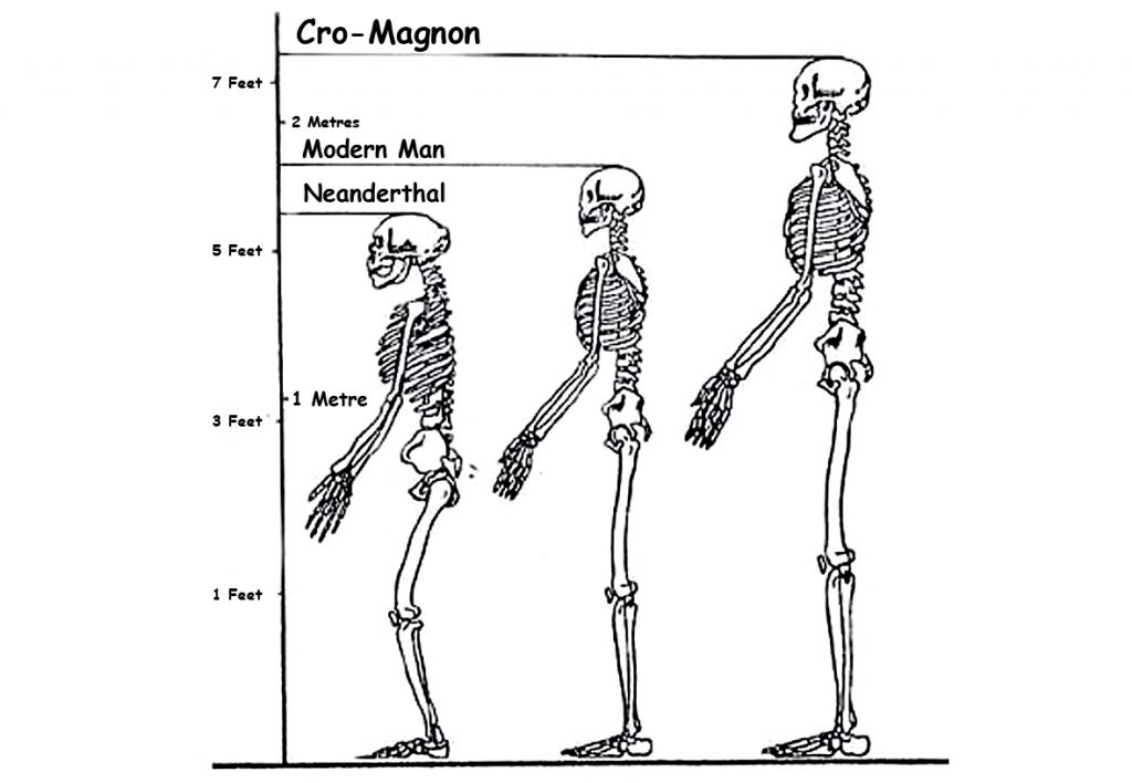
 The mandible is robust, with massive ascending ramus (the upward projection of the jaw, where it attaches to the skull), has strongly developed points of muscular attachment and quite a prominent chin. The stature of CroMagnon is very tall, on average well over six feet.  Their longevity was exceptional for a prehistoric Society as some skeletons are found to be over 50 years old – this should be set in context to other ancient civilisations. The average age of a Neolithic (farmers) man was 25 and a Roman only 30.

You can see why the Victorians, with an average height of 5′ 2″ and an average age of death at 34 (44 for the academic classes and 25 for the working class) saw Cro-Magnon man as a sub-species as far apart from themselves as the Neanderthal.

An interesting fact is that there are notable differences between Eastern and Western types of Cro-Magnon man humanoids genetically mutated to create Haplogroups (a group of genes within an organism that was inherited together from a single parent) M173 and M343 about 50,000 years ago; some moved east the others moved west.  The Eastern types have been given individual titles to show the variation, such as Brunn Man, Predmost or Combe Capelle. 

These Eastern types of humanoid are generally shorter, more gracile and smaller brained than the western Cro-Magnon that ventured into Europe. Still, there is now a tendency to place them all under one banner called ‘modern man’, which has the effect of confusing the issue and leading to generalisations that Cro-Magnon was not as tall or larger brained as they were smaller non-Cro-Magnons have been added to bring down the average statistic. For example, the Combe Capelle Man is only 5′ 4″ rather than the French and Spanish Cro-Magnons’ six-foot statue; hence, some reference books classify Cro-Magnons incorrectly as 5′ 6″ – 5′ 7″.
Giant Skeletons (Cro-Magnon)

The second example of the difference between east and west Cro-Magnon is the tool kit they used; the Eastern tools are just a slight extension of the Neanderthal toolkit of the past 80,000 years, whereas the Western toolkits show signs of craftsmanship.  However, the most apparent signs of the difference between the east and west Cro-Magnon’s and all other members of the human tree is that Cro-Magnons brought art and music to our civilisation.  It is in the paintings found ‘throughout’ the Pyreness and Cantabrian mountains in France, which have become famous throughout the world, showing a high degree of skill and coordination of these skilled artists, which was missing in the eastern group.

Anthropologists agree that the eastern Cro-Magnons were nomads indicated by their numbers, which were extremely thin and scattered in occupational sites.  While the western Cro-Magnon numbers are usually thick (meaning a long and settled occupation in a single place) and are clustered towards the rivers of the European continent, which could explain the sources of their food and the differences in their physical appearance over time and consequently, their increased intelligence. 

These occupational sites also contain the first evidence of ‘houses’, which answers an earlier question in this chapter asking where did they live if not in caves – in fact; they lived in houses showing that this society was not the stereotypical ‘cave men’ archaeologists still used to describe prehistoric Europeans.

Cro-Magnons resulted from a crossbreed between migrating Sapiens from Africa and Neanderthals, and this crossbreeding took place on many occasions and locations ‘prior’ to their travels into Europe from  Siberia (Caspian Sea). Consequently, how the family structure is managed is very important if this kind of crossbreeding was going to be successful, it is more likely that the Neanderthal family groups would mate with Sapien males for they are of ‘matriarch’ structure, which is reflected in their burial practices, which have shown that Neanderthals buried their dead with items and flowers long before homo sapiens burial customs were established.

It should be recognised that even in today’s societies, in the third world, infanticide is commonplace as strong independent boys are desired as they can work more hours and support the family financially better than girls who are seen as liabilities.   Hunter-Gather Sapien groups would travel long distances, and for the same reason, boys would be ‘preferred’ to the social group that was probably male-dominated, leaving girls and the old when the terrain becomes difficult without assistance.

Giant Skeletons (Cro-Magnon)

Crossbreeding

The Neanderthals had successfully survived over 100,000 years of a fluctuating climate without extinction – but then disappeared almost overnight without reason or archaeological evidence.  The causation of this extinction could be relatively simple – as in the female to male ratio being too great/ small or quite possibly reintroducing of a Sapien disease, which was deadly to the Neanderthals.  For example, the smallpox plagues that infested Central America after the arrival of the Spanish, who made war on the Aztecs.  The war killed little compared to the Smallpox that spread North and South, killing 90% of the population who had no immunity. Such a disease during the harsh winters of the last ice age would undoubtedly end the Neanderthal species, especially when you remember the finding of Prof Eiberg earlier noting that people carrying ‘blue-eyed’ DNA in modern man carried a type of disease immunity.

So why was there crossbreeding?

Males of many species tend to ‘mate’ at random without emotional or family connection for self-fulfilment, and so the pairing would leave a Neanderthal’ single mother’ and a Cro-Magnon child who shared the positive aspects of both species.  Alternatively, if the species was disappearing due to the lack of males or a selective disease, the Neanderthals may have no other option but to pair with Sapiens for pure survival.

So what are the positive attributes of this crossbreeding of the Species?

Neanderthals used simple stones for tools. They constructed and made essentially the same stone tools repeatedly for perhaps 200,000 years, until around 35,000 years ago, with slight variation or consideration of alternatives.   They greatly lacked creativity, initiative or imagination, and tended to create simple stone tools that served a single purpose, even with a larger brain than modern man.

As neatly summed up by an ardent defender of Neanderthal cognitive capabilities (Hayden, 1993, p. 139).

“As a rule, there is no evidence of private ownership or food storage, no evidence for the use of economic resources for status or political competition, no elaborate burials, no ornaments or other status displays items, no skin garments requiring intensive labour to produce, no tools requiring high-energy  investments, no intensive regional exchange for rare items like seashells or amber, no competition for labour to produce economic surpluses and no corporate art or labour intensive rituals in deep cave recesses to impress onlookers and help attract labour.”
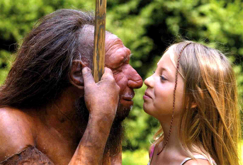
Giant Skeletons (Cro-Magnon)

Neanderthals tended to live in the ‘here and now’ with limited ability to think about or consider the distant future, the only notable exception being the future life after death. This noteworthy exception is a function of the differential evolution of the head-on versus the temporal lobes. The head-on lobes are the ‘organisational and management of the brain and are responsible for the initiative, goal formation, long-term planning, the generation of multiple alternatives, and the consideration of numerous alternative consequences. The frontal lobes are the source of creativity and imagination, whereas the temporal lobes are the brain’s ‘speech and vision centre.  The temporal lobes were maximally developed in Neanderthals, whereas the frontal lobe would increase in size by a third in the transition from archaic humans to Cro-Magnon woman or man.

Based on a gross analysis of the skull and casts made of the skull’s inner surface, it is apparent that Neanderthal men and women possessed a well-developed inferior temporal lobe, whereas the frontal lobe is sloped and stunted. The temporal lobes and the limbic structures buried within are directly implicated in the generation of personal, emotional, and religious experience, including the ability to form long-term emotional attachments and feel intense love. This fierce love plays an essential role in the nurturing power of the less mobile Neanderthal groups, less likely to abandon their ‘crossbreed’ babies, unlike the more mobile ‘nomad’ Homo Sapien groups.

Giant Skeletons (Cro-Magnon)

Neanderthals provided loving care for friends and family who had been injured or maimed, enabling them to prolong their lives despite their grievous injuries. For example, the skeleton of one Neanderthal male, approximately aged 45 when he died, had been cared for several years following profoundly crippling injuries. His right arm had wasted away through disease or injury, and his lower arm and hand had apparently been ripped or bitten off, and his left eye socket, right shoulder, collarbone, and both legs were severely injured. Someone loved and tenderly cared for this man. He was no doubt a father, a husband, a brother, and a son, and someone in his family not only provided long term loving care to make him comfortable in this life but prepared him for the next life as well.

Moreover, Neanderthals could not fashion complex tools or think complex thoughts, as they lacked the ‘complex’ language, although they could communicate on a fundamental level.  However, they were people of passion who experienced profound emotions and love, made possible by the limbic system and temporal lobe. It is because they had the limbic capacity to experience love, spiritual awe, and religious concerns that these expressions of love may have continued beyond death. Hence, the Neanderthals carefully buried their dead, providing them with food and even sprinkling the bodies with seven different types of blooming fragrant flowers.

 In comparison, their ‘crossbreed’ offspring were intellectual giants; they had a brain capacity more significant than both mum and dad, inheriting the Neanderthal’s visual cortex and strength/weight with the Sapiens frontal cortex and height/mobility. Cro-Magnons were accomplished artists, musicians, craftsmen, sorcerers, and highly talented hunters, fishermen, and highly efficient gatherers and herbalists. When they emerged upon the scene over 35,000 years ago, they carried and fashioned tools and weapons that had never been seen before. They had the know-how to make and bake pottery to construct clay figurines and bake bread by building kilns and burning coal to fire and mould their minds’ creations.

As Jacob Bronowski observed in his book and T.V. series ‘The Ascent of Man’ 1973. “From an early time man made tools by working the stone.  Sometimes the stone had a natural grain, sometimes the toolmaker created the lines of cleavage by learning how to strike the stone.  It may be the idea comes, in the first place, from splitting wood, because wood is a material with a visible structure which opens easily along the grain, but which is hard to shear across that grain.  And from that simple beginning man, prizes open the Nature of things and uncover the laws that the structure dictates and reveals.  Now the hand no longer imposes itself on the shape of things.  Instead, it becomes an instrument of discovery and pleasure together, in which the tool transcends its immediate use and enters into and reveals the qualities and forms that lie hidden in the material.  Like a man cutting a crystal, we find in the form within the secret laws of Nature.”

Giant Skeletons (Cro-Magnon)

But this ‘new thinking’ and relationships run far deeper than the simple tools; they were remoulding and discovering, for Bronowski found a ‘direct link’ between art, structure, creativity and society.  In reality, these elements show us that this society was ‘well structured’ probably with an established hierarchy system.  Humans join into families, and families join into kinship groups, the kinship groups into clans or tribes, and finally, the tribes into nations or civilisations.

 From the time of Homo Erectus (1.9 million to 500,000 years ago), humans had utilised fire to keep warm, provide light, cook their food, and ward off animals. However, the Cro-Magnon learned over 30,000 years ago how to make fire using the Firestone; iron pyrite was repeatedly struck with a flint, causing sparks, which could easily ignite brush. They also created the first rudimentary blast furnaces capable of emitting enormous amounts of heat to fire clay. This was accomplished by digging a tiny tunnel into the bottom of the hearth, which allowed air to be drawn in. Indeed, 30,000 years ago, these people were making fire-hardened ceramics and clay figures of animals and females with bulging buttocks and breasts, presumed to be the first goddesses or just the first ‘impressionist’ art form.

Much of the art produced, be it finely crafted ‘laurel leafs’ or other artistic masterpieces, served ritual, spiritual, and aesthetic functions. However, they also created art that was meant to be looked at, owned and admired, and for trade, jewellery and household decorations, and as highly prized possessions or possibly religious reverence.  Likewise, the first musical instruments were created by these people some 25,000 years ago. These included wooden drums, tiny flutes and whistles.

These people were also the first to weave baskets and the first to use ‘needle and thread’ to make finely fitted clothes carefully and deftly sewn together. Unlike all those who had come before them, they decorated their clothes, tools, and weapons with elaborate designs and geometric and animal symbols.  Within their underground ‘cathedrals’ (using the stone structure of the cave system as we use stone in our past religious buildings), they left behind elaborate and complex paintings, some of which were dark, mysterious and almost 3-dimensional. These people demonstrated an aesthetic, artistic awareness and mastery that were unprecedented and equal to the ability of any living artist today. 

Thirty-five thousand five thousand years ago, Cro-Magnon was painting animals not only on walls but on ceilings, utilising rich yellows, reds, and browns in their paintings and employing the actual shape of the cave walls to conform with and give life-like dimensions, including the illusion of movement to the creature they were depicting. Many of their engravings on bones and stones also show a complete mastery of geometric awareness, and they often used the natural contours of the cave walls, including protuberances, to create a 3-dimensional effect.

The drawing or carving often became a harmonious or organic part of the object, wall, ceiling, or tool upon which it was depicted. The Cro-Magnon drew and painted scenes in which animals mated, defecated, fought, charged, and/or were fleeing and dying from wounds inflicted by hunters. The Cro-Magnon cave painters were exceedingly adept at recreating the scenes of everyday life. Moreover, most of the animals were drawn to scale; that is, they were depicted in their actual size, and all this, 35,000 years ago.

Giant Skeletons (Cro-Magnon)

“Here I can only give you may personal view” Jacob Bronowski (The Ascent of Man, 1973, BBC) “I think that the power that we see expressed here for the first time is the power of anticipation: the forward-looking imagination.  In these paintings, the hunter was made familiar with dangers he knew he had to face but had no come.  When the hunter was brought here into the secret dark, and the light was suddenly flashed on the pictures, he saw the bison as he would face him, he saw the running deer, he saw the turning boar.  And he felt alone with them as he would in the hunt.  The moment of fear was made present to him; his spear arm flexed with an experience he would have and needed not to be afraid of.  The painter had frozen the moment of fear, and the hunter entered it through the painting as if though an air-lock.”

The Cro-Magnons were inventive and obtained their colours from natural earth pigments, such as ocher, a clay that contains a variety of iron minerals. However, whereas Neanderthals had a fondness for red, the Cro-Magnon learned to separate and mix these pigments, creating various hues and colours. To mix and to arrive at the correct consistency, a variety of lubricants were employed, such as blood, urine, vegetable and fruit juices, animal fat, and the contents of eggs. The separate colours were then mixed in various hollowed-out rocks and shells.  The Cro-Magnon artist used a brush, as well as his or her fingers in order to paint. In fact, they used a variety of different brushes, which enabled the artist to create different shades and strokes. In some cases, the artist simply blew the paint onto the drawing via a tubular bone, making a mist-like spray.

Giant Skeletons (Cro-Magnon)

Cro-Magnon artists had also invented abstract impressionism, as many of their paintings and artworks were exceedingly abstract, surrealistic, or comprised of geometric forms and concentric shapes and ovals, which in some cases formed abstract versions of animals or women. Indeed, they displayed an artistic mastery equal to that of any modern master, including Picasso. Awestruck by these Cro-Magnon masterpieces’ Picasso once complained that in 30,000 years, “we have learned nothing new. We have invented nothing.” Indeed, the geometric and angular form of representation employed by these pre-Atlantis Masters repeatedly appears throughout history and is found in Egyptian, Sumerian, and even early Greek art.

So to lose this unique species to the ‘politically correct’ anthropologists is not only complete madness but scientifically inaccurate.   Cro-Magnons are the forefathers of our culture and humanity.  It would be lovely if a sole pair of humanoids (Adam & Eve) created all the diverse cultures of humanity, but that is delusional.  Mankind has evolved by mutation into groups of different humanoids, which Darwinian Theory is all about – mutation, not adaption!

Cro-Magnons are the ‘mutational’ group of the crossbreeding of humans and Neanderthals; these sub-species possessed blond/red hair and blue/green eyes.  They were the prehistoric giants of Victorian’s archaeology are alive and well in our ‘modern world’ for we see them nearly every day of our lives count the numbers of these ‘mutations’, you find on the Bus, Tube or on Television.

For further information on Cro-Magnons click HERE or visit our video channel HERE.

Are Raised Beaches Archaeological Pseudoscience?

A raised beach, marine terrace, or perched coastline is an emergent coastal landform. Raised beaches and terraces are beaches or wave-cut platforms high above the current shoreline relative to a fall in the sea level.  These are seen in Norway or Scotland, where the ice cap has compressed and sunk the ground surface layer (Isostatic Transformation) and has over thousands of years rebounded back to its original height – but are Raised Beaches – archaeological pseudoscience?

Are Raised Beaches Archaeological Pseudoscience
A typical beach – Raised Beaches – Are Raised Beaches Archaeological Pseudoscience

One of the classic ‘Raised Beach’ theories is on the South Coast of Britain between Bournemouth and Brighton.  Unfortunately, an ice cap has never reached these areas during the last half a million years, although the raised beaches are just 18″ below the topsoil. Theories of how this sandy layer that appears in the soil layers high in hill sediments are abundant, including British tsunamis (giant tidal waves that left sand deposits on hills).

If you consult Wikipedia, it will tell you:

The total displacement of the shoreline relative to the age of the associated interglacial stage allows calculation of a mean uplift rate or the calculation of eustatic level at a particular time if the uplift is known

In order to estimate vertical uplift, the eustatic position of the considered paleo sea levels relative to the present one must be known as precisely as possible.

Our chronology relies principally on relative dating based on geomorphologic criteria but in all cases, we associated the shoreline angle of the marine terraces with numerical ages. The best-represented terrace worldwide is the one correlated to the last interglacial maximum (MISS 5e) (Hearty and Kindler, 1995; Johnson and Libbey, 1997, Pedoja et al., 2006 a, b, c). Age of MISS 5e is arbitrarily fixed to range from 130 to 116 ka (Kukla et al., 2002) but is demonstrated to range from 134 to 113 ka in Hawaii and Barbados (Muhs et al., 2002) with a peak from 128 to 116 ka on tectonically stable coastlines (Muhs, 2002).

Older marine terraces well represented in worldwide sequences are those related to MIS 9 (~303-339 ka) and 11 (~362-423 ka) (Imbrie et al., 1984). Compilations show that sea level was 3 ± 3 meters higher during MISS 5e, MIS 9 and 11 than during the present one and –1 ± 1 m to the present one during MIS 7 (Hearty and Kindler, 1995, Zazo, 1999). Consequently MIS 7 (~180-240 ka; Imbrie et al., 1984) marine terraces are less pronounced and sometimes absent (Zazo, 1999). When the elevations of these terraces are higher than the uncertainties in paleoeustatic sea level mentioned for the Holocene and Late Pleistocene, these uncertainties have no effect on overall interpretation.

Sequence can also occur where the accumulation of ice sheets depressed  the land so that when the ice sheets melt the land readjusts with time thus raising the height of the beaches (glacial-isostatic rebound)and in places where co-seismic uplift occurs. In the latter case, the terraces are not correlated with sea level high stand even if co-seismic terraces are known only for the Holocene.

What is more interesting is the note Wikipedia has placed with this explanation, which states:

“This article may be too technical for most readers to understand. Please help improve this article to make it understandable to non-experts, without removing the technical details. The talk page may contain suggestions.” (September 2010)

And here lies the problem with this theory – it’s far too complicated to be true!

This is a much simpler explanation geologist’s use:

Raised Beaches:

  • When sea levels fall, more of the coastline is revealed. Beaches, no longer combed by wave are left, stranded and exposed above the new sea level.
  • These features are called raised beaches.
  • The lower part will often show signs of marine erosion, and a small cliff may be formed.
  • Any former cliff-line is also left stranded. No longer undercut by the sea if it becomes a degraded cliff. Over time, it will often become clothed in shrubs and bushes – a sure sign of physical inactivity.

Geologists have come up with this complex argument for a natural phenomenon because quite clearly, we see sandy soil levels in hills and other places where we perceive that water has not been for some millions of years.  In some countries, this geological problem can be easy dismissed as within the last 20,000 years (a relatively short and recent period in geological terms), these areas have had ice covering them from the previous ice age, and the severe conditions that it produces is always a good excuse for such events.

Are Raised Beaches Archaeological Pseudoscience
Suggested Raised Beach terraces – Raised Beaches – archaeological pseudoscience?

These events include the rising and falling of continents (isostatic transformations), although closer examination of these events shows if they were causing these raised beaches, the effect was limited.

Geologists claim that raised beaches in Western Scotland have been recognised 8m, 15m and 30m above the present sea level and raised beaches can only technically exist and be seen on coastal areas as the surface area below the beach has had to be cut away by the sea to reveal the raised beach. 

The first problem with this theory is that these beaches are at different levels.  If you look at a UK map today, you will notice all the beaches are at one level – sea level.  So this is where ‘localised’ factors are introduced to the geological equation.

The sea in the past was lower than today, and at the end of the last ice age, it would have been some 60m lower – so these Scottish raised beaches are not 8m, 15m and 30m higher than sea level but 68m, 75m and 90m. 

Are Raised Beaches Archaeological Pseudoscience
Scottish Raised Beaches – Raised Beaches – archaeological pseudoscience?

This is where the ‘isostatic transformation’ kicks in, or as Wikipedia explains it as:

Post-glacial rebound (sometimes called continental rebound, glacial isostasy, glacial isostatic adjustment) is the rise of land masses that were depressed by the huge weight of ice sheets during the last glacial period, through a process known as isostasy. It affects northern Europe (especially Scotland, Estonia, Fennoscandia, and northern Denmark), Siberia, Canada, the Great Lakes of Canada and the United States, the coastal region of the US state of Maine, parts of Patagonia, and Antarctica.

You instantly know when the academics are floundering for explanations when they use various words for the same effect.  This is because when they get stuck using one explanation, they will tell you, “no that’s glacial isostasy, this is glacial isostatic adjustment – something completely different.” A sure way of saying ‘no idea’ but if I make up a series of complex names with intelligible explanations – they will not ask me awkward questions and think I’m clever!’ This well known  (bluff them with science or statistics) ploy is also used by politicians during the current covid crisis!

Wiki continues:

During the last glacial period, much of northern Europe, Asia, North America, Greenland and Antarctica were covered by ice sheets. The ice was as thick as three kilometres during the last glacial maximum about 20,000 years ago. The enormous weight of this ice caused the surface of the Earth’s crust to deform and warp downward, forcing the viscoelastic mantle material to flow away from the loaded region. At the end of each glacial period when the glaciers retreated, the removal of the weight from the depressed land led to slow (and still ongoing) uplift or rebound of the land and the return flow of mantle material back under the deglaciated area. Due to the extreme viscosity of the mantle, it will take many thousands of years for the land to reach an equilibrium level.

Studies have shown that the uplift has taken place in two distinct stages. The initial uplift following deglaciation was almost immediate due to the elastic response of the crust as the ice load was removed. After this elastic phase, uplift preceded by slow viscous flow so the rate of uplift decreased exponentially after that. Today, typical uplift rates are of the order of 1 cm/year or less. In northern Europe, this is clearly shown by the GPS data obtained by the BIFROST GPS network.

Studies suggest that rebound will continue for about at least another 10,000 years. The total uplift from the end of deglaciation depends on the local ice load and could be several hundred metres near the centre of rebound.

Recently, the term post-glacial rebound has gradually been replaced by the term glacial isostatic adjustment. This is in recognition that the response of the Earth to glacial loading and unloading is not limited to the upward rebound movement, but also involves downward land movement, horizontal crustal motion, changes in global sea levels,  the Earth’s gravity field, induced earthquakes and changes in the rotational motion.  An alternate term that is sometimes used is glacial isostasy, because the uplift near the centre of rebound is due to the tendency towards the restoration of isostatic equilibrium (as in the case of isostasy of mountains). Unfortunately, that term gives the wrong impression that isostatic equilibrium is somehow reached, so by appending “adjustment” at the end, the motion of restoration is emphasised.

Alternatively, in simple terms – the ice age squashed the surface of the planet and made it sink and then when the ice had gone, it popped up again! 

Are Raised Beaches Archaeological Pseudoscience
Post-Glacial rebound – Raised Beaches – archaeological pseudoscience?

So as the land went from squashed to where we see it now, the beach would have brushed against it, creating a beach, and that is what we see today in the cliffs!

‘Job done, easy explanation, now go home, students’ – But is it?

We can see beaches at 8m, 15m and 30m, but where are the 1m, 2m 3m 4m 5m 6m…. 29m beaches which would also be on the shoreline of this rising cliff face?  If the sea has cut away the shoreline washing away the 1-7m, 1-15m and 1 – 29m shoreline, then behind the raised beach, there should be a 9m, 16m and 31m beach, which will be exposed if this suggested weathering continues.

However, there is not – the only beach is found at one level, and that is a fundamental flaw in the hypothesis.

Geologists understand this flaw in this hypothesis, so some have come up with a much more elaborate theory that can’t be as easily disproved; this is called:

The Tsunami Theory – from Wikipedia

Tsunamis affecting the British Isles are extremely uncommon, and there have only been two confirmed cases in recorded history. However, meteotsunamis are somewhat more common, especially on the southern coasts of England around the English and Bristol Channels.

The classic case geologists use as an example occurred in Scotland (6,100 BCE) from the Storegga Slide, from Wikipedia:

The east coast of Scotland was struck by a 70 feet (21 m) high tsunami around 6 100 BCE, during the Mesolithic period. The wave was caused by the massive underwater Storegga slide off

Are Raised Beaches Archaeological Pseudoscience
Storegga Slide Off – Raised Beaches – archaeological pseudoscience?

Norway, which occurred then. The tsunami even washed over some of the Shetland Islands. Tsunamite (the deposits left by a tsunami) dating from this event can be found at various locations around the coastal areas of Scotland, and are also a tourist feature in the Montrose Basin, where there is a layer of deposited sand about 0.6 metres (2.0 ft) thick.

At the time, what became the east coast of England was connected to the areas of modern Denmark and The Netherlands by a low- lying land bridge, now known to archaeologists as Doggerland.

The area is believed to have had a coastline of lagoons, marshes, mudflats, and beaches, and may have been the most successful hunting, fowling and fishing ground in Europe then available. Much of this land would have been inundated by the tsunami, with a catastrophic impact on the local human population.

Sadly, geologists are not mathematicians, and the numbers do not work! 

Remember earlier; I had mentioned that in the past, sea levels were lower than today by as much as 60m at the end of the Ice Age.  Well, by 6,100BCE, the seas were not 60m lower, but according to marine geologists 20m lower than today.  So a vast 21m wave would have indeed swamped Doggerland, but would only be 1m higher than today’s sea level, so the deposits they list found 20m higher than today’s sea level could not be caused by this tsunami.

This leaves geologists in a complete mess; as pointed out in the Wikipedia article, these deposits are dated at 6,000 BCE, so they could not be a ‘raised beach’ as it was 20m below!

Fortunately, for us, the date of 6 100 BCE does allow us to find an answer to this mystery.  The ice age melted just a few thousand years before this date, which created a ‘Post-Glacial Flooding’, which would have carried similar quantities of sand and pebbles like a beach to these ancient waterways’ shorelines we see in our case study.

Case Study – Brighton

From Brighton & Hove website:

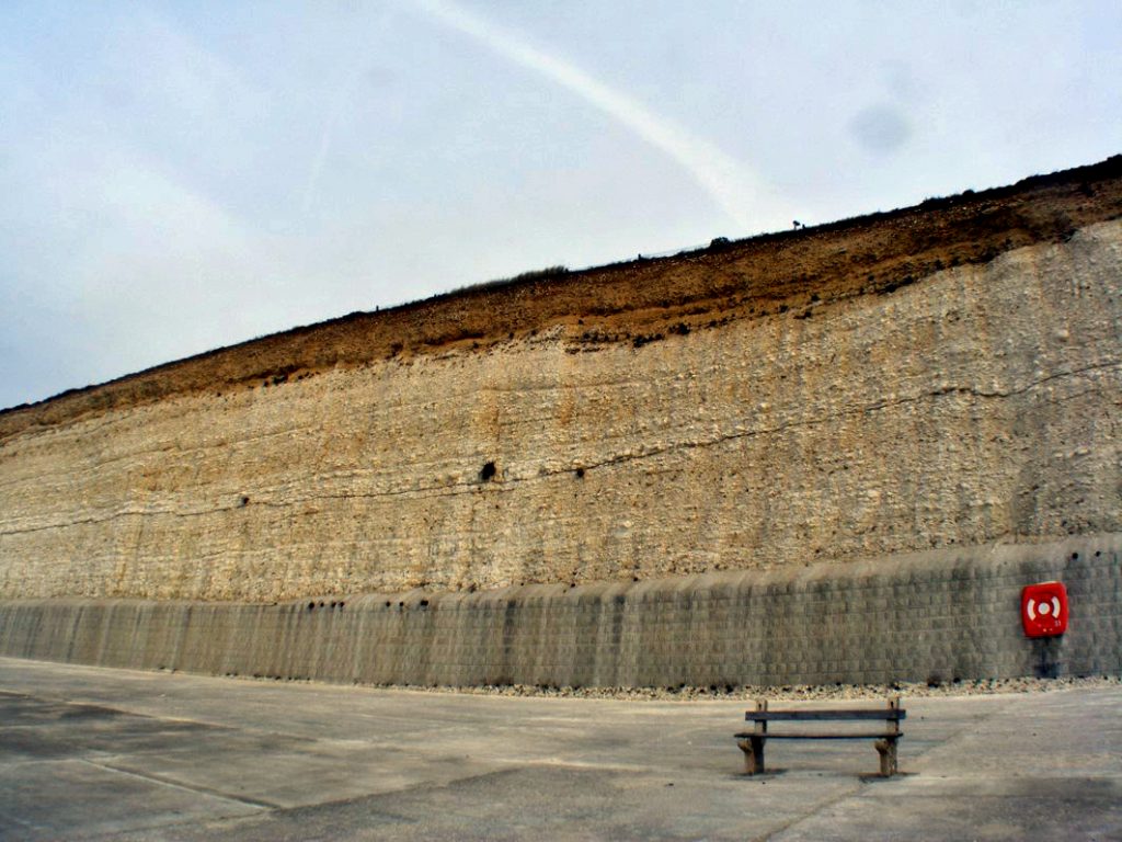
Inspection of the cliffs at Black Rock will reveal they are not composed of solid chalk-like those to the east along the East Sussex Coast but comprise chalk and flint rubble resulting from cliff collapse and brown, sandy water-lain sediments washed down the Whitehawk Valley. These deposits were laid down under two phases of extremely cold conditions when the Earth was in a stage of prolonged global cooling.

Are Raised Beaches Archaeological Pseudoscience
Brighton Asda Car Park – Raised Beaches – archaeological pseudoscience?

However, below these cold stage rubbles can be seen a bed of rounded flint gravel identical to that you might find on the beach at Brighton today. Nevertheless, these pebbles were laid down between 200 and 250 thousand years ago and are now some 8 – 10m above modern sea level. 

They were laid down during a phase of global warming around a quarter of a million years ago and have been elevated to their current height above sea level through long term uplift of South East England due to tectonic processes. These gravels and others surviving beneath the Sussex Coastal Plain between Brighton and Chichester form a record of changing environments over millennia.  They are known as Raised Beaches and can be traced running inland parallel to the modern Sussex coast.

The Brighton Raised Beach can be traced through Kemptown, Hove, Worthing and then on to Portsmouth as an extensive spread of sands and gravels overlain by inter-tidal silts and occasionally preserved landscapes. They are often associated at Black Rock and elsewhere with the bones of horse and mammoth. However, they are generally quite profoundly buried, and so the Black Rock cliffs provide a unique visible exposure through these sediments.

On its face, the description and logic seem pretty plausible, so most people accept this as gospel and then raised beaches to become part of our geology – but there are problems here. Remember all the information about  ‘Isostatic transformations’; the bottom line was that all these beaches were caused by the landmass rebounding after the last ice age, as up to a mile of the glacier was on the surface squashing the landmass.

In Brighton, there was no glacier; it finished about 100 miles away.  Now, this fact is only recent (as geology is constantly reinventing itself), but at the time of Raised Beaches in Brighton was introduced, they believed that the South Downs were carved from an ice sheet, so modern geologists have a problem with dates.  We have moved from 10 -20,000 years for the formation of the raised beaches to now 250,000 years.

Now geologists struggle to understand what happened 20,000 thousand years ago, let alone 250,000 – but it is sufficient time to disqualify anyone from arguing against it – until now.  So, where did this date come from, and how was it obtained?  For this, we can look at a news report from the BBC:

Cliffs at Brighton Marina hide remains from Ice Age.

If you had to name sites in Sussex where you could see Ice Age archaeology, Brighton Marina would hardly spring to mind.  However, right by the entrance to the complex, by a superstore car park, lays a stretch of cliff, which had traces from the Palaeolithic era, which are over 200,000 years old.

Matt Pope, a researcher and archaeologist at University College London, says they are distinctive to the rest of the coastline. “Anyone looking at these cliffs would think they are part of the chalk cliffs of Sussex,” he told the BBC; the cliffs are covering a beach which is more than 200,000 years old and now lies around 15 metres above current sea level. “From the beach, we’ve picked up the tools of ancient Neanderthals and the bones of the animals they were hunting,” Matt continued.

“There’re a 200 to a 300-yard stretch of ice age sediment, which contains bones of mammoth, woolly rhinoceros, bison and whale.”

The problem with this assumption is that these animals are over 250,000 years old.  We know from the dredging of the bottom of the sandbank called Dogger that these same bones are being collected to be sold on the Internet.  Dogger sank less than 10,000 years ago, and the bones that are currently being collected are on the surface of the sandbank, so these animals would have been alive at the time of Doggerland sinking.

Yet there has been some scientific research in this area, as can be seen from this extract from UCL’s Archaeological South East division report 2747 (2007) on the Black Rock area:

The Raised Beach Deposits can be Archaeology South-East Brighton International Arena, Black Rock clearly seen as a lighter band near the bottom of the cliff (in Plate 5). New dating  methods, which measure amino-acid ratios from shells preserved in sediments,  date the Brighton-Norton formation to approximately 200,000 years Before Present (BP) (ibid.). Although archaeological finds from this sequence are relatively rare it is likely that Sussex was occupied by a Neanderthal type population at this time, alongside cold climate mammals such as horse and mammoth (ibid.). Faunal remains from the sequence include horse, bison and red deer. As with all the raised beach deposits in Sussex, the Black Rock exposure is of international importance, and as such is classified as both an Archaeologically Sensitive Area (ASA) and a Site of Special Scientific Interest.

Are Raised Beaches Archaeological Pseudoscience
(Plate 5) notice the beach is at almost 45 degrees to the horizon – Raised Beaches – archaeological pseudoscience?

Sadly, you indeed see a line of sandy soil, but what is not explained is the fact that it is ‘concave’ in shape and the centre; there is a ton of chalk, and if you follow the line, it flies off into the air.  Now the report talks about the chalk cliff’s ‘raised beaches’ from Portsmouth to Brighton but does not explain why they stop at Brighton as they go all the way around the coast to Eastbourne.  These cliffs are of a similar age and deterioration, which can be seen from the chert layers embedded into the chalk cliffs.

So what is the answer to this mystery?

If we go back to the evidence of the raised beach, we find something very unusual.  The beach has been entombed by a ton of chalk.  This chalk is called ‘unstructured’, and this term is used when chalk has been broken away from the ‘solid’ chalk and relayed down.  Now the question you should ask is ‚what has happened to this part of the chalk cliff, and does it have some relevance to the ‘raised beach’ found?

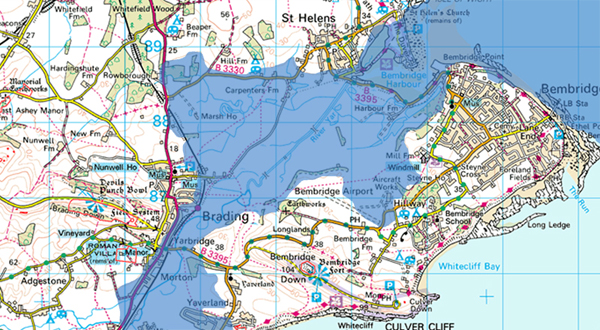
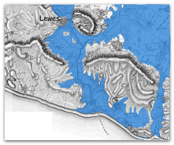
Looking at a British Geological Map of the South Downs and what is called ‘superficial deposits’ (anything that is not bedrock and millions of years old), you will find the strangest patterns weaved into the sub-soil.  They look like a vast tree and its branches, but rather than starting from the trunk and moving outward to the leaves, they originate high on the hills of the South Downs and move down to the sea – from branch to trunk.

Are Raised Beaches Archaeological Pseudoscience
Another raised beach or a paleochannel from the last ice age? Raised Beaches – archaeological pseudoscience?

These are deposits of what geologists call ‘head’ in the branches and ‘alluvium’ in this most bizarre formation trunks.  What links these superficial deposits is that they are made up of the same substances – sand, silt and pebbles.  These are the remains of what I call the ‘Post Glacial Flooding’ that affected our land some 10,000 years ago when the ice age finished and the ice caps melted. 

After the last ice age when two miles thick of ice lay on our tiny little island, rather than the water from this great melt simply running away into the sea as most of the ‘experts’ believe, it did seep into the soil and rocks, creating vast lakes under the ground which hydrologists call ‘aquifers’.  Because of the extreme mass of the melting ice (remembering that usually a couple of inches of rain typically result in massive flooding even today), the 66,000 inches of equivalent rain must have swamped the landscape after the last ice age and stayed flooded for thousands of years afterwards.

Is this what we see on the Cliffs of Brighton?

The fact that this ‘raised beach’ is found to be concave like the bottom of a river and doesn’t follow a flat path horizontally across the cliff in a straight-line that follows the chert layers, which were laid some 80 million years earlier, clearly shows a problem of constancy.  The tons of chalk that lay broken on top of this beach also show that another force (unexplained) was acting in this region while the beach was constructed.  However, what is more, compelling is the BGS maps showing that this ‘beach’ was just one (a huge one, I grant you) post-glacial exit from the floodwaters of the great melt which affected our land some 10,000 years ago, which would explain the animal bones that were found in these deposits? 

The other anomaly that came from their research was the amino-acid dating of shells found on the bottom of the beach.  This can easily be understood by the fact that the floodwaters would have cut into the Cliff chalk surface (and in some cases, this is as deep as 15m) and pushed the debris down the river to be re-laid at a point close to a river’s exit by the sea, as we see today in most rivers. Moreover, these post-glacial rivers affect all parts of Britain, which would also explain the 8m, 15m and 30m beaches of Scotland and the 20m tsunami found inland. 

Post-Glacial flooding, a reality that affected Britain and our finding from investigations by the Russian Archaeological Federation, affected other parts of the world, including the Black and Caspian Sea.  To ignore the facts that this island must have flooded in the recent past with some 368.1 Giggatones of water from the last Ice Age is to overlook the most likely candidate for these sand shelves on top of our hills.

For More information about: Raised Beaches – archaeological pseudoscience? see this article or video

Gigantic Prehistoric Canals (Dykes) – Wansdyke

This is an extract from the forthcoming book ‘Gigantic Prehistoric Canals of Britain – a gazetteer of all known Dykes’. This essay is a detailed analysis of Wansdyke and shows why the Dyke was constructed and disproving the current ‘expert’ analysis as being frivolous nonsense as a scientific explanation.

CASE STUDY – Wansdyke

According to Wikipedia, “Wansdyke consists of two sections of 14 and 19 kilometres (9 and 12 mi) long with some gaps in between. East Wansdyke is an impressive linear earthwork, consisting of a ditch and bank running approximately east-west, between Savernake Forest and Morgan’s Hill. West Wansdyke is also a linear earthwork, running from Monkton Combe south of Bath to Maes Knoll south of Bristol, but less impressive than its eastern counterpart. The middle section, 22 kilometres (14 mi) long, is sometimes referred to as ‘Mid Wansdyke’ but is formed by the remains of the London to Bath Roman road. It used to be thought that these sections were all part of one continuous undertaking, especially during the Middle Ages when the pagan name Wansdyke was applied to all three parts.

East Wansdyke in Wiltshire, on the south of the Marlborough Downs, has been less disturbed by later agriculture and building and remains more clearly traceable on the ground than the western part. Here the bank is up to 4 m (13 ft) high with a ditch up to 2.5 m (8.2 ft) deep. Wansdyke’s origins are unclear, but archaeological data shows that the eastern part was probably built during the 5th or 6th century. That is after the withdrawal of the Romans and before the takeover by Anglo-Saxons. The ditch is on the north side, so presumably it was used by the British as a defence against West Saxons encroaching from the upper Thames Valley westward into what is now the West Country.

West Wansdyke, although the antiquarians like John Collinson considered West Wansdyke to stretch from south East of Bath to the west of Maes Knoll, a review in 1960 considered that there was no evidence of its existence to the west of Maes Knoll.   Keith Gardner refuted this with newly discovered documentary evidence.  In 2007 a series of sections were dug across the earthwork which showed that it had existed where there are no longer visible surface remains.

It was shown that the earthwork had a consistent design, with stone or timber revetment. There was little dating evidence, but it was consistent with either a late Roman or post-Roman date. A paper in “The Last of the Britons” conference in 2007 suggests that the West Wansdyke continues from Maes Knoll to the hill forts above the Avon Gorge and controls the crossings of the river at Saltford and Bristol as well as at Bath.

As there is little archaeological evidence to date the western Wansdyke, it may have marked a division between British Celtic kingdoms or have been a boundary with the Saxons. The evidence for its western extension is earthworks along the north side of Dundry Hill, its mention in a charter and a road name.

Gigantic Prehistoric Canals (Dykes) - Wansdyke
The location of Wansdyke in prehistoric times – in comparison to the Victorian canal – Prehistoric canals (dykes)

Figure 10- Map comparing Wansdyke (green) to the Kennet and Avon canal
(Gigantic Prehistoric Canals (Dykes) – Wansdyke)

The area of the western Wansdyke became the border between the Romano-British Celts and the West Saxons following the Battle of Deorham in 577 AD.  According to the Anglo-Saxon Chronicle, the ‘Saxon’ Cenwalh achieved a breakthrough against the British Celtic tribes, with victories at Bradford on Avon (in the Avon Gap in the Wansdyke) in 652 AD,  and further south at the Battle of Peonnum (at Penselwood) in 658 AD,  followed by an advance west through the Polden Hills to the River Parrett.  It is, however significant to note that the names of the early Wessex kings appear to have a Brythonic (British) rather than Germanic (Saxon) etymology”.

Later scholars have often questioned the accuracy of the descriptions given by these antiquaries such as assertions that Wansdyke reached the Bristol Channel (Fox and Fox 1958) and even Asser’s statement that Offa’s Dyke ran from sea to sea (Hill and Worthington 2003 106). While some antiquarians were probably exaggerating the size of earthworks, we must be cautious of dismissing descriptions of the dykes from before they suffered the ravages of the Agricultural Revolution.

Some scholars went beyond merely describing the dykes and tried, often erroneously (with hindsight), to link them with known historical events like the Belgic invasions mentioned by Caesar or Caesar’s own invasion (Warne 1872 4-10; Guest 1883; Handford 1951 119-40). Among these early, rather speculative descriptions, the work of the Wiltshire historian Sir Richard Colt Hoare (1758-1838) stands out, not only in terms of the quality of his survey work but also his ability to differentiate between features of different dates, for example by realising that the central section of Wansdyke was actually a Roman road (Hoare 1812; Hoare 1821).1

Boundary Markers & Defensive Structures

The archaeologist Mortimer Wheeler produced an analysis of the dykes of southeast England and, like Fox, suggested that they were not primarily military structures but political boundary markers facing post-Roman Britons centred on London (Wheeler 1934 261).

Osbert Crawford’s 1953 book on Wansdyke analysis of the dykes as either military-political (with no clarification of what that meant in practice) or in respect of the coastal dykes (like Dane’s Dyke at Flamborough Head or the Cornish dykes) calling them beach-heads He also made no attempt to group what he termed defensive linear earthworks by period; in his list of them given as an appendix to his field archaeology guide, he includes prehistoric and Anglo-Saxon dykes together with undated earthworks (Crawford 1936 240-53). These shortcomings are easy to criticise now, though, at the time, Crawford’s work was exceptional.

The problem with Crawford’s work is that Wansdyke has a gap in the middle of the defence/boundary and no explanation for the lack of Dyke?

(Gigantic Prehistoric Canals (Dykes) - Wansdyke)
The ‘so called’ warring tribes of the Medieval period – Prehistoric canals (dykes)

Figure 11 – Crawford Political Boundaries

One of the fundamental weaknesses of this earthwork as a defensive structure is the fact it just stops in a middle of a field on the Eastern side of the Dyke.

A series of excavations carried out by H. Stephen Green on Wansdyke in the late 1960s provided the first opportunity to apply both snail and pollen analysis to dyke studies (Green 1971). While the evidence for snails was largely inconclusive, the pollen samples (analysed by GW Dimbleby) suggested that central parts of the eastern half of Wansdyke passed through a pasture. The pollen evidence from the eastern end of Wansdyke suggested the presence of nearby woodland (Savernake Forest), though it did not prove or disprove the hypothesis that it was an impassable barrier that protected the eastern flank of the dyke, as Fox had postulated (Fox and Fox 1958).

There have sadly been very few excavations or thorough investigations of these dykes (remembering there are over 1000 dykes in Britain), one of the earliest excavations was overseen by Lieutenant-General Pitt Rivers, who excavated Wansdyke at Shepherd’s Shore, Devizes.

Although most of the findings and accounts lack scientific accuracy, we find some aspects that support the dating of dykes earlier than the current ‘expert’ theories of Saxon Britain.  In one of his cuttings through the ditch and bank he noted that “At Wand’s house, there is a break in the line of the Dyke, which is occupied by the site of the Roman station of Verlucio, where quantities of Roman pottery are scattered on the soil”.

Pitt-Rivers also found vast amounts of pottery and iron nails in the bank of Wansdyke further down the earthwork. Isn’t it more likely, that the Romans placed their settlement actually on the Dyke as it may have still held water two thousand years ago and, looking at the positions of the findings, actually cleaned it out, which would allow them to take and receive supplies by boat to and from the river Kennet? Moreover, he noticed that at Sandy Lane and the Roman settlement in Spye Park – the river was still running inside the Dyke!

(Gigantic Prehistoric Canals (Dykes) - Wansdyke)
Stukeley’s map of Morgans Hill – Prehistoric canals (dykes)
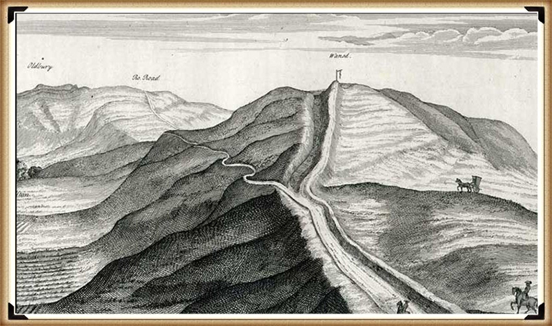
Figure 12- Stukeley’s Map of 1724 showing the Roman road ‘sitting on top’ of the Wansdyke ditch

In fact, within his excavation of the dyke we noted that:

“Very little ‘silting’ had accumulated on the escarp, but in the ditch, it had collected to a depth of about 3 feet in the centre” – showing that the main purpose for the dyke was to take water like a canal.

The final proof of the fact that the Dykes predate the Roman invasion can be found strangely with empirical evidence from a drawing produced by the first British archaeologist William Stukeley in 1724.  The Roman road is clearly made on and above the Wansdyke ditch and then cutting through the Dyke’s bank – this is impossible to do if the bank and ditch were built AFTER the road (archaeologist and historians, please take note!!).

If we look at Wansdyke on an OS map, to the East, the ditch ends in the middle of nowhere, just before the forest of Savernlake.  The question that archaeologists fail to answer is ‘why stop there’?

If you continued another 6km, you would have reached water – a natural boundary (remembering you have already cut 19km), or just turn south, and that’s a mere 3km.  To the west, it’s even worse, you could go south again and connect to the river, using that as a natural defensive boundary, but no – it just stops dead.

If you were to attack the ditch, you would be mad – as you just walk around it as the German’s did on the Siegfried line at the outbreak of World War II.

The final proof of that the ditch is not defensive can be found in its method of construction.  Going back to the work of Pitt-Rivers, he produced a series of detailed cross-sectional drawings to support his investigation.  These drawings showed two significant findings: firstly, the ditches fill was spread over both sides of the ditch (one side slightly more than the other) – you would not do this if it’s a defensive feature as you would want all the ‘high ground’ on your side to help defend.  This kind of slightly even distribution we see on Iron Hill ditches and other featured sites such as Durrington, Stonehenge, and particularly Old Sarum.  In fact, the only site we don’t see this happen is at Avebury.

(Gigantic Prehistoric Canals (Dykes) - Wansdyke)
Savernake Forest – Prehistoric canals (dykes)
Figure 13 – Wansdyke East section just stops – the forest would not have been there during Roman times and hence the roman road going through the centre

Secondly, and most importantly, the bottom of the ditch is flat, again just like Stonehenge, Avebury and Durrington – it could also be Old Sarum, but sadly nobody has done an excavation of the ditches to date.

(Gigantic Prehistoric Canals (Dykes) - Wansdyke)
Pitt-Rivers cross section – Prehistoric canals (dykes)
Figure 14- Pitt-Rivers cross section shows ditch fill spread on BOTH sides – so not defensive

You do not make the bottom of a ditch flat if used as a defensive ditch or a land marker (you’re doubling the time it takes to make a ditch).  On Pitt-River’s excavation plan, the flat bottom is a third of the width of the ditch.

The Kennet and Avon Canal (Fig. 93) is a waterway in southern England with an overall length of 87 miles (140 km), made up of two lengths of navigable river linked by a canal.  The name is commonly used to refer to the entire length of the navigation rather than solely to the central canal section. From Bristol to Bath, the waterway follows the natural course of the River Avon before the canal links it to the River Kennet at Newbury, and from there to Reading on the River Thames. Quite remarkably, Wansdyke was constructed just 3 km north of the Kennet and Avon canal. If it was a prehistoric waterway, it would have achieved the same purpose of joining the River Thames to the Bristol Channel but some 6-8K years before the Victorian’s great canal system.

Now let us consider the human resources it needed to create such a structure.  At 33 km in length (33,000m), its volume can be calculated as about 618,750 cubic metres of chalk (if it is 2.5m deep and 7.5m wide as an average). This is the approximate volume of material removed from the ditch.  This is five times more than what was excavated at Avebury and two and a half times larger than Silbury hill. So, according to Atkinson’s calculations at Silbury Hill, we are looking at 45 million working hours, which equates to 100 people working for 12-hours every day 365 days a year for 102 years.

It took the Victorians one hundred years to build the Avon & Kennet Canal using metal tools and steam engines. Moreover, the Victorian canal was only 1.3m deep and 6m wide – the ancient canal ditch is in places twice as big as the Victorian counterparts. So, whoever built it must have spent many years completing this task – which suggested it was essential at the time of construction.

If you study a geological map of this area, you will be struck by the endless twisting rivers that once flowed on and around the Wansdyke earthwork.  These are called ‘superficial deposits’ and consist of sand, silt and pebbles.  This is evidence that ‘once upon a time’ rivers formerly flowed in these what we call today’ dry valleys’ (Palaeochannels), and the clue just like the name for these earthworks (Dykes) is in the title.

If we add the known prehistoric groundwater rivers (based on our hypothesis) to the map of this great ditch, we find that springs would feed the ditch naturally, flooding it – and there you have yourself a canal.   This 21-mile canal links (just like the Avon & Kennet) the river Thames to the Bristol Channel.   And there can be only one reason for this massive undertaking (boat travel for the purpose of trade) just like the Victorian ancestors would achieve some six to eight thousand years later.

However, the most miraculous revelation about these Dykes is the fact that the builders had a greater knowledge of hydrology than even today’s engineers and geologists, for the weakness and final demise of the canal system in Britain was the fact they were very slow (the  Victorians had to build at least one lock per mile of the canal to keep in the water high) the Kennet and Avon have over 100 locks. The original prehistoric channel had none as it relied on the natural groundwater table levels to fill the canal. Therefore, it was straighter and shorter in length than the Avon & Kennet, which would have allowed them to travel from the Thames to the Bristol Channel almost a hundred times faster than the Victorian barges.

Moreover, if you find this difficult to believe, you should bear in mind that there are over 1,000 dykes in Britain; a majority, 90%, are straight and less than 1km in length.   To date, every single dyke we have investigated has underground links to these prehistoric rivers created from the ‘post-glacial flooding’ after the last ice age. 

Furthermore, some of these Dykes are linked to ancient sites directly, as shown in this case study confirming the age of these earthworks. For if we add the known prehistoric groundwater rivers, we find out why this remarkable canal has two dead ends.  For West side of the dyke is in the middle of a prehistoric island, which perfectly cuts the island into two and would allow boats to sail from one end of the island to the other in the Mesolithic. At a later date, an extension was added (as the water table levels dropped) to keep it connected to the Bristol Channel in the Central and West Section.

This explains why the Central section is different and straighter than the Eastern section of Wansdyke and is often referred to as a ‘Roman Road’ on OS maps.  Moreover, it proves beyond doubt that it was not built as a boundary marker of a defensive ditch as it would have had a 6-mile gap in the middle of the earthwork.

This Dyke was built over hundreds if not thousands of years, which reflects not only the engineering and organisational skills of this advanced civilisation but, moreover, the sophistication and complexity of this trading society.

(Gigantic Prehistoric Canals (Dykes) - Wansdyke)

Figure 15 – East Wansdyke was an island in the Prehistoric Period with section analysis to follow

East Wansdyke Maps in Detail (from East to West)

Section 1 – North Savernake to Gore Copse – 1,995 metres long (6,650 working days – 20 men, 333 days).

(Gigantic Prehistoric Canals (Dykes) - Wansdyke)
East Wansdyke (section 1) with Cross Section -Prehistoric canals (dykes)

Figure 16 – Wansdyke NW of Wernham – with Mesolithic Water Levels

No information is available from Historic Monuments England – no survey or excavation has been undertaken.

(Gigantic Prehistoric Canals (Dykes) - Wansdyke)
East Wansdyke OS series – Prehistoric canals (dykes)

Figure 17 – Current OS Map

(Gigantic Prehistoric Canals (Dykes) - Wansdyke)
East Wansdyke 1800 map series – Prehistoric canals (dykes)

Figure 18 – 1800 map

LiDAR Map – Prehistoric canals (dykes)

The maps tell us very little, sadly, except that the subsoil of clay with flints is ideal for canals and water retention – so even if the water table fell, the clay would and could be used like a dew pond as a liner for rainwater retention.  We estimate at a rate of 0.3m per day this section of the Dyke would have taken 6,650 working hours to construct or 20 men working 333 days – this is based on one man cutting 0.3m per day (Ditch down to 2m and bank) although Fowler used 0.1423 metres per hour and claimed 1,000 men built the ENTIRE East Dyke in 30 days working 10-hours a day 6 days a week??

This ridiculous claim I have discounted as even with modern tools, it would be too demanding, and the logistics of feeding, mending tools and housing 1,000 men was not taken into account.  Therefore, we have used a more reasonable number of men (20) ‘digging’ as you would probably need double that number to feed and maintain and clear (it was mostly woods and forests in the past) in front of the diggers.

ment as the barrows were of Bronze age or earlier and as we have seen from the carbon dating evidence at Blackrock Lane much earlier than its 1500 BCE date.

A NEW VERSION OF THIS BOOK IS AVAILABLE AS A eFLIPBOOK AT: https://prehistoric-britain.co.uk/wansdyke-flipbook

Further Reading

For information about British Prehistory, visit www.prehistoric-britain.co.uk for the most extensive archaeology blogs and investigations collection, including modern LiDAR reports.  This site also includes extracts and articles from the Robert John Langdon Trilogy about Britain in the Prehistoric period, including titles such as The Stonehenge Enigma, Dawn of the Lost Civilisation and the ultimate proof of Post Glacial Flooding and the landscape we see today.

Robert John Langdon has also created a YouTube web channel with over 100 investigations and video documentaries to support his classic trilogy (Prehistoric Britain). He has also released a collection of strange coincidences that he calls ‘13 Things that Don’t Make Sense in History’ and his recent discovery of a lost Stone Avenue at Avebury in Wiltshire called ‘Silbury Avenue – the Lost Stone Avenue’.

Langdon has also produced a series of ‘shorts’, which are extracts from his main body of books:

The Ancient Mariners

Stonehenge Built 8300 BCE

Old Sarum

Prehistoric Rivers

Dykes ditches and Earthworks

Echoes of Atlantis

Homo Superior

For active discussions on the findings of the TRILOGY and recent LiDAR investigations that are published on our WEBSITE, you can join our and leave a message or join the debate on our Facebook Group.

The First European Smelted Bronzes

Introduction

The current Victorian archaeological dating system is past its sell buy date as it no longer reflects the archaeological world of the 21st century and is tool of suppressing understanding of the real history of the World by its continued use as a propaganda tool to suppress new ideas and hypotheses. This academic narrative is mantainted to keep the current dated archaeologists in work through their many publications and media programs as these new discoveries would question their ‘expertise’ recognition and credibility, that the institutions maintain to by association give them self authenticity. (First European Smelted Bronzes).

At present in Britain the archaeological community uses the term Neolithic (‘new stone age’) to denote the period 4500 BCE to 2500 BCE and then the Bronze Age (2500 BCE to 750 BCE). This article shows labeling of the past is completely false – as ‘British Tin’ was used to make the first European smelted Bronzes.

In Southern Serbia archaeologists have found evidence of what could be the oldest metal workshop in all of Europe. This could prove that the metal age started centuries earlier than previously believed.

Plocnik was discovered in 1927
Plocnik was discovered in 1927 – First European Smelted Bronzes


This archaeological site in Plocnik was discovered in 1927 during the building of a railroad from the city of Nis to Kosovo’s capital Pristina.
During decades of research and discoveries, archaeologists have dug out a large number of tools. But they are hoping that recent finds will prove that the metal age began much earlier than previously believed.

Archaeologist Dusan Slivar said copper tools found at the location, conflict with it being a Neolithic site.

Archaeologist Dusan Slivar- First European Smelted Bronzes


“Very strong arguments and elements exist which indicate there was some kind of workshop where metal was processed and made,” Sljivar said.
“That is the character of this year’s discovery because Plocnik has its long pre-history and now for the first time we have everything with clear chronologically defined stratography. So we now know that it was the Gradac phase of the Vinca culture, which means the end of the 6th millennium BC. We even have a copper chisel that was found here,” he added.

The archaeologists have found that houses were warm, they had stoves and slept on woollen rags and fur, made clothes of wool, flax and leather.
They kept animals, used a copper tool that was an axe on one side, and a hammer on the other, with a wooden handle. And for woodwork they used a chisel.

It is almost certain that people who lived in the village between 5400 and 4700 BC knew about trade, handicrafts, art and metallurgy, which makes this more of a metropolis than a village. The archaeologists have dug out three layers from different periods of the settlement, the oldest one 3.5 metres deep.

metallurgy, which makes this more of a metropolis than a village - First European Smelted Bronzes
Sites figuarine, which makes this more of a metropolis than a village – First European Smelted Bronzes


Life was organised in a way that suited people best. They even took care of their hygiene, as special holes for trash have been found. They also buried their dead at an arranged necropolis.

The site in Plocnik is spread over 120 hectares, bordered by rivers. It was a metropolis where copper and copper tools have been produced.
Archaeologists found a big workshop which they say is proof of the metallurgical work.

metallurgy, which makes this more of a metropolis than a village.- First European Smelted Bronzes
metallurgy, which makes this more of a metropolis than a village- First European Smelted Bronzes

“Although we believed for a long time that the younger stone age, the Neolithic was followed by Eneolithic, the so called Copper age, which took place in the fourth millennium BC. But our latest discoveries show that the Vinca culture, although a Neolithic culture, knew about production of copper, which moves the start of copper metallurgy 500 years earlier, to the sixth millennium BC,” archaeologist Julka Kuzmanovic said.

Archaeologists hope that this find in southern Serbia will prove the theory that the metal age began a lot earlier than previously believed. They are now waiting for results and a second opinion from their colleagues at the German Heidelberg University where some samples have been sent.

This Site is just south of the Danube - which connects the Black Sea to Doggerland - First European Smelted Bronzes
This Site is just south of the Danube – which connects the Black Sea to Doggerland- First European Smelted Bronzes

Interestingly, this site would have connected by river to the daube and via the Rhine to the North Sea. Consequently, the easiest source for the tin needed for this furness would have been Cornwall (Germany/Poland being the only other source in Europe). This shows the extent of trading in the 5th Millennium BCE and questions the dated Victorian Metal based time periods which start the bronze age some 2,000 years later.

More information about Bronze Age history can be found here and on our video channel here

Tin Mines in Prehistory
Location of Tin Mines in Prehistory – First European Smelted Bronzes

Further Reading

For information about British Prehistory, visit www.prehistoric-britain.co.uk for the most extensive archaeology blogs and investigations collection, including modern LiDAR reports.  This site also includes extracts and articles from the Robert John Langdon Trilogy about Britain in the Prehistoric period, including titles such as The Stonehenge Enigma, Dawn of the Lost Civilisation and the ultimate proof of Post Glacial Flooding and the landscape we see today.

Robert John Langdon has also created a YouTube web channel with over 100 investigations and video documentaries to support his classic trilogy (Prehistoric Britain). He has also released a collection of strange coincidences that he calls ‘13 Things that Don’t Make Sense in History’ and his recent discovery of a lost Stone Avenue at Avebury in Wiltshire called ‘Silbury Avenue – the Lost Stone Avenue’.

Langdon has also produced a series of ‘shorts’, which are extracts from his main body of books:

The Ancient Mariners

Stonehenge Built 8300 BCE

Old Sarum

Prehistoric Rivers

Dykes ditches and Earthworks

Echoes of Atlantis

Homo Superior

For active discussions on the findings of the TRILOGY and recent LiDAR investigations that are published on our WEBSITE, you can join our and leave a message or join the debate on our Facebook Group.

Other Blogs

[sitemap_posts]

The Long Barrow Mystery

Now been updated with more data here: – https://prehistoric-britain.co.uk/the-long-barrow-and-dolman-enigma

The enigmatic nature of long barrows (The Long Barrow Mystery) in Northern Europe has long been a subject of fascination and intrigue for archaeologists and historians. These ancient structures are widely accepted as some of the oldest monuments in the region, and their distribution, coupled with similar construction dates, has raised fundamental questions about the connectivity and interactions among ancient cultures. As we delve into the mysteries of long barrows, we find ourselves reevaluating the established narratives of isolated or unconnected societies.

Long barrows are distinctive burial mounds characterized by their elongated shape and contain chambers for the interment of the deceased. They are spread across various parts of Northern Europe, bearing witness to the distant past and the diverse traditions that once thrived in the region. The prevalence of long barrows hints at a shared cultural practice, but their geographical distribution challenges our understanding of ancient migrations and contacts. (The Long Barrow Mystery)

Long Barrow
Long Barrow

Full Screen map of Long Barrows in Europe – was Doggerland around at the time of Long Barrow construction across Northern Europe? (The Long Barrow Mystery)

One intriguing perspective that has emerged in recent scholarship speculates about the purpose of long barrows extending beyond mere burial sites. It suggests that these structures might represent symbolic representations of ships or boats, signifying a journey to the afterlife. This interpretation is particularly captivating when we consider the design of long barrows, which may have mirrored the contemporary ship designs of their time. Such a connection implies a level of interconnectedness between cultures, even those separated by geography and time.

The map you referenced, which demonstrates the distribution of long barrows, adds an additional layer to this intriguing narrative. It challenges traditional migration routes and patterns into Britain, as it highlights the scarcity of long barrows in Northern France. This absence calls into question the previously held assumptions about the movement of people and ideas across these regions. Were there indeed insurmountable barriers or significant cultural distinctions that prevented the spread of the long barrow tradition to Northern France?

Another fascinating aspect of the long barrow mystery is the realization that the center of this cluster of long barrows is now submerged beneath the North Sea, in an area known as Doggerland. Doggerland was once a vast landmass connecting what is now the British Isles to continental Europe during the Mesolithic Period. This submersion due to rising sea levels further complicates our understanding of long barrows. In the Mesolithic Period, when Doggerland was above sea level, it would have facilitated more accessible routes and interactions. The dating of long barrows in light of this submerged landscape requires careful reconsideration.

In conclusion, the enigma of long barrows in Northern Europe challenges the conventional wisdom about ancient cultures and their interactions. These structures, whether seen as burial mounds or symbols of a journey to the afterlife, hold deep cultural and historical significance. The geographical distribution of long barrows and the absence of such structures in Northern France make us reevaluate migration patterns. The submersion of the central cluster of long barrows beneath the North Sea adds further layers of complexity to this intriguing puzzle. The “Long Barrow Mystery” is a vivid reminder that history is ever-evolving, and its exploration is a journey filled with surprises and revelations, encouraging us to revisit and reassess the past’s hidden stories and connections. (The Long Barrow Mystery)

Further information can be found also on our Video Channel Prehistoric Britain

The Long Barrow Mystery
Long Barrows – Europe (The Long Barrow Mystery)

Further Reading

For information about British Prehistory, visit www.prehistoric-britain.co.uk for the most extensive archaeology blogs and investigations collection, including modern LiDAR reports.  This site also includes extracts and articles from the Robert John Langdon Trilogy about Britain in the Prehistoric period, including titles such as The Stonehenge Enigma, Dawn of the Lost Civilisation and the ultimate proof of Post Glacial Flooding and the landscape we see today.

Robert John Langdon has also created a YouTube web channel with over 100 investigations and video documentaries to support his classic trilogy (Prehistoric Britain). He has also released a collection of strange coincidences that he calls ‘13 Things that Don’t Make Sense in History’ and his recent discovery of a lost Stone Avenue at Avebury in Wiltshire called ‘Silbury Avenue – the Lost Stone Avenue’. (The Long Barrow Mystery)

Langdon has also produced a series of ‘shorts’, which are extracts from his main body of books:

The Ancient Mariners

Stonehenge Built 8300 BCE

Old Sarum

Prehistoric Rivers

Dykes ditches and Earthworks

Echoes of Atlantis

Homo Superior

For active discussions on the findings of the TRILOGY and recent LiDAR investigations that are published on our WEBSITE, you can join our and leave a message or join the debate on our Facebook Group.

(The Long Barrow Mystery)

Woodhenge – the World’s First Lighthouse?

Recent archaeological findings and engineering analysis now questions the original interpretation of Woodhenge as being either a simple Neolithic single storey building or as an artificial woodland, but in fact the World’s First Lighthouse.

To understand the reasons why it was the World’s First Lighthouse, you need to grasp the reality that Woodhenge was constructed with a series of ‘massive’ wooden post holes – at this point, we need to explain that archaeologists don’t seem to understand the difference between a ‘Post Hole’ and a ‘Stake Hole’. 

You use stake holes for posts such as fences as they can be easily buried in the ground as they have a sharp point – this point naturally compresses the surroundings (due to the shape and hammering from above) so they don’t move or wobble – this is key to understand the Woodhenge reconstruction.A ‘Post Hole’ is totally different as it has a flat bottom and needs rubble to stop it rocking from side to side.  Stake holes are easy as they are ‘self-burying’ while post holes are more work as you need to dig a hole for it. The only reason you would do all the extra work of digging a flat bottomed hole (especially in chalk) is if the wooden pole is to take some kind of weight from above, for a stake hole is useless for this type of structure as it would sink (overtime) under the weight pushing down on the point and probably fall over.

Therefore, if you have a round wooden single-storey building with a simple roof as current archaeologists suggested for some of these post hole structures, why use these massive posts as it is ‘over-engineering’ and time consuming – especially with simple tools?

Cunnington excavations at Woodhenge in 1929, suggested that some posts are up to 60 inches in diameter:

“clear evidence was obtained in excavation that the six centric rings of holes once held posts or tree trunks varying from 1ft to 3ft in diameter according to the size of the hole…… the size and depth and distance varies in each circle…. In the outer circle holes are 6ft apart from centre to centre, from 1 1/2 ft to 2ft in depth and from 2ft to 3ft in diameter. In the second circle the holes are larger and further apart, averaging about 4ft in depth and 3 ½ to 4ft in diameter. The largest of all were those were those of the third circle, being about 6ft deep with a diameter at the top from 4ft to 5ft “ (Cunnington. M.E., ‘Prehistoric Timer Circles’, Antiquity A Quarterly Review Of Archaeology Vol.1, 1927).

Figure 59– Cunnington Excavation plan 1929 – Woodhenge the World’s First Lighthouse

Sadly, Woodhenge reconstruction shows us yet another illustration of flawed science in archaeology.  Even with a ‘second rate’ excavation report from the 1920’s the conclusion of modern archaeologists is that this structure was a single-story house – a slightly grander feature to the traditional ‘iron age’ house.  This is simply nonsense. If we look closely at the evidence presented here, we obtain a totally different and more accurate conclusion to the nature of this structure.

Firstly, if we look at the layout of the site (which lacks much detail), we can see from these original excavation plans the scale of this understatement, as the existing ‘concrete’ posts, on the site, are far too small.  The most recent photo was from the excavation by Pollard in 2007, indicates that these posts are at least five times larger than the current representations.

The next fact that goes unanswered is the reason for the large ramps by the post holes. You don’t take time to put 32 ramps into the soil unless it is essential as you just added at least another month to the building work for the site and 500 working-hours.  What archaeologists have missed (or failed to mention) is in which direction these ramps were cut – as it tells us more than the entire excavation report by Cunnington.

The massive 4 – 5 ft pine posts of the 16 postholes (known as the C Ring) would weigh 214kg per foot of length.  Therefore, a sizeable healthy person could pick up one foot of pine and place it in a hole without assistance or a need for a ramp. Consequently, an eight-foot pine tree trunk could easily be placed on the shoulders of 8 people and put straight into the hole, which is the current estimations by archaeologists for a single storey structure. Therefore, the empirical evidence suggests they are wrong, and the pole was much more significant.

Figure 60 – Woodhenge reconstruction; post holes much larger than the concrete posts on the site – Woodhenge the World’s First Lighthouse

Moreover, if you are chopping down a 4 – 5ft wide tree – it’s not going to be 8 – 10 ft high! You are chopping down a pine tree in excess of 100 ft and then cutting off all the branches, then to chop it into just 8 – 10 ft lengths – sadly, its pure nonsense!

What we have seen at Stonehenge is similar ramps not by the 4-tonne bluestones but by the Sarsen stones that weighed an average of 25-tonnes (the trilithons are 35-tonnes) but half the size of these ramps.

A 25-tonne, pine post of width between 4 – 5 ft would be 39m long or 128ft, and a 35-tonne pine tree is some 177ft long.  But do Pine trees grow that tall?  Just down the road from Durrington Walls is Longleat Forest, within this forest there are pine trees like the Douglas fir that grow to nearly 200ft tall.

Moreover, the site plan does also give us another clue to the length of these poles.  If to look carefully at the angle of the ramps into the giant postholes, you will notice that they are not all facing the same direction.  The only logical reason for that to happen is if you erect the pine poles in a set order so that they would not hit or interfere with each other when attempting to erect the posts.

This allows us to come to some remarkable conclusions about the construction and the process of how it was built:

  1. Holes were filled in an anti-clockwise direction starting at hole 1 (at four o’clock to the site)
  2. Poles must have been more than 100’ long as otherwise, you could erect them in any order and direction.
  3. The ditch that is current at the site was added at a later date, as you would need to bring the poles through the ditch and in some cases be in the ditch to erect it.
  4. The 4 to 5ft diameter posts all entered the site from the south, as it has the minimal distance to travel – as these poles were either rolled or dragged on a sledge and therefore probably the direction of where the pine trees have initially been growing or unloaded, after being floated down the river.

Now the slopes for ‘Ring C’ (the largest posts) are 5 to 8ft long, which are even longer than the Stone ramps (3 to 4ft) at Stonehenge (Fig.58).  This probably shows the large (Sarsens are only 13ft tall) leverage factor required to be pulled upright with an A-frame, which then allows the posts to slide into position and then into the hole.

Ring B – the 3.5 to 4ft diameter trees, also have ramps, but much smaller (3 to 4ft), indicating less leverage and therefore half the weight/height?  Moreover, they were placed into position after the C Ring, as their ramps point away from the centre with no common direction.

Figure 61– Broch which was a later version of Woodhenge; made of Stone – Woodhenge the World’s First Lighthouse

The last row of postholes (A), 1 to 3ft in diameter, do not have ramps and are sporadic in nature and size – which leads me to believe they have no structural significance and was probably more like a palisade covering, to either enclose the structure or allow mud or reed covering (wattle & daub) and protection from the elements.

The internal posts (D to F) are superficial and probably were there to support the first-floor structure, as we see in their successors in British history the ‘broch’ – a stone version-built thousands of years later for the same purpose.

But my money would be on the tower being of a lower ratio of 1 to 1, with the base, making it 135ft high and the same height as Silbury Hill, a little further up the river Avon and its design I would suggest, would have been the same ‘layer cake’ design as we will see in the chapter on Avebury.

Therefore, what would you build next to a harbour to attract and direct boats – obvious isn’t it, a fire beacon (with a stone base) as we know from written history and the Pharos of Alexandria (280 – 247 BCE).

Figure 62- Woodhenge reconstruction; probably looked like during phase I of its construction, with a spiral staircase – Woodhenge the World’s First Lighthouse

Furthermore, this link with the harbour is illustrated by the construction of the Moat, Bank and then a Dyke. As we have suggested, the Woodhenge ditch would not have existed at the original time (Phase I) of the construction of the C and then the B rings.  It seems that it was added at the end of Phase I when the structure was complete and before Ring A was established, as it points to the shoreline of the Neolithic Avon River. This alignment disproves the current ‘expert’ theory about being an astronomical alignment with the Solstice Sunrise. 

Evidence for the construction of the postholes (with gaps in the circle which were later filled with smaller posts) indicate that the ditch had filled from age, or by design. The main opening (in the A circle) to the northeast is not in line with the gap in the ditch, and the two other spaces in the circle, would track across the ditch in the southeast and northwest.


As for the dating of Woodhenge reconstruction (and Durrington Walls), like Stonehenge, unrelated antler and bone fragments have dated it to about 2400 BCE, which is very convenient.  The problem is that most of the post hole samples at Woodhenge were either lost or have been stored away and not tested since the excavations between 1926 to 29, for reasons known best to the experts.

Moreover, like the samples taken from the old car park in 1966, pine charcoal were reported to be found “similar to the charcoal found at Woodhenge” was the quote from the labs at the time, who failed to carbon date the samples as the experts had declared them Neolithic, supporting the antler pick dates.  Although now, once this gross error was exposed, we know these pine charcoal wood dates to be in fact Mesolithic 8100 BCE – which ‘begs-the-question’ so are the pine charcoal dates found at Woodhenge also Mesolithic?

Less than a mile down the river is ‘Blick mead’, (Vespasian’s Camp),which has also been found dates ranging from 7900 BCE, (remember our bluestone estimation for Stonehenge is 8000 BCE), to 4050 BCE, with multiple RC dates from the 8th to the 5th BCE.  Sadly, until someone finds these samples and carbon tests them, to get an accurate date for Woodhenge and Durrington Walls, this unscientific archaeological ad hoc dating methodology will continue.

Figure 63- Woodhenge Reconstruction; Unique building technique for towers, still used today – Woodhenge the World’s First Lighthouse

Furthermore, the engineering structure created by this civilisation – like the design at Stonehenge, has been overlooked by archaeologists looking for a more simplistic ‘hunter gatherer’ solution for this superstructure, which has ended up with a single storey roof, that is clearly well over engineered for that purpose.  What we can see at Woodhenge (and also at The Sanctuary at Avebury) is the ‘triangulation’ of wood joints using the mortice and tenon techniques we have seen on the Sarsen stones at Stonehenge – this structural technique (which are incorporated in modern towers today) allows to construction of extremely high wooden towers, which is what we see through the Woodhenge reconstruction.

Modern Telecommunication Towers use this same triangulation structure as first seen at Woodhenge 8,000 years ago – Woodhenge the World’s First Lighthouse

A video on Woodhenge the World’s First Lighthouse and a reconstruction is now available at: https://youtu.be/piow4yDUs3U and from the book.

British Roman Ports miles away from the coast

When we look at old maps of Roman settlements or ports around Britain and the Mediterranean (we will look at these other roman ports outside Britain in part two of this blog), we see that most are built on the coastline or major waterways of these countries.  This fact is not surprising as these locations would need a constant supply of commodities and goods for trading and construction. Many historians believe that these towns were solely supplied by road – but the economics of this idea is flawed as road building, even with slaves (for someone has to feed and clothe them), is expensive, and the Roman army had absolute priority over the road system and its use.  So most settlements and fortifications were built by the water, and if security was an issue, by a road as well, the other could be used as a backup in time of conflict. (British Roman Ports)

However, if we look more closely at these sites, it becomes apparent that some of the locations are far away from the shoreline or rivers that once supplied them. For example, the Roman town of Brading in the Isle of Wight is 3km from the sea and 500m from the nearest river, which is so small that it could hardly take a canoe, let alone a heavy ladened Roman ship.

British Roman Ports
Brading I.O.W. today – British Roman ports miles away from the coast

At a date (which is impossible to specify), the East Yar valley of Brading became a tidal haven – it would seem to have been the same at the time of the Roman occupation in the first four centuries A.D. As such, Brading sat on the head of a sea inlet: the sea nourished its growth, allowing maritime trading activities which, by 1180, had earned it recognition as a ‘town’.  East Yar is a natural Harbour surrounded by high hills allowing ships to shelter safely against inclement weather and high winds.

From around 6,000 BCE to A.D. 43, evidence of settlement in Brading by Mesolithic, Neolithic, Bronze and Iron Age peoples take the form of burial mounds of tribal chieftains at Nunwell Down, and weapons, tools, coins and jewellery from different sites. In 55-54 BCE, Julius Caesar invaded (briefly) Southern Britain; there is subsequent evidence of imported Roman wine and pottery from the Brading Roman Villa site. Claudius then invaded Britain again in A.D. 43, for a period lasting over 400 years. (British Roman Ports)

An unchallenged governorship of the Island by Vespasian followed with Brading as its main port. The Villa in Brading probably had its origins before A.D. 100 and developed over the next 250 years, with mosaic floors laid around A.D. 320-340 in its most prosperous period. Alas, Pirate raids in about A.D. 367 marked the end of the Villa and the town’s systematic ransacking.

Consequently, we know that the harbour was in use for nearly 7000 years prior to it silting over. (British Roman Ports)

(British Roman Ports)
Brading During the Roman Period – British Roman ports miles away from the coast

When the ‘silting’ started (silting is the landing drying out to become land) and the harbour became less effective, other ports such as Newport (hence the name!) with a similar sheltered harbour, as well as Cowes started to be used.  The final demise of Brading began in 1562, when a tendency towards the natural situation of the waterway combined with the enticing prospect of reclaiming more lucrative agricultural land prompted George Oglander and German Richards of Yaverland Manor to wall in the Oglanders’ North Marsh and other lands to the west of Bexley Point and up to Carpenters on the road to St. Helens. (British Roman Ports)

Edward Richards built an embankment across the marshes to Centurion’s copse on the Bembridge side in 1594 and relocated the town quay to the end of Quay Lane on the seaward side of this embankment, which is now known as the Old Sea Wall. There were numerous pleas (documented from 1576 onwards) for merchants to be allowed access for their boats through these walls to the previous town quays, particularly that at Wade Mill, because their livelihoods were threatened.

The history books will tell you that this reclaiming of land was created by artificial drainage, but why would you wish to allow a thriving harbour to silt up if it was commercially viable? 

If we look at a map of Brading, we see that the old harbour was fed by several rivers, which survive today in a more shallow form; this indicates that this was a freshwater harbour and was connected to the sea.  Another British harbour down the Shoreline in East Sussex is called Lewes and shows just how strange these ancient disappearing ports are and the reason for this mystery. (British Roman Ports)

According to the history books:

 ‘The Ouse is one of the four rivers that cut through the South Downs. It is presumed that its valley was cut during a glacial period; since it forms the remnant of a much larger river system that once flowed onto the floor of what is now the English Channel. The extent of the inundation it experienced after the last ice age can be observed in the lower valley which would have flooded; there are ‘raised beaches’ 40 metres (Goodwood – Slindon) and eight metres (Brighton – Norton) above present sea level. The offshore topography indicates that the current coastline was also the coastline before the final deglaciation, and therefore, the mouth of the Ouse has long been at its latitude.’

(British Roman Ports)
Lewes during the Roman Period – British Roman ports miles away from the coast

Archaeological evidence points to prehistoric dwellers in this area. Scholars think that the Roman settlement of Mutuanton is was here, as quantities of artefacts have been discovered within the area. The Saxons also built a castle here, having first constructed its mote as a defensive point over the river; they gave the town its name. However, the most interesting aspect of Lewes is that it is seven miles from the current Shoreline at Newhaven, and until recent history (last 2000 years), it was the main port of the South coast as it had a substantial natural shelter inland of the stormy seas. Moreover, there are stories that Lewes was the original landing point for Julius Caesar’s first invasion as it was the most extensive and safest harbour in Southern Britain’s mainland.

Today the River Ouse is just a sleepy river running through the café bar area of the town of Lewes, yet in the recent past, the town would have been a fishing port with boats moored up next to what we see the retail High Street today. According to geologists, the sea levels have been rising since the great flood, after the last ice age and that the ‘Isostatic uplift’ from the same event is now in reverse and lowering the landscape to compound the sea level rises – so why has Lewes gone from an essential seaport to a small idyllic river with café bars?

At the time of the Doomsday book (1086), the Ouse valley was still a tidal inlet with a string of settlements located at its margins. In later centuries, the Ouse was draining the valley sufficiently well for some of the marshland to be reclaimed as highly prized meadowland. At this point in history, the Ouse’s outlet at Seaford provided a natural harbour behind the shingle bar. (British Roman Ports)

(British Roman Ports)
Landscape view of the water levels around Lewes in the past – British Roman ports miles away from the coast

However, by the 14th century, the Ouse valley was still regularly flooding in winter, and frequently, the waters remained on the lower meadows through the summer. In 1422, a Commission of Sewers was appointed to restore the banks and drainage between Fletching and the coast, indicating that the Ouse was affected by the same storm that devastated The Netherlands in the St Elizabeth’s flood of 1421. Drainage became so bad that 400 acres (1.6 km2) of the Archbishop of Canterbury’s meadow at Southerham were converted into a permanent fishery (the Brodewater) in the mid-15th century, and by the 1530s, the entire Lewes and Laughton Levels, 6,000 acres (24 km2), were reduced to marshland again. (British Roman Ports)

Prior Crowham of Lewes Priory sailed to Flanders and returned with two drainage experts. In 1537 a water-rate was levied on all lands on the Levels to fund the cutting of a channel through the shingle bar across the mouth of the Ouse (below Castle Hill at Meeching) to allow the river to drain the Levels. 

This canalisation created access to a sheltered harbour, Newhaven (hence the name for a New Haven for boats), which succeeded Seaford as the port near the mouth of the Ouse.  The new channel drained the Levels, and much of the valley floor was reclaimed for pasture. However, shingle continued to accumulate, and so the mouth of the Ouse began to migrate eastwards again. In 1648, the Ouse was reported to be unfit either to drain the levels or for navigation. By the 18th century, the valley was regularly inundated in winter and often flooded in summer.

What we can see here is with rising sea levels (and isostatic lowering of the land), the natural ground under this part of the South Downs is slowly drying out rather than getting wetter, which you would not expect as the sea level increased. (British Roman Ports)

So was the Lewes harbour fed by freshwater rather than seawater in the past?  (British Roman Ports)

This is an extract from a report on the viability of a new desalination (removing salt from seawater to obtain drinking water) plant in Newhaven.  From ‘Geoarchaeological Assessment’ – (partial transcription from M. Bates in Dunkin 1998):

 “The Ouse basin is a medium-sized catchment draining southwards in the southern Weald. The town of Newhaven and the investigation area lies at the mouth of the river, where the lower course of the river has eroded a channel through the Chalk of the South Downs. The Pleistocene history of the river is poorly understood (Burrin and Jones, 1991), and remnants of older Pleistocene sediments (fluvial) occur upstream close to the Brooks. Within the area of study Pleistocene deposits are restricted to head, and valley till sediments found along the valley sides and within the dry valley systems…”

Holocene sediments dominate the valley bottom from the Brooks southwards to the sea at Newhaven. These deposits (mapped as alluvium by the British Geological Survey) include various sediment types, including marine beach gravels and sands, clay-silts, organic silts, peats and fluvial gravels, and this zone has been described as the perimarine area (Burrin and Jones 1991).  Previous works indicated that some of these deposits contained freshwater and estuarine shells and that others reported pollen from these sediments (Thorley 1981), and a radiocarbon date of 6290+/-180 B.P., from a depth of – 8.15m O.D. was reported from the Brooks (Jones 1971).

Geologists admit that the history of the Ouse (and other post-glacial rivers) are ‘poorly understood’, which is the closest to a geologist acknowledging that the evidence does not fit the current theory. – for the evidence clearly shows that in 4290 BCE, the Ouse valley was covered in freshwater.

The only place to get this volume of freshwater would be the groundwater under the South Downs, which must have still been so high that the valley remained flooded even 10,000 years after the last ice had melted, and this key evidence shows that this area suffered glacial freshwater flooding and answers the question, why are the Roman ports so far away from the shoreline?

Consequently, the shoreline in the past was constructed not from seawater but freshwater from the rivers that flowed into the sea in both Brading and Lewes areas. For more information and the reason why on Roman ports are miles away from the coast – Click on either these links: Post-Glacial Flooding Hypothesis or the DVD video on the subjects. (British Roman Ports)

Further Reading

For information about British Prehistory, visit www.prehistoric-britain.co.uk for the most extensive archaeology blogs and investigations collection, including modern LiDAR reports.  This site also includes extracts and articles from the Robert John Langdon Trilogy about Britain in the Prehistoric period, including titles such as The Stonehenge Enigma, Dawn of the Lost Civilisation and the ultimate proof of Post Glacial Flooding and the landscape we see today.

Robert John Langdon has also created a YouTube web channel with over 100 investigations and video documentaries to support his classic trilogy (Prehistoric Britain). He has also released a collection of strange coincidences that he calls ‘13 Things that Don’t Make Sense in History’ and his recent discovery of a lost Stone Avenue at Avebury in Wiltshire called ‘Silbury Avenue – the Lost Stone Avenue’. ( The Thames through time)

Langdon has also produced a series of ‘shorts’, which are extracts from his main body of books:

The Ancient Mariners

Stonehenge Built 8300 BCE

Old Sarum

Prehistoric Rivers

Dykes ditches and Earthworks

Echoes of Atlantis

Homo Superior

For active discussions on the findings of the TRILOGY and recent LiDAR investigations that are published on our WEBSITE, you can join our and leave a message or join the debate on our Facebook Group. (British Roman Ports)

Unlocking the Mysteries of British Prehistory

Delve into the depths of time, as we embark on a captivating voyage into the enigmatic world of British prehistory. www.prehistoric-britain.co.uk is your portal to a treasure trove of archaeological wonders, modern LiDAR reports, and fascinating insights from the Robert John Langdon Trilogy. This immersive digital hub is your key to unlocking the secrets of Britain’s ancient past.

A Glimpse into the Robert John Langdon Trilogy

Step into the shoes of Robert John Langdon, a dedicated explorer of Britain’s prehistoric mysteries. His trilogy, comprising “The Stonehenge Enigma,” “Dawn of the Lost Civilization,” and “The Post-Glacial Flooding Hypothesis,” is a literary marvel that unravels the untold tales of our ancestors. These books take you on an exhilarating journey through time, meticulously researched and backed by over 125 references from esteemed scientists, archaeological experts, and geological researchers.

Dive into the World of LiDAR

At www.prehistoric-britain.co.uk, we harness the power of LiDAR technology to unearth hidden landscapes and archaeological marvels. Our LiDAR reports offer a modern lens through which you can peer into ancient history. Explore the effects of flooding on the British environment after the great ice age melt, a phenomenon that has shaped the landscape we see today. Join us in decoding the mysteries of our past using cutting-edge technology. (British Roman Ports)

A Multimedia Experience

Our commitment to storytelling extends beyond the written word. Robert John Langdon has curated a rich multimedia experience, including a YouTube web channel featuring over 100 investigations and video documentaries. These visual journeys complement his classic trilogy, providing a multi-dimensional understanding of prehistoric Britain. From Stonehenge’s construction in 8300 BCE to the lost Stone Avenue at Avebury in Wiltshire known as ‘Silbury Avenue,’ these documentaries offer an immersive experience that brings history to life.

Explore the ’13 Things that Don’t Make Sense in Ancient History’

History is replete with anomalies and enigmas that defy explanation. Robert John Langdon has curated a collection of such historical curiosities in ’13 Things that Don’t Make Sense in History.’ These peculiar occurrences and unanswered questions will leave you pondering the mysteries of the past, inviting you to join the debate on their possible interpretations.

(British Roman Ports)

The Oldest Boat Yard in the World found in Wales

And this ‘Oldest Boat Yard’ in the World, was making not just boats but Catamarans eight thousand years before the polynesians and twenty-six thousand miles away!

This article (The Oldest Boat Yard in the World) appeared during my research trip to Turkey in 2013 and has sat in my ‘inbox’ ever since – which is a shame as the consequences are enormous but alas, yet again, the archaeologists got it fundamentally wrong with the dating as I will explain at the end.

At the time of publication it was said to be the ‘World’s oldest boatyard in the World’ where (according to the authors) prehistoric man built huge canoes 4,000 years ago discovered under area earmarked for new housing estate – the main points from the article were:

  • Site is believed to be first prehistoric boatyard ever to be discovered
  • The site dates back to 1700 BC and is of ‘international importance’
  • Excavations revealed channels shaped like bottom of wooden canoes
  • Archaeologists say channels are evidence boats was built at the site

By JAMES RUSH PUBLISHED: Wales News, 2 October 2013 | UPDATED: 15:34, 2 October 2013


The world’s oldest boatyard dating back nearly 4,000 years has been uncovered by archaeologists at the site of a new housing estate in Wales. The site, believed to be the first prehistoric boat building site ever to be discovered, was found when developers came upon the edge of a long-vanished Ice Age lake.

Work on the housing estate in Monmouth, South Wales, was stopped for six months as a team of archaeologists unearthed the remains of the ancient boat building site used by prehistoric man.

Site: Archaeologists have uncovered a boatyard dating back nearly 4,000 years at the site of a new housing estate in Wales

Site: Archaeologists have uncovered a boatyard dating back nearly 4,000 years at the site of a new housing estate in Wales – The Oldest Boat Yard in the World

Important discovery: The site, which dates back to 1700 BC, is said to be of 'international importance'. Pictured is an artist's impression of the boatyard

Important discovery: The site, which dates back to 1700 BC, is said to be of ‘international importance’. Pictured is an artist’s impression of the boatyard – The Oldest Boat Yard in the World

Development: The site was found when developers came upon the edge of a long-vanished Ice Age lake
Development: The site was found when developers came upon the edge of a long-vanished Ice Age lake – The Oldest Boat Yard in the World


Archaeologist Stephen Clarke said the discovery of the site, which dates back to 1700 BC, was of ‘international importance’.
Mr Clarke, 71, said: ‘I have been digging for 55 years and I have never seen anything like it.’No one in the world has ever identified a prehistoric boat building site before.’They have found fragments of boats but never a boat building site – this is of international importance.’
Excavations at the site have revealed three 100ft-long channels which run parrallel to each other and at right angles to the ancient lake.
The ‘dead-straight’ metre-wide channels are shaped like the bottom of wooden canoes. They are also cut through a mound of burned earth carbon-dated to the early Bronze Age. 


Unearthed: Excavations have revealed three 100ft-long channels shaped like the bottom of wooden canoes

Unearthed: Excavations have revealed three 100ft-long channels shaped like the bottom of wooden canoes – The Oldest Boat Yard in the World

Work underway: Archaeologists working on the site with the three channels of the boatyard clearly visible

Work underway: Archaeologists working on the site with the three channels of the boatyard clearly visible – The Oldest Boat Yard in the World

Dig: Work on the housing estate was stopped for six months as a team of archaeologists unearthed the remains of the ancient boat building site

Dig: Work on the housing estate was stopped for six months as a team of archaeologists unearthed the remains of the ancient boat building site – The Oldest Boat Yard in the World

Boatyard: The three 100ft-long channels run parrallel to each other and at right angles to the ancient lake

Boatyard: The three 100ft-long channels run parallel to each other and at right angles to the ancient lake – The Oldest Boat Yard in the World

Mr Clarke said they showed a twin-hulled boat with an outrigger being dragged into a huge Ice Age lake.The discovery was made on the newly built Parc Glyndwr housing estate on the edge of the historic market town of Monmouth, South Wales. Monmouth Archaeological Society moved onto the site soon after the edge of the post-glacial lake was uncovered by unsuspecting builders. Mr Clarke said: ‘It’s a hell of a site – within 60 yards of it we had Stone Age artefacts and six Bronze Age sites.
Boat: An artist's impression of the type of boat built in the yard
Boat: An artist’s impression of the type of boat built in the yard – The Oldest Boat Yard in the World


‘The three channels turned out to be 100 ft-long and all perfectly parallel, level and at right angles to the edge of the post-glacial lake. The channels show they built a boat made out of twin canoes with an outrigger.

DEVELOPMENT OF EARLY BOATS

The oldest boats found by archaeologists are dugout canoes from around 7,000 to 10,000-years-ago.The Pesse canoe is the oldest ever to be recovered. It was made from the hollowed trunk of a Pinus sylvestris tree.It is believed to have been built between 8200 to 7600BCE.

Elsewhere, a 7,000-year-old reed boat was discovered in Kuwait while they are also known to have been used between 4000 and 3000BCE in ancient Egypt and in the Indian Ocean.Logboats meanwhile also survived in Europe until modern times and are still made in the Tropics.Planked boats are believed to have developed from extended logboats or rafts.In Egypt, a method of using mortises and tenons to develop edge-fastening, instead of using stitching or sewing, became the method throughout the Mediterranean and lasted throughout the Greek and Roman times. Source: ferribyboats.co.uk’

There was no sign of the wooden boat but there was evidence of wood working on the site – with sharp flakes of imported flint found alongside the channels.’ He said the boat was built on what was a huge prehistoric lake which became a home to hunter gatherers – and slowly drained away over thousands of years.

The Oldest Boat Yard in the World
Scandinavian Prehistoric Boats

Prehistoric cave drawings in Scandinavia have been discovered depicting outrigger boats like the one built at Monmouth and they were still being used in places like Fiji in the 19th century.

A large boat of a similar date and form to the Monmouth remains was recently recovered from a peat bog at Lurgan, Ireland, but was a log canoe and not a catamaran.

Mr Clarke said: ‘The prehistoric site is now mostly under a flood pond and the parts that aren’t have been built on.’We have preserved it by recording it to the best of our ability before it was developed on. Unfortunately there just isn’t the money to preserve and protect all these sites.’
In use: The boats were still being used in places such as Fiji in the 19th century (pictured)
In use: The boats were still being used in places such as Fiji in the 19th century (pictured) – The Oldest Boat Yard in the World

The research surrounding the prehistoric boat building site is now being published in a book called The Lost Lake.Mr Clarke added: ‘I am hoping other archaeologists will have seen similar channels on other sites and realise what was happening there.

‘This is the first site that has been recognised in the world but there must be others out there.’


Evidence: Prehistoric cave drawings in Scandanavia have been discovered depicting outrigger boats like the one built at Monmouth. Pictured is an example of similar boats in use in Fiji in the 19th century
Evidence: Prehistoric cave drawings in Scandinavia have been discovered depicting outrigger boats like the one built at Monmouth. Pictured is an example of similar boats in use in Fiji in the 19th century – The Oldest Boat Yard in the World

Now the obvious mistake is the dating of the so called ‘glacial lake’ – RJL

The last ice age ended about 17,000 BCE with all the ice gone by 10,000 BCE to 12,000BC, we know this because Doggerland started to be eaten away by the sea in this period due to the raised sea levels.  The chances that this was a lake still in 1,700 BCE (15,000 years after the ice melted) is almost NIL as this map shows it would have naturally drained into the rivers that exist today, if it was a lake.

Map of Excavation The Oldest Boat Yard in the World
Location of Boat Yard -The Oldest Boat Yard in the World

So what are we seeing here?
This is a map of the same area showing the ‘superficial deposits’ laid down AFTER the ice age as I have shown in my book ‘The Stonehenge Enigma’ this is POST GLACIAL FLOODING due to GROUNDWATER levels and effected a much greater area than the boatyard.

Geological Map of the Excavation area - The Oldest Boat Yard in the World
Superficial Deposits showing the extent of the ‘Lake’ after the last Ice Age – The Oldest Boat Yard in the World

Theses raised rivers would created a flooded area of water in the low laying areas as shown here (in yellow and orange), but this is NOT an ice age lake as described in the article but an enlarged River of the Mesolithic Period showing the rivers feeding the area.  This FUNDAMENTAL mistake is due to archaeologists not understanding the environment after the last ice age during the Mesolithic period and partly in the Neolithic, for these raised water levels (higher rivers) decreased gradually over the last 10,000 as they are still doing TODAY and eventually the River Minnow will disappear from the map. (The Oldest Boat Yard in the World)

The Oldest Boat Yard in the World
How the Oldest Boat Yard in the World would have been located in the Mesolithic

So how accurate are the dates?
As archaeologists are not experts at hydrology and therefore they have to rely on carbon dating.  They found a fire in one of the boat pits ” cut through a mound of burned earth carbon dated to the early Bronze Age” Which clearly was used as a natural grassy dhole in the ground and therefore a natural shelter for a fire at a LATER DATE after the boatyard was disused – it can not be contemporary as the boat would have either caught alight or stopped it slipping down into the Lake. Moreover, they have found similar dates at a camp over 60m away, which is too far to be associated with the boatyard with other Bronze Age date.  Furthermore, on the site they found Mesolithic tools.

Sadly, this confusion is commonplace with current batch of archaeologists as we can see on this same site just a year earlier – for they (not believing in boats) first publicised they found a ‘Long House’. But later they changed their mind as now reported; “Earlier this year archaeologists working at a dig at the Parc Glyndwr housing development said they may have found the remains of a “longhouse” dating back to at least the Bronze Age and possibly as far back as the New Stone Age.” – yet this boat yard doesn’t date back to the New Stone age as first reported?

The only ‘fact’ is that this channel was man-made and cut into the riverbank of a Post Glacial River, which existed probably until about five thousand years ago – so we are looking at a date of about 3000 BCE – 8000 BCE and we can be quite sure of these dates as this is NOT the only ship ‘slipway’ to be found in Britain – there are THOUSANDS yes thousands of these throughout the country – known as Dykes, these are boat Slipways’ between the higher river levels of the Holocene.

But what is more remarkable and is left without comment by Archaeologists or Historians is that – IT’S A CATAMARAN!! This is a remarkable engineering feat not known in the western world until the 16th Century and even in the Polynesian Islands some 12,000 miles way around 800 A.D. Moreover, We may have found the OLDEST BOAT YARD IN THE WORLD, so what do we do – WE BUILD HOUSES ON IT!! Can you imagine the USA finding such a site and allowing it to be destroyed? This is just another example of OUR TRUE HISTORY BEING BURIED as the academics have failed to answer the questions of Archaeology and therefore allows evidence to an alternative history to be buried forever!! (The Oldest Boat Yard in the World)

Catamaran - The Oldest Boat Yard in the World
Catamaran – The Oldest Boat Yard in the World

The TRUE history of our country and this civilisations boat building abilities can be found on our Video Channel www.Prehistoric-Britain.online or in an accompanying article HERE. (The Oldest Boat Yard in the World)
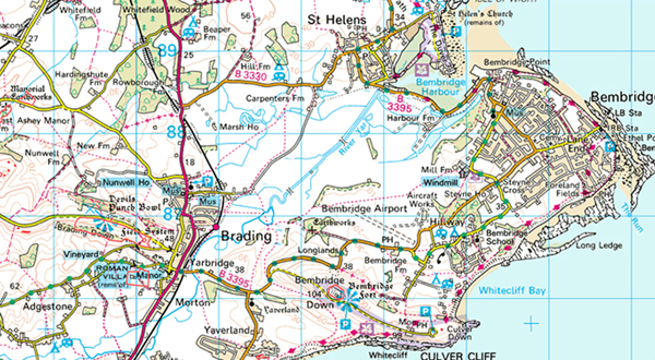
Further Reading

For information about British Prehistory, visit www.prehistoric-britain.co.uk for the most extensive archaeology blogs and investigations collection, including modern LiDAR reports.  This site also includes extracts and articles from the Robert John Langdon Trilogy about Britain in the Prehistoric period, including titles such as The Stonehenge Enigma, Dawn of the Lost Civilisation and the ultimate proof of Post Glacial Flooding and the landscape we see today.

Robert John Langdon has also created a YouTube web channel with over 100 investigations and video documentaries to support his classic trilogy (Prehistoric Britain). He has also released a collection of strange coincidences that he calls ‘13 Things that Don’t Make Sense in History’ and his recent discovery of a lost Stone Avenue at Avebury in Wiltshire called ‘Silbury Avenue – the Lost Stone Avenue’. (The Oldest Boat Yard in the World)

Langdon has also produced a series of ‘shorts’, which are extracts from his main body of books:

The Ancient Mariners

Stonehenge Built 8300 BCE

Old Sarum

Prehistoric Rivers

Dykes ditches and Earthworks

Echoes of Atlantis

Homo Superior

For active discussions on the findings of the TRILOGY and recent LiDAR investigations that are published on our WEBSITE, you can join our and leave a message or join the debate on our Facebook Group

(The Oldest Boat Yard in the World)

Ten thousand-year-old boats found on Northern Europe’s Hillsides

– 7,000 years before they were ‘supposedly’ invented

The exact time and circumstances of when our ancestors took to the waters of Britain is unclear to both Archaeologists and Historians alike, although they are aware that the materials used to build the earliest boats, such as wood and reed, have been about since the dawn of time.  However, until the experts’ dig up physical proof in the form of a complete ship, they will resist the temptation to accept that ten thousand year old boats existed and accept an earlier date, than the oldest partially constructed boat, dated 4,000 years old, found along the banks of the Humber at Ferriby near Hull in 1937. (Ten thousand-year-old boats).

In recent years, some more enlightened archaeologists have started to accept earlier dates for boat construction, as they recognise that the ‘dating’ for ancient sites in Ireland and the Scottish Isles are far older than the remains found in Hull and therefore, some kind of boat must have existed at an earlier time with the remains having yet to be discovered.  If the radiocarbon dating evidence used in Ireland is correct, it will show conclusively that sea travel must have been invented a further four thousand years earlier than the Ferriby discovery in a period called the Mesolithic dated around 6,000 BCE if not before. 

As a compromise, historians now imagine that these earliest boats were probably not constructed of wood or reed but a design consisting of an oval shape similar to half a walnut shell, with the structure made of a framework of split and interwoven willow rods tied with willow bark. The outer layer was originally an animal skin such as horse or bullock hides with a thin layer of tar to make it thoroughly waterproof.  This type of boat is called a ‘Coracle’ and is still used in parts of Ireland and Wales to travel over small rivers and placid lakes. (Ten thousand-year-old boats).

Coracle would not get across the Irish Sea -Ten thousand-year-old boats

The problem with this mad idea is that no respectable seafarer would attempt to paddle’ across such harsh waterways such as the Irish Sea with twenty-foot waves (on a good day) in such a flimsy craft unless they were either insane or had decided to set sail on their final voyage!

Another oversight by archaeologists is the fact that the first mariners did not have maps or any idea what anything existed over the horizon, especially when you realise that Dublin (the nearest point to Anglesey from Wales) is 55 nautical miles away and way beyond ‘naked eye’ visibility.  The only other route to Ireland would be to ‘hop scotch’ 85 miles along with the Scottish Islands on the West Coast, which will still leave you with a 12-mile paddle across the Irish Sea.  The other dilemma for historians and archaeologists is that most prehistoric remains in Ireland are not where you would expect them in the North East or East – the closest shoreline to Scotland and Wales.  But in the SW region, over 250 miles further away from where the first Irish settlers are supposed to have landed, with little to no sites showing historical movement in-between. (Ten thousand-year-old boats).

-Ten thousand-year-old boats
Seriously ??-Ten thousand-year-old boats

But most importantly, what was the motivation to set sail to an unknown point over the horizon in the first place?

Anthropologists estimate that in 6 000 BCE Britain was occupied by bands of simple ‚hunter gatherers’ armed with spears chasing wild pigs and picking berries.  This population was estimated to be a mere 50,000 people on an island of 120,000 sq. miles – giving every man, woman and child on average the freedom to roam 2.5 sq. miles each to hunt and pick fruit and roots their heart’s content. Remembering everything in those days was free, and land ownership was another four thousand years time. (Ten thousand-year-old boats).

So why risk your life to travel to another place when you have no idea if it even exists or is habitable?

The reality is that the first mariners were exploring our seas and shorelines in a more substantial and suitably designed craft, long before historians are leading us to believe. Any mariner ‘worth his salt’ can see this reflected in the hills of Britain with ancient monuments called a ‘Long Barrow’ if he knows what to look for – they are over 100m long, 20m wide and had a chamber covered with chalk or soil, so it sat some 4m – 5m high.  It has two moats on either side of a ‘wedge shaped’ sloping mound, with the larger end to the rear and the chamber entrance.  Long Barrows has always been the archaeologist’s greatest mystery and appear in abundance on most ordinance survey maps, denoted by a small oval black star.  The first thing we should note about these Long Barrows is that they are unique and only built-in in Northern Europe, unlike Round Barrows, which are found worldwide. (Ten thousand-year-old boats).

-Ten thousand-year-old boats
West Kennet Long Barrow – original construction – -Ten thousand-year-old boats

Archaeologists all agree that the Long Barrows are the oldest monuments to exist in our landscape. 

This belief originates from the fact that the structure is very elaborate and includes huge ‚megalithic’ stones in their construction, as seen in the best-preserved Long Barrows at Avebury called West Kennet and Belas Knap in Gloucestershire, which were found with human bone remains inside its stone chambers.  It is believed that these remains have been collected rather than buried (as only the larger bones have been found), probably from a process called ‚excarnation’ where the bodies of the dead are laid out to rot naturally, and the bones are then collected for burial inside the tomb.  This process is very different from the individual graves and cremations that are seen at a later date in history. (Ten thousand-year-old boats).

These objects are connected to boats and a marine society because of their size and shape.  The Long Barrows mound originally had two deep ditches built on either side of the exterior; this ditch would have flooded with water giving the impression that the mound was surrounded by water.  We know that these ditches would have become moats is because, at the time of construction, the waterways of Britain and Northern Europe were much higher than today; this rise in ‚groundwater’ levels was due to ‘post-glacial flooding’ a by-product of the process our last ice cap undertook when it melted on the landscape some fifteen thousand years earlier. (Ten thousand-year-old boats).

Furthermore, the shapes of these mounds are not square, round or oblong – they are boat-shaped!

If these Long Barrows existed in Egypt, archaeologists would have no problem in identifying what these objects were or represented, as they look like the giant boats used by the Egyptians and are depicted on their temple walls.  Moreover, the act of placing bones inside the Long Barrows would then make perfect sense as it was recreating the person’s last voyage to the afterlife.  Consequently, Long Barrows prove a marine society (a civilisation that lives and trades upon water) in existence directly after the last ice age in Northern Europe, who lived in boats and later chose to be buried within a boat. Even today, there still is an old Celtic custom of placing money over a dead person’s eyes to ‘pay the ferryman’, and we lay out our loved ones in strange, unnecessary eight-sided coffin ns tapered at the shoulders that look remarkably like boats – to take them on their last voyage to the afterlife. (Ten thousand-year-old boats).

But it also gives us a fantastic insight into the design of the boats used in this period of ancient history, which has not survived the ravages of time. 

Long Barrows look more like barges than canoes, with the stern (back end) being where the boat was steered, and the cabin was placed. The particular size and shape of Long Barrows (similar to Thor Heyerdahl’s reed boat ‘Ra’ that successfully sailed across the Atlantic in 1970) indicates that these vessels had sails and were not rowed or paddled.  Moreover, a sailed boat would have a greater range than a canoe as the boat’s front is round, like an archer’s bow – hence the name?  Not flat or wedged, this is a design constructed for manoeuvrability, speed and distance, clearly indicating these ancient mariners’ knowledge of advanced boat design. (Ten thousand-year-old boats).

-Ten thousand-year-old boats
Design of a Long Barrow is the same as a Barge Boat- -Ten thousand-year-old boats

The other noteworthy aspect of Long Barrows is the size and construction of the monument. At West Kennet and other Long Barrows, giant megaliths were used to highlight the entrance of the chamber; these boulders are over 15 tonnes in weight and four to five metres in height.  They are an unnecessary addition to the construction, but they are visible even a couple of miles away on a clear day.  Long Barrows, when first constructed, would have been covered not with grass as today, but with the sub-soil that came from the ditches they dug that surrounded the monument; in the case of West Kennet, it would be bright white chalk.  The massive size of these monuments must also be taken into consideration as they are over 100m in length – five times longer than the chambers they hide within them, and they are tapered from the helm 4m high to the bow, just 1m tall. Making them (from a distance on the waters) look like a gigantic direction indicator. (Ten thousand-year-old boats).

The appearance of the bright white Long Barrow would act as a directing indicator from a great distance against a green grass background. (Ten thousand-year-old boats).

-Ten thousand-year-old boats
Long Barrows are built halfway up a hill to show direction – -Ten thousand-year-old boats

Another remarkable aspect of Long Barrows is its location and position on the landscape.  If we look at the extensive river ways after the last ice age, we notice that these monuments are built parallel to significant rivers and appear at junctions where rivers converge. Moreover, they don’t occur on the top of the hills surrounding the rivers but appear just over halfway up – so that they cannot be seen over the top of the hill on the opposite side.  Because of their size and construction materials, these ‘markers’ are visible for miles like white pointers in daylight, but because they are pure white, they can also be seen at night with ‘moonshine’. (Ten thousand-year-old boats).

However, these objects are not in Egypt; they are in Northern Europe, and within the Mesolithic period, our ancestors are supposed to have been primitive‚ hunter gathers’ that lived in temporary shelters.  The concept of boats (according to the experts) would not become common for another four thousand years.

If this was a marine civilisation that lived so long ago, who were they, and why have we not found any evidence of them?   

Astonishingly, we have, and it’s in the form of myths, wooden planking and wall paintings.  As we have already shown, the voyage to the afterlife is a well-known myth and practised belief. Even today, yet another tale connecting us to our marine ancestry and ritual of death is moonlight as well as headstones and raising spirits.  Stonehenge is a ‘world heritage site’ made of stone, and when it was first constructed, our ancestors surrounded it with a circle of 58 (four tonnes) ‘Bluestones’ dug into round chalk holes (called Aubrey Holes, named after their discoverer).  With these stones, you can flawlessly track the moon’s seasons (like a calendar), connecting a link between the Stones and the moon. (Ten thousand-year-old boats).

-Ten thousand-year-old boats
Voyage to the Afterlife as seen by the Egyptians-Ten thousand-year-old boats

 But where did the body lay before the bones were collected?

Archaeologists have found that originally, in the centre of Stonehenge lay two rows of stone holes (Q & R) two metres apart in a crescent shape open to the NW segment of the monument. These holes held stone slabs for the dead, on which they laid in a ceremony known as an ‘Excarnation’, where the dead are left to rot naturally. Stonehenge is surrounded by no less than ten Long Barrows, which would have taken the dead bodies over two thousand years.  Each of the Long Barrows are built on the shorelines of the Mesolithic waterways (which were 30m higher than today), and at least two barrows have had ‘canals’ created from the shorelines to the entrance of the barrow. 

These constructions show that the ceremony of taking the bones by boat from Stonehenge to the Long Barrows for final burial probably undertaken at sunset or in the dead of the night under a full moon,  where the bones and spirit of the departed rise for the last time and go on their final voyage? (Ten thousand-year-old boats).

More information on ten thousand year old boats can be found on our Video Channel www.prehistoric-britain.online or the Book ‘The Stonehenge Enigma’

(Ten thousand-year-old boats).

Further Reading

For information about British Prehistory, visit www.prehistoric-britain.co.uk for the most extensive archaeology blogs and investigations collection, including modern LiDAR reports.  This site also includes extracts and articles from the Robert John Langdon Trilogy about Britain in the Prehistoric period, including titles such as The Stonehenge Enigma, Dawn of the Lost Civilisation and the ultimate proof of Post Glacial Flooding and the landscape we see today.

Robert John Langdon has also created a YouTube web channel with over 100 investigations and video documentaries to support his classic trilogy (Prehistoric Britain). He has also released a collection of strange coincidences that he calls ‘13 Things that Don’t Make Sense in History’ and his recent discovery of a lost Stone Avenue at Avebury in Wiltshire called ‘Silbury Avenue – the Lost Stone Avenue’. (Ten thousand-year-old boats).

Langdon has also produced a series of ‘shorts’, which are extracts from his main body of books:

The Ancient Mariners

Stonehenge Built 8300 BCE

Old Sarum

Prehistoric Rivers

Dykes ditches and Earthworks

Echoes of Atlantis

Homo Superior

For active discussions on the findings of the TRILOGY and recent LiDAR investigations that are published on our WEBSITE, you can join our and leave a message or join the debate on our Facebook Group. (Ten thousand-year-old boats).

(Ten thousand-year-old boats).

The Dolmen and Long Barrow Connection

Now been updated with more data here: – https://prehistoric-britain.co.uk/the-long-barrow-and-dolman-enigma

Dolmens, Long Barrows and Burial Passage misconceptions

As a discipline deeply intertwined with the humanities and sciences, archaeology faces unique challenges that can slow its progress compared to fields like engineering or medicine. Limited funding, the complex nature of archaeological evidence, and interdisciplinary hurdles complicate the timely update and correction of historical misconceptions. These issues are compounded by the need to respect contemporary cultural sensitivities and legal frameworks, which can delay excavations and complicate the interpretation of findings. Moreover, integrating transformative technologies such as GIS, LIDAR, and Optically Stimulated Luminescence (OSL) into mainstream research is often slow, affecting how quickly new insights can revise outdated narratives.

Dolmen - excarnation platform The Dolmen and Long Barrow Connection
Dolmen – excarnation platform

These structural challenges in archaeology contribute to frequent misinterpretations and the misclassification of archaeological sites, which can persist even in the face of new evidence that suggests alternative explanations. The slow-moving nature of the peer-review process and the specialised language used in academic publications further widen the gap between current research and public understanding. Addressing these issues is crucial for refining our understanding of history and requires a concerted effort to enhance the dissemination of archaeological research and foster public engagement. Examples of misidentified sites and the consequences of such errors will highlight the critical need for improving both academic and public discourse in archaeology.

Prehistoric burial sites have been categorised and named differently across regions, including Ireland and Wales, based on their structural features, historical context, and cultural significance. Here’s a list of various terms used to describe these monuments:

General Terms

Barrow – A mound of earth and stones raised over a grave or graves.

Tumulus – Another term for a mound or barrow.

Cairn – A mound of stones built as a memorial or landmark, often used as a burial site.

Dolmen – A type of single-chamber megalithic tomb, usually consisting of two or more vertical megaliths supporting a large, flat horizontal capstone (also known as a table).

Passage Tomb – A tomb with a passage leading to one or more burial chambers covered with earth or stone.

Chamber Tomb – A broad category that includes any tomb with an enclosed space that might be segmented into chambers.

Long Barrow – A type of barrow that is notably longer than it is wide, often associated with collective burials.

Specific to Ireland

Court Tomb – Prehistoric tombs found in Northern

Ireland is characterised by an entrance court leading to a burial chamber.

 Portal Tomb – Another term for dolmens in Ireland, distinguished by their large capstone balanced on upright stones, often creating a portal-like appearance.

Wedge Tomb – Typically found in the west of Ireland, these tombs are narrower at one end and wider at the other, resembling a wedge shape from above.

Cist – Small stone-built coffin-like boxes used to hold the bodies or the cremated remains of the dead.

Specific to Wales

Cromlech – A Welsh term traditionally used to describe prehistoric megalithic structures, especially portal tombs or dolmens.

Quoit – Another term used in some parts of the British Isles, including Wales, to describe dolmens.

Round Barrow – A type of barrow that is circular in shape and standard across the British Isles, including Wales.

Bryn Celli Ddu is a specific example of a passage tomb known for its unique features in Anglesey, Wales.

These terms reflect the diversity of burial practices and architectural styles in prehistoric Europe, especially across Ireland and Wales, where regional variations are prominent due to different cultural influences and historical development. Each name identifies a type of structure and often conveys information about its form, function, and cultural significance.

We can declutter these 14 categories into just four associated sites, stopping this absolute confusion between archaeologists and making more sense of what we see.

1. Dolmens

Dolmen / Cromlech / Quoit: These terms are generally used interchangeably to describe a megalithic structure with large upright stones supporting a horizontal capstone. While “dolmen” is the more universally used term, “portal tomb” is common in Ireland, “cromlech” in Wales, and “quoit” in some parts of the British Isles.

The Dolmen and Long Barrow Connection
Dolmens have a distinctive structure to allow the cap stone to balalnce on the uprights to stop vermin climing the structure eating the bodies

2. Barrows and Cairns

Barrow / Tumulus / Round Barrow / Long Barrow / Court Tomb: These terms describe mounds of earth and stone raised over graves. “Barrow” and “tumulus” are broadly used, while “round barrow” and “long barrow” specify the shape and possibly the cultural context of the mound.

Cairn: While often used to describe piles of stones used as markers, in a burial context, cairns serve as stone-built mounds over graves, akin to earthen barrows but constructed with stones.

Court Tomb: Found primarily in Northern Ireland, these tombs include an open entrance area or “court,” which leads into a more enclosed burial chamber, reflecting a variation within the megalithic tomb group.

The Dolmen and Long Barrow Connection
Long Barrows are vessels for the bones to be collected ready for the voyage to the after life – hence the boat shape

3. Chambered Tombs

Chamber Tomb / Passage Tomb / Wedge Tomb / Portal Tomb: This category includes structures that have an enclosed space with one or more chambers. “Passage tomb” refers to tombs with a long entrance passage leading to a central chamber, commonly seen in sites like Newgrange in Ireland. “Wedge tomb,” a term used in Ireland, describes a chamber tomb shaped like a wedge.

Bryn Celli Ddu: A specific type of passage tomb found in Wales, noted for its unique architectural features.

The Dolmen and Long Barrow Connection
Chamber tombs are underground and the stone is compact to stop water and soil erosion

4. Burial Enclosures

Cist: These are small stone-built boxes across the British Isles, including Ireland and Wales. Cists typically hold the remains of a single individual either through inhumation or cremation. They can be found within more prominent barrows or cairns or as standalone burial sites.

These categories help simplify and clarify the relationships between the different terms used to describe prehistoric burial sites, reflecting their structural characteristics and geographical variations.

The Dolmen and Long Barrow Connection

Dolmen and Barrow sites – Stonehenge

The connection between palisade and excarnation practices and their relevance to structures like dolmens and long barrows during the early phases of Stonehenge’s history offers a fascinating glimpse into Neolithic beliefs and funerary customs.

Excarnation

Excarnation refers to the practice of exposing a body to the elements and, particularly, to birds of prey as a means of disposing of the flesh before the bones are finally interred. This practice is based on the belief that it helps the soul of the deceased ascend to the afterlife, a realm often conceptualised as the “sky” or an aerial domain shared with ancestral spirits.

Palisade

The palisade found at Stonehenge likely served a practical and symbolic role. Practically, it protected the exposed bodies during excarnation from terrestrial scavengers, allowing only birds access to the remains. Symbolically, it delineated a sacred space, isolating it from the everyday world and marking it as a liminal area where the living could interact with the dead and the divine.

Stonehenge environment

In my book ‘The Stonehenge Enigma,’ I highlight the process and the empirical evidence supporting the idea that the original site (Phase 1) was a reincarnation site. This is indicated by a semi-circle of reincarnation stones, with the Q & R supporting stones facing the northwest moon alignment, and a palisade surrounding these stone holes. Furthermore, a second palisade isolated the Stonehenge site, effectively cutting it off as a peninsula for similar reasons.

The Dolmen and Long Barrow Connection
Excarnation slabs (Q & R Stone Holes) palisade (Z & Y Post Holes)

Dolmens

These simpler forms of megalithic tombs might not have been directly involved in excarnation but could represent a subsequent phase in the funerary process where the cleaned bones were finally laid to rest. Although more commonly associated with earlier Neolithic practices, the conceptual connection to death and the afterlife is clear.

Long Barrows

These are more directly connected to the types of funerary practices involving excarnation. Long barrows could house multiple individuals and often had long, narrow chambers that could store bones post-excarnation. However, not much remains. The Normanton Long Barrow near Stonehenge exemplifies how these barrows could serve as final resting places for bones prepared through excarnation. This particular barrow’s boat shape and surrounding moat emphasise the Mesolithic symbolism of journey and transition, aligning with beliefs about water as a medium to the afterlife.

The overall landscape around Stonehenge, with its combination of sacred spaces marked by palisades, areas for excarnation, and burial sites like long barrows and possibly dolmens, reflects a complex belief system where the realms of the living, the dead, and the divine were intricately connected. This cultural landscape allowed for the integration of practical and symbolic elements to facilitate the community’s mundane and spiritual needs. Such practices illustrate a deep and complex understanding of life, death, and the afterlife, showing how our ancestors used their environment and architectural ingenuity to reflect and enhance their spiritual and social worlds.

Excarnation and Storage areas for the bones

It’s important to realise that the earliest land burials occurred within Long Barrows, the world’s oldest known storage tombs throughout Northern Europe. This makes dating burial practices somewhat easier, as the later cremations belong to a different culture and shouldn’t be mixed up with the megalithic culture, a mistake that’s become common among today’s archaeologists.

This misconception extends to Stonehenge, our oldest monument, which is now dated by the remains of cremated bones that were actually left and buried much later. This flawed approach has inaccurately pushed forward the construction date of Stonehenge by 5,000 years, distorting and undermining the site’s true history.

In other parts of the country, like Wales and Ireland, Dolmens are common but Long Barrows are not as frequent. It’s possible that bones were moved to other storage areas besides Long Barrows, with round Chambered tombs being sensible alternatives in some regions. This variation could indicate a later change in burial practices or that the destruction of these monuments over the years has left archaeologists struggling to understand their original use. Consequently, they may reconstruct these sites incorrectly, based on their misunderstandings of our history.

Bad Science

Misidentification and bad practices also plague the analysis of megalithic structures, such as Dolmens, which are often assumed to have been tombs originally covered by mounds or soil that have since eroded away. This ‘leap of faith’ is based on a flawed analysis that suggests Dolmens were designed to keep vermin away from bodies and that covering them with a mound would lead to cave-ins due to soil entering through large gaps. If this assumption were accurate, we would expect to find sites with varying levels of soil erosion. Still, instead, we see sites consistently devoid of soil, which defies logic and represents bad science.

Moreover, when excavations are conducted at such sites, like ‘Arthur’s Tomb’, and a normal palisade is found confirming the site as an excarnation site, these are mistakenly identified as earlier roundhouses. This shows a fundamental lack of historical understanding, even at the PhD level in archaeology.

Further Reading

For information about British Prehistory, visit www.prehistoric-britain.co.uk for the most extensive archaeology blogs and investigations collection, including modern LiDAR reports.  This site also includes extracts and articles from the Robert John Langdon Trilogy about Britain in the Prehistoric period, including titles such as The Stonehenge Enigma, Dawn of the Lost Civilisation and the ultimate proof of Post Glacial Flooding and the landscape we see today.

Robert John Langdon has also created a YouTube web channel with over 100 investigations and video documentaries to support his classic trilogy (Prehistoric Britain). He has also released a collection of strange coincidences that he calls ‘13 Things that Don’t Make Sense in History’ and his recent discovery of a lost Stone Avenue at Avebury in Wiltshire called ‘Silbury Avenue – the Lost Stone Avenue’.

Langdon has also produced a series of ‘shorts’, which are extracts from his main body of books:

The Ancient Mariners

Stonehenge Built 8300 BCE

Old Sarum

Prehistoric Rivers

Dykes ditches and Earthworks

Echoes of Atlantis

Homo Superior

(Top Ten misidentified Fire Beacons in British History)

[sitemap]