Extract from the book: The Stonehenge Enigma (Stonehenge – Monument to the Dead)
The most popular view of Stonehenge is false facts for it was not a completely round monument with lintel stones completing the circle – but there is a massive problem with this idea, for not all the stones or the stone holes are present. Some people have suggested that the monument is incomplete, but those individuals do not understand its significance and the reason behind the construction.
A monument to the dead as we have previously illustrated, would not face the Summer Solstice Sunrise, it would either face the moon’s furthest setting in the night’s sky (the northwest and the lost Mesolithic pathway) or it would face Winter Solstice Sunset to mark the shortest day – when light finally overcomes the darkness the symbolism of rebirth (life after death).
Another reason to ignore the reference to a solar temple, is that the Sun is usually represented as life and a circular symbol as we see in many ancient civilisations in the Middle East and South and Central America – where monuments to the dead are represented by the moon and particularly, a crescent moon.
Figure 36– Stonehenge was ‘crescent’ shaped not round
(Stonehenge – Monument to the Dead)
Stonehenge was designed to be crescent-shaped, with an alignment to the Winter Solstice Sunset and hence the construction and alignment with a trilithon (two standing stones with a third suspended on top of the two uprights) in the south-west quadrant. Which only one survives and is still upright, which is not surprising as the druids in the Iron Age altered the monuments symbology by pulling the Heel stone to an awkward angle to meet the sunrise of the Summer Solstice, and no doubt pulled down the trilithon in the south-west quadrant.
The ‘crescent within the crescent’ (the larger horseshoe trilithon standing stones) that faces the Summer solstice sunrise; this is very symbolic as it represents rebirth or reincarnation, it’s a poignant message through the ages to us (the descendants of this civilisation), that their homeland may be dead, but the survivors still live on, to begin again.
This can be proven in various ways. In archaeological terms, the fact that the stones are missing is a problem for archaeologists, unless the monument was incomplete.
All the so-called missing stones of the monument are in the SW quadrant; this area is the furthest away from any roads – if you are going to cart away stones would you not start at a point nearest a road, rather than the stones furthest away. The second problem with the Solar temple is that some of the existing stones that have not been moved or chipped away are not large enough to take a horizontal lintel stone – such as stone 11. Consequently, the only type of monument that the site could have been designed for is the crescent moon facing the Winters Solstice Sunset.
This is confirmed if you consider how the structure was designed. It would have been based using strings to the centre and the moat forming a Hexagram (the reason this form was used is further discussed in the last book of the trilogy: ‘Dawn of the Lost Civilisation’).
For active discussions on the findings of the TRILOGY and recent LiDAR investigations that are published on our WEBSITE, you can join our and leave a message or join the debate on our Facebook Group.
Extract from the Book: The Stonehenge Enigma (The Stonehenge Avenue)
When the waters started to subside, the builders of Stonehenge had an engineering problem: how to cope with the lower groundwater table, to allow the Stonehenge moat to remain full. Firstly, as we have already illustrated, by lining the Stonehenge moat with a clay waterproofing, so it acted like a dew pond, and in this chapter we shall go into detail of how they built a new earthwork called ‘The Avenue’ (Stonehenge Avenue) with its own moat which brought the waters closer to the monuments bathing moat.
Processional Walkway
The Avenue was created sometime after the original moated henge, once the original Mesolithic groundwater and shoreline lowered towards the new Neolithic groundwater level. When the water levels fell, the builders faced two problems; firstly, the original mooring could no longer accept boats or cargo, so a new entrance was required. Secondly, the moat would no longer fill as it did in Mesolithic times, as the water table had dropped by about 10 metres.
As we have seen from the excavations by Hawley in the 1920s, the builders had added a liner similar to those found in other Mesolithic period constructions like ‘dew ponds’ also found in this area. The reason for the liner would have been to retain the water that accumulated by the natural rain and seasonal high tides that would have replenished the moat. It is entirely plausible that insufficient, or infrequently water levels were a common occurrence during the late Mesolithic, therefore if they wished to continue the bluestone treatments, an alternative method to fill the moat needed to be found.
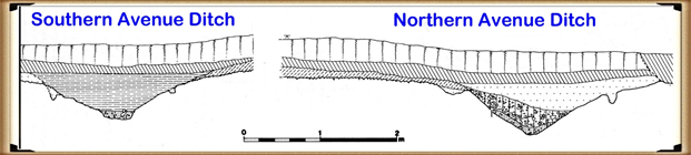
The Avenue is quite curious, and excavations have revealed its ongoing development, as indicated by the post holes dotted down its entire length. This clearly shows that it ‘adapted’ over a long period to match the retreating shoreline in the Neolithic period, which lasted over two and a half thousand years. Moreover, the physical construction of the Avenue earthwork shows the incorporation of water features. The Southern ditch is much shallower than the Northern ditch of the Avenue. This is because the water lies on the Southern side of the Avenue and does not need extra depth to fill the Southern ditch evenly, while the Northern ditch is further away from the water (and on a gradient). For it to fill evenly to the same depth of water as the Southern ditch, the Northern ditch would therefore need to be 10% deeper. Furthermore, this extra depth to one side of the monument can also be seen in the main ditch of Stonehenge as the main ditch corresponding to the northern avenue ditch is also 10% deeper.
Figure 31– North and South Avenue Ditch comparison
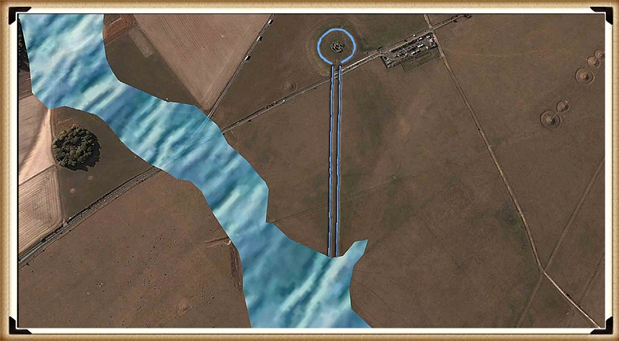
The wooden poles within the Avenue seem to be somewhat sporadic and impractical at first glance. But if you then add the prehistoric waters to the Avenue, you can see that the poles actually line up in pairs. These pairs of posts seem to appear every ten metres as you proceed down the Avenue, indicating that the Avenue was created in sections. This is a consequence of the periodic need to replacement of the poles as the shoreline retreated. The first main brace of these shoreline poles are seen quite close to the famous North-Eastern entrance by the Heel Stone, extending to the last evidence of the poles at the ‘elbow’ at the end.
The current ‘expert’ theories suggest that the path of the Avenue is a processional walkway down to the River Avon. But a careful study of this walkway shows that it makes absolutely no sense in the route it follows – it’s not direct, nor logical in its course. What the avenue shows as we see today, is the continuation of its association with the River Avon, after the original Avenue that finished at Stonehenge Bottom had fallen into disuse. This explains the strange haphazard route it now shows. Archaeologists, not finding the valid reason for its course, attempt to justify the route as a ‘ceremonial’ pathway, which ignores the facts. These ‘facts’ are compounded as later ancestors constructed Barrows that mimicked their ancestor’s constructions and placed burials within them, totally confusing the timeline.
The later attempts to keep a connection to the original builders of Stonehenge can be seen in the Avenue as it moves off to the North East for about 500 metres (the original construction), then suddenly swings off East for another 1,000 metres, then turns again and heads South, like a stretched lower case ‘n’. Archaeologists suggest that this is a ‘natural route’ deliberately passing burial mounds that lay to the East of Stonehenge.
The facts are; the walkway came first, followed by the introduction of the burial mounds – which is borne out by carbon dating showing that the Avenue was first introduced in Neolithic times, and the burial mounds much later in the Iron Age. Also, archaeologists have identified that the Avenue was built in sections; the first section up to the ‘elbow’, according to Julian Richards in his book ‘The Stonehenge Environs Project’, was built during what archaeologists’ call ‘Period II’, including:
Modification of the original enclosure
Entrance
Construction of the first straight stage of the Avenue
Erection of the Station Stones
Resetting of the two entrance stones
Dismantling of the double bluestone circle
Our hypothesis (unlike the current expert views) answers this question fully. The Avenue was built to meet the new shoreline that emerged during the Neolithic period, where (as at the old North West entrance) they received and moored the boats, cargo, and even the stones. Consequently, this then acted as a new entrance to the Stonehenge monument.
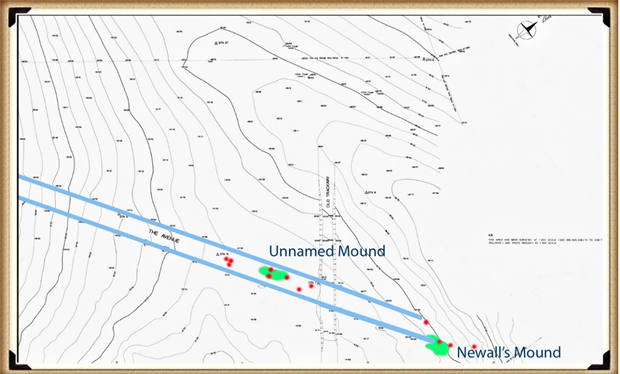
Further evidence of this shoreline can be seen in the post holes found in the Avenue. These post holes do not make sense, as they would have blocked the walkway unless they are mooring posts for various phases in the Avenue’s construction and water level. A small survey carried out from 1988 to 1990 investigated the last 100m of the Avenue up to the elbow. (Cleal et al., 1995) It found 14 large post holes that could have been used as moorings for boats. These moorings are paired off at 45 degrees to the Avenue, which would match the exact shoreline predicted over several periods.
Figure 32– The Avenue showing its termination and the wooden post holes and man-made mounds that were used to unload ships and boats
Recent investigations have revealed that as well as post holes down the Avenue, there is a distinctive man-made mound of ‘clay and flint’ called Newall’s mount (named after it’s discoverer) and a second mount, can also be found on the contour maps of the avenue (but has yet to be named or excavated), which has the same characteristics and post hole alignment. This indicates that these human-made mounds were used as raised platforms to unload boats as they could not serve any other practical purpose. (Stonehenge – the environment in the Late Neolithic and Early Bronze Age and a Beaker-Age burial, WANHS Magazine, 78, 1984, pp. 7-30)
NB. Such platforms are also found in the nearby site of Avebury, at a location I called Silbury Avenue, (which I discovered in 2014) and leads over Waden Hill, to a mooring platform called ‘Waden Mount’ located by photographer Pete Glastonbury in 2004. (Langdon, 2015, ‘Avebury’s Lost Stone Avenue’)
We can also date the extension past the ‘elbow’, as it no longer has the elaborate moats on either side of the processional walkway. The Avenue beyond the ‘elbow’ travels over a series of hillocks that could not hold water at any level and therefore made such moats useless and unnecessary. This, again, shows that our ancestors were practical and pragmatic people who included aspects such as ditches for useful purposes, not for religious or aesthetic reasons as current archaeologists believe.
At this stage of the monument’s construction, I believe Stonehenge finally turned from being a monument to the moon, for curing the sick for excarnating the dead, to become a shrine to life and the sunrise – which was, in the Bronze Age and after that, taken over by a new civilisation of druids and iron age tribal cultures.
The Avenue II
An indication of the changes that were introduced in Phase II of Stonehenge can be seen in the development of the Avenue to maintain the ceremonial link between Stonehenge and the river system. Our ancestors started by backfilling the ditch in the North-East sector of the site. Both Hawley and Atkinson observed that the secondary filling was not natural. This backfill extended to a depth of 1 m, at which pottery and bluestone fragments are first seen, clearly indicating that it preceded the arrival of the bluestones.
When the Avenue was first constructed, it could have had a dual purpose: to serve as the new mooring processional way for the dead, and also to help maintain the groundwater levels, because the moat had been reduced to a trickle as a consequence of the lower river levels.
Figure 33– The Avenue terminating at Stonehenge bottom showing the ditches on each side
We have seen in the archaeological section of our hypothesis that Hawley had found a liner in the moat. This liner would not have been required when the moat was first constructed, as the groundwater tables were sufficiently high to fill the moat, whether daily or periodically. But a liner would have been necessary once the tidal groundwater no longer reached the base of the pits. To keep the moat waters at a suitable depth, the pits would have needed to be topped up from time to time with either groundwater from the receding rivers around Stonehenge, precipitation like dew ponds or manual transference (or a combination of all three).
The Avenue is a processional causeway that had a deep trench built into both sides (over 1m deep in places). This trench is totally unnecessary unless there is another reason for its use, and that reason was either practical or symbolic.
The ditch allows water to travel along the Avenue all the way up to the existing moat, but there is no evidence that it is directly connected – but it doesn’t need to be as we have already illustrated the fact that chalk is a porous material that will allow water to flow through it over short distances.
For active discussions on the findings of the TRILOGY and recent LiDAR investigations that are published on our WEBSITE, you can join our and leave a message or join the debate on our Facebook Group.
Extract from the book : The Stonehenge Enigma (An Inconvenient TRUTH (Craig Rhos Y Felin))
A recent paper by the University of London, Southampton, and Manchester; about the discovery of the quarry that provided the ‘bluestones’ for Stonehenge at Craig Rhos-y-Felin (Mike Parker-Pearson et al., 2015) caught the eye of the world by archaeologists announcing Stonehenge was initially built in Wales and was then transferred to Salisbury Plain 500 years later.
The ‘Craig Rhos-y-Felin: a Welsh bluestone megalith quarry for Stonehenge’ was a report published in December’s Edition of Antiquity Magazine 2016, it stated that a series of radiocarbon dates were found on the site next to a 4m long monolith (ready for transportation) made of a rock which was microscopically identified as the same bluestone as the rocks that surround the existing Stonehenge site. Moreover, the report’s authors had decided that just two random sample dates (the two closest to their own well-publicised hypothesis on Stonehenge’s construction date) would be headlined and advertised to the mass media.
In spite of these ‘limited’ published radiocarbon dates, the archaeologists still had an obvious problem, as the dates were still 500 years older than the proof, they were hoping to find. So, they had to invent a new ‘story’ to compensate for this ‘poor science’ and so stated the speculation, in their report, that the monument was initially built in Wales then moved at a later date. This will no doubt be followed by another story in a few years’ time (archaeologists love to do the lucrative lecture tours on limited ‘titbits’ of information) finding remains of a few small bluestones within a short distance from the quarry site and claiming them as evidence of the original Stonehenge – this would probably be followed by an even more lucrative lecture tour.
Nevertheless, if we take an unbiased and more analytical view of the report, we find something very different from the media claims and much more scientifically interesting.
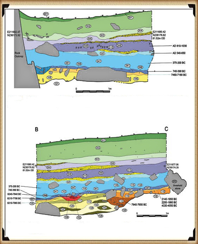
What was contained in detail within the report but overlooked, was the fact that a considerable number of Mesolithic carbon dates (fourteen compared to just two Neolithic dates the report headlined) were obtained from actual human-made hearths which were much, much earlier in history compared to two random nutshells found in an ‘occupation area’ – which could have been scattered by animals or even the weather?
These earlier and more frequent dates are from hearths rather than just random nutshells and were entirely overlooked by the team, as it was ‘perceived’ to be too early to have a connection to Stonehenge. Nevertheless, this connection was well established some fifty years ago and was reported in a press release I released in August 2011 – entitled ‘The Stonehenge Enigma; an inconvenient truth’:
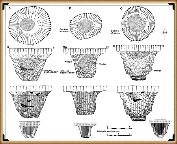
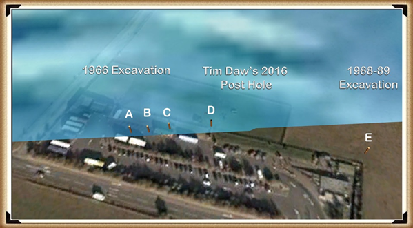
The article shows that English Heritage did their utmost to conceal the truth about the real ‘probable’ date of Stonehenge being 5,000 years earlier than their current position. This scientific evidence was based on radiocarbon dating of the three giant post holes found in the visitor’s car park during its construction in 1966.
At the time the wooden charcoal remains of the posts (found at the bottom of the post holes) were labelled Neolithic in origin to support the accepted antler pick dating hypothesis and was placed on a shelf probably for eternity.
The report from the 1966 excavation reads: “It is unfortunate that no dating evidence was obtainable from the three holes in the form of pottery. Certainly, the holes themselves would appear to be Neolithic in character, very similar to others excavated of this period….. comparable traces of posts have been found in a Neolithic context… such as King Barrow Wood” Lance and Faith Vatcher. 3
Moreover, the charcoal deposits were sent to their laboratory, and the results were: “It is surprising, in the view of the chalkland environment, that most of the charcoal should be pine. Pine has, however, been found at other sites where it would not be expected, notably Woodhenge” – but even so, these samples were not requested to be carbon dated.
Fortunately, some years later an inquisitive PhD student writing a thesis on the Stonehenge environment found these samples and concluded that they could not be Neolithic, as claimed by the archaeological community, as they were from pine trees which pollen analysis had concluded were ‘extinct’ in this area at this time of Stonehenge’s supposed construction.
The officials (of the Historic Buildings and Monuments Commission, which was later renamed English Heritage) were dismayed when they found out that their ‘experts’ were wrong, and the student was absolutely correct (yet sadly, never gave her a deserved job!!) in her assumption as the carbon dating placed them at the start of the Mesolithic of 8860 to 6590 BCE just after the last ice age. Furthermore, what happened to the pine Woodhenge samples as indicated in the lab report of 1966 – which to date have not been carbon dated, are they also Mesolithic and not Neolithic as their original unscientific estimation, if so, what is the real age of Woodhenge?
Consequently, rather than then admitting their fundamental error and re-opening the site to look for more holes and dates to get to the bottom of this unique mystery (which would have been the case for most credible scientific disciplines) they came up with a remarkable and unproven story that these were random ‘totem poles’ placed by wandering ‘hunter-gatherers’ which did not relate to the Stonehenge site just 50m away. But was a sheer coincidence, which should be totally ignored.
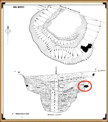
If the missed carbon dating of these Mesolithic posts didn’t spark an enquiry into the dating of Stonehenge, then another similar discovery three years later in 1988-89 should have done, as Wessex Archaeology, were employed to undertake an investigation of the area next to the Old Car Park and the construction of the Visitors Centre, opposite Stonehenge. They reported a series of stripes under the surface (they thought was periglacial) and a single pit WA9580 which was on the line of the other posts found in 1966, in the area of the old ticket office.
Within the pit they found (no doubt to the dismay of EH) yet another Mesolithic post hole that match the dates of the 1966 findings. Moreover, what they also found should have transformed the current dating of the Stonehenge site. 40cm below the top of the pit they found ‘a single piece of rhyolite (62g) within context layer 9581 at the same stratification level of 9585 carbon dated at 7737 – 7454 BCE.
Again EH attempted to supress this finding by suggesting that ‘this layer was not earlier than, and was probably contemporary with, the dressing of the Bluestone’ – which might be so if the bluestone was not BELOW context layer 9582 which was dated 7595 – 7178 BCE.
Figure 26– WA 9580 excavated in 1988 which found a Bluestone in the soil 5,000 years before the current EH published date.
Archaeologists have also found charcoal (OxA-18655) from fires in the centre of the Stonehenge monument, found in the Hole socket of Stone 10 dated 7330 – 7060 BCE (same as the Mesolithic post holes) but again the news was suppressed from the mass media. Then less than a mile away at the top of the hill that overlooks Stonehenge a site called ‘blick mead’ was excavated by the Open University, they found evidence that people were living and feasting at this same earlier Mesolithic period yet this ‘totem pole’ myth is still firmly entrenched in EH’s view of our prehistoric history through their exhibitions and many costly guidebooks.
Furthermore, recently the Stonehenge site has had a significant transformation as it has closed the B-road that went past the stones and gave access to the old visitor’s car park – which was now moved a mile up the road to the new multi-million-pound visitors centre. Consequently, the old tarmac was removed and was replaced by grass to make it look more like it did at the time of Stonehenge’s construction.
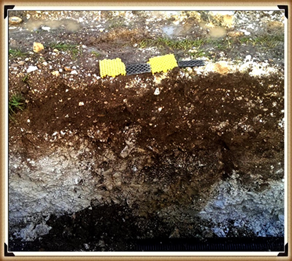
Figure 27– Tim Daw’s unpublished photo of another post in the Old Visitor’s Car Park – 600mm to 700mm wide.
Now one might imagine that if you were going to remove the tarmac from the old visitor’s car park (knowing you have found something quite extraordinary underneath in the past), you would take this ‘once in a lifetime opportunity’ to excavate the car park fully to see if you can find any more evidence about the Mesolithic Period of Stonehenge’s history?
Tim Daw was a warden at Stonehenge, and he has always been active in taking pictures on the site as he worked on a day-to-day basis at Stonehenge and published them on his blog site. Last year, he found patch marks by the centre upright stones that were identified as the possible missing circle stones of the Inner Circle; therefore, his contribution to the investigation of Stonehenge has been immense.
Tim also took some shots of trenches dug during the reinstatement of the grass over the old visitor’s car park and found something quite remarkable – but he was not allowed to publish (his pictures of the trenches) as EH had warned him that his unauthorized blog activities had to stop or else…. three guesses why this happened? Now Tim is a man of principal resisted and resigned so continuing his blog work, and as a consequence, these new ‘unofficial’ pictures have been made available, showing, even more, post holes are under the car park.
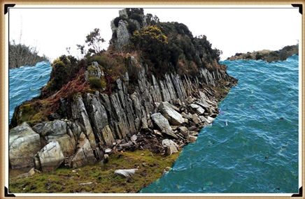
Tim’s newly discovered post hole is on the line of four other known 1966 post holes. Moreover, it supports my hypothesis, that they are all on the shoreline of the River Avon at about 8000 BCE. Furthermore, the fact that rivers in Britain were much larger in the past than today effected on not only the River Avon – but the River Nevern, at Craig Rhos-y-Felin which the current ‘Brynberian Stream, (which feeds the Nevern) is only 20m away, from the newly identified quarry site.
During the Mesolithic period, the newly quarried stones could be placed in boats on the shoreline of the quarry in Wales and could be sailed almost directly to Stonehenge, via just two or three enlarged rivers. And not over the longer sea route, some archaeologists have considered.
This report also goes into great depth in the analysing of the Stone structure of the bluestones from other Preseli sites such as Carn Goedog, Cerrigmarchogion and Craig Talfynyydd, Carn Breseb, Carn Gyfrwy and finally Carn Alw areas. All of which have streams and rivers connecting them with the River Nevern – unfortunately, the archaeologists only can conceive this connection is of a ‘religious’ order rather than something quite functional. Yet, archaeologists do seem able to consider the existence of a hypothetical road system which Mike Parker-Pearson’s calls his ‘ox-cart’ route, that follows the current tarmac covered A40, but sadly doesn’t take into account the woods, swamps and even forests of that period, which would make road passing almost impossible.
Nevertheless, this should be no surprise to readers of the Craig Rhos-y-Felin report as it is full of inconsistencies and logical inaccuracies as the layout of the site were never taken into consideration. My analysis of the area shows that the ‘Brynberian Stream’ by the rocky outcrop was much larger in the past – such as in the period directly after the last ice age. The flooding of this area is well known to geologists as they have found sandy deposits are in the excavation sub-soil. Sadly, the team seems to have created a false assumption that these floodwaters are from ‘ice melt’ which rapidly disappeared after the ice age into the sea.
Figure 29– Craig Rhos-Y-Felin as it would have looked in the Mesolithic period
We have shown in the first book of the trilogy ‘The post-glacial flooding hypothesis’ that this is a false assumption. If this was true, the sea levels would have risen rapidly to a couple of meters short of today’s sea level then plateaued for thousands of years – but this is not the case as the scientific ocean evidence shows that the ‘seepage’ into the seas took many thousands of years to occur and hence Doggerland off the East coast of Britain, took almost ten thousand years to disappear under the North Sea.
We obtain this confirmation within the report that an old river ran around this quarry as long ago as 5620 – 5460 BCE and possibly up to 1030 – 910 BCE.
“Most of the site was then covered by a layer of yellow colluvium (035), dated by oak charcoal to 1030–910 cal BC (combine SUERC-46199; 2799±30 BP and SUERC-46203; 2841±28 BP). This deposit is contemporary with the uppermost fill of a palaeochannel of the Brynberian stream that flowed past the northern tip of the outcrop. Charcoal of Corylus and Tilia from the basal fill of this palaeochannel dates to 5800–5640 cal BC (OxA- 32021; 6833±40 BP) and 5620–5460 cal BC (OxA-32022; 6543±37 BP), both at 95.4% probability.”
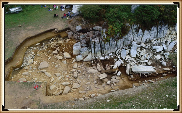
Figure 30– Craig Rhos-Y-Felin Excavation showing Mesolithic human hearths in RED
Consequently, what the report is trying to tell us, is that an enlarged stream that feeds into the River Nevern was flowing at during the Mesolithic Period up to the quarry outcrop rocks, and it remained there just a few metres away even up to 1000 BCE. Therefore, the apparent system of transport for these large newly quarried stones to their final destination at Stonehenge, as we have seen in other countries with their stone constructions like Egypt – was via a boat.
Nevertheless, the site layout also gives a clear indication of when the stone was genuinely quarried. There is a single monolith ready for transportation by the river on the east side of the site and the hearths which are human-made are a few metres south of this monolith – where you would expect them. The problem for archaeologists is that these are Mesolithic hearths, and they’re not just one but three hearths dating from 8550 – 8330 BCE; 8220 – 7790 and BCE 7490 – 7190B CE and yet the report quite clearly states:
“There is no evidence of any Mesolithic Quarrying or working of Rhyolite from this crop”.
This is an astonishing unscientific claim – for how they would know what tool marks are either Mesolithic or Neolithic (would they not be using the same tools?) And secondly, what do they think they were doing there at the quarry during these 1300 years?
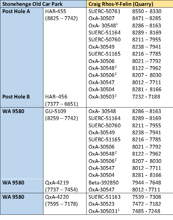
Moreover, we can now see the massive connection between the quarry site and Stonehenge with over twenty C16 dates and correlations to my hypothesis – compared to just two samples the ‘experts’ are currently claiming (which are 300 – 500 years older than current estimations).
Furthermore, we can narrow down the exact date for the construction of Phase I of Stonehenge (bluestone placements in the Aubrey holes) by looking at the overlapping dates and using the latest carbon dating curve (intCal20) to obtain most accurate date variation, and calculating the mean average probable dates.
Table 1– Matching Carbon Dates
This calculation shows that work started at the Quarry: 8300 BCE and its main use and activity was 8000 BCE, with continuous use (replacing the exhausted Bluestones at Stonehenge) ongoing for at least 1000 years.
English Heritage has invested millions in its new ‘money spinner’ the Stonehenge Visitors Centre. Within it, you will see many claims and models about the origin and possible function of Stonehenge – this exhibition has cost hundreds of thousands of pounds to design and build. BUT what would happen financially, if their assumptions are proven wrong?
Moreover, the money within archaeology is sparse, and there are many ‘schools’ of thought who compete against each other for funding. These schools are the University professors who compete for ‘airtime’ and media attention to promote their views, which the public perceive as ‘expertise’. But science evolves, through new ideas and concepts, yet these ‘experts’ are firmly cemented in the past with old ideas, publications and credibility – as nobody dares to be found wrong when so much hangs in the balance.
Extract from the book: The Stonehenge Enigma (Stonehenge Phase I (The Stonehenge Landscape))
Looking at the most important prehistoric site in Britain, Stonehenge and it’s landscape, we are asked by archaeologists to consider that it is an astronomical calendar showing the rising and setting of the Sun, Moon, etc. This assumption may be partially correct, but why would you place the site in an area were trees would obscure your view – if you wish to study the sunrise and sunset, with any great accuracy, would you not locate your site at the highest point available?
So why was Stonehenge built where it is, rather than at the top of the hill just 500 metres away that is 30 metres higher – especially considering that the builders took the trouble to get stones from 200 miles away in Wales, for what possible reason would they stop short of obtaining the best setting?
As there is no observational advantage to placing the site in this location, we must therefore conclude that it was access to the area that was of paramount importance. If we look at a standard Ordnance Survey (OS) map of Stonehenge, it outlines the landscape and topology of the surrounding area by showing the contours of the hillsides. But it does not give you a clear idea of how Stonehenge sits in the landscape; for that, we need to look at a profile of the area.
Figure 9 – Profile of Stonehenge (east to west) and the Palaeochannel that it sits beside.
Stonehenge Phase I (The Stonehenge Landscape)
Amazingly these profiles of Stonehenge show that it was built on the shoreline of a vast river complex. We can see this evidence on any elevation map, where we find that Stonehenge is sited halfway up a ‘Dry River Valley’ (Palaeochannel) known as ‘Stonehenge Bottom’.
Figure 10 – Stonehenge with the River Avon as it would have looked in 8000BCE.
Stonehenge Phase I (The Stonehenge Landscape)
Our hypothesis and case study on the river Avon indicates that the groundwater tables during the Mesolithic and Neolithic periods were as high as river terrace T9 (Egberts et al., 2019), which was 100m high. This would mean that the river Avon would have filled the dry river valley with groundwater 30m above the existing groundwater table – when this happens, the profile changes dramatically.
And so suddenly, the impossible becomes possible, the implausible becomes credible, and myth becomes fact, for these profiles can only indicate one conclusion – Stonehenge was built on the side of a hill surrounded by water!
These amazing features are not just found on a single side of the monument; we can go around the whole circle to see these watery features. I believe these profiles tell the entire story of Stonehenge. A picture is said to paint a thousand words; these pictures show that our most famous ancient monument was once a magnificent feature in the landscape on the edge of a peninsula, surrounded by water. Now that we have shown that water existed at the Stonehenge site during Mesolithic and Neolithic times, we can re-sequence the events and building phases.
Figure 11– Profiles of Stonehenge showing the River Avon around the Stonehenge Peninsula
For active discussions on the findings of the TRILOGY and recent LiDAR investigations that are published on our WEBSITE, you can join our and leave a message or join the debate on our Facebook Group.
Extract from the book: Dawn of the Lost Civilisation (New Home Land – for Homo Superior)
When Homo Superior travelled north at the end of the last Ice Age, they did so in reed boats which grew in abundance in the boggy soils of Northern Europe. Archaeologists have identified this culture as the ‘Maglemose’ civilisation.
Which Wikipedia reports as:
“Maglemosian (c. 9000 BC – 6000 BC) is the name given to a culture of the early Mesolithic period in North Europe. In Scandinavia, the culture was succeeded by the Kongemose culture.
The actual name originates from the Danish archaeological site Maglemose, situated near Gørlev and Høng on western Zealand, southwest of lake Tissø. Here the first settlement of the culture was excavated in 1900, by George Sarauw. During the following century a long series of similar settlements were excavated from England to Poland and from Skåne in Sweden to northern France.
The Maglemosian people lived in forest and wetland environments, using fishing and hunting tools made from wood, bone, and flint microliths. It appears that they had domesticated the dog. Some may have lived settled lives, but most were nomadic.
Huts made of bark have been preserved, and the tools were made of flint, bone, and horn. A characteristic of the culture are the sharply edged microliths of flintstone, used for spear and arrow heads. Another notable feature is the “leister”, a characteristic type of fishing spear, used for gigging.
When the Magesmosian culture reigned, sea levels were much lower than now and Europe and Scandinavia were landlocked with Britain. The cultural period overlaps the end of the last ice age, when the ice retreated and the glaciers melted. It was a long process and sea levels in Northern Europe, did not reach current levels until almost 6000 BC, by which time they had inundated large territories previously inhabited by Maglemosian people. Therefore, there is hope that the emerging discipline of underwater archaeology may reveal interesting finds related to the Maglemosian culture in the future.”
There is a lack of artefacts from this period, as most of this civilisation lay under the existing North Sea, which used to be known as Doggerland. This includes essential boating evidence, due to the rapid deterioration of these natural fibres, or the confusion in finding peat like substances at ancient sites and being unable to understand the significance of these fragile remains. This lack of understanding of past history has led archaeologists to overlook the most influential piece of technology in our history – The Boat. Wooden boats survive the savages of time much better than reed boats or leather (coracle) tub boats although we have seen other cultures of the world use these materials with relative ease.
Fortunately, history has left other associated evidence showing the nautical nature of this society, such as harpoons – a long spear-like instrument used in fishing to catch not only fish, but also large mammals such as whales. Harpoons are only effective over short distances and so a boat is essential. Consequently, if you find harpoons, you find boats and seafaring civilisations. Spear fishing with barbed poles (harpoons) was widespread in Palaeolithic times when Homo Superior entered Europe. Cosquer cave in Southern France contains cave art over 16,000 years old; including drawings of men harpooning seals. What is more interesting is the fact that Seals are not native to France – today you will need to travel North to Britain or Norway to find seals – suggesting that the men harpooning seals on these cave drawings must have sailed hundreds of miles to achieve this feat!
The other indicator of the existence of boats are the occupation of islands; we are now aware that Neanderthals and Erectus did not sail because they probably could not swim – so the only fossil remains of these Homo cousins are just found on the mainland or islands that were connected during the low tides of the ice age periods. Therefore, the population of remote islands such as; Ireland, Isle of Man, Scilly, Shetland, Orkney and the Faroe Islands prove that the early inhabitants had to possess boats to colonise these places. Not only does the archaeological evidence of these islands show occupation during the Mesolithic period, which supports my hypothesis, but as a consequence the DNA also found in these locations has a high percentage of the genetic R1a1 bloodline still in the resident population – confirming that Homo Superior was the first civilisation who colonised these islands with prehistoric boats.
Nevertheless, human genetic DNA is not the only evidence of colonisation in the past. Looking closely at the wildlife of these islands and the diversity of the animals, we will get a better idea of when these lands were first occupied. As an example, bones of a particular breed of vole on the Orkney Isles, which does not exist on mainland Britain, have been found. This creature does exist – in Germany – a clear indication of extensive trading over very long distances throughout Europe. These bones were found with ‘tell-tale’ Palaeolithic ‘microliths’, which are the most sophisticated, misunderstood and incorrectly dated artefacts in archaeological history. Moreover, we are now certain that the islands were first occupied, at the very least, in the Mesolithic Period and the animals found coming from outside the region (such as the voles) were accidents of transportation – we can therefore confidently assume that these boats were not just small boats but, in fact, ships of great size. For if these were just small dugout canoes (as some archaeologists would suggest) they would have easily been spotted and removed.
New Home Land – for Homo Superior
Addendum – In recent years, the ‘politically correct’ lobby has sought to quash humanity’s real history for a more politically correct version that stops the internet from giving the far-right suppressive groups literature and information that supports their delusional ideology. Although I believe that the incorrect use of such material is morally wrong – the censorship and corruption of history, I find it even more unacceptable as it ‘dumbs down’ our society by replacing history with propaganda.
This ridiculous attempt suggests that humankind was just from a single cultural entity. Therefore, one big happy family is sadly nonsense, as anyone who has eyes and intelligence could recognise that the world is made of very different biological cultures. This obvious observation is in line with Darwin’s theory of Evolution, which quite clearly (but sadly is misrepresented by the scientific community) shows that humanity has evolved by a series of ‘mutations’ each one giving us a new biological identity demonstrated by the changes in blood type (Haplogroup) of which there are many.
An example of this attempt to twist history for the political benefit we saw in the reconstruction of ‘Cheddar Man’ showed a Blue-eyed Black male dated about 7k BCE and Britain’s first inhabitant. This has been derided and disproven by the knowledgeable DNA scientists who quite rightly pointed out that skin colour can not be judged by DNA analysis (although eye colour can) – but not before the media circus had widely publicised this picture ‘dumbing down’ society as a consequence in this false perception.
Another false claim that has caught media attention is the Evolution of Blue Eyes and Pale skin – it has been suggested that it evolves not through mutation but by living in cold conditions with less intense sun. This again is complete bunkum and has been developed from a reported change in blue eye colour gene (probably the change from blue eyes to green), which happened just 6000 years ago – that has been linked with the incorrectly perceived movement of the first farmers moving from Asia minor to Northern Europe – which this book has thoroughly disproven through both DNA and Archaeological evidence.
The real source of Blue Eyes can be found in the R1 mutation (Cro-Magnon off-spring of Neanderthals and African Homo Sapiens) as shown in this link that goes back 28K years, not 6K. “The genes for blond hair are more strongly correlated with the distribution of haplogroup R1a, but those for red hair have not been found in Europe before the Bronze Age, and appear to have been spread primarily by R1b people. (New Home Land – for Homo Superior) “https://www.eupedia.com/europe/Haplogroup_R1b_Y-DNA.shtml
Further information on Homo Superior and documentary on their work can be found at: https://youtu.be/V825KgfDDeM
For active discussions on the findings of the TRILOGY and recent LiDAR investigations that are published on our WEBSITE, you can join our and leave a message or join the debate on our Facebook Group.
Extract of the book: Dawn of the Lost Civilisation (Brain capacity (Cro-Magnon Man))
At roughly 3.2 billion base pairs, the Neanderthal genome is about the size of the modern human genome. According to preliminary sequence data, 99.84% of base pairs in the modern human and Neanderthal genomes are identical, compared with humans sharing around 94% of base pairs with chimpanzees. The researchers recovered ancient Neanderthal DNA by extracting it from the femurs of three 38,000-year-old female Neanderthal specimens from Vindija Cave, Croatia, and from other bones found in Spain, Russia, and Germany. The project faced many difficulties, including contamination of the samples by bacteria that had colonised the Neanderthal’s body, and by humans who handled the bones at the excavation site and in the laboratory. So, we must be realistic about the outcomes and acknowledge that future samples may vary in investigations into Cro-Magnon man’s ancestors.
Another comparison is in the cranial capacities of this species. Within the human population, studies have examined whether brain size is related to various cognitive measures. Early anthropologists and psychometricians found these correlations, and even modern studies (which began with Van Valen 1974) have suggested similar correlations, including Jensen & Johnson 1994 in ‘Race and Sex differences in Head Size and IQ’. They wrote
“In all of the 25 independent studies we have found in the literature, nonzero positive correlations between head measurements and intelligence measurements to be found, all but five with correlations significant beyond the 0.5confidence level. The average correlation between various external head size and IQ is close to 0.15. But external head size is rather weak proxy for brain size. Two recent studies have measured brain size per se by means of magnetic resonance imaging (MRI) and found correlations with IQ in the 0.3 to 0.4 range (Andreasen et al.,1993 Willerman, Schulz, Rutledge, & Bigler, 1991).”
Therefore, just how intelligent was Homo Superior in comparison to other groups and us in prehistory?
Today’s human Brain (Modern Man) is on average 1380cm3, while Homo sapiens’ brain averaged 1660cm3, so they are (on average) 20% more intelligent than us. On the IQ scale, that would mean that ‘Modern Man’ has an IQ of between 90 and 110 points (Stanford–Binet Intelligence Scale). While Homo Superior would have an IQ between 108 and 132 (classified as High Average to Superior, held by the top 7% of the present population) – hence my new Homo Superior (Cro-Magnon man) classification.
We can see the same correlation in other animals, such as the size of Wolfs and Dogs – the dog’s brain is a deterioration of the animal it used to be in the wild. It does not mean that they are stupid, or their lives are poor; in fact, one would suggest (if you were a dog) that their lives today are much more progressive than the life they once lived. But if man were wiped out by disease tomorrow, how many dogs would survive in the long term? It would not be beyond thinking that dogs would become extinct without humans to look after them?
Can we not use the same analogy for Modern Man compared to Homo sapiens (Cro-Magnon man)?
For if the sun’s electromagnetic radiation increased through our Van Allen magnetic belt that surrounds the earth, our power stations would go into ‘meltdown’ and would work no longer, leaving the world without electricity – how many ‘modern day’ advanced, sophisticated and cultured people would survive, long term, without electricity, gas and petrol?
Dogs need humans to help them survive their ‘luxury’ lifestyles, and humans need technology for the same reason. Wolves and Homo Superiors (Cro-Magnon man) are naturally ‘wild’ animals of superior intelligence that allow them to adapt to ‘any’ environment and not to simply survive but, moreover, grow and thrive within the environment, without fear of extinction. Another interesting comparison between brain capacity and IQ is that the further north you travel, the higher a species’ IQ. This includes both man and wolf. Given this fact, we have to consider the reasons for this occurrence. Is this growth a product of the environment and weather, or does the higher intelligence allow a species to travel further, as its adaptability can overcome the environment better than someone with a lesser capacity?
In our last chapter, we theorised that the last Homo migration ‘Out of Africa’ by Sapiens 50,000 years ago, led to an exodus from southern Asia about 30,000 years ago to Europe as a consequence of multiple mutations. This interbreeding brought an unknown kind of humanoid – Homo Superior. With a new kind of thinking as they had much larger brains with immense IQ, thus allowing them to move to fresh and greener pastures, following the ample food supply through their natural migration patterns. This increase in food allowed for an increased brain capacity, and the growth of imagination led them to develop and create brand new forms of transportation, allowing them and their families to travel faster and for longer than before, through dangerous forests full of deadly animals.
For a species that had a natural ability to both swim and walk on land, with the vast waterways that spread across Palaeolithic Europe for thousands of miles in all directions (let alone the sea routes within sight of the shoreline), the boat would have been the method of choice. The environment was full of marshlands, lakes and forests from the last ice age, and water reeds would have grown in abundance. The simplest way to make a boat is to gather dried reeds into bundles and then tie them together. Almost instantly and without extensive effort, you have a floating reed boat. Over the space of a day, the tied and twisted bundles would produce a large boat that can travel many thousands of miles and allow you to fish in safety in the middle of a landscape full of lions, tigers, wolves and bears.
For active discussions on the findings of the TRILOGY and recent LiDAR investigations that are published on our WEBSITE, you can join us and leave a message or join the debate on our Facebook Group.
Extracts from the book: Dawn of the Lost Civilisation
Whilst researching my trilogy, there was a profound recognition that the accepted prehistoric history was not quite as portrayed in the academic history books of our schools and colleges. In fact, the deeper the findings took me, the more amazing the journey became – to find that Stonehenge was indeed five thousand years older than the experts believed was a revelation, but then to discover that it was built by the lost civilisation known to us as Atlantis was an unwelcome surprise beyond belief. For it took the story of our ancient past beyond the realms of archaeology, into the unexplored depths of mythology with the realistic understanding that the academic world would be given a twenty-four carat golden reason to dismiss my claims as ‘fantasy’, not because of the scientific facts I have based the hypothesis upon, but simply by association.
I was therefore left to ponder how to present my findings in a way to not only justify the science of my research but moreover, the enormity of the conclusions. The solution was, therefore, a trilogy of books that would allow me to place all the archaeological evidence, such as the dating of Stonehenge in a single book based on a more scientific format, including clear evidence Followed by this book you are currently reading, which looks at the anthropology of these megalithic builders, traced through the modern method of DNA genealogy, and lastly the final volume written as a comprehensive academic paper with over 125 peer-reviewed references and associated carbon dating to finally prove to the sceptics that ‘rivers were higher in the past’ and lay the foundations to ‘the greatest story ever told’
As an advocate of truth and reason, I fail to see the wisdom in recording history out of its true context. I can only imagine that our current misinterpretations of these poorly rationalised ideas are a result of teachers and university students being coerced to accept traditional theories and models through dogma or the fear of ridicule.
I am reminded of the wise words of Dr Jacob Bronowski who once said, “It is important that students bring a certain ragamuffin, barefoot irreverence to their studies; they are not here to worship what is known, but to question it.”
Dawn of the Lost Civilisation – Introduction
The Stonehenge Enigma questioned our existing conceptions and took a detailed look at the archaeology of Stonehenge and its associated sites such as; Woodhenge, Old Sarum and Avebury. These monuments are linked not only by the age of this ancient society but moreover, by who built them and their exact social purposes. The reasoning for their construction is inevitably linked to my hypothesis – that during the Mesolithic Period (directly after the last ice age), the land was flooded for thousands of years due to the action of the polar ice cap that sat on top of Northern European continent for the previous 100,000 years. This natural compression of the land increased the height of the ground water table – creating the Post Glacial Flooding of the landscape.
This ‘Isostatic’ sinking movement (due to the weight of the ice on the earth’s surface) was compounded by the melting of the two miles of glacier that once sat upon the lands surface. As this ice water melted in the rising heat of the ‘pre-boreal period’, a new era for humankind started to begin as these flood waters covered not only our tiny island but also the lands of Northern Europe and beyond. At the end of the ice-age the sea level was 65m lower than today. A landmass not seen in our times was the centre of this new Mesolithic world, for the North Sea gave way to a land we now call ‘Dogger’ which was a ‘foot bridge’ connecting Britain to its European neighbours within a giant peninsula that protruded into the Atlantic Ocean and incorporated all of Europe.
Stonehenge built by the lost Civilisation was once surrounded by the river Avon – Dawn of the Lost Civilisation – Introduction
Through sonar mapping, we can now understand what the landscape actually looked like at the end of the ice age and appreciate that the warmer temperatures assisted the natural growth of foliage and plant life. This allows us to re-evaluate the archaeological evidence in a completely different way as we begin to understand that what we see today with green plains and fields of golden crops, is not as it looked in the past. Where now we see rolling valleys and grassy hills there once was a watery landscape filled with dense sub-tropical trees and islands, much like the Amazon forest.
‘The Stonehenge Enigma’ changed our perception of our history by reinterpreting the scientific excavational evidence from ancient sites, which showed how the ‘Post-Glacial Flooding’ enlarged the rivers of Britain and Europe, influencing the location and design of these ancient sites to facilitate this higher water table, with canals and landing platforms. This unique understanding of the landscape allows us to establish a new discipline within landscape archaeology that can more accurately date the phases of these sites and their function. Now these new dates have been established in the first two parts of the trilogy, then the last part (this book) can concentrate on an even more fascinating aspect of our history, the great historically ‘lost civilisation’ that created our present society.
Stonehenge, as we can now see from archaeological evidence, was first used as a place for treatment for the sick and dying, contained with the monument there was also a site for the dead (like a mortuary in a modern hospital) where the bodies were prepared for the ’last voyage’ to the afterlife. The ‘ditch’ surrounding Stonehenge contains a series of ‘individual pits’ that had small walls in-between and seats cut into the chalk flooring – this ditch was unique in its design and no similar construction has been found anywhere else in the world. Moreover, this has been completely overlooked by most archaeologists, but it was made with a clear purpose in mind – and that was as a bathing pool.
Stonehenge Ditch showing ‘individual pits’ the lost civilisation used for bathing – Dawn of the Lost Civilisation – Introduction
The reason our ancestors chose Salisbury Plain was two-fold. Firstly, at the end of the Ice Age this area was flooded, and the Stonehenge site would have been surrounded from three sides by water making it a magnificent peninsula with easy access for boats. Secondly, the sub-soil was made of chalk. This mineral is porous and allows water to flow naturally through it. Consequently, when the pits/ditch were dug to a certain depth to the groundwater level, they filled with clean water, like a moat.
This naturally filtered water would be good enough to drink, but this water was not for drinking; it was for bathing, with the addition of a bluestone additive, from the Preseli Mountains of Wales some 200 miles to the North West. Evidence suggests our ancestors not only placed some of these large bluestones in the bottom of the ditch, but they also hammered small pieces off the larger megalithic bluestone blocks and placed them in the waters like the ‘bath salts’ we have used for hundreds of years, and even today. This type of traditional bathing was commonly practiced in the past and has been seen in the historic spa city of Bath, which lays just a few miles along the road from Stonehenge. Like bath salts of today, these bluestone rocks contained minerals that dissolved in water to aid recovery. Therefore, what was this ’wonder cure’ of prehistoric times?
The greatest killer of people during this period (apart from child mortality) would be cuts and abrasions and their associated infections. These minor injuries are easily treated with modern ‘antiseptic’ medicines, and in Prehistoric Britain, Stonehenge offered the same through bluestones. These rocks have veins of ’rock salt’ contained within and around the dolomite and rhyolite bluestones, helping to clean the wound. This historical use of spa baths to cure illness continued through to the Roman period and was even practiced up until the Victorian era.
Unfortunately, this treatment was not always the miracle cure hoped for at Stonehenge. Consequently, if the patient failed to recover from their illness and died, they were taken to the centre of the monument (behind a wooden palisade) and laid out on 6 foot stone slabs like a modern-day mortuary. These slabs were positioned in a distinctive ‘crescent moon’ shape which represented our ancestor’s belief that the moon in the sky was where the deceased soul travelled to the afterlife. This is the first indication we find of the philosophy of this society, as clearly their disregarding of the dead body (by allowing it to rot and be picked clean by birds) indicates that they are the original ‘dualists’ and must have believed the body and soul are separate in identities.
These structures are called ‘Rondel Enclosures’, and hundreds have been found throughout Europe built by the lost civilisation – Dawn of the Lost Civilisation – Introduction
The mortuary area in the centre of the monument was screened by a wooden circular palisade affording the dead privacy from the outside world, including the bathers in the outside moat. The corpses were laid out to decompose naturally and were inaccessible to animals except to the carnivorous birds such as eagles, hawks, owls, crows and ravens, which have always had a connection with the spirits from the dead in the form of guides and guardians. These animals are also connected to the afterlife as they inhabited the sky where the spirits were to wander after death. Once the corpse had been completely de-fleshed they were taken to a Long Barrow, probably near a spot of either birth or social habitat where they would be placed inside a chamber with their relatives or a group known to the individual for their last voyage to the afterlife.
The Long Barrow is a very distinctive shape and size, and studying it allows us to understand what kind of ships and boats were used by the living of this society. Long Barrows typically represented a long boat shape with a pointed nose for speed and manoeuvrability and a flat stern which had the chambers contained within it under the decking of the ship – in the case of West Kennett near Avebury; the covering would be of white chalk to give it maximum visibility. The Long Barrow would then be surrounded by rocks to enhance the outline of the boat, and a ditch would be dug that would fill with water to represent the sea. Larger stones would be placed at the Entrance of the Chambers at the back of the boat to stop animals taking the disarticulated bones and to act as a ‘direction indicator’ for the boats using the Long Barrow as a navigational aid.
Here in Northern Europe, this connection to the dead and boats remains prevalent. In most countries they practice these same ancient ‘traditions’. Family and friend’s bodies are still buried in the ground in wooden coffins – which remarkably look like small one-man boats with six sides not four; we give our dead a plaque of stone and make films and TV series of the undead rising from their coffins in the dead of the night by the light of the full moon and in some pre-pagan cultures coins are placed over the eyes of the deceased to pay the ferryman to take the corpse safely to the afterlife.
Another myth the first books of the trilogy dispelled was the inaccurate archaeological use of the term ‘hunter-gatherer’. This term was invented by Victorian archaeologists and anthropologists in an attempt to classify and understand our past by comparing them to the known indigenous primitive peoples of the world. The problem with this concept is clearly irrational, as the ‘hunter gatherer’ peoples of the world are nomadic tribes that walk the land, hunting game and gathering berries and plants – never built stone monuments.
‘Belas Knap’ is a Neolithic chambered long barrow, situated on Cleeve Hill, near Cheltenham used by the lost civilisation for Burials – Dawn of the Lost Civilisation – Introduction
These nomadic tribes did not evolve past basic stone tools, unlike the our society over the last eight thousand years, and even when the influence of our progressive society attempted to change their lives, for example by contacting these ‘natural indigenous’ tribes of Africa and South America and trading food for modern metal knives and machetes to replace their ‘traditional’ flint tools, it did not accelerate their culture. It would have been expected that the introduction of this quantum leap technology (that has been available to some of these tribes for hundreds of years) would have enabled them to duplicate the technology independently, but this has not been the case.
The real key to many of our historical mysteries and the true ‘ascent of man’ lie behind the events just before the last ice age. Humankind (Homo Sapien) and to a lesser extent his ancestors prior to him (Homo Erectus and Homo Neanderthal), who hunted and lived for millions of years without change, venturing only short distances to follow food resources. Yet, in the blink of an eye in anthropological time scale, we went from stone age man to rocket man – but the obvious question not answered by the experts is why? What on earth happened around 30,000 BCE and what was this revolutionary event that changed the whole of humanity forever, which allowed us to spread with great speed and diversity throughout the entire world in such a short period of time?
Moreover, to link ‘modern man’ to primitive hunter-gathering societies 10,000 years ago leads us into this great ‘misconception’ of existing academic history, which can be shown in recent findings at Göbekli Tepe in Turkey. This is a clear example of how ‘traditional’ archaeology is finding the simple ‘linear history model’ of Mesolithic hunter-gatherers (people with spears in nomadic tribes, dressed in fur going on walkabout) impossible to justify, as these findings proves that this stone settlement was established some 4,000 years before the so-called ‘agricultural revolution’. The buildings show a high greater degree of constructional (stonemasonry) knowledge and skills than any early farming community should have been capable of producing. Moreover, this degree of sophistication would not be equalled or even surpassed until the Roman and Greek empires some eight-and-a-half-thousand years later.
Gobeki Tepe in Turkey built by the lost civilisation – Dawn of the Lost Civilisation – Introduction
Modern researchers and academics have attempted to rationalised this (Gobekli Tepe) ‘blip’ in their linear history of the world, by suggesting that this is just a freak ‘earlier period’ which they have now called the ‘early Neolithic’, by moving the Anatolia Neolithic timeline to 3,000 years earlier. Consequently, if we accept this kind of ‘logic’ as rational and accurate, then we must view Australia up to the 16th century as ‘Mesolithic’ as aborigines did not develop either farming or metalwork. To manipulate these historical timelines in such a fashion is total nonsense and shows that our antiquity is far from ‘linear’ or straightforward than our history books would suggest.
We have similarly shown that this kind of institutional and stereotypical thinking in our first books of the trilogy, perpetuated the belief that our ancient sites and monuments were built on the same dry grassy plains we see today, which lead historians to come up with (an amusing but ridiculous) hypothesis that fur covered men dragged large stones 200 miles across Salisbury plain from the Preseli Mountains in Wales – which at the time of construction was, in reality, a forest covered with rivers and marshes and therefore, impossible to traverse in such a fashion. This is despite nearly every palynologist, (scientists who studies tree pollen) showing that there is little to no grass pollen found at these sites, but plenty of tree pollen. Still this myth continues and until recently could be seen upon the walls in the underground tunnel that used to go under the old A322 that lays next to the site at Stonehenge – fortunately, this embarrassment has now been backfilled for future archaeologists to amuse themselves, when it is eventually rediscovered.
The lack of open plains also goes a long way to support the argument that these people were not traditional ‘hunter-gatherers’; for not only was this environment a flooded landscape due to the enlarged rivers during the past which forced prehistoric man to move from place to place by boat, but moreover, the dangerous animals, such as bears, wolfs and even wild cats outnumbered the very small human population by about 60 to 1 and so it was foolhardy to roam on land without protection.
Throughout time, many other cultures that lived in this kind of watery environment have adapted successfully by using boats, though these boats are not always the perceived wooden log boats of African or South American descent. The simplest boat to build in Britain due to the abundance of reed is the ‘reed boat’. The only requirement being to gather the natural growing reeds in a bundle and tie them together and ‘lo and behold’, it floats – so why bother to cut down a tree and hollow it out, unless a larger and more sea worthy project is required?
It is so simple to use this building method that even complete islands can be made from reed. These floating artificial islands are generally made of bundled reeds, and the best-known examples are those of the Uros people of Lake Titicaca, Peru, who built their villages upon what are, in effect, huge rafts of bundled totora reeds. The Uros originally created their islands to prevent attacks by their more aggressive neighbours, the Incas and Collas.
Boats used by the lost civilisation – Dawn of the Lost Civilisation – Introduction
Even the Aztec capital, Tenochtitlan, was surrounded with chinampas, small artificial islands used for agriculture known as “floating gardens.” Floating gardens on a large scale were demonstrated with aquaponics systems in China growing rice, wheat and canna lily on islands, with some installations exceeding 2.5 acres (10,000 m2). However, archaeologists have chosen to ignore these cultures in favour of nomad wanderers, which do not fit either the ancient environment or the creative nature of the culture.
The Post-Glacial Flooding Hypothesis explained in detail why the environment was flooded directly after the last ice age. Many societies currently still use boats throughout the world; these people are not ‘traditional’ academic hunter-gatherers who eat just red meat and berries. This boat civilisations would have had a ‘high-protein diet’ from mainly fish, shell food and fat free meat (reindeer) as well as carbohydrate/plant in-take, which promotes not only an increase in the size of the human brain, thereby increasing the capacity for intelligence, but moreover, increased physical growth and bone size resulting in increased height and strength.
Archaeological artefacts have also shown that this diet enhances the resourcefulness possessed by this lost civilisation, allowing them to develop a host of new skills, including the ability to cut and move massive building stones, engineer and excavate dykes(canals) and even undertake complex social medical procedures such as treating the sick, limb amputations and trepanations (brain surgery).
The ingenuity exhibited by this ancient lost civilisation to build monuments such as Stonehenge, Avebury, Old Sarum and Carnac some 10,000 years ago is undisputed. Recent discovery of the worlds ‘oldest boat yard’ at the bottom of the Solent in Britain, offers evidence of this civilisation being able to ‘plank wood’ (for the construction of wooden boats), during Phase I and Phase II of Stonehenge’s construction – allowing us an obvious method of how these stones were transported. Moreover, with the discovery of wheat found by these wooden planks that have been dated not only from the same Mesolithic period, but more importantly showing that this grain was brought to Britain from Asia Minor (as this wheat grain is not native to Britain), by the same ships made from these planks – instantly changing the historical timeline of Britain.
In conclusion, it is evident that this ‘advanced civilisation’ that lived on the waterways of Britain and Europe in a time known to geologists and archaeologists as the Mesolithic (Holocene) Period from 10,000 BCE to 5,000 BCE, had the ability to build ships and boats and travel far and wide. Moreover, we may be able to find ancient accounts of such a civilisation as according to the famous philosopher Plato, another great boat civilisation which he termed as a ‘great naval power’ was in their ascendancy, during this same period of history.
According to Plato, they lay beyond the ‘Pillars of Hercules’ (the opening to the Atlantic Ocean from the Mediterranean) and travelled to the ‘four corners of the known world’. This ‘great lost civilisation of history’ was known to the ancient Greeks, and many of their fables and stories bore testament to their character and skills. The Greeks believed this society were the forefathers of our civilisation and therefore seen as Gods in ancient times.
Amazingly, if this is true then it was this civilisation, that placed four gigantic metre wide mooring posts on the shorelines of a peninsula which we now call Salisbury plain. These mooring posts, which was the beginning of a construction that was to become the greatest and oldest surviving monument of this civilisation – Stonehenge.
For Plato was referring to this ‘Great Lost Civilisation’ known to the ancient Greeks as Atlantis, which lay in the ‘Atlantis Ocean’ (Atlantic) and through his detailed descriptions fit the landscape and specifications of the lost land of Doggerland that now lays below the North Sea, as we shall show you in absolute detail within this book.
Atlantis (capital city of the lost civilisation) as described by Plato – we have many similar constructions in Britain called ‘Causewayed Enclosures’ or ‘Henges’ by archaeologists who don’t understand their true function. The best preserved is Old Sarum in Wiltshire. – Dawn of the Lost Civilisation – Introduction
For active discussions on the findings of the TRILOGY and recent LiDAR investigations that are published on our WEBSITE, you can join our and leave a message or join the debate on our Facebook Group.
Extracts from the book: The Post Glacial Flooding Hypothesis
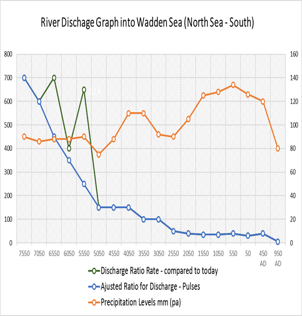
When we put all the information about the Holocene together including the vast amounts of meltwater, Ice melt pulses, raised water table and increased precipitation, then we are left with evidence of increased water activity, volume and consequential raised river levels levels of the Holocene.
Landscape Transformation (raised river levels)
Figure 14. Shows the Discharge rates into the Wadden Sea for the last ten thousand years – see below for statistical details of the graph. We have ‘smoothed’ the pulses (in green) to show the steady drop of river discharge (in blue) since the last ice age.
Table 3 – Wadden Sea statistics
BCE
Change (mm) over – 500 years
Discharge Ratio rate – compared to today = 1
Adjusted Ratio for Discharge – Pulses
Precipitation levels mm pa
950 AD
50
1
1
450
450 AD
400
8
8
430
50
300
6
6
440
550
400
8
8
440
1050
350
7
7
450
1550
350
7
7
375
2050
400
8
8
440
2550
500
10
10
550
3050
1000
20
20
550
3550
1000
20
20
460
4050
1500
30
30
450
4550
1500
30
30
525
5050
1500
30
30
625
5550
6500
130 *
50
640
6050
4000
80
70
670
6550
7000
140 *
90
630
7050
6000
120
120
600
7550
7000
140
140
400
Landscape Transformation (raised river levels)
* Meltwater Pulse – see figure 8.
We have added the increased precipitation (in yellow) during this period to indicate the reasons for the river flooding events we will show in the following sections.
Therefore the blue ‘discharge’ line on the graph is an indication of the volume discharge and hence the size and height of rivers over the last ten thousand years – the chart uses today’s discharge rate (950 AD) representing one unit, to give us a simple visual comparison to previous years as a ratio of size – hence 8050 BCE the rivers were 140 times larger than today.
For active discussions on the findings of the TRILOGY and recent LiDAR investigations that are published on our WEBSITE, you can join our and leave a message or join the debate on our Facebook Group.
A Glimpse into the Robert John Langdon Trilogy
Step into the shoes of Robert John Langdon, a dedicated explorer of Britain’s prehistoric mysteries. His trilogy, comprising “The Stonehenge Enigma,” “Dawn of the Lost Civilization,” and “The Post-Glacial Flooding Hypothesis,” is a literary marvel that unravels the untold tales of our ancestors. These books take you on an exhilarating journey through time, meticulously researched and backed by over 125 references from esteemed scientists, archaeological experts, and geological researchers.
Extract from the book: The Post-Glacial Hypothesis
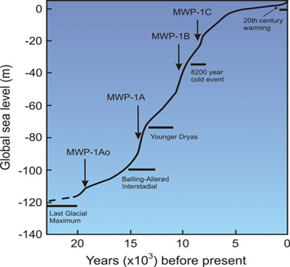
If our ‘flooded Britain’ hypothesis is correct, we should be able to get verification via the empirical evidence of sea level changes to see if it has been constant over the last 12,500 years. Most scientists and historians when talking about the end of the LGM, refer people to the phenomenon called the ‘Meltwater Pulses’ to prove that the exchange from frozen glaciers to today’s landscape was rapid. (Sea Level Changes)
The first significant increase in sea levels was (meltwater pulse 1Ao, or MWP 1Ao), 19,600-18,800 years ago, ocean levels climbed at least 10m within 800 years. However, not all sea-level proxies register this event.
A faster rise began 14,600 years ago during the comparatively mild Bølling-Allerød interstadial, which accelerated about 300 years later and peaked about 13,800 years ago (meltwater pulse 1A, or MWP 1A) (Stanford et al., 2011). Although it is a tremendous 20m surge in height, it should be recognised that this ‘pulse’ as only 16% of the total sea rise since the end of the LGM.
Computer models that “fingerprint” spatial patterns of sea-level rise attribute much of the meltwater to Antarctica. Different sources of ice melt leave geographically distinctive sea-level fingerprints because their ice unloading histories and the gravitational pull between shrinking ice masses and oceans vary.
On the other hand, geological data indicate significant deglaciation in Antarctica starting only toward the end of MWP 1A, which suggests that most of the meltwater originated from the breakup of Northern Hemisphere ice sheets. (Sea Level Changes)
During the Younger Dryas cold period, between 12,900 and 11,800 years ago, the encroaching oceans slowed their upward pace. A massive freshwater influx via the Mackenzie River into the Arctic Sea and ultimately the eastern North Atlantic may have triggered this cold episode. Once the warmth returned, rates of sea-level rise averaged 13 to 15 mm/yr during meltwater pulse 1B, 11,000-9,000 years ago, an event recorded in Barbados, but not in Pacific corals. This difference may arise from glacial isostatic or gravitational effects; alternatively, the increase at Barbados may have been overestimated.
Around 9,300 years ago, a glacial dam burst at the south-eastern end of Lake Superior, provoking pervasive Northern Hemisphere cooling, followed by a minor meltwater pulse about 9,000 years ago. However, meltwater pulse 1C (8,200-7,600 years ago) left traces at numerous locations in the United States, north-western Europe, and China.
Most glacial melting ended by about 7,000-6,000 years ago.
Because of slowly diminishing adjustments of Earth’s lithosphere to ice sheet removal, sea level falls near formerly ice-covered regions and rises along the margins of the vanished ice sheets. (Kemp et al., 2011). This ‘conveyor belt’ carries warm water from the tropics (represented by red arrows) into the North Atlantic. There, the water cools and sinks before flowing back toward the south (yellow arrows). This pattern of circulation plays a vital role in regulating climate in the North Atlantic as well as the rest of the world. (Sea Level Changes)
For active discussions on the findings of the TRILOGY and recent LiDAR investigations that are published on our WEBSITE, you can join our and leave a message or join the debate on our Facebook Group
Extract from the book: The Post-Glacial Flooding Hypothesis
In a later paper, Lemieux (2017) had constructed a model to calculate the amount of LGM total ice volume that is absorbed into the ground to become groundwater.
“Glaciations are known to have a large and long-lasting impact on groundwater flow. Several geochemical and isotopic studies have shown that water of glacial origin is still present in basins in North America and northern Europe that were formerly covered by ice-sheets. The presence of glacial water is commonly identified by low salinity, depletion in heavy isotopes such as 18O and 2H, high excess air, cold recharge temperature inferred from noble gases, and old groundwater age”.
Moreover, what the research article also provides is the evidence that the meltwater will recharge the groundwater under the landmass as it recharges it throughout the glaciers life-cycle and not just the end during the glaciers retreat.
“Subglacial recharge of meltwater is the prevailing hypothesis of recharge of water of glacial origin during the Pleistocene. Ice-sheets can be partially wet-based due to basal friction and can release large volumes of subglacial meltwater. If the permeability of the ground is sufficient, it was put forward that meltwater could infiltrate into the subsurface under pressure exerted by the ice sheet showed that recharge of supraglacial meltwater could also occur below ice-sheets due to the presence of crevasses”.(Lemieux,2017)
The paper also concluded that “By the end of the glacial maximum (15 ky B.P.), the meltwater contents in the intermediate and lower aquifers are about 10 and 12.5%, respectively and in the same aquifers, meltwater has travelled about 50 and 75 km”.
Therefore, even BEFORE the ice cap retreated and completely melted, meltwaters had moved tens of kilometres into the surface and had partly recharged the aquifers. (The Maths – LGM total ice volume)
The conclusion by Lemieux indicates that “The average infiltration/exfiltration fluxes range between 1 and 12 mm/a. Using mixed, ice sheet thickness-dependent boundary conditions for the subglacial environment, it was estimated that 15–70% of the meltwater infiltrated into the subsurface as recharge, with an average of 43%.”
Therefore, we can now return to our original meltwater calculation of 8.42 quadrillion tonnes of water for the Fennoscandia & U.K. Ice Sheet to give us an estimate of groundwater in the land at the end of the last ice age. (The Maths – LGM total ice volume)
According to ‘Table 1’ The Fennoscandian and Great Britain ice sheet covered 9.18 106 KM2, which is equivalent to:
8.42 106 Gigatonnes of water / 9.18 106 km2, which gives us 0.92 Gt per km2
0.92 Gt of water at a penetration rate of 43%, give us 0.4 Gt of water per km2
0.4 Gigatonnes of water by U.K. landmass 242,495 km² give us 96,998 Gt of groundwater in the ground even BEFORE the start of the Meltwater pulses
Moreover, this water will be released at a rate of 1 – 12mm per annum and be at a depth of possibly 75km. Therefore, to release groundwater at a depth of 75km at an average rate of 6mm per annum would take 12,500 years – not the 1,200 years previously believed, which is just the surface meltwater from the latter stages of last ice age. (The Maths – LGM total ice volume)
Location of Aquifers and recharge time depending on depth – The Maths – LGM total ice volume
Robert John Langdon has also created a YouTube web channel with over 100 investigations and video documentaries to support his classic trilogy (Prehistoric Britain). He has also released a collection of strange coincidences that he calls ‘13 Things that Don’t Make Sense in History’ and his recent discovery of a lost Stone Avenue at Avebury in Wiltshire called ‘Silbury Avenue – the Lost Stone Avenue’. (The Maths – LGM total ice volume)
Langdon has also produced a series of ‘shorts’, which are extracts from his main body of books:
For active discussions on the findings of the TRILOGY and recent LiDAR investigations that are published on our WEBSITE, you can join our and leave a message or join the debate on our Facebook Group.