The Stonehenge Hoax – Bluestone Quarry Site

Introduction

Archaeology’s inconvenient truth

The Problem

A recent paper by the University of London, Southampton, and Manchester; about the discovery of the Quarry that provided the ‘bluestones’ for Stonehenge at Craig Rhos-y-Felin caught the eye of the world by archaeologists announced that Stonehenge was initially built in Wales and was then transferred to Salisbury Plain 500 years later.  This amazing claim came about as only two of the Carbon Dates found on the site were within one thousand years of the Antler Pick dates that English Heritage holds so dear as the construction date. (Bluestone Quarry Site)

The Solution

The ‘Craig Rhos-y-Felin: a Welsh bluestone megalith quarry for Stonehenge was a report published in December’s Edition of Antiquity Magazine 2016; it stated that a series of radiocarbon dates were found on the site next to a 4m long monolith (ready for transportation) made of a rock which was microscopically identified as the same Bluestone as the rocks that surround the existing Stonehenge site.  Moreover, the report’s authors had decided that just two random sample dates (the two closest to their well-publicised hypothesis on Stonehenge’s construction date) would be headlined and advertised to the mass media.

Despite these ‘limited’ published radiocarbon dates, the archaeologists still had an obvious problem, as the dates were still 500 years older than the proof they were hoping to find.  So, they had to invent a new ‘story’ to compensate for this ‘poor science’ and so stated the speculation, in their report, that the monument was initially built in Wales and then moved at a later date.  This was followed by stories over the last ten years (archaeologists love to do the lucrative lecture tours on limited ‘titbits’ of information), finding remains of a few small bluestones within other stone circles, claiming them as evidence of the original Stonehenge site – followed by more lucrative lectures and documentaries.

Craig Rhos-y-felin Quarry - Bluestone Quarry
Craig Rhos-y-felin Quarry – Bluestone Quarry

Nevertheless, if we take an unbiased and more analytical view of the report, we find something very different from the media claims and much more scientifically interesting. 

What was contained in detail within the report but overlooked was the fact that a considerable number of Mesolithic carbon dates (fourteen compared to just two Neolithic dates the report headlined) were obtained from actual human-made hearths which were much, much earlier in history compared to two random nutshells found randomly within an ‘occupation area’ – which could have been scattered by animals or even the weather?

These earlier and more frequent dates are from hearths rather than just random nutshells and were entirely overlooked by the team, as it was ‘perceived’ to be too early to have a connection to Stonehenge.  Nevertheless, this connection was well established some fifty years ago and was reported in a press release I released in August 2011 – entitled ‘The Stonehenge Enigma; an inconvenient truth’:

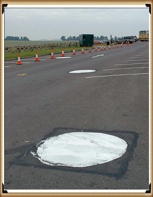
The article shows that English Heritage did its utmost to conceal the truth about Stonehenge’s actual ‘probable’ date being 5,000 years earlier than their current position.  This scientific evidence was based on radiocarbon dating of the three giant post holes in the visitor’s car park during its construction in 1966.(Bluestone Quarry Site)

Old Car Park Excavation in 1966 - Bluestone Quarry
Old Car Park Excavation in 1966 – Bluestone Quarry

At the time the wooden charcoal remains of the posts (found at the bottom of the post holes) were labelled Neolithic in origin to support the accepted antler pick dating hypothesis and were placed on a shelf probably for eternity.

The report from the 1966 excavation reads: “It is unfortunate that no dating evidence was obtainable from the three holes in the form of pottery.  Certainly, the holes themselves would appear to be Neolithic in character, very similar to others excavated of this period….. comparable traces of posts have been found in a Neolithic context… such as King Barrow Wood” Lance and Faith Vatcher. 

Moreover, the charcoal deposits were sent to their laboratory, and the results were: “It is surprising, in the view of the chalkland environment, that most of the charcoal should be pine.  Pine has, however, been found at other sites where it would not be expected, notably Woodhenge” – but even so, these samples were not requested to be carbon dated.

Fortunately, some years later, an inquisitive PhD student writing a thesis on the Stonehenge environment found these samples and concluded that they could not be Neolithic, as claimed by the archaeological community, as they were from pine trees which modern pollen analysis had concluded were ‘extinct’ in this area at this time of Stonehenge’s supposed construction.

The officials (of the Historic Buildings and Monuments Commission, which was later renamed English Heritage) were dismayed when they found out that their ‘experts’ were wrong, and the student was correct in her assumption (yet sadly, they never gave her a deserved job and she went off for a city career!) as the carbon dating placed them at the start of the Mesolithic of 8860 to 6590 BCE just after the last ice age.  Furthermore, what happened to the pine Woodhenge samples as indicated in the lab report of 1966 – which to date have not been carbon dated, are they also Mesolithic and not Neolithic as their original unscientific estimation, and if so, what is the actual age of Woodhenge?

Consequently, rather than then admitting their fundamental error and re-opening the site to look for more holes and dates to get to the bottom of this unique mystery (which would have been the case for most credible scientific disciplines), they came up with a remarkable and unproven story that these were random ‘totem poles’ placed by wandering ‘hunter-gatherers’ which did not relate to the Stonehenge site just 50m away.  But it was a sheer coincidence, which should be totally ignored.(Bluestone Quarry Site)

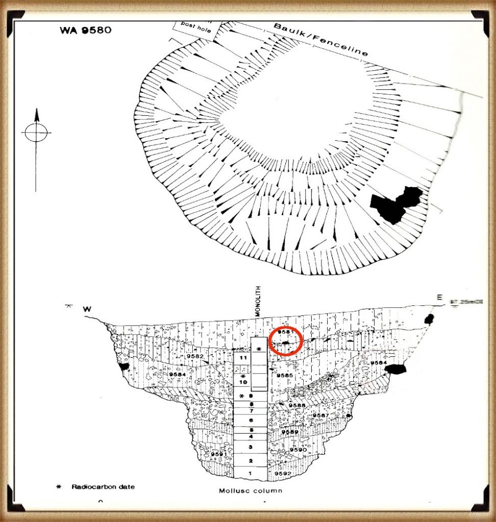
WA 9580 excavated in 1988 which found a Bluestone in the soil 5,000 years before the current EH published date - Bluestone Quarry
WA 9580 excavated in 1988 which found a Bluestone in the soil 5,000 years before the current EH published date – Bluestone Quarry

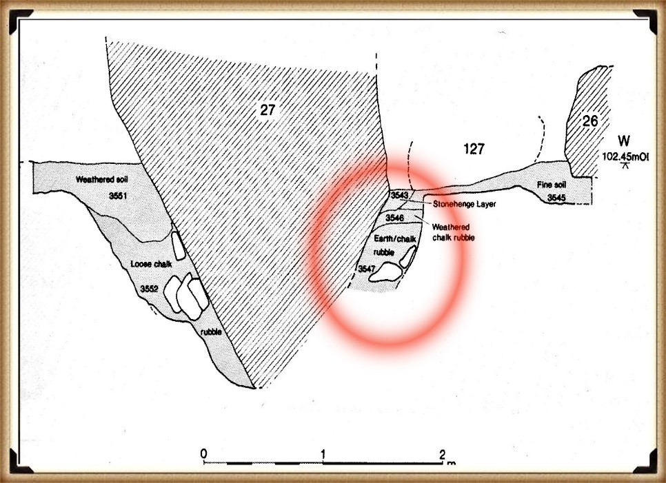
If the missed carbon dating of these Mesolithic posts didn’t spark an enquiry into the dating of Stonehenge, then another similar discovery three years later in 1988-89 should have done, as Wessex Archaeology were employed to investigate the area next to the Old Car Park and the construction of the Visitors Centre, opposite Stonehenge.  They reported a series of stripes under the surface (they thought periglacial) and a single pit WA9580 on the line of the other posts found in 1966 in the old ticket office.

Within the pit, they found (no doubt to the dismay of EH) yet another Mesolithic post hole that matches the dates of the 1966 findings.  Moreover, what they also found should have transformed the current dating of the Stonehenge site.  20cm below the top of the pit, they found a single piece of rhyolite (62g) sitting on context layer 9582 dated 7580 – 7090 BCE.

Again EH attempted to suppress this finding by suggesting that ‘this layer was not earlier than, and was probably contemporary with, the dressing of the Bluestone’.

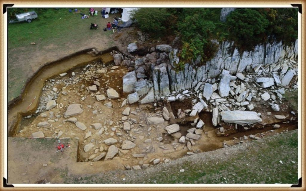
Archaeologists have also found charcoal (OxA-18655) from fires in the centre of the Stonehenge monument, located in the Hole socket of Stone 10 dated 7330 – 7060 BCE (same as the Mesolithic post holes), but again the news was suppressed from the mass media. 

Less than a mile away, at the top of the hill that overlooks Stonehenge, the Open University excavated a site called ‘Blick Mead’; they found evidence that people were living and feasting in this same earlier Mesolithic period, yet this ‘totem pole’ myth is still firmly entrenched in EH’s view of our prehistoric history through their exhibitions and many costly guidebooks.(Bluestone Quarry Site)
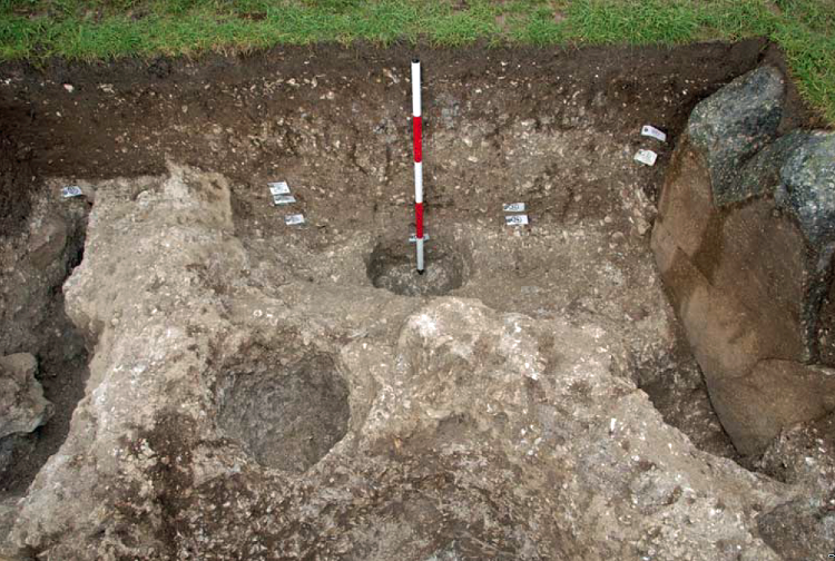
Stone 10 showing Mesolithic Carbon Dating - Bluestone Quarry
Stone 10 showing Mesolithic Carbon Dating – Bluestone Quarry

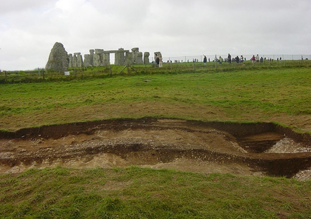
Moreover, the Stonehenge site has recently had a significant transformation as it closed the B-road that went past the stones and gave access to the old visitor’s car park, which was moved a mile up the road to the new multi-million-pound visitors centre.  Consequently, the old tarmac was removed and replaced by grass to make it look more like it did at Stonehenge’s construction.

Now one might imagine that if you were going to remove the tarmac from the old visitor’s car park (knowing you have found something quite extraordinary underneath in the past), you would take this ‘once in a lifetime’ opportunity to excavate the car park fully to see if you can find any more evidence about the Mesolithic Period of Stonehenge’s history?

Tim Daw was a warden at Stonehenge, and he has always been active in taking pictures on the site as he worked on a day-to-day basis at Stonehenge and published them on his blog site.  Last year, he found patch marks by the centre upright stones that were identified as the possible missing circle stones of the Inner Circle; therefore, his contribution to the investigation of Stonehenge has been immense.(Bluestone Quarry Site)
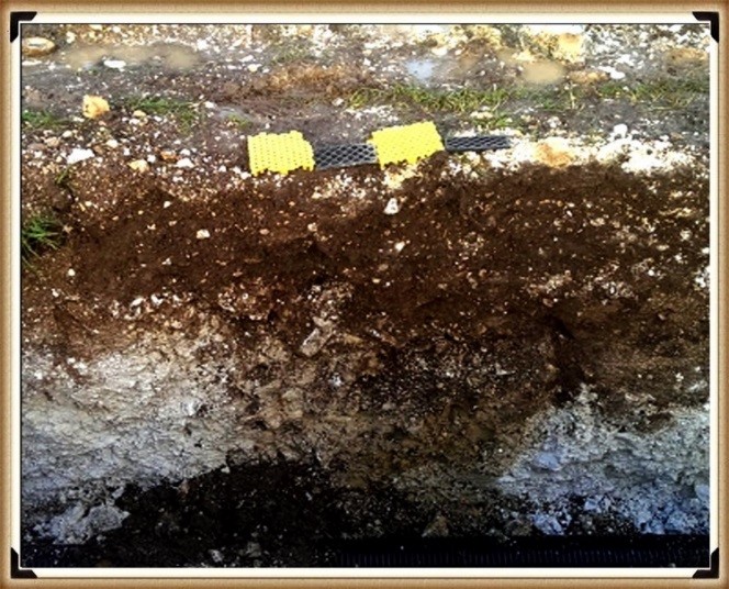
Tim Daw's unpublished photo of another post in the Old Visitor’s Car Park – 600mm to 700mm wide  - Bluestone Quarry
Tim Daw’s unpublished photo of another post in the Old Visitor’s Car Park – 600mm to 700mm wide – Bluestone Quarry

Tim also took some shots of trenches dug during the reinstatement of the grass over the old visitor’s car park and found something quite remarkable – but he was not allowed to publish (his pictures of the trenches) as EH had warned him that his unauthorised blog activities had to stop or else…. three guesses why this happened?  Now Tim is a man of principal resisted and resigned, so continuing his blog work, and as a consequence, these new ‘unofficial’ pictures have been made available, showing even more post holes are under the car park.

Tim’s newly discovered post hole is on the line of four other known 1966 post holes.  Moreover, it supports my hypothesis that they are all on the shoreline of the River Avon at about 8000 BCE.   Furthermore, the fact that rivers in Britain were much more prominent in the past than today affected not only the River Avon – but the River Nevern, at Craig Rhos-y-Felin, which the current ‘Brynberian Stream (which feeds the Nevern) is only 20m away, from the newly identified quarry site.(Bluestone Quarry Site)
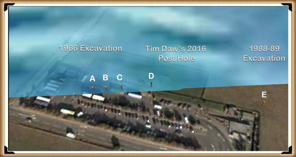
Newly discovered Post Hole D - Bluestone Quarry
Newly discovered Post Hole D – Bluestone Quarry

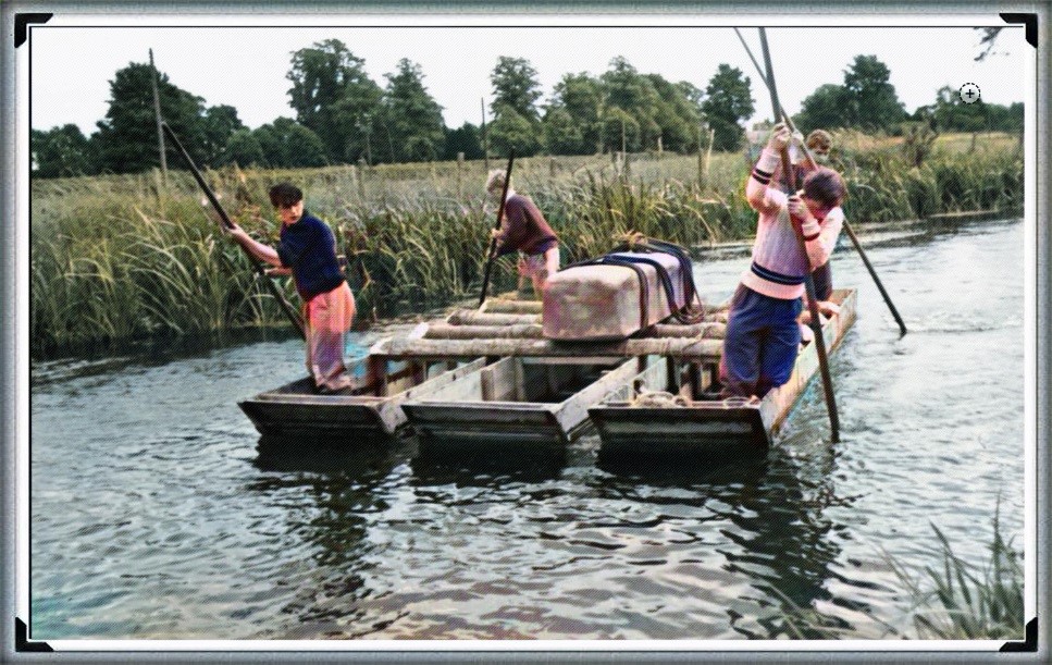
During the Mesolithic period, the newly quarried stones could be placed in boats on the shoreline of the Quarry in Wales and could be sailed almost directly to Stonehenge via just two or three enlarged rivers.  And not over the longer sea route, some archaeologists have considered.

This report also goes into great depth in analysing the Stone structure of the Bluestones from other Preseli sites such as Carn Goedog, Cerrigmarchogion and Craig Talfynyydd, Carn Breseb, Carn Gyfrwy and finally Carn Alw areas.  All of which have streams and rivers connecting them with the River Nevern – unfortunately, the archaeologists can only conceive this connection as a ‘religious’ order rather than something quite functional. 

Yet, archaeologists do seem able to consider the existence of a hypothetical road system which Mike Parker-Pearson calls his ‘ox-cart’ route, that follows the existing tarmac-covered A40 but sadly doesn’t take into account the woods, swamps and even forests of that period, which would make road passing almost impossible.

Nevertheless, this should be no surprise to readers of the Craig Rhos-y-Felin report as it is full of inconsistencies and logical inaccuracies as the site’s layout was never considered.  My analysis of the area shows that the ‘Brynberian Stream’ by the rocky outcrop was much larger in the past – such as in the period directly after the last ice age.  The flooding of this area is well known to geologists as they have found sandy deposits in the excavation sub-soil.  Sadly, the team seems to have created a false assumption that these floodwaters are from ‘ice melt’, which rapidly disappeared after the ice age into the sea.

If this were true,  the sea levels would have risen rapidly to a couple of meters short of today’s sea level and then plateaued for thousands of years – but this is not the case as the scientific ocean evidence shows that the ‘seepage’ into the seas took many thousands of years to occur and hence Doggerland off the East coast of Britain, took almost ten thousand years to disappear under the North Sea after all the last ice age glaciers had melted.(Bluestone Quarry Site)
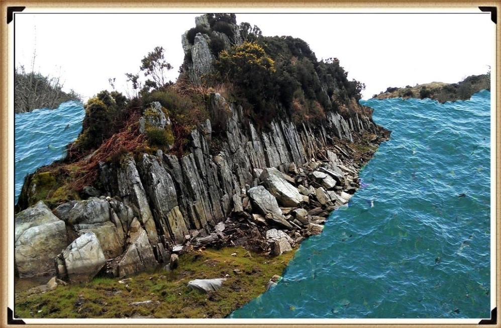
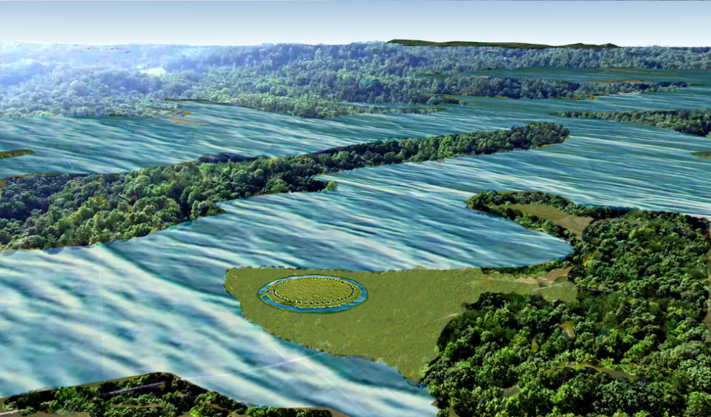
Craig Rhos-Y-Felin as it would have looked in the Mesolithic period - Bluestone Quarry
Craig Rhos-Y-Felin as it would have looked in the Mesolithic period – Bluestone Quarry

We obtain this confirmation within the report that an old river ran around this Quarry as long ago as 5620 – 5460 BCE and possibly up to 1030 – 910 BCE.

“Most of the site was then covered by a layer of yellow colluvium (035), dated by oak charcoal to 1030–910 cal BC (combine SUERC-46199; 2799±30 BP and SUERC-46203; 2841±28 BP).  This deposit is contemporary with the uppermost fill of a palaeochannel of the Brynberian stream that flowed past the northern tip of the outcrop.  Charcoal of Corylus and Tilia from the basal fill of this palaeochannel dates to 5800–5640 cal BC (OxA- 32021; 6833±40 BP) and 5620–5460 cal BC (OxA-32022; 6543±37 BP), both at 95.4% probability.”
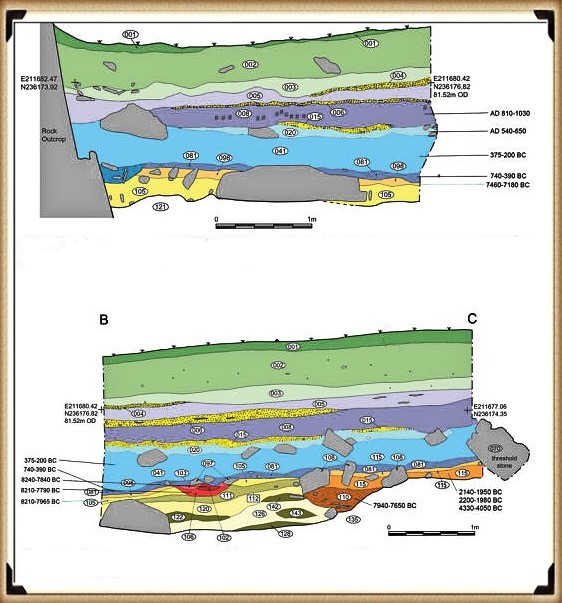
Craig Rhos-Y-Felin Excavation showing Mesolithic human hearths in RED - Bluestone Quarry
Craig Rhos-Y-Felin Excavation showing Mesolithic human hearths in RED – Bluestone Quarry

Consequently, the report is trying to tell us that an enlarged stream that feeds into the River Nevern was flowing during the Mesolithic Period up to the quarry outcrop rocks, and it remained there just a few metres away even up to 1000 BCE.  Therefore, the apparent transport system for these large newly quarried stones to their final destination at Stonehenge, as we have seen in other countries with their stone constructions like Egypt – was via a boat.

Moreover, the site layout also clearly indicates when the stone was quarried.  There is a single monolith ready for transportation by the river on the east side of the site, and the hearths which are human-made are a few metres south of this monolith – where you would expect them.  The problem for archaeologists is that these are Mesolithic hearths, and they’re not just one but three hearths dating from 8550 – 8330 BCE; 8220 – 7790 and BCE 7490 – 7190B CE and yet the report quite clearly states:

“There is no evidence of any Mesolithic Quarrying or working of Rhyolite from this crop”.

This is an astonishing unscientific claim – for how they would know what tool marks are either Mesolithic or Neolithic (would they not be using the same tools?) And secondly, what do they think they were doing there at the Quarry during these 1300 years?

Furthermore, we can now see the massive connection between the quarry site and Stonehenge with over twenty C16 dates and correlations to my hypothesis – compared to just two samples the ‘experts’ are currently claiming (300 – 500 years older than current estimations).

Accordingly, we can now narrow down the exact date for the construction of Phase I of Stonehenge (Bluestone placement in the Aubrey holes) by looking at the overlapping dates and using the latest carbon dating curve (intCal20) to obtain the most accurate date variation, and calculating the mean average probable dates.

This calculation shows that work started at the Quarry: in 8300 BCE, and its primary use and activity was 8000 BCE, with continuous use (replacing the exhausted Bluestones at Stonehenge) ongoing for at least 1000 years.

English Heritage has invested millions in its new ‘money spinner’, the Stonehenge Visitors Centre.  Within it, you will see many claims and models about Stonehenge’s origin and possible function – this exhibition has cost hundreds of thousands of pounds to design and build.  BUT what would happen financially if their assumptions were proven wrong?(Bluestone Quarry Site)
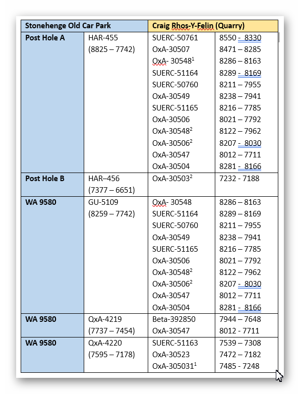
Matching Carbon dates between Craig Rhos-Y-Felin and Stonehenge sites - Bluestone Quarry
Matching Carbon dates between Craig Rhos-Y-Felin and Stonehenge sites – Bluestone Quarry

Moreover, the money within archaeology is sparse, and there are many ‘schools’ of thought who compete against each other for funding.  These schools are the University professors who compete for ‘airtime’ and media attention to promote their views, which the public perceives as ‘expertise’.    But science evolves through new ideas and concepts, yet these ‘experts’ are firmly cemented in the past with old ideas, publications and credibility – as nobody dares to be found wrong when so much hangs in the balance.(Bluestone Quarry Site)

Quarry Sites for Stonehenge All on Rivers - Bluestone Quarry
Quarry Sites for Stonehenge All on Rivers – Bluestone Quarry

Unearth the Astonishing Secrets of Stonehenge (The Stonehenge Hoax)

Introduction

Video

Synopsys

Stonehenge, a timeless enigma etched in stone and earth, has stood as a formidable puzzle challenging the intellects of archaeologists and historians alike. Despite the myriad attempts, including books, TV programs, and academic conferences, the secrets of these ancient stones and their encircling ditches have proven elusive. Against this backdrop, we scrutinise the existing thirteen hypotheses, each presenting its narrative but collectively lacking a coherent thread.

In adopting the deductive reasoning akin to Sherlock Holmes, we endeavour to weave these disparate threads into a unified tapestry that not only unravels the mystery of Stonehenge but also shakes the foundations of established academic narratives. This intellectual journey may induce some discomfort as we challenge conventional perceptions and invite a reevaluation of our understanding of the past. Apologies are extended in advance for any cognitive dissonance, but the pursuit of truth and reason mandates an unfiltered presentation of the facts.

So, fasten your seatbelts for an expedition into the archaeological unknown.

As we navigate this intellectual rollercoaster, be prepared for a revelation that might reshape our understanding of Stonehenge and question the foundations of our historical narratives. The dawn of a new archaeological era awaits promising insights that could leave even the most curious minds astonished. As we delve into this intellectual rabbit hole, be ready for a revelation that could make Alice astonished.

Robert John Langdon (2023) – (The Stonehenge Hoax)

The Journey

Langdon’s journey was marked by meticulous mapping and years of research, culminating in a hypothesis that would reshape our understanding of prehistoric Britain. He proposed that much of the British Isles had once been submerged in the aftermath of the last ice age, with these ancient sites strategically positioned along the ancient shorelines. His groundbreaking maps offered a fresh perspective, suggesting that Avebury had functioned as a bustling trading hub for our ancient ancestors. This audacious theory challenged the prevailing notion that prehistoric societies were isolated and disconnected, instead highlighting their sophistication in trade and commerce.

In the realm of historical discovery, the audacious thinkers, the mavericks who dare to question established narratives, propel our understanding forward. Robert John Langdon is undeniably one of these thinkers. With a deep passion for history and an unyielding commitment to his research, he has unearthed a hidden chapter in the story of Avebury that transcends the boundaries of time and offers fresh insights into our shared human history.

As Langdon’s trilogy, ‘The Stonehenge Enigma,’ continues to explore these groundbreaking theories, it beckons us to embark on a journey of discovery, to challenge our assumptions, and to embrace the possibility that the past is far more complex and interconnected than we ever imagined. With its ancient stones and enigmatic avenues, Avebury continues to whisper its secrets to those who dare to listen, inviting us to see history through a new lens—one illuminated by the audacious vision of Robert John Langdon.

(Bluestone Quarry Site)

The Book
The Stonehenge Hoax
The Great Stonehenge Hoax

Further Reading

For information about British Prehistory, visit www.prehistoric-britain.co.uk for the most extensive archaeology blogs and investigations collection, including modern LiDAR reports.  This site also includes extracts and articles from the Robert John Langdon Trilogy about Britain in the Prehistoric period, including titles such as The Stonehenge Enigma, Dawn of the Lost Civilisation and the ultimate proof of Post Glacial Flooding and the landscape we see today.

Robert John Langdon has also created a YouTube web channel with over 100 investigations and video documentaries to support his classic trilogy (Prehistoric Britain). He has also released a collection of strange coincidences that he calls ‘13 Things that Don’t Make Sense in History’ and his recent discovery of a lost Stone Avenue at Avebury in Wiltshire called ‘Silbury Avenue – the Lost Stone Avenue’.

Langdon has also produced a series of ‘shorts’, which are extracts from his main body of books:

The Ancient Mariners

Stonehenge Built 8300 BCE

Old Sarum

Prehistoric Rivers

Dykes ditches and Earthworks

Echoes of Atlantis

Homo Superior

(Bluestone Quarry Site)

Other Blogs

[sitemap_posts]

(Bluestone Quarry Site)
 

Stonehenge Through Time

This is Stonehenge as we see it today on a plane of chalky grass, farmers fields and small, shallow woods – (Stonehenge through time)

But it hasn’t always looked like this in the past.10,000 years ago, at the end of the last ice Age, the rivers such as the Avon were overflowing from the melted water of the ice sheet that laid over Britain for 30,000 years.And the old dry river valleys such as Stonehenge Bottom, were active rivers again.

Stonehenge region 10,000 years ago - Stonehenge through time
Stonehenge region 10,000 years ago – Stonehenge through time

Moreover, a thick and lush pine forest covered the entire land.Within this environment, the first phase of Stonehenge was built. First, the moat that surrounds the site and then 56 blue stones from a quarry now identified as Craig Rhos y-felin, was constructed inside the Stonehenge mode because of man made hearths left at the quarry site.

Stonehenge Phase 1 - Stonehenge Through Time
Stonehenge Phase 1 – Stonehenge Through Time

We can now, for the first time date the first phase of Stonehenge, which is between 8850 to 8330 BCE, some 50 years before the date quoted by most archaeologists.They suggest that because Stonehenge does not have similar carbon dates on site, but they are incidental.

Stonehenge Phase 1 - Stonehenge Through Time
Craig Rhos-Y-Felin – Stonehenge through time

But that is not true.

If we return to when the visitor’s centre at Stonehenge was by the monument and look at the old car park, we find something quite amazing. On the shoreline of the old Holocene River, we find three large white circles on the tarmac of the car park.These circles are the exact position of the oldest evidence of human existence at Stonehenge.

Old Car Park Post Holes - Stonehenge through time
Old Car Park Post Holes – Stonehenge through time

The experts would have you believe that these post holes were not associated with Stonehenge and are randomly constructed totem poles, as their dates do not match the current estimations by archaeologists. What we now see from the carbon dating is that not only the oldest hearth of the quarry matches post hole A at Stonehenge, but the other hearths of the quarry, also match post holes B and E.

Matching Post Hole Carbon Dates – Stonehenge through time

This is a mathematical improbability, unless both sites were connected in some form, but the most compelling and absolute evidence for the construction data.Phase one of Stonehenge can be seen in post hole E known as pit 9580 by archaeologists, where we find not just one carbon dated correlation with the quarry, but three dates.Moreover, 20 CM down this same pit, we find a piece of Rhyolite, commonly known as bluestone, and the date of this deposit can be estimated by the soil layer it was sitting upon 7560 to 7335 BCE, overlapping with the date of hearth number three found at the quarry site.

WA9580 with Bluestone - Stonehenge through time
WA9580 with Bluestone – Stonehenge through time

The question archaeologists refuse or find impossible to answer is:

How could a piece of bluestone used in the construction of the monument, which came from a quarry over 200 miles away, get into a pit at Stonehenge 5000 years before it was supposedly built?

These posts were placed at the edge of the Mesolithic waters to unload the boats loaded with blue stones, as the raised waters of the Holocene period would have also flooded the quarry site at Craig Rhos-Y-Felin.This has been confirmed by archaeologists who have found high levels of alluvium silt within the excavations.This same silt also exists in the post holes of Stonehenge, indicating the edges of the river levels during this time period, moreover showing the obvious method of transportation from the shoreline of the quarry 200 miles away to the Mesolithic shoreline of Stonehenge.

Stonehenge Mesolithic Shoreline with Mooring posts - Stonehenge through time
Stonehenge Mesolithic Shoreline with Mooring posts – Stonehenge through time

For this was a boat using civilisation and not the hunter gatherers, as past archaeologists had previously imagined hunting with spears over grassy plains, which gives us a clue to the second phase of Stonehenge, with the erection and construction of the gigantic Sarsen stones and the need for even larger boats 4000 years after phase one of Stonehenge was first completed, the even water levels had dropped to such an extent that its original purpose and function contained within the moat became obsolete.

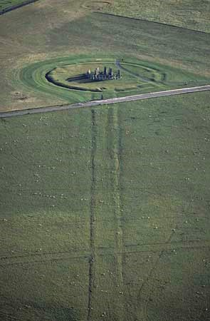
This civilisation then embarked in changing the site’s purpose and therefore transported the gigantic Sarsen stones from a location just 20 miles away at West Woods by the River Avon to the site, again by boat. If we look down on Stonehenge from the air,it becomes clear the new location of the mooring site and how they were transported to the monument.

The Avenue leading to Stonehenge Bottom – Stonehenge through time

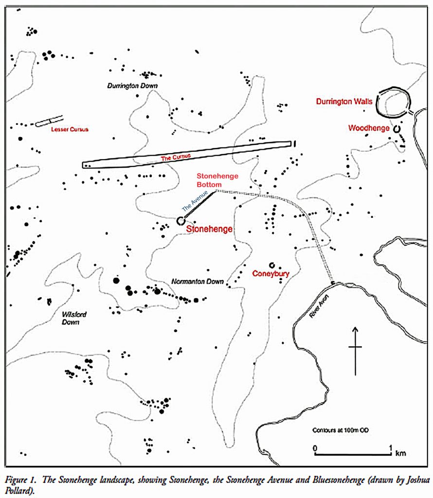
In the landscape you can see two parallel ditches 12 meters wide leading from the motor Stonehenge to a landing point archaeologists call Stonehenge Bottom.This is the lowest point in the landscape and therefore would have had the deepest water level in the early Neolithic period.This is Britain’s first road and would have been used to transport the large Sarsen stones from the boats moored at Stonehenge Bottom to the main site.

The feature is called the Avenue and it has always been a mystery to archaeologists where the road with ditches ends so abruptly and without reason.We now can see it is because it meet the river Avon during the phase two construction period.Once the Avon had completely retreated in the Bronze Age, a more simple footpath without the ditches continued across the landscape to again end at the Avenue, as was its original purpose.

The Avenue - Britain's first road? - Stonehenge through time
The Avenue – Britain’s first road? – Stonehenge through time

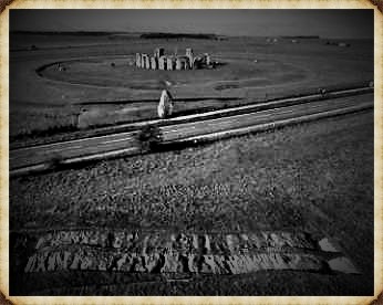
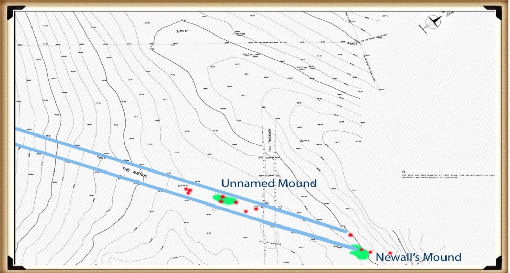
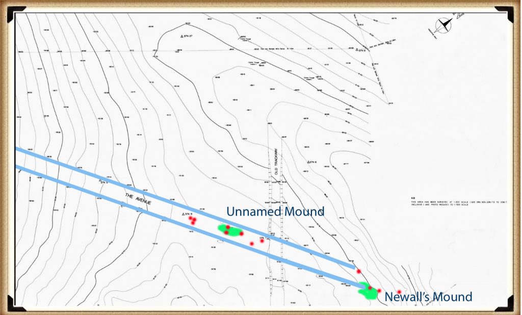
In a detailed magnetometer survey of the Avenue in 1990, 14 post holes were discovered located inside the Avenue, just like phase one, the post holes supported wooden uprights and pairs, allowing them to be used as prehistoric rains with the ability to move heavy stones from boats to carts. Sitting on the Avenue, archaeologists have identified and excavated part of the Newell’s mound, which is made from clay and flint and is therefore manmade. But the second unnamed mound, which is clearly identified on the contour maps like the 14 post holes, are unexcavated and so we have no dates of construction.

The 14 post holes and two mounds found on the avenue – Stonehenge through time

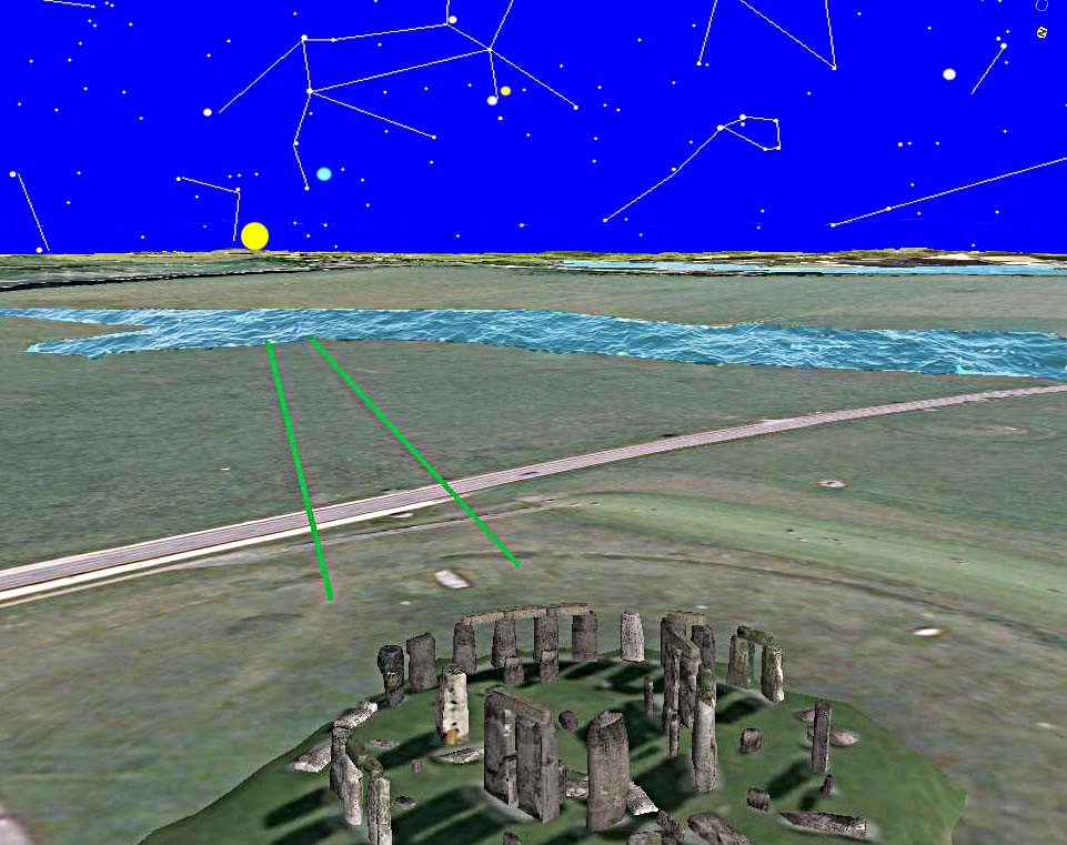
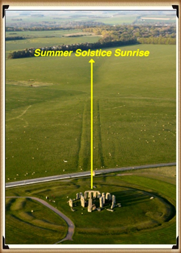
Fortunately, as most observers know, the Avenue was constructed in an alignment to the summer solstice sunrise. We can therefore measure the alignment and discover the exact date of construction as the sun moves one degree along the horizon every 50 years.Currently the sun rises one two degrees from the centre of the Avenue.

The Avenue aligns to the Sunset at the time of construction - Stonehenge through time
The Avenue aligns to the Sunset at the time of construction – Stonehenge through time

This shows us that the Avenue in phase two of the Stonehenge monument was started 6000 years ago and not before 5000 years ago, the archaeologists currently believe. This date can be confirmed by carbon dating with the packing foundations of Stone 27 – Atkinson, who lead the excavation around the base o fthe stone, was very keen to have this piece of antler bone carbon dated on the grounds that it was the first fined in situ that could give them their best date of construction.

But the date was so not what they wanted that it was disregarded.Although it fits the solar alignment of the avenue,to date, archaeologists have still to fully explain how a piece of undergraded animal bone, which was supposedly at the time 1700 years old, got to be used to wedge a gigantic standing stone into position.

4200 BCE Antler found in Stone 27 packing debris - Stonehenge through time
4200 BCE Antler found in Stone 27 packing debris – Stonehenge through time

This scientific evidence now allows us to predict the date of Stonehenge phase Two as 4200 BCE, 1700 years earlier than the current hypothesis and consequently the rewriting of our history.

Further Reading

For information about British Prehistory, visit www.prehistoric-britain.co.uk for the most extensive archaeology blogs and investigations collection, including modern LiDAR reports.  This site also includes extracts and articles from the Robert John Langdon Trilogy about Britain in the Prehistoric period, including titles such as The Stonehenge Enigma, Dawn of the Lost Civilisation and the ultimate proof of Post Glacial Flooding and the landscape we see today.

Robert John Langdon has also created a YouTube web channel with over 100 investigations and video documentaries to support his classic trilogy (Prehistoric Britain). He has also released a collection of strange coincidences that he calls ‘13 Things that Don’t Make Sense in History’ and his recent discovery of a lost Stone Avenue at Avebury in Wiltshire called ‘Silbury Avenue – the Lost Stone Avenue’.

Langdon has also produced a series of ‘shorts’, which are extracts from his main body of books:

The Ancient Mariners

Stonehenge Built 8300 BCE

Old Sarum

Prehistoric Rivers

Dykes ditches and Earthworks

Echoes of Atlantis

Homo Superior

For active discussions on the findings of the TRILOGY and recent LiDAR investigations that are published on our WEBSITE, you can join our and leave a message or join the debate on our Facebook Group.

The Stonehenge Avenue

The Stonehenge Avenue investigation transcript.

In our last video we looked at Stonehenge during the Mesolithic period and showed that the Dry River Valley (that surrounds the site) is called ‘Stonehenge Bottom’ and was full of water during this period, as the many natural springs in Stonehenge Bottom would have flooded the area, up to the Old Car Park. We believe this was the landing site where the four-tonne Bluestones that travelled by boat from their quarry site in Wales.

Bluestone boat to Stonehenge - Stonehenge Avenue
Bluestone boat to Stonehenge – Stonehenge Avenue

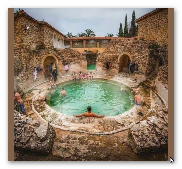
This was the start of Stonehenge (Phase I), which was a ditch surrounding the site, with 56 Bluestone chalk pits known as Aubrey Holes. This construction was used as a bathing place as the excavation is unique as it is not a traditional ditch, but a series of individual 2m deep chalk holes with walls and seats. This facility was used with the Bluestone chippings to heal ailments and diseases, as we see later in history with Roman baths.

This structure lasted for thousands of years and was replenished periodically with more Bluestones as they were chipped away from the large stone blocks until the Neolithic period when the site changed its function. This change was necessary as the water table in the area had dropped (and consequently, the shoreline of the River Avon within the Stonehenge Bottom). This drop in the water table dried up the ditch, and so it could no longer function as a bathing pool.

Roman Health Spa - Stonehenge avenue
Roman Health Spa – Stonehenge avenue

At this stage, a new monument was created to celebrate the Motherland of these ‘Megalithic Builders’ who originally came from Doggerland in the North Sea, which had surrendered to the rising sea levels (the original) global warming event. So, they decided to build a stone structure in remembrance, as we continue to do today for monumental occasions.

Moreover, the River Avon was now much lower than in the Mesolithic and to bringing the Bluestones to Stonehenge (from the quarry) became more difficult and so, to meet the retreating water, a new ‘pathway’ was constructed with mooring points throughout its length – this is called The Avenue.

Stonehenge Avenue
Stonehenge Avenue

Traditional archaeologists believe that the Avenue existed before the start of Stonehenge as a natural feature – excavations have revealed ‘preglacial stripes’ which they believe was the reason Stonehenge was placed in this low location. These Stripes (they imagine) were created through tundra thawing and freezing during the last ice age.
The problem with this idea is that these stripes were only found within this 20 ft wide narrow path going to the site and not over the general area as would be expected as the geology within this area of the Avenue is pretty universal (chalk bedrock) and not unique, so this idea can easily be dismissed.
Preglacial stripes - Stonehenge Avenue
Preglacial stripes – Stonehenge Avenue

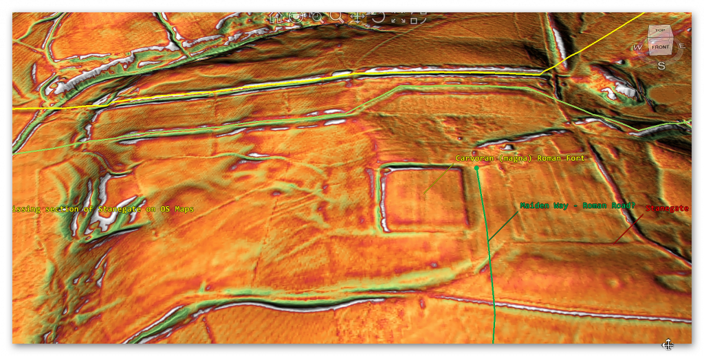
From the LiDAR scan, it is obvious (and we will change the colour to see the detail better), that it is a roadway with ditches on the edge. Inside it the excavations shows track marks of past visitors who used the Avenue as a natural road for their transportation, as seen in Stukeley 18th century drawings – we have found evidence from latter cart tracks in excavations, and these are pretty shallow as the carriages are only about 1500lbs to 1800lbs in weight (0.8 tonnes), but the deeper cuts are clearly from overly heavy wheeled vehicles used to ship the massive 25-tonne sarsen stones to the site during the Neolithic and hence their misidentification.

These archaeologists also support that the Avenue takes a ‘long walk’ down to the existing River Avon past a series of borrows on the opposite hill (called The Kings Barrows). This may be the case today, with a light path that some wander down as it appears on their OS maps, but the reality is that it didn’t exist in the past or on the first series of OS maps.

The Avenue today - Stonehenge Avenue
The Avenue today – Stonehenge Avenue

If we look at the End of the Avenue, we see that the river valley looks like it splits as we see in Stukeley’s 18th-century drawing – but compared to the deep cuttings of the original Avenue, they are not worth considering as original.

The larger Sarsen stones would have been transported from the bottom of the Avenue (as shown on the LiDAR Map) as this feature’s final function. Prior to that occasion, the Avenue would have been used over a couple of thousand years to bring the Bluestone in the Late Mesolithic and Early Neolithic, from their quarry site which can be seen from the post holes in the Avenue (which could not have any other useful function) these are at an angle to the shoreline, as we saw in the Old Car Park at Stonehenge.

The Avenue with Post Holes and mounds - Stonehenge Avenue
The Avenue with Post Holes and mounds – Stonehenge Avenue

We also see two artificial flint mounds within the Avenue (pic). One has been identified as Newmans Mound, and the other remains unidentified. These features have no other rational explanation other than unloading platforms for boats on the River Avon in the Neolithic.

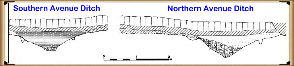
Moreover, the physical construction of the Avenue earthwork shows the incorporation of water features, supporting the higher water table theory. For example, the Southern ditch is much shallower than the Northern ditch of the Avenue. This is because the river lies on the Southern side of the Avenue and does not need extra depth to fill the Southern ditch evenly, while the Northern ditch is further away from the river.  

The Avenue Ditches - Stonehenge Avenue
The Avenue Ditches – Stonehenge Avenue

Furthermore, this extra depth to one side of the monument can also be seen in the main ditch of Stonehenge as the north western side also 10% deeper, reflecting the water table at that time.

Further Reading

For information about British Prehistory, visit www.prehistoric-britain.co.uk for the most extensive archaeology blogs and investigations collection, including modern LiDAR reports.  This site also includes extracts and articles from the Robert John Langdon Trilogy about Britain in the Prehistoric period, including titles such as The Stonehenge Enigma, Dawn of the Lost Civilisation and the ultimate proof of Post Glacial Flooding and the landscape we see today.

Robert John Langdon has also created a YouTube web channel with over 100 investigations and video documentaries to support his classic trilogy (Prehistoric Britain). He has also released a collection of strange coincidences that he calls ‘13 Things that Don’t Make Sense in History’ and his recent discovery of a lost Stone Avenue at Avebury in Wiltshire called ‘Silbury Avenue – the Lost Stone Avenue’.

Langdon has also produced a series of ‘shorts’, which are extracts from his main body of books:

The Ancient Mariners

Stonehenge Built 8300 BCE

Old Sarum

Prehistoric Rivers

Dykes ditches and Earthworks

Echoes of Atlantis

Homo Superior

For active discussions on the findings of the TRILOGY and recent LiDAR investigations that are published on our WEBSITE, you can join our and leave a message or join the debate on our Facebook Group.

Stonehenge Hoax – Round Monument?

Which could be called the Stonehenge ‘circular argument’? ………(Extract from the Book The Stonehenge Hoax)

Introduction

The Problem

The traditional view of Stonehenge is of an entirely round monument with lintel stones completing the circle – but there is a massive problem with this theory (and it is ONLY a hypothesis – as nothing has ever been proven), for not all the expected stones holes are present, leading to some experts to suggest that the monument is, in fact, incomplete and was never finished. 

The Solution

The original references to Stonehenge were made by William Stukeley FRS, FRCP, FSA (7 November 1687 – 3 March 1765), an Anglican Clergyman and English Antiquarian who pioneered the archaeological investigation of the prehistoric monuments of Stonehenge and Avebury.  He was friends with Isaac Newton and was amongst Newton’s first biographers.  Stukeley was also involved with Freemasonry and instrumental in British scholarship’s acceptance of Charles Bertram’s forged ‘Description of Britain’.

‘Description of Britain’, also known by its Latin name De Situ Britanniae (“On the Situation of Britain”), was a literary forgery perpetrated by Charles Bertram on the historians of England.  It purported to be a 15th-century manuscript by the English monk Richard of Westminster, including information from a lost contemporary account of Britain by a Roman general (dux), new details of the Roman roads in Britain in the style of the Antonine Itinerary, and “an ancient map” as detailed as by Ptolemy. (Stonehenge Hoax – Round Monument?)

Stukeley's Vision of Stonehenge - Stonehenge Hoax
Stukeley’s Vision of Stonehenge – (Stonehenge Hoax – Round Monument?)

Bertram disclosed the existence of the work through his correspondence with the antiquarian William Stukeley in 1748, provided him with a “copy”, which was made available, and published in Latin in 1757.  By this point, his Richard had become conflated with the historical Richard of Cirencester.  The text was treated as a legitimate and significant source of information on Roman Britain from the 1750s through the 19th century, when it was progressively debunked by John Hodgson, Karl Wex, B. B. Woodward, and J. E. B. Mayor.  Some tales from the forgery can still be found in peer-reviewed works of British history.

Despite Stukeley’s Anglican faith and church offices, he was obsessed with the idea of Druidism, and he will be remembered as “the greatest of the early forerunners of the discipline of archaeology” – the ‘Father of Archaeology’ for his habit of going out personally with teams of ‘navvies’ to examine, explore (and sadly destroy) many ancient sites in search of lost treasures.

Stonehenge Hoax - Round Monument
(Stonehenge Hoax – Round Monument?)

Druids were Sun worshippers, according to the limited accounts which have survived.  Their name means ‘Knowing the Oak Tree’, and the oak was a Druidic symbol of the Sun.  The ‘mighty oak’ claim to be the king of the forest, which is difficult to dismiss and its strength is legendary.  Unfortunately, all their lore and history were committed to memory, never written down, but the symbolism and myths have survived to include reincarnation was at the centre of their ancient faith.

There has been much speculation on the Druidic religion, but in the main, we have only Roman accounts, particularly that of Julius Caesar, on which to rely.  Every sign of this popular general’s attempt to translate Druidic gods and customs into his native Roman language would be surprising if a degree of adverse propaganda did not colour his account.(Stonehenge Hoax – Round Monument?)

Stonehenge Hoax - Round Monument
(Stonehenge Hoax – Round Monument?)

However, Caesar has no hesitation in equating the Druids’ Gods and Goddesses with the astrological gods of Rome.  It’s hard to doubt these accomplished priests, with their international connections, recognised the solar majesty worshipped throughout the ancient world with his family of planetary divinities.

Stukeley was attracted to Stonehenge as a Druid, and his excavations in and around the site found  Roman pottery and artefacts, which made him believe that the monument was first a Druid Temple that continued as a Roman Sun Temple.  The classic shape of a Sun Temple was round (like the Sun), and as three-quarters of Stonehenge survived in a rounded form with the rest of the site ‘robbed out’, therefore there was no problem for Stukeley to imagine the entire site was round and commissioned artists to create drawings of the monument as it would have looked when it was first constructed.

This observation of the monument was complemented as ‘The Avenue’ (a roadway with ditches on either side), he found was aligned towards the Midsummer Solstice – the longest day of the calendar year and therefore a druid festival. (Stonehenge Hoax – Round Monument?)

We can see why the ‘myth’ about Stonehenge being round started – but why does it continue today?

Stonehenge remaining Stones - Stonehenge Hoax
Stonehenge remaining Stones -(Stonehenge Hoax – Round Monument?)

Some academics have commented upon the ‘incompleteness’ of the SW quadrant of the structure as it seems to lack the large uprights and lintels that other areas possess.  This is compounded as there has been a lack of excavations in this area.  

In dry summers, post hole ‘patches’ have been found on the unexcavated sections of Stonehenge that match the predicted missing stone holes, and as a consequence, most archaeologists have felt that to be was sufficient evidence to prove the monument was indeed complete and round as Stukeley first suggested – yet there is a standing stone which defies this belief.

Stone 11 is a strange standing stone that seems to have been in the position since the start of the monument – but is rarely spoken about by the archaeologists or the site experts.  For example, in English Heritage’s (EH) book “Stonehenge in its landscape.” cleal et al. (1995) – the equivalent to the bible on Stonehenge by EH, all they say about this unique stone is: “Unexcavated – standing, but possibly broken in antiquity, as it is considerably shorter than the other stones of the circle.”

Stone Hole 13 is the same size as Stone 11 - Stonehenge Hoax
Stone Hole 13 is the same size as Stone 11 – Stonehenge Hoax

While it is indeed ‘shorter’ (it is half the size in height) – but moreover, less than 25- 30% the width of the other circle standing stones!  Now, we could accept that the top of a stone could have been broken off (but there are no others like that at Stonehenge – so consequently, it’s unique).  Moreover, how do you reduce the ‘width’ of a stone by 75% without leaving some signs of alteration like an enlarged base still in the ground?

Furthermore, stone hole 13 is again too small to take a full-sized Sarsen, but it may take a stone of Stone 11 proportions.  All the major standing stones of Stonehenge have huge foundation holes because they contain ‘ramps’ next to the stone holes, which were used to lever the stone in place due to their colossal weight.  Stone hole 13 showed that it did not have a ramp and was deeper than expected – either this was a ‘badly’ built stone hole, or it was never intended for a larger sarsen stone.

Stonehenge Hoax - Round Monument
Stonehenge Hoax – Round Monument

Consequently, the size of unaltered Stone 11 and the Stone hole 13 clearly proves beyond any reasonable doubt that the idea that Stonehenge was a circular monument ‘with lintels’ and standing stones of exact proportions are entirely fabricated and falsely reported by archaeologists.

The truth, the whole truth and nothing but the` truth!

Looking at the existing standing stones in detail, including the excavation reports (remembering only about half of the site has ever been fully excavated), we realise that we have a circular type of stone circle – the SW quadrant stones are missing in some respects.  So how does this help us to understand the site and construction?

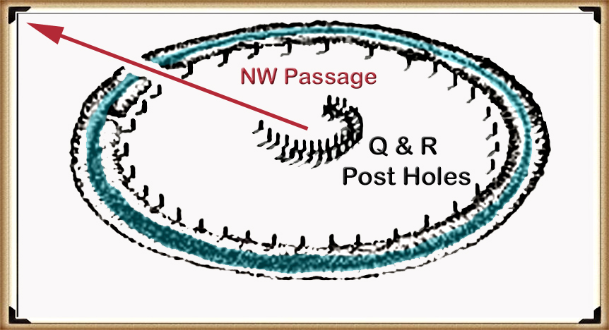
Another aspect of Stonehenge not discussed in detail is the early (Phase I – you see Phase III currently) monument’s design.  Excavations have found a horseshoe arrangement of stone holes that are separated by a constant 2m facing the NW.  We are all aware of the NE Solstice sunrise, but few understand that the moon sets in the NW at its northerly position on the horizon.

Stonehenge is also surrounded by other mysterious constructions called ‘Long Barrows’ – in fact, there are as many as eight long barrows within two miles of the Stonehenge site – more Long Barrows in any single location in Britain (or even the world!).  Long Barrows are sites our ancestors placed the bones of their dead after they have been ‘defleshed’ by the process known as ‘excarnation’ – this is achieved by leaving the body out in the open.  Thus, birds eat the corpse’s flesh (as they were seen as sacred animals as they could fly from the heavens – as seen in Egyptian Archaeology and Mythology). 

We traditionally represent (even today) death with the night and the moon, so we can conclude that if this were a site for the dead and excarnation – if a temple were to be constructed, it would naturally reflect an affiliation to the moon.  Symbolically, we would historically represent the moon as a ‘crescent shape’ (as we see from flags of the world), which we see on this site from the existing standing stones combined with the smaller stone hole foundations (Stone 11 & 13).  Consequently, Stonehenge was never constructed initially as a round stone circle but as a crescent circle to represent death and the journey to the afterlife.

Why is a horseshoe crescent facing the Sun in the monument’s centre?

The giant stone trilithon crescent within the crescent (that faces the Summer Solstice sunrise) is very symbolic – as we have seen in other cultures and belief systems of the ancient world, which frequently represents rebirth or reincarnation.
Phase I of Stonehenge, with Mortuary Stone holes - Stonehenge Hoax
 Phase I of Stonehenge, with Mortuary Stone holes – Stonehenge Hoax

The same structure can also be used to point to the Midwinter Solstice sunset (which is precisely 180 o in the opposite direction), So the ‘open’ (direction) of the horseshoe points to the Solstice Sunrise, but the ‘main’ and more important direction of the symbol points in the opposite direction, out of the back of the inner horseshoe to the Winter Solstice sunset.

Is this the first indication of how the builders of Stonehenge viewed their world of life and death?  The symbolism indicates that the temple is telling us that Stonehenge represents the reincarnation of the soul and the belief in the afterlife.

Stonehenge is a monument to the DEAD and so Crescent Moon shaped - Stonehenge Hoax
Stonehenge is a monument to the DEAD and so Crescent Moon shaped – Stonehenge Hoax

The Stonehenge Hoax Book – 13 Things that don’t make sense about Stonehenge

Introduction

Video

Synopsys

Stonehenge, a timeless enigma etched in stone and earth, has stood as a formidable puzzle challenging the intellects of archaeologists and historians alike. Despite the myriad attempts, including books, TV programs, and academic conferences, the secrets of these ancient stones and their encircling ditches have proven elusive. Against this backdrop, we scrutinise the existing thirteen hypotheses, each presenting its narrative but collectively lacking a coherent thread.

In adopting the deductive reasoning akin to Sherlock Holmes, we endeavour to weave these disparate threads into a unified tapestry that not only unravels the mystery of Stonehenge but also shakes the foundations of established academic narratives. This intellectual journey may induce some discomfort as we challenge conventional perceptions and invite a reevaluation of our understanding of the past. Apologies are extended in advance for any cognitive dissonance, but the pursuit of truth and reason mandates an unfiltered presentation of the facts.

So, fasten your seatbelts for an expedition into the archaeological unknown.

As we navigate this intellectual rollercoaster, be prepared for a revelation that might reshape our understanding of Stonehenge and question the foundations of our historical narratives. The dawn of a new archaeological era awaits promising insights that could leave even the most curious minds astonished. As we delve into this intellectual rabbit hole, be ready for a revelation that could make Alice astonished. (The Stonehenge Hoax)

Robert John Langdon (2023) – (The Stonehenge Hoax)

The Journey

Langdon’s journey was marked by meticulous mapping and years of research, culminating in a hypothesis that would reshape our understanding of prehistoric Britain. He proposed that much of the British Isles had once been submerged in the aftermath of the last ice age, with these ancient sites strategically positioned along the ancient shorelines. His groundbreaking maps offered a fresh perspective, suggesting that Avebury had functioned as a bustling trading hub for our ancient ancestors. This audacious theory challenged the prevailing notion that prehistoric societies were isolated and disconnected, instead highlighting their sophistication in trade and commerce.

In the realm of historical discovery, the audacious thinkers, the mavericks who dare to question established narratives, propel our understanding forward. Robert John Langdon is undeniably one of these thinkers. With a deep passion for history and an unyielding commitment to his research, he has unearthed a hidden chapter in the story of Avebury that transcends the boundaries of time and offers fresh insights into our shared human history.

As Langdon’s trilogy, ‘The Stonehenge Enigma,’ continues to explore these groundbreaking theories, it beckons us to embark on a journey of discovery, to challenge our assumptions, and to embrace the possibility that the past is far more complex and interconnected than we ever imagined. With its ancient stones and enigmatic avenues, Avebury continues to whisper its secrets to those who dare to listen, inviting us to see history through a new lens—one illuminated by the audacious vision of Robert John Langdon.

(The Stonehenge Hoax)

The Book

The Stonehenge Hoax
The Great Stonehenge Hoax

Further Reading

For information about British Prehistory, visit www.prehistoric-britain.co.uk for the most extensive archaeology blogs and investigations collection, including modern LiDAR reports.  This site also includes extracts and articles from the Robert John Langdon Trilogy about Britain in the Prehistoric period, including titles such as The Stonehenge Enigma, Dawn of the Lost Civilisation and the ultimate proof of Post Glacial Flooding and the landscape we see today. (AI now Supports – Homo Superior)

Robert John Langdon has also created a YouTube web channel with over 100 investigations and video documentaries to support his classic trilogy (Prehistoric Britain). He has also released a collection of strange coincidences that he calls ‘13 Things that Don’t Make Sense in History’ and his recent discovery of a lost Stone Avenue at Avebury in Wiltshire called ‘Silbury Avenue – the Lost Stone Avenue’.

Langdon has also produced a series of ‘shorts’, which are extracts from his main body of books:

The Ancient Mariners

Stonehenge Built 8300 BCE

Old Sarum

Prehistoric Rivers

Dykes ditches and Earthworks

Echoes of Atlantis

Homo Superior

Other Blogs

[sitemap_posts]

(Stonehenge Hoax – Round Monument?)

The Great Stonehenge Hoax

13 Things that don’t make sense about Stonehenge (The Great Stonehenge Hoax)

Conundrum 1 – A Circular Monument

Aubrey's Vision - the Great Stonehenge Hoax
Aubrey’s Vision – the Great Stonehenge Hoax

Which could be called the Stonehenge ‘circular argument’?

The Problem

The traditional view of Stonehenge is of an entirely round monument with lintel stones completing the circle – but there is a massive problem with this theory (and it is ONLY a hypothesis – as nothing has ever been proven), for not all the expected stones holes are present, leading to some experts to suggest that the monument is, in fact, incomplete and was never finished. 

Click here for the The Solution

Conundrum 2 – Summer Solstice

How Stonehenge original design - the Great Stonehenge Hoax
How Stonehenge original design – the Great Stonehenge Hoax

Stone me – are the druids looking the wrong way!

The Problem

When we think about Stonehenge, our mind relates to the mass gatherings of people that meet at the stones to celebrate the Summer and Winter Solstice, as if the monument was built for this single purpose.  But the structure was not made for this purpose, as shown by The Avenue and The ‘Heel Stone’( where the sun appears from behind it on mid-summers day), for it is not in the centre of the Avenue (as some imagine) and consequently, it has been tilted at an angle to meet the sun at a later date.

Click here for The Solution

Conundrum 3 – Dating of the Monument

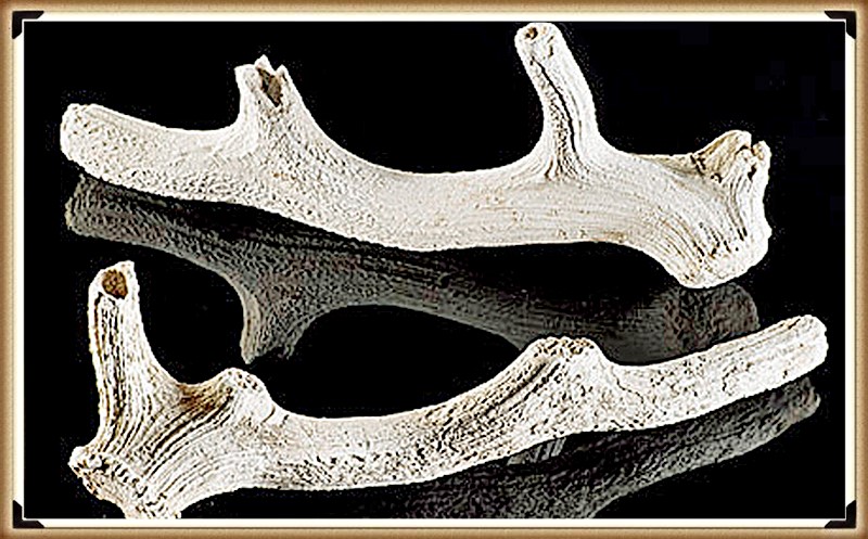
The best tool to dig ditches?  - the Great Stonehenge Hoax
The best tool to dig ditches? – the Great Stonehenge Hoax

Could Antler Picks build these Monuments

The Problem

The first time real science could be used to date the ancient monument was when archaeologists   ‘carbon dated’ the antler picks found within the ditch of the site – as it was assumed that these were the tools used to dig the ditches, which they had been discarded as a ‘ritual’ to the bottom of the trench once it was completed.  Since then, archaeologists have attempted to justify these dates with all new finds on the site and have rejected as anomalies all other radio carn dates that don’t match its ‘established’ timescale.

Click here for The Solution

Conundrum 4 – Totem Poles

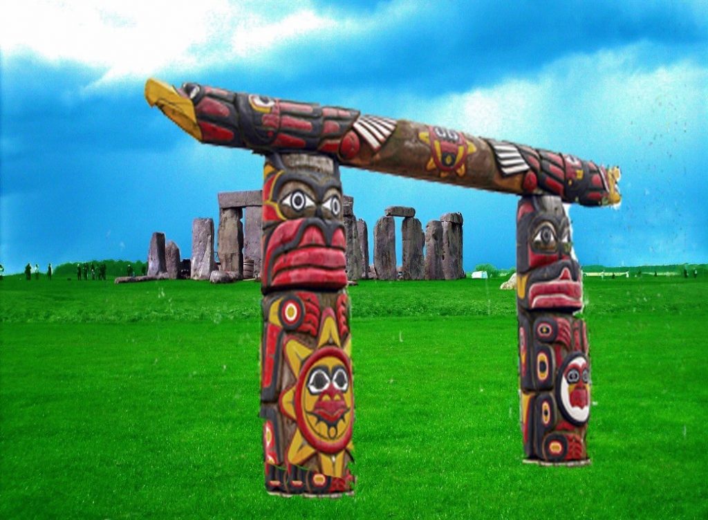
Totem Poles... really? - The Great Stonehenge Hoax
Totem Poles… really? – The Great Stonehenge Hoax

Lots of cowboys (archaeologists) but no Indians (scientists)

The Problem

Four post holes were found in the old visitor’s car park at Stonehenge in 1966; these holes were excavated, and the pine charcoal found was dated (by observation) to be Neolithic, and the same date as the carbon-dated Antler picks found on the site some 50m away.   The problem arose when someone pointed out that Pine trees didn’t exist in the Stonehenge area in the Neolithic and that the post holes were filled in with ‘silt’ (from a river).  So they carbon-dated the pine to find out it was Meslithic some 5,000 before Stonehenge was supposedly built – so they came up with a story of ‘Totem Poles’ placed at random from a hunter-gather tribe, which had nothing to do with Stonehenge.

Click here for The Solution

Conundrum 5 – Craig Rhos-Y-Felin

Stonehenge Quarry site - the Great Stonehenge Hoax
Stonehenge Quarry site – the Great Stonehenge Hoax

Archaeology’s inconvenient truth

The Problem

A recent paper by the University of London, Southampton, and Manchester; about the discovery of the Quarry that provided the ‘bluestones’ for Stonehenge at Craig Rhos-y-Felin caught the eye of the world by archaeologists announced that Stonehenge was initially built in Wales and was then transferred to Salisbury Plain 500 years later.  This amazing claim came about as only two of the Carbon Dates found on the site were within one thousand years of the Antler Pick dates that English Heritage holds so dear as the construction date.

Click here for The Solution

Conundrum 6 – Moving the Bluestones

The Avenue at Stonehenge goes to the bottom of a valley - the Great Stonehenge Hoax
The Avenue at Stonehenge goes to the bottom of a valley – the Great Stonehenge Hoax

Water, water everywhere…… where did I put my boat?

The Problem

Archaeologists would have you believe that the Bluestones from Craig Rhos-Y-Felin were dragged two hundred miles overland to Stonehenge by large ‘work gang’ groups with long ropes or by ‘ox-cart’ routes mimicking the current M4.  However, both theories are highly flawed for many reasons, as shown by ‘experimental’ archaeologists attempting to drag stones across flat grassy surfaces with large groups of students.  For either of these ideas to be feasible, you need an even flat surface.  However, the prehistoric environment would have been 70% forest (woodland) and/or marshland and rivers, making such transportation impossible.

Click for The Solution

Conundrum 7 – Stonehenge Ditch

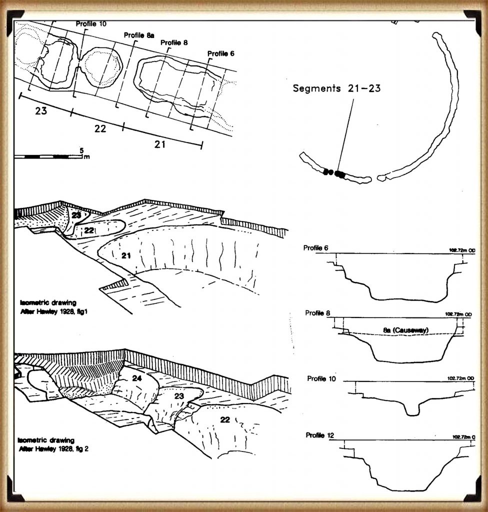
The Ditch Is really a series of pits - The Great Stonehenge Hoax
The Ditch Is really a series of pits – The Great Stonehenge Hoax

When is a ditch not really a ditch?

The Problem

The Stonehenge ditch is something the archaeologists don’t frequently (if at all) discuss or publicise as it is not a ditch as we commonly know it, which has baffled them since its first excavation.  The fact that this Ditch is ‘unique’ in the world, which you would imagine would be promoted as such, but they prefer to hide their lack of understanding of this feature and say nothing, for the Stonehenge Ditch is not a ditch but a series of pits with walls, seats and stone holes in the base that goes against the current theories about the site.

Click for The Solution

Conundrum 8 – The Stonehenge Layer

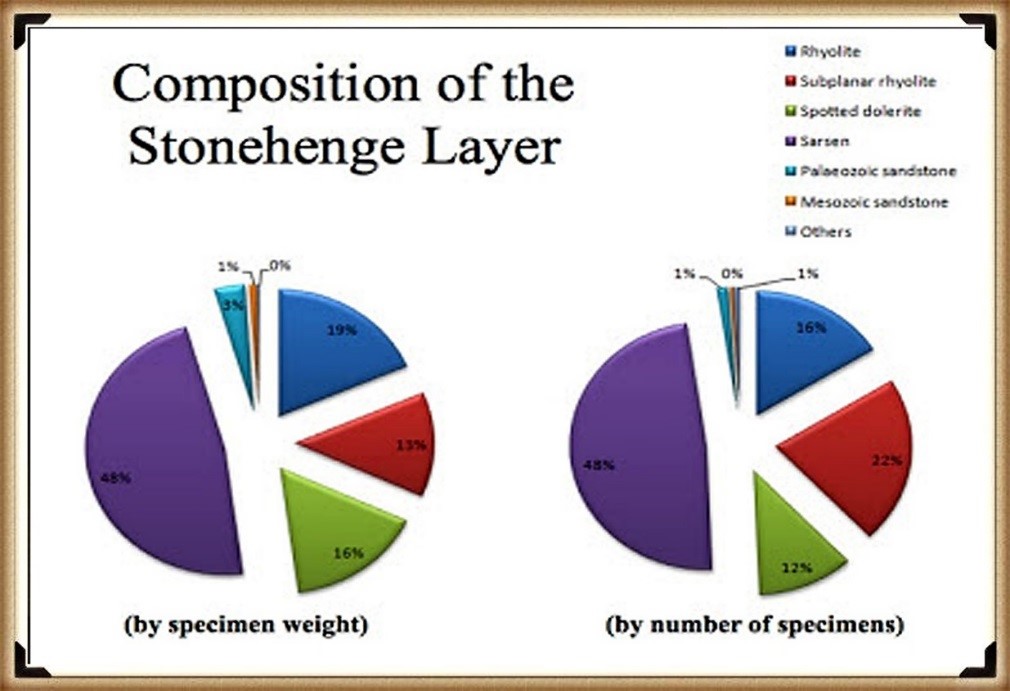
The Stonehenge Layer - the Great Stonehenge Hoax
The Stonehenge Layer – the Great Stonehenge Hoax

Chips are Us

The Problem

During the limited excavations at Stonehenge undertaken in the early parts of the last century, archaeologists were amazed by the number and scattering of the bluestones scattered and lying within the soil at Stonehenge. The number of stones was so great that the archaeologists called it the ‘Stonehenge layer.’ Chippings from the facing of the stones (particularly the larger Sarsen stones would be expected), but the more significant number of chippings came from the smaller, less frequent Bluestones, which has baffled the experts even today.

Click for The Solution

Conundrum 9 – Stonehenge’s Location

Stonehenge's landscape as seen by LiDAR - the Great Stonehenge Hoax
Stonehenge’s landscape as seen by LiDAR – the Great Stonehenge Hoax

Location, Location, Location tells the story of Stonehenge

The Problem

Archaeologists fail to mention in their many publications and documentaries the mystery of the Location of Stonehenge in the landscape. One would imagine that such a massive undertaking and monument would be placed in the most prominent position in the landscape, such as on top of a hill.  The elevated position would help promote its magnificence and allow its astronomical function as it would be clear of trees and foliage, which currently it experiences during such times as the Solstice celebrations.

Click for The Solution

Conundrum 10 – Station Stones

Station Stone Alignments - the Great Stonehenge Hoax
Station Stone Alignments – the Great Stonehenge Hoax

Was it an astronomical observatory?

The Problem

In recent years the idea of Stonehenge as an astronomical observation point has become very popular with the ‘new age’ cult that looks at the stones as a ‘magical’ monument rather than a practical, functional site as the archaeologists fail to identify the exact reason and purpose successfully was built. So these ‘ideas’ have flourished to fill the void created by the ‘experts’ as they stutter for explanations.  Within this new age, the theory is the Station stones’ role that seems to line up with more astrological occurrences than the leading site.

Click for The Solution

Conundrum 11 – Periglacial Stripes

Periglacial Stripes OR Cart Tracks - the Great Stonehenge Hoax
Periglacial Stripes OR Cart Tracks – the Great Stonehenge Hoax

When was the wheel invented?

The Problem

Deep chalk cuts lines found under the surface of the Avenue, which lead from the Stonehenge monument site to ‘Stonehenge Bottom’ a valley in the NE of the landscape, had always created speculation, especially today as the ‘experts’ came up with a ludicrous argument that had caught the mainstream archaeologists imagination when they suggested that these were Periglacial Stripes from the last ice age, and this was the reason for our ancestors built Stonehenge at this place.  These lines are just a foot or so below the topsoil on a known roadway that dated back older than the B-road that passed the stones that have now been removed.

Click for The Solution

Conundrum 12 – The Slaughter Stone

Slaughter stone is a Relief Map - the Great Stonehenge Hoax
Slaughter stone is a Relief Map – the Great Stonehenge Hoax

“The Killing of great numbers of human beings”

The Problem

The slaughter stone has always been associated with mythology and speculation.  Some say it was where Druids sacrificed bodies to their gods (hence the name); others suggested that it is merely a fallen Sarsen stone that once stood upright as the entrance to the monument.  But recent scanning has shown that it was once sculpted to look ’lumpy and ‘rolling’,’ but why?

Click for The Solution

Conundrum 13 – The Builders / Woodhenge

Woodhenge, showing the true size of the post holes - the Great Stonehenge Hoax
Woodhenge, showing the true size of the post holes – the Great Stonehenge Hoax

I owe, I owe so off to work I go

The Problem

Stonehenge has also been a problem as there is no evidence of occupancy, and this causes problems as it is supposed to have been built by the first farmers of the Neolithic period (if the carbon dating is correct). The solution is that Durrington Walls and Woodhenge, so close to Stonehenge and houses, are reportedly found within the ‘henge’.  But there are problems with this ‘simplistic’ solution, the distance being the first, as you can’t see Stonehenge from Durrington Walls, and the second is, why build a time-consuming structure such as Woodhenge if you’re busy with building Stonehenge?

Click for The Solution

Further Reading

For information about British Prehistory, visit www.prehistoric-britain.co.uk for the most extensive archaeology blogs and investigations collection, including modern LiDAR reports.  This site also includes extracts and articles from the Robert John Langdon Trilogy about Britain in the Prehistoric period, including titles such as The Stonehenge Enigma, Dawn of the Lost Civilisation and the ultimate proof of Post Glacial Flooding and the landscape we see today.

Robert John Langdon has also created a YouTube web channel with over 100 investigations and video documentaries to support his classic trilogy (Prehistoric Britain). He has also released a collection of strange coincidences that he calls ‘13 Things that Don’t Make Sense in History’ and his recent discovery of a lost Stone Avenue at Avebury in Wiltshire called ‘Silbury Avenue – the Lost Stone Avenue’.

Langdon has also produced a series of ‘shorts’, which are extracts from his main body of books:

The Ancient Mariners

Stonehenge Built 8300 BCE

Old Sarum

Prehistoric Rivers

Dykes ditches and Earthworks

Echoes of Atlantis

Homo Superior

For active discussions on the findings of the TRILOGY and recent LiDAR investigations that are published on our WEBSITE, you can join our and leave a message or join the debate on our Facebook Group.

The Silbury Hill Lighthouse?

In 2014 a remarkable new Stone Avenue was located at the UNESCO World Heritage Site of Avebury in Wiltshire.  Previously, two other Stone Avenues called the ‘West Kennet’, and the ‘Beckhampton’ are known to archaeologists as they have some of the massive Sarsen stones that line these Avenues still present, but this newly discovered pathway was never thought to exist that lead directly to Silbury Hill.

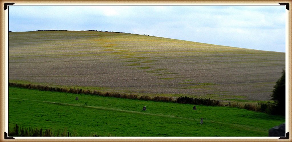
Waden Hill showing the patch marks of stone holes under the soil - silbury hill lighthouse
Figure 73– Waden Hill showing the patch marks of stone holes under the soil – silbury hill lighthouse

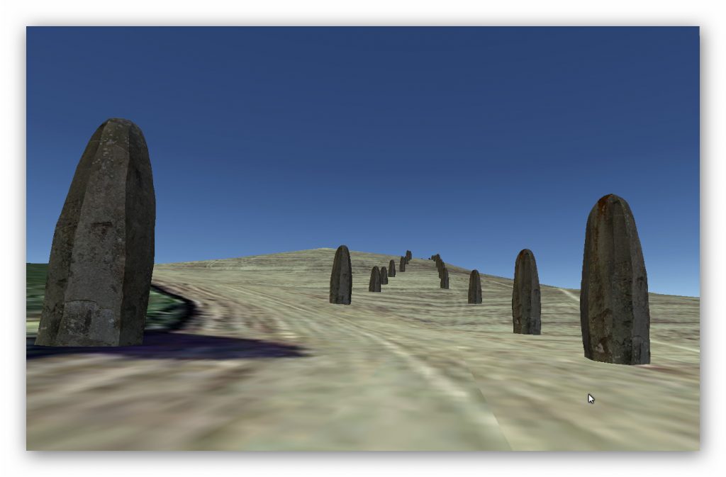
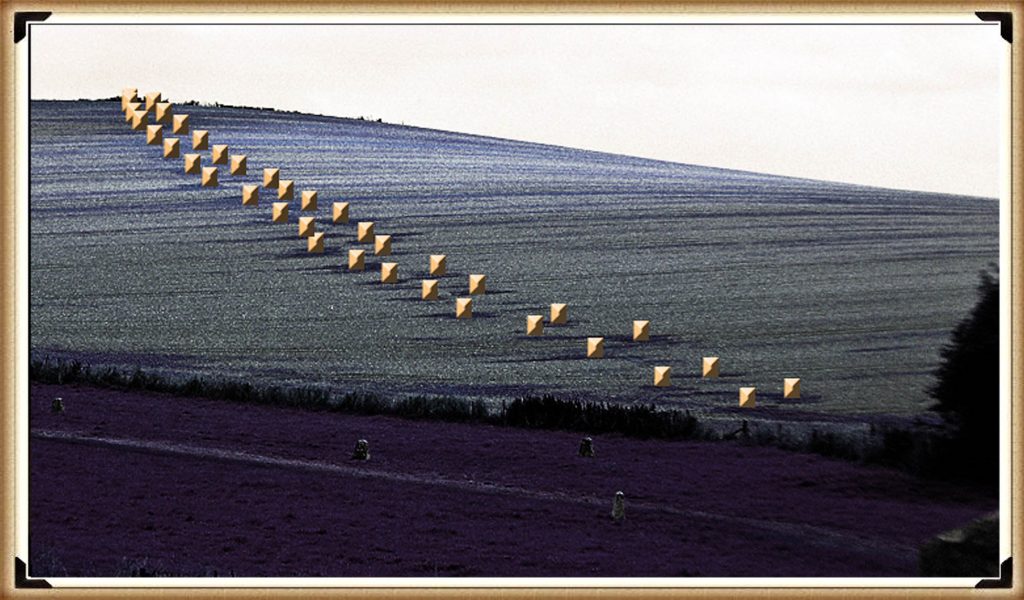
As the discoverer, I have named the pathway ‘Silbury Avenue’ as it is merely the path directly to Silbury Hill over Waden Hill.  The discovery was made by digital photographic pictures that show a series of green ‘patches’ that measures over 470 metres in length towards the apex of the hill.  We can therefore estimate if it ran down the far side of the hill towards Silbury Hill, it would have been approximately 1470 metres in total length.

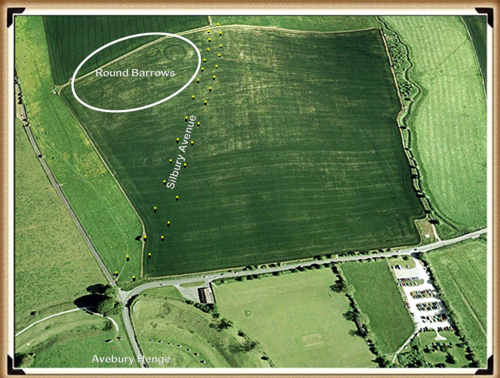
Silbury Avenue post hole positions - Silbury Hill Lighthouse
Silbury Avenue post hole positions – Silbury Hill Lighthouse

From these measurements and by counting the discolourations of this new Avenue, we can estimate that ‘Silbury Avenue’ had at least 19 pairs of stones to the apex with an average of 25m between each pair.  We can also estimate the width of this avenue at about 15m to 20m.  In comparison, the West Kennet Avenue (calculated from Google Earth) has a pairing at a distance of about 22 – 24 metres, and a width of the Avenue is approximately 15m to 17m – so a very close match.

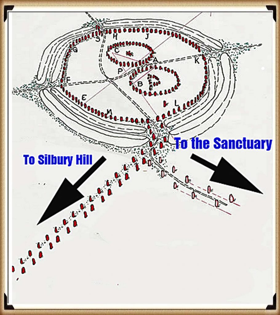
Excavations and restoration work carried out by Keiller and Piggot in 1936 on the West Kennet Avenue showed that this part of the Avenue was built in series of ten straight sections and not the smooth serpentine shape as suggested by the eighteenth-century antiquarian Stukeley.

Where stones were missing, they placed concrete markers above the excavated stone holes where they had formally stood, so providing a record of the northern section of the Avenue.  Paradoxically, Keiller’s plan survey of this section of the West Kennet Avenue shows it heading away from the southern entrance of the henge, while ‘other’ pairs seem to repair this ‘error’ with an awkward zig-zag route to connect with the southern entrance.

Recent archaeological commentary on the Avenue has suggested two interpretations for this convoluted approach route. Burl claimed that this was a mistake, of the prehistoric builders in starting the Avenue at both ends but failing to anticipate an accurate direction for each section to join up (Burl 2002).  But Gillings & Pollard argued that Keiller’s excavation plan is a mistake, and re-excavation will establish a more direct route for this section of the Avenue (Gillings and Pollard 2004, p. 78).

Yet quite rightly (Sims 2009) suggested that if it were a mistake, then it cannot explain why elsewhere in the Avebury monument there are more complex highly accurate pre-planned features.

The reality is that Burl, Gillings and Pollard are all wrong, as the discovery of my new avenue shows why such a strange ‘zig-zag’ shape was formed – as the original stones were aligned with ‘Silbury Avenue’ from an earlier date than the West Kennet Avenue. This Avenue led directly to Silbury Hill but was then abandoned for a path leading SE around the base of the hill to ‘The Sanctuary’, at a later date.

Moreover, an earlier antiquarian of the seventeenth-century, John Aubrey, recorded how the other end of the Avenue connected to the western entrance of the Sanctuary with the exact same dog-leg design. Showing the two ends of West Kennet Avenue were additions.

The change of direction on the Southern section of West Kennet Avenue shows that this Avenue was used at a very late date in Avebury’s history and after the Sanctuary’s construction.  This would explain why the Sanctuary was altered so many times in its past.  The likelihood is that The Sanctuary was the termination point of the ‘Ridgeway’ over an adjacent hill.

Figure 75 - the 'Zig Zag' Avenue currently seen is simply explained - Silbury Hill Lighthouse
Figure 75 – the ‘Zig Zag’ Avenue currently seen is simply explained – Silbury Hill Lighthouse

Silbury Avenue doesn’t go in the shortest line to Silbury Hill, but to the highest point, where we find a series of nine Barrows directly to the east side of the new Avenue. Archaeologists have dated these features as Bronze Age, although no excavations have ever been attempted as the barrows (or other features on top of the hill) were destroyed even before Stukeley visited the site in the 18th century. 

The only significant findings made in this area was in “An oval-shaped pit”, three feet deep, and discovered by workmen in 1913 while digging a trench for water pipes on Waden Hill.  The pit, situated 105m NE of the pond on the hill, contained Windmill Hill sherds, sarsen muller, two flint scrapers, charcoal and burnt flints, together with broken bones of sheep, pig and ox, some of them burnt.”

The barrows on the left of Silbury Avenue indicate that these features were built after the Avenue was constructed and not because of them, as the path passes the barrows to one side without termination.  Although the new

Figure 76- Waden Hill showing the pathway stones and the Round Barrows at the Apex to the left only - Silbury Hill Lighthouse
Figure 76– Waden Hill showing the pathway stones and the Round Barrows at the Apex to the left only – Silbury Hill Lighthouse

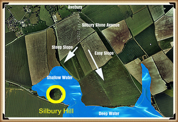
Avenue would have led towards Silbury Hill, it did not terminate at the monument as it was inaccessible due to it being surrounded by deep water, which can still be seen today during the winter seasons. 

The topology shows that Silbury Hill would have been built as part of the River Kennet, on a natural peninsula.  This high groundwater table which causes this flooding is due to springs that have recently been located. (Whitehead, P. and M. Edmunds. 2012. Palaeohydrology of the Kennet, Swallowhead Springs and the Sitting of Silbury Hill, English Heritage, Research Report Series 12-2012.

After the ‘great melt’ of the last ice age, this area would have been almost completely flooded at the start of the Mesolithic period.  The only part of Avebury above this ‘initial water level’ would have been Windmill Hill – which is NW of the current Avebury site.  This site shows evidence of occupation as it is what archaeologists call a ‘Causewayed Enclosure’, as they (incorrectly) imagine, that the moats built to accommodate boats were, in fact, dry ditches in an attempt to contain cattle – although a fence would have been quicker and more effective.

Windmill Hill

The use of this site for this purpose of storing cattle is nonsense, as the time and effort required to dig a ditch rather than build a fence is immeasurable. Although, I have no doubt that after their original use, many thousands of years later, they did serve the purpose of farmers who could not afford nor had the time to build fences. 

I have renamed these monuments ‘Concentric Circle’ sites, as they are a product of the same civilisation as the ‘megalithic builders’ and have this very distinctive design feature, of which Greek philosophers and writers have left a written history and used that term to describe their trading sites.

Once the waters of the Mesolithic subsided, a couple of thousand years later, Windmill Hill would have not been accessible by boat and therefore another site closer to the new water’s edge would have been required – this is the Avebury we know today.  Consequently, the ditches were built to accommodate (like Windmill Hill) the ships and boats of this trading civilisation.

Figure 77 - Windmill Hill - Silbury Hill Lighthouse
Figure 77 – Windmill Hill – Silbury Hill Lighthouse

Unfortunately for our ancestors, the groundwater levels continued to recede, as they have done consistently since the end of the last ice age.  When the waters failed to reach the moats of Avebury, and they faced the same option as they had two thousand years earlier to either – to abandon or replace?

Again, they decided to replace, our ancestors, therefore, moved the boats to a natural harbour slightly downriver from Avebury at a place we call Silbury Hill.  The River Kennet would have been much smaller in the Neolithic Period, but still three to four times larger than today. 

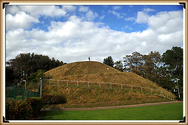
Silbury Hill

If you understand how the landscape looked and was used in the past, then such beacons can be easily found all over Britain, even ones built, to a similar design to Silbury hill  To find this unique design we can look at the most recent re-excavation and detailed examination of Silbury Hill, by English Heritage.  For only a few years ago it needed to be ‘shored up’ because of the reckless archaeologists of the past, cutting vast tunnels and shafts into the hill, looking for tombs and treasure making it totally unstable.  This investigation showed for the first time that the hill was built like the pyramids of Egypt and South America in steps.  This is from The Daily Mail in 2010:

Figure 78 - Silbury Hill made like a 'layer cake' - Silbury Hill Lighthouse
Figure 78 – Silbury Hill made like a ‘layer cake’ – Silbury Hill Lighthouse

Silbury Hill – one of the most mysterious and striking monuments in Britain – was a prehistoric ‘cathedral’, built layer by layer over 100 years, a new study suggests. The 4,000 year-old earth mound, which towers over the Wiltshire countryside, was the tallest human-made structure in Europe until the Middle Ages.

However, despite its size, and repeated attempts to tunnel into the heart of the mound, archaeologists have long been puzzled about how and why it was created.

Now a new book published by English Heritage suggests that the 120 ft high hill was not built to a grand blueprint but was assembled by at least three generations of Bronze Age Britons between 2400 and 2300 BC.  A study of soil, rocks, gravel and tools inside the hill shows that it went through 15 distinct stages of development.

Dr Jim Leary, English Heritage archaeologist, said the creators were building the mound as part of a ‘continuous storytelling ritual’ – and that the final shape of the mound may have been unimportant. He argues that the familiar outline of stepped sides and the flat top visible today is primarily the result of Anglo-Saxons and later alterations.

“Most interpretations of Silbury Hill have, up to now, concentrated on its monumental size and its final shape,’ he said.  ‘It has generally been thought to be a concerted effort of generations of people building something out of a common vision and spiritual zeal akin to that spurred the creation of soaring medieval cathedrals.

‘The flat top, especially, was often seen to be a “platform” deliberately built to bring people closer to the skies.  ‘But new evidence is increasing telling us that our Neolithic ancestors display an almost obsessive desire to constantly change the monument – to rearrange, tweak and adjust it. It’s as if the final form of the Hill did not matter – it was the construction process that was important.”

Silbury Hill lies close to the stone circles of Avebury and a few miles from Stonehenge. Archaeologists estimate that it would have taken 700 men working for ten years to build out of soil and chalk. It started as a low gravel mound before it was transformed into a pile of soil and rock surrounded by a ditch.

Dr Leary added: “The most intriguing discovery is the repeated occurrence of antler picks, gravel, chalk and stones in different kinds of layering, in ways that suggest that these materials and their different combinations had symbolic meanings.  We don’t know what myths they were representing but they must have meant something quite compelling and personal. 

What we do know is that by the time work on the hill had started in the later Neolithic period, the surrounding area was already saturated with evidence of past use; it was a place that was heavily inscribed with folk memories that recalled ancestors and their origins.  What is emerging is a picture of Neolithic people having the same need to anchor and share ideas and stories as we do now, and that built structures like Silbury Hill may not be conceived as grand monuments of worship but intimate gestures of communication.”

The hill was damaged in the 18th century when archaeologists sank a vertical shaft from the top. In the 1840s, a tunnel was dug into the mound from the edge, while in 1968 BBC2 filmed a new attempt to tunnel into the centre of the mound.

After parts of the mound began to sink in 2002, English Heritage reopened the BBC tunnel, took samples of soil and rock, filled in the gaps and sealed the mound for good.

Dr Leary now believes the mound went through 15 stages of construction – and up to 100 different phases within four or five generations.  It would make sense that a monument was a round-based hill made in layers (similar to Marlborough Mound – sometimes known as Merlin’s Barrow, also excavated by Dr Leary, hence his idea!). The question not answered by archaeologists is – why build this monument in stages? 

Fortunately, the answer is simple – to make it higher, for Silbury was a beacon to attract ships to its harbour.  Over time the height of the mound was raised to increase the beacon’s visibility.

Figure 79 - Marlborough Mount - Built like Silbury Hill - Silbury Hill Lighthouse
Figure 79 – Marlborough Mount – Built like Silbury Hill – Silbury Hill Lighthouse

‘The flat top, especially, was often seen to be a “platform” deliberately built to bring people closer to the skies. 

Unfortunately, the article is also full of nonsense like this quotation.  So, the ancestors built a hill at the bottom of a valley to get closer to the skies – is it me, or can anyone see the error in this statement?  You may therefore respond to my criticism by asking – wouldn’t a beacon on top of a hill have greater visibility?  Yet the reason the beacon is located in the watery harbour and not on top of a hill is that the light shows the exact location of mooring places, in bad weather and at night, when visibility is poor.

This type of device can be seen throughout our recent nautical history as illustrated at the Spurn Point Lighthouse.  The earliest reference to a lighthouse on Spurn Point is 1427, which was a coal-fired lighthouse at the ground level.  There were several lighthouses of various designs until in 1767; John Smeaton was commissioned to build a new pair of lighthouses (one a 90ft tower). The 1895 lighthouse is a round brick tower, 128ft tall, painted black and white. It was designed by Thomas Matthews. Its main light had a range of 17 nautical miles.

Silbury Hill also started at ground level and was built up (like Spurn Point) over hundreds of years until it reached the 120ft height seen today.

From the Guardian 31st May 2011

For generations, it has been scrambled up with pride by students at Marlborough College. But the mysterious, pudding-shaped mound in the grounds of the Wiltshire public school now looks set to gain far wider acclaim as scientists have revealed it is a prehistoric monument of international importance.

After thorough excavations, the Marlborough mound is now thought to be around 4,400 years old, making it roughly contemporary with the nearby, and far more renowned, Silbury Hill.

The new evidence was described by one archaeologist, an expert on ancient ritual sites in the area, as “an astonishing discovery”. Both Neolithic structures are likely to have been constructed over many generations.

The Marlborough mound had been thought to date back to Norman times. It was believed to be the base of a castle built 50 years after the Norman invasion and later landscaped as a 17th-century garden feature. But it has now been dated to around 2400BC from four samples of charcoal taken from the core of the 19-metre-high hill.

The Marlborough mound has been called “Silbury’s little sister”, after the more famous artificial hill on the outskirts of Avebury, which is the largest manmade prehistoric hill in Europe.

Marlborough, at two-thirds the height of Silbury, now becomes the second largest prehistoric mound in Britain; it may yet be confirmed as the second largest in Europe.

Jim Leary, the English Heritage archaeologist who led a recent excavation of Silbury, said: “This is an astonishing discovery. The Marlborough mound has been one of the biggest mysteries in the Wessex landscape. For centuries, people have wondered whether it is Silbury’s little sister, and now we have an answer. This is a very exciting time for British prehistory.”

Fire Beacon

Marlborough Mound shows that fires were light on the hill throughout its use, and the same fact can be found at Silbury Hill. Jim Leary’s excavations showed signs of fire and associated dates for these charcoal remains. According to jim:

Old Land Surface

Sample: OxA-20808

Hazelnut fragments (from the same hazelnut) from [4041] – sample <9821>, sub sample of <9435>. [4041] is a concentration of charcoal comprising charred hazel nutshell fragments and other charred remains as well as two pig or wild boar teeth. It was recorded within a small, defined area of the upper part of the OLS (4041]) on the north side of the East Lateral in Bay 7, and is thought to indicate the remains of a hearth.

Radiocarbon Date: 4012±29; 2620–2460 cal BC; 2510–2465 cal BC

Sample: SUERC- 24089
Maloideae branchwood (single entity) as OxA-20808

Radiocarbon Date: 4030±35; 2840–2470 cal BC; 2510–2465 cal BC

This presence of charcoal is reinforced by: Canti, Matthew & Campbell, Gill & Robinson, D.. (2004). Site Formation, Preservation and Remedial Measures at Silbury Hill. Who reported that: ” The remaining part of Core 5 consisted of around 29 m of chalk rubble from the rest of the mound, and this was also assessed for the presence of biological remains. Samples were taken at 25 cm intervals respecting interfaces, and floated using a 0.25 mm mesh for the flot and a 0.5 mm mesh for the residue. Tiny fragments of charcoal were present at intervals throughout the depth of the mound.”

This clearly shows that both Fire beacons were used around 2400 – 2500 BCE, when the Neolithic Waters were still high and could carry boats.

Figure 80 - Lewes Castle with a 'second mount' - which predates the Norman fortifications - Silbury Hill Lighthouse
Figure 80 – Lewes Castle with a ‘second mount’ – which predates the Norman fortifications – Silbury Hill Lighthouse

We find these beacons throughout Britain, but they remain undiscovered by archaeologists as they are believed to be Norman in origin.  Sadly, this is the simplistic nature of archaeology – if it’s a mound – it must be a Norman Motte and Bailey – if it has a ditch and on top of a hill – it must be an Iron Age fort?

In Lewes, on the South Downs, there are two beacons in this small Sussex village, both had the same function – to attract shipping.  The first is prehistoric and called the ‘Brack Mount’, historians here believe it was part of the old Norman Castle and show pictures of a wall connecting the traditional Motte and Bailey with this ‘additional feature’. 

Recent excavations have shown that this beacon has a Norman well installed at the top of the mount (probably for the castle?), the problem for archaeologists and historians dating the mound is – why on earth would you build a 50 foot high earth mound, and then dig a 60ft well, unless it predates the Norman Castle?

Figure 81- Lewes Tump - used by the 'Cluny' monks to attract ships from the English Channel - Silbury Hill Lighthouse
Figure 81– Lewes Tump – used by the ‘Cluny’ monks to attract ships from the English Channel – Silbury Hill Lighthouse

Lewes in Prehistoric times was one of the largest inland harbours in Britain, and this mound would have had a fire on top to attract shipping.  If that was not interesting enough and an excellent example of a beacon for ships and boats, a second one was built some four thousand years later, when the groundwaters of Lewes (like Avebury) were much lower.  This was built for the Monks of the French Cluny Monastery that obtained supplies and people from France and needed to show their location along the English Channel just after the Norman conquest when maps were – not very accurate!

The Harbour

Silbury Hill was built as a beacon for Avebury within a deep natural port, that now surrounds the Hill which still floods in wet winters. However, they had a problem as the trading centre Avebury was just under a kilometre from this new port and therefore, a trackway was needed to be constructed to the old site.

Silbury Stone Avenue was this new pathway. It goes from Silbury Hill harbour to Avebury over Waden Hill; this trackway was lined with the same gigantic sarsen stones we now see currently in West Kennet Stone Avenue and also believed to have existed in Beckhampton Avenue.

Photographic evidence shows that the Silbury Stone Avenue went to the apex of Waden Hill beside the ploughed-out barrows located to the eastern side of this new Avenue.  The most direct route from the peak would have been an SSW direction towards the base of Silbury Hill, but the gradient down this slope is large and would be an improbable route for ladened carts.

Figure 82- Silbury Avenue - Silbury Hill Lighthouse
Figure 82– Silbury Avenue – Silbury Hill Lighthouse

The best route for travellers would have been a longer, but with a far easier gradient to walk and carry goods, so not surprisingly, this path (which is still in existence today) and also used as a boundary marker between fields, can be found down the centre of the hill. 

We have found at sites like Old Sarum and the Avenue at Stonehenge, loading platforms placed on the ends of tracks and edges of the ditches, where boats used to dock and load.  So, therefore, did Silbury Avenue have something similar? 

The answer was found on a ‘LiDAR’ map of the area which showed a large mound at the end of the suspected avenue.

In 2004, Pete Glastonbury (photographer) rediscovered what he termed ’Silbaby’ mound. This mound appears in early archaeological maps of Avebury but was lost through the introduction of the A4 on Ordinance Survey maps. After six years of campaigning and requesting an investigation, soil samples were finally taken to date the mound (which had always been presumed to be a modern dumping ground from the A4’s construction).

So, the archaeologists thanked Pete for all his hard work, diligence and years of campaigning, but as he was not an ‘archaeological professional’, or a member of the elite ‘academia club’, they renamed his Silbaby – ‘Waden Mount’ – now that’s what I call archaeological politics for you.

Midway between Silbury Hill and the road that runs from West Kennet to the henge is what appears to be the remains of a mound that has a resemblance to the profile of Silbury. It lies just to the south of the main A4 road that runs alongside Silbury itself and, though partly obscured by vegetation, is quite visible to visitors going to the West Kennet Long Barrow. It is relatively large when compared to most of the round-barrows in the area and must contain a substantial amount of material.

For want of something more formal, its similarity in shape to Silbury Hill has generated the nickname of “Silbaby” although the text of William Stukeley’s book mentions “Weedon Hill” which might be a reference to it.

Curiously, though being a prominent feature in such an important landscape, very little appears to be known about it despite much research by local photographer Pete Glastonbury who has now brought it to the attention of archaeologists in the hope that it will soon receive some serious investigation. If it does prove to be contemporary with Avebury’s other ancient monuments its unusual position on the flood-plain of the river ( as opposed to the usual hill-top position of Bronze Age

Figure 83- Waden Mount - Silbury Hill Lighthouse
Figure 83– Waden Mount – Silbury Hill Lighthouse

round barrows ) and closeness to the enclosures will make it a fascinating site for theorists.

William Stukeley appears to have recorded a feature at the same position and some old illustrations and maps also show it though others seem to ignore it. Of significance must be the fact that it is connected to the river by a small and probably artificially enhanced spur that carries the water of Waden Spring on which the mound appears to sit. The proximity of the road makes it difficult to judge quite what the original profile of the mound may have been if it does precede the Roman period. With the recent discovery of a substantial Roman settlement in the area, there is the possibility that it may be a legacy of our continental visitors.

The evidence of some more recent earthmoving may ultimately be found to be responsible, or its artificial appearance might just be the chance result of natural forces at work, but until an explanation for its existence is found it will surely remain another enigma amongst the many others that already exist at Avebury. Perhaps the central mystery about it currently is why, when this landscape has been crawled over by numerous archaeologists and researchers during the past century or more, has it apparently been ignored?

Core samples were taken in 2010, and we await the official findings – but preliminary reports from Pete suggest it is human-made and has a similar composition and therefore date to Silbury Hill.

Figure 84– Waden Hill showing the two possible pathways from the apex of the hill

Waden Mound (Silbaby) was built at the end of Silbury Stone Avenue for a reason. We know that it was surrounded by water as the Waden Spring is found even today at its base, and the external view of the mound is round like Silbury Hill. From its height and size protruding into what would have been the raised water levels of the Kennet, it was more likely made specifically for the Silbury Stone Avenue, as a stable earth platform to load boats as seen at other sites like Old Sarum and Stonehenge

The research into Silbury Hill’s use is still ongoing and even today as I write this paragraph; I have new LiDAR scans of this area, which indicate that the path over the centre of Waden Hill may have been 20m West of the current track.  The scan shows a deep indent which may be the original footpath which leads from the apex even more directly to Waden Mount. Only real excavation work will answer this question in time, and that is unlikely as archaeology is grossly underfunded at present, even for such a significant discovery.

The waters around Silbury Hill eventually dried up as the groundwater receded even further over the next thousand or so years – therefore, a new mooring point was needed to maintain Avebury’s trading status. At this time, there doesn’t seem to be another typical harbour on the River Kennet available, so they created the final loading point on the River allowing traders to unload their ships and probably smaller boats, and this new loading quay is called ‘The Sanctuary’ which was once the natural termination point of the Ridgeway path (supposedly Britain’s oldest pathway) which led to the ‘Uffington White Horse’.

It’s entirely possible that the use of the Sanctuary was a sign of Avebury’s concluding days as a trading centre. As the mooring point was on the River, this would limit the number of boats that could moor daily. It is quite feasible that Silbury Hill beacon could still have been used as a lighthouse, as shipping would need to pass the Sanctuary before reaching Silbury Hill.

Moreover, it’s also possible that technology was by this time more advanced, and as we saw from the example of ‘Spurn point lighthouse’ a new type of lighthouse structure was developed. If we look for a description of The Sanctuary, we find it’s both peculiar and familiar at the same time.

Situated beside the A4 road on Overton Hill the Sanctuary is the site of a stone circle that once formed the terminal point of the West Kennet Avenue. Large enough to contain the outer ring of stones at Stonehenge, its earliest parts are dated to around 3000 BC, which is about the same period the cove in the northern inner circle of the henge was erected. Unless any evidence to the contrary is found it is believed to have only become linked to the distant henge when the avenue was built about 2400 BC.

Figure 85- Silbury Hill was a lighthouse/Fire beacon for the Harbour below - Silbury Hill Lighthouse
Figure 85– Silbury Hill was a lighthouse/Fire beacon for the Harbour below – Silbury Hill Lighthouse

Now destroyed and only consisting of small concrete markers where the various elements once stood, the Sanctuary must have played an important part in the function of the henge.  When Aubrey saw it he recorded it as a double ring of stones. Although Stukeley also recorded quite a number of stones on his drawing of it he was to witness much of its destruction during the period of his visits. The destruction was so complete that the site was to become lost and forgotten until Mrs. Maud Cunnington was able to locate it once more in 1930 prior to her excavation of it.

It is a confusing site from an archaeological point of view. Despite a number of excavations (one as recent as 1999), it continues to be a challenge to researchers. It appears to have started as a series of small circles comprising of wooden posts, some of which have now been established as being quite massive. Whether these were evidence of a roofed building or just remained as standing posts is the subject of debate. Eventually, after many modifications, it was to evolve into a stone circle about 130 feet in diameter which has now disappeared. Whatever its purpose it remains an essential and fascinating part of the Avebury complex.

Consequently, when Silbury harbour dried up, this was the only logical landing site on the River Kennet near Avebury. So, they built a wooden lighthouse-like Woodhenge with the same external diameter of 138ft but with a smaller inner timber circle and posts just up to 24 inches wide (not 60 as at Woodhenge) and hence probably half the size high.

Moreover, Silbury Avenue was now redundant, and so they moved the large avenue sarsen stones from on top of the hill down to the east side and created West Kennet Avenue as we see today – with the ‘zig-zag’ kink and path correction as you enter Avebury.

Still find it hard to believe this function is common place for nautical societies?

The historical role of lighthouses has always fascinated me, and it’s clear that their purpose extended well beyond simply warning ships of danger. When we delve into the past, we discover that lighthouses were beacons, guiding vessels to safe harbours, even within rivers. The 17th-century map of the River Tyne is a vivid example of this concept.

In that era, lighthouses played a pivotal role in maritime navigation. They not only ensured safe passage during adverse weather conditions but also signified the presence of harbours where ships could find refuge, conduct maintenance, and make necessary repairs. These beacons were lifelines for sailors and the cornerstones of maritime trade and commerce.

The map of the River Tyne with its two lighthouses tells a compelling story of historical navigation. It reveals a network of guiding lights that not only aided ships but also fostered the growth and prosperity of the communities they served. It’s a testament to the enduring legacy of lighthouses as symbols of safety, hope, and refuge in the world of seafaring.

The Tyne in the 17th century - Silbury Hill Lighthouse
The Tyne in the 17th century – Silbury Hill Lighthouse
Two Lighthouses offing safe harbour to ships - Silbury Hill Lighthouse
Two Lighthouses offing safe harbour to ships – Silbury Hill Lighthouse

We should also not forget that the oldest Lighthouse in Britain is Roman and were also built in pairs (Like Silbury and the Sanctuary) at Dover again to ATTRACT ships to port.

Roman Lighthouses in Britain attracting ships in the channel to Dover Harbour

Further Reading

For information about British Prehistory, visit www.prehistoric-britain.co.uk for the most extensive archaeology blogs and investigations collection, including modern LiDAR reports.  This site also includes extracts and articles from the Robert John Langdon Trilogy about Britain in the Prehistoric period, including titles such as The Stonehenge Enigma, Dawn of the Lost Civilisation and the ultimate proof of Post Glacial Flooding and the landscape we see today.

Robert John Langdon has also created a YouTube web channel with over 100 investigations and video documentaries to support his classic trilogy (Prehistoric Britain). He has also released a collection of strange coincidences that he calls ‘13 Things that Don’t Make Sense in History’ and his recent discovery of a lost Stone Avenue at Avebury in Wiltshire called ‘Silbury Avenue – the Lost Stone Avenue’.

Langdon has also produced a series of ‘shorts’, which are extracts from his main body of books:

The Ancient Mariners

Stonehenge Built 8300 BCE

Old Sarum

Prehistoric Rivers

Dykes ditches and Earthworks

Echoes of Atlantis

Homo Superior

For active discussions on the findings of the TRILOGY and recent LiDAR investigations that are published on our WEBSITE, you can join our and leave a message or join the debate on our Facebook Group.

To understand why rivers were larger in the past we have video with all the relevant information.

Hadrian’s Wall – Military Way Hoax


Case Study – The Roman Military Way……… (Extract from the Book – The Hadrian’s Wall Enigma)

Many, new to the famous Whin Sill section of the Roman Wall frontier, confuse the Military Road (B6318) with the Roman Military Way. They have nothing in common, either in time or purpose. In fact, the Military Road was only constructed after the Jacobite Rising of 1745, in large part upon the ruin of the wall!


The Romans created the Military Way (according to Historic England) as the means of speedily relaying goods along the line of the wall. It was used to support the running of the frontier wall during the Roman period.


When Hadrian’s first grand plan was executed, The Stanegate (another Case Study in this book) was created as an east/west military road. But when Hadrian’s successor, Antonius Pius, pushed the frontier north, through the isthmus between the Forth and Clyde, creating the Antonine Wall (yet another case study in this book), the supply road was installed integral to the turf-banked frontier linking the forts and milecastles.


Over time, when the frontier retreated to consolidate upon the original Hadrianic line, it was essential to have the same flexibility close to the Hadrian’s Wall.


But does it exist, and what was it for in reality?


If we look at the first instance of this ‘alleged’ road, we need to go to Section E (of our Map) – Historic England (HE) section 1010979, this road starts some 24.2 km from the western flank of Hadrian’s Wall – which ‘begs the question’ – what was used to link the 20% of the wall when this road was missing?


When we do eventually find this ‘road’ (according to archaeologists), another mystery occurs – there is nothing on LiDAR! Further investigation into why Historic England (HE) included it in its scheduling reports indicates that – it only existed in ‘short distances’, or it’s invisible, and maybe under another road?

Section E (HE:1010979)
“The course of the Roman road known as the Military Way, which ran along the corridor linking turrets, milecastles and forts, has been identified for a short distance to the east of Wallhead.


There are no remains visible on the surface except for a short section of a turf-covered mound, 4m-5m wide and up to 0.4m high.


Its course was confirmed during excavation in 1894 by Haverfield. The road consisted of a gravel layer laid over larger stones with a stone kerb and central spine. Its survival here was confirmed by a geophysical survey in 1981. However, the unusual survival of this section suggests the possibility that it was reused in the medieval period serving as access to Bleatarn Quarry.”


This problem of misidentified comes about when archaeologists go out looking for a ‘perceived structure’ to satisfy an objective.


Section H (HE 1010996) is some 33.5 km from the Western start of the wall (27.5%) – so what do we have here?


“The exact course of the Roman road known as the Military Way, which ran along the corridor between the wall and the Vallum linking the turrets, milecastles and forts, is known intermittently throughout this section where it survives as an earthwork feature.


Opposite the disused quarry west of Bankshead Farm the Military Way survives as a terrace, 3m-5m wide, on the north side of an old hedge line. Occasional rises in hedge lines denote traces of its course.”


Again it does not appear on the OS (1800) map, and what we find on the LiDAR maps seems to indicate that it is linked to the Old Quarry rather than ‘connecting turrets and milecastles’?

Section H (HE:1010996) - Military Way Hoax
Section H (HE:1010996) – Military Way Hoax

Moreover, the Vallum has disappeared from this section and what we might be seeing is a shallow bank of the Vallum of a replacement.


Section I (HE: 1010994)
“Excavations in 1911 by Simpson showed there to be two early floor levels as well as late pottery, demonstrating that the turret had continued in use, unlike many other turrets. The course of the Roman road known as the Military Way, which ran along the corridor between the wall and the Vallum linking turrets, milecastles and forts, is known throughout this section. West of the fort it survives as an intermittent low linear mound, 0.1m in maximum height. East of the fort, a geophysical survey in 1986 by Walker confirmed the existence of the Military Way below the turf cover.”

Small section of Military Way only? - Military Way Hoax
Small section of Military Way only? – Military Way Hoax
Military Way looks rather fragmented and incomplete? - Military Way Hoax
Military Way looks rather fragmented and incomplete? – Military Way Hoax

There looks like a partial road in-between the Wall and The Vallum. Which may join the Station (Amboglanna) to the Milecastle in that region – but it’s not a connecting road that continues past this isolated point (less than 1000m in length)?

The road now again disappears for another 7km, and then it reappears again in Section I on the OS maps.

Military Way clearly shown on OS maps - Military Way Hoax
Military Way clearly shown on OS maps – Military Way Hoax
Flimsy evidence of the Military Way on LiDAR - Military Way Hoax
Flimsy evidence of the Military Way on LiDAR – Military Way Hoax

Section J:
“The course of the Roman road known as the Military Way, which ran along the corridor between the wall and the Vallum linking the turrets, milecastles and forts, is known throughout this section. It is visible as a low causeway, 0.2m high, or as a terrace, 5m wide, winding between rock outcrops to the south of the wall. Turret 45a is situated on a high point on Walltown Crags with extensive views in all directions. It survives as an upstanding exposed feature, which is consolidated and in the care of the Secretary of State.”

Military Way on OS Maps
Military Way on OS Maps – Military Way Hoax
Military Way on LiDAR Maps - rather small?
 Military Way on LiDAR Maps – rather small? – Military Way Hoax

“The road which connected the milecastle to the Military Way survives as a causeway 3.5m wide and 0.2m high. Milecastle 45 is situated on the crest of Walltown Crags with commanding views to the north and south.”


“It survives as a low turf-covered causeway 5.5m wide and up to 0.5m high, or as a terrace in the hillside with a minimum width of 3m. It is straight for most of its course except where it deviates around rock outcrops.”


“West of the Cockmount Hill Plantation the foundations of two large regularly laid out rectangular buildings overlie the Military Way, using it as a hard standing. Their form suggests they are post-medieval or later in date. South east of King Arthur’s Well a spur road branched off the Military Way, the remains of which can be seen as a turf-covered causeway leading south-east towards Lowtown.”


“Its course from the Caw Burn is known where it survives as a low turf-covered mound, 6m to 8m wide and 0.2m to 0.5m high. Occasional sections of this low turf-covered causeway reappear on the line up to the east gateway of Great Chester’s fort.

Beyond the field boundary west of the fort the Military Way is visible again as a discontinuous terrace with a slightly sinuous course which avoids the rock outcrops. Field gates are positioned on its course at the east and west end of this stretch.

A road linking the Military Way and the Stanegate Roman road to the south via Great Chester’s fort is overlain by the modern trackway to Great Chesters Farm which enters the fort through the south gateway.”

From these strong descriptions, we would imagine that the course and evidence for the road will show strongly on LiDAR, but it’s totally invisible but for a small 260m section.

 OS map showing how the road is ‘supposedly’ layout
 OS map showing how the road is ‘supposedly’ layout – Military Way Hoax
Military Way - showing just 260m of road
Military Way – showing just 260m of road – Military Way Hoax

Section K (HE: 1010975):
“The course of the Roman road known as the Military Way, which ran along the corridor between the wall and the Vallum linking the turrets, milecastles and forts is known throughout this section except around Cawfields Quarry where its precise course has not yet been confirmed. It survives as a linear causeway which is most prominent at the east end of this section. Here it measures between 3.5m and 5.2m wide with a revetment containing large stones on the south side and with evidence of a stone kerb. Further west the causeway, where extant, averages about 0.1m in height and 7m in width.


Where there is no trace of the causeway the line of the road has been identified by changes in vegetation growth with grass growing less well above the former road surface. Around Cawfields Quarry the remains of the Military Way may have been destroyed by the quarry, however, it is possible that here the Military Way was built on the line of the Vallum, as it was further to the east at the crossing site of the Caw Burn and thus survives. About 200m east of milecastle 42 and 10m to the south of the Military Way is a fallen Roman milestone. It measures 1.38m high by 0.4m by 0.3m. It is oblong in shape and crudely rounded at the corners. This uninscribed milestone now lies in long grass. Two other milestones from this vicinity have been removed and are now in Chesters museum.”

Military Way from Chesters Fort
Military Way from Chesters Fort – Military Way Hoax
Observable Military Way on LiDAR
Observable Military Way on LiDAR – Military Way Hoax

The LiDAR map shows that the road did not go to the Quarry but terminated in the River Valley (Like the Vallum) – was there a bridge across (no foundations) are shown on the LiDAR map.

No Military Road to the Quarry but one coming out of the Vallum
No Military Road to the Quarry but one coming out of the Vallum – Military Way Hoax


Section HE: 1010973 suggest that:
“Its course is marked usually by a slight causeway, up to 0.2m high, or by differing vegetation marks seen in grass colour. This differentiation in vegetation cover reflects differing growing conditions on the compacted road surface. It is best preserved where it crosses a gully running into Green Slack. Here it survives as a built-up causeway, 1.7m high and 2m wide. South of milecastle 41 the causeway survives up to 0.7m high with kerbstones on its south side.”

Clear evidence of a Roman Military Way – Military Way Hoax

“The course of the Roman road known as the Military Way, which ran along the corridor between the wall and the Vallum linking turrets, milecastles and forts, survives well as a linear causeway throughout this section. Some stone is visible on the south scarp, where it has been built up to make a level surface. This scarp appears to have had a stone revetment. The south scarp averages 0.4m in height, although it reaches up to 1.2m high in places. West of Peel Farm the Military Way is overlain by the road to Steel Rigg car park. To the south of Sycamore Gap are the remains of a prehistoric field boundary running roughly from north to south, probably dating to the Bronze Age.“

“The Roman Military Way overlies this boundary, indicating that it is certainly pre-Roman. The peat bog, which has grown over remains of this boundary further to the south, is of Bronze Age origin. A second boundary is located running transversely to the Sycamore Gap boundary, to the west of it, south of the Military Way. Their assumed junction is masked by the peat bog which has built up to the south.”


Section L (HE:1010964):
“The course of the Roman road known as the Military Way, which ran along the corridor between the wall and the Vallum linking turrets, milecastles and forts survives as a turf-covered linear mound throughout most of this section. It is visible as a disturbed causeway averaging 5m wide with traces of a stone revetment on the south side. It was partly excavated between 1978 and 1980 when it was shown to have a damaged metalled surface 4m wide, a stone revetment on the south scarp, and to have been overlain by later roadways. Branch roads survive linking the Military Way with the south gates of both milecastles 35 and 36. At milecastle 35 the low, uneven turf-covered mound of the causeway is up to 5.5m wide and 0.2m high.”


Section M (HE:1010963):
“The course of the Roman road known as the Military Way, which ran along the corridor between the wall and the Vallum linking the turrets, milecastles and forts, was carried on the north mound of the Vallum in the east half of this section. Its buried remains survive below grassland east of milecastle 33, until the B6318 road coincides with the north mound of the Vallum where it lies below the modern road surface.”


“South of turret 33b the Military Way leaves the north mound of the Vallum and follows a course parallel to that of the wall. Here it survives as a distinct linear mound up to 6m wide and up to 0.3m high. The Vallum survives well as an upstanding earthwork visible on the ground throughout this section. It runs roughly parallel with the line of the wall until south of turret 33b where it turns to the south west and follows the tail of the escarpment. In the east half of this section the vallum ditch averages 3.5m in depth, while the north and south mounds average 1.5m in height.”


“The course of the Roman road known as the Military Way, which ran along the corridor linking turrets, milecastles and forts is not yet known with certainty in this section. However, there is a slight rise alongside the field wall on the south side of the wooded area to the south of Carraw Farm which could be the remains of the `agger’, or raised spine, of the road. The antiquarian Horsley, writing in the 1730s, stated that the Military Way was carried on the north mound of the Vallum in this general area.”


Section N (HE:1010959):
“It is visible as a low turf covered causeway immediately south of the car park heading directly for the east gate of the fort, though it fades before it reaches the fort. On the west side of the fort it re-emerges heading from the west gateway to the north mound of the Vallum which was used to carry the road in this section. The road is visible as a low linear mound, 0.2m high, along the summit of the north mound of the Vallum. The Vallum survives as an intermittent earthwork throughout this section.”


“The Military Way survives as a turf covered causeway leading up to the south gateway of the milecastle. Milecastle 31 is situated immediately to the east of Carrawburgh car park with wide views to the north and south, but with a restricted outlook to the east and west. It survives as a low turf covered platform 0.25m high. The remains of north wall of the milecastle lies beneath the B6318 road. Traces of the road connecting the milecastle to the Military Way survive as a causeway 0.15m high. Turret 29b survives as a turf covered mound with parts of the north, west and east walls surviving up to two courses. The road connecting the turret to the Military Way is discernible as a slight linear mound.”


“It was excavated during 1912 by Newbold who found the doorway in the east end of the south side and a ladder platform in the south west corner. Heavily burnt masonry and rubbish indicated that the turret had been destroyed by fire and was then left in ruins. Turret 30a is situated about 400m east of Carrawbrough Farm below the B6318 road. It was located during 1912, though there are no surface remains visible now. Turret 30b is located about 50m west of the drive to Carrawbrough Farm partly below the B6318 road. The south side of the turret is visible in the field to the south of the road as a turf covered scarp, 0.5m high.”

“At Limestone Corner the Military Way is visible as a low causeway, 0.6m high, leading to the south gateway of milecastle 30. Beyond the milecastle it rejoins the north mound of the well preserved Vallum. Excavations during 1911 confirmed this to be the case.”

Military Way added to the Vallum to meet the Milecastle 30
Military Way added to the Vallum to meet the Milecastle 30 – Military Way Hoax

“There are no upstanding remains of the road to the west of the fort. However, the antiquarian Horsley considered that the Military Way exited Chesters and then converged gradually with the north mound of the Vallum where they continued united for a considerable distance.”

Military Way on OS Maps by milecastle 29
Military Way on OS Maps by milecastle 29 – Military Way Hoax
No sign of Military Way on LiDAR Maps by milecastle 29 – Military Way Hoax

Section O (HE:1010959):
“The course of the Roman road known as the Military Way, which ran along the corridor between the wall and the Vallum linking turrets, milecastles and forts, survives well in the section between the North Tyne and the fort. The line of the road is clearly defined on the ground leaving the fort by the east gateway and heading towards the Roman bridge. Initially it is a depression and then becomes a causeway with a maximum height of 0.8m with a kerb to the south visible for 1.3m.”

Military Way, west of the fort on OS Maps – Military Way Hoax
Military Way does not exist! – Military Way Hoax

“There are no upstanding remains of the road to the west of the fort. However, the antiquarian Horsley considered that the Military Way exited Chesters and then converged gradually with the north mound of the Vallum where they continued united for a considerable distance”

The reality is that there is no evidence of the Military Way in this section.

Schedule: HE:1018581
“The course of the Roman road known as the Military Way, which ran along the corridor between the wall and the Vallum linking turrets, milecastles and forts, is considered to be on the line of the north mound of the Vallum in this section.”

“Throughout this section the north mound of the Vallum has been largely levelled by ploughing and so it is doubtful whether the Military Way survives intact here. The exception to this is where the angle of descent down to the North Tyne is particularly steep opposite Black Pasture Cottage, and here a turf-covered trackway leaves the line of the north mound to run down the side of a dry valley to rejoin it some 180m further on. This diversion effectively eases the gradient. Where the valley opens out this track is visible as a raised causeway 7m wide and 0.2m high.”

Still no sign of any Military Road
Still no sign of any Military Road – Military Way Hoax

“The course of the Roman road known as the Military Way, which ran along the corridor between the wall and the Vallum linking turrets, milecastles and forts, is known for most of this section. It uses the north mound of the Vallum as its base, certainly up to milecastle 25, along which it could be seen by Horsley who recorded it in his 1732 publication. A recent survey by the Royal Commission on the Historical Monuments of England shows that the Military Way probably continued along the north mound of the Vallum beyond milecastle 25 where Horsley could no longer trace it.“

Section O shows us that there is no Military Way as an independent road and only as an assumption of the Northern Bank of the Vallum – which was not continuous in this section due to the River Tyne. Moreover, Section P to W have the same excuse for the loss of the Military Way, a total of 35km (28%) of the wall length. “The course of the Roman road known as the Military Way, which ran along the corridor between the wall and the Vallum linking turrets, milecastles and forts, is known for most of this section. It uses the north mound of the Vallum as its base.“

Conclusion

Our investigation has found that over 50% of Military Way does not exist as a separate road as suggested by archaeologists and English Heritage. Instead, the existing road is fragmented and only comes ‘alive’ as an independent road when the Vallum separates from the wall at any great distance.
This gives us a clue to the function of the rough and wonky road (known as the Military Way), as the stone for the wall would have needed to be delivered by cart if the Vallum was not available.


This supports our hypothesis that the Vallum was constructed upon a series of older prehistoric Dykes (canals) and was utilised to carry stone (by boat) to the wall throughout its entire length in association with the ‘Military Way’ for areas of the wall that was too far away from the Vallum for the stone to be easily transported on the Canal.

Moreover, Silbury Avenue was now redundant, and so they moved the large avenue sarsen stones from on top of the hill down to the east side and created West Kennet Avenue as we see today – with the ‘zig-zag’ kink and path correction as you enter Avebury.

Further Reading

For information about British Prehistory, visit www.prehistoric-britain.co.uk for the most extensive archaeology blogs and investigations collection, including modern LiDAR reports.  This site also includes extracts and articles from the Robert John Langdon Trilogy about Britain in the Prehistoric period, including titles such as The Stonehenge Enigma, Dawn of the Lost Civilisation and the ultimate proof of Post Glacial Flooding and the landscape we see today.

Robert John Langdon has also created a YouTube web channel with over 100 investigations and video documentaries to support his classic trilogy (Prehistoric Britain). He has also released a collection of strange coincidences that he calls ‘13 Things that Don’t Make Sense in History’ and his recent discovery of a lost Stone Avenue at Avebury in Wiltshire called ‘Silbury Avenue – the Lost Stone Avenue’.

Langdon has also produced a series of ‘shorts’, which are extracts from his main body of books:

The Ancient Mariners

Stonehenge Built 8300 BCE

Old Sarum

Prehistoric Rivers

Dykes ditches and Earthworks

Echoes of Atlantis

Homo Superior

For active discussions on the findings of the TRILOGY and recent LiDAR investigations that are published on our WEBSITE, you can join our and leave a message or join the debate on our Facebook Group.

To understand why rivers were larger in the past we have video with all the relevant information.

Hadrian’s Wall – the Stanegate Hoax

Case Study – Stanegate Roman Road……… (Extract from the Book – The Hadrian’s Wall Enigma)

According to Wikipedia:

The Stanegate (meaning “stone road”) was an important Roman road built in what is now northern England. It linked many forts, including two that guarded important river crossings: Corstopitum (Corbridge) on the River Tyne in the East and situated on Dere Street, and Luguvalium (Carlisle) on the River Eden in the west. The Stanegate ran through the natural gap formed by the valleys of the River Tyne in Northumberland and the River Irthing in Cumbria. It predated Hadrian’s Wall by several decades; the Wall would later follow a similar route, slightly to the north.

The Stanegate differed from most other Roman roads in that it often followed the most accessible gradients and so tended to weave around, whereas typical Roman roads follow a straight path, even if this sometimes involves having punishing slopes to climb.

A large section of the Stanegate is still used today as a modern minor road between Fourstones and Vindolanda in Northumberland.

It is believed that the Stanegate was probably built under the governorship of Agricola, from 77 to 85 AD, during the reigns of the emperors Vespasian, Titus and Domitian. It is also thought that it was built as a strategic road when the northern frontier was on the line of the Forth and Clyde. An indication of this is that it was provided with forts at one-day marching intervals (14 Roman miles or modern 13 miles (21 km)), sufficient for a strategic non-frontier road. The forts at Vindolanda (Chesterholm) and Nether Denton have been shown to date from about the same time as Corstopitum and Luguvalium, in the 70s AD and 80s AD.

When the Romans decided to withdraw from Scotland in about 105 AD, the line of the Stanegate became the new frontier, and it became necessary to provide forts at half-day marching intervals. Newbrough, Magnis (Carvoran), and Brampton Old Church were additional forts. It has been suggested that a series of smaller forts were built in between the ‘half-day-march’ forts (6.5m/10km). Haltwhistle Burn and Throp might be such forts, but there is insufficient evidence to confirm a series of such fortlets.

Where it left the base of Corstopitum, the Stanegate was 22 feet (6.7 m) wide with covered stone gutters and a foundation of 6-inch (150 mm) cobbles with 10 inches (250 mm) of gravel on top.

According to English Heritage

The Stanegate military road linked Corbridge and Carlisle, which were also situated on important north-south routeways. It also extended west of Carlisle towards the Cumbrian coast.

The construction of a series of forts along the road line allowed many troops to be stationed in this crucial frontier area and ensured that the site could be extensively patrolled. A series of smaller watchtowers were also built to help frontier control. The Stanegate frontier thus created, developed further, and consolidated during the late first and early second century AD and helped crystallise Roman tactics and military expectations in the area.

The function of the road and its forts changed when Hadrian’s Wall was constructed to the north, and their support roles were, initially at least, enhanced. The later history of the road and its forts and their relationship with the Wall is less well understood, although, overall, their strategic functions declined as the new frontier line was confirmed.

Therefore!

Stanegate is built from Corstopitum (Corbridge) to Luguvalium (Carlisle) 13 miles constructed between 77 to 85 AD as a predates Hadrian’s Wall, but it’s not like most Roman Roads as it’s not straight and follows the contours of the landscape.  Moreover, when the Romans withdrew from Scotland in 105 AD (Hadrian’s wall was built in 122 AD) it was used as a frontier line.

But is it true?

Let’s look at the suggested route and find out using LiDAR if it is remotely true?

For Ease’s purpose, we will go from West to East for reasons that will become obvious at the end of the case study.

Route

The Stanegate began in the east at Corstopitum, where the critical road, Dere Street headed towards Scotland. West of Corstopitum, the Stanegate crossed the Cor Burn, and then followed the north bank of the Tyne until it reached the North Tyne near the village of Wall. A Roman bridge must have taken the road across the North Tyne, from where it headed west past the present village of Fourstones to Newbrough, where the first fort is situated, 7 miles (12.1 km) from Corbridge, and 6 miles (9.7 km) from Vindolanda. It is a small fort occupying less than an acre and is in the graveyard of Newbrough church, which stands alone to the west of the village.

From Newbrough, the Stanegate proceeds west, parallel to the South Tyne, until it meets the next major fort, at Vindolanda (Chesterholm). From Vindolanda the Stanegate crosses the route of the present-day Military Road and passes just south of the minor fort of Haltwhistle Burn. From Haltwhistle Burn, the Stanegate continues west away from the course of the South Tyne and passes the major fort of Magnis (Carvoran), 6 miles (10.5 km) from Vindolanda and 20 miles (32 km) from Corstopitum. The road is joined by the Maiden Way coming from Epiacum (Whitley Castle) to the south.

From Magnis, the road turns towards the southwest to follow the course of the River Irthing, passing the minor fort of Throp, and arriving at the major fort of Nether Denton, 4 miles (7.2 km) from Magnis and 24 miles (39.4 km) from Corstopitum. The fort occupies an area of about 3 acres (12,000 m2).

From Nether Denton, the road continues to follow the River Irthing and heads towards present-day Brampton. It passes the minor fort of Castle Hill Boothby and then, 1 mile (1.6 km) west of Brampton, reaches the next major fort, that of Brampton Old Church, 6 miles (9.7 km) from Nether Denton and 30miles (49.1 km) from Corstopitum. The fort is so-called because half of it is buried under Old St Martin’s church and its graveyard.

From Brampton Old Church, the road crosses the River Irthing and continues southwest through Irthington and passes through what is now the site of Carlisle Airport, just to the north of the main runway. The curving corner of an associated marching camp can be made out from the air on the south edge of the runway near its western end and seen on Google Earth. The Stanegate then continued through an extensive cutting in High Crosby, where a small fort was postulated based on marching distances but was not yet found.

The Stanegate then crossed the River Eden near the cricket ground[9] in modern Carlisle and eventually reached the fort of Luguvalium (Carlisle) on the site of Carlisle Castle, 7 miles (12.1 km) from Brampton Old Church and 38 miles (61 km) from Corstopitum. It has been suggested that the road may have carried on west for a further 4 miles (7.2 km) to the Roman fort at Kirkbride overlooking Moricambe Bay, an inlet of the Solway Firth. A large camp of 5 acres (20,000 m2) was found there but the evidence for a road is insufficient.

Stanegate Road and Fort formation

It has also been suggested that the Stanegate may have run eastwards from Corstopitum towards Pons Aelius, present-day Newcastle upon Tyne, and possibly linking to Washing Wells Roman Fort in Whickham, but no evidence has yet been found to support this.

The first thing you notice is that they are not in a line and the gaps (for a 6.5mile marching gap) is inconstant.


Carlisle to Brampton Section (7.8 miles/12.5 km – Direct)

Carlisle to Brampton - Stanegate
Carlisle to Brampton – Stanegate
B4245 - Stanegate B-road
B4245 – Stanegate B-road

The most obvious route from Carlisle Castle (Luguvalium Roman Fort) is the B4245, which may have been originally the ‘Stanegate road’ which heads for Brampton Old Church Roman Fort via Irthington.

Carlisle to Brampton (GE)

One would imagine that you would stay on this road until you get to Brampton – but the OS maps show that you veer off at High Crosby?

High Crosby Turn off - Stanegate
High Crosby Turn off – Stanegate

The problem is that (although the road has been spotted on Google Earth – LiDAR shows absolutely nothing?

High Crosby Turn-off

The line (which goes through Carlisle airport – shows little to no road and abruptly ends at a massive riven and the river Irthing. The fort has no direct road access (even if you continued on the B4245 and not turned off) until you reach Brampton, and then it’s a windy 1.5 mile / 2.4 km road (old church road). So to supply this station, you will need a boat and hence its position by the river.

Old Brampton Roman fort with no Stanegate connection

 Brampton To Boothby Fortlet (2.4 miles / 3.8 km)

 Brampton To Boothby Fortlet - Stanegate
 Brampton To Boothby Fortlet – Stanegate

There is no road on the OS map that connect the two forts or any scheduled monument.  There is nothing on the LiDAR map, and Boothby fort may appear on the OS and scheduled monuments listing – but on LiDAR, there is absolutely nothing or any road connection?

Boothby Roman Fort
Boothby Scheduled Area

If Boothby slips into the old riverbed – the river must have been much more prominent in the past than today?

This would question if the site was Roman or Prehistoric? Interestingly, we have identified possible Dyke/Paleochannel in this area.  Is it possible that it was another Dyke/Paleochannel that was identified in 1947 by air photography as a side of the Roman fort and is is the Dyke that was partially excavated?

Boothby Coastline
Boothby Coastline

If we return to our LiDAR map of the area and flood it with a higher water table (10m over the current river level), we not only see why Boothby slid into the water (if it was a Roman fort) but was also see Old Brampton roman fort was so isolated with no adjoining roads – it’s on an island?

Boothby and Brampton with Higher River levels than today

So what’s going on here?

We have failed to find Stanegate road (if the OS map is correct), and neither of the Roman forts has any road connection to the Stanegate – even if the current Old Brampton Road is the real Stanegate?

Boothby to Nether Denton Roman Fort (3.4 miles / 5.4 km)

Boothby to Nether Denton Roman Fort

Again there is no road (modern or old that connects the Nether Denton Fort to Boothby) – the only connection is the river, and it is this river that archaeologists are now suggesting was the ‘natural’ boundary when the Roman retreated from Scotland in 105AD before Hadrian’s Wall was constructed. (Symonds, 2017). The pathway to the south of the fort stops at the river.

Nether Denton Fort
Nether Denton Fort

The first 5 Roman forts on the ‘Stanegate road’ are on the river irthing and not connected by a single road!!

First 5 Roman forts on the ‘Stanegate road’

So where is Stanegate, and did it ever connect any Roman forts together?

Nether Denton Roman Fort to Throp (2.3 miles / 3.8 km)

Denton to Throp

The first signs of the Road called Stanegate on the OS map, which makes any sense comes as we moved towards the fourth fort, ‘Thorpe’- further down the river.

Emergence of Stanegate

This road is not well defined in the landscape, with a single ditch (8m) on the North side rather than two ditches on either side. The road itself is 9m wide then halfing to 4m wide.

 First signs of the Road called Stanegate
First signs of the Road called Stanegate

According to the archaeologists, Throp Fort/camp’s exit is obvious (South East).

Throp Fort Plan - with Stanegate exit
Throp Fort Plan – with Stanegate exit
Throp Roman Fort/Camp - with Stangegate exit?
Throp Roman Fort/Camp – with Stangegate exit?

If Throp Fort does indeed join Stanegate – then the road is very ‘wibbly wobbly’ in construction and veers North East past Throp Fort and into a riven where it disappears by the Vallum (green line), which also seems to be missing??

We also see other Roman camps like Wallford (like the last four Roman sites we have studied) that are next to the River Irthing – but again not the road to Stanegate – although only a few hundred metres from the site according the OS maps?  Moreover, there are more substantial (sized) than Throp; Wallford (626m to the NW) and Crooks (600m to the SE) therefore has it been misidentified as one of these critical sites of defence??

Consequently, if it was a fall-back position, and using the River as a boarder marker – it was too far away from the River to be effective and so Wallford (which is on the water would be the preferered fort?

Trop to Carvoran (2.1 miles/3.4 km)

Trop to Carvoran

A road that goes to Carvoran from Throp Roman Fort presides, seems to start in the region of the quarry – there is no sign of any road in or coming out of the riven. The Vallum seems to do the same – which is an indication of the probable water levels or terrain of this area.

Odd landscape starts of Stanegate and Vallum due to High River levels

The other Roman fort you would expect to connect to any existing road – Crooks Camp seems to be connected by what looks like a Dyke rather than a Road as it has a double bank on each side of the straight track – which starts in a river valley and ends in the same river valley as Stanegate starts?

Crooks Roman Camp – Stanegate


But a clear connection to the Fort is not conclusive as the road/dyke is at a strange angle, and one would imagine that if the trackway existed at the time of construction – the fort would be built to the exact alignment rather than aligning with the two river valleys in the area?

Crooks fort would be built to the exact alignment rather than aligning with the two river valleys in the area?
At Last – we have found a Roman Fort that connects to Stanegate

Further down the observable road, we find a Roman Fort that seems to connect to this section of Stanegate – called Glenwhelt Leases.

There seems to be a direct connection to Stanegate via a sunken path?  This path continues to the Vallum, passing Stanegate – an Historic England Report ‘Haltwhistle Golf Course, Greenhead Carlisle; Glenwhelt Leazes Temporary Camp: Aerial Assessment by Cara Pearce – suggest that the ditches to the WEST of the site are prehistoric in origin (which look like the same size and shape as the ditch going North?

There is no evidence of Stangate or the road going down the slope to the river or crossing this riven (need a bridge?), and OS maps show it disappears and then reappearing just before Carvoran camp.

Stanegate just ends before the river valley


On the other side of the riven is Carvoran Roman Fort.  The OS map suggest a SE Stanegate meet the Southern aspect of the Fort and then continued East in parallel to the forts wall until it meets another Roman road called Maiden Way – sadly LiDAR suggest that this is pure speculation!!

Carvoran Roman Fort

The interesting aspects of Carvoran (somethings known as ‘Magna’ is that it does not connect to Stanegate or Maiden Way??  The only raise walkway is in the NW of the camp and links to the Vallum (again) – as we will see in other case studies, the Vallum (spoiler alert!!) was also used as a roadway

Form the LiDAR map, Stanegate appears from out of the riven, and present roadway sunk into the ground (so could be another Dyke) whose bank was used as a road, and the Stanegate veered off this prehistoric route?

Carvoran (Magna) to Haltwhistle (3.1 miles / 5km)

Carvoran (Magna) to Haltwhistle - stanegate
Carvoran (Magna) to Haltwhistle

This is the first stretch of Stanegate that actually is complete and connects two of the supposed defensive forts made for the Stanegate together!!

On this road to Haltwhistle, we notice that Stanegate changes character on several occasions.

Stanegate changes character on several occasions.
Stanegate changes character on several occasions

At the start of the road in this section, it is 4m wide with no gutter on each side – but as we reported earlier, “Where it left the base of Corstopitum, the Stanegate was 22 feet (6.7 m) wide with covered stone gutters and a foundation of 6-inch (150 mm) cobbles with 10 inches (250 mm) of gravel on top.” So we are looking at a 7m road that fits the classic description.

So, this section is nearly half the expected size?

A few hundred metres East of this point, the Stanegate turns into a 24m wide road with an 8m central road way and 8m ditches on both sides – before disappearing into quarries. And these quarries are commonplace on this road – which we will look at more in the essay’s conclusion. Then Stanegate emerges into a broken, dysfunctional construction of no obvious nature.

And so when it crosses a modern suspected Roman Road, we see no kind of intersection and barely a trace of Stanegate.

Intersecting Roman Roads - but no obvious connection
Intersecting Roman Roads – but no obvious connection
Haltwhistle Fort – stanegate
Haltwhistle Fort – Stanegate

Stonegate returns to its single track just before it reaches Haltwhistle Fort and once again turns into a ditch with two banks, then disappear down ‘Haltwhistle Burn’ returning as a ditch with two banks (20m wide) or could be judged as a Bank with two ditches 23m wide with ditches the same size as the Fort.

Haltwhistle Fort – with a very strange deep Stanegate road with massive ditches?

The fort itself is also interesting as the design is a fort within a fort – which archaeologists have suggested it was designed this way as:

“Nevertheless, it seems convincing and matches the presence of storage facilities in some larger road fortlets elsewhere, such as Castleshaw (Bidwell and Hodgson Reference Bidwell and Hodgson2009, 73). The articulation of the Stanegate fortlet gates makes sense to allow traffic loading or offloading goods to circulate easily through the installation. Building a measure to aid traffic flow into the design implies that this was a fundamental concern, suggesting a logistical role for the fortlets, rather than frontier control.”

This idea of storage we again will come back to in the conclusion.

Haltwhistle to Vindolanda (3.4 miles – 5.5)

Haltwhistle to Vindolanda - Stanegate
Haltwhistle to Vindolanda – Stanegate

The Stanegate Road to Vinddolanda is of great interest as it goes past a vast number of Quarries and Forts, including Haltwhistle Tep camps 2 & 3, which again have no road connection to Stanegate Milestone House, Seatsides 1 & 2 Temp Camp, bean Burn 1 & 2 and a massive 15 Quarries.

The Stanegate Road to Vindolanda is of great interest as it goes past a vast number of Quarries and Forts,

One of these Milestone House can’t be a defensive fort as it is too large and in the eastern side unprotected – moreover, it’s covered in Quarries, and EH reports kilns. So this was a protected industrial area, and it seems that the other Temp camps were probably storage areas for their mining operations? Interestingly as the boundary of the fort goes over the existing B-road – we can concluded that at the time of construction (of the fort) the Stanegate was the only road, but the fort boundary falls short of the road on both East and West sides?

Milestone House Roman Fort surrounds a quarry

When we finally reach Vindolanda, the OS maps suggest that Stanegae separates from the existing road and by passes (no doubt with the view of it connecting to the fort) then moves across the valley to move NE to the next fort.

Sadly, this is not the case, and the fort doesn’t seem to have any connection to either Stanegate or the current road.

 Vindolanda and stanegate road
Vindolanda and Stanegate Road
 Vindolanda shows no direct connection to Stanegate Road
Vindolanda shows no direct connection to Stanegate Road

The most up to date map (from the new Charitable trust) shows the road coming out NW and joining the new road (no sign of Stanegate on this map?)

Vindolanda to Newbrough (6.2 miles / 10 km)

Vindolanda to Newbrough - Stanegate
Vindolanda to Newbrough – Stanegate

Stanegate becomes an existing road at an interesting junction.  The OS map shows Stanegate coming out of the riven of Vindolanda but is not on the LiDAR map

Stonegate just 'appears' out of the River Valley
Stonegate just ‘appears’ out of the River Valley

Stanegate seems to come out of a steep gradient from the raven (like a Dyke) and head towards a quarry. Then it starts again on the other side of the quarry ‘under’ the existing B-road.

stanegate spaghetti junction?
Junction with lots of quarries and trackways going everywhere – stanegate spaghetti junction?

This B-road has had Roman milestone found (in the 19th century) by the wayside and travels all the way to Newbrough, passing numerous quarries and two other Roman temp forts again without clear road connections.

Two more camps with no road connections
Newbrough Fort

The ‘experts’ are confused by the site as:

“Newbrough Roman Fort was 195ft north-south and190ft east-west. This is about 0.75 acres sufficient to house two centuries, say 160 infantry. The stone walls were surrounded by a ditch 15ft wide and 5ft deep, 16ft from the walls, which were 4ft wide. It was identified as the 4th century by coins, pottery and construction. Why it was built here close to Hadrian’s Wall is a mystery. It was only excavated once in 1930.

At the beginning of the 2nd century, the Stanegate had become the defacto frontier just before Hadrian’s Wall was built.

The location indicates that should have been an earlier fort here at the beginning of the 2nd century, but nothing was found at that time.”

Is it as if there was a huge gap in the Stanegate Road theory and needs something to fill it?

Newbrough to Corbridge (7.4 Miles / 11.8 km)

Newbrough to Corbridge - stanegate
Newbrough to Corbridge – Stanegate

Once Stanegate leaves Newbrough town on the existing B-road, the OS maps show it veers off NE into nowhere.  This seems to be because they have found a piece of ‘Roman Road’ by another quarry (about a mile from the turn-off) and arachaeologisyt have imagined it to be Stanegate – the LiDAR map shows that this route does not exist in reality but only this tiny (220m) roadway.

Stanegate Veers off NE
Only 220m of Stanegate is visible on LiDAR

Stanegate disappears going towards the River Tyne – in theory it is supposed to cross the river (via a bridge) and then head south to Corbridge.

We see a wibbly-wobbly ditch and bank – which is probably a Dyke – certainly not a bridge and no signs of a road down the bank of the Tyne unless the railway built it on top of Stanegate – but why would your follow the river doubling the mileage when you build a road direct accros land,and the railway ends only halfway at acob not Corbridge!

Moreover, if we attempt to trace this road from Corbridge to where we left it outside Newbrough, we find that the OS map shows no trace (apart from a Roman road heading for the Roman baths that disappear into yet another Burn?

Corbridge (Corstopitvm Camp) - Stanegate heads for the river?
Corbridge (Corstopitvm Camp) – Stanegate heads for the river?

In all honestly, this is such a loose connection – its beyond comprehension and the reason we started our investigation from the West to East as the suggestion:

“The Stanegate began in the east at Corstopitum, where the important road, Dere Street headed towards Scotland. West of Corstopitum, the Stanegate crossed the Cor Burn, and then followed the north bank of the Tyne until it reached the North Tyne near the village of Wall. A Roman bridge must have taken the road across the North Tyne, from where it headed west past the present village of Fourstones to Newbrough.”

Wall - no Stanegate bridge here?
Wall – no Stanegate bridge here?
Wall - no Stanegate bridge here?
No signs of a Stanegate brWall – no Stanegate bridge here?idge or road heading south here?

All we see fro the last visible aspect of the Stanegate is a wibbly-wobbly trackway which looks more like a Paleochannel/Dyde rather than a Roman Road, which doesn’t match the OS Map route. Moreover, there is no sign of a ‘foundation’ for a bridge (which had to be really large?) or the Stanegate going south to Corbridge.

Conclusion

Our investigation found that there is very little to no evidence (20%) of the ‘Stanegate Roman Road’, which (according to the current theory proposed by English Heritage) ‘consolidated as a frontier’ during the late first and early second century AD and helped crystallise Roman tactics and military expectations in the area.

Stanegate Road (when not part of an existing B-road system) is inconsistent in width and structure -moving from bank track to road with two ditches on each side to a ditch with two banks on each side, that is far from straight and usually starts and ends in ravens.

The majority of the Forts and the Stanegate are not found to connect (with intersecting sub-roads) on only two occasions, and the rest show no form of connection at all.  Moreover, later ‘temporary’ camps also did not connect with the road – which questions whether (a defence line) was its purpose.  

Moreover, this would then question the ‘myth’ of using the Stanegate as a ‘boundary’ for the withdrawal of troops from Scotland in the first century AD is correct. And whether the River Tyne (which most of these Forts sit upon) was used as a more practical and effective boundary/defence?

This ‘myth buster’ will not surprise many in academia as it has been ‘hinted’ at for some time (but not acted upon it by updating the literature) as we see from Symonds et al.

“The question of whether a road even existed when the fortlets were founded is by default an existential one for the notion that they provided highway protection. But even if the metalled road does post-date the fortlets, a reasonably robust thoroughfare of some form must have existed from at least the mid AD 80s to service Vindolanda. The question, then, is not whether there was a road, but whether it was metalled when the fortlets were founded.” Symonds, M. (2017). Hadrian’s Wall. In Protecting the Roman Empire: Fortlets, Frontiers, and the Quest for Post-Conquest Security (pp. 95-132)

Moreover, even if Stanegate was not built as suggested, it exists in parts, and it looks prehistoric (by design) as it has a heavy reliance on ravens that start and end sections of the Stanegate sections; its sunken structure in parts is unfamiliar to traditional Roman Road design.

So, are we seeing the use of prehistoric Dykes (linear earthwork) banks being utilised for a new purpose?

As we have shown, there are many ‘quarry sites’ along the Stanegate Road and an increased number of ‘temporary’ forts, some of which have these quarries inside. Therefore, have archaeologists missed the point of not only the ‘temporary’ forts but the purpose for the roads use and, consequently, why Hadrian’s Wall was built?

When the Roman Empire decides to invade any country (contrary to the traditional myth), it was for the possession of more incredible wealth.  Britain was a wealthy (iron Age) island, perfect for conquestas it had rich commodities such as gold, silver, tin, lead, and wheat and slaves.  Some of this mineral trading wealth is found in the quarries that surround this area and has been exploited since the dawn of trading (prehistoric times).

This may explain why so many unscheduled Dykes are found in this area and why so many of them start/terminate within the quarries.  Romans are the best adapters in history when it comes to the assimilation of foreign assets, engineering and cultures – therefore, would it not have been prudent to take the existing infrastructure of Dykes and adapt them to make roads rather than starting from scratch? (we will see this in detail when we examine the Roman Vallum).

These quarries needed a workforce to extract the minerals and therefore housing, feeding facilities to function, and storing the precious quarried materials.  We have seen how this has been done in history by lightly guarded fortifications (places with wooden walls and armed guards), and is this what we see alone on Stanegate Road with the ‘temporary’ fort camps?

Eventually, these ‘warehouses’ would have been a target for raiding and robbery – so would it not make sense to eventually build a more substantial defence against robbers (non-enslaved picts of Scotland?) and is this the real reason that the Romans built Hadrian’s wall and why it was moved just after 40 years to incorporate the quarries that are currently north of the Wall?

Further Reading

For information about British Prehistory, visit www.prehistoric-britain.co.uk for the most extensive archaeology blogs and investigations collection, including modern LiDAR reports.  This site also includes extracts and articles from the Robert John Langdon Trilogy about Britain in the Prehistoric period, including titles such as The Stonehenge Enigma, Dawn of the Lost Civilisation and the ultimate proof of Post Glacial Flooding and the landscape we see today.

Robert John Langdon has also created a YouTube web channel with over 100 investigations and video documentaries to support his classic trilogy (Prehistoric Britain). He has also released a collection of strange coincidences that he calls ‘13 Things that Don’t Make Sense in History’ and his recent discovery of a lost Stone Avenue at Avebury in Wiltshire called ‘Silbury Avenue – the Lost Stone Avenue’.

Langdon has also produced a series of ‘shorts’, which are extracts from his main body of books:

The Ancient Mariners

Stonehenge Built 8300 BCE

Old Sarum

Prehistoric Rivers

Dykes ditches and Earthworks

Echoes of Atlantis

Homo Superior

For active discussions on the findings of the TRILOGY and recent LiDAR investigations that are published on our WEBSITE, you can join our and leave a message or join the debate on our Facebook Group.

To understand why rivers were larger in the past we have video with all the relevant information.

Wansdyke – Short Film

Brilliant short film documentary from the Photographer Chris Lambourne about the various theories on Wansdyke.

Wansdyke – short film

Further Reading

For information about British Prehistory, visit www.prehistoric-britain.co.uk for the most extensive archaeology blogs and investigations collection, including modern LiDAR reports.  This site also includes extracts and articles from the Robert John Langdon Trilogy about Britain in the Prehistoric period, including titles such as The Stonehenge Enigma, Dawn of the Lost Civilisation and the ultimate proof of Post Glacial Flooding and the landscape we see today.

Robert John Langdon has also created a YouTube web channel with over 100 investigations and video documentaries to support his classic trilogy (Prehistoric Britain). He has also released a collection of strange coincidences that he calls ‘13 Things that Don’t Make Sense in History’ and his recent discovery of a lost Stone Avenue at Avebury in Wiltshire called ‘Silbury Avenue – the Lost Stone Avenue’.

Langdon has also produced a series of ‘shorts’, which are extracts from his main body of books:

The Ancient Mariners

Stonehenge Built 8300 BCE

Old Sarum

Prehistoric Rivers

Dykes ditches and Earthworks

Echoes of Atlantis

Homo Superior

For active discussions on the findings of the TRILOGY and recent LiDAR investigations that are published on our WEBSITE, you can join our and leave a message or join the debate on our Facebook Group.

To understand why rivers were larger in the past we have video with all the relevant information.

Wansdyke - Short Film
Wansdyke – Short Film

Further Reading

For in-depth information about British Prehistory, we invite you to explore www.prehistoric-britain.co.uk, an extensive resource featuring archaeology blogs and investigations. This collection includes modern LiDAR reports that shed light on ancient landscapes. Additionally, you will find extracts and articles from the Robert John Langdon Trilogy, offering fascinating insights into Britain during the Prehistoric period. Some notable titles from the trilogy include “The Stonehenge Enigma,” “Dawn of the Lost Civilisation,” and groundbreaking evidence of Post Glacial Flooding and its impact on the landscape we see today.

Robert John Langdon has further enriched the exploration of Prehistoric Britain through his YouTube web channel, boasting over 100 investigations and video documentaries that complement his classic trilogy. In addition to his extensive work, Langdon has unveiled a compilation of intriguing coincidences titled “13 Things that Don’t Make Sense in History.” He has also brought to light his recent discovery of a forgotten Stone Avenue in Avebury, Wiltshire, aptly named ‘Silbury Avenue – the Lost Stone Avenue.’

To provide concise glimpses into the wealth of knowledge presented in his books, Langdon has created a series of ‘shorts.’ These are extracted segments from his main works, each delving into specific aspects of prehistoric history. These shorts include:

  1. The Ancient Mariners
  2. Stonehenge Built 8300 BCE
  3. Old Sarum
  4. Prehistoric Rivers
  5. Dikes, Ditches, and Earthworks
  6. Echoes of Atlantis
  7. Homo Superior

For those who wish to actively engage in discussions about the findings from the TRILOGY and recent LiDAR investigations, we invite you to join our community. You can participate by leaving messages and joining debates on our dedicated Facebook Group. We encourage open dialogue and the exchange of ideas to foster a deeper understanding of Prehistoric Britain and its fascinating mysteries.

As you embark on your journey through British Prehistory, we hope these resources provide valuable insights and inspire further exploration of this captivating field of study.

Unlocking the Mysteries of British Prehistory

Delve into the depths of time, as we embark on a captivating voyage into the enigmatic world of British prehistory. www.prehistoric-britain.co.uk is your portal to a treasure trove of archaeological wonders, modern LiDAR reports, and fascinating insights from the Robert John Langdon Trilogy. This immersive digital hub is your key to unlocking the secrets of Britain’s ancient past.

A Glimpse into the Robert John Langdon Trilogy

Step into the shoes of Robert John Langdon, a dedicated explorer of Britain’s prehistoric mysteries. His trilogy, comprising “The Stonehenge Enigma,” “Dawn of the Lost Civilization,” and “The Post-Glacial Flooding Hypothesis,” is a literary marvel that unravels the untold tales of our ancestors. These books take you on an exhilarating journey through time, meticulously researched and backed by over 125 references from esteemed scientists, archaeological experts, and geological researchers.

Dive into the World of LiDAR

At www.prehistoric-britain.co.uk, we harness the power of LiDAR technology to unearth hidden landscapes and archaeological marvels. Our LiDAR reports offer a modern lens through which you can peer into ancient history. Explore the effects of flooding on the British environment after the great ice age melt, a phenomenon that has shaped the landscape we see today. Join us in decoding the mysteries of our past using cutting-edge technology.

A Multimedia Experience

Our commitment to storytelling extends beyond the written word. Robert John Langdon has curated a rich multimedia experience, including a YouTube web channel featuring over 100 investigations and video documentaries. These visual journeys complement his classic trilogy, providing a multi-dimensional understanding of prehistoric Britain. From Stonehenge’s construction in 8300 BCE to the lost Stone Avenue at Avebury in Wiltshire known as ‘Silbury Avenue,’ these documentaries offer an immersive experience that brings history to life.

Explore the ’13 Things that Don’t Make Sense in History’

History is replete with anomalies and enigmas that defy explanation. Robert John Langdon has curated a collection of such historical curiosities in ’13 Things that Don’t Make Sense in History.’ These peculiar occurrences and unanswered questions will leave you pondering the mysteries of the past, inviting you to join the debate on their possible interpretations.

A Journey through Short Extracts

For those seeking concise insights, Langdon’s ‘shorts’ provide a glimpse into key topics such as ‘The Ancient Mariners,’ ‘Stonehenge Built 8300 BCE,’ ‘Old Sarum,’ ‘Prehistoric Rivers,’ ‘Dikes, Ditches, and Earthworks,’ ‘Echoes of Atlantis,’ and ‘Homo Superior.’ These bite-sized excerpts from his main body of work offer a quick yet informative overview of fascinating subjects in British prehistory.

Join the Discussion

The quest for knowledge is a communal endeavor. At www.prehistoric-britain.co.uk, we encourage active participation and discussion. Engage with like-minded enthusiasts and scholars to share your thoughts, insights, and questions. Our platform fosters a vibrant community of individuals passionate about uncovering the mysteries of British prehistory. Join the debate, leave a message, and be part of an ongoing exploration into our ancient past.

In conclusion, www.prehistoric-britain.co.uk is your gateway to a world of prehistoric wonders. From the pages of Robert John Langdon’s Trilogy to the visual splendor of LiDAR reports and video documentaries, our platform offers a holistic approach to understanding British prehistory. Explore, engage, and embark on a journey through time like never before. Join us in unraveling the mysteries that shroud our ancient heritage. Visit our website today and become a part of the ongoing adventure into British prehistory.

Archaeological Pseudoscience

I find myself deeply concerned about the state of discourse in the field of archaeology, particularly within the realm of alternative theories and interpretations. I’ve long held the belief that constructive criticism is the lifeblood of expanding knowledge, and that scientific progress hinges on the willingness to question established ideas – Archaeological Pseudoscience.

As a mathematician and scientist, I understand that hypotheses are by nature provisional, always open to refinement and correction. The very essence of science lies in its capacity to challenge what we think we know and to seek deeper understanding through critical examination.

Yet, it appears that in archaeology, as in other fields, the age-old practice of constructive criticism has been replaced by name-calling and simplistic labeling, especially in the arena of social media. Such a development is deeply concerning, for it hinders the progress of knowledge and stifles the free exchange of ideas.

Archaeological Pseudoscience

This trend is not limited to online platforms. Even within scientific journals and academic institutions, there is a noticeable reluctance to publish contrary evidence or ideas that challenge established paradigms. This censorship, whether overt or subtle, impedes the very essence of scientific inquiry.

Furthermore, it’s disheartening to see that some educational institutions seem to prioritize conformity over critical thinking. The failure to teach students the principles of critical analysis and deductive logic when examining primary sources perpetuates a narrow view of history and stifles independent thought.

The over-reliance on peer review as a measure of credibility is also a matter of concern. As the editor of The Lancet, Richard Horton, astutely pointed out, peer review is far from infallible. It’s a mechanism to gauge acceptability, not necessarily validity. Relying too heavily on it can stifle innovative thinking and discourage the pursuit of unconventional ideas.

Archaeological Pseudoscience
Horton – Archaeological Pseudoscience

One specific example that highlights these issues is the topic of Atlantis. In my work, I’ve used the term ‘Atlantis’ to explain the builders of megalithic structures in Northern Europe, including Stonehenge. However, the mere mention of ‘Atlantis’ has led to irrational reactions and misconceptions, often fueled by Hollywood and popular culture.

Plato’s account of Atlantis in his dialogue ‘Timaeus’ is our primary source on this subject. Yet, academics have sometimes taken liberties in interpreting Plato’s work, seemingly dismissing its details in favor of their own interpretations. Such interpretations should be subjected to rigorous scrutiny, just as we would scrutinize any other scientific hypothesis.

Archaeological Pseudoscience
Plato – Archaeological Pseudoscience

In the realm of modern archaeology, the bias and manipulation of data to support established theories, even in the case of Stonehenge, highlight the need for more transparent and open-minded practices. Scientific investigations should begin with open questions rather than preconceived answers.

Giants

In examining the builders of the megalithic monuments of Northern Europe and their genetic ties to what was once referred to as ‘Cro-Magnon’ man, I am struck by the complex interplay of perception and historical understanding. The term ‘giants’ used by Victorian-era archaeologists to describe these ancient individuals is indeed subjective, and the modern-day skepticism surrounding their existence may stem from a limited view of history.

Archaeological Pseudoscience
Cro-Magnon – Archaeological Pseudoscience

It is true that our understanding of the past can be coloured by the prevailing narratives of earlier times. These narratives often create a linear progression of human history, which, as you aptly point out, may not reflect the reality of how societies evolve. The ebb and flow of progress and regression, like a sine wave, is a more nuanced way of viewing history, one that accounts for the complex interplay of factors that shape human societies.

The architecture of homes in Britain throughout history is an excellent example of this non-linear progression. It highlights how societies can evolve and devolve in response to various circumstances, including technological advancements, cultural influences, and environmental factors. The reintroduction of Roman underfloor heating after a long hiatus is a particularly interesting example of how knowledge can be lost and rediscovered over time.

The recent analysis of the impact of diet and agriculture on human height and stature also adds depth to the discussion. The influence of diet on physical characteristics is a well-documented aspect of human history, and it’s essential to consider how changes in diet can affect a population’s average height and overall health.

Therefore the concept of a ‘LAND OF GIANTS’ is intriguing and thought-provoking. It challenges us to reconsider our assumptions about the past and the idea that human history follows a linear path of progress. Instead, it prompts us to explore the complexity of human societies and their interactions with the environment.

My book ‘Dawn of the Lost Civilisation’ added research and perspective on the rich tapestry of human history, where individuals of varying sizes and physical attributes have contributed to the development of our species. As we continue to unearth new evidence and refine our understanding of the past, it is essential to remain open to alternative viewpoints and interpretations. In doing so, we can gain a more comprehensive understanding of the remarkable journey of humanity.

So, are we living in a LAND OF GIANTS? or are archaeologists and historians using this phase to hide behind their ignorance of our history and the evolution of humanity – here is my list of just ‘normal-sized Giants’ who are still genetically connected to the R1B DNA Cro-Magnon ancestors:

Archaeological Pseudoscience - roy arnold
Rory Arnold – 6′ 10″ – 280 lbs

Luke Charteris – 6′ 10″ – 275lb

Martin Christopher Bayfield – 6′ 10″ – 275 lbs

Devin Toner – 6′ 11″ – 280 lbs (Professional rugby player)

Devin Toner – 6′ 11″ – 280 lbs

Richard Metcalfe – 7′ 0″ – 290 lbs (Scottish rugby union player)

Richard Metcalfe – 7′ 0″ – 290 lbs

Tyson Fury – 6’ 9” – 300 to 480 lbs (British Heavyweight Boxer)

Tyson Fury – 6’ 9” – 300 to 480 lbs

In examining the individuals referred to as ‘giants’ within my research, it becomes clear that such a label is not only subjective but also potentially detrimental to the pursuit of knowledge. This term, ‘giants,’ has often been misused to stifle genuine research and suppress alternative viewpoints that challenge the status quo of historical understanding. It’s essential to recognize that these individuals, who were once thought of as giants due to their remarkable height, are not anomalies but rather part of the tapestry of human history.

Moreover, delving into the genetic connections between these ancient individuals and what we’ve labeled as ‘Cro-Magnon’ man reveals a more complex story. The term ‘giants’ doesn’t do justice to the intricacies of their physical attributes and the impact of crossbreeding between Homo sapiens and Neanderthals. These factors influenced their stature and frame, making them distinct from modern humans while highlighting the interconnectedness of our evolutionary history.

The concept of Western hunter-gatherers (WHG) challenges conventional wisdom about constant invasion and conquest as drivers of societal change. Instead, DNA evidence suggests a more nuanced picture, with the original DNA of Mesolithic people persisting in certain regions. This underscores the need for archaeologists and historians to remain open to new discoveries and to revise prevailing narratives when the evidence demands it.

The misconceptions surrounding the lives of hunter-gatherers also serve as a reminder of the ever-evolving nature of our understanding of history. The realisation that boats played a crucial role in early human mobility challenges the traditional image of hunter-gatherers as individuals roaming vast, open plains. Archaeological findings like those at Star Carr demonstrate the adaptability and resourcefulness of our ancestors.

In a world increasingly characterized by ‘post-truth’ ideologies, nurturing an educational system that encourages critical thinking and the ability to interpret primary sources with an unbiased scientific methodology is of paramount importance. It is through this commitment to intellectual rigor that we can hope to unravel the complexities of our shared human history and embrace a more nuanced, accurate understanding of our past.

As I continue to explore these facets of human history, I am reminded of the importance of questioning established narratives, challenging preconceived notions, and fostering a spirit of open inquiry. It is through these efforts that we can contribute to the ongoing pursuit of knowledge and gain deeper insights into the fascinating story of our species.

Further Reading

For information about British Prehistory, visit www.prehistoric-britain.co.uk for the most extensive archaeology blogs and investigations collection, including modern LiDAR reports.  This site also includes extracts and articles from the Robert John Langdon Trilogy about Britain in the Prehistoric period, including titles such as The Stonehenge Enigma, Dawn of the Lost Civilisation and the ultimate proof of Post Glacial Flooding and the landscape we see today.

Robert John Langdon has also created a YouTube web channel with over 100 investigations and video documentaries to support his classic trilogy (Prehistoric Britain). He has also released a collection of strange coincidences that he calls ‘13 Things that Don’t Make Sense in History’ and his recent discovery of a lost Stone Avenue at Avebury in Wiltshire called ‘Silbury Avenue – the Lost Stone Avenue’.

Langdon has also produced a series of ‘shorts’, which are extracts from his main body of books:

The Ancient Mariners

Stonehenge Built 8300 BCE

Old Sarum

Prehistoric Rivers

Dykes ditches and Earthworks

Echoes of Atlantis

Homo Superior

For active discussions on the findings of the TRILOGY and recent LiDAR investigations that are published on our WEBSITE, you can join our and leave a message or join the debate on our Facebook Group.