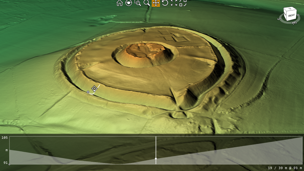
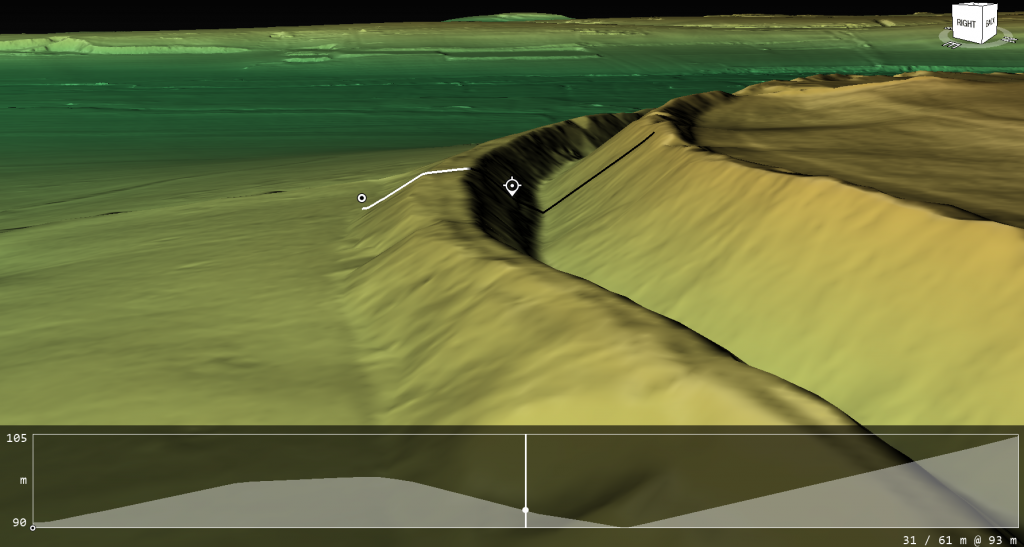
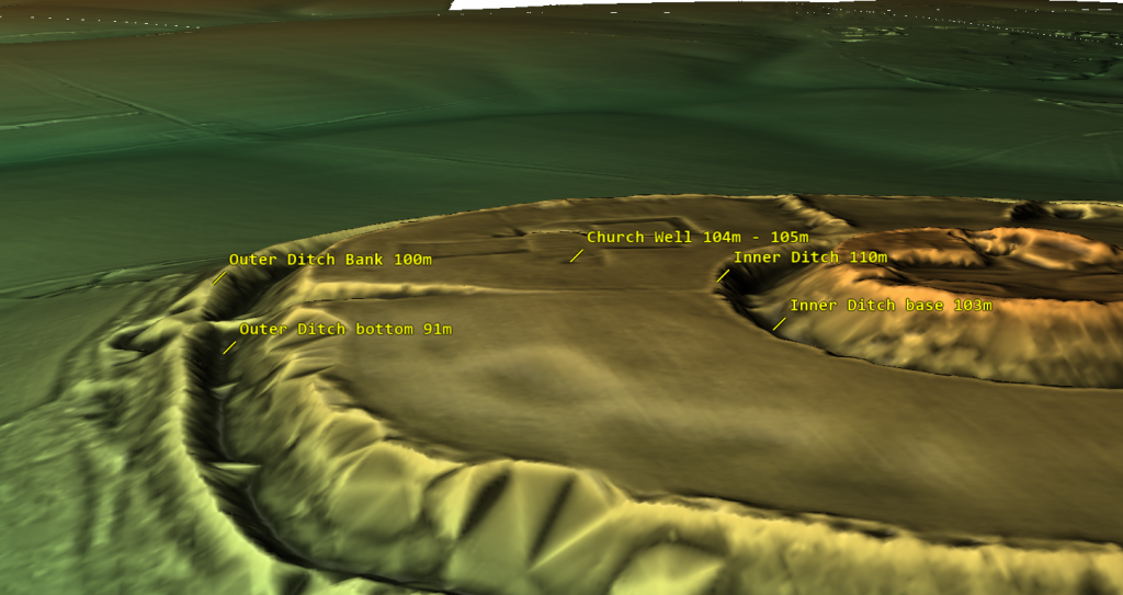
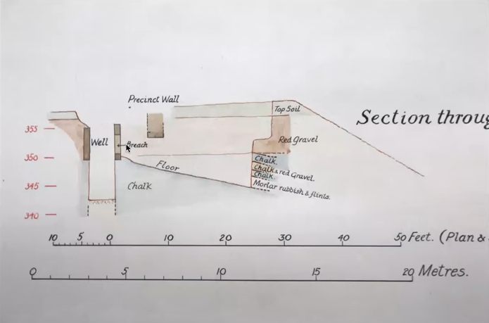
Silbury Hill / Sanctuary – Avebury Phase 3

Video Transcript (Silbury Hill / Sanctuary – Avebury Phase 3)

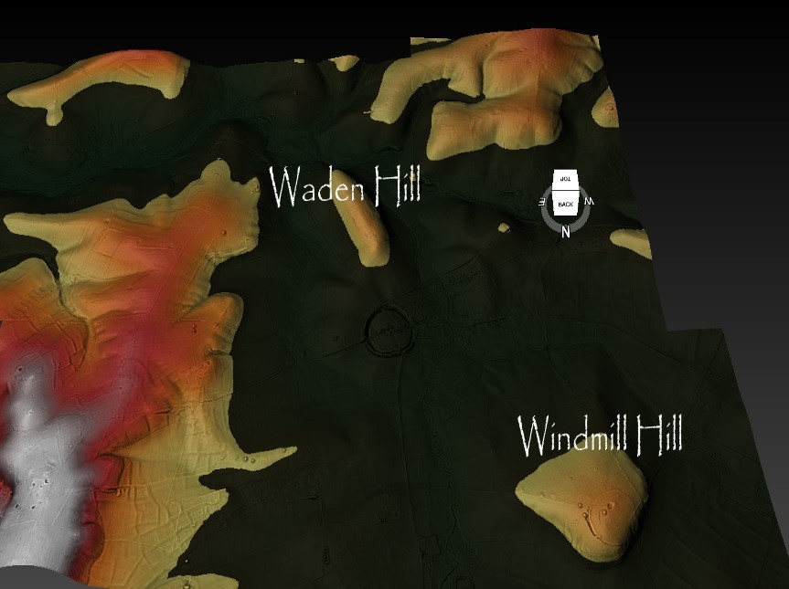
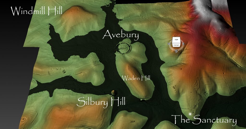
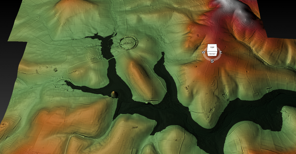
This week we look at Avebury phase 3 which is the construction of Silbury Hill the largest man-made mound in Europe, and the Avenues that led to it.  Before we do this, we need to do a quick recap just in case you haven’t looked at the previous two videos on this area; now, this is Avebury and the site around Avebury, and here, you can see quite clearly Windmill Hill which in the first video we show that these ditches around the edge at an angle met the river connects this is the river Kennet this is not sea level people get baffled this is a river.  This river which runs over the contours of the landscape, ran down here towards the Avon and this way towards the Bristol Channel; this is the Kennet as it was in the Mesolithic period, and you can see; therefore, Windmill Hill would have been constructed in the Mesolithic period as it was built on the edge of the river as we know it then.
Silbury Hill / Sanctuary - Avebury Phase 3
Avebury Landscape

That’s roughly about 180 meters high at this point here; we then saw that during the Mesolithic, the rivers would have dropped, and we get to a position in the Neolithic period where all the early, very early Neolithic period where the waters would have dropped to about we’ve got about 56 meters here.

Now that’s this point, access to this site was impossible, and therefore they built a new location here, which we know as Avebury with its massive ditches and its massive ditches would have been filled with water because the river Kennet which runs this way would have cut into the west of the site into the large ditches, and this is what we showed in great detail on video number two phase two as I call it
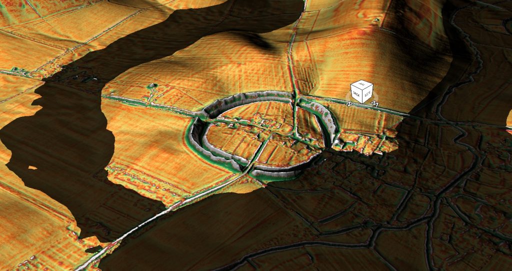
Avebury showing River Kennet filling the Ditches - Silbury Hill / Sanctuary - Avebury Phase 3
Avebury showing River Kennet filling the Ditches

This week we’re going to look at Silbury Hill and phase three because what happened during the Neolithic and probably maybe the early Bronze Age -dating is complicated, the rivers would have dropped even lower, and so this access point would have finished,  you can’t get boats into Avebury and so we have to find another route.

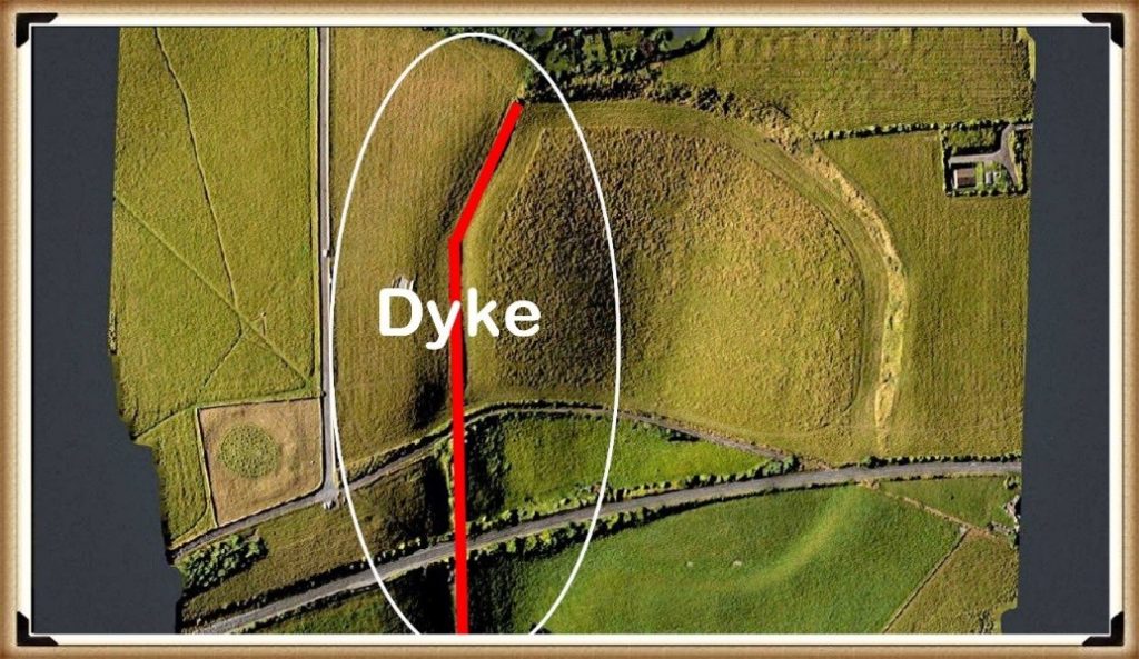
Now logically you say well why don’t you just uh it’s probably a little bit lower than this model it’s gone too far why don’t you drag the boats across land now this will be pretty marshy this would have been there they may have once upon a time a Dyke coming across and I’ll imagine that there would have been a Dike here which is now covered by the road which would try to keep the access open as long as possible but eventually as you see here it dries up rather rapidly and now we’re looking at just that 152 meters this landscape dries up quickly and therefore when the river’s dropped access to this site would have been limited and so what they’ve done they’ve actually built the harbour which needs deep water it’s not it’s not a little bit of water obviously ample water therefore we can surmise that the boats may actually be ships these could be pretty big now if you’re the the boats or ships that took the large stones to a rather must be quite massive they’re not canoes and therefore what we have a look what we see here is that a new site was created about here we know this is all being channelled out by hand and this is what’s called Silbury Hill.
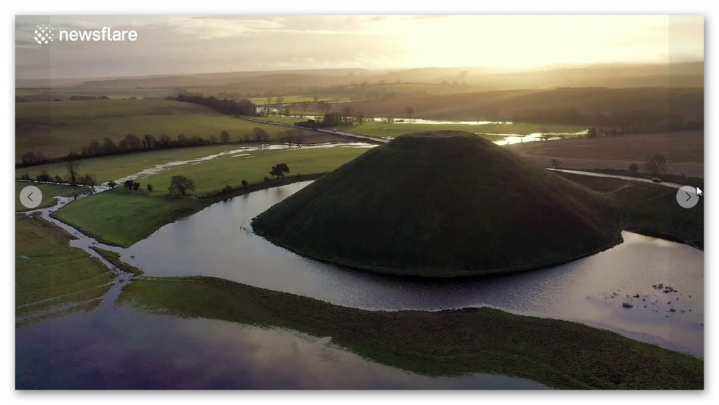
Silbury Hill showing channelled harbour - Silbury Hill / Sanctuary - Avebury Phase 3
Silbury Hill showing channelled harbour

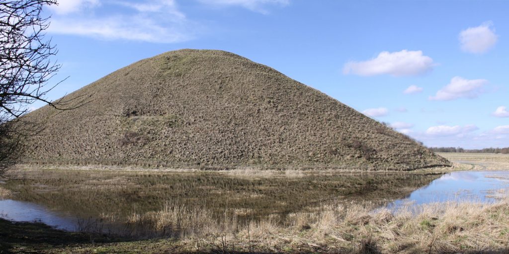
Now, what do we do we’ll have a quick look at this Silbury; this is Silbury Hill Mound here; as you see, it’s quite prominent and what we see underneath here is the effort was which was made to dig out this area to make sure that this was a natural hub for boots if I now change the angle of this to give it a bit a better representation.  What we find is that the best way to get to this mooring site here would be directly over the top of what’s known as Waden Hill, or now there’s been a stone Avenue that goes this way, but it would have gone through this marshy ground which makes you believe that this was actually headed at a much later date.
Beckhampton Ave going through the town - Silbury Hill / Sanctuary - Avebury Phase 3
Beckhampton Ave going through the town

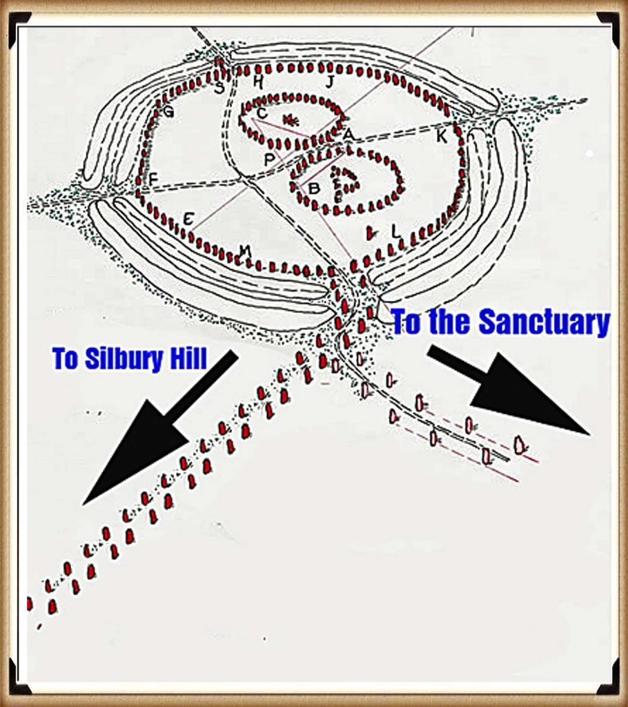
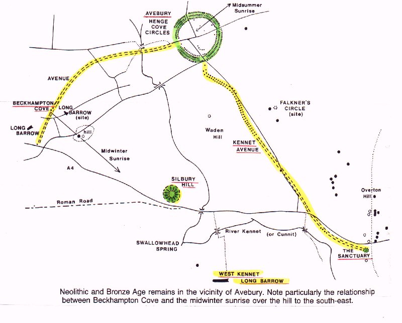
It’s entirely possible, and I wouldn’t ignore the fact that once this had dried up, you would have had a procession, a sort of causeway procession of stones going from this point here to Avebury, as you know and because they still exist.  One or two stones through it say there, but unfortunately, they’re all being dug up by, but the ones that did happen have all been dug up by the town that we know along this path here is the famous West Kennet Avenue of huge stones.

But the logic you say you’ve got the most significant man-made structure in Europe here now it’s been made for a particular reason now archaeology seem to ignore the connection between Silbury Hill and Avebury which I find rather annoying because it’s in the same see the same locality for goodness sake, so it’s not rocket science to believe that one is connected to the other back to date well up to nine up to 2014 archaeologists have failed to find a connection between the two and so it’s been left very separate.
Avebury's Lost Stone Avenue book
Avebury’s Lost Stone Avenue book

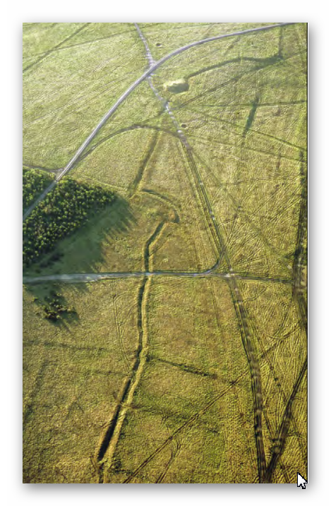
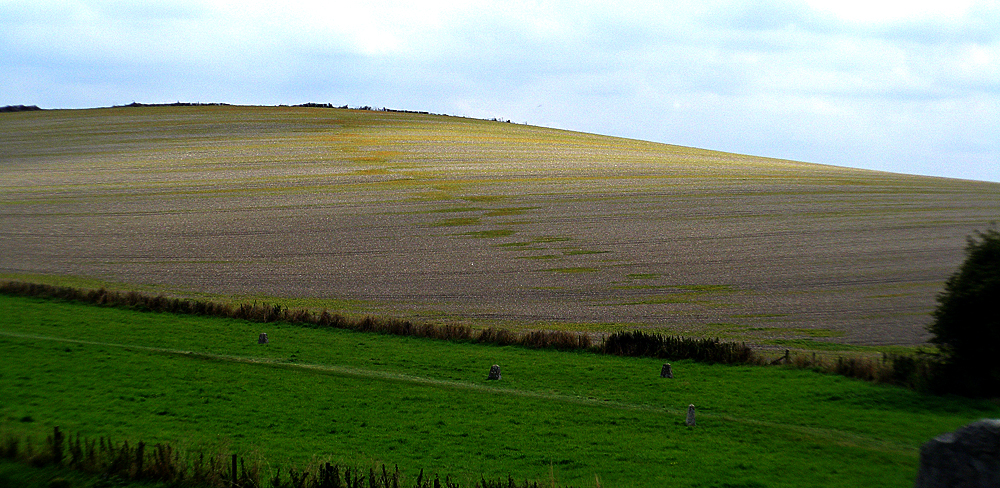
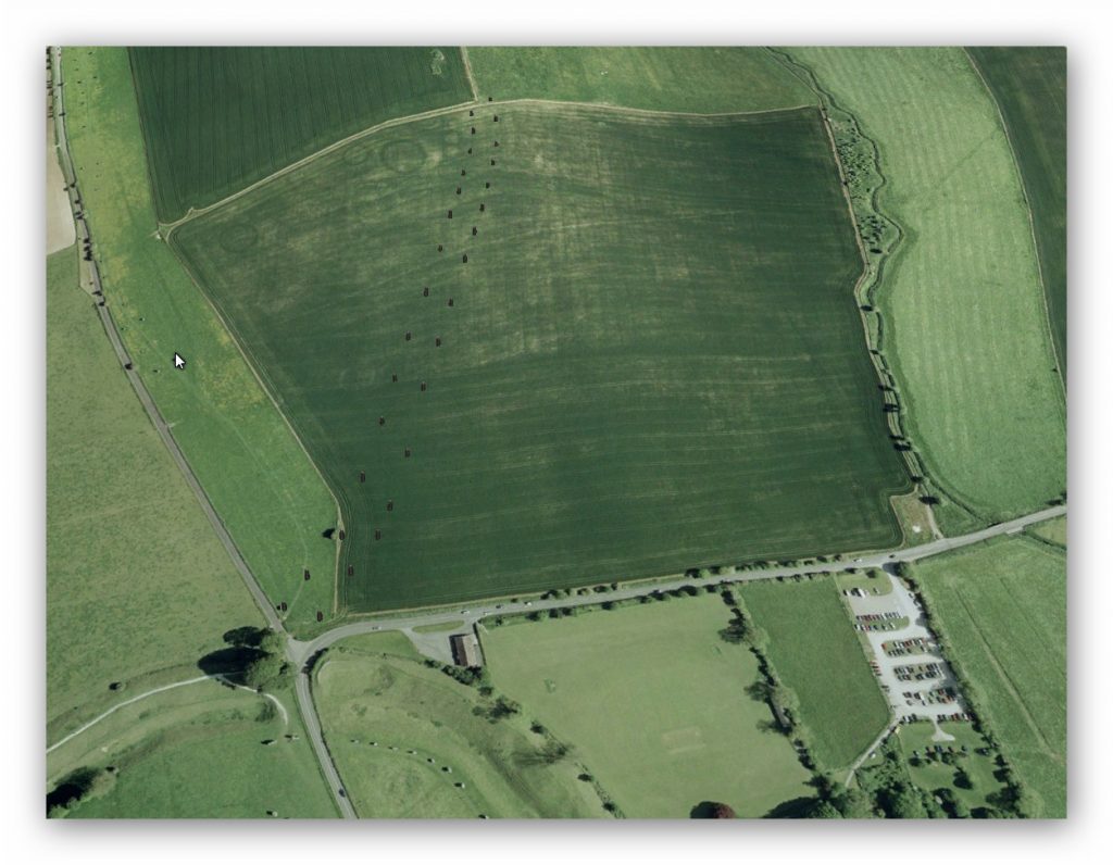
Fortunately, on one of my summer trips, I actually found Lost Stone Avenue, and there’s a book which is up here which you can see, and I published pictures.  But unfortunately, I didn’t have my drone available; several years later, I’ve been going back to try and find the stones, and I’ve been I’m successful but what I found is that there is a pathway of stones well stone holes – the stone houses have left their mark which is usually a green surface against a yellow background which you see in the photographs that’s because they’re deeper.  They’re deeper holes, obviously because they’ve taken these large assassins when they’ve been filled in there’s more because it’s a very short background there’s more subsoil in the holes, which makes them go greener and shows up as a crop mark.
Stone Holes over Waden Hill

Now, these go across as you see here and down Waden Hill, which is cool  because what we have found from my discovery is that if we turn this round, if we go down to the natural end, I don’t know.  So hence, it leaves here it goes over one hill there’s all there’s all at the top here barrows so let’s go and have a look at that here so a closer look at the barrows we’ve got we’ve got going across this hill here we know it’s been used because here are empty barrows they’ve been ploughed through this is all someone’s big field and has spent the last I don’t know 5 000 years ploughing it up.  Hence, there’s not a lot left; we got a little remember something there; who knows what that is you’re not allowed to its private property.
Barrows on top of Waden Hill

In fact, quite interesting, a friend of mine, Bob was walking here up here, and he found people excavating this area here, and he thinks they found a recumbent stone that’s flat in the ground; he did ask about it, but they refused to tell him anything because they want to claim the discovery some ten years after I found it – but then again that’s archaeology for you.
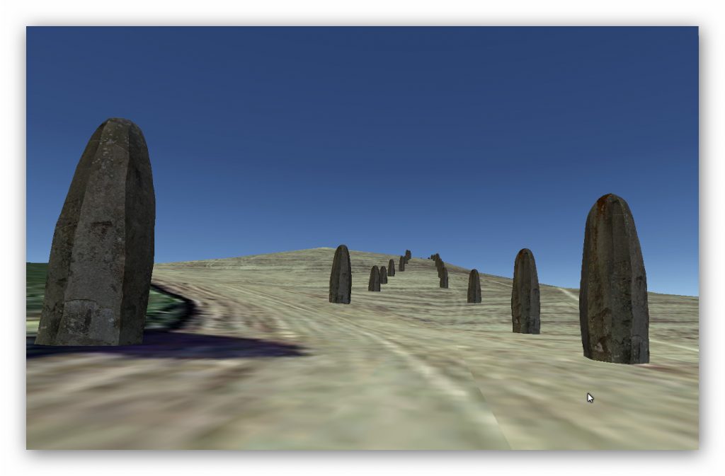
Silbury Avenue over Waden Hill

Eventually, when they published their paper, you’ll find there was a path that went across there and down there.  What I find interesting about this pathway because it could have gone this way that’s steep, and if you’re taking goods by the cart, which it would have been, it’d be like a cart if you’re taking in goods by a cart going down you know you’ll need ABS brakes it’s not going to happen – this is a much sensible longer but more shallow root and it this comes down it’s a nice little bump there oh turn this off again there’s a nice little bump there don’t know where that is it’s pretty interesting but we find that it all comes down and it ends here now this as I put in the book is quite interesting this was always believed to be a this is the Roman Road A4
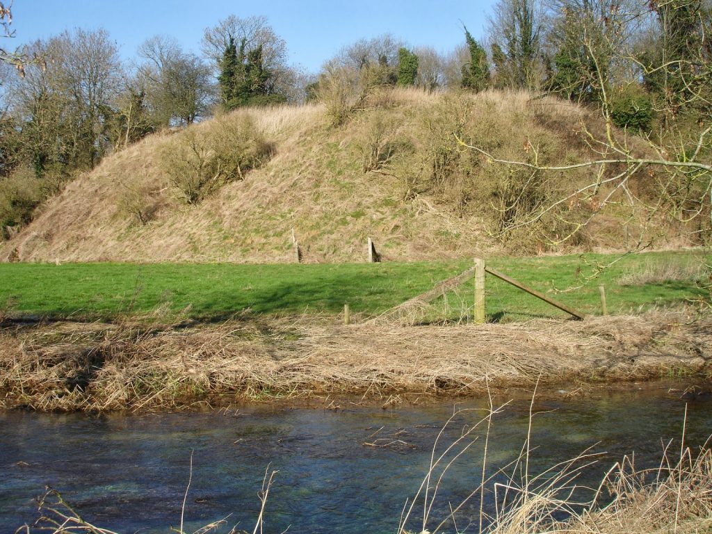
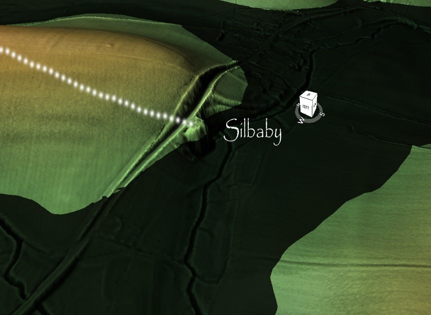
Silbaby (Waden Mound)

This was what’s being seen as a rubbish dump for the road apparently this that was the logic it’s clearly very large you know it’s not small as we see from Silbury Hill this is not a tiny little landscape feature this is quite big now in 2012 a photographer sent details he took photographs and sent details off this is a river Kennet underneath here so this is the Kennet so there’s all springs around here huge springs which was a filled in the Bronze Age Neolithic and the Mesolithic age this mound here he called Silbaby because it’s baby of Silbury which is it’s fine and he put forward the proposition that is actually historically prehistoric which was pooh pooh’d  because they said no it’s just just a mound but what we find that it’s actually on of the old maps Stukeley’s maps he shows these this this mount so it’s been around longer than the A4 certainly and it’s probably very unlikely that the Romans were piled all their rubbish in a big heap to the side of one road like that because it’s just it’s pure nonsense really.
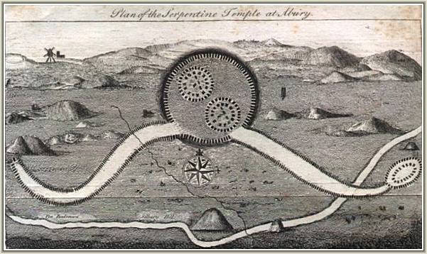
Silbably on Stukeley's map (right of Silbury Hill at bottom)
Silbably on Stukeley’s map (right of Silbury Hill at bottom)

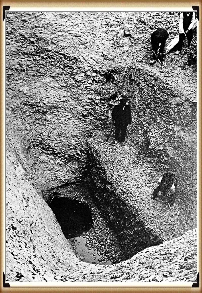
So they’ve taken core samples they haven’t excavated it which is a shame because that the only way you’re going to get proper dates is through excavator it they took core samples and they’re now freely admit that it’s at least medieval at least maybe why because you know at the end of the day the only way you’re going to find out the date of this is to actually get to the put a core sample from here all the way down the base they’ve been putting ones into the side which is lovely but this base has clearly if this has been around for 5 000 years some of this will get eroded some bits will have been dumped on with people who’ve had campfires on top and you know full hardy archaeology the only way you’re gonna get a proper real scientific date is to take that all the way down to the bottom find out where the original level is and take a core sample from there and get that radio carbon dated that has not been done and until that is done we’ll never get a real date for this but clearly clearly we see we have already seen one of these on would you believe Old Sarum if you go and look at my my Langdon investigates on Old Sarum you find identical and with the river around it landing it’s a landing point for ships.
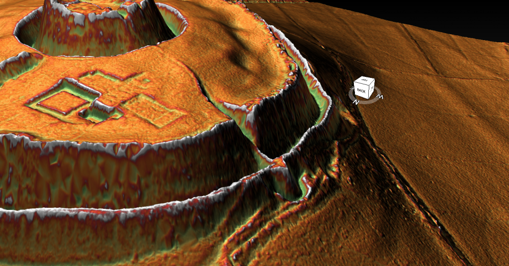
Landing Site at Old Sarum - identical to Silbaby
Landing Site at Old Sarum – identical to Silbaby

Ships would have come in landed here unloaded their goods and take it via what I call Silbury Avenue which I’m sure the archaeologists will renamed because they don’t like me – for obvious reasons can’t have that sceptic naming something – so they would have unloaded take that across all the way down to Avebury and that saved them obviously when this river dried up they couldn’t get their boats this these would have dried up as well and be the large dishes we see today and and that’s that’s the problem when you start dating these ditches you’re dating ditches when they were last used and the last used at the end of the Neolithic so you’re gonna get at best at best late neolithic date it’s rather than the dates when they were first constructed because the only way you can do that is same as Silbury is to take excavation through that that mound and find the bottom of where they the original land surface is and you date stuff from there do not date bits from ditches their their modus operandi of archaeologists is fundamentally flawed because they date sites from what’s in a ditch and the ditch has been open for so many years it’s going to have a multitude of dates it’s a it’s a complete nonsense sadly.
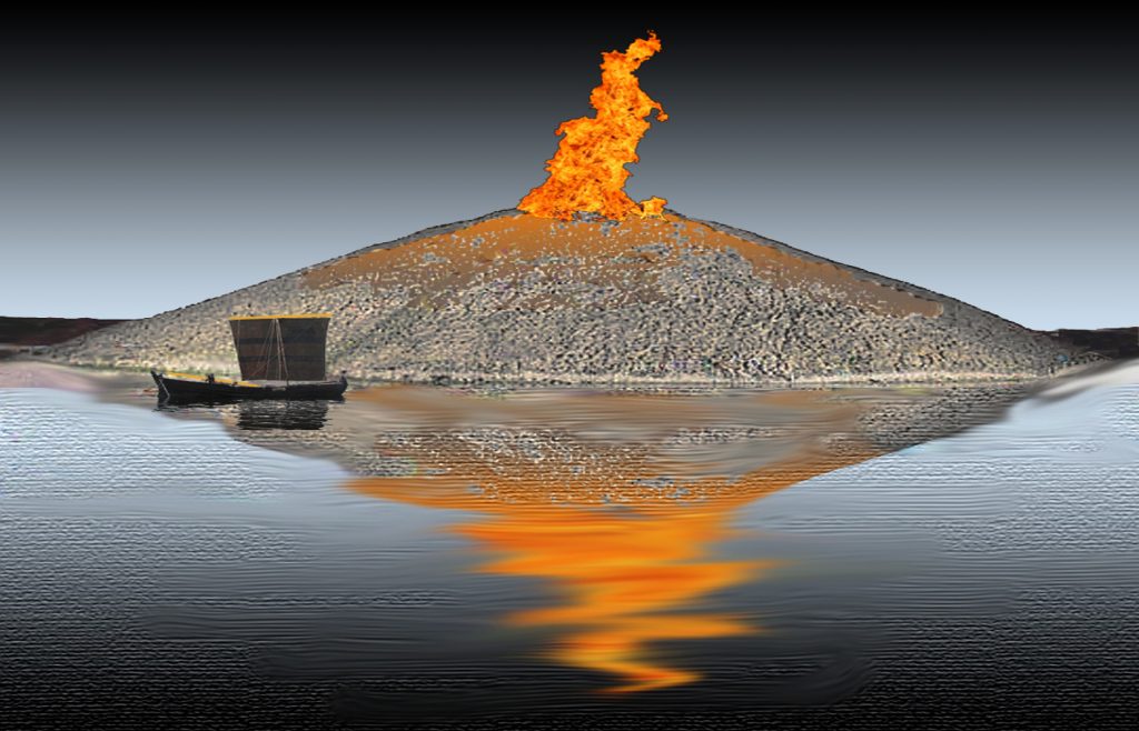
Silbury Hill Fire Beacon

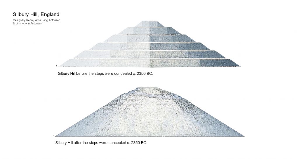
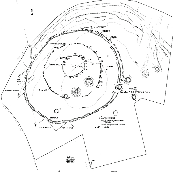
So that’s Silbury Hill and Silbury Avenue that went over Silbury Hill, so what’s this thing then – why is this here well you know I’ve left it to last because it’s obvious fire beacon what we’ve now found and this you know from time to time when we have to we do proper archaeology fantastic what we found is this looked a lot different in the past it was like a layer cake it was we’ve just down the road is another one called a Marlborough Mound now that’s done in like a layer cake effective it’s something later on in history probably the Christians didn’t like it because I don’t like anything that was pretty quick anything pre-Christian was the work of the devil and so what they’ve probably done in Christian times is made it round they’ve covered up the layers that were in it, but we now know there’s been proper archaeology done this was built over hundreds of years in different layers
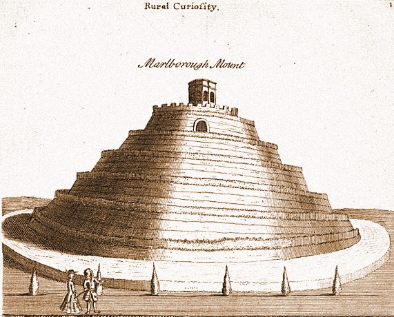
Marlborough Mount - just down the river on the Kennet
Marlborough Mount – just down the river on the Kennet

Okay so what do you do what what is built by the edge of a river in different layers to make it go higher and the logic is it’s a fire beacon at the end of the day you start low you light your fight you’ll get people from the vicinity where the the fire shows you know how do you know that the the car boot sale you know local car boot sales on well if if you’ve got a calendar you know it’s on a Sunday fantastic probably didn’t have calendars in them days just guessing on that one but what you can do is look for smoke and if this is smoke you go ah the village The Village car boot sale is on you know the the market is on people have come to sell their wares I’ll get my wares and we go and barter and buy tools or food so the the idea of a fire beacon is to tell people some events happening come along and when they do they were heading for the fire now the fire is on this side they were parked their boats on the deeper waters here they will unload their boats here and wore their boats here and they’ll take their boat their goods to market it’s pretty straightforward.

So Silbury Hill fire Beacon now even during the Neolithic a period the waters would have dropped and certainly by the Bronze Age – Silbury Hill may not being able to be used the water Kennet was carried on but these water levels would have got lower and you can see exactly the the problem you would have you wouldn’t be able to unload your boat unless you want to climb a mountain you know it’s just impractical so they moved themselves to another site and we call that site The Sanctuary and this is the Sanctuary probably in the Bronze Age like maybe later maybe I it could be Iron Age they could maybe use this site up to the eye it’s almost impossible to tell at the moment because there’s such little archaeology but here you’ve got the Sanctuary and the Sanctuary as I said lies at the end lies at the end of the  West Kennet now what I find interesting with is the West Kennet really doesn’t go although it’s there it sort of disappears around this area now that’s not a great surprise because this would have been probably the area you would have actually you never go from top down makes life easier.

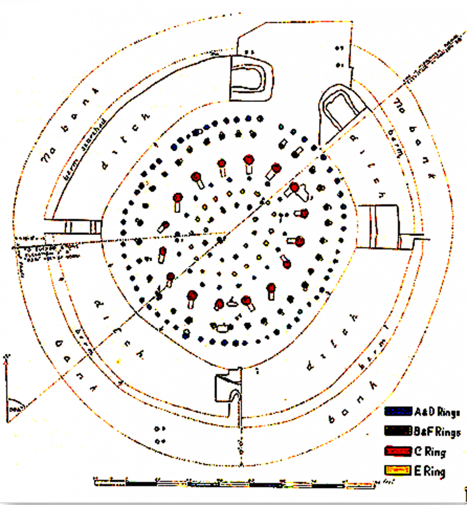
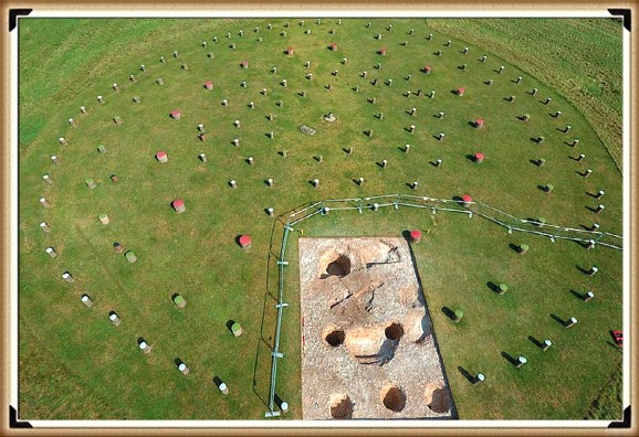
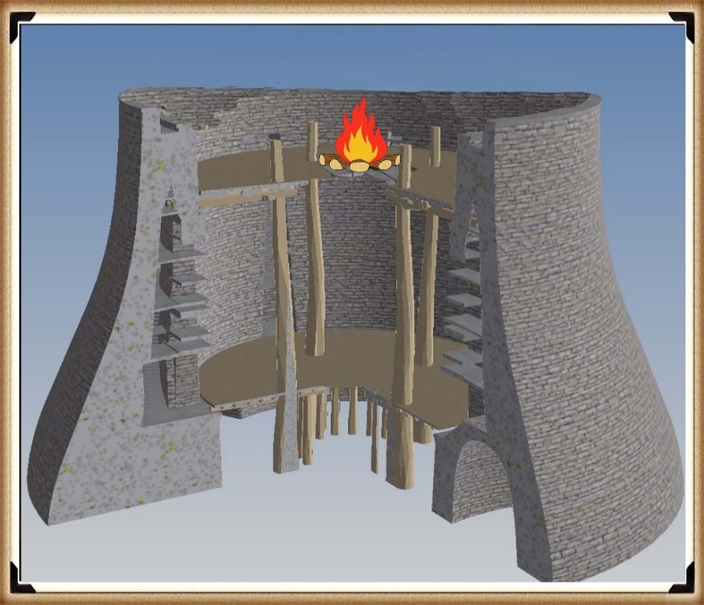
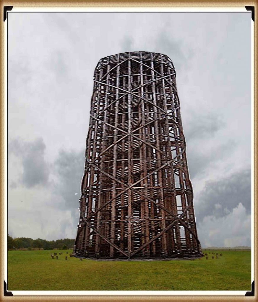
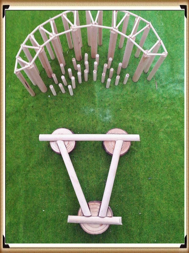
This is the area that you would have probably brought your boat; there was this the Sanctuary would have been a mini lighthouse simple enough I’ve done a I’ve done a another Langdon Investigates on Woodhenge if you want details of how they built this structure and the and the the size of the timbers take a look at that but basically you’ve got unnecessary 24 inch two foot wide timbers which take a long time to to chop down unless you’ve got metal tools but even though if you’ve got 24 feet a two meter wide pillars you’re building something high you’re not building something that looks like a little one-story house which I’ve seen as a representation of the Sanctuary it’s just nonsense.

If you’ve got a 24, you know you could do that if you want a 12-foot house, you can do a bit of four by two.  I mean, the biggest tree trunk you need is six inches, not two feet if it’s two feet, it’s going to be a lot higher than a single-story house; it’s common sense; there’s no common sense in archaeology.
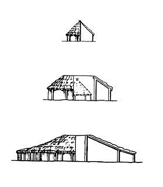
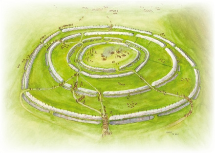
Traditional View of the Sanctuary

It’s just speculation people say what the Sanctuary is?  They go, oh it’s ceremonial it’s nonsense absolute it’s a little bit like the ditches at Avebury let me tell you it’s ceremony they do they dug down for 30 35 foot part of the ceremonial you know what’s that ceremony is it the ceremony of the digging of the ditch is that one you know we’ve got nothing better to do in life like hunting food or looking after the kids let’s dig a ditch that is 35 foot because you know yeah it appeases the Gods what a lot of rubbish.

But that’s archaeology today; sadly no common sense.  The Sanctuary was probably a mini lighthouse to show people where to park their boat, particularly at night.  Avebury if you go through every you’re a grounded your boat too late you you wouldn’t have a boat anymore you just pull it on on on the on the on the wasteland marsh and you’ll never get it off you know a bit of a waste of a boat so what you do you would have bought they were built the Sanctuary they might have actually kept that uh them out of you know why not they might have lit this um to get because it’s higher to get a greater view this is quite high as well by the way this is this is almost on on top of the Ridgeway so this this is probably about the same height so actually light in the Sanctuary if the Sanctuary will say I don’t know 50 100 foot high would probably be equivalent of Silbury Hill but people would know because it was lit that they would have to park their boats here or just around the corner from here which is probably this beach here I would imagine if I if that because we can’t get an exact representation of how the river looked in the past I would reckon that what what you have and this is quite interesting because you’ve actually got a lot of uh going on here in LiDAR so it’s always been sort of used at one point.
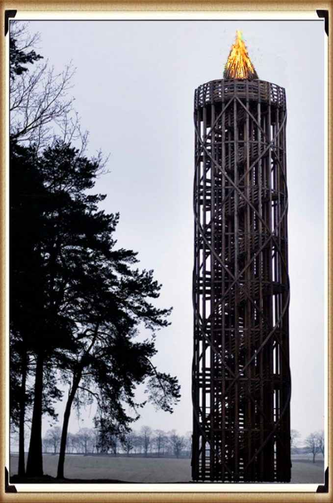
The Sanctuary
The Sanctuary

I imagine that would probably be the river level at the time of the Sanctuary.  Don’t you don’t use the Sanctuary.  The interesting thing is there is little to no evidence of West Kenner Avenue past at this point here you’ve got them up to here everybody’s walked to this part it stops here you’ve got one over here somewhere you’ve got this sort of little pathway here which is quite interesting I would imagine people would have beached their boats all along here and then walked to Avebury and walked to Avebury from this beached area.  That beached area would have been highlighted by the Sanctuary the boats would come in you would see that all we here were parked as close as this as possible the the the large stones will show them this is the way to Avebury you know, so it’s not rocket science.

So you park your boat, use the West Kennet, and go to your trading point at Avebury, which kept it alive for another maybe a thousand years.  So I mean, we’re talking about a long extended period there.  Okay well that’s it; this is we’ve now given you Avebury phase one, Windmill Hill phase two the main site phase three Silbury Hill and The Sanctuary with Commandments one because the same thing these are mooring points for uh beacons ones one’s a land Beacon and one will probably be one of the first lighthouses in the world.

 For more information about British Prehistory and other articles/books, go to our BLOG WEBSITE for daily updates or our VIDEO CHANNEL for interactive media and documentaries. The TRILOGY of books that ‘changed history’ can be found with chapter extracts at DAWN OF THE LOST CIVILISATION, THE STONEHENGE ENIGMA and THE POST-GLACIAL FLOODING HYPOTHESIS. Other associated books are also available such as 13 THINGS THAT DON’T MAKE SENSE IN HISTORY and other ‘short’ budget priced books can be found on our AUTHOR SITE or on our PRESS RELEASE PAGE. For active discussion on the findings of the TRILOGY and recent LiDAR investigations that is published on our WEBSITE you can join our FACEBOOK GROUP.
Linear Earthworks are Canals (Dykes)

When it comes to the use of ‘linear earthworks’ (we call ‘Dykes’), there is massive confusion amongst both professionals and amateur archaeologists about how such structures could function when they are dry today? (Linear Earthworks).

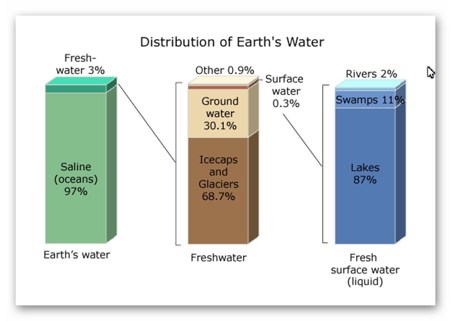
The incorrect perception of these ‘Dykes’ is either they are ‘rivers’ (like the Thames) that flow uphill or Victorian Canals with locks and wooden gates regulating the flow of the water – which are equally nonsensical as a prehistoric structures. Basic Hydrology that most people (should be but not necessarily ALL) learnt at school is that water is under the ground – not just a little water but 30% of all the fresh water on the planet.

Linear Earthworks are Canals (Dykes)
Figure 10 – Groundwater Sources – Linear Earthworks are Canals (Dykes)

This abundance of ‘groundwater’ is evident as it is the source of ALL rivers and supplies the Wells that have been dug since the beginning of time when rivers were absent. Even today, if you go into your garden and dig a hole, it will eventually fill with groundwater, whether in a valley or on top of a hill or mountain.

How and why water is on hills is very challenging for individuals as most people have a simplistic view of water being flat and sitting at ground level – but the earth is a far more complicated structure as this is the reason that it took centuries for people to recognise that we lived on a sphere and not a ‘flat-earth’ as such complex concepts such as gravity are hard to comprehend.

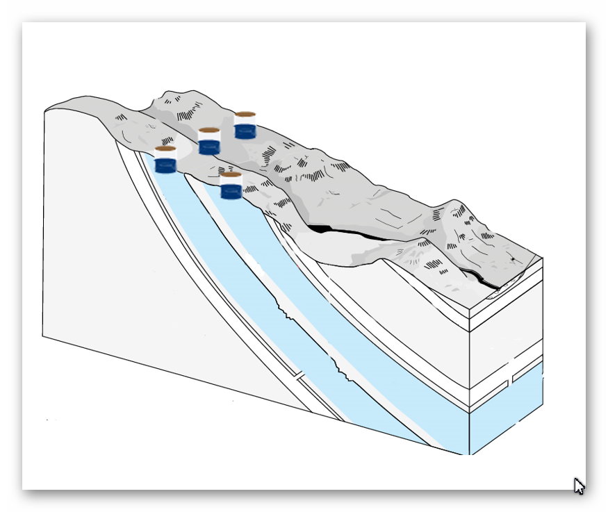
The reality is that ‘streams’ of water are encapsulated within the bedrock allowing ‘springs’ to start rivers at a great height as the groundwater is under pressure and erupts to the surface from BELOW and does not flow up or down the hill internally – but can flow downhill AFTER it escapes from the soil, because at the point of escape gravity then becomes the greater force overcoming the water pressure when within the bedrock – which stops it flowing down the landscape and can push it up to the top of hills and mountains.

Linear Earthworks are Canals (Dykes)
Figure 11 – Wells work at all levels even at top of hills as groundwater is encapsulated into the bedrock – Linear Earthworks are Canals (Dykes)

Consequently, wells work even on hills as the groundwater is encapsulated in the bedrock and soil. The above illustration shows that if wells are dug halfway up a hill where there is a groundwater pocket, they will fill – if we join up these wells, the entire ditch will also fill with water – sourced from the ground.

The central aspect that must be remembered when considering the reasons behind the construction and maintenance of these earthworks (Dykes) is that the environment was so much different in the Mesolithic Period, which changed rapidly when entering the Neolithic and then even more changes in the Bronze and Iron Ages.

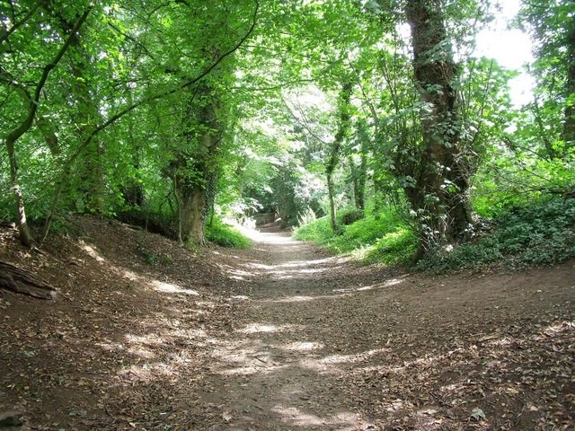
Once the ice sheets had melted and the climate began to warm, the landscape gradually changed from open tundra to dense woodland. By around 8000 BC, pine and birch dominated the woodland cover. These were slowly replaced by lime, elm and oak with some hazel. By 6500 BC, pine and birch woodland would only have been found on the thinner limestone soils of the uplands.

Linear Earthworks are Canals (Dykes)
Figure 12 – Britain 8000 BCE would be a flooded tree covered environment – Linear Earthworks are Canals (Dykes)

With up to 90% of the land covered in woodland or another, the Mesolithic people needed all the open ground they could find to hunt larger animals like deer using their flint-tipped bows and arrows. The lakes also provided plenty of minor game, such as birds and fish.

We know that the hunters were here because archaeologists have collected thousands of their flint artefacts from sites around both lakes and rivers. Recent fieldwork and excavation by Bradford University around Malham Tarn have thrown more light on the people who used it as a hunting base. In the later Mesolithic, people were camping out on areas of slightly raised ground close to the shore of the Tarn. Geophysical survey work has shown several possible hearths at one of these campsites.

Charcoal has also been found in Mesolithic contexts in the wetlands above the Tarn. It seems likely that the hunters burned back the edge of the woodland to create more open ground for their prey to graze on. This would also have favoured the growth of hazel since, unlike other woodland trees, hazel grows back quickly from a burnt stump. With hazelnuts being a significant winter food source at this time, the people may have had this aim in mind too. People had begun to alter their environment, and it was the beginning and end of the wildwood in the Neolithic Period.

Consequently, at the time of the construction of Dykes the water table was still high, and rivers and wetlands dominated the landscape.  When looking at the landscape of these Dykes (particularly our case studies of Offa and Wansdyke), we notice that the earthworks are not consistent or continuous.  Fell walkers who have followed these features on foot have trouble accepting that these were canals abandoned long ago and hence are just a shadow of their former selves.

If we compare other known abandoned canals from just a mere 100 years since their abandonment, we see there look remarkably the same, and even today, people find it difficult to accept these empty hollows were once part of a massive ‘super highway’ of the Victorian era that linked cities of trading together – like our ancestors Dykes. 

The gradients of some of the valleys these features follow have also given walkers great concern as if water had been within the ditch, they perceive, it would all run away to the bottom of the valley, leaving the canal ditch dry and a large lake at the bottom.

Linear Earthworks are Canals (Dykes)
Figure 13 – Not Offa or Wansdyke but A dried Victorian Canal

The problematic conclusion with this analysis is that the walkers rely on OS maps (for accuracy), and they show these Dykes as continuous features – but the reality, if we look at the ‘scheduling of these monuments’ through Historic England, this is far from the truth. As we have shown in case studies on my web site, most of these earthworks stop at the top of the valley hill and continue on the other side as if there was something in between?

We find that there is indeed something in between these breaks, and it’s called water, as, at the time of construction, the river levels were higher, and these valleys would have been flooded. So, they would paddle across the riven.

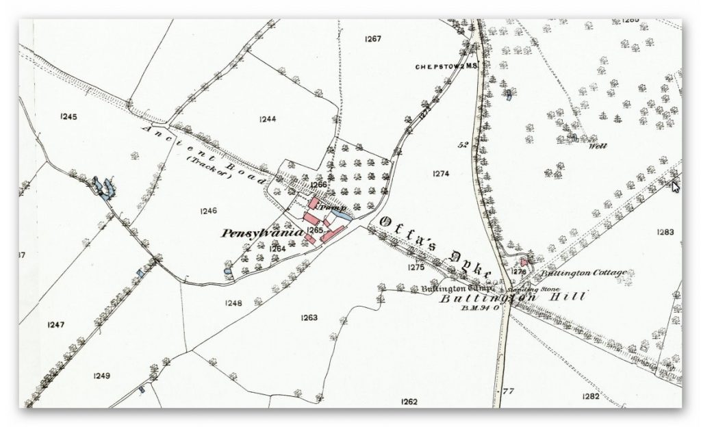
Moreover, what we see added at a later date are extensions to the original Dyke to follow the falling river levels down the valley in sections and to a different specification to the above initial earthwork. This can be shown in the area of Offa’s Dyke just outside Chepstow, where the Dyke enters the valley but seems to stop at the top and then other partitions are added later.

Linear Earthworks are Canals (Dykes)
Figure 14 Offa’s Dyke nr Chepstow – showing its not continuous – Linear Earthworks are Canals (Dykes)

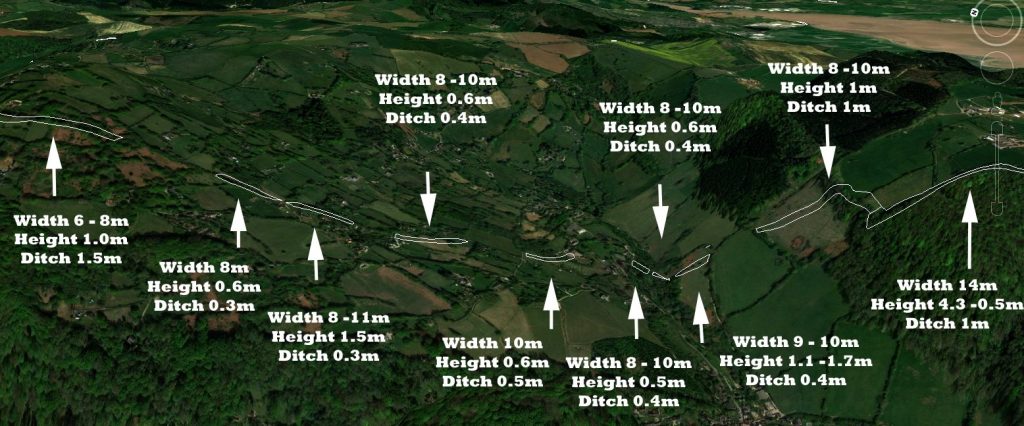
In the above GE photo, we see that the extracts of Offa’s Dyke that enters the dry river valley change in character except for one aspect – the width of the bank.

This evidence suggests that when the rivers fell in the Neolithic/Bronze Age, they may have adapted the route to place ‘ponds’ (small lengths of Dyke with water) to allow boats to cross the dried river channel. If we look at the far Right connection between the main Dyke and the first Pond, we can see that they may have been a small channel (1m) connecting the 10m wide ditches, which would have been fed by water between the ponds without over spilling and emptying the pond – a prehistoric lock system.

Linear Earthworks are Canals (Dykes)
Figure 15 – There is a connection between the larger Ditches that look small and thin

So, what makes the width of the bank so important?

The width gives us a clear view of how the use of this earthwork changed over time.  What we see today is not what was initially built in prehistoric times – then the ditch was of greater importance, and then as the water table fell over many millenniums, the bank became of great significance and adapted.

Linear Earthworks are Canals (Dykes)
Figure 16 – Typical Dyke Profile – Linear Earthworks are Canals (Dykes)


The bank needs not to be so vast unless it has changed from being a towpath (only 2 – 3m wide) to a road that took two-way traffic.

Interestingly, Dyke banks have developed to become the same width as a standard Roman Road (5m – 10m). However, our Offa example shows that the road (bank) is 6m – 14m and only 0.4m to 1m in height.  This suggests that the Dykes purpose changed in later use, and looking at the 1800 OS map; this is confirmed as Offa’s Dyke is marked as an ‘ancient road’.

Linear Earthworks are Canals (Dykes)
Figure 17 – Offa’s Dyke an Ancient Road? – Linear Earthworks are Canals (Dykes)

This would explain why the ditch became more shallow down the dry valley, and on the Historic England monument reports, a copious number of ‘Pits’ were found next to Bank, indicating that the contents of these pits were used to widen the road later than the original ditch.

We can only speculate that the ditch, which is only half to a third of the size of the ditch outside the dry river valley area, was still used as a canal initially and then was entirely abandoned for a road when the water table diminished.

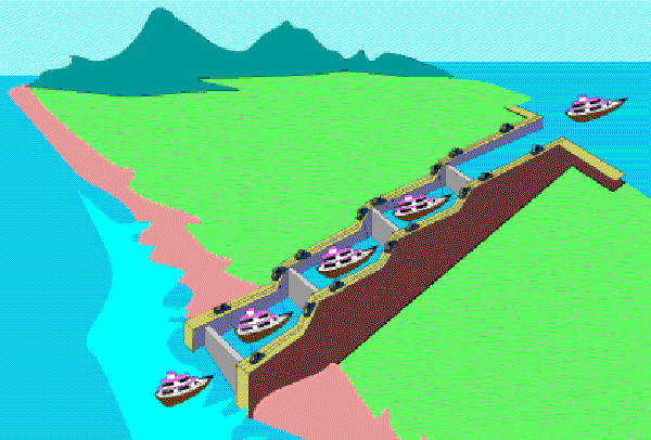
Looking at how the Victorian engineers used locks to go up and down hills does give us an alternative possibility to how our ancestors regulated the flow of the canals allowing them to cross hills with minimal fuss.

Linear Earthworks are Canals (Dykes)
Figure 18 – Modern LOCK solution over hills – Linear Earthworks are Canals (Dykes)
Linear Earthworks are Canals (Dykes)
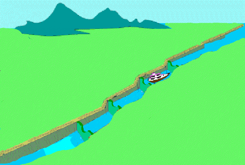
Figure 19 – Prehistoric solution to a lock allows puddles of water to form and not flow downhill but allows dragging the boat over weirs or through narrow channels -Linear Earthworks are Canals (Dykes)
Linear Earthworks are Canals (Dykes)
Figure 20 – Isolating water levels is not rocket science and is achieved all over the world – Linear Earthworks are Canals (Dykes)

We have seen with Offa’s Dyke (fig. 13) that if you cut small unconnected ditches, the water will remain inside the channel and not flow downhill. Therefore, you can access this channel by cutting a small connecting ditch which is very shallow – this allows boats to move between channels without the large ditches losing water.  

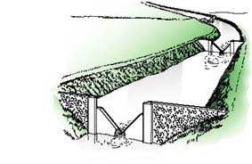
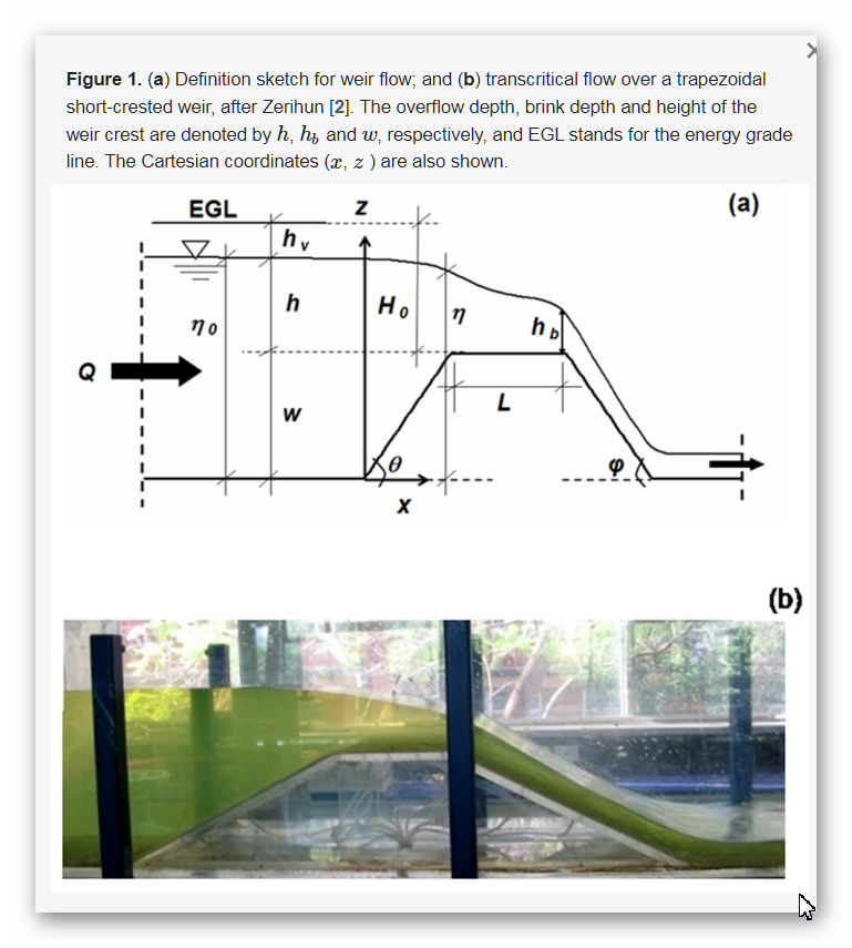
This same principle can be seen with wooden weirs that have a small grove or cut, allowing only a tiny amount and a boat to move from channel to channel, or a combination of both with ponds with narrow ditch channel connections and Weirs on vast stretches to regulate the flow.

Linear Earthworks are Canals (Dykes)
Figure 21 V-Shaped Weirs – Linear Earthworks are Canals (Dykes) – Linear Earthworks are Canals (Dykes)
Linear Earthworks are Canals (Dykes)
Figure 22 V-Shaped Weirs still in operation – Linear Earthworks are Canals (Dykes)

Where ‘Springs ‘ do sprung!!

My recent investigations into another prehistoric Dyke that the Romans reused, called the Vallum by Hadrian’s Wall, have shown that Dykes can not only trap water, but they can also place the Dyke over or close to ‘Springs’ to allow the ditch to replenish its loss of water due to the gradient losses.

Rivers are formed from ‘springs’ and gain greater volume from ‘runoff’ from surface water (rain) or other interacting rivers. What we have found with the Vallum (and we believe this occurs in both Offa and Wansdyke) is that the Dyke was constructed on top of some ‘Springs’ or within 200m of other springs (which would indicate that the water table was just under the surface) and so a ditch of 1m to 2m would fill with groundwater – but under pressure that would naturally replenish if it moved downhill like a river.

The speed of the replenishment would depend on the depth of the ditch – the more deep the ditch, the more the water as the soil/rock is removed, lessening the resistance to the water.  Springs give out a massive amount of water depending on their closeness to the surface:

Linear Earthworks are Canals (Dykes)
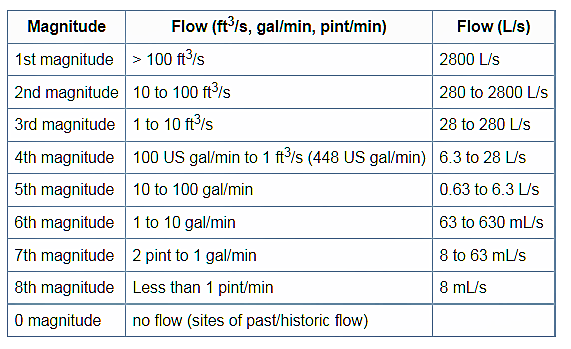
Figure 23 – Spring Flow rate (even today) – Linear Earthworks are Canals (Dykes)

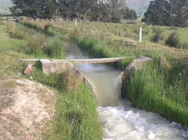
As you can see, a significant spring can pump out as much as 2,800 litres PER SECOND, and you might tap into several spring on a canal length – this water would naturally run downhill, and on a steep incline, the water will have to be managed. The simplest way of dealing with fast downhill currents (so you can take your boat up the opposite way with ease) is to create a series of weirs (artificial barriers); these can be either by narrowing the sides or under the water to slow the flow rate and dam up the water stream.

Linear Earthworks are Canals (Dykes)
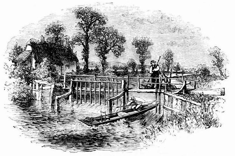
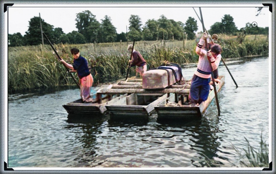
Figure 24 – Early Thames Weir – Using paddles/planks – Linear Earthworks are Canals (Dykes) – Linear Earthworks are Canals (Dykes)

The early Victorian Canals had no locks but weirs. These weirs regulated the flow downhill by placing a wooden barrier (weir) in the canal and leaving a small gap to one side to allow boats to either go up (with the assistance of a winch) or down, keeping a majority of the water upstream of the canal by a gate that could make panels of wood of ‘paddles’ depending on the volume of the water flow. These are more effective than Locks as the boat needs not to stop to pass – but are required to have the weir almost manned full-time and therefore at a higher cost in Victorian times, not necessarily in prehistoric times.

Linear Earthworks are Canals (Dykes)
Figure 25 – More complicated underwater Weir – but easy to construct – Linear Earthworks are Canals (Dykes)

What has surprised us about this technique is the number of ‘springs’ that are in the vicinity or under the Dyke (Vallum) – the construction is about 70 miles long, and we have found over 65 springs associated with the struct (about one spring per mile), but these are TODAY’S reported springs – we have not taken into account (because there are no maps) the more significant number of ‘Springs’ that would have been in that Dyke construction area at the time of construction (so we could be looking at 100+ springs if not more!!) this volume of water would keep any structure supplied with water at whatever gradient it took.

Linear Earthworks are Canals (Dykes)
Figure 26 – Why would you build something on a Spring? – Linear Earthworks are Canals (Dykes)
Linear Earthworks are Canals (Dykes)
Figure 27 –  Springs around Dykes indicate a High Water Table at the time of Construction – hence the pond in the middle of the Vallum – Linear Earthworks are Canals (Dykes)

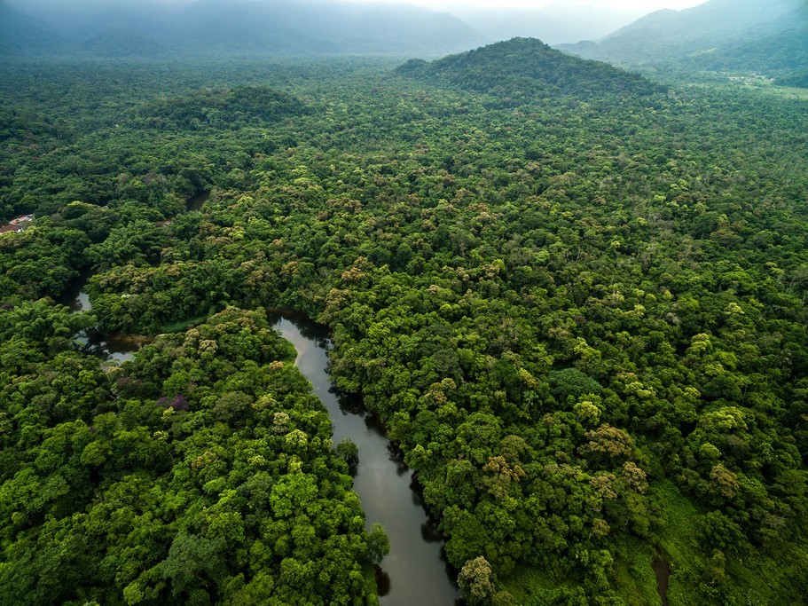
To understand how these canals worked in hillsides of Britain, where today they are dry and barren, you need to appreciate the landscape after the last ice age. As we have already started, the environment was primarily covered (90%) with woodland and trees.  This is because the water was abundant on the land as the water table was incredibly high.

This made the landscape almost like a latter-day tropical rainforest rather than the grassy plains we see today.

Linear Earthworks are Canals (Dykes)
Figure 28 – Mesolithic Period has 90% Woodland and Tree coverage- even over the hills – Linear Earthworks are Canals (Dykes)

The high-water table is a direct consequence of the last ice age, which, at its maximum about 30k years ago, had most of Britain under two miles of the ice cap.  The melting of this 361.8 gt of water, or 67,000 inches of water per square inch, flooded the soil, which it could not absorb, so it leaked out for thousands of years at all elevation levels.

Linear Earthworks are Canals (Dykes)
Figure 29 – Offa’s Dyke as we see it today – Linear Earthworks are Canals (Dykes)

This shows why rivers were at their highest level in history in the Mesolithic period and how easily it would be to find the water table if you dug a well or in this case a ditch some 7,000 years ago – which is the current estimated date of the construction of these Dykes.

Linear Earthworks are Canals (Dykes)
Figure 30 – Offa’s Dyke in the Mesolithic with the Higher Water Table – Linear Earthworks are Canals (Dykes)

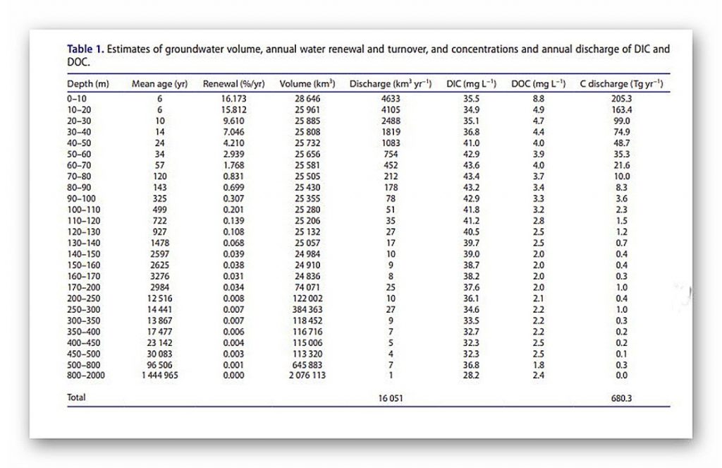
This leaking of ground water into the environment can be found in SEA LEVEL CHANGES, but (Table 1) this constant flow and replenishment of groundwater are shown in another measurement, such as the age of water in the groundwater aquifers.

These dates show that water entered the groundwater table in vast quantities in the Ice Age – but stopped for six thousand years – so did it stop raining for 9,000 years? Or was more water coming out than entering the ground at this time and beyond?

Linear Earthworks are Canals (Dykes)
Figure 31 – The Age of Water – Linear Earthworks are Canals (Dykes)

The Age of Water table shows that most waters were placed in the landscape soils during the ice age, and it seeped out for 9,000 years before the rainfall penetrated the land again.

 The reason for the construction of Dykes in the past is shown by the sheer volume of ‘Linear Earthworks’ found in the Northern Hemisphere.  There are 1497 Scheduled Dyke sites found covering the entire British landscape – from the known Offa and Wansdyke to the East Coast, Ireland and Wales and now we have even found that the Vallum connected to Hadrian’s Wall was also once a prehistoric Dyke that the Romans reused to convey the stone to the Walls.

The idea that these features are Medieval (although they may have been reused at that period) in origin is impossible as they are found as far as field as Southern Ireland (a mere 147 Dykes) and on both the Shetland and Scilly Isles – too widespread to be these so-called ‘Saxon’ boundary/ defensive markers.

Why do archaeologists and geologists have so much trouble understanding past river and water levels?

We have shown in our trilogy ‘Prehistoric Britain’ that other ancient ditches contained water from the high water tables of the past that also fed local active ‘springs’ which flowed into the local rivers – like the River Avon next to Stonehenge, which consequently raised the River’s water level that flooded the area by ‘The Avenue’ known as Stonehenge Bottom.

Archaeologists who have attempted to investigate this possibility, like Julian Richards in his book ‘The Stonehenge Environs Project’ concluded that it could not be possible or was at a much earlier date, as their expert Geologist has assured them that the amount of ‘alluvium’ (sandy silt) found at the site was insufficient in volume. Sadly, this was ‘Bad Science’ as any true expert in ‘Hydrology’ would have told them – for alluvium is only produced when a river flows rapidly (due to surface runoff), cutting down rocks and stones that create this sandy, silty substance.

Water from a spring does not create ‘alluvium’ as it is from ‘Aquifers’ and not rainfall runoff – as this article from Wikipedia on chalk streams qualifies.

Chalk Streams (Wikipedia)

Chalk streams are rivers that rise from springs in landscapes with chalk bedrock. Since chalk is permeable, water percolates easily through the ground to the water table and chalk streams therefore receive little surface runoff. As a result, the water in the streams contains little organic matter and sediment and is generally very clear. The beds of the rivers are generally composed of clean, compacted gravel and flints, which are good spawning areas for Salmonidae fish species.

Since they are fed primarily by aquifers, the flow rate, mineral content and temperature range of chalk streams exhibit less seasonal variation than other rivers. They are mildly alkaline] and contain high levels of nitrate, phosphate, potassium and silicate.] In addition to algae and diatoms, the streams provide a suitable habitat for macrophytes (including water crowfoot) and oxygen levels are generally supportive of coarse fish populations.

Of the 210 rivers classified as chalk streams globally, 160 are in England.

Chalk is a highly porous and permeable rock, and rain falling onto chalk topography percolates directly into the ground, where the chalk layer acts as an aquifer. The groundwater flows through the chalk bedrock, re-emerging lower down the slope in springs. The chalk acts as a temporary reservoir by regulating the amount of water supplied to the springs.

This is why many chalk streams in the UK have stable flow regimes that vary only slightly over time. The temperature of the emerging surface water is fairly stable and rarely deviates from 10 °C (50 °F). On cold winter mornings, water vapour from the relatively warm stream condenses in the cold air above to form fog.

Chalk is slightly soluble in rainwater because rain is naturally slightly acidic. The products of chalk weathering are dissolved in rainwater and are transported in stream flow. Chalk streams transport little suspended material (unlike most rivers), but are considered “mineral-rich” due to the dissolved calcium and carbonate ions.

The surface water of chalk streams is commonly described as “gin clear”. The channel bed consists of angular flint gravel derived from the natural flint deposits found embedded within the chalk geology that contains relatively low amounts of clay and silt deposits.

The unique characteristics of chalk stream ecology are due to stable temperature and flow regimes combined with highly transparent water and lack of sand grade sediment particles.

Chronology

The dating of these linear earthworks can only be achieved by looking at the rivers these features interact with and connect to that form the Dykes we observe today – which are now just dried up ‘Dry River Valleys’ also known as ‘Paleochannels’ by geologists. However, a recent publication by Historic England also admits that these features are much older than first believed because older dated items are being found on each new excavation.

Prehistoric Linear Boundary Earthworks: Introductions to Heritage Assets. Swindon. Historic England 2018.

Linear earthworks are not always easy to date: often, they contain little dateable material and in many cases they are likely to have been repeatedly cleaned out or refashioned so that evidence for their origins has potentially been removed. Superficially, their form is not often diagnostic, so prehistoric examples can be confused with medieval or later ones. For this reason, amongst others, associations with other monuments are extremely important.

Linear Earthworks are Canals (Dykes)
Figure 32 – Chapperton Down, Wiltshire – Linear Earthworks are Canals (Dykes)

In some cases, survey can demonstrate that linear earthworks are aligned on, or even impinge upon, pre-existing monuments such as burial mounds and hillforts.

A number of other hillforts, such as Woolbury, Danebury and that on Quarley Hill, all in Hampshire, or Sidbury in Wiltshire, were established at the junctions or terminals of pre-existing linear earthworks. In these cases, understanding of the associated monuments can make a vital contribution to the understanding of the function and date of the linear earthworks.

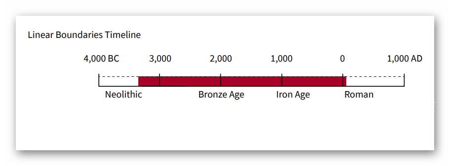
Overall, it would seem that boundaries were constructed, in one form or another, from the early Neolithic onwards. The earliest ‘conventional’ linear earthwork so far confirmed, dating to around 3600 BC, follows the crest of the western escarpment of Hambleton Hill, Dorset, for perhaps as much as 3 km. It comprises an almost continuous bank and segmented ditch, thus similar in form to two causewayed enclosures on the adjacent summits.

Land boundaries appear in greater numbers from the middle of the Bronze Age, around 1500 BC, apparently coinciding with pressure on land brought about by increasing population levels and perhaps with the rise of powerful rulers who were able to command large workforces. Some of these early boundaries, as well as newly constructed ones, continued to structure the social and economic landscape through the Iron Age and into the Roman period. Indeed, some have seen continuous use, or repeated re-use, from prehistory to the present day.

The construction and initial use of pit alignments may have spanned a somewhat shorter period, though a number were re-used subsequently.

On Chapperton Down, Wiltshire, within Salisbury Plain Training Area (Fig. 30) , a linear earthwork is aligned on a Neolithic long barrow, cuts through earlier fields, and changes direction sharply to avoid a pre-existing settlement.

Some of the earliest seem to date to the later Neolithic period: on Ebberston Common the latest of the sequence of at least six pit alignments appears to predate the construction of a round barrow which would typically date to the earlier Bronze Age, around 2000 BC. Relatively few pit alignments seem to have been created after the Early Iron Age. Excavations elsewhere have discovered other anomalies, however, constructed in the Roman period and even in the 18th century. So-called ‘multiple ditch systems’ appear to have originated in the late 2nd to early 1st centuries BC and to have continued in use into the Roman period. This makes them broadly contemporary with the oppida with which they share various characteristics.

Linear Earthworks are Canals (Dykes)
Figure 33 – Linear Boundary Timeline – Linear Earthworks are Canals (Dykes)


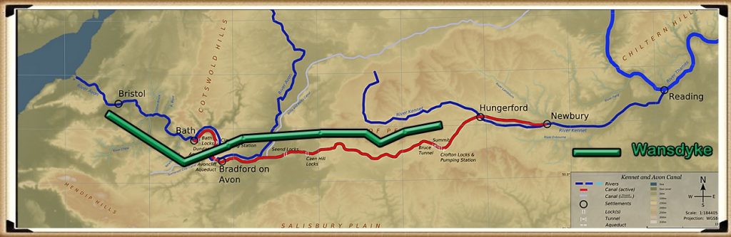
Case Study Wansdyke – Morgan’s Hill West

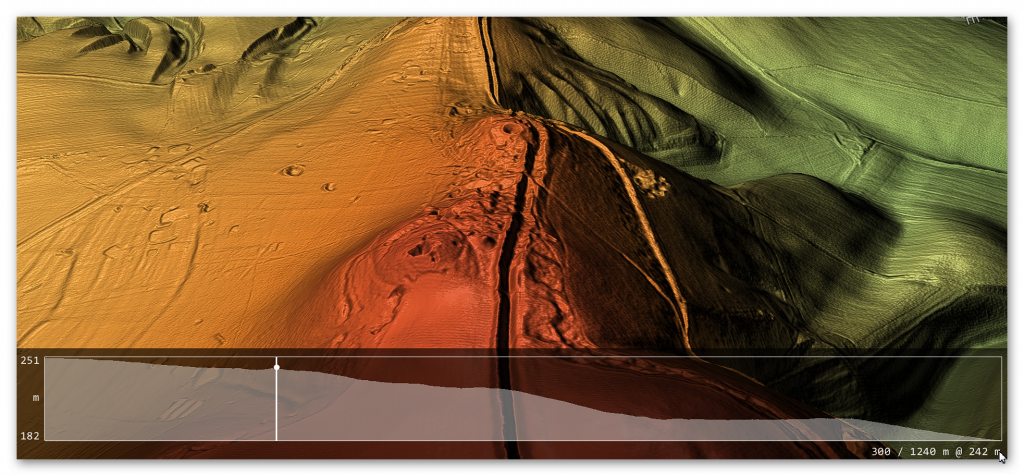
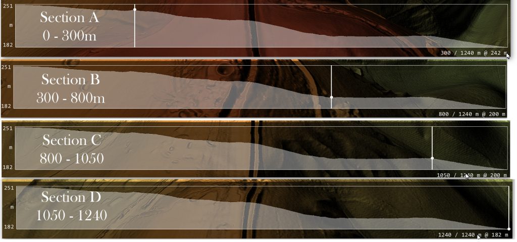
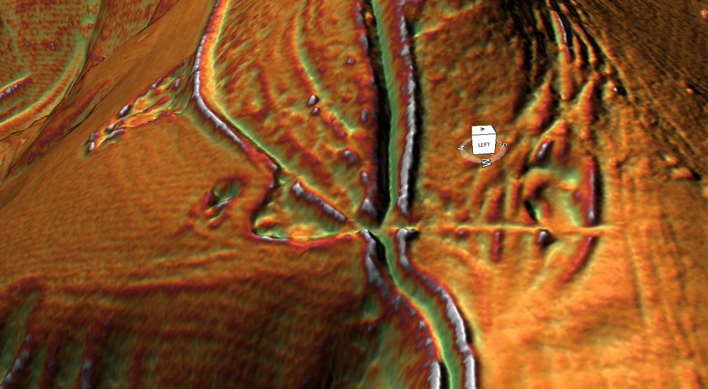
The steepest aspect of Wansdyke is the rise over Morgan’s Hill, which is an incline from 182m OD to 252m OD.

Linear Earthworks are Canals (Dykes)
Figure 34 – Morgan Hill West (Wansdyke) – Linear Earthworks are Canals (Dykes)

If we are correct with our assumption, we need to show that you can transverse this massive incline using natural springs and basic wooden weirs.  If we split the gradient into four parts, we can see better the profile and problems our ancestors faced.

Linear Earthworks are Canals (Dykes)
Figure 35 Morgan’s Hill West in Sections – Linear Earthworks are Canals (Dykes)

Section A – 0 to 300 downhill

Length is 300m, and the inclination lowers from 251m OD to 242m OD at a ratio of 3% or 1:33 – If we accept that within this section, we had four cat A ‘springs’ that would release 11.2 cu. metres of water PER SECOND (11,200 litres per second) would fill a 10m ditch that is 1.5 deep by one-metre width of the Dyke’s ditch every SECOND.

According to the mathematical formula (v = k * C * R0.63 * S0.54 ), water at the end of section A would be travelling at 5 MPH – the speed of the Thames at Henley (so quite navigable) and, therefore, no need for any Weirs to reduce the water flow.

Section B – 300 to 800m downhill

This section would receive water at one metre per second from Section A, travelling at 5 MPH – The length of this section is 500m in length, and the inclination lowers from 242m OD to 200m at a ratio of 8% or 1:12 this would accelerate the water to 15 mph which is too fast the navigate uphill. Therefore, a series of weirs would have been placed either under the water or, as the early Victorians achieved, by a paddle weir or both.

An underwater weir (blocking 50% of the water but allowing boats to move over the top without hindrance) would reduce the flow by 50% – so if placed at the End of Section A (at 5 MPH) would reduce the water flow to 2.5 MPH and down to 12.5 MPH at the End of Section B. Consequently, if we place one of these 50% reduction weirs at 100m intervals the water flow would not go over the 5-mph mark and would probably be in the region of 3 – 5 MPH which again is easily navigable.

Section C – 500 to 1050m downhill

The length of this Section is 550m at an inclination of 0% – its flat the only water flow movement will be from the residue movement from Section B – another 50% weir could kill this if they wanted 550m of dead water to allow the animals or people dragging the boats to rest before the next incline?

Section D – 1050 to 1240m downhill

The length of this section is 190m at an inclination of 200 to 182m at a ratio of 9.5% or 1:9.5 – the length of this section in the Mesolithic would be questionable as the river Kennet during this time may have covered this section, and so not a problem. But at a later date, if this section was required (i.e. during the Roman period), then like section B a 50% weir every 100m would slow the water flow below five mph.

Linear Earthworks are Canals (Dykes)
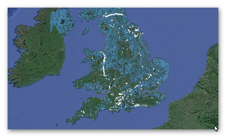
Figure 36 – Dykes of Britain (White all link to the Mesolithic Rivers of the Past (Blue) – Linear Earthworks are Canals (Dykes)


For more information about British Prehistory and other articles/books, go to our BLOG WEBSITE for daily updates or our VIDEO CHANNEL for interactive media and documentaries. The TRILOGY of books that ‘changed history’ can be found with chapter extracts at DAWN OF THE LOST CIVILISATION, THE STONEHENGE ENIGMA and THE POST-GLACIAL FLOODING HYPOTHESIS. Other associated books are also available such as 13 THINGS THAT DON’T MAKE SENSE IN HISTORY and other ‘short’ budget priced books can be found on our AUTHOR SITE or on our PRESS RELEASE PAGE. For active discussion on the findings of the TRILOGY and recent LiDAR investigations that is published on our WEBSITE you can join our FACEBOOK GROUP.
Avebury Ditch – Avebury Phase 2

Transcript from the Video Langdon – investigates Avebury Ditch Phase Two

My name is Robert John Langdon and you’re watching my video channel this video cast is one of my 10 minute shorts which looks at sites around Britain using LiDAR in a strange sense this is my version of landscape archaeology for the 21st century I hope you enjoy. Last week we looked at phase one of the Avebury site site which was windmill Hill which we discovered was a island in the Mesolithic. This week we’ll look at the main site Avebury to see how that developed and why.

Windmill Hill - Avebury Ditch
Windmill Hill – Avebury Ditch

First thing we need to do is have a look at how Avebury looked in the Mesolithic and here we are back again with the Mesolithic high waters this is the Kennet this is Windmill Hill and as you we saw last week Windmill Hill are causewayed enclosure or what I call concentric Circle site which is much more accurate which is actually orientated towards the water so boats will come in and come more around the edge

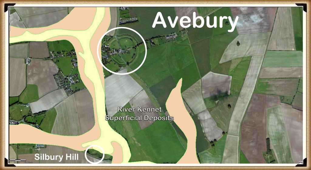
Now as the Mesolithic continued in the rivers fell in high what would have happened this site would become more and more inaccessible so much so that at some point they would have to actually have a new site and this is where Avebury will phase two as I call it was built if we zoom in a bit into Avebury you can see it’s quite unique with its large ditches and the River Kennet actually flowing but this is the river Kennet here today very small obviously much larger in the past.

BGS Map of river alluvium - Avebury Ditch
BGS Map of river alluvium – Avebury Ditch

When it was that size and that large and I’ll show you a picture of the tick off the of the alluvium from the British Geological Society with their fanned around here it shows that once upon a time the Kennet was this size and would have touched the edge of the Avebury site which gives you a bit of a clue of what they were doing with it because the boats will now be able to come in and more inside Avebury in these gigantic ditches which I would imagine actually would joined we now got roads there this was just been one large ditch

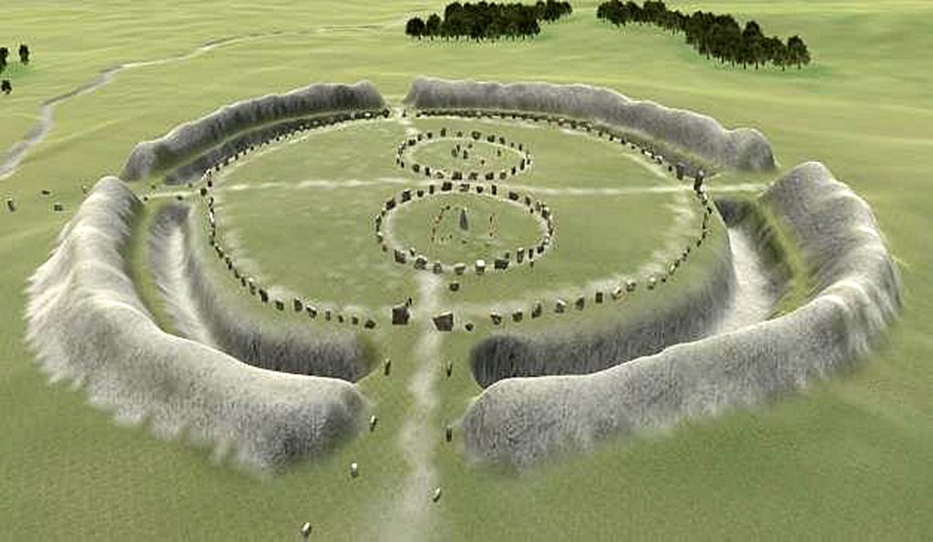
I think it actually was there would have been a gap here because we’ve got the stone Avenues coming out this side but I would imagine the ditches would have continued here and were continued on that side as well and it’s only recently since the roads have been put in that these ditches have been filled in for obvious reasons.

Stone Avenues spreading from the Southern Entrance - Avebury Ditch
Stone Avenues spreading from the Southern Entrance – Avebury Ditch

Now what’s interesting if we can pan in and tilt this just a little bit is having a look at the west side which has been lowered for the Kennet. Now archaeologists have seemed to miss this completely for some reason.

As we can see there very clearly and what I’ll do I’ll take the water off because it’s a bit distracting that’s better well you can see here very clearly is that this bank has been tapered it’s been rounded here and tapered there now that and obviously on this side has been tapered here there is no logical reason that it’s been should have been tapered and if you look at some of the if you look at some of the icon drawings they will show you it has been completely round at some point which is a nonsense it was never that way these tapered edges have always been there and as we have a closer look we could go around the back and have a look

Archaeologists view of the Avebury - Avebury Ditch
Archaeologists view of the Avebury – Avebury Ditch

We can show you that basic there you go can’t get more clear there this was this was made to be tapered this was not natural there is nothing here… most people think that it was tapered or cut down because it’s in a way off part of the tap well there’s no town there and as you see from the LiDAR there’s never been we can see we see walls and buildings and bits here and here and here here nothing so why would you take down this gigantic bank if you have no reason to it’s a bit of a nonsense really.

So this tapered effect of the bank has never been explained by archaeologists unfortunately but it is a main key feature and if we put the water back in again it becomes painfully obvious and that’s a bit too high and we it will drop a bit here we go painfully obvious that this is where the water were coming to fill the ditches of Avebury – archaeological conundrum 101 Avebury resolved

Okay for we go and take a look at the number bank here we also see that that’s been this rounded obviously it’s not squared it’s been tapered as well and that’s because it was never meant to be there and I imagine once upon a time that the river probably came in here and would have come in here it’d be very hard to see this now because this is now raised ground due to the fact that you’ve got a cricket ground and you’ve got buildings and you can see this is this is natural ground – this has been built upon in recent years with bits and pieces which have changed the level and therefore we don’t see as we see on this side it’s nice clear aspect of where the River would have come in in the past .

We see here very clear River would have been here boats would have come here and trading would have been on here very much like Windmill Hill in the past so a very clear indication of Avebury phase two the other aspect which archaeologists sadly don’t really go into much detail about is why did they dig the ditches are so deep. They don’t need to be 12 meters deep do they?

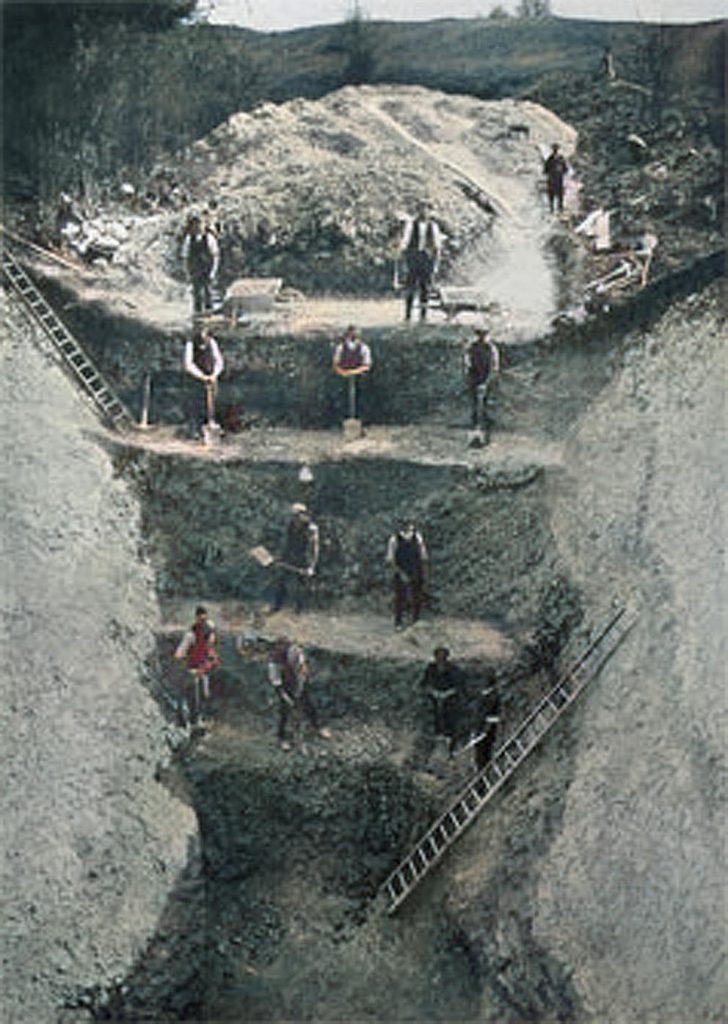
Avebury Excavation of 1914 - Avebury Ditch
Avebury Excavation of 1914 – Avebury Ditch

Unless there this is a really good reason now sadly I watched Carenza on Time Team once and she told me on the television that these ditches were so deep it was to keep out evil spirits…wow!

How can I question that that is such a scientific proof with such great evidence who wanted to question that logical scientific conclusion to why these ditches are 12 meters deep unless of course it’s wrong what we have found is that as the river and let’s see if I can illustrate this by showing the River as as the river went further and further away the water table would have got lower and lower as you see here it’s dropped another three meters if it drops another three meters here and not touching to keep this has water and I would imagine again because we can’t see there might be still a connection roughly here to here because again you’ve got buildings here it’s referring the landscape so it’s almost impossible to tell surfaced original surface area was it’s all been built up since then.

But clearly from this illustration here we can see there is there is a a hint that the river continued to touch the edge of the the site here and it’s dropped from one five seven to one five four so that’s three metres now if it’s dropped three metres in water level these would have to be three metres deep deeper to contain water that’s the logical aspect of the water table.

So let’s say it started up as a two metre ditch which is what we see in Stonehenge and other rare and other sites start up as a two metre ditch with water as you start to dry up they would have to then dig so it would on this hand this occasion they’re out of it a number three metres to it so that’s a minimum of five metres which is a very very big ditch.

Silbury Hill built in Phases - Avebury Ditch
Silbury Hill built in Phases – Avebury Ditch

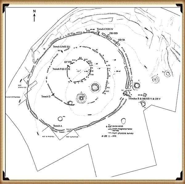
So what we see here is that Avebury was actually built in stages and then we see this later on in phase three when we start looking at Silbury Hill and the fire Beacon there and how that was built we see it started low and it built up high over hundreds of years very good reason for that is for visibility on this occasion with a brief phase two is because the groundwater dropped and they tried to keep up with the drop of the groundwater by digging the ditch deeper until it got to 12 metres and if I can just lob in a picture here when we done an excavation or when archaeologists done the excavation in 1922 (2014) when it got when they got to the bottom of this ditch which was at the same height as the eight of the same height as the cross so you can see the picture we’ve been at the same height of as the Kennet which is this river here they actually had to stop because it failed full of water one we might have to say a bit of a clue what it was when it filled full of water but clearly archaeologists don’t want to know the truth because they’ll have to rewrite the books.

1914 Avebury Excavation had to stop as it hit the water table - Avebury Ditch
1914 Avebury Excavation had to stop as it hit the water table – Avebury Ditch

Anyway that is Avebury phase two next week we’ll look at Avebury phase three which we’ll be looking at the very famous Silbury Hill and where that was built and again it’s to do with water levels

Well that’s all we’ve got time for this week tune in next week for another edition of Langdon investigates where we look at another ancient site until then subscribe below to make sure you’re informed when new videos come on the video channel until then thank you for watching.

For more information about British Prehistory and other articles/books, go to our BLOG WEBSITE for daily updates or our VIDEO CHANNEL for interactive media and documentaries. The TRILOGY of books that ‘changed history’ can be found with chapter extracts at DAWN OF THE LOST CIVILISATION, THE STONEHENGE ENIGMA and THE POST-GLACIAL FLOODING HYPOTHESIS. Other associated books are also available such as 13 THINGS THAT DON’T MAKE SENSE IN HISTORY and other ‘short’ budget priced books can be found on our AUTHOR SITE. For active discussion on the findings of the TRILOGY and recent LiDAR investigations that is published on our WEBSITE you can join our FACEBOOK GROUP.
Silbury Hill

Extract from the book – Chapter 2 Silbury Hill – Avebury’s lost stone circle

The barrows on the left of Silbury Avenue indicate that these features were built after the Avenue was constructed and not because of them, as the path passes the barrows to one side without termination.  Although the new Avenue would have led towards Silbury Hill, it did not terminate at the monument.  As it was inaccessible due to it being surrounded by deep water, which can still be seen today during the winter seasons. 

The topology shows that Silbury Hill would have been built on a natural peninsula as part of the River Kennet.  This high groundwater table causes this flooding due to springs that have recently been located.  (Whitehead, P. and M. Edmunds. 2012.  Palaeohydrology of the Kennet, Swallowhead Springs and the Sitting of Silbury Hill, English Heritage, Research Report Series 12-2012).

My radical ‘Post-Glacial Flooding’ hypothesis (now clearly supported by Whitehead) is that Britain was flooded directly after the latest ice age due to the raised river levels; consequently, these ancient sites were built on the shorelines of these ‘wetlands’.  The springs identified by Whitehead are a consequence of Ice age groundwater, which would naturally disappear over time, as the levels fall.

Silbury Hill still showing the past water levels in winter

After the ‘great melt’ of the last ice age this area would have been almost completely flooded at the start of the ‘Mesolithic Period’ – about 10 000 BCE.  The only part of Avebury above this ‘initial water level’ would have been Windmill Hill – which is NW of the current Avebury site.  This site shows evidence of occupation as it is what archaeologists call a ‘Causewayed Enclosure’ as they (incorrectly) imagine the moats that were built to accommodate ships and boats were, in fact, dry ditches in an attempt to contain cattle.

Windmill Hill - Mesolithic Trading Site
Windmill Hill – Mesolithic Trading Site

The construction of this kind of site for the use of cattle is nonsense, as the time, effort, organisation and workforce required to dig a ditch rather than build a fence make it unfeasible (otherwise, we would have done it in the recent past and even today with modern JCB’s).  Although, I have no doubt that after their original use, many thousands of years later, they did serve the purpose of farmers who could not afford nor had the time to build fences. 

I have renamed these monuments’ Concentric Circle sites’ as they are a product of an earlier civilisation whose construction practice produces this distinctive feature, which the Greek philosopher and writer Plato wrote about in his dialogues about a culture that lived in the 10th millennium BCE.

Once the waters of the Mesolithic subsided, a couple of thousand years later, Windmill Hill would not have been accessible by boat; therefore, another site closer to the new water’s edge would have been required – this is the Avebury we know today.  The ditches were built to accommodate (like Windmill Hill) the ships and boats of this trading civilisation.

Avebury (under the water) at the start of the Mesolithic

Unfortunately for our ancestors, the groundwater levels continued to recede, as they have consistently since the end of the last ice age.  Consequently, the waters failed to reach the moats of Avebury (even as they dug deeper into the ditch to find the groundwater – and hence the 12m canal/ditches), and consequently, they faced the same option they had two thousand years earlier to abandon or replace.

Avebury in the Neolithic with Kennet feeding the ditches with water

Again, they decided to replace, but this time keep the original site as it had assets which were not only historic but almost impossible to transport – the gigantic megalithic stones which we will discuss later.

Our ancestors moved to a natural harbour slightly downriver from Avebury at a place we call Silbury Hill.  The River Kennet would have been much smaller in the Neolithic Period (4500 BCE to 2500 BCE) but still three to four times larger than today.  Mariners could find prehistoric harbours relatively easily without maps by following the ‘Long Barrow’ markers that acted like giant direction finders and are found all over on the hillsides of Britain. 

Silbaby Loading Platform for Boats
Silbury Avenue from Avebury to the Platform at Silbaby

I understand some readers will find this ‘Long Barrow’ idea somewhat ‘far-fetched’, but not surprisingly, this type of navigational aid is commonplace and was used less than a hundred years ago at the birth of the aeronautical industry.

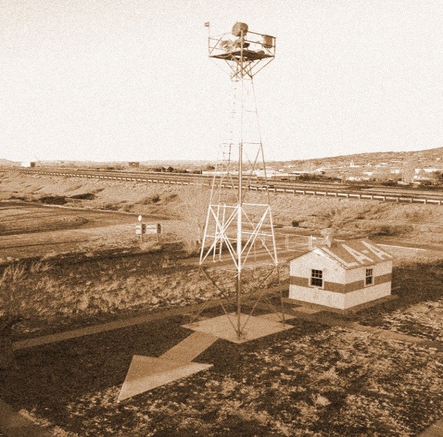
In 1924, the federal government of the United States of America funded enormous 70-foot concrete arrows to be built every 10 miles or so along an established airmail route to help the pilots trace their way across America in lousy weather conditions and particularly at night, which was a more efficient time to fly.  Painted in bright yellow, they were each built alongside a 50-foot tall tower with a rotating gas-powered light.  And each station had a little rest house for the folks that maintained the generators and the lights.  These airway beacons are said to have been visible from a distance to 10 miles high.

Not only did they build seventy-foot bright yellow arrows, but they also illuminated them at night and during bad weather.  Strangely, this is no different to what our ancestors did in the past with the introduction of the boat.  Long barrows are over 300 feet long, built with a higher back end and a smaller front end (in height), so they will look like a gigantic pointer from a distance as it was made of bright white chalk.  In addition, the harbours had fire beacons to assist navigation further (just like the aeroplane arrows), and this is the secret of Silbury Hill – it is a fire beacon.

Sign posts with arrows for aeroplanes

For more information about British Prehistory and other articles/books, go to our BLOG WEBSITE for daily updates or our VIDEO CHANNEL for interactive media and documentaries. The TRILOGY of books that ‘changed history’ can be found with chapter extracts at DAWN OF THE LOST CIVILISATION, THE STONEHENGE ENIGMA and THE POST-GLACIAL FLOODING HYPOTHESIS. Other associated books are also available such as 13 THINGS THAT DON’T MAKE SENSE IN HISTORY and other ‘short’ budget priced books can be found on our AUTHOR SITE. For active discussion on the findings of the TRILOGY and recent LiDAR investigations that is published on our WEBSITE you can join our FACEBOOK GROUP.
Other post suggestions:

Avebury’s Lost Stone Avenue – Flipbook

Wansdyke Flipbook

LiDAR Tile Reference Map

Linear Earthworks are Canals (Dykes)

Windmill Hill – Avebury Phase 1

Langdon Investigates Short Videocast – Transcript (Windmill Hill)

Hello my name is Robert John Langdon and you’re watching my video channel this video cast is one of my 10 minute shorts which looks at sites around Britain using LIDAR in a strange sense this is my version of landscape archaeology for the 21st century i hope you enjoy

This week we look at Avebury Stone Circle a little bit like Stonehenge the way to examine this site is to look at the surrounding areas and the landscape what i have done is split this into three sections and this is phase one which will concentrate at windmill hill now windmill hill is a very interesting sight because it’s somewhat northwest of the main site of Avebury but if we can if we see it’s actually on the highest aspect of the landscape now if we put in the Neolithic water levels at the time we see it’s become an island which is makes it even more interesting we if we now zoom in to the site we’re gonna give it a bit of a tilt to make it much more interesting to look at and then we’re going to give it a bit of a look around so we’re going to look around why explain windmill hill and what the archaeologists make of it.

After the great melt of the last ice age this area would have been almost flooded at the start the Mesolithic period about 10 000 bce the only part of Avebury above this initial water level would have been windmill hill this site shows evidence of occupation this is what archaeologists call a caused way enclosure as they incorrectly imagine that the moats that built to accommodate ships and boats were in fact dry ditches to contain cattle -would you believe

Windmill Hill Avebury

So let’s have a closer look at Windmill Hill – now the first thing you should observe its location if you’re going to build a site surely you would build it in the middle of the island and archaeologists don’t believe it was island this is if it was a hillside then you would have built it on top of the hill rather than on one h which doesn’t make any sense as we spin around you see this more clearly

Now the fascinating aspect of this is that one of these ditches dips into what would have been the River Kennet in the Mesolithic period when we’ve looked at other sites such as the volcano we actually found that there are very very clear dykes that go from the inner ring to the outer ring but what you do see very clearly is where they’ve actually positioned this caused weighing closure as they could this gives you a better idea of the original depth of the dishes this is all being ploughed down left so we only got a ghost of the image as it was but clearly this is a lot different to what the archaeologists imagine is something for cattle

Causewayed Enclosure - Windmill Hill
Causewayed Enclosure – Windmill Hill

The construction is kind of site used for cattle to be honest is complete nonsense if you think about it as the time the effort the organisation and the workforce required to dig this these dishes for some cows is I find totally bizarre you know at the end of the day wood was free build a fence it’s far far quick this is 30 times more work than building a fence and at the end of the day why would you want you know three rings if it’s to corrode some cows that’s great put it that way and you know fits it off in the middle it’s much why would you do a concentric circle site for some cows – and sadly this is archaeology today it’s nonsense it doesn’t make

Whitehawk Causewayed Enclosure - Windmill Hill
Whitehawk Causewayed Enclosure – Windmill Hill

Any sense any rational person would look at this and go obviously there must have been method in their matters look if you’ve spent you know thousands of man hours building something and you’re going to put some cows in it you know if a ditch was an effective way of keeping cows in you would have farmers with their jcbs which is somewhat quicker than digging it by hand knocking out ditches all right their farms rather than building fences which is you know it’s just a nonsense but that’s archaeology today you know what do i know i’m an idiot according to them

Construction of Causewayed Enclosures - Windmill Hill
Construction of Causewayed Enclosures – Windmill Hill

So this was phase one back to reality rather than the archaeological bubble this was phase one it’s um it’s a causeway include and you know the the most fascinating aspect i don’t call them complaint closures because it’s a nonsense yeah i call concentric circle sites and i do that because they’re we the one of the earliest writers in history talk about them would you believe you know someone from 300 bce talk about concentric circle science and that guy was Plato.

Plato described a a a city with concentric circles it’s amazing that you’ve got someone in history who actually writes about concentric circle sites now it’s you know this is over two and a half thousand years ago much closer to the time where obviously these these sites existed so one would imagine that the the they had a better idea of why they were constructed today

Plato - Windmill Hill
Plato – Windmill Hill

But the most amazing aspect of you know Plato’s work and contra concentric circle sites is that he dates them as nine thousand years before the present he’s present so then ninety thousand bce we’re talking about now no one in the past ever imagined that these sites could exist but they have existed and they’re here now they’re in Britain they’re in the northern hemisphere they’re probably under Doggerland where they these people actually who originated these sites came from and and an amazing aspect of Plato’s work is that he talks about a civilisation who drowned under you know the first of climate change I suppose the ladies put it by rising sea levels and that was 9 000 years ago that’s when it started at least and this these signs are dated back to them

Now the archaeologists would tell you oh no no no no they’re only 3 000 bce not no they’re only 5 000 years old not not 10 000 years old and that’s because at the end of the day they date and if we put this on holding it they go and date these sites by what they find in this ditch now to be honest that’s probably what i would call bad science and they’re bad science because at the end of the day you can’t date you cannot take that site but what’s in that ditch

Causewayed Enclosure Distribution - Windmill Hill
Causewayed Enclosure Distribution – Windmill Hill

So back to our little display we have windmill it’s it’s made to touch the River Kennet because you would sell your boat to this river in you go on on the inner circle you can park it there i would imagine that something like here you can then take your boat to the inner circle perhaps you know yeah that’s i see it more like I don’t know a um a car park everybody goes to Sunday markets don’t they think think of it more your boat is your your modern day car you take it along the river which is the highway and you want to sell your goods at the back of yours in your Sunday market so you park your car in a car park as close close to the centre as possible you know if you got there late you have to come to the end if you got there early you get in the centre wherever you’ve got the bigger footfall so you go there you park your car you open your boot and you sell your goods do you think people in the past didn’t do something similar they didn’t have a car clearly but they had a boat you take your boat full of your goods you come into this site you take your bring your boat in from the river if you’re late you have to park around the end if you’re early you can go to the the inner one of the inner circles if you’re really really early and you’ve got lots of things to to sell but perhaps you’re selling food.

You know we know that we know that food was brought from as far as Scotland into uh big meat we know that it’s a fact you know it’s something archaeologists don’t like to admit but they’re mystified how the hell do you get a cow from Scotland to pick mead if you don’t have a boat it’s you know the the idea they bring this by car is absolute nonsense you wouldn’t even know what big media is from Scotland you know if we got the if they got GPS or the greatest signposts in the world – I don’t think so

Mesolithic Site Animal DNA distribution - Windmill Hill
Mesolithic Site Animal DNA distribution – Windmill Hill

But you can follow a river and rivers usually lead down to to places like this and we’ll have a look with phase two how they got to places like this in the most obvious way so you bring your boat in if you’re if you’re early you get into the centre if you’re selling food particularly you get into the centre you go you park your boat on the banks and people will come in perhaps perhaps uh the the people with their wares take this inner circle and they say out the circle and people are visiting use the out circle you know at the end of the day if you bring it back you can always park it on the edge and walk up yeah and you can beat it on these beaches and just walk across you know to you know if we’ve got a footpath that may be tens of thousands of years old you know we could park beaches there walk up do some trading go back to your boat go back home phase one of uh windmill hill piece of cake if you’ve got half

Well that’s all we’ve got time for this week tune in next week for another edition of Langdon investigates where we look at another ancient site until then subscribe below to make sure you’re informed when new videos come on the video channel until then thank you for watching.

For more information about British Prehistory and other articles/books, go to our BLOG WEBSITE for daily updates or our VIDEO CHANNEL for interactive media and documentaries. The TRILOGY of books that ‘changed history’ can be found with chapter extracts at DAWN OF THE LOST CIVILISATION, THE STONEHENGE ENIGMA and THE POST-GLACIAL FLOODING HYPOTHESIS. Other associated books are also available such as 13 THINGS THAT DON’T MAKE SENSE IN HISTORY and other ‘short’ budget priced books can be found on our AUTHOR SITE. For active discussion on the findings of the TRILOGY and recent LiDAR investigations that is published on our WEBSITE you can join our FACEBOOK GROUP.
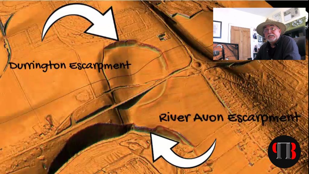
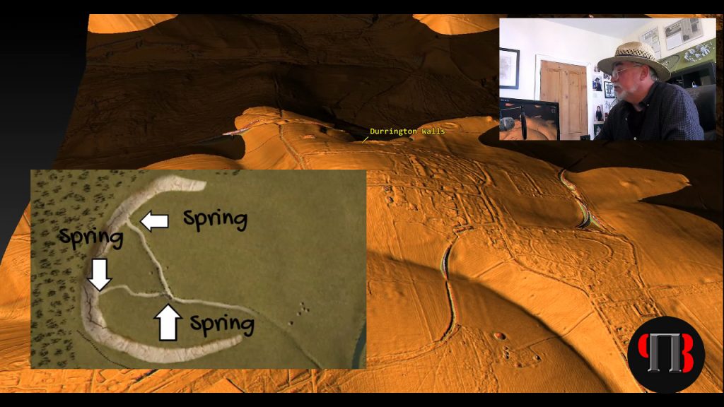
The Old Sarum Hoax

This week we that a look at The Old Sarum Hoax

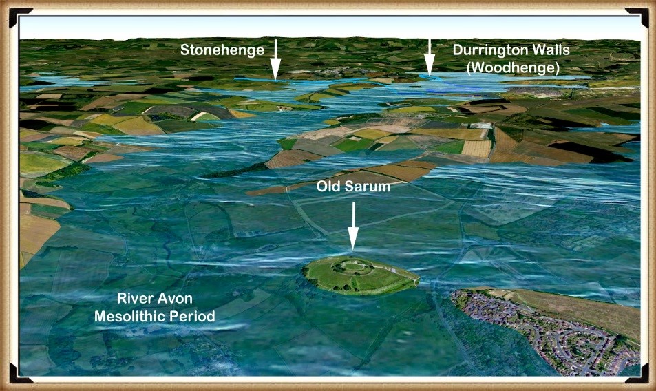
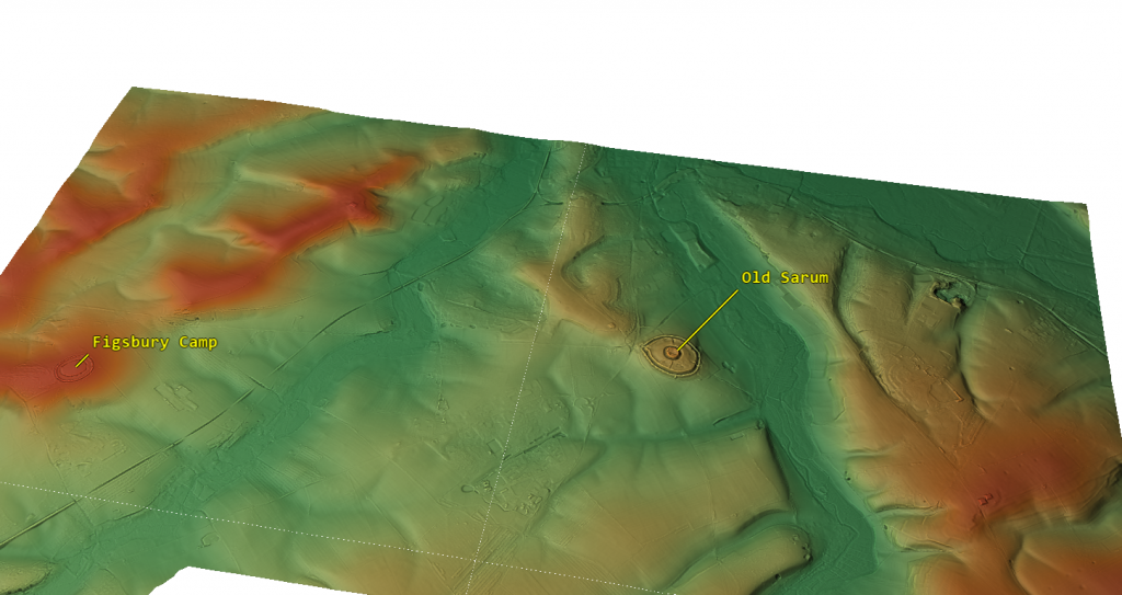
If we use the Southern Station Stone as a direction marker from Stonehenge, it points South by South East.  If we then follow the line on a map of our Mesolithic landscape, showing the raised river levels of the past, we find that it points to a fantastic site just 10 km away from Stonehenge: an island in the middle of an extensive waterway called Old Sarum. (The Old Sarum Hoax).

 The Old Sarum Hoax
The Island of Old Sarum in the Mesolithic Period – The Old Sarum Hoax

The positioning of this site is most interesting, as it lies very close to the English Channel, which would have enabled boats to reach the continent.  It is quite possible that this was Britain’s first seaport, as it appears to be the last known Mesolithic-era island to be occupied.  If so, it would have been one of the most critical sites in Britain and Europe, as it would have been involved in nearly all Mesolithic imports and exports to and from France, Spain and the Mediterranean countries.

The area surrounding Old Sarum is also of great interest, as it has two sites on the same raised river, the Avon, in the past.  One of these sites, called Figsbury Ring, is even older than Old Sarum.  The Old Sarum area is very similar to the Avebury Area, as it has an ancient site older than the central Avebury Stone circle called Windmill Hill. 

River Avon and sites on the route

Both Windmill Hill and Figsbury are what archaeologists call ’causewayed enclosures’ – this is sadly and not uncommonly incorrect labelling of these sites by academics, as we also see from their term ‘Iron Age Forts’ that are neither Iron Age nor fortifications.

Causewayed enclosures are labelled as enclosures for cattle, with paths across the ditches (causeways) for access by the livestock – this is complete nonsense.

A more historically accurate definition for these monuments would be ‘concentric circle sites’ – the term was created by none other than Plato, who referred to them back in 300 BCE when relating to the story of Atlantis and its central city’s description, which I cover in great depth in my books.

This ancient reference to such sites clearly dates both Windmill Hill and Figsbury to the very early Neolithic, when the Avon and Kennet waters were at their highest, directly after the last Ice Age, 12k years ago.

These monuments were constructed for boats to moor with their circular ditches to trade, and it was only when the waters fell towards the end of the Mesolithic and early Neolithic that both Old Sarum and Avebury were constructed to replace their predecessors.

The island of Sarum would have been a magnificent sight, sitting in a vast river as wide as the eye could see.  When we look at the LiDAR survey of the site, we notice that two deep ditches lead from the outer to the inner ditch, both of which have been partially filled.  During the Mesolithic, the groundwater would have flooded both the outer and inner channels via the Dykes (canal) cut in between the two ditches.

Current theories on this site speculate that the central moat was dug for the motte-and-bailey Norman castle that stands there today.  Still, without firm evidence, this is just speculation – although as the centre of the site is now raised, it would be probable that both the Romans and then the Normans, cleaned out the prehistoric ditch and then extended further down to the new water table, to keep the inner ditch as a defensive moat, placing the excess spoil in the inner area of the site.

Lidar Magnetometry Survey showing two Dykes

The site at Old Sarum is much bigger than Stonehenge and is similar to Avebury.  One can only guess what would have been in the centre of the Mesolithic island.  From the amount of reused Sarsen stone found in the remains of the Norman castle, the original cathedral, and the Roman Fort, we can infer that a megalithic structure such as Stonehenge or Avebury stood at Sarum in prehistoric times.  Because if you extend a line from the centre of the motte-and-bailey at Old Sarum through the centre of the church (the original Salisbury Cathedral), it points to Stonehenge.

Churches built on prehistoric sites are not uncommon.  In addition, there are many instances of pagan religions being crushed by Christianity, taking over their sacred sites and using the stone circles as a building material for their churches.  So, we believe that in prehistory, three stone circles existed at Sarum: one large outer circle and two smaller inner circles, indicating the way to Stonehenge.  Later, as the groundwater fell, our ancestors built Sarum’s outer banks to keep their sacred site an island.  At Avebury, a similar configuration is evident, with two smaller stone rings within the large ring bordering the outer moat.

In the Neolithic Period, the groundwater table dropped by about 10 m, and the island of Sarum was joined to the mainland by a peninsula.  Our ancestors, therefore, built giant ditches 12 m deep to keep the site surrounded by groundwater.  The Southern and Northern mooring points could no longer be used, as the groundwater had receded too far, so the Neolithic people created a new landing point to the West.  They left a gap in the large ditch, so that people and goods could enter the island; this would have looked like a bridge across the water.

Neolithic Loading position with a pathway cut over the outer moat to the interior

At the end of this footpath, they built another mooring station that protruded from the edge of the moat, like a peninsula, so that boats could be moored safely around the feature.  (Silbaby)

For some bizarre reason known only to early archaeologists, the platform is shown on some maps as a Roman road which connected to a road some 200 metres away on the island’s West side. But, unfortunately, that theory would take a leap of faith and nature. The landing platform, shown as a lumpy protrusion on maps, has a 1:2 slope and a vertical drop of over 30 metres.  I would suggest that a Roman horse and cart would not be an advisable means of transport for this terrain unless they were equipped with ABS brakes and a parachute.

Plan of Old Sarum - with 'impossible' Roman road to Bath with a 1:2 vertical drop
Plan of Old Sarum – with ‘impossible’ Roman road to Bath with a 1:2 vertical drop

The historical record gives us some clues to Old Sarum’s deeper past and how the groundwater surrounding the island dictated its history.  The original Salisbury Cathedral was built here, only to be moved down to the valley a few hundred years later.  Can you guess the reason for the move?  That’s right, the lack of water!  It seems that even over the Cathedral’s brief history at Old Sarum, the groundwater continued to subside.  As this story is well known, why did no one wonder how deep the rivers might have been thousands of years ago?

The Maths

Currently, the groundwater table around Old Sarum is 56.5 m above sea level.  The well in the Norman fort is 70 m deep from an altitude of 130 m, which shows that the groundwater is today 3.5 m below the Norman well.  Therefore, the groundwater table in 1000 AD – when the well was first constructed – must have been at least 60 m, so in 1,000 years the groundwater has fallen 3.5 m.  If we multiply this thousand-year drop in the groundwater table by 9, then add 56.5 m to account for the existing groundwater table, we can estimate the groundwater table 9,000 years ago, i.e. in 7000 BC.  That would make the groundwater table (9 x 3.5 m) + 56.5 m = 88 m.

I, the outer banks of Old Sarum, are 89 m above sea level – close enough to prove my point, methinks?

New information 2024

According to English Heritage, which owns the site, Old Sarum is an ‘Iron Age hillfort’, which may have been established here about 400 BC. It was then occupied shortly after the Roman conquest of Britain (AD 43), when it became known as Sorviodunum.

The Great Iron Age Hill Fort Hoax
EH: A reconstruction showing how the Iron Age hillfort at Old Sarum may have appeared in about 100 BC

Three Roman roads from the north and east converged outside the east gate of the hillfort, and two sizeable Romano-British settlements were also established outside the ramparts. Little is known of this period, though it has been suggested that in the early Roman period a military fort was set up within the earthworks, with a civilian settlement outside. The civilian settlement formed the nucleus of one, or both, of the extra-mural Roman settlements. As the need for a fort dwindled, meanwhile, the area within the ramparts was converted to become the precinct for a Romano-British temple.

We have no evidence of the fate of Sorviodunum at the end of the Roman period, and the Anglo-Saxon period as a whole is poorly recorded. In 1003, however, a mint was sited within the old hillfort; and archaeological finds suggest there was late Anglo-Saxon settlement outside the ramparts. So there is evidence of life in and around Old Sarum before the Conquest.

Old Sarum with supposed Roman roads


In my view, oversimplified interpretations of the past, lacking excavation work to substantiate theories, pose significant challenges. Close examination often reveals fundamental flaws, such as the assumption that Roman roads converge and pass through a particular site. This type of desk-based archaeology, relying solely on OS maps and rulers, can lead to subjective conclusions.

The reality, as demonstrated by my own LiDAR investigation, contradicts these assumptions. The supposed road leading through the site to Bath is absent from both LiDAR maps and satellite photographs. Furthermore, considering the topography, it would be implausible for such a road to exist unless it were the largest land bridge in British Roman history.

It’s crucial to approach archaeological interpretations with a critical eye and to rely on comprehensive research methods to uncover the true complexities of the past. My LiDAR investigation highlights the importance of utilising advanced technologies and conducting thorough fieldwork to refine our understanding of historical landscapes.

Is it a defensive structure?

In archaeology, I believe honesty is paramount. Categorising sites under broad labels like “Iron Age Forts” oversimplifies their complexities. Take Old Sarum, for instance—it’s situated in a floodplain on an island, not on a hill as commonly assumed. This challenges our traditional understanding of fortifications and prompts us to reconsider our interpretations.

The Great Iron Age Hill Fort Hoax
Hills are in red, flood plain is in green – Old Sarum is an island in a floodplain on a hillock

The proximity of these supposed defensive forts raises another intriguing question. Why would communities invest considerable time and effort in building multiple forts close to each other? Considering the logistical challenges and the likely limited population of prehistoric Britain, it’s logical to question the necessity of such clustering.

Assuming that manpower was an unlimited and cost-free resource in ancient times is overly simplistic. It overlooks the practical considerations that would have influenced decision-making. By challenging these assumptions, we can gain a deeper understanding of prehistoric society. I believe it’s essential to critically examine these aspects of the past rather than accepting naive interpretations. Let’s strive for a more nuanced understanding that acknowledges the complexities of ancient societies and avoids oversimplification.

Was the Outer Moat constructed to keep water in as a moat?

When we examine the site’s profile using lidar, two major findings become apparent. Firstly, the spoil from the ditch was placed on the outside rather than the inside (as expected if it was defensive), and the base of the spoil was not part of the natural rise of the floodplain, indicating that the outer part of the ditch is actually a bank.

The Great Iron Age Hill Fort Hoax
The Ditch Spoil is on the outside not inside as a defensive structure would expect
The Great Iron Age Hill Fort Hoax
The profile shows that the base is not part of the natural hillock and is in fact a false bank

Water Table

Based on the site’s historical records, we understand that one motive for relocating the church was its water shortage, which led it to tap into the garrison’s deep well. This knowledge allows us to assess the state of the moats and comprehend why the inner moat was excavated to a depth of 7 meters. By examining the well discovered during excavation, we ascertain that it was abandoned at a depth of 104m to 105m (OD), suggesting that any ditch below this level would have become waterlogged.

The Great Iron Age Hill Fort Hoax
The sites feature with their height over OD specified

The initial depth of the inner ditch was 110 meters (OD), but today it measures 103 meters (OD), which is below the bottom of the Church well. Based on this data, we can hypothesise that during Norman times, the inner ditch was dug deeper to reach the water table. It’s also possible that, as the water supply for the moat decreased over the church’s lifetime, the moat was excavated unusually deep to access the diminishing water levels.

The Great Iron Age Hill Fort Hoax
Church well going form 108M (OD) to 104m (OD)

This new understanding of the water table also opens up the possibility that the outer ditch was also moated up to the Norman conquest, and moreover, during the Roman period – this is something that needs urgent explanation and further study.

For more information about British Prehistory and other articles/books, go to our BLOG WEBSITE for daily updates or our VIDEO CHANNEL for interactive media and documentaries. The TRILOGY of books that ‘changed history’ can be found with chapter extracts at DAWN OF THE LOST CIVILISATION, THE STONEHENGE ENIGMA and THE POST-GLACIAL FLOODING HYPOTHESIS. Other associated books are also available such as 13 THINGS THAT DON’T MAKE SENSE IN HISTORY and other ‘short’ budget priced books can be found on our AUTHOR SITE. For active discussion on the findings of the TRILOGY and recent LiDAR investigations that is published on our WEBSITE you can join our FACEBOOK GROUP.
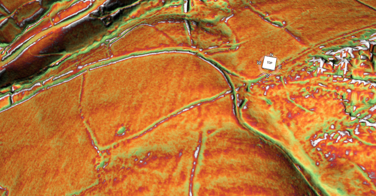
The Woodhenge Hoax

In our last video, we looked at Durrington Walls in Wiltshire to find that it was not a traditional henge but a harbour for boats, with natural springs and ditches cut into the site to allow boats to moor in the prehistoric past – (Woodhenge Hoax). Today we will look at an associated structure next to the prehistoric harbour – Woodhenge, to see if we can find what association this has with Durrington Walls.

This monument has a series of ‘massive’ wooden post holes – at this point, I need to explain that archaeologists don’t seem to understand the difference between a ‘Post Hole’ and a ‘Stake Hole’. You use stake holes for posts such as fences as they can be quickly buried in the ground as they have a sharp point – this point naturally compresses the surroundings (due to the shape and hammering from above), so they don’t move or wobble!

A ‘Post Hole’ is different as it has a flat bottom and needs rubble to stop it from rocking from side to side. Stake holes are easy as they are ‘self-burying’ while post holes are more work as you need to dig a hole for it. The only reason you would do all the extra work of digging a flat-bottomed hole (especially in chalk) is if the wooden pole is to take some kind of weight from above, for a stake hole is useless for this type of structure as it would sink (overtime) under the weight pushing down on the point and probably fall over.

Therefore, if you have a round wooden single-storey building (which was the original theory by archaeologists that excavated Woodhenge) with a simple roof, the use of massive posts is simple ‘over-engineering’ and time-consuming – especially with simple tools.

Cunnington excavations at Woodhenge in 1929 suggested that some posts are up to 60 inches in diameter: Cummington reports that:

“clear evidence was obtained in excavation that the six centric rings of holes once held posts or tree trunks varying from 1ft to 3ft in diameter according to the size of the hole…… the size and depth and distance varies in each circle…. In the outer circle holes are 6ft apart from centre to centre, from 1 1/2 ft to 2ft in depth and from 2ft to 3ft in diameter. In the second circle the holes are larger and further apart, averaging about 4ft in depth and 3 ½ to 4ft in diameter. The largest of all were those were those of the third circle, being about 6ft deep with a diameter at the top from 4ft to 5ft“

Sadly, Woodhenge shows us yet another illustration of flawed science in archaeology. Even with a ‘second rate’ excavation report from the 1920’s the conclusion of modern archaeologists is that this structure was a single-story house – a slightly grander feature to the traditional ‘iron age’ house. This is simply nonsense. If we look closely at the evidence presented here, we obtain a totally different and more accurate conclusion to the nature of this structure.

Cunnington Excavation plan 1929 - (Woodhenge Hoax).
Cunnington Excavation plan 1929 – (Woodhenge Hoax).

Firstly, if we look at the layout of the site (which lacks much detail), we can see from these original excavation plans the scale of this understatement, as the existing ‘concrete’ posts on the site, are far too small. The most recent photo was from the excavation by Pollard in 2007, indicates that these posts are at least five times larger than the current representations – although he is happy with the concrete post representations – which suggests either he was towing the traditional archaeological view or he should have gone to Specsavers?

The next fact that goes unanswered by archaeologists is the reason for the large post-hole ramps. You don’t take time to put 32 ramps into the soil unless it is essential, as you just added at least another month to the building work for the site and 500 working hours. What archaeologists have missed (or failed to mention) is in which direction these ramps were cut – as it tells us more than the entire excavation report by Cunnington.

The massive 4 – 5 ft pine posts of the 16 post-holes (known as the C Ring) would weigh 214kg per foot of length. Therefore, a sizeable healthy person (we will go into detail about who these megalithic people in my book – ‘Dawn of the Lost Civilisation’) could pick up one foot of pine and place it in a hole without assistance or a need for a ramp. 

Woodhenge post holes much larger than the concrete posts on the site! - (Woodhenge Hoax).
Woodhenge post holes much larger than the concrete posts on the site! – (Woodhenge Hoax).

Consequently, an eight-foot pine tree trunk could easily be placed on the shoulders of 8 people and put straight into the hole, which is the current estimation by archaeologists for a single-storey structure.

Therefore, the empirical evidence suggests they are wrong, and the pole was much more significant.

We have seen similar ramps at Stonehenge, not for the 4-tonne bluestones but by the Sarsen stones that weighed an average of 25 tonnes (the trilithons are 35 tonnes) but half the size of these ramps.

A 25-tonne pine post of width between 4 – 5 ft would be 39m long or 128ft, and a 35-tonne pine tree is some 177ft long. But do Pine trees grow that tall? Longleat Forest is just down the road from Durrington Walls; within this forest there are pine trees that grow to nearly 200ft tall.

Moreover, the site plan also gives us another clue to the length of these poles. If to look carefully at the angle of the ramps into the giant post holes, you will notice that they are not all facing the same direction. The only logical reason for that is if you erect the pine poles in a set order so that they would not hit or interfere with each other when attempting to erect the posts.

This allows us to come to some remarkable conclusions about the construction and the process of how it was built:

  1. Holes were filled in an anti-clockwise direction starting at hole 1 (at four o’clock to the site)
  2. Poles must have been more than 100’ long; otherwise, you could erect them in any order and direction.
  3. The current ditch at the site was added later, as you would need to bring the poles through the ditch and in some cases be in the ditch to erect it.
  4. The 4 to 5ft diameter posts all entered the site from the south, as it has the minimal distance to travel – as these poles were either rolled or dragged on a sledge and therefore probably the direction of where the pine trees have initially been growing or unloaded, after being floated down the river.

Now the slopes for ‘Ring C’ (the largest posts) are 5 to 8ft long, which are even longer than the Stone ramps (3 to 4ft) at Stonehenge (Fig.58). This probably shows the large (Sarsens are only 13ft tall) leverage factor required to be pulled upright with an A-frame, which then allows the posts to slide into position and then into the hole.

Ring B – the 3.5 to 4ft diameter trees also have ramps, but much smaller (3 to 4ft), indicating less leverage and therefore half the weight/height. Moreover, they were placed into position after the C Ring, as their ramps point away from the centre with no common direction.

Broch which was a later version of Woodhenge - made of Stone - (Woodhenge Hoax).
Broch which was a later version of Woodhenge – made of Stone – (Woodhenge Hoax).

The last row of post-holes (A), 1 to 3ft in diameter, do not have ramps and are sporadic in nature and size – which leads me to believe they have no structural significance and were probably more like a palisade covering, to either enclose the structure or allow mud or reed covering (wattle & daub) and protection from the elements.

The internal posts (D to F) are superficial and probably were there to support the first-floor structure, as we see in their successors in British history the ‘broch’ – a stone version-built thousands of years later for the same purpose.

But my money would be on the tower being of a lower ratio of 1 to 1, with the base making it 135ft high and the same height as Silbury Hill, a little further up the river Avon.

Therefore, what would you build next to a harbour to attract and direct boats – obvious, isn’t it, a fire beacon (with a stone base) as we know from written history and the Pharos of Alexandria (280 – 247 BCE).

What Woodhenge probably looked like during phase I of its construction – with a spiral staircase - (Woodhenge Hoax).
What Woodhenge probably looked like during phase I of its construction – with a spiral staircase – (Woodhenge Hoax).

Furthermore, this link with the harbour is illustrated by the Moat, Bank and then a Dyke construction. As we have suggested, the Woodhenge ditch would not have existed at the original time (Phase I) of the construction of the C and then the B rings. It seems that it was added at the end of Phase I when the structure was complete and before Ring A was established, as it points to the shoreline of the Neolithic Avon River. This alignment disproves the current ‘expert’ theory about being an astronomical alignment with the Solstice Sunrise. 

Evidence for the construction of the post holes (with gaps in the circle which were later filled with smaller posts) indicates that the ditch had filled from age or by design. The main opening (in the A circle) to the northeast is not in line with the gap in the ditch, and the two other spaces in the circle, would track across the ditch in the southeast and northwest.

As for the dating of Woodhenge (and Durrington Walls), like Stonehenge, unrelated antler and bone fragments have dated it to about 2400 BCE, which is very convenient. The problem is that most of the post hole samples at Woodhenge were either lost or have been stored away and not tested since the excavations between 1926 to 29, for reasons known best to the experts.

Moreover, like the samples taken from the old car park in 1966, pine charcoal was reported to be found “similar to the charcoal found at Woodhenge” was the quote from the labs at the time, who failed to carbon date the samples as the experts had declared them Neolithic, supporting the antler pick dates. Although now, once this gross error was exposed, we know these pine charcoal wood dates to be in fact, Mesolithic 8100 BCE – which ‘begs-the-question’ so are the pine charcoal dates found at Woodhenge also Mesolithic?

Less than a mile down the river is ‘Blick mead’, (Vespasian’s Camp), which has also been found in dates ranging from 7900 BCE, (remember our bluestone estimation for Stonehenge is 8000 BCE), to 4050 BCE, with multiple RC dates from the 8th to the 5th BCE. Sadly, until someone finds these samples and carbon tests them to get an accurate date for Woodhenge and Durrington Walls, this unscientific archaeological ad hoc dating methodology will continue.

Furthermore, the engineering structure created by this civilisation – like the design at Stonehenge, has been overlooked by archaeologists looking for a more simplistic ‘hunter-gatherer’ solution for this superstructure, which has ended up with a single-storey roof, that is clearly well over-engineered for that purpose. We can see at Woodhenge (and also at The Sanctuary at Avebury) the ‘triangulation’ of wood joints using the mortice and tenon techniques we have seen on the Sarsen stones at Stonehenge. This structural technique (which are incorporated in modern towers today) allows to the construction of extremely high wooden towers, which is what we see at Woodhenge.

Woodhenge Unique construction technique for building towers – still used today – (Woodhenge Hoax).

For more information about British Prehistory and other articles/books, go to our BLOG WEBSITE for daily updates or our VIDEO CHANNEL for interactive media and documentaries. The TRILOGY of books that ‘changed history’ can be found with chapter extracts at DAWN OF THE LOST CIVILISATION, THE STONEHENGE ENIGMA and THE POST-GLACIAL FLOODING HYPOTHESIS. Other associated books are also available such as 13 THINGS THAT DON’T MAKE SENSE IN HISTORY and other ‘short’ budget priced books can be found on our AUTHOR SITE. For active discussion on the findings of the TRILOGY and recent LiDAR investigations that is published on our WEBSITE you can join our FACEBOOK GROUP.
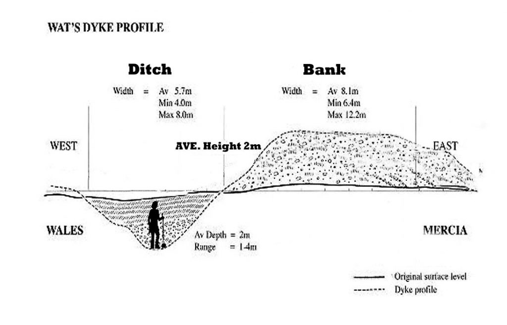
The Great Wansdyke Hoax

Extract from the forthcoming book……………………….. The Wansdyke Hoax
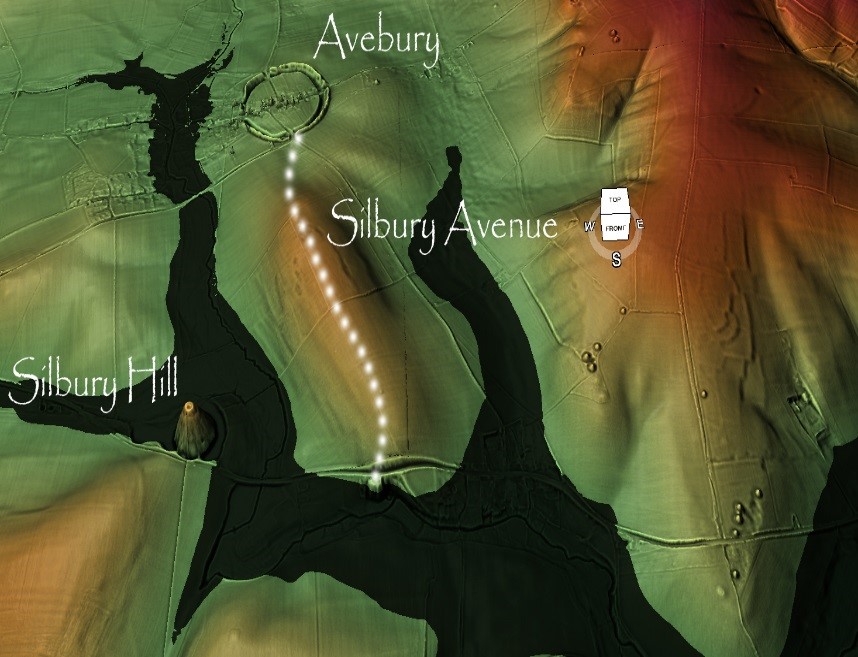
CASE STUDY – Wansdyke

According to Wikipedia, “Wansdyke consists of two sections of 14 and 19 kilometres (9 and 12 mi) long with some gaps in between. East Wansdyke is an impressive linear earthwork, consisting of a ditch and bank running approximately east-west, between Savernake Forest and Morgan’s Hill. West Wansdyke is also a linear earthwork, running from Monkton Combe south of Bath to Maes Knoll south of Bristol, but less impressive than its eastern counterpart. The middle section, 22 kilometres (14 mi) long, is sometimes referred to as ‘Mid Wansdyke’ but is formed by the remains of the London to Bath Roman road. It used to be thought that these sections were all part of one continuous undertaking, especially during the Middle Ages when the pagan name Wansdyke was applied to all three parts.

East Wansdyke in Wiltshire, on the south of the Marlborough Downs, has been less disturbed by later agriculture and building and remains more clearly traceable on the ground than the western part. Here the bank is up to 4 m (13 ft) high with a ditch up to 2.5 m (8.2 ft) deep. Wansdyke’s origins are unclear, but archaeological data shows that the eastern part was probably built during the 5th or 6th century. That is after the withdrawal of the Romans and before the takeover by Anglo-Saxons. The ditch is on the north side, so presumably it was used by the British as a defence against West Saxons encroaching from the upper Thames Valley westward into what is now the West Country.

West Wansdyke, although the antiquarians like John Collinson considered West Wansdyke to stretch from south East of Bath to the west of Maes Knoll, a review in 1960 considered that there was no evidence of its existence to the west of Maes Knoll.   Keith Gardner refuted this with newly discovered documentary evidence.  In 2007 a series of sections were dug across the earthwork which showed that it had existed where there are no longer visible surface remains.

It was shown that the earthwork had a consistent design, with stone or timber revetment. There was little dating evidence, but it was consistent with either a late Roman or post-Roman date. A paper in “The Last of the Britons” conference in 2007 suggests that the West Wansdyke continues from Maes Knoll to the hill forts above the Avon Gorge and controls the crossings of the river at Saltford and Bristol as well as at Bath.

As there is little archaeological evidence to date the western Wansdyke, it may have marked a division between British Celtic kingdoms or have been a boundary with the Saxons. The evidence for its western extension is earthworks along the north side of Dundry Hill, its mention in a charter and a road name.

Map comparing Wansdyke (green) to the Kennet and Avon canal - Wansdyke Hoax
Map comparing Wansdyke (green) to the Kennet and Avon canal – Wansdyke Hoax

The area of the western Wansdyke became the border between the Romano-British Celts and the West Saxons following the Battle of Deorham in 577 AD.  According to the Anglo-Saxon Chronicle, the ‘Saxon’ Cenwalh achieved a breakthrough against the British Celtic tribes, with victories at Bradford on Avon (in the Avon Gap in the Wansdyke) in 652 AD,  and further south at the Battle of Peonnum (at Penselwood) in 658 AD,  followed by an advance west through the Polden Hills to the River Parrett.  It is, however significant to note that the names of the early Wessex kings appear to have a Brythonic (British) rather than Germanic (Saxon) etymology”.

Later scholars have often questioned the accuracy of the descriptions given by these antiquaries such as assertions that Wansdyke reached the Bristol Channel (Fox and Fox 1958) and even Asser’s statement that Offa’s Dyke ran from sea to sea (Hill and Worthington 2003 106). While some antiquarians were probably exaggerating the size of earthworks, we must be cautious of dismissing descriptions of the dykes from before they suffered the ravages of the Agricultural Revolution.

Some scholars went beyond merely describing the dykes and tried, often erroneously (with hindsight), to link them with known historical events like the Belgic invasions mentioned by Caesar or Caesar’s own invasion (Warne 1872 4-10; Guest 1883; Handford 1951 119-40). Among these early, rather speculative descriptions, the work of the Wiltshire historian Sir Richard Colt Hoare (1758-1838) stands out, not only in terms of the quality of his survey work but also his ability to differentiate between features of different dates, for example by realising that the central section of Wansdyke was actually a Roman road (Hoare 1812; Hoare 1821).1

Boundary Markers & Defensive Structures

The archaeologist Mortimer Wheeler produced an analysis of the dykes of southeast England and, like Fox, suggested that they were not primarily military structures but political boundary markers facing post-Roman Britons centred on London (Wheeler 1934 261).

East and West Wansdyke on LiDAR - Wansdyke Hoax
East and West Wansdyke on LiDAR – Wansdyke Hoax

Osbert Crawford’s 1953 book on Wansdyke analysis of the dykes as either military-political (with no clarification of what that meant in practice) or in respect of the coastal dykes (like Dane’s Dyke at Flamborough Head or the Cornish dykes) calling them beach-heads He also made no attempt to group what he termed defensive linear earthworks by period; in his list of them given as an appendix to his field archaeology guide, he includes prehistoric and Anglo-Saxon dykes together with undated earthworks (Crawford 1936 240-53). These shortcomings are easy to criticise now, though, at the time, Crawford’s work was exceptional.

The problem with Crawford’s work is that Wansdyke has a gap in the middle of the defence/boundary and no explanation for the lack of Dyke?

Crawford Political Boundaries - Wansdyke Hoax
Crawford Political Boundaries – Wansdyke Hoax

One of the fundamental weaknesses of this earthwork as a defensive structure is the fact it just stops in a middle of a field on the Eastern side of the Dyke.

A series of excavations carried out by H. Stephen Green on Wansdyke in the late 1960s provided the first opportunity to apply both snail and pollen analysis to dyke studies (Green 1971). While the evidence for snails was largely inconclusive, the pollen samples (analysed by GW Dimbleby) suggested that central parts of the eastern half of Wansdyke passed through a pasture. The pollen evidence from the eastern end of Wansdyke suggested the presence of nearby woodland (Savernake Forest), though it did not prove or disprove the hypothesis that it was an impassable barrier that protected the eastern flank of the dyke, as Fox had postulated (Fox and Fox 1958).

There have sadly been very few excavations or thorough investigations of these dykes (remembering there are over 1000 dykes in Britain), one of the earliest excavations was overseen by Lieutenant-General Pitt Rivers, who excavated Wansdyke at Shepherd’s Shore, Devizes.

The Wansdyke Hoax
The Wansdyke Hoax

Although most of the findings and accounts lack scientific accuracy, we find some aspects that support the dating of dykes earlier than the current ‘expert’ theories of Saxon Britain.  In one of his cuttings through the ditch and bank he noted that “At Wand’s house, there is a break in the line of the Dyke, which is occupied by the site of the Roman station of Verlucio, where quantities of Roman pottery are scattered on the soil”.

Pitt-Rivers also found vast amounts of pottery and iron nails in the bank of Wansdyke further down the earthwork. Isn’t it more likely, that the Romans placed their settlement actually on the Dyke as it may have still held water two thousand years ago and, looking at the positions of the findings, actually cleaned it out, which would allow them to take and receive supplies by boat to and from the river Kennet? Moreover, he noticed that at Sandy Lane and the Roman settlement in Spye Park – the river was still running inside the Dyke!

Stukeley’s Map of 1724 showing the Roman road ‘sitting on top’ of the Wansdyke ditch – Wansdyke Hoax
Even on the LiDAR Map today we see that the Roman Road cut through the Earlier Dyke - Wansdyke Hoax
Even on the LiDAR Map today we see that the Roman Road cut through the Earlier Dyke – Wansdyke Hoax

In fact, within his excavation of the dyke we noted that:

“Very little ‘silting’ had accumulated on the escarp, but in the ditch, it had collected to a depth of about 3 feet in the centre” – showing that the main purpose for the dyke was to take water like a canal.

The final proof of the fact that the Dykes predate the Roman invasion can be found strangely with empirical evidence from a drawing produced by the first British archaeologist William Stukeley in 1724.  The Roman road is clearly made on and above the Wansdyke ditch and then cutting through the Dyke’s bank – this is impossible to do if the bank and ditch were built AFTER the road (archaeologist and historians, please take note!!).

If we look at Wansdyke on an OS map, to the East, the ditch ends in the middle of nowhere, just before the forest of Savernlake.  The question that archaeologists fail to answer is ‘why stop there’?

If you continued another 6km, you would have reached water – a natural boundary (remembering you have already cut 19km), or just turn south, and that’s a mere 3km.  To the west, it’s even worse, you could go south again and connect to the river, using that as a natural defensive boundary, but no – it just stops dead.

The Wansdyke Hoax

If you were to attack the ditch, you would be mad – as you just walk around it as the German’s did on the Siegfried line at the outbreak of World War II.

The final proof of that the ditch is not defensive can be found in its method of construction.  Going back to the work of Pitt-Rivers, he produced a series of detailed cross-sectional drawings to support his investigation.  These drawings showed two significant findings: firstly, the ditches fill was spread over both sides of the ditch (one side slightly more than the other) – you would not do this if it’s a defensive feature as you would want all the ‘high ground’ on your side to help defend.  This kind of slightly even distribution we see on Iron Hill ditches and other featured sites such as Durrington, Stonehenge, and particularly Old Sarum.  In fact, the only site we don’t see this happen is at Avebury.

Wansdyke Hoax
Wansdyke East section just stops – the forest would not have been there during Roman times and hence the roman road going through the centre – Wansdyke Hoax

Secondly, and most importantly, the bottom of the ditch is flat, again just like Stonehenge, Avebury and Durrington – it could also be Old Sarum, but sadly nobody has done an excavation of the ditches to date.

Wansdyke Hoax
Pitt-Rivers cross section shows ditch fill spread on BOTH sides – so not defensive – Wansdyke Hoax

You do not make the bottom of a ditch flat if used as a defensive ditch or a land marker (you’re doubling the time it takes to make a ditch).  On Pitt-River’s excavation plan, the flat bottom is a third of the width of the ditch.

The Kennet and Avon Canal (Fig. 93) is a waterway in southern England with an overall length of 87 miles (140 km), made up of two lengths of navigable river linked by a canal.  The name is commonly used to refer to the entire length of the navigation rather than solely to the central canal section. From Bristol to Bath, the waterway follows the natural course of the River Avon before the canal links it to the River Kennet at Newbury, and from there to Reading on the River Thames. Quite remarkably, Wansdyke was constructed just 3 km north of the Kennet and Avon canal. If it was a prehistoric waterway, it would have achieved the same purpose of joining the River Thames to the Bristol Channel but some 6-8K years before the Victorian’s great canal system.

Now let us consider the human resources it needed to create such a structure.  At 33 km in length (33,000m), its volume can be calculated as about 618,750 cubic metres of chalk (if it is 2.5m deep and 7.5m wide as an average). This is the approximate volume of material removed from the ditch.  This is five times more than what was excavated at Avebury and two and a half times larger than Silbury hill. So, according to Atkinson’s calculations at Silbury Hill, we are looking at 45 million working hours, which equates to 100 people working for 12-hours every day 365 days a year for 102 years.

It took the Victorians one hundred years to build the Avon & Kennet Canal using metal tools and steam engines. Moreover, the Victorian canal was only 1.3m deep and 6m wide – the ancient canal ditch is in places twice as big as the Victorian counterparts. So, whoever built it must have spent many years completing this task – which suggested it was essential at the time of construction.

If you study a geological map of this area, you will be struck by the endless twisting rivers that once flowed on and around the Wansdyke earthwork.  These are called ‘superficial deposits’ and consist of sand, silt and pebbles.  This is evidence that ‘once upon a time’ rivers formerly flowed in these what we call today’ dry valleys’ (Palaeochannels), and the clue just like the name for these earthworks (Dykes) is in the title.

If we add the known prehistoric groundwater rivers (based on our hypothesis) to the map of this great ditch, we find that springs would feed the ditch naturally, flooding it – and there you have yourself a canal.   This 21-mile canal links (just like the Avon & Kennet) the river Thames to the Bristol Channel.   And there can be only one reason for this massive undertaking (boat travel for the purpose of trade) just like the Victorian ancestors would achieve some six to eight thousand years later.

However, the most miraculous revelation about these Dykes is the fact that the builders had a greater knowledge of hydrology than even today’s engineers and geologists, for the weakness and final demise of the canal system in Britain was the fact they were very slow (the  Victorians had to build at least one lock per mile of the canal to keep in the water high) the Kennet and Avon have over 100 locks. The original prehistoric channel had none as it relied on the natural groundwater table levels to fill the canal. Therefore, it was straighter and shorter in length than the Avon & Kennet, which would have allowed them to travel from the Thames to the Bristol Channel almost a hundred times faster than the Victorian barges.

Moreover, if you find this difficult to believe, you should bear in mind that there are over 1,000 dykes in Britain; a majority, 90%, are straight and less than 1km in length.   To date, every single dyke we have investigated has underground links to these prehistoric rivers created from the ‘post-glacial flooding’ after the last ice age. 

Furthermore, some of these Dykes are linked to ancient sites directly, as shown in this case study confirming the age of these earthworks. For if we add the known prehistoric groundwater rivers, we find out why this remarkable canal has two dead ends.  For West side of the dyke is in the middle of a prehistoric island, which perfectly cuts the island into two and would allow boats to sail from one end of the island to the other in the Mesolithic. At a later date, an extension was added (as the water table levels dropped) to keep it connected to the Bristol Channel in the Central and West Section.

This explains why the Central section is different and straighter than the Eastern section of Wansdyke and is often referred to as a ‘Roman Road’ on OS maps.  Moreover, it proves beyond doubt that it was not built as a boundary marker of a defensive ditch as it would have had a 6-mile gap in the middle of the earthwork.

This Dyke was built over hundreds if not thousands of years, which reflects not only the engineering and organisational skills of this advanced civilisation but, moreover, the sophistication and complexity of this trading society.

Further Reading

For information about British Prehistory, visit www.prehistoric-britain.co.uk for the most extensive archaeology blogs and investigations collection, including modern LiDAR reports.  This site also includes extracts and articles from the Robert John Langdon Trilogy about Britain in the Prehistoric period, including titles such as The Stonehenge Enigma, Dawn of the Lost Civilisation and the ultimate proof of Post Glacial Flooding and the landscape we see today.

Robert John Langdon has also created a YouTube web channel with over 100 investigations and video documentaries to support his classic trilogy (Prehistoric Britain). He has also released a collection of strange coincidences that he calls ‘13 Things that Don’t Make Sense in History’ and his recent discovery of a lost Stone Avenue at Avebury in Wiltshire called ‘Silbury Avenue – the Lost Stone Avenue’.

Langdon has also produced a series of ‘shorts’, which are extracts from his main body of books:

The Ancient Mariners

Stonehenge Built 8300 BCE

Old Sarum

Prehistoric Rivers

Dykes ditches and Earthworks

Echoes of Atlantis

Homo Superior

For active discussions on the findings of the TRILOGY and recent LiDAR investigations that are published on our WEBSITE, you can join our and leave a message or join the debate on our Facebook Group.

To understand why rivers were larger in the past we have video with all the relevant information.

The Wansdyke Hoax 2022

The Stonehenge Hoax – Moving the Bluestones

Introduction (The Stonehenge Hoax – Moving the Bluestones)

Water, water everywhere…… so where did I put my boat?

The Problem

Archaeologists would have you believe that the Bluestones from Craig Rhos-Y-Felin were dragged two hundred miles overland to Stonehenge by large ‘work gang’ groups with long ropes or by ‘ox-cart’ routes mimicking the current M4.  However, both theories are highly flawed for many reasons, as shown by ‘experimental’ archaeologists attempting to drag stones across flat grassy surfaces with large groups of students.  For either of these ideas to be feasible, you need an even flat surface.  However, the prehistoric environment would have been 70% forest (woodland) and/or marshland and rivers, making such transportation impossible.

The Solution

Bluestones were brought by wooden barges the short distance (just 82 miles if they come direct by river) from the Preseli Hills in Southern Wales.  The higher groundwater levels would have allowed the transportation of the bluestones via a more direct route compared to the current theories that the bluestones were brought by boats sailing around South West Britain or were dragged overland for hundreds of miles through the forest (which would have been impossible, requiring levels of human resources more significant than the estimated population of Britain at that time).

Moreover, both these sites would have been on the shorelines of an aquatic forest that covered Britain; therefore, wood for transportation by boat/floater would be plentiful.  Prof. Richard Atkinson, in his book Stonehenge (Penguin Books, 1956.) Provides an example of how the 7-ton unfinished Altar Stone could be floated on a log boat made of pine with a density in the region of 35 lb/ft3 (560 kg/m3).  He calculates that a raft of some 700 cubic feet (20 cubic metres) could carry the stone along with a crew of 12 average men. 

Such boats do not tend to survive the ravages of time, although an example of this type of boat was found in Derbyshire in 1998, which was dated to circa 1300 BC.  It was 11 m (36 ft) long, capable of carrying 4 tons (the weight of a Stonehenge bluestone). But, of course, you could take much heavier stones if you lashed two or more boats together.

An even easier option is to strap sufficient wood to the stone so that it becomes buoyant.  For example, the same Altar Stone could be floated with just ten cubic metres of pine – half as much as the boat – if the wood was simply lashed to the stone.  This could then be dragged behind two smaller crewed boats for guidance.  The stones, when cut, would be brought down to the shore via a ‘log rail’ that used levers to move the stones.  Once the stones were deposited at the shore at low tide, logs would be attached to the top and bottom of each stone.  The stone would float on its wooden raft as the tide came in.  Men could then stand and punt the stone downriver, avoiding rocks and sandbanks. (The Stonehenge Hoax – Moving the Bluestones)

Atkinson showing that four small boys could have easily taken these 4-tonne stones to Stonehenge by boat - Moving the Bluestones
Atkinson showing that four small boys could have easily taken these 4-tonne stones to Stonehenge by boat – (The Stonehenge Hoax – Moving the Bluestones)

At Stonehenge, the raft would be guided to the shallow shoreline of the North West side of the peninsula, where the river was lowest and were the mooring posts (Totem Poles according to EH) had cross-posts attached.  The lifting system for getting the stones out of the boats would have needed only a minimal number of men, as it used the river to lift the blocks in the air.  The stone was brought to the mooring at high tide and lashed to the crossbar with large ropes.  When the river retreated, the stone would be left hanging above the water, allowing the removal of the flotation logs or boat.  A simple sledge or lever system could be used to slide or lever it a short distance to the monument.

Either system (boat or floats) would require a minimal number of workers: 10 to 20, far less than a conventional estimate of 200+ men lugging rocks across Salisbury Plain.  Moreover, this lever system would be second nature to a water-based civilisation; using wood as their primary source of materials, they would quickly have adapted to using wooden levers to move weights and manoeuvre their boats, either through punting or by adding a couple of upright sticks to the side of the boat to create oars that could propel their vessels much faster than punting or canoeing. (The Stonehenge Hoax – Moving the Bluestones)

The Avenue

The Avenue- Moving the Bluestones

The Avenue was created sometime after the original moated henge, once the original Mesolithic groundwater and shoreline lowered towards the new Neolithic groundwater level.  When the water levels fell, the builders faced two problems; firstly, the original mooring could no longer accept boats or cargo, so a new entrance was required.  Secondly, the Moat would no longer fill as it did in Mesolithic times, as the water table had dropped by about 10 metres.

As we have seen from the excavations by Hawley in the 1920s, the builders had added a liner similar to those found in other Mesolithic period constructions like ‘dew ponds’ also found in this area.  The reason for the liner would have been to retain the water that accumulated by the natural rain and seasonal high tides that would have replenished the Moat.  However, it is entirely plausible that insufficient or infrequency water levels were typical during the late Mesolithic; therefore, if they wished to continue the bluestone treatments, an alternative method to fill the Moat needed to be found. (The Stonehenge Hoax – Moving the Bluestones)

Stonehenge Summer Solstice sunrise - Moving the Bluestones
Stonehenge Summer Solstice sunrise – Moving the Bluestones

The Avenue is quite curious, and excavations have revealed its ongoing development, as indicated by the post holes dotted down its length.  This clearly shows that it was ‘adapted’ over a long period to match the retreating shoreline in the Neolithic period, which lasted over two and a half thousand years.   Moreover, the physical construction of the Avenue earthwork shows the incorporation of water features.  For example, the Southern ditch is much shallower than the Northern ditch of the Avenue.  (The Stonehenge Hoax – Moving the Bluestones)

The Avenue ditches comparison - Moving the Bluestones
The Avenue ditches comparison – Moving the Bluestones

This is because the water lies on the Southern side of the Avenue and does not need extra depth to fill the Southern ditch evenly, while the Northern ditch is further away from the water (and on a gradient).  To fill evenly to the same water depth as the Southern ditch, the Northern ditch would need to be 10% deeper.  Furthermore, this extra depth to one side of the monument can also be seen in the main ditch of Stonehenge, as the primary ditch corresponding to the northern avenue ditch is also 10% deeper.

The wooden poles within the Avenue seem to be somewhat sporadic and impractical at first glance.  But if you then add the prehistoric waters to the Avenue, you can see that the poles line up in pairs. Moreover, these pairs of posts appear every ten metres as you proceed down the Avenue, indicating that the Avenue was created in sections.  This is a consequence of the periodic need to replace the poles as the shoreline retreated.  The first main brace of these shoreline poles is seen quite close to the famous North-Eastern entrance by the Heel Stone, extending to the last evidence of the poles at the ‘elbow’ at the end. (The Stonehenge Hoax – Moving the Bluestones)

Stonehenge Avenue post holes - Moving the Bluestones
Stonehenge Avenue post holes – Moving the Bluestones

The current ‘expert’ theories suggest that the path of the Avenue is a processional walkway down to the River Avon.  But a careful study of this walkway shows that it makes no sense in the route it follows – it’s neither a direct nor logical course.  Today, the Avenue offers the continuation of its association with the River Avon, after the original Avenue that finished at Stonehenge Bottom had fallen into disuse.  This explains the strange haphazard route it now shows.  Without finding a valid reason for its course, archaeologists attempt to justify the route as a ‘ceremonial’ pathway, which ignores the facts.  These ‘facts’ are compounded as later ancestors constructed Barrows that mimicked their ancestor’s constructions and placed burials within them, totally confusing the archaeological timeline.

The later attempts to keep a connection to the original builders of Stonehenge can be seen in the Avenue as it moves off to the North East for about 500 metres (the original construction), then suddenly swings off East for another 1,000 metres, then turns again and heads South, like a stretched lower case ‘n’.  Archaeologists suggest that this is a ‘natural route’ deliberately passing burial mounds to the East of Stonehenge.

The reality is that the walkway came first, followed by the introduction of the burial mounds, which is borne out by carbon dating, indicating that the Avenue was first introduced in Neolithic times, and the burial mounds were added much later in the Iron Age and beyond.  Archaeologists have identified that the Avenue was built in sections; the first section up to the ‘elbow’, according to Julian Richards in his book ‘The Stonehenge Environs Project’, was built during what archaeologists call ‘Period II’, including:

  • Modification of the original enclosure
  • Entrance
  • Construction of the first straight stage of the Avenue
  • Erection of the Station Stones
  • Resetting the two entrance stones
  • Dismantling of the double bluestone circle

Our hypothesis (unlike the current expert views) answers this question fully.  The Avenue was built to meet the new shoreline that emerged during the Neolithic period, where (as at the old North West entrance) they received and moored the boats, cargo, and even the stones.  Consequently, this then acted as a new entrance to the Stonehenge monument.

Further evidence of this shoreline can be seen in the post holes found in the Avenue.  These post holes do not make sense, as they would have blocked the walkway unless they were mooring posts for various phases in the Avenue’s construction and water level.  A small survey carried out from 1988 to 1990 investigated the last 100m of the Avenue up to the elbow.  (Cleal et al., 1995) It found 14 large post holes that could have been used as moorings for boats.  These moorings are paired off at 45 degrees to the Avenue, which would match the exact shoreline predicted over several periods. (The Stonehenge Hoax – Moving the Bluestones)

The Avenue showing its termination and the wooden post holes and man-made mounds that were used to unload ships and boats - Moving the Bluestones
The Avenue showing its termination and the wooden post holes and man-made mounds that were used to unload ships and boats – Moving the Bluestones

Recent investigations have revealed that as well as post holes down the Avenue, there is a  distinctive artificial mound of ‘clay and flint’ called Newall’s mount (named after its discoverer), and a second mount can also be found on the contour maps of the Avenue (but has yet to be documented or excavated), which has the same characteristics and post hole alignment.  This indicates that these human-made mounds were used as raised platforms to unload boats as they could not serve any other practical purpose.  (Stonehenge – the environment in the Late Neolithic and Early Bronze Age and a Beaker-Age burial, WANHS Magazine, 78, 1984, pp. 7-30)

NB.  Such platforms are also found in the nearby site of Avebury, at a location I called Silbury Avenue (which I discovered in 2014) and leads over Waden Hill, to a mooring platform called ‘Waden Mount’ located by photographer Pete Glastonbury in 2004.  (Langdon, 2015, ‘Avebury’s Lost Stone Avenue’)

LiDAR map of The Avenue, showing it stops at the bottom of the valley - Moving the Bluestones
LiDAR map of The Avenue, showing it stops at the bottom of the valley – Moving the Bluestones

We can also date the extension past the ‘elbow’, as it no longer has the elaborate moats on either side of the processional walkway.  The Avenue beyond the ‘elbow’ travels over a series of hillocks that could not hold water at any level, making such moats useless.  This, again, shows that our ancestors were practical and pragmatic people who included aspects such as ditches for practical purposes, not for religious or aesthetic reasons as current archaeologists believe. (The Stonehenge Hoax – Moving the Bluestones)

The Avenue II

An indication of the changes that were introduced in Phase II of Stonehenge can be seen in the development of the Avenue to maintain the practical link between Stonehenge and the river Avon.  Our ancestors started by backfilling the ditch in the North-East sector of the site.  Both Hawley and Atkinson observed that the secondary filling was not natural.  This backfill extended to a depth of 1 m, at which pottery and bluestone fragments are first seen, clearly indicating that it preceded the arrival of the Bluestones.

When the Avenue was first constructed, it could have had a dual purpose: to serve as the new mooring processional way for the dead and help maintain the groundwater levels because the moat had been reduced to a trickle as a consequence of the lower water table (river levels).

Hawley had found a liner of clay in the moat.  This liner would not have been necessary when the ditch was first constructed, as the groundwater tables were sufficiently high to fill the moat, whether daily or periodically.  But a liner would have been necessary once the groundwater no longer reached the base of the pits.  To keep the moat waters at a suitable depth, the pits would have needed to be topped up from time to time with either groundwater from the receding groundwater around Stonehenge or precipitation from rain as we see from dew ponds or even manual transference (perhaps a combination of all three).

The Avenue terminating at Stonehenge bottom showing the ditches on each side - Moving the Bluestones
The Avenue terminating at Stonehenge bottom showing the ditches on each side – Moving the Bluestones

The Avenue is a processional causeway with a deep trench built into both sides (over 1m deep in places).  This trench is unnecessary unless there is another reason for its use, either practical or of use.

The ditch allows water to travel along the Avenue up to the existing moat, but there is no evidence that it is directly connected – but it doesn’t need to be as we have already illustrated the fact that chalk is a porous material that will allow water to flow through it over short distances. (The Stonehenge Hoax – Moving the Bluestones)

Sarsen Stones

The Sarsen stones would have been brought to the Stonehenge site before the river finally disappeared from ‘Stonehenge Bottom” to become the River Avon of today.   Our ancestor’s use of Sarsen stones is fascinating, as the original structure, consisting solely of Welsh Bluestones, lasted over 4,000 years as a centre for curing sickness.  Therefore, they must have wanted a colossal new monument for a different purpose and, consequently, another larger stone.

Monument built with a different larger stone - Moving the Bluestones
Monument built with a different larger stone – Moving the Bluestones

From an engineering point of view, the size of the structure was significant, and because of the magnitude of these stones, the most effective means of transportation to this site would again be by boat.  In addition, even though the deeply forested landscape would have started to thin, the sub-soils would still have been waterlogged and marshy after the groundwater had receded, making it impossible to drag (or roll) heavy stones across large distances.

The construction of the Sarsen monument is of even greater interest because if they were building only for aesthetic pleasure, then you would imagine that simply laying one giant stone on top of another would be sufficient, as seen at other megalithic sites.  But our ancestors wanted to do something special with these stones, so they carved mortise and tenon joints on their surfaces.  The only engineering reason for this construction method would be that they required this site to last for a considerable time in history, hence its importance to this civilisation.  (The Stonehenge Hoax – Moving the Bluestones)

Unearth the Astonishing Secrets of Stonehenge (The Stonehenge Hoax)

Introduction

Video

Synopsys

Stonehenge, a timeless enigma etched in stone and earth, has stood as a formidable puzzle challenging the intellects of archaeologists and historians alike. Despite the myriad attempts, including books, TV programs, and academic conferences, the secrets of these ancient stones and their encircling ditches have proven elusive. Against this backdrop, we scrutinise the existing thirteen hypotheses, each presenting its narrative but collectively lacking a coherent thread.

In adopting the deductive reasoning akin to Sherlock Holmes, we endeavour to weave these disparate threads into a unified tapestry that not only unravels the mystery of Stonehenge but also shakes the foundations of established academic narratives. This intellectual journey may induce some discomfort as we challenge conventional perceptions and invite a reevaluation of our understanding of the past. Apologies are extended in advance for any cognitive dissonance, but the pursuit of truth and reason mandates an unfiltered presentation of the facts.

So, fasten your seatbelts for an expedition into the archaeological unknown.

As we navigate this intellectual rollercoaster, be prepared for a revelation that might reshape our understanding of Stonehenge and question the foundations of our historical narratives. The dawn of a new archaeological era awaits promising insights that could leave even the most curious minds astonished. As we delve into this intellectual rabbit hole, be ready for a revelation that could make Alice astonished.

Robert John Langdon (2023) – (The Stonehenge Hoax)

The Journey

Langdon’s journey was marked by meticulous mapping and years of research, culminating in a hypothesis that would reshape our understanding of prehistoric Britain. He proposed that much of the British Isles had once been submerged in the aftermath of the last ice age, with these ancient sites strategically positioned along the ancient shorelines. His groundbreaking maps offered a fresh perspective, suggesting that Avebury had functioned as a bustling trading hub for our ancient ancestors. This audacious theory challenged the prevailing notion that prehistoric societies were isolated and disconnected, instead highlighting their sophistication in trade and commerce.

In the realm of historical discovery, the audacious thinkers, the mavericks who dare to question established narratives, propel our understanding forward. Robert John Langdon is undeniably one of these thinkers. With a deep passion for history and an unyielding commitment to his research, he has unearthed a hidden chapter in the story of Avebury that transcends the boundaries of time and offers fresh insights into our shared human history.

As Langdon’s trilogy, ‘The Stonehenge Enigma,’ continues to explore these groundbreaking theories, it beckons us to embark on a journey of discovery, to challenge our assumptions, and to embrace the possibility that the past is far more complex and interconnected than we ever imagined. With its ancient stones and enigmatic avenues, Avebury continues to whisper its secrets to those who dare to listen, inviting us to see history through a new lens—one illuminated by the audacious vision of Robert John Langdon.

(The Stonehenge Hoax – Moving the Bluestones)

The Book

The Stonehenge Hoax
The Great Stonehenge Hoax

Further Reading

For information about British Prehistory, visit www.prehistoric-britain.co.uk for the most extensive archaeology blogs and investigations collection, including modern LiDAR reports.  This site also includes extracts and articles from the Robert John Langdon Trilogy about Britain in the Prehistoric period, including titles such as The Stonehenge Enigma, Dawn of the Lost Civilisation and the ultimate proof of Post Glacial Flooding and the landscape we see today. (The Stonehenge Hoax – Moving the Bluestones)

Robert John Langdon has also created a YouTube web channel with over 100 investigations and video documentaries to support his classic trilogy (Prehistoric Britain). He has also released a collection of strange coincidences that he calls ‘13 Things that Don’t Make Sense in History’ and his recent discovery of a lost Stone Avenue at Avebury in Wiltshire called ‘Silbury Avenue – the Lost Stone Avenue’.

Langdon has also produced a series of ‘shorts’, which are extracts from his main body of books:

The Ancient Mariners

Stonehenge Built 8300 BCE

Old Sarum

Prehistoric Rivers

Dykes ditches and Earthworks

Echoes of Atlantis

Homo Superior

(The Stonehenge Hoax – Moving the Bluestones)

Other Blogs

[sitemap_posts]

(The Stonehenge Hoax – Moving the Bluestones)

The Durrington Walls Hoax – it’s not a henge?

If we look at Durrington Walls (hoax) from top down it looks like a traditional round site which archaeologists call a henge.

Durrington Walls
Durrington Walls

But it’s NOT!!

A henge is an earthwork that is created by ditches being cut to produce a corresponding bank – the classic case is Avebury with its massive 12m deep ditches and consequently 12m banks.

Avebury showing the banks  - Durrington walls hoax
Avebury showing the banks – Durrington walls hoax

But looking at Durrington Walls from the centre like it has a bank but no visible ditch.  Archaeologists suggest that the ditch is under the surface and is not visible although the bank looks massive and one would wonder if you have dug a hole that produces that amount of soil bank then some kind of indentation should be visible – but is not?

The mystery deepens when you look at Durrington with Lidar which turns it into a 3D model – suddenly this changes its perspective and the round site now transforms into a round hole in the ground with steep walls just like a quarry.

Durrington Walls LiDAR map  - Durrington walls hoax
Durrington Walls LiDAR map – Durrington walls hoax

If we look very closely at the outside or back end of the bank looking towards the centre – we find there is no substantial bank… so small it not worth considering as a real bank as the land surround in the site is at the same level.

So why have the archaeologists miss this obvious design flaw and called Durrington Walls a Henge?

If we look at some of their diagrams of the site we find that not only are the ditches hidden from view but also it seems the banks which have been marked on the site maps but are invisible from view.

Durrington Missing Banks and ditches?  - Durrington walls hoax
Durrington Missing Banks and ditches? – Durrington walls hoax

So are the archaeologists relying on detailed excavation evidence then of these ditches and banks – well no, all they have is geophysics guestimations and very limited small excavation results which show that there ‘maybe’ ditches and banks under the ground of unknown proportions.

Durrington Walls - Geophysical Results
Durrington Walls – Geophysical Results

Back to our Lidar map – we can see that this massive carved hole in the landscape is at a strange angle – in fact it tilts towards the River Avon and would have flooded in the past at the start of the Mesolithic when the River Avon was at its highest.

Moreover, if we use LiDAR we can see this strange earthwork is duplicated towards the River Avon – the same kind of steep walls have been cut from the waters of the river.  This is were LiDAR is an exceptional tool for landscape archaeology and has not been fully utilised to its full potential when investigation Durrington Walls. 

They are Escarpments – NOT banks

Examining the river-cut cliff face, we notice the extreme height the river had to be in the past, to remove the chalk bedrock.  This is another clear indication and proof of the Post-Glacial Flooding that existed after the last ice age and during the Mesolithic period, obviously eroding these cliffs for thousands of years because of the raised river Avon level.

If we know raise the level of the River Avon we see that this feature floods to create a perfect harbour, which would suggest it was natural to start and was tinkered with at a later date as the river levels dropped.

Archaeologists have found ‘natural springs’ withing the site at the north end of the henge which would suggest that it would have flooded with up to 2800 litres of water per second per spring directly at the start of the Mesolithic gradually decreasing the flow over the following millenniums.

Springs inside Durrington Walls  - Durrington walls hoax
Springs inside Durrington Walls – Durrington walls hoax

This may explain the shallow ditch found by archaeologists at the northern end which may have been built to allow boats from the river to be ‘beached’ on the shoreline at low tide – and yes the Avon is tidal and even more so in the past as water levels were higher and so the current two metre variation would have been even greater.

Before I continue I feel that I must point out that the current archaeologist believe that Durrington was a settlement for the builders of Stonehenge as they have found post holes in a round patterns within the site.  But just looking at the profile of the site clearly shows that to build houses at ground level on this site would be complete ‘bonkers’ – the gradient of the site would flood any house every time it rained and why build a house in a ditch when surround this site is normal flat ground – it’s a sad nonsense.

The holes they found were for another kind a building we see in other parts of Britain – a crannog.  Crannogs are houses build in the air on stilts in flooded areas as they are perfect mooring sites for boats.

Crannogs  - Durrington walls hoax
Crannogs – Durrington walls hoax

This marine use of this site is further found towards the Eastern side towards the river were we find mooring post similar to what we have seen on the Stonehenge avenue, placed their during the Neolithic period as the water levels fell, with the addition of larger crannogs which archaeologist have misidentified as smaller wooden ceremonial circles.

Other additions to the site can be found on the western side of the henge with another feature that has foxed archaeologists and has been misidentified as a lynchet (a farming feature) – this earthwork is a ‘Dyke’ also known as a linear earthwork. It is a ditch and a bank and LiDAR clearly shows it starting from the River Avon. 

Post Holes found on the Durrington Shoreline – Durrington walls hoax

Sadly, again archaeologists are unaware of why these Dykes were built in the past (which is strange) as there are over 1500+ known scheduled monuments listed as ‘linear Earthworks’ and therefore the most frequent prehistoric feature in the landscape?

My other site investigations have found that Dykes are late Mesolithic and early Neolithic (about 5000 BCE) and so would have been added to the site as an access point once the rive Avon had dropped below the natural harbour entrance to allow boats to access the site up to the ditches in the north of the site we saw earlier.

Durrington Walls Dyke -Durrington walls hoax

This is when the Eastern Banks and ditch must have been added to the site – which are clearly shown as very different to the other features on the site.  Again it may have been another attempt to prolong the sites usefulness by adding additional landing points as the river shrunk in size.

The biggest question for me is what was this site used for?

In the next video we will look at the famous site connected with Durrington – Woodhenge and why it was constructed and the reason it reinforces the hypothesis that it was a harbour for boats – but where were they going?

A tantalising clue maybe found if we go back to the Dyke that crosses the site going north.  If we look closely at lidar we find it actually goes beyond the edge of the site and connects to an existing road at a very odd angle – in fact to road is a dead end going south and so has no reason to kink like it does.

We have found that some B-roads were initially formed from the banks of Dykes and so logically this road could be the direction of the Dyke’s bank that takes us into the middle of the Army camp – which may have been something once but not anymore – sadly we may never know consequently?

Further Reading

For information about British Prehistory, visit www.prehistoric-britain.co.uk for the most extensive archaeology blogs and investigations collection, including modern LiDAR reports.  This site also includes extracts and articles from the Robert John Langdon Trilogy about Britain in the Prehistoric period, including titles such as The Stonehenge Enigma, Dawn of the Lost Civilisation and the ultimate proof of Post Glacial Flooding and the landscape we see today.

Robert John Langdon has also created a YouTube web channel with over 100 investigations and video documentaries to support his classic trilogy (Prehistoric Britain). He has also released a collection of strange coincidences that he calls ‘13 Things that Don’t Make Sense in History’ and his recent discovery of a lost Stone Avenue at Avebury in Wiltshire called ‘Silbury Avenue – the Lost Stone Avenue’.

Langdon has also produced a series of ‘shorts’, which are extracts from his main body of books:

The Ancient Mariners

Stonehenge Built 8300 BCE

Old Sarum

Prehistoric Rivers

Dykes ditches and Earthworks

Echoes of Atlantis

Homo Superior

For active discussions on the findings of the TRILOGY and recent LiDAR investigations that are published on our WEBSITE, you can join our and leave a message or join the debate on our Facebook Group.