
The Excavation That Supposedly Proved Ackling Dyke Was Roman
Our investigation has finally reached Woodyates and Bokerley Junction, one of the most important archaeological locations along the entire Ackling Dyke corridor.
For over a century, the excavations undertaken by General Augustus Pitt-Rivers between 1888 and 1890 have provided some of the strongest physical evidence supporting the conventional Roman-road interpretation.
Unlike the uncertain river crossings examined in Sections 6 and 7, Woodyates contains genuine excavated road foundations.
Pitt-Rivers identified carefully constructed layers of flint, rammed chalk and gravel. He recorded parallel ditches, measured their dimensions and documented the relationship between the road and neighbouring earthworks [5].
These discoveries are important.
But what exactly did Pitt-Rivers prove?
Did he demonstrate that the entire substantial monument known as Ackling Dyke was originally constructed by Roman engineers?
Or did he excavate a Roman roadway within a much larger landscape containing earlier earthworks, successive ditches, changing routes and extensive later reconstruction?
The distinction is fundamental.
Finding a Roman road is not necessarily the same thing as establishing the original date and purpose of every substantial earthwork associated with it.
And Pitt-Rivers’ own measurements reveal that the archaeological story is considerably more complicated than the conventional description suggests.
Our modern LiDAR investigation provides an additional opportunity to revisit his findings [4,25].
Rather than simply accepting the classification attached to the monument, we can now compare his excavated road sections with the surviving earthwork over more than seven kilometres.
The first question is whether Pitt-Rivers’ own excavations demonstrate one consistent Roman road design.
As we shall see, they do not.
Woodyates Was Not Simply a Road Junction
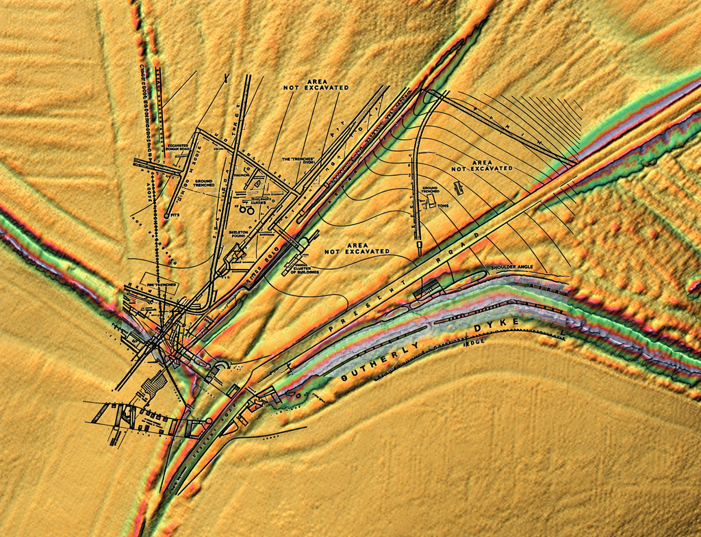
Pitt-Rivers was investigating a complicated archaeological landscape.
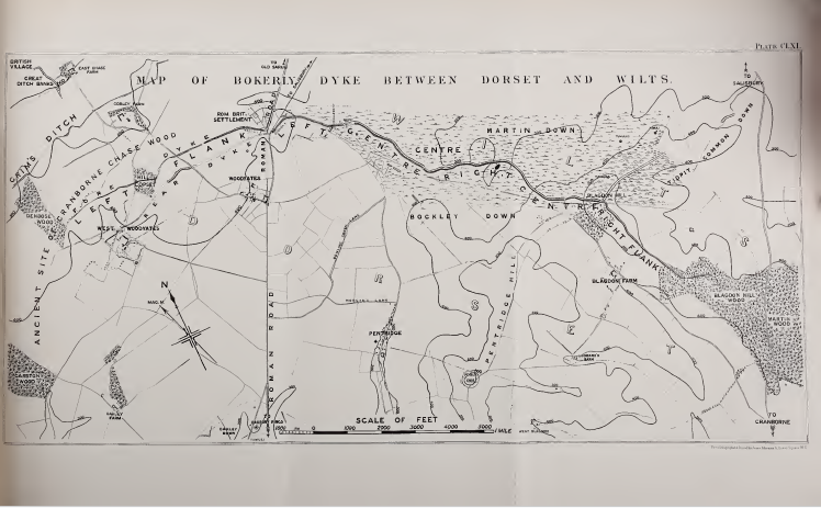
The recognised Roman-road alignment crossed Bokerley Dyke, a substantial earthwork system extending across the Dorset-Wiltshire borderlands.
Around the junction lay a Romano-British settlement containing pits, hearths, burials, structures and an extensive network of excavated drains.
The Dorset Historic Environment Record describes this settlement as occupying both sides of Bokerley Dyke, with the main period of activity extending from approximately AD 275 to 400 [10].
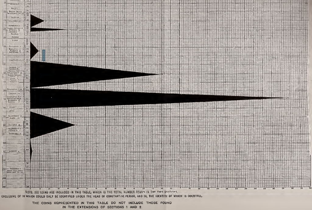
The excavations recovered more than 1,200 Roman coins, although relatively few belonged to the earlier centuries of Roman occupation.
The archaeological record also includes Iron Age pottery and a burial associated with a first-century brooch.
The wider landscape had therefore experienced several phases of activity before its final Roman-period occupation and reconstruction.
Most importantly, Pitt-Rivers investigated not just a road but the relationships between the road, the settlement and successive phases of Bokerley Dyke.
This makes his excavation records especially valuable.
They contain the evidence necessary to distinguish what was constructed, what was subsequently altered and which structures existed before others.
Section 3 — The Famous Roman Road
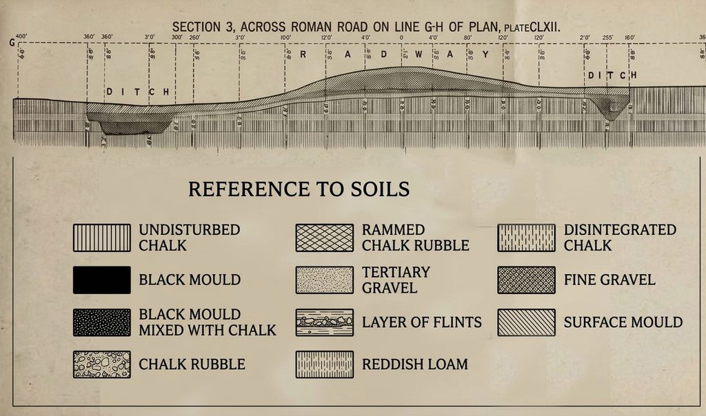
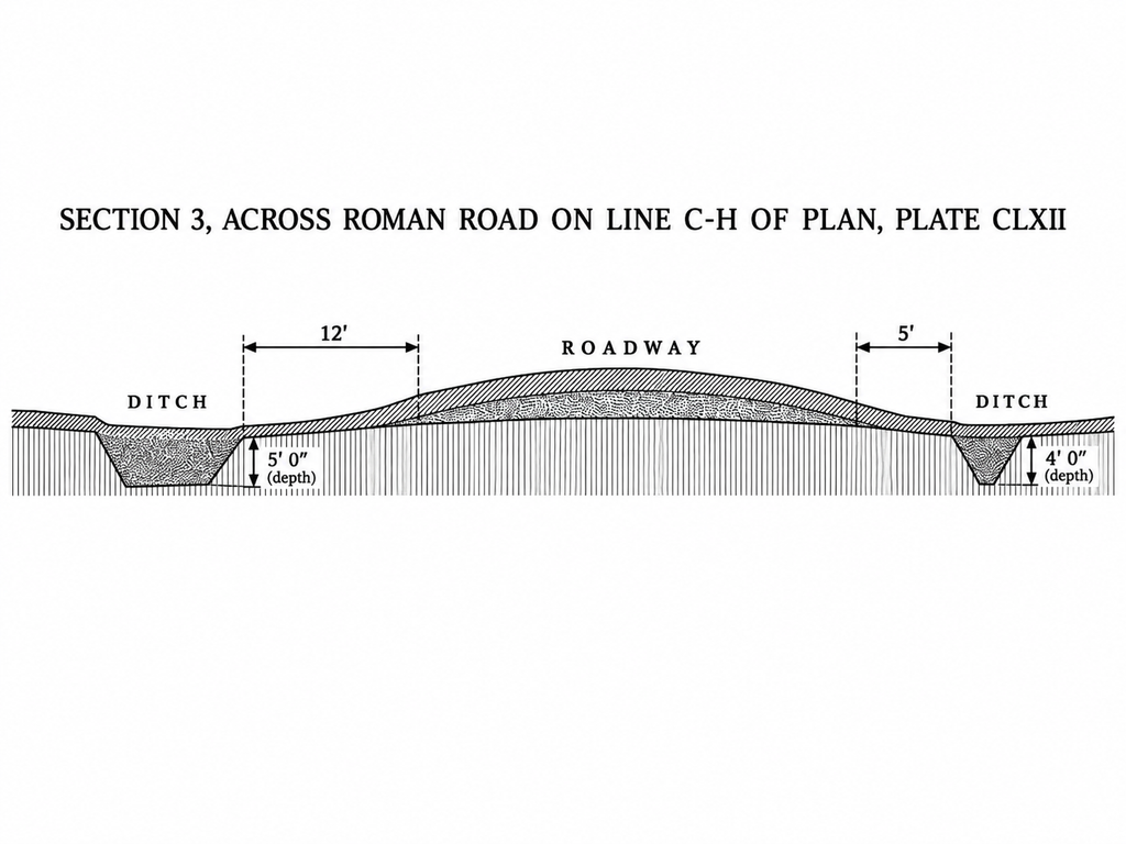
Section 3 was one of Pitt-Rivers’ most important road excavations.
He located this approximately 245 feet, or 74.7 metres, north-east of the Fore Dyke [5].
The excavation exposed a deliberately constructed road formation.
From the surface downwards, Pitt-Rivers recorded approximately:
- Four inches of turf mould.
- Eight inches of fine gravel containing small rounded pebbles.
- Five inches of rammed chalk rubble.
- A four-inch layer of large nodular flints.
- The original ground surface beneath the construction.
This was unquestionably an engineered surface.
The gravel, rammed chalk and flint foundation demonstrate deliberate road-building activity.
Pitt-Rivers also recorded ditches on either side of the road.
Their inner margins were separated by approximately 49 feet, or 14.9 metres [5].
These observations provide substantial archaeological evidence for a prepared roadway at Woodyates.
However, Pitt-Rivers’ own description includes an important qualification.
He explained that the road had already suffered extensive destruction.
Approximately 170 yards, or 155 metres, of its centre had been excavated for stone.
Elsewhere, material had apparently been removed to construct later road embankments.
As a result, Pitt-Rivers found it difficult to obtain satisfactory excavation sections from the surviving structure.
Section 3 was selected partly because it offered an opportunity to examine comparatively well-preserved construction.
This is significant.
Section 3 was not necessarily representative of the entire original monument. It was a surviving piece of road construction within a landscape already extensively modified and damaged.
There is another important observation.
Pitt-Rivers recorded fragments of New Forest pottery, nails and a glass bead within the material associated with Section 3.
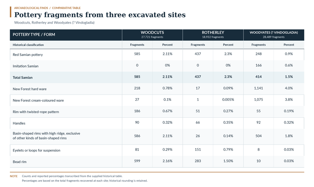
He took this as evidence that the ground had been occupied before construction of the road formation at this location [5].
The pottery is particularly relevant because New Forest ware belongs principally to the later Roman period.
The finding supports a relatively late construction or reconstruction episode at this location, depending upon the exact depositional context.
It does not establish an earlier prehistoric date for the road.
But a later road-building episode should not be confused with the first creation of every surrounding bank and ditch.
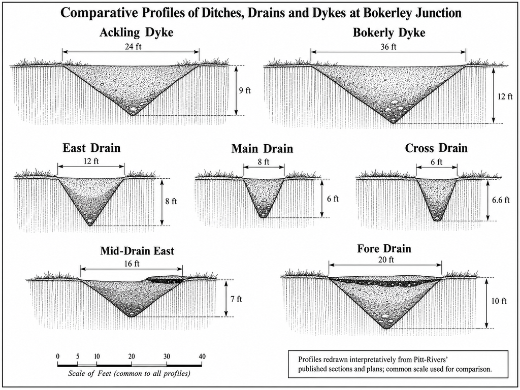
What Section 3 establishes is a deliberately engineered roadway, not a complete construction history for the entire Ackling Dyke corridor.
Section 4 — The Road Changes Within 402 Metres
If the traditional Roman-road interpretation represents one consistently constructed engineering project, Pitt-Rivers’ next excavation provides an immediate opportunity for comparison.
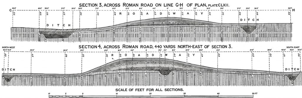
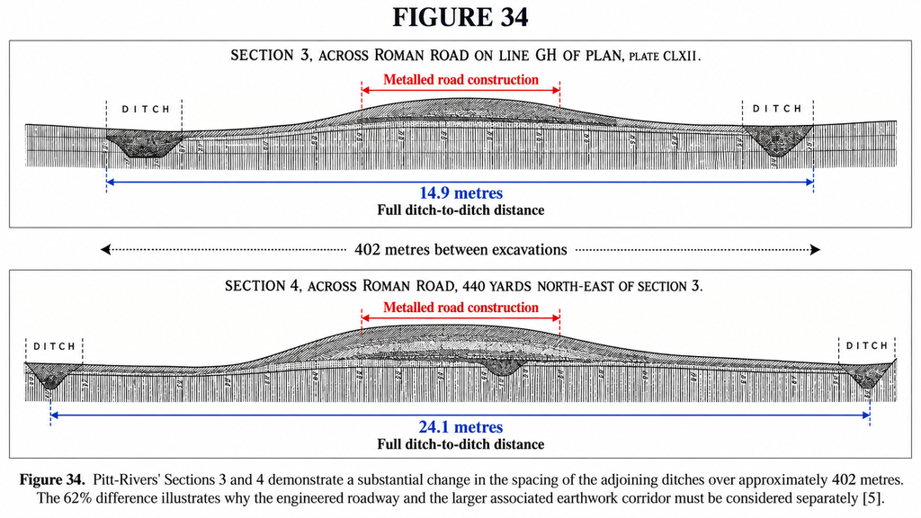
Section 4 was excavated approximately 440 yards, or 402 metres, north-east of Section 3 [5].
Pitt-Rivers considered this part of the road particularly well preserved.
Its construction was substantial.
He recorded successive deposits of gravel, compacted chalk and large flints laid upon the original ground surface.
The completed formation stood approximately three feet above the original surface, excluding the overlying turf and soil.
So far, this is entirely consistent with an engineered Roman road.
But the surrounding dimensions had changed dramatically.
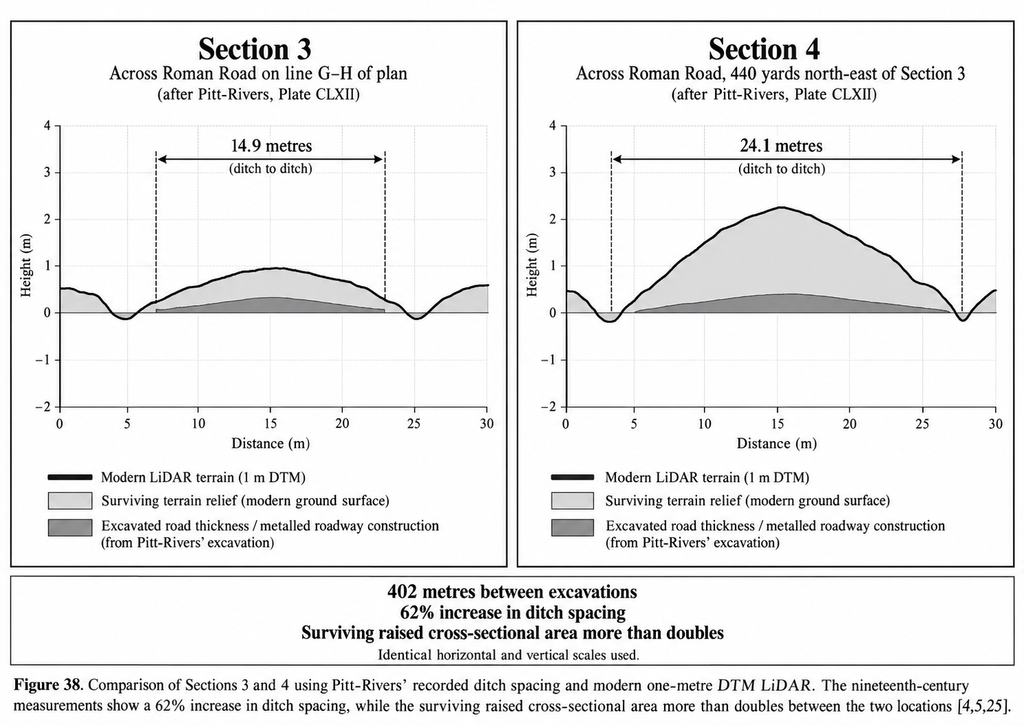
At Section 3, the inner margins of the flanking ditches were 49 feet apart.
At Section 4, they were approximately 79 feet apart.
That gives us the following comparison.
| Pitt-Rivers’ measurement | Section 3 | Section 4 |
|---|---|---|
| Spacing between inner ditch margins | 14.9 m | 24.1 m |
| Distance between excavation locations | — | 402 m |
| Increase in ditch spacing | — | 9.2 m |
| Percentage increase | — | Approximately 62% |
This is a substantial difference.
In less than half a kilometre, the total spacing between the supposedly corresponding roadside ditches increased by nearly two-thirds.
Pitt-Rivers himself recognised that the broader ditch arrangement appeared to include more than the intended width of the actual roadway [5].
That observation is extremely important.
It means he was already distinguishing the engineered running surface from the wider system of banks and ditches surrounding it.
The road and the larger earthwork corridor were not necessarily the same engineering structure.
A roadway could have been built within a broader pre-existing corridor.
Alternatively, the differences might reflect separate road-building episodes, local construction requirements, disturbance or later modification.
The excavations alone do not decide between those possibilities.
But they demonstrate that treating one road section as the universal design for Ackling Dyke is not justified.
And this conclusion emerges directly from the nineteenth-century measurements.
We have not yet needed to introduce our new LiDAR evidence.
The Missing 155 Metres — And the Channel Problem
Pitt-Rivers’ account becomes still more interesting when we compare it with the modern terrain model.
Our investigation examined approximately 7.56 kilometres of the Ackling Dyke alignment using one-metre Digital Terrain Model LiDAR [4,25].
We generated 303 perpendicular cross-sections, spaced at approximately 25-metre intervals.
This allowed us to examine the surviving earthwork systematically rather than relying exclusively on the two nineteenth-century excavation trenches.
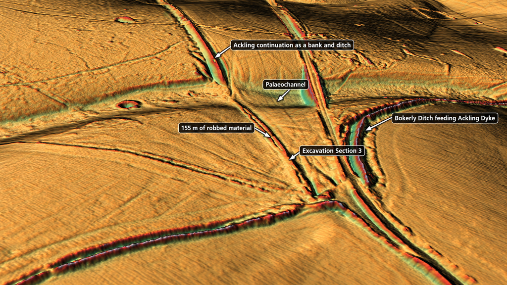
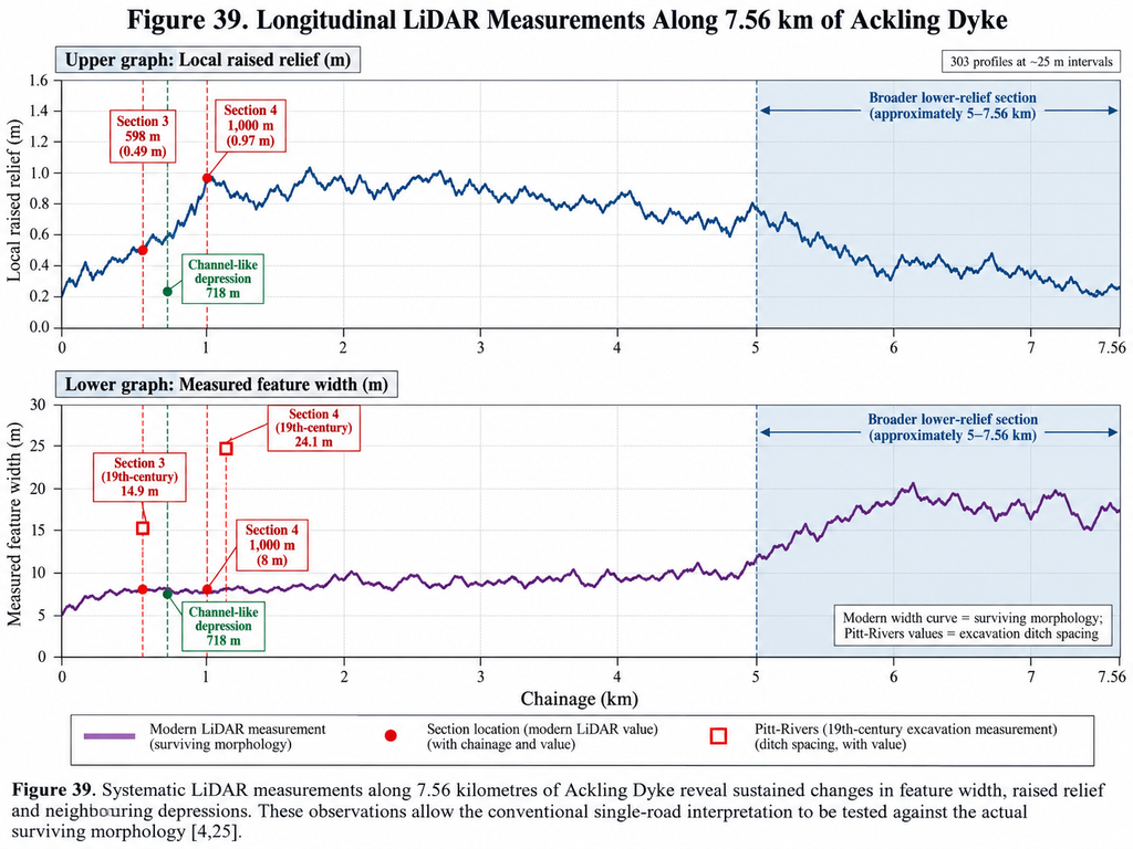
Using Pitt-Rivers’ recorded distances and the mapped Bokerley reference point, we reconstructed the approximate location of Section 3 at chainage 598 metres.
The modern terrain profile at this location displays a raised feature with approximately 0.49 metres of local relief.
But only around 120 metres farther along the route, at chainage 718 metres, the LiDAR records a much stronger depression or channel-like signature.
Our earlier visual examination had suggested a comparable distance of approximately 124 metres.
The close agreement is noteworthy, although both measurements refer to the modern surviving terrain and depend upon the reconstructed excavation positions.
The feature does not simply maintain the same form.
The local profile changes from a raised road-like feature towards a substantial depression.
However, Pitt-Rivers’ own account provides an important alternative explanation.
He explicitly recorded the destruction and removal of approximately 155 metres of road material in this general landscape.
Some or all of the depression could therefore relate to later extraction rather than an original water channel.
That explanation must be taken seriously.
But there is a further consequence.
If large portions of the monument were already missing when Pitt-Rivers investigated them, we cannot assume that the surviving Section 3 represents the original form of everything that has disappeared.
The Roman road foundations are demonstrated where Pitt-Rivers excavated them. We cannot recover the original form of the destroyed sections merely by extending the same profile across the gap.
The LiDAR identifies an important morphological transition.
Its original cause and function remain separate questions.
Section 5 — The Road Beneath Bokerley Dyke
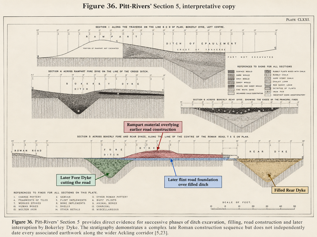
Pitt-Rivers’ Section 5 provides perhaps the clearest evidence that the Woodyates landscape underwent successive construction phases.
Here he excavated across the Fore and Rear Dykes along the course of the recognised Roman road [5].
The findings are especially important because the excavation exposed relationships between successive ditches and road surfaces.
The Rear Dyke represented an earlier phase of the Bokerley earthwork at this junction.
Excavators excavated its ditch and later filled it.
The filling contained Roman material, including coins associated with Carausius and Valens.
The Valens coin provides a late fourth-century chronological indicator, assuming it was securely deposited within the recorded fill.
Above the filled ditch, Pitt-Rivers identified a road foundation containing large nodular flints.
The physical relationship demonstrates that this road surface was placed over the earlier filled ditch.
Consequently, the surviving foundation at this crossing belongs to a phase after the relevant ditch filling was deposited.
But Pitt-Rivers made an important distinction.
The existence of a road surface over the filled ditch did not necessarily mean that no road had existed before the ditch was excavated.
The ditch could have cut an earlier route, and it could have been restored.
The excavation therefore established a road-building or rebuilding episode.
It did not necessarily establish the date when the original route through the landscape first came into use.
The later Fore Dyke created another construction relationship.
Pitt-Rivers observed that its excavation cut through the road and that material from the later rampart covered surviving road layers.
This provides a genuine archaeological sequence.
The road existed before this later dyke construction.
The dyke was subsequently excavated across it.
And the road had previously been restored across the filled Rear Dyke.
These relationships are not speculative.
They are recorded in the excavation.
The landscape was repeatedly altered. Ditches were excavated, filled and crossed by renewed road construction. Later earthworks then interrupted the road again.
This is clear evidence for more than one phase of engineering at Woodyates.
It must, however, be interpreted carefully.
Section 5 provides strong late Roman chronological evidence for road repair and dyke construction.
It does not positively establish a prehistoric road or canal beneath these works.
Equally, the date of a late Roman road repair cannot automatically establish the original construction date of every larger bank or ditch associated with Ackling Dyke over the rest of its course.
Our investigation addresses that distinction.
Section 6 — The Ditch-Bottom Measurements Archaeologists Should Not Ignore
Section 6 contains another particularly important observation.
Pitt-Rivers did not simply record ditch positions.
He examined their physical relationships and measured their relative elevations [5].
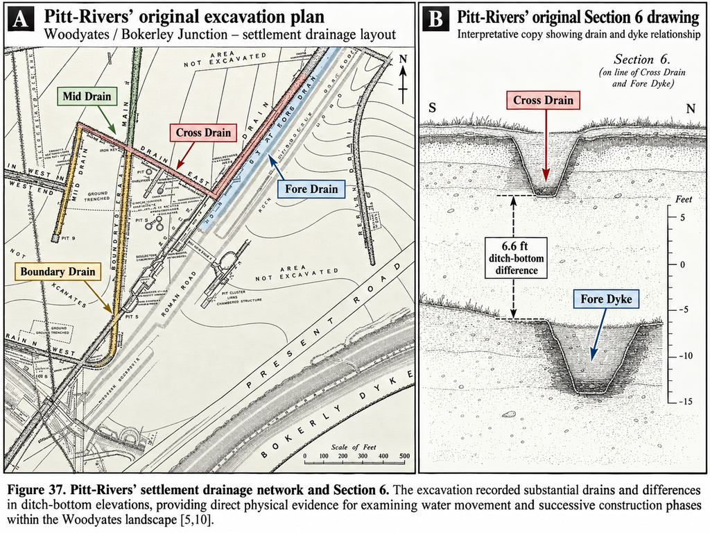
Among the features recorded around the Romano-British settlement were the Fore Drain, Boundary Drain, Mid Drain and Cross Drain.
These were substantial excavated structures.
Their arrangement formed a network of rectilinear enclosures, with individual drains approaching, intersecting or terminating near other major ditches.
The modern Dorset Historic Environment Record also describes the Woodyates settlement as containing a drainage system forming rectangular enclosures [10].
This is significant because the excavations demonstrate that water management formed part of the Roman-period settlement landscape.
One of the most revealing measurements concerns the relationship between the Cross Drain and the Fore Dyke.
In Section 6, Pitt-Rivers identified a difference of about six and a half feet between the recorded ditch-bottom levels, with the Cross Drain standing substantially higher than the deeper Fore Dyke ditch [5].
He considered the implications for the drainage relationship and construction sequence.
The difference is important because the original bed levels determine whether one excavation could have discharged into another under the conditions being considered.
A ditch identified as a drain should not be interpreted solely from its position on a plan.
Its depth and level matter.
So does its relationship with earlier or later structures.
A channel that is functional during one phase of construction may become obstructed or isolated when a deeper ditch is excavated, or an adjoining earthwork is rebuilt.
Likewise, a ditch that appears disconnected in its final archaeological form may previously have operated within a different drainage arrangement.
This does not demonstrate that Ackling Dyke was itself a prehistoric canal.
But it establishes that Pitt-Rivers was dealing with a landscape in which water movement, ditch-bottom elevations and successive engineering modifications were archaeologically relevant.
Our wider hydraulic interpretation must therefore be tested against the actual levels recorded in these excavations.
And the conventional interpretation should not ignore those same measurements when explaining the larger earthwork network.
The Roman Settlement Was Older Than Some of the Major Earthworks
Another important discovery concerns the relationship between occupation deposits and the construction of Bokerley Dyke.
Pitt-Rivers recovered extensive late Roman material from the settlement and from material incorporated into later earthworks.
The excavated ramparts contained numerous Roman coins.
The material was especially important where former occupation deposits had been disturbed and incorporated into newly constructed banks [5].
This shows that the relevant occupation occurred before those later ramparts were built.
Subsequent archaeological investigations, particularly those associated with Philip Rahtz in 1958, strengthened the evidence for multiple late Roman phases of Bokerley Dyke [23,24].
The Dorset Historic Environment Record describes three principal phases of the earthwork: an earlier A Dyke, a later B or Rear Dyke, and a still later C or Fore Dyke.
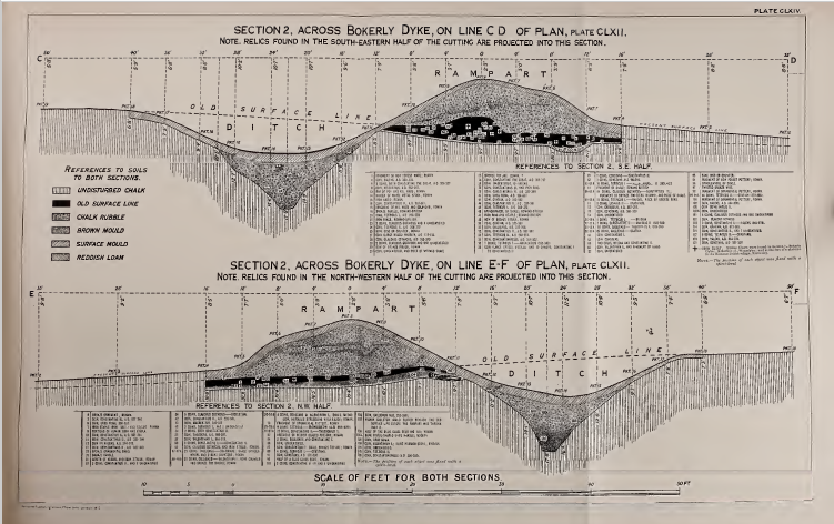
The proposed dates include construction around AD 325–330, a major alteration after AD 364 and another phase after the early 390s.
These dates reflect archaeological interpretations of specific construction episodes.
They should not be treated as the foundation dates for every earthwork in the surrounding prehistoric landscape.
Historic England itself recognises that Bokerley Dyke may have originated in the Bronze Age or Early Iron Age before extensive later rebuilding [3].
Its surviving form therefore includes substantial evidence for late Roman reconstruction while the possibility of earlier origins remains part of the official interpretation.
The consequence is important.
Dating a reconstructed rampart does not necessarily date the earliest earthwork occupying the same corridor.
That is especially relevant when a monument has undergone repeated excavation, filling, recutting and rebuilding.
At Woodyates, those processes are not hypothetical.
They were recorded in the ground.
Re-examining Pitt-Rivers with 303 LiDAR Profiles
The next stage of our investigation moves beyond the excavated junction.
Pitt-Rivers was restricted to selected trenches and the surface survey methods available in the nineteenth century.
We can now follow the surviving Ackling earthwork continuously.
Our detailed study used one-metre DTM LiDAR across approximately 7.56 kilometres of the Woodyates corridor [4,25].
We sampled the centreline at 25-metre intervals, producing 303 transverse profiles.
We analysed each profile for the relief of the central raised formation, the width of the identifiable feature, and the character of neighbouring depressions.
The results demonstrate substantial variation in the surviving morphology.
The reconstructed locations of Pitt-Rivers’ Sections 3 and 4 provide an especially useful comparison.
| Measurement | Section 3 | Section 4 |
|---|---|---|
| Approximate LiDAR chainage | 598 m | 1,000 m |
| Surviving local raised relief | 0.49 m | 0.97 m |
| Half-prominence width | 8 m | 8 m |
| Nearby trough depth | 0.25 m | 0.36 m |
| Raised cross-sectional area | 3.34 m² | 7.46 m² |
| Pitt-Rivers’ ditch spacing | 14.9 m | 24.1 m |
The distinction between the two sets of measurements is essential.
Pitt-Rivers’ figures are nineteenth-century excavation observations.
Our LiDAR measurements describe the surviving modern terrain.
They cannot be treated as direct measurements of the original road-building thickness.
Nevertheless, they provide an independent comparison of the surviving landscape.
At Section 4, the modern raised relief is nearly twice that measured at Section 3.
The raised cross-sectional area is more than twice as large.
And Pitt-Rivers’ original ditch spacing increases by approximately 62%.
These are substantial differences over a short distance.
They do not prove separate dates.
But they undermine any assumption that the complete surviving monument possesses one consistent constructional profile.
Beyond the Excavations — The Monument Changes Again
The wider 303-profile investigation reveals a more substantial pattern.
For much of the central section of the surveyed corridor, the identifiable raised feature is comparatively narrow.
Between approximately one and four-and-a-half kilometres along the study alignment, typical measured feature widths are around eight to ten metres.
Local raised relief frequently approaches 0.8 to 1.0 metres.
But farther along the route, the morphology changes.
Beyond approximately five kilometres, the principal identifiable feature becomes broader, commonly measuring around 15 to 20 metres.
At the same time, the central raised formation becomes generally lower and the neighbouring depressions less pronounced.
Between chainages of approximately 5.5 and 6 kilometres, the median recorded trough depth falls to around 0.04 metres [25].
This is a sustained change in the surviving earthwork.
It is not confined to one isolated excavation trench.
We therefore encounter contrasting morphological regimes along what conventional maps identify as one continuous Roman road.
Part of the monument appears relatively narrow and prominently raised.
Another part becomes broader and substantially less pronounced.
Elsewhere, channel-like depressions, disturbed sections and different neighbouring linear features complicate the picture.
Some of this variation undoubtedly reflects later damage.
Cultivation, erosion, quarrying and modern land use can substantially change an ancient monument.
Roman roads could also vary in width and height according to local terrain and construction requirements.
But those explanations cannot simply be assumed to account for every measured difference.
They must be assessed against the individual features.
The archaeological question is whether the variation results entirely from preservation and road-building adaptation, or whether the surviving corridor incorporates structures originally built during different phases and possibly for different purposes.
The LiDAR demonstrates substantial physical variation. The next task is to establish the chronology and function of that variation.
Does the Evidence Support an Earlier Engineering Corridor?
Having examined the road sections, the ditch network, the construction sequence and the modern LiDAR, we can now return to the central question.
Could Roman engineers have constructed their roadway through an older system of substantial earthworks?
The excavations show that such reuse is an archaeological possibility.
At Bokerley Junction, ditch construction interrupted road surfaces, which were later restored.
Later dykes cut through earlier formations.
Occupants incorporated occupation deposits into new ramparts.
Drainage structures were modified as the settlement and surrounding earthworks developed.
This demonstrates a landscape undergoing repeated engineering rather than one construction episode.
Farther along Ackling Dyke, the surviving banks and depressions change significantly in form.
At Vernditch Chase, examined in Section 8, recognised prehistoric ditch systems approach and continue across the accepted Roman-road corridor [20–22].
Together, these findings raise a substantial question about the original relationship between the Roman roadway and the larger earthwork network.
Our Post-Glacial Flooding Hypothesis proposes that some major prehistoric ditches may have formed part of water-management or water-assisted transport systems [7].
Under that interpretation, sections of older channels and adjoining banks could later have been adapted for terrestrial transport.
Roman engineers could then have constructed metalled surfaces upon strategically useful stretches of an inherited landscape.
This could explain the coexistence of genuine Roman road construction with much larger and morphologically different earthworks.
But one distinction must remain clear.
A raised bank that climbs and descends across substantial hills cannot itself have functioned as a continuously level water channel.
A hydraulic interpretation therefore requires examining the proposed water-bearing ditches independently of the road crest.
Their longitudinal bed elevations, possible water sources, former water levels and physical connections must all be consistent with the intended function.
The ditch system, rather than every metre of the raised roadway, must be tested for possible hydraulic use.
This is particularly relevant at Woodyates, where Pitt-Rivers actually recorded the elevations of individual drains.
The archaeological evidence therefore gives us a method for evaluating the hypothesis rather than merely proposing an alternative historical label.
What Pitt-Rivers Actually Demonstrated
The results can now be distinguished more clearly.
Pitt-Rivers demonstrated that deliberately constructed road surfaces existed at Woodyates.
He excavated flint foundations, compacted chalk and gravel.
He recorded substantial adjoining ditches whose dimensions differed between the excavated locations.
He identified road construction placed across a previously filled ditch.
He documented later earthworks that cut and covered road surfaces.
He recovered extensive Roman-period material from the surrounding settlement.
He also recorded a complex drainage network with features at different elevations.
These are substantial archaeological observations.
They strongly establish Roman-period engineering, settlement activity and repeated construction at the Bokerley junction.
But several broader claims require additional evidence.
The excavations do not independently establish that every bank and ditch along the 7.56-kilometre study corridor was created in one Roman construction episode.
They do not establish that the different modern LiDAR profiles all represent the same original structural arrangement.
Nor do the excavated late Roman road surfaces determine the first use of every substantial linear earthwork through which the later route passes.
Our investigation must therefore distinguish between three separate questions.
First: did the Romans construct and use roads at Woodyates?
Yes. The excavated engineering and associated archaeological evidence strongly support that conclusion.
Second: was the relationship between Ackling Dyke, Bokerley Dyke and the surrounding drains altered repeatedly?
Yes. The excavation demonstrates successive phases of cutting, filling, road construction and rebuilding.
Third: did Roman engineers originally excavate every element of the monumental Ackling Dyke corridor?
That broader proposition is not established merely by the presence of Roman road construction at Woodyates.
This is the distinction lost when a complicated archaeological landscape is reduced to one line on a map.
Conclusion — A Roman Road Within a Much Older Landscape?
Woodyates has provided the strongest physical evidence encountered so far in our journey from Old Sarum.
Unlike the uncertain crossings of the Avon, Nadder and Ebble, the excavations at Bokerley Junction establish genuine engineered road surfaces.
The Roman presence is substantial and well documented.
But the excavation records also reveal an archaeological landscape repeatedly reconstructed over several centuries.
Pitt-Rivers found ditches that had been excavated and filled.
He found roads constructed over earlier disturbances.
He found later earthworks interrupting existing road surfaces.
He recorded drainage features whose physical relationships depended upon their positions and elevations.
Sections 3 and 4 already show major differences in the dimensions of the structures surrounding the road.
Our modern LiDAR extends that observation across approximately 7.56 kilometres.
The 303 profiles reveal repeated variations in the height, width and surviving character of the monument.
The result is not one identical earthwork continuing unchanged through the landscape.
It is a complex sequence of surviving forms whose construction histories need to be understood individually.
Pitt-Rivers demonstrated Roman road construction at Woodyates. He did not demonstrate that the entire Ackling Dyke monument originated as one Roman engineering project.
That is not a criticism of his excavation.
It recognises what his archaeology actually tells us.
The evidence for Roman road building is real.
The evidence for successive construction and rebuilding is equally real.
And the wider landscape contains substantial linear structures whose origins cannot be established solely by dating a later road surface.
Our hydraulic interpretation proposes that some of those earthworks may belong to a considerably earlier system of connected ditches and transport infrastructure.
The excavations at Woodyates do not prove that earlier hydraulic origin.
But they identify the very construction relationships and ditch levels through which such an interpretation can be investigated.
The Romans undoubtedly engineered part of Ackling Dyke.
The more important question is whether they were its original builders — or simply the latest major engineers to make use of an already ancient landscape.
The remaining sections of this investigation will continue to test that question.
References
[3] Historic England. Bokerley Dyke, and a Section of Grim’s Ditch, a Section of a Medieval Boundary Bank, and Two Bowl Barrows on and North West of Martin Down. Scheduled Monument 1012135.
https://historicengland.org.uk/listing/the-list/list-entry/1012135
[4] Langdon, R. J. (2026). Ackling Dyke: Old Sarum–Dorchester Route-Wide LiDAR and Morphological Investigation. Original research dataset and measured profiles. Unpublished.
[5] Pitt-Rivers, A. H. L. F. (1892). Excavations in Cranborne Chase, Near Rushmore, on the Borders of Dorset and Wilts. Volume III: Excavations in Bokerly and Wansdyke, Dorset and Wilts, 1888–1891. Privately printed. Particularly pp. 20–21, 69–74 and 90–91, with Plates CLXIII and CLXXI.
[7] Langdon, R. J. (2026). The Post-Glacial Flooding Hypothesis: The Evidence. Version 3.4.
[10] Dorset Council. Romano-British Settlement at Bokerley Junction, Woodyates, Pentridge. Dorset Historic Environment Record MDO5931.
https://heritage.dorsetcouncil.gov.uk/Monument/MDO5931
[20] Historic England. Two Linear Earthworks in Vernditch Chase. Scheduled Monument 1010763.
https://historicengland.org.uk/listing/the-list/list-entry/1010763
[21] Historic England. Three Adjoining Linear Earthworks and Three Bowl Barrows North of Bokerley Dyke on Martin Down. Scheduled Monument 1011006.
https://historicengland.org.uk/listing/the-list/list-entry/1011006
[22] Langdon, R. J. (2026). Ackling Dyke — Part III: The Roman Road Mystery Finally Makes Sense. Prehistoric Britain.
https://prehistoric-britain.co.uk/ackling-dyke-roman-road-mystery-finally-makes-sense
[23] Dorset Council. Bokerley Dyke, Cranborne and Pentridge. Dorset Historic Environment Record MDO5932.
https://heritage.dorsetcouncil.gov.uk/Monument/MDO5932
[24] Rahtz, P. A. (1961). An Excavation on Bokerly Dyke, 1958. Archaeological Journal, 118, pp. 65–99.
[25] Langdon, R. J. (2026). Ackling Dyke at Woodyates: What Pitt-Rivers Actually Proved and What Modern LiDAR Now Reveals. Prehistoric Britain, 5 October 2026.
https://prehistoric-britain.co.uk/ackling-dyke-at-woodyates-part-iii-what-pitt-rivers-actually-proved-and-what-modern-lidar-now-reveals
⬅️ Previous: Section 8 — Nadder to Woodyates: Searching for the Roman Road
➡️ Next: Section 10 — Wyke Down: Where the Route Splits