
Beyond the Nadder — Does the Roman Road Reappear?
Our investigation now continues south-west from the River Nadder towards Woodyates, following the accepted alignment of Ackling Dyke across Wiltshire’s chalk landscape.
In the preceding section, we examined the uncertain archaeological connections between Old Sarum, the River Avon and the Nadder. We found that the traditional route relies on a combination of surviving tracks, historical crossing places, geophysical interpretations and projected alignments.
But does the evidence improve once we leave the river valleys?
According to the conventional reconstruction, the Roman road crossed the Nadder near Bemerton, continued across the rising ground towards the Ebble valley, and eventually climbed onto the downs approaching Woodyates [17].
The landscape changes considerably along this journey. Low-lying river valleys give way to chalk hills, dry valleys and extensive prehistoric earthworks.
The archaeology also changes.
Whereas substantial stretches near Old Sarum and the river crossings lack clearly identifiable surviving road construction, farther south-west we encounter raised banks, apparent road foundations, metalling and scheduled monuments.
The key question is whether these surviving features form one continuous Roman road or represent separate engineering works later connected within the conventional route reconstruction.
For this section, we follow the accepted alignment without assuming every feature belongs to the same construction period.
The Nadder Crossing — An Ancient Ford but an Uncertain Road
Thomas Codrington’s 1903 account provides a useful starting point.
He describes the Roman road approaching Bemerton, where the eighteenth-century antiquarian William Stukeley had previously reported a substantial stony ford across the Nadder [17].
This historical testimony is significant because a substantial ford could preserve evidence of an earlier engineered crossing.
However, its existence would not automatically establish Roman construction.
A stony river crossing could have been constructed, maintained or rebuilt over several historical periods. Without securely dated construction deposits, its earliest use remains uncertain.
The same issue applies to the roadway beyond the crossing.
Codrington describes a road rising towards Wilton Racecourse, accompanied by a parish boundary, before continuing along a sequence of surviving routes and tracks [17].
Such features can preserve the course of an ancient road.
But they are not equivalent to an excavated Roman road foundation.
Parish boundaries frequently followed existing routeways or substantial earthworks. Their presence may demonstrate that a feature was already important when the boundary was established, but it does not independently date the feature to the Roman period.
The distinction matters because the accepted alignment is again being reconstructed through a succession of landscape indicators rather than a continuous exposed road structure.
We need evidence that the supposed Roman road extended from the Nadder crossing onto the higher ground as a deliberately constructed wheeled route.
If that evidence survives, it should be distinguishable from ordinary tracks, boundary banks and later agricultural features.
If it has been destroyed, the precise alignment must remain partly inferred.
An ancient crossing and an ancient road are not necessarily parts of the same original engineering project.
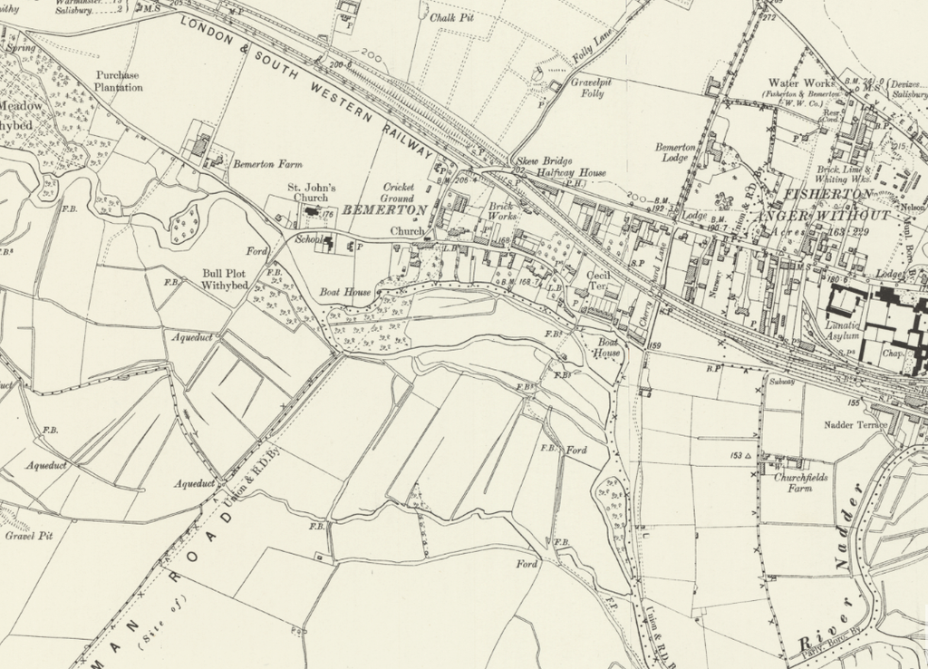
Across the Downs Towards the River Ebble
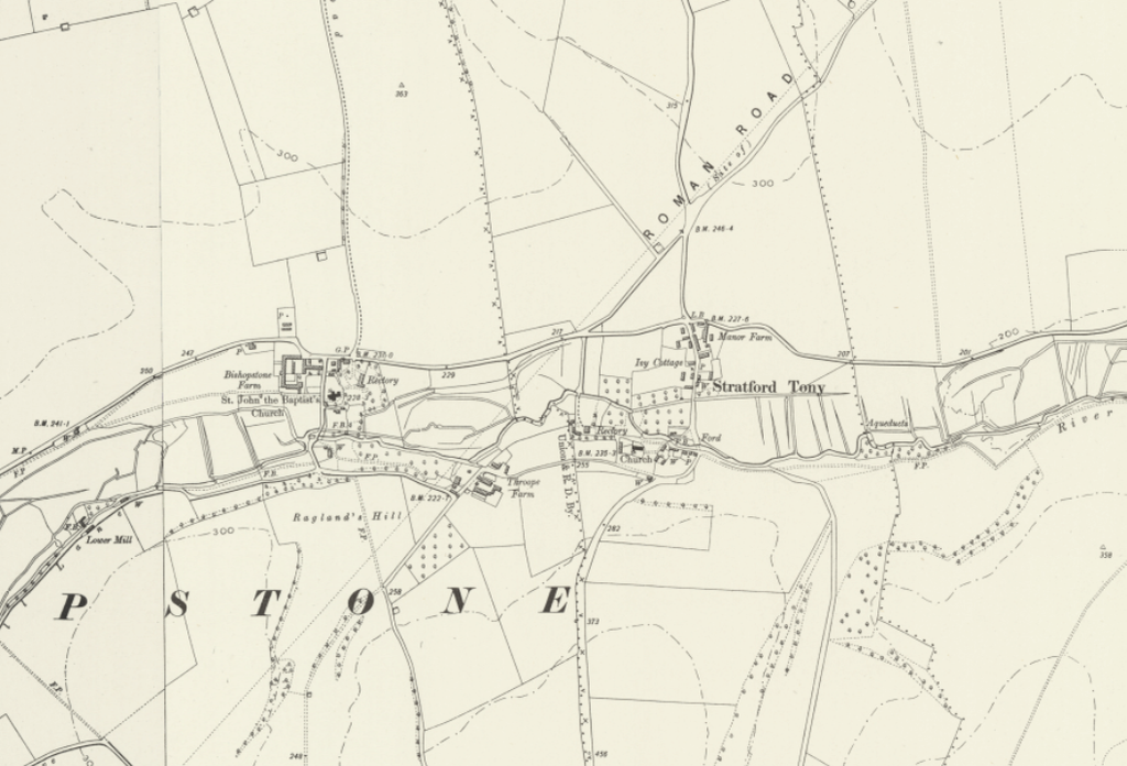
Beyond the Nadder, Codrington’s description becomes particularly revealing.
He follows a road towards Wilton Racecourse, then identifies a green track across cultivated land, another track over the downs and a lane leading towards the River Ebble near Stratford Tony [17].
Notice the changing nature of the evidence.
The route is no longer described as one continuous raised Roman embankment.
Instead, researchers reconstruct its course from several different kinds of surviving features.
A road becomes a green track. The track becomes a route over cultivated ground. Another track then provides the apparent continuation towards the next river crossing.
This sequence is not necessarily incorrect.
Ancient roads can survive differently depending on geology, cultivation, erosion, and later land use.
However, the geographical alignment of these features does not establish that they were originally built together.
The transition from the Nadder towards the Ebble should therefore be treated as a sequence of testable archaeological observations, not as a single proven construction.
Our route-wide LiDAR investigation is particularly relevant here [4].
Rather than simply tracing the conventional line, we must classify each surviving section according to its actual morphology.
Does it contain a raised, comparatively level running surface?
Is there a consistently excavated roadside ditch?
Is the apparent road only a narrow track?
Does a supposed road bank instead resemble a larger boundary earthwork?
Or has cultivation removed the surface evidence entirely?
These distinctions are essential because a line labelled as Roman on a historical map may contain several different types of structure.
Continuity of direction is not continuity of construction.
The Ebble Valley — Another Unproven Connection
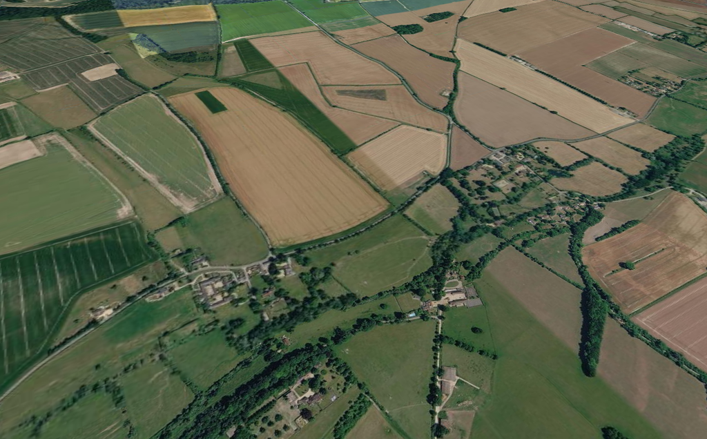
The proposed route reaches the River Ebble near Stratford Tony.
Codrington identifies a crossing in this vicinity before following an increasingly indistinct track onto the higher ground south-south-west of Bishopstone [17].
Once again, we encounter the same fundamental problem.
The reconstructed road must descend towards a river, cross its floodplain and emerge onto higher ground.
If this were one continuous engineered route, the approaches on both sides ought to form a plausible functional relationship.
That does not mean they must follow a perfectly straight line. River crossings frequently require alignment changes because of local gradients, bank conditions, and available fords or bridges.
But those changes must be explained.
Identify a crossing from physical evidence wherever possible, rather than selecting it solely because it lets a projected route continue.
Nor can the modern river channel automatically be assumed to occupy precisely the same position or have possessed the same hydrological conditions in antiquity.
Under the Post-Glacial Flooding Hypothesis, the earlier relationship between river valleys, transport routes and major earthworks presents an additional possibility for investigation [7].
However, this remains a working hypothesis. The scale and duration of any proposed earlier flooding would require independent geological and chronological evidence.
The immediate archaeological question is more restricted.
What survives at the proposed Ebble crossing to establish its construction, date and connection with the road on either side?
The historical route descriptions examined here do not resolve that question.
The Road That Suddenly Changes Direction
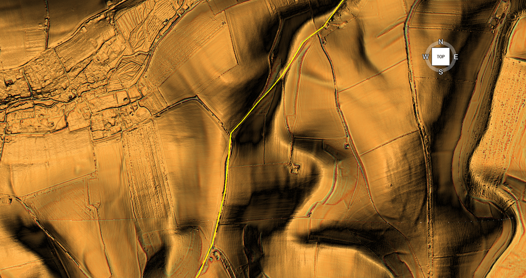
South-west of the Ebble, the traditional Roman-road interpretation encounters one of its most interesting geographical features.
The previously projected alignment changes direction.
Codrington describes a substantial diversion beginning on the higher ground approximately one mile south-south-west of Bishopstone [17].
Rather than continuing directly towards Bokerley Dyke, the reconstructed route turns to avoid a series of deep chalk valleys.
Codrington explains this change by reference to the terrain.
Continuing along the original straight alignment would have required the road to cross three steep-sided coombes, with intervening spurs of similar height.
The diversion instead follows higher ground to the south, avoiding these abrupt changes in elevation.
This is a plausible explanation for a route intended for wheeled transport.
But it also raises an important question about the engineering history.
Was the diversion constructed as part of the original road, or was an older alignment modified or reused to negotiate the landscape?
The historical description assumes that the change in direction formed part of a Roman road-planning decision.
Yet the geometry of the diversion does not establish its construction date.
A route following the natural contours could have developed in several periods, and a Roman road could equally have incorporated an existing track or earlier engineered feature.
The function and chronology must therefore be investigated separately.
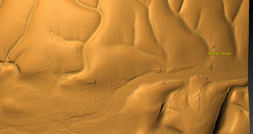
Knighton — Where Substantial Earthworks Reappear
As the accepted route continues across the downs, the archaeological evidence becomes considerably more substantial.
Historic England’s Scheduled Monument 1003728 protects sections of the so-called Knighton Roman road, extending between Reddish Gore and the reservoir in the Broad Chalke and Bishopstone area [19].
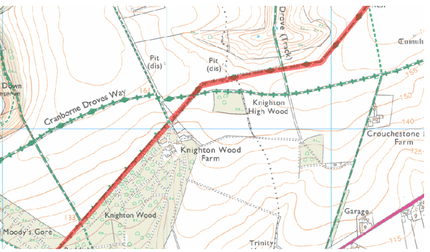
This monument is particularly important because the official description records approximately 2.6 kilometres of the accepted Roman-road alignment, divided into three protected areas.
The surviving remains include raised earthworks, an agger measuring up to approximately 10 metres wide and 1.5 metres high, and buried features visible on aerial photography, including interpreted roadside ditches.
This is materially different from the uncertain crossings examined earlier.
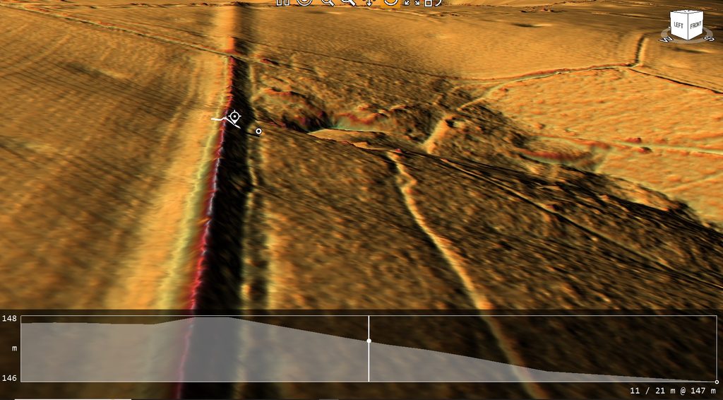
We now have a substantial linear construction that can be measured and compared with accepted Roman-road engineering.
However, two important qualifications remain.
First, the survival is differential. The road does not remain equally visible across its entire recorded length.
Second, the scheduling describes the monument as a Roman road but does not present a newly excavated and independently dated construction sequence for every part of the alignment.
Its status therefore provides strong evidence for the archaeological importance of the surviving formation, while leaving questions about its precise construction phases open.
The presence of a substantial agger supports the interpretation of an engineered route.
But the complete relationship between the central formation, its side ditches and neighbouring landscape features remains a subject for physical investigation.
Where substantial earthworks survive, our LiDAR should establish their actual widths, heights and relationships with the natural terrain.
These measurements can then be compared directly with Historic England’s descriptions.
This is where the investigation begins to move from projected geography towards identifiable construction.
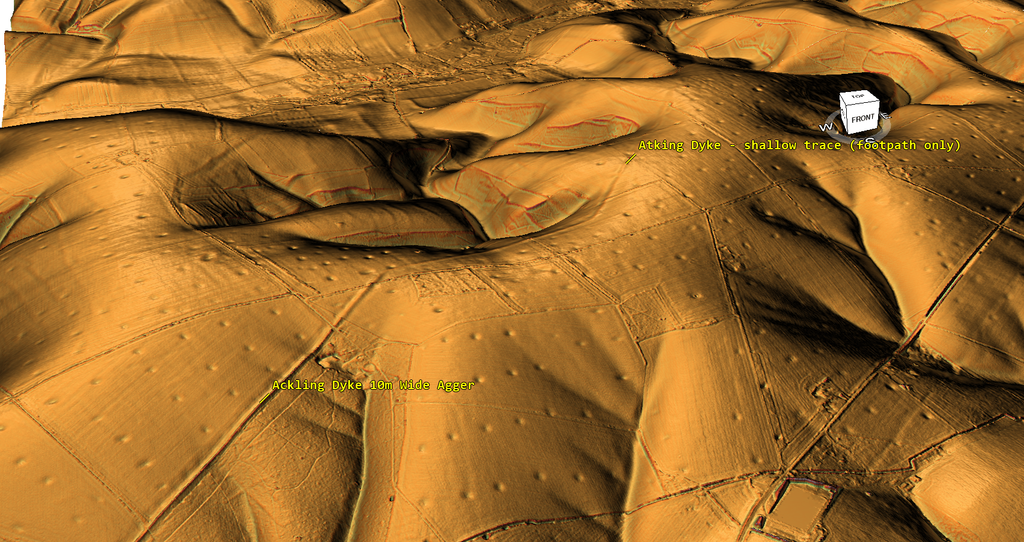
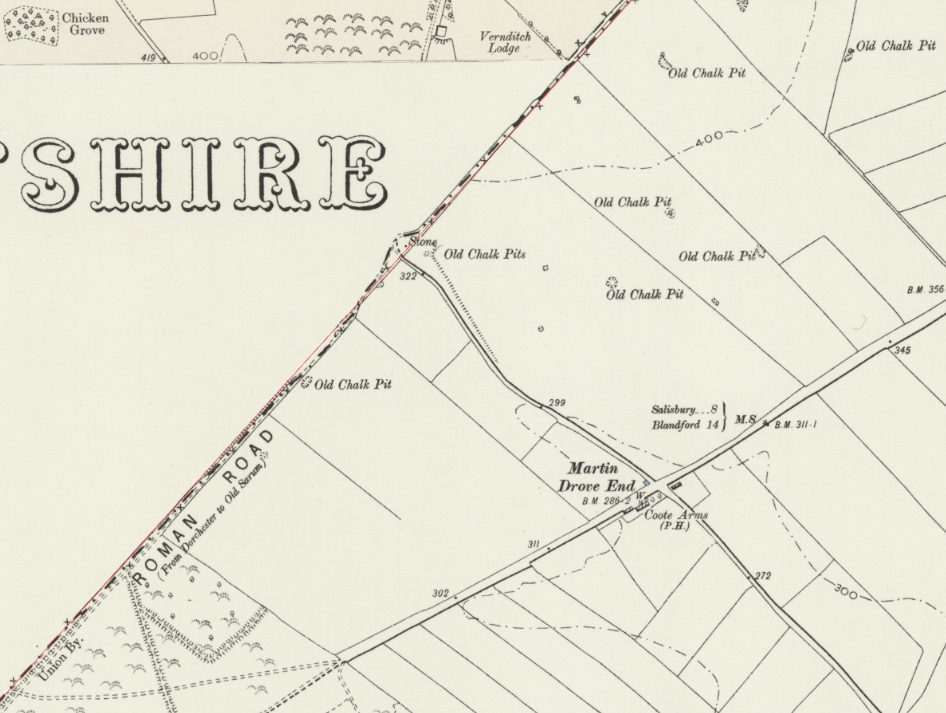
Q: Why so many pits (30m wide) at the start of the agger section of this so-called road?
The Vernditch Junction — Where the Roman-Road Explanation Breaks Down
Our investigation now reaches one of the most revealing locations along the entire Ackling Dyke corridor.
At Vernditch Chase, the problem is no longer simply that the supposed Roman road resembles a prehistoric dyke.
Here, a recognised prehistoric ditch system physically approaches and continues across the corridor occupied by Ackling Dyke.
This is not merely an interpretation based on our LiDAR investigation. Historic England’s own Scheduled Monument records acknowledge the relationship [20,21].
What those records describe, however, becomes considerably more interesting when examined as a single engineered landscape rather than as separate monuments labelled prehistoric boundary and Roman road.
A Prehistoric Dyke That Meets Ackling
Historic England’s Scheduled Monument 1010763 identifies two associated Bronze Age linear earthworks in Vernditch Chase [20].
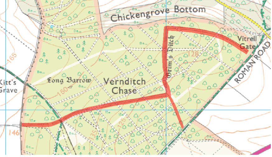
The principal earthwork forms part of Grim’s Ditch, extending approximately 1.91 kilometres through the landscape.
Its construction is substantial. At one location, the feature reaches approximately 18 metres overall, with a ditch measuring eight to nine metres across.
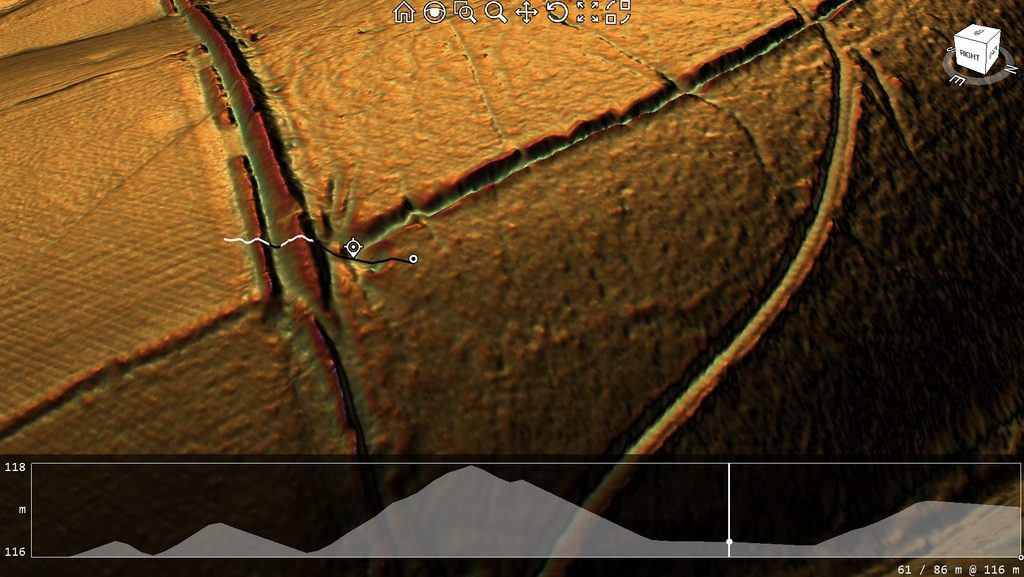
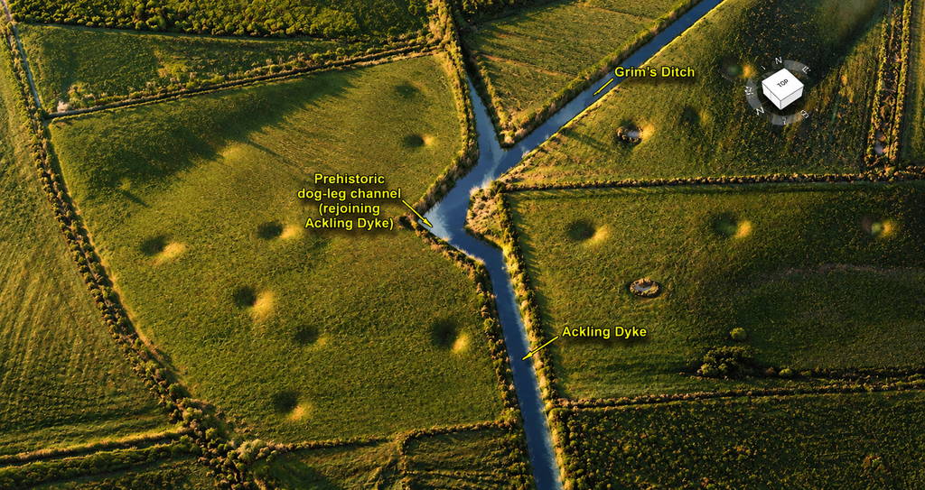
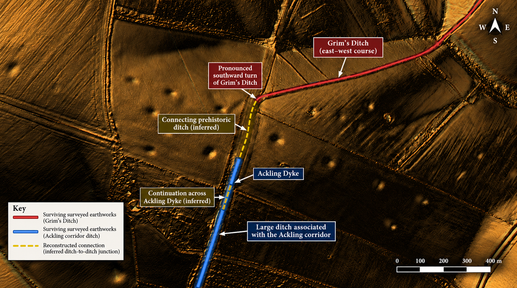
From a pronounced corner in this prehistoric system, a second earthwork runs approximately 225 metres southwards towards Ackling Dyke.
This connecting feature contains a ditch approximately five metres wide, accompanied by banks on either side.
The official description records that this earthwork is disturbed immediately north of the supposed Roman road but continues south of it, where the same linear system is protected under another Scheduled Monument classification.
South of Ackling, Scheduled Monument 1011006 records the continuation of the prehistoric earthwork system across Martin Down [21].
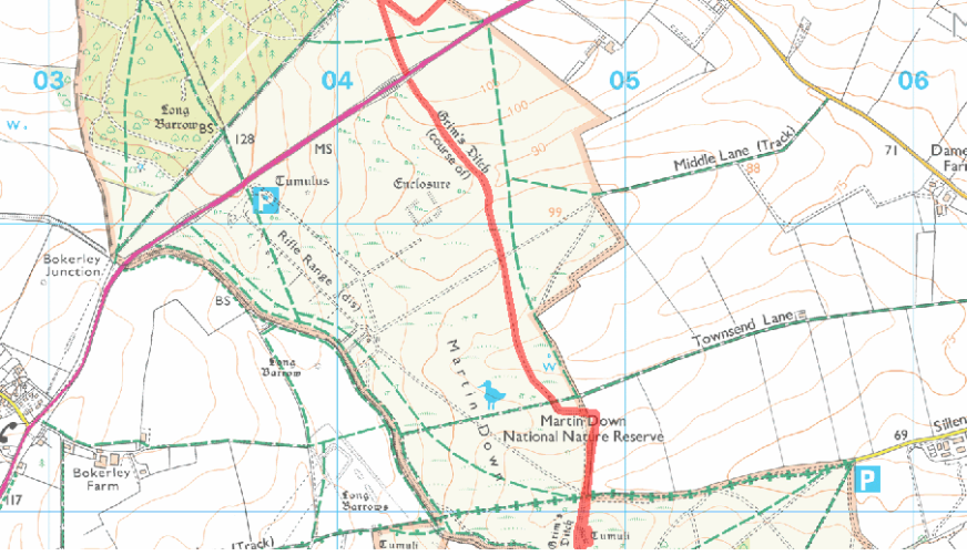
The southern system includes an approximately 1.81-kilometre linear earthwork extending towards the recognised Roman-road alignment, with its continuation north of that road joining Grim’s Ditch.
Pitt-Rivers’ excavations recovered Middle Bronze Age pottery from the ditch.
We therefore recognise prehistoric earthwork construction on both sides of Ackling Dyke, with the archaeological record identifying its continuation across the supposedly Roman corridor.
This is not a coincidence of two unrelated lines on a map.
It is an established relationship between substantial ancient earthworks.
The Dog-Leg — Why Does the Ditch Turn Towards Ackling?
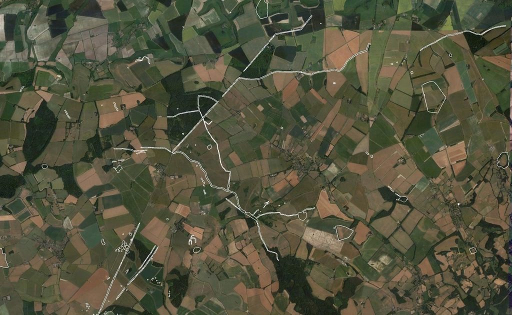
Our original LiDAR investigation reveals the most revealing aspect of this connection [4,22].
Grim’s Ditch does not simply run in a straight line until it encounters Ackling.
Instead, it makes a pronounced change of direction.
The ditch runs westwards, turns south and follows a connecting alignment towards the main Ackling earthwork.
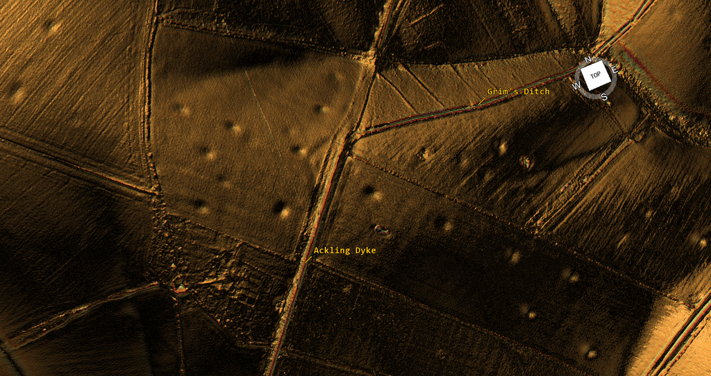
This creates an extraordinary engineering question.
Why construct this additional length of substantial ditch merely to reach what archaeologists classify as a Roman road?
For wheeled transport, the arrangement is unnecessarily complicated.
A track meeting another road does not require excavating a major connecting ditch. Travellers need access to the running surface, not a continuous trench connecting with the next earthwork.
Yet the prehistoric builders excavated precisely such a linear feature.
The distinction becomes obvious when we consider water movement.
Unlike a road, a water channel requires a physical connection with the channel receiving its water.
The unusual dog-leg is therefore intelligible as part of a connected ditch system.
The feature does not merely turn towards Ackling’s route. Our LiDAR interpretation indicates that it turns towards Ackling’s ditch.
That is the central finding of our original investigation.
We are not comparing two neighbouring earthworks because they happen to look similar.
We are examining a prehistoric ditch system whose surviving geometry appears designed to connect with the larger linear feature.
The Roman-Road Explanation Does Not Account for This Engineering
Historic England records a substantial agger along the southern edge of Vernditch Chase, with gravel metalling, flint foundations and accompanying ditches [11].
But its description also identifies an unusually large ditch, reaching approximately eight metres wide and one metre deep, alongside a road whose other recorded drainage ditches are generally only two to three metres wide.
This difference in scale matters.
A relatively narrow constructed roadway and a substantial excavated dyke are not necessarily the same engineering structure.
Our original investigation proposed that this is precisely the mistake behind the conventional interpretation of Ackling Dyke [22].
A later Roman road could occupy an older engineered corridor without having created its original banks and ditches.
The Roman-style metalling would demonstrate the construction or improvement of a terrestrial road.
It would not establish that the Romans originally excavated the much larger ditch system.
At Vernditch Chase, this matters because a recognised prehistoric ditch system is already part of the same physical landscape.
The conventional explanation therefore has a serious problem.
It cannot simply classify the large Ackling earthwork as Roman road construction while treating the substantial prehistoric ditch approaching it as an unrelated boundary, without accounting for their physical relationship.
The labels do not explain the engineering.
Two Scheduled Monuments — One Connected Landscape
Another revealing detail appears in the official records.
Historic England acknowledges that the prehistoric earthworks and the supposed Roman road abut one another, but explains that they have been designated separately for clarity [20,21].
That is an administrative distinction.
Separate scheduling does not demonstrate separate original functions, nor does it establish the construction sequence at their junction.
Nevertheless, the landscape is conventionally presented in two categories.
On one side is a Bronze Age linear earthwork.
Across its path is a Roman road.
But the prehistoric linear feature continues through this same corridor.
The result is an interpretation that divides the landscape according to accepted archaeological labels without resolving the relationship between the original structures.
Our LiDAR investigation instead examines the engineering as a connected system.
Once we do that, the pronounced turns, the substantial ditch dimensions and the physical continuation become central to understanding the monument.
The Hydraulic Explanation
Under the Post-Glacial Flooding Hypothesis, this arrangement has a coherent functional explanation [7,22].
The larger ditch-and-bank systems may have formed part of an earlier network connecting high ground, resource areas and former watercourses.
In such a system, major linear ditches would not necessarily follow the most convenient alignment for wheeled transport.
Their course would be determined by the destinations they served, the available gradients and the need to connect one channel with another.
A sharp turn that appears unnecessary for a road could therefore represent purposeful hydraulic engineering.
This interpretation is strengthened by the wider pattern identified in our Ackling investigation.
At Woodyates, substantial ancient dykes converge towards the Ackling corridor.
Pitt-Rivers’ excavations recorded an extensive network of drains and ditches, including carefully measured differences in ditch-bottom elevations.
Beside the much larger earthwork, our LiDAR identifies a smaller road-like formation which appears to approach a palaeochannel.
Elsewhere along the route, substantial earthworks change form or terminate near former waterways and concentrations of extraction features.
The Vernditch junction is therefore not an isolated anomaly.
It belongs to a recurring landscape pattern in which large ditches, banks, possible connecting channels and later terrestrial routes occupy the same corridors.
The hydraulic interpretation supplies a possible engineering purpose for features that a simple Roman-road explanation leaves inadequately explained.
What the Evidence Actually Challenges
The existence of Roman road construction at Vernditch Chase is not the issue.
The issue is the proposition that the substantial Ackling Dyke earthwork was originally created as one continuous Roman road.
That proposition cannot be established merely by identifying a Roman-style running surface.
Evidence at Vernditch shows that the corridor intersects a substantial prehistoric ditch network. The official records identify its continuation on both sides, while our LiDAR investigation reveals a pronounced connecting alignment whose geometry is consistent with a more extensive ditch system.
The conventional road classification does not explain why this prehistoric engineering takes the form it does, or establish that the larger Ackling ditch was first excavated for Roman roadside drainage.
This is the fundamental scientific weakness in the traditional narrative.
The road has been identified.
The larger earthwork has then been associated with that road.
And the association has too often been allowed to stand in place of an explanation for the earthwork’s original construction.
Our investigation reverses that process.
We begin with the surviving engineering.
We identify the prehistoric ditch network.
We examine how its features connect.
We distinguish the smaller constructed road from the much larger ditch-and-bank system.
And only then do we consider the Roman use of the corridor.
The Conclusion at Vernditch Chase
The Vernditch junction exposes why Ackling Dyke cannot be understood simply by tracing a Roman-road alignment across the landscape.
A substantial prehistoric ditch system already forms part of the corridor.
Its connection with the surrounding earthworks is documented, and its unusual alignment provides a meaningful engineering question that the conventional road explanation does not resolve.
Our hydraulic model interprets the dog-leg as a purposeful connection between excavated channels rather than an inexplicable diversion in a terrestrial route.
That interpretation does not depend upon denying the Roman road.
It depends upon distinguishing the original large-scale earthwork from the later roadway associated with it.
The central error in the conventional interpretation is the assumption that identifying a Roman road also identifies the original builders and purpose of the much larger dyke.
At Vernditch Chase, the recognised prehistoric earthworks demonstrate why that assumption cannot simply be accepted.
The Romans may have constructed a road through this landscape.
But the evidence does not entitle us to attribute the entire pre-existing system of monumental earthworks to Roman road engineering.
The road is one part of the archaeological story. The interconnected dykes may preserve a much earlier one.
Vernditch Chase — Two More Supposed Roman-Road Sections
As you approach Vernditch Chase, the recognised route becomes even more prominent.
Two separately scheduled monuments preserve substantial sections of the accepted Ackling Dyke alignment.
These are particularly useful because Historic England provides measurements of the surviving structures, rather than relying solely on their apparent course across the map.
The North-Eastern Section — Scheduled Monument 1013203
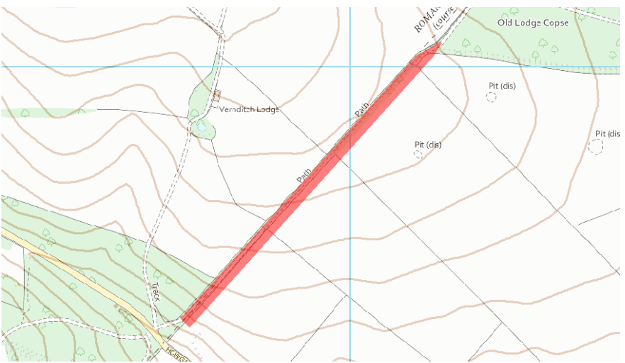
The first monument extends approximately 730 metres north-east from the Broad Chalke–Martin road towards Old Lodge Copse [9].
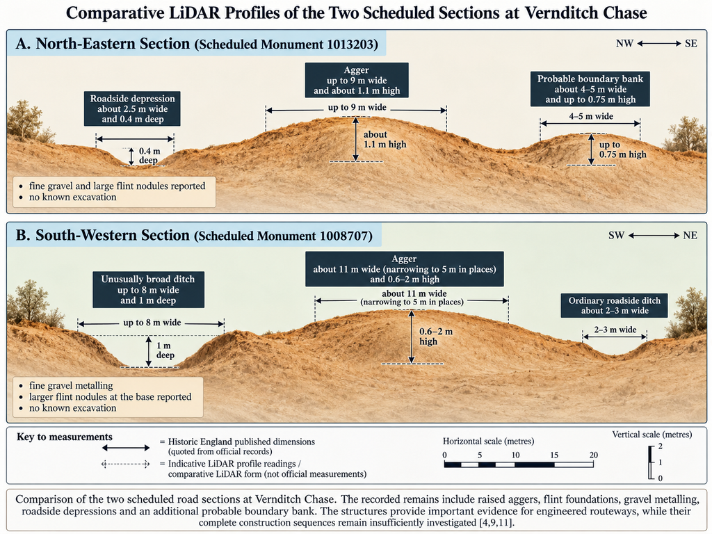
Historic England describes a raised agger up to 9 metres wide, reaching approximately 1.1 metres above the surrounding ground.
Fine gravel and large flint nodules are reported on or near the surface.
A shallow roadside depression approximately 2.5 metres wide and 0.4 metres deep survives near the southern end.
These observations are consistent with a substantial engineered roadway.
However, the scheduling also records an additional feature alongside the supposed road.
A probable boundary bank, approximately 4 to 5 metres wide and up to 0.75 metres high, lies along or near its south-eastern side.
This is especially important for our investigation.
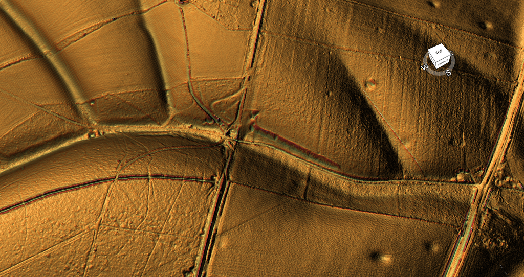
If the road formation and adjoining boundary bank are separate structures, their combined width cannot automatically be attributed to a single Roman road construction.
Cross-sections and, ideally, excavation should establish the distinction.
The agger also disappears at both ends of the scheduled stretch. Historic England records cultivation damage and material removal affecting parts of its continuation.
The record explicitly states that no archaeological excavations of this particular stretch are known [9].
Consequently, the visible fabric provides substantial evidence for an engineered formation, but the monument description does not establish the complete construction chronology of every adjoining bank and ditch.
The Southern Section — Scheduled Monument 1008707
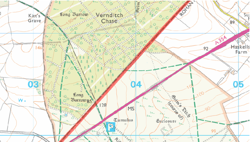
Farther south-west, Historic England records approximately two kilometres of surviving Roman-road earthworks along the southern side of Vernditch Chase, extending towards Bokerley Junction [11].
This is one of the most substantial surviving sections encountered since leaving Old Sarum.
The agger reaches approximately 11 metres in width, narrowing to around 5 metres in places, and stands between 0.6 and 2 metres above the surrounding ground.
Fine gravel metalling has been observed, while larger flint nodules forming the base of the road are exposed where forestry and farm tracks have cut into the structure.
These are important constructional observations.
They provide much stronger evidence for an engineered road formation than the isolated tracks and projected alignments across the river valleys.
However, the accompanying ditches deserve closer examination.
Historic England describes ordinary roadside ditches approximately 2 to 3 metres wide, but also records one much broader ditch, up to 8 metres wide and 1 metre deep, near the western end.
The wider ditch is not automatically evidence of a different function. Roman-road construction could involve borrow pits, larger drainage features or subsequent alterations.
But the substantial variation in ditch dimensions should not be ignored.
The record also identifies sections damaged by stone-robbing, areas where the central surface has been excavated away, and approximately 100 metres destroyed near the north-eastern end.
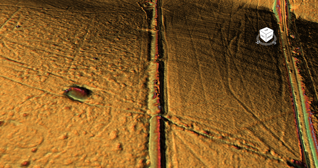
Once again, the official description states that no records of archaeological excavation exist for this scheduled stretch [11].
We therefore have clear evidence for substantial surviving construction, but more limited evidence for its complete stratigraphic history.
What Does the Surviving Road Construction Actually Prove?
By this point, the evidence has shifted.
At Old Sarum, the argument concerned an enormous cutting whose original function and construction date remained uncertain.
Across the Avon and Nadder valleys, the conventional route depended heavily on historical roads, fords, tracks and reconstructed alignments.
Farther south-west, the evidence becomes increasingly physical.
At Knighton and Vernditch Chase, Historic England describes substantial aggers, gravel metalling, flint foundations and associated ditch features [9,11,19].
These cannot simply be dismissed as imaginary roads.
They represent genuine archaeological remains that require explanation.
But an important distinction remains between establishing that an engineered road exists and establishing the complete construction history of every feature within its corridor.
For example, gravel and flint foundations establish that a prepared surface was constructed.
It does not, on its own, establish whether an adjoining large ditch was excavated at the same time.
Nor does classifying an embankment as Roman establish that every earlier layer or neighbouring bank was originally created for the same purpose.
A substantial roadway can be constructed over an existing earthwork, just as an older road can be widened, repaired or rebuilt in a later period.
These possibilities are not speculative objections to Roman archaeology. They are ordinary questions of stratigraphy and construction sequence.
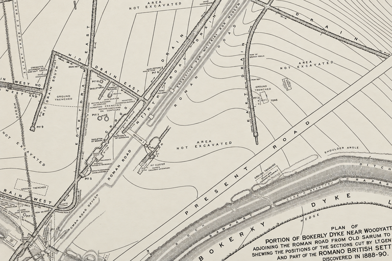
They become especially important at Woodyates, where General Pitt-Rivers’ nineteenth-century excavations provide detailed information about the relationship between the road, its foundations and Bokerley Dyke [5].
That evidence must be assessed separately rather than used retrospectively to date every substantial earthwork between Old Sarum and Woodyates.
The Approach to Woodyates
As the route approaches Woodyates and Bokerley Junction, the surviving earthworks and archaeological record become particularly important.
Codrington described a conspicuous raised embankment in this area, including evidence of gravel construction and substantial sections exposed through earlier disturbance [17].
He also referred to the excavations undertaken by General Pitt-Rivers at the intersection of the recognised Roman road and Bokerley Dyke.
Unlike the earlier valley crossings, Woodyates provides archaeological excavations, recorded construction layers and evidence of successive modifications to a major linear earthwork.
It also contains substantial evidence of Romano-British settlement.
The Dorset Historic Environment Record identifies pits, ditches, occupation deposits and burials investigated in the nineteenth and twentieth centuries, with much of the principal settlement activity dating to the later Roman period [10].
This presents a different problem from the supposed road’s beginning at Old Sarum.
Here, we have evidence of engineered route construction and associated Romano-British activity.
But we must still ask what the excavations actually dated, what they established about the relationship between the road and Bokerley Dyke, and whether they identified any earlier structural phases.
We must also distinguish between road surfaces, underlying foundations, successive rebuilding and the larger surrounding earthworks.
Those questions deserve their own detailed investigation.
The Verdict — A Road That Reappears, but Not a Continuous Construction History
The route between the Nadder and Woodyates presents a more complicated picture than either a completely lost Roman road or a continuously preserved one.
Beyond the Nadder, historic accounts reconstruct the alignment through a ford, surviving lanes, parish boundaries and tracks.
At the Ebble, another river crossing interrupts the identifiable engineering.
The route then changes direction across the chalk downs, apparently avoiding steep coombes before approaching the better-preserved formations farther south-west.
At Knighton, surviving banks and buried features provide more substantial archaeological evidence.
At Vernditch Chase, raised aggers, gravel metalling, flint foundations and associated ditches demonstrate the presence of considerable engineered remains.
But these remains also occur within a landscape containing substantial prehistoric dykes and other linear features.
The scheduling records preserve important measurements and observations while leaving questions about the complete stratigraphic relationships unanswered.
The essential conclusion is that the strength and type of evidence vary dramatically along the supposedly continuous Roman road.
Some parts are reconstructed from historic routes.
Some survive as visible banks or buried alignments.
Others preserve material consistent with deliberately engineered roadway construction.
These distinctions should not be obscured by applying the same historical label to the entire corridor.
Our investigation does not need to deny Roman road construction at Knighton or Vernditch Chase.
It needs to establish precisely which structures were constructed, when they were constructed, whether earlier earthworks were incorporated, and how securely they connect with the sections on either side.
By the time we reach Woodyates, historic excavation records let us explore these questions in much greater detail.
The next challenge is not simply to identify a Roman road. It is to understand the construction sequence beneath and around it.
And for that, we must return to General Pitt-Rivers’ excavations at Bokerley Junction.
References
[4] Langdon, R. J. (2026). Ackling Dyke: Old Sarum–Dorchester Route-Wide LiDAR and Morphological Investigation. Original research dataset, route classifications and measured profiles. Unpublished.
[5] Pitt-Rivers, A. H. L. F. (1892). Excavations in Cranborne Chase, near Rushmore, on the Borders of Dorset and Wilts. Volume III. Published privately.
[7] Langdon, R. J. (2026). The Post-Glacial Flooding Hypothesis: The Evidence. Version 3.4.
[9] Historic England. Roman road north east of Vernditch Chase: part of the Roman road between Sorviodunum (Old Sarum) and Vindocladia (Badbury). National Heritage List for England, Scheduled Monument 1013203. https://historicengland.org.uk/listing/the-list/list-entry/1013203
[10] Dorset Council. Romano-British settlement at Bokerley Junction, Woodyates. Dorset Historic Environment Record MDO5931. https://heritage.dorsetcouncil.gov.uk/Monument/MDO5931
[11] Historic England. Roman road along the south side of Vernditch Chase: part of the Roman road between Sorviodunum (Old Sarum) and Vindocladia (Badbury). National Heritage List for England, Scheduled Monument 1008707. https://historicengland.org.uk/listing/the-list/list-entry/1008707
[17] Codrington, T. (1903). Roman Roads in Britain. Chapter IX, Section 6, “Old Sarum to Badbury”, pp. 305–307. Society for Promoting Christian Knowledge. https://penelope.uchicago.edu/Thayer/E/Gazetteer/Periods/Roman/Topics/Engineering/roads/Britain/_Texts/CODROM/9*.html
[19] Historic England. Knighton Roman road (stretching from Reddish Gore to reservoir). National Heritage List for England, Scheduled Monument 1003728. https://historicengland.org.uk/listing/the-list/list-entry/1003728
[20] Historic England. Two linear earthworks in Vernditch Chase. National Heritage List for England, Scheduled Monument 1010763. https://historicengland.org.uk/listing/the-list/list-entry/1010763
⬅️ Previous: Section 7 — The Avon Crossing: Where the Roman Road Disappears
➡️ Next: Section 9 — Woodyates and Bokerley Junction: What Pitt-Rivers Actually Excavated