
Two Routes, Two Harbours and a Changing Prehistoric Landscape
Having examined Pitt-Rivers’ excavations at Woodyates, we now follow Ackling Dyke south-west towards Wyke Down, where the LiDAR reveals one of the most significant features in our entire investigation.
The surviving landscape contains two alignments associated with the Ackling Dyke corridor.
The first leads towards Sixpenny Handley.
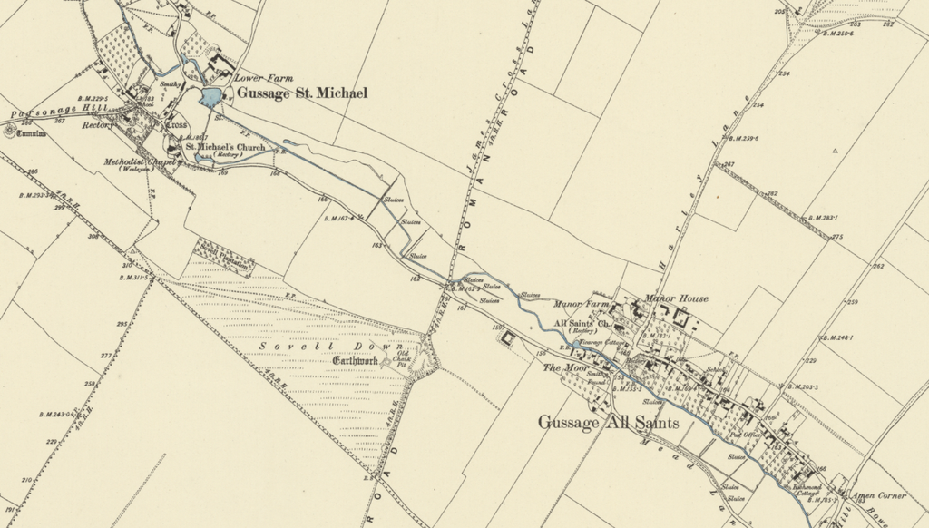
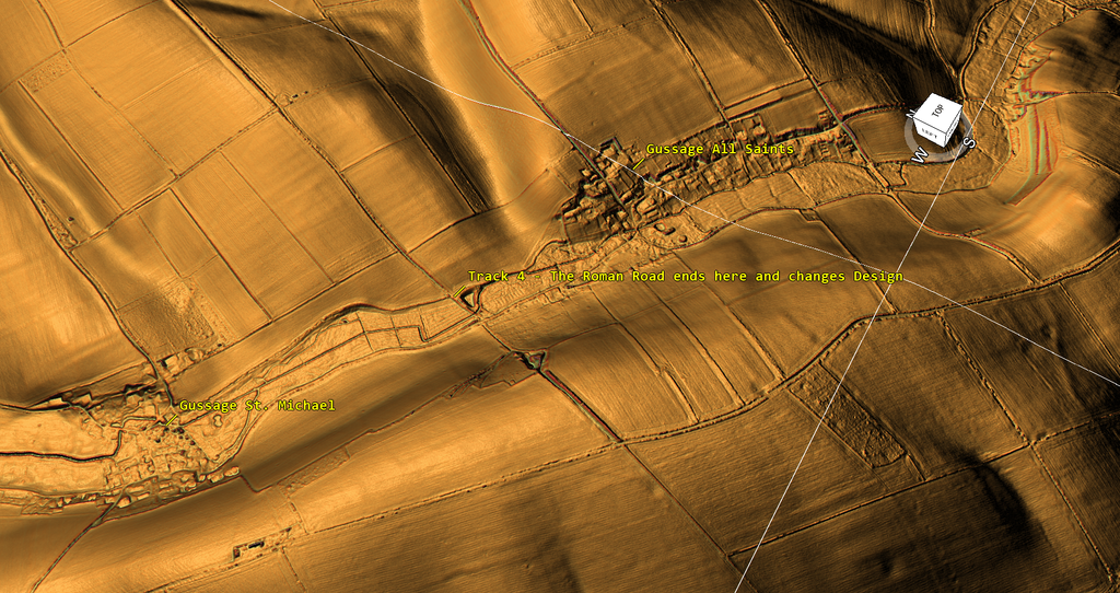
The second continues towards Gussage All Saints.
Our investigation identifies these as Track 3 and Track 4 respectively.
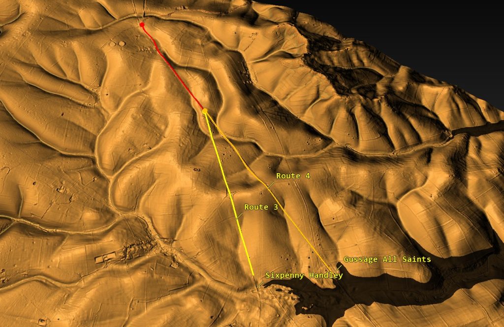
At first glance, this might seem like a simple example of one ancient route dividing into two.
But the surrounding terrain suggests a much more important explanation.
We propose that these alignments originally served two different harbours, constructed or used during different periods as the accessible water system changed.
Under our Post-Glacial Flooding Hypothesis, the original prehistoric dyke was engineered to reach a natural harbour in the Sixpenny Handley valley.
Later, when water levels had fallen, and that harbour was no longer accessible in the same way, a further route was constructed towards Gussage All Saints, where we propose that Roman-period engineers developed a new harbour serving the lower waterway.
This would not be two alternative roads competing to reach the same destination.
It would be a sequence of transport engineering responding to an environmental change.
The first route reached the harbour that nature provided. The latter route reached the harbour that engineers had to construct.
That is the proposition we will now examine.
1. Following the Original Dyke Towards Sixpenny Handley
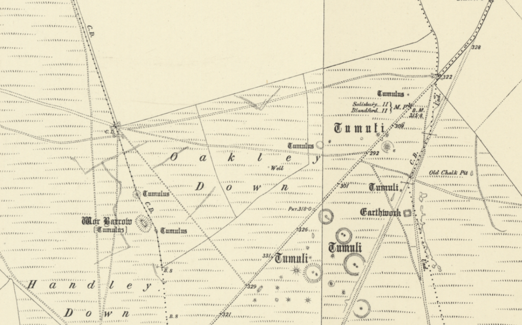
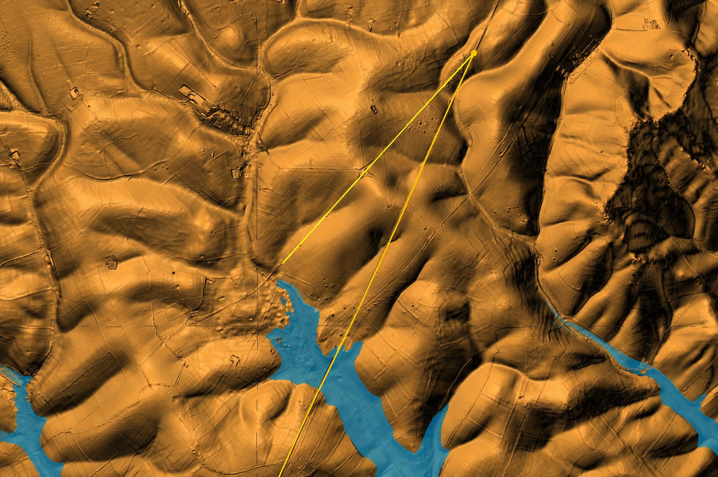
Our first LiDAR image shows the route running from the higher chalk downs towards the surrounding valleys.
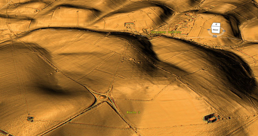
A second, wider perspective illustrates its relationship with the landscape below.
The approach to Sixpenny Handley is particularly important.
In our reconstruction, this was not simply a convenient location beside a terrestrial track.
It was the terminus of the original dyke system, where the engineered feature reached a natural harbour within the prehistoric waterway.
The shape of the surrounding valley is fundamental to this interpretation.
Unlike an artificial basin, which requires excavation or substantial modification to create usable access, a natural harbour can form where a watercourse widens or enters a sheltered indentation.
Our model proposes that higher prehistoric water levels occupied this low-lying landscape, making the valley accessible to waterborne transport.
The ancient builders would therefore have needed to excavate their connecting dyke only as far as the available natural water.
Beyond that point, the existing waterway would provide the onward transport connection.
This explains the proposed original destination of Track 3.
The route terminates at the natural harbour because that is where the navigable water was available.
Its destination, rather than its resemblance to a later Roman road, provides the starting point for examining its original function.
The exact prehistoric water level must ultimately be supported by the landscape’s elevation, geological and sedimentary evidence.
But the geographical relationship identified in the LiDAR gives us a location where we can test that hypothesis.
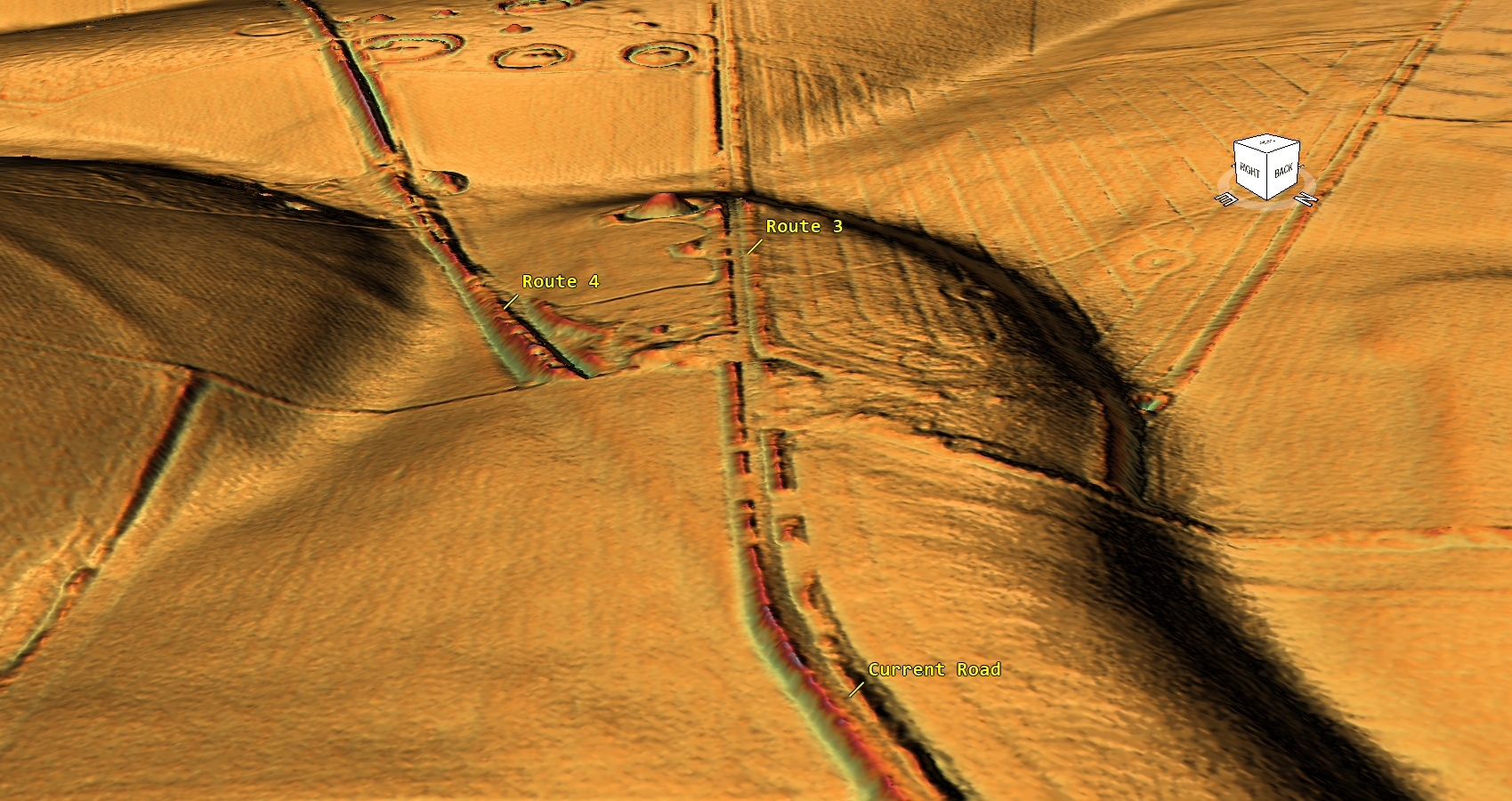
2. Why the Original Harbour Became Obsolete
The next question concerns environmental change.
If Track 3 originally provided access to navigable prehistoric water, why was an additional route needed?
Our proposed explanation is the progressive reduction in accessible water levels.
Under the Post-Glacial Flooding Hypothesis, the extent and elevation of former waterways changed as the landscape moved towards its later drainage configuration.
A harbour that had provided access earlier could become increasingly shallow, separated from the principal watercourse, or unsuitable for the vessels and loads it was intended to accommodate.
The original dyke would then lose part of its practical purpose.
It might remain visible as a substantial bank-and-ditch earthwork.
Its banks could still be useful for movement across the landscape.
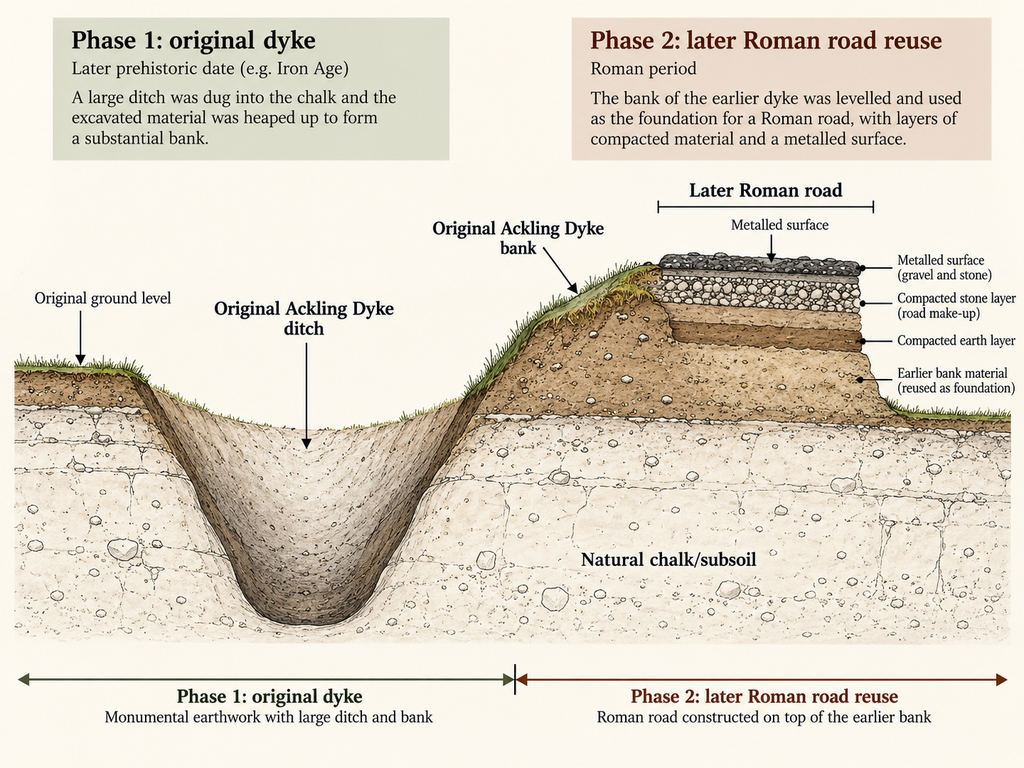
Parts might be filled, resurfaced or incorporated into later roads.
But the water-access point the original feature served would no longer function as it once did.
This provides the chronological explanation for the additional alignment.
Rather than abandoning an established transport corridor entirely, later engineers could extend or adapt it to reach the water farther downstream.
That is precisely the arrangement proposed at Wyke Down.
The original route continues towards Sixpenny Handley.
The later alignment extends towards Gussage All Saints.
Their different destinations are therefore not incidental. It is central to understanding why the second route was needed.
3. Track 4 — The Roman-Period Route to Gussage All Saints
The second alignment continues towards Gussage All Saints.
In our proposed reconstruction, this represents a later phase associated with Roman-period transport engineering.
By this period, the higher harbour at Sixpenny Handley is proposed to have lost its earlier usefulness.
A replacement connection was therefore required.
But the landscape at Gussage All Saints presented a different engineering problem.
Unlike the earlier natural harbour, the later destination required creating or improving a usable terminal.
We interpret this as an artificial harbour constructed to provide access to the lower waterway.
This distinction is vital.
Track 3 terminates at a proposed natural harbour. Track 4 leads towards a proposed engineered harbour.
They need not have been designed for the same water levels, built by the same people or used for precisely the same purpose.
The Roman-period attribution of Track 4 is a chronological proposition to be examined alongside the recognised Roman road construction in the area.
Historic England records substantial engineered road formations along Ackling Dyke across Wyke Down and neighbouring downs, including raised aggers, flint foundations and gravel construction [2].
Such evidence demonstrates Roman-style road engineering within this corridor.
It does not, by itself, date the initial excavation of Track 3 or establish when the proposed harbour installations at Gussage All Saints were built.
Those questions require the physical evidence at each destination.
Nevertheless, the proposed sequence offers a functional explanation for the two routes.
The later engineering was not necessarily an attempt to improve a badly aligned prehistoric road. It may have been necessary because the original dyke’s destination was no longer accessible by water.
That is an entirely different interpretation of the landscape.
4. What the Change in Alignment Actually Tells Us
Our survey records an angular difference of approximately 17.8 degrees between Tracks 3 and 4.
This measurement helps distinguish and reproduce the two mapped routes.
But the angle itself does not establish the chronology.
It cannot determine which route was built first.
Nor does it establish whether either route was intended for terrestrial traffic or water transport.
The more significant evidence lies in their different destinations.
If the Sixpenny Handley terminal was accessible during an earlier period of higher water, and the Gussage All Saints terminal became necessary after that access diminished, the route change would have a practical engineering explanation.
The relevant evidence is therefore the relationship between the two route termini and the former water system.
The angle describes the divergence. The changing harbour locations explain why the divergence may have occurred.
This is why the wider LiDAR images are more important to the argument than a diagram of two lines separated by 17.8 degrees.
The terrain provides the functional context.
The historical interpretation must follow the physical geography.
5. The Prehistoric Monuments — Evidence of an Earlier Landscape
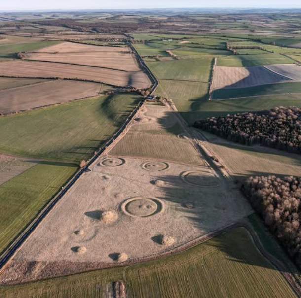
Wyke Down also contains substantial prehistoric monuments, including elements of the Dorset Cursus and Bronze Age burial mounds.
Their presence matters because they show this landscape was already extensively occupied and engineered before the Roman period [1,26–28].
Historic England records that the recognised Ackling Dyke road cuts through earlier monuments, including barrows, field systems and the Dorset Cursus [2].
Those intersections provide evidence that construction or modification of the road at particular locations postdated the prehistoric features it crossed.
But they do not establish the original date of every element within the broader Ackling Dyke corridor.
Under our reconstruction, the prehistoric monuments form part of the landscape through which the original dyke passed or alongside which it was constructed.
Their precise relationships may help establish the construction order.
For example, where a later road cuts across an earlier ditch or burial monument, excavation can potentially demonstrate the sequence.
Where a substantial dyke passes beside a monument without cutting it, proximity alone cannot establish which came first.
These relationships are important for testing the proposed corridor development.
They should not be confused with the main explanation for the two destinations.
That explanation remains the changing accessibility of the prehistoric waterway.
6. Testing the Harbour Relocation
Our reconstruction raises several questions that we can investigate directly.
The first concerns the Sixpenny Handley harbour.
Does the surrounding terrain form a plausible sheltered natural inlet under the proposed prehistoric water conditions?
Can we identify the former shoreline elevation?
Does the dyke approach that shoreline at an appropriate height?
The second concerns Gussage All Saints.
Does the terrain contain evidence of artificial construction consistent with a harbour or water-access installation?
Are there identifiable cuttings, banks, platforms or connecting channels?
Can any of these be dated to the Roman period?
The third concerns the water levels themselves.
Were the two proposed terminals accessible under different hydrological conditions?
Can palaeochannel sediments, former valley-floor elevations, and evidence of changing drainage reconstruct those conditions?
Finally, the dyke’s construction sequence must be examined.
Does the original alignment towards Sixpenny Handley display an earlier relationship with the landscape than the route towards Gussage All Saints?
Does the later route cut, join or reuse an older earthwork?
These tests matter because the proposed harbour relocation is not established merely by drawing two lines towards the valleys.
The hypothesis predicts two different types of terminal: an earlier natural harbour and a later engineered harbour, together with evidence that their accessibility depended upon different water conditions.
That gives the investigation specific archaeological features to look for in the following sections.
7. The Roman Road May Be the Later Phase of a Much Older System
This interpretation also changes how we approach the traditional classification of Ackling Dyke.
At Woodyates, Pitt-Rivers demonstrated Roman road construction within a complex landscape of substantial dykes and drains.
At Vernditch Chase, the recognised prehistoric ditch system approaches and continues across the supposed Roman-road corridor.
And at Wyke Down, our proposed reconstruction identifies an earlier water-access route and a later extension towards a different harbour.
Taken together, these observations raise a broader historical question.
Did Roman engineers build an entirely new route across the landscape, or did they adapt an older system designed around access to prehistoric waterways?
Under our interpretation, the latter provides a coherent explanation.
The original dyke served the earlier water system.
As that water system changed, the available terminals moved.
Roman engineers could then construct new sections of roadway, extend existing earthworks and develop artificial facilities to maintain transport access.
This would account for genuine Roman engineering without requiring every part of the larger monumental corridor to have originated during the Roman period.
A later road surface can demonstrate Roman use.
It cannot automatically determine the original function of the underlying or adjoining earthworks.
The question must be investigated from the construction sequence and the changing geography.
Conclusion — A Harbour Moved, and the Route Followed
Wyke Down is important not simply because two lines diverge.
It matters because the two proposed alignments lead to different harbour landscapes.
In our reconstruction, the original prehistoric dyke followed Track 3 towards the natural harbour at Sixpenny Handley.
That harbour existed because the earlier water system occupied a higher part of the landscape.
When the accessible water retreated, the original harbour ceased to serve its former purpose.
The later route, Track 4, extended towards Gussage All Saints, where we propose that Roman-period engineers constructed a new harbour to reach the lower waterway.
The measured 17.8-degree divergence is a useful way of documenting the routes, but the central historical proposition concerns the changing destination of the infrastructure.
The earlier builders took their dyke to the water. The later engineers had to follow the water as it receded.
This proposed sequence provides a practical explanation for the two alignments and a series of archaeological tests for examining their relative dates and functions.
The next two sections will therefore investigate the destinations separately.
First, we follow the original proposed dyke to Sixpenny Handley and examine the evidence for a natural prehistoric harbour.
We then return to the later route towards Gussage All Saints, where we examine the proposed artificial harbour and its relationship with Roman-period engineering.
If the terminal evidence supports that sequence, the history of Ackling Dyke becomes something far more significant than a single Roman road.
It becomes the history of a transport system repeatedly adapted to a changing landscape.
References
[1] Royal Commission on Historical Monuments (England). (1975). An Inventory of the Historical Monuments in the County of Dorset, Volume V: East Dorset.
[2] Historic England. Part of Ackling Dyke (Roman Road), Including Roman Road on Oakley Down. Scheduled Monument 1003309.
[4] Langdon, R. J. (2026). Ackling Dyke: Old Sarum–Dorchester Route-Wide LiDAR and Morphological Investigation. Original survey and route reconstruction.
[5] Pitt-Rivers, A. H. L. F. (1892). Excavations in Cranborne Chase. Volume III.
[7] Langdon, R. J. (2026). The Post-Glacial Flooding Hypothesis: The Evidence. Version 3.4.
[26] Historic England. Barrows on Wyke Down. Scheduled Monument 1002789.
[27] Dorset Historic Environment Record. The Dorset Cursus. MDO5608.
[28] Dorset Historic Environment Record. Round Barrow, Cursus Group, Gussage All Saints. MDO5556.
⬅️ Previous: Section 9 — Woodyates: Pitt-Rivers’ Excavations Revisited
➡️ Next: Section 11 — Sixpenny Handley: The Original Natural Harbour