
A New Engineering Alignment
We now follow Track 4 southwest from Wyke Down towards Gussage All Saints, examining the surviving engineering and its relationship with the earlier dyke system to the west.
Why was this alignment constructed, how was it intended to function, and does its surviving form reveal changes in its original design?
Our investigation proposes that Roman engineers were attempting to maintain commercial transport connections as groundwater levels declined. The eventual use of the earthwork as a road may represent a subsequent adaptation of that infrastructure.
We can now examine this proposal using the original route coordinates, the LiDAR terrain and two additional cross-sections taken at the change of alignment. [1,2]
1. Measuring the Gussage Alignment — A Connection with an Older Dyke
Our original Track 4 survey contains nine geographical control points. [1]
Recalculation gives a digitised route length of 6,843 metres, compared with a direct distance between its endpoints of 6,837 metres.
The overall bearing is approximately 203.4 degrees.
This shows the surveyed route is remarkably straight, with individual bearings generally ranging between 203 and 206 degrees before shifting toward approximately 199 degrees.
But the change in direction is particularly interesting.
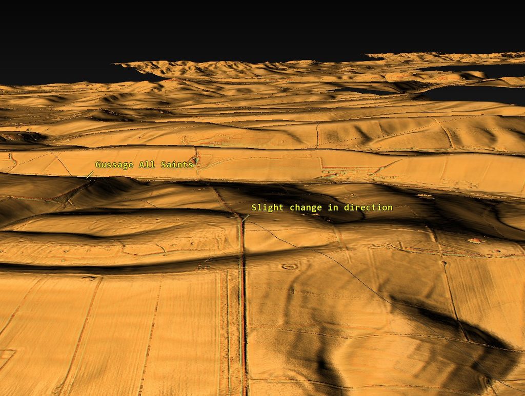
Our latest LiDAR examination indicates that the alteration in alignment marks a connection with an older dyke, rather than simply an adjustment to the course of a uniformly constructed Roman road. [1,2]
The two new transverse profiles provide additional evidence.
The first, extending across approximately 75 metres, shows a substantial raised bank with an asymmetric cross-section and adjoining lower ground.
The second, extending across approximately 62 metres, shows another prominent banked formation, with a different distribution of raised and depressed ground.
Both profiles show local relief approaching one metre. The 75-metre and 62-metre measurements represent the lengths of the transverse survey lines, not the bank widths.
The important observation is the relationship between the changing route direction and the surviving bank-and-ditch morphology.
Rather than simply continuing along its original bearing, the later alignment appears to join an existing engineered feature.
This would have considerable practical advantages.
Connecting with an older dyke could provide access to an established transport corridor without excavating an entirely new route.
The junction therefore offers a possible explanation for the directional change, while the differences between the two profiles provide a location to investigate the construction sequence.
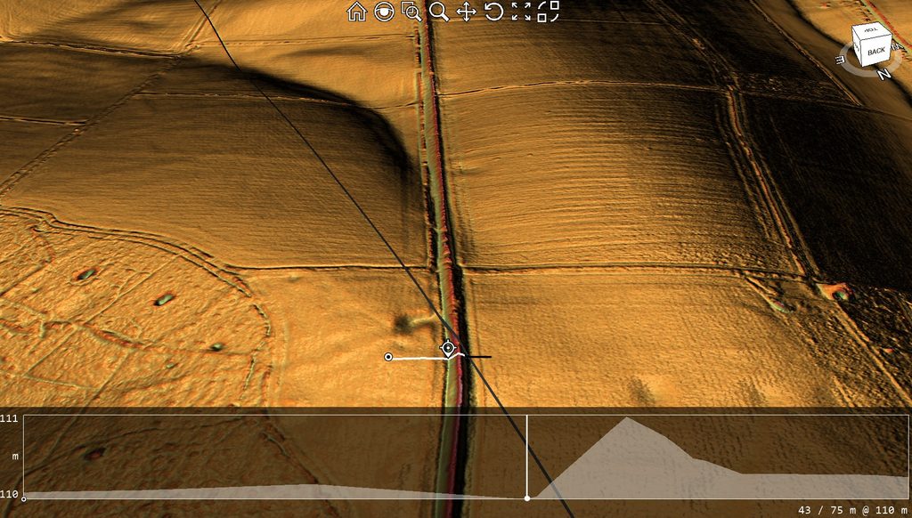
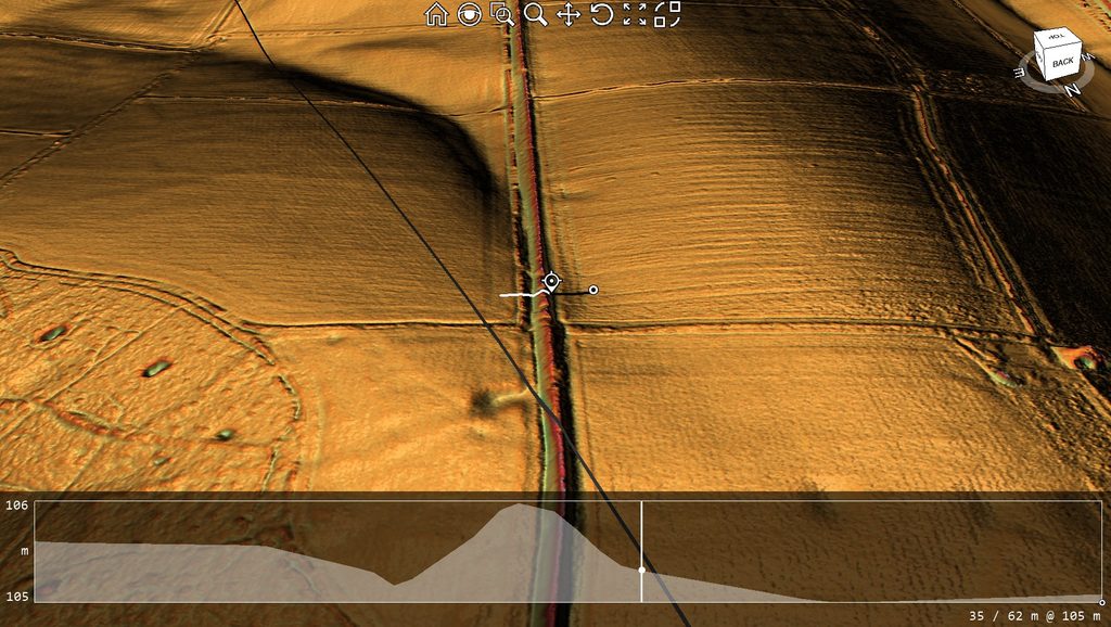
Figure 41. Two transverse LiDAR profiles at the proposed junction with an older dyke. The raised banks and associated depressions show differences in their surviving form. Together with the change in direction, these features suggest a possible connection between separate engineering phases. [1,2]
2. The Unexpected Changes in Elevation
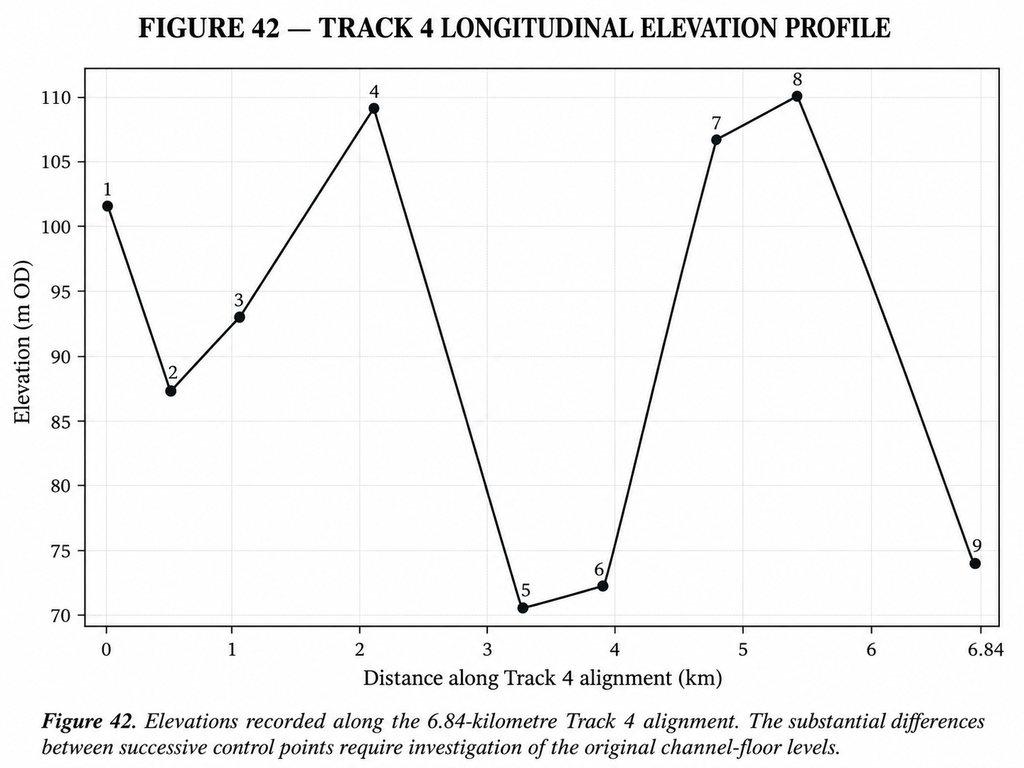
Although the route is almost straight in plan, its recorded elevations vary substantially. [1]
The northern control point stands at approximately 101 metres.
At chainage 1.95 km, the recorded elevation reaches approximately 109 metres.
At 3.12 km, it falls to approximately 69.7 metres.
The route subsequently rises to approximately 110.1 metres at 5.39 km before falling to approximately 74.1 metres at its final recorded point.
These are sampled ground or route elevations, not measurements of an excavated channel floor.
Nevertheless, they present an important engineering problem.
A continuous open waterway cannot simply climb and descend across such substantial elevation changes while maintaining navigable depth.
If the alignment was intended to carry water, its engineers needed a suitable channel gradient, controlled water levels or other means of overcoming the terrain.
The question is whether the surviving bank conceals a more carefully graded excavation or whether parts of the alignment were always intended for terrestrial movement.
This makes the longitudinal profile particularly important when examining the proposed hydraulic function.
3. What Was the Commercial Objective?
The surrounding extraction landscape may explain the purpose of the later construction.
Our LiDAR mapping identifies hundreds of pits around Faulston Down, which we propose represent substantial mineral extraction. [1,2]
Transporting heavy materials from these workings would have required an economical connection with an accessible waterway.
Waterborne transport offered a major advantage over repeated journeys by cart and animal.
Independent evidence shows specialised production in the Gussage landscape.
Excavations at Gussage All Saints revealed extensive Iron Age bronze-working, including the manufacture of chariot and harness fittings, demonstrating that industrial activity existed here before Roman occupation. [3,12]
Although the Faulston pits have not yet been independently linked to that industry, the wider area had both potential extraction resources and an established demand for transporting materials.
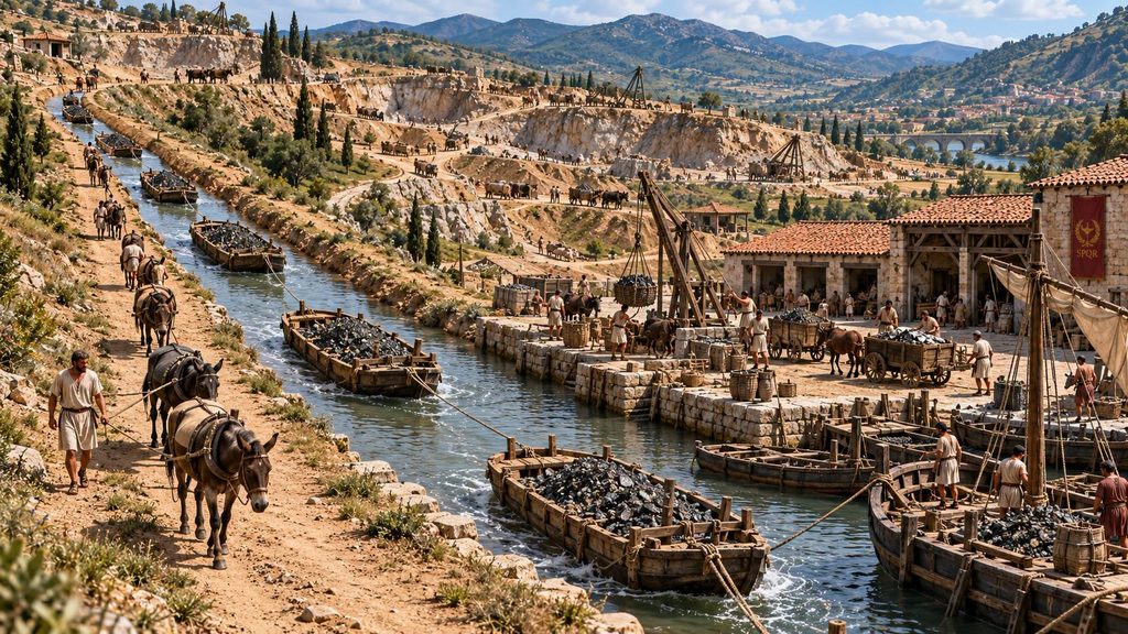
We interpret the later alignment as constructed or adapted to maintain a commercially useful connection between the extraction landscape and the changing waterways.
4. The Problem of Supplying Water
The earlier prehistoric dyke system in our reconstruction exploited natural springs and elevated groundwater.
The later engineers faced a different problem.
As groundwater levels declined, existing channels would have required greater depth or supplementary supplies to remain useful.
Our previous examination of Woodyates identified successive ditch modifications and substantial Roman-period deposits. [4]
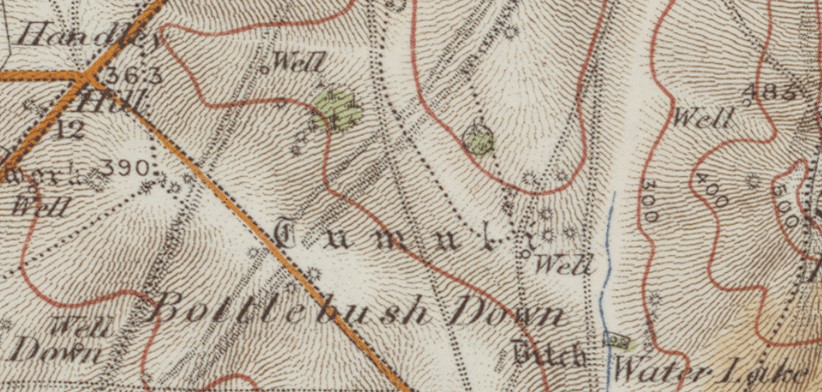
We proposed that Roman engineers attempted to deepen existing channels and connect Bokerley Ditch to provide additional water. [1,4]
The Gussage alignment now provides a geographical test of that interpretation.
Its considerable changes in ground elevation mean we cannot assume water supply from nearby springs alone.
We must identify whether the available water stood above the proposed channel floor and whether the connecting earthworks could maintain sufficient depth.
If the engineers could not achieve this, the proposed waterway might have operated only temporarily or proved unsuccessful.
5. The Road Cuts Through the Prehistoric Cemetery
The clearest chronological evidence comes from the monuments intersected by the alignment.
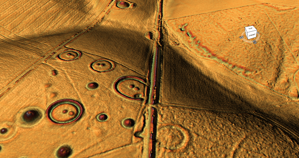
Historic England records that Ackling Dyke cuts through the Neolithic Dorset Cursus, Bronze Age barrows and earlier field systems. [6]
One particularly useful example is Dorset HER monument MDO5556. [7]
This Bronze Age round barrow, approximately 36.6 metres in diameter, is recorded at SU 0096 1498.
Our coordinate comparison places its centre approximately 12 metres from the digitised Track 4 centreline, consistent with the archaeological record that Ackling Dyke cuts its south-eastern side. [1,7]
The road builders evidently did not preserve the existing prehistoric cemetery.
If the later alignment was for commercial transport, maintaining the desired route may have mattered more than avoiding ancient burial monuments.
The physical intersections also establish that this phase of road construction postdates the monuments. [6,7]
Roman Hydraulic Engineering — An Inverted Siphon at the Valley Crossing?
The longitudinal LiDAR survey reveals an interesting engineering relationship along the proposed route towards Gussage All Saints. [1,2]
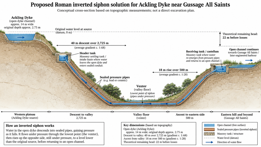
The landscape descends about 40 metres over 2,725 metres, then rises again by about 18 metres over 500 metres.
At first, this appears to pose a substantial obstacle to a continuous waterway.
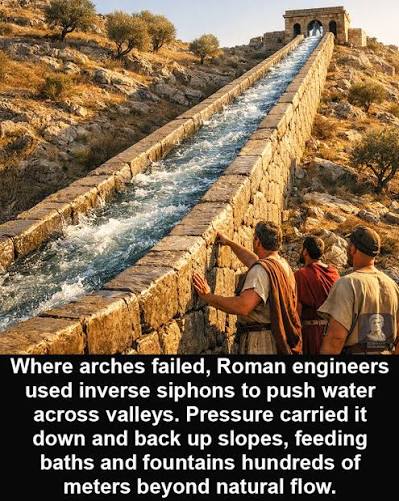
However, Roman engineers possessed a well-documented solution to precisely this kind of topographical problem: the inverted siphon. [8,9]
Vitruvius described the system in the first century BCE: it carried water from an elevated supply into sealed pipes that descended through a valley. The pipes crossed the valley floor before ascending the opposite hillside, where the water emerged at a lower elevation than its original supply.
The pressurised valley-floor section was known as the venter.
This is particularly relevant to the Ackling Dyke reconstruction.
Under our working interpretation, the earlier substantial channel could have delivered water towards the valley, where a later engineered pressure system might have carried it across the intervening depression and up the opposite slope.
The measured topographical relationship favours investigating this possibility.
A 40-metre difference between an elevated supply and the valley floor, followed by an 18-metre ascent, leaves a theoretical elevation difference of 22 metres between the source and receiving point. [1]
This would provide potential hydraulic head for an inverted siphon, subject to frictional losses and conduit dimensions. [9]
The important requirement is that the system must retain its upstream head through a sealed connection. The speed of water in an ordinary open ditch, or a narrowing of that ditch alone, could not generate the required pressure.
Roman examples show that multiple parallel pipes, carefully constructed joints, and reinforced valley-floor sections could be used where substantial water volumes or pressures were involved.
Consequently, the rise towards Gussage All Saints need not have made a water-supply system impossible.
The surviving topography is compatible with an engineering solution already known to Roman hydraulic specialists. [1,8,9]
The archaeological question is whether the necessary pressure conduit, collecting arrangement or associated foundations can be identified in the Ackling Dyke corridor.
If such evidence exists, it could help explain how later engineers maintained water access across an uneven landscape while reusing parts of an earlier dyke system.
6. The Final Descent — From the Siphon Hill to Gussage All Saints
Downhill to the Proposed Harbour
After crossing the final hill and the proposed Roman siphon location, Ackling Dyke continues downhill towards Gussage All Saints.
Unlike the preceding section, where an 18-metre ascent presented a significant hydraulic obstacle, the remaining route follows a comparatively straightforward descent.
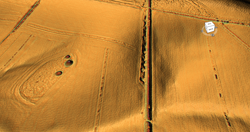
The LiDAR reveals the alignment travelling across the chalk hillside before negotiating the distinctive bend identified earlier in Section 1. From here, the route continues towards Gussage All Saints, where it approaches the lower valley of Gussage Brook and meets the earlier dyke system already examined. [1,2]
Under our hydraulic reconstruction, water emerging from a receiving tank beyond the final hill could have continued downhill under gravity towards the proposed harbour.
Once the uphill obstacle had been overcome, the remaining route required no further pressure system.
Three Dykes Converging on the Valley
Our latest LiDAR reveals that Ackling Dyke is not the only substantial linear feature descending towards Gussage All Saints.
Two additional dyke-like earthworks approach the valley from the surrounding hills, one on either side of the principal alignment.
This arrangement deserves attention because it suggests that the valley may have served as a meeting point for several engineered routes.
The Royal Commission’s 1975 Dorset inventory independently records a substantial linear dyke running towards Tenantry Down. [10,11]
Where preserved, its ditch measured about 25 feet (7.6 metres) wide and at least four feet (1.2 metres) deep, with an 18-foot-wide bank.
Ploughing had already destroyed much of the feature, although aerial photographs revealed its former continuation.
Its identification with either additional LiDAR alignment remains to be established.
Nevertheless, the archaeological record confirms that substantial linear ditch-and-bank engineering existed in this landscape independently of the recognised Roman road.
The convergence of these features on the Gussage valley raises the possibility that more than one transport route approached the proposed harbour.
An Established Settlement Before the Romans
An especially important discovery comes from the Royal Commission’s record of the Iron Age settlement Geoffrey Wainwright excavated in 1972. [3,10,12]
Situated on the ridge overlooking Gussage Brook, the settlement occupied almost three acres and contained substantial enclosure ditches, storage pits, timber structures and evidence of agricultural and industrial activity.
Excavation recovered thousands of fragments of clay moulds used to manufacture bronze horse-harness fittings, together with crucibles, tools and metalworking debris.
This was clearly an established productive community.
Significantly, occupation continued into the early Roman period, ending around AD 80.
The settlement therefore provides independent archaeological evidence of activity in the Gussage landscape during the decades following the Roman conquest.
The inventory also records forty-one prehistoric round barrows within the parish, many now severely damaged or entirely levelled by cultivation.
This is important when interpreting the LiDAR.
The absence of obvious monumental earthworks immediately beside the proposed harbour does not mean the wider area lacked prehistoric occupation.
Much of its archaeology survives only beneath the modern agricultural landscape.
Could the Harbour Have Encouraged the Development of Gussage All Saints?
Our proposed Roman harbour would have differed considerably from the earlier natural harbour reconstructed at Sixpenny Handley.
The later installation may have required timber landing stages, warehouses, workshops and temporary accommodation for people handling goods arriving through the transport network.
Such structures may have disappeared from the modern surface, particularly after centuries of cultivation and settlement development.
Wainwright’s excavations show how extensive timber-built occupation can survive archaeologically through postholes, pits, and buried deposits rather than prominent standing earthworks. [3,12]
The existing settlement and its industrial activity also suggest a landscape in which access to transport would have been economically valuable.
Under our reconstruction, a harbour where the converging dykes met the lower waterway could have become a focus for trade and later settlement.
This offers a possible explanation for why Gussage All Saints developed at this particular location: the harbour and its associated transport connections may have helped establish the settlement’s later importance.
This remains a historical hypothesis. The excavated Iron Age settlement does not independently demonstrate a Roman harbour or establish continuous development into the present village. [3,12]
The End of Route 4
We have now followed Route 4 from its divergence at Wyke Down, across the prehistoric cemetery, over the final hill and downhill through the bend to Gussage All Saints. [1]
The route terminates within a landscape containing several substantial linear earthworks, an established watercourse and independently documented occupation extending into the Roman period. [1,11,12]
Unlike the proposed original natural harbour at Sixpenny Handley, the Gussage terminal may have required an engineered landing facility to maintain access to the lower waterway.
The central proposition is that Roman engineers adapted an existing transport landscape, extending access towards a new harbour as the earlier water system became less accessible.
The final LiDAR view now provides the geographical setting for that interpretation. The convergence of the earthworks, the downhill route and the archaeological evidence for settlement together identify where the proposed Roman harbour should be investigated. [1,2]
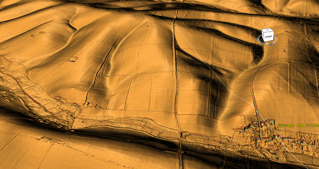
7. Why Does the Bank Survive Better Than the Ditch?
Historic England records the surviving raised formation as reaching approximately 13 metres wide and between 1.2 and 2.5 metres high. [6]
However, the adjoining western ditch is clearly identifiable only in certain sections.
This raises an important question concerning the original engineering.
If the feature once functioned as a water-connected dyke, why does the substantial bank survive while much of the ditch appears to have disappeared?
One explanation is that declining groundwater eventually made the channel redundant.
Once abandoned, the excavation would have been vulnerable to silting, cultivation and deliberate infilling.
The bank, particularly if later used as a roadway, could have survived more prominently.
Alternatively, later agricultural disturbance may explain the variable preservation of a road and its drainage ditch.
The missing or diminished ditch is therefore a feature requiring investigation.
Detailed transverse LiDAR measurements and subsurface evidence should establish whether a substantial earlier excavation survives beneath the present ground level.
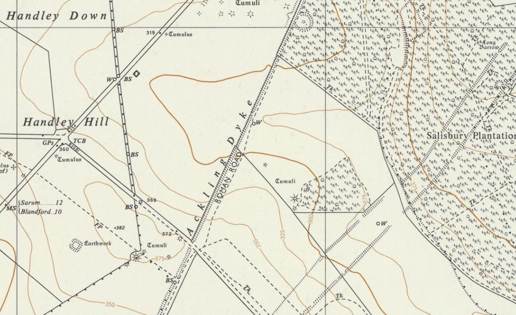
8. From Dyke Bank to Roman Road
If an existing dyke bank remained after its channel lost its water supply, it would have been a valuable engineering resource.
Constructing an entirely new Roman agger required extensive excavation, material movement and labour.
Reusing an existing substantial bank could avoid much of that expense.
The engineers could level or widen the formation and add chalk, flint and gravel to create a suitable running surface. [4,6]
This would explain how an older earthwork could acquire the recognised characteristics of a Roman road without the whole bank having originated during Roman construction.
The important archaeological distinction is between the original bank and the later prepared roadway.
Evidence of road foundations overlying an earlier artificial formation would directly test this proposed sequence.
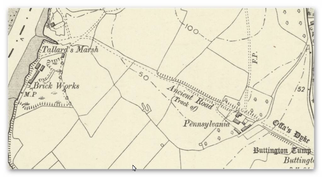
Conclusion — A Measurable Change in the Engineering
Our investigation has followed the 6.84-kilometre Route 4 alignment from Wyke Down to the lower valley at Gussage All Saints, revealing substantial changes in elevation, evidence of differing earthwork construction and a possible Roman hydraulic installation. [1]
The final 18-metre ascent presents an engineering problem that Roman inverted-siphon technology could theoretically have overcome. Beyond this obstacle, the route descends naturally through the previously identified bend towards Gussage All Saints, where it approaches an older dyke system. [1,8,9]
The LiDAR also identifies two additional substantial earthworks descending from the surrounding hills towards the same valley. [1,2]
Significantly, archaeological excavations confirm that Gussage All Saints already possessed a substantial Iron Age settlement, with industrial activity and occupation continuing into the early Roman period, around AD 80. [3,10,12]
Under our working hypothesis, the Romans adapted an existing transport corridor to reach a lower waterway after the earlier natural harbour at Sixpenny Handley became less accessible.
A new engineered harbour could have supported trade, storage, and transport, potentially contributing to the settlement’s later development.
The evidence now raises a more specific question: did Roman engineers adapt an older dyke network to establish a new transport terminal at Gussage All Saints?
The excavated settlement, converging earthworks and descending route provide a geographical and archaeological basis for investigating that possibility. The proposed siphon and harbour still require confirmation through direct archaeological evidence. [1,3,11,12]
The next stage of our investigation must establish whether the changing earthwork morphology and the original channel elevations support that engineering sequence.
References
[1] Prehistoric Britain Research Project (2026). Ackling Dyke investigation: Track 4 (Wyke Down–Gussage All Saints). Author’s nine-point route coordinates, recalculated bearings and distances, transverse LiDAR profiles, Faulston Down pit mapping, and interpretation of associated earthworks. Original research data and figures reproduced in Chapter 12; not independently verified by excavation.
[2] Environment Agency (2022; dataset updated 2025). LIDAR Composite Digital Terrain Model (DTM), 1-metre resolution. National Data Library. Source dataset for terrain-model interpretation; the exact survey tiles used for the author’s measurements are not separately documented here.
[3] Wainwright, G. J. (1979). Gussage All Saints: An Iron Age Settlement in Dorset. Department of the Environment Archaeological Reports 10. London: HMSO. Dorset Historic Environment Record source SDO14247.
https://heritage.dorsetcouncil.gov.uk/Source/SDO14247
[4] Pitt-Rivers, A. H. L. F. (1892). Excavations in Cranborne Chase, near Rushmore, Volume III: Excavations in Bokerly and Wansdyke, Dorset and Wilts, 1888–1891. Privately printed. Dorset Historic Environment Record source SDO16713; see Woodyates and Bokerley Dyke excavations.
https://heritage.dorsetcouncil.gov.uk/Source/SDO16713
[5] Ordnance Survey (1885–1890). Dorset 25-inch mapping, First Edition (Epoch 1). Dorset Historic Environment Record source SDO10239. The catalogue record cites historic map evidence; the author interprets individual well symbols and the proposed siphon identification in the map analysis rather than demonstrating them in the catalogue record.
https://heritage.dorsetcouncil.gov.uk/Source/SDO10239
[6] Historic England. Part of Ackling Dyke (Roman road), including Roman road on Oakley Down. National Heritage List for England, Scheduled Monument 1003309. Covers the agger dimensions, western ditch, construction materials and intersections with earlier monuments.
https://historicengland.org.uk/listing/the-list/list-entry/1003309
[7] Dorset Historic Environment Record. MDO5556: Round barrow, one of the Cursus Group of barrows, Gussage All Saints. Bronze Age barrow at SU 0096 1498; recorded as cut on its south-east side by Ackling Dyke.
https://heritage.dorsetcouncil.gov.uk/Monument/MDO5556
[8] Vitruvius, M. P. (first century BCE). De architectura, Book VIII, Chapter 6, Aqueducts, Wells, and Cisterns, especially sections 4–9 concerning pressure conduits, the venter, and baked-clay pipes. English translation, Perseus Digital Library.
https://www.perseus.tufts.edu/hopper/text?doc=Perseus%3Atext%3A1999.02.0073%3Abook%3D8
[9] Kessener, P. M. (2022). ‘Roman Water Transport: Pressure Lines’. Water, 14(1), article 28. Discusses inverted siphons, header tanks, receiving tanks, pipes, hydraulic head and pressure losses.
https://doi.org/10.3390/w14010028
[10] Royal Commission on Historical Monuments (England) (1975). An Inventory of Historical Monuments in the County of Dorset, Volume V: East Dorset, pp. 20–22, ‘Gussage All Saints’, entries (20)–(62). London: HMSO. Bibliographic record and extracts reproduced in Dorset Historic Environment Record entries MDO5544 and MDO5545.
https://heritage.dorsetcouncil.gov.uk/Monument/MDO5544
[11] Dorset Historic Environment Record. MDO5545: Linear dyke running towards Tenantry Down, Gussage All Saints. Includes surviving ditch/bank dimensions, aerial photographic evidence and uncertain relationship to adjacent earthworks.
https://heritage.dorsetcouncil.gov.uk/Monument/MDO5545
[12] Dorset Historic Environment Record. MDO5544: Iron Age settlement, Gussage All Saints. Documents Wainwright’s 1972 excavation, metalworking, timber structures, postholes and occupation continuing into the early Roman period.
https://heritage.dorsetcouncil.gov.uk/Monument/MDO5544
[13] Heneb / Clwyd-Powys Archaeological Trust Historic Environment Record. PRN 106727: Offa’s Dyke, section from Coed Talon Banks, Ffordd Llanfynydd. Records the A5101 road built on the crest of an Offa’s Dyke bank. This supports later road reuse of an earthwork, not the claim that the dyke originally carried water or that drying caused its reuse.
https://archwilio.org.uk/her/chi3/report/page.php?watprn=CPAT106727
⬅️ Previous: 11. Sixpenny Handley — Three Phases of a Prehistoric Waterway
➡️ Next:13. Sovell Down and Moor Crichel — When the Roman Road Meets the Quarries