
A Road That No Longer Follows the Evidence
Our investigation now reaches the River Avon, where the supposed Roman road from Old Sarum encounters a fundamental geographical and archaeological problem.
The enormous cutting examined in Section 6 descends towards the Avon valley. Yet beyond this point, the surviving terrain does not reveal an obvious continuation of the same substantial earthwork.
Instead, the traditional route becomes a succession of possible alignments, historic tracks, former crossing places and stretches where no clearly identifiable Roman road survives.
This matters because the route must negotiate three rivers before reaching the higher ground towards Woodyates: the Avon, the Nadder and, farther south-west, the Ebble.
Where is the continuous Roman road linking these crossings?
The issue is not whether Roman-period travellers crossed these valleys. It is whether the surviving engineering demonstrates the specific route traditionally reconstructed between Old Sarum and Badbury Rings.
Our LiDAR investigation suggests a landscape considerably more complicated than the straightforward line depicted on conventional maps [4].
Southampton’s Figure 32 — A Reconstruction, Not an Excavated Road
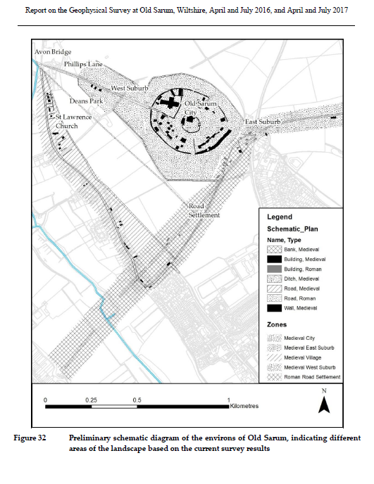
The 2016–2017 Southampton University geophysical report includes an important illustration: Figure 32, which its authors describe as a preliminary schematic diagram of the environs of Old Sarum [13].
The drawing presents a reconstructed landscape containing Roman roads, medieval routes, settlement areas and different phases of activity.
A broad hatched area is labelled as Roman road settlement. That distinction matters: the hatching represents an interpreted settlement zone, not the measured width of a Roman road.
Nevertheless, the diagram incorporates a coherent south-western route corridor associated with Ackling Dyke.
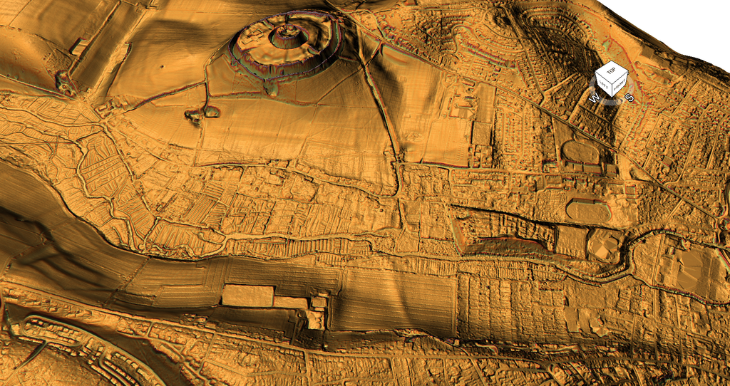
When compared with our three-dimensional LiDAR, however, the physical relationship is far from straightforward.
The surviving terrain contains shallow linear traces, field boundaries, depressions and later routeways. It does not display one unmistakable raised agger with paired drainage ditches continuing uninterrupted across the surveyed landscape.
The visible shallow earthworks do not necessarily correspond to every alignment suggested by the schematic.
This raises an important methodological qualification. Figure 32 is a generalised interpretation, not an accurately surveyed plan of every earthwork. We cannot test it directly against LiDAR until the relevant features are georeferenced.
But that qualification works both ways.
A schematic reconstruction cannot be treated as independent proof of the physical roadway it depicts.
To establish the proposed alignment, we must return to the actual archaeological observations.
What the Geophysical Survey Actually Found
The detailed results of the 2016–2017 geophysical investigation are more qualified than the simplified schematic might suggest.
In the field south of Old Sarum, anomalies m182 and m183 were interpreted as following the Portway/Ackling Dyke alignment towards the Avon. A second group, m184 and m185, ran parallel to that line [13].
The survey also identified numerous other ditches, structures and possible road features.
This is consistent with an area containing several phases of occupation and movement. It is not, by itself, proof that all the identified structures belonged to one Roman construction project.
Elsewhere, in Dean’s Park Field to the west of Old Sarum, the investigators identified anomalies m219 and m220.
These formed a substantial linear feature approximately 170 metres long and five metres wide.
The report suggested that the feature was probably a road or hollow way approaching Avon Bridge, although it acknowledged that a ditch was another possible explanation [13].
Crucially, this feature lies within the western survey area and forms an approach to Avon Bridge. It should not automatically be confused with the south-western alignment traditionally associated with the Ackling Dyke crossing near Coldharbour Farm.
We therefore have multiple possible approaches to the Avon, not a single excavated roadway demonstrating their original relationship.
The geophysical report also does not date all these possible route features to the Roman period.
The Supposed Crossing at Coldharbour Farm
To understand how the conventional alignment developed, we must return to the earlier literature.
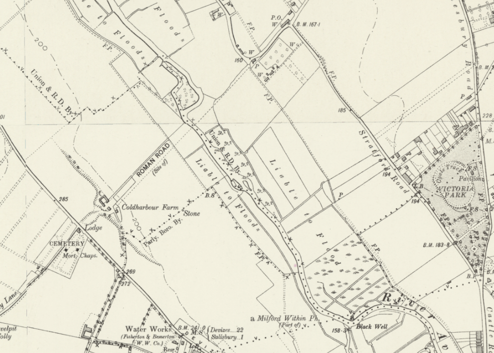
In 1903, Thomas Codrington described the supposed Roman route from Old Sarum to Badbury Rings [17].
His account places an Avon crossing near Coldharbour Farm, south of Stratford-sub-Castle.
But what evidence did he use to reconstruct the onward route?
Codrington described a lane approaching a ford, followed by a track and Folly Lane leading towards Bemerton. He then referred to William Stukeley’s earlier account of a stony ford over the Nadder.
The route was assembled from a combination of landscape observations, historic roadways, reported fords and projected alignments.
Those observations deserve serious consideration. Former roads and fords can preserve the course of ancient communications.
However, their existence alone does not establish the date of the underlying route.
A historic ford indicates a river crossing. A later lane indicates movement through the landscape. Neither necessarily demonstrates that the same crossing and lane were constructed as parts of one Roman road.
The distinction between an ancient route and a demonstrably Roman engineering project is critical.
Codrington’s account shows that the reconstructed road depended on linking separate surviving features.
Our investigation must determine whether those features genuinely belong to the same construction sequence.
The Alignment Problem on the Opposite Bank
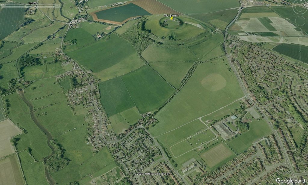
Our recent examination of satellite imagery raises an additional question.
The roads and tracks visible on the far side of the Avon do not appear to provide an obvious, uninterrupted continuation of the substantial earthwork descending from Old Sarum.
This apparent discrepancy requires investigation rather than the automatic assumption that the missing section once existed on the projected line.
One possibility is that the original roadway changed direction to negotiate a suitable ford or crossing.
Another is that medieval and later routes adopted different crossing places, leaving parts of an earlier alignment abandoned.
A third possibility is that separate structures have been grouped into a single supposed Roman route because of their approximate geographical relationship.
All three explanations are possible.
What matters is that evidence must establish the precise alignment, crossing point, and construction sequence.
The satellite and LiDAR images show a problem worth testing. They do not yet establish the measured displacement between the archaeological alignments.
This requires plotting the geophysical anomalies, historic mapping, LiDAR, and known crossing locations in a common coordinate system.
Until this is done, presenting the Avon crossing as one continuous Roman road is more confident than the available evidence warrants.
The Medieval Landscape Complicates the Picture
The Avon crossing cannot be examined without considering the substantial medieval activity around Old Sarum and Stratford-sub-Castle.
Southampton University’s report identified medieval settlement, structural remains, burgage plots and several possible phases of road development [13].
It also recorded evidence that some later features cut or overlaid earlier Roman-period deposits.
Consequently, the roads visible today may preserve several distinct periods of movement.
This is not merely our interpretation.
In his 2013 doctoral investigation of travel and communications in early medieval Wessex, Alexander Langlands specifically discussed the difficulty of reconstructing roads across river crossings [18].
He highlighted the importance of the Avon and Nadder crossings for the survival of the road south-west of Old Sarum, and considered the possibility that crossings were reconstructed or realigned during the Anglo-Saxon period.
That is an important admission of archaeological uncertainty.
If later communities abandoned an earlier ford or constructed a new bridge, the road network could change substantially without the original route disappearing everywhere.
However, it also means that a road identifiable in the medieval landscape cannot automatically be projected backwards into the Roman period.
We may be looking at several generations of roads superimposed upon the same river valley.
From the Avon Towards the Nadder — Where Is the Roman Engineering?
Once across the Avon, the conventional Roman route is generally reconstructed towards Bemerton and the Nadder.
Historic accounts identify existing roads, lanes, tracks and crossing places along this corridor [17].
But the essential engineering question remains unanswered.
Where is the continuous metalled formation?
Where are the recorded construction layers establishing a Roman date?
Where do the associated drainage ditches survive?
And which sections are independently identified from physical remains, rather than being connected by the projected alignment?
It would be wrong to demand that a Roman road must survive visibly at the surface after nearly two thousand years. Cultivation, alluvial deposition, construction and changing river courses can obscure or destroy ancient infrastructure.
But these processes explain why evidence might be missing. They do not supply the missing evidence.
The archaeological reconstruction therefore needs to distinguish between locations where Roman road construction has been demonstrated, places where historic routes suggest a possible course, and stretches where the alignment remains uncertain.
A road that disappears from the surviving archaeological record cannot be made continuous simply by joining its presumed endpoints.
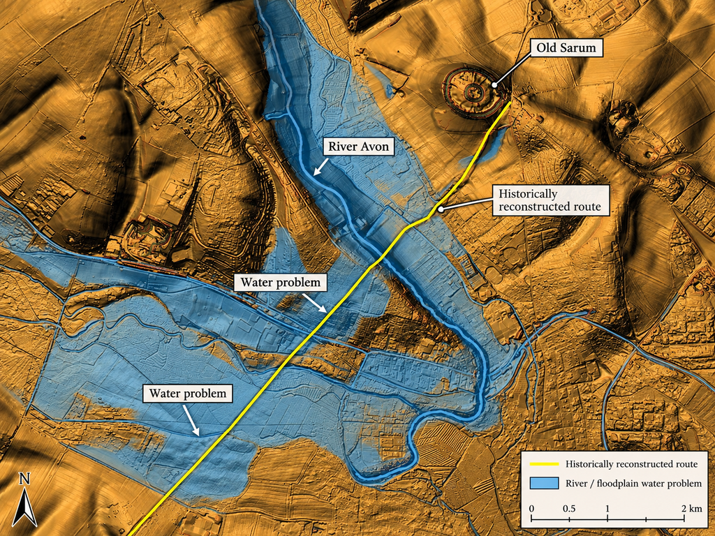
LiDAR overview showing the Avon valley, the proposed route towards Bemerton and the Nadder valley.
Overlay the historically reconstructed course and independently identifiable surviving linear features separately. Use different line styles for observed and inferred sections.
Caption: Figure 26. The reconstructed route across the Avon and towards the Nadder. Historic maps preserve possible route connections, while the surviving landscape does not provide an obvious uninterrupted Roman agger through the river valleys [4,17,18].
Three Rivers, Three Engineering Questions
The traditional route must eventually negotiate the Avon, Nadder and Ebble before reaching the better-preserved features farther south-west.
Each crossing presents an independent engineering problem.
A Roman road could have crossed these rivers by ford, bridge, causeway or a combination of structures, depending on local conditions.
But the methods used at one crossing need not have been employed at another, and the original Roman route need not coincide with subsequent medieval roads.
Nor should we presume that the river channels, floodplain boundaries and usable crossing places remained unchanged over the intervening centuries.
Under the Post-Glacial Flooding Hypothesis, the relationship between the earthworks and the earlier water landscape becomes a further subject for testing [7]. That model cannot itself establish the age or purpose of the roads, but it raises potentially useful questions about historic water levels and access.
The crucial point is that any proposed river crossing must satisfy both its archaeological and geographical requirements.
It must have a plausible physical approach, a defensible crossing location and evidence supporting its connection to the onward route.
A line on a map does not resolve those questions.
The Verdict at the Nadder
Our investigation began at Old Sarum with a substantial cutting whose origin remains undemonstrated.
At the Avon, that uncertainty grows.
The Southampton surveys identify possible Roman-period roads, hollow ways and ditch systems in a complicated multi-period landscape. The reconstructed route towards the Avon therefore has archaeological support.
Yet the published investigations do not provide an uninterrupted excavated Roman construction crossing the river and continuing towards the Nadder.
Historic accounts supply possible fords, roads and tracks, but their Roman construction is not established merely by their presence along the accepted alignment.
The LiDAR and satellite evidence raise additional questions about the relationship between the routes approaching the Avon and those leaving it.
Langlands’s work shows that changing river crossings and later route development are recognised archaeological complications, not problems invented by this investigation.
The conclusion is not that Roman roads never crossed these valleys. It is that the accepted continuous alignment is less securely demonstrated than its conventional presentation suggests.
By the time we reach the Nadder, we have moved from the conspicuous engineered cutting outside Old Sarum into a landscape where the road’s identity increasingly depends on historic interpretation, route continuity and the survival of fragmentary evidence.
In the next section, we will cross the Nadder, examine the route towards the Ebble, and follow the proposed road onwards towards Woodyates.
There, we can begin testing whether the surviving earthworks provide the constructional evidence that is missing or uncertain across the river valleys.
References
[4] Langdon, R. J. (2026). Ackling Dyke: Old Sarum–Dorchester Route-Wide LiDAR and Morphological Investigation. Original research dataset, route classifications and measured profiles. Unpublished.
[7] Langdon, R. J. (2026). The Post-Glacial Flooding Hypothesis: The Evidence. Version 3.4.
[12] Strutt, K., Barker, D., Heard, W. and Sly, T. (2015). Report on the Geophysical Survey at Old Sarum, Wiltshire, March–July 2015. Old Sarum Landscapes Project, Research Report No. 2, SREP 8/2015.
[13] Strutt, K., Barker, D., Langlands, A. and Sly, T. (2018). Report on the Geophysical Survey at Old Sarum, Wiltshire, April and July 2016, and April and July 2017. Old Sarum Landscapes Project, Research Report No. 3, SREP 1/2018, pp. 20–26, 41–46.
[17] Codrington, T. (1903). Roman Roads in Britain. Chapter IX, Section 6, “Old Sarum to Badbury”, pp. 305–307. Society for Promoting Christian Knowledge.
[18] Langlands, A. J. (2013). Travel and Communication in the Landscape of Early Medieval Wessex. PhD thesis, University of Winchester, particularly pp. 182–183.
⬅️ Previous Page — 6. Old Sarum to the Avon
➡️ Next Page — 8. Nadder to Woodyates