

LiDAR, Hydrology and the Case for a Multi-Phase Transport System Between Old Sarum and Dorchester
Robert John Langdon
Summary — What the Investigation Found
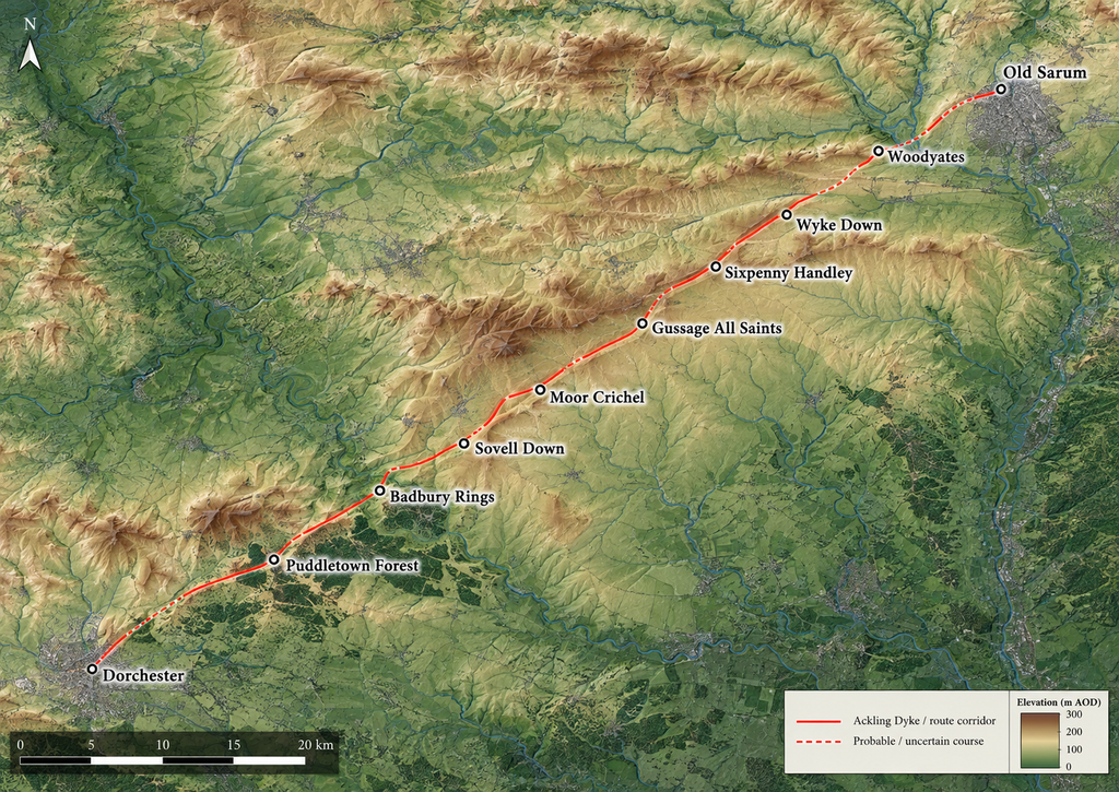
Ackling Dyke is traditionally identified as a Roman road connecting Old Sarum in Wiltshire with Badbury Rings in Dorset, forming part of a longer communication route continuing towards the Roman town of Dorchester. This interpretation is reflected in archaeological inventories, Historic Environment Records and the scheduling of substantial surviving sections of the earthwork [1–3].
However, the conventional interpretation raises a fundamental question: does the surviving evidence represent a single Roman engineering project, or have structures of different origins, functions and construction phases been incorporated into what is now recognised as one continuous route?
This investigation examines approximately 64 kilometres of the Old Sarum–Dorchester corridor using high-resolution LiDAR, aerial photography, historical excavation records, archaeological inventories and measurements of surviving earthworks [4–6].
Our principal conclusion is that the corridor cannot be adequately characterised as a physically uniform road. We propose that some of its larger earthworks may represent elements of an earlier, multi-phase extraction and water-transport network, subsequently modified or incorporated into Roman-period communications infrastructure.
This interpretation is based on the physical dimensions of surviving earthworks, variations in construction morphology, their relationships with extraction landscapes, and the possibility that some alignments originally terminated beside ancient waterways.
The Route-Wide Evidence
The route-wide morphological classification identified approximately 24.3 per cent of the surveyed alignment as wheeled-width road, 21.7 per cent as narrow surface, 6.2 per cent as ditch or channel, and 47.8 per cent as having no surviving identifiable trace [4].
Within the traditionally recognised Old Sarum–Badbury Rings section, approximately 22.1 per cent was classified as wheeled-width surface, while 63.9 per cent lacked an identifiable surviving route [4].
These classifications describe the earthworks’ current visibility and morphology. They do not establish the original form or date of sections that are no longer visible.
Nevertheless, the results show the corridor’s considerable physical variability and raise questions about interpreting its surviving remains as a uniform Roman construction.
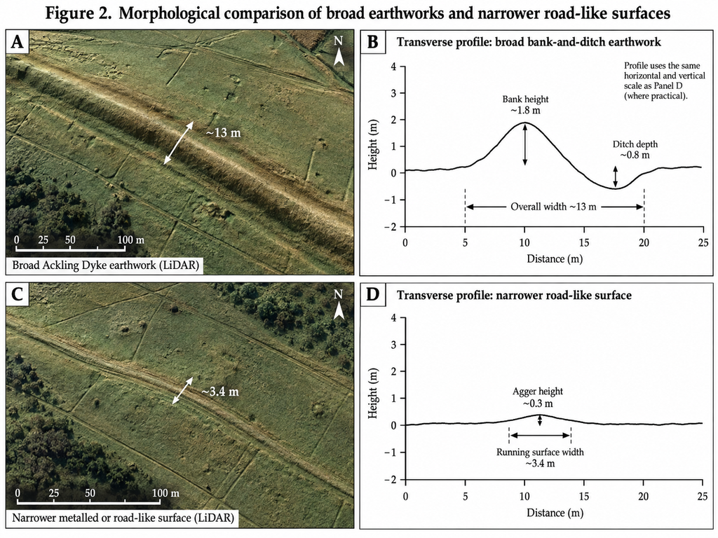
Historic England’s scheduling records describe substantial sections of Ackling Dyke between Oakley Down and Handley Down, where the raised structure reaches approximately 13 metres in width and varies from 1.2 to 2.5 metres in height. The recorded alignment also crosses earlier prehistoric monuments and field systems, including features associated with the Dorset Cursus [2].
Such substantial dimensions warrant investigation beyond the assumption that every bank and ditch was required solely to support wheeled traffic.
Woodyates — Evidence of Different Structures
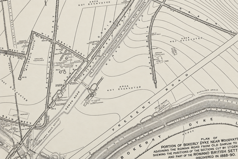
The nineteenth-century excavations undertaken by General Pitt-Rivers at Woodyates and Bokerley documented a complex landscape of banks, ditches, and drainage features, along with evidence of road construction [5].
His excavation drawings and recorded section levels provide important evidence for distinguishing the physical characteristics of individual structures.
Our re-examination considers whether the relatively modest road-like features and the larger Ackling earthworks should necessarily be attributed to the same construction phase or original purpose.
The recorded drainage arrangements are particularly relevant because they allow us to examine actual ditch-floor elevations and the possible movement of water through the landscape.
The presence of drainage features does not establish that Ackling Dyke was originally a canal. However, their arrangement and recorded dimensions require consideration within any functional interpretation of the wider earthwork.
Wyke Down — The Evidence for Changing Alignments
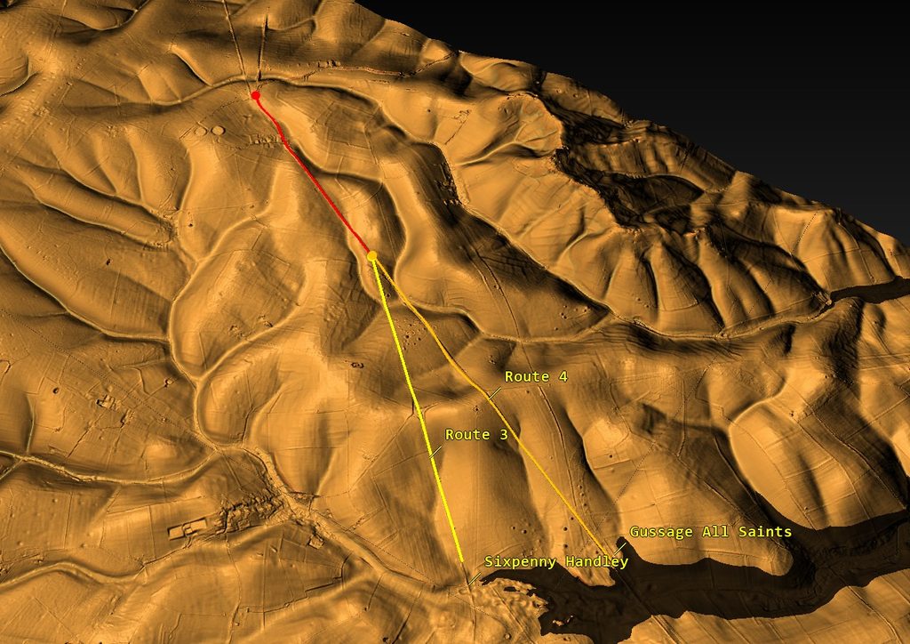
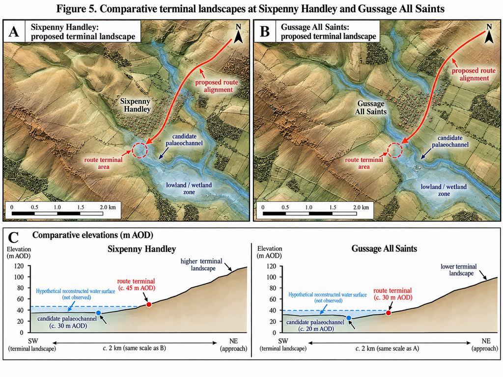
One of the most significant findings of the LiDAR investigation occurs at Wyke Down, where the mapped route exhibits two contrasting alignments.
The first, identified in our survey as Track 3, turns approximately 18 degrees towards the higher palaeochannel landscape around Sixpenny Handley.
A second alignment, Track 4, continues on a considerably straighter course towards the lower landscape associated with Gussage All Saints [4].
The straighter continuation also interacts with prehistoric monuments, providing an opportunity to investigate its relative construction sequence.
This geometry raises the possibility that the alignments represent different periods of route development, although differences in direction alone cannot establish their relative ages.
We propose that the two alignments may have served different terminal landscapes during successive phases of transport infrastructure.
Under this interpretation, the earlier route may have connected with a higher water-accessible landscape, while a subsequent extension or diversion could have reached lower ground after changes in regional hydrological conditions.
Changing Water Levels and the Two Terminal Landscapes
The possibility of successive transport terminals is particularly relevant to the Post-Glacial Flooding Hypothesis, which proposes that river and groundwater conditions during parts of the early Holocene differed substantially from those of the present day [7].
If some of the Ackling earthworks were associated with waterborne transport, changes in accessible water levels could have influenced the location and usefulness of individual terminals.
The landscapes around Sixpenny Handley and Gussage All Saints therefore provide a potential test of this interpretation.
Rather than treating their geographical positions as sufficient evidence of former harbours, the investigation considers their relative elevations, palaeochannel morphology and potential hydrological connections.
To establish the proposed sequence, it will be necessary to demonstrate that the relevant landforms were accessible by water during the periods in question and that the associated engineered features could function as transport channels.
Extraction Landscapes and the Proposed Transport Function
A further result of the route-wide investigation is the recurring association between substantial earthworks and areas containing extraction features.
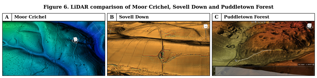
At Moor Crichel, near The Rookery, a major cut-and-bank feature descends from an extensive extraction landscape towards a palaeochannel, where the substantial construction appears to terminate. A less prominent alignment continues along the conventionally recognised route [4].
At Sovell Down, the accepted route makes a notable diversion around another major extraction feature.
Puddletown Forest contains numerous hollows, terraces, cuttings and banks, creating a landscape in which several distinct engineering functions may have operated [4,6].
These relationships suggest that access to extracted materials may have influenced the alignment and development of parts of the transport corridor.
The working interpretation proposes a system in which materials extracted from higher ground were moved through engineered corridors towards natural waterways.
Where sufficient water was available, boats could potentially have provided an alternative to transporting heavy loads over long distances by wheeled vehicles.
Such an arrangement would offer a possible functional explanation for some of the larger cut-and-bank structures and apparent lowland terminals.
However, extraction features and palaeochannel relationships alone do not demonstrate canal construction. The hypothesis must also satisfy the physical requirements of water supply, channel gradient, navigable depth and associated sedimentary evidence.
Roman Road Use and the Problem of Original Construction
The Roman evidence remains essential to the investigation.
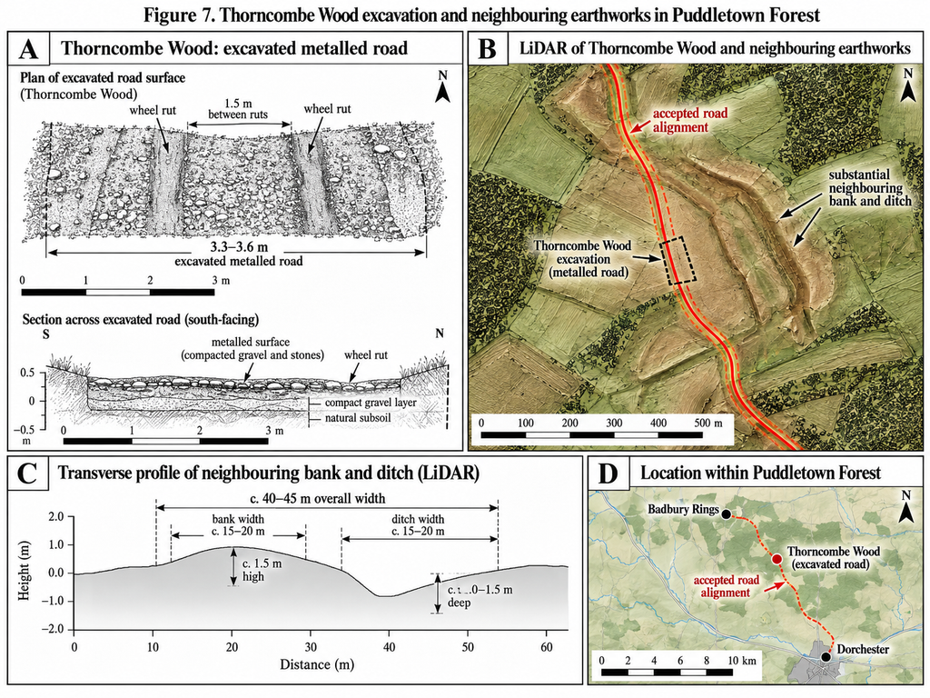
At Thorncombe Wood, within Puddletown Forest, excavations attributed to W. Putnam recorded a metalled running surface approximately 3.3 to 3.6 metres wide, with wheel tracks approximately 1.5 metres apart [6,8].
This provides evidence for wheeled transport at that location.
It does not independently establish that every adjoining bank, ditch, terrace or extraction feature was originally constructed as part of the same Roman road-building project.
Fletcher’s archaeological investigation of Puddletown Forest also considered the possibility that the Roman-period route south-west of Badbury Rings followed an earlier alignment, potentially of prehistoric origin [6].
This is particularly relevant to the present interpretation because it demonstrates that the possible inheritance of earlier route infrastructure is a legitimate archaeological question, independently of whether the larger earthworks were originally connected with hydraulic transport.
Badbury Rings provides an important comparison between the substantial Ackling Dyke earthworks and the recognised continuation towards Dorchester.
If the entire corridor originated as a single Roman road-building project, its construction might be expected to exhibit greater consistency, allowing for differences imposed by terrain, geology and later disturbance.
Instead, our survey identifies significant variations in the surviving morphology of the route on both sides of Badbury Rings [4].
The evidence therefore supports distinguishing demonstrated Roman-period road use from the original construction and possible earlier functions of the wider earthwork system.
A Proposed Multi-Phase Development Model
Taken together, the investigation suggests that the Old Sarum–Dorchester corridor should be examined as a multi-component landscape rather than assumed to represent one uniform construction.
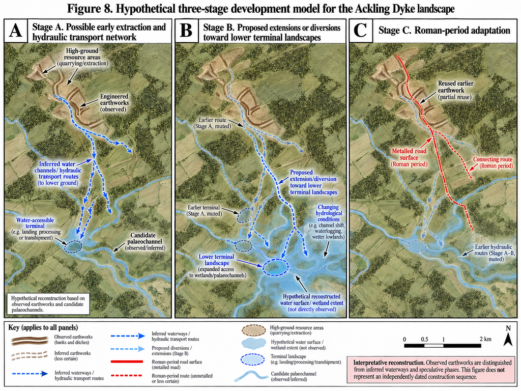
A working model involving three broad phases is proposed.
The first is a possible prehistoric phase in which substantial engineered earthworks were associated with resource extraction and movement of materials towards accessible waterways.
The second is a possible period of modification in which changes in river levels, groundwater conditions, or transport requirements caused particular alignments to be extended, abandoned, or diverted towards different terminal landscapes.
The third involves Roman-period road use, potentially incorporating the construction of metalled surfaces and the reuse or adaptation of earlier infrastructure.
The proposed sequence is not yet an established chronology. Direct dating evidence, stratigraphic relationships and independent palaeoenvironmental reconstruction will be required to determine whether these phases occurred and how they relate to one another.
Nevertheless, the model provides an explanation that can be tested against the varying earthwork dimensions, changes in alignment, extraction-site associations and palaeochannel relationships identified during the route-wide survey.
Overall Conclusion
The investigation demonstrates substantial physical variation across the approximately 64-kilometre Old Sarum–Dorchester corridor.
The surviving remains include broad and narrow raised surfaces, major banks and ditches, extraction landscapes, changes in alignment and numerous sections where no identifiable trace survives.
The archaeological record establishes Roman-period road use in parts of the corridor, but that evidence alone cannot infer the original construction history and function of every associated earthwork.
Our principal interpretation is that Ackling Dyke may preserve elements of a much earlier, multi-phase transport landscape, potentially involving extraction, engineered water channels, changing palaeochannel terminals and subsequent adaptation for Roman road traffic.
This model offers a testable explanation for several of the observed relationships, but its prehistoric chronology and navigational function remain hypotheses requiring further archaeological and hydrological investigation.
The remainder of this article examines the evidence geographically, beginning at Old Sarum and following the conventional alignment through Woodyates, Wyke Down, Sixpenny Handley, Gussage All Saints, Moor Crichel, Sovell Down, Badbury Rings and Puddletown Forest before reaching Dorchester.
Each section presents the relevant photographs, LiDAR maps, measured profiles and archaeological records, allowing the observed evidence to be distinguished from the interpretations derived from it.
The purpose is not to assume either Roman-road construction or prehistoric canal construction at the outset, but to determine which explanation best accounts for the surviving physical evidence.
References
[1] Royal Commission on Historical Monuments (England). (1975). An Inventory of Historical Monuments in the County of Dorset, Volume V: East Dorset. London: HMSO, pp. 33–34. Associated Dorset Historic Environment Record MDO2228.
[2] Historic England. Part of Ackling Dyke (Roman road), including Roman road on Oakley Down. National Heritage List for England, Scheduled Monument 1003309.
[3] Dorset Council. Roman Road from Old Sarum to Badbury Rings. Dorset Historic Environment Record, MDO6400.
[4] Langdon, R. J. (2026). Ackling Dyke: Old Sarum–Dorchester Route-Wide LiDAR and Morphological Investigation. Original research dataset, route classifications and measured profiles. Unpublished; supporting tables and figures to accompany the complete article.
[5] Pitt-Rivers, A. H. L. F. (1892). Excavations in Cranborne Chase, near Rushmore, on the Borders of Dorset and Wilts. Volume III: Excavations in Bokerly and Wansdyke, Dorset and Wilts, 1888–1891. Privately printed.
[6] Fletcher, M. (2004). The Ackling Dyke Roman Road in Puddletown Forest, Dorset. English Heritage Archaeological Investigation Report 37/2004; Historic England Research Report 103/2004.
[7] Langdon, R. J. (2026). The Post-Glacial Flooding Hypothesis: The Evidence. Version 3.4. ABC Publishing Group.
[8] Putnam, W. (1968). Thorncombe Wood road excavation, discussed in Fletcher (2004). Full primary publication details to be verified before final submission.
Continue Exploring Ackling Dyke Reconsidered
Follow the investigation as we uncover the evidence, examine the ancient landscape and challenge the traditional interpretation of Ackling Dyke.
➡️ Next Page — 2. The Question – Is Ackling Dyke Really One Road?