
1. The Archaeological Evidence Behind the Roman Road Classification
Investigating Ackling Dyke through Puddletown Forest reveals a fundamental problem with its conventional interpretation. Although the monumental earthworks are routinely classified as a Roman road, the archaeological evidence does not establish that the entire surviving structure was originally constructed during the Roman occupation.
In 2004, Martin Fletcher undertook a detailed English Heritage survey of approximately 1.75 kilometres of the earthworks. His report begins its background discussion by admitting that very little is known about Ackling Dyke [1].
Nevertheless, the surviving banks are consistently described as a Roman road and its raised earthworks as an agger.
This creates an interpretative problem. An agger is generally understood as a raised Roman road formation, yet identifying an earthwork by that name does not independently establish its date or original function.
Fletcher also acknowledges that the Ordnance Survey depiction, first drawn in 1889, was stylised and subsequently reproduced on later maps [1].
The apparent continuity of Ackling Dyke on historical mapping therefore cannot substitute for evidence that the underlying earthworks represent one continuous construction.
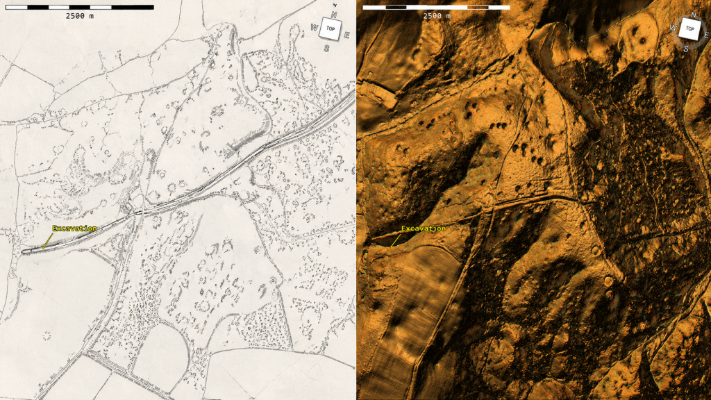
2. LiDAR Reveals Seven Different Earthwork Sections
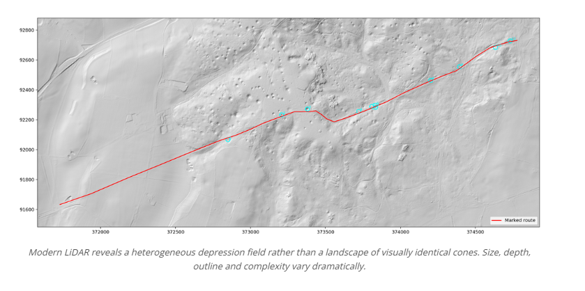
The present investigation traced 3.315 kilometres of the accepted alignment through Environment Agency one-metre-resolution LiDAR, extending beyond Fletcher’s original survey towards Thorncombe Wood [2].
Comparison with the seven sections identified by Fletcher reveals substantial variations in their surviving physical construction.
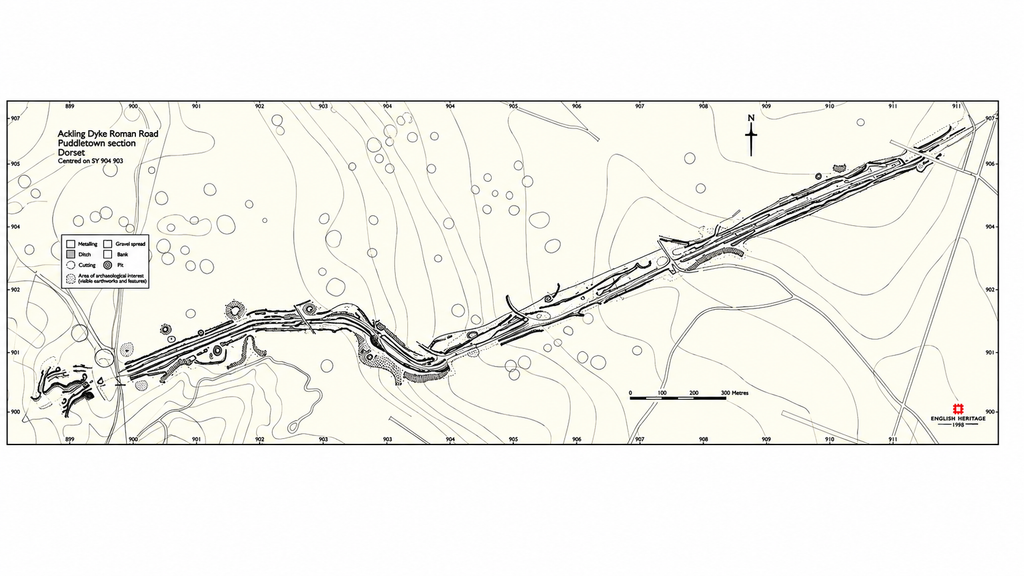
Section A–B contains no identifiable agger according to an earlier Ordnance Survey investigation, although probable quarrying has disturbed the original ground.
Section B–C preserves a short raised formation approximately 6 metres wide.
Section C–D contains a flat-topped earthwork between 4 and 6 metres wide, yet its complete bank-and-ditch complex measures approximately 26–33 metres across.
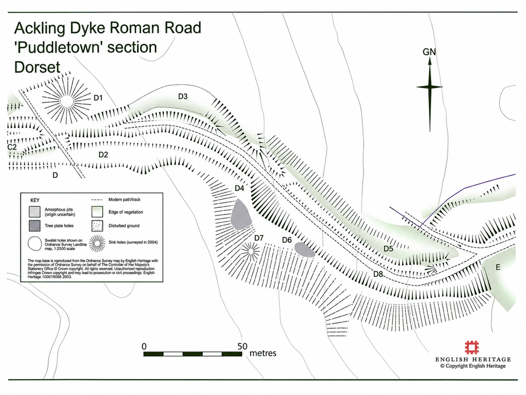
Section D–E descends a steep hillside, with changing alignments, substantial terracing and hollow ways. Its overall earthwork width reaches approximately 24 metres.
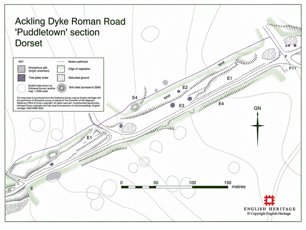
Section E–F has been extensively altered by quarrying and forestry tracks. Nevertheless, the formation interpreted as a Roman road measures approximately 34 metres across.
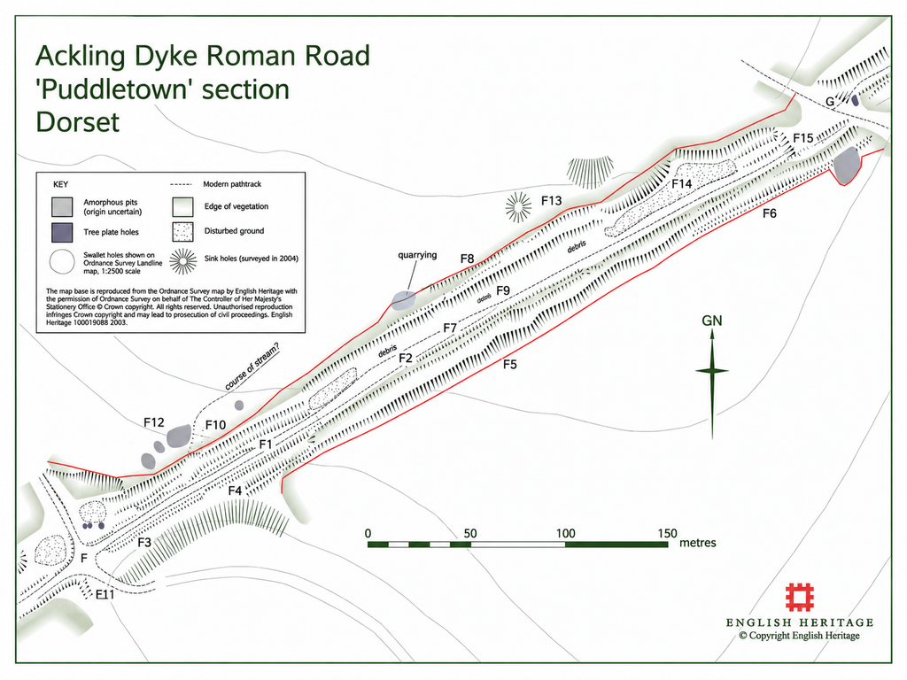
Section F–G follows a different alignment and occupies a terrace approximately 26 metres wide, although Fletcher acknowledges that the original agger width cannot be established.
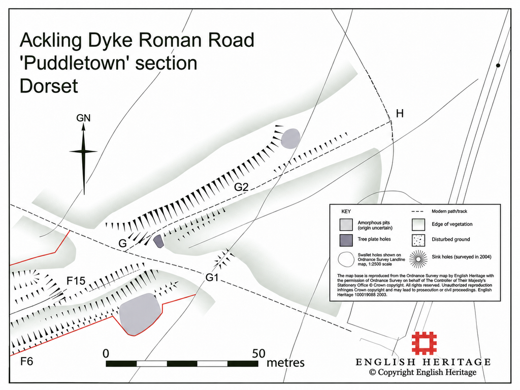
Finally, section G–H is largely obscured, with surviving banks described only as probably associated with the road [1].
| Published section | Approx. distance along our 3.315 km trace | Published physical description |
|---|---|---|
| A-B | 1.30-1.40 km | Earlier OS investigator recorded “no trace of the agger”; area disturbed by apparent quarrying |
| B-C | 1.40-1.46 km | Short surviving raised feature; top reported about 6 m wide |
| C-D | 1.46-1.76 km | Flat-topped raised earthwork 4-6 m wide, locally ~7 m; entire complex 26-33 m wide |
| D-E | 1.76-2.00 km | Curving descent of ridge; earthwork damaged by hollow ways; total width about 24 m |
| E-F | 2.00-2.38 km | Badly disturbed by forestry tracks and quarrying; supposed road complex approximately 34 m wide |
| F-G | 2.38-2.82 km | Different alignment; total earthwork about 26 m wide, but report says agger width cannot now be ascertained |
| G-H | 2.82-2.91 km | Almost completely obscured; linear banks described only as “most probably associated with the road” |
The important observation is not simply variation in width, which can occur in Roman road engineering.
The surviving alignment changes between raised banks, extensive ditch complexes, hillside terraces, disturbed ground and sections where a carriageway cannot be positively identified.
The LiDAR cross-sections reinforce these differences. They do not reveal one consistently repeated engineering profile [2].
This raises the possibility that the recognised route connects earthworks of different original functions or construction periods.
3. Thorncombe Wood — A Road Without an Independent Roman Date
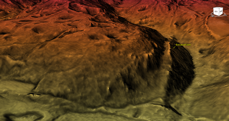
W. Putnam undertook the excavation most often used to support the Roman interpretation at Thorncombe Wood in 1968, southwest of the principal Puddletown survey.
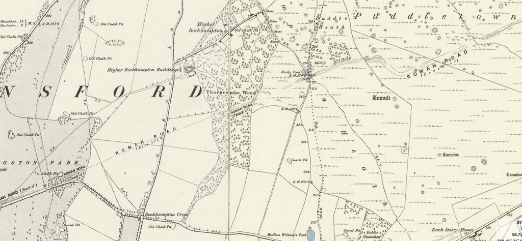
A two-metre-wide excavation exposed gravel metalling 25-50 centimetres thick, with wheel tracks about 1.5 metres apart.
The running surface measured only 11–12 Roman feet, approximately 3.3–3.6 metres wide.
Significantly, no accompanying side ditches were identified [1].
These findings establish a constructed terrestrial route capable of carrying wheeled traffic.
However, Fletcher’s summary provides no independent dating evidence demonstrating when this particular metalled surface was constructed.
Neither does the narrow running surface establish that the substantially wider earthworks elsewhere originated during the same construction episode.
At Bere Down, another excavation exposed metalling approximately 6.1 metres wide, likewise considerably narrower than some of the monumental earthwork complexes [1].
The archaeological evidence demonstrates engineered road surfaces at particular locations, not a common Roman construction date for every adjoining bank, ditch and terrace.
4. Even the English Heritage Survey Questions a Single Construction Phase
Fletcher’s discussion acknowledges uncertainty over whether the substantial earthwork represents one construction episode or several phases [1].
He also questions the practical need to build such a prominent raised agger along a steep ridge where natural drainage already existed.
One proposed explanation is that the monumental structure deliberately demonstrated Roman power.
However, the suggestion that its height provided a spectacle for approaching Roman soldiers is interpretative rather than evidence from archaeological dating.
A further complication is the report’s observation that modern forestry tracks, constructed with imported gravel and side drainage ditches, can resemble cambered Roman aggers [1].
This demonstrates that road-like morphology is not exclusive to Roman engineering.
The report also notes that only approximately 5 kilometres of the 27-kilometre Dorchester–Badbury Rings alignment coincided with metalled roads and tracks on 1987 Ordnance Survey mapping.
Fletcher considers whether the road was abandoned after relatively limited use.
Although later non-reuse cannot disprove Roman construction, it raises the question of whether the enormous route functioned continuously as the major highway its monumental appearance implies.
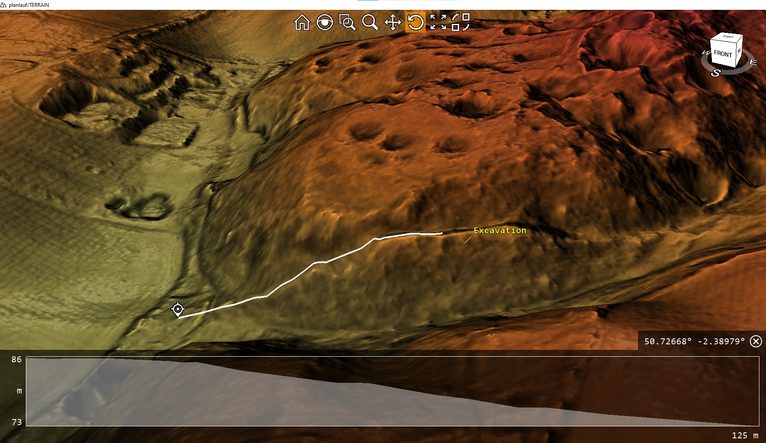
5. The Extraction Landscape — 513 Depressions
The surrounding forest contains an extensive landscape of depressions, extraction hollows and former workings.
Fletcher distinguishes substantial natural solution hollows from smaller irregular features resembling quarries, acknowledging that some could have supplied construction materials or served other purposes [1].
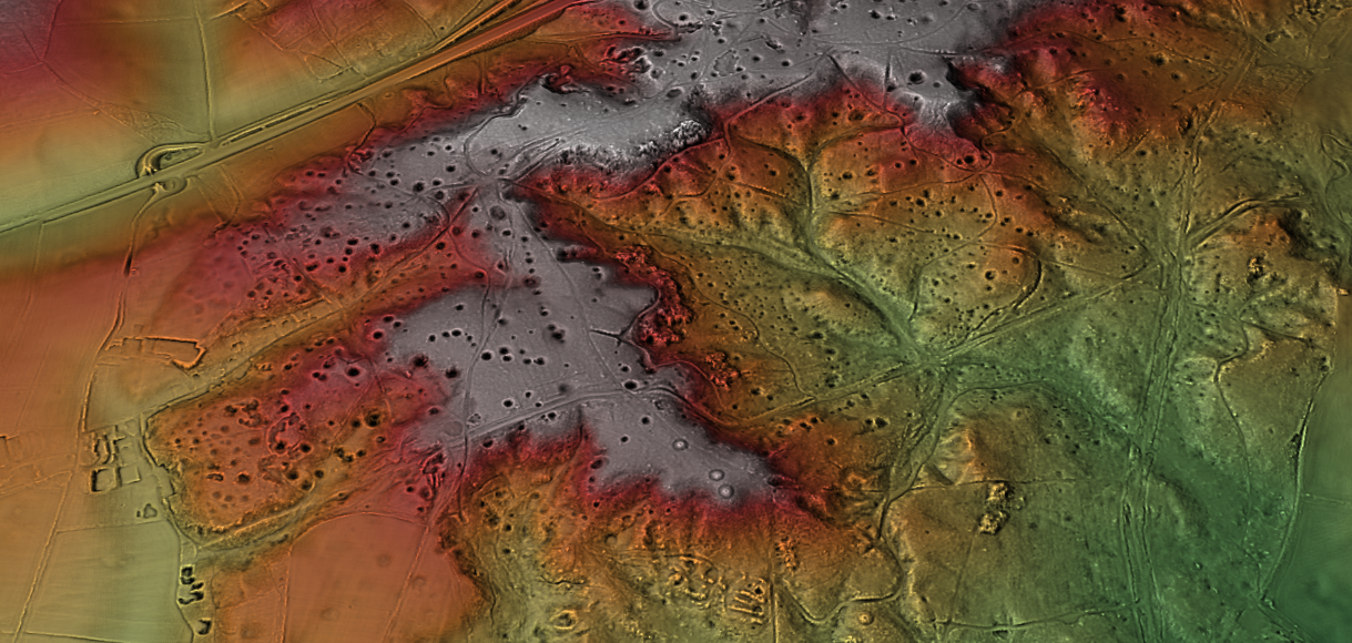
More significantly, the report records sand pits and a probable nineteenth-century mineral tramway, apparently used to transport sand to brickworks at Broadmayne, approximately seven kilometres away.
This demonstrates that mineral extraction and transportation formed part of the documented historical landscape, although it does not date the larger Ackling Dyke earthworks.
The modern LiDAR investigation examined 2.6775 square kilometres and identified 513 closed depressions, representing approximately 192 per square kilometre [2].
| LiDAR measurement | Result |
|---|---|
| Robust depressions detected | 513 |
| Density in analysed area | ~192/km² |
| Diameter 2.5-5 m | 158 |
| Diameter 5-10 m | 187 |
| Diameter 10-15 m | 89 |
| Diameter 15-20 m | 45 |
| Diameter 20-30 m | 27 |
| Diameter 30-50 m | 7 |
| Median equivalent diameter | 7.31 m |
| Largest detected equivalent diameter | 49.39 m |
| Depth 0.25-0.5 m | 165 |
| Depth 0.5-1 m | 163 |
| Depth 1-2 m | 104 |
| Depth 2-3 m | 49 |
| Depth 3-5 m | 25 |
| Depth 5-6.75 m | 7 |
| Median apparent depth | 0.71 m |
| Maximum apparent depth | 6.75 m |
Their morphology was highly variable.
Only 176 depressions, or 34.3%, met the deliberately strict criteria for a simple bowl-shaped feature.
A further 305 were irregular single-minimum depressions, while 32 contained multiple minima.
Therefore, approximately 65.7% failed the strict simple-bowl classification.
The result was:
| Morphological screen | Number | Percentage |
|---|---|---|
| Strict simple single-bowl form | 176 | 34.3% |
| Single minimum but irregular/non-classic form | 305 | 59.5% |
| Compound/multiple-minimum depression | 32 | 6.2% |
| Total | 513 | 100% |
Approximately two-thirds therefore fail our deliberately strict “simple bowl” t
These results do not demonstrate that the irregular depressions were artificially excavated. Natural geological processes can produce complex forms.
However, they establish a heterogeneous landscape requiring individual geological and archaeological investigation.
Comparison with mapped superficial geology also revealed no straightforward correspondence between depression concentrations and a single geological unit [2].
The hypothesis of extensive extraction activity therefore remains viable alongside natural doline formation.
6. An Earlier Mineral Transport System?
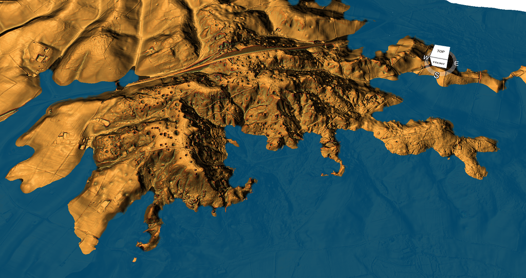
The relationship between the substantial earthworks, extraction features and lower-elevation corridors provides a possible alternative explanation for the landscape.
Under the Post-Glacial Flooding Hypothesis, some of the original banks and ditches may have formed part of a prehistoric extraction and transport network connected to former waterways.
As water levels changed, terrestrial tracks could have reused existing banks, terraces and routes, with Roman engineers subsequently constructing or resurfacing selected sections [2].
Such a sequence would explain why relatively narrow metalled roads occur along a corridor containing much larger and morphologically different earthworks.
However, the proposed palaeochannels require independent palaeoenvironmental dating, and the extraction features must be examined stratigraphically before establishing their relationship to the dykes.
Conclusion — Roman Use Does Not Establish Roman Construction
Archaeological evidence from Puddletown Forest shows that engineered road surfaces existed along parts of the recognised Ackling Dyke corridor.
It does not establish that the entire monumental earthwork complex was originally built as a single Roman road.
Changing cross-sections, missing aggers, uncertain banks, undated metalling, possible multiple construction phases, and extensive extraction landscape collectively challenge that assumption.
Fletcher’s survey documents many of these uncertainties, while the modern LiDAR analysis demonstrates their significance across a wider landscape.
The central issue is therefore not whether Roman traffic used Ackling Dyke, but whether Roman road construction explains the origin of the substantial earthworks themselves.
An earlier mineral-extraction and transport network, subsequently adapted for terrestrial movement, offers a testable alternative.
Until the major bank-and-ditch structures are independently dated, their original construction period and function remain unresolved.
References
[1] Fletcher, M. (2004). The Ackling Dyke Roman Road in Puddletown Forest, Dorset. English Heritage Archaeological Investigation Report 37/2004. Subsequently published as Historic England Research Report 103/2004. Particularly pp. 3–4, 6–19.
https://historicengland.org.uk/research/results/reports/103-2004
[2] Prehistoric Britain (2026). Ackling Dyke — Part II: Puddletown Forest — When a Roman Road Becomes an Assumption. Published 7 October 2026. Original 3.315 km LiDAR alignment investigation, measured earthwork profiles, 513-depression morphological analysis and geological comparisons.
https://historicengland.org.uk/research/results/reports/103-2004https://prehistoric-britain.co.uk/ackling-dyke-part-ii-puddletown-forest-when-a-roman-road-becomes-an-assumption
⬅️ Previous: Section 15. Introduction — Extending Ackling Dyke Beyond Badbury Rings
➡️ Next: Section 17 — Puddletown to Dorchester: The Disappearing Road