
1. Historical Mapping and the Surviving Route
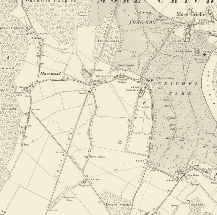
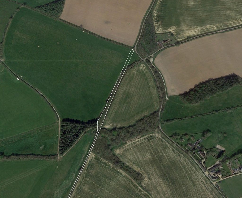
Southwest of The Rookery, the accepted Ackling Dyke alignment passes through Witchampton and Pamphill towards Badbury Rings. Historical Ordnance Survey maps identify the course as a Roman road, but preservation varies between visible earthworks, later tracks and buried linear features inferred from aerial photography.
The evidence must therefore be examined at particular locations rather than assuming that a continuous line on the map records a uniform surviving construction.
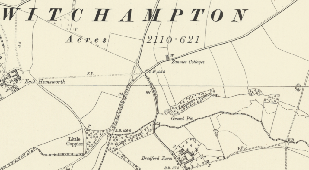
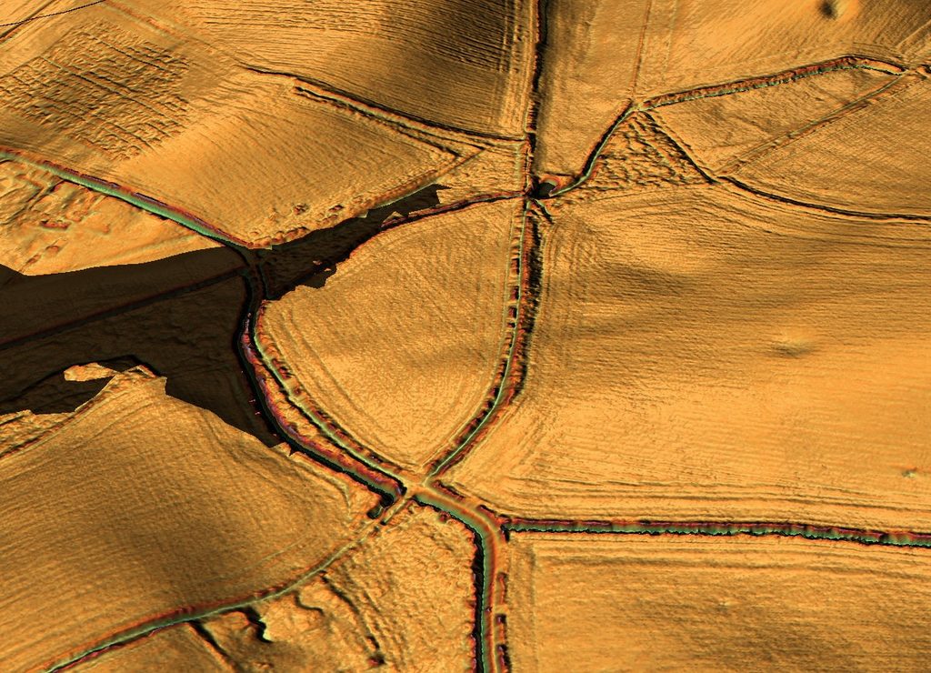
The historical map around East Hemsworth, Zannies Cottages and Bradford Farm is especially informative. It depicts the recognised road approaching a crossroads near Zannies Cottages, with branching and curved lanes to the southwest. The modern LiDAR image shows that the landforms around this junction are far more complex than a simple straight road intersection.
2. Zannies Cottages — The Crossroads Problem
The LiDAR shows a pronounced hollow west and southwest of the upper junction, with a curved earthwork or track following its margin. Another linear feature extends southwards on the eastern side.
These routes do not appear as a single, straight, uninterrupted raised agger through the crossing. Instead, the surviving formations bend, converge and separate around the hollow.
This is significant because the accepted Roman-road designation could encourage interpreting the junction as an ordinary crossing of two continuous roads.
Yet the topography does not demonstrate such a construction. Nor does the historical Ordnance Survey map provide evidence of a buried straight continuation: it records the routes recognised by the surveyor, not their underlying foundations.
The hollow is not automatically a quarry or prehistoric channel. Likewise, the curved track is not necessarily a Roman diversion.
Its relationship with the earthwork approaching from the northeast requires measurement, georeferencing and, ultimately, stratigraphic investigation.
A road could once have crossed ground subsequently removed or obscured, but that possibility is not equivalent to demonstrating that it did.
3. What the Archaeological Records Establish
The Dorset Historic Environment Record classifies more than 2.5 kilometres of the route through Witchampton as a broken line of earthworks, identified on aerial photographs and Environment Agency LiDAR (MDO45376). [1]
A further 625-metre stretch between The Old School and Sheephouse Drove survives as cropmarks recorded in MDO40694. [2]
Neither entry lists archaeological finds or an excavation establishing the original construction date of its recorded alignment.
More revealingly, the Royal Commission’s 1975 inventory describes the route through Witchampton and into Pamphill as obscured by a later track, before the agger becomes visible again near King Down Farm. [3]
This describes limited archaeological visibility, not a demonstrated buried roadway at Zannies Cottages.
The records examined do not identify an excavation or geophysical survey proving that a straight Roman road continues beneath this particular junction.
Consequently, the Zannies Cottages crossing should be recorded as an unresolved relationship between visible routes rather than a proven subsurface connection.
An alignment reconstructed between surviving sections may be plausible without becoming an excavated archaeological fact.
4. King Down Farm — Road Construction Demonstrated
Farther southwest, the evidence becomes considerably stronger.
Historic England’s Scheduled Monument 1002445 protects approximately 415 metres of the road west of Bradford Farm, near King Down Farm. [4]
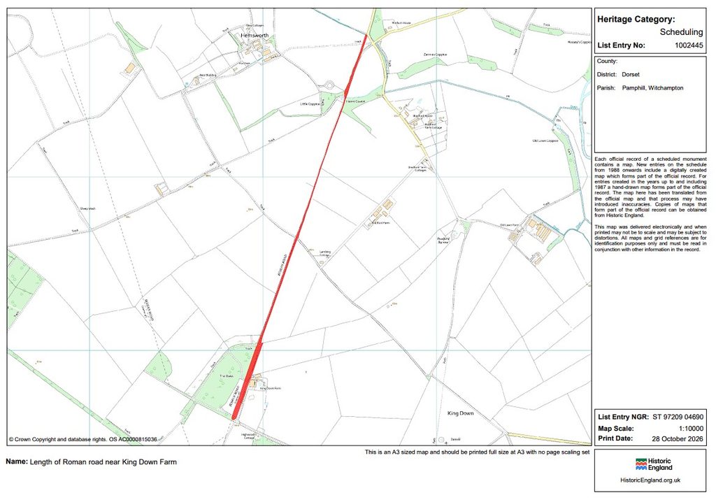
Its official description records a stone-built causeway standing up to one metre high, with buried side ditches, on a ridge overlooking the River Allen.
This is identifiable road engineering and should not be dismissed.
However, the scheduling entry does not demonstrate that the causeway and the disrupted formations around Zannies Cottages belong to a single construction phase.
In particular, the preserved causeway cannot retrospectively provide the missing structural evidence at the junction farther northeast.
5. Badbury Rings — Quarrying and the Final Road Alignment
At Badbury Rings, the recognised route from Witchampton approaches a landscape containing substantial extraction features and several converging roads.
LiDAR reveals an apparent reduction in the surviving road formation beside a large quarry complex, with a much narrower track continuing towards the hillfort.
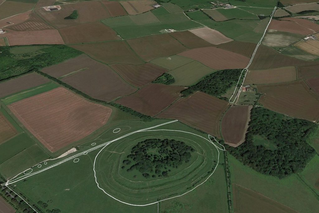
The archaeological literature provides important evidence that quarrying and road construction occurred in different phases.
Papworth (2019, pp. 141–142) documents extensive quarrying alongside the Dorchester road, including the feature known as the Devil’s Footprint, approximately 100 metres northeast of the road’s junction with the hillfort rampart. [7]
This excavation measures up to 30 metres wide and 0.7 metres deep. Crawford and Keiller (1928) considered it a quarry of considerable antiquity, noting tracks that converged to avoid the excavation. [8]
Papworth proposes that the cutting interrupted the existing road and that the road was subsequently reconstructed across it, with material later subsiding into the excavation.
This interpretation identifies successive phases of engineering rather than a single unmodified Roman construction.
However, the Devil’s Footprint lies on the Dorchester-road alignment and must be distinguished from the quarry adjoining the approach from Witchampton.
The chronological relationship remains critical. If a road foundation was constructed over an earlier quarry or its infilling deposits, the quarry necessarily predates that road construction. Conversely, a quarry cutting through an existing road demonstrates the opposite sequence.
The wider hypothesis proposes that some quarry complexes and associated dykes originated within an earlier extraction and transport network, potentially prehistoric, which was subsequently adapted for Roman terrestrial movement.
The Badbury evidence is compatible with multiple construction phases, but the prehistoric date of the individual quarry features remains to be established.
Determining whether the Witchampton approach was constructed over earlier extraction works requires stratigraphic evidence from the quarry margins, road foundations and associated deposits.
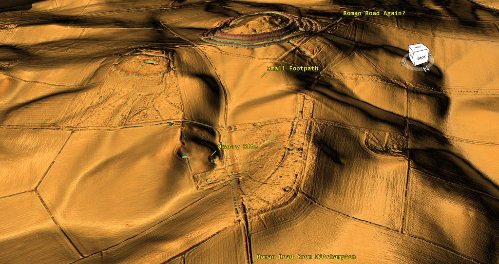
Conclusion
The final approach to Badbury Rings reveals a discontinuous transport alignment, substantial surviving road construction, extensive quarrying and evidence of successive modifications.
At Witchampton, the relationship between the mapped Roman road and surviving earthworks remains unresolved. At Badbury Rings, Papworth’s investigation demonstrates that roads were interrupted, modified and reconstructed in a landscape already containing numerous extraction features.
These findings support investigating Ackling Dyke as a multi-phase transport corridor rather than assuming that every associated bank, cutting and quarry originated during one Roman construction programme.
The proposed prehistoric extraction network remains a hypothesis requiring independent dating.
The fundamental chronological question is whether Roman engineers created the original earthworks or incorporated and modified an existing transport and extraction landscape.
The surviving physical relationships, rather than the Roman designation applied to the route, must determine that sequence.
References
[1] Dorset Historic Environment Record. MDO45376: Roman Road, Witchampton.
[2] Dorset Historic Environment Record. MDO40694: Roman Road, Witchampton.
[3] Royal Commission on Historical Monuments (England) (1975). An Inventory of Historical Monuments in the County of Dorset, Volume V: East Dorset.
[4] Historic England. Scheduled Monument 1002445: Length of Roman Road near King Down Farm.
[5] Dorset Historic Environment Record. MDO2228: Roman Road from Badbury Rings to Dorchester.
[6] Dorset Historic Environment Record. MDO6030: Roman Road near Badbury Rings.
[7] Papworth, M. (2019). Excavation and Survey at Badbury Rings, Dorset. Proceedings of the Dorset Natural History and Archaeological Society, 140, pp. 129–171, particularly pp. 141–142.
[8] Crawford, O. G. S. and Keiller, A. (1928). Wessex from the Air. Oxford: Clarendon Press, p. 59.
⬅️ Previous: Section 13. Sovell Down and Moor Crichel — When the Roman Road Meets the Quarries
➡️ Next: Section 15. Introduction — Extending Ackling Dyke Beyond Badbury Rings