
1. Sovell Down — Why Does the Roman Road Divert Around a Quarry?
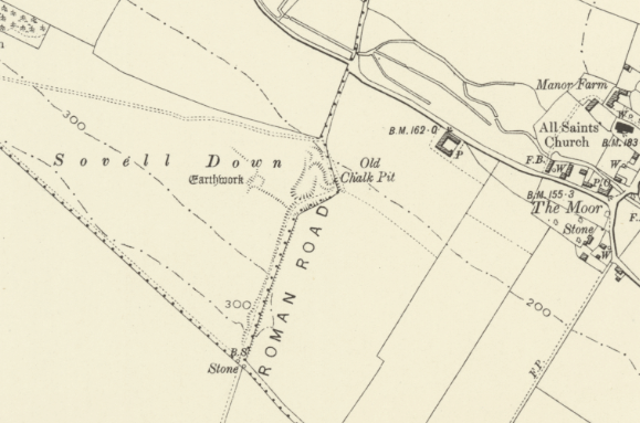
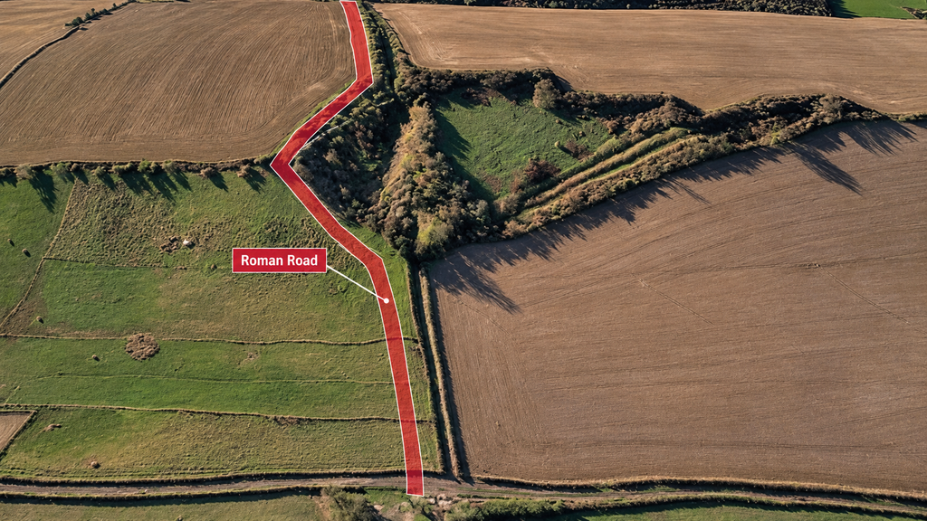
Leaving Gussage All Saints, our investigation continues southwest towards Sovell Down, where the recognised Roman-road alignment encounters an unusual landscape feature. [2, 3]
The historical Ordnance Survey map identifies a substantial excavation as an “Old Chalk Pit”, immediately beside a pronounced change in the road’s alignment. [1]
Rather than continuing directly across the hillside, the recognised route diverts around the quarry. [2]
This raises a chronological question.
Was the quarry already present when the road was constructed, or did later quarrying remove an earlier section of the road?
A third possibility emerges from our LiDAR investigation: the substantial excavations might originally have formed part of a water-managed extraction system, subsequently reused as a terrestrial route. [4]
This distinction matters because the route followed by Roman travellers need not reflect the original purpose of every surviving earthwork.
2. The Upper Channel, Quarry and Lower Channel
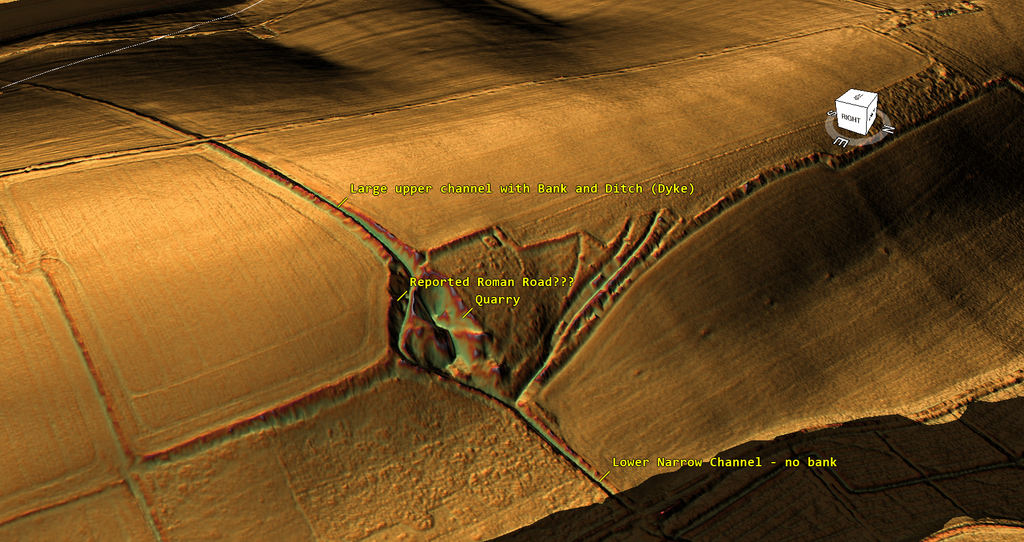
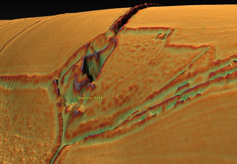
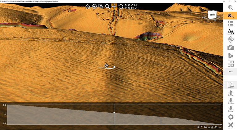
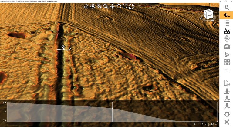
Our original one-metre LiDAR terrain measurements identify two distinct excavated features associated with the Sovell Down quarry. [4]
The upper feature is a substantial hillside cutting approximately 1.76 metres deep and 7.5 metres wide.
The lower feature is considerably smaller, approximately 0.74 metres deep and 5 metres wide.
Their measured elevations reveal an interesting relationship. [4]
| Feature | Recorded elevation |
|---|---|
| Upper channel | 86.35 m |
| Quarry | 65.90 m |
| Lower channel | 52.93 m |
From the upper quarry, the ground descends approximately 20.5 metres over 129 metres.
From the quarry to the channel, it falls another 13 metres over approximately 117 metres.
The oblique LiDAR suggests that the substantial upper cutting descends towards the quarry, while the smaller lower feature continues downslope. [4]
The arrangement can therefore be investigated as a possible sequence:
Upper channel → extraction hollow → lower discharge channel → palaeochannel.
These are sampled terrain elevations, not surveyed channel-floor levels. Nevertheless, the considerable fall demonstrates that this could not have operated as a conventional level navigation canal.
For an extraction or processing system, however, the gradient could have served a very different purpose.
3. Could Water Have Been Used to Wash Minerals?
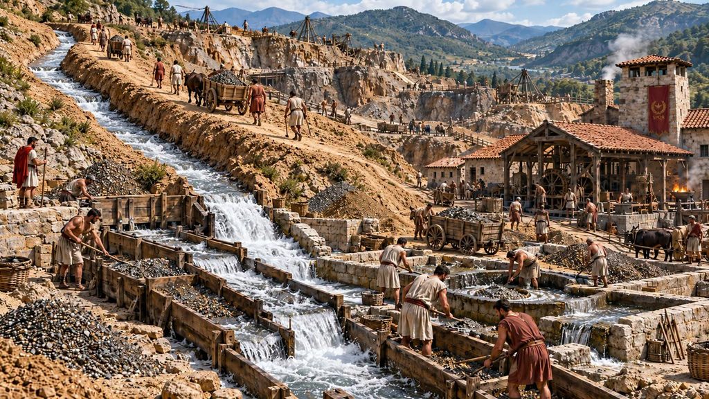
One possibility is that the deeper upper cutting intercepted groundwater or collected water from higher ground.
This water could then have descended towards the quarry under gravity.
If suitable mineral deposits were being extracted, a controlled water supply might have been used to wash, separate material from waste, or flush smaller particles towards a collection area.
The smaller lower channel might subsequently have discharged the water towards the palaeochannel below.
Under this interpretation, the apparent excessive gradient becomes potentially useful rather than an engineering obstacle.
However, the nature of the extracted material remains unconfirmed. The historic designation “Chalk Pit” records the cartographer’s identification and does not establish prehistoric mineral processing. [1, 5]
Nor has a former spring supply or mineral-washing installation been demonstrated.
A water-management explanation would require evidence of a reliable source, controlled flow, suitable processing deposits and an identifiable downstream outlet.
4. Evidence of Pre-Roman Engineering
Importantly, Sovell Down already possesses independent evidence of prehistoric ditch construction.
An archaeological excavation recovered the headless skeleton of a man deposited in a linear ditch around 300 BC, approximately three centuries before the Roman conquest. [6]
This establishes that at least one substantial ditch existed in the local landscape during the Iron Age.
It does not date the quarry or demonstrate that the excavated prehistoric ditch corresponds to either of our measured features.
But it does establish that linear earthworks were being constructed here before the Romans.
The question is therefore whether the recognised Roman road followed an existing engineered landscape, or whether the quarry and its associated cuttings represent later disturbance of an originally continuous road.
5. Moor Crichel and The Rookery — The Disappearing Earthwork
Continuing southwest towards Moor Crichel, we encounter another substantial extraction landscape surrounding The Rookery.
Historical maps identify several old chalk pits, while modern LiDAR reveals additional excavated hollows. [1, 7]
The Dorset Historic Environment Record identifies the Ackling Dyke alignment through The Rookery as MDO5842, with surviving sections protected under Scheduled Monument 1002420. [8, 9]
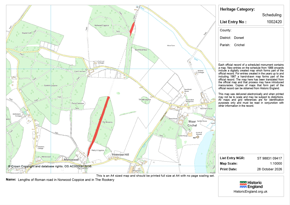
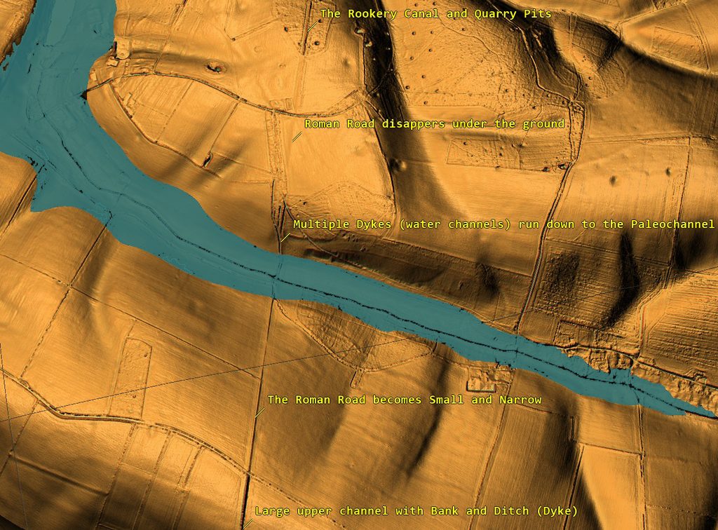
Here, our earlier examination identified a major cut-and-bank earthwork descending from the extraction area towards a proposed palaeochannel. [10]
But the substantial formation does not visibly continue across the valley with the same dimensions.
On the opposite side, the surviving alignment is much smaller.
Significantly, another quarry occurs near the beginning of this reduced track. [10]
Could the two extraction areas originally have possessed separate access routes leading down to the same waterway?
If the palaeochannel contained navigable water at the relevant date, neither substantial earthwork would necessarily have required a continuous terrestrial crossing.
The watercourse itself could have provided the connection.
Later travellers might simply have followed or joined the surviving tracks after the earlier waterway became inaccessible.
6. Three Cross-Sections — Quantifying the Difference
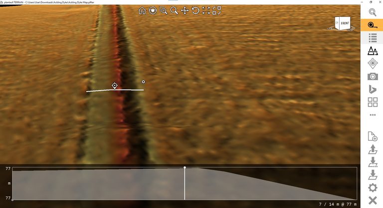
Our original LiDAR investigation measured three transverse sections through the Moor Crichel alignment. [10]
We corrected each against the surrounding natural hillside to establish the surviving artificial relief.
| Profile | Bank height | Raised area |
|---|---|---|
| A | 0.17 m | 2.15 m² |
| B | 0.56 m | 5.59 m² |
| C | 0.50 m | 4.39 m² |
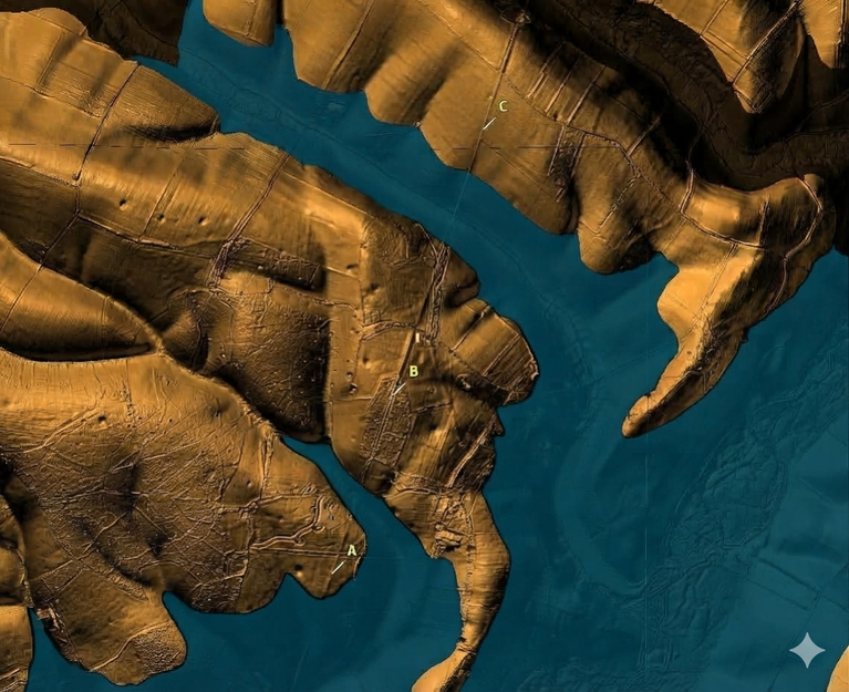
Profiles B and C preserve substantially greater earthwork cross-sections than A.
B contains approximately 2.6 times the surviving raised area of A, while C contains approximately twice as much.
These differences confirm that the recognised alignment does not retain one uniform physical cross-section. [10]
One possibility is that the substantial earthworks belonged to an earlier transport system, subsequently connected by smaller Roman or later terrestrial routes.
Alternatively, the differences could result from variations in Roman construction, quarrying, erosion or cultivation.
The LiDAR establishes the differences in surviving form, but cannot independently date their construction.
Conclusion — An Extraction Network or a Continuous Roman Road?
Sovell Down and Moor Crichel introduce two important relationships absent from a simple map of the Roman road.
At Sovell Down, a substantial upper cutting approaches a quarry, followed by a smaller lower channel descending towards the valley. [4]
At Moor Crichel, a major earthwork approaches a proposed palaeochannel, while a much smaller alignment and another extraction area occur beyond it. [10]
Both locations raise the possibility that the original engineering was associated with extraction and access to water rather than solely with overland movement.
Our working hypothesis is that some of these dykes originally connected extraction sites with an earlier water-transport network, and that the Romans subsequently adapted suitable surviving formations as roads.
The competing explanation is that Roman roads were constructed across the landscape and later altered them through quarrying and agricultural activity.
Decisive evidence must come from dating the quarry deposits, identifying any original road metalling beneath the earthworks, and establishing the former water levels.
Until those investigations are completed, the construction sequence remains unresolved.
But the measurements demonstrate why the quarry features cannot simply be ignored when reconstructing the history of Ackling Dyke.
References
[1] Ordnance Survey (1885–1890). Ordnance Survey 25-inch Map, First Edition, Dorset. Historic mapping of Sovell Down, Gussage All Saints and Moor Crichel. Dorset Historic Environment Record, Source SDO10239. https://heritage.dorsetcouncil.gov.uk/Source/SDO10239
[2] Dorset Life. Following in Roman Footsteps. Historical and landscape account of Ackling Dyke, including the Roman-road deviation around the chalk quarry at Sovell Down. https://dorsetlife.co.uk/following-in-roman-footsteps/
[3] Historic England. Length of Roman Road on Sovell Down. National Heritage List for England, Scheduled Monument 1002421. https://historicengland.org.uk/listing/the-list/list-entry/1002421
[4] Prehistoric Britain Research Project (2026). Ackling Dyke Investigation: Sovell Down, Sections D and E. Original analysis of one-metre Digital Terrain Model elevation data, cross-sections, channel depths and quarry approach. Primary research measurements supplied for this investigation; independent excavation verification outstanding.
[5] Dorset Wildlife Trust. Sovell Down Nature Reserve. Landscape description recording chalk extraction, ancient ditches and the Ackling Dyke Roman-road alignment. https://www.dorsetwildlifetrust.org.uk/nature-reserves/sovell-down
[6] Thorpe, N. (2019). ‘Scales of Conflict in Bronze Age to Iron Age Britain: Enemies Both Outside and Within.’ In Hansen, S. and Krause, R. (eds.), Materialisierung von Konflikten / Materialisation of Conflicts. Universitätsforschungen zur prähistorischen Archäologie, Volume 346, pp. 259–276, particularly p. 269. The discussion of the Sovell Down headless burial references McKinley, J. I. (1997), Sovell Down, Gussage All Saints, Dorset, unpublished human bone report for Wessex Archaeology. https://cris.winchester.ac.uk/ws/portalfiles/portal/3689333/Thorpe_article_in_Hansen_Krause_eds_Materialisation_of_Conflicts_UPA346_2019.pdf
[7] Dorset Historic Environment Record. Post-medieval Extractive Pits, The Rookery, Moor Crichel. Monument MDO40675. Three hollows identified from LiDAR and provisionally interpreted as post-medieval extraction. https://heritage.dorsetcouncil.gov.uk/Monument/MDO40675
[8] Dorset Historic Environment Record. Ackling Dyke Roman Road, The Rookery, Moor Crichel. Monument MDO5842. Records the road earthwork identified through aerial photography and LiDAR during the Dorset Stour National Mapping Programme. https://heritage.dorsetcouncil.gov.uk/Monument/MDO5842
[9] Historic England. Lengths of Roman Road in Norwood Coppice and in The Rookery. National Heritage List for England, Scheduled Monument 1002420. https://historicengland.org.uk/listing/the-list/list-entry/1002420
[10] Prehistoric Britain (2026). Ackling Dyke — Facts and the Archaeological Fiction. Original Moor Crichel and The Rookery investigation, including one-metre LiDAR cross-sections A, B and C, calculations of artificial relief, and examination of the earthwork approaching the proposed palaeochannel. https://prehistoric-britain.co.uk/ackling-dyke-facts-and-the-archaeological-fiction/
⬅️ Previous: Section 12. Gussage All Saints — Investigating the Roman Road/Dyke Alignment
➡️ Next: Section 14. The Rookery to Badbury Rings — The Witchampton Alignment