
Where Is the Evidence That This Road Actually Began at Old Sarum?
Before following the supposed Roman road from Old Sarum towards Woodyates, we must address a fundamental problem with the conventional archaeological interpretation.
Where is the physical evidence demonstrating that Ackling Dyke actually began at Old Sarum?
The question might appear elementary, yet it is remarkably important.
Historical Ordnance Survey mapping identifies a Roman road approaching Old Sarum from the east. Another accepted Roman-road alignment extends south-west towards Woodyates, eventually reaching Badbury Rings [2–4]. On a map, these alignments can appear as part of one coherent route system.
But does the archaeology actually demonstrate that connection?
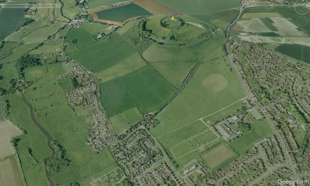
Old Sarum is a substantial prehistoric hillfort, later reused and modified during several historical periods [14]. The monument is not itself evidence that every road approaching it was constructed by the Romans. Nor does the apparent alignment of linear features on opposite sides of a prehistoric monument demonstrate that they formed one continuous Roman road.
A straight line is a geographical observation. It is not a construction date.
This distinction appears to have blurred in the traditional interpretation of Ackling Dyke. A road approaching Old Sarum from the east and another route projected south-west from its vicinity may look convincing as lines on a map, but that is not the same as demonstrating a continuous, excavated, and securely dated Roman construction joining them.
What should concern us at once is that the supposed starting point of the road is not explained archaeologically. The interpretation assumes a beginning at Old Sarum, yet the physical and chronological basis for that assumption is weak. If this were science rather than inherited cartographic tradition, the starting point would have to be demonstrated, not presumed.
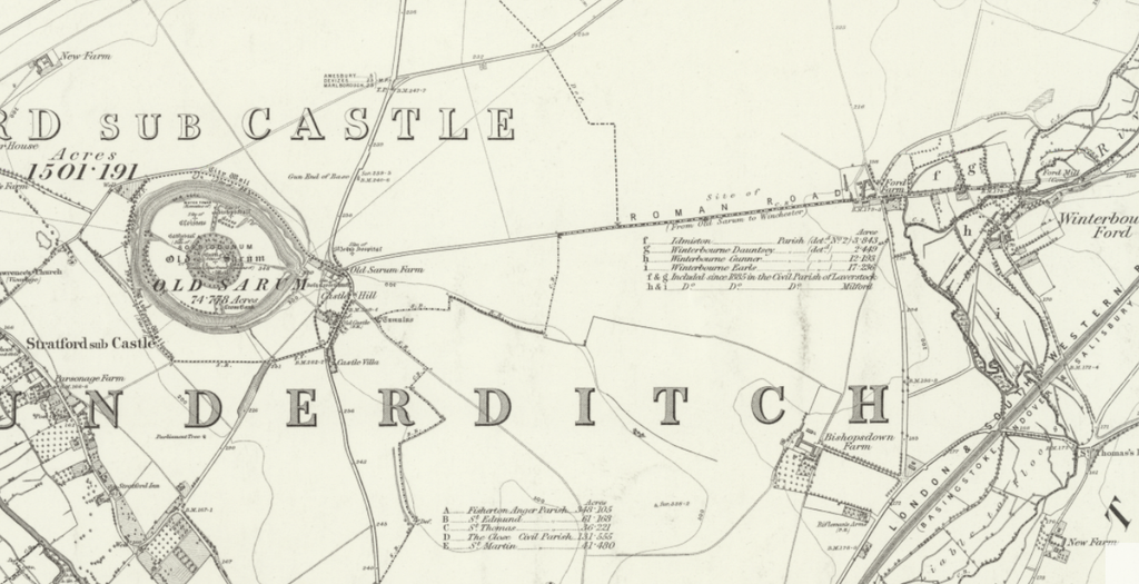
The Missing Archaeological Connection
Southampton University’s Old Sarum Landscapes Project investigated the surrounding landscape through geophysical surveys between 2015 and 2017 [12,13]. These surveys identified several possible roads, roadside ditches and hollow ways in the wider Old Sarum landscape, including features associated with the Portway/Ackling Dyke corridor.
This is useful evidence, but it does not solve the problem.
Identifying several road-like features in the same general area does not show they were constructed at the same time, belonged to the same route, or formed one continuous Roman engineering project. The published surveys do not provide an excavated construction sequence linking the eastern Roman-road approach to Old Sarum with the substantial south-western earthwork identified in our LiDAR investigation [12,13].
Nor do they establish the original construction date of that substantial earthwork.
This is not a minor technical omission. It concerns the very place where the accepted Roman road is supposed to begin. If the starting point cannot be archaeologically demonstrated, then the standard narrative already begins with an assumption.
The Southampton Survey — A Road, a Ditch, or Several Different Structures?
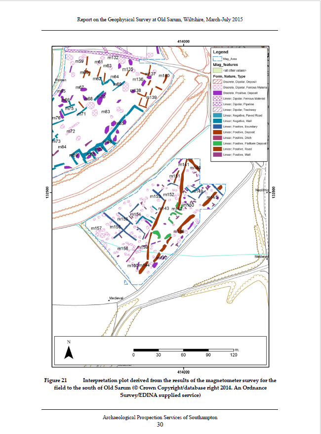
The archaeological evidence becomes particularly interesting when we compare our three-dimensional LiDAR survey with Figure 21 of Southampton University’s 2015 geophysical investigation [12].
The original report identifies several linear anomalies immediately south of Old Sarum.
Anomalies m141 and m142 represent a possible road or hollow way extending approximately 62 metres. A second alignment, m143 and m144, runs at a slight angle, while m145–m147 form another possible route extending approximately 130 metres, parallel to the existing bridleway [12].
Importantly, the investigators identified several possible routes, rather than one unambiguous Roman road construction.
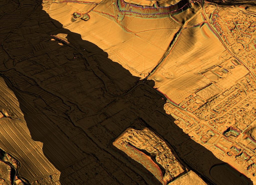
Our LiDAR survey provides a complementary view of the surviving landscape, showing a relatively narrow linear formation and a substantial associated depression near the accepted approach to Old Sarum [4].
No excavated construction sequence demonstrates that these features were originally built together as a conventional Roman road.
The geophysical evidence also does not establish their original construction date.
The Southampton evidence identifies possible roads and ditches. It does not independently demonstrate a continuous Roman road leading from Old Sarum into the much larger cutting farther south-west.
This distinction matters because the conventional interpretation treats the various alignments as components of a recognised Roman-road corridor, while the available archaeological evidence indicates a more complex landscape with potentially different structures and construction phases.
Before accepting the identification, we must establish which features genuinely belong together and whether their physical construction supports the proposed Roman date.
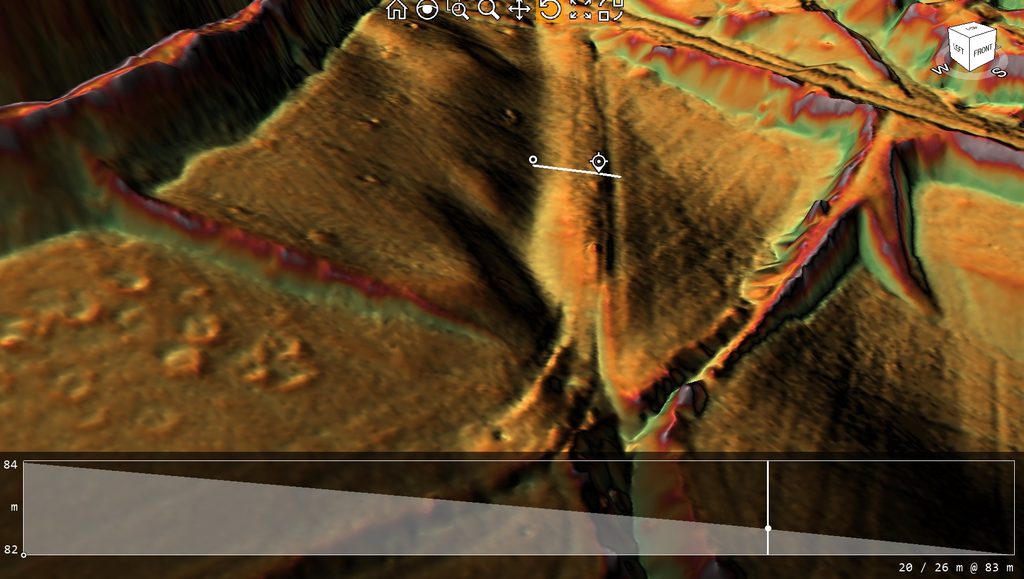
The Enormous Cutting South-West of Old Sarum
The problem becomes much sharper when we examine the south-western feature itself.
Our LiDAR investigation identifies a substantial cutting immediately beyond Old Sarum associated with the traditionally recognised route. The feature measures approximately 38 metres across and reaches approximately 3 metres below the adjoining higher ground in the displayed profile [4].
This is not a minor hollow or a faint terrace. It is a major engineered landform.
It also clearly predates modern road improvement, because it is already visible on nineteenth-century mapping. In other words, the cutting is not simply the result of recent road engineering. It was already a significant feature in the historic landscape.
Yet this is not the characteristic form of a conventional Roman agger. A Roman agger is normally understood as a raised road embankment, with the metalled running surface set above the surrounding ground so that water can drain away into flanking ditches. By contrast, the feature at Old Sarum is a substantial recessed cutting. The present route occupies the bottom of a large depression within the landscape.
Roman engineers could, of course, create cuttings where topography required them. The existence of a cutting is not, by itself, proof that the feature is non-Roman. But the issue here is not merely that it is a cutting. It is the scale of the excavation and the lack of a demonstrated Roman construction sequence.
What archaeological evidence establishes that Roman engineers originally excavated this 38-metre-wide, 3-metre-deep cutting for a wheeled road?
At present, none of the published evidence examined here answers that question.
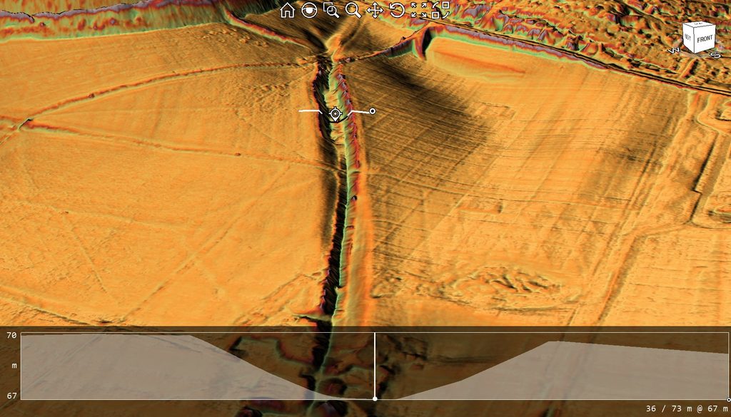
Morphology — More Like a Prehistoric Dyke Than a Roman Road?
If we assess the feature morphologically rather than simply inheriting its label, a further problem becomes obvious.
In both scale and form, this cutting looks less like a normal Roman road embankment and more like a substantial dyke-type earthwork. It has the proportions of a major excavated linear feature rather than a modest engineered running surface.
That does not prove a prehistoric date. Morphology alone cannot date an earthwork. But it does affect the burden of proof.
If a feature looks like a major dyke in size and design, archaeologists should not assume it was excavated as a Roman road unless they can demonstrate that through excavation, constructional evidence, or securely dated deposits. Without that evidence, the Roman-road attribution becomes a label attached to a form that is not self-evidently Roman.
This matters because Old Sarum is itself a prehistoric monument in a landscape full of prehistoric boundaries, defensive earthworks, and later reuse. In such a setting, it is entirely plausible that later routes could reuse or adapt earlier large-scale earthworks rather than having created them in the Roman period.
The crucial distinction is therefore this:
A road can run within or along an earthwork without proving that the earthwork was originally made as a road.
That distinction lies at the heart of the Ackling Dyke problem.
Does the Cutting Run Down to the River Avon?
The wider LiDAR setting adds another, highly significant observation.
In three dimensions, the larger landscape suggests the substantial cutting runs down towards the River Avon. More precisely, it appears to descend to the edge of what, under a prehistoric hydrological model, may have been a broader river margin or water-associated landscape [4,7].
Beyond that point, the design changes.
In other words, the substantial dyke-like cutting does not simply continue in the same form as a standard road embankment. Rather, it appears to terminate or transform as it approaches the Avon-side landscape. This transition warrants close investigation.
Under the Post-Glacial Flooding Hypothesis, such an arrangement is potentially meaningful [7]. If the Avon occupied a broader, wetter or more accessible transport zone in earlier periods, then a major cutting descending towards it may not have functioned simply as a wheeled Roman road. It could instead reflect access to a riverside zone, an earlier boundary or dyke, or a larger transport or drainage arrangement later reused by roads.
That is, of course, a working hypothesis rather than a demonstrated fact.
But the key point is not that the feature must have been prehistoric or hydraulic. The point is that its morphology and apparent termination at the Avon invite that question, whereas the conventional Roman-road interpretation largely ignores it.
If the earthwork does indeed descend to an older riverside zone and then change character, that is not a trivial detail. It is a major clue to original function.
What the Archaeology Actually Demonstrates
At this point, it is important to be clear and fair.
The archaeology around Old Sarum does demonstrate Roman-period roads and activity in the wider landscape [12–14]. It would therefore be unreasonable to claim that the Roman-road interpretation is pure fantasy with no supporting evidence.
But that is not the issue.
The issue is whether the available archaeology demonstrates the specific claim that the south-western route from Old Sarum was one coherent Roman road beginning here and continuing towards Badbury Rings.
At present, the evidence does not support that claim.
What the published surveys demonstrate is:
- several road-like or ditch-like features around Old Sarum [12,13];
- a complicated, multi-period landscape [12–14];
- Roman activity in the area [12–14];
- and the presence of route elements later interpreted as belonging to Ackling Dyke [3,4].
What they do not demonstrate is:
- a continuous excavated Roman road connecting the eastern approach, Old Sarum and the substantial south-western cutting;
- a securely dated Roman construction sequence for the large cutting itself;
- or evidence that the dyke-like earthwork was originally excavated for wheeled Roman transport.
The distinction is critical.
Evidence exists for Roman roads near Old Sarum. At present, there is not adequate evidence that the entire large earthwork south-west of Old Sarum was originally Roman road construction.
Geometry Trying to Become History
That is why the conventional interpretation deserves strong criticism.
The usual account gives the impression that because a Roman road approaches Old Sarum from the east, and because another recognised route extends south-west from the vicinity, the two may be treated as one continuous Roman road.
But this is precisely where geometry starts to masquerade as history.
Two lines that appear to align across a prehistoric site are not the same as one excavated road. A ruler on a map is not an archaeological method. If one road segment is Roman, and another road segment is traditionally identified as Roman, that still does not prove that a massive intervening earthwork was also Roman, or that the three form one original construction.
This is not scientific reasoning. It asks a geometric projection to do the work of archaeological demonstration.
The criticism is not excessive. It is simply methodological.
If archaeologists wish to maintain that Ackling Dyke began at Old Sarum as one Roman road, then the burden lies with them to demonstrate:
- where the road physically began;
- which structures can be securely dated as Roman;
- how the large cutting fits into that sequence;
- and how the supposedly connected route was constructed across the landscape rather than merely mapped across it.
Until that is done, the standard interpretation remains a reconstruction — not a demonstrated fact.
Why This Matters for the Rest of the Route
This starting-point problem matters because it sets the tone for the whole investigation.
If the road’s beginning is assumed rather than demonstrated, then the rest of the route risks being interpreted in the same way: one section of surviving Roman-style road here, a mapped alignment there, a substantial bank or ditch elsewhere — all then gathered together under one inherited label.
But that is precisely what this investigation is testing.
At Old Sarum, the supposed Roman road begins not with a securely explained roadway, but with an enormous cutting whose form, scale and apparent relation to the Avon suggest that its original function may have been something else. It resembles a dyke more than a standard Roman agger. It appears to descend to an older river landscape and then change in design. And the published archaeology so far does not securely date it as Roman road construction.
That does not prove the conventional interpretation false.
But it does mean that the road begins with a major unanswered question.
And that is exactly where this section of the investigation should begin.
References
[2] Historic England. Part of Ackling Dyke (Roman road), including Roman road on Oakley Down. National Heritage List for England, Scheduled Monument 1003309.
[3] Dorset Council. Roman Road from Old Sarum to Badbury Rings. Dorset Historic Environment Record MDO6400.
[4] Langdon, R. J. (2026). Ackling Dyke: Old Sarum–Dorchester Route-Wide LiDAR and Morphological Investigation. Original research dataset, route classifications and measured profiles. Unpublished.
[7] Langdon, R. J. (2026). The Post-Glacial Flooding Hypothesis: The Evidence. Version 3.4. ABC Publishing Group.
[12] Strutt, K., Barker, D., Heard, W. and Sly, T. (2015). Report on the Geophysical Survey at Old Sarum, Wiltshire, March–July 2015. Old Sarum Landscapes Project, Research Report No. 2, SREP 8/2015.
[13] Strutt, K., Barker, D., Langlands, A. and Sly, T. (2018). Report on the Geophysical Survey at Old Sarum, Wiltshire, April and July 2016, and April and July 2017. Old Sarum Landscapes Project, Research Report No. 3, SREP 1/2018.
[14] Historic England. Old Sarum. National Heritage List for England, Scheduled Monument 1015675.
⬅️ Previous Page — 5. Old Sarum to Woodyates
➡️ Next Page — 7. The Avon to Woodyates