
Where the Investigation Begins
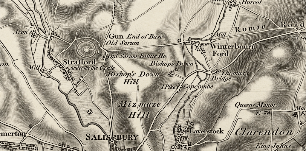
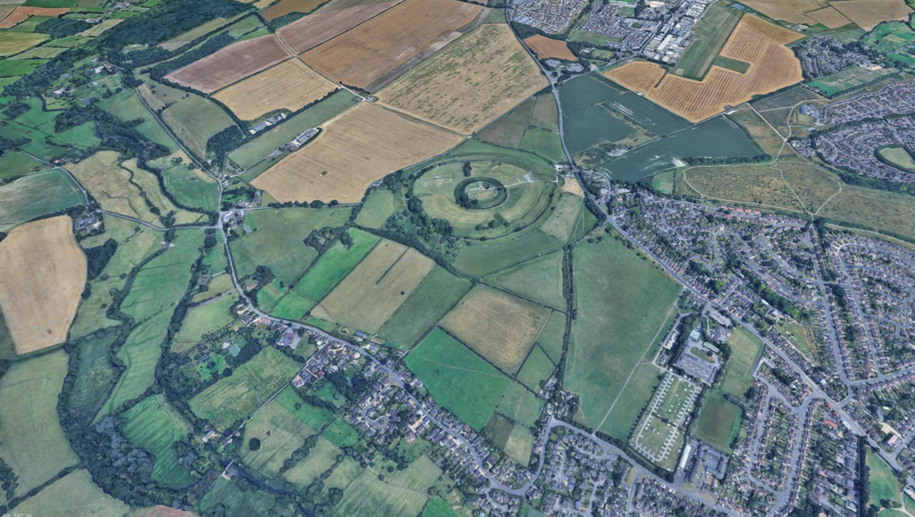
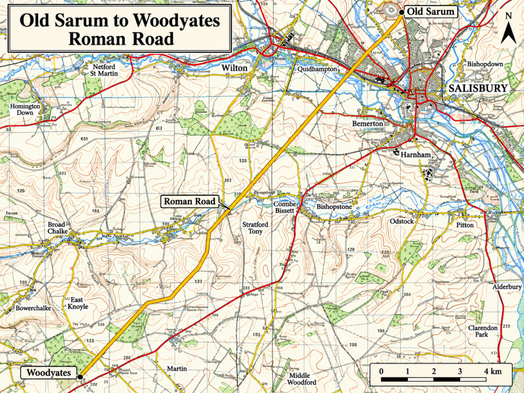
Our investigation begins at Old Sarum, approximately two miles north of modern Salisbury, where the traditionally recognised Roman road known as Ackling Dyke commences its south-westward journey across Wiltshire towards Dorset.
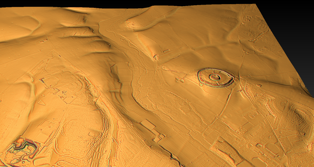
Old Sarum occupies a prominent chalk hill overlooking the surrounding valleys. Its history extends well beyond the Roman occupation, incorporating an earlier defended enclosure, Roman-period activity, a medieval castle and the original cathedral of Salisbury.
The location’s importance as a centre of communication is therefore undisputed.
Under the conventional archaeological interpretation, Ackling Dyke formed part of the Roman road network connecting Old Sarum, or Sorviodunum, with Badbury Rings, traditionally associated with Vindocladia, before continuing towards Dorchester and other settlements in southern Britain [1–3].
The accepted Old Sarum–Badbury Rings route extends about 35 kilometres, although our wider investigation covers about 64 kilometres through to Dorchester [2,4].
However, Roman activity at both ends of a route does not independently establish the construction date of every surviving structure between them.
The first task is therefore to examine how the recognised alignment leaves Old Sarum and progresses towards Woodyates, where the historic excavation evidence becomes particularly important.
Leaving Old Sarum — The Conventional Road Alignment
The Roman-road interpretation presents a route proceeding south-west from Old Sarum across the chalk landscape towards the Wiltshire–Dorset border.
Ackling Dyke is generally described as a relatively direct line across Cranborne Chase, with surviving stretches identified through raised embankments, tracks, cropmarks and other archaeological evidence [1–3].
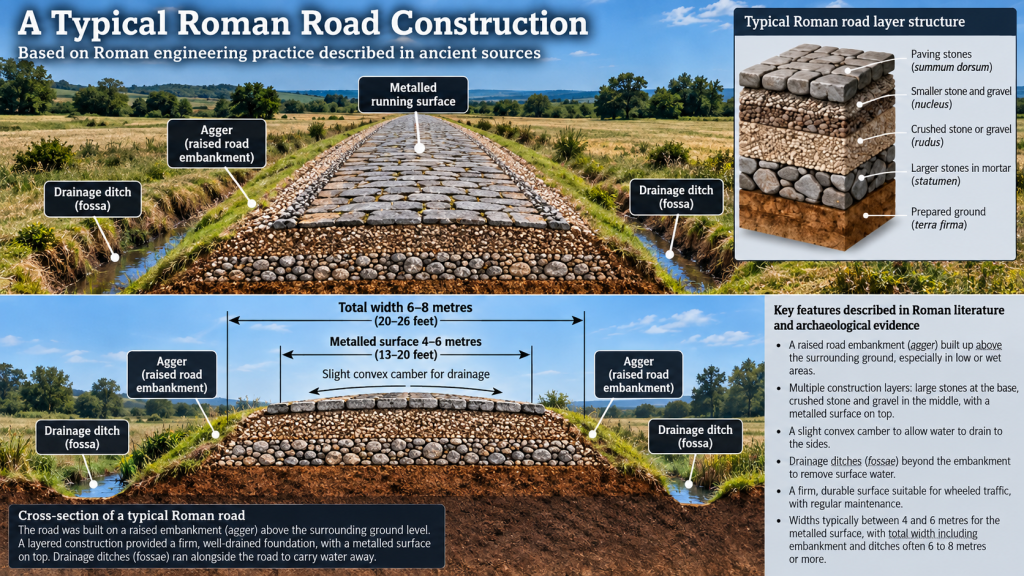
This is consistent with established Roman road-building practice, in which engineers frequently employed direct alignments between important destinations, modifying construction where terrain or ground conditions required it.
However, it is important to distinguish between a road’s course as reconstructed from archaeological evidence and the surviving physical construction itself.
A line shown continuously on an Ordnance Survey map may incorporate several different forms of evidence.
One section might preserve a substantial raised bank. Another may survive as a narrow track or buried formation. Elsewhere, its position may have been reconstructed from historic observations, cropmarks or the continuation of an established alignment.
These distinctions matter because a reconstructed route can be geographically continuous even if not every part of its original construction remains visible.
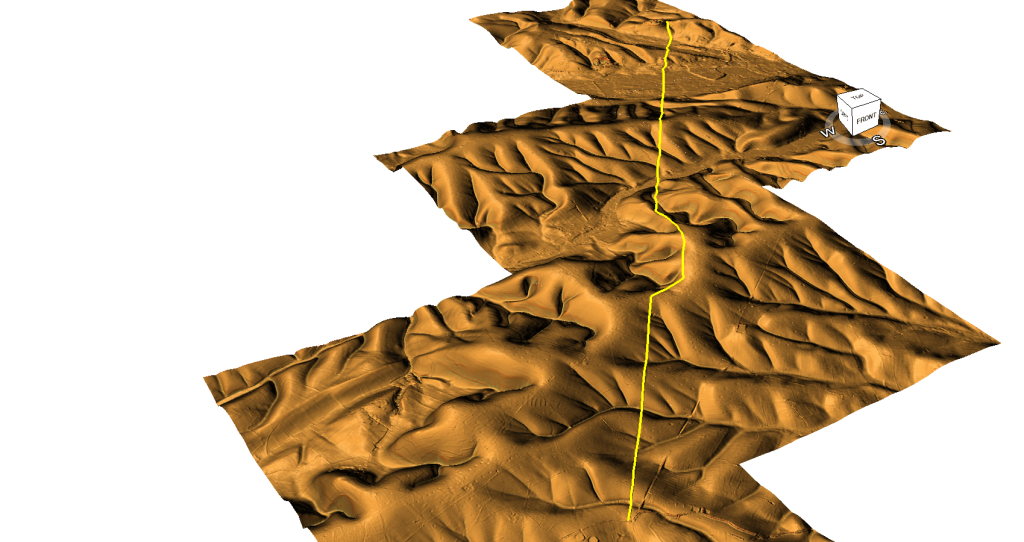
We undertook our route-wide LiDAR survey specifically to distinguish these differences, rather than treating the complete mapped alignment as one surviving engineering structure [4].
The question at this stage is not whether a Roman road existed between Old Sarum and Woodyates.
It is what physical evidence can be identified along that route, how its surviving form changes and what can legitimately be inferred from those observations.
Following the Route Across the Chalk Landscape
The landscape south-west of Old Sarum is characterised by chalk uplands, dry valleys and a complex network of natural drainage features.
These landforms matter because they influence both road construction and water movement across the landscape.
A raised embankment crossing a valley may have been required to provide a stable running surface. A cutting across higher ground may have reduced the gradient, while an adjoining ditch could have supplied construction material or assisted drainage.
Such arrangements are compatible with conventional Roman road engineering.
However, similar banks, cuttings and ditches may also arise from other forms of infrastructure, including boundaries, quarry access and drainage works.
The physical shape of a feature must therefore be considered alongside its construction materials, location, dimensions and relationship with neighbouring structures.
For this reason, our investigation recorded differences in surviving morphology along the Old Sarum–Dorchester corridor rather than classifying every identifiable linear feature as a wheeled road [4].
Historic England’s documentation of the Roman road north-east of Vernditch Chase provides an important example of the limitations of the surviving evidence.
The scheduled section preserves recognised road earthworks, but its official description also records substantial damage from stone removal and truncation by cultivation. It further notes that no archaeological excavation records exist for that particular scheduled section [9].
This demonstrates how the surviving evidence can be both significant and incomplete.
An identifiable road earthwork may exist at one location while adjoining stretches have been disturbed or destroyed.
Nevertheless, a surviving alignment does not establish that every associated bank, ditch and cutting was necessarily constructed in one operation.
That remains a matter for archaeological investigation.
A Road That Does Not Survive Uniformly
The complete route-wide survey revealed that physical survival varies considerably across the Old Sarum–Dorchester corridor.
Within the traditionally recognised Old Sarum–Badbury Rings section, approximately 22.1% was classified as wheeled-width surface, while 63.9% lacked an identifiable surviving route under our morphological classification system [4].
These figures apply to the complete northern section, not specifically to the shorter Old Sarum–Woodyates portion.
The local classification must therefore be examined separately rather than assuming that the same percentages apply equally to every part of the route.
Nevertheless, the overall results provide an important context for examining this first section.
They show that the conventional route contains substantial stretches where the survey cannot confidently identify its original physical form.
Where such gaps occur, several explanations must remain possible.
An original road may have been destroyed by cultivation or later construction.
Its surface may have been removed for building material.
Subsequent landscape changes may have obscured the underlying formation.
Alternatively, some portions of the mapped route may represent reconstructed connections between surviving features rather than continuously identifiable engineered remains.
None of these possibilities can be selected simply because it supports a preferred historical interpretation.
The central question remains whether the observed characteristics of individual sections are consistent with the conventional Roman-road explanation or indicate that different structures have been incorporated into the accepted alignment.
What Would Demonstrate Roman Road Construction?
The investigation does not dispute that Roman roads could contain substantial raised foundations or elaborate drainage arrangements.
The Romans could construct roads across difficult terrain, and variations in width or embankment height are not sufficient grounds for rejecting a Roman attribution.
Stronger evidence comes from the road’s internal construction.
A prepared foundation, deliberately laid running surface, construction layers, adjoining drainage features and evidence of wheeled use can together provide a coherent interpretation.
When accompanied by securely dated archaeological material or stratigraphic relationships, a construction sequence may also be established.
However, it is necessary to distinguish Roman-period material incorporated into a surface from evidence that securely dates the feature’s original construction.
A Roman road built over an existing bank would not necessarily reveal the bank’s age or original purpose unless archaeologists investigated the relationship.
This distinction matters for Ackling Dyke because some surviving sections consist of exceptionally substantial raised earthworks.
The question is not whether a Roman road could have been constructed upon such features.
It is whether the entire bank-and-ditch structure was originally built for that purpose.
Our investigation therefore treats evidence for Roman road use and evidence for original earthwork construction as related but separate questions [4].
Approaching Woodyates and Bokerley Junction
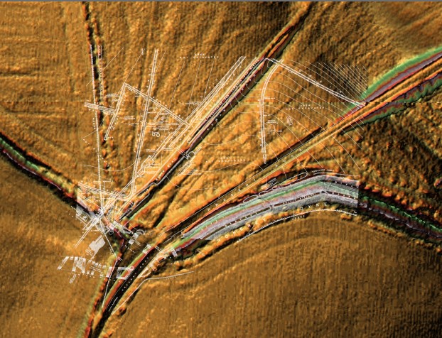
As the recognised alignment approaches Woodyates, near the Wiltshire–Dorset boundary, the archaeological landscape becomes considerably more complicated.
Here the traditional Roman road encounters Bokerley Dyke and a landscape containing substantial earthworks, settlement evidence, ditches and other archaeological remains.
Woodyates is important partly because of the extensive nineteenth-century excavations undertaken by General Pitt-Rivers between 1888 and 1891, followed by investigations associated with Philip Rahtz during the twentieth century [5,10].
Unlike sections where the evidence consists primarily of visible earthworks or mapped alignments, Woodyates contains published excavation plans, recorded measurements and archaeological finds.
The wider Bokerley Junction area also produced evidence of Romano-British occupation, including pits, ditches, burials, structural remains and substantial quantities of Roman material [10].
These discoveries establish considerable Roman-period activity in the area.
However, they do not eliminate the need to establish the individual construction histories of the road, Bokerley Dyke and the surrounding drainage or boundary features.
Indeed, the recorded sequence of modification and reuse at Bokerley Junction demonstrates why different earthworks occupying the same landscape must not automatically be treated as contemporary [5,10].
Our investigation will return to this evidence in detail.
For now, Woodyates offers the first major opportunity to compare the conventional mapped alignment with the much more detailed physical record preserved by excavation.
What This First Section Establishes
The journey from Old Sarum towards Woodyates establishes the geographical and archaeological context for the remainder of the investigation.
Old Sarum provides a recognised Roman-period centre from which the traditional route extends south-west towards Dorset.
Official archaeological records identify surviving sections of the road and document areas where its physical remains have been damaged or removed [3,9].
Our LiDAR investigation provides a method for comparing the visible morphology of the mapped alignment with its conventional archaeological classification [4].
However, the existence of a recognised Roman-road corridor is not equivalent to proof that every surviving or associated earthwork originated as part of one Roman construction project.
The distinction becomes increasingly important as the route approaches Woodyates, where substantial banks, ditches, drainage features and road-like construction occupy the same landscape.
We have therefore reached a location where the argument can move beyond surface appearances and reconstructed alignments.
At Woodyates, we have something more valuable: recorded observations and measurements from an archaeological excavation.
The next stage of our investigation will examine what Pitt-Rivers actually uncovered, including the relationship between the metalled road-like structure, neighbouring earthworks and the recorded ditch-floor elevations.
The fundamental question is whether the evidence demonstrates one coherent Roman road construction or a more complicated sequence of engineering and reuse.
The excavation record can now test that question.
References
[1] Royal Commission on Historical Monuments (England). (1975). An Inventory of Historical Monuments in the County of Dorset, Volume V: East Dorset. London: HMSO, pp. 33–34.
[2] Historic England. Part of Ackling Dyke (Roman road), including Roman road on Oakley Down. National Heritage List for England, Scheduled Monument 1003309.
[3] Dorset Council. Roman Road from Old Sarum to Badbury Rings. Dorset Historic Environment Record MDO6400.
[4] Langdon, R. J. (2026). Ackling Dyke: Old Sarum–Dorchester Route-Wide LiDAR and Morphological Investigation. Original research dataset, route classifications and measured profiles. Unpublished.
[5] Pitt-Rivers, A. H. L. F. (1892). Excavations in Cranborne Chase, near Rushmore, on the Borders of Dorset and Wilts. Volume III: Excavations in Bokerly and Wansdyke, Dorset and Wilts, 1888–1891. Privately printed.
[9] Historic England. Roman road north east of Vernditch Chase: part of the Roman road between Sorviodunum (Old Sarum) and Vindocladia (Badbury). National Heritage List for England, Scheduled Monument 1013203.
[10] Dorset Council. Romano-British Settlement at Bokerley Junction, Woodyates, Pentridge. Dorset Historic Environment Record MDO5931.
Continue Exploring Ackling Dyke Reconsidered
Follow the evidence as our investigation moves from the reconstructed route to the detailed nineteenth-century excavation records.
⬅️ Previous Page — 4. The Whole Route at a Glance
➡️ Next Page — 6. Old Sarum to the Avon