
From Old Sarum to Dorchester — A 64-Kilometre Investigation
Before examining the individual sections of Ackling Dyke, we need to establish what actually survives across the entire route.
The traditional interpretation identifies Ackling Dyke as a Roman road extending from Old Sarum in Wiltshire to Badbury Rings in Dorset, with the wider communication route continuing towards the Roman town of Dorchester [1–3].
On archaeological maps, this appears as a relatively straightforward connection between recognised Roman-period locations.
However, a continuous line on a map does not necessarily represent a continuous surviving engineering feature.
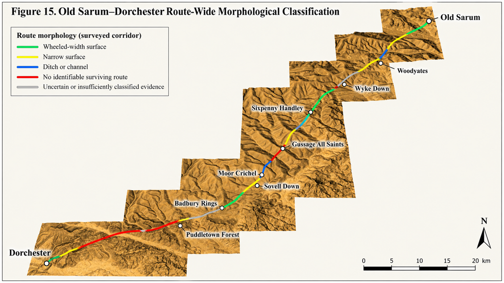
Our LiDAR investigation examined approximately 64 kilometres of the Old Sarum–Dorchester corridor, recording the morphology of identifiable earthworks, road-like surfaces, ditches and sections where no corresponding feature could be confidently recognised [4].
The results reveal a route considerably more complicated than its conventional cartographic representation.
What Actually Survives?
The route-wide classification produced a striking result.
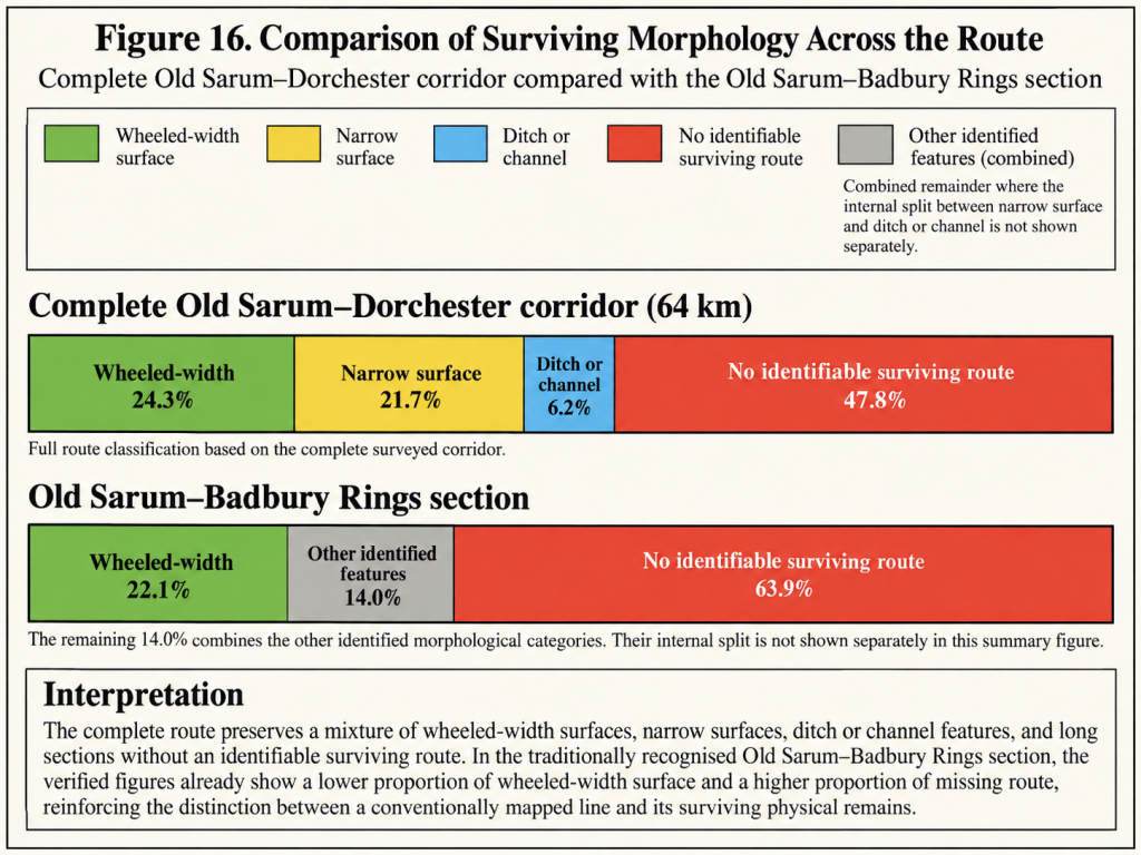
Only approximately 24.3% of the surveyed corridor was classified as a surviving wheeled-width road surface or formation [4].
The remainder comprised narrower surfaces, ditch-like features or sections without an identifiable surviving route.
| Surviving classification | Percentage | Approximate length |
|---|---|---|
| Wheeled-width road | 24.3% | 15.6 km |
| Narrow surface | 21.7% | 13.9 km |
| Ditch or channel | 6.2% | 4.0 km |
| No identifiable surviving route | 47.8% | 30.6 km |
| Total | 100% | 64.0 km |
Table 1. Route-wide morphological classification of the Old Sarum–Dorchester corridor. Lengths are calculated from the approximate 64-kilometre survey distance and rounded to one decimal place; use the original classified segment lengths for final analytical precision [4].
These figures reveal that less than one-quarter of the complete mapped route retains a formation classified as wheeled-width road.
A further 21.7% preserves a narrower identifiable surface.
Approximately 6.2% is represented by ditch or channel morphology, while almost half the surveyed corridor lacks a confidently identifiable surviving feature.
This does not mean that nearly half the Roman road never existed.
Centuries of cultivation, erosion, extraction, construction and landscape modification may have removed substantial portions of its original formation.
Equally, however, we cannot assume that every missing section originally contained the same engineering structure as those that survive.
The evidence demonstrates variation in the surviving landscape. It does not, by itself, establish a uniform original construction.
The Old Sarum–Badbury Rings Section
The contrast becomes particularly apparent when the traditionally recognised Ackling Dyke section is examined separately.
Between Old Sarum and Badbury Rings, approximately 22.1% of the surveyed alignment was classified as wheeled-width surface, while 63.9% lacked an identifiable surviving route [4].
This is significant because the northern section contains some of the most substantial surviving earthworks associated with Ackling Dyke.
Those prominent remains have helped define the monument’s character in archaeological descriptions, yet they do not represent the physical condition of the entire alignment.
The surviving route alternates between substantial banks, smaller road-like features, narrow surfaces and long sections where the expected engineering cannot be confidently traced.
Consequently, an impressive raised earthwork at one location should not automatically determine the interpretation of a missing or physically different section several kilometres away.
The Problem of Changing Construction
The surviving sections differ not only in visibility but also in physical dimensions and construction forms.
Historic England describes substantial Ackling Dyke earthworks between Oakley Down and Handley Down, where the raised construction reaches approximately 13 metres in width and varies between 1.2 and 2.5 metres in height [2].
By comparison, the excavated metalled running surface at Thorncombe Wood in Puddletown Forest was approximately 3.3–3.6 metres wide, with evidence of wheeled traffic [6,8].
These measurements are not necessarily contradictory.
A Roman road could have a relatively narrow running surface supported by a much broader embankment, especially where engineering conditions required it.
Nevertheless, this possibility needs to be demonstrated through construction sections and stratigraphic relationships, not simply assumed from the designation Roman road.
A broad raised bank, a metalled roadway, a cutting and a linear ditch are physically different features.
They may have formed components of one transport system, but they might also represent structures built at different times for different purposes.
The route-wide mapping therefore identifies a fundamental question:
Does the variability result from one Roman engineering project adapting to changing terrain, or from incorporating and modifying earlier infrastructure?
Both explanations remain open to investigation.
The Significance of Changes in Alignment
The map also identifies locations where the recognised route changes direction or appears to separate into alternative alignments.
The most significant example occurs at Wyke Down.
Here, Track 3 turns approximately 17.8 degrees towards Sixpenny Handley, while Track 4 forms a considerably straighter continuation towards Gussage All Saints [4].
The two alignments approach different lowland landscapes at different elevations.
This is potentially important because it raises the possibility that they served different destinations or originated at different times.
However, route geometry alone cannot determine their relative ages.
A diversion may have been created to reach a settlement, avoid difficult ground, access resources or accommodate a pre-existing structure.
Wyke Down is therefore significant because it provides a measurable opportunity to investigate whether more than one phase of engineering survives within the corridor.
Sections 8–10 examine the two alignments individually.
Extraction Landscapes Along the Corridor
The survey also identifies a recurring relationship: substantial engineered features are often close to extraction hollows, cuttings, and disturbed ground [4].
At Moor Crichel, near The Rookery, a substantial cut-and-bank feature descends from an extraction landscape towards a palaeochannel. The larger construction appears to terminate while a lighter alignment continues.
At Sovell Down, the conventionally recognised route makes a notable diversion around an extraction feature.
Puddletown Forest contains further examples of cuttings, terraces, hollows and substantial changes in surviving route morphology [4,6].
These associations matter because roads, quarry-access routes, drainage channels, and material-transport infrastructure can leave overlapping archaeological signatures.
An extraction site adjoining a road might have supplied construction materials for that road.
Alternatively, an engineered route might have provided access to an existing extraction area.
A third possibility is that substantial earthworks originally moved extracted materials toward lower ground or natural waterways.
The LiDAR evidence identifies the geographical relationships but does not independently determine which explanation is correct.
The individual sites must therefore be examined in greater detail.
Badbury Rings — An Important Comparison Point
Badbury Rings represents a particularly useful geographical and archaeological division in the investigation.
The conventionally recognised Ackling Dyke route approaches Badbury Rings from Old Sarum, while the wider Roman communication corridor continues towards Dorchester [1–3].
This allows us to compare the engineering characteristics of the two sections without changing the classification methodology.
If the corridor represents one coherent Roman road-building programme, we might expect some consistency in its engineering principles, while allowing for local variations caused by terrain, geology and subsequent disturbance.
Conversely, substantial differences in construction form, associated earthworks, and route relationships could reflect different origins or phases of adaptation.
The excavation evidence at Thorncombe Wood provides an important comparison because it identifies a metalled surface used by wheeled traffic [6,8].
The question becomes whether comparable evidence can be demonstrated beneath or within the substantially larger earthworks farther north.
Badbury Rings is therefore not treated as proof of either interpretation.
It is a convenient and meaningful point at which to compare the physical characteristics of the two traditionally connected routes.
What the Route-Wide Survey Establishes
The complete survey produces three principal observations.
First, the recognised route is not preserved as one continuous, physically uniform construction.
Across approximately 64 kilometres, its surviving morphology includes wheeled-width surfaces, narrow tracks, ditch-like features and substantial sections without an identifiable route [4].
Second, the dimensions and forms of the surviving engineering vary considerably.
Some sections preserve substantial raised banks and accompanying ditches, while excavated surfaces elsewhere demonstrate comparatively narrow routes suitable for wheeled transport [2,4,6].
Third, several alignments exhibit relationships with prehistoric monuments, extraction landscapes and palaeochannels that require further investigation.
These relationships may reflect changing transport requirements, multiple construction periods, environmental change or the reuse of existing infrastructure [4].
None of these observations independently proves that Ackling Dyke originated as a prehistoric canal.
Neither do they justify assuming that every surviving feature was originally constructed as part of one Roman road.
The proposed hydraulic interpretation must ultimately demonstrate feasible gradients, water supply, navigable dimensions and appropriate chronological relationships.
The conventional road interpretation must likewise account for the physical differences, route changes and construction relationships identified in the survey.
The most important result of the route-wide investigation is therefore not the rejection of Roman road use, but the recognition that the corridor contains physical evidence requiring more than one possible explanation.
Beginning the Journey
Having established the condition of the complete route, we can now begin examining the evidence geographically.
Rather than moving between disconnected examples, the following sections follow the conventional alignment from Old Sarum through Woodyates and Wyke Down, examining the individual earthworks, alternative alignments and surrounding landscapes.
The investigation then continues through the Dorset extraction landscapes, Badbury Rings and Puddletown Forest before reaching Dorchester.
At every stage, the same questions will be asked:
What physically survives?
What are its measured dimensions?
How does it relate to the surrounding landscape?
What archaeological evidence exists for its construction and use?
And, most importantly, which interpretation best explains the evidence without requiring unsupported assumptions?
Our journey begins at Old Sarum.
References
[1] Royal Commission on Historical Monuments (England). (1975). An Inventory of Historical Monuments in the County of Dorset, Volume V: East Dorset. London: HMSO, pp. 33–34. Associated Dorset Historic Environment Record MDO2228.
[2] Historic England. Part of Ackling Dyke (Roman road), including Roman road on Oakley Down. National Heritage List for England, Scheduled Monument 1003309.
[3] Dorset Council. Roman Road from Old Sarum to Badbury Rings. Dorset Historic Environment Record, MDO6400.
[4] Langdon, R. J. (2026). Ackling Dyke: Old Sarum–Dorchester Route-Wide LiDAR and Morphological Investigation. Original research dataset, route classifications and measured profiles. Unpublished; supporting tables and figures to accompany the complete investigation.
[5] Pitt-Rivers, A. H. L. F. (1892). Excavations in Cranborne Chase, near Rushmore, on the Borders of Dorset and Wilts. Volume III: Excavations in Bokerly and Wansdyke, Dorset and Wilts, 1888–1891. Privately printed.
[6] Fletcher, M. (2004). The Ackling Dyke Roman Road in Puddletown Forest, Dorset. English Heritage Archaeological Investigation Report 37/2004; Historic England Research Report 103/2004.
[7] Langdon, R. J. (2026). The Post-Glacial Flooding Hypothesis: The Evidence. Version 3.4. ABC Publishing Group.
[8] Putnam, W. (1968). Thorncombe Wood road excavation, discussed in Fletcher (2004). Full primary publication details to be verified.
Continue Exploring Ackling Dyke Reconsidered
Explore the surviving evidence section by section as we follow the ancient route across Wiltshire and Dorset.
⬅️ Previous Page — 3. How We Tested It
➡️ Next Page — 5. Old Sarum: Where the Investigation Begins